December 2017 1045 Olive Project Case Number: ENV- 2016-4630-EIR Project Location: 1033 - 1057 S. Olive Street, Los Angeles, CA 90015 Community Plan Area: Central City Council District: 14 – Huizar Project Description: The 1045 Olive Project (the Project) includes the removal of four existing commercial buildings and the construction of a mixed-use high-rise building not to exceed 751,777 square feet containing a maximum of 794 residential units and 12,504 square feet of commercial uses located at the ground and mezzanine levels. At 70 stories, the project will reach up to 810 feet in height. The neighborhood serving commercial uses and residential lobby would front along 11th Street and Olive Street. Vehicle and bicycle parking would be provided per requirements of the Los Angeles Municipal Code (LAMC) within up to six (6) subterranean levels and eight (8) partial levels above grade (the fifth through ninth levels will contain residential units and other active uses along the perimeter of the Podium along the 11 th Street and Olive Street frontages). The Project sits on an approximately 0.96-acre Site (Project Site), approximately 0.6 miles north of the Santa Monica Freeway (I-10) and 0.60 miles east of the Harbor Freeway (I-110) in the South Park community of Downtown Los Angeles. The Project Site is located at the northwest corner of the intersection of Olive Street and 11 th Street. It is zoned [Q]R5-4D-O and designated by the Central City Community Plan as High Density Residential. PREPARED FOR: The City of Los Angeles Department of City Planning PREPARED BY: ESA 233 Wilshire Blvd., Suite. 150 Santa Monica, CA 90401 APPLICANT: 1045 Olive, LLC 2200 Biscayne Blvd., Miami, FL 33137
Transcript
December 2017
1045 Olive Project
Case Number: ENV- 2016-4630-EIR
Project Location: 1033 - 1057 S. Olive Street, Los Angeles, CA 90015
Community Plan Area: Central City
Council District: 14 – Huizar
Project Description: The 1045 Olive Project (the Project) includes the removal of four existing commercial buildings and the construction of a mixed-use high-rise building not to exceed 751,777 square feet containing a maximum of 794 residential units and 12,504 square feet of commercial uses located at the ground and mezzanine levels. At 70 stories, the project will reach up to 810 feet in height. The neighborhood serving commercial uses and residential lobby would front along 11th Street and Olive Street. Vehicle and bicycle parking would be provided per requirements of the Los Angeles Municipal Code (LAMC) within up to six (6) subterranean levels and eight (8) partial levels above grade (the fifth through ninth levels will contain residential units and other active uses along the perimeter of the Podium along the 11th Street and Olive Street frontages).
The Project sits on an approximately 0.96-acre Site (Project Site), approximately 0.6 miles north of the Santa Monica Freeway (I-10) and 0.60 miles east of the Harbor Freeway (I-110) in the South Park community of Downtown Los Angeles. The Project Site is located at the northwest corner of the intersection of Olive Street and 11th Street. It is zoned [Q]R5-4D-O and designated by the Central City Community Plan as High Density Residential.
PREPARED FOR:
The City of Los Angeles Department of City Planning
PREPARED BY:
ESA 233 Wilshire Blvd., Suite. 150
Santa Monica, CA 90401
APPLICANT:
1045 Olive, LLC 2200 Biscayne Blvd.,
Miami, FL 33137
[1045 S. Olive Street Project i City of Los Angeles
Initial Study December 2017
INITIAL STUDY Table of Contents
Page
Initial Study and Appendix G Checklist ..........................................................................IS-1
Attachment A: Project Description .................................................................................. A-1 A. Project Summary ...............................................................................................A-1 B. Environmental Setting ........................................................................................A-1 C. Project Description .............................................................................................A-6 D. Requested Permits and Approvals ..................................................................A-15
Attachment B: Explanation of Checklist Determinations .............................................. B-1 I. Aesthetics ..........................................................................................................B-1 II. Agriculture and Forestry Resources ..................................................................B-4 III. Air Quality ..........................................................................................................B-5 IV. Biological Resources .........................................................................................B-7 V. Cultural Resources ..........................................................................................B-10 VI. Geology and Soils ............................................................................................B-11 VII. Greenhouse Gas Emissions ............................................................................B-15 VIII. Hazards and Hazardous Materials ...................................................................B-16 IX. Hydrology and Water Quality ...........................................................................B-19 X. Land Use and Planning ...................................................................................B-22 XI. Mineral Resources ...........................................................................................B-24 XII. Noise ....................................................................................................................... B-24 XIII. Population and Housing ...................................................................................B-26 XIV. Public Services ................................................................................................B-27 XV. Recreation .......................................................................................................B-29 XVI Transportation and Traffic ................................................................................B-29 XVII. Tribal Cultural Resources ................................................................................B-31 XVIII. Utilities and Service Systems ..........................................................................B-32 XVIII. Mandatory Findings of Significance .................................................................B-38
Appendices
Appendix A: Arborist Street Tree Report Appendix B: Phase I and Limited Phase II Environmental Site Assessment
Table of Contents
[1045 S. Olive Street Project ii City of Los Angeles
Initial Study December 2017
List of Figures
A-1 Regional and Site Location Map ..............................................................................A-2 A-2 Aerial Photograph of Project Site and Vicinity ..........................................................A-4 A-3 Conceptual Site Plan ...............................................................................................A-8 A-4 Conceptual Project Rendering .................................................................................A-9 A-5 Selected Rendering Details ...................................................................................A-10 A-6 Conceptual 11th Street and Olive Street Elevations. .............................................A-11
List of Tables
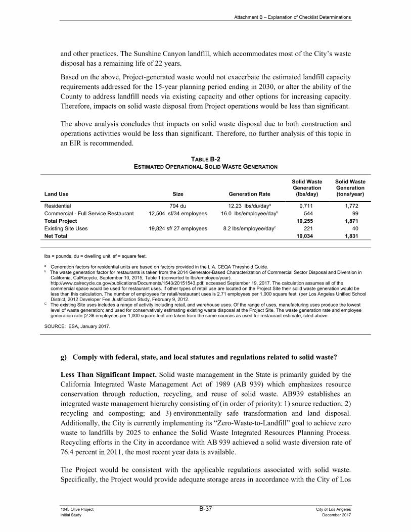
A-1 Proposed Development Program .............................................................................A-7 B-1 Project Demolition and Construction Debris ..........................................................B-36 B-2 Estimated Operational Solid Waste Generation .....................................................B-37
INITIAL STUDY AND APPENDIX G CHECKLIST
1045 Olive Project IS-1 City of Los Angeles
Initial Study December 2017
CITY OF LOS ANGELES OFFICE OF THE CITY CLERK ROOM 360, CITY HALL
LOS ANGELES, CALIFORNIA 90012
CALIFORNIA ENVIRONMENTAL QUALITY ACT
INITIAL STUDY AND APPENDIX G CHECKLIST
LEAD CITY AGENCY
City of Los Angeles Department of City Planning
COUNCIL DISTRICT
14 ‐ Huizar
DATE
December, 2017 RESPONSIBLE AGENCIES
Regional Water Quality Control Board, South Coast Air Quality Management District (SCAQMD), CRA/LA PROJECT TITLE/CASE NO.
The 1045 Olive Project (the Project) includes the removal of four existing commercial buildings and the construction of amixed‐use high‐rise building not to exceed 751,777 square feet containing a maximum of 794 residential units and 12,504square feet of commercial uses located at the ground and mezzanine levels. At 70 stories, with a 61‐story tower above a nine‐story podium structure, the Project would reach up to 810 feet in height. Neighborhood serving commercial uses anda residential lobby would front along 11th Street and Olive Street. A public plaza space would be located at the corner of 11th Street and Olive Street. In addition, the Project would provide up to 100,652 square feet of amenity/open space area for its residents located above the podium structure, at mid‐tower, on a roof terrace and within private balconies. Vehicle and bicycle parking would be provided per requirements of the LAMC within up to six (6) subterranean levels and eight (8) partial levels above grade (the fifth through ninth levels will contain residential units and other active uses along theperimeter of the Podium along the 11th Street and Olive Street frontages). The maximum floor‐area ratio (FAR) for the Transit Area Mixed‐Use Project would be 13:1. For further discussion, see Attachment A, Project Description. ENVIRONMENTAL SETTING:
The Project Site is 41,603 square feet in size, inclusive of 34,673 square feet occupied by four existing commercial buildings (containing 35,651 square feet of rentable area), 3,424 square feet of paved parking lot area and 3,506 square feet of rightof way and alley easement area. The existing buildings are one‐story in height and are typical of older single story commercial buildings in the Project vicinity. Uses surrounding the Project Site include a seven‐story mixed‐use developmentto the north, surface parking lot to the south, seven‐story mixed‐use development to the northwest, single story commercial uses to the east and a 25‐story mixed‐use high‐rise building to the west.
The Project Site is located in the South Park community of Downtown Los Angeles. The South Park area includes a mix of residential, medical, commercial, and retail uses. There is a substantial concentration of housing located next to and oversupport services, such as retail and commercial developments that provide employment opportunities. The Project Site is
1045 Olive Project IS-2 City of Los Angeles
Initial Study December 2017
located just over one/quarter mile from the Convention Center, Staples Center and the Figueroa Corridor.
The Project Site is served by a network of regional transportation facilities that provide access to the greater metropolitan area. It is located less than 0.5 miles from Metro Blue Line and Expo Line station at Pico Boulevard, adjacent to multiple bus and shuttle lines in the immediate vicinity; and it is located approximately 0.6 miles north of the Santa Monica Freeway (I‐10) and 0.6 miles east of the Harbor Freeway (I‐110).
For further discussion, see Attachment A, Project Description.
Have California Native American tribes traditionally and culturally affiliated with the project area requested consultationpursuant to Public Resources Code section 21080.3.1? If so, has consultation begun?
No. Outreach to tribes will occur upon the issuance of the Notice of Preparation for the Project.
1045 Olive Project IS-4 City of Los Angeles
Initial Study December 2017
EVALUATION OF ENVIRONMENTAL IMPACTS:
1) A brief explanation is required for all answers except "No Impact" answers that are adequately supported by the information sources a lead agency cites in the parentheses following each question. A "No Impact" answer is adequately supported if the referenced information sources show that the impact simply does not apply to projects like the one involved (e.g., the project falls outside a fault rupture zone). A "No Impact" answer should be explained where it is based on project‐specific factors as well as general standards (e.g., the project will not expose sensitive receptors to pollutants, based on a project‐specific screening analysis).
2) All answers must take account of the whole action involved, including off‐site as well as on‐site, cumulative as well as project‐level, indirect as well as direct, and construction as well as operational impacts.
3) Once the lead agency has determined that a particular physical impact may occur, then the checklist answers must indicate whether the impact is potentially significant, less that significant with mitigation, or less than significant. "Potentially Significant Impact" is appropriate if there is substantial evidence that an effect may be significant. If there are one or more "Potentially Significant Impact" entries when the determination is made, an EIR is required.
4) "Negative Declaration: Less Than Significant With Mitigation Incorporated" applies where the incorporation of a mitigation measure has reduced an effect from "Potentially Significant Impact" to "Less Than Significant Impact." The lead agency must describe the mitigation measures, and briefly explain how they reduce the effect to a less than significant level (mitigation measures from "Earlier Analysis," as described in (5) below, may be cross referenced).
5) Earlier analysis must be used where, pursuant to the tiering, program EIR, or other CEQA process, an effect has been adequately analyzed in an earlier EIR, or negative declaration. Section 15063 (c)(3)(D). In this case, a brief discussion should identify the following:
a) Earlier Analysis Used. Identify and state where they are available for review.
b) Impacts Adequately Addressed. Identify which effects from the above checklist were within the scope of and adequately analyzed in an earlier document pursuant to applicable legal standards, and state whether such effects were addressed by mitigation measures based on the earlier analysis.
c) Mitigation Measures. For effects that are "Less Than Significant With Mitigation Measures Incorporated," describe the mitigation measures which were incorporated or refined from the earlier document and the extent to which they address site‐specific conditions for the project.
6) Lead agencies are encouraged to incorporate into the checklist references to information sources for potential impacts (e.g., general plans, zoning ordinances). Reference to a previously prepared or outside document should, where appropriate, include a reference to the page or pages where the statement is substantiated.
7) Supporting Information Sources: A sources list should be attached, and other sources used or individuals contacted should be cited in the discussion.
8) This is only a suggested form, and lead agencies are free to use different formats; however, lead agencies should normally address the questions from this checklist that are relevant to a project’s environmental effects in whichever format is selected.
9) The explanation of each issue should identify:
a) The significance criteria or threshold, if any, used to evaluate each question; and
b) The mitigation measure identified, if any, to reduce the impact to less than significance.
1045 Olive Project IS-5 City of Los Angeles
Initial Study December 2017
ENVIRONMENTAL IMPACTS (Explanations of all potentially and less than significant impacts are required to be attached on separate sheets)
Potentially Significant Impact
Less Than Significant with
Mitigation Incorporated
Less Than Significant Impact No Impact
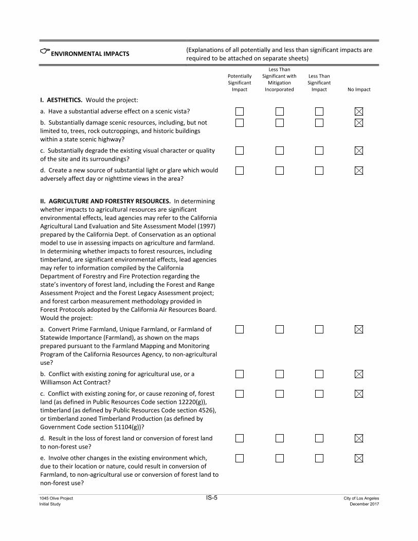
I. AESTHETICS. Would the project:
a. Have a substantial adverse effect on a scenic vista?
b. Substantially damage scenic resources, including, but not limited to, trees, rock outcroppings, and historic buildings within a state scenic highway?
c. Substantially degrade the existing visual character or quality of the site and its surroundings?
d. Create a new source of substantial light or glare which would adversely affect day or nighttime views in the area?
II. AGRICULTURE AND FORESTRY RESOURCES. In determining whether impacts to agricultural resources are significant environmental effects, lead agencies may refer to the California Agricultural Land Evaluation and Site Assessment Model (1997) prepared by the California Dept. of Conservation as an optional model to use in assessing impacts on agriculture and farmland. In determining whether impacts to forest resources, including timberland, are significant environmental effects, lead agencies may refer to information compiled by the California Department of Forestry and Fire Protection regarding the state’s inventory of forest land, including the Forest and Range Assessment Project and the Forest Legacy Assessment project; and forest carbon measurement methodology provided in Forest Protocols adopted by the California Air Resources Board. Would the project:
a. Convert Prime Farmland, Unique Farmland, or Farmland of Statewide Importance (Farmland), as shown on the maps prepared pursuant to the Farmland Mapping and Monitoring Program of the California Resources Agency, to non‐agricultural use?
b. Conflict with existing zoning for agricultural use, or a Williamson Act Contract?
c. Conflict with existing zoning for, or cause rezoning of, forest land (as defined in Public Resources Code section 12220(g)), timberland (as defined by Public Resources Code section 4526), or timberland zoned Timberland Production (as defined by Government Code section 51104(g))?
d. Result in the loss of forest land or conversion of forest land to non‐forest use?
e. Involve other changes in the existing environment which, due to their location or nature, could result in conversion of Farmland, to non‐agricultural use or conversion of forest land to non‐forest use?
1045 Olive Project IS-6 City of Los Angeles
Initial Study December 2017
Potentially Significant Impact
Less Than Significant with
Mitigation Incorporated
Less Than Significant Impact No Impact
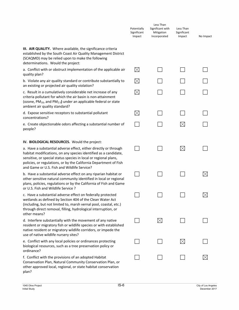
III. AIR QUALITY. Where available, the significance criteria established by the South Coast Air Quality Management District (SCAQMD) may be relied upon to make the following determinations. Would the project:
a. Conflict with or obstruct implementation of the applicable air quality plan?
b. Violate any air quality standard or contribute substantially to an existing or projected air quality violation?
c. Result in a cumulatively considerable net increase of any criteria pollutant for which the air basin is non‐attainment (ozone, PM10, and PM2.5) under an applicable federal or state ambient air quality standard?
d. Expose sensitive receptors to substantial pollutant concentrations?
e. Create objectionable odors affecting a substantial number of people?
IV. BIOLOGICAL RESOURCES. Would the project:
a. Have a substantial adverse effect, either directly or through habitat modifications, on any species identified as a candidate, sensitive, or special status species in local or regional plans, policies, or regulations, or by the California Department of Fish and Game or U.S. Fish and Wildlife Service?
b. Have a substantial adverse effect on any riparian habitat or other sensitive natural community identified in local or regional plans, policies, regulations or by the California of Fish and Game or U.S. Fish and Wildlife Service ?
c. Have a substantial adverse effect on federally protected wetlands as defined by Section 404 of the Clean Water Act (including, but not limited to, marsh vernal pool, coastal, etc.) through direct removal, filling, hydrological interruption, or other means?
d. Interfere substantially with the movement of any native resident or migratory fish or wildlife species or with established native resident or migratory wildlife corridors, or impede the use of native wildlife nursery sites?
e. Conflict with any local policies or ordinances protecting biological resources, such as a tree preservation policy or ordinance?
f. Conflict with the provisions of an adopted Habitat Conservation Plan, Natural Community Conservation Plan, or other approved local, regional, or state habitat conservation plan?
1045 Olive Project IS-7 City of Los Angeles
Initial Study December 2017
Potentially Significant Impact
Less Than Significant with
Mitigation Incorporated
Less Than Significant Impact No Impact
V. CULTURAL RESOURCES: Would the project:
a. Cause a substantial adverse change in the significance of a historical resource as defined in State CEQA Guidelines §15064.5?
b. Cause a substantial adverse change in the significance of an archaeological resource pursuant to State CEQA Guidelines §15064.5?
c. Directly or indirectly destroy a unique paleontological resource or site or unique geologic feature?
d. Disturb any human remains, including those interred outside of formal cemeteries?
VI. GEOLOGY AND SOILS.
In 2015, the California Supreme Court in CBIA v. BAAQMD, held that CEQA generally does not require a lead agency to consider the impacts of the existing environment on the future residents or users of the project. The revised thresholds are intended to comply with this decision. Specifically, the decision held that an impact from the existing environment to the project, including future users and/or residents, is not an impact for purposes of CEQA. However, if the project, including future users and residents, exacerbates existing conditions that already exist, that impact must be assessed, including how it might affect future users and/or residents of the project.
In accordance with Appendix G of the State CEQA Guidelines and the CBIA v. BAAQMD decision, the project would have a significant impact related to geology and soils if it results in any of the following impacts to future residents or users.
Would the Project:
a. Expose people or structures to potential substantial adverse effects, including the risk of loss, injury, or death involving:
i. Rupture of a known earthquake fault, as delineated on the most recent Alquist‐Priolo Earthquake Fault Zoning Map issued by the State Geologist for the area or based on other substantial evidence of a known fault caused in whole or in part by the project’s exacerbation of the existing environmental conditions? Refer to Division of Mines and Geology Special Publication 42.
ii. Strong seismic ground shaking caused in whole or in part by the project’s exacerbation of the existing environmental conditions?
iii. Seismic‐related ground failure, including liquefaction caused in whole or in part by the project’s exacerbation of the existing environmental conditions.?
iv. Landslides caused in whole or in part by the project’s exacerbation of the existing environmental conditions.?
b. Result in substantial soil erosion or the loss of topsoil?
1045 Olive Project IS-8 City of Los Angeles
Initial Study December 2017
Potentially Significant Impact
Less Than Significant with
Mitigation Incorporated
Less Than Significant Impact No Impact
c. Be located on a geologic unit or soil that is unstable, or that would become unstable as a result of the project, and potentially result in on‐ or off‐site landslide, lateral spreading, subsidence, liquefaction or collapse caused in whole or in part by the project’s exacerbation of the existing environmental conditions?
d. Be located on expansive soil, as defined in Table 18‐1‐B of the Uniform Building Code (1994), creating substantial risks to life or property caused in whole or in part by the project’s exacerbation of the existing environmental conditions.?
e. Have soils incapable of adequately supporting the use of septic tanks or alternative waste water disposal systems where sewers are not available for the disposal of waste water?
VII. GREENHOUSE GAS EMISSIONS. Would the project:
a. Generate greenhouse gas emissions, either directly or indirectly, that may have a significant impact on the environment?
b. Conflict with an applicable plan, policy or regulation adopted for the purpose of reducing the emissions of greenhouse gases?
VIII. HAZARDS AND HAZARDOUS MATERIALS.
In 2015, the California Supreme Court in CBIA v. BAAQMD, held that CEQA generally does not require a lead agency to consider the impacts of the existing environment on the future residents or users of the project. The revised thresholds are intended to comply with this decision. Specifically, the decision held that an impact from the existing environment to the project, including future users and/or residents, is not an impact for purposes of CEQA. However, if the project, including future users and residents, exacerbates existing conditions that already exist, that impact must be assessed, including how it might affect future users and/or residents of the project. For example, if construction of the project on a hazardous waste site will cause the potential dispersion of hazardous waste in the environment, the EIR should assess the impacts of that dispersion to the environment, including to the project's residents.
In accordance with Appendix G of the State CEQA Guidelines and the CBIA v. BAAQMD decision, the project would have a significant impact related to geology and soils if it results in any of the following impacts to future residents or users.
Would the project: a. Create a significant hazard to the public or the environment through the routine transport, use, or disposal of hazardous materials?
b. Create a significant hazard to the public or the environment through reasonably foreseeable upset and accident conditions involving the release of hazardous materials into the environment?
c. Emit hazardous emissions or handle hazardous or acutely hazardous materials, substances, or waste within one‐quarter mile of an existing or proposed school?
1045 Olive Project IS-9 City of Los Angeles
Initial Study December 2017
Potentially Significant Impact
Less Than Significant with
Mitigation Incorporated
Less Than Significant Impact No Impact
d. Be located on a site which is included on a list of hazardous materials sites compiled pursuant to Government Code Section 65962.5 and, as a result, would it create a significant hazard to the public or the environment caused in whole or in part by the project’s exacerbation of the existing environmental conditions?
e. For a project located within an airport land use plan or, where such a plan has not been adopted, within two miles of a public airport or public use airport, would the project have the potential to exacerbate current environmental conditions so as to result in a safety hazard for people residing or working in the project area?
f. For a project within the vicinity of a private airstrip, would the project have the potential to exacerbate current environmental conditions so as to result in a safety hazard for people residing or working in the project area?
g. Impair implementation of or physically interfere with an adopted emergency response plan or emergency evacuation plan?
h. Expose people or structures to a significant risk of loss, injury or death involving wildland fires, including where wildlands are adjacent to urbanized areas or where residences are intermixed with wildlands caused in whole or in part by the project’s exacerbation of the existing environmental conditions?
IX. HYDROLOGY AND WATER QUALITY. Would the project:
a. Violate any water quality standards or waste discharge requirements?
b. Substantially deplete groundwater supplies or interfere substantially with groundwater recharge such that there would be a net deficit in aquifer volume or a lowering of the local groundwater table level (e.g., the production rate of pre‐existing nearby wells would drop to a level which would not support existing land uses or planned land uses for which permits have been granted)?
c. Substantially alter the existing drainage pattern of the site or area, including through the alteration of the course of a stream or river, in a manner which would result in substantial erosion or siltation on‐ or off‐site?
d. Substantially alter the existing drainage pattern of the site or area, including through the alteration of the course of a stream or river, or substantially increase the rate or amount of surface runoff in an manner which would result in flooding on‐ or off site?
1045 Olive Project IS-10 City of Los Angeles
Initial Study December 2017
Potentially Significant Impact
Less Than Significant with
Mitigation Incorporated
Less Than Significant Impact No Impact
e. Create or contribute runoff water which would exceed the capacity of existing or planned stormwater drainage systems or provide substantial additional sources of polluted runoff?
f. Otherwise substantially degrade water quality?
g. Place housing within a 100‐year flood hazard area as mapped on federal Flood Hazard Boundary or Flood Insurance Rate Map or other flood hazard delineation map?
h. Place within a 100‐year flood hazard area structures which would impede or redirect flood flows?
i. Expose people or structures to a significant risk of loss, injury or death involving flooding, including flooding as a result of the failure of a levee or dam?
j. Inundation by seiche, tsunami, or mudflow?
X. LAND USE AND PLANNING. Would the project:
a. Physically divide an established community?
b. Conflict with any applicable land use plan, policy, or regulation of an agency with jurisdiction over the project (including, but not limited to the general plan, specific plan, local coastal program, or zoning ordinance) adopted for the purpose of avoiding or mitigating an environmental effect?
c. Conflict with any applicable habitat conservation plan or natural community conservation plan?
XI. MINERAL RESOURCES. Would the project:
a. Result in the loss of availability of a known mineral resource that would be of value to the region and the residents of the state?
b. Result in the loss of availability of a locally‐important mineral resource recovery site delineated on a local general plan, specific plan or other land use plan?
XII. NOISE. Would the project result in:
a. Exposure of persons to or generation of noise levels in excess of standards established in the local general plan or noise ordinance, or applicable standards of other agencies?
b. Exposure of persons to or generation of excessive groundborne vibration or groundborne noise levels?
c. A substantial permanent increase in ambient noise levels in the project vicinity above levels existing without the project?
d. A substantial temporary or periodic increase in ambient noise levels in the project vicinity above levels existing without the project?
1045 Olive Project IS-11 City of Los Angeles
Initial Study December 2017
Potentially Significant Impact
Less Than Significant with
Mitigation Incorporated
Less Than Significant Impact No Impact
e. For a project located within an airport land use plan or, where such a plan has not been adopted, within two miles of a public airport or public use airport, would the project expose people residing or working in the project area to excessive noise levels?
f. For a project within the vicinity of a private airstrip, would the project expose people residing or working in the project area to excessive noise levels?
XIII. POPULATION AND HOUSING. Would the project:
a. Induce substantial population growth in an area, either directly (for example, by proposing new homes and businesses) or indirectly (for example, through extension of roads or other infrastructure)?
b. Displace substantial numbers of existing housing, necessitating the construction of replacement housing elsewhere?
c. Displace substantial numbers of people, necessitating the construction of replacement housing elsewhere?
XIV. PUBLIC SERVICES. Would the project result in substantial adverse physical impacts associated with the provision of new or physically altered governmental facilities, need for new or physically altered governmental facilities, the construction of which could cause significant environmental impacts, in order to maintain acceptable service ratios, response times or other performance objectives for any of the public services:
a. Fire protection?
b. Police protection?
c. Schools?
d. Parks?
e. Other public facilities?
XV. RECREATION.
a. Would the project increase the use of existing neighborhood and regional parks or other recreational facilities such that substantial physical deterioration of the facility would occur or be accelerated?
b. Does the project include recreational facilities or require the construction or expansion of recreational facilities which might have an adverse physical effect on the environment?
1045 Olive Project IS-12 City of Los Angeles
Initial Study December 2017
Potentially Significant Impact
Less Than Significant with
Mitigation Incorporated
Less Than Significant Impact No Impact
XVI. TRANSPORTATION/TRAFFIC. Would the project:
a. Conflict with an applicable plan, ordinance or policy establishing measures of effectiveness for the performance of the circulation system, taking into account all modes of transportation including mass transit and non‐motorized travel and relevant components of the circulation system, including but not limited to intersections, streets, highways and freeways, pedestrian and bicycle paths, and mass transit?
b. Conflict with an applicable congestion management program, including, but not limited to level of service standards and travel demand measures, or other standards established by the county congestion management agency for designated roads or highways?
c. Result in a change in air traffic patterns, including either an increase in traffic levels or a change in location that results in substantial safety risks?
d. Substantially increase hazards to a design feature (e.g., sharp curves or dangerous intersections) or incompatible uses (e.g., farm equipment)?
e. Result in inadequate emergency access?
f. Conflict with adopted policies, plans, or programs regarding public transit, bicycle, or pedestrian facilities, or otherwise decrease the performance or safety of such facilities?
XVII. TRIBAL CULTURAL RESOURCES. Would the project:
a. Cause a substantial adverse change in the significance of a tribal cultural resource, defined in Public Resources Code section 21074 as either a site, feature, place, cultural landscape that is geographically defined in terms of the size and scope of the landscape, sacred place, or object with cultural value to a California Native American tribe, and that is: Listed or eligible for listing in the California Register of Historical Resources, or in a local register of historical resources as defined in Public Resources Code section 5020.1 (k)?
1045 Olive Project IS-13 City of Los Angeles
Initial Study December 2017
Potentially Significant Impact
Less Than Significant with
Mitigation Incorporated
Less Than Significant Impact No Impact
b. Cause a substantial adverse change in the significance of a tribal cultural resource, defined in Public Resources Code section 21074 as either a site, feature, place, cultural landscape that is geographically defined in terms of the size and scope of the landscape, sacred place, or object with cultural value to a California Native American tribe, and that is: A resource determined by the lead agency, in its discretion and supported by substantial evidence, to be significant pursuant to criteria set forth in subdivision (c) of Public Resources Code Section 5024.1. In applying the criteria set forth in subdivision (c) of Public Resource Code Section 5024.1, the lead agency shall consider the significance of the resource to a California Native American tribe?
XVIII. UTILITIES AND SERVICE SYSTEMS. Would the project:
a. Exceed wastewater treatment requirements of the applicable Regional Water Quality Control Board?
b. Require or result in the construction of new water or wastewater treatment facilities or expansion of existing facilities, the construction of which could cause significant environmental effects?
c. Require or result in the construction of new storm water drainage facilities or expansion of existing facilities, the construction of which could cause significant environmental effects?
d. Have sufficient water supplies available to serve the project from existing entitlements and resources, or are new or expanded entitlements needed?
e. Result in a determination by the wastewater treatment provider which serves or may serve the project that it has adequate capacity to serve the project’s projected demand in addition to the provider’s existing commitments?
f. Be served by a landfill with sufficient permitted capacity to accommodate the project’s solid waste disposal needs?
g. Comply with federal, state, and local statutes and regulations related to solid waste?
XVIV. MANDATORY FINDINGS OF SIGNIFICANCE.
a. Does the project have the potential to degrade the quality of the environment, substantially reduce the habitat of fish or wildlife species, cause a fish or wildlife population to drop below self‐sustaining levels, threaten to eliminate a plant or animal community, reduce the number or restrict the range of a rare or endangered plant or animal or eliminate important examples of the major periods of California history or prehistory?
1045 Olive Project IS-14 City of Los Angeles
Initial Study December 2017
Potentially Significant Impact
Less Than Significant with
Mitigation Incorporated
Less Than Significant Impact No Impact
b. Does the project have impacts that are individually limited, but cumulatively considerable? ("Cumulatively considerable" means that the incremental effects of a project are considerable when viewed in connection with the effects of past projects, the effects of other current projects, and the effects of probable future projects).
c. Does the project have environmental effects which will cause substantial adverse effects on human beings, either directly or indirectly?
ATTACHMENT A Project Description
1045 Olive Project A-1 City of Los Angeles
Initial Study December 2017
ATTACHMENT A Project Description
A. Project Summary
1045 Olive, LLC (Applicant) proposes the development of a new mixed-use development on an approximately 0.96-acre site located at the northwest corner of Olive Street and 11th Street (Project Site). Five existing single story commercial buildings containing 35,651 square feet would be removed and replaced with a new 751,777 square foot mixed-use high-rise building (Project).
The Project would include a maximum of 794 residential units and 12,504 square feet of neighborhood serving commercial uses located at the ground level. The development would include a 61-story tower atop a nine level podium structure (Podium) for a total of 70 floors, up to 810 feet in height.1 Approximately 103,380 square feet of amenity/open space would be provided including a ground level public plaza with streetscaping, landscaping and a public art display (Plaza). Open space and recreation facilities for residents would be located atop the Podium (10th Floor Terrace), at mid-tower, on a terrace on the tower rooftop (Tower Roof Terrace) and within private balconies. At the pedestrian level, the Project would provide a 17-foot sidewalk along Olive Street and a 15-foot sidewalk (including a 3-foot sidewalk easement) along 11th Street in conformance with Mobility Plan 2035.
Vehicle access (ingress/egress) would be provided from one entrance along Olive Street, near the northern property line, and from two entrances on the alley between 11th Street and Olympic Boulevard. An on-site loading and move-in/out service area would also be accessed from the alley near the center of the Project Site. Vehicle parking would be provided within six (6) subterranean parking levels and in eight (8) partial levels of above grade parking within the Podium. The Project would provide up to 891 parking spaces, and up to 886 bicycle spaces.
B. Environmental Setting
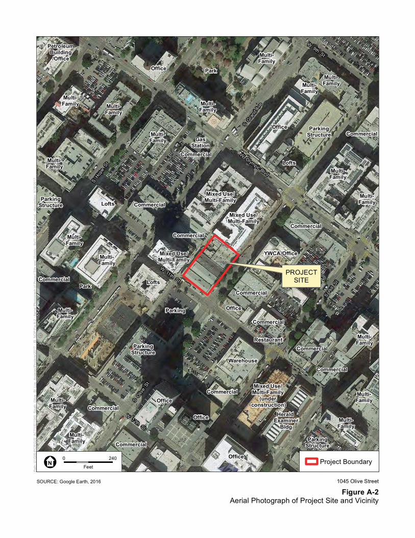
Project Location and Surrounding Uses As indicated in Figure A-1, Regional and Site Location Map, the 0.96-acre (41,603 sf) Project Site is located at the northwest corner of Olive Street and W. 11th Street in the Downtown area and South Park community of the City of Los Angeles (City).
1 The height to the top of the residential development, i.e. to the Tower Roof Terrace, is 770 feet. The 810 feet is the
height to the top of the rooftop screening.
PROJECTSITE
Pa
th:
U:\
GIS
-PC
R\G
IS_
AC
TIV
E\1
045
_So
uth
_Oliv
e_
St_
Los
_An
gele
s\P
roje
cts\
2017
- IS
_N
OP
\Fig
A-1
- R
egio
nal
an
d S
ite L
ocat
ion
Ma
p -
8x1
1 -
08
-10
-17
.mxd
, d
kan
eshi
ro 8
/11/
201
7
SOURCE: Open Street Map, 2016 1045 Olive Street
Figure A-1Regional and Site Location Map
N0 800
FeetProject Boundary
PROJECTSITE
Initial Study Attachment A – Project Description
1045 Olive Project A-3 City of Los Angeles
Initial Study December 2017
The South Park community of Downtown Los Angeles is one of nine-districts in the Central City Community Plan area, and is representative of the Downtown Center with its concentration of government-related uses, high- and mid-rise office buildings, residential buildings, hotels, retail uses, museums, and cultural districts. The South Park area includes a mix of residential, medical, commercial, and retail uses; with a substantial concentration of housing located next to and over support services, such as retail and commercial developments, which provide employment opportunities for area residents.
In the more immediate Project vicinity, as depicted on Figure A-2, Aerial Photograph of Project Site and Vicinity, the Project Site lies within the southeast quadrant of the block that is surrounded by Olive Street on the east, 11th Street on the south, Grand Avenue on the west and Olympic Boulevard on the north.2 The block is split by a south to north alley at midblock between Olive Avenue and Grand Avenue. The alley serves as the western boundary of the Project Site. Uses within the block that lie adjacent to the Project include a seven-story mixed-use development to the north, seven-story mixed-use development to the northwest, and a two-story commercial building and 25-story mixed-use high-rise building to the west.
Adjacent development across Olive Street to the east includes single story commercial uses; and across 11th Street to the south includes a surface parking lot. Surrounding development includes a large array of newer mixed use development, and older commercial, office, residential and warehouse uses. Public oriented/school facilities within 1,000 feet of the Project Site include the LA Child Care and Development Council (daycare center), Los Angeles Unified School District Los Angelitos Early Education Center, and Grand/Hope Park (a 2.5-acre park with a large lawn, playground, public art and benches).
The Project Site is also located approximately 0.27 miles east of the Figueroa Street Corridor, the focus of the MyFigueroa Streetscape project that is transforming the Figueroa Corridor into a multimodal street with improved transit, streetscape and landscaping features to better serve the needs of pedestrians, bicyclists, transit riders, and drivers alike. The MyFigueroa project extends eastward from Figueroa Street along 11th Street adjacent to the Project Site, ending at Broadway.
Figueroa Street in the Project vicinity is also the focus of regional activity including LA LIVE, an entertainment, hotel, and residential complex that is a Citywide focus of entertainment activity; the Staples Center Arena, a multipurpose sports arena which is home to the Los Angeles Clippers, Los Angeles Kings, Los Angeles Lakers and Los Angeles Sparks; and the Los Angeles Convention Center, which regularly features conventions, trade shows, and exhibitions.
The Project Site is served by a network of regional transportation facilities that provide access to the greater metropolitan area. It is located approximately 1500 feet from the entrance to the Pico Boulevard Station that provides rail service to the Metro Blue, and Expo Lines; and
2 Streets in the Downtown area do not align along a true north-south axis. However, the streets are extensions of
streets that lie long north-south and east-west axes within the greater City area. Unless otherwise dictated by contexts, the generally understood references of east, west, north and south will be used here.
PROJECTSITE
W 11th St
W Olympic Blvd
W 12th St
W 9th St
S G
rand
Ave
S H
ope
St
S O
live
St
S H
ill S
t
Multi-Family
Multi-Family
ParkingStructure
Multi-Family
Multi-Family Multi-
Family
Multi-Family
Multi-Family
Office
PetroleumBuilding/Office
Park
Multi-Family
Multi-Family
Office ParkingStructure
GasStation
Commercial
YWCA/Office
Office
ParkingStructure
Multi-Family
Park
Multi-Family
ParkingStructure
Office
Office
Commercial
Warehouse
Herald Examiner
Bldg
Multi-Family
Multi-Family
Commercial
Commercial
Lofts
Mixed Use/Multi-Family
Mixed Use/Multi-Family
Commercial
Lofts
Lofts
Commercial
Mixed Use/Multi-Family
Commercial
Commercial
Commercial
Restaurant
Commercial
Commercial
Commercial
Multi-Family
Multi-Family
Commercial
Multi-Family
Office
Mixed Use/Multi-Family
(under construction)
Multi-Family
Multi-Family
Parking
Pa
th:
U:\
GIS
-PC
R\G
IS_
AC
TIV
E\1
045
_So
uth
_Oliv
e_
St_
Los
_An
gele
s\P
roje
cts\
2017
- IS
_N
OP
\Fig
A-2
- A
eri
al P
hoto
gra
ph
of
Pro
ject
Site
and
Vic
inity
- 8
x11
- 0
8-1
0-1
7.m
xd,
dka
nes
hiro
8/1
8/2
017
SOURCE: Google Earth, 2016 1045 Olive Street
Figure A-2Aerial Photograph of Project Site and Vicinity
N0 240
FeetProject Boundary
Initial Study Attachment A – Project Description
1045 Olive Project A-5 City of Los Angeles
Initial Study December 2017
approximately 2,700 feet from the 7th Street/Metro Center Station that provides rail service to the Blue, Expo, Red and Purple Lines. It also lies adjacent to multiple bus and shuttle lines in the immediate vicinity; and it is located approximately 0.6 miles north of the Santa Monica Freeway (I-10) and 0.6 miles east of the Harbor Freeway (I-110).
Site Background and Existing Conditions The Project Site is 41,603 square feet in size, inclusive of 34,673 square feet of ground area that is occupied by five existing commercial buildings (containing 35,651 square feet of area inclusive of mezzanines), 3,424 square feet of paved parking lot area and 3,506 square feet of right of way and alley easement area.3 Of this area, 4,431 square feet would be dedicated to the City for sidewalks and alleys, leaving a development site of 37,172 square feet of buildable area. The size of the Project Site for calculating FAR pursuant to City regulations for the Transit Area Mixed Use Project extends to the centerline of Olive Street, 11th Street and the alley, inclusive of easements that would be provided in the alley and public right of way; and is approximately 57,829 square feet in size.
The five existing buildings are approximately one-story in height and are reflective of the older single story development in the Downtown area. There are no trees located on the Project Site, however five street trees are located along the street-side edge of Olive Street.
Existing Planning and Zoning The Project Site is located within the Central City Community Plan Area, City Center Redevelopment Project, Central City and Downtown Parking Districts, Greater Downtown Housing Incentive Area, South Park II Business Improvement District, Central City Revitalization Zone, Los Angeles State Enterprise Zone and is subject to the Downtown Design Guide. The Project Site is designated by the Central City Community Plan as High Density Residential and is zoned [Q]R5-4D-O.
The R5 zoning designation permits the development of high density residential development. The “Q” Condition, pursuant to Ordinance No. 164,307, allows commercial uses to be included along with the residential development provided the floor area for the commercial uses does not exceed a 2:1 FAR. The Height District No. 4 permits a FAR of 13:1. However, the “D” limitation, pursuant to Ordinance No. 164,307, restricts the floor area to a maximum of 6:1 FAR unless additional floor area is permitted through a Transfer of Floor Area (TFAR). The Project is located within a designated Transit Priority Area and as a mixed use project qualifies for the 13:1 FAR pursuant to Section 14.5 of the Los Angeles Municipal Code (LAMC) as a Transit Area Mixed Use Project that allows the proposed FAR to be based on the area contained within the centerlines of Olive Street, 11th Street, and the abutting alley.
As a Transit Priority Area, the Project qualifies for consideration under the Environmental Leadership Act of 2011 (AB 900, as amended by SB 743 (2013) and SB 734 (2016), which is codified in Sections 21178 – 21189.3 of the California Public Resources Code). This act was
3 The Project Site is comprised of 10 street addresses (1033, 1035, 1039, 1041, 1045, 1047, 1049, 1053, 1055 and
1057 South Olive Street). It also contains six County Assessor Tax Parcels (APNs) that are used for assigning property tax assessment information (APNs: 5139-010-001, -002, -008, -010, -011).
Initial Study Attachment A – Project Description
1045 Olive Project A-6 City of Los Angeles
Initial Study December 2017
approved to encourage California’s economic recovery by providing a streamlined process for judicial review of compliance with CEQA for development projects like the Project that are certified by the Governor as an Environmental Leadership Development Projects (ELDP). The Project is pursuing qualification as an ELDP project. In so doing the Project will need to meet a number of requirements including a demonstration that the Project will achieve LEED Silver certification (or better), maximize transit friendly features (resulting in a minimum 10 percent greater transportation efficiency) and be ‘Net-Zero’ in carbon/greenhouse gas (GHG) emissions.
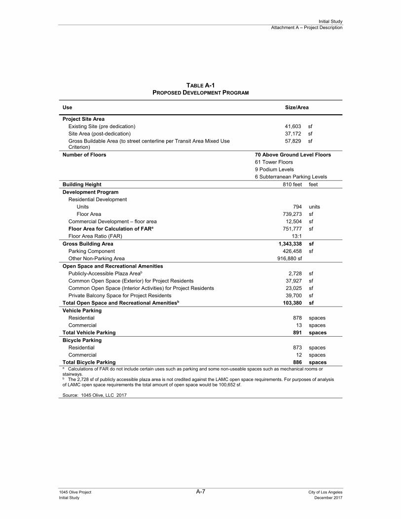
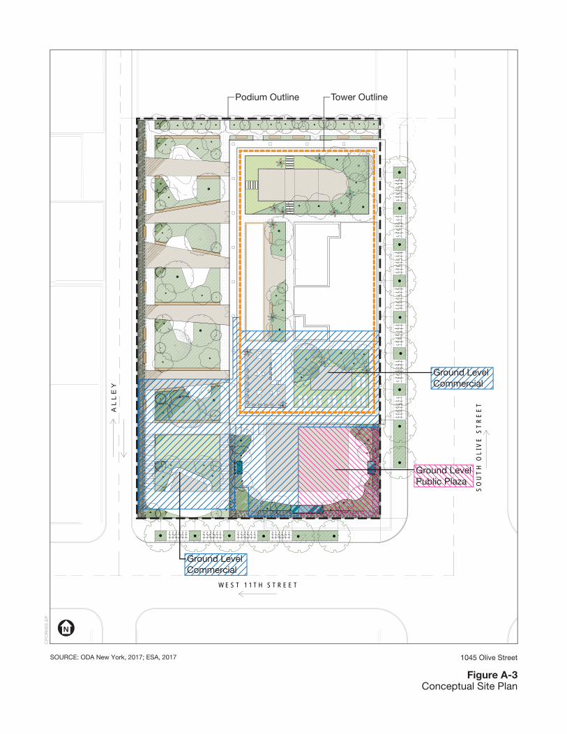
C. Project Description
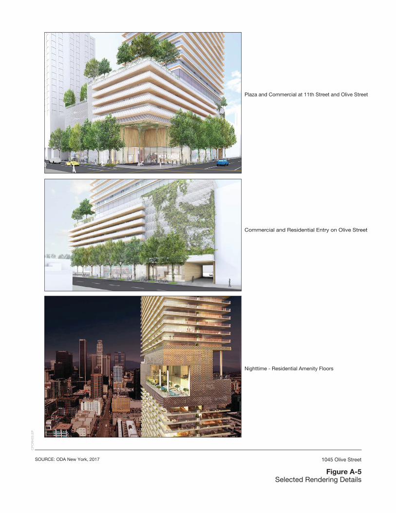
Development Program The proposed development program for the Project is summarized in Table A-1, Proposed Development Program. A conceptual site plan showing the arrangement of building components is presented on Figure A-3, Conceptual Site Plan. A rendering of the Project and its surrounding setting is shown in Figure A-4, Conceptual Project Rendering. Details of the Project appearance are shown in Figure A-5, Selected Rendering Details. Elevations of the building as viewed from the Project’s two main street frontages are shown on Figure A-6, Conceptual 11th Street and Olive Street Elevations.
As indicated in Figure A-3 and Figure A-5, the ground level development is oriented around a Plaza located at the corner of Olive Street and 11th Street. The Plaza is a public oriented pedestrian space that extends sidewalks and also provides entries into the adjacent commercial uses. The plaza would include streetscaping (including benches), landscaping and public art display. The adjacent commercial uses extend westward along 11th Street and northward to mid-block Olive Street. Further north along Olive Street would be located the primary entrance to the residential lobby.
The nine level Podium would be primarily composed of structural, above ground parking. However, the Podium would also include ground level commercial area and residential units along the perimeter of the Podium face adjacent to 11th Street and Olive Street on the fifth through ninth levels. At the top of the Podium, the 10th Floor Terrace would include a common open space area for the residential use, with a variety of tenant amenities such as lounge areas and an event deck. The 61-floor tower would rise above the Podium, covering only a portion of the development footprint on the Project Site (36 percent exclusive of balconies and 43 percent including the balconies).
Residential Development The Project includes up to 794 residential dwelling units. The units would include a range of housing types to serve a broad section of the housing market including: studios, 1- and 2-bedroom units (with and without dens), and 3-bedroom units. The residential units would be mostly located within the residential tower. However, as previously indicated, approximately 40 units would be located along the perimeter of the top five levels of the Podium facing Olive Street and 11th Street. These units would present a residential appearance along the upper Podium levels, providing a visual transition from the lower Podium uses to the residential tower.
Initial Study Attachment A – Project Description
1045 Olive Project A-7 City of Los Angeles
Initial Study December 2017
TABLE A-1 PROPOSED DEVELOPMENT PROGRAM
Use Size/Area
Project Site Area
Existing Site (pre dedication) 41,603 sf
Site Area (post-dedication) 37,172 sf
Gross Buildable Area (to street centerline per Transit Area Mixed Use Criterion)
57,829 sf
Number of Floors 70 Above Ground Level Floors
61 Tower Floors
9 Podium Levels
6 Subterranean Parking Levels
Building Height 810 feet feet
Development Program
Residential Development
Units 794 units
Floor Area 739,273 sf
Commercial Development – floor area 12,504 sf
Floor Area for Calculation of FARa 751,777 sf
Floor Area Ratio (FAR) 13:1
Gross Building Area 1,343,338 sf
Parking Component 426,458 sf
Other Non-Parking Area 916,880 sf
Open Space and Recreational Amenities
Publicly-Accessible Plaza Areab 2,728 sf
Common Open Space (Exterior) for Project Residents 37,927 sf
Common Open Space (Interior Activities) for Project Residents 23,025 sf
Private Balcony Space for Project Residents 39,700 sf
Total Open Space and Recreational Amenitiesb 103,380 sf
Vehicle Parking
Residential 878 spaces
Commercial 13 spaces
Total Vehicle Parking 891 spaces
Bicycle Parking
Residential 873 spaces
Commercial 12 spaces
Total Bicycle Parking 886 spaces a Calculations of FAR do not include certain uses such as parking and some non-useable spaces such as mechanical rooms or stairways. b The 2,728 sf of publicly accessible plaza area is not credited against the LAMC open space requirements. For purposes of analysis of LAMC open space requirements the total amount of open space would be 100,652 sf. Source: 1045 Olive, LLC 2017
S O
U T
H
O L
I V
E S
T R
E E
T
W E S T 1 1 T H S T R E E T
A L
L E
Y
1045 Olive Street
Figure A-3Conceptual Site Plan
SOURCE: ODA New York, 2017; ESA, 2017
CP
CR
H05
.EP
N
Ground Level Commercial
Ground Level Public Plaza
Tower OutlinePodium Outline
Ground Level Commercial
1045 Olive Street
Figure A-4Conceptual Project Rendering
SOURCE: ODA New York, 2017
CP
CR
H05
.EP
Nighttime - Residential Amenity Floors
Plaza and Commercial at 11th Street and Olive Street
Commercial and Residential Entry on Olive Street
1045 Olive Street
Figure A-5Selected Rendering Details
SOURCE: ODA New York, 2017
CP
CR
H05
.EP
1045 Olive Street
Figure A-6Conceptual 11th Street and Olive Street Elevations
SOURCE: ODA New York, 2017
CP
CR
H05
.EP
Olive Street11th StreetNote: Building heights shown are approximate.
19’
27’
49.5’
113.
5’
18’
76.5’
426’
154’
40’Rooftop/ Terracewith Screen
Up to 810’
Initial Study Attachment A – Project Description
1045 Olive Project A-12 City of Los Angeles
Initial Study December 2017
Commercial Uses The Project’s 12,504 square feet of commercial space would be located on the ground level. Access to the individual commercial units would be from 11th Street, Olive Street and the Plaza area. The commercial uses would meet needs of neighborhood residents. The specific uses may vary; however it is expected that a substantial amount of the commercial area would be devoted to restaurant uses.4
Proposed Land Use and Zoning The Project is consistent with existing Community Plan and Zoning designations. That is, the Project Site land use and zoning designation would remain High Density Residential and [Q]R5-4D-O. As allowed under the Project Site’s land use and zoning designations, the Project would implement the option of applying for a Transfer of Floor Area Rights (TFAR) for a Transit Area Mixed Use Project pursuant to LAMC Section 14.5.6. The transferred development density would be from the Los Angeles Convention Center (Donor Site) at 1201 S. Figueroa Street, a City-owned property. The Project, as a receiver site, would include approximately 404,803 square feet of transferred floor area that would be added to the 346,974 square feet of Transit Area Mixed Use Base Permitted floor area (6:1 FAR). The total floor area of 751,777 square feet would result in a Transit Area Mixed Use Project FAR of 13:1.
Design and Architecture As shown in Figures A-4 to A-6, the Project would appear as an integrated single structure with articulation and variation created by the massing of individual components. Parking spaces within the Podium, ground level commercial uses and residential units located within the Podium and the tower have been integrated into the overall architectural theme of the Project to create a sculpted appearance, particularly as seen from the nearby neighborhood. Overall variation in building appearance is created with the use of various materials and massing of the ground level uses, the placement of residential units along the perimeter of the Podium, the landscaped 10th Floor Terrace, and the transition of the horizontal Podium to the vertical residential tower.
A large Plaza is carved out of the building massing at the corner of 11th Street and Olive Street. The Plaza creates an extension of the sidewalk and the public realm; and with its open space relief, where landscaping and public art could serve as a visual focus for pedestrians. The Plaza is intended to serve as a flexible space to encourage community activities such as gatherings and art displays.
Ground level commercial uses extend the length of 11th Street continuing along the rear of the Plaza. The 11th Street frontage is recessed slightly to contribute to the sculpted ground level appearance of the structure and to provide outdoor seating along the sidewalk. The pedestrian oriented commercial uses would have large windows to activate the adjacent streets.
4 Calculations included the analysis of environmental impacts for this Project conservatively assumes that all of the
commercial space would be used for restaurant uses. This provides for conservative analyses as restaurant uses generate greater impacts than retail uses. For example, restaurant uses generate greater levels of traffic and greater consumption of resources such as water consumption.
Initial Study Attachment A – Project Description
1045 Olive Project A-13 City of Los Angeles
Initial Study December 2017
The residential lobby is located on Olive Street north of the commercial uses. This frontage demarks and defines the Project’s residential function. As such, the appearance of this building component ties into the changing character of Downtown as an integrated live, work, play community. The parking components of the Podium would be covered with mesh screening. The residential units at the Podium level offer a variation in the building appearance that is defined by the horizontal lines of the residential balconies. These balconies offer visual transition from the vertical lines of the rising tower.
The tower provides a strong narrow vertical addition to the Downtown skyline. The appearance of the tower is distinguished by its varied development profile on the 53rd to 55th floors, which includes additional cutouts in the building massing, providing a combination of indoor and outdoor amenity spaces for Project residents. The outdoor amenity areas provide views through the buildings and provide a unique visual element within the Downtown skyline. The rooftop includes the meshed Tower Rooftop Terrace which provides varied materials and defines the top of the building.
Open Space, Landscaping, and Public Art The Project would provide 100,652 square feet of open space and would include a number of amenities for residents and visitors. The ground level public plaza area, with an additional 2,728 square feet of open space, would expand the pedestrian walkway, provide a seating area and a visual amenity. The top of the Podium 10th Floor Terrace would contain residential amenities such as lounge areas and event areas; levels 53-55 would contain mid-tower amenity spaces with such facilities as a pool and fitness center; and the Tower Roof Terrace would include active and passive open space amenities.
The Project would enhance the streetscape and walkability by providing a 17-foot sidewalk along Olive Street and a 15-foot sidewalk along 11th street (including the existing 12-foot sidewalk and an additional three-foot sidewalk easement). The sidewalk widths would be consistent with the Mobility Plan 2035 and Downtown Street Standards. The sidewalks would be enhanced with new street trees, parkway landscaping and bicycle parking
The Project would provide on and off-site landscaping consistent with Downtown Design Guidelines and the requirements of the Bureau of Engineering, Urban Forest Division. The proposed landscaping programs would include such features as climbing ivy in the plaza area and the addition of more than 500 new plantings to the Project Site. Of these, approximately 130 of the new plants would be canopy trees. Remaining planting would include native shrubs and perennials mixed with native ground cover. New landscaping would be provided along the street edges and throughout all of the Project’s open space areas.
Access and Circulation, Parking, and Bicycle Amenities Vehicle access (ingress/egress) would be provided from one entrance along Olive Street, near the northern property line and two entrances on the alley. An on-site loading and move-in/out service area would also be accessed from the alley near the center of the property.
Initial Study Attachment A – Project Description
1045 Olive Project A-14 City of Los Angeles
Initial Study December 2017
Vehicle parking would be provided consistent with the Central City Parking Exception and Downtown Business District parking requirements and is proposed to be located within 6 subterranean levels and 8 levels above grade. The Project would provide up to 891 parking spaces, with approximately 878 spaces dedicated to residential parking and 13 spaces provided for commercial uses. Residential parking would be provided at a ratio of approximately 1.10 spaces per dwelling unit. Bicycle parking would also be provided consistent with the requirements of the LAMC, with approximately 800 long-term spaces provided within the parking garage. An additional maximum of 86 short-term bicycle parking spaces would be provided consistent with LAMC Section 12.21-A.16, with short-term bicycle parking located along the streets.
Lighting and Signage Project Site signage would include building identification, wayfinding, and security markings. Commercial and residential signage would be similar to other signage in the Project vicinity and no off-site signage is proposed.
The Project’s exterior lighting would be consistent with Section 8, Architectural Detail, of the Downtown Design Guidelines. Exterior lighting would be shielded to reduce glare and eliminate light being cast into the night sky. Security lighting would be integrated into the overall architectural and landscape themes for the Project.
The Project would also comply with LAMC lighting regulations that include approval of street lighting plans by the Bureau of Street Lighting; limited light intensity from signage to no more than three foot-candles above ambient lighting; and limited exterior lighting to no more than two foot-candles of lighting intensity or direct glare onto specified sensitive uses.
Site Security The Project would provide an extensive security program, 24 hours per day/seven days per week, to ensure the safety of its residents, commercial operations and Site visitors. Security features to assist in crime prevention efforts and to reduce the demand for police protection services would include secured building access/design to residential areas (electronic keys specific to each user); lighting of building entryways and plaza areas; staff training in safety and sound security policies; 24-hour video surveillance; and trained 24-hour security personnel. Security personnel duties would include but not be limited to assisting residents and visitors with Site access; monitoring entrances and exits of buildings; managing and monitoring fire/life/safety systems; and patrolling the property.
Sustainability Features The Project will pursue qualification as an ELDP Project as certified from the Governor’s Office of Planning and Resources. In so doing the Project would achieve LEED Silver certification (or better), maximize transit friendly features, and be ‘Net-Zero’ in carbon/GHG emissions. The Project would also comply with the City of Los Angeles Green Building Code, which builds upon and sets higher standards than those incorporated in the 2010 California Green Building Standards Code (CALGreen).
Initial Study Attachment A – Project Description
1045 Olive Project A-15 City of Los Angeles
Initial Study December 2017
Specific design features would be incorporated into the Project to enhance energy efficiency and sustainability. Wraparound cantilevered balconies on every residential level have been designed to provide shade and minimize solar gain throughout the building. Further considerations regarding energy efficiency and sustainability include native plants and drip/subsurface irrigation systems, individual metering or sub metering for water use, leak detection systems, rainwater harvesting and provisions for electric vehicle charging (wiring for 5 percent of all parking spaces and pre-wiring for 20 percent of all parking spaces).
The Project’s infill location would promote the concentration of development in an urban location with extensive infrastructure and access to public transit facilities. The Project’s proximity to public transportation would reduce vehicle miles traveled for residents and visitors. The Project would also promote bicycle transportation by providing up to 886 bicycle parking spaces.
CEQA Guidelines Appendix F
In accordance with CEQA Guidelines Appendix F, the EIR will provide further information as to energy conservation, energy implications, and the energy-consuming equipment and processes that would be used during Project construction and operation. Design features of the Project, energy supplies that would serve the Project, and total estimated daily vehicle trips that would be generated by the Project will also be analyzed. In addition, while development of the Project would not be anticipated to cause the wasteful, inefficient, and unnecessary consumption of energy and would be consistent with the intent of Appendix F of the CEQA Guidelines, further analysis of the Project’s consistency with Appendix F will also be provided in the EIR.
Anticipated Construction Schedule Project construction would take place in a single phase anticipated to begin in 2019 with Project buildout projected for 2023. To provide for the new development, approximately 80,520 cubic yards of soil would be excavated, all of which is expected to be exported off site.
D. Requested Permits and Approvals
Discretionary entitlements, reviews, and approvals required for implementation of the Project would include, but not necessarily be limited to, the following:
Approval of a Transfer of Floor Area Rights (TFAR) for a Transit Area Mixed-Use Project, from the Los Angeles Convention Center (Donor Site) at 1201 S. Figueroa Street, a City-owned property, to the Project Site (Receiver Site) for the approximate amount of 404,803 square feet of floor area, pursuant to LAMC Section 14.5.6;
Approval of Master Conditional Use Permit (MCUP) for the sale and dispensing of a full-line of alcoholic beverages for on-site consumption within up to ten establishments, pursuant to LAMC Section 12.24-W.1;
Site Plan Review for a project that would result in an increase of 50 or more dwelling units, pursuant to LAMC Section 16.05;
Approval/Clearance from CRA/LAfor conformance with the City Center Redevelopment Plan;
Initial Study Attachment A – Project Description
1045 Olive Project A-16 City of Los Angeles
Initial Study December 2017
Provision of a Zoning Administrator Interpretation (ZAI) pursuant to LAMC Section 12.21-A.2 as follows:
– An interpretation that all parts of the Project’s wrap-around balconies, including corner areas, do not fit the definition of Floor Area under LAMC Section 12.03, even if some or all of such areas do not count toward meeting the Project’s open space requirement and
– An interpretation of the LAMC to clarify that the covered exterior open space provided within the Project’s open space building cutout features are not considered Floor Area and meet the LAMC definition of “Common Open Space”. If the building cutout areas are not counted as Common Open Space, there be an interpretation that these spaces qualify as “Recreation Rooms” under LAMC Section 12.21-G.2(a)(4)(i), to allow the areas to be counted towards interior Common Open Space;
Permission to provide residential parking consistent with LAMC Section 12.21-A.4(p) at a ratio of approximately 1.1 parking space per residential dwelling unit in consideration of its proximity to jobs, services, and public transit, in lieu of the 2.25 parking spaces per residential condominium unit provided by Advisory Agency policy memo AA-2000-1;
Approval of Vesting Tentative Tract Map 74531, for the merger and resubdivision of the Project Site to create one master ground lot, 17 airspace lots, 794 residential condominium units and up to 12,504 square feet of commercial space, pursuant to LAMC Section 17.01 and Section 17.15;
Approval of a haul route in conjunction with the Vesting Tentative Tract Map approval; and
Other administrative approvals and permits as deemed necessary by the City to implement the Project including but not limited to the following: demolition, excavation, shoring, grading, foundation, building, street tree removal, and tenant improvements.
ATTACHMENT B Explanation of Checklist Determinations
1045 Olive Project B-1 City of Los Angeles
Initial Study December 2017
ATTACHMENT B Explanation of Checklist Determinations
I. AESTHETICS
Senate Bill (SB) 743 [Public Resources Code (PRC) §21099(d)] sets forth new guidelines for evaluating project transportation impacts under CEQA, as follows: “Aesthetic and parking impacts of a residential, mixed-use residential, or employment center project on an infill site within a transit priority area (TPA) shall not be considered significant impacts on the environment.” PRC Section 21099 defines a “transit priority area” as an area within 0.5 mile of a major transit stop that is “existing or planned, if the planned stop is scheduled to be completed within the planning horizon included in a Transportation Improvement Program adopted pursuant to Section 450.216 or 450.322 of Title 23 of the Code of Federal Regulations.” PRC Section 21064.3 defines “major transit stop” as “a site containing an existing rail transit station, a ferry terminal served by either a bus or rail transit service, or the intersection of two or more major bus routes with a frequency of service interval of 15 minutes or less during the morning and afternoon peak commute periods.” PRC Section 21099 defines an “employment center project” as “a project located on property zoned for commercial uses with a floor area ratio of no less than 0.75 and that is located within a transit priority area. PRC Section 21099 defines an “infill site” as a lot located within an urban area that has been previously developed, or on a vacant site where at least 75 percent of the perimeter of the site adjoins, or is separated only by an improved public right-of-way from, parcels that are developed with qualified urban uses.
This state law supersedes the aesthetic impact thresholds in the 2006 L.A. CEQA Thresholds Guide, including those established for aesthetics, obstruction of views, shading, and nighttime illumination. Zoning Information File (ZI) No. 2452 issued by the City of Los Angeles Department of City Planning, as well as the Department of City Planning, Great Streets Initiative Program Interactive Map shows that the Project Site is located in a Transit Priority Area (TPA).1,2 Therefore, all aesthetic impacts, including “visual resources, aesthetic character, shade and shadow, light and glare, and scenic vistas or any other aesthetic impact as defined in the City’s CEQA Threshold Guide shall not be considered an impact for infill projects within TPAs pursuant to CEQA.
PRC Section 21099 applies to the Project. Therefore, the Project is exempt from aesthetic impacts. The analysis in this initial study (or in the EIR, if any aesthetic impact discussion is included), is for informational purposes only and not for determining whether the Project will result in 1 Los Angeles Department of City Planning, Great Streets Program Interactive Map, Transit Priority Area Layer,
https://ladcp.maps.arcgis.com/apps/webappviewer/index.html?id=02d509dfe1ea458da1157b516249f4d9. Accessed May, 17, 2017.
2 City of Los Angeles, ZI 2452, “Transit Priority Areas (TPAs)/Exemptions to Aesthetics and Parking Within TPAs Pursuant to CEQA,” http://zimas.lacity.org/documents/zoneinfo/ZI2452.pdf. Accessed May, 17, 2017.
Attachment B – Explanation of Checklist Determinations
1045 Olive Project B-2 City of Los Angeles
Initial Study December 2017
significant impacts to the environment. Any aesthetic impact analysis in this initial study (or the EIR) is included to discuss what aesthetic impacts would occur from the Project if PRC Section 21099(d) was not in effect. As such, nothing in the aesthetic impact discussion in this initial study (or the EIR) shall trigger the need for any CEQA findings, CEQA analysis, or CEQA mitigation measures.
Would the project:
a) Have a substantial adverse effect on a scenic vista?
No Impact. The Project Site is located within the highly urbanized Downtown area and South Park community of Los Angeles, and within the vicinity of multiple mid-rise mixed use projects, and high rise residential and office buildings. The Project Site is located within relatively close proximity (4.5 blocks) of the Los Angeles Sports and Entertainment District (LASED) along the Figueroa Corridor, an active regional entertainment and mixed-use district. The high-rise skyline and urban corridors of Downtown Los Angeles provide a general point of interest in the scenic character for views of the Los Angeles basin. The Project would replace the existing one-story commercial buildings and surface parking at the Project Site with an up to 61-story residential tower atop a nine-story podium structure. The combined building with up to 70 stories would rise to a height of approximately 810 feet above grade, contributing to the Downtown Los Angeles urban skyline. The Project would alter the visual conditions on the Project Site, and views of the Downtown area scenic vistas.
Pursuant to SB 743 and ZI 2452, the Project would result in no impact to scenic vistas.
Notwithstanding the above and the exemption of the Project from aesthetic impacts under SB 743, the EIR will include a discussion of the Project’s impacts under the City thresholds for informational purposes only. The impact conclusion for aesthetics is no impact.
b) Substantially damage scenic resources, including, but not limited to, trees, rock outcroppings, and historic buildings within a state scenic highway?
No Impact. The Project Site does not contain scenic resources such as trees or rock outcroppings (other than five existing trees located in the adjacent street rights-of-way (ROWs), and is not located along a designated City- or State-designated scenic highway or associated view corridor.3
Pursuant to SB 743 and ZI 2452, the Project would result in no impact to scenic resources within a state or local scenic corridor
Notwithstanding the above and the exemption of the Project from aesthetic impacts under SB 743, the EIR will include a discussion of the Project’s impacts under the City thresholds for informational purposes only. The impact conclusion for aesthetics is no impact.
3 Los Angeles Department of City Planning, Mobility Plan2035, an Element of the General Plan.
Attachment B – Explanation of Checklist Determinations
1045 Olive Project B-3 City of Los Angeles
Initial Study December 2017
c) Substantially degrade the existing visual character or quality of the site and its surroundings?
No Impact. The Project would replace the existing one-story commercial buildings and surface parking at the Project Site with a nine-story podium structure and up to 61 story tower, for a combined development of up to 70 stories, rising to a height of approximately 810 feet above grade. The Project would alter the visual character of the Project Site and its surroundings by increasing the height and density of on-site development.
Pursuant to SB 743 and ZI 2452, the Project would result in no impact to the visual character of the Project Site and its surroundings.
Notwithstanding the above and the exemption of the Project from aesthetic impacts under SB 743, the EIR will include a discussion of the Project’s impacts under the City thresholds for informational purposes only. The impact conclusion for aesthetics is no impact.
d) Create a new source of substantial light or glare which would adversely affect day or nighttime views in the area?
No Impact. The Project Site lies within the highly urbanized Downtown area and South Park community of Los Angeles. It is completely surrounded by existing development, and is located within the general vicinity (4.5 blocks) of the Los Angeles Sports and Entertainment District Specific Plan (LASED), an active regional entertainment and mixed-use district. At night, the surrounding development generates moderate to high levels of interior and exterior lighting related to interior activity and exterior security, parking, architectural and landscaping/decorative lighting. Static and animated illuminated signage, street lights, and traffic on local streets also contribute to the ambient light levels in the area.
The Project would contribute to ambient nighttime illumination as the Project’s new lighting would increase light levels over existing conditions. Some lighting elements would be visible from nearby off-site vantages.
Shading impacts are influenced by the height and bulk of a structure, the time of year, the duration of shading during the day, and the proximity of shade-sensitive land uses, or receptors. The Project vicinity is characterized by a number of existing shade-sensitive receptors (e.g., residential and associated outdoor activity area). As the Project would increase the height and massing of on-site development, some shading could occur on sensitive receptors.
Pursuant to SB 743 and ZI 2452, the Project would result in no impact to light and glare conditions.
Notwithstanding the above and the exemption of the Project from aesthetic impacts under SB 743, the EIR will include a discussion of the Project’s impacts under the City thresholds for informational purposes only. The impact conclusion for aesthetics is no impact.
Attachment B – Explanation of Checklist Determinations
1045 Olive Project B-4 City of Los Angeles
Initial Study December 2017
II. AGRICULTURE AND FORESTRY RESOURCES
In determining whether impacts to agricultural resources are significant environmental effects, lead agencies may refer to the California Agricultural Land Evaluation and Site Assessment Model (1997) prepared by the California Department of Conservation as an optional model to use in assessing impacts on agriculture and farmland. In determining whether impacts to forest resources, including timberland, are significant environmental effects, lead agencies may refer to information compiled by the California Department of Forestry and Fire Protection regarding the state’s inventory of forest land, including the Forest and Range Assessment Project and the Forest Legacy Assessment Project; and forest carbon measurement methodology provided in Forest Protocols adopted by the California Air Resources Board.
Would the project:
a) Convert Prime Farmland, Unique Farmland, or Farmland of Statewide Importance (Farmland), as shown on the maps prepared pursuant to the Farmland Mapping and Monitoring Program of the California Resources Agency, to non-agricultural use?
No Impact. The Project Site, which is located in the Downtown area and South Park community of the City, has been developed with the existing on-site commercial buildings from over 65 to more than 100 years. No agricultural uses or related operations are present within the Project Site or in the surrounding highly urbanized area. Furthermore, the Project Site is not located on designated Prime Farmland, Unique Farmland, or Farmland of Statewide Importance (Farmland) as shown on the maps prepared pursuant to the Farmland Mapping and Monitoring Program.4. Since the Project would not convert farmland to non-agricultural uses, there would be no impact. No further analysis of this topic in an EIR is required and no mitigation measures are required.
b) Conflict with existing zoning for agricultural use, or a Williamson Act contract?
No Impact. The Project Site is zoned [Q]R5-4D-O (High Density Residential) and is currently occupied by commercial buildings and associated surface parking. The Project Site is not zoned for agricultural use or subject to a Williamson Act contract, nor are other parcels in the vicinity.5 As such, the Project would not conflict with existing zoning for agricultural uses or a Williamson Act contract, and there would be no impact. No further analysis of this topic in and EIR is required, and no mitigation measures are required.
4 California Department of Conservation, Division of Land Resource Protection, Farmland Mapping and Monitoring
Program Los Angeles County Important Farmland 2012. Available at: ftp://ftp.consrv.ca.gov/pub/dlrp/FMMP/pdf/2012/los12.pdf Accessed January 15, 2017. Also, City of Los Angeles Department of City Planning, Zoning Information and Mapping Access System (ZIMAS), Parcel Profile Report: 1045 S. Olive Street. Generated January 3, 2017.
5 Ibid.
Attachment B – Explanation of Checklist Determinations
1045 Olive Project B-5 City of Los Angeles
Initial Study December 2017
c) Conflict with existing zoning for, or cause rezoning of, forest land (as defined in Public Resources Code section 12220(g)), timberland (as defined by Public Resources Code section 4526), or timberland zoned Timberland Production (as defined by Government Code section 51104(g))?
No Impact. As discussed in the response to Checklist Question II.b, the Project Site is zoned [Q]R5-4D-0 (High Density Residential). The Project Site is currently occupied by commercial buildings and associated surface parking. Furthermore, consistent with the urbanized area surrounding the Project Site, the larger Project vicinity is zoned for commercial and residential uses. No forest land or land zoned for timberland production is present on the Project Site or in the surrounding area. As such, the Project would not conflict with existing zoning for forest land or timberland, and there would be no impact. No further analysis of this topic in an EIR is necessary, and no mitigation measures are required.
d) Result in the loss of forest land or conversion of forest land to non-forest use?
No Impact. The Project Site is currently developed, and no forest land exists in the Project vicinity. As such, the Project would not result in the loss of forest land or conversion of forest land to non-forest use, and there would be no impact. No further analysis of this topic is required and no mitigation measures are required.
e) Involve other changes in the existing environment which, due to their location or nature, could result in conversion of Farmland, to non-agricultural use or conversion of forest land to non-forest use?
No Impact. There are no agricultural uses or related operations on or near the Project Site, which is located in the highly urbanized Downtown area and South Park community of the City of Los Angeles. Therefore, the Project would not involve the conversion of farmland to other uses, either directly or indirectly. No impacts to agricultural land or uses would occur. No further analysis of this topic in the EIR is necessary and no mitigation measures are required.
III. AIR QUALITY
Where available, the significance criteria established by the South Coast Air Quality Management District (SCAQMD) may be relied upon to make the following determinations.
Would the project:
a) Conflict with or obstruct implementation of the applicable air quality plan?
Potentially Significant Impact. The Project Site is located within the 6,600-square-mile South Coast Air Basin (Basin). The South Coast Air Quality Management District (SCAQMD) together with the Southern California Association of Governments (SCAG) is responsible for formulating and implementing air pollution control strategies throughout the Basin. The current Air Quality Management Plan (AQMP) was adopted March 3, 2017 and outlines the air pollution control measures needed to meet Federal particulate matter (PM2.5) and ozone (O3) standards. The AQMP also proposes policies and measures currently contemplated by responsible agencies to achieve
Attachment B – Explanation of Checklist Determinations
1045 Olive Project B-6 City of Los Angeles
Initial Study December 2017
Federal standards for healthful air quality in the Basin that are under SCAQMD jurisdiction. In addition, the current AQMP addresses several Federal planning requirements and incorporates updated emissions inventories, ambient measurements, meteorological data, and air quality modeling tools from earlier AQMPs.
The Project would support and be consistent with several key policy directives set forth in the AQMP. For example, the Project would provide for new residential and commercial uses in proximity to commercial and entertainment activities as well as a range of employment opportunities, locate new development in proximity to existing public transit facilities including numerous bus stops and light rail lines. The Project would redevelop a Project Site already served by existing roadway/transit and utility infrastructure. Notwithstanding these attributes, the Project has the potential to increase the amount of operational air emissions that could affect implementation of the AQMP due to increased traffic and energy consumption including potential increases in the amounts of gas and electricity needed to support the Project. Pollutant emissions resulting from construction of the Project would also have the potential to affect implementation of the AQMP. Therefore, it is recommended that an EIR provide further analysis of potential impacts to implementation of the AQMP.
b) Violate any air quality standard or contribute substantially to an existing or projected air quality violation?
Potentially Significant Impact. The Project Site is located within the Basin, which is characterized by relatively poor air quality. According to the 2016 AQMP, the Air Basin is designated non-attainment for federal and State ozone standards, as well as the current PM2.5 standards. The Los Angeles County portion of the Basin is also designated a nonattainment area for the federal lead standard on the basis of source-specific monitoring at two locations, as determined by U.S. EPA using 2007–2009 data. However, all other stations in the Basin, including the near-source monitoring in Los Angeles County, have remained below the lead NAAQS for the 2012 through 2015 period. SCAQMD is therefore requesting that U.S. EPA re-designate the Los Angeles County portion of the Basin as attainment for lead. The Project would result in increased air emissions associated with construction and operations due to increased traffic and energy consumption including potential increases in the amounts of gas and electricity needed to support the Project. Therefore, it is recommended that an EIR provide further analysis of potential impacts associated with the Project’s construction and operational air pollutant emissions, with the Air Quality analysis accounting for the most recent regulatory changes.
c) Result in a cumulatively considerable net increase of any criteria pollutant for which the air basin is non-attainment (ozone, PM10, and PM2.5) under an applicable federal or state ambient air quality standard?
Potentially Significant Impact. As discussed in the response to Checklist Question III.b, the Project would result in increased air emissions from construction and operational traffic in the Basin, within an air quality management area currently in non-attainment of Federal and State air quality standards for O3, PM10, and PM2.5. As such, implementation of the Project could potentially contribute to cumulatively significant air quality impacts, in combination with other existing and
Attachment B – Explanation of Checklist Determinations
1045 Olive Project B-7 City of Los Angeles
Initial Study December 2017
future emission sources in the Project area. Therefore, it is recommended that the an EIR provide further analysis of potential cumulative impacts associated with an increase in criteria pollutants.
d) Expose sensitive receptors to substantial pollutant concentrations?
Potentially Significant Impact. The Project Site is located in the Downtown area of Los Angeles, which includes a high density, concentrated mix of uses, including residential and other sensitive uses, in the Project vicinity. Construction activities and operation of the Project could increase air emissions above current levels. Therefore, it is recommended that an EIR provide further analysis of potential impacts associated with the exposure of sensitive receptors to substantial pollutant concentrations.
e) Create objectionable odors affecting a substantial number of people?
Less Than Significant Impact. Odors are typically associated with industrial projects involving the use of chemicals, solvents, petroleum products, and other strong-smelling elements used in manufacturing processes. Odors are also associated with such uses as sewage treatment facilities and landfills. The Project would develop a mixed-use development, including residential and commercial uses, and would not introduce any major odor-producing uses that would have the potential to affect a substantial number of people. Odors associated with Project operation would be limited to those associated with on-site waste generation and disposal (e.g., trash cans, dumpsters) and occasional minor odors generated during food preparation activities. Thus, Project operation is not expected to create objectionable odors. Activities and materials associated with construction would be typical of construction projects of similar type and size. On-site trash receptacles would be covered and properly maintained in a manner that promotes odor control. Any odors that may be generated during construction of the Project would be localized and would not be sufficient to affect a substantial number of people or result in a nuisance as defined by South Coast Air Quality Management District (SCAQMD) Rule 402. Impacts with regard to odors would be less than significant. No further analysis of this topic is required and no mitigation measures are required.
IV. BIOLOGICAL RESOURCES
Would the project:
a) Have a substantial adverse effect, either directly or through habitat modifications, on any species identified as a candidate, sensitive, or special status species in local or regional plans, policies, or regulations, or by the California Department of Fish and Game or U.S. Fish and Wildlife Service?
Less Than Significant Impact. The Project Site is located in the highly urbanized Downtown area and South Park area of the City, and is fully developed with commercial buildings and associated surface parking. The Project Site does not contain existing landscaping or trees. Furthermore, because of the urbanized nature of the Project Site and Project vicinity, the Project Site does not support habitat for candidate, sensitive, or special status species. Therefore, impacts to candidate,
Attachment B – Explanation of Checklist Determinations
1045 Olive Project B-8 City of Los Angeles
Initial Study December 2017
sensitive, or special status species would be less than significant. No further analysis of this topic in an EIR is necessary, and no mitigation measures are required.
b) Have a substantial adverse effect on any riparian habitat or other sensitive natural community identified in local or regional plans, policies, regulations or by the California Department of Fish and Game or U.S. Fish and Wildlife Service?
No Impact. As discussed in the response to Checklist Question IV.a, the Project Site is located in the highly urbanized Downtown area and South Park area of the City, and is fully developed with commercial buildings and associated surface parking. The Project Site does not contain any riparian habitat or other sensitive natural communities as indicated in the City or regional plans or in regulations by the California Department of Fish and Wildlife or US Fish and Wildlife Service. Furthermore, the Project Site is not located in or adjacent to a Significant Ecological Area as defined by the City of Los Angeles.6 Therefore, the Project would not have an adverse effect on any riparian habitat or other sensitive natural community. No further analysis of this topic is necessary in an EIR and no mitigation measures are required.
c) Have a substantial adverse effect on federally protected wetlands as defined by Section 404 of the Clean Water Act (including, but not limited to, marsh, vernal pool, coastal, etc.) through direct removal, filling, hydrological interruption, or other means?
No Impact. As discussed in response to Checklist Question IV.a, the Project Site is located in the highly urbanized Downtown area and South Park area of the City, and is fully developed with commercial buildings and associated surface parking. The Project Site does not contain wetlands as defined by Section 404 of the Clean Water Act. Therefore, the Project would not have an adverse effect on federally protected wetlands. No further analysis of this topic in an EIR is required and no mitigation measures are required.
d) Interfere substantially with the movement of any native resident or migratory fish or wildlife species or with established native resident or migratory wildlife corridors, or impede the use of native wildlife nursery sites?
Less Than Significant with Mitigation. As stated in response to Checklist Question IV.a, the Project Site is located in the highly urbanized Downtown area and South Park area of the City, and is fully developed with commercial buildings and associated surface parking. Due to the highly urbanized nature of the Project Site and surrounding area, the lack of on-site trees and other landscaping, and the lack of a major water body, the Project Site does not contain substantial habitat for native resident or migratory species, or native wildlife nursery sites. As further discussed in Checklist Question IV.e below, there are five street trees adjacent to the Project Site that would be replaced during implementation of the Project. Therefore, the Project would not interfere with the movement of any native resident or migratory fish or wildlife species or with established native resident or migratory wildlife corridors, or impede the use of native wildlife nursery sites.
6 City of Los Angeles, Department of City Planning, Los Angeles Citywide General Plan Framework, Final
Environmental Impact Report, SCH #94701030, Figure BR-1B, Biological Resource Areas (Metro Geographical Area), January 19, 1995. Available at: http://cityplanning.lacity.org/HousingInitiatives/HousingElement/FrameworkEIR/GPF_DraftEIR/GPF_FEIR_DEIR2.18.pdf.
Attachment B – Explanation of Checklist Determinations
1045 Olive Project B-9 City of Los Angeles
Initial Study December 2017
However, the potential exists for protected bird species to be nesting in the street trees during Project construction. In order to avoid disturbance of nesting birds a mitigation measure shall be implemented to reduce impacts to nesting birds to a less than significant level. With the implementation of Mitigation Measure BIO-MM-1, impacts to sensitive plant and animal species would be less than significant and no further analysis of this topic in an EIR is required. The Mitigation Measure must be incorporated into the Mitigation Reporting Program that will be a component of the Final EIR for the Project.
Mitigation Measure
MM-BIO-1: Prior to issuance of a grading permit, the Project Applicant shall demonstrate that the following requirements have been included in the Project construction plan:
1. Any construction activities that occur during the nesting season (February 15 to August 31) shall require that all suitable habitat (i.e., street trees and shrubs) be surveyed for the presence of nesting birds by a qualified biologist, retained by the Applicant as approved by the City of Los Angeles Building and Safety, before commencement of clearing and prior to grading permit issuance. The survey shall be conducted within 72 hours prior to the start of construction. A copy of the pre-construction survey shall be submitted to the City of Los Angeles Building and Safety.
2. If the required pre-construction survey detects any active nests, an appropriate buffer as determined by the biological monitor, shall be delineated, flagged, and avoided to the extent feasible until the qualified biological monitor has verified that the young have fledged or the nest has otherwise become inactive.
e) Conflict with any local policies or ordinances protecting biological resources, such as a tree preservation policy or ordinance?
Less than Significant. As stated in the response to Checklist Question IV.a, the Project Site is located in the highly urbanized Downtown area and South Park area of the City, and is fully developed with commercial buildings and associated surface parking. The Project Site does not contain existing landscaping or trees. However, four Indian Laurel fig (Ficus microcarpa) trees of approximately 40 feet in height and ranging in diameters at breast height (DBH) from 16- to 20-inches, and one pink trumpet tree (Tabebuia impetiginosa) of approximately 10 feet in height and 1-inch DBH, occur within the adjacent Olive Street ROW.7 These five trees would be replaced under the auspices of a tree planting permit issued by the Urban Forestry Division (UFD) of the Los Angeles Bureau of Street Services, subject to review regarding the species, size and planting locations. The Project would not conflict with any local policies or ordinances protecting biological resources, such as a tree preservation polity or ordinance. No further analysis of this topic in an EIR is required.
7 Evergreen Arborist Consultants, Inc., Protected Tree Report for 1045 S. Olive Street, December 5, 2016. Included
as Appendix A of this Initial Study.
Attachment B – Explanation of Checklist Determinations
1045 Olive Project B-10 City of Los Angeles
Initial Study December 2017
f) Conflict with the provisions of an adopted Habitat Conservation Plan, Natural Community Conservation Plan, or other approved local, regional, or state habitat conservation plan?
No Impact. As discussed in the response to Checklist Question IV, the Project Site is located within a developed, urbanized area and does not provide habitat for any sensitive biological resources. The Project Site is not located within a habitat conservation plan, natural community conservation plan, or other approved local, regional, or State habitat conservation plan.8 Therefore, the Project would not conflict with the provisions of any adopted conservation plan, and no impact would occur. No further analysis of this topic is required in an EIR and no mitigation measures are required.
V. CULTURAL RESOURCES
Would the project:
a) Cause a substantial adverse change in the significance of a historical resource as defined in State CEQA Guidelines §15064.5?
Potentially Significant Impact. The five existing on-site building range from 69 to 104 years old, and thus all meet the 45-year age guideline of the California Register of Historical Resources (California Register) to be evaluated for their potential as historical resource. There are also several buildings within the Project vicinity that represent historic resources, including but not necessarily limited to the Petroleum Building on West Olympic Boulevard, approximately three blocks west of the Project Site, and the Herald Examiner Building on Broadway, approximately two blocks east of the Project Site. As the Project would result in the demolition of the existing on-site buildings and would potentially affect the general setting of off-site historic resources in the area, it is recommended that the potential for direct and indirect impacts to historical resources be analyzed further in an EIR.
b) Cause a substantial adverse change in the significance of an archaeological resource pursuant to State CEQA Guidelines §15064.5?
Potentially Significant Impact. Section 15064.5(a)(3)(D) of the State CEQA Guidelines generally defines archaeological resources as any resource that “has yielded, or may be likely to yield, information important in prehistory or history.” Archaeological resources are features, such as tools, utensils, carvings, fabric, building foundations, etc., that document evidence of past human endeavors and that may be historically or culturally important to a significant earlier community. The Project Site has been previously graded and developed. Thus, surficial archaeological resources that may have existed at one time have been previously disturbed. Furthermore, the Project Site is not known to have yielded previous archaeological resources in the past.9 Nonetheless, Project construction would require grading and excavation activities for building
8 California Department of Fish and Wildlife, Habitat Conservation Planning, Natural Community Conservation
Planning, Summary of Natural Community Conservation Plans (NCCPs), August 2015. Available at: https://nrm.dfg.ca.gov/FileHandler.ashx?DocumentID=15329&inline. Accessed January 15, 2017.
9 Los Angeles Citywide General Plan Framework Draft EIR, Figure CR-1, Archaeological Resources, January 1995.
Attachment B – Explanation of Checklist Determinations
1045 Olive Project B-11 City of Los Angeles
Initial Study December 2017
foundations and subterranean parking that could have the potential to disturb existing but undiscovered archaeological resources. Therefore, it is recommended that this topic be analyzed further in an EIR to determine the potential for, and significance of, any impacts on archaeological resources.
c) Directly or indirectly destroy a unique paleontological resource or site or unique geologic feature?
Potentially Significant Impact. The Project Site has been previously graded and developed. Furthermore, the Project Site does not contain any unique geologic features and is not known to have yielded previous vertebrate paleontological resources in the past.10 However, the Project would require grading and excavation for building foundations and subterranean parking that could extend into native soils potentially containing undiscovered paleontological resources. Therefore, it is recommended that this topic be analyzed further in an EIR to determine the potential for, and significance of, any impacts on paleontological resources.
d) Disturb any human remains, including those interred outside of formal cemeteries?
Less Than Significant Impact. No known traditional burial sites or other type of cemetery usage has been identified within the Project Site. In addition, as previously indicated, the Project Site has been previously graded and developed. Nonetheless, the Project Site would require excavation that could extend into native soils. Thus, the potential exists to encounter human remains during excavation activities. A number of regulatory provisions address the handling of human remains inadvertently uncovered during excavation activities. These include State Health and Safety Code Section 7050.5, Public Resources Code 5097.98, and CEQA Guidelines Section 15064.5(e). Pursuant to these codes, in the event of the discovery of unrecorded human remains during construction, construction excavations shall be halted and the County Coroner shall be notified. If the human remains are determined to be Native American, the California Native American Heritage Commission shall be consulted to designate a Most Likely Descendant who shall recommend appropriate measures to the landowner regarding the treatment of the remains. Compliance with these protocols would reduce impacts to a less than significant level. No further analysis of this topic in an EIR is required and no mitigation measures are required.
VI. GEOLOGY AND SOILS
In 2015, the California Supreme Court in CBIA v. BAAQMD, held that CEQA generally does not require a lead agency to consider the impacts of the existing environment on the future residents or users of the project. The revised thresholds are intended to comply with this decision. Specifically, the decision held that an impact from the existing environment to the project, including future users and/or residents, is not an impact for purposes of CEQA. However, if the project, including future users and residents, exacerbates existing conditions that already exist, that impact must be assessed, including how it might affect future users and/or residents of the project.
10 Los Angeles Citywide General Plan Framework Draft EIR, Figure CR-2, Paleontological Resources, January 1995.
Attachment B – Explanation of Checklist Determinations
1045 Olive Project B-12 City of Los Angeles
Initial Study December 2017
Thus, in accordance with Appendix G of the State CEQA Guidelines and the CBIA v. BAAQMD decision, the project would have a significant impact related to geology and soils if it results in any of the following impacts to future residents or users.
Would the project:
a) Expose people or structures to potential substantial adverse effects, including the risk of loss, injury, or death involving:
i) Rupture of a known earthquake fault, as delineated on the most recent Alquist-Priolo Earthquake Fault Zoning Map issued by the State Geologist for the area or based on other substantial evidence of a known fault caused in whole or in part by the project’s exacerbation of the existing environmental conditions? Refer to Division of Mines and Geology Special Publication 42.
Potentially Significant Impact. The seismically active region of Southern California is crossed by numerous active and potentially active faults and is underlain by several blind thrust faults. Based on criteria established by the California Geological Survey (CGS), faults can be classified as active, potentially active, or inactive. Active faults are those that have shown evidence of movement within the past 11,000 years (i.e., during the Holocene Epoch).
Potentially active faults are those that have shown evidence of movement between 11,000 and 1.6 million years ago (i.e., during the Pleistocene Epoch). Inactive faults are those that have exhibited displacement greater than 1.6 million years before the present (i.e., during the Quaternary Epoch). Blind thrust faults are low angle reverse faults with no surface expression. Due to their buried nature, the existence of blind thrust faults is not usually known until they produce an earthquake.
Fault rupture is the displacement that occurs along the surface of a fault during an earthquake. The CGS has established earthquake fault zones known as Alquist-Priolo Earthquake Fault Zones around the surface traces of active faults to assist cities and counties in planning, zoning, and building regulation functions. These zones identify areas where potential surface rupture along an active fault could prove hazardous and identify where special studies are required to characterize hazards to habitable structures. In addition, the City’s General Plan Safety Element has designated fault rupture study areas extending along each side of active and potentially active faults to establish areas of hazard potential due to fault rupture.
The Project Site is not located with an Alquist-Priolo Earthquake Fault Zone and the closest fault is the Puente Hills Blind Thrust, located approximately 0.17 kilometer (0.11 mile) away.11 Since the Project Site is located within the seismically active Southern California region, the Project could expose people or structures to substantial adverse effects, including the risk of loss, injury, or death involving rupture of a known earthquake fault. In order to adequately address these conditions, it is recommended that this topic be analyzed further in an EIR.
11 City of Los Angeles Department of City Planning, Zoning Information and Mapping Access System (ZIMAS), Parcel
Profile Report: 1045 S. Olive Street. Generated January 3, 2017.
Attachment B – Explanation of Checklist Determinations
1045 Olive Project B-13 City of Los Angeles
Initial Study December 2017
ii) Strong seismic ground shaking caused in whole or in part by the project’s exacerbation of the existing environmental conditions?
Potentially Significant Impact. The Project Site is located within the seismically active Southern California region. The level of ground shaking that would be experienced at the Project Site from active or potentially active faults or blind thrust faults in the region would be a function of several factors including earthquake magnitude, type of faulting, rupture propagation path, distance from the epicenter, earthquake depth, duration of shaking, site topography, and site geology. Active faults that could produce shaking at the Project Site include the Whittier-Elsinore Fault, San Jacinto Fault, San Andreas Fault and numerous other smaller faults and blind thrust faults (including the Puente Hills Blind Thrust) found throughout the region. As with any new project development in the State of California, Project building design and construction would be required to conform to the current seismic design provisions of the City’s Building Code, which incorporates relevant provision of the 2016 California Building Code (CBC) (effective 2017). The 2016 CBC, as amended by the City’s Building Code, incorporates the latest seismic design standards for structural loads and materials to provide for the latest in earthquake safety. Nonetheless, it is recommended that this topic be analyzed further in an EIR.
iii) Seismic-related ground failure, including liquefaction, caused in whole or in part by the project’s exacerbation of the existing environmental conditions?
Potentially Significant Impact. Liquefaction is a seismic phenomenon in which loose, saturated, granular soils behave similarly to a fluid when subject to high-intensity ground shaking. Specifically, liquefaction occurs when the shock waves from an earthquake of sufficient magnitude and duration compact and decrease the volume of the soil; if drainage cannot occur, this reduction in soil volume will increase the pressure exerted on the water contained in the soil, forcing it upward to the ground surface. This process can transform stable soil material into a fluid-like state. This fluid-like state can result in horizontal and vertical movements of soils and building foundations from lateral spreading of liquefied materials and post-earthquake settlement of liquefied materials. Liquefaction occurs when three general conditions exist: 1) shallow groundwater; 2) low density non-cohesive (granular) soils; and 3) high-intensity ground motion.
The CGS has delineated seismic hazard zones in areas where the potential for strong ground shaking, liquefaction, landslides, and other ground failures due to seismic events, which if designated requires cities and counties to regulate certain development projects within these zones until the geologic and soil conditions of a site are investigated and appropriate mitigation measures, if any, are incorporated into development plans. In addition, the City’s General Plan Safety Element has designated areas susceptible to liquefaction. The Project Site is not located in a City-designated liquefaction zone.12 Nor is the Project Site located in a liquefaction zone on the State’s Earthquake Zones of Required Investigation, Hollywood Quadrangle map.13 However, because of historically
12 Ibid. 13 California Geological Survey, Earthquake Zones of Required Investigation, Hollywood Quadrangle map, Revised
Official Map, released November 6, 2014. http://gmw.conservation.ca.gov/SHP/EZRIM/Maps/HOLLYWOOD_EZRIM.pdf. Accessed September 14, 2017.
Attachment B – Explanation of Checklist Determinations
1045 Olive Project B-14 City of Los Angeles
Initial Study December 2017
high groundwater levels in the vicinity of the Los Angeles River (located approximately 1.84 miles to the east), it is recommended that liquefaction be analyzed further in an EIR.
iv) Landslides caused in whole or in part by the project’s exacerbation of the existing environmental conditions?
No Impact. The Project Site is not located within a City-designated Hillside Grading Area, is not subject to the City’s Hillside Ordinance, and is not located in a City-designated Landslide area.14,15 Furthermore, the Project Site is located in an urbanized area on relatively flat land, and is not located in proximity to any mountains or steep slopes. As such, there is no potential for landslides to occur on or near the Project Site. Therefore, the Project would not expose people or structures to potential substantial adverse effects involving landslides and no impact would result. No further analysis of this topic in an EIR is required and no mitigation measures are required.
b) Result in substantial soil erosion or the loss of topsoil?
Potentially Significant Impact. During construction, the 0.96-acre Project Site and potentially portions of surrounding streets would be subject to ground-disturbing activities (e.g., excavation, grading, soil stockpiling, foundation construction, the installation of utilities). These activities would expose unprotected soils to the elements for a limited time, allowing for possible erosion. In addition, the change in on-site drainage patterns resulting from the Project could also result in limited soil erosion. Thus, it is recommended that the potential for soil erosion resulting from Project construction and operation be analyzed further in an EIR.
c) Be located on a geologic unit or soil that is unstable, or that would become unstable as a result of the project, and potentially result in on- or off-site landslide, lateral spreading, subsidence, liquefaction, or collapse caused in whole or in part by the project’s exacerbation of the existing environmental conditions?
Potentially Significant Impact. As previously discussed in response to Checklist Questions VI.a.iii and a.iv, liquefaction hazards were concluded to be potentially significant and landslide hazards were concluded to have no impact. Subsidence occurs when a void is located or created underneath a surface, causing the surface to collapse. Common causes of subsidence include groundwater or oil resources or wells beneath a surface. No oil wells are located on the Project Site.16 However, an oil well is located several blocks west of the Project Site17, and the Project Site is located within or in close proximity to the boundaries of the historic Los Angeles Downtown Oil Field.18 Furthermore, historically high groundwater levels have been recorded in the vicinity of the Los Angeles River (located approximately 1.84 miles to the east), and the Project Site is located within a region subject to potentially high seismic ground shaking. Therefore, it is recommended 14 Ibid. 15 City of Los Angeles General Plan Safety Element, , adopted November 26, 1996, Exhibit C: Landslide Inventory &
Hillside Areas. Available at: http://cityplanning.lacity.org/cwd/gnlpln/saftyelt.pdf. Accessed on January 16, 2017. 16 City of Los Angeles Department of City Planning, Zoning Information and Mapping Access System (ZIMAS), Parcel
Profile Report: 1045 S. Olive Street. Generated January 3, 2017. 17 Ibid. 18 City of Los Angeles, Department of City Planning, Safety Element of the Los Angeles City General Plan, adopted
November 26, 1996, Exhibit E: Oil Fields and Oil Drilling Areas in the City of Los Angeles. Available at http://cityplanning.lacity.org/cwd/gnlpln/saftyelt.pdf. Accessed on January 16, 2017.
Attachment B – Explanation of Checklist Determinations
1045 Olive Project B-15 City of Los Angeles
Initial Study December 2017
that the potential for lateral spreading, subsidence, liquefaction, and collapse be evaluated in an EIR.
d) Be located on expansive soil, as defined in Table 18 1 B of the Uniform Building Code (1994), creating substantial risks to life or property caused in whole or in part by the project’s exacerbation of the existing environmental conditions?
Potentially Significant Impact. Expansive soils are typically associated with fine-grained clayey soils that have the potential to shrink and swell with repeated cycles of wetting and drying. Because the soils on the Project Site are currently unknown, there is potential for on-site soils to be subject to expansion resulting from changes in the moisture content. Therefore, it is recommended that this topic be further evaluated in an EIR.
e) Have soils incapable of adequately supporting the use of septic tanks or alternative wastewater disposal systems where sewers are not available for the disposal of wastewater?
No Impact. The Project Site is located in an urbanized area where wastewater infrastructure is currently in place. The Project would connect to the City’s existing sewer system, and would not use septic tanks or alternative wastewater disposal systems. Therefore, no impact would occur. No further analysis of this topic in an EIR is required and no mitigation measures are required.
VII. GREENHOUSE GAS EMISSIONS
Would the project:
a) Generate greenhouse gas emissions, either directly or indirectly, that may have a significant impact on the environment?
Potentially Significant Impact. The Project is pursuing qualification as an Environmental Leadership Development Project (ELDP). In so doing the Project will need to meet a number of requirements including a demonstration that the Project will achieve LEED Silver certification (or better), maximize transit friendly features and be ‘Net-Zero’ in carbon/GHG emissions. Accordingly, an analysis of the Project’s emissions of greenhouse gases due to construction and operation should be performed pursuant to ELDP guidelines. Therefore, it is recommended that this topic be further evaluated in an EIR.
b) Conflict with an applicable plan, policy or regulation adopted for the purpose of reducing the emissions of greenhouse gases?
Potentially Significant Impact. The Project would be required to comply with the City’s Green Building Code pursuant to Chapter IX, Article 9, of the LAMC. In conformance with these requirements, the Project would be designed to reduce GHG emissions through various energy conservation measures. In addition, the Project is required to implement applicable energy conservation measures to reduce GHG emissions such as those described in California Air Resources Board AB 32 Scoping Plan, which describes the approaches California will take to achieve the goal of reducing GHG emissions to 1990 levels by 2020. The Project would incorporate
Attachment B – Explanation of Checklist Determinations
1045 Olive Project B-16 City of Los Angeles
Initial Study December 2017
sustainable elements of design during construction and operation in an effort to meet LEED Silver standards or the equivalent. However, the amount of GHG emissions associated with the Project have not been estimated at this time. Therefore, further evaluation in an EIR is required to determine if the Project would achieve consistency with applicable plans, policies or regulations adopted for the purpose of reducing GHG emissions.
VIII. HAZARDS AND HAZARDOUS MATERIALS
As discussed above, in 2015, the California Supreme Court in CBIA v. BAAQMD, held that CEQA generally does not require a lead agency to consider the impacts of the existing environment on the future residents or users of the project. The revised thresholds are intended to comply with this decision. Specifically, the decision held that an impact from the existing environment to the project, including future users and/or residents, is not an impact for purposes of CEQA. However, if the project, including future users and residents, exacerbates existing conditions that already exist, that impact must be assessed, including how it might affect future users and/or residents of the project. For example, if construction of the project on a hazardous waste site will cause the potential dispersion of hazardous waste in the environment, the EIR should assess the impacts of that dispersion to the environment, including to the project's residents. Thus, in accordance with Appendix G of the State CEQA Guidelines and the CBIA v. BAAQMD decision, the project would have a significant impact related to hazards and hazardous materials if it would result in any of the following impacts.
Would the project:
a) Create a significant hazard to the public or the environment through the routine transport, use, or disposal of hazardous materials?
Potentially Significant Impact. Construction of the Project would involve the temporary use of hazardous substances in the form of paint, adhesives, surface coatings and other finishing materials, and cleaning agents, fuels, and oils. All materials would be used, stored, and disposed of in accordance with applicable laws and regulations and manufacturers’ instructions. Furthermore, any emissions from the use of such materials would be minimal and localized to the Project Site. Operation of the Project would involve the use and storage of small quantities of potentially hazardous materials in the form of cleaning solvents, painting supplies, and pesticides for landscaping. The use of these materials would be in small quantities and in accordance with the manufacturers’ instructions for use, storage, and disposal of such products. As with construction, any emissions from the use of such materials regarding the operation of the Project would be minimal and localized to the Project Site. However, the potential for the presence of hazardous environmental conditions on the Project Site will be analyzed further in an EIR.
Attachment B – Explanation of Checklist Determinations
1045 Olive Project B-17 City of Los Angeles
Initial Study December 2017
b) Create a significant hazard to the public or the environment through reasonably foreseeable upset and accident conditions involving the release of hazardous materials into the environment?
Potentially Significant Impact. The Project Site is located within a City-designated Methane Zone.19 Furthermore, given the age of the existing on-site buildings, there is the potential that these buildings may contain asbestos and/or lead-based paints which would require remediation and abatement, and that any past or current use of hazardous materials at the Project Site may have resulted in soils and/or groundwater contamination. Further, undocumented underground storage tanks (USTs) are common in downtown Los Angeles and could be located onsite. Lastly, while the use of any hazardous materials during Project construction and operation would occur in accordance with applicable regulations, and would not be expected to include large quantities of hazardous materials, there is nevertheless the potential for the accidental release of any such materials. Accordingly, it is recommended that these topics be analyzed further in an EIR.
c) Emit hazardous emissions or handle hazardous or acutely hazardous materials, substances, or waste within one-quarter mile of an existing or proposed school?
Potentially Significant Impact. The schools closest to the Project Site are Los Angeles Unified School District’s (LAUSD’s) Los Angelitos Early Education Center located at 915 S. Olive Street, and L A Child Care and Development Council at 1001 S Hope Street, both approximately 0.17 miles northwest of the Project Site. Because Project construction could potentially include hazardous emissions and/or the handling of hazardous materials, substances or waste within one-quarter mile of this and potentially other schools, it is recommended that this topic be analyzed further in an EIR.
d) Be located on a site which is included on a list of hazardous materials sites compiled pursuant to Government Code Section 65962.5 and, as a result, would it create a significant hazard to the public or the environment caused in whole or in part from the project’s exacerbation of existing environmental conditions?
Less than Significant Impact. Government Code Section 65962.5, amended in 1992, requires CalEPA to develop and update annually the Cortese List, which is a list of hazardous waste sites and other contaminated sites. A Phase I and Limited Phase II Environmental Site Assessment (ESA) has been prepared for the Project Site.20 The ESA concluded that no Recognized Environmental Conditions (RECs) are present on the Project Site. However, Historical Recognized Environmental Conditions (HRECs) were identified. These are environmental conditions that refer to a past release of contaminated material that has been remediated to below “residential” standards and given regulatory closure with no use restrictions. Therefore, further analysis pursuant to lists of hazardous materials sites is not required. No further analysis of this topic in an EIR is recommended, and no mitigation measures are required.
19 City of Los Angeles Department of City Planning, Zoning Information and Mapping Access System (ZIMAS), Parcel
Profile Report: 1045 S. Olive Street. Generated January 3, 2017. 20 Leighton and Associates, Inc. Phase I and Limited Phase II Environmental Site Assessment, 1033 to 1057 South
Olive Street, City of Los Angeles, Los Angeles County, California. January 26, 2016.
Attachment B – Explanation of Checklist Determinations
1045 Olive Project B-18 City of Los Angeles
Initial Study December 2017
e) For a project located within an airport land use plan or, where such a plan has not been adopted, within two miles of a public airport or public use airport, would the project result in a safety hazard for people residing or working in the project area?
f) For a project within the vicinity of a private airstrip, would the project result in a safety hazard for people residing or working in the project area?
No Impact (e-f). The Project Site is not located in a designated Airport Hazard Zone.21 Furthermore, the Project Site is not located within an airport land use plan, within two miles of a public airport or public use airport, or within the vicinity of a private airstrip. The two nearest airports are the Hawthorne Municipal Airport and Los Angeles International Airport located approximately 9 miles and 10 miles to the southwest, respectively. The nearest private airport or airstrip is the Goodyear Blimp Base Airport in the City of Carson, approximately 13 miles south of the Project Site. Therefore, the Project would not result in an airport-related safety hazard for people residing or working in the Project vicinity. No further analysis of this topic in an EIR is recommended, and no mitigation measures are required.
g) Impair implementation of or physically interfere with an adopted emergency response plan or emergency evacuation plan?
Potentially Significant Impact. The Project Site is located in an established urban area that is well served by the surrounding roadway network. No designated City-designated Selected Disaster Routes border the Project Site – the closest such routes are Olympic Boulevard located one-half block to the north and Broadway located two blocks to the east.22 These routes would be close enough to the Project Site to potentially be affected by backup congestion associated with construction activity. Potential staging and site accessibility during construction should be evaluated and potentially mitigated with a Construction Management Plan to ensure that impacts on traffic are minimized and adequate emergency access is maintained during construction.
Operation of the Project would generate traffic in the Project vicinity and would result in some modifications to access (i.e., new curb cuts for Project driveways) from the streets that surround the Project Site. However, the Project would be required to provide adequate emergency access and to comply with Los Angeles Fire Department (LAFD) access requirements.
Based on the above, the Project could impair implementation or physically interfere with adopted emergency response or emergency evacuation plans due to construction activities. Therefore, it is recommended that impacts to emergency response and emergency evacuation plans be further evaluated in an EIR.
21 City of Los Angeles Department of City Planning, Zoning Information and Mapping Access System (ZIMAS), Parcel
Profile Report: 1045 S. Olive Street. Generated January 3, 2017. 22 City of Los Angeles, Department of City Planning, Safety Element of the Los Angeles City General Plan, adopted
November 26, 1996, Exhibit H – Critical Facilities & Lifeline Systems. Available at: http://cityplanning.lacity.org/cwd/gnlpln/saftyelt.pdf. Accessed on January 16, 2017.
Attachment B – Explanation of Checklist Determinations
1045 Olive Project B-19 City of Los Angeles
Initial Study December 2017
h) Expose people or structures to a significant risk of loss, injury or death involving wildland fires, including where wildlands are adjacent to urbanized areas or where residences are intermixed with wildlands caused in whole or in part from the project’s exacerbation of existing environmental conditions?
No Impact. The Project Site is located in a highly urbanized area. No wildlands are present on the Project Site or surrounding area. Furthermore, the Project Site is not within a City-designated wildfire hazard area.23 Therefore, the Project would not expose people or structures to a significant risk involving wildland fires. No further analysis of this topic in an EIR is recommended, and no mitigation measures are required.
IX. HYDROLOGY AND WATER QUALITY
Would the project:
a) Violate any water quality standards or waste discharge requirements?
Potentially Significant Impact. The Project Site is currently developed with five commercial building and associated surface parking. Construction of the Project would require earthwork activities, including grading and excavation of the Project Site. During precipitation events in particular, construction activities associated with the Project have the potential to result in the conveyance of soils due to minor soil erosion during grading and soil stockpiling and subsequent siltation, as well as other pollutants into municipal storm drains. Construction dewatering may also be necessary due to the Project’s excavation for the proposed six levels of subterranean parking. While the Project would be required to implement design features and regulatory mechanisms to avoid significant impacts to water quality standards and waste discharge requirements, it is recommended that water quality impacts be analyzed further in an EIR to disclose the potential impacts and identify the appropriate procedures that would be necessary to avoid significant impacts.
b) Substantially deplete groundwater supplies or interfere substantially with groundwater recharge such that there would be a net deficit in aquifer volume or a lowering of the local groundwater table level (e.g., the production rate of pre-existing nearby wells would drop to a level which would not support existing land uses or planned uses for which permits have been granted)?
Less Than Significant Impact. The Los Angeles Department of Water and Power (LADWP) is the water purveyor for the City. Water is supplied to the City from three primary sources, including the Metropolitan Water District’s Colorado River and Feather River supplies (57 percent, Bay Delta 48 percent, Colorado River 8 percent), snowmelt from the Eastern Sierra Nevada Mountains via the Los Angeles Aqueduct (29 percent), local groundwater from the San Fernando groundwater basin (12 percent), as well as recycled water (2 percent).24 Based on the City’s most current Urban
23 City of Los Angeles, Department of City Planning, Safety Element of the Los Angeles City General Plan, adopted
November 26, 1996, Exhibit D – Selected Wildfire Hazard Areas in the City of Los Angeles. Available at: http://cityplanning.lacity.org/cwd/gnlpln/saftyelt.pdf. Accessed January 16, 2017.
24 Los Angeles Department of Water and Power: Facts and Figures. Available at: https://www.ladwp.com/ladwp/faces/
Attachment B – Explanation of Checklist Determinations
1045 Olive Project B-20 City of Los Angeles
Initial Study December 2017
Water Management Plan (UWMP), in 2014 and 2015, LADWP had an available water supply of roughly 611,800 acre-feet, with approximately 18 percent coming from local groundwater.25 Groundwater levels in the City are actively maintained via spreading grounds and recharge. Furthermore, the Project does not propose groundwater withdrawal. Lastly, the Project Site is already approximately 100 percent developed with impervious surfaces, so the development of impervious surfaces under the Project would not be expected to reduce groundwater recharge at the Project Site. Therefore, the impact would be less than significant, and no further evaluation of this topic is recommended in an EIR.
c) Substantially alter the existing drainage pattern of the site or area, including through the alteration of the course of a stream or river, in a manner which would result in substantial erosion or siltation on- or off-site?
Potentially Significant Impact. The Project Site is currently developed with five commercial buildings and associated surface parking. Construction activity could alter the drainage pattern of the Project Site during construction activity, and, if precipitation occurred during construction exposed sediments could be carried off-site and into the local storm drain system, thereby causing siltation. Therefore, it is recommended that this topic be analyzed further in an EIR.
d) Substantially alter the existing drainage pattern of the site or area, including through the alteration of the course of a stream or river, or substantially increase the rate or amount of surface runoff in a manner which would result in flooding on- or off-site?
Potentially Significant Impact. While the Project would not alter the course of a stream or river, as no streams or river occur on or within the vicinity of the Project Site, construction activities could potentially alter drainage patterns on the Project Site during the construction period and redirect Site runoff to the municipal drainage system in a manner that could cause flooding or sheet flows adjacent to the Project Site. Therefore, it is recommended that this topic be analyzed further in an EIR.
e) Create or contribute runoff water which would exceed the capacity of existing or planned stormwater drainage systems or provide substantial additional sources of polluted runoff?
Potentially Significant Impact. The Project Site is currently impervious; and the Project would include Low Impact Development (LID) features that would capture some rainfall. However, the adequacy of the existing drainage system to accommodate drainage flows in the Project vicinity under existing conditions, and compatibility of the Project drainage system linkages to the existing drainage system should be verified. Therefore, it is recommended that this topic be analyzed further in an EIR.
ladwp/aboutus/a-water/a-w-factandfigures?_adf.ctrl-state=j77lkjtqw_4&_afrLoop=357285129360562. Accessed January 16, 2017.
25 Los Angeles Department of Water and Power, 2015 Urban Water Management Plan, Exhibit ES-S – Service Area Reliability Assessment for Average Weather Year, adopted July 1, 2016. Available at: https://www.ladwp.com/cs/idcplg?IdcService=GET_FILE&dDocName=QOELLADWP005416&RevisionSelectionMethod=LatestReleased. Accessed January 16, 2017.
Attachment B – Explanation of Checklist Determinations
1045 Olive Project B-21 City of Los Angeles
Initial Study December 2017
f) Otherwise substantially degrade water quality?
Potentially Significant Impact. The Project would be required to implement a Stormwater Pollution Prevention Plan (SWPPP) that includes Best Management Practices (BMPs) to reduce pollutants in stormwater runoff from the Project Site, and also would be required comply with the City’s Low Impact Development (LID) Ordinance and Standard Urban Stormwater Mitigation Plan (SUSMP) requirements to good housekeeping practices intended to preclude sediment and hazardous substances from entering stormwater flows. While these are expected to avoid significant impacts to water quality standards and waste discharge requirements, it is recommended that water quality impacts be analyzed further in an EIR to disclose potential impacts and identify the appropriate design features and regulatory compliance mechanisms, necessary to avoid any significant impacts.
g) Place housing within a 100-year flood hazard area as mapped on a federal Flood Hazard Boundary or Flood Insurance Rate Map or other flood hazard delineation map?
h) Place within a 100-year flood hazard area structures which would impede or redirect flood flows?
No Impact (g-h). The Project Site is not located within a 100-year flood hazard area.26,27 No flood zone impacts would occur, no mitigation measures would be required, and no further analysis of this topic in an EIR is recommended.
i) Expose people or structures to a significant risk of loss, injury or death involving flooding, including flooding as a result of the failure of a levee or dam?
No Impact. The Project Site is not located within a potential inundation area for the Los Angeles River, levees, or upstream dams.28 Therefore, no impact associated with flooding, including flooding due to the failure of a levee or dam, would occur. No further analysis of this topic in an EIR is required
j) Inundation by seiche, tsunami, or mudflow?
No Impact. A seiche is an oscillation of a body of water in an enclosed or semi-enclosed basin, such as a reservoir, harbor, lake, or storage tank. A tsunami is a great sea wave, commonly referred to as a tidal wave, produced by a significant disturbance undersea, such as a tectonic displacement
26 City of Los Angeles Department of City Planning, Zoning Information and Mapping Access System (ZIMAS), Parcel
Profile Report: 1045 S. Olive Street. Generated January 3, 2017. 27 Federal Emergency Management Agency, Flood Insurance Rate Map, Panel 06037C1620F , September 26, 2008.
Available at: http://map1.msc.fema.gov/idms/IntraView.cgi?ROT=0&O_X=7204&O_Y=5179&O_ZM=0.038617&O_SX=556&O_SY=399&O_DPI=400&O_TH=14251095&O_EN=14251095&O_PG=1&O_MP=1&CT=0&DI=0&WD=14408&HT=10358&JX=1528&JY=762&MPT=0&MPS=0&ACT=1&KEY=14250798&ITEM=1&PICK_VIEW_CENTER.x=274.3999938964844&PICK_VIEW_CENTER.y=210&R1=VIN. Accessed on January 16, 2017.
28 City of Los Angeles General Plan, Safety Element Exhibit G, Inundation & Tsunami Hazard Areas, March 1994. Available at: http://cityplanning.lacity.org/cwd/gnlpln/saftyelt.pdf. Accessed on January 16, 2017.
Attachment B – Explanation of Checklist Determinations
1045 Olive Project B-22 City of Los Angeles
Initial Study December 2017
of sea floor associated with large, shallow earthquakes. Mudflows occur as a result of downslope movement of soil and/or rock under the influence of gravity.
The Project Site is located in an area of relatively flat topography and urban development, with no hillsides or enclosed bodies of water nearby, and as such, there is no potential for inundation resulting from a seiche or mudflows. Relative to tsunami hazards, the Project Site is located approximately 16 miles inland (northeast) from the Pacific Ocean, and therefore, would not be subject to a tsunami. Furthermore, the Project Site is not located on a City-designated tsunami hazard area.29 Therefore, no impacts would occur due to inundation by tsunami or mudflow. No further analysis of this topic in an EIR is required.
X. LAND USE AND PLANNING
Would the project:
a) Physically divide an established community?
Less Than Significant Impact. The Project Site is located within the boundaries of the Central City Community Plan area, in a highly urbanized area of Downtown and the South Park community of the City, and is improved with five commercial buildings and associated surface parking. The Project would represent redevelopment of an already developed site in conformance with the existing General Plan land use designation and zoning of the Site, and would be similar to other large mixed-use development projects recently constructed in the area. Furthermore, while the Project would result in minor changes to the way vehicles access the Project Site, it would not close or re-route existing streets, and traffic in the surrounding community would continue to utilize the same circulation facilities and patterns as occur presently. Furthermore, the ground and mezzanine levels of the proposed development would include neighborhood commercial uses and improvements to Olive Street and 11th Street sidewalks that would increase pedestrian activity and improve pedestrian connectivity in the area. Therefore, the Project would not physically divide an established community, a less than significant impact would result, and no mitigation measures are required. No further analysis of this topic in an EIR is required.
b) Conflict with any applicable land use plan, policy, or regulation of an agency with jurisdiction over the project (including, but not limited to the general plan, specific plan, local coastal program, or zoning ordinance) adopted for the purpose of avoiding or mitigating an environmental effect?
Less Than Significant Impact. The Project Site is located within the Central City Community Plan Area, City Center Redevelopment Project, Central City and Downtown Parking Districts, Greater Downtown Housing Incentive Area, South Park II Business Improvement District, Central City Revitalization Zone, and Los Angeles State Enterprise Zone and is subject to the Downtown Design Guide.30 The Project site is designated by the Central City Community Plan as High Density Residential and is zoned [Q]R5-4D-O which permits high density residential development. The
29 Ibid. 30 City of Los Angeles Department of City Planning, Zoning Information and Mapping Access System (ZIMAS), Parcel
Profile Report: 1045 S. Olive Street. Generated January 3, 2017.
Attachment B – Explanation of Checklist Determinations
1045 Olive Project B-23 City of Los Angeles
Initial Study December 2017
“Q” Condition allows commercial uses to be included along with the residential development provided the floor area for the commercial uses does not exceed a 2:1 FAR. The “D” limitation restricts the maximum FAR to 6:1, with an increase to a maximum FAR of 13:1 with approval of a Transfer of Floor Area Rights (TFAR).
The Applicant is requesting several entitlements/approvals, including: approval of Vesting Tentative Tract Map 74531; approval of a Transfer of Floor Area Rights (TFAR) for a Transit Area Mixed-Use Project from the Los Angeles Convention Center donor site; approval of a Master Conditional Use Permit for the sale and dispensing of a full-line of alcoholic beverages for on-site consumption within up to 10 establishments; a request for permission to deviate from the number of residential parking spaces listed in Advisory Agency policy memo AA-20000-1; Site Plan Review; a Zoning Administrator’s Interpretation; and approval/clearance from CRA/LA for conformance with the City Center Redevelopment Plan. The Applicant will also request other administrative approvals and permits as deemed necessary by the City to implement the Project including but not limited to the following: demolition, excavation, shoring, grading, foundation, building, haul route, street tree removal, and tenant improvements.
The Project would fully comply with all applicable zoning and land use plans, policies, and regulations adopted for the purpose of avoiding or mitigating environmental effects. Accordingly, the City anticipates that the Project’s Land Use impacts regarding conformity with all such land use plans, policies, and regulations would be less than significant. However, as a result of the scale and complexity of the Project, and the land use approvals and entitlements involved, it is recommended that the Project’s conformity with applicable zoning and land use plans, policies, and regulations adopted for the purpose of avoiding or mitigating environmental effects be analyzed in an EIR.
c) Conflict with any applicable habitat conservation plan or natural community conservation plan?
No Impact. As discussed in the response to Checklist Question IV, Biological Resources, the Project Site is located in the highly urbanized Downtown area and South Park community of the City, is currently developed with five commercial buildings and associated surface parking, is surrounded on all sides by urban development, and lacks trees or other landscaping. Furthermore, the Project Site is not located within or adjacent to a Sensitive Ecological Area (SEA) as defined by the City or County of Los Angeles, or within an area subject to a habitat conservation plan or natural community conservation plan. 31,32 Therefore, the Project would not conflict with the provisions of an applicable habitat conservation plan or natural community conservation plan, no mitigation measures are required, and no further analysis of this topic in an EIR is required.
31 City of Los Angeles, Department of City Planning, Los Angeles Citywide General Plan Framework, Draft
Environmental Impact Report, January 19, 1995, at page 2.18-13. Available at: http://cityplanning.lacity.org/housinginitiatives/housingelement/frameworkeir/FrameworkFEIR.pdf. Accessed on January 16, 2017.
32 County of Los Angeles, Department of Regional Planning, County of Los Angeles Significant Ecological Areas Program, Figure 9.3, Significant Ecological Areas and Coastal Resources Areas Policy Map, February 2015. Available at: http://planning.lacounty.gov/assets/upl/project/gp_2035_2014-FIG_9-3_significant_ecological_areas.pdf. Accessed on January 16, 2017.
Attachment B – Explanation of Checklist Determinations
1045 Olive Project B-24 City of Los Angeles
Initial Study December 2017
XI. MINERAL RESOURCES
Would the project:
a) Result in the loss of availability of a known mineral resource that would be of value to the region and the residents of the state?
b) Result in the loss of availability of a locally-important mineral resource recovery site delineated on a local general plan, specific plan or other land use plan?
No Impact (a-b). The Project Site is not classified by the City of Los Angeles as containing significant mineral deposits.33 Furthermore, the Project Site and its environs are not designated as an existing Aggregate Production Area by the State of California or the U.S. Geological Survey.34 The Project Site is fully developed with urban uses and, has not been the site of mineral resource extraction in the past, and rather than being designated for resource extraction, the Project Site is designated for High Density Residential use by the City of Los Angeles General Plan. Therefore, Project implementation would not result in the loss of availability of a known mineral resource of value to the region and residents of the State, nor of a locally important mineral resource recovery site. No impacts to mineral resources would occur. Further analysis of Mineral Resources is not required and no mitigation measures are required.
XII. NOISE
Would the project result in:
a) Exposure of persons to or generation of noise level in excess of standards established in the local general plan or noise ordinance, or applicable standards of other agencies?
Potentially Significant Impact. Construction of the Project would require the use of heavy construction equipment (e.g., bulldozers, backhoes, cranes, loaders, etc.) that would generate noise on an intermittent short-term basis. Additionally, operation of the Project may increase existing noise levels as a result of Project-related traffic, the operation of heating, ventilation, and air conditioning (HVAC) systems, vehicles in the parking garage, loading and unloading of trucks. As such, nearby residential or other sensitive uses could potentially be affected. Therefore, it is recommended that the Project’s potential to exceed noise standards be analyzed further in an EIR.
b) Exposure of persons to or generation of excessive groundborne vibration or groundborne noise levels?
Potentially Significant Impact. Construction of the Project may generate groundborne vibration and noise due to Project Site grading, clearing activities, and haul truck travel. As such, the Project
33 City of Los Angeles, Department of City Planning, Los Angeles Citywide General Plan Framework, Draft
Environmental Impact Report, January 19, 1995, Figure GS-1 – Areas Containing Significant Mineral Deposits in the City of Los Angeles. Available at: http://cityplanning.lacity.org/housinginitiatives/housingelement/frameworkeir/FrameworkFEIR.pdf. Accessed on January 16, 2017.
34 California Geological Survey, Aggregate Sustainability in California, California, 2012. Available at: http://www.conservation.ca.gov/cgs/information/publications/ms/Documents/MS_52_2012.pdf. Accessed on January 16, 2017
Attachment B – Explanation of Checklist Determinations
1045 Olive Project B-25 City of Los Angeles
Initial Study December 2017
would have the potential to generate or expose people to excessive groundborne vibration and noise levels during short-term construction activities. In addition to the potential to expose people to potential groundborne vibration. It is recommended that this topic be analyzed further in an EIR.
Once construction is complete, Project operation (e.g. residential, retail/restaurant activity) would not generate groundborne vibration or groundborne noise at levels beyond those which currently exist due to the existing urbanized development setting. As such, operation of the Project would not have the potential to expose people to excessive groundborne vibration or noise, resulting in a less than significant impact. Therefore, no further analysis of operational groundborne vibration or noise is required in an EIR and no mitigation measures would be necessary.
c) A substantial permanent increase in ambient noise levels in the project vicinity above levels existing without the project?
Potentially Significant Impact. As discussed in the response to Checklist Question XII.a, operation of the Project may increase existing noise levels as a result of Project-related traffic, the operation of HVAC systems, loading and unloading of trucks, and vehicles in the parking garage. Therefore, it is recommended that potential impacts associated with a permanent increase in ambient noise levels be analyzed further in an EIR.
d) A substantial temporary or periodic increase in ambient noise levels in the project vicinity above levels existing without the project?
Potentially Significant Impact. As discussed in the response to Checklist Question XII.a, construction of the Project would require the use of heavy construction equipment (e.g., bulldozers, backhoes, cranes, loaders, etc.) that would generate noise on a short-term basis. Therefore, it is recommended that potential impacts associated with a temporary or periodic increase in ambient noise levels be further analyzed in an EIR.
e) For a project located within an airport land use plan or, where such a plan has not been adopted, within two miles of a public airport or public use airport, would the project expose people residing or working in the project area to excessive noise levels?
f) For a project located within the vicinity of a private airstrip, would the project expose people residing or working in the project area to excessive noise levels?
No Impact (e-f). As discussed in the response to Checklist Question VIII.e and f above, the Project Site is not located within an airport land use plan, within two miles of a public use airport, or within the vicinity of a private airstrip. The two nearest airports are the Hawthorne Municipal Airport and the Los Angeles International Airport, which are located approximately 9 and 10 miles southwest of the Project Site, respectively. The nearest private airport or airstrip is the Goodyear Blimp Base Airport in the City of Carson, approximately 13 miles south of the Project Site. Therefore, the Project would not expose its future residents or residents within the Project vicinity to excessive noise levels from airport use. No further analysis of this topic in an EIR is required and no mitigation measures are required.
Attachment B – Explanation of Checklist Determinations
1045 Olive Project B-26 City of Los Angeles
Initial Study December 2017
XIII. POPULATION AND HOUSING
Would the project:
a) Induce substantial population growth in an area, either directly (for example, by proposing new homes and businesses) or indirectly (for example, through extension of roads or other infrastructure)?
Potentially Significant Impact. The Project Site is located within the jurisdiction of the Southern California Association of Governments (SCAG), a Joint Powers Agency established under California Government Code Section 6502 et seq. SCAG’s mandated responsibilities include developing plans and policies with respect to the region’s population growth, transportation programs, air quality, housing, and economic development. In April 2016, SCAG’s Regional Council adopted the 2016-2040 Regional Transportation Plan/Sustainable Communities Strategy (2016 RTP/SCS). The 2016 RTP/SCS presents the transportation vision for the region through the year 2040 and provides a long-term investment framework for addressing the region’s transportation and related challenges. It also includes projections of population, households, and employment through 2040.
Furthermore, the City’s General Plan including its community plans address growth in the region. The Central City Community Plan includes estimates of population and housing growth expected to occur within its boundaries. The City Center Redevelopment Plan also includes policies regarding the number of buildings and residential units expected to be provided within its boundaries.
The Project would cause an increase in population, construct new residential units, and create new employment opportunities. Due to the Project’s projected population, housing, and employment increase. it is recommended that a detailed analysis be undertaken as part of an EIR that compares the Project’s contribution to population, housing, and employment growth to SCAG’s 2016 RTP/SCS, Central City Community Plan policies, and Citywide projections and policies regarding future development.
b) Displace substantial numbers of existing housing, necessitating the construction of replacement housing elsewhere?
c) Displace substantial numbers of people, necessitating the construction of replacement housing elsewhere?
No Impact (b-c). The Project would replace the existing 35,651 square feet of on-site commercial uses with up to 794 residential units and 12,504 square feet of commercial uses. No dwelling units are currently located on the Project Site. Thus, the Project would not displace substantial numbers of existing housing or people, and would not necessitate the construction of replacement housing elsewhere. As no impacts would occur, no mitigation measures are required, and further analysis of this topic in an EIR is not recommended.
Attachment B – Explanation of Checklist Determinations
1045 Olive Project B-27 City of Los Angeles
Initial Study December 2017
XIV. PUBLIC SERVICES
Would the project result in substantial adverse physical impacts associated with the provision of new or physically altered governmental facilities, need for new or physically altered governmental facilities, the construction of which could cause significant environmental impacts, in order to maintain acceptable service ratios, response times or other performance objectives for any of the following public services:
a) Fire protection?
Potentially Significant Impact. The Los Angeles Fire Department (LAFD) provides fire protection and emergency medical services in the City of Los Angeles. Five LAFD Fire Stations are located within a 1.53-mile radius of the Project Site, including: Fire Station #10 at 1335 South Olive Street (0.30 mile southwest); Fire Station #9 at 430 E. 7th Street (0.71 mile east); Fire Station #11 at 1819 W. 7th Street (1.21 miles northwest); Fire Station #3 at 108 N. Fremont Avenue (1.26 miles north); and Fire Station #4 at 450 E. Temple Street (1.53 miles northeast).
Because the Project would increase the developed floor area and height of the proposed building on the Project Site, and would introduce a residential population and potentially greater employee and customer populations than currently occur at the Project Site, the Project could increase the demand for LAFD fire protection and emergency medical services. Furthermore, Project construction activities could potentially generate a demand for LAFD fire protection services, while Project construction and operational traffic could potentially impact LAFD emergency response times. Therefore, it is recommended that potential impacts on police protection services be analyzed further in an EIR.
b) Police protection?
Potentially Significant Impact. The Los Angeles Police Department (LAPD) provides police protection services in the City of Los Angeles. The nearest LAPD Station is the LAPD Central Community Police Station located at 251 E. 6th Street which is located approximately 0.76 miles northeast from the Project Site.
Because the Project would increase the developed floor area of buildings on the Project Site, and would introduce a residential population and potentially greater employee and customer populations than currently occur at the Project Site, the Project could increase the demand for LAPD police protection services. Furthermore, Project construction activities could potentially generate a demand for LAPD police protection services, while Project construction and operational traffic could potentially impact LAPD emergency response times. Therefore, it is recommended that potential impacts on police protection services be analyzed further in an EIR.
Attachment B – Explanation of Checklist Determinations
1045 Olive Project B-28 City of Los Angeles
Initial Study December 2017
c) Schools?
Potentially Significant Impact. The Project Site is located within the jurisdiction of the Los Angeles Unified School District (LAUSD), and specifically within LAUSD’s East Local District.35 The Project Site is within the attendance boundaries of 9th Street Elementary, John H. Liechty Middle School, and is within the LAUSD Belmont Zone of Choice with multiple high school options including Belmont High School, Miguel Contreras Learning Center, Ramon C. Cortines School of Visual & Performing Arts, and Edward R Roybal Learning Center.36 Because the Project would introduce a new residential population to the Project Site, a greater demand on LAUSD schools would be generated. Therefore, it is recommended that potential impacts to local schools be analyzed further in an EIR.
d) Parks?
Potentially Significant Impact. The City of Los Angeles Department of Recreation and Parks (LADPR) provides park facilities and services within the City of Los Angeles. Because the Project would introduce new residents to the Project Site who might visit nearby City parks, greater demand on existing City parks would be generated. While the Project would provide open space and recreation facilities on-site to meet the needs of its residents and reduce the Project’s demand for parks, demand on City parks could increase. Therefore, it is recommended that potential impacts to parks be analyzed further in an EIR.
e) Other public facilities?
Potentially Significant Impact. The Los Angeles Public Library (LAPL) provides library services to the City of Los Angeles. Because the Project would introduce new residents, and potentially increase existing on-site employees and customers, demand on LAPL library services could increase. Therefore, it is recommended that potential impacts associated with library services be analyzed further in an EIR.
During construction and operation of the Project, other governmental services, including roads, would continue to be utilized. Project residents, employees and customers would use the existing road network, without the need for new roadways to serve the Project Site. As discussed in the response to Checklist Question XVI, Transportation/Traffic, the Project could result in an increase in the number of vehicle trips attributable to the Project Site. However, the additional use of roadways would not be excessive and would not necessitate the upkeep of such facilities beyond normal requirements. Any minor roadway improvements (e.g., street dedications), pursuant to City requirements, would be constructed concurrent with the Project and would be analyzed as needed throughout the EIR. Therefore, the Project would result in less than significant impacts on other governmental services, including roads. Further analysis of other governmental services related to roads is not required and no mitigation measures would be required.
35 LAUSD. Local District East Map, June 2015. Available at: http://achieve.lausd.net/cms/lib08/CA01000043/
Centricity/Domain/33/East.pdf. Accessed on January 17, 2017. 36 LAUSD Resident School Identifier. Available at http://rsi.lausd.net/ResidentSchoolIdentifier/. Accessed January 17,
2017.
Attachment B – Explanation of Checklist Determinations
1045 Olive Project B-29 City of Los Angeles
Initial Study December 2017
XV. RECREATION a) Would the project increase the use of existing neighborhood and regional parks or other
recreational facilities such that substantial physical deterioration of the facility would occur or be accelerated?
Potentially Significant Impact. As discussed in the response to Checklist Question XIV.d, above, because the Project would introduce new population to the Project Site, greater demand on existing public recreational and park facilities and services could be generated. Therefore, it is recommended that this issue be analyzed further in an EIR.
b) Does the project include recreational facilities or require the construction or expansion of recreational facilities which might have an adverse physical effect on the environment?
Potentially Significant Impact. The Project would include the development of on-site open space and recreation facilities to serve its residential population and reduce demand on recreational facilities in the area. However, as indicated in the response to Checklist Question XV.a above, the Project would introduce new population to the Project Site which could generate a greater demand on existing public recreational and park facilities and services. Therefore, it is recommended that this issue be analyzed further in an EIR.
XVI TRANSPORTATION AND TRAFFIC
Would the project:
a) Conflict with an applicable plan, ordinance or policy establishing measures of effectiveness for the performance of the circulation system, taking into account all modes of transportation including mass transit and non-motorized travel and relevant components of the circulation system, including but not limited to intersections, streets, highways and freeways, pedestrian and bicycle paths, and mass transit?
Potentially Significant Impact. The Project proposes to remove 35,651 square feet of existing commercial development at the Project Site, and to develop in its place a mixed-use development consisting of up to 794 residential units and 12,504 square feet of commercial uses. These uses would add traffic to local and regional transportation systems. As such, operation of the Project could adversely affect the existing capacity of the street system or exceed an established standard. Construction of the Project would also result in a temporary increase in traffic due to construction-related truck trips and worker vehicle trips. Therefore, traffic impacts during construction could also adversely affect the street system. As the Project’s increase in traffic would have the potential to result in a significant traffic impact, it is recommended that this topic, including parking provisions, be analyzed further in an EIR.
b) Conflict with an applicable congestion management program, including, but not limited to level of service standards and travel demand measures, or other standards established by the county congestion management agency for designated roads or highways?
Potentially Significant Impact. The Project proposes to remove 35,651 square feet of existing commercial development at the Project Site, and to develop in its place a mixed-use development
Attachment B – Explanation of Checklist Determinations
1045 Olive Project B-30 City of Los Angeles
Initial Study December 2017
consisting of up to 794 residential units and 12,504 square feet of commercial uses. These uses would add traffic to local and regional transportation systems. As such, operation of the Project could adversely affect the existing capacity of the street system or exceed an established LOS standard. Construction of the Project would also result in a temporary increase in traffic due to construction-related truck trips and worker vehicle trips. Therefore, traffic impacts during construction could also adversely affect the street system. As the Project’s increase in traffic would have the potential to result in a significant traffic impact, it is recommended that this further analysis of this topic, including impacts on mass transit and non-motorized travel be analyzed further in an EIR.
c) Result in a change in air traffic patterns, including either an increase in traffic levels or a change in location that results in substantial safety risks?
Less Than Significant Impact. As discussed in the response to Checklist Question VIII.e above, the two nearest airports are the Hawthorne Municipal Airport and Los Angeles International Airport located approximately 9 miles and 10 miles to the southwest, respectively. The Project is proposed within an area that includes high-rise towers that comprise the Downtown area of Los Angeles. As such, the Project is not anticipated to alter air traffic patterns or affect the utilization of navigable air space. Further, to ensure the safety of residents and guests from localized aircraft (e.g., helicopters), the Project would be subject to the Federal Aviation Administration’s (FAA) Federal Aviation Regulations Part 77, Objects Affecting Navigable Airspace. These regulations ensure air safety by regulating construction or alteration of buildings or structures that may affect navigable airspace, and apply to buildings with a height of over 200 feet above ground level. The Project would result in the development of a single tower on the site that would be up to 810 feet (70 stories, inclusive of the podium structure) above finished grade. In accordance with FAA regulations, and similar to other Downtown high-rise buildings, the Project would be required to notify the FAA of the building’s location and height, and install flashing beacons and/or steady burning lights to demarcate the building’s location to aircraft. As such, the Project would not result in a change in air traffic patterns including, increases in traffic levels or changes in location that would result in substantial safety risks. As a less than significant impact would occur, further analysis of this topic is not necessary, and no mitigation measures are required.
d) Substantially increase hazards due to a design feature (e.g., sharp curves or dangerous intersections) or incompatible uses (e.g., farm equipment)?
Potentially Significant Impact. The Project would not alter existing street patterns in the vicinity, and there are no existing hazardous design features such as sharp curves or dangerous intersections on-site or within the Project vicinity. However, Project construction may require temporary lane or sidewalk closures. Access on and near the Project Site could also be temporarily disrupted resulting in conflicts with vehicles, pedestrians and/or bicyclists. Also, Project operation may alter the way vehicles ingress and egress the Project Site, and increase trip generation on local streets. Considering these factors, the potential for hazardous conditions during Project construction and operation may increase over existing conditions. Therefore, it is recommended that the potential construction impacts be analyzed further in an EIR.
Attachment B – Explanation of Checklist Determinations
1045 Olive Project B-31 City of Los Angeles
Initial Study December 2017
e) Result in inadequate emergency access?
Potentially Significant Impact. Immediate vehicular access to the Project Site is currently provided via Olive Street, 11th Street and an alley which border the Project Site. While it is expected that the majority of construction activities for the Project would be confined on-site, short-term construction activities may temporarily affect emergency access on segments of adjacent streets during certain periods of the day. In addition, the Project would alter the way vehicles ingress and egress the Project Site, and generate traffic in the Project vicinity and would result in some modifications to access from the streets that surround the Project Site. Thus, it is recommended that this topic be analyzed further in an EIR.
f) Conflict with adopted policies, plans, or programs regarding public transit, bicycle, or pedestrian facilities, or otherwise decrease the performance or safety of such facilities?
Potentially Significant Impact. The Project Site is well served by public transportation and is anticipated to improve the pedestrian experience through the provision of ground floor commercial and sidewalk improvements to the Project Site’s Olive Street and 11th Street frontages. Furthermore, the Project is expected to further the City’s goals for increased use of alternative transportation by locating residential uses within an employment center well served by public transit, and by co-locating residential and commercial uses on the same site. However, the Project would include construction activities that could temporarily disrupt pedestrian and bicycle circulation and public transit routes in the Project vicinity, and increase the on-site population which would create a greater demand for public transit during Project operation. Therefore, it is recommended that the Project’s potential for conflicts with the City’s policies, plans, and programs supporting alternative transportation be further evaluated in an EIR.
XVII. Tribal Cultural Resources Would the project:
a) Cause a substantial adverse change in the significance of a tribal cultural resource, defined in Public Resources Code section 21074 as either a site, feature, place, cultural landscape that is geographically defined in terms of the size and scope of the landscape, sacred place, or object with cultural value to a California Native American tribe, and that is: Listed or eligible for listing in the California Register of Historical Resources, or in a local register of historical resources as defined in Public Resources Code section 5020.1 (k)?
b) Cause a substantial adverse change in the significance of a tribal cultural resource, defined in Public Resources Code section 21074 as either a site, feature, place, cultural landscape that is geographically defined in terms of the size and scope of the landscape, sacred place, or object with cultural value to a California Native American tribe, and that is: A resource determined by the lead agency, in its discretion and supported by substantial evidence, to be significant pursuant to criteria set forth in subdivision (c) of Public Resources Code Section 5024.1. In applying the criteria set forth in subdivision (c) of Public Resource Code Section 5024.1, the lead agency shall consider the significance of the resource to a California Native American tribe?
Potentially Significant Impact (a-b). Approved by Governor Brown on September 25, 2014,
Attachment B – Explanation of Checklist Determinations
1045 Olive Project B-32 City of Los Angeles
Initial Study December 2017
Assembly Bill 52 (AB 52) establishes a formal consultation process for California Native American Tribes to identify potential significant impacts to tribal cultural resources, as defined in Public Resources Code Section 21074, as part of CEQA. Effective July 1, 2015, AB 52, applies to projects that file a Notice of Preparation or Notice of Negative Declaration/Mitigated Negative Declaration on or after July 1, 2015. As specified in AB 52, lead agencies must provide notice to tribes that are traditionally and culturally affiliated with the geographic area of a proposed project if the tribe has submitted a written request to be notified. The tribe must respond to the lead agency within 30 days of receipt of the notification if it wishes to engage in consultation on the project, and the lead agency must begin the consultation process within 30 days of receiving the request for consultation. Should any information be gained during the consultation process, it would be used to analyze impacts to tribal cultural resources in the EIR. The existence of tribal cultural resources on the Project Site is currently unknown. Therefore, it is recommended that further analysis of the topic be provided in the EIR to determine the potential for, and significance of, the Project’s impacts on tribal cultural resources.
XVIII. UTILITIES AND SERVICE SYSTEMS
Would the project:
a) Exceed wastewater treatment requirements of the applicable Regional Water Quality Control Board?
Potentially Significant Impact. The City of Los Angeles Department of Public Works (LADPW) provides wastewater services for the Project Site. Any wastewater generated at the Project Site is treated at the Hyperion Treatment Plant (HTP). The HTP is a part of the Hyperion Treatment System, which also includes the Tillman Water Reclamation Plant (TWRP) and the Los Angeles-Glendale Water Reclamation Plant (LAGWRP). The HTP is designed to treat 450 million gallons per day (mgd) HTP has an average dry water flow of approximately 362 mgd, leaving approximately 88 mgd of capacity available.37,38 The discharge of effluent from the HTP into Santa Monica Bay is regulated by the HTP’s National Pollutant Discharge Elimination System (NPDES) Permit issued under the Clean Water Act and is required to meet the Regional Water Quality Control Board (RWQCB)’s requirements for a recreational beneficial use. The Project would result in new sources of wastewater generated at the Project Site with the development of the new residential and commercial uses along with related amenities and open space. The incremental increase in the quantity of wastewater generated by the Project could potentially result in impacts with respect to wastewater treatment. Therefore, it is recommended that this topic be analyzed further in an EIR.
37 The HTP is an end-of-the-line plant, subject to diurnal and seasonal flow variation. It was designed to provide full
secondary treatment for a maximum-month flow of 450 mgd, which corresponds to an average daily waste flow of 413 mgd, and peak wastewater flow of 850 mgd. (Information regarding peak flow is included in the City of Los Angeles Department of Public Works, Bureau of Sanitation, Water Integrated Resources Plan (IRP), , Volume 1, Wastewater Management, 2006; page 7-3.)
38 City of Los Angeles Department of Public Works, Bureau of Sanitation website, Hyperion Water Reclamation Plant. Available at: https://www.lacitysan.org/san/faces/wcnav_externalId/s-lsh-wwd-cw-p-hwrp?_adf.ctrl-state=modqzbl8f_4&_afrLoop=33199812189076655. Accessed January 23, 2017.
Attachment B – Explanation of Checklist Determinations
1045 Olive Project B-33 City of Los Angeles
Initial Study December 2017
b) Require or result in the construction of new water or wastewater treatment facilities or expansion of existing facilities, the construction of which could cause significant environmental effects?
Potentially Significant Impact. Water and wastewater systems consist of two components, the source of the water supply or place of sewage treatment, and the conveyance systems (i.e., distribution lines and mains) that link these facilities to Project Site. Given the Project’s proposed increase in developed floor area on the Project Site, it is recommended that this topic be analyzed further in an EIR.
c) Require or result in the construction of new storm water drainage facilities, or expansion of existing facilities, the construction of which could cause significant environmental effects?
Potentially Significant Impact. Under existing conditions, the Project Site is developed with five commercial buildings and surface parking. Current drainage on the Project Site flows to nearby the nearby municipal drainage systems. The Project would include Low Impact Development (LID) features that would capture some rainfall. However, the adequacy of the existing drainage system to accommodate drainage flows in the Project vicinity under existing conditions, and compatibility of the Project drainage system linkages to the existing drainage system should be verified. Therefore, it is recommended that this topic be analyzed further in an EIR.
d) Have sufficient water supplies available to serve the project from existing entitlements and resources, or are new or expanded entitlements needed?
Potentially Significant Impact. Given the increased development that would occur on the Project Site with up to 794 residential units and 12,504 square feet of commercial space, the Project would increase water demand beyond existing conditions. Sections 10910-10915 of the State Water Code (Senate Bill [SB] 610) requires the preparation of a water supply assessment (WSA) demonstrating sufficient water supplies for a project that, among other criteria, includes more than 500 dwelling units. A WSA will be required for the Project as it is anticipated that the Project would result in a net increase in water use that is greater than the amount of water needed to serve a 500 unit residential development. This topic will be further analyzed in the EIR in order to assess projected water demand and the sufficiency of current water supplies.
e) Result in a determination by the wastewater treatment provider which serves or may serve the project that it has adequate capacity to serve the project’s projected demand in addition to the provider’s existing commitments?
Potentially Significant Impact. Given the increase in developed floor area proposed on the Project Site with up to 794 residential units and 12,504 square feet of commercial space, the Project would result in an increase in wastewater generation compared to existing conditions. Therefore, it is recommended that this topic be analyzed further in an EIR.
Attachment B – Explanation of Checklist Determinations
1045 Olive Project B-34 City of Los Angeles
Initial Study December 2017
f) Be served by a landfill with sufficient permitted capacity to accommodate the project’s solid waste disposal needs?
Less Than Significant Impact. Solid waste management in the City of Los Angeles involves both public and private refuse collection services as well as public and private operation of solid waste transfer, resource recovery, and disposal facilities. The City of Los Angeles Bureau of Sanitation (BOS) is responsible for developing strategies to manage solid waste generation and disposal in the City of Los Angeles. The BOS collects solid waste generated primarily by single-family dwellings, small multi-family dwellings, and public facilities. Private hauling companies collect solid waste generated primarily from large multi-family residential, commercial, and industrial properties. The City of Los Angeles does not own or operate any landfill facilities, and the majority of its solid waste is disposed of at in-County landfills.
The remaining in County disposal capacity for the County’s Class III landfills is estimated at approximately 114.4 million tons as of December 2015, the most recent data available.39 The average daily disposal capacity is 28,549 tons per day and the average daily disposal rate is 15,298 tons per day, leaving a residual daily capacity of 13,251 tons per day. Waste from the City of Los Angeles is disposed primarily at the Sunshine Canyon and Chiquita landfill sites. Of the 114.4 million tons of remaining capacity within the County, 72.6 million tons or approximately 54 percent, is located at the Sunshine Canyon landfill, which has a remaining life of 22 years.
In addition to in-County landfills, out-of-County disposal facilities may also available to the City of Los Angeles. Aggressive waste reduction and diversion programs on a Countywide level have helped reduce disposal levels at the County’s landfills, and based on the Los Angeles County Integrated Waste Management Plan (ColWMP), the County anticipates that future Class III disposal needs can be adequately met through 2030 through a combination of landfill expansion, waste diversion at the source, out-of-County landfills, and other practices.
Construction waste, demolition debris and exported soil (if not reused at another site) is disposed of at one of the unclassified inert landfills available to the City of Los Angeles, typically the Azusa Land Reclamation Facility, which has an estimated remaining capacity of approximately 57.56 million tons or 46.09 million cy. The average disposal rate was 264,000 tpy (846 tpd) in 2015. The estimated remaining life is 30 years. Other inert debris facilities that process inert waste and other construction and demolition waste, in 2015 collectively handled nearly approximately 2.4 million tons.40
Waste disposal in the City of Los Angeles is also carried out under the auspices of the City of Los Angeles Solid Waste Integrated Resources Plan (SWIRP), most commonly known as the City’s Zero Waste Plan. This plan identifies a long term plan through 2030 for the City of Los Angeles’s solid waste programs, policies and environmental infrastructure. The SWIRP aims for the City of Los Angeles to achieve a goal of 90 percent diversion by 2025. This targeted diversion rate would
39 County of Los Angeles Department of Public Works, County of Los Angeles Countywide Integrated Waste
Management Plan: 2015 Annual Report. December 2016. Appendix E-2, Table 1. 40 County of Los Angeles Department of Public Works, County of Los Angeles Countywide Integrated Waste
Management Plan: 2015 Annual Report. December 2016. Page 32 and Appendix E-2, Table 1 and Table 2.
Attachment B – Explanation of Checklist Determinations
1045 Olive Project B-35 City of Los Angeles
Initial Study December 2017
be implemented through an enhancement of existing policies and programs, implementation of new policies and programs, and the development of future facilities.41
Construction Impacts
Project construction would require demolition of the existing on-site commercial buildings, earthwork (grading and excavation including soil export), and the new construction of the new mixed-use residential building on the Project Site. Each of these activities would generate construction waste including but not limited to asphalt, wood, paper, glass, plastic, metals, and soil.
As shown in Table B-1, Project Demolition and Construction Debris, development of the Project would generate an estimated 2,948 tons of building construction waste, 1,640 tons of demolition debris, 86,670 tons of soil export and 62 tons of asphalt removal for a total of 91,321 tons.
Construction and Demolition materials would be conveyed pursuant to the City’s Waste Hauler Permit Program (Ordinance No. 181,519), effective January 1, 2011. Under this regulation, all private waste haulers collecting solid waste within the City, including C&D waste, are required to obtain AB 939 Compliance Permits and to transport C&D waste to City certified C&D processing facilities. These facilities process received materials for reuse and have recycling rates that vary from 70 percent to 87 percent, thus exceeding the 70 percent reclamation standard. 42
As of 2014, Azusa Land Reclamation, the only permitted Inert Waste Landfill in the County with a full solid waste facility permit, had a remaining capacity of 57.56 million tons. Given the remaining permitted capacity and the average disposal rate of 846 tpd in 2015. This Inert Waste Landfill has a remaining life of 30 years. Other inert debris facilities that process inert waste and other construction and demolition waste, in 2015 collectively handled nearly 2.36 million tons.43
On a daily basis 7,555 tons per day were disposed in contrast to 31,098 tons per day of capacity.
As indicated in Table B-1, the total amount of Project C & D debris is estimated to be 91,331 tons. If this were amount were to be reduced by 70 percent, the net debris requiring disposal would be 27,399 tons. There is substantial capacity available to accommodate the Project’s C&D wastes for the foreseeable future.
41 Solid Waste Integrated Resources Plan , https://www.lacitysan.org/san/faces/home/portal/s-lsh-wwd/s-lsh-wwd-s/s-
lsh-wwd-s-zwswirp;jsessionid=AgIoE85QVAFQnxqPpAdrn65Tc-m75Je2g-nC1ILEy8UCT1VM7lLo!-395322140!-1871668233?_afrLoop=11115782988512864&_afrWindowMode=0&_afrWindowId=null#!%40%40%3F_afrWindowId%3Dnull%26_afrLoop%3D11115782988512864%26_afrWindowMode%3D0%26_adf.ctrl-state%3Dgm4tpb8fc_4. Accessed January 19, 2017.
42 LA Sanitation, Waste Hauler Permit Program. https://www.lacitysan.org/san/faces/home/portal/s-lsh-wwd/s-lsh-wwd-s/s-lsh-wwd-s-c/s-lsh-wwd-s-c-whp?_afrLoop=13533789757387876&_afrWindowMode=0&_afrWindowId=null#!%40%40%3F_afrWindowId%3Dnull%26_afrLoop%3D13533789757387876%26_afrWindowMode%3D0%26_adf.ctrl-state%3Dsbifk38qh_131; updated July 1, 2017. Accessed August 9, 2017
43 County of Los Angeles Department of Public Works, County of Los Angeles Countywide Integrated Waste Management Plan: 2015 Annual Report. December 2016. Page 32 and Appendix E-2, Table 1 and Table 2.
Attachment B – Explanation of Checklist Determinations
1045 Olive Project B-36 City of Los Angeles
Initial Study December 2017
TABLE B-1 PROJECT DEMOLITION AND CONSTRUCTION DEBRIS
Debris Type Size/Amount
(ksf/cy)a Generation
Rate Total Solid Waste Generation
(tons)
Site Preparation
Building Demolition 35,651 sf 92 lbs/sfb 1,640
Asphalt Removal 128 cy 0.5625 tons/cyc 72
Excavation 80,250 cy 1.08 tons/cyc 86,670
Building Construction
Total Building Area 1,343,338 sf 4.39 lbs/sfd 2,949
Total Construction waste 91,331
a gross sf/cy. ksf = 1,000 sf, cy = cubic yards. Size/amounts of construction activity provided by Applicant, 1045 Olive, LLC, b CalEEMod User’s Guide, Appendix A, p. 12, July 2013. c CA.Gov, CalRecycle, Diversion Study Guide, Appendix I, Conversion Factors: Construction and Demolition.
http://www.calrecycle.ca.gov/LGCentral/Library/DSG/ICandD.htm. Accessed January 18, 2017. Factors converted from 80 lbs/cf to 1.08 tons/cy; and 45 lbs/cf to 0.0562 tons/cy.
d EPA, Estimating 2003 Building-Related Construction and Demolition Material Amounts. https://www.epa.gov/sites/production/files/2015-11/documents/cd-meas.pdf. Accessed January 18, 2017.
SOURCE: ESA, 2017.
Disposal and recycling of the construct debris would be required to comply with all Federal, State, and local regulations. Therefore, the Project would not cause any significant impacts from conflicting with statutes or regulations related to solid waste. Based on the above, a less than significant impact regarding solid waste would occur.
Operational Impacts
Estimated operational solid waste generation for the Project is shown in Table B-2, Estimated Operational Solid Waste Generation. It is estimated that the net increase in waste generation for the Project would be approximately 10,034 pounds per day (5.0 tons per day) or 1,831 tons per year. These amounts represent total waste generation without consideration for diversion/reclamation; and would be substantially reduced under current and improving reclamation rates. As noted above, SWIRP aims sets a goal for the City of Los Angeles to achieve a 90 percent diversion rate by 2025 through an enhancement of existing policies and programs, implementation of new policies and programs, and the development of future facilities.
The Project’s net daily waste generation of 5.0 tons/day without accounting for diversion would amount to 0.04 percent of the residual daily capacity of 12,251 tons per day. The annual net waste generated, prior to diversion, 1,831 tons per year, would amount to 0.0016 percent of the remaining 114.4 million-ton capacity. If the City were to meet the diversion goal of 90 percent by 2025 the disposal rate would be 183 tons per year, or approximately 0.00016 percent of the remaining 114.4 million-ton capacity.
As described above, according to the CoIWMP 2015 Annual Report the County anticipates that future Class III disposal needs can be adequately met through the 2030 planning horizon period through a combination of landfill expansion, waste diversion at the source, out-of-County landfills,
Attachment B – Explanation of Checklist Determinations
1045 Olive Project B-37 City of Los Angeles
Initial Study December 2017
and other practices. The Sunshine Canyon landfill, which accommodates most of the City’s waste disposal has a remaining life of 22 years.
Based on the above, Project-generated waste would not exacerbate the estimated landfill capacity requirements addressed for the 15-year planning period ending in 2030, or alter the ability of the County to address landfill needs via existing capacity and other options for increasing capacity. Therefore, impacts on solid waste disposal from Project operations would be less than significant.
The above analysis concludes that impacts on solid waste disposal due to both construction and operations activities would be less than significant. Therefore, no further analysis of this topic in an EIR is recommended.
lbs = pounds, du = dwelling unit, sf = square feet. a Generation factors for residential units are based on factors provided in the L.A. CEQA Threshold Guide. b The waste generation factor for restaurants is taken from the 2014 Generator-Based Characterization of Commercial Sector Disposal and Diversion in
California, CalRecycle, September 10, 2015, Table 1 (converted to lbs/employee/year). http://www.calrecycle.ca.gov/publications/Documents/1543/20151543.pdf; accessed September 19, 2017. The calculation assumes all of the commercial space would be used for restaurant uses. If other types of retail use are located on the Project Site their solid waste generation would be less than this calculation. The number of employees for retail/restaurant uses is 2.71 employees per 1,000 square feet. (per Los Angeles Unified School District, 2012 Developer Fee Justification Study, February 9, 2012.
C The existing Site uses includes a range of activity including retail, and warehouse uses. Of the range of uses, manufacturing uses produce the lowest level of waste generation; and used for conservatively estimating existing waste disposal at the Project Site. The waste generation rate and employee generation rate (2.36 employees per 1,000 square feet are taken from the same sources as used for restaurant estimate, cited above.
SOURCE: ESA, January 2017.
g) Comply with federal, state, and local statutes and regulations related to solid waste?
Less Than Significant Impact. Solid waste management in the State is primarily guided by the California Integrated Waste Management Act of 1989 (AB 939) which emphasizes resource conservation through reduction, recycling, and reuse of solid waste. AB939 establishes an integrated waste management hierarchy consisting of (in order of priority): 1) source reduction; 2) recycling and composting; and 3) environmentally safe transformation and land disposal. Additionally, the City is currently implementing its “Zero-Waste-to-Landfill” goal to achieve zero waste to landfills by 2025 to enhance the Solid Waste Integrated Resources Planning Process. Recycling efforts in the City in accordance with AB 939 achieved a solid waste diversion rate of 76.4 percent in 2011, the most recent year data is available.
The Project would be consistent with the applicable regulations associated with solid waste. Specifically, the Project would provide adequate storage areas in accordance with the City of Los
Attachment B – Explanation of Checklist Determinations
1045 Olive Project B-38 City of Los Angeles
Initial Study December 2017
Angeles Space Allocation Ordinance (Ordinance No. 171,687), which requires that developments include a recycling area or room of specified size on the Project Site.44 The Project’s commercial uses would also be subject to the provisions of AB 1826, which requires businesses to recycle their organic waste. Further, the Project would comply with the City’s Construction and Demolition Waste Recycling Ordinance, AB 939. Since the Project would comply with federal, State, and local statutes and regulations related to solid waste, a less than significant impact would occur and no mitigation measures would be required. No further analysis of this topic in an EIR is recommended.
XVIII. MANDATORY FINDINGS OF SIGNIFICANCE a) Does the project have the potential to degrade the quality of the environment,
substantially reduce the habitat of a fish or wildlife species, cause a fish or wildlife population to drop below self-sustaining levels, threaten to eliminate a plant or animal community, reduce the number or restrict the range of a rare or endangered plant or animal or eliminate important examples of the major periods of California history or prehistory?
Potentially Significant Impact. As discussed previously in the response to Checklist Question IV.a-f, the Project would not substantially reduce the habitat of fish or wildlife species, cause a fish or wildlife population to drop below self-sustaining levels, threaten to eliminate a plant or animal community, reduce the number or restrict the range of a rare or endangered plant or animal. Also, the Project would not eliminate important examples of the major periods of California history or prehistory.
However, as discussed within this Initial Study, the Project could result in environmental impacts that have the potential to degrade the quality of environment as addressed herein. Potentially affected resources include Air Quality, Cultural Resources (Historical, Archaeological and Paleontological), Geology and Soils, Greenhous Gas Emissions, Hazards and Hazardous Materials, Hydrology and Water Quality, Noise, Population and Housing, Public Services (Fire, Police, Schools, Parks, and Libraries), Recreation, Transportation/Traffic (Traffic and Access), Tribal Cultural Resources, and Utilities (Water and Wastewater). An EIR will be prepared to analyze and document these potentially significant impacts.
Potentially significant impacts on biological resources include construction impacts on protected nesting birds. However, a mitigation measure is provided in the Initial Study that would reduce this impact to a less than significant level. As such, impacts to biological resources will not be further addressed in the EIR.
b) Does the project have impacts that are individually limited, but cumulatively considerable? ("Cumulatively considerable" means that the incremental effects of a project are considerable when viewed in connection with the effects of past projects, the effects of other current projects, and the effects of probable future projects)?
Potentially Significant Impact. The potential for cumulative impacts occurs when the independent impacts of a given Project are combined with the impacts of related projects in
44 Ordinance No. 171,687 adopted by the Los Angeles City Council on August 6, 1997.
Attachment B – Explanation of Checklist Determinations
1045 Olive Project B-39 City of Los Angeles
Initial Study December 2017
proximity to the Project Site that would to create impacts that are greater than those of the Project alone. Related projects include past, current, and/or probable future projects whose development could contribute to potentially significant cumulative impacts in conjunction with a given project.
Each of the topics determined to have the potential for significant impacts within this Initial Study, will be subject to further evaluation in an EIR, including evaluation of the potential for cumulatively significant impacts. Topics for which Initial Study determinations were “No Impact,” “Less Than Significant Impact”, or “Less Than Significant With Mitigation Incorporated” have been determined not to have the potential for significant cumulative impacts, as discussed below.
With respect to potential contributions to cumulative impacts for agricultural resources, biological resources, and mineral resources: the Project Site is located in an urbanized area, and like the Project, other development occurring in the area would also constitute urban infill in already densely developed areas. The Project Site does not contain agricultural, sensitive biological, or mineral resources, and therefore Project implementation would not be expected to result in a considerable contribution to cumulatively significant impacts on these resources. Also, with respect to biological resources, the Project would implement Mitigation Measure MM-BIO-1, as stated under Checklist Question IV.d, which would ensure that potential impacts to nesting birds would be reduced to a less than significant level; avoiding potential contributions to cumulative impacts.
With respect to aesthetics, because the Project is a mixed-use residential project that would be located on an infill site within a Transit Priority Area, under SB 743, there would be no aesthetic impacts. Nonetheless, aesthetic impacts would still be analyzed in the EIR for informational purposes only.
The Project Site is not located in areas that are designated by the City or County to be Landslide areas, within a 100-year flood hazard area, inundation area, or a significant ecological area (SEA); therefore, the Project would have no impact and there would be no potential for cumulative impacts. Because the Project Site is already previously developed, approximately 100-percent impermeable, and served by existing wastewater infrastructure, there would be no Project or cumulative impact on septic tanks or the reduction of groundwater recharge. Since the Project Site is not located within two miles of an airport or within any flight paths, any cumulative impacts with regards to airports and air traffic would be less than significant. Impacts regarding dividing a community or displacing housing are site specific, and because the Project would have no impact on those issues, there would be no potential for cumulative impacts. Therefore, Project implementation would not be expected to result in a considerable contribution to cumulatively significant impacts for these resources. No further discussion of potential cumulative effects for these topics is required in the EIR.
With respect to other utilities, e.g. solid waste disposal, the provision of these services is regional in nature. The service providers have prepared forecasts of regional demand for these utilities and their ability to meet future demand. These are incorporated into the respective service providers’ plans and strategies for meeting future needs. Utility provider plans are updated periodically to identify emerging shortfalls in service capacity not previously anticipated and develop strategies to accommodate any shortfalls. The plans address expected growth, which anticipates projected development within the service areas. The information contained in this Initial Study concerning
Attachment B – Explanation of Checklist Determinations
1045 Olive Project B-40 City of Los Angeles
Initial Study December 2017
the ability of the solid waste service provider to meet the Project’s needs supports the determination that future demand for solid waste disposal can be met for new growth and development, including the Project. The above analysis of solid waste is based on the CoIWMP 2015 Annual Report. The CoIWMP 2015 Annual Report indicates that the County’s future Class III disposal needs, inclusive of cumulative development occurring within the County, can be adequately met through the 2030 planning horizon, with a remaining life for the Sunshine Canyon landfill (the primary facility serving the City) having a remaining life of 22 years. Therefore, the Project is not expected to result in cumulatively considerable contributions to cumulatively significant impacts as the result of solid waste disposal.
c) Does the project have environmental effects which will cause substantial adverse effects on human beings, either directly or indirectly?
Potentially Significant Impact. As discussed in this Initial Study, the Project could result in potentially significant environmental impacts associated with Air Quality, Cultural Resources (Historical, Archaeological, and Paleontological), Geology and Soils, Greenhous Gas Emissions, Hazards and Hazardous Materials, Hydrology and Water Quality, Noise, Population and Housing, Public Services (Fire, Police, Schools, Parks, and Libraries), Recreation, Transportation/Traffic (Traffic and Access), Tribal Cultural Resources, and Utilities (Water and Wastewater). An EIR will be prepared to analyze and document these potentially significant impacts. These impacts could have potentially adverse effects on human beings, and the EIR will provide further analysis of these impacts.