A9 Dualling Northern Section (Dalraddy to Inverness) A9 Dualling Dalraddy to Slochd Stage 3 Environmental Statement A9P11-AMJ-EGN-Z_ZZZ_ZZ-RP-EN-0033 11-1 11. Road Drainage and the Water Environment 11.1. Introduction 11.1.1. This chapter presents the results of the DMRB Stage 3 Assessment of the potential impacts of the Proposed Scheme on the water environment. The assessments have focussed on surface water and floodplains, and consider potential impacts upon: • water quality; • hydromorphology; • hydrology and flood risk; and • surface water dependent public and private water supplies. 11.1.2. This chapter is supported by the following technical appendices: • Appendix 11.1 - A9 Dualling, Dalraddy to Slochd: Baseline; • Appendix 11.2 - A9 Dualling, Dalraddy to Slochd: Hydromorphology Assessment; • Appendix 11.3 - A9 Dualling, Dalraddy to Slochd: Flood Risk Assessment; and • Appendix 11.4 - A9 Dualling, Dalraddy to Slochd: Road Drainage Water Quality Calculations. 11.1.3. It should be noted that this chapter deals with impacts on surface water only. Groundwater impacts are discussed in Chapter 10: Geology, Soils and Groundwater. 11.1.4. Consequential impacts on locations with nature conservation value, aquatic and marginal habitats and associated fauna are discussed in Chapter 12: Ecology and Nature Conservation. 11.1.5. Planning policy documents are summarised in Chapter 19: Policies and Plans in addition to an assessment of the Proposed Scheme in terms of potential policy conflicts and compliance. Study Area 11.1.6. The study area generally refers to a broad 5km buffer surrounding the extent of the Proposed Scheme. Watercourse reaches which extend downstream of this corridor are also considered part of the study area due to hydrological connectivity. 11.1.7. In relation to the Flood Risk Assessment (FRA) the study area is based on the River Spey catchment as the FRA is required to assess the impacts on downstream sensitive receptors as well as in the immediate vicinity of the Proposed Scheme. 11.1.8. Specific baseline datasets are more limited in extent, to focus attention closer to the Proposed Scheme, for example water supplies have been identified within 1km of the Proposed Scheme, extending to 5km downstream. 11.2. Approach and Methods 11.2.1. The assessment has been carried out in accordance with the guidance contained in the Design Manual for Roads and Bridges (DMRB), Volume 11, Section 3, Part 10 Road
Transcript
A9 Dualling Northern Section (Dalraddy to Inverness) A9 Dualling Dalraddy to Slochd Stage 3 Environmental Statement
A9P11-AMJ-EGN-Z_ZZZ_ZZ-RP-EN-0033 11-1
11. Road Drainage and the Water Environment
11.1. Introduction
11.1.1. This chapter presents the results of the DMRB Stage 3 Assessment of the potential impacts of the Proposed Scheme on the water environment. The assessments have focussed on surface water and floodplains, and consider potential impacts upon:
• water quality;
• hydromorphology;
• hydrology and flood risk; and
• surface water dependent public and private water supplies.
11.1.2. This chapter is supported by the following technical appendices:
• Appendix 11.1 - A9 Dualling, Dalraddy to Slochd: Baseline;
• Appendix 11.3 - A9 Dualling, Dalraddy to Slochd: Flood Risk Assessment; and
• Appendix 11.4 - A9 Dualling, Dalraddy to Slochd: Road Drainage Water Quality Calculations.
11.1.3. It should be noted that this chapter deals with impacts on surface water only. Groundwater impacts are discussed in Chapter 10: Geology, Soils and Groundwater.
11.1.4. Consequential impacts on locations with nature conservation value, aquatic and marginal habitats and associated fauna are discussed in Chapter 12: Ecology and Nature Conservation.
11.1.5. Planning policy documents are summarised in Chapter 19: Policies and Plans in addition to an assessment of the Proposed Scheme in terms of potential policy conflicts and compliance.
Study Area
11.1.6. The study area generally refers to a broad 5km buffer surrounding the extent of the Proposed Scheme. Watercourse reaches which extend downstream of this corridor are also considered part of the study area due to hydrological connectivity.
11.1.7. In relation to the Flood Risk Assessment (FRA) the study area is based on the River Spey catchment as the FRA is required to assess the impacts on downstream sensitive receptors as well as in the immediate vicinity of the Proposed Scheme.
11.1.8. Specific baseline datasets are more limited in extent, to focus attention closer to the Proposed Scheme, for example water supplies have been identified within 1km of the Proposed Scheme, extending to 5km downstream.
11.2. Approach and Methods
11.2.1. The assessment has been carried out in accordance with the guidance contained in the Design Manual for Roads and Bridges (DMRB), Volume 11, Section 3, Part 10 Road
A9 Dualling Northern Section (Dalraddy to Inverness) A9 Dualling Dalraddy to Slochd Stage 3 Environmental Statement
A9P11-AMJ-EGN-Z_ZZZ_ZZ-RP-EN-0033 11-2
Drainage and the Water Environment (HD 45/09)i. An explanation of the methods used is provided below.
Guidance
11.2.2. The following guidance documents have been used to inform the assessment:
• Highways Agency et al., Design Manual for Roads and Bridges (DMRB):
Volume 11, Section 3, Part 10 HD 45/09 – Road Drainage and the Water Environmenti;
Volume 11, Section 4, Part 1 HD 44/09 – Assessment of Implications (of Highways and/or Road Projects) on European Sites (Including Appropriate Assessment)v;
Volume 4, Section 2, Part 3 HD 33/16 Design of Highway Drainage Systemsvi; and
DMRB Part 7 HA 107/04 Design of Outfall and Culvert Detailsvii.
• Society of Chief Officers of Transportation for Scotland’s (SCOTS) 2009 ‘SUDS for Roads’ guidance documentviii;
• The Highland Council - Flood Risk and Drainage Impact Assessment Supplementary Guidanceix;
• Topographical Survey (including aerial imagery) for the A9 Dualling Corridor (Blom);
• 1:2,500 aerial photography and grid Digital Terrain Model (DTM);
• High precision 1:500 survey of the carriageway envelopes;
• NextMap DTM;
• Road Drainage Record Drawings from Transport Scotland;
• 3D models, including elevations and information of spans, headroom and clearance for each watercourse crossing and road structure;
• National Library of Scotland historical mappingxxx;
• Old Maps historical mappingxxxi;
• SEPA WFD Classification Results Webpagexxxii;
• Natural Environment Research Centre (NERC) Sub-set of UK digital 1:50,000 scale river centre-line networkxxxiii
• Public water supply data (Scottish Water);
• Private water supply data (The Highland Council);
• SEPA Indicative Flood Mapsxxxiv;
• The National Flood Risk Assessmentxxxv;
• Flood Estimation Handbook (FEH) CD ROM (V3)xxxvi;
• National River Flow Archive (NRFA), Centre for Ecology and Hydrology (CEH)xxxvii; and
• Macaulay Institute for Soil Research Soil maps of Scotland (partial coverage) at a scale of 1:250,000xxxviii and 1:25,000xxxix;
11.2.5. Initial hydrological walkover surveys were undertaken in 2015 from the 9th to the 13th November; and in 2016 from the 12th to the 15th January and the 26th to the 28th April. These focussed on existing A9 water-related infrastructure and local water features. Consideration was given to potential scheme interactions in order to establish the sensitivity of receptors.
11.2.6. A hydromorphological walkover was undertaken from the 30th November to the 4th December 2015, this supplemented data collected during the hydrological walkover surveys and provided further evidence to support the sensitivity and impact assessments.
11.2.7. Further walkover surveys were undertaken on the 22nd and 23rd March 2016 focussing on existing culverts and floodplains. A prior review of SEPA flood maps and OS mapping was conducted in order to establish areas indicative of potential flooding issues, and to identify floodplain areas requiring further detail to be obtained during the site visit. These locations included the Allt-na-Criche (Lynwilg), Aviemore Burn, Allt na Criche (Granish), Feith Mhor, and River Dulnain.
11.2.8. Prior to the site visit, the topographical survey data was analysed in order to determine if all the relevant data, needed to build the hydraulic models, was present. The results, supported by the findings of the site visit led to additional topographical surveys of the following watercourses in December 2015, April 2016 and October 2017:
A9 Dualling Northern Section (Dalraddy to Inverness) A9 Dualling Dalraddy to Slochd Stage 3 Environmental Statement
A9P11-AMJ-EGN-Z_ZZZ_ZZ-RP-EN-0033 11-5
• Allt an Fhearna;
• Allt Chriochaidh;
• Loch Alvie;
• Allt na Criche (Lynwilg);
• Aviemore Burn;
• The Shieling / Easter Aviemore Burn;
• Allt na Criche (Granish);
• Avielochan;
• Allt Cnapach;
• Fèith Mhòr;
• River Dulnain;
• Bogbain Burn; and
• Allt Slochd Mhuic.
11.2.9. A private water supply survey was carried out from the 6th to the 8th of June 2017, to establish the type of private water supplies, the number of properties fed by each supply and the location of the source, properties and associate infrastructure to the Proposed Scheme.
11.2.10. Further walkover surveys were also undertaken during the 6th to the 8th of June 2017 focussing on additional watercourse interactions including proposed crossings and potential discharge locations.
Consultation
11.2.11. There has been ongoing A9 Dualling Project stakeholder consultation through the Environmental Steering Group (ESG) and feedback following public exhibitions.
11.2.12. There has been consultation with SEPA on flood risk, with focus on the specific issues raised by them, following submission of the Stage 2 DMRB Flood Risk Assessment. A meeting was held with SEPA on 13th March 2018 to discuss flood risk and present the proposed mitigation.
11.2.13. A meeting was held with SEPA on 25th April regarding drainage design proposals and associated water quality assessments.
Assessment of Impacts
11.2.14. The approach has focussed upon the characteristics and subsequent Proposed Scheme impacts upon surface water hydrological catchments with reference to water bodies characterised by SEPA under the WFD. This hydrological catchment-based approach enables due consideration to be given to both individual locations and the wider cumulative impacts within larger surface water body areas.
11.2.15. The assessment has involved a desk study and preliminary screening exercise to categorise numerous smaller watercourses and drains, considered to be of similar character, into a group for assessment. This approach enables a proportionate assessment for smaller channels with more focus on the watercourses considered of greater sensitivity and where significant impacts from the Proposed Scheme are more
A9 Dualling Northern Section (Dalraddy to Inverness) A9 Dualling Dalraddy to Slochd Stage 3 Environmental Statement
A9P11-AMJ-EGN-Z_ZZZ_ZZ-RP-EN-0033 11-6
likely. In order to ensure channels were adequately assessed, any watercourse meeting any of the following criteria has been considered for individual assessment:
• Watercourse is classified under the WFD;
• Watercourse interaction is within 1km upstream of a water related designated site for conservation (SAC, SPA, SSSI etc.);
• Watercourse identified as ecologically sensitive;
• Watercourse identified as geomorphologically sensitive;
• Watercourse has a Qmean flow value of greater than 0.1m3/s;
• Watercourse has an upstream catchment size greater than 0.5km2; or
• Watercourse is well established and considered to be more than a ‘land drain’ or ephemeral.
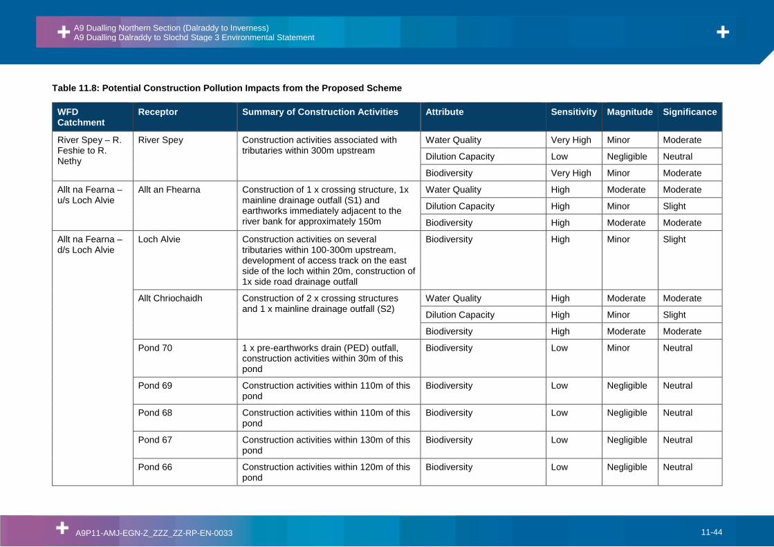
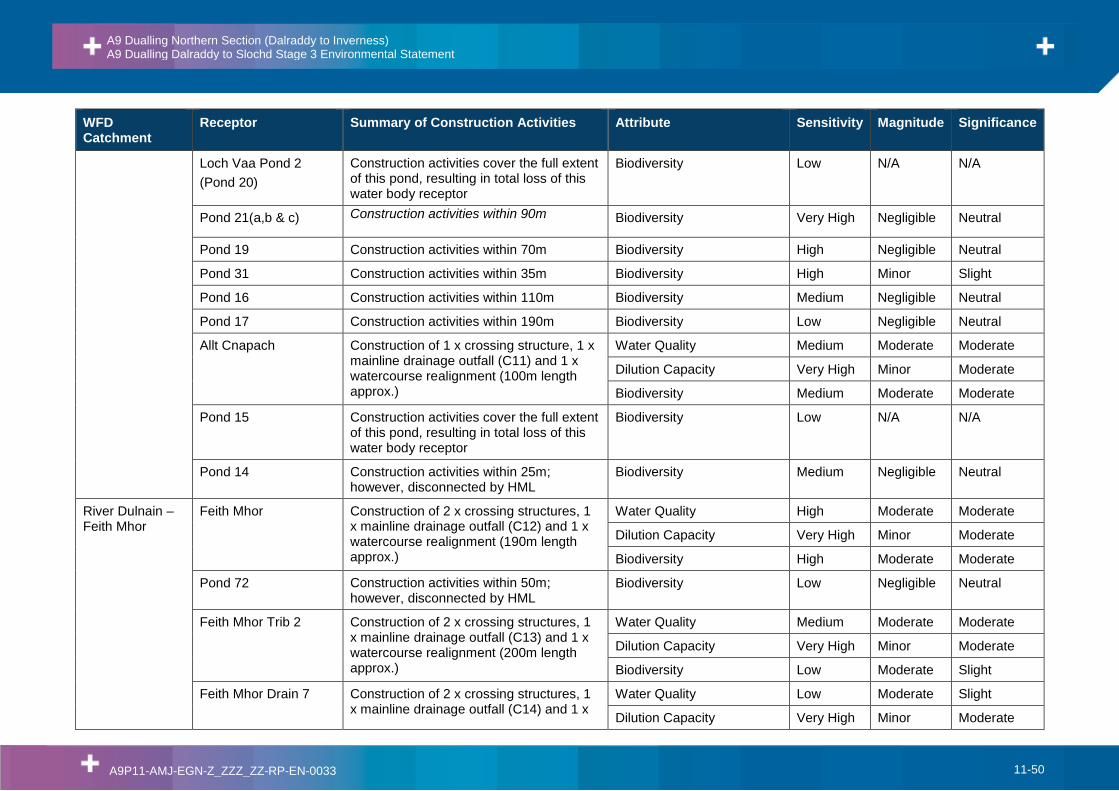
Construction Pollution
11.2.16. Evaluation of the potential for pollution of surface waters, as a result of spillage and of the release of sediments into watercourses or water bodies, has involved a review of areas where construction would be required within or in close proximity (i.e. within 50m) to watercourses and water bodies. The number of proposed permanent road drainage discharge structures, the number of watercourse crossings and the individual length of each watercourse realignment has been quantified for the Proposed Scheme alignment.
11.2.17. The sensitivity or importance of the surface waters has been evaluated qualitatively, as has the magnitude of impact of the Proposed on each water body (as set out further below).
Pollution from routine runoff
11.2.18. DMRB HD 45/09 specifies procedures for the assessment of pollution impacts from routine runoff on surface waters, known as ‘Method A’. It should be noted that Method C assessments are included within Chapter 10: Geology, Soils and Groundwater.
11.2.19. The Method A assessment comprises two separate elements:
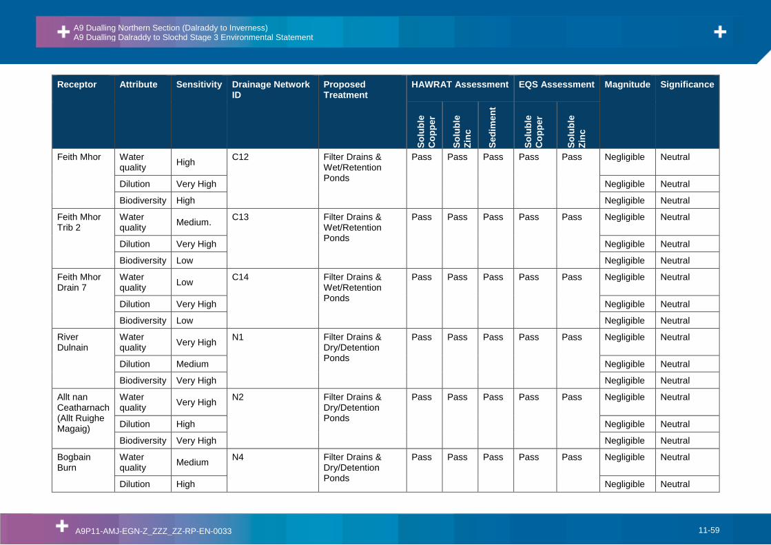
• HAWRAT Assessment: the Highways Agency Water Risk Assessment Tool (HAWRAT) is a Microsoft Excel application designed to assess the short-term risks related to the intermittent nature of road runoff. It assesses the acute and chronic pollution impacts on aquatic ecology associated with soluble and sediment bound pollutants, respectively; and
• EQS Assessment: Environmental Quality Standards (EQS) are the maximum permissible annual average concentrations of potentially hazardous chemicals, as defined under the WFD. The long-term risks over the period of one year are assessed through comparison of the annual average concentration of pollutants discharged with the published EQS for those pollutants.
11.2.20. To carry out these assessments a variety of baseline and drainage design information is required including: traffic volumes, areas of impermeable and permeable road surfaces to be drained, proposed treatment train, receiving watercourse dimensions and flow data, water hardness, presence of sensitive sites (considered as international / national designated conservation sites) and in-stream structures or features which may slow the flow.
A9 Dualling Northern Section (Dalraddy to Inverness) A9 Dualling Dalraddy to Slochd Stage 3 Environmental Statement
A9P11-AMJ-EGN-Z_ZZZ_ZZ-RP-EN-0033 11-7
11.2.21. In relation to the treatment train, preliminary road drainage design proposals were assessed assuming the proposed sustainable drainage systems included in the Stage 3 design are embedded mitigation (refer to Figure 5.2 Proposed Scheme Layout). Reference values for effectiveness of the various systems at removing various pollutants are based on treatment system reduction factors published in DMRB HD 33/16, further details on the values used are provided in Appendix 11.4.
11.2.22. The HAWRAT and EQS assessments apply to trunk roads with annual average traffic volumes greater than 10,000 vehicles/day. With modelled traffic volumes for the Proposed Scheme mainline ranging between 16,000 and 18,000 vehicles/day, HAWRAT and EQS assessments have therefore been carried out for each of the Proposed Scheme mainline and junction road drainage outfalls. Cumulative assessments have also been carried out where multiple outfalls discharge to a single reach of a watercourse.
11.2.23. For side roads and accommodations tracks, with local traffic flow volumes predicted to be less than 600 vehicle movements per day (with many routes having considerably lower predicted levels), the DMRB HD 45/09 Method A assessment was not deemed appropriate. Therefore, assessment of side road routine runoff has been carried out qualitatively on a case-by-case basis, taking into consideration site specific conditions, and with reference to the guidance provided in the CIRIA SuDS Manual, SCOTS SuDS for Roads and SEPA WAT-RM-08.
Pollution from Accidental Spillage
11.2.24. The DMRB document HD 45/09 specifies procedures for the assessment of pollution impacts from accidental spillage, known as Method D. A summary of the methodology is provided below, with full details provided in DMRB HD 45/09.
11.2.25. The assessment takes the form of a risk assessment, where the risk is expressed as the annual probability of a serious pollution incident occurring. This risk is the product of two probabilities:
• The probability that an accident will occur, resulting in a serious spillage of a polluting substance on the carriageway; and
• The probability that, if such a spillage did occur, the polluting substance would reach the receiving water body and cause a serious pollution incident.
11.2.26. The probability of a serious spillage occurring is dependent on a variety of factors; traffic volumes, percentage of heavy goods vehicles in the traffic volumes, whether the road is motorway, rural or urban trunk road, the road type categories within the road drainage catchment under assessment i.e. ‘no junction’, ‘slip road’, ‘cross road’ or ‘roundabout’ and the length of each road type within the catchment.
11.2.27. The probability of a serious spillage subsequently causing a serious pollution incident is dependent on the receiving surface water body and the response time of the emergency services, i.e. less than 20 minutes, less than one hour, or greater than one hour.
11.2.28. Typically an annual probability of 1% (i.e. a 1 in 100 chance of a serious pollution incident occurring in any one year) is considered by DMRB as an acceptable risk. However, where a road drainage outfall discharges within 1km of a sensitive receptor, (such as a nationally designated conservation site), a higher level of protection is required, such that the risk has no greater annual probability than 0.5% (i.e. a 1 in 200 chance of occurring in any one year).
A9 Dualling Northern Section (Dalraddy to Inverness) A9 Dualling Dalraddy to Slochd Stage 3 Environmental Statement
A9P11-AMJ-EGN-Z_ZZZ_ZZ-RP-EN-0033 11-8
11.2.29. Evaluation of the predicted effects has been undertaken for all proposed mainline drainage networks in accordance with the guidance provided in Annex IV of HD 45/09 and outlined in the Impact Assessment Criteria section below.
11.2.30. With regards to side road and accommodation track drainage, risk of pollution as a result of accidental spillage is considered to be very low due to the low traffic volumes anticipated. There is not, therefore, considered to be a significant impact in relation to accidental spillage from the Proposed Scheme side roads and access tracks.
Pollution from Road Salt
11.2.31. The DMRB does not provide a method for assessing the potential impacts of salt on the surface water environment. In the absence of an existing method for assessing salt concentrations in runoff and at the point of dilution, a simple and conservative risk-based model has been developed for use on all projects within the A9 Dualling Programme. This generally follows the approach taken by the HAWRAT method.
11.2.32. Full details of the salt assessment methodology and results are provided in Appendix 11.4.
11.2.33. It should be noted that the results of the salt assessment have not been included within the overall impact assessment for the Proposed Scheme due to there being no defined UK short-term EQS for Cl-, an absence of any methodology for assessing the impacts of salt within the DMRB guidance, and lack of published data on SuDS treatment efficiency of Cl-.
Alterations to Hydromorphological Regime
11.2.34. The hydromorphology assessment has involved a desk study and preliminary screening exercise to identify sensitive watercourses and locations where impacts from the Proposed Scheme were most likely.
11.2.35. The screening exercise was carried out for all watercourses identified as being crossed by the Proposed Scheme, in order to identify those which met the following broad set of criteria:
• The watercourse is a permanent flowing system with a channel width >1m; and,
• the watercourse is to be lost/culverted/diverted or potentially experience a substantial change in water quality or quantity; and,
• is not obviously canalised or heavily managed; or,
• is hydrologically linked to a designated water-dependent site.
11.2.36. Subsequently, a hydromorphological walkover survey was carried out to determine the specific character of the geomorphological forms and processes in each of these watercourses. Further details on the desk study, screening process and walkover survey are provided in Appendix 11.2 Hydromorphology Assessment.
11.2.37. The above information, in conjunction with data on the WFD status of the relevant water bodies, has been used in the evaluation of the sensitivity of the watercourses.
11.2.38. Locations of proposed watercourse crossing structures, watercourse diversions and outfalls associated with the Proposed Scheme have been reviewed. The magnitude of potential impacts on channel form and gradient, flow volumes and rates, and erosion and sedimentation processes has been evaluated qualitatively. Sediment entrainment
A9 Dualling Northern Section (Dalraddy to Inverness) A9 Dualling Dalraddy to Slochd Stage 3 Environmental Statement
A9P11-AMJ-EGN-Z_ZZZ_ZZ-RP-EN-0033 11-9
and stream power calculations were also undertaken based on the outputs from the flood risk assessment hydraulic models, providing additional context to the assessment.
11.2.39. As part of the Proposed Scheme, it has been anticipated that the design of structures and any diverted channels will incorporate standard good practice measures, considered as embedded design for this assessment.
11.2.40. It should be noted that the DMRB does not outline a specific methodology or guidance on the evaluation of hydromorphological impacts. Therefore, hydromorphological sensitivity and impact magnitude criteria have been developed based on guidance provided in the DEFRA/EA R&D Report FD1914 Guide Book of Fluvial Geomorphology.
Increased Flood Risk
11.2.41. The appraisal of flood risk impacts associated with the Proposed Scheme has considered:
• Increases in upstream water level caused by any restriction in flow;
• Loss of floodplain storage due to road infrastructure occupying areas which were previously available for flood storage or flows;
• Loss of floodplain conveyance due to road infrastructure crossing existing floodplain and forming a barrier to flow or modifying existing hydraulic links between channel and floodplain;
• Impediment of water flow caused by road infrastructure crossing existing drainage channels, causing potential blockage and altering local catchment area boundaries; and
• The diversion of watercourses and drains causing changes in catchment boundaries, channel flow capacities and floodplain storage.
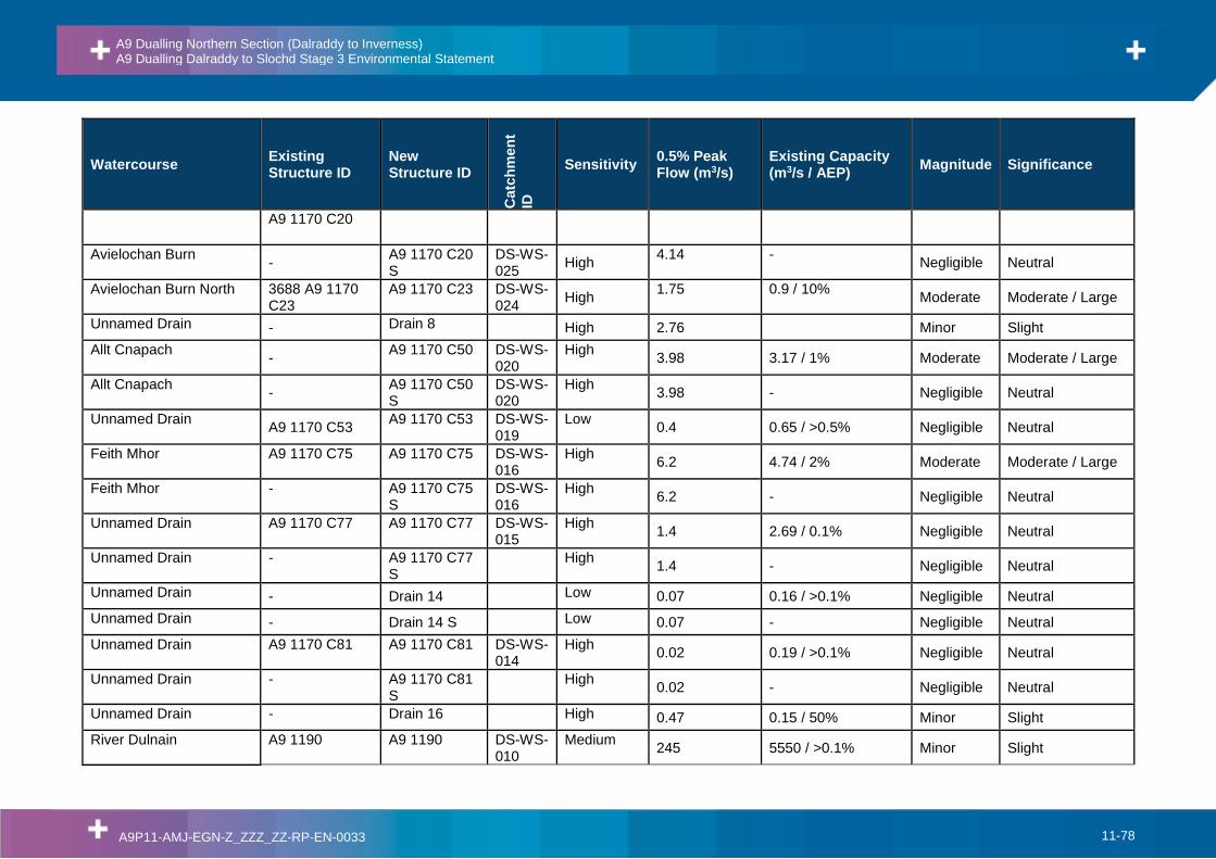
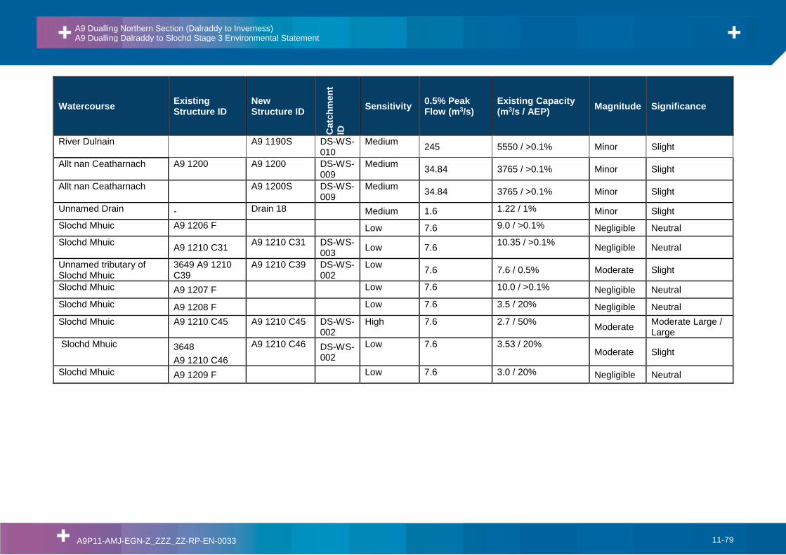
11.2.42. Existing watercourse crossings were identified from OS Mastermap data, Transport Scotland’s structures database and confirmed from site visit. Peak flows were derived for each watercourse crossing catchment using the methodologies outlined in the Flood Estimation Handbook and methods agreed with SEPA. The hydraulic capacities of each crossing have been calculated using unsteady state one dimensional (1D) hydraulic models.
11.2.43. A matrix has been developed using professional judgement to categorise the magnitude of the potential impact from increasing hydraulic capacity at existing watercourse crossings (Table 11.1) based on the scale of the change in flow and the size of the watercourse.
Table 11.1: Impact Magnitude of Changes to Flow Regime - Future Impact Matrix
Some potential for increasing DS flows if culvert is upsized.
<10% AEP
Significant potential for increasing DS flows if culvert is upsized.
Minor Moderate Major Major
11.2.44. The logic of Table 11.1 is that the magnitude of impact increases with the difference between the existing hydraulic capacity of a culvert and the 0.5% AEP flow and also with the magnitude of the 0.5% AEP flow.
11.2.45. Further details of the technical approach, parameters, modelling and proposed modelling can be found in Appendix 11.3 Flood Risk Assessment.
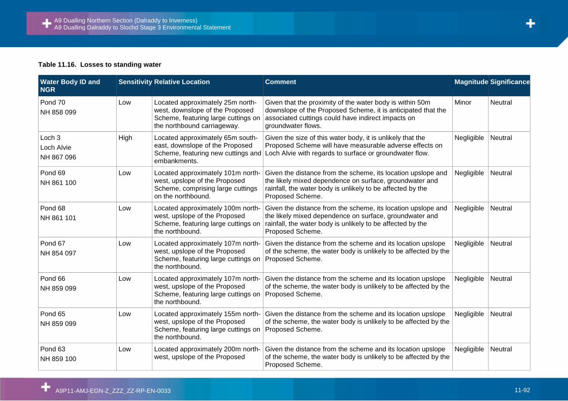
Loss or Change to Standing Water
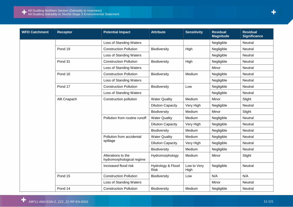
11.2.46. Direct loss of standing water under the footprint of the Proposed Scheme has been identified. Activities occurring close to standing water bodies can also cause indirect effects, interrupting flows feeding the local water body. Standing water bodies within 500m of the Proposed Scheme have were initially identified using OS 1:10,000 mapping and were considered alongside local topography in order to identify potential impacts. Further review identified that only those standing water bodies located within 250m of the Proposed Scheme are considered to have the potential to be impacted, with those outwith 250m considered to be disconnected by intervening distance and topography. Therefore, only those located within a distance of 250m of the Proposed Scheme have been considered further as part of this assessment.
11.2.47. The sensitivity or importance of standing waters have been evaluated qualitatively, with reference to the evaluation of a number of ponds in Chapter 12 Ecology and Nature Conservation, as has the magnitude of impact of the Proposed Scheme on each.
Loss or Change to Water Supplies
11.2.48. Public and private water abstraction information was provided in October 2015 by Scottish Water and The Highland Council, with a small number of owner-occupier consultations undertaken during DMRB Stage 2 and further consultation undertaken at DMRB Stage 3.
11.2.49. The quality of the private water supply data provided by The Highland Council was variable, with grid references and type of supply (i.e. surface water or groundwater source) missing for a small number of supplies. In such cases, consultation has led to confirmation of supply type and source location. It has resulted in the removal of some previously suspected supplies from this Stage 3 assessment, following confirmation by the resident or landowner as now being redundant and/or non-operational, and has also led to the inclusion of additional properties and supplies where identified.
11.2.50. Potential impacts on water supplies have been evaluated qualitatively based on the potential hydrological linkage and distance between the construction areas of the Proposed Scheme and the water supply sources.
A9 Dualling Northern Section (Dalraddy to Inverness) A9 Dualling Dalraddy to Slochd Stage 3 Environmental Statement
A9P11-AMJ-EGN-Z_ZZZ_ZZ-RP-EN-0033 11-11
Impact Assessment Criteria
Magnitude of Impact
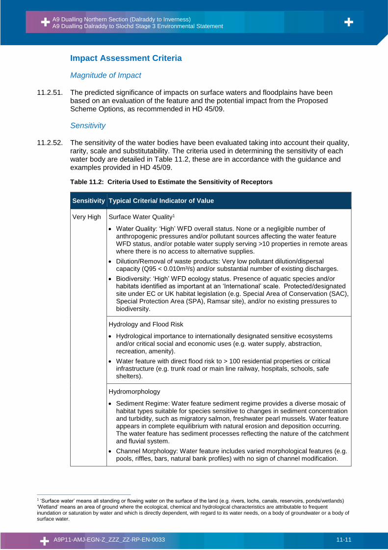
11.2.51. The predicted significance of impacts on surface waters and floodplains have been based on an evaluation of the feature and the potential impact from the Proposed Scheme Options, as recommended in HD 45/09.
Sensitivity
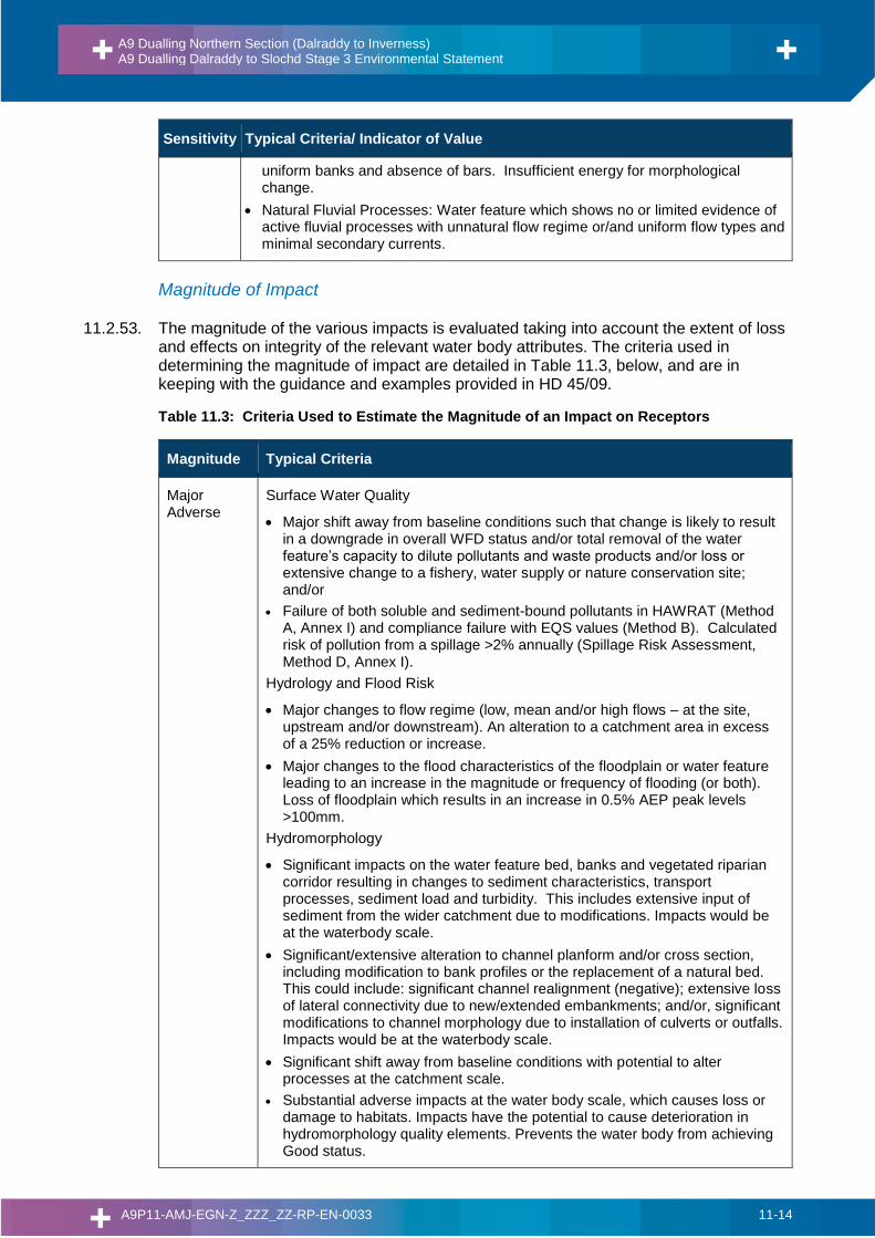
11.2.52. The sensitivity of the water bodies have been evaluated taking into account their quality, rarity, scale and substitutability. The criteria used in determining the sensitivity of each water body are detailed in Table 11.2, these are in accordance with the guidance and examples provided in HD 45/09.
Table 11.2: Criteria Used to Estimate the Sensitivity of Receptors
Sensitivity Typical Criteria/ Indicator of Value
Very High Surface Water Quality1
• Water Quality: ‘High’ WFD overall status. None or a negligible number of anthropogenic pressures and/or pollutant sources affecting the water feature WFD status, and/or potable water supply serving >10 properties in remote areas where there is no access to alternative supplies.
• Dilution/Removal of waste products: Very low pollutant dilution/dispersal capacity (Q95 < 0.010m³/s) and/or substantial number of existing discharges.
• Biodiversity: ‘High’ WFD ecology status. Presence of aquatic species and/or habitats identified as important at an ‘International’ scale. Protected/designated site under EC or UK habitat legislation (e.g. Special Area of Conservation (SAC), Special Protection Area (SPA), Ramsar site), and/or no existing pressures to biodiversity.
Hydrology and Flood Risk
• Hydrological importance to internationally designated sensitive ecosystems and/or critical social and economic uses (e.g. water supply, abstraction, recreation, amenity).
• Water feature with direct flood risk to > 100 residential properties or critical infrastructure (e.g. trunk road or main line railway, hospitals, schools, safe shelters).
Hydromorphology
• Sediment Regime: Water feature sediment regime provides a diverse mosaic of habitat types suitable for species sensitive to changes in sediment concentration and turbidity, such as migratory salmon, freshwater pearl mussels. Water feature appears in complete equilibrium with natural erosion and deposition occurring. The water feature has sediment processes reflecting the nature of the catchment and fluvial system.
• Channel Morphology: Water feature includes varied morphological features (e.g. pools, riffles, bars, natural bank profiles) with no sign of channel modification.
1 ‘Surface water’ means all standing or flowing water on the surface of the land (e.g. rivers, lochs, canals, reservoirs, ponds/wetlands) ‘Wetland’ means an area of ground where the ecological, chemical and hydrological characteristics are attributable to frequent inundation or saturation by water and which is directly dependent, with regard to its water needs, on a body of groundwater or a body of surface water.
A9 Dualling Northern Section (Dalraddy to Inverness) A9 Dualling Dalraddy to Slochd Stage 3 Environmental Statement
A9P11-AMJ-EGN-Z_ZZZ_ZZ-RP-EN-0033 11-12
Sensitivity Typical Criteria/ Indicator of Value
• Natural Fluvial Processes: Water feature displays natural fluvial processes and natural flow regime, which would be highly vulnerable to change as a result of modification.
High Surface Water Quality
• Water Quality: ‘Good’ WFD overall status. A small number of anthropogenic pressures and/or pollutant sources that do not significantly affect the water feature WFD status and/or potable water supplies serving < 10 properties in remote areas where there is no access to alternative supplies and/ or use of water for extensive agricultural purposes.
• Dilution/Removal of waste products: Moderate pollutant dilution/dispersal capacity (Q95 = 0.01m³/s – 0.1m³/s) and/or several existing discharges at the waterbody scale.
• Biodiversity: ‘Good’ WFD ecology status. Presence of aquatic species and/or habitats identified as important at a ‘National’ scale. Protected/designated site under EC or UK legislation (SAC, SPA, Ramsar, SPA, SSSI) and few existing pressures to biodiversity.
Hydrology and Flood Risk
• Hydrological importance to nationally designated ecosystems and/or locally important social and economic uses (e.g. water supply, abstraction recreations, and amenity).
• Water feature with direct flood risk to 1 -100 residential properties, >10 industrial premises, and/or other land use of high value or indirect flood risk to critical infrastructure.
Hydromorphology
• Sediment Regime: Water feature sediment regime provides habitats suitable for species sensitive to changes in sediment concentration and turbidity, such as migratory salmon, freshwater pearl mussels. Water feature appears largely in natural equilibrium with some localised accelerated erosion and/or deposition caused by land use and/or modifications. Primarily the sediment regime reflects the nature of the natural catchment and fluvial system.
• Channel Morphology: Water feature exhibiting a natural range of morphological features (e.g. pools, riffles, bars, varied natural river bank profiles), with limited signs of artificial modifications or morphological pressures.
• Natural Fluvial Processes: Predominantly natural water feature with a diverse range of fluvial processes that is highly vulnerable to change as a result of modification.
Medium Surface Water Quality
• Water Quality: ‘Moderate’ WFD overall status or not classified by SEPA. Likely to have deteriorated in water quality as a result of anthropogenic pressures and/or pollutant sources and/or potable water supplies, located within the vicinity of a mains water supply and/ or supplies used only for local agricultural purposes.
• Dilution/Removal of waste products: High pollutant dilution and dispersal capacity (Q95 =0.1m³/s – 1m³/s) and/or a small number of existing discharges at the waterbody scale. Biodiversity: ‘Moderate’ WFD ecology status. Presence of aquatic species and/or habitats identified as important at a ‘Local’, ‘Authority Area’, or ‘Regional’ scale. Likely to exhibit a limited number of regional designated ecosystems and/or existing pressures which are likely to be affecting biodiversity.
A9 Dualling Northern Section (Dalraddy to Inverness) A9 Dualling Dalraddy to Slochd Stage 3 Environmental Statement
A9P11-AMJ-EGN-Z_ZZZ_ZZ-RP-EN-0033 11-13
Sensitivity Typical Criteria/ Indicator of Value
• Biodiversity: ‘Moderate’ WFD ecology status. Likely to exhibit a limited number of regionally designated ecosystems and/or existing pressures which are likely to be affecting biodiversity.
Hydrology and Flood Risk
• Some but limited hydrological importance to sensitive ecosystems and/or social and economic uses.
• Water feature with direct flood risk to recreational land or high value agriculture (e.g. arable land, pastures, complex cultivation patterns and agro-forestry) and/or affecting < 10 industrial premises.
Hydromorphology
• Sediment Regime: Water feature sediment regime provides some habitat suitable for species sensitive to change in suspended sediment concentrations or turbidity. A water feature with natural processes occurring but modified, which causes notable alteration to the natural sediment transport pathways, sediment sources and areas of deposition.
• Channel Morphology: Water feature exhibiting some morphological features (e.g. pools, riffles and depositional bars). The channel cross-section is partially modified in places, with obvious signs of modification to the channel morphology. Natural recovery of channel form may be present (e.g. eroding cliffs, depositional bars).
• Natural Fluvial Processes: Water feature with some natural fluvial processes, including varied flow types. Modifications and anthropogenic influences having an obvious impact on natural flow regime, flow pathways and fluvial processes.
Low Surface Water Quality
• Water Quality: ‘Poor/Bad’ WFD overall status or not classified by SEPA. Highly likely to be affected by anthropogenic pressures and/or pollution sources and/or heavily engineered or artificially modified features (e.g. Road and field drains, and ephemeral features) and/or not used for water supplies.
• Dilution/Removal of waste products: Very High pollutant dilution and dispersal capacity (>1m³/s) and/or none or negligible existing discharges at the waterbody scale.
• Biodiversity: ‘Poor/Bad’ WFD ecology status. No habitats/species of conservation and/or any existing pressures which are considered to be adversely affecting biodiversity. Areas considered to be of ‘Less than Local’ importance.
Hydrology and Flood Risk
• Minimal hydrological importance to sensitive ecosystems and/or social and economic uses.
• Water feature with little or no flood risk, affecting low value agricultural land (e.g. rough grazing land).
Hydromorphology
• Sediment Regime: Water feature sediment regime which provides very limited physical habitat for species sensitive to changes in suspended solids concentration or turbidity. Highly modified sediment regime with limited/no capacity for natural recovery.
• Channel Morphology: Water feature that has been extensively modified (e.g. by culverting, addition of bank protection or impoundments) and exhibits limited-to-no morphological diversity. The water feature is likely to have uniform flow,
A9 Dualling Northern Section (Dalraddy to Inverness) A9 Dualling Dalraddy to Slochd Stage 3 Environmental Statement
A9P11-AMJ-EGN-Z_ZZZ_ZZ-RP-EN-0033 11-14
Sensitivity Typical Criteria/ Indicator of Value
uniform banks and absence of bars. Insufficient energy for morphological change.
• Natural Fluvial Processes: Water feature which shows no or limited evidence of active fluvial processes with unnatural flow regime or/and uniform flow types and minimal secondary currents.
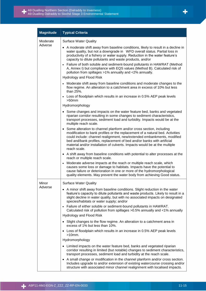
Magnitude of Impact
11.2.53. The magnitude of the various impacts is evaluated taking into account the extent of loss and effects on integrity of the relevant water body attributes. The criteria used in determining the magnitude of impact are detailed in Table 11.3, below, and are in keeping with the guidance and examples provided in HD 45/09.
Table 11.3: Criteria Used to Estimate the Magnitude of an Impact on Receptors
Magnitude Typical Criteria
Major Adverse
Surface Water Quality
• Major shift away from baseline conditions such that change is likely to result in a downgrade in overall WFD status and/or total removal of the water feature’s capacity to dilute pollutants and waste products and/or loss or extensive change to a fishery, water supply or nature conservation site; and/or
• Failure of both soluble and sediment-bound pollutants in HAWRAT (Method A, Annex I) and compliance failure with EQS values (Method B). Calculated risk of pollution from a spillage >2% annually (Spillage Risk Assessment, Method D, Annex I).
Hydrology and Flood Risk
• Major changes to flow regime (low, mean and/or high flows – at the site, upstream and/or downstream). An alteration to a catchment area in excess of a 25% reduction or increase.
• Major changes to the flood characteristics of the floodplain or water feature leading to an increase in the magnitude or frequency of flooding (or both). Loss of floodplain which results in an increase in 0.5% AEP peak levels >100mm.
Hydromorphology
• Significant impacts on the water feature bed, banks and vegetated riparian corridor resulting in changes to sediment characteristics, transport processes, sediment load and turbidity. This includes extensive input of sediment from the wider catchment due to modifications. Impacts would be at the waterbody scale.
• Significant/extensive alteration to channel planform and/or cross section, including modification to bank profiles or the replacement of a natural bed. This could include: significant channel realignment (negative); extensive loss of lateral connectivity due to new/extended embankments; and/or, significant modifications to channel morphology due to installation of culverts or outfalls. Impacts would be at the waterbody scale.
• Significant shift away from baseline conditions with potential to alter processes at the catchment scale.
• Substantial adverse impacts at the water body scale, which causes loss or damage to habitats. Impacts have the potential to cause deterioration in hydromorphology quality elements. Prevents the water body from achieving Good status.
A9 Dualling Northern Section (Dalraddy to Inverness) A9 Dualling Dalraddy to Slochd Stage 3 Environmental Statement
A9P11-AMJ-EGN-Z_ZZZ_ZZ-RP-EN-0033 11-15
Magnitude Typical Criteria
Moderate Adverse
Surface Water Quality
• A moderate shift away from baseline conditions, likely to result in a decline in water quality, but not a downgrade in WFD overall status. Partial loss in productivity of a fishery or water supply. Reduction in the water feature’s capacity to dilute pollutants and waste products, and/or
• Failure of both soluble and sediment-bound pollutants in HAWRAT (Method A, Annex I) but compliance with EQS values (Method B). Calculated risk of pollution from spillages >1% annually and <2% annually.
Hydrology and Flood Risk
• Moderate shift away from baseline conditions and moderate changes to the flow regime. An alteration to a catchment area in excess of 10% but less than 25%.
• Loss of floodplain which results in an increase in 0.5% AEP peak levels >50mm
Hydromorphology
• Some changes and impacts on the water feature bed, banks and vegetated riparian corridor resulting in some changes to sediment characteristics, transport processes, sediment load and turbidity. Impacts would be at the multiple reach scale.
• Some alteration to channel planform and/or cross section, including modification to bank profiles or the replacement of a natural bed. Activities could include: channel realignment, new/extended embankments, modified bed and/bank profiles, replacement of bed and/or banks with artificial material and/or installation of culverts. Impacts would be at the multiple reach scale.
• A shift away from baseline conditions with potential to alter processes at the reach or multiple reach scale.
• Moderate adverse impacts at the reach or multiple reach scale, which causes some loss or damage to habitats. Impacts have the potential to cause failure or deterioration in one or more of the hydromorphological quality elements. May prevent the water body from achieving Good status.
Minor Adverse
Surface Water Quality
• A minor shift away from baseline conditions. Slight reduction in the water feature’s capacity to dilute pollutants and waste products. Likely to result in a slight decline in water quality, but with no associated impacts on designated species/habitats or water supply; and/or
• Failure of either soluble or sediment-bound pollutants in HAWRAT. Calculated risk of pollution from spillages >0.5% annually and <1% annually
Hydrology and Flood Risk
• Slight changes to the flow regime. An alteration to a catchment area in excess of 1% but less than 10%.
• Loss of floodplain which results in an increase in 0.5% AEP peak levels >10mm.
Hydromorphology
• Limited impacts on the water feature bed, banks and vegetated riparian corridor resulting in limited (but notable) changes to sediment characteristics, transport processes, sediment load and turbidity at the reach scale.
• A small change or modification in the channel planform and/or cross section. Includes upgrade to and/or extension of existing watercourse crossing and/or structure with associated minor channel realignment with localised impacts.
A9 Dualling Northern Section (Dalraddy to Inverness) A9 Dualling Dalraddy to Slochd Stage 3 Environmental Statement
A9P11-AMJ-EGN-Z_ZZZ_ZZ-RP-EN-0033 11-16
Magnitude Typical Criteria
• Minimal shift away from baseline conditions with typically localised impacts up to the reach scale.
• Minor adverse impacts at the reach scale, which may cause partial loss or damage to habitats. Impacts have the potential to cause failure or deterioration in one of the hydromorphological quality elements.
Negligible Surface Water Quality
• No perceptible changes to baseline conditions. No measurable change in water quality. No change in the water feature’s capacity to dilute pollutants and waste products; and/or
• No risk identified by HAWRAT. Risk of pollution from spillages <0.5%
Hydrology and Flood Risk
• Negligible changes to the flow regime (i.e. changes that are within the monitoring errors). An alteration to a catchment area of less than 1% reduction in area.
• Negligible increase in peak flood level (Increase in 0.5% AEP peak levels <10mm).
Hydromorphology
• Minimal or no measurable change from baseline conditions in terms of sediment transport, channel morphology and natural fluvial processes. Any impacts are likely to be highly localised and not have an effect at the reach scale.
Minor Beneficial
Surface Water Quality
• Minor improvement over baseline conditions, with the potential to facilitate: a slight increase in the water features capacity to dilute pollutants or waste products, a slight improvement in the productivity of a fishery or water supply and/or
Hydrology and Flood Risk:
• Moderate improvement over baseline conditions involving a reduction in 0.5% AEP peak flood level >10mm
Hydromorphology
• Partial improvement to sediment processes at the reach scale, including reduction in siltation and localised recovery of sediment transport processes.
• Partial improvements include enhancements to in-channel habitat, riparian zone and morphological diversity of the bed and/or banks.
• Slight improvement on baseline conditions with potential to improve flow processes at the reach scale.
• Slight beneficial impacts at the reach scale, which may cause partial habitat enhancement. Impacts have the potential to improve one of the hydromorphological quality elements.
Moderate Beneficial
Surface Water Quality
• A moderate improvement over baseline conditions with the potential to facilitate: an upgrade in individual WFD quality elements, moderate increase in the water features capacity to dilute pollutants or waste products, a moderate improvement in the productivity of a fishery or water supply and/or
Hydrology and Flood Risk
• Moderate improvement over baseline conditions involving a reduction in 0.5% AEP peak flood level >50mm
Hydromorphology
A9 Dualling Northern Section (Dalraddy to Inverness) A9 Dualling Dalraddy to Slochd Stage 3 Environmental Statement
A9P11-AMJ-EGN-Z_ZZZ_ZZ-RP-EN-0033 11-17
Magnitude Typical Criteria
• Reduction in siltation and recovery of sediment transport processes at the reach or multiple reach scale.
• Partial creation of both in-channel and vegetated riparian habitat. Improvement in morphological diversity of the bed and/or banks at the reach or multiple reach scale. Includes partial or complete removal of structures and/or artificial materials.
• Notable improvements on baseline conditions and recovery of fluvial processes at the reach or multiple reach scale.
• Notable beneficial impacts at the reach to multiple reach scale. Impacts have the potential to improve one or more of the hydromorphological quality elements and/or assist the water body in achieving Good status.
Major Beneficial
Surface Water Quality
• Major improvement over baseline conditions with the potential to facilitate: an upgrade in WFD overall status, substantial increase in the water features capacity to dilute pollutants or waste products, a substantial improvement in the productivity of a fishery or water supply; and/or
• Removal of existing polluting discharge, or removing the likelihood of polluting discharges occurring to a watercourse
Hydrology and Flood Risk:
• Moderate improvement over baseline conditions involving a reduction in 0.5% AEP peak flood level >100mm
Hydromorphology
• Improvement to sediment processes at the catchment scale, including recovery of sediment supply and transport processes.
• Extensive creation of both in-channel habitat and riparian zone. Morphological diversity of the bed and/or banks is restored, such as natural planform, varied natural cross-sectional profiles, recovery of fluvial features (e.g. cascades, pools, riffles, bars) expected for river type. Removal of modifications, structures, and artificial materials.
• Substantial improvement on baseline conditions at catchment scale. Recovery of flow and sediment regime.
• Substantial beneficial impacts at the catchment scale, which result in recovery/restoration of natural habitats suitable for supporting sensitive species. Potential improvement of overall status condition, which could lead to achieving Good status.
Impact Significance
11.2.54. The estimation of the impact significance has been arrived at by combining the estimated sensitivity of the affected water bodies and the magnitude of the impacts as indicated in Table 11.4, following the guidance provided in HD 45/09. Where the significance is shown as being one of two alternatives a single description is provided based upon reasoned judgement. Impact significance can be adverse or beneficial.
Table 11.4: Criteria Used to Estimate the Significance of Potential Effects
Sensitivity Magnitude of Impact
Major Moderate Minor Negligible
Very High Very Large Large / Very Large Moderate / Large Neutral
High Large / Very Large Moderate / Large Slight / Moderate Neutral
A9 Dualling Northern Section (Dalraddy to Inverness) A9 Dualling Dalraddy to Slochd Stage 3 Environmental Statement
A9P11-AMJ-EGN-Z_ZZZ_ZZ-RP-EN-0033 11-18
Sensitivity Magnitude of Impact
Major Moderate Minor Negligible
Medium Large Moderate Slight Neutral
Low Slight / Moderate Slight Neutral Neutral
Limitations of the Assessment
11.2.55. This assessment has relied upon the accuracy and level of detail of the documented data sources. For instance, the identification of water bodies and current characteristics has involved reference to Scotland’s Environment and SEPA websites for RBMPs and associated WFD water body information. The datasets are updated annually and the latest available information (2016) has been included.
11.2.56. With regards to the routine runoff assessment, use of HAWRAT presents several limitations. Firstly, a rainfall site must be selected from an embedded list of 21 sites across the UK, with only three located in Scotland. The closest and most geographically similar rainfall site is Ardtalnaig (near Aberfeldy). The annual average rainfall at Ardtalnaig is reported as being 1402mm while the annual average rainfall within the study area is approximately 1012mm (based on the River Dulnain at Balnaan Bridge NRFA catchment). There is therefore potential for overestimation of flows within the receiving watercourses and from the road drainage networks. Additionally, HAWRAT uses two-way Annual Average Daily Traffic (AADT) volumes in the estimation of pollutant build-up on the road, where AADT data is entered in broad bands of 10,000 to 50,000, 50,000 to 100,000, and >100,000. Given that the volumes of traffic estimated for the Proposed Scheme (16,000-18,000 AADT) are at the lower end of the lowest traffic band it is likely that there is overestimation of the pollutant concentrations in the road runoff. Finally, the required treatment percentages returned by HAWRAT are very precise, however, the guidance on the treatment efficiency of SuDS provided in HD 33/16 can only be used as broad indicator of performance. Therefore, a degree of pragmatism is required when designing and assessing the road drainage system; the treatment train should be sufficient to reasonably treat runoff.
11.2.57. In addition to the limitations associated with HAWRAT as outlined above, it should be noted that there is no direct linkage between the results and current or targeted WFD objectives. In order to be certain of the direction of impact (adverse/beneficial) it would be necessary to carry out a baseline HAWRAT assessment of the existing drainage system and compare the existing and proposed scenarios. However as there is no formal collection system or outfalls from the existing drainage this is not possible. Notwithstanding this, the fact that the existing drainage system provides no treatment, while the Proposed Scheme has committed to two levels of treatment for each network as a minimum provides an adequate level of certainty that there will be no adverse impacts associated with the proposed drainage discharges.
11.2.58. The results of the hydromorphology walkover are based on a fluvial geomorphological walkover rather than a full fluvial audit approach, supplemented by desk study information and aerial imagery. This was approach was deemed as appropriate based on the relatively small watercourses being surveyed and considering the likely impacts resulting from the Proposed Scheme. The findings of the walkover are focussed around the immediate vicinity of the Proposed Scheme crossings and are not broken into reaches, except for those sections immediately upstream and downstream of the existing A9 crossing locations. Where possible a minimum of 250m upstream and downstream was surveyed; however, where this was not possible due to access restrictions, spot checks were taken at accessible locations upstream and downstream in order to establish a sufficient understanding of the watercourse processes and sensitivity.
A9 Dualling Northern Section (Dalraddy to Inverness) A9 Dualling Dalraddy to Slochd Stage 3 Environmental Statement
A9P11-AMJ-EGN-Z_ZZZ_ZZ-RP-EN-0033 11-19
11.2.59. The watercourse features and processes observed may vary over time/seasons and high flow events. Overall watercourse function and stability were inferred through professional judgement and the interpretation of features on site. The Proposed Scheme will be subject to a subsequent detailed design, undertaken by the appointed contractor, therefore the precise nature of the impacts on the watercourses are potentially subject to change. In all cases a precautionary approach has been adopted for the assessment.
11.2.60. The balance of surface water and groundwater influence on standing water bodies is not certain. Therefore, indirect impacts as a result of changes to hydrological catchments, such as drainage of ponds is not fully known. In all cases the worst case scenario has been considered and assessed.
11.2.61. Information on public and private water supplies has been provided by Scottish Water and The Highland Council, respectively. It is recognised that private water supply data may not have been accurately registered for all local properties, with limited information provided relating to current use, source type and source locations. Detailed consultation with a number of owner-occupiers has been carried out as part of both DMRB Stage 2 and Stage 3 to confirm location and use of water supplies within the scheme area, including properties suspected to be fed by private water supply, which are not registered with The Highland Council.
11.2.62. The accuracy of hydraulic modelling is primarily dependent on the quality of hydrological and topographical data. Key factors include the resolution of the topographic data, the accuracy of surveys of hydraulic structures, the availability of data on past flooding and the limitations of the modelling software. SEPA and EA guidance advises that model accuracy is site specific and recommends that modellers use sensitivity analysis to assess model accuracy. Model accuracy is considered as a part of the flood risk assessment.
11.3. Baseline Conditions
11.3.1. Due to the large number of water environment receptors associated with the Proposed Scheme much of the detailed baseline information has been collated in Appendix 11.1 Baseline Conditions. This appendix provides detailed information on the following aspects of the water environment of the study area:
• Rainfall;
• Surface water catchment and channel descriptions;
• Surface water flows;
• Standing waters;
• Water quality; and
• Water supplies, abstractions and discharges, including:
• Public water supplies;
• Private water supplies;
• SEPA CAR registered abstractions and discharges; and
• Existing road drainage discharges.
11.3.2. Detailed baseline information on the hydromorphology and flood risk of the watercourses within the study area is documented in Technical Appendices 11.2 and 11.3, respectively.
A9 Dualling Northern Section (Dalraddy to Inverness) A9 Dualling Dalraddy to Slochd Stage 3 Environmental Statement
A9P11-AMJ-EGN-Z_ZZZ_ZZ-RP-EN-0033 11-20
11.3.3. A brief overview of the baseline conditions is provided below, complete with a summary table of all potential receptors, their assessed sensitivity for a variety of attributes and brief details of the justification for those sensitivity ratings.
Overview
11.3.4. Within the Study Area, the existing A9 has approximately 70 watercourse crossings including bridges, culverts and drainage pipes, which have been identified using existing as-built information and subsequent surveys of structures and watercourses. At the crossing points the watercourses are generally typical of rural upland watercourses, exhibiting fast, shallow flow, moderate to steep gradients and a flashy response to rainfall events.
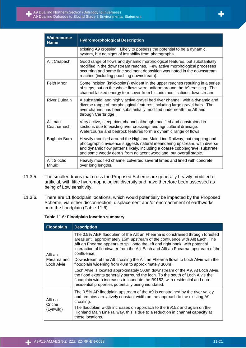
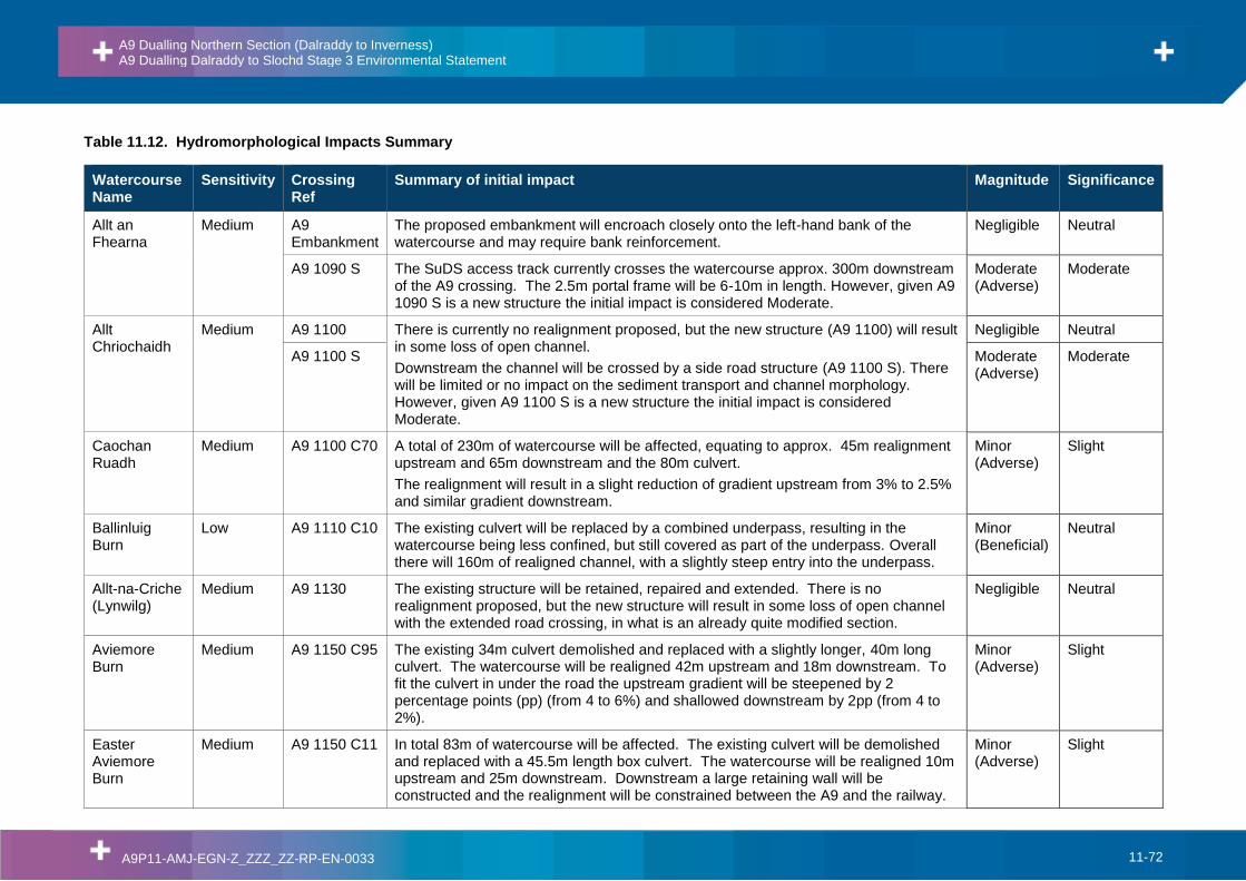
Table 11.5: Watercourse hydromorphology summary
Watercourse Name
Hydromorphological Description
Allt an Fhearna The watercourse has a diverse range of morphological processes and features (including large gravel deposits, steps, large wood and bank erosion). It has been historically modified (straightened) and is constrained underneath and alongside the existing A9.
Allt Chriochaidh
Channel possesses a diverse range of morphological forms and processes, with the downstream reaches shown to be able to partially laterally adjust the planform. Modifications are substantial, but limited to the existing A9 crossing.
Caochan Ruadh
The channel has been historically modified around the existing crossing and along the upper reaches, but does possess some geomorphic diversity, particularly upstream with a steep step-pool bedrock system evident.
Ballinluig Burn Modified and constrained watercourse, with uniform flows (heavily vegetated in-channel) and little morphological diversity evident.
Allt-na-Criche (Lynwilg)
Morphologically diverse in the upper reaches, with large gravel bars. Substantially modified adjacent to Lynwilg properties (gabion bank protection) and through the existing A9 and railway crossing (straightened and widened). However, there are signs of recovery underneath the A9 as the channel is shown to be narrowing through deposition of coarse substrate.
Aviemore Burn Diverse watercourse throughout with a good range of flows and morphological features, however substantially constrained through recently constructed housing estate and existing crossings.
Easter Aviemore Burn
Some lengths possess diverse morphology especially in the upper reaches with step sequences common and clean coarse gravel substrate. However, overall the watercourse has historically been modified for residential and agricultural drainage purposes. Minor fine sediment deposition was noted on the downstream reaches where flow energy was reduced.
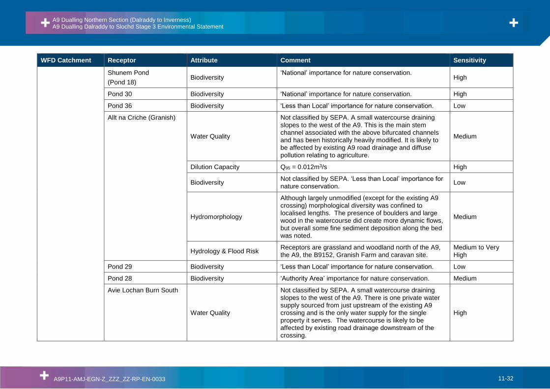
Allt na Criche (Granish)
Although largely unmodified (except for the existing A9 crossing) morphological diversity was confined to localised lengths. The presence of boulders and large wood in the watercourse did create more dynamic flows, but overall some fine sediment deposition along the bed was noted.
Avie Lochan Burn South
Vast variety of morphological features, including high energy step-pool system in the upstream and meandering planform in the downstream. Heavily modified over short distance around existing A9 crossing.
Avie Lochan Burn North
A variety of morphological features, including step-pool system and meandering planform likely to exist upstream. Heavily modified around
A9 Dualling Northern Section (Dalraddy to Inverness) A9 Dualling Dalraddy to Slochd Stage 3 Environmental Statement
A9P11-AMJ-EGN-Z_ZZZ_ZZ-RP-EN-0033 11-21
Watercourse Name
Hydromorphological Description
existing A9 crossing. Likely to possess the potential to be a dynamic system, but no signs of instability from photographs.
Allt Cnapach Good range of flows and dynamic morphological features, but substantially modified in the downstream reaches. Few active morphological processes occurring and some fine sediment deposition was noted in the downstream reaches (including poaching downstream).
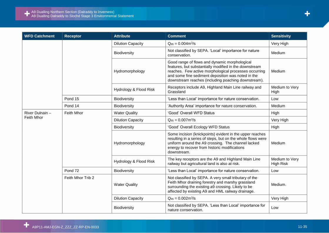
Feith Mhor Some incision (knickpoints) evident in the upper reaches resulting in a series of steps, but on the whole flows were uniform around the A9 crossing. The channel lacked energy to recover from historic modifications downstream.
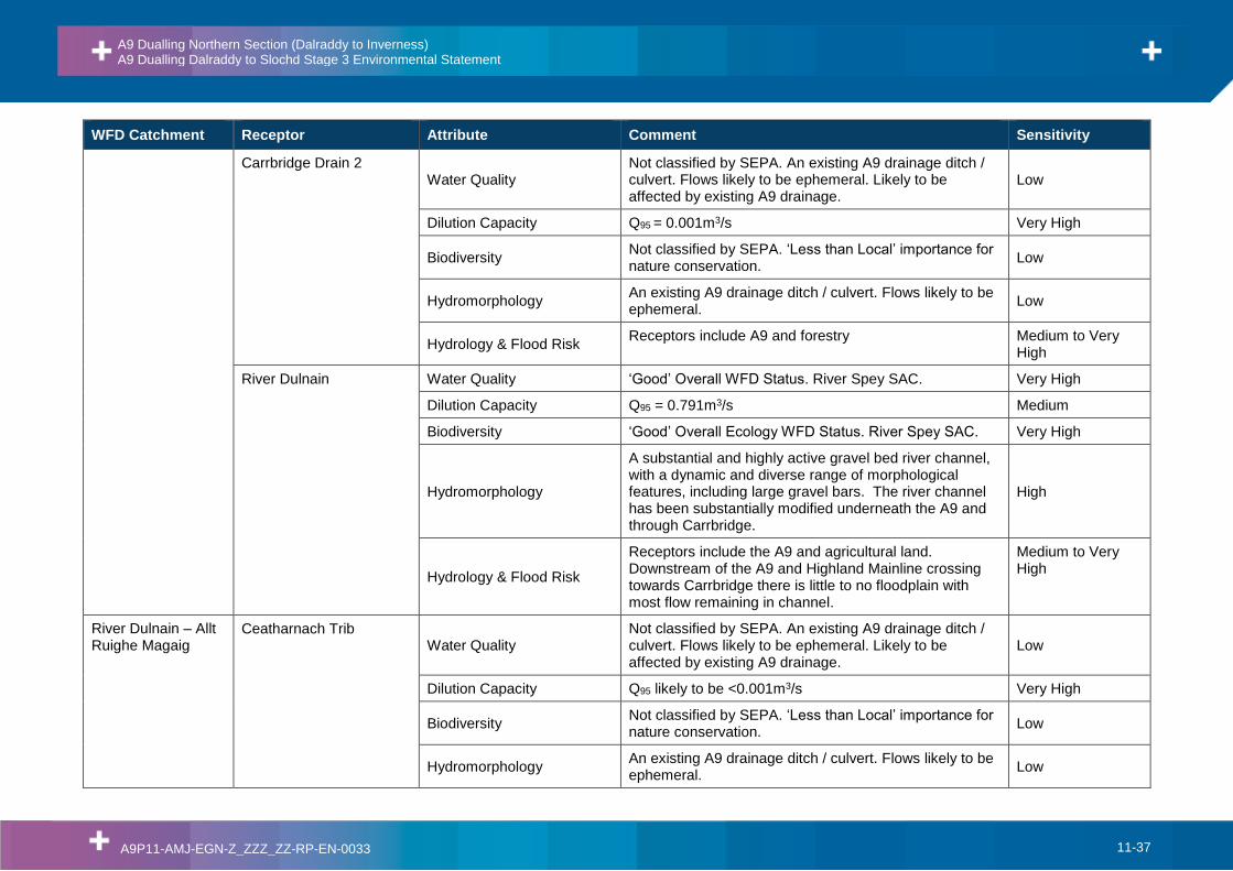
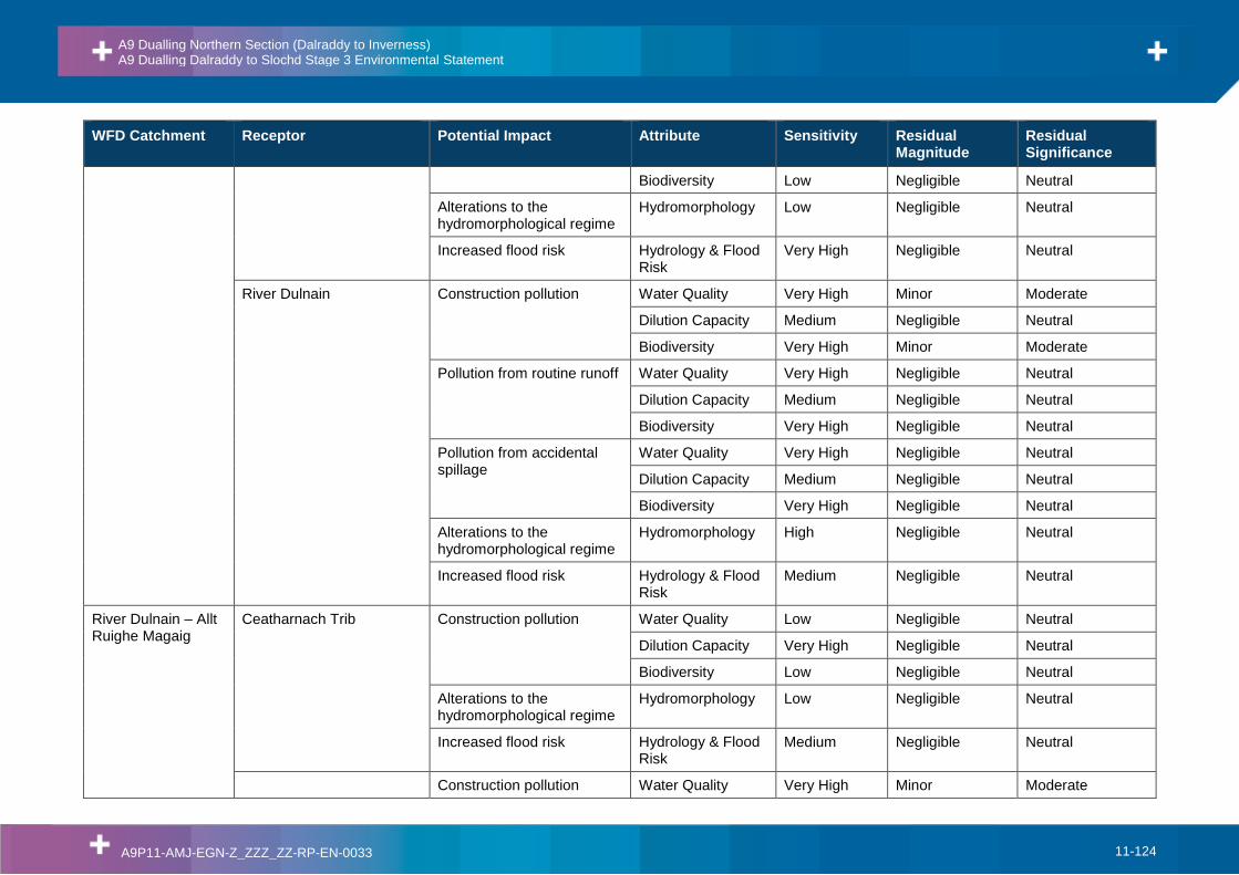
River Dulnain A substantial and highly active gravel bed river channel, with a dynamic and diverse range of morphological features, including large gravel bars. The river channel has been substantially modified underneath the A9 and through Carrbridge.
Allt nan Ceatharnach
Very active, steep river channel although modified and constrained in sections due to existing river crossings and agricultural drainage. Watercourse and bedrock features form a dynamic range of flows.
Bogbain Burn Heavily modified around the Highland Main Line Railway, but mapping and photographic evidence suggests natural meandering upstream, with diverse and dynamic flow patterns likely, including a coarse cobble/gravel substrate and some woody debris from adjacent woodland, but overall stable.
Allt Slochd Mhuic
Heavily modified channel culverted several times and lined with concrete over long lengths.
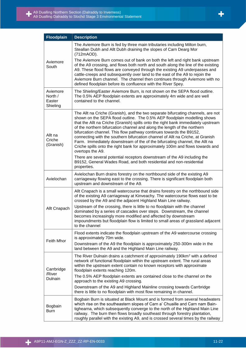
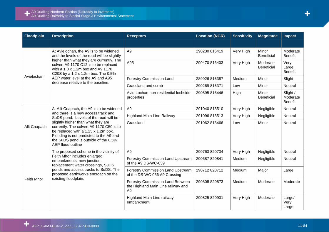
11.3.5. The smaller drains that cross the Proposed Scheme are generally heavily modified or artificial, with little hydromophological diversity and have therefore been assessed as being of Low sensitivity.
11.3.6. There are 11 floodplain locations, which would potentially be impacted by the Proposed Scheme, via either disconnection, displacement and/or encroachment of earthworks onto the floodplain (Table 11.6).
Table 11.6: Floodplain location summary
Floodplain Description
Allt an Fhearna and Loch Alvie
The 0.5% AEP floodplain of the Allt an Fhearna is constrained through forested areas until approximately 15m upstream of the confluence with Allt Each. The Allt an Fhearna appears to spill onto the left and right bank, with potential interaction of floodwater from the Allt Each and Allt an Fhearna, upstream of the confluence.
Downstream of the A9 crossing the Allt an Fhearna flows to Loch Alvie with the floodplain widening from 40m to approximately 300m.
Loch Alvie is located approximately 500m downstream of the A9. At Loch Alvie, the flood extents generally surround the loch. To the south of Loch Alvie the floodplain width increases to inundate the B9152, with residential and non-residential properties potentially being inundated.
Allt na Criche (Lynwilg)
The 0.5% AP floodplain upstream of the A9 is constrained by the river valley and remains a relatively constant width on the approach to the existing A9 crossing.
The floodplain width increases on approach to the B9152 and again on the Highland Main Line railway, this is due to a reduction in channel capacity at these locations.
A9 Dualling Northern Section (Dalraddy to Inverness) A9 Dualling Dalraddy to Slochd Stage 3 Environmental Statement
A9P11-AMJ-EGN-Z_ZZZ_ZZ-RP-EN-0033 11-22
Floodplain Description
Aviemore South
The Aviemore Burn is fed by three main tributaries including Milton burn, Steallan Dubh and Allt Dubh draining the slopes of Carn Dearg Mor (712mAOD).
The Aviemore Burn comes out of bank on both the left and right bank upstream of the A9 crossing, and flows both north and south along the line of the existing A9. These flood flows are conveyed through the existing A9 underpasses and cattle-creeps and subsequently over land to the east of the A9 to rejoin the Aviemore Burn channel. The channel then continues through Aviemore with no defined floodplain before its confluence with the River Spey.
Aviemore North / Easter Shieling
The Shieling/Easter Aviemore Burn, is not shown on the SEPA flood outline. The 0.5% AEP floodplain extents are approximately 4m wide and are well contained to the channel.
Allt na Criche (Granish)
The Allt na Criche (Granish), and the two separate bifurcating channels, are not shown on the SEPA flood outline. The 0.5% AEP floodplain modelling shows that the Allt na Criche (Granish) spills onto the right bank immediately upstream of the northern bifurcation channel and along the length of the northern bifurcation channel. This flow pathway continues towards the B9152, connecting with the southern bifurcation channel of Allt na Criche, at Granish Farm. Immediately downstream of the of the bifurcating channel, the Allt na Criche spills onto the right bank for approximately 100m and flows towards and overtops the A9.
There are several potential receptors downstream of the A9 including the B9152, General Wades Road, and both residential and non-residential properties.
Avielochan Avielochan Burn drains forestry on the northbound side of the existing A9 carriageway flowing east to the crossing. There is significant floodplain both upstream and downstream of the A9.
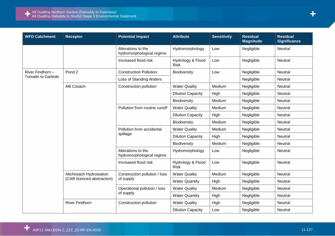
Allt Cnapach
Allt Cnapach is a small watercourse that drains forestry on the northbound side of the existing A9 carriageway at Kinveachy. The watercourse flows east to be crossed by the A9 and the adjacent Highland Main Line railway.
Upstream of the crossing, there is little to no floodplain with the channel dominated by a series of cascades over steps. Downstream, the channel becomes increasingly more modified and affected by downstream impoundments but floodplain flow is limited to small areas of grassland adjacent to the channel
Feith Mhor
Flood extents indicate the floodplain upstream of the A9 watercourse crossing is approximately 70m wide.
Downstream of the A9 the floodplain is approximately 250-300m wide in the land between the A9 and the Highland Main Line railway.
Carrbridge /River Dulnain
The River Dulnain drains a catchment of approximately 190km2 with a defined network of functional floodplain within the upstream extent. The rural areas within the upstream extent contain no known receptors with approximate floodplain extents reaching 120m.
The 0.5% AEP floodplain extents are contained close to the channel on the approach to the existing A9 crossing.
Downstream of the A9 and Highland Mainline crossing towards Carrbridge there is little to no floodplain with most flow remaining in channel.
Bogbain Burn
Bogbain Burn is situated at Black Mount and is formed from several headwaters which rise on the southeastern slopes of Carn a’ Chuaille and Carn nam Bain-tighearna, which subsequently converge to the north of the Highland Main Line railway. The burn then flows broadly southeast through forestry plantation, roughly parallel with the existing A9, and is crossed several times by the railway
A9 Dualling Northern Section (Dalraddy to Inverness) A9 Dualling Dalraddy to Slochd Stage 3 Environmental Statement
A9P11-AMJ-EGN-Z_ZZZ_ZZ-RP-EN-0033 11-23
Floodplain Description
and the A938 before joining the Allt nan Ceatharnach. The floodplain extends between the A938 and the railway affecting agricultural land and A938.
Slochd Mhuic
The Slochd Mhuic has a catchment area of 7.3km2 draining upland moor and forestry. A heavily modified section of the headwater drains Slochd Summit, flows southeast, and is crossed several times over a distance of approximately 1.3km by the existing A9 carriageway. The watercourse continues south, running broadly parallel to the existing A9, to the confluence with Allt Ruighe an t-Sabhail. From here the Slochd Mhuic flows predominantly south for approximately 4km, converging with several large streams to become the Allt an Aonaich, which converges with the River Dulnain. Flows are confined within channel with only small floodplain extents.
11.3.7. The SEPA Medium flood risk scenario (the 0.5% AEP event) mapping only covers seven of the 11 floodplain areas and is not sufficiently detailed to accurately quantify the impact of the scheme. The SEPA map is a national scale map derived from a generalised methodology which is not catchment specific and does not map catchments with areas less than 3km2. To improve the floodplain definition additional topographic surveys were carried out and hydraulic models were developed. Full details of the hydrological and hydraulic methodology are given in Appendix 11.3.
11.3.8. No Scottish Water surface water supply sources were identified within the study area. Five surface water fed private water abstractions were identified within the study area, with two of them identified as having the potential to be impacted by the scheme (all within the River Spey surface water catchment):
• PWS Eilan Cottage – abstraction from an Avie Lochan Burn South, located under the Proposed Scheme footprint, featuring a new ditch;
• PWS Avielochan – abstraction from Avie Lochan Burn North, located under the Proposed Scheme footprint, featuring a new ditch.
11.3.9. There are 16 licenced discharges within 1km of the Proposed Scheme. Six licences relate to public sewage discharges; two private sewage discharges; two relate to outflow coming from a SuDS system; three relate to engineering works on the River Spey; one relates to the final effluent coming from Rothiermurchus Fish Farm; one relates to an emergency overflow to the River Spey from Aviemore Caravan Site; and one relates to a backwash outfall from Kinakyle.
11.3.10. It is also anticipated that there are numerous other sewage discharges from individual properties within the study area, in addition to drainage discharges associated with the highland mainline railway, the existing A9, the B-roads and other unclassified or private roads.
11.3.11. The existing A9 is understood to discharge unattenuated and untreated runoff, generally via kerbs, gullies and carrier pipes. Locations of existing outfalls were identified as far as possible from the original as-built drawings and recorded as part of the walkover surveys.
11.3.12. Standing waters within the study area comprise Loch Alvie, Loch Vaa, Loch Puladdern, Loch Beag, Bogach, Avie Lochan, Loch Roid and numerous undesignated small ponds. Notable examples include a cluster of small ponds at Ballinluig and a small pond in the grounds of the MacDonald Aviemore Resort. Several of the ponds, located outwith 250m of the Proposed Scheme, have been screened out of the assessment as they are unlikely to be impacted by the Proposed Scheme due to distance and intervening topography. Of the remaining water bodies only Loch Alvie is classified under WFD, having a status of ‘Good’, equating to High sensitivity. The remaining smaller water
A9 Dualling Northern Section (Dalraddy to Inverness) A9 Dualling Dalraddy to Slochd Stage 3 Environmental Statement
A9P11-AMJ-EGN-Z_ZZZ_ZZ-RP-EN-0033 11-24
bodies have been assessed using the National Pond Survey methodology. The findings of these surveys found that in general these are of ‘Less than Local’ importance for nature conservation, with the exception of:
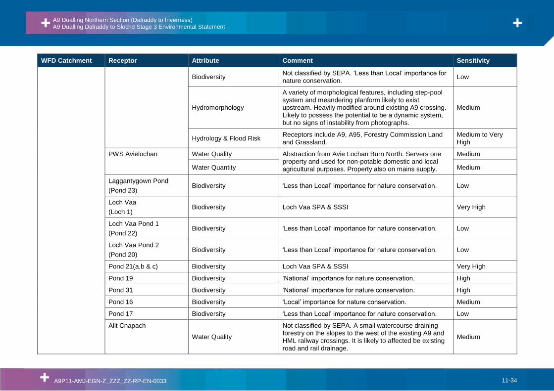
• Loch Vaa and Pond 21, designated SPA and SSSI and therefore of ‘International’ importance;
• Macdonald Pond, Shunem Pond, Ponds 8, 19, 31 and 30, of ‘National’ importance;
• Ponds 28 and 14, of ‘Authority Area’ importance; and
• Pond 16 of ‘Local’ importance.
Receptor Sensitivity
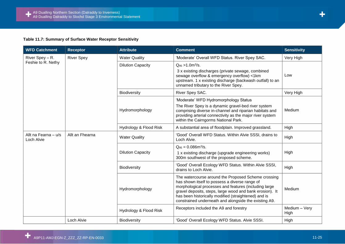
11.3.13. Receptor sensitivity has been evaluated on the basis of the baseline data presented in Appendices 11.1, 11.2, 11.3 and 11.4, and summarised above, and using the criteria as set out in Table 11.2. Table 11.7 presents a summary of the sensitivity of surface water receptors.
11.3.14. In relation to flood risk there may be several receptors sensitive to changes in flood risk within the watercourses/floodplains identified, with each flood receptor having a different sensitivity to flooding (e.g. rough grazing has a low sensitivity, while essential infrastructure such as roads has a high sensitivity). Table 11.7 summarises the range of sensitivities associated with each floodplain.
A9 Dualling Northern Section (Dalraddy to Inverness) A9 Dualling Dalraddy to Slochd Stage 3 Environmental Statement
A9P11-AMJ-EGN-Z_ZZZ_ZZ-RP-EN-0033 11-25
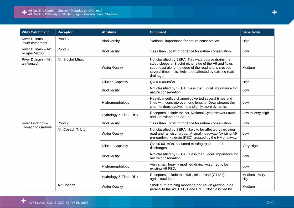
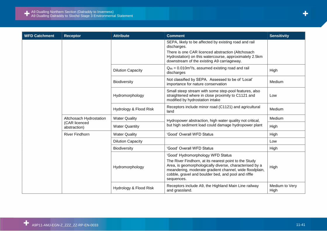
Table 11.7: Summary of Surface Water Receptor Sensitivity
River Spey Water Quality ‘Moderate’ Overall WFD Status. River Spey SAC. Very High
Dilution Capacity Q95 >1.0m3/s.
3 x existing discharges (private sewage, combined sewage overflow & emergency overflow) <1km upstream. 1 x existing discharge (backwash outfall) to an unnamed tributary to the River Spey.
Low
Biodiversity River Spey SAC. Very High
Hydromorphology
‘Moderate’ WFD Hydromorphology Status
The River Spey is a dynamic gravel-bed river system comprising diverse in-channel and riparian habitats and providing arterial connectivity as the major river system within the Cairngorms National Park.
Medium
Hydrology & Flood Risk A substantial area of floodplain. Improved grassland. High
Allt na Fearna – u/s Loch Alvie
Allt an Fhearna Water Quality
‘Good’ Overall WFD Status. Within Alvie SSSI, drains to Loch Alvie.
High
Dilution Capacity
Q95 = 0.086m3/s.
1 x existing discharge (upgrade engineering works) 300m southwest of the proposed scheme.
High
Biodiversity ‘Good’ Overall Ecology WFD Status. Within Alvie SSSI, drains to Loch Alvie.
High
Hydromorphology
The watercourse around the Proposed Scheme crossing has shown itself to possess a diverse range of morphological processes and features (including large gravel deposits, steps, large wood and bank erosion). It has been historically modified (straightened) and is constrained underneath and alongside the existing A9.
Medium
Hydrology & Flood Risk Receptors included the A9 and forestry Medium – Very
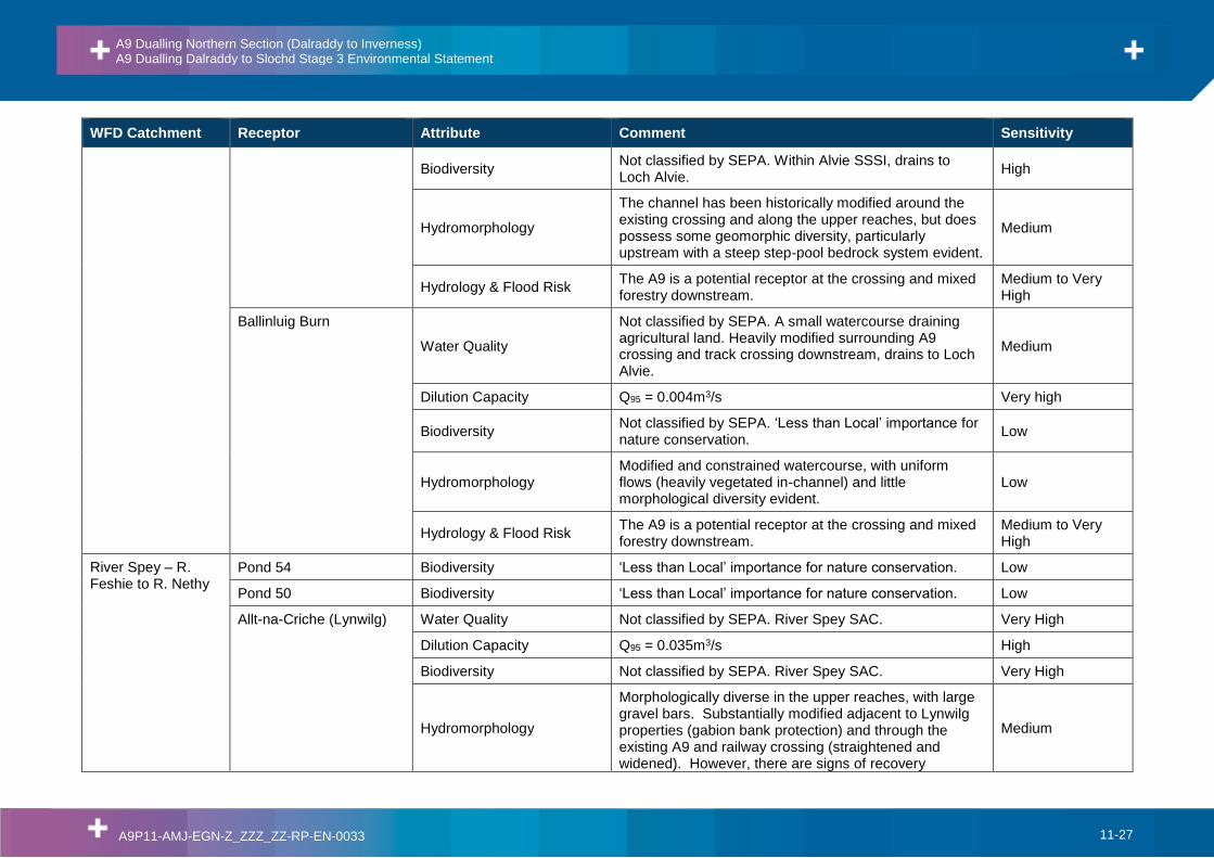
Not classified by SEPA. Within Alvie SSSI, drains to Loch Alvie.
High
Dilution Capacity Q95 = 0.017m3/s High
Biodiversity Not classified by SEPA. Within Alvie SSSI, drains to Loch Alvie.
High
Hydromorphology
Channel possesses a diverse range of morphological forms and processes, with the downstream reaches shown to be able to partially laterally adjust the planform. Modifications are substantial, but limited to the existing A9 crossing.
Medium
Hydrology & Flood Risk Receptors included forestry and Alvie SSSI Medium –High
Pond 70 Biodiversity ‘Less than Local’ importance for nature conservation. Low
Pond 69 Biodiversity ‘Less than Local’ importance for nature conservation. Low
Pond 68 Biodiversity ‘Less than Local’ importance for nature conservation. Low
Pond 67 Biodiversity ‘Less than Local’ importance for nature conservation. Low
Pond 66 Biodiversity ‘Less than Local’ importance for nature conservation. Low
Pond 65 Biodiversity ‘Less than Local’ importance for nature conservation. Low
Pond 63 Biodiversity ‘Less than Local’ importance for nature conservation. Low
Pond 62 Biodiversity ‘Less than Local’ importance for nature conservation. Low
Pond 61 Biodiversity ‘Less than Local’ importance for nature conservation. Low
Pond 60 Biodiversity ‘Less than Local’ importance for nature conservation. Low
Pond 59 Biodiversity ‘Less than Local’ importance for nature conservation. Low
Pond 58 Biodiversity ‘Less than Local’ importance for nature conservation. Low
Pond 57 Biodiversity ‘Less than Local’ importance for nature conservation. Low
Caochan Ruadh Water Quality
Not classified by SEPA. Within Alvie SSSI, drains to Loch Alvie.
High
Dilution Capacity Q95 = 0.01m3/s High
A9 Dualling Northern Section (Dalraddy to Inverness) A9 Dualling Dalraddy to Slochd Stage 3 Environmental Statement
Biodiversity Not classified by SEPA. Within Alvie SSSI, drains to Loch Alvie.
High
Hydromorphology
The channel has been historically modified around the existing crossing and along the upper reaches, but does possess some geomorphic diversity, particularly upstream with a steep step-pool bedrock system evident.
Medium
Hydrology & Flood Risk The A9 is a potential receptor at the crossing and mixed forestry downstream.
Medium to Very High
Ballinluig Burn
Water Quality
Not classified by SEPA. A small watercourse draining agricultural land. Heavily modified surrounding A9 crossing and track crossing downstream, drains to Loch Alvie.
Medium
Dilution Capacity Q95 = 0.004m3/s Very high
Biodiversity Not classified by SEPA. ‘Less than Local’ importance for nature conservation.
Low
Hydromorphology Modified and constrained watercourse, with uniform flows (heavily vegetated in-channel) and little morphological diversity evident.
Low
Hydrology & Flood Risk The A9 is a potential receptor at the crossing and mixed forestry downstream.
Medium to Very High
River Spey – R. Feshie to R. Nethy
Pond 54 Biodiversity ‘Less than Local’ importance for nature conservation. Low
Pond 50 Biodiversity ‘Less than Local’ importance for nature conservation. Low
Allt-na-Criche (Lynwilg) Water Quality Not classified by SEPA. River Spey SAC. Very High
Dilution Capacity Q95 = 0.035m3/s High
Biodiversity Not classified by SEPA. River Spey SAC. Very High
Hydromorphology
Morphologically diverse in the upper reaches, with large gravel bars. Substantially modified adjacent to Lynwilg properties (gabion bank protection) and through the existing A9 and railway crossing (straightened and widened). However, there are signs of recovery
Medium
A9 Dualling Northern Section (Dalraddy to Inverness) A9 Dualling Dalraddy to Slochd Stage 3 Environmental Statement
Not classified by SEPA. A small hillside watercourse draining wooded area on the northbound side of the A9 carriageway, joins a roadside drainage ditch.
Low
Dilution Capacity Q95 <0.001m3/s Very High
Biodiversity Not classified by SEPA. ‘Less than Local’ importance for nature conservation.
Low
Hydromorphology A small hillside watercourse draining wooded area on the northbound side of the A9 carriageway, joins a roadside drainage ditch.
Low
Hydrology & Flood Risk Woodland no identified receptors Low
Craigellachie Pond Biodiversity
An ephemeral water body, part of the existing A9 drainage network. ‘Less than Local’ importance for nature conservation.
Low
Pond 45 Biodiversity ‘Less than Local’ importance for nature conservation. Low
Loch Puladdern
(Pond 43) Water Quality
Not classified by SEPA. This pond is impacted by existing road discharges
Medium
Dilution Capacity Standing water Very High
Biodiversity ‘Authority Area’ importance for nature conservation. Medium
A9 Dualling Northern Section (Dalraddy to Inverness) A9 Dualling Dalraddy to Slochd Stage 3 Environmental Statement
‘National’ importance for nature conservation. High
Pond 42 Biodiversity ‘Less than Local’ importance for nature conservation. Low
Pond 39 Biodiversity ‘Less than Local’ importance for nature conservation. Low
Aviemore Burn
Water Quality
Not classified by SEPA. A large watercourse draining forestry and moorland via several smaller tributaries on steep slopes to the west, before the A9 crossing where it is heavily and extensively modified on the fringe of the town of Aviemore. The watercourse is likely to be affected by existing A9 road drainage outfalls and sources of diffuse pollution related to forestry, surface runoff and sewage discharges.
Medium
Dilution Capacity
Q95 = 0.023m3/s.
3 x existing discharges (combined sewage overflow) <1km upstream.
High
Biodiversity Not classified by SEPA. ‘Regional’ importance for nature conservation.
Medium
Hydromorphology
Diverse watercourse throughout with a good range of flows and morphological features, however substantially constrained through recently constructed housing estate and existing crossings.
Medium
Hydrology & Flood Risk Receptors include the A9, residential and Non Residential Properties in Aviemore.
Very High
Pond 38 Biodiversity ‘Less than Local’ importance for nature conservation. Low
Easter Aviemore Burn
Water Quality
Not classified by SEPA. A small watercourse draining a forested area on the north west fringe of Aviemore, flowing south east and is crossed by the A9 carriageway. It likely to be affected by existing A9 drainage and diffuse pollution.
Medium
Dilution Capacity Q95 = 0.002m3/s Very High
A9 Dualling Northern Section (Dalraddy to Inverness) A9 Dualling Dalraddy to Slochd Stage 3 Environmental Statement
Biodiversity Not classified by SEPA. ‘Less than Local’ importance for nature conservation.
Low
Hydromorphology
Some lengths possess diverse morphology especially in the upper reaches with step sequences common and clean coarse gravel substrate. However, overall the watercourse has historically been modified for residential and agricultural drainage purposes. Minor fine sediment deposition was noted on the downstream reaches were flow energy reduced.
Medium
Hydrology & Flood Risk Receptors include the A9 and Woodland and Scrub Medium to Very High
Southern Bifurcation of Allt na Criche (Granish)
(AnCG Bifurcation South) Water Quality
Not classified by SEPA. A small watercourse draining slopes to the west of the A9. The channel is a bifurcation of the Allt na Criche (Granish) watercourse which has been historically modified. It is likely to be affected by existing A9 road drainage and diffuse pollution relating to agriculture. There is one private water supply located approximately 100m upstream of the existing crossing associated with Granish farm and is used only for agricultural purposes.
Medium
Dilution Capacity Q95 = 0.006m3/s Very High
Biodiversity Not classified by SEPA. ‘Less than Local’ importance for nature conservation.
Low
Hydromorphology
A small watercourse draining slopes to the west of the A9. The channel is a bifurcation of the Allt na Criche (Granish) watercourse which has been historically modified. There is a plastic pipe in place at the point of bifurcation which is assumed to have been installed to maintain flow via this channel and there is further modification at the A9 crossing location. The watercourse is, however, well established and possesses morphological features such as step-pool sequences.
Low
Hydrology & Flood Risk Receptors include the A9, the B9162 and isolated Residential & Non Residential Properties.
Medium to Very High
A9 Dualling Northern Section (Dalraddy to Inverness) A9 Dualling Dalraddy to Slochd Stage 3 Environmental Statement
‘National’ importance for nature conservation. High
Northern Bifurcation of Allt na Criche Granish
(AnCG Bifurcation North)
Water Quality
Not classified by SEPA. A small watercourse draining slopes to the west of the A9. The channel is a bifurcation of the Allt na Criche (Granish) watercourse with lack of a distinct channel as it flows through poached agricultural land. It is likely to be affected by existing A9 road drainage and diffuse pollution relating to agriculture. It has been extensively modified in the area surrounding the A9 crossing, including a long culverted section.
There is one licenced CAR abstraction (Granish Landfill Site) approximately 350m downstream of the existing A9 crossing location.
Medium
Dilution Capacity Q95 = 0.006m3/s Very High
Biodiversity Not classified by SEPA. ‘Less than Local’ importance for nature conservation.
Low
Hydromorphology
A small watercourse draining slopes to the west of the A9. The channel is a bifurcation of the Allt na Criche (Granish) watercourse with lack of a distinct channel as it flows through poached agricultural land. It has been extensively modified in the area surrounding the A9 crossing, including a long culverted section.
Low
Hydrology & Flood Risk Receptors include the A9, the B9162 and isolated Residential & Non Residential Properties.
Medium to Very High
Granish Landfill Site (CAR licenced abstraction)
Water Quality Local industrial/commercial processes
Abstraction from pond fed by AnCG Bifurcation North, approximately 350m downstream of the existing A9 crossing location.
Medium
Water Quantity Medium
Pond 35 Biodiversity ‘Less than Local’ importance for nature conservation. Low
Pond 34 Biodiversity ‘Less than Local’ importance for nature conservation. Low
Pond 33 Biodiversity ‘Less than Local’ importance for nature conservation. Low
Pond 32 Biodiversity ‘Less than Local’ importance for nature conservation. Low
A9 Dualling Northern Section (Dalraddy to Inverness) A9 Dualling Dalraddy to Slochd Stage 3 Environmental Statement
‘National’ importance for nature conservation. High
Pond 30 Biodiversity ‘National’ importance for nature conservation. High
Pond 36 Biodiversity ‘Less than Local’ importance for nature conservation. Low
Allt na Criche (Granish)
Water Quality
Not classified by SEPA. A small watercourse draining slopes to the west of the A9. This is the main stem channel associated with the above bifurcated channels and has been historically heavily modified. It is likely to be affected by existing A9 road drainage and diffuse pollution relating to agriculture.
Medium
Dilution Capacity Q95 = 0.012m3/s High
Biodiversity Not classified by SEPA. ‘Less than Local’ importance for nature conservation.
Low
Hydromorphology
Although largely unmodified (except for the existing A9 crossing) morphological diversity was confined to localised lengths. The presence of boulders and large wood in the watercourse did create more dynamic flows, but overall some fine sediment deposition along the bed was noted.
Medium
Hydrology & Flood Risk Receptors are grassland and woodland north of the A9, the A9, the B9152, Granish Farm and caravan site.
Medium to Very High
Pond 29 Biodiversity ‘Less than Local’ importance for nature conservation. Low
Pond 28 Biodiversity ‘Authority Area’ importance for nature conservation. Medium
Avie Lochan Burn South
Water Quality
Not classified by SEPA. A small watercourse draining slopes to the west of the A9. There is one private water supply sourced from just upstream of the existing A9 crossing and is the only water supply for the single property it serves. The watercourse is likely to be affected by existing road drainage downstream of the crossing.
High
A9 Dualling Northern Section (Dalraddy to Inverness) A9 Dualling Dalraddy to Slochd Stage 3 Environmental Statement
There is one private water supply source (PWS Eilan Cottage) located on this watercourse, approximately 10m upstream from the existing A9 crossing location.
Dilution Capacity Q95 = 0.004m3/s Very High
Biodiversity Not classified by SEPA. ‘Less than Local’ importance for nature conservation.
Low
Hydromorphology
Vast variety of morphological features, including high energy step-pool system in the upstream and meandering planform in the downstream. Heavily modified over short distance around existing A9 crossing.
Medium
Hydrology & Flood Risk Receptors include A9, A95, Forestry Commission Land and Grassland.
Medium to Very High
PWS Eilan Cottage Water Quality Abstraction from Avie Lochan Burn South. Serves one property and is used as potable and domestic purposes. Property is not on mains supply.
High
Water Quantity High
Avie Lochan
(Loch 2) Biodiversity
‘Less than Local’ importance for nature conservation. Low
Pond 25 Biodiversity ‘Less than Local’ importance for nature conservation. Low
Pond 26 Biodiversity ‘Less than Local’ importance for nature conservation. Low
Pond 27 Biodiversity ‘Less than Local’ importance for nature conservation. Low
Pond 24 Biodiversity ‘Less than Local’ importance for nature conservation. Low
Avie Lochan Burn North
Water Quality
Not classified by SEPA. A small watercourse draining steep slopes to the west of the A9. Likely to be affected by existing A9 drainage. There is one private water supply sourced from just upstream of the existing A9 crossing.
There is one private water supply source (PWS Avielochan ) located on this watercourse, approximately 30m upstream of the existing A9 crossing location.
Medium
Dilution Capacity Q95 = 0.002m3/s Very High
A9 Dualling Northern Section (Dalraddy to Inverness) A9 Dualling Dalraddy to Slochd Stage 3 Environmental Statement
Biodiversity Not classified by SEPA. ‘Less than Local’ importance for nature conservation.
Low
Hydromorphology
A variety of morphological features, including step-pool system and meandering planform likely to exist upstream. Heavily modified around existing A9 crossing. Likely to possess the potential to be a dynamic system, but no signs of instability from photographs.
Medium
Hydrology & Flood Risk Receptors include A9, A95, Forestry Commission Land and Grassland.
Medium to Very High
PWS Avielochan Water Quality Abstraction from Avie Lochan Burn North. Servers one property and used for non-potable domestic and local agricultural purposes. Property also on mains supply.
Medium
Water Quantity Medium
Laggantygown Pond
(Pond 23) Biodiversity ‘Less than Local’ importance for nature conservation. Low
Loch Vaa
(Loch 1) Biodiversity Loch Vaa SPA & SSSI Very High
Loch Vaa Pond 1
(Pond 22) Biodiversity ‘Less than Local’ importance for nature conservation. Low
Loch Vaa Pond 2
(Pond 20) Biodiversity ‘Less than Local’ importance for nature conservation. Low
Pond 21(a,b & c) Biodiversity Loch Vaa SPA & SSSI Very High
Pond 19 Biodiversity ‘National’ importance for nature conservation. High
Pond 31 Biodiversity ‘National’ importance for nature conservation. High
Pond 16 Biodiversity ‘Local’ importance for nature conservation. Medium
Pond 17 Biodiversity ‘Less than Local’ importance for nature conservation. Low
Allt Cnapach
Water Quality
Not classified by SEPA. A small watercourse draining forestry on the slopes to the west of the existing A9 and HML railway crossings. It is likely to affected be existing road and rail drainage.
Medium
A9 Dualling Northern Section (Dalraddy to Inverness) A9 Dualling Dalraddy to Slochd Stage 3 Environmental Statement
Biodiversity Not classified by SEPA. ‘Local’ importance for nature conservation.
Medium
Hydromorphology
Good range of flows and dynamic morphological features, but substantially modified in the downstream reaches. Few active morphological processes occurring and some fine sediment deposition was noted in the downstream reaches (including poaching downstream).
Medium
Hydrology & Flood Risk Receptors include A9, Highland Main Line railway and Grassland
Medium to Very High
Pond 15 Biodiversity ‘Less than Local’ importance for nature conservation. Low
Pond 14 Biodiversity ‘Authority Area’ importance for nature conservation. Medium
River Dulnain – Feith Mhor
Feith Mhor Water Quality ‘Good’ Overall WFD Status High
Dilution Capacity Q95 = 0.007m3/s Very High
Biodiversity ‘Good’ Overall Ecology WFD Status High
Hydromorphology
Some incision (knickpoints) evident in the upper reaches resulting in a series of steps, but on the whole flows were uniform around the A9 crossing. The channel lacked energy to recover from historic modifications downstream.
Medium
Hydrology & Flood Risk The key receptors are the A9 and Highland Main Line railway but agricultural land is also at risk.
Medium to Very High Risk
Pond 72 Biodiversity ‘Less than Local’ importance for nature conservation. Low
Feith Mhor Trib 2
Water Quality
Not classified by SEPA. A very small tributary of the Feith Mhor draining forestry and marshy grassland surrounding the existing a9 crossing. Likely to be affected by existing A9 and HML railway drainage.
Medium.
Dilution Capacity Q95 = 0.002m3/s Very High
Biodiversity Not classified by SEPA. ‘Less than Local’ importance for nature conservation.
Low
A9 Dualling Northern Section (Dalraddy to Inverness) A9 Dualling Dalraddy to Slochd Stage 3 Environmental Statement
A very small watercourse with a range of bed material and potential for some morphological features to be present further upstream and downstream from the existing A9 crossing.
Medium
Hydrology & Flood Risk Receptors include A9, Highland Main Line railway and forestry
Medium to Very High
Feith Mhor Drain 7
Water Quality
Not classified by SEPA. A small field / forest drain originating from a flat area of marshy grassland on the west side of the A9. Flows likely to be ephemeral. Likely to be affected by existing A9 drainage.
Low
Dilution Capacity
Q95 = 0.002m3/s.
2 x existing discharges (surface water drainage) <1km upstream.
Very High
Biodiversity Not classified by SEPA. ‘Less than Local’ importance for nature conservation.
Low
Hydromorphology A small field / forest drain originating from a flat area of marshy grassland on the west side of the A9. Flows likely to be ephemeral.
Low
Hydrology & Flood Risk Receptors include A9, Highland Main Line railway and forestry
Medium – Very High
River Dulnain – lower catchment
Carrbridge Drain 1 Water Quality
Not classified by SEPA. An existing A9 drainage ditch / culvert. Flows likely to be ephemeral. Likely to be affected by existing A9 drainage.
Low
Dilution Capacity Q95 likely to be <0.001m3/s Very High
Biodiversity Not classified by SEPA. ‘Less than Local’ importance for nature conservation.
Low
Hydromorphology An existing A9 drainage ditch / culvert. Flows likely to be ephemeral.
Low
Hydrology & Flood Risk Receptors include A9 and forestry Medium to Very
High
A9 Dualling Northern Section (Dalraddy to Inverness) A9 Dualling Dalraddy to Slochd Stage 3 Environmental Statement
Not classified by SEPA. An existing A9 drainage ditch / culvert. Flows likely to be ephemeral. Likely to be affected by existing A9 drainage.
Low
Dilution Capacity Q95 = 0.001m3/s Very High
Biodiversity Not classified by SEPA. ‘Less than Local’ importance for nature conservation.
Low
Hydromorphology An existing A9 drainage ditch / culvert. Flows likely to be ephemeral.
Low
Hydrology & Flood Risk Receptors include A9 and forestry Medium to Very
High
River Dulnain Water Quality ‘Good’ Overall WFD Status. River Spey SAC. Very High
Dilution Capacity Q95 = 0.791m3/s Medium
Biodiversity ‘Good’ Overall Ecology WFD Status. River Spey SAC. Very High
Hydromorphology
A substantial and highly active gravel bed river channel, with a dynamic and diverse range of morphological features, including large gravel bars. The river channel has been substantially modified underneath the A9 and through Carrbridge.
High
Hydrology & Flood Risk
Receptors include the A9 and agricultural land. Downstream of the A9 and Highland Mainline crossing towards Carrbridge there is little to no floodplain with most flow remaining in channel.
Medium to Very High
River Dulnain – Allt Ruighe Magaig
Ceatharnach Trib Water Quality
Not classified by SEPA. An existing A9 drainage ditch / culvert. Flows likely to be ephemeral. Likely to be affected by existing A9 drainage.
Low
Dilution Capacity Q95 likely to be <0.001m3/s Very High
Biodiversity Not classified by SEPA. ‘Less than Local’ importance for nature conservation.
Low
Hydromorphology An existing A9 drainage ditch / culvert. Flows likely to be ephemeral.
Low
A9 Dualling Northern Section (Dalraddy to Inverness) A9 Dualling Dalraddy to Slochd Stage 3 Environmental Statement
Hydrology & Flood Risk Receptors include the A9 and agricultural land. Medium to Very
High
Allt nan Ceatharnach (Allt Ruighe Magaig)
Water Quality ‘Good’ Overall WFD Status. River Spey SAC. Very High
Dilution Capacity
Q95 = 0.045m3/s.
1 x existing discharge (SuDS outfall to river) <1km upstream.
High
Biodiversity ‘Good’ Overall Ecology WFD Status. River Spey SAC. Very High
Hydromorphology
Very active, moderately steep river channel although modified and constrained in sections due to existing river crossings (A9 and railway) and agricultural drainage. The bed of the channel is modified in places, but did possess bedrock features form a dynamic range of flows.
Medium
Hydrology & Flood Risk Receptors include the A9 and agricultural land. Medium to Very
High
Ceatharnach Drain Water Quality
Not classified by SEPA. An existing A9 drainage ditch / culvert. Flows likely to be ephemeral. Likely to be affected by existing A9 drainage.
Low
Dilution Capacity Q95 likely to be <0.001m3/s Very High
Biodiversity Not classified by SEPA. ‘Less than Local’ importance for nature conservation.
Low
Hydromorphology An existing A9 drainage ditch / culvert. Flows likely to be ephemeral.
Low
Hydrology & Flood Risk Receptors include the A9 and agricultural land. Medium to Very
High
Bogbain Burn
Water Quality
Not classified by SEPA. A large watercourse draining forestry and open moorland surrounding the HML railway. Likely to be affected by existing railway drainage.
Medium
Dilution Capacity Q95 = 0.018m3/s High
A9 Dualling Northern Section (Dalraddy to Inverness) A9 Dualling Dalraddy to Slochd Stage 3 Environmental Statement
Biodiversity Not classified by SEPA. ‘Regional’ importance for nature conservation.
Medium
Hydromorphology
Heavily modified around the HML railway, but mapping and photographic evidence suggests natural meandering upstream, with diverse and dynamic flow patterns likely, including a coarse cobble/gravel substrate and some woody debris from adjacent woodland, but overall stable.
Medium
Hydrology & Flood Risk Receptors include the A9, A938, Highland Main Line railway and Grassland.
Low to Very High
Bogbain Trib
Water Quality
Not classified by SEPA. A small forest drain flowing from south west to north east and is crossed by the A9 and the HML railway. Flows are likely to be ephemeral. Likely to be affected by existing A9 and railway drainage.
Medium
Dilution Capacity Q95 <0.001m3/s Very High
Biodiversity Not classified by SEPA. ‘Less than Local’ importance for nature conservation.
Low
Hydromorphology A small forest drain flowing from south west to north east and is crossed by the A9 and the HML railway. Flows are likely to be ephemeral.
Low
Hydrology & Flood Risk Receptors include A9 and Highland Main Line railway and forestry
Medium to Very High
Bogbain Drain Water Quality
Not classified by SEPA. An existing A9 drainage ditch. Flows likely to be ephemeral. Likely to be affected by existing A9 drainage.
Low
Dilution Capacity Q95 <0.001m3/s Very High
Biodiversity Not classified by SEPA. ‘Less than Local’ importance for nature conservation.
Low
Hydromorphology An existing A9 drainage ditch. Flows likely to be ephemeral.
Low
Hydrology & Flood Risk Receptors include A9 and forestry Medium to Very High
A9 Dualling Northern Section (Dalraddy to Inverness) A9 Dualling Dalraddy to Slochd Stage 3 Environmental Statement
Pond 8 Biodiversity ‘National’ importance for nature conservation. High
River Dulnain – Allt Ruighe Magaig
Pond 6 Biodiversity ‘Less than Local’ importance for nature conservation. Low
River Dulnain – Allt an Aonaich
Allt Slochd Mhuic
Water Quality
Not classified by SEPA. This watercourse drains the steep slopes at Slochd either side of the A9 and flows south east along the edge of the road and is crossed several times. It is likely to be affected by existing road drainage.
Medium
Dilution Capacity Q95 = 0.003m3/s High
Biodiversity Not classified by SEPA. ‘Less than Local’ importance for nature conservation.
Low
Hydromorphology Heavily modified channel culverted several times and lined with concrete over long lengths. Downstream, the channel does evolve into a slightly more dynamic.
Low
Hydrology & Flood Risk Receptors include the A9, National Cycle Network track and Grassland and Scrub
Low to Very High
River Findhorn – Tomatin to Garbole
Pond 2 Biodiversity ‘Less than Local’ importance for nature conservation. Low
Allt Cosach Trib 1 Water Quality
Not classified by SEPA, likely to be affected by existing road and rail discharges. A small headwater/existing A9 pre-earthworks drain (PED) crossed by the HML railway.
Low
Dilution Capacity Q95 <0.001m3/s, assumed existing road and rail discharges
Very High
Biodiversity Not classified by SEPA. ‘Less than Local’ importance for nature conservation
Low
Hydromorphology Very small, heavily modified drain. Assumed to be existing A9 PED.
Low
Hydrology & Flood Risk Receptors include the HML, minor road (C1121), agricultural land
Medium - Very High
Allt Cosach Water Quality Small burn draining moorland and rough grazing, runs parallel to the A9, C1121 and HML. Not classified by
Medium
A9 Dualling Northern Section (Dalraddy to Inverness) A9 Dualling Dalraddy to Slochd Stage 3 Environmental Statement
Biodiversity Not classified by SEPA. Assessed to be of ‘Local’ importance for nature conservation
Medium
Hydromorphology Small steep stream with some step-pool features, also straightened where in close proximity to C1121 and modified by hydrostation intake
Low
Hydrology & Flood Risk Receptors include minor road (C1121) and agricultural land
Water Quality Hydropower abstraction, high water quality not critical, but high sediment load could damage hydropower plant
Medium
Water Quantity High
River Findhorn Water Quality ‘Good’ Overall WFD Status High
Dilution Capacity Low
Biodiversity ‘Good’ Overall WFD Status High
Hydromorphology
‘Good’ Hydromorphology WFD Status
The River Findhorn, at its nearest point to the Study Area, is geomorphologically diverse, characterised by a meandering, moderate gradient channel, wide floodplain, cobble, gravel and boulder bed, and pool and riffle sequences.
High
Hydrology & Flood Risk Receptors include A9, the Highland Main Line railway and grassland.
Medium to Very High
A9 Dualling Northern Section (Dalraddy to Inverness) A9 Dualling Dalraddy to Slochd Stage 3 Environmental Statement
A9P11-AMJ-EGN-Z_ZZZ_ZZ-RP-EN-0033 11-42
11.4. Potential Impacts
11.4.1. The potential impacts of the Proposed Scheme are discussed in this section, subdivided into construction and operational impacts. For the purposes of this assessment construction impacts are generally considered to be short-term impacts which occur during the construction phase only. Operational impacts are considered to be long-term or permanent impacts affecting receptors after the construction phase is complete. It is recognised that many operational impacts are initiated by construction activities; however, the full effect of the impact may only manifest itself in the long-term.
11.4.2. Each impact is assessed using the methods outlined in Section 11.2. The potential impacts are assessed with embedded design mitigation, but without additional environmental mitigation and therefore a precautionary approach has been adopted.
Construction Phase Impacts
Construction Pollution
11.4.3. Silt and sediment laden site runoff generated during construction activities, such as soil stripping and earthworks can have a detrimental impact if allowed to enter watercourses untreated. Fine sediments can increase water turbidity and smother stream beds, affecting water quality and causing harm to fish, aquatic invertebrates and plants by interfering with feeding, respiration and spawning. The effects of sediment release can extend considerable distances downstream.
11.4.4. In addition, spillages of potential pollutants such as oils, fuels, concrete, cement and sewage from construction staff welfare facilities can potentially occur during construction. Oils form a film on the water surface and can coat organisms, blocking respiration, photosynthesis and feeding. Biodegradation of oils in aquatic systems can lead to oxygen depletion and many hydrocarbons are toxic, persistent and bio-accumulate in the environment i.e. they build-up in the body tissue both directly and from feeding on other contaminated organisms. Concrete and cement is highly alkaline and can harm aquatic organisms if the pH of the receiving waters is affected.
11.4.5. The risk of sedimentation or spillage affecting watercourses would be highest where direct interaction with the water environment occurs, such as during construction of bridges, culverts and road drainage outfalls, and where watercourse diversions are required. Additionally, locations where construction would be required alongside and within 50m of a watercourse are also at increased risk. The effects on water quality would be acute and short term, however the consequential impact on aquatic ecology could be chronic and long term.
11.4.6. Furthermore, an increased risk to surface water bodies would be anticipated in relation to blasting activities required for the construction of the Proposed Scheme. The need for substantial blasting has been identified in the Slochd area; however, the blast design is currently in its early stages. Blasting introduces potential sediment impacts to water bodies via the blast throw, overland flow from the blast pile, from haul roads and exposed new ground. Blasting also presents potential pollution risks from blasting agents which is dependent on the adopted approach and the specific blasting agents used. It is not possible to assess specific blasting impacts at this early stage of the blast design; however, it is expected that blasting activities should follow the same construction good practice guidelines as outlined in Section 11.5 Mitigation in this chapter, and that more specific mitigation measures will be developed at detailed design stage, following consultation between the relevant technical disciplines, the blasting contractors and SEPA.
A9 Dualling Northern Section (Dalraddy to Inverness) A9 Dualling Dalraddy to Slochd Stage 3 Environmental Statement
A9P11-AMJ-EGN-Z_ZZZ_ZZ-RP-EN-0033 11-43
11.4.7. Based on the road drainage design, it is anticipated that there would be 26 mainline road drainage outfalls discharging to surface waters, in addition there would be numerous surface water outfalls associated with side roads and accommodation tracks. These outfall locations would require construction activity on channel banks, including pipe-laying and installation of appropriate outfall structures.
11.4.8. There is a requirement for a minimum of 38 watercourse crossing features, including bridge structures and culverts. Watercourse realignments will be required for several of these locations; in most cases this will necessitate excavation of the channel bed and banks during construction. There is also requirement for a number of drainage pipes to be installed throughout the Proposed Scheme; the exact number of which will be established at the detailed design stage
11.4.9. Details of the specific construction activities and the potential pre-mitigation impact significance for each surface water body are provided in Table 11.8.
11.4.10. It should be noted that, in the case where standing water bodies have been identified as being ‘lost’ to the Proposed Scheme, these have been reported as ‘N/A’ for the assessment of potential impacts from construction pollution. Losses of standing water bodies are assessed specifically within the operational impacts section.
A9 Dualling Northern Section (Dalraddy to Inverness) A9 Dualling Dalraddy to Slochd Stage 3 Environmental Statement
A9P11-AMJ-EGN-Z_ZZZ_ZZ-RP-EN-0033 11-44
Table 11.8: Potential Construction Pollution Impacts from the Proposed Scheme
WFD Catchment
Receptor Summary of Construction Activities Attribute Sensitivity Magnitude Significance
River Spey – R. Feshie to R. Nethy
River Spey Construction activities associated with tributaries within 300m upstream
Water Quality Very High Minor Moderate
Dilution Capacity Low Negligible Neutral
Biodiversity Very High Minor Moderate
Allt na Fearna – u/s Loch Alvie
Allt an Fhearna Construction of 1 x crossing structure, 1x mainline drainage outfall (S1) and earthworks immediately adjacent to the river bank for approximately 150m
Water Quality High Moderate Moderate
Dilution Capacity High Minor Slight
Biodiversity High Moderate Moderate
Allt na Fearna – d/s Loch Alvie
Loch Alvie Construction activities on several tributaries within 100-300m upstream, development of access track on the east side of the loch within 20m, construction of 1x side road drainage outfall
Biodiversity High Minor Slight
Allt Chriochaidh Construction of 2 x crossing structures and 1 x mainline drainage outfall (S2)
Water Quality High Moderate Moderate
Dilution Capacity High Minor Slight
Biodiversity High Moderate Moderate
Pond 70 1 x pre-earthworks drain (PED) outfall, construction activities within 30m of this pond
Biodiversity Low Minor Neutral
Pond 69 Construction activities within 110m of this pond
Biodiversity Low Negligible Neutral
Pond 68 Construction activities within 110m of this pond
Biodiversity Low Negligible Neutral
Pond 67 Construction activities within 130m of this pond
Biodiversity Low Negligible Neutral
Pond 66 Construction activities within 120m of this pond
Biodiversity Low Negligible Neutral
A9 Dualling Northern Section (Dalraddy to Inverness) A9 Dualling Dalraddy to Slochd Stage 3 Environmental Statement
A9P11-AMJ-EGN-Z_ZZZ_ZZ-RP-EN-0033 11-45
WFD Catchment
Receptor Summary of Construction Activities Attribute Sensitivity Magnitude Significance
Pond 65 Construction activities within 170m of this pond
Biodiversity Low Negligible Neutral
Pond 63 Construction activities within 210m of this pond
Biodiversity Low Negligible Neutral
Pond 62 Construction activities within 230m of this pond
Biodiversity Low Negligible Neutral
Pond 61 Construction activities within 180m of this pond
Biodiversity Low Negligible Neutral
Pond 60 Construction activities within 190m of this pond
Biodiversity Low Negligible Neutral
Pond 59 Construction activities within 190m of this pond
Biodiversity Low Negligible Neutral
Pond 58 Construction activities within 190m of this pond
Biodiversity Low Negligible Neutral
Pond 57 Construction activities within 170m of this pond
Biodiversity Low Negligible Neutral
Caochan Ruadh Construction of 1 x crossing structure and 1 x watercourse realignment (210m length approx.)
Water Quality High Moderate Moderate
Dilution Capacity High Minor Slight
Biodiversity High Moderate Moderate
Ballinluig Burn Construction of 2 x crossing structures, 1 x mainline drainage outfall (S3).
Water Quality Medium Moderate Moderate
Dilution Capacity Very high Minor Moderate
Biodiversity Low Moderate Slight
River Spey – R. Feshie to R. Nethy
Pond 54 Construction activities encroach upon this pond
Biodiversity Low Moderate Slight
Pond 50 Construction activities within 230m of this pond; however, pond is hydrologically disconnected
Biodiversity Low Negligible Neutral
Water Quality Very High Moderate Large
A9 Dualling Northern Section (Dalraddy to Inverness) A9 Dualling Dalraddy to Slochd Stage 3 Environmental Statement
A9P11-AMJ-EGN-Z_ZZZ_ZZ-RP-EN-0033 11-46
WFD Catchment
Receptor Summary of Construction Activities Attribute Sensitivity Magnitude Significance
Allt-na-Criche (Lynwilg)
Construction of 1 x crossing structure and 2 x mainline drainage outfalls (S4 & S5)
Dilution Capacity High Minor Slight
Biodiversity Very High Moderate Large
Kinakyle Drain Existing drainage pipe to be removed, not required by Proposed Scheme
Water Quality Low Negligible Neutral
Dilution Capacity Very High Negligible Neutral
Biodiversity Low Negligible Neutral
Birch View Drain Construction activities within 25m, flows to be intercepted by proposed cut off drains
Water Quality Low Negligible Neutral
Dilution Capacity Very High Negligible Neutral
Biodiversity Low Negligible Neutral
Craigellachie Pond This ephemeral pond is an existing infiltration basin and is to be developed as an infiltration basin as part of the Proposed Scheme.
Biodiversity Low Negligible Neutral
Pond 45 Construction activities within 30m of this pond
Biodiversity Low Minor Neutral
Loch Puladdern
(Pond 43)
Construction of 2 x mainline drainage outfalls (S7 & S7A), 1 x crossing structure and watercourse realignment (50m approx.) of outflow channel leading to Macdonald Pond and additional construction activities within 10m of this standing water body
Water Quality Medium Moderate
Moderate
Dilution Capacity Very High Minor Moderate
Biodiversity Medium Moderate
Moderate
Macdonald Pond
(Pond 44)
1 x watercourse realignment (50m approx.) of inflow channel from Loch Puladdern and additional construction activities within 10m of this pond
Biodiversity High Moderate Moderate
Pond 42 Construction activities within 170m of this pond
Biodiversity Low Negligible Neutral
Pond 39 Construction activities within 200m of this pond
Biodiversity Low Negligible Neutral
A9 Dualling Northern Section (Dalraddy to Inverness) A9 Dualling Dalraddy to Slochd Stage 3 Environmental Statement
A9P11-AMJ-EGN-Z_ZZZ_ZZ-RP-EN-0033 11-47
WFD Catchment
Receptor Summary of Construction Activities Attribute Sensitivity Magnitude Significance
Aviemore Burn Construction of 1 x crossing structure, 1 x mainline drainage outfall (S8A) and 1 x watercourse realignment (100m approx.)
Water Quality Medium Moderate Moderate
Dilution Capacity High Minor Slight
Biodiversity Medium Moderate Moderate
Pond 38 Construction activities within 50m Biodiversity Low Minor Neutral
Easter Aviemore Burn Construction of 1 x crossing structure, 1 x mainline drainage outfall (S8) and 1 x watercourse realignment (100m approx.)
Water Quality Medium Moderate Moderate
Dilution Capacity Very High Minor Slight
Biodiversity Low Moderate Slight
Southern Bifurcation of Allt na Criche (Granish)
(AnCG Bifurcation South)
Construction of 1 x crossing structure and 1 x mainline drainage outfall (S9)
Water Quality Medium Moderate Moderate
Dilution Capacity Very High Minor Moderate
Biodiversity Low Moderate Slight
Granish Pond
(Pond 37)
Construction of PED outfall and mainline construction activities within 5m
Biodiversity High Minor Moderate
Northern Bifurcation of Allt na Criche Granish
(AnCG Bifurcation North)
Construction of 2 x crossing structures, 1 x mainline drainage outfall (C1) and 1 x watercourse realignment (160m approx.)
Water Quality Medium Moderate Moderate
Dilution Capacity Very High Minor Moderate
Biodiversity Low Moderate Slight
Granish Landfill Site (CAR licenced abstraction)
Construction activities within 30m of this water resource
Water Quality Medium Minor Slight
Pond 35 Construction activities within 30m of this pond
Biodiversity Low Minor Neutral
Pond 34 Construction activities within 110m of this pond
Biodiversity Low Negligible Neutral
A9 Dualling Northern Section (Dalraddy to Inverness) A9 Dualling Dalraddy to Slochd Stage 3 Environmental Statement
A9P11-AMJ-EGN-Z_ZZZ_ZZ-RP-EN-0033 11-48
WFD Catchment
Receptor Summary of Construction Activities Attribute Sensitivity Magnitude Significance
Pond 33 Construction activities within 130m of this pond
Biodiversity Low Negligible Neutral
Pond 32 Construction activities within 120m of this pond
Biodiversity Low Negligible Neutral
Shunem Pond
(Pond 18)
Construction activities cover the full extent of this pond, resulting in total loss of water body receptor
Biodiversity High N/A N/A
Pond 30 Construction activities within 80m of this pond
Biodiversity High Negligible Neutral
Pond 36 Construction activities within 80m of this pond
Biodiversity Low Negligible Neutral
Allt na Criche (Granish)
Construction of 3 x crossing structures, 1 x mainline drainage outfall (C3) and 1 x watercourse realignment (210m approx.)
Water Quality Medium Moderate Moderate
Dilution Capacity High Minor Moderate
Biodiversity Low Moderate Slight
Pond 29 Construction activities associated with access track within 5m of this pond
Biodiversity Low Minor Neutral
Pond 28 Construction activities within 50m of this pond
Biodiversity Medium Minor Slight
Avie Lochan Burn South
Construction of 2 x crossing structures, 1 x mainline drainage outfall (C5B) and 2 x watercourse realignments (200m approx. combined length)
Water Quality High Moderate Moderate
Dilution Capacity Very High Minor Moderate
Biodiversity Low Moderate Slight
PWS Eilan Cottage Source is located immediately adjacent and upstream of the Proposed Scheme and approximately 110m downstream of an access track associated with the Proposed Scheme.
Therefore, there is potential for disruption by construction activities
Water Quality High Moderate Large
A9 Dualling Northern Section (Dalraddy to Inverness) A9 Dualling Dalraddy to Slochd Stage 3 Environmental Statement
A9P11-AMJ-EGN-Z_ZZZ_ZZ-RP-EN-0033 11-49
WFD Catchment
Receptor Summary of Construction Activities Attribute Sensitivity Magnitude Significance
Avie Lochan
(Loch 2)
Construction activities associated with access track within 90m of this water body
Biodiversity Low Negligible Neutral
Pond 25 Construction of a mainline drainage outfall (C5B) within 200m upstream of the watercourse feeding this pond and other construction activities within 90m
Biodiversity Low Moderate Slight
Pond 26 Construction of a mainline drainage outfall (C5B) within 30m upstream of the watercourse feeding this pond and other construction activities within 25m
Biodiversity Low Moderate Slight
Pond 27 Construction activities within 15m of this pond
Biodiversity Low Minor Neutral
Pond 24 Construction activities within 50m of this pond
Biodiversity Low Minor Neutral
Avie Lochan Burn North
Construction of 1 x crossing structure and 1 x watercourse realignment (80m length approx.)
Water Quality Medium Moderate Moderate
Dilution Capacity Very High Minor Moderate
Biodiversity Low Moderate Slight
PWS Avielochan Source is located immediately adjacent and upstream of the Proposed.
Therefore, there is potential for disruption by construction activities
Water Quality Medium Moderate Moderate
Laggantygown Pond
(Pond 23)
Construction activities cover the full extent of this pond, resulting in total loss of this water body receptor
Biodiversity Low N/A N/A
Loch Vaa
(Loch 1)
Construction activities within 160m Biodiversity Very High Negligible Neutral
Loch Vaa Pond 1
(Pond 22)
Construction activities cover the full extent of this pond, resulting in total loss of this water body receptor
Biodiversity Low N/A N/A
A9 Dualling Northern Section (Dalraddy to Inverness) A9 Dualling Dalraddy to Slochd Stage 3 Environmental Statement
A9P11-AMJ-EGN-Z_ZZZ_ZZ-RP-EN-0033 11-50
WFD Catchment
Receptor Summary of Construction Activities Attribute Sensitivity Magnitude Significance
Loch Vaa Pond 2
(Pond 20)
Construction activities cover the full extent of this pond, resulting in total loss of this water body receptor
Biodiversity Low N/A N/A
Pond 21(a,b & c) Construction activities within 90m Biodiversity Very High Negligible Neutral
Pond 19 Construction activities within 70m Biodiversity High Negligible Neutral
Pond 31 Construction activities within 35m Biodiversity High Minor Slight
Pond 16 Construction activities within 110m Biodiversity Medium Negligible Neutral
Pond 17 Construction activities within 190m Biodiversity Low Negligible Neutral
Allt Cnapach Construction of 1 x crossing structure, 1 x mainline drainage outfall (C11) and 1 x watercourse realignment (100m length approx.)
Water Quality Medium Moderate Moderate
Dilution Capacity Very High Minor Moderate
Biodiversity Medium Moderate Moderate
Pond 15 Construction activities cover the full extent of this pond, resulting in total loss of this water body receptor
Biodiversity Low N/A N/A
Pond 14 Construction activities within 25m; however, disconnected by HML
Biodiversity Medium Negligible Neutral
River Dulnain – Feith Mhor
Feith Mhor Construction of 2 x crossing structures, 1 x mainline drainage outfall (C12) and 1 x watercourse realignment (190m length approx.)
Water Quality High Moderate Moderate
Dilution Capacity Very High Minor Moderate
Biodiversity High Moderate Moderate
Pond 72 Construction activities within 50m; however, disconnected by HML
Biodiversity Low Negligible Neutral
Feith Mhor Trib 2 Construction of 2 x crossing structures, 1 x mainline drainage outfall (C13) and 1 x watercourse realignment (200m length approx.)
Water Quality Medium Moderate Moderate
Dilution Capacity Very High Minor Moderate
Biodiversity Low Moderate Slight
Feith Mhor Drain 7 Construction of 2 x crossing structures, 1 x mainline drainage outfall (C14) and 1 x
Water Quality Low Moderate Slight
Dilution Capacity Very High Minor Moderate
A9 Dualling Northern Section (Dalraddy to Inverness) A9 Dualling Dalraddy to Slochd Stage 3 Environmental Statement
A9P11-AMJ-EGN-Z_ZZZ_ZZ-RP-EN-0033 11-51
WFD Catchment
Receptor Summary of Construction Activities Attribute Sensitivity Magnitude Significance
watercourse realignment (150m length approx.)
Biodiversity Low Moderate Slight
River Dulnain – lower catchment
Carrbridge Drain 1 Complete loss of this receptor Water Quality Low N/A N/A
Dilution Capacity Very High N/A N/A
Biodiversity Low N/A N/A
Carrbridge Drain 2 Construction of 1 x crossing structure Water Quality Low Minor Neutral
Dilution Capacity Very High Minor Moderate
Biodiversity Low Minor Neutral
River Dulnain Construction of 1 x crossing structure and 1 x mainline drainage outfall (N1)
Water Quality Very High Moderate Large
Dilution Capacity Medium Minor Slight
Biodiversity Very High Moderate Large
River Dulnain – Allt Ruighe Magaig
Ceatharnach Trib Construction activities within 25m of this watercourse
Water Quality Low Minor Neutral
Dilution Capacity Very High Minor Moderate
Biodiversity Low Minor Neutral
Allt nan Ceatharnach (Allt Ruighe Magaig)
Construction of 2 x crossing structures and 1 x mainline drainage outfall (N2)
Water Quality Very High Moderate Large
Dilution Capacity High Minor Slight
Biodiversity Very High Moderate Large
Ceatharnach Drain This drainage ditch is likely to be lost, as flows are predominantly road drainage
Water Quality Low Negligible Neutral
Dilution Capacity Very High Negligible Neutral
Biodiversity Low Negligible Neutral
Bogbain Burn Construction of 2 x mainline drainage outfalls (N4 & N5) and additional construction activities within 50m
Water Quality Medium Moderate Moderate
Dilution Capacity High Minor Slight
Biodiversity Medium Moderate Moderate
Bogbain Trib Construction of 1 x crossing structure Water Quality Medium Moderate Moderate
A9 Dualling Northern Section (Dalraddy to Inverness) A9 Dualling Dalraddy to Slochd Stage 3 Environmental Statement
A9P11-AMJ-EGN-Z_ZZZ_ZZ-RP-EN-0033 11-52
WFD Catchment
Receptor Summary of Construction Activities Attribute Sensitivity Magnitude Significance
Dilution Capacity Very High Minor Moderate
Biodiversity Low Moderate Slight
Bogbain Drain Construction of new drainage channel Water Quality Low Negligible Neutral
Dilution Capacity Very High Negligible Neutral
Biodiversity Low Negligible Neutral
River Dulnain – Lower Catchment
Pond 8 Construction within 10m of this pond Biodiversity High Minor Slight
River Dulnain – Allt Ruighe Magaig
Pond 6 Construction within 40m of this pond Biodiversity Low Minor Neutral
Allt Slochd Mhuic Construction of 8 x crossing structures and 5 x mainline drainage outfalls (N7, N8, N9, N10 & N11)
Water Quality Medium Moderate Moderate
Dilution Capacity High Minor Minor
Biodiversity Low Moderate Slight
River Findhorn – Tomatin to Garbole
Pond 2 Construction activities within 130m of this pond
Biodiversity Low
Negligible Neutral
Allt Cosach Construction of 1 x mainline drainage outfall upstream (N12) of drainage channel 350m upstream
Located over 2.5km downstream of the Proposed Scheme
Water Quality Medium
Negligible Neutral
River Findhorn N/A Water Quality High Negligible Neutral
Dilution Capacity Low Negligible Neutral
Biodiversity High Negligible Neutral
Various Catchments
Typical Small Drainage Channel
May include construction of crossing structures, realignments PED outfalls and/or mainline drainage outfall
Water Quality Low Moderate Slight
Dilution Capacity Very High Minor Moderate
Biodiversity Low Moderate Slight
A9 Dualling Northern Section (Dalraddy to Inverness) A9 Dualling Dalraddy to Slochd Stage 3 Environmental Statement
A9P11-AMJ-EGN-Z_ZZZ_ZZ-RP-EN-0033 11-53
Construction Flood Risk
11.4.11. The magnitude of impact and significance of flood risk associated with the construction of the Proposed Scheme has been separated into impacts associated with watercourse crossings and floodplains.
Watercourse Crossings
11.4.12. The Proposed Scheme will include the upgrade, replacement, extension or construction of new watercourse crossings. The majority of the culverts will be constructed offline from the existing culverts which will maintain flows of the watercourses during construction. Minor local watercourse diversions at the inlets and outlets will also be necessary to allow offline construction
11.4.13. Should it be required to construct crossings online then the watercourse will be temporarily diverted through a temporary channel and/or pumped, which could result in flows being:
• Conveyed more effectively downstream increasing the flood risk to the site and third parties; or
• Water backing up due to insufficient capacity resulting in washout to the construction area.
11.4.14. Materials and plant equipment stored on site could result in the blockage to existing structure and localised flooding to the site and sensitive receptors.
11.4.15. Excavation and construction works on the site could lead to blockage and or severance of surface water that could lead to localised flooding to the site and sensitive receptors.
11.4.16. During construction, localised ground-raising could result in displacement of floodwater and changes to the surface water runoff pathways increasing the flood risk to the surrounding area.
11.4.17. During construction, movement of materials on site including the creation of stockpiles could alter flow pathways and displace flood water.
11.4.18. The operation of plant may result in compaction of soils, which may reduce the infiltration capacity. This could result in an increase in surface water runoff leading to localised flooding and runoff into the receiving watercourse.
Floodplain
11.4.19. During construction, localised ground-raising could result in displacement of floodwater and changes to the surface water runoff pathways increasing the flood risk to the surrounding area.
11.4.20. During construction, movement of materials on site including the creation of stockpiles could alter flow pathways and displace flood water.
11.4.21. The operation of plant may result in compaction of soils, which may reduce the infiltration capacity. This could result in an increase in surface water runoff leading to localised flooding and runoff into the receiving watercourse.
A9 Dualling Northern Section (Dalraddy to Inverness) A9 Dualling Dalraddy to Slochd Stage 3 Environmental Statement
A9P11-AMJ-EGN-Z_ZZZ_ZZ-RP-EN-0033 11-54
Mitigation Measures
11.4.22. In general, the placement of site compounds and the storage of construction material and equipment will be outside of natural flow paths to prevent severance of flow pathways and displacement of flood water.
11.4.23. The magnitude of impact of flood risk associated with the construction of the Proposed Scheme will consider the duration, time of year and construction sequencing. Typical mitigation measures will include:
11.4.24. In relation to flood risk the Contractor will implement a number of mitigation measures to reduce the risk to construction works. These include:
• The establishment of a Flood Response Plan;
• Store plant and materials in areas outside the functional floodplain where practicable;
• Where practicable, haul routes will be located out of the functional floodplain; and
• When in the floodplain stockpiling of material must be carefully controlled with limits to the extent of stockpiling within an area to prevent compartmentalisation of the floodplain implement the following mitigation measures during construction.
11.4.25. With respect to runoff and surface water drainage the Contractor will implement appropriate controls for construction site runoff. These include temporary drainage systems/SuDS systems (or equivalent) including pre-earthworks drainage to increase storage capacity potential for surface water runoff.
11.4.26. In relation to in-channel working the Contractor will implement the mitigation measures that include undertaking the works during low flow periods as far as practicable; minimising the length of channel disturbed and size of working corridor; limiting the amount of removal of the vegetated riparian corridor and woodland area retaining vegetated buffer zone wherever possible; and limiting the amount of tracking along the side of watercourses.
11.4.27. Where channel realignment is proposed the following mitigation measures will be implemented by the Contractor: once a new channel is constructed, the flow should, where practicable, be diverted from the existing channel to the new course under normal/low flow conditions. In addition, diverting flow to a new channel should be timed to avoid forecast heavy rainfall events at the location and higher up in the catchment. The optimum time for constructing a new channel, where practicable, is in the spring and early summer months to allow vegetation establishment to help stabilise the new channel banks.
Operational Phase Impacts
Pollution from Routine Runoff
11.4.28. During operation, a broad range of potential pollutants, such as hydrocarbons i.e. fuel and lubricants, fuel additives, metal from corrosion of vehicles, de-icer and gritting material, can accumulate on road surfaces. These can subsequently be washed off the road during rainfall events, polluting the receiving water bodies. Routine runoff from road drainage networks can result in both acute and chronic impacts on water quality and subsequently on the biodiversity of the receiving watercourses, due to both soluble (in particular, dissolved copper and dissolved zinc) and sediment bound pollutants.
11.4.29. A drainage design has been developed for the Proposed Scheme as detailed in Chapter 5 and shown in Figure 5.2. The 26 networks draining the mainline will be subject to a
A9 Dualling Northern Section (Dalraddy to Inverness) A9 Dualling Dalraddy to Slochd Stage 3 Environmental Statement
A9P11-AMJ-EGN-Z_ZZZ_ZZ-RP-EN-0033 11-55
minimum of two levels of treatment, typically comprising filter drains and retention ponds, prior to discharge to surface waters. Opportunities to incorporate set-back outfalls in the form of a short ditch or swale have been considered, where appropriate, in order to provide additional water quality and habitat benefits.
11.4.30. The filter drains will generally be unlined, but may need to be lined with impermeable membrane in some embankment areas to prevent seepage into the embankment fill; this will be fully established at the detailed design stage. Although discharge will be primarily to surface waters an assessment of the potential impacts on groundwaters has been undertaken and is presented along with proposed specific mitigation, in Chapter 10: Geology, Soils and Groundwater.
11.4.31. The proposed mainline surface water outfalls have been subject to the HAWRAT and EQS assessments described in Section 11.2. The results of the assessments are provided in full in Appendix 11.4 Drainage Network Water Quality Calculations, and summarised in Table 11.9 below.
11.4.32. It should be noted that Networks S7 and S7A both discharge to a standing water body, Loch Puladdern. HAWRAT is designed for predicting the impact of runoff on receiving rivers and streams for soluble pollutants (acute impacts) and sediment related pollutants (chronic impacts), and requires input of specific watercourse dimensions in order to assess the impact of the sediment related pollutants. It has therefore not been possible to complete this element of the assessment for these two networks, as shown as ‘N/A’ in Table 11.9.
A9 Dualling Northern Section (Dalraddy to Inverness) A9 Dualling Dalraddy to Slochd Stage 3 Environmental Statement
A9P11-AMJ-EGN-Z_ZZZ_ZZ-RP-EN-0033 11-56
Table 11.9: Summary of Mainline Routine Runoff Assessment Results
Receptor Attribute Sensitivity Drainage Network ID
A9 Dualling Northern Section (Dalraddy to Inverness) A9 Dualling Dalraddy to Slochd Stage 3 Environmental Statement
A9P11-AMJ-EGN-Z_ZZZ_ZZ-RP-EN-0033 11-62
11.4.33. With regards to networks S7 and S7A, the issue surrounding the use of HAWRAT was raised during recent (25th April 2018) consultation with SEPA over the proposed drainage design. SEPA were content with the approach taken, given that HAWRAT is not designed for use on standing water bodies; however, had been applied where possible, and that a minimum of two levels of SuDS treatment had been proposed, regardless of the HAWRAT outcomes. Taking into account the estimated sediment treatment efficiency values for SuDS treatments proposed for networks S7 and S7A; 83% and 70%, respectively, it is anticipated that treatment of sediment prior to discharge to Loch Puladdern would be sufficient. It should also be noted the current situation involves drainage of raw road runoff directly to the water body and therefore any treatment proposed is considered to be a net positive in terms of water quality.
11.4.34. As a further precaution, the Simple Index Approach (CIRIA 2015), a broader and more conservative assessment method, has been considered. This indicates that the combined treatment proposed for network S7 (filter drain, retention pond and swale) exceeds the published mitigation index value for total suspended solids (TSS) by approximately 31%. The treatment proposed for network S7A (filter drain and detention basin) falls short of the mitigation index for TSS by approximately 19%. The aggregated treatment provided by the two networks does exceed the published mitigation index. This is considered acceptable given the space constraints associated with this location, which does not allow for a retention pond and/or swale as part of the network S7A treatment train. It should also be noted that the road drainage catchment area associated with network S7A is approximately 22% of the catchment area associated with network S7.
Road Salt
11.4.35. Using the method and generic parameters set out in Appendix 11.4, the concentration of Chloride ion in the theoretical raw road runoff has been estimated to be 3411mg/l. The in-river concentrations at each of the mainline road drainage outfalls is presented in Table 11.10.
Table 11.10: Road Salt Assessment Results
Mainline Drainage Network ID
Imperm. Area (Ha)
Gre
en
field
Ru
no
ff R
ate
(l/s
)
Receiving watercourse
Mean Flow (l/s)
In-r
ive
r C
l-
Co
nc. (m
g/l)
Pass / Fail
S1 0.926 1.9 Allt an Fhearna
471 13 Pass
S2 2.176 4.4 Allt Chriochaidh
67 208 Pass
S3 0.946 1.9 Ballinluig Burn 18 324 Pass
S4 3.715 7.4 Allt-na-Criche (Lynwilg)
137 175 Pass
S5 2.492 5.0 Allt-na-Criche (Lynwilg)
137 120 Pass
A9 Dualling Northern Section (Dalraddy to Inverness) A9 Dualling Dalraddy to Slochd Stage 3 Environmental Statement
A9P11-AMJ-EGN-Z_ZZZ_ZZ-RP-EN-0033 11-63
Mainline Drainage Network ID
Imperm. Area (Ha)
Gre
en
field
Ru
no
ff R
ate
(l/s
)
Receiving watercourse
Mean Flow (l/s)
In-r
ive
r C
l-
Co
nc. (m
g/l)
Pass / Fail
S4 / S5 6.207 12.4 Allt-na-Criche (Lynwilg)
137 283 Pass
S7 4.668 9.3 Loch Puladdern
12 1493 Fail
S7A 0.685 1.4 Loch Puladdern
14 304 Pass
S7 / S7A 5.353 10.7 Loch Puladdern
12 1,608 Fail
S8 1.365 2.7 Easter Aviemore Burn
7 957 Fail
C1 0.548 1.1 AnCG bifurcation north
37 98 Pass
C3 1.255 2.5 Allt na Criche (Granish)
53 154 Pass
C5B 0.814 1.6 Avie Lochan Burn South
21 245 Pass
C11 2.326 4.7 Allt Cnapach 19 671 Fail
C12 1.978 4.0 Feith Mhor 37 329 Pass
C13 0.938 1.9 Feith Mhor Trib 2
8 648 Fail
C14 3.416 6.8 Feith Mhor Drain 7
11 1307 Fail
N1 1.479 3.0 River Dulnain 4770 2 Pass
N2 2.879 5.8 Allt nan Ceatharnach
343 56 Pass
N4 1.262 2.5 Bogbain Burn 131 64 Pass
N5 5.29 10.6 Bogbain Burn 122 272 Pass
N4 / N5 6.552 13.1 Bogbain Burn 122 310 Pass
A9 Dualling Northern Section (Dalraddy to Inverness) A9 Dualling Dalraddy to Slochd Stage 3 Environmental Statement
A9P11-AMJ-EGN-Z_ZZZ_ZZ-RP-EN-0033 11-64
Mainline Drainage Network ID
Imperm. Area (Ha)
Gre
en
field
Ru
no
ff R
ate
(l/s
)
Receiving watercourse
Mean Flow (l/s)
In-r
ive
r C
l-
Co
nc. (m
g/l)
Pass / Fail
N7 1.031 2.1 Allt Slochd Mhuic
74 92 Pass
N8 1.7 3.4 Allt Slochd Mhuic
44 245 Pass
N9 0.595 1.2 Allt Slochd Mhuic
37 106 Pass
N10 0.707 1.4 Allt Slochd Mhuic
35 132 Pass
N11 1.576 3.2 Allt Slochd Mhuic
27 357 Pass
N7 / N8 / N9 / N10 / N11
5.609 11.2 Allt Slochd Mhuic
74 449 Pass
N12 0.545 1.1 Allt Cosach 22 161 Pass
11.4.36. As can be seen, five of the outfalls, discharging to Loch Puladdern, Easter Aviemore Burn, Allt Cnapach, Feith Mhor Trib 2 and Feith Mhor Drain 7, fail the road salt assessment. This is unsurprising given that, for four of these watercourses, a large proportion of the watercourse flow is attributed to the road drainage discharge itself. In these instances it is likely that there will be a short term impact on the watercourse due to road salt. Loch Puladdern also results in an overall fail for the cumulative assessment of outfalls S7 and S7A. This is also unsurprising given that S7, the larger of the two networks, fails individually.
11.4.37. For the theoretical calculations reported above, the road salt will discharge over a period of 7 hours. However, it should be noted that this is assuming a single gritter run/application of road salt. Any additional gritter runs during the winter weather event would prolong the period of salt discharge.
11.4.38. With regard to the watercourses where failures are anticipated, these are generally small heavily modified drains with Low biodiversity sensitivity, with the exception of Loch Puladdern, which is of Medium sensitivity, located within the Craigellachie National Nature Reserve and SSSI. It should be noted that the results of the road salt assessment do not include for any removal of salt by treatment as part of the proposed SuDS, which would be anticipated to occur, and therefore represents a cautious approach. Specifically, for Loch Puladdern, the existing baseline situation is road runoff discharging directly into the water body without treatment. Each of the remaining drains discharges into a larger watercourse a short distance downstream of the outfall, where the salt content is diluted to levels below the acute impact threshold used in this assessment. Therefore, it is unlikely there will be any significant impact on the aquatic ecology of the study area.
A9 Dualling Northern Section (Dalraddy to Inverness) A9 Dualling Dalraddy to Slochd Stage 3 Environmental Statement
A9P11-AMJ-EGN-Z_ZZZ_ZZ-RP-EN-0033 11-65
11.4.39. It should be noted that the results of the salt assessment have not been included within the overall impact assessment for the Proposed Scheme, due to there being no defined UK short-term EQS for Cl-, an absence of any methodology for assessing the impacts of salt within the DMRB guidance and lack of published data on SuDS treatment efficiency of Cl-. Full details of the methodology applied can be found in Appendix 11.4.
Pollution from Accidental Spillage
11.4.40. During operation, there is a risk that road traffic accidents or vehicle fires may result in accidental spillage of potential pollutants on the road surface. These may then enter the road drainage network and subsequently be discharged to the water environment, causing an acute pollution event.
11.4.41. The proposed mainline surface water outfalls have been subject to the accidental spillage assessments described in Section 11.2. The results of the assessments are provided in full in Appendix 11.4 Drainage Network Water Quality Calculations, and summarised in Table 11.11.
A9 Dualling Northern Section (Dalraddy to Inverness) A9 Dualling Dalraddy to Slochd Stage 3 Environmental Statement
A9P11-AMJ-EGN-Z_ZZZ_ZZ-RP-EN-0033 11-66
Table 11.11: Summary of Accidental Spillage Assessment Results
Receptor Attribute
Sen
sit
ivit
y
Dra
inag
e
Netw
ork
ID
Retu
rn
Peri
od
Pro
bab
ilit
y
(1 in
X
years
) Pass / Fail Magnitude Significance
Allt an Fhearna Water Quality High S1 13,238 Pass Negligible Neutral
Dilution Capacity High Negligible Neutral
Biodiversity High Negligible Neutral
Allt Chriochaidh Water Quality High S2 5,642 Pass Negligible Neutral
Dilution Capacity High Negligible Neutral
Biodiversity High Negligible Neutral
Ballinluig Burn Water Quality Low S3 12,707 Pass Negligible Neutral
Dilution Capacity Very High Negligible Neutral
Biodiversity Low Negligible Neutral
Allt-na-Criche (Lynwilg)
Water Quality Very High S4 1,690 Pass Negligible Neutral
Dilution Capacity High Negligible Neutral
Biodiversity Very High Negligible Neutral
Allt-na-Criche (Lynwilg)
Water Quality Very High S5 4,583 Pass Negligible Neutral
Dilution Capacity High Negligible Neutral
Biodiversity Very High Negligible Neutral
Allt-na-Criche (Lynwilg)
Water Quality Very High S4/S5 1,234 Pass Negligible Neutral
Dilution Capacity High Negligible Neutral
Biodiversity Very High Negligible Neutral
Loch Puladdern Water Quality Medium S7 3,191 Pass Negligible Neutral
Dilution Capacity Very High Negligible Neutral
Biodiversity Medium Negligible Neutral
A9 Dualling Northern Section (Dalraddy to Inverness) A9 Dualling Dalraddy to Slochd Stage 3 Environmental Statement
A9P11-AMJ-EGN-Z_ZZZ_ZZ-RP-EN-0033 11-67
Receptor Attribute
Sen
sit
ivit
y
Dra
inag
e
Netw
ork
ID
Retu
rn
Peri
od
Pro
bab
ilit
y
(1 in
X
years
) Pass / Fail Magnitude Significance
Loch Puladdern Water Quality Medium S7A 15,005 Pass Negligible Neutral
Dilution Capacity Very High Negligible Neutral
Biodiversity Medium Negligible Neutral
Loch Puladdern Water Quality Medium S7/S7A 2,631 Pass Negligible Neutral
Dilution Capacity Very High Negligible Neutral
Biodiversity Medium Negligible Neutral
Easter Aviemore Burn
Water Quality Medium S8 7,667 Pass Negligible Neutral
Dilution Capacity Very High Negligible Neutral
Biodiversity Low Negligible Neutral
AnCG bifurcation south
Water Quality Medium S9 16,155 Pass Negligible Neutral
Dilution Capacity Very High Negligible Neutral
Biodiversity Low Negligible Neutral
AnCG bifurcation north
Water Quality Medium C1 10,369 Pass Negligible Neutral
Dilution Capacity Very High Negligible Neutral
Biodiversity Low Negligible Neutral
Allt na Criche (Granish)
Water Quality Medium C3 12,505 Pass Negligible Neutral
Dilution Capacity Very High Negligible Neutral
Biodiversity Low Negligible Neutral
Avie Lochan Burn South
Water Quality High C5B 17,570 Pass Negligible Neutral
Dilution Capacity Very High Negligible Neutral
Biodiversity Low Negligible Neutral
Allt Cnapach Water Quality Medium C11 6,527 Pass Negligible Neutral
A9 Dualling Northern Section (Dalraddy to Inverness) A9 Dualling Dalraddy to Slochd Stage 3 Environmental Statement
A9P11-AMJ-EGN-Z_ZZZ_ZZ-RP-EN-0033 11-68
Receptor Attribute
Sen
sit
ivit
y
Dra
inag
e
Netw
ork
ID
Retu
rn
Peri
od
Pro
bab
ilit
y
(1 in
X
years
) Pass / Fail Magnitude Significance
Dilution Capacity Very High Negligible Neutral
Biodiversity Medium Negligible Neutral
Feith Mhor Water Quality High C12 3,875 Pass Negligible Neutral
Water Quality Low C14 4,293 Pass Negligible Neutral
Dilution Capacity Very High Negligible Neutral
Biodiversity Low Negligible Neutral
River Dulnain Water Quality Very High N1 9,413 Pass Negligible Neutral
Dilution Capacity Medium Negligible Neutral
Biodiversity Very High Negligible Neutral
Allt nan Ceatharnach
Water Quality Very High N2 5,626 Pass Negligible Neutral
Dilution Capacity High Negligible Neutral
Biodiversity Very High Negligible Neutral
Bogbain Burn Water Quality Medium N4 2,147 Pass Negligible Neutral
Dilution Capacity High Negligible Neutral
Biodiversity Medium Negligible Neutral
Bogbain Burn Water Quality Medium N5 2,327 Pass Negligible Neutral
Dilution Capacity High Negligible Neutral
A9 Dualling Northern Section (Dalraddy to Inverness) A9 Dualling Dalraddy to Slochd Stage 3 Environmental Statement
A9P11-AMJ-EGN-Z_ZZZ_ZZ-RP-EN-0033 11-69
Receptor Attribute
Sen
sit
ivit
y
Dra
inag
e
Netw
ork
ID
Retu
rn
Peri
od
Pro
bab
ilit
y
(1 in
X
years
) Pass / Fail Magnitude Significance
Biodiversity Medium Negligible Neutral
Bogbain Burn Water Quality Medium N4/N5 1,116 Pass Negligible Neutral
Dilution Capacity High Negligible Neutral
Biodiversity Medium Negligible Neutral
Allt Slochd Mhuic Water Quality Medium N7 11,207 Pass Negligible Neutral
Dilution Capacity High Negligible Neutral
Biodiversity Low Negligible Neutral
Allt Slochd Mhuic Water Quality Medium N8 4,737 Pass Negligible Neutral
Dilution Capacity High Negligible Neutral
Biodiversity Low Negligible Neutral
Allt Slochd Mhuic Water Quality Medium N9 24,267 Pass Negligible Neutral
Dilution Capacity High Negligible Neutral
Biodiversity Low Negligible Neutral
Allt Slochd Mhuic Water Quality Medium N10 18,340 Pass Negligible Neutral
Dilution Capacity High Negligible Neutral
Biodiversity Low Negligible Neutral
Allt Slochd Mhuic Water Quality Medium N11 7,975 Pass Negligible Neutral
Dilution Capacity High Negligible Neutral
Biodiversity Low Negligible Neutral
Allt Slochd Mhuic Water Quality Medium N7/N8/N9/N10/N11 1,917 Pass Negligible Neutral
Dilution Capacity High Negligible Neutral
Biodiversity Low Negligible Neutral
A9 Dualling Northern Section (Dalraddy to Inverness) A9 Dualling Dalraddy to Slochd Stage 3 Environmental Statement
A9P11-AMJ-EGN-Z_ZZZ_ZZ-RP-EN-0033 11-70
Receptor Attribute
Sen
sit
ivit
y
Dra
inag
e
Netw
ork
ID
Retu
rn
Peri
od
Pro
bab
ilit
y
(1 in
X
years
) Pass / Fail Magnitude Significance
Allt Cosach Water Quality Medium N12 21,789 Pass Negligible Neutral
Dilution Capacity High Negligible Neutral
Biodiversity Medium Negligible Neutral
A9 Dualling Northern Section (Dalraddy to Inverness) A9 Dualling Dalraddy to Slochd Stage 3 Environmental Statement
A9P11-AMJ-EGN-Z_ZZZ_ZZ-RP-EN-0033 11-71
11.4.42. As can be seen above, the calculations indicate there is a very low risk of accidental spillage impacts associated with the mainline networks, with all networks assessed as having an impact magnitude of Negligible and an impact significance of Neutral. These calculations have been carried out assuming no mitigation is in place. If the SuDS proposed for the treatment of routine runoff are taken into account the accidental spillage risks will fall further. As the spillage risks are considerably less than 1% for all networks, no further spillage prevention measures (i.e. shutoff valves, penstocks, stop logs, etc.) would be required to reduce the risk of a serious pollution incident.
11.4.43. As discussed previously in Section 11.2, the side roads and access tracks have not been assessed for accidental spillage impacts. The low traffic volumes anticipated on these roads would indicate that the risk of accidental spillage is exceptionally low and therefore no impact is anticipated.
Alterations to the Hydromorphological Regime
11.4.44. Typical hydromorphological impacts upon receptors may include channel realignments, loss of features and potential failure of hydromorphological elements (morphology, quantity and dynamics of flow) resulting from works, loss or damage to existing habitats, replacement of natural bed and/or banks with artificial materials, and changes to planform.
11.4.45. The hydromorphology screening exercise outlined in Section 11.2 identified a total of 16 watercourse locations which required further investigation, all of which are located in the River Spey catchment area. Potential hydromorphological impacts associated with proposed watercourse crossings, realignments and other modifications are summarised in Table 11.12, with figures and further detail, including effects on stream power and sediment entrainment, provided in Appendix 11.2.
11.4.46. The initial assessment of potential impacts has taken into account embedded design measures, such as the provision of a two-stage profile in all culverts, utilising the mammal ledges to help provide a low flow channel.
11.4.47. The impacts span the construction and operation phases of the Proposed Scheme. For all watercourses considered as part of this assessment the magnitude of the potential impacts range from minor beneficial to moderate adverse, with an associated significance ranging from Neutral to Moderate.
11.4.48. There are many minor watercourses previously screened out from detailed hydromorphological assessment, but which will still require culverts, realignments or modifications to enable the Proposed Scheme to be constructed. The risks from these modifications are considered much lower and less environmentally sensitive. The impact on these Low sensitivity watercourses is considered to be of Minor magnitude, with a subsequent significance of Neutral.
11.4.49. Whilst the majority of those watercourses assessed within this report individually result in a relatively small loss of open watercourse as a result of the widening of the A9 mainline carriageway and new side roads, cumulatively this is over 200m or roughly twice the existing culverted watercourse length. However, replacing the concrete box culverts (with artificial beds) with portal frames, which allow for natural substrates through the structures, is an important benefit. Overall this impact is considered to have a neutral impact overall.
A9 Dualling Northern Section (Dalraddy to Inverness) A9 Dualling Dalraddy to Slochd Stage 3 Environmental Statement
A9P11-AMJ-EGN-Z_ZZZ_ZZ-RP-EN-0033 11-72
Table 11.12. Hydromorphological Impacts Summary
Watercourse Name
Sensitivity Crossing Ref
Summary of initial impact Magnitude Significance
Allt an Fhearna
Medium A9 Embankment
The proposed embankment will encroach closely onto the left-hand bank of the watercourse and may require bank reinforcement.
Negligible Neutral
A9 1090 S The SuDS access track currently crosses the watercourse approx. 300m downstream of the A9 crossing. The 2.5m portal frame will be 6-10m in length. However, given A9 1090 S is a new structure the initial impact is considered Moderate.
Moderate (Adverse)
Moderate
Allt Chriochaidh
Medium A9 1100 There is currently no realignment proposed, but the new structure (A9 1100) will result in some loss of open channel.
Downstream the channel will be crossed by a side road structure (A9 1100 S). There will be limited or no impact on the sediment transport and channel morphology. However, given A9 1100 S is a new structure the initial impact is considered Moderate.
Negligible Neutral
A9 1100 S Moderate (Adverse)
Moderate
Caochan Ruadh
Medium A9 1100 C70 A total of 230m of watercourse will be affected, equating to approx. 45m realignment upstream and 65m downstream and the 80m culvert.
The realignment will result in a slight reduction of gradient upstream from 3% to 2.5% and similar gradient downstream.
Minor (Adverse)
Slight
Ballinluig Burn
Low A9 1110 C10 The existing culvert will be replaced by a combined underpass, resulting in the watercourse being less confined, but still covered as part of the underpass. Overall there will 160m of realigned channel, with a slightly steep entry into the underpass.
Minor (Beneficial)
Neutral
Allt-na-Criche (Lynwilg)
Medium A9 1130 The existing structure will be retained, repaired and extended. There is no realignment proposed, but the new structure will result in some loss of open channel with the extended road crossing, in what is an already quite modified section.
Negligible Neutral
Aviemore Burn
Medium A9 1150 C95 The existing 34m culvert demolished and replaced with a slightly longer, 40m long culvert. The watercourse will be realigned 42m upstream and 18m downstream. To fit the culvert in under the road the upstream gradient will be steepened by 2 percentage points (pp) (from 4 to 6%) and shallowed downstream by 2pp (from 4 to 2%).
Minor (Adverse)
Slight
Easter Aviemore Burn
Medium A9 1150 C11 In total 83m of watercourse will be affected. The existing culvert will be demolished and replaced with a 45.5m length box culvert. The watercourse will be realigned 10m upstream and 25m downstream. Downstream a large retaining wall will be constructed and the realignment will be constrained between the A9 and the railway.
Minor (Adverse)
Slight
A9 Dualling Northern Section (Dalraddy to Inverness) A9 Dualling Dalraddy to Slochd Stage 3 Environmental Statement
A9P11-AMJ-EGN-Z_ZZZ_ZZ-RP-EN-0033 11-73
Watercourse Name
Sensitivity Crossing Ref
Summary of initial impact Magnitude Significance
Generally, the gradients are proposed to decrease by 2pp both upstream and downstream, from 9% to 7% upstream and 5 to 3% downstream, although the gradient generally shallows to 1 from 2% a little further downstream.
Allt na Criche (Granish)
Medium A9 1170 C12 S
The proposed works will affect a total of 200m of watercourse, comprising two culverts (11m and 64m) and 140m of watercourse realignment. The gradients will vary by approx. 1-2% upstream and downstream of both structures. Increasing upstream of the side road structure from 1.2 to 2.5%, and decreasing from 2 to 1.2%. Similarly, upstream of the main culvert the gradients will decrease from 2 to 1.2% and 1.5 to 0.6% downstream.
Moderate (Adverse)
Moderate
A9 1170 C12 Minor (Adverse)
Slight
Avie Lochan Burn South
Medium A9 1170 C20 S
200m of watercourse will be affected by the proposed works here. Including a 54m culvert, and watercourse realignments comprising 40m upstream and 40m downstream. The gradients here are already very steep varying between 8 and 14%, the proposed channel will comprise a steep, 4m high, cascade set at 1 in 2.5 (approx. 40%), which would replace an existing cascade structure. Downstream the channel gradients vary between 5 and 13% and the proposed realignment will be set at 7.6%.
Minor (Adverse)
Slight
A9 1170 C20 Minor (Adverse)
Slight
Avie Lochan Burn North
Medium A9 1170 C22 Similar to above there will be a steep cascade structure (>40%) constructed upstream of the A9 crossing (A9 1170 C23).
However, the existing channels leading into the culvert are already very steep >10% and there is unlikely to be any significant impact on the stream powers. Downstream there will be an increase of 2pp, from 4% to 6%
Minor (Adverse)
Slight
Allt Cnapach Medium A9 1170 C50 S
Almost 100m of watercourse will be affected in total, of which much of it will be culverted including the proposed 70m A9 culvert and the existing forestry access track crossing will be replaced by two 750mm pipes (approx. 10m in length). The remaining length will be realigned to tie-in with the new offset culverts. The realignment in between the road and railway is very constrained.
The existing channel is currently very steep, varying between 5 and 16%. Upstream through the side road and leading into the A9 culvert the channel will be set at 7-8%, and will be broadly in line with the existing.
Minor (Adverse)
Slight
A9 1170 C50 Minor (Adverse)
Slight
Feith Mhor Medium A9 1170 C75 S
184m of watercourse will be affected in total, including the proposed 60m A9 culvert and 11m side road culvert. The remaining length will be realigned to tie-in with the new offset culverts.
Upstream of each structure the gradients will decrease by around 1pp, broadly from around 2.5 to 1.5%. This will result in an increased gradient downstream, from 2.3% to 3.4% downstream of the side road and from 1.5 to 2.1% downstream of the A9.
Minor (Adverse)
Slight
A9 1170 C75 Minor (Adverse)
Slight
A9 Dualling Northern Section (Dalraddy to Inverness) A9 Dualling Dalraddy to Slochd Stage 3 Environmental Statement
A9P11-AMJ-EGN-Z_ZZZ_ZZ-RP-EN-0033 11-74
Watercourse Name
Sensitivity Crossing Ref
Summary of initial impact Magnitude Significance
River Dulnain High A9 1190 There is currently no realignment proposed, but the new structure will result in some loss of open channel. The bridge will be clear span with no structures (piers) within the channel. Therefore, there is expected to be very little or no impact on the watercourse permanently.
Negligible Neutral
Allt nan Ceatharnach
Medium A9 1200 There is currently no realignment proposed, but the new structure will result in some loss of open channel. The bridge will be clear span with no structures (piers) within the channel. Therefore, there is expected to be very little or no impact on the watercourse permanently.
Negligible Neutral
A9 1200 S A new SuDS access track (A9 1200 S) will be constructed adjacent an existing residential access structure. This is a clear span structure, resulting in a loss of 4m of open watercourse. There will be limited or no impact on the sediment transport and channel morphology. However, given A9 1100 S is a new structure the initial impact is considered Moderate.
Minor Slight
Allt Slochd Mhuic
Low A9 1209 F A challenging environment with an already very modified watercourse. Open watercourse proposed where viable, including a concrete channel with natural substrate on the bed. Culverts A9 1209 F, A9 1208 F, A9 1207 F and A9 1206 F will remain unaffected by the works.
The channel will utilise a rock trap before entering a new combined underpass shared with the cycleway, with the existing A9 1210 C31 blocked. The channel then flows down a steep cascade structure, varying between 2.9% and 25% in gradient, before discharging into the existing channel just upstream of A9 1209 F.
Negligible Neutral
A9 1210 C46
A9 1210 C45
A9 1208 F
A9 1207 F
A9 1210 C39
A9 1210 C31
A9 1206 F
A9 Dualling Northern Section (Dalraddy to Inverness) A9 Dualling Dalraddy to Slochd Stage 3 Environmental Statement
A9P11-AMJ-EGN-Z_ZZZ_ZZ-RP-EN-0033 11-75
Increased Flood Risk
11.4.50. The Proposed Scheme could potentially increase flood risk as a result of capacity improvements in watercourse crossings, development within the floodplain, increased runoff rates and volumes from hardstanding areas and proposed channel modifications such as watercourse realignment. These impacts span the construction-operational phases of the Proposed Scheme.
11.4.51. The assessment, which is reported in detail in Appendix 11.3 Flood Risk Assessment, considers the impact of the proposed watercourse crossings on the flood risk to downstream receptors and the impact of the Proposed Scheme on floodplain storage. The cumulative impact of the watercourse crossings on the floodplain was also considered.
Watercourse Crossings
11.4.52. The design process for the watercourse crossings is complex, taking account of a range of design criteria and constraints to develop the most appropriate crossing for each watercourse. The primary technical standards driving the design of culverts are DMRB HA107/04 Design of Outfall and Culvert Details (2004) and the CIRIA Culvert design and operation guide (C689) (2010). However, in addition to these technical standards, across all project areas there are other drivers that influence the culvert design which include:
• Flood risk - In the event that a culvert is either extended (based on current geometry) or replaced, the impact on flood sensitive receptors may change by either retaining more water on the upstream side of the A9 or by passing more water through the culvert. Extending a culvert in the absence of any other change may increase flood levels upstream, while replacing an existing culvert with a larger one will increase the flow downstream, possibly reducing water level upstream and increasing water level downstream.
• Maintenance requirements - Maintenance of culverts to meet DMRB standards (as defined by HA107/04) requires consideration of a minimum culvert size. This culvert may be larger than the culvert size required from a hydraulic perspective, in which case increasing the culvert size may have an impact on flood sensitive receptors downstream.
• Ecological considerations - When designing new culverts, consideration is given to the provision of adequate integrated mammal passage, which if required will influence culvert size. In addition, consideration is given to maintaining a natural bed level within the culvert barrel by burying the culvert invert such that the culvert is sized to carry both flood flow and river bed sediment.
• Geomorphological considerations - When increasing the size of a culvert there is the potential for influencing sediment transport which occurs during a flood, thereby impacting on either erosion or sedimentation in the vicinity of the culvert, both upstream and downstream.
• Highway drainage design - The culvert design, in terms of both gradient and cross-section, needs to be considered so that it does not conflict with the Proposed Scheme i.e. the proposed road structure and drainage system.
11.4.53. For all areas, these influencing factors need to be considered together on a case-by-case basis to develop the most appropriate culvert design for each crossing. This design process is iterative, such that the final design meets the fundamental design standard, which is that the Proposed Scheme remains free from flooding in the 0.5% AEP (200-year) design flood event plus an allowance for climate change (increase in flow of 20%),
A9 Dualling Northern Section (Dalraddy to Inverness) A9 Dualling Dalraddy to Slochd Stage 3 Environmental Statement
A9P11-AMJ-EGN-Z_ZZZ_ZZ-RP-EN-0033 11-76
and freeboard (typically 600mm). In this context freeboard is defined as the difference between the proposed scheme road level and the peak water level during the 0.5% AEP (200-year) plus climate change event.
11.4.54. The design approach for the watercourse crossings, which takes account of the culvert design guidance, allows for a degree of flexibility and engineering judgement to be applied to the culvert design, to take into account the various influencing factors outlined above. The final designs for the watercourse crossings included within this FRA are all compliant with this guidance, with a focus on design considerations set out in CIRIA C689 and DMRB HA107/04.
11.4.55. The results of the 1D hydraulic modelling confirmed that all the proposed structures under the main A9 alignment pass the 0.5% AEP flow with 20% allowance for climate change and an appropriate freeboard unless the capacity of the structure needs to be limited to protect downstream flood risk receptors. The minimum freeboard allowance is 600mm for structures larger than 1.2m high and 300mm for smaller openings.
11.4.56. The magnitude of the impact is based on the capacity of the existing structure (given in Table 11.1) to reflect the change in downstream flow when the culvert is replaced. For watercourses where no structure currently exists the magnitude has been set as negligible on the basis that all new structures have the capacity to convey the 0.5% AEP plus climate change.
11.4.57. The assessed impacts for each watercourse are given in Table 11.13.
A9 Dualling Northern Section (Dalraddy to Inverness) A9 Dualling Dalraddy to Slochd Stage 3 Environmental Statement
A9 Dualling Northern Section (Dalraddy to Inverness) A9 Dualling Dalraddy to Slochd Stage 3 Environmental Statement
A9P11-AMJ-EGN-Z_ZZZ_ZZ-RP-EN-0033 11-80
11.4.58. The following sections discuss the approach taken at each watercourse crossing starting with those with a Major magnitude and stopping at Minor magnitude.
A9 1170 C12 Allt na Criche, Granish
11.4.59. A9 1170 C12 Allt na Criche, Granish is the only watercourse crossing with the potential to have a Major magnitude of impact on peak flows downstream of the structure due to the scale of the increase in downstream flow between the current hydraulic capacity and the 0.5% AEP and the magnitude of the 0,5% AEP.
11.4.60. The immediate downstream receptor of the Allt na Criche (DS-WC-022) is forestry land, which is considered to be of Medium Sensitivity with a Large significance of impact. The B9152 would be considered to have a High sensitivity, however there is no evidence of historical flooding at either locations. The A9 is included as a Very High sensitive receptor. Just less than 1.2km downstream of the A9 culvert crossing A9 1170 C12 is the Highland main line railway which has been included in the assessment as a precaution given it is Very High Sensitivity receptor. Mitigation measures are required to address the impact here and are included in the Allt na Criche (Granish) floodplain assessment.
11.4.61. The following six watercourse crossings are assessed as having a Moderate magnitude impact. The following sections explain how the mitigation for those crossings has been assessed.
A9 1150 C95 Aviemore Burn
11.4.62. Downstream receptors of Carn Elrig View (A9 1150 C95) are the residential and non-residential properties. Historical flooding information indicates that Craig-na-Gower Avenue and the former Aviemore Primary School, flooded in February 1990. This is considered to be a high sensitivity receptor with an associated moderate / large significance of impact where mitigation measures are required to reduce the impact. The assessment of flood mitigation is included in the Aviemore South floodplain assessment.
A9 1170 C20 S and C23 Avielochan
11.4.63. The A95 road is downstream of the A9 1170 C20 S and C23 and has a sensitivity of High. Vegetation is mixed woodland and there are no flood risk receptors between the A9 and the A95. There are a number of holiday cottages and caravans situated around the loch downstream of the A95. The proposed main alignment culvert A9 1170 C23 has a smaller cross-sectional area (1.44m2) than the existing culvert in this location (1.77m2) so further mitigation is not proposed. The culverts were included include in the floodplain assessment for this area to assess the impact of loss of floodplain storage and to guide design.
A9 1170 C50 Allt Cnapach
11.4.64. Downstream of A9 1170 C50 is the A95. The sensitivity of this receptor is Very High and increasing flow conveyance could increase the flood risk to the road. The significance of the impact is considered to be Moderate/Large and further assessment and mitigation has been considered.
A9 1170 C75 Feith Mhor
11.4.65. Downstream of A9 1170 C75 is the Highland Main Line railway. The sensitivity of this receptor is Very High and increasing flow conveyance could increase the flood risk to
A9 Dualling Northern Section (Dalraddy to Inverness) A9 Dualling Dalraddy to Slochd Stage 3 Environmental Statement
A9P11-AMJ-EGN-Z_ZZZ_ZZ-RP-EN-0033 11-81
the railway. The significance of the impact is considered to be Moderate/Large and further assessment and mitigation has been considered.
A9 1210 C45 Slochd Mhuic
11.4.66. The immediate downstream receptors of A9 1210 C45 is the National Cycle Network (NCN) route 7 and the Highland Main Line railway. Increases in culvert capacity could increase flow conveyance upstream of these assets. This is considered to be a High sensitivity receptor with an associated Large/Very Large impact significance. The Slochd Mhuic is to be diverted at this location and the Proposed Scheme includes for mitigation of the impacts of this crossing.
Floodplain
11.4.67. The development of the Proposed Scheme and the assessment of flood risk has been an iterative process. Early in Stage 3 preliminary flood risk modelling was carried out for the developing preferred scheme, without any allowance for potential embedded mitigation, such as compensation storage, and with culverts designed to satisfy the strategic environmental design principles. The results of this preliminary floodplain assessment are given in Table 11.14.
11.4.68. This preliminary assessment identified a number of significant potential impacts, which are summarised below. The Proposed Scheme and the flood risk modelling were subsequently refined and flood mitigation options developed as embedded mitigation to the Proposed Scheme. A summary of this mitigation is given below, with further detail provided in Appendix 11.3 Flood Risk Assessment. The potential impact assessment results, with embedded mitigation, are summarised in Table 11.14.
A9 Dualling Northern Section (Dalraddy to Inverness) A9 Dualling Dalraddy to Slochd Stage 3 Environmental Statement
There is existing flood risk to the B9152 to the south east shore of Loch Alvie and access roads to North east shore of Loch Alvie for a 0.5% AEP event.
The proposed scheme includes improvements to the existing access roads on the North east shore of Loch Alvie and a new SuDS access road across the Allt an Fhearna to the North West of Loch Alvie.
A9 285410 809200 Very High Negligible Neutral
Access Road on North East shore of Loch Alvie
287300 810090 Medium Negligible Neutral
SuDS Access Road and agricultural land / woodland / SSSI
285670 809370 Medium Moderate Moderate
B9152 286860 809160 High Negligible Neutral
Residential & Non Residential Properties
286700 809100 High Negligible Neutral
Allt na Criche (Lynwilg)
The 0.5% AEP is contained within the channel and no flood plain is displaced by the earthworks for the new bridge crossing. The Proposed Scheme also includes two SUDS ponds located upstream of the A9 1130 crossing and either side of the watercourse. The ponds and their access tracks are above the 0.5% AEP flood level.
A9 288370 810610 Very High Negligible Neutral
Agricultural land 288412 810661 Medium Negligible Neutral
Grassland 288384 810593 Low Negligible Neutral
B9152 288398 810575 High Negligible Neutral
Highland Main Line railway 288416 810559 Very High Negligible Neutral
Aviemore South
At Aviemore South, the A9 1150 C92 and A9 1150 C92 along with the Milton Sheep Creep access will be replaced. The proposed A9 1150 C95 will be a portal frame 2.5 x 2.5 m of 32m in length with 600 mm mammal ledges included. The A9 1150 C92 will be replaced with a
A9 289326 813856 Very High Negligible Neutral
Grassland area between the existing A9 and Carn Elrig, north of DS-WC-014. Land Classification as grassland with limited potential. A9 road embankment retains water upstream of Aviemore.
289317 813889 Low Negligible Neutral
A9 Dualling Northern Section (Dalraddy to Inverness) A9 Dualling Dalraddy to Slochd Stage 3 Environmental Statement
1.2 m box culvert, 44m in length. The Milton Sheep Creep will be replaced with a 2.0 m box culvert, 34 in length and will be a dry culvert used only for flood relief, mammal passage and access. The proposed earthworks of the A9 do not encroach on the existing floodplain.
Aviemore Burn downstream of DS-WC-014, residential properties.
289394 813871 High Negligible Neutral
Residential Properties at Strathspey Avenue
289375 813705 High Negligible Neutral
Aviemore Burn at Strathspey Avenue 289459 813646 High Negligible Neutral
Aviemore North Easter Shieling
At Aviemore North / Easter Shieling the earthworks for the proposed widening encroach on the existing flood risk upstream of the A9. The two new SuDs ponds are located outside of the 0.5% AEP flood outline but the SuDS access track crosses the existing floodplain.
A9 289330 813850 Very High Negligible Neutral
Woodland and Scrub 289410 814170 Low Negligible Neutral
Allt na Criche (Granish)
The Proposed Scheme includes a grade separated junction (GSJ), underpasses on the main alignment (A9 1170) and junction (A9 1171), replacement of the culverts A9 1170 C6 and A9 1170 C12, four SuDs ponds and associated tracks. The junction is located outside of the 0.5% AEP flood outline but the earthworks for the mainline dualling and the access tracks do encroach on the 0.5% AEP flood outline.
Forestry downstream of DS-WC-022 290140 815672 Medium Major Beneficial
Large Benefit
Mixed woodland and rough grassland west of the A9 and north of the bifurcation channel
289806 815072 Medium Major Large
Rough grassland west of the A9 and south of the bifurcation channel
289787 815027 Medium Major Large
B9152 road to the east of Granish 289930 814718 High Minor Beneficial
Slight / Moderate Benefit
Non-coniferous woodland downstream of Granish underpass
289763 814641 Low Moderate Slight
B9152 north of Granish Farm. 289883 814593 High Negligible Neutral
Highland Main Line railway downstream of the B9152
290224 814224 Very High Major Beneficial
Very Large Benefit
A9 Dualling Northern Section (Dalraddy to Inverness) A9 Dualling Dalraddy to Slochd Stage 3 Environmental Statement
At Avielochan, the A9 is to be widened and the levels of the road will be slightly higher than what they are currently. The culvert A9 1170 C12 is to be replaced with a 1.8 x 1.2m box and A9 1170 C20S by a 1.2 x 1.2m box. The 0.5% AEP water level at the A9 and A95 decrease relative to the baseline.
A9 290230 816419 Very High Minor Beneficial
Moderate Benefit
A95 290470 816403 Very High Moderate Beneficial
Very Large Benefit
Forestry Commission Land 289926 816387 Medium Minor Slight
Grassland and scrub 290269 816371 Low Minor Neutral
Avie Lochan non-residential lochside properties
290595 816446 High Minor Beneficial
Slight / Moderate Benefit
Allt Cnapach
At Allt Cnapach, the A9 is to be widened and there is a new access track and SuDS pond. Levels of the road will be slightly higher than what they are currently. The culvert A9 1170 C50 is to be replaced with a 1.25 x 1.2m box. Flooding is not predicted to the A9 and the SuDS pond is outside of the 0.5% AEP flood outline
A9 291040 818510 Very High Negligible Neutral
Highland Main Line Railway 291096 818513 Very High Negligible Neutral
Grassland 291062 818466 Low Minor Neutral
Feith Mhor
The proposed scheme in the vicinity of Feith Mhor includes enlarged embankments, new junction, replacement water crossings, SuDS ponds and access tracks to SuDS. The proposed earthworks encroach on the existing floodplain.
A9 290763 820734 Very High Negligible Neutral
Forestry Commission Land Upstream of the A9 DS-WC-039
290687 820841 Medium Negligible Neutral
Forestry Commission Land Upstream of the DS-WC-036 A9 Crossing
290712 820712 Medium Major Large
Forestry Commission Land Between the Highland Main Line railway and A9
290808 820873 Medium Moderate Moderate
Highland Main Line railway embankment
290825 820931 Very High Moderate Large/ Very Large
A9 Dualling Northern Section (Dalraddy to Inverness) A9 Dualling Dalraddy to Slochd Stage 3 Environmental Statement
For the River Dulnain, the proposed scheme includes an additional single span bridge on the downstream side and new SuDS pond and access tracks to SuDS. The proposed earthworks do not encroach on the existing floodplain.
A9 289668 822549 Very High Negligible Neutral
Agricultural Land 289630 822530 Medium Negligible Neutral
Allt nan Ceatharnach
For the Allt nan Ceatharnach, the proposed scheme includes an additional single span bridge on the downstream side and new SuDS pond and access tracks to SuDS. The proposed earthworks do not encroach on the existing floodplain.
A9 289119 823152 Very High Negligible Neutral
Agricultural Land 289150 822580 Medium Negligible Neutral
Bogbain Burn
At Bogbain Burn, the scheme includes a grade separated junction (GSJ) to connect the A938 with the dualled A9, an auxiliary junction connects the southbound GSJ loop with the U2400. A SUDS pond is located between the GSJ and the railway. The earthworks for the southern loop of the GSJ constrains the floodplain between the scheme and the railway causing floodplain levels.
Grassland and Scrub 287840 824160 Low Minor Neutral
Highland Main Line railway 287804 824140 Very High Minor Moderate
A938 288170 824050 Very High Moderate Large
Slochd Mhuic
At Slochd Mhuic, widening of the southbound carriageway and the diversion of Allt Slochd Mhuic alongside the carriageway at higher elevation before cascading into an underpass to join the existing channel.
Grassland and Scrub 284350 824210 Low Negligible Neutral
A9 283500 825670 Very High Negligible Neutral
National Cycle Network track 283590 825510 High Negligible Neutral
A9 Dualling Northern Section (Dalraddy to Inverness) A9 Dualling Dalraddy to Slochd Stage 3 Environmental Statement
A9P11-AMJ-EGN-Z_ZZZ_ZZ-RP-EN-0033 11-86
11.4.69. There is no floodplain loss at Allt na Criche (Lynwilg), River Dulnain, Allt nan Ceatharnach, Allt Cnapach and Slochd Mhuic and no impact on flood risk to sensitive receptors.
11.4.70. The Proposed Scheme increases flood levels at Allt an Fhearna in the vicinity of the new SuDS access track and would impact on medium sensitivity receptors of agricultural and woodland areas along with the SSSI. The Proposed Scheme includes improvements to the existing access roads on the north east shore of Loch Alvie and a new SuDS access road across the Allt an Fhearna to the North West of Loch Alvie. Options to reduce the Moderate impact were considered but found to have unacceptable indirect impacts on the SSSI.
11.4.71. At Aviemore Burn South, the encroachment of the scheme has very little impact on available floodplain storage at the site. In total there is approximately 68m3 of floodplain loss. Any shortening of watercourse channels immediately downstream of the A9 is replaced by increasing proposed culvert lengths, all of which have capacity matching or exceeding the existing channel capacity lost. The A9 crossing structure has been optimised to manage flows downstream whilst ensuring any increased water levels are contained within the channel upstream so as not to increase flood risk to upstream properties. The result is that there are some beneficial impacts of a reduction in 1-2mm on flood risk areas for the 0.5% AEP event within the residential area with only a minimal 2mm increase further downstream. The results of the hydraulic modelling given in Appendix 11.3 show that water levels are within 10 mm of baseline conditions downstream of the A9 for all AEP events. The embedded mitigation included as part of the scheme design at Aviemore South results in a negligible impact, and as such, compensatory floodplain storage or further scheme mitigation measures are not considered necessary at this site and it was not therefore necessary to apply Sequential Test 3.
11.4.72. At Allt na Criche (Granish) the grade separated junction scheme is located outside of the 0.5% AEP flood outline but the earthworks for the mainline dualling and the farm and SUDS access tracks do encroach on the 0.5% AEP floodplain causing a depth of flooding of between 2cm and 15cm on the A9, a Very High sensitivity receptor. Therefore, embedded mitigation is required at this location.
11.4.73. At Avielochan, flows are constrained by the replacement culvert A9 1170 C12 which has been sized to ensure that downstream receptors are not impacted by the scheme. The SUDS pond lies outside of the 0.5% AEP floodplain. No embedded mitigation is therefore proposed at this location.
11.4.74. The proposed scheme earthworks at Feith Mhor encroaches on the floodplain between the A9 and the Highland Main Line railway which would impact on Forestry Commission land (medium sensitivity receptor) and the railway embankment (high sensitivity receptor) if no embedded mitigation is included in the scheme.
11.4.75. The proposed scheme earthworks at the A938 junction encroaches on the Bogbain Burn floodplain between the A938 and the Highland Main Line railway which would impact on scrub (low sensitivity receptor) and the A938 itself (high sensitivity receptor).
11.4.76. The revised potential impact assessment results, with embedded mitigation, are summarised in Table 11.15. The description includes details of the scheme specific embedded mitigation to address the impacts identified.
A9 Dualling Northern Section (Dalraddy to Inverness) A9 Dualling Dalraddy to Slochd Stage 3 Environmental Statement
A9 Very High Negligible Neutral None, the increased flood depth associated with the SuDS access track is to the woodland area which is comprised of ancient woodland and SSSI designation. The only technical viable solution to reduce flood depths is to provide compensatory storage which would result in a loss of woodland and SSSI encroachment. Due to the potential detrimental impact on the environment, mitigation is proposed through de facto online storage behind the access track which increases flood depths in the woodland
Negligible Neutral
Access Road on North East shore of Loch Alvie
Medium Negligible Neutral Negligible Neutral
SuDS Access Road and agricultural land / woodland
Medium Moderate Moderate Moderate Moderate
B9152 High Negligible Neutral Negligible Neutral
Residential & Non Residential Properties
High Negligible Neutral Negligible Neutral
Allt na Criche (Lynwilg)
A9 Very High Negligible Neutral None Negligible Neutral
Agricultural land Medium Negligible Neutral Negligible Neutral
Highland Main Line railway Very High Negligible Neutral Negligible Neutral
Aviemore South
A9 Very High Negligible Neutral None Negligible Neutral
Grassland area between the existing A9 and Carn Elrig, north of DS-WC-014.
Low Negligible Neutral Negligible Neutral
A9 Dualling Northern Section (Dalraddy to Inverness) A9 Dualling Dalraddy to Slochd Stage 3 Environmental Statement
A9P11-AMJ-EGN-Z_ZZZ_ZZ-RP-EN-0033 11-88
Floodplain Receptors Sensitivity No Mitigation
Proposed Mitigation With Mitigation
Magnitude Significance Magnitude Significance
Aviemore Burn downstream of DS-WC-014, residential properties.
High Negligible Neutral Negligible Neutral
Residential Properties at Strathspey Avenue
High Negligible Neutral Negligible Neutral
Aviemore Burn at Strathspey Avenue
High Negligible Neutral Negligible Neutral
Aviemore North Easter Shieling
A9 Very High Negligible Neutral None Negligible Neutral
Woodland and Scrub Low Negligible Neutral Negligible Neutral
Allt na Criche (Granish)
Forestry downstream of DS-WC-022
Medium Major Beneficial
Large Benefit Approximately 115m long bund along the right bank of the bifurcation channel of between 0.5 and 1m in height. The mitigation measure eliminates the flooding of A9 and compensates for the lost 0.5% AEP floodplain storage by increasing the depth of flood water west of the A9.
1 The sensitivity of the receptor west of the A9 has been reduced to Low as it is embedded mitigation (allocated for floodplain displacement).
Major Beneficial
Large Benefit
Mixed woodland and rough grassland west of the A9 and north of the bifurcation channel
Low1 Major Large Major Slight
Rough grassland west of the A9 and south of the bifurcation channel
Medium Major Large Major Beneficial
Large / Very Large Benefit
B9152 road to the east of Granish High Minor Beneficial
Slight / Moderate Benefit
Minor Beneficial
Slight / Moderate Benefit
Non-coniferous woodland downstream of Granish underpass
Low Moderate Slight Negligible Neutral
B9152 north of Granish Farm. High Negligible Neutral Minor Beneficial
Slight / Moderate Benefit
Highland Main Line railway downstream of the B9152
Very High Major Beneficial
Very Large Benefit
Major Beneficial
Very Large Benefit
Avielochan A9 Very High Minor
Beneficial Moderate Benefit
None Minor Beneficial
Moderate Benefit
A9 Dualling Northern Section (Dalraddy to Inverness) A9 Dualling Dalraddy to Slochd Stage 3 Environmental Statement
A9P11-AMJ-EGN-Z_ZZZ_ZZ-RP-EN-0033 11-89
Floodplain Receptors Sensitivity No Mitigation
Proposed Mitigation With Mitigation
Magnitude Significance Magnitude Significance
A95 Very High Major Beneficial
Very Large Benefit
Major Beneficial
Very Large Benefit
Forestry Commission Land Medium Minor Beneficial
Slight Benefit Minor Beneficial
Slight Benefit
Grassland and scrub Low Minor Beneficial
Neutral Minor Beneficial
Neutral
Avie Lochan non-residential lochside properties
High Minor Beneficial
Slight / Moderate Benefit
Minor Beneficial
Slight / Moderate Benefit
Highland Mainline Railway Very High Negligible Neutral Negligible Neutral
Feith Mhor
A9 Very High Negligible Neutral Retaining water upstream of the A9 by blocking off the flow path between the southern and northern channel. Ground levels of the base of the proposed storage area have been set to 258.5 mAOD to provide additional storage
1 The sensitivity of the receptor west of the A9 has been reduced to Low with mitigation to reflect that this area is now mitigation.
Negligible Neutral
Forestry Commission Land Upstream of the A9 DS-WC-039
Medium/ Low1
Negligible Neutral Major Slight / Moderate
Forestry Commission Land Upstream of the DS-WC-036 A9 Crossing
Medium/ Low1
Major Large Major Slight / Moderate
Forestry Commission Land Between the Highland Main Line railway and A9
Medium Moderate Moderate Negligible Neutral
Highland Main Line railway embankment
Very High Moderate Large/ Very Large
Negligible Neutral
Downstream of the Highland Railway
Medium Minor Slight Minor Slight
River Dulnain Agricultural Land Medium Negligible Neutral None Negligible Neutral
Allt nan Ceatharnach
Agricultural Land Medium Negligible Neutral None Negligible Neutral
Allt Cnapach Highland Main Line railway Very High Negligible Neutral None Negligible Neutral
A9 Dualling Northern Section (Dalraddy to Inverness) A9 Dualling Dalraddy to Slochd Stage 3 Environmental Statement
A9P11-AMJ-EGN-Z_ZZZ_ZZ-RP-EN-0033 11-90
Floodplain Receptors Sensitivity No Mitigation
Proposed Mitigation With Mitigation
Magnitude Significance Magnitude Significance
Grassland Low Minor Neutral Minor Neutral
Bogbain Burn
Grassland and Scrub Low Minor Neutral Mitigation involves an increase in height (410mm) to the right bank upstream of the railway crossing (313.20mAOD compared to 312.79mAOD) to control the volume of spill onto the floodplain between the A9 and the railway.
Minor Neutral
Highland Main Line railway Very High Minor Moderate Negligible Neutral
A938 Very High Moderate Large Negligible Neutral
Slochd Mhuic Grassland and Scrub Low Minor Neutral None Minor Neutral
A9 Dualling Northern Section (Dalraddy to Inverness) A9 Dualling Dalraddy to Slochd Stage 3 Environmental Statement
A9P11-AMJ-EGN-Z_ZZZ_ZZ-RP-EN-0033 11-91
Loss of Standing Water
11.4.77. Construction of the Proposed Scheme would involve direct loss of six standing water bodies adjacent to the existing A9 carriageway:
• Shunem Pond (Pond 18), located at NH 899 153, falls within the proposed Granish and Black Mount Junction;
• Craigellachie Pond (an existing A9 drainage infiltration basin), located at NH 891 119, will be developed as a new SuDS feature (infiltration basin); and
• Ponds P23 (NH 906 171), P22 (NH 909 175), P20 (NH 909 177) and P15 (NH 910 190) are all located under the carriageway widening footprint.
11.4.78. Other standing water bodies may be subject to impacts such as by indirect disruption to inflowing surface water where the Proposed Scheme drainage intercepts or diverts flows from the natural catchment area, leading to drying out or a reduction in pond surface area and/or depth and subsequently impacting the biodiversity of the affected water bodies. Water bodies within 50m of the Proposed Scheme and those hydrologically connected are considered likely to be subject to a greater magnitude of impact in this regard. Table 11.16 summarises such potential impacts.
A9 Dualling Northern Section (Dalraddy to Inverness) A9 Dualling Dalraddy to Slochd Stage 3 Environmental Statement
Low Located approximately 25m north-west, downslope of the Proposed Scheme, featuring large cuttings on the northbound carriageway.
Given that the proximity of the water body is within 50m downslope of the Proposed Scheme, it is anticipated that the associated cuttings could have indirect impacts on groundwater flows.
Minor Neutral
Loch 3
Loch Alvie
NH 867 096
High Located approximately 65m south-east, downslope of the Proposed Scheme, featuring new cuttings and embankments.
Given the size of this water body, it is unlikely that the Proposed Scheme will have measurable adverse effects on Loch Alvie with regards to surface or groundwater flow.
Negligible Neutral
Pond 69
NH 861 100
Low Located approximately 101m north-west, upslope of the Proposed Scheme, comprising large cuttings on the northbound.
Given the distance from the scheme, its location upslope and the likely mixed dependence on surface, groundwater and rainfall, the water body is unlikely to be affected by the Proposed Scheme.
Negligible Neutral
Pond 68
NH 861 101
Low Located approximately 100m north-west, upslope of the Proposed Scheme, featuring large cuttings on the northbound.
Given the distance from the scheme, its location upslope and the likely mixed dependence on surface, groundwater and rainfall, the water body is unlikely to be affected by the Proposed Scheme.
Negligible Neutral
Pond 67
NH 854 097
Low Located approximately 107m north-west, upslope of the Proposed Scheme, featuring large cuttings on the northbound.
Given the distance from the scheme and its location upslope of the scheme, the water body is unlikely to be affected by the Proposed Scheme.
Negligible Neutral
Pond 66
NH 859 099
Low Located approximately 107m north-west, upslope of the Proposed Scheme, featuring large cuttings on the northbound.
Given the distance from the scheme and its location upslope of the scheme, the water body is unlikely to be affected by the Proposed Scheme.
Negligible Neutral
Pond 65
NH 859 099
Low Located approximately 155m north-west, upslope of the Proposed Scheme, featuring large cuttings on the northbound.
Given the distance from the scheme and its location upslope of the scheme, the water body is unlikely to be affected by the Proposed Scheme.
Negligible Neutral
Pond 63
NH 859 100
Low Located approximately 200m north-west, upslope of the Proposed
Given the distance from the scheme and its location upslope of the scheme, the water body is unlikely to be affected by the Proposed Scheme.
Negligible Neutral
A9 Dualling Northern Section (Dalraddy to Inverness) A9 Dualling Dalraddy to Slochd Stage 3 Environmental Statement
Scheme, featuring large cuttings on the northbound.
Pond 62
NH 859 100
Low Located approximately 220m north-west, upslope of the Proposed Scheme, featuring large cuttings on the northbound.
Given the distance from the scheme and its location upslope of the scheme, the water body is unlikely to be affected by the Proposed Scheme.
Negligible Neutral
Pond 61
NH 860 100
Low Located approximately 171m north-west, upslope of the Proposed Scheme, featuring large cuttings on the northbound.
Given the distance from the scheme and its location upslope of the scheme, the water body is unlikely to be affected by the Proposed Scheme.
Negligible Neutral
Pond 60
NH 860 100
Low Located approximately 176m north-west, upslope of the Proposed Scheme, featuring large cuttings on the northbound.
Given the distance from the scheme and its location upslope of the scheme, the water body is unlikely to be affected by the Proposed Scheme.
Negligible Neutral
Pond 59
NH 861 100
Low Located approximately 179m north-west, upslope of the Proposed Scheme, featuring large cuttings on the northbound.
Given the distance from the scheme and its location upslope of the scheme, the water body is unlikely to be affected by the Proposed Scheme.
Negligible Neutral
Pond 58
NH 861 100
Low Located approximately 174m north-west, upslope of the Proposed Scheme, featuring large cuttings on the northbound.
Given the distance from the scheme and its location upslope of the scheme, the water body is unlikely to be affected by the Proposed Scheme.
Negligible Neutral
Pond 57
NH 861 100
Low Located approximately 145m north-west, upslope of the Proposed Scheme, featuring large cuttings on the northbound.
Given the distance from the scheme and its location upslope of the scheme, the water body is unlikely to be affected by the Proposed Scheme.
Negligible Neutral
Pond 54
(Lynwilg Pond)
NH 874 101
Low Pond located partially within the Aviemore South Junction footprint, comprising embankments.
It is anticipated that a small proportion of this pond will be directly lost as a result of the Aviemore South Junction slip road embankments. With the remainder of the pond affected by indirect impacts on surface water and groundwater flows.
Moderate Slight
Pond 50
NH 885 104
Low Standing water body located 220m south-east and hydrologically
Given the distance from the scheme and the presence of the River Spey between the scheme and the water body, it is likely
Negligible Neutral
A9 Dualling Northern Section (Dalraddy to Inverness) A9 Dualling Dalraddy to Slochd Stage 3 Environmental Statement
the water body is fed primarily by surface water and will be unaffected by the proposed works.
Pond 45
NH 891 120
Low Pond connected to the proposed drainage network.
Given the pond is proposed to be connected to the drainage network, surface water runoff discharged to the pond impact on flow volumes to the water body.
Moderate Slight
Pond 44
(Macdonald Pond)
NH 891 121
High Located directly east and downslope of the Proposed Scheme.
Due to the proximity to proposed drainage, it is likely that the pond could be indirectly affected by changes on surface water flows.
Minor Slight
Pond 43
Loch Puladdern
Medium Loch Puladdern is downstream of SuDS ponds S7 and S7A.
The proposed drainage is likely to alter the surface inflows and outflows on the pond. Therefore, it is anticipated the pond will be affected by the Proposed Scheme.
Minor Slight
Craigellachie Pond (not surveyed under the National Pond Survey)
NH 891 119
Low Located within the Proposed Scheme, featuring a new SuDS drainage feature.
This ephemeral water body is an infiltration basin, part of the existing drainage network and will be incorporated within the Proposed Scheme drainage network.
Negligible Neutral
Pond 42
NH 888 123
Low Located approximately 167m west, upslope of SuDS pond S7.
Given the distance from the scheme and its location upslope of the scheme, the water body is unlikely to be affected by the Proposed Scheme.
Negligible Neutral
Pond 39
NH 894 133
Low Located approximately 195m east and hydrologically disconnected from the Proposed Scheme.
Given the distance from the scheme and the presence of Aviemore Burn between the scheme and the water body, it is unlikely to be affected by the Proposed Scheme.
Negligible Neutral
Pond 38
NH 892 140
Low Located approximately 69m west, upslope of the Proposed Scheme.
Given the water body is located within a residential area upslope of the scheme, and the proximity to tracks it is unlikely the water body will be affected by the works proposed downslope.
Negligible Neutral
Pond 37
(Granish Pond)
NH 897 149
High Pond connected to the proposed drainage network.
Given the pond is proposed to be connected to the drainage network, surface water runoff discharged to the pond impact on flow volumes to the water body.
Moderate Moderate
Pond 35
NH 901 148
Low Located approximately 7m east, downslope of the upgrade works to the B9152.
Given that the proximity of the water body is within 50m downstream of the Proposed Scheme it is considered possible for inflows to the water body to be adversely affected;
Minor Neutral
A9 Dualling Northern Section (Dalraddy to Inverness) A9 Dualling Dalraddy to Slochd Stage 3 Environmental Statement
however, the scale of the proposed earthworks in this location are fairly small.
Pond 34
NH 902 150
Low Located approximately 100m east, downslope of the upgrade works to the B9152.
Given the distance and the scale of the earthworks upslope of the water body, it is unlikely that the water body will be adversely affected.
Negligible Neutral
Pond 33
NH 903 150
Low Located approximately 134m east, downslope of the upgrade works to the B9152.
Given the distance to the earthworks upslope of the water body, it is unlikely that the water body will be adversely affected.
Negligible Neutral
Pond 32
NH 903 151
Low Located approximately 107m east, downslope of the upgrade works to the B9152.
Given the distance to the earthworks upslope of the water body, it is unlikely that the water body will be adversely affected.
Negligible Neutral
Shunem Pond
(Pond 18)
NH 899 153
High Pond located within the proposed Granish Junction footprint.
This water body will be entirely lost as a result of the Junction earthworks.
Major Large
Pond 36
NH 901 155
Low Located approximately 60m east, downslope of the Proposed Scheme, comprising earthworks for the mainline widening.
Given the distance from the scheme, it is unlikely that the works proposed upslope of the pond will have indirect impacts on the noted water body.
Negligible Neutral
Pond 30
NH 901 155
High Located approximately 69m east, downslope of the Proposed Scheme, comprising earthworks for the mainline widening.
Given the distance from the scheme, it is unlikely that the works proposed upslope of the pond will have indirect impacts on the noted water body.
Negligible Neutral
Pond 29
NH 903 160
Low Located 0m south-east, downslope of the upgrade works to a track.
Given the close proximity of the water body to the Proposed Scheme it is considered possible for inflows to the water body to be adversely affected; however, the scale of the proposed earthworks in this location are fairly small.
Minor Neutral
Pond 28
NH 902 161
Medium Located approximately 28m east, downslope of the Proposed Scheme.
Given that the proximity of the water body is within 50m downstream of the Proposed Scheme it is considered possible for inflows to the water body to be adversely affected.
Minor Slight
Pond 27
NH 901 164
Low Located approximately 86m east, downslope of the upgrade works to
Given that the water body is within 50m of the Proposed Scheme, it is considered possible that the water body will be adversely affected.
Minor Neutral
A9 Dualling Northern Section (Dalraddy to Inverness) A9 Dualling Dalraddy to Slochd Stage 3 Environmental Statement
a track, and 12m upstream of the Proposed Scheme mainline.
Pond 26
NH 902 163
Low Located approximately 28m east, downslope of the Proposed Scheme.
Given that the water body is ‘inline’ on the Avie Lochan Burn South watercourse, it is unlikely that the water body will be adversely affected as a result of intercepted flows.
Minor Neutral
Pond 25
NH 904 163
Low Located approximately 127m east, downslope of SuDS pond C5B.
Given the distance from the scheme, it is unlikely that the works proposed upslope of the pond will have indirect impacts on the noted water body.
Negligible Neutral
Loch 2
Avie Lochan
NH 906 165
Low Located approximately 111m east, downslope of the upgrade works to a track.
Given the size of the water body it is anticipated that the Proposed Scheme will have no measurable impacts on Avie Lochan with regards to groundwater or surface water inflows.
Negligible Neutral
Pond 24
NH 905 166
Low Located approximately 170m east, downslope of the Proposed Scheme,.
Given the distance from the scheme, it is unlikely that the works proposed upslope of the pond will have indirect impacts on the noted water body.
Negligible Neutral
Pond 23
(Laggantygown Pond)
NH 906 171
Low Located within the Proposed Scheme footprint.
This water body will be entirely lost as a result of the earthworks for the carriageway widening.
Major Moderate
Pond 22
(Loch Vaa Pond 1)
NH 909 175
Low Located within the Proposed Scheme footprint.
This water body will be entirely lost as a result of the earthworks for the carriageway widening.
Major Moderate
Loch 1
Loch Vaa
NH 913 174
Very High Located approximately 160m east, downslope of a series of SuDS ponds C8 and C9(1-4).
Given the distance from the scheme and the presence of the A95 between the scheme and the water body, it is unlikely that the water body will be adversely affected.
Negligible Neutral
Pond 21
NH 911 177
Very High Located approximately 65m east, downslope of a series of SuDS ponds C7-9A(1-4).
Given the distance from the scheme and the presence of the A95 between the scheme and the water body, it is unlikely that the water body will be adversely affected.
Negligible Neutral
Pond 20
(Loch Vaa Pond 2)
NH 909 177
Low Water body located within the Proposed Scheme footprint.
This water body will be entirely lost as a result of the earthworks for the carriageway widening.
Major Moderate
A9 Dualling Northern Section (Dalraddy to Inverness) A9 Dualling Dalraddy to Slochd Stage 3 Environmental Statement
High Located approximately 61m west, downslope of the Proposed Scheme.
Given the scale of the earthworks downslope of the water body, it is unlikely that the water body will be adversely affected.
Negligible Neutral
Pond 31
NH 909 181
High Located approximately 28m west, downslope of the Proposed Scheme.
Given the scale of the earthworks upslope of the water body, it is unlikely that the water body will be adversely affected.
Minor Neutral
Pond 16
NH 911 183
Medium Located approximately 126m east, downslope of the Proposed Scheme.
Given the distance from the scheme, it is unlikely that the works proposed upslope of the pond will have indirect impacts on the noted water body.
Negligible Neutral
Pond 17
NH 913 183
Low Located approximately 100m south-east of SuDS pond C11.
Given the distance from the scheme and the presence of the A95 between the scheme and the water body, it is unlikely that the water body will be adversely affected.
Negligible Neutral
Pond 15
NH 910 190
Low Located within the Proposed Scheme footprint.
Water body will be entirely lost as a result of the earthworks for the carriageway widening.
Major Moderate
Pond 14
NH 911 190
Medium Located approximately 18m east, downslope of the Proposed Scheme, featuring earthworks for the carriageway widening.
Given the presence of the railway line between the scheme and the water body, it is unlikely that the water body will be adversely affected.
Minor Slight
Pond 72
NH 908 207
Low Located approximately 34m east, downslope of SuDS pond C12.
Given the lack of hydrological connectivity due to the presence of the railway line between the scheme and the water body, it is unlikely that the water body will be adversely affected.
Minor Neutral
Pond 8
NH 861 238
High Located approximately 6m south, downslope of a new proposed track.
Given that the proximity of the water body is within 50m downstream of the Proposed Scheme it is considered possible for inflows to the water body to be adversely affected.
Minor Slight
Pond 6
NH 854 239
Low Located approximately 28m north, downslope of the Proposed Scheme.
Given that the proximity of the water body is within 50m downstream of the Proposed Scheme it is considered possible for inflows to the water body to be adversely affected.
Minor Neutral
Pond 2
NH 830 258
Low Located approximately 121m south-west, upslope of the Proposed Scheme.
Given the lack of hydrological connectivity due to the presence of the railway line between the Proposed Scheme and the water body, it is unlikely to be adversely affected.
Negligible Neutral
A9 Dualling Northern Section (Dalraddy to Inverness) A9 Dualling Dalraddy to Slochd Stage 3 Environmental Statement
A9P11-AMJ-EGN-Z_ZZZ_ZZ-RP-EN-0033 11-98
Loss or Change to Water Supplies
11.4.79. The surface water abstractions of PWS Eilan Cottage, supplying one property for potable use, and PWS Avielochan, supplying one property for agricultural and domestic (non-potable) uses, are located under the Proposed Scheme footprint. As a result, both water supply intake locations will be lost under the Proposed Scheme, resulting in temporary disruption in terms of quantity and quality, as alternative intake locations are established further upstream, in advance of construction.
11.4.80. It is anticipated that the impact on supply for PWS Eilan Cottage will be of Moderate Adverse magnitude. Based on its High sensitivity, this results in a significance of Large.
11.4.81. It is anticipated that the impact on supply for PWS Avielochan will be of Moderate Adverse magnitude. Based on its Medium sensitivity, this results in a significance of Moderate.
11.5. Mitigation
11.5.1. Embedded mitigation has been included within the Proposed Scheme design as detailed in Section 11.4. In addition to this there is a need for further environmental mitigation, both standard and project specific.
11.5.2. A list of standard mitigation measures has been developed for all projects within the A9 Dualling Programme; those related to road drainage and the water environment are detailed below in Table 11.17. In addition to these, scheme specific mitigation measures have also been developed as detailed in Table 11.18. The location and timing of measures is included in Chapter 21 (Schedule of Environmental Commitments) along with other general A9 standard mitigation and project specific mitigation relating to other topics.
Table 11.17. A9 Standard Mitigation Commitments
Mitigation Item
Description
SMC-W1 In relation to authorisations under CAR, the Contractor will be required to provide a detailed Construction Method Statement which will include proposed mitigation measures for specific activities including any requirements identified through the pre-CAR application consultation process.
SMC-W2 In relation to flood risk, the Contractor will implement the following mitigation measures during construction:
• The Flood Response Plan (as part of the CEMP, refer to Mitigation Item SMC-S1 in Table 21.1 of Chapter 21 (Schedule of Environmental Commitments)) will set out the following mitigation measures to be implemented when working within the functional floodplain (defined here as the 0.5% AEP (200-year) flood extent):
- Routinely check the MET office Weather Warnings and the SEPA Floodline alert service for potential storm events (or snow melt), flood alerts and warnings relevant to the area of the construction works.
- During periods of heavy rainfall or extended periods of wet weather (in the immediate locality or wider river catchment) river levels will be monitored using for example SEPA Water Level Data when available/visual inspection of water features. The Contractor will assess any change from base flow condition and be familiar with the normal dry weather flow conditions for the water feature, and be familiar with the likely hydrological response of the
A9 Dualling Northern Section (Dalraddy to Inverness) A9 Dualling Dalraddy to Slochd Stage 3 Environmental Statement
A9P11-AMJ-EGN-Z_ZZZ_ZZ-RP-EN-0033 11-99
Mitigation Item
Description
water feature to heavy rainfall (in terms of time to peak, likely flood extents) and windows of opportunity to respond should river levels rise.
- Should flooding be predicted, works close or within the water features should be immediately withdrawn (if practicable) from high risk areas (defined as: within the channel or within the bankfull channel zone - usually the 50% (2-year) AEP flood extent). Works should retreat to above the 10% AEP (10-year) flood extent) with monitoring and alerts for further mobilisation outside the functional floodplain should river levels continue to rise.
• Plant and materials will be stored in areas outside the functional floodplain where practicable, with the aim for temporary construction works to be resistant or resilient to flooding impacts, to minimise/prevent movement or damage during potential flooding events. Where this is not possible, agreement will be required with the Environmental Clerk of Works (EnvCoW).
• Stockpiling of material within the functional floodplain, if unavoidable, will be carefully controlled with limits to the extent of stockpiling within an area, to prevent compartmentalisation of the floodplain, and stockpiles will be located >10m from watercourse banks.
• Temporary drainage systems will be implemented to alleviate localised surface water flood risk and prevent obstruction of existing surface runoff pathways. Where practicable, temporary haul routes will be located outside of the functional floodplain.
SMC-W3 The Contractor will implement appropriate controls in relation to construction site runoff and sedimentation, including:
• avoiding unnecessary stockpiling of materials and exposure of bare surfaces, limiting topsoil stripping to areas where bulk earthworks are immediately programmed;
• installation of temporary drainage systems/SuDS systems (or equivalent) including pre-earthworks drainage, to reduce potential for contaminated runoff to water features;
• pre-earthworks drainage/SuDS with appropriate outfalls to be in place prior to any earthworks activities;
• treatment facilities to be scheduled for construction early in the programme, to allow settlement and treatment of any pollutants contained in site runoff and to control the rate of flow before water is discharged into a receiving watercourse;
• adherence to CIRIA guidance ‘C648 Control of Water Pollution from Linear Construction Projects’, SEPA guidance ‘WAT-SG-29 Temporary Construction Methods’ and relevant sections of ‘BS6031:2009 Code of Practice for Earthworks’;
• the adoption of silt fences, check dams, settlement lagoons, soakaways and other sediment trap structures as appropriate;
• the maintenance and regrading of haulage route surfaces where issues are encountered with the breakdown of the existing surface and generation of fine sediment;
• provision of wheel washes at appropriate locations (in terms of proposed construction activities) and >10m from water features and appropriate disposal of dirty water;
• limitation of uncontrolled run-off from exposed are areas and newly paved areas;
• protecting soil stockpiles using bunds, silt fencing and peripheral cut-off ditches, and location of stockpiles at distances >10m from water features;
A9 Dualling Northern Section (Dalraddy to Inverness) A9 Dualling Dalraddy to Slochd Stage 3 Environmental Statement
A9P11-AMJ-EGN-Z_ZZZ_ZZ-RP-EN-0033 11-100
Mitigation Item
Description
• provision of peripheral cut-off ditches to intercept runoff from outside the working area such that it does not encroach on the working area;
• regular inspection and monitoring of receiving water features;
• restoration of bare surfaces (seeding and planting) throughout the construction period as soon as possible after the work has been completed, or protecting exposed ground with geotextiles if to be left exposed;
• temporary discharge consents to be obtained from SEPA through the Water Environment (Controlled Activities) (Scotland) Regulations 2011 (as amended), where required; and
• any other appropriate measures required following consultation/CAR licencing discussions with SEPA.
SMC-W4 In relation to in-channel working, the Contractor will adhere to GPPs/PPGs (SEPA, 2006-2017) and other good practice guidance (Section 11.2), and implement appropriate measures which will include, but may not be limited to:
• undertaking in-channel works during low flow periods (i.e. when flows are at or below the mean average) as far as reasonably practicable to reduce the potential for sediment release and scour and using appropriate methods to reduce the risk of pollution;;
• no in-channel working during the salmonid spawning seasons unless permitted within any CAR license;
• minimise the length of channel disturbed and size of working corridor, with the use of silt fences or bunds where appropriate to prevent sediment being washed into the water feature;
• limit the removal of vegetation from the riparian corridor and woodland area, retaining a vegetated buffer zone wherever reasonably practicable; and
• limit the amount of tracking adjacent to watercourses and avoid creation of new flow paths between exposed areas and new or existing channels.
SMC-W5 Where channel realignment is necessary, the Contractor will adhere to good practice guidance and implement appropriate measures which will include, but may not be limited to:
• Once a new channel is constructed, the flow should, where practicable, be diverted from the existing channel to the new course under normal/low flow conditions;
• diverting flow to a new channel should be timed to avoid forecast heavy rainfall events at the location and higher up in the catchment (the optimum time will be the spring and early summer months to allow vegetation establishment to help stabilise the new channel banks);
• with offline realignments, the flow will be diverted with a steady release of water into the newly constructed realignment to avoid entrainment of fine sediment or erosion of the new channel;
• the length of the channel to be realigned will be minimised;and
• any proposed realignment works will be supervised by a suitably qualified fluvial geomorphologist.
Where realignments result in an increase or decrease of channel gradient, the following principles will be applied by the Contractor:
• an increased gradient within the channel (resulting in higher stream energies) will require mitigation in the form of energy dissipation, which could include the creation of step-pool sequence; boulder bed checks;plunge pools at culvert outlets; and/or; increased sinuosity;
• a decrease in gradient within the channel will require mitigation in the form of the construction of a low flow channel to minimise the impacts on locally varying flow conditions and reduce the risk of siltation of the channel
A9 Dualling Northern Section (Dalraddy to Inverness) A9 Dualling Dalraddy to Slochd Stage 3 Environmental Statement
A9P11-AMJ-EGN-Z_ZZZ_ZZ-RP-EN-0033 11-101
Mitigation Item
Description
SMC-W6 In relation to refuelling and storage of fuels, the Contractor will adhere to GPPs/PPGs (SEPA, 2006-2017) and other good practice guidance, and implement appropriate measures which will include, but may not be limited to:
• only designated trained and competent operatives will be authorised to refuel plant;
• refuelling will be undertaken at designated refuelling areas (e.g. on hardstanding, with spill kits available, and >10m from water features) where practicable;
• appropriate measures will be adopted to avoid spillages (refer to Mitigation Item SMC-W7);
• compliance with SEPA CAR General Binding Rules 26, 27 and 28xl; and
• compliance with the Pollution Incident Control Plan (refer to Mitigation Item SMC-S1).
SMC-W7 In relation to oil/fuel leaks and spillages, the Contractor will adhere to GPPs/PPGs (SEPA, 2006-2017) and other good practice guidance, and implement appropriate measures which will include, but may not be limited to:
• stationary plant will be fitted with drip trays and emptied regularly;
• plant machinery will be regularly inspected for leaks with maintenance as required;
• spillage kits will be stored at key locations on-site and detailed within the Construction Environmental Management Plan (CEMP) (refer to Mitigation Item SMC-S1); and
• construction activities will comply with the Pollution Incident Control Plan (refer to Mitigation Item SMC-S1).
SMC-W8 In relation to chemical storage, handling and reuse, the Contractor will adhere to GPPs/PPGs (SEPA, 2006-2017) and other good practice guidance, and implement appropriate measures which will include, but may not be limited to:
• chemical, fuel and oil storage will be undertaken within a site compound, which will be located on stable ground at a low risk of flooding and >10m from any watercourse;
• chemical, fuel and oil stores will be locked and sited on an impervious base within a secured bund with 110% of the storage capacity; and
• pesticides, including herbicides, will only be used if there are no alternative practicable measures, and will be used in accordance with CAR requirements, the manufacturer’s instructions and application rates.
SMC-W9 In relation to concrete, cement and grout, the Contractor will adhere to GPPs/PPGs (SEPA, 2006-2017) and other good practice guidance (Section 11.2, and implement appropriate measures which will include, but may not be limited to:
• concrete mixing and washing areas will:
- be located more than 10m from water bodies;
- have settlement and re-circulation systems for water reuse; and
- have a contained area for washing out and cleaning of concrete batching plant or ready-mix lorries.
• wash-water will not be discharged to the water environment and will be disposed of appropriately either to the foul sewer (with permission from Scottish Water), or through containment and disposal to an authorised site;
• where concrete pouring is required within a channel, a dry working area will be created;
A9 Dualling Northern Section (Dalraddy to Inverness) A9 Dualling Dalraddy to Slochd Stage 3 Environmental Statement
A9P11-AMJ-EGN-Z_ZZZ_ZZ-RP-EN-0033 11-102
Mitigation Item
Description
• where concrete pouring is required within 10m of a water feature or over a water feature, appropriate protection will be put in place to prevent spills entering the channel (e.g. isolation of working area, protective sheeting); and
• quick setting products (cement, concrete and grout) will be used for structures that are in or near to watercourses.
SMC-W10 Sewage from site facilities will be disposed of appropriately either to a foul sewer (with the permission of Scottish Water) or via appropriate treatment and discharge as agreed with SEPA in advance of construction and in accordance with ‘GPP4 Treatment and disposal of wastewater where there is no connection to the public foul sewer’ (SEPA, 2017).
SMC-W11 In relation to service diversions and to avoid damage to existing services from excavations and ground penetration, including temporary severance of public and private water supplies through damage to infrastructure, the Contractor will:
• locate and map all private or public water supply assets and other service infrastructure prior to construction;
• take measures to prevent damage to services and to avoid pollution during service diversions, excavations and ground works; and
• provide a temporary alternative water supply (e.g. bottled or tankered) if services are to be disrupted or diverted by the works.
SMC-W12 For works within areas identified as potentially containing contaminated land and sediment the Contractor will reduce the risk of surface water pollution to an acceptably low level through:
• further site investigation to determine the level of contamination prior to construction to beginning;
• the installation of temporary treatment facilities to enable removal of pollutants from surface waters; and
• adoption of mitigation measures relating to contaminated land as outlined in Table 21.4.
Details of any temporary treatment measures should be agreed with SEPA prior to commencement of construction, following CIRIA guidance including ‘C648 Control of Water Pollution from Linear Construction Projects: Technical Guidance’, ‘C649 Control of Water Pollution from Linear Construction Projects: Site Guide’, ‘C753 The SuDS Manual’ and ‘C698 Site Handbook for the Construction of SuDS’.
SMC-W13 In relation to in-channel structures and bank reinforcement, design principles and mitigation measures will adhere to good practice (SEPA, 2008 GPG Bank Protection Rivers and Lochs; SEPA, 2010 GPG River Crossings; SEPA, 2015 WAT-PS-06-02 Culverting of Watercourses), which will include, but may not be limited to:
• non-engineering solutions and green engineering (e.g. vegetation, geotextile matting) to be the preference during options appraisal;
• requirements for grey engineering to control/prevent scour (e.g. rock armour, rip-rap, gabion baskets) to be minimised; and
• post project appraisal to identify if there are issues that can be investigated and addressed at an early stage.
SMC-W14 • In relation to in-channel structures and bank reinforcement, design principles and mitigation measures will adhere to good practice (SEPA, 2008 GPG Bank Protection Rivers and Lochs; SEPA 2010 GPG River Crossings, SEPA; 2015 WAT-PS-06-02 Culverting of Watercourses), which will include, but may not be limited to: directing each outfall downstream to minimise impacts to flow patterns;
• avoiding projecting the outfall into the watercourse channel;
A9 Dualling Northern Section (Dalraddy to Inverness) A9 Dualling Dalraddy to Slochd Stage 3 Environmental Statement
A9P11-AMJ-EGN-Z_ZZZ_ZZ-RP-EN-0033 11-103
Mitigation Item
Description
• avoid installation of outfalls at locations of known historical channel migration;
• avoid positioning in flow convergence zones or where there is evidence of active bank erosion/instability;
• directing an outfall away from the banks of a river to minimise any potential risk of erosion (particularly on the opposite bank);
• minimising the size/extent of the outfall headwall where possible to reduce the potential impact on the banks; and
• post project appraisal to identify if there are issues that can be investigated and addressed at an early stage.
The location of the outfalls along the water features would be refined within the CPO boundary as part of the detailed design. Outfalls have been recommended to be installed at locations that would not excessively alter channel flow and sedimentation patterns
SMC-W15 In relation to watercourse crossings, specimen and detailed design will ensure compliance with good practice (SEPA, 2010 River Crossings), which will include, but may not be limited to:
• Detailed design will mitigate flood risk impacts through appropriate hydraulic design of culvert structures. Flood risk will be assessed against the 0.5%AEP (200-year) plus an allowance for climate change design flood event. Detailed design will mitigate any loss of existing floodplain storage volume, where required, by appropriate provision of compensatory storage. Where culvert extension is not practicable or presents adverse impact on the water environment, appropriately designed replacement culverts may be installed.
• Detailed design will mitigate impacts on the water environment through appropriate design of culvert structures and watercourse modifications (e.g. realignments) with respect to fluvial geomorphology, and both riparian and aquatic ecology.
• Detailed design of culverts and associated watercourse modifications will incorporate wherever practical:
- adherence to design standards and good practice guidance (Section 11.2);
- allowance for the appropriate conveyance of water and sediment for a range of flows (including at low flow conditions);
- maintenance of the existing channel gradient to avoid erosion at the head (upstream) or tail (downstream) end of a culvert;
- avoidance of reduction of watercourse length through shortening of watercourse planform;
- minimisation of culvert length;
- close alignment of the culvert with the existing water feature;
- depressing the invert of culverts to allow for formation of a more natural bed (embedment of the culvert invert to a depth of at least 0.15m to 0.3m); and
- roughening of culvert inverts to help reduce water velocities.
- Post project appraisal of watercourse crossings will be undertaken to identify if there are issues that can be investigated and addressed at an early stage.
SMC-W16 In relation to channel realignments, specimen and detailed design will ensure compliance with good practice (Section 11.2), which will include, but may not be limited to:
• minimising the length of the realignment, with the existing gradient maintained where possible;
• design of the realignment in accordance with channel type and gradient;
A9 Dualling Northern Section (Dalraddy to Inverness) A9 Dualling Dalraddy to Slochd Stage 3 Environmental Statement
A9P11-AMJ-EGN-Z_ZZZ_ZZ-RP-EN-0033 11-104
Mitigation Item
Description
• if required, low flow channels or other design features to reduce the potential for siltation and provide an opportunity to improve the geomorphology of the water feature;
• realignment designs will be led by a suitably qualified fluvial geomorphologist;
• where realignments result in an increase or decrease of channel gradient, the following principles will be applied:
- an increased gradient within the channel (resulting in higher stream energies) will require mitigation in the form of energy dissipation, which could include the creation of a step-pool sequence; boulder bed-checks; plunge pools at culvert outlets; and/or; increased sinuosity; and
- a decrease in gradient within the channel will require mitigation in the form of the construction of a low flow channel to minimise the impacts on locally varying flow conditions and reduce the risk of siltation of the channel.
• Post project appraisal to identify if there are issues that can be investigated and addressed at an early stage.
SMC-W17 In relation to drainage discharges the Contractor will implement the following mitigation measures:
• The Proposed Scheme includes outfalls that discharge routine road runoff to receiving water features. In Scotland, SuDS are a legal requirement under the Controlled Activities Regulations (CAR) 2011 (as amended); a minimum of two levels of SuDS is intended to be included for all mainline outfalls, in agreement with SEPA and SNH.
• SuDS would be designed in accordance with The SuDS Manual, CIRIA C753 (CIRIA, 2015) and SuDS for Roads (SCOTS, 2010) guidance.
• For each outfall, a ‘treatment train’ of SuDS would be incorporated to attenuate the road runoff to pre-development rates, reduce the polluting load carried within this runoff to acceptable levels and significantly reduce the risk of any accidental spillages. See Operation – Specific Mitigation for details.
• All of the proposed SuDS systems for the outfalls from the mainline, junctions and side road connections would be designed with an impermeable liner where required to reduce any identified risk of pollution to groundwater, unless otherwise agreed with SEPA by the Contractor. The proposed SuDS for some selected local road drainage networks and access tracks would infiltrate into the ground.
• SuDS retention ponds and detention basins would be sized to attenuate and store the 0.5% AEP (200 year) plus climate change flood event and restrict the outflow to the greenfield pre-development runoff rate of 50% AEP (2 year) flood event. SuDS systems would be located where practical outside the functional (0.5% AEP) floodplain;
• SuDS features will be seeded/planted reflecting natural localised vegetation patterns. See Chapter 13: Landscape, and associated Landscape and Ecological Mitigation drawings (Figure 13.4);anagement of vegetation within ponds and drains through grass cutting, pruning of any marginal or aquatic vegetation (as appropriate to the SuDS component) and removal of any nuisance plants, especially trees;
• inspect inlets, outlets, banksides, structures and pipework for any blockage and/or structural damage and remediate where appropriate;
• regular inspection and removal of accumulated sediment, litter and debris from inlets, outlets, drains and ponds to avoid sub-optimal operation of SuDS;
• adherence to the maintenance plans specific to each SuDS component type as detailed within The SuDS Manual (CIRIA, 2015b); and
Provision of scour protection at the drainage discharge outfall to protect the banks and bed of the receiving water feature and to limit erosion.
A9 Dualling Northern Section (Dalraddy to Inverness) A9 Dualling Dalraddy to Slochd Stage 3 Environmental Statement
A9P11-AMJ-EGN-Z_ZZZ_ZZ-RP-EN-0033 11-105
Table 11.18. Project Specific Mitigation Commitments
Mitigation Item
Description
P11-W18 Prior to construction the Contractor shall produce a Pollution Prevention Plan (PPP), in accordance with SEPA guidance document WAT-SG-75xli, that will be submitted to SEPA for approval as part of the CAR authorisation process for site discharges. This document will include details of temporary construction drainage and sediment control measures and will take into consideration the phasing of works, topography, land available for treatment of surface water and the location of surface water features.
A preliminary assessment of construction SuDS requirements has been carried out, involving calculation of indicative sizes of settlement basins and identification of land that may be of use to the Contractor for the purposes of surface water and sediment control. These land areas lie within the Proposed Scheme construction area boundary (Figure 5.2).
P11-W19 To measure the effectiveness of implemented mitigation measures in protecting downstream water quality and aquatic ecological interests monitoring protocols prior to and during the construction phase will be developed within a site specific Water Quality Monitoring Plan and included in the Pollution Prevention Plan, which will be submitted to SEPA for approval prior to construction as part of the CAR authorisation process for site discharges. This would include, but would not be limited to:
• Appointment of a suitably qualified Environmental Clerk of Works (EnvCoW), who will review the scheduling of earthworks, storage of materials, implementation of drainage and surface water treatment measures, and undertake monitoring of water quality, as detailed in standard Mitigation Items SMC-W1, SMC-W3, SMC-W4, SMC-W6, SMC-W7, SMC-W8, SMC-W9 and SMC-W10; EnvCoW will be provided with the authority to stop works and implement remedial action with immediate effect.
• The location of sampling points, frequency and duration of monitoring, sampling parameters, thresholds and protocols for the notification of Stakeholders in the event of failures will be agreed with SEPA.
• The monitoring programme will include baseline monitoring prior to construction, and monitoring post construction where deemed necessary.
• Upstream control locations will be included, in addition to the main downstream monitoring locations.
• Water quality monitoring locations will be co-located with proposed aquatic ecology monitoring locations where practicable.
P11-W20 To ensure the protection of surface water fed PWS a site specific Private Water Supply Protection Plan will be developed and included in the PPP which will be submitted to SEPA for approval prior to construction. This will include, but will not be limited to:
• Identification and mapping of all PWS sources and infrastructure that could be impacted by the proposed scheme.
• Development of a PWS water quality monitoring programme preconstruction, during construction and post construction.
• Development of a PWS contingency plan including provision of an emergency hotline telephone and arrangements for an alternative temporary water supply (tankers or similar).
• Providing affected properties with an alternative supply prior to construction. Consideration of options will be undertaken in consultation with the land owner and may include the use of a mains water supply, for example.
P11-W21 In relation to culverts (crossings identified on Figure A11.2.2), the Contractor will implement the following measures:
A9 Dualling Northern Section (Dalraddy to Inverness) A9 Dualling Dalraddy to Slochd Stage 3 Environmental Statement
A9P11-AMJ-EGN-Z_ZZZ_ZZ-RP-EN-0033 11-106
Mitigation Item
Description
• Natural bed substrate: for box culverts (i.e. with an artificial bed) a depressed invert set slightly below the existing bed level is require. This will allow space for natural bed substrates to be imported to form the bed level. For culverts less than 1.2 m diameter or height (internal height) the invert should be buried at least 15 cm below the natural bed level. For culverts 1.2 - 1.8 m diameter or height (internal height) the invert should be buried at least 20 cm below the natural bed level. For culverts greater than 1.8 m diameter or height (internal height) the invert should be buried at least 30 cm below the natural bed level. Baffles (precast or otherwise) may be required if there is a risk of the natural sediment flushing through at high flows. The culvert design should reflect the natural bed profile including bank to bank channel width, channel gradients and substrates where possible. Portal frames which do not possess an artificial bed do not require specific bed mitigation, but do still need an appropriate bed substrate;
• Low flow channel: a low flow channel (sized appropriate to each watercourse) should be constructed within the culvert to maintain sufficient water depths and sediment transport through the culvert during normal flow conditions;
• Fish passage: a ‘buffer’ zone will be created up and downstream of culverts to allow for the creation of habitats which will both enhance the watercourse, and incorporate features such as pools which will allow fish to rest before entering the culvert. The overall culvert design should not in any way impede fish passage up and downstream, and the gradient should reflect the surrounding landscape, overly steep or shallow gradient should be avoided where possible. The aquatic ecologists together with the fluvial geomorphologists should input to the design;
• Bank protection: although each culvert should be considered separately, it is likely that some bed and bank protection will be required upstream at transition between the watercourse and culvert. Hard (grey) bank and bed protection should be avoided where possible. Rip-rap and boulders (or ‘greener’ solutions where possible) and planted stone and coir rolls are preferable to gabions;
• Transition: appropriate inlet and outlet structures should be provided to ensure smooth hydraulic transition and avoid erosion. Headwall arrangements at the upstream and downstream ends of a culvert should be suitably keyed into the bed and banks of the watercourse, should be the shortest length possible, and should be appropriate to the local environment;
• Scour pool: scour pools at the outlet of the culvert should be constructed to dissipate energy and provide resting areas for fish. This is especially important for steeper culverts (>3%) and/or where stream powers are high; and
• Outfalls: it is also important that the alignment of outfalls are designed to reduce scour around the structure and erosion of the adjacent river bed and banks. Discharge from the outfalls should be similar to the adjoining watercourse (see SEPA guidelines for more information).
P11-W22 In relation to river realignments/diversions (shown in Figure A11.2.2) the Contractor will implement the following measures:
• Bed gradient: maintaining the existing bed gradient will ensure the continuity of the existing sediment regime. Too low and excessive substrate may begin to deposit, blocking culvert entrances and/or reducing flood flow capacity, this also reduces sediment supply downstream. Too steep and excessive bank erosion and/or bed incision may begin to occur increasing sediment supply downstream (potentially depositing within culverts). Where the design of the road dictates a change to the bed gradient, mitigation will be necessary, which may include features such as step-pools, bed-checks and sediment traps;
• Cross-section: the design of an appropriate low flow channel will also ensure the continuity of the existing sediment transport regime. A two-stage or
A9 Dualling Northern Section (Dalraddy to Inverness) A9 Dualling Dalraddy to Slochd Stage 3 Environmental Statement
A9P11-AMJ-EGN-Z_ZZZ_ZZ-RP-EN-0033 11-107
Mitigation Item
Description
multiple-stage cross-section can provide a wide range of benefits and preserve the existing low flow processes, allowing for natural adjustment and improve system resilience to low flow events. The multiple stage cross-section also encourages a range of habitats to form and accommodates flood flow capacity whilst ensuring a low flow channel is maintained;
• Planform: the planform should reflect the existing channel where possible or restore historical planforms where the existing channel has been artificially modified; and
• Boundary conditions: existing substrates should be collected, stored (without contamination) and reinstated. Where re-use of is not possible, substrates should be matched to local material. The suitability of substrates should be considered using empirical observations made by a qualified geomorphologist, as well sediment transport calculations (where deemed appropriate) and local sources.
Other mitigation features such as woody material, gravel features (bars), vegetation and riffle-pools should be considered to further enhance and restore habitats and natural processes to the watercourse in appropriate locations.
The design of any realignments, especially including features such as steps or bed checks will need to ensure they are suitable (i.e. passable) for any potential migratory fish species present. Consultation between the fluvial geomorphologists and the freshwater aquatic ecologists is essential at the outset.
The need for a realignment in all cases should be avoided (or minimised) where possible. Unnecessary modification to a river channel may initiate instability as the channel attempts to recover to a natural course.
P11-W23 In relation to watercourse bank and bed protection the Contractor will ensure:
• where bank protection is required (e.g. culvert inlets and outlets, tight meander bends or vulnerable areas),this should be formed of naturally occurring materials, stone and/or locally sourced hardwood wherever possible (rip-rap may be used at the toe of the bank). If the channel requires more engineered solutions it should be sympathetic to the local landscape and habitats, and used in combination with a planting scheme to improve the aesthetics and long-term stability of the banks. The role of vegetation for channel stability should also not be underestimated and consultation with the landscape architect should be undertaken at the earliest opportunity; and
• where it is necessary to protect the bed from bed scour (incision) natural materials (boulders, ideally buried) should be used as opposed to smooth concrete to increase roughness, maintain flow diversity and reduce the risk of transferring the erosion downstream.
P11-W24 Where culverts are to be built online, early consideration is required of the design and implementation of temporary bypass channels. Temporary bypass channels should be constructed to maintain flow continuity and allow unimpeded fish migration through the watercourse. The design of any bypass diversion should also consider all the items listed above in Mitigation Item P11-W22, especially if intended to be in-situ for a long period of time.
Other temporary works such as pipes or over-pumping should be used where a temporary bypass channel cannot be constructed.
P11-W25 To compensate for the loss of Shunem Pond (Pond 18) a new pond will be established immediately adjacent the existing pond. As per Mitigation Item P11-E30 the new pond will be of a similar surface area to the original pond, but with sloping marginal shelves of gradient no greater than 1:8. This will ensure the establishment of an extensive marginal ‘drawdown’ area. The new pond will be constructed in an area immediately adjacent to the existing pond (as shown in Landscape and Ecological Mitigation plan, Figure 13.4).
A9 Dualling Northern Section (Dalraddy to Inverness) A9 Dualling Dalraddy to Slochd Stage 3 Environmental Statement
A9P11-AMJ-EGN-Z_ZZZ_ZZ-RP-EN-0033 11-108
Mitigation Item
Description
The new pond may be lined to ensure water retention, subject to ground and soil conditions. In the event pond lining is required, a natural bentonite clay product will be used to ensure the sustained hydrological viability of the replacement pond. The new pond will be ‘seeded’ with translocated material from the pond lost to the Proposed Scheme. This will include the existing marginal seed bank/marginal vegetated turf and bare-root plant stock (where available), as well as pond sediment. This will encourage rapid establishment of similar successional characteristics as the pond being lost, and maximise the establishment of northern damselfly (Coenagrion hastulatum) aquatic larvae, as part of the wider aquatic macroinvertebrate community.
The replacement pond shall be constructed no later than March prior to the loss of their adjacent pond to be lost to the Proposed Scheme. Limited translocation of material (as defined above) will be undertaken in March at the time of construction, to include no more than 10% of the pond perimeter. This will reduce disturbance of the existing pond and the macroinvertebrate community. The pond to be lost shall remain in situ until at least August of the same year, allowing for emergence and breeding of adult northern damselfly from the existing pond, maximising the likelihood of oviposition (egg-laying) in the replacement pond. Prior to loss of the existing pond, additional material (as defined above) shall be translocated to the replacement pond, maximising the establishment of the macroinvertebrate community.
The replacement pond will otherwise be designed following good practice principles as described by SEPA Guidance on good practice in the management and creation of small waterbodies in Scotlandxlii. CNPA shall be consulted during the detailed design of the replacement pond.
An ecological watching brief and fish rescue plan will be instigated in consultation with SNH and SEPA during pond dewatering activities.
P11-W26 Ponds of Local ecological importance or greater and lost to construction will be replaced as near to their original location as practically possible, or within the nearest suitable habitat, whichever is more ecologically advantageous. This links with Mitigation Item P11-E29 and refers directly to the compensation Pond 15 (as shown in Landsacpe and Ecological Mitigation Plan, Figure 13.4). This will be undertaken at a ratio of 1 pond loss: 1 pond replacement. SuDS and drainage features shall not act to compensate for the loss of any pond; however, SuDS shall be designed to maximise their biodiversity value, in line with the CIRIA SuDS Manual. Replacement ponds will be designed following good practice principles as described by SEPA Guidance on good practice in the management and creation of small waterbodies in Scotlandxliii. An ecological watching brief and fish rescue plan will be instigated in consultation with SNH and SEPA during pond dewatering activities.
11.6. Residual Impacts
11.6.1. A summary of the residual impacts associated with the Proposed Scheme is provided in Table 11.19. It should be noted that the impact significance stated in the table represents the residual impact, taking into account the mitigation discussed above. As such, there may be differences in the significance ratings listed compared with those discussed in Section 11.4, Potential Impacts. Unless otherwise stated, all impact magnitudes refer to Adverse Impacts.
11.6.2. It should be noted that, in the case where standing water bodies have been identified as being ‘lost’ to the Proposed Scheme, these have been reported as ‘N/A’ for the assessment of potential impacts from construction pollution. Losses of standing water bodies are assessed specifically within the operational impacts section.
A9 Dualling Northern Section (Dalraddy to Inverness) A9 Dualling Dalraddy to Slochd Stage 3 Environmental Statement
A9P11-AMJ-EGN-Z_ZZZ_ZZ-RP-EN-0033 11-109
11.6.3. The majority of the potential impacts relating to the Road Drainage and Water Environment chapter are assessed as of slight or lesser significance (not significant). The significant residual impacts identified relate to construction pollution and increased flood risk for specific receptors.
11.6.4. Due to the Very High sensitivity status applied to water quality and biodiversity attributes of specific watercourses within the River Spey SAC, Allt-na-Criche (Lynwilg) River Dulnain and Allt nan Ceatharnach (Allt Ruighe Magaig), in combination with an anticipated Minor magnitude impact, construction pollution has been assessed as being of Moderate significance (significant) for construction phase activities planned in close proximity to these receptors. This conclusion is precautionary, with appropriately designed crossing structures planned to minimise in-channel works and application of good site environmental management practice reducing the likelihood, severity and timeframe of any construction pollution incidents.
11.6.5. There are a small number of flood risk receptors which have been identified as having significant residual impacts, with the outcomes reported in this chapter summarising the additional detail that is included in Appendix 11.3, Flood Risk Assessment. These significant impacts are associated with mitigation measures where increased floodplain depths are incorporated within the scheme.
A9 Dualling Northern Section (Dalraddy to Inverness) A9 Dualling Dalraddy to Slochd Stage 3 Environmental Statement
Construction pollution Water Quality Low Minor Neutral
Dilution Capacity Very High Negligible Neutral
Biodiversity Low Minor Neutral
Pollution from routine runoff Water Quality Low Negligible Neutral
Dilution Capacity Very High Negligible Neutral
Biodiversity Low Negligible Neutral
Pollution from accidental spillage
Water Quality Low Negligible Neutral
Dilution Capacity Very High Negligible Neutral
Biodiversity Low Negligible Neutral
Alterations to the hydromorphological regime
Hydromorphology Low Negligible Neutral
Increased flood risk Hydrology & Flood Risk
Medium Negligible Neutral
A9 Dualling Northern Section (Dalraddy to Inverness) A9 Dualling Dalraddy to Slochd Stage 3 Environmental Statement
A9P11-AMJ-EGN-Z_ZZZ_ZZ-RP-EN-0033 11-129
i The Highways Agency, Scottish Executive, Welsh Assembly Government and The Department Regional Development Northern Ireland (2009); Design Manual for Roads and Bridges, Volume 11, Section 3, Part 10 Road Drainage and the Water Environment HD45/09. ii Transport Scotland (2013); A9 Dualling Programme Strategic Environmental Assessment (SEA). iii Transport Scotland (2014); A9 Dualling Programme Strategic Flood Risk Assessment (SFRA). iv The Scottish Government (2014); Scottish Planning Policy (paragraphs 254 – 268). v The Highways Agency, Scottish Executive, Welsh Assembly Government and The Department Regional Development Northern Ireland (2009); Design Manual for Roads and Bridges, Volume 11, Section 4, Part 1 Assessment of Implications (of Highways and/or Road Projects) on European Sites (Including Appropriate Assessment) HD 44/09. vi The Highways Agency, Scottish Executive, Welsh Assembly Government and The Department Regional Development Northern Ireland (2009). Design Manual for Roads and Bridges, Volume 4, Section 2, Part 3, Geotechnics and drainage. Drainage. Design of highway drainage systems HD 33/16. vii The Highways Agency, Scottish Executive, Welsh Assembly Government and The Department Regional Development Northern Ireland (2004); Design Manual for Roads and Bridges, Volume 4, Section 2, Part 7 Design of Outfall and Culvert Details HA107/04. viii Society of Chief Officers of Transportation for Scotland (SCOTS) (2009); SUDS for Roads guidance. ix The Highland Council (2013); Flood Risk & Drainage Impact Assessment: Supplementary Guidance. x Scottish Environment Protection Agency (SEPA) (2018); The Water Environment (Controlled Activities) (Scotland) Regulations 2011 (as amended), A Practical Guide, Version 8.2. February 2018. Scottish Environment Protection Agency. xi SEPA (2010); Good Practice – River Crossings. xii SEPA (2008); Good Practice – Inlets and Outfalls. xiii SEPA (2015); Position Statement – Culverts. xiv SEPA (2015); Technical Flood Risk Guidance for stakeholders. xv Flood Modelling Guidance for Responsible Authorities version 1.1 xvi SEPA (2013); Regulatory Method (WAT-RM-02) Regulation of Licence-level Engineering Activities. xvii SEPA (2014); Regulatory Method (WAT-RM-08) Sustainable Urban Drainage systems (SUDS or SUD Systems). xviii CIRIA (2001) C532 - Control of water pollution from construction sites. Guidance for consultants and contractors. xix CIRIA (2006) C648 – Control of water pollution from linear construction projects. Technical guidance. xx CIRIA (2006) C649 – Control of water pollution from linear construction sites. Site guide. xxi Construction Industry Research and Information Association (CIRIA) (2010); C689 - Culvert design and operation guide. xxii CIRIA (2013); C720 - Culvert design and operation guide supplementary technical note on understanding blockage risks. xxiii CIRIA (2015); C753 – The SuDS Manual. xxiv Scotland & Northern Ireland Forum for Environmental Research (SNIFFER) (2009); A functional wetland typology for Scotland: Field Survey Manual. xxv Scottish Government (2012); River Crossings and Migratory Fish: Design Guidance. xxvi Environment Agency: The Fluvial Design Guide (http://evidence.environment-agency.gov.uk/FCERM/en/FluvialDesignGuide/Fluvial_Design_Guide_Overview.aspx). xxvii Sear, D., Newson, M. & Thorne, C., (2003); Guidebook to Applied Fluvial Geomorphology. Department of Environment, Food and Rural Affairs. xxviii Environment Agency: Accounting for residual uncertainty: updating the freeboard guide (Report – SC120014). xxix Ordnance Survey (OS) (2015) Raster mapping on 1:10k, 1:50k, 1:250k scale & Mastermap digital vector mapping. Ordnance Survey. xxx National Library of Scotland historical mapping (2015) Available at: http://www.nls.uk/ (Accessed 4 December 2015). xxxi Old Maps historical mapping (2015) Available at: https://www.oldmaps.co.uk/#/ (Accessed 4 December 2015). xxxii SEPA (2016) WFD Classification Results Webpage Available at: https://www.sepa.org.uk/data-visualisation/water-classification-hub/ (Accessed 31 October 2017). xxxiii Moore RV, Morris DG and Flavin RW, 1994. Sub-set of UK digital 1:50,000 scale river centre-line network. NERC, Institute of Hydrology, Wallingford. xxxiv SEPA (2015) Flood Risk Management Maps. Available at: http://map.sepa.org.uk/floodmap/map.htm. (Accessed June 2016).
A9 Dualling Northern Section (Dalraddy to Inverness) A9 Dualling Dalraddy to Slochd Stage 3 Environmental Statement
A9P11-AMJ-EGN-Z_ZZZ_ZZ-RP-EN-0033 11-130
xxxv SEPA (2015) The National Flood Risk Assessment. Available at: http://www.sepa.org.uk/environment/water/flooding/flood-risk-management/national-flood-risk-assessment/. (Accessed 4 December 2015). xxxvi Centre for Ecology and Hydrology (CEH) (2009) Flood Estimation Handbook (FEH) CD ROM (V3) Centre for Ecology and Hydrology, Wallingford. xxxvii CEH (2016) National River Flow Archive webpage. Available at: http://nrfa.ceh.ac.uk/ (Accessed May 2016). xxxviii Macaulay Institute for Soil Research (1982) Soil maps of Scotland (partial coverage) at a scale of 1:250,000. Macaulay Institute for Soil Research. xxxix Soil Survey of Scotland Staff (1970-1987); Soil maps of Scotland (partial coverage) at a scale of 1:25,000. Macaulay Institute for Soil Research, Aberdeen. Available at: http://www.soils-scotland.gov.uk/data/soil-survey25k (Accessed June 2016). Scottish Environment Protection Agency (2008) Good Practice Guide Intakes and Outfalls Design Manual for Roads and Bridges (2004), Volume 4, Section 2, Part 7 Design of Outfalls and Culvert Details xl Scottish Environment Protection Agency (2018) The Water Environment (Controlled Activities) (Scotland) Regulations 2011 (as amended). A Practical Guide. Version 8.2. February 2018. xli Scottish Environment Protection Agency (2018) Supporting Guidance (WAT-SG-75) Sector Specific Guidance: Construction Sites. xlii Construction Industry Research and Information Association (2015) SUDS Manual C753. xliii Scottish Environment Protection Agency (2000) Ponds, Pools and Lochans: Guidance on good practice in the management and creation of small waterbodies in Scotland.