This document is downloaded from DR-NTU, Nanyang Technological
University Library, Singapore.
TitlePrehistoric large earthquakes produced by slip on theSan Andreas fault at Pallett Creek, California.
Author(s) Sieh, Kerry.
Citation
Sieh, K. (1978). Prehistoric large earthquakes producedby slip on the San Andreas fault at Pallett Creek,California. Journal of Geophysical Research, 83(B8),3907-3939.
VOL. 83, NO. B8 JOURNAL OF GEOPHYSICAL RESEARCH AUGUST 10, 1978
PrehistoricLarge EarthquakesProducedby Slip on the San AndreasFault
at Pallett Creek, California
KERRY E. $IEH •
GeologyDepartment,Stanford Unioersity,Stanford, California 94305
Late Holocenemarshdeposits omposing terraceabout 55 km northeastof Los Angeles,California,contain geologicevidenceof many large seismic ventsproducedby slip on the San Andreas fault sincethe sixth centuryA.D. I excavated everal renches nto the deposits n order to study his evidence. heprincipal ndicators f past events re (1) sandblows nd other effects f liquefaction, 2) the terminationof secondary aults at distinct evelswithin the stratigraphic ection,and (3) sedimentary eposits ndfaulted relationships long the main fault. The effectsupon the marsh depositsof six of the eightprehistoric vents re comparableo thoseof the great Me = 8/t+) 1857event,which s the youngest fthe nine eventsdisturbing he strata and is associatedwith about 4• m of right lateral slip nearby. Twolarge events may be smaller than this. Radiocarbon dates indicate that the events occurred n thenineteenth,eighteenth, ifteenth, hirteenth, ate twelfth, tenth, ninth, seventh,and sixth centuriesA.D.Recurrence ntervals average 160 years but vary from • century to about 3 centuries.The dates mayindicatea fairly systematic attern of occurrence f large earthquakes.
1. INTRODUCTION
Background nd Purpose
The geologic record of the recent past provides the best
opportunities for study of the long-term behavior of active
faults, especially n areas that lack a long historical record of
seismicity Allen, 1975]. Many of the phenomena hat accom-pany earthquakes are preserved n the sedimentary record.These nclude faults, folds, fissures,soft sediment deformation,
and sandblows.A few geologistshave attempted to use such
features preserved in young sediments o date prehistoricearthquakesand calculateaveragerecurrence ntervals. n an
excavationacrossa fault scarp associatedwith the 1971 SanFernandoearthquake, or example,Bonilla [1973] recognizedand may have dated an older, buried scarpproducedduring apreviousearthquake,and in excavations f datable prehistoriclake sediments,which were faulted during the 1968 Borrego
Mountain earthquake,Clark et al. [1973] recognized videnceof many prehistoriceventsand were able to infer an averagerecurrence nterval for moderate events. Also, Sims [1973,
1975] has correlated deformed layers of lake depositswithknown historical earthquakes.
I studied a section of late Holocene sediments,broken by
the San Andreas fault, in an attempt to characterizecertainaspects f the late Holocene slip historyof one segment f thislarge strike slip fault. Specifically, wished o determinewhenlarge prehistoric events had occurred, thereby deriving anunderstandingof the frequenciesand irregularities of their
occurrence.Such knowledgeof the long-term behavior of theSan Andreas fault and other faults would provide a better
geologic context in which to interpret possiblegeophysical
precursors o large earthquakes.
Setting
During the period of historical ecord i.e., the past 100-200
years) he SanAndreas ault hasexhibitedcontrasting tyles fbehavior between its individual reaches. n general, segments
that ruptured in 1857 and 1906 (Figure l) have been seis-
•Now at Division of Geological nd PlanetarySciences 70-25,California nstituteof Technology,Pasadena, alifornia 91125.
Copyright 1978 by the AmericanGeophysical nion.
Paper number 8B0461.0148-0227/78/088 B-0461 $01.00
mically very quiet since heir respective reat earthquakes.The
intervening segment, approximately 100 km in length, has
beencreeping elativelycontinuously hroughout he twentiethcentury and is characterizedby a high level of seismicity[Brown and Wallace, 1968].
Allen [1968] has proposed,on the basis of the rather per-manent geologicaland geometricalcharacteristics f and con-trastsbetween he creeping nd the dormant segments,hat thehistoricalbehavior s representative f the long-termbehavior.
This implies hat the segmentswhich produced he great 1906and 1857 earthquakesare characterizedby great earthquakesseparatedby long periodsof dormancy. Preliminaryexamina-tions of offset channelsalong the 1857 break seem o support
this hypothesis Sieh, 1977, chapter 2], but further study will
be necessaryo confirm or deny it.The site of this study is at least 25 km from the south-ernmost erminusof the fault rupture associated ith the great(Ms = 8¬+) 1857 earthquake (Figures 1 and 2) [Sieh, 1978].
Offset stream channels ndicate that 1857 displacementsn the
vicinity were between 3 and 4• m (Figure 2) [Sieh, 1978].
Since 1857 the level of seismicity long the fault near the sitehas been low. Figure 3 showsearthquakes M >• 6) that have
occurred ithin80 km of the site.The four smaller vents7, 9,10, and 1 ) that have occurredcloseenough o producemod-erate ntensities t the site are also plotted. None of the eventsare believed o havebeenassociated ith slipalong he traceofthe San Andreas fault.
Pallett Creek is an ephemeralstream hat flows down the
north flank of the San Gabriel mountainsand into the MojaveDesert (Figure 4). Near the base of the mountains t flowsacross he San Andreas fault. Figure 5 illustrates he en eche-lon configuration f the recent ault tracesnear PallettCreek.
For centuries,conditionsat this crossinghave been favor-
able for the preservation f the geologic eatures roduced nassociation ith earthquakes. he SanAndreas ault has rup-tured the sediments epeatedly,and their rapid accumulation
has producedstratigraphic eparationof the faulting events.Long hiatuses n sedimentationhave been infrequent, andscour has not eliminated large portions of the, record. Anabundance of carbonaceous materials allows radiometric dat-
ing of events ecorded n the layers.Finally, modern ncisionof the deposits y Pallett Creek has lowered he water table
and exposed he previously aturateddeposits.
3907
7/27/2019 140. Pre-Historic Large Earthquakes Produced by Slip on the San Andreas Fault at Pallett Creek, California
3908 SIEH.'PREHISTORICARTHQUAKES N SAN ANDREAS AULT
250 500 KMI I
Fig. 1. The San Andreas fault has been the sourceof two greatearthquakessince he arrival of white men in California in 1769. Thefirst occurred n 1857, and the second n 1906. The fault ruptureassociated ith the 1857earthquakeextendedmore han 250 km to thenorthwest nd at least25 km to the southeast f Pallett Creek [Sieh,1978]. LA is Los Angeles, and SF is San Francisco.
Organizationof the Paper
I have organized the text into five sections s follows:1. Introduction. This section sets forth the nature of this
study, previouswork, and the geographic nd seismic ettingof the site.
2. Stratigraphy. This sectiondescribes he 'environmen-
tal' historyof the site as revealedby historical ecords nd bythe radiometricallydated stratigraphic ecord.
3. Late Holoceneseismichistory. This sectiondescribes
the nature and detailsof the evidence or large earthquakes tthe site.
4. Summary. This section capsulizes he evidence for
large seismiceventsdetailed in the previous section.
5. Discussion. This sectionconsiders he possible mpli-
cations of the frequencyof large earthquakesat this site incombinationwith other information on prehistoric nd histor-ical behavior of the San Andreas fault.
I suggest hat the more casual readersof this paper study
only the figures and figure captions in the following rather
lengthy sections 2 and 3) and then proceed o the last twosections 4 and 5).
2. STRATIGRAPHY
Near its intersection with the San Andreas fault, Pallett
Creek now flowswithin a 10-m-deep,50- to 170-m-wide,steep-
walled gorge that has been cut into a broad alluvial terrace.
Old land-survey ecords,personal ecollections, erial photo-graphs, and topographicmaps offer clear evidence hat theinitial historic entrenchment of the creek occurred between
1904 and about !9!5 and that the water table had been very
close o the terrace surfaceprior to that time. This informa-tion, which s summarized n Figure 6, is discussedn detail bySieh [1977, pp. 79-84].
The entrenchment f Pallett Creek at its crossing f the SanAndreas ault resulted n dewateringof an 8-m-thick sectionoffaulted late Holocene peats and clastic sediments.Figure 7illustrates he excavations t the studysite,where he upper4-
5 m (1400 years) of sedimenthave been examined.Radiocarbondates ndicate hat the average ate of accumu-
lation of the upper 6 m has beenabout 3.2 mm/yr. Althoughthe oldestaccessiblematerials i.e., those ying above the 8-m-
deepwater table) may have beendepositedn about 500 B.C.,only the sediments epositedafter about 500 A.D. have beenstudied.
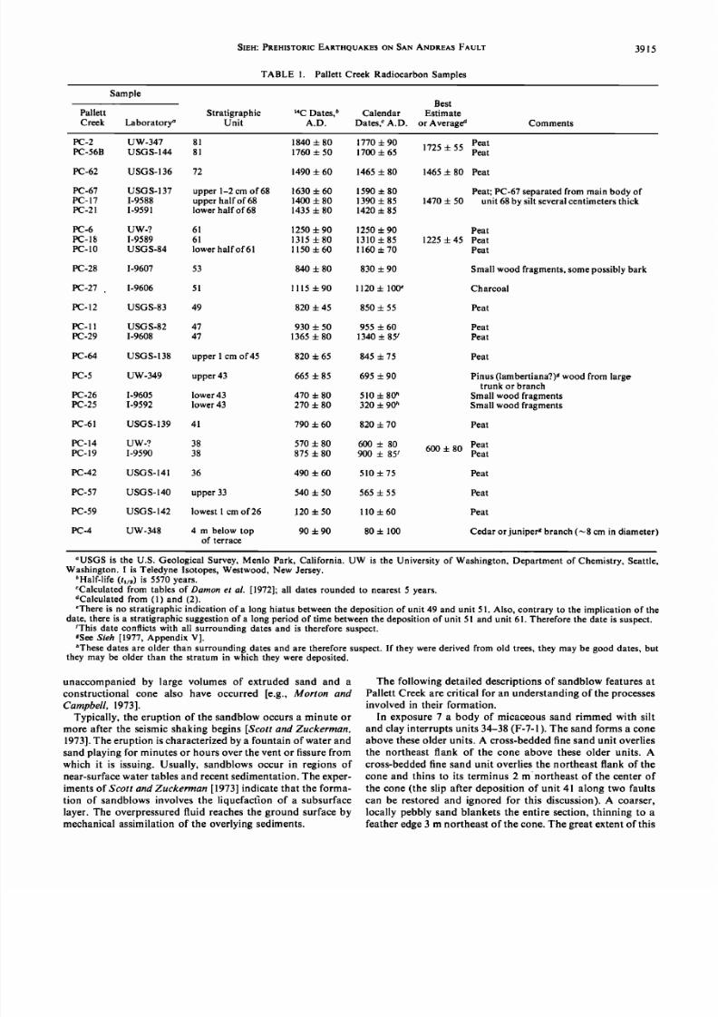
Figure 8 is a generalizedcolumnar sectionof the variousdeposits.Strata are numbered rom 26 to 98, from bottom totop of the section, o facilitate discussion. umbers that aremultiplesof l0 indicate groupsof strata. Radiocarbondatesare givenwith a statisticaluncertaintyof 1 standarddeviation(a) and have been converted rom radiocarbonyears o abso-lute years (Table 1) by using the calibration of Damon et al.[1972]. If there is more than one date determination or astratum, the dates A, B, ...) and their standarddeviations
(aA, aB, ''') have been statisticallycombinedas suggestedby Long and Rippeteau [1974] to give an averagedate:
Date•e= • + • + .... +• + ... (1)O'A O'B O'A O'B
) /2+JL+ ...O.av- O. 2 O'B (2)
Historical Deposits
The uppermost unit in the section (gravel unit 98) mustpredate 1930 by at least a decadeor 2. This can be deduced
NWlorn
SE
ß o
L 'øø1 I ,Tejon Pollerr SonChol•me Corrizo Ploin"• Poss Creek Bernordmo
Locof•on olong foult
Fig. 2. Right ateraloffsetslong he SanAndreasaultassociatedith hegreat1857 arthquake,romSieh 1978].Solid inesand heavydots ndicate ocations f data points.Light dots ndicate nterpolated alues.Near PallettCreek,offsets n 1857 ranged between 3 and 4} m.
7/27/2019 140. Pre-Historic Large Earthquakes Produced by Slip on the San Andreas Fault at Pallett Creek, California
Fig.3. Earthquakesf ML _> (1932-1972)andML •6(after1857)near allettCreek. mall hocksreshown nly ftheyare esshan50 km from hesite.PC sPallettCreek.1, February , 1890; , July22, 1899; , September0, 1907,M =6; 4, October 3, 1916,M = 6; 5, July23, 1923,M = 6{;6, March10, 1933,M = 6.3;7, February 4, 1946,M = 4.1;8, July21, 1952,M = 7.7;9, August 3, 1952,M = 5.0; 10,February 8, 1969,M = 4.3; II, September2, 1970,M = 5.4;and 12,February , 1971,M = 6.4. (Adapted nd modifiedromHilernan t al. [1973]andRichter 1958].)
from aerial photographs aken in 1930 and 1940. The 1940photographs how hat the greatest lood on record n the area
(March 2, 1938) [Butler et al., 1966, p. 24] removed he largetreesshown n the gorgeon the 1930photographs.n addition,the 1940photographs how resh1938(?)gravelson the gorgefloor but none on the top of the terrace.Apparently, hen, nodepositionoccurredon the terrace during the greatestdis-chargeof the past60 years.The largediameters f many treesin the gorgenow and the flood records or neighboring rain-agesexclude he possibilityof any overbankdeposition ince1938.
Large trees that are visible n the gorge on the 1930 aerialphotographs reclude he possibility hat a flood overtoppedthe gorge during the decadeor so prior to 1930. A brokenbottle found in unit 98 indicates hat the unit must be post-1895,however,becausehe quality of the glass ndicates hatthe bottle was producedafter 1895 bottle shopowner;Little-rock, California;personalcommunication; 976).Thus unit 98was probably depositedsometime between 1895 and about1915.
A silty unit underlying unit 98 contains many willowbranches, omeof which may be in the position n which heygrew all plant identifications re by V. Page,BiologyDepart-ment, Stanford University). These are probably the buriedremnantsof the 'willow thicket' noted by the 1904 and sur-
veyor (see Figure 6).A discontinuousnd thin peat mat whichoccurs t the top
of siltyunit 88 (Figure 8) is the youngest orizon hat couldbecorrelatedwith the 'swamp' recordedat the site by the 1855land surveyor seeFigure6). Unit 81 hasa radiocarbon ateof1725 + 55 A.D. Even if the actual date is 1725 + 2• (i.e.,
1835), the marsh producing the peat of unit 81 probablyexistedprior to the 1855marsh.Thus the 1855marshdepositsare probably present within or at the top of unit 88. Thisimplies hat the 1857 event, less han 2 yearsafter the 1855survey,musthave occurredduring or at the end of depositionof unit 88. Judging rom the historical seismicity he 1857event is the latest large event associated with fault dis-placementsat Pallett Creek. The nearestmoderate historical
earthquake July 22, 1899) occurredabout 40 km to the south-
east,and its intensitydistributionprecludeshe possibilityofmajor fault rupture at Pallett Creek. Later in this paper thelatest seismicdisturbances nd faulting of the Pallett Creeksection re shown o haveoccurred t the end of deposition funit 88. An argument can be made, then, that the date of the
top of unit 88 is 1857 A.D.
The Peats
The peats in the section are an assortmentof freshwater
marshplant remains,as indicatedby pollen (J. West, written
communication,1977) in units 26, 33, 38, 47, and 81 and byplant remains n units26 and 78 (V. Page,written communica-tion, 1977) [Sieh, 1977, Appendix V].
West writes that in the peats
there are relatively high values of Cyperaceae sedge]pollen.Theseare most ikely representative f Scirpis Bulrush,Tule] andCyperus [Umbrella Sedge]... All the [peat] sampleshave Cy-peraceae aluessufficiently igh to suggesthat they are represen-tative of a series of very shallow fresh-water tule-Cyperusmarshes... the marshes erequiteshallow 50-350 mm) when[or if] theydid contain tanding ater ... In unit 26 two charredseeds f Cyperus f. acuminatuswerenoted.Cyperusspp.usuallylike wet placesbut are not commonly found growing in water.
A detaileddescriptionof theseplants s given by Munz [1974].Wood fragments n the section ndicate the prehistoricpres-enceof the samewillow, pine, cedar, and juniper genera that
are presentupstream n the Pallett Creek drainage today (V.Page, written communication, 1977).
The ClasticDeposits
Several thick gravel units (43, 53, 55, 93, and 98) in the
section ndicate that large floods have buried the marsh onoccasionduring the past 2000 years. Units 93 and 98 indicatehistoric floods, and units 53 and 55 indicate floods about 1000
years ago. As might be expected or suchdeposits, hicknessand faciescharacteristics f thesegravelsvary considerably t
the site. Locally prominent nversegrading suggestshat the
units were depositedas debris lows, but prominent lamina-tions elsewherendicatea fluvial origin. None of the gravelsor
7/27/2019 140. Pre-Historic Large Earthquakes Produced by Slip on the San Andreas Fault at Pallett Creek, California
Fig. 4. View of PallettCreek and surroundingsooking o the northeastrom above he Los Angeles rea (U.S. AirForce-U.S. Geological urvey erialphoto064L-100; uly 18, 1968).PallettCreekoriginates n the northern lank of theSanGabriel mountains nd crosseshe SanAndreas t the studysite.This view ncludes bout45 km of the SanAndreasfault. Segment llustrated n Figure 5 is in white brackets.
other fluvial units have cut far into its substrate,so no older
units appear to have been eroded out of the section.
Several iner-grainedunits n placesdisplay low structures.Units 34 and 39 locally contain internal scour and fill and
other bed forms ndicativeof an upper low regime.Sandsof
unit 73 containsmallclimbing ipples, ndicativeof a low flowregime, and planar lamination.
The wide distribution, uniform grain size, and great unifor-
mity in thicknessof several thin silt beds suggest hey areaeolian deposits. Unit 71 is perhaps the best example. Inalmostall exposureshis powdery, punky, structureless ilt isabout 30 mm thick. It mantlesscarps nd irregular opography
without change n thickness.That it accumulatedslowly issuggested y the scatteredoccurrence f a peat stringerabout
7/27/2019 140. Pre-Historic Large Earthquakes Produced by Slip on the San Andreas Fault at Pallett Creek, California
Fig. 5. Themost ecentraces f theSanAndreasaultdisplay n enechelononfigurationn thevicinity f PallettCreek(from low-sun-angleerial photographs f I. K. Curtis, 1971).
1 mm thick within the silt. Units that are alsoaeolianprobablyinclude he lower parts of units 34, 39, and 43 and the siltsofunits 70 and 88 and uppermostunit 50.
A rate of peat deposition 1.4 mm/yr 4- 18%) and a rate ofsilt deposition 1.9 mm/yr + 32%), which are derived ater in
the paper,can be used o discernmajor unconformities ithinthe sedimentarysection. The total thicknessof peat and silt
deposited inceabout 110 A.D. is about 2.5 m. This represents1400 plus or minusseveralhundred) years,or all but perhapsa few hundred years of the 1800 years representedby thesection.
Where might there be major unconformities,hen?The mostapparent one is the modern surface,which has been inactive
for 60-70 years.Others might be (1) betweenunit 38 and unit41, where oo little silt accumulated o account or the approx-imately 200 years betweendepositionof units 38 and 41 and
(2) betweenunits 61 and 68. There are few other clues o the
stratigraphic ocationsof other possibleunconformities. t isunlikely, however, hat any unrecognized nconformities ep-resentas much as a century of nondeposition.
3. LATE HOLOCENE SEISMIC HISTORY
Procedures
Severalexposures f the Pallett Creek sedimentary ectionwere studied n detail. Two wereexcavatedby backhoe 10 and11), and the others were dug by hand (see block diagram,
Figure 7). Exposureswere numberedconsecutively uring the
course of field studies, and, becausenot all exposures represented n this paper, certain numbersare not shown. The
exposureswere mapped at a scale of 1:20 because he in-tricacies and subtletiesof the recorded phenomena required
detailedobservation nd recording.One-half-meterstringandnail gridsprovided he basiccontrol for mapping.Details were
measured rom the grid with a metric tape. Mapping of ex-
posuresproceededat an averagerate of about 3 m:/d. This
method resulted n a much more satisfactoryunderstandingand documentationof the exposureshan mappingon photo-graphswould have yielded.
A fencediagram (Figure 9) illustrates he generalrelation-ships of the features mapped in the exposures. he major
faults, stratigraphic units, and disturbances re visible n thediagram.
Discussionof theseand other phenomenapertinent to theseismic istory of the area follows, with the evidence or older
eventsconsidered irst. Evidences or seismicactivity have athree-part abel on exposures -1 lb. For example, n the label'F-11-1' the event with which the feature is identified is shown
by the letter (F), the exposuren which he featureoccurs sshownby the middlenumber 11), and the individualnumberof the feature (lower numbersappear nearest he left of the
exposure,and higher numbers nearer the right of the ex-posure) is shown by the last number (1).
Letter designationswere assigned o events n the courseof
field studies,and so, although earlier letters indicate earlierevents, etter assignments re not continuous rom A to Z. The
following detailed discussions f evidencedocumented n the
variousexposuremaps will be easier o follow if the exposuremaps (in pocket at back of journal) are laid out for quickreference in front of the reader.
Event F
Several features n exposures7, 10, 11, and 11a document
the eruptionof large sandblows uring the time betweendepo-sition of units 38 and 41 (see Figure 8). Each of the features
includesa pit several ens of centimetersdeep and wide ex-cavated nto units 34-38. The pit is filled with well-laminatedsiltsand fine sandswhichgenerallycoarsen raduallyupward.These sediments re nearly devoid of recognizable ragments
of the surrounding ost sediment. he fine sandsnear the top
of the pit are continuouswith fine sandsoverlying a severelydisturbedsilt (basal unit 39). Some of thesesandshave struc-
tures indicating upper flow regime conditions of deposition,and in two places he sands orm constructional ones.Clastic
dikesor pipesmay connectwith the baseof all the pits, but thisis observed n only one favorably exposed ase.These eaturesappear o have resulted rom the extrusionof liquefiedsilt andsand from some depth in the section.
Sandblows. Sandblowdeposits rewell-known earthquakephenomena.The terms 'sand boil,' 'sand crater' or 'sand cra-terlet,' and 'sand volcano' also have been used to describe such
features.Here 'sandblow'will refer to the active,spoutingphenomenon.Sandblow eposit'will refer o the sedimentaryevidences f the phenomenon.Sandblowsand their depositshave beenobserved fter many earthquakesof M • 5•. Recent
7/27/2019 140. Pre-Historic Large Earthquakes Produced by Slip on the San Andreas Fault at Pallett Creek, California
Fig.8. Stratigraphicolumn nd egendor thePallett reek eposits.hedepositsonsistf peats epositedn amar•henvironment,eolian ilts, nd luvialsands ndgravels. adiocarbonges eterminedor manyof thepeats re othe eft,andnumbersssignedo distinctivenits ndgroupsf unitso facilitateeferencere o the ightof thecolumn.
Theradiocarbonatesndicaten averageateof depositionf about .3m/century.he egendn he ight ide f thefigure serves s a legend or all exposuremaps in pocket).
earthquakes accompaniedby such deposits nclude the 1976Guatemala Ms = 7.5 [Plafker et al., 1976, Figures 38 and 39],
the 1973 Pt. Mugu Mt = 5.9 [Morton and Campbell,1973], he
1971 San FernandoMt = 6.4 (T. L. Youd, personalcommuni-
cation, 1976), and the 1964Niigata Ms = 7.5 [Kuribayashi ndTatsuoka, 1975] events. Earlier events for which sandblow
deposits have been documented nclude the 1906 San Fran-
ciscoM = 8.3 [Lawsonet al., 1908, p. 403 and Plates 142, 143],
the 1899 Assam M • 8• [Oldham, 1899, Plate 11], the 1886
Charleston M • 6 [Dutton, 1889, Plates 20, 21, 28], and the
1811-1812 New Madrid mo = 7.1, 7.2, and 7.4 [Fuller, 1912;Nuttli, 1973] earthquakes.
The dimensionsf sandblow eposits panseveral rdersof
magnitude.n SanFernandon 1971, and orming mall 0.1-to 1.0-mdiameter)solated oneswasextrudedhrough mallcracks everalmillimeterswide T. L. Youd, personal ommu-nication, 976). n the MississippiiverValley n 1811-1812,sandblow cones attained diameters of several tens of meters
and were fed by ventsmore han 2 m wide [Morse,1941].Often the features re aligned, uggestingruptionalong is-sures r faults e.g.,Bolt, 1974,Figure8]. In some nstances,omuch sand has been extruded that the entire surface of the
ground asbeenblanketedy a meter r moreof sand e.g.,Oldham,1899,Plate 11]. Largecraters n the groundsurface
7/27/2019 140. Pre-Historic Large Earthquakes Produced by Slip on the San Andreas Fault at Pallett Creek, California
PC-59 USGS-142 lowest 1 cm of 26 120 ñ 50 110 ñ 60 Peat
PC-4 UW-348 4 m below top 90 ñ 90 80 ñ 100of terrace
Cedar or junipeff branch •8 cm in diameter)
"USGS s the U.S. GeologicalSurvey,Menlo Park, California.UW is the Universityof Washington,Departmentof Chemistry,Seattle,Washington. is Teledyne sotopes,Westwood,New Jersey.
øHalf-life (t•/:) is 5570 years.cCalculatedrom tablesof Damonet al. [1972];all dates ounded o nearest years.dCalculated rom (1) and (2).eTheres no stratigraphicndication f a longhiatusbetweenhe deposition f unit 49 andunit 51. Also,contrary o the implication f the
date, here s a stratigraphicuggestionf a longperiodof timebetweenhedepositionf unit 51 andunit 61. Thereforehe date s suspect.rThis date conflictswith all surrounding atesand is thereforesuspect.eSeeSieh [1977, Appendix V].
hThese atesare older than surrounding atesand are therefore uspect.f they werederived rom old trees, hey may be gooddates,butthey may be older than the stratum n which they were deposited.
unaccompaniedby large volumes of extruded sand and aconstructional cone also have occurred [e.g., Morton and
Campbell, 1973].Typically, the eruption of the sandblowoccursa minute or
more after the seismicshaking begins [Scott and Zuckerman,
1973].The eruption s characterizedby a fountain of water and
sandplaying or minutesor hoursover the vent or fissure romwhich it is issuing. Usually, sandblowsoccur in regions of
near-surfacewater tablesand recentsedimentation. he exper-imentsof Scott and Zuckerman [1973] indicate that the forma-
tion of sandblowsnvolves he liquefaction f a subsurface
layer. The overpressuredluid reaches he ground surfacebymechanicalassimilationof the overlying sediments.
The following detailed descriptions f sandblow eaturesatPallett Creek are critical for an understanding f the processesinvolved in their formation.
In exposure7 a body of micaceoussand rimmed with silt
and clay interruptsunits 34-38 (F-7-1). The sand orms a coneabove these older units. A cross-bedded fine sand unit overlies
the northeast flank of the cone above these older units. A
cross-bedded fine sand unit overlies the northeast flank of the
cone and thins to its terminus 2 m-northeast of the center of
the cone (the slip after depositionof unit 41 along two faultscan be restored and ignored for this discussion).A coarser,
locally pebbly sand blankets the entire section, hinning to afeatheredge3 m northeastof the cone.The great extentof this
7/27/2019 140. Pre-Historic Large Earthquakes Produced by Slip on the San Andreas Fault at Pallett Creek, California
SIEH.'PREHISTORIC ARTHQUAKES N SAN ANDREASFAULT 3917
coarserunit in other excavations uggestshat it was fluviallyderived. n the plane of exposure7 the three units composeawedge3 m long and more than } m thick over the vent.
The circular vent 100 mm in diameter from which the sand
was extruded is bisectedby the plane of exposure7. Excava-
tion of the loosesandwithin the pit revealed hat the vent has a
main trunk with several very short, narrower blunt-nosed
pipes penetrating horizontally into the silt and clay of thelower portion of the pit. This may indicate hat as he liquefiedmaterials mechanicallyassimilateda path through the over-lying sediments, everalpathwayswere activelyeroded owardthe ground surface. When one broke through the ground
surface, he other pathwaysmay have become nactive, and the
rapid removal of sand may have widened he pipe which hadreached the surface.
Further excavation of exposure7 revealed he geometry of
the sandblowdeposit n three dimensions. erpendicular o the
plane of exposure7, the pit in units 34, 36, and 38 diminishesin depth. One-half meter to the northwest (behind the face of
exposure7), the pit is about as deep as it is in exposure7 but
has no vent piercing its base or sides Figure 10). Notice the
gradual upward coarsening f the dark organic silts nto light,fine micaceous and.Nearly I m behind the face of exposurethe pit is only half as deep. The three-dimensionalpit shapecan be imagined as a canoe 3 m long oriented nearly per-pendicular o the exposure; t is deepestat the vent and higher
on the left than on the right. The sand composing he coneexposed n excavation7 was extrudedalonga fault formed ustprior to eruption. This fault is indicated by a difference of
about 300 mm in elevation of the unit 38 peat across he sand
body after one makes a mental restorationof post-unit-41faulting (see exposure7). The fault plane in the exposurewas
destroyedby the excavationof the sandblowpit immediately
below the cone.Thus the faulting preceded he pit formation;although perhaps by no more than a few minutes, and the
downthrown block received most of the extruded sand.
Between he extrudedsand that composes pper unit 39 and
the peat of unit 38 in exposure 7 is a contorted silt layer.Although the silt is locally well laminated, t generallydisplays
disturbedstructure.Small open and closed oldsand flamelikestructuresare common. Similar structureshave developed nunconsolidatedsaturated lake sedimentssubjected o seismic
shaking [Sims, 1973, 1975]. Thus seismicshaking may have
preceded he ejection of the sandblow deposit.
The relationshipsof various facieswithin the sandblowde-posit are important in understanding he evolution of thissandblow. In the exposure 7 record the fine micaceoussand
composing he cone and filling most of the pit surroundsanangular body of silt. Similar silt and clay form a liner, a few
tensof millimeters hick on the edgesof the pit and thicker at
the base of the pit. This silt and clay unit is pierced by the
sand-filledvent. Behind the mapped exposure he well-lami-nated silts form an unpierced basal facies which coarsens
gradually upward into the fine sand of the cone (Figure 10).Clearly, the finer materialswere deposited n the pit before he
fine sandspiercedand were depositedover them. It is difficultto imagine how the finer componentswere deposited n thelowest part of the pit before the coarser components. Any
explanation must account for the completeabsenceof recog-nizable ragmentsof host sediment n the silt and clay deposits
lining or filling the lower part of the crater. Perhaps a large
sustainedoutward flow of water eliminated all loose particles
from the floor and sidesof the crater. Alternatively, complete
38
fine'
ßn.•ca.½-.•'-ous.
organic
Fig. 10. Sandblow deposit encountered n exposure7 displaysdifferent characteristicsn this exposure,about • m northwest i.e.,behind he face) of exposure . No vent is apparentat the baseof the
pit, and well-laminated ilt and sand ill the pit. As in exposure , allfaulting on the northeast right) side of the photograph s severalhundredyearsyounger han the sandblowdeposit.
disarticulationof the fragmentsof host sedimentmay haveoccurredbefore incorporation in the pit sediments.
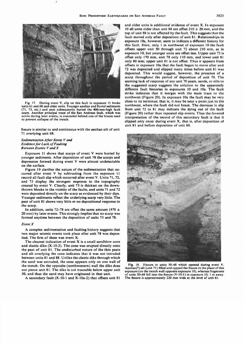
Another feature that may be related to the extrusion ofliquefiedmaterialsoccurs n exposures 1 and 1 a. F-11-1 andFol l aol are about I m apart on opposite walls of trench 11.
Essentially,hey are transverse rosssectionshrougha bodysimilar in general form to the F-7-1 sandblow feature. In
general, his featureconsists f (1) an inclined abular plug oflaminatedsilt and clayeysilt that interruptsunits 34-38, (2) alarge wedge of sand that showsdune or antidune bed forms
and thins and flows southwardaway from a vent above theplug, and (3) a thinner body of sand north of the plug. Theplug disappears nly } m behind southeast f) exposure11, isdeepestn exposure a, and is very nearlyparallel to a majorfault. As at F-7-1, there is evidence or faulting and seismicshaking ust prior to sandblowdeposition,and there is addi-
tional evidencebearingon the nature of emplacement f thepit sediments.
In exposure 11, unit 38 has a vertical separationof about500 mm. Unit 41, overlying he sandblowdeposit,has a verti-cal separationof only about 300 mm. This difference annotbe
explainedby lateral offset of units with differentdips, sinceboth units have an apparent dip of about 1ø parallel to thefault in trench 11. Thus slip apparently occurredbetween he
depositionof units 38 and 41.
7/27/2019 140. Pre-Historic Large Earthquakes Produced by Slip on the San Andreas Fault at Pallett Creek, California
3918 SIEH.'PREHISTORIC ARTHQUAKES N SAN ANDREASFAULT
Relationshipsn F-11-1 supplyadditionalevidence or faultslip just before or during sandblowdeposition. n the crosssection of exposure11, two blocks of units 36-38 occur be-tween the pit and the main fault trace. The block nearest he
pit appears o have slid into the pit sometime fter the lower-most 50-100 mm of the pit had been filled with silty clay,clayeypeat-richsilt, and charcoal-rich ilt. This suggestshat a
fresh,unstable ault scarpexistedduring depositionof materi-als within the pit.Vents. The sourceof the sandblowdeposit n exposures11
and l lb is not obvious. A sand-filled crack 10 mm wide
bisecting he F-I 1-1 body (see exposure 11) may have beenfilled from above after depositionof the sandblowmaterials.The wide sand-filled rack overlying he plug and interruptingthe laminated sandsof F-11 a-1, however,almost certainly s a
sandblowvent. It has rregular vertical aminations n the sand
filling the crack, nonmatching rack walls,and a circularplanview. Nevertheless, the vent could not be traced downward
into the plug of siltsand clayeysilts.Perhaps he lowerportionof the vent was destroyedduring excavationof the trench.
F-I la-3 is another sandblow feature. The plug of silt and
clayeysilt widens nto the wall of the exposure, uggestinghatthe pit was a circular eature.Only the edgewas ntersected ythe excavation. No obvious vent was found to penetrate the
plug, yet it appears hat a coneof extrudedsand estsover the
plug.The silt plug. The geometries nd relationships f various
facies within the sandblow deposit F- 11- /F- 11a- 1 are puz-zling but must be consideredn the discussion f the creationof the deposit.F-I 1-1 has a partial lining of chaoticdepositsnits base exposure11 and Figure 11). Thesemay be fragmentsof the eroded host material. As in F-7-1, however, the silts and
sands illing the pits have no recognizable ragmentsof theintruded material. The F- 11- /F- 11a- 1 pit is steeply nclined
and at least 1 m long, yet the unconsolidatedwater-saturated
slab of overlyingsediments id not collapse nto the pit beforeit was illed. In fact, exposure11 shows hat the peat of unit 38and the overlyingsilt of unit 39 were underminedabout 250mm, yet these hin overhangingunits did not collapse nto thepit. This alsooccurred n pit F-I la-3 at point F-I la-4. F-I la-3and F-11a-4 show tonguesof clayey silt and silt probing into
•andbtow. • ..:$.Gnd'
the host materials yet without incorporation of recognizablefragmentsof the host materials. Also the basal silt of unit 39
and the unit 38 peat appear to be intricately intercalatedwith
the depositsof F-11-I (Figure 11), F-11a-1, and F-11a-3.The featuresshaped ike kettle drums abeled F-10-1 and F-
10-2 are two more sandblowphenomena.Unlike the featuresjust discussed,F-10-1 and F-10-2 are not associatedwith a
constructionalcone. In fact, unit 41 is depressed ver the two
features.Apparently, too little material was extruded o con-struct a cone over these arge pits or bowing of the groundsurface at the time of event F allowed extruded sand to be
depositedaway from the vent area. Units 34-38 are continu-
ous on the opposite unmapped) wall of the excavationaboutI m to the northwest. Likewise, these units were found to be
continuousonly } m southeastof exposure10. Thus the twopits are roughly circular n plan view, with diametersof about1 m. Although no vent pierces he silty o sandy ill of eitherpitin the plane of the exposure, he wall of the exposuremay be toone sideof the vents. These two pits are also filled with well-
laminatedsiltsand sand hat coarsen pward. A broken peatyunit between he pits is undercut by the northeasternpit.
Creation and filling of the pits. Several observationsarepertinent o discussion f the processesf formation of the pitsthat have been described:
1. The sedimentscoarsen upward, generally from darkbrown peat- and charcoal-richclayey silt through fine sandysilt and silty fine sand nto fine sand.Where the coarseningsgradual, it suggestsather continuousdepositionof graduallycoarseningmaterials;where it is relativelyabrupt, a two-stage
depositionalprocessmight be invoked.
2. The silts, clayey silts, and sandy silts filling the pitsconstitutea relatively small percentageof the total volume ofextruded materials.
3. Two of the pits are tabular and aligned along fault
planes. It is hard to conceive of pits of such shape being
explosivelyexcavatedby forcesconcentratedat the top of avent 100-200 mm in diameter.
4. Pit boundaries re very sharp,although ocally, they arevery irregular and extend nto the host materialsas wedges nd
tongues.Although in large part the pits may have been ex-
plosivelyexcavated,substantialadditional erosionby the tur-bulent movement of water and liquefied materials within the
............ pit after the explosiveexcavation s probably responsible orthe clean but irregular boundaries.
5. Few fragmentsof the surroundingmaterials are incor-
porated within the pit sediments.Most host material musthave been either removed from the pit or so thoroughly dis-
...................:... :;!' articulatedndhomogenizeds o beunrecognizablen thepit:'
--:•.•..:..•-:* --:•.,..•?: ..• sediments.Although the lowest parts of the pits contain peat.>. ß.
• lying materials, he completeabsence f any pebbles rom unit•, 34 implies that the former explanation may be correct.
6. The silty sandand sandysiltsof the pits in exposures 1and 1 a are intercalated with unit 39 and basal unit 39 at the
lip of the pit (Figure 11). The laminae of sand and silt inter-leave or intrude the irregular laminae of the depositsof units38 and 39.
7. Thin slabsof unit 38 and basal unit 39 overhang he pitsat a few sites. These unlithified water-saturated sediments
probably would not have had sufficient oherence r strengthto maintain such positions f the pits had been filled merelywith air or water prior to pit sedimentation.Perhaps hen the
pit sedimentswere emplacedas slurries mmediately after ex-cavation of the pits. However, it is difficult o envision amina-
Fig. 11. Relation of sandblowdepositnear northeastend of ex-posure 11 (F-11-1) to host units 34-39. Attempts to describe heformation of the sandblow deposit must explain (1) the laminatedsandblow and,which s free of host materialsbut interfingers ith siltof umt 39, (2) the chaotic ining, and (3) the thin soft ayer of unit 38,whichdid not collapse fter erosionof the hollowand beforeemplace-
ment of the sandblow and n the hollow.The figure s approximately750 mm across.
7/27/2019 140. Pre-Historic Large Earthquakes Produced by Slip on the San Andreas Fault at Pallett Creek, California
tion and sorting of sand and silt under such conditions ofdeposition.
8. The silt and sand laminae are regular, nowherecon-voluted r irregular, nd ypicallyerminate bruptly t thepitwalls. This might argueagainstdeposition s slurries nd infavor of depositionn quiet water.Sucha historywould re-quire wo argeseismic vents,he irstresultingn creation f
the pits and followed by hours,days, or monthsof quietdepositionof silt and clayey silt. The secondseismiceventwouldhave esultedn deposition f the sandyportions f thesandblowdeposits.
One of the least mplausible xplanationsor the observedfeatures nd relationshipsas heactionstartingwith a strongearthquakeaccompanied y surface aulting. Basal unit 39,lying at the surfaceof the marsh, undergoes oft sedimentdeformation.A fine sandy ayerat somedepth iquefies fterthe onsetof heavyshaking.Overpressuredater n the lique-fied sand ayerbegins o assimilatemechanically r to fractureoverlying iltyand peatymaterials ydraulically, nd a pipeorsheetof fluidized materialsgrows upward along the faultplane; he materials n the pipe or sheetare predominantly
assimilated ilts and peatssecondarilyiquefiedby the risingoverpressured ater. Upon reachinga point about • m belowthe marsh surface, he overpressured ater overcomes heoverburden ressure, nd a crater s explosively xcavatednthe groundsurface. he fluidizedmaterials igh n the pipeorsheet re the assimilated eatsand silts.The circulating lurryof thesematerials 1) rapidlyerodeshe greaterpart of the pit,removingmostof the hostmaterials, nd (2) is thendepositedin the excavatedpit. The liquefied ine sand follows the finer
materials p the ventand works hrough he finerpit deposits,eruptingonto the groundsurface.Bed ormsof the upper low
regimesuggesthat the sand s ejectedwith large volumesofwater. A fountain spoutsover the vent for severalminutesor
•hoursbefore graduallyceasing o flow.
Evidence or fault slip synchronouswith the sandblows.Several ocalities show evidenceof fault slip synchronouswith the sandblow activity. Dip-slip movement on a faultsynchronousith the fofmationof F-11-1 hasbeendescribed
above.Severalminor aultsappear o haveslipped t this imealso.Units 34-39 are separatedmore han unit 41 alongF-7-2.Unless the difference is due to offset of beds of different
warping s probably indicativeof movementon the main faultduring event F.
Event D
Although exposuresof materials older than unit 38 are
relatively limited, the northern half of exposures11 and 10displayenougholder stratigraphy o reveal at leastone event
that occurred prior to event F. This will be called event D.Several small faults related to event D occur in exposure 10
belowunit 34. D-10-1 displaces ll unitsexposed elowunit 34about 50 mm and terminates upward at a degradedscarp at
the top of unit 34. D-10-2 and D-10-3 displaceolder units asmuch as 200 mm but cannot be traced through unit 34. D-10-6
is a group of faults clearly offsettingall units exposedbelowunit 34 but not affecting he youngercratersof event F above.Together he apparentverticalslipon these aults s less han •m. Perhaps he 300-mm change n thickness f unit 34 acrossthe F-10-6 fault zone in exposure 10 is an indication of theapparentvertical slip.
Near the faults in exposure10 is evidence hat unit 34 is asandblowdeposit.Two silty plugs D-10-5) pierceunit 33 andlower unit 34. They are part of a pit through which unit 34apparentlywas extruded.D-10-4 is a siltyclayey lare originat-ing in D-10-5 and penetrating he sandof unit 34. Immediatelyto the left are nearly vertical laminations n unit 34. The steeplaminations of D-10-4 and D-10-5 indicate nearly verticalmovement of materials.
Event I
Unit 46 appears o be a sandblowdepositextruded during
an eventhereinafter ermedevent . The unit occurs ocally aslenses,wedges, and irregular bodies of silty fine sand (ex-posures10, 10a, 11, and 1 b) betweenunits 45 and 47.
1-10-1 s the largestbody of unit 46. Silt near the main fault
trace with vertical laminations (Figure 12) suggests ventnearby. A small crack in unit 45 only about 100 mm southwest
of the fault appears o have beena minor route of evacuation.The sand and silt body thins to a feather edge about 4 m
southwest f the fault. About • m from the vent it was depos-ited over a small fault in unit 45 (I-10-2); 1• to 2• m from the
vent it buried the highly deformed surfaceof unit 45 (I-10-3).
orientation,his ndicates lip subsequento the extrusion f This deformationmay indicateseismic hakingof at leastsandblowF-7-1, perhaps n response o the evacuationofsubsurface material in order to create the sandblow. Fault F-
10-3 appears o haveslipped fter deposition f unit 38 and thebasal silt of unit 39. It does not offset the sand of unit 39. F-5-1
is a complicatedault zonewhichdisrupts ll unitsbelowunit
39 but disturbsnone from unit 39 up. Unit 38 is thrust overitself, and an older peat is tightly folded on top of unit 38.Complicationsseen n this fault zone at and below the 94-m
levelare related o a •-m-diameterplug of sandand sandblowcone a few hundred millimeters behind the plane of themappedexposure.The massiveoval body in the exposurerecord s a part of the silt shellsurroundinghat unexposedbody that was producedduringevent F.
Substantial lipon the main fault probablyoccurred uringeventF (that is, betweendeposition f units 38 and 41). Therelationship f unit 38 to overlying nits41-47 in exposure(F-5-2) establisheshis.Unit 38 displays largedip away romthe main fault zone.Units 45 and 47 showonly a slightdip.Units 41-47 merge toward the main zone with unit 38. This
appears o reflect ocalwarpingof the groundsurface ear hefault between he time of deposition f units38 and 41. This
Modified Mercalli intensityV or VI [Sims, 1973,p. 63]. About3•[m from the vent the extruded sand buried a 150-mm-highfault scarp I-10-4). The fact that the fault displaces ll older
deposits y the sameamount ndicates hat slipoccurred itherduring or just before the sandblowoccurred.A few more tens
of millimetersof slip occurredsoonafter burial of the fault byunit 47 or 49.
Units 5-47 n exposures1and lb displaytratigraphicand structuralcomplexity.The soft upper surfaceof unit 45 is
deformed n three places I-11-3, I-11-6, and I-11-7). Severalminor breaks n unit 45 do not extendupward into unit 47 (I-11-5, 1-11-7, and I-11-9). Many small pods and lenses f finesandoccurbetweenunits45 and 47. These enses nd podsarediscontinuousnot only in the direction of the exposurebut
also perpendicular o the exposure,sincevery few are on theoppositeside of the trench. The large sand body (unit 46)southwestof the fault in exposure 1 b, for example, is but asmall sliver across he trench in exposure 11. It is difficult to
conceiveof fluvial or aeolian depositswith these geometric
relationships. he stratigraphicassociation f thesepod- orwedge-shaped odies with soft sedimentdeformation, minor
7/27/2019 140. Pre-Historic Large Earthquakes Produced by Slip on the San Andreas Fault at Pallett Creek, California
Fig. 12. Verticalaminationsabove rrows)n sandblowepositin exposure0,unit46 I-10-1),ndidateroximityo hevent hroughwhich he depositwas extruded. iew is approximately80 mmacross.Southwest s to the right.
main ault racewhenunit47, but not unit45, wasdeposited.The top of unit 46 swings harply pwardat the ault,and unita7 seemso havebeendeposited ponunit 46 in responseothis condition.By the time of deposition f basalunit 50, thisscarpwasburied,andunitswerebeingdepositedorizontallyacross he scarp. t is important to emphasizehat in thisparticularcase he evacuation f the liquefied ubsurfacenit
Indicationsf a largedeformationear he ault n exposureI strongly suggestmovement on the main trace of the faultafter depositionof unit 52. Units 45-53 southwest f the fault
tilt steeplyway rom he ault N-1-5).Becauseheoverlyingportions of unit 50 thin toward the fault, it can be concluded
that thedeformationook placebefore heirdeposition.hiseffectand accompanyingffectsndicateeventN.
A wedge of rubble overlies unit 52 southwestof the main
fault (N-l-6). The rubble nterfingers ith gravelof units53and55, suggestinghat t wasdepositedradually fterdeposi-
tionof unit52.Burrows uggesthat he ubblemaybepartofa groundsquirrelmound.Alternatively,he rubbleunit maybea brecciaormed t thebase f an eventN faultscarp.f so,it is not extensive long he fault. Less han 1 m to the north-west, n exposure , the rubble N-3-1) occupieshe samestratigraphicosition ut is only 100mm thick, s not pebbly,and grades mperceptiblynto the pebblygravelof unit 53.Becausehe rubble overliesa major break within the main
fault zone exposure) and s associatedith a largewarpnear he ault N-l-5), eventN probably epresentsajorslipalong he SanAndreas ault at this ocality.
Supportingdata for an event N are numerousminor faults
and fracturesn exposures , 3, and 11 (N-l-2, N-l-3, N-3-2,N-3-3, N-11-1, N-11-2, and N-11-3) that break units 52 and
belowbut are overlainby the gravelof unit 53. Soft sediment
faults,and the largesandblow edgeI-10-1) suggestshattheymightbe sandblow eposits.
The sandblow eposits f eventF (unit 39) may be thesourceor at leastsome f thesandblow eposits f event . 1-10-5,whichappears o originate n unit 39, the eventF sand-blowdeposit,maybe representativef fissureshroughwhichthe smalldeposits ereextruded.n exposure 0, unit 39 isthinnestdirectlybelow the thickestportionsof 1-10-1.Thevolume needed to restore unit 39 to its 'normal' thickness is
approximatelyqual o the volumeof 1-10-1.Although hismaybe a merecoincidence,he temptations to concludehat
Movementon a main fault traceduringevent cannotbeunequivocallyemonstrated,ut two ines f evidenceuggestsuch movement:
1. Verticalseparation f unit 45 at 1-10-1 s greater hanthe vertical eparation f unit 47. This suggestshat at leastone more ncrement f slip hasbeenexperiencedy unit 45than by unit 47. Alternatively,his apparent lip differencemightbe due o horizontal lip uxtaposing sectionn whichunit 46 was deposited gainsta section n which t was notdeposited Figure 13a), or the extrusionof unit 39 onto the
surfacemighthavecaused ontectoniclip on the main fault(Figure 13b).
2. 1-10a-2 uggestshat a scarpmay haveexisted n the
. 47
4•
Fig. 13. Possible easonswhy unit 45 is separatedmore thanoverlying nits n exposure0. a) In theupper iagramhesectionothe eftof the aultdidnotreceive sandblowepositstipplednit)above nit 45 during vent , whereashe sectiono the rightof thefaultdid.Unit47 aterwasdepositedpon oth ections.ight ateralfaultslipof perhapseveral eters, ccompaniedya small mount fvertical lip, then uxtaposedhe two different ections,iving heimpressionhat unit45 is vertically ffsetmore hanunit47. Relation-ships n the owerdiagrammay havedevelopedn a similar ashion.(b) Liquefactionf unit39 during vent mayhavebeenollowed yextrusionf a portion f thatunit o forma sandblowstippleunit).Theevacuationf a partof unit39 mayhave esultedn a bendingf
overlying nitsdownwardlong he ault.Thismightgive he mpres-sion hat tectonicaultinghad occurred ven hough t had not.
7/27/2019 140. Pre-Historic Large Earthquakes Produced by Slip on the San Andreas Fault at Pallett Creek, California
deformation also s associatedwith event N. N-11-4 and N-11-
5 are flexures n unit 52 that developed eforedeposition funit 53. More impressive re unmapped inusoidalolds nunits45-52 exposedn the gorgewall at the southwestndoftrench l (Figure 7 shows he locationof the gorgewall).Theseextendnearlyparallel o the fault for about 10 m alongthegorgewall.Their amplitudesre about100mm,and heir
wavelengthsre about400 mm. They are overlainby appar-ently undisturbed ravel of unit 53.
Event R
EventR is basedupon threeexposures hichcontainevi-dence hat strike-slipaultingoccurred rior to deposition fpeatunit61. At all three ocalities 150- o 300-mm outhwestfacingscarpwas formedat the time of this event. n eachplace,differencesn unit thicknessesnd faciesacross hefaults ndicatestrike-slipmovement. hat is, strike-slip is-locationof unitsof irregular hickness nd grain sizecharac-teristics has occurred. At location R-11-1, near the northern
endof exposure1,a major ault erminatespwardn a hardclayey ilt. Different acies crosshe fault hereshow ignifi-
cant ateralslipon the fault for example, nitsabove 5 andunits 45-49).
A 230-mmscarp ormedust prior to deposition f unit 61 atexposure (refer o Figure9). Lateraloffsetcreated aciesdifferences cross he fault. The silt of uppermostunit 50,
displacedownward n thesouthwestideof the ault,hasnoequivalentcrosshe fault.This suggestshat it waserodedfrom heupthrown lockbeforedepositionf unit 61. Unit 61wasdeposited vera verybroadscarp emainingromeventR. This s not apparent nless neviews nit61 parallel o theplane of the exposure.
Another fault, visible n the bulldozercut (Figure 14), alsomovedduring eventR. All exposed nitsbelow unit 61 areoffsetabout 300 mm along his fault, which mplies hat thefaultmoved nlyonce.As n exposure, unit61wasdepositedacrosshe very broaderodedscarpof this fault.
Event T
Disruption long hemain ault raceandevidencef lique-faction re heprincipalndicators f eventT, whichoccurredjust after depositionf the peatof unit 61. T-2-1 is a fissurethatopened long hemain aultduring ventT andwas aterfilled.The northeastern oundaryof the fissures the planeofthe main fault traceand thushasslipped gainsince he fissureformed.The southwesterndgeof the fissure,which has notbeendisturbedsince ts burial, terminatesat the top of unit 61.
The fissures less han 3 m long. t continues nly about m tothe northwest and continues no more than about 1 m to the
southeast, ecauset doesnot appear n exposure . The lowerhalf of the issureschokedwith peatysilt,rubblypebblysand,
two ragmentsf peat, nda fragment f silt.The ragmentsfpeatmatchunit 61 in texture ndgeneral ppearance.hesematerials robably ell into the fissure hortly fteror duringits formation.A well-laminated ilty sandwith festooned rossbedsills heupper alfof the issure ndoverlies nit61 o thesouthwest.Whether this is a fluvial or a sandblow deposit s
not known. However, t is too poorly sorted o be aeolian.Fissures an form along faults unaccompaniedy seismic
activity.Clark [1972]carefully ocumentedhe developmentof collapseissureslong heCoyoteCreek aultwellafter hefaulthadexperiencedeismiclip.Rainwater unningnto he
tectonic racturesat the groundsurface roded arge chasmsby carryingmaterial ownward long he ectonicractureso
38
Fig. 14. Minor fault exposedn bulldozer ut (seeblockdiagram,Figure ) offsets ll unitsbelowunit 61 about300mm.This ault sevidence for event R. Facies and thicknessdifferencesacross he fault
in thegravelly nitsbetween nits52 and61 indicate t leastseveralhundreds f millimeters f lateralslipon the fault. Dots ndicate aulttrace n gravels. cale s 220mm ong.View s to the northwest.
the water table tens of meters below. I have found clear evi-
dence f the same rocesslong he SanAndreasault n theCarrizo Plain 200 km northwest of Pallett Creek after heavy
rains.Therealsoa deepwater ableenables ownwardlowofrainwateralong tectonic ractures.The peat of unit 61 atPallett Creek indicatesa water table very near, if not at, the
ground urfacemmediatelyrior to eventT [Sieh,1977,Ap-pendixV]. Hence t is quite unlikely hat pipingby waterflowing nto a tectonicracture ouldhaveproducedhe fis-sures observed in the section. Thus the existenceof the fissure,
T-2-1,suggestshatslipon themain raceof the aultoccurredat the time of event T.
A small silt- and clay-filledcrevasseT-10-3 and T-10a-1)
may alsoderive rom a crack hat formedalong he faultduringeventT. The crevasses overlain y peat.The usualunits61-65-68 equences not present t this ocality, nd t isuncertainwhether he peatoverlyinghe crackbelongso unit61, unit 68, or both. Thus it is not clear whether he crackformedust beforedepositionf unit 61 or beforedepositionof unit 68. In any case, ts formationwouldcorrelate itherwithevent (before nit68) or witheventR (before nit61).For two reasonshe overlying eatprobablybelongso unit68, and so he crackprobably ormedduringeventT: (1) The
orange iltandclay illing hecrevasses similar o orange iltandclaymapped lsewheren exposure0under r withinunit
7/27/2019 140. Pre-Historic Large Earthquakes Produced by Slip on the San Andreas Fault at Pallett Creek, California
3922 SIEH.'PREHISTORIC ARTHQUAKES N SAN ANDREASFAULT
68. Thus the peat above the crevasses probably unit 68 peat.(2) Liquefaction during event T appears to have disrupted
units 61 and 50 in the vicinity of the crack, so unit 61 might not
exist here. The fissureoccurs on the higher block, indicating
that just after event T the block was at nearly the sameeleva-
tion or lower than the present lower block.Two other features indicate the occurrence of event T. A
small fault (T-10-1) displacesunit 61 but not unit 68 (Figure15). It affectsonly units $0 and 60 in exposure10 and doesnot
break the sedimentsexposed on the opposite wall of thetrench. Because t affects only the upper meter of sedimentsand is so localized, it must be nontectonic in origin. It is
explained most reasonably as a feature accompanying ocal
liquefaction of gravel and sand of unit 50. Evidence hat unit
50 liquefied s presented elow.Becausehe overhanging carpdid not collapse,unit 65 must have been deposited airly soon
after fault slip occurred.Perhapsunit 65 is a sandblowdeposit.
A peaty sandy silty slab (T-10-2) a meter to the southwest
projects nto upper unit 50 materials (seeexposure10 recordand far right of Figure 15). This is characteristicof the enig-matic relationships hat occur at this locality. Upper unit 50
may have iquefiedduring event T, producing he surficial aultT-10-1, the slab T-10-2, and the generally confused sedi-mentary relationshipsnear the main fault in units 50 and 61.
Additional evidence or rupture of the main fault is visible n
exposure 1 b, where unit 61 at T- 11b- 1 is highly disturbed.
The disturbanceof unit 61 may be an indication of fault slipduring event T. The general chaosof that unit within 250 mm
of the main fault might be expected f the fault slippedwhileunit 61 was at the surfaceof the ground.
T-2-2 is a fault which began to slip after depositionof unit61 and slipped again one or more times before depositionof
upper unit 68. Lack of major facieschangesacross he fault
suggests nly minor strike-slip movementon the fault, if any.
Ground squirrel activity has obscured his fault on the log ofexposure 2. Further excavation revealed the undisturbedex-
posure llustrated n Figure 16, where unit 61 is offset 170 mm,
basal unit 68 is displacedonly •70 mm, and the upper half ofunit 68 is not faulted. The similarity of faciesand thicknesses
of gravelly unit 65 across he fault indicates hat the faultmovementwas primarily vertical. Upper unit 68 and overlying
units thin toward the scarp,providinga very good illustrationof a sedimentary response' o the presence f a fault scarp. tappears hat 100 mm (170 - 70 mm) of vertical displacement
Fig. 15. Minor fault (T-10-1) in exposure 0 that offsets nit 61 (at
arrows), but not unit 68, is evidence or event T. Sandblow(?)sandofunit 65 was deposited efore he overhanging carp above enscap)collapsed.Southwest s to the right.
Fig. 16. Minor fault (T-2-2) offsets nits61 and 65 and ower,butnot upper, unit 68 (arrows). During eventT, unit 61 was offset 100mm. After erosion of the scarp produced during event T, alluvialdepositionof unit 65 occurred,and unit 68 began o form. Seventymillimeters f additionalslipoccurredbeforedeposition f unit 68 washalf complete.This exposure s about 300 mm northwestof exposure2. Length of scale s 170 mm.
occurred uring vent (Figure16).Erosion f thescarphenoccurred. nit 65 was hendeposited pon he remnant f thescarp.Duringdepositionf lowerunit 68, an additional 0mm of slip occurred. his slip after eventT may ndicateslumpingoward he main fault trace ather han tectonicactivity.
Several ensesof silt betweenunits 61 and 68 in exposures1
and 11maybe sandblow epositsf event (T-1-1,T-1-3,T-1-4,andT- 11-1. One ens T- 1-1 isconnectedo a clastic ikewhichoriginates ithinunit 50. Unit 61 is offset long hisdike, but unit 68 is not. In general,unit 61 in exposure is
more disturbed y faulting han unit 68, whichsuggestsheoccurrence of event T.
Event V
The largestverticalseparation' f any unit ascribableo oneseismicevent appears n trench 11. About 400 mm of separa-tion occurred on a fault within the main fault zone during
event V, between he depositionof units 68 and 71 (V-11-1 ). In
exposure 1 b the faulting (V-1 lb-3) was accompaniedby alarge amount of warping.That this fault has not beenreacti-vated since event V is evidencedby the unbroken sediments
that blanket the fault (Figure 17). A thin blanket of silt (unit71) coversunit 68 and drapes he fault scarpof event V. Thissilt is aeolian, judging from its uniform thicknessover an
irregular opography.Large differencesn faciesand thicknessof subunits of units 40, 50, and 60 across he fault indicate a
large amount of horizontal slip on the fault.The other principal fault break, about I rn southwest f the
fault just described, lso slippedduring event V. This is im-plied by the adjacentdisruptionof unit 68 (V-11-2). In addi-tion, units 71 and 72 were depositedover the scarp of thisfault. Materials of both units appear to have slid off the scarp
to form a jumbled massat V- 1 b- 1.Fissuring n the marsh occurredduring event V. V-10-1 is a
cross section of an event V fissure into which some of units 61
and 68 and upper unit 50 have dropped. Units 71 and 72blanket the fissure. The fissure is also visible in the wall of the
trench oppositeV- 10-1 (Figure 18). There, however,no frac-tured materials fell into the fissure. Instead, silt that coarsens
upward completely ills the crack. Silt in the upperhalf of the
7/27/2019 140. Pre-Historic Large Earthquakes Produced by Slip on the San Andreas Fault at Pallett Creek, California
Fig. 17. During event V, slip on this fault in exposure 11 brokeunits 61 and 68 and older units. Younger aeolian and fluvial sediments
(71, 73, etc.) and peat subsequentlyburied the 400-ram-high faultscarp. Another principal trace of the San Andreas fault, which wasactive during later events, s concealed ehind one of the bracesusedto prevent collapseof the trench.
fissure is similar to and continuous with the aeolian silt of unit
71 overlying unit 68.
SedimentationAfter Event V and
Evidenceor Lack of FaultingBetween Events V and X
Exposure 11 shows hat scarpsof event V were buried by
youngersediments.After depositionof unit 78 the scarpsand
depression ormed during event V were almost undetectableon the surface.
Figure 19 clarifies he nature of the sedimentation hat oc-curred after event V by subtracting from the exposure 11recordall fault slip which occurredafter eventV. Units 71, 72,
and 73 display the strongestresponse o the topographycreatedby event V. Clearly, unit 73 is thickest on the down-thrown blocks n the vicinity of the faults, and units 71 and 72
were depositeddirectly on the scarpas evidenced y their dips.
Younger sedimentseflect he underlying carpvery ittle. Thepeat of unit 81 showsvery little or no depositional esponseothe scarp.
In addition, units 72-78 are offset the same amount (470 +
20 mm) by later events.This strongly mplies hat no scarpwas
formed anytime between he depositionof units 73 and 78.Event X
A complexsedimentation nd faulting history suggestshattwo major seismicevents ook place after unit 78 was depos-ited. The first of these was event X.
The clearest indication of event X is a small sandblow cone
and clasticdike (Xo10-2). The cone was erupteddirectly ontothe peat of unit 81. The undisturbednature of the thin peats
and silt overlying the cone indicates hat it was not intrudedbetweenunits 81 and 88. Unlike the clasticdike throughwhich
the sand was extruded, he cone appearsonly on one wall ofthe trench. On the opposite northwestern)wall the dike doesnot pierceunit 81. The dike is not traceablebelow upper unit
50, and thus the sandmay have originated n that unit.A secondary ault (XoI0-1 and X-10ao2) that offsetsunit 81
3923
and older units s additional evidenceof event X. In exposure10 all units older than unit 88 are offset 210 + 20 mm, and the
top of unit 88 is not affected y the fault. This suggestshat thefault moved only after depositionof unit 81. Relationships n
exposure10a, however,seem o indicatea differenthistory orthis fault. Here, only 1 m northwest of exposure10 the faultoffsetsupper unit 50 through unit 72 about 210 mm, as in
exposure10, but youngerunits are offset ess.Upper unit 73 isoffset only 170 mm, unit 78 only 110 mm, and lower unit 81
only 80 mm; upper unit 81 is not offset.Thus it appears romoffsets n exposure10a that the fault began o move after unit72 wasdeposited nd slippedmany timesbeforeunit 81 wasdeposited. This would suggest,however, the presenceof ascarp throughout the period of deposition of unit 70. The
seeming ack of response f any unit 70 peats,sands,or silts o
the suggested carp suggestshe solution to the apparentlydifferent fault histories in exposures10 and 10a. The faultstrike indicates that it merges with the main trace to the
northwest Figure 20). In exposure10a the fault may be veryclose o its terminus; hat is, it may be near a point ust to thenorthwest,where the fault did not break. The decreasen slip
from unit 72 to 81 may indicate the dying out of the fault(Figure 20) rather than repeatedslip events.Thus the favored
interpretation of the record of this secondary ault is that it
slipped only once: during event X, that is, after depositionofunit 81 and before deposition of unit 88.
Fig. 18. Fissure in units 50-68 which opened during event V.Aeolian(?)silt (unit 71) filled and capped he fissuren the planeof thisexposureon the trenchwall opposite xposure 0), whereas ragments
of units 50-68 fell into the fissure V-10-1) in exposure10, I m away.The fissure s approximately220 mm wide at the level of unit 61.
7/27/2019 140. Pre-Historic Large Earthquakes Produced by Slip on the San Andreas Fault at Pallett Creek, California
Fig.19. Removalf faultinghatoccurredfter vent in exposure1enablescleareriew f heburial f heeventscarpby youngersediments.
Evidenceor eventX at the main fault is present, ut it isdifficulto interpret. nit 78 is not abruptlyruncated y thefaultat X-11-1,unlikeower ubunitsf unit70,which ppear
to have been simply shearedafter depositionand burial.Rather, the uppersurface f unit 78 slopes 5ø toward hefaulton thenortheastideof the ault.Unit 81 rests pon hisslope. he contact f units78 and81 along heslopemaybeeitherdepositionalr faulted. f it is a faultedcontact,t musthave developed oon after unit 81 formed,because o units
above nit 81 arebroken y this ault. f it is a depositional
Fig. 20. Fencediagram howinghe relationship f faults o ex-
posures 0 and 10a.Lengthof arrows s proportionalo hypotheticalright ateraland vertical ault slip.
contact,t must ndicateormation f a scarpustafterdeposi-tionof unit 78. For reasonshataremade pparent elow, heevidenceeems est o fit thehistoryllustrated elow Figure
21, sequence a-21b-21c•).Exposure 0aappearso display vidence f a history imi-
lar to that ust suggestedor exposure1. n exposure0a hebaseof unit 78 seemso havebeendepositedlmosthorizon-tally across he buried fault. Thus it can be inferred that no
fault scarpwaspresent t the time of deposition f unit 78.Upperunit 78, however, lopest the aultas n exposure1.Unit 81 is very thin over this slope X-10a-l). Figure21(sequence1a-21b-21c:)illustrateshe favorednterpretationfor the developmentf these elationships. thin laminaofpeat appears o have formed ust after eventX. This peatdrapeshe degraded carp lope f unit 78. Perhapshis s thesamepeat whichdrapes he sandblow -10-2. Judging romthe slopeheightof X-10a-1 and X-11-1 the scarplet hatformedduringeventX was200-300mm high.
Sedimentation fter EventX
The occurrencef eventX canbe ndirectly erifiedrom henature of unit 88 deposits,which were formed after event X.
Recallinghat n exposures1and10a, ll or nearly ll scarpsand irregular opography ssociated ith eventV are buriedunder deposits of unit 70, note that unit 88 showsa marked
responseo an irregular opography.Unit 88 is thickerand hasmore subunits southwest of the fault than northeast. This
demandsheexistencef a 200-mm-highvent scarp uringunit 88 deposition.
In exposure1 the thicknessf unit 88 immediatelyouth-
westof the fault s 370-400mm, taperingo less han 100mm7-8 m southwest f the ault.On the higherblock,northeast f
7/27/2019 140. Pre-Historic Large Earthquakes Produced by Slip on the San Andreas Fault at Pallett Creek, California
SIEH: PREHISTORIC ARTHQUAKES N SAN ANDREASFAULT 3925
Fig. 21. Developmentof scarp ormed during event X, basedonanalysis f exposures 0, 10a, 1 , and 1 b. (a) Configuration f sedi-
ments and faults immediatelyprior to event X. (b) Faulting duringeventX results n the formation of a scarpabout 200 mm high and afissure. caand ca)Unit 78 (stippled) s not able to maintaina verticalfaceand collapsesnto the fissure. he modified carpnow hasa slopeof about 35ø. In Figure 21c,, peat of unit 81 comes o rest over thefissure. n Figure 21c2 he peat slidesover the fissure nto the lowerblock. n both cases peat approximately mm thick formsupon hescarpduring he severalyears ollowingevent X.
and near the fault, thicknessesof unit 88 are 160-200 mm. Thedifference between the thicknesses of unit 88 on the two sides
of the fault scarpwhich formed during event X givesa clue asto what degree he scarpwas obscuredby depositionof unit88. The differences about 200 mm. Since his s very similar o
the inferredheightof the scarpwhich formedduringeventX,
it is reasonable o conclude hat the scarpwas not evident atthe surfaceafter unit 88 had been deposited.Similar analysesof exposures 0, 10a,and 11b support his conclusionhat unit88 buried the scarpsof event X.
Event Z
The latest seismic event recorded in the Pallett Creek section
occurred ust after depositionof unit 88. The great distur-bancesof unit 88 are the most striking evidenceof this event.
In places, nit 81 penetratesnto unit 88 as peat diapirs Z-10-1, Z-10-3, and Z-11-5). At one locality, near Z-10-3, peat ofunit 81 actually rests at the top of unit 88. Throughout ex-
posure 10 is evidenceof internal contortion of unit 88, in-volvingsandyand silty loops and wispswithin the unit and an
irregular or undulatory upper surface.Exposure11 also dis-playsa great deal of irregularity n the uppersurfaceof unit 88but only a few expressions f soft sedimentdeformation Z-I 1-
3 and Z-11-6) or peat diapirs (Z-11-4 and Z-11-5) as pro-nouncedas those n exposure10. None of thesedisturbancesinvolve unit 93. Where the top surfaceof unit 88 is undulatory,undisturbedgravel of unit 93 fills the troughs.Thus the shak-
ing occurredbetween he times of depositionof unit 88 andunit 93.
Evidence f fault slip duringeventZ exists ut is puzzling. fthe previousargument hat no appreciable carpexisted ustafter deposition f unit 88 werevalid, then he scarpheight oreventZ would be simply he difference n the elevationof the
top of unit 88 acrosshe fault zone.The scarp husdeterminedis < 130 mm in exposures 0 and 10a and about 300 mm in
exposures 1 and 1 b. The thoroughlyhomogenized ature ofunit 88 in exposures10 and 10a suggests hat it probablyliquefied during eventZ and thus did not encourage ormation
of a scarpat the top of unit 88. The 300-mm heightof the scarp
in exposures 1 and 1 b would thereforebe a more representa-tive figure.
The fault plane alongwhich eventZ slip occurred s elusive.
Only in exposure10 s t well defined Z-10-2). There t effects300-mm vertical separationof unit 81. This slip cannot haveoccurred during event X, becauseunit 88, a unit depositedafter event X, is faulted againstunit 78. Exposure 1 b showsclear evidence or disruption of well-laminated siltsand sandlayersof unit 88 over a 500-mm-widezone above he fault, but
no clean break is evident. Apparently, the fault ruptures ofevent X and eventZ at this locality are characterizedmore as
monoclinalwarps than as a discrete ault plane.Exposures11 and 10a display no clear evidence or major
fault slip in unit 88. Two faults which appear o be minor areevident in exposure11 at the main fault. One (Z-11-1) verti-cally separates ubunitsof unit 88 about 30 mm. The excellent
match of all subunitsacross his break arguesstrongly hat no
major horizontal slip occurredalong it. An open fracture (Z-11-2) is located n unit 88 just above the main fault trace. Noappreciable lip is detectable cross his feature n exposure11.
The only suggestion f major slip is the chaotic amination ofthe silty sandy units between Z-11-1 and Z-11-2. However,
about 60 mm southeastof (behind) the mapped exposure hesedimentssouthwestof Z-11-1 dip vertically. Evidently, fault
slip during event Z occurredbetween he two fractures.
Sedimentation fter EventZ
Exposure1 b best shows he wholly undisturbed ature ofthe sandsand gravelsdeposited ver unit 88 after eventZ. Thezone of disruption of unit 88 doesnot continue nto the well-laminated sands of unit 93. Unit 93 also lies undisturbed over
faulted unit 88 in exposures11, 10, and 10a and shows asedimentary esponseo the eventZ scarp.This is especiallyclear in exposure11, where he unit is about 200 mm thickerand has several more subunits on the lower block than on the
higher block.Despite burial of the fault by unit 90 the fault in exposures
11 and l lb is expressed s a broad 160- to 200-mm-highscarpover the buried fault. The shallowersurfaceexpression ver 10
and 10a probably reflects he small scarp hat developed hereduring event Z becauseof liquefactionof unit 88.
Suggestions f Other Events
Are other events recorded in the Pallett Creek section? The
answer o this question s not clear. Because ach major new
excavation has led to the discoveryof at least one previouslyunknown or unconfirmedevent, one might expect hat other
significant eismic vents re recorded lsewheren units30-90of the Pallett Creek deposits.Alternatively, becauseevidencefor all but two of the nine established events exists in two or
more excavations, he presenceof evidence or other eventselsewhere t the site may be considered nlikely.
Several of the nine established ventswere first suspectedfrom ambiguous and suggestive elationships.Event V, forexample, was first suspected rom evidence of a fissure ntrench 10. With this lead, trench 11 was excavated in search of
unequivocalevidence or event V. Keeping this in mind, thefollowing paragraphsdescribesuggestive vidence or eventsthat remain unconfirmed.
Faulting at the baseof unit 33 and aboveunit 29 in exposure
7/27/2019 140. Pre-Historic Large Earthquakes Produced by Slip on the San Andreas Fault at Pallett Creek, California
3926 SlEH: PREHISTORICEARTHQUAKESON SAN ANDREAS FAULT
5 (near the southwestend of the exposure) may indicate an
eventprevious o eventD. Small faultsat about the 95-m leveljust northeastof the main fault in exposure also suggesthis
event.Exposures f this portion of the sectionare too limited,however, to support any conclusions egarding this (these)possibleevent(s).
Two small faults break unit 43 but are cappedby unit 45 (H-10-1 and H-10-2). One (H-10-1) has a scarpat the top of unit45. These faults may be due to settlingof unit 39, especiallyfunit 39 liquefied o produceunit 46 during event .
The upper surfaceof unit 47 is very irregular at two local-ities (J-2-1 and J-3-1). This suggests ither seismicallynducedpost-unit-47soft sedimentdeformationafter depositionof unit47 or depositionof unit 47 over a sectionof unit 45 disturbedby event I. No other exposures orroborate an event afterdepositionof unit 47 by providingother featuresascribableoseismicactivity or fault slip.
At several ocalities for example,L-2-1 and L-3-1), smallfaults terminate in upper unit 51. Perhapsmore significant sthe suggestionof a fault and a sedimentarydisturbance n
upper unit 51 (L- 11b- 1 cappedby unit 52. Becausehis distur-
bance is so near the main fault (100 mm), where very largedisplacementshave taken place, it may be related in someunseenway to an established vent on that fault. A fissure nunits 45-49 filled with unit 51 (L-lib-2) also suggests he
possibilityof an eventL. It is not inconceivable, owever, hat
this feature was producedby later faulting, perhaps duringevent V.
Several disturbances ear the level of unit 55 in exposures
and 2 hint at the possibilityof an eventP. Terminating within
unit 55 is a minor fault, P-l-3. This suggests lip during anevent P. A sandblow pit 300 mm in diameter (P-l-l) and
relatedsmall faults P-l-2) might represent uchan eventwereit not that the sandblowcone usually associatedwith suchafeature s not present.The fine micaceous and illing the pit
and the feeder dike is not similar to the fine to coarse sand ofunit 55. It is identical,however, o sand n severaldikescuttingunit 50. One of these is the feeder to a small event T sandblow
deposit T-l-1). Two small bodiesof the fine micaceous and
do occur n unit 55 ust north of the pit. However, t is unlikelythat these ragile bodieswere picked up from a nearby sand-blow cone and depositedwithin unit 55 here. Perhaps he sand
was iquefiedby event R, T, V, X, or Z shaking.The sandandwater began to move upward through dikes at the site, butupon reaching he surfaceat a different ocality, the liquefiedunit was able to dissipate ts high water pressures uickly andtherebycease o be active.The nearby aults (P-1-2) might beproductsof the final assimilating ctivity of the upward mov-
ing fluidizedsand.Taken together, hese eaturesdo not con-
stitute compelling evidence or seismicshaking of fault slipduring an event P.
A conservative ppraisalwould allow for the possibility hat
eventsH, J, K, and P are significantbut as yet undiscoveredeventsrecorded n the Pallett Creek deposits.Moreover, it isnot altogether mpossible hat featuresof someother signifi-cant event,not yet evensuggested, ay lie at someunexploredlocation at the site. The existence f any undiscovered ventmore recent than event T is very unlikely, however, udging
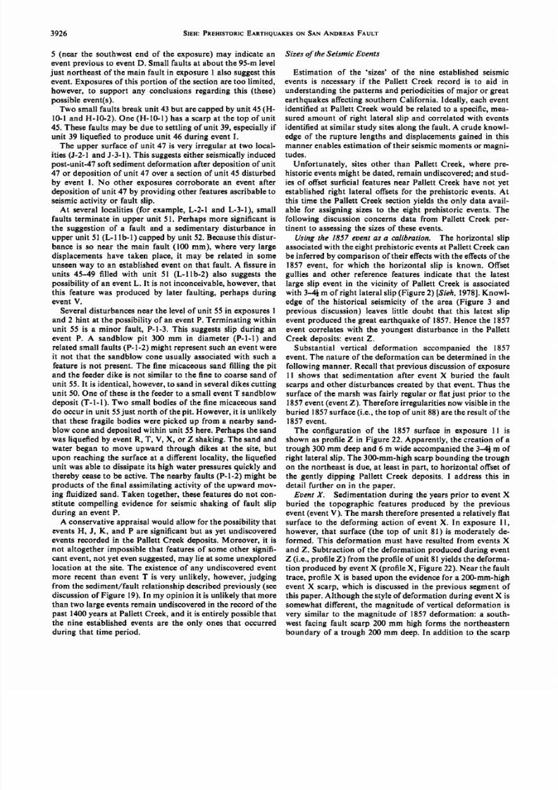
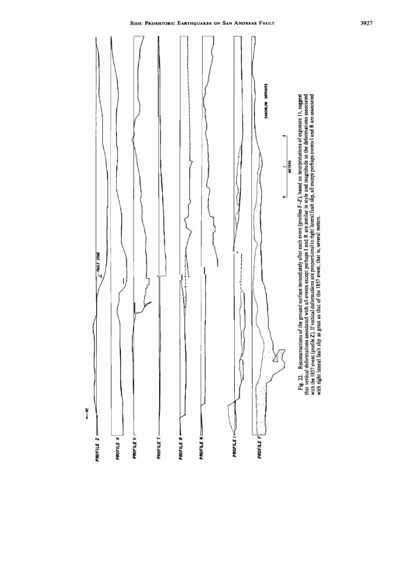
Sizesof theSeismicEvents
Estimation of the 'sizes' of the nine established seismic
events is necessary f the Pallett Creek record is to aid in
understandinghe patternsand periodicities f major or greatearthquakes ffectingsouthernCalifornia. Ideally, each eventidentifiedat Pallett Creek would be related o a specific,mea-sured amount of right lateral slip and correlatedwith events
identifiedat similar studysitesalong he fault. A crude knowl-
edgeof the rupture lengthsand displacementsained n thismannerenables stimationof their seismicmomentsor magni-tudes.
Unfortunately, sites other than Pallett Creek, where pre-historiceventsmight be dated, remain undiscovered; nd stud-
ies of offsetsurficial eaturesnear Pallett Creek have not yetestablished ight lateral offsets or the prehistoricevents.Atthis time the Pallett Creek sectionyields he only data avail-able for assigningsizes to the eight prehistoricevents.The
following discussion oncernsdata from Pallett Creek per-tinent to assessinghe sizesof theseevents.
Using he 1857 eventas a calibration. The horizontal slip
associated ith the eight prehistoriceventsat Pallett Creek canbe inferredby comparisonof their effectswith the effects f the1857 event, for which the horizontal slip is known. Offsetgullies and other reference features indicate that the latest
large slip event in the vicinity of Pallett Creek is associated
with 3-4• m of right lateral slip Figure 2) [Sieh,1978].Knowl-edge of the historical seismicityof the area (Figure 3 and
previous discussion) eaves little doubt that this latest slip
event produced he great earthquakeof 1857.Hence the 1857event correlateswith the youngestdisturbance n the PallettCreek deposits:event Z.
Substantial vertical deformation accompanied he 1857event. The nature of the deformation can be determined in the
followingmanner.Recall that previous iscussionf exposure
11 shows that sedimentation after event X buried the fault
scarpsand other disturbances reatedby that event.Thus thesurfaceof the marsh was fairly regularor flat ust prior to the1857event eventZ). Therefore rregularities ow visible n theburied 1857surface i.e., the top of unit 88) are the resultof the1857 event.
The configuration of the 1857 surface n exposure 11 isshownas profile Z in Figure 22. Apparently, he creationof atrough 300 mm deepand 6 m wide accompaniedhe 3-4• m ofright lateral slip. The 300-mm-highscarpbounding he trougt•on the northeast s due, at least n part, to horizontal offsetof
the gently dipping Pallett Creek deposits. address his indetail further on in the paper.
Event X. Sedimentationduring the yearsprior to event X
buried the topographic features produced by the previousevent eventV). The marsh hereforepresented relatively latsurface o the deforming action of event X. In exposure11,however, hat surface the top of unit 81) is moderatelyde-formed. This deformation must have resulted from events X
and Z. Subtractionof the deformationproducedduring event
Z (i.e., profileZ) from the profile of unit 81 yields he deforma-tion producedby eventX (profileX, Figure22). Near the faulttrace, profile X is basedupon the evidence or a 200-mm-high
from thesediment/faultelationshipescribedreviouslysee eventX scarp,which s discussedn the previous egment fdiscussionf Figure19). n my opinion t is unlikely hat more thispaper.Although hestyleof deformation uring ventX isthan two largeevents emainundiscoveredn the recordof the somewhat ifferent, he magnitude f verticaldeformation spast 1400yearsat PallettCreek,and it is entirelypossiblehat very similar to the magnitudeof 1857deformation: south-
the nineest•blishedvents re the onlyones hat occurredwest acing aultscarp 00mm high orms henortheasternduring hat time period. boundary f a trough200 mm deep. n addition o the scarp
7/27/2019 140. Pre-Historic Large Earthquakes Produced by Slip on the San Andreas Fault at Pallett Creek, California
3928 SlEH: PREHISTORIC ARTHQUAKES N SAN ANDREASFAULT
and trough, a 1}ø tilt to the northeastmay have accompanied
the event. f styleand magnitudeof deformation n the verticalplane are proportional to the magnitudeof horizontal faultslip, the horizontal slip accompanying vent X was similar tothat of 1857, .e., severalmeters.This assumptions similar to
that made by Clark et al. [1972] in establishing n averagerecurrenceperiod for moderate earthquakeson the CoyoteCreek fault in southern California.
Event V. If sedimentationafter event T (top of unit 61)
had buried the irregular opographyproducedby eventT, thedeformation accompanying vent V could be found by sub-tracting 1857and eventX deformation rom the top of unit 68.Unfortunately, only a thin gravel (unit 65) and peat (unit 68)
blanketed event T topography at the time of event V. Al-though it is clear from the abnormal thickness f the peat ofunit 68 just southwestof the fault in exposures 0 and 11 thatsome maskingof the event T scarpsoccurred, t is also clearthat event T topography still existed at the time of event V(e.g., note the broad depression f the top of unit 68 overT-10-
1). So, subtracting1857 and event X deformations rom theevent V surfaceyields event V deformationsplus somebroad
event T deformation.The profile of the ground surface ust after eventV (profile
V, Figure 22) is very similar o the eventX and 1857profiles:trough 5• m wide and 400 mm deepboundedon the northeastby a fault scarp300 mm high. Unlike the deformations ssoci-ated with event X and the 1857 event, however, an anticlinal
warp occurredsouthwestof the fault during eventV. Because
a 300-mm-highscarp ormed during eventV (seediscussionnprevioussectionor Figure 17), it is fairly certain hat most ofthe 400-mm-deep rough formed during event V. Event Vdeformations hen are remarkably similar in form and magni-tude to those of 1857 and event X. Hence the amount of right
lateral slip during eventV was comparable o that of the 1857event and event X.
Event T. The relatively uniform thicknessof unit 61 andnearly completeburial of two observed vent R scarps R-11-1
and R-11-3) suggestshat the marshsurfacewas fairly regularor flat ust beforeeventT occurred.ThereforeprofileT (Figure22) shouldbe a reliablerepresentation f eventT deformation.It is a profile of unit 61 minusprofilesV, X, and Z. The profileis a minimum event T deformation, however, sincesome event
T deformation is contained n profile V. Again the familiarfault-bounded rough is present.
Clay-, sand-, and silt-filled issures p to 500 mm in width,which formed along the fault during event T (see previous
discussion), uggest hat T was a substantial vent. Togetherwith profile T they suggest hat right lateral slip associatedwith event T was similar in size o the slip associatedwith the1857 event.
Event R. Event R deformations are well representedbyprofile R (Figure 22) becauseevent R occurred after deposi-
tion of a thick blanket of gravels,sands,and siltswhich buriedthe deformations resulting from event N. Profile R is theprofile of the baseof the hard, clayey silt near the top of unit
50 minus profilesT, V, X, and Z (i.e., minus deformationsof
events T, V, X, and Z).
The principal vertical deformationoccurredon a fault at the
northeastend of exposure11 (R-11-1). Other than this, verylittle warping appears n the profile. Fault slip on the mainfault cannot be convincinglydemonstratedor ruled out intrenches 11, 10, 2, or 1.
Two southwest acing fault scarps, n addition to R-11-1 inexposure 11, were formed during event R. A scarp 300 mm
high is visible n the wall of the bulldozercut (seeFigure 14),
and a scarp200 mm high s apparent n cut 7 (seeFigures7 and9). The three faults are not connected o one another. Facies
changes cross ll three aults ormed during eventR imply atleast 100 or 200 mm of horizontal slip on each of the threeindependent aults.
Effects of event R on the Pallett Creek marsh differ noticea-
bly from the effectsof eventsT, V, X, and the 1857 event.No
pronouncedwarping of the ground surfacesouthwest f thefault occurred, and no slip on the main fault is recognized.
Three separate aults northeastof the main fault producedsouthwest acing scarps nd showevidenceof horizontalsliptotaling at least severalhundredsof millimeters.Thesediffer-
encesmay indicate hat event R was smaller han eventsT, V,
and X and the eventof 1857.Nevertheless, orizontalslip of atleast severalhundredmillimeterssuggestst leasta moderateevent (i.e., M •> 6).
Event N. Sediments epositedprior to event N appear to
have buriedsurface rregularities reatedduringevent . Bedsare very regular in exposure11 even where they cover largeevent I irregularities e.g., considerunit 52 over 1-11-1). It
seems easonable o believe that a once flat pre-event-N sur-face was deformed by event N and subsequent vents.Sub-tracting he deformationsof eventsR, T, V, X, and Z from the
pre-event-N surface in exposure 11 yields the deformationassociatedwith eventN (profile N, Figure 22). The deforma-tion is very similar to deformationsassociatedwith eventsT,
V, X, and Z. It bears an especiallyclose resemblanceo thedisturbance associated with event V. The surface southwest of
the main trace has a 400-mm-higharch. Except or possiblyabout 100 mm of slip on the fault at the northeastend of theprofile, the profile northeastof the main fault, like profilesT,V, and Z, is not appreciablywarped.A 400-mm-deep rough sindicated southwest f the main fault. Gravels deposited fter
event N seem to have been deposited n response o this
trough, he coarsestacieshavingbeendepositedn the deepestpart of the trough.
Other evidencesuggestshat N was a large event. Duringevent N a homoclinal warp 800 mm high developedon thesouthwestside of the main fault trace in exposure1. In addi-tion, an oblique-slip ault (N-l-1) at the southwest dgeof ex-posure 1 produceda scarp 250 mm high probably duringevent N.
All the evidence described above leads to the conclusion that
displacements ssociated ith eventN were at leastas argeasthose of 1857.
Event I. After event F, as much as a meter of coarse sand
and gravelburied he topographic vidence or that event.Theapparentresultwas that ust prior to event the marshsurfacewas relatively flat. The fairly regular thicknessof the unit 45
clays, silts, and peats, which were depositedbefore event I,supports his view. Profile (Figure 22) then fairly well repre-sents he deformationof that flat surfaceduring event . This is
the profile of the top of unit 45 minus profilesN-Z.A scarpperhaps100 mm high appearsat the northeastedge
of the profile. The contrast n sandblow hickness cross hefault is a reminder hat variations n thickness f a unit parallelto the fault can result n an apparentrather than a real offset.This may be the explanation or the scarpat the main fault inprofile I (Figure 22). Neglecting sandblow depositsand softsediment deformation, substantial warps developed during
this event.The reality of the southwest ipping,300-mm-deep
warp southwestof the main fault may be indicated by moresubstantialpeat and sand depositson the lower parts of the
7/27/2019 140. Pre-Historic Large Earthquakes Produced by Slip on the San Andreas Fault at Pallett Creek, California
slopeafter event . That is, the existence f the warp may beverified by the response f later sedimentation o it.
There is no convincingevidence hat major tectonic aultslip occurred uring event . The extensive rray of sandblowdeposits,numeroussmall secondary aults, and soft sedimentdeformation does not require an event with a magnitudeof
larger than 5.5-6.0. Although the warping is as great as that
for the 1857event, ts differentstylecautions gainstusing heevidence o conclude hat event displacements ere as greatas those of 1857. Therefore I consider event I to be a moderate
or large event.Event F. Several lines of evidence lead to the conclusion
that event F was comparable n size to the 1857 event:1. Six sandblows occur in the several tens of meters of
event F horizon exposed n the excavations. his densityofsandblowssuggests sceneat Pallett Creek during event Freminiscent of one related by an observer of effects of the
Indian earthquakeof 1934 (Ms = 8.3) [Geological urveyofIndia, 1939, p. 34]:
... As the rocking ceased .. water spouts, hundreds of themthrowing up water and sand, were to be observedon the wholeface of the country, the sand orming miniaturevolcanoes,whilstthe water spoutedout of the craters,someof the spoutswere quite5 feet high. In a few minutes--as far as the eye could see--wasvast expanse of sand and water, water and sand. The roadspoutedwater, and wide openingswere to be seenacross t aheadof me, then under me, and my car sank,while the water and sandbubbled nd spat,and sucked,ill my axleswerecovered.Aban-don ship' was quickly obeyed,and my man and I stepped ntoknee deep water and sand and made for shore.
Whether the spectacular isplayof sandblow ountainsduringevent F requireda very large number of loading cycles i.e., agreat earthquake) or relatively few is not known.
2. Secondary aulting occurredprior to the evacuationof
the sandblowmaterial.This hasbeendiscussedn the previoussection on event F disturbances.
3. The most compellingevidence hat event F was a largeevent s the large-scale arping visible n exposure southwestof the main fault. If unit 45 (depositedafter event F) is re-stored to horizontality, units depositedprior to event F stilldip about 7ø away from the fault. Whether this indicates
developmentof a 400-mm-deep rough southwest f the faultor a 400-mm-highmound along he fault is unknown. n eithercase this deformation is no less than that associated with the
1857 event at Pallett Creek.
4. A high-amplitudewarp also s evident n exposure 0. funit 45 northeastof the main fault is restored o horizontality
there, unit 38, which was deposited rior to eventF, retainsa300-mm-highanticlinal arch centeredon the two large eventF
sandblowpits. This magnitudeof deformation s comparableto that of 1857.All availableevidence oints o the assignmentof a large size to event F.
EventD. The event D horizon i.e., unit 33) is exposednrelatively ew places,so there is little opportunity o viewdeformations associated with event D. Deformation in ex-
posure10, one of only two longexposures f unit 33, suggeststhat event D may have been large. There, northeastof themain fault, slip alongseveralevent D faultsproduced 300-mm-highsouthwest acing scarp see previousdiscussion fevent D). If unit 34, which buried the scarp, s a sandblowdeposit,very large volumesof sandwere extrudedduring or
immediately fter eventD. This might have producedsurfacedeformations similar in size to those of 1857, even if event D
was a smaller event. Nonetheless, in view of substantial defor-
mation and liquefaction ffects imilar o eventF liquefactioneffects, vent D is tentativelyconsideredo be a large event.
Apparent offsetsalong the main fault and other structural
developments. n general, he PallettCreekdeposits lope1ø-2ø to the southeast,parallel to the main fault. Thus the total
horizontalslip L that occurred incedepositionof a bed would
be proportional to the vertical separation of the bed (seeFigure 23). In this way, successivepisodes f horizontalslipwould result n greater vertical separationof older units thanyounger units (Figure 24).
The exposure ecords and the deformation profiles pro-duced from exposure 11 (Figure 22) show that the relation-ships are more complex than this. Consider the deformation
profileof the 1857event profileZ, Figure22). Theoretically,4J•-materal offsetof a 1ø-2ø slopewould haveproduced heprofile drawnwith a solid ine n Figure25. Instead, he profiledrawn with a dashed ine was produced. This discrepancydemonstrateshat a small synclineand anticline developedsouthwest of the fault in 1857.
Deformation profilesF, N, T, V, and X (Figure 22) indicate
that this structurehas been developing or at least the past1400 years.Only events and R do not seem o have contrib-uted to its development. he welt and trough also are presentsouthwest f the fault in exposure10, although he detailsaresomewhatdifferent. In exposures1 and 2 the structure s not
apparent.Perhaps he growth of the welt has been esponsible
for the deflection f PallettCreek along he fault (Figure26).In exposure 10, vertical separation on the main fault in-
creases airly regularly with increasingunit age, suggestingfault activity from event F to the 1857 event. n exposure11,units 61-88 show ncreased ertical separationat the timesofeventsT, V, and X and the 1857 event,but older units displaya nearly uniform verticalseparationof about 1 m. The fault at
the northeastend of the exposure,however,displaysverticalseparationswhich are greater or older units. Does this implythat the main trace n exposure 1wasactiveonly after eventT
and that the northeastern race was the principal trace duringearlier events? he followingdiscussion emonstrateswhy one
should be cautious about such an interpretationof data onincreasing ertical separation.
The apparentoffsetof a 1ø slope the averageslopeof unit38 is 1ø) producedby right lateral slip of 4} m is 80 mm. If oneassumeshat all largeevents t the sitesince ventF havebeenassociated ith 4} m of right lateral slip, the total lateral offsetof unit 38 depositedprior to event F ought to be 27 m (sixevents F, N, T, V, X, and Z) X 4• m = 27 m). The vertical
separationdue to right lateral slip ought to be 480 mm. The
observedvertical separation,shown in the tabulation below,ranges rom 970 to 1260 mm:
Fig. 23. A simplemodel demonstrateshat right lateral offsetL ofa surfacewith a slopeangle 0 parallel to the fault producesa verticalseparationr apparent ertical ffsetD. At PallettCreek,where hedepositsslope generally 1ø-2ø to the southeast,parallel to the fault,
right lateral movement s, at least n part, responsible or the verticalseparationof units seen n the exposures.
7/27/2019 140. Pre-Historic Large Earthquakes Produced by Slip on the San Andreas Fault at Pallett Creek, California
3930 SIEH: PREHISTORICEARTHQUAKESON SAN ANDREAS FAULT
Exposure Separation,mm NE
11 970
lib 930
10 12601 1160
Considernow the magnitudeof local disturbances long the
fault. In exposure10, unit 38 varies n elevationby some600mm northeastof the fault and by a similar amount southeastof the fault. These variations occur over distances f only 2-3m. In exposure11, unit 38 has been offset500 mm on another
fault northeastof the main fault. If local deformationsparallelto the fault are as great as thesedeformations ransverseo the
fault, it is small wonder that vertical separationsof unit 38vary by 200 mm. Comparing absoluteelevationsof unit 38 inexposure 10 with those in exposure 11 (by overlaying ex-
posures11 and 10), it becomes eadily apparent that largedeformations arallel o the fault are present. ustnortheast fthe fault betweenexposures10 and 11, unit 38 slopes1.4ø to
the northwest,whereas ts averagedip at Pallett Creek is 1.0øsoutheast.A future 4•-m right lateral offset would reduce he
970-mm vertical separationof unit 38 now seen n exposure11to only 850 mm. Unit 45, which dips about 0 ø betweenex-posures 0 and 11 and now hasa verticalseparationof 1.08m,would maintain that separationwere4• m of right lateral slipto occur.
Attempts to calculate the height of scarpsproduced byindividual events from apparent vertical offsets have beenfutile for eventsprevious o R, because f these rregularities.For this reason,scarpheightsshown n profilesF, I, N, and R(Figure 22) for events F, I, N, and R are not meaningful.
The youngerunits61-98 haverelatively egularslopes t thesite, and scarpheightsobserved t variousexposures re more
consistent Table 2); 1857 scarp heightsare about 300 mm.Event X, V, and T scarpsare about 200 mm. This agreeswith
the deformationprofile data in suggestinghat thesepast fourevents have been of similar size.
Analysisof the effectsof the nine established vents eads o
the conclusion hat the magnitudeof right lateral slip associ-
ated with at least six of the eight prehistoriceventsat PallettCreek is similar to that of the 1857 earthquake. Two of the
events I and R) are associatedwith displacements nd effects
indicating at least a moderate size.
Dating the Events
The many radiocarbon dates determined for various stratain the Pallett Creek sectionprovide a basic ime framework for
NE _ -b L sw
Fig. 24. The effectof several ight ateralmovementsn depositsdippinggentlyaway from the reader s shown n this cross ection. he
older layers,which have experiencedmore slip events,have argerverticalseparationshan the younger ayers.
Predicfed
Observed
$W
Fig. 25. Simpleright lateral slip would produce he cross-sectionalprofile indicatedby the solid line. The observedprofiles n exposure11are generallymore like the profile indicatedby the dashed ine. Thissuggestshat in addition to right lateral fault slip, vertical deforma-tions have occurred.
the nine events. Rates of depositionand other stratigraphicconsiderations llow more refined assignment f event dateswithin this framework.
Table 3 summarizeshe data used n assigning achevent adate. The secondcolumn indicates he stratigraphicunits de-posited ust before and ust after eachevent.The third columnshows he radiocarbon and/or historic dates bracketing the
event. In the fourth column are commentsand stratigraphicconsiderations ertinent to estimating he datesof occurrence
shown in the last column.
Ratesof sediment eposition. The determinationof reason-
able ratesof sedimentdeposition s critical n refining he dates
of the prehistoric events. Sedimentation ates determined nthis section enable interpolation of dates for events whichoccurredbetween he depositionof two radiometricallydatedlayers.
First, I calculatea rate of peat and claydeposition, sing hetwo radiocarbondates which bracket the formation of peat-rich units 29-33 (see exposure 11). The majority of material
constitutingunits 29-33 is peat and clay. The measured hick-
nessof the peat and clay (To) is 615 mm. The average ate ofdepositionof the peats and clays (Ro) equals heir thickness(T,) divided by the length of time during which they accumu-
lated (to):
To/t (3)
It is assumed that each of the four sand beds between units 29
and 33 accumulated nstantaneously.Hence their thicknesses
are not included n To.
The time required or deposition, o, equals he difference,IA - BI, of the radiocarbon atesof unit 33 (A = 565A.D.)and unit 29 (B = 110 A.D.): 455 years. The statisticaluncer-
tainty a in to is a function of the uncertainty n theseradio-carbon dates aA = 55 years,and aB = 60 years) [Beers,1962,p. 33]:
a = (aA ' + abe')/•' (4)
In this case, o = 455 + 81 years.Before o can be divided ntoT, to derive Ro, the uncertainty n to must be expressed npercentof to, that is, 455 + 18%.To determine he uncertainty
in Ro, this uncertainty s combinedwith the uncertainty n To(which in this case s zero) in the same fashion as aA and a•
Second, estimatean average ate of depositionRs for siltysand and silt, using the depositsof unit 70. This involvessubtracting he time during which peat was accumulating n
that sectionand assumeshat the peatsof unit 70 accumulatedat the same rate as those between units 29 and 33:
Rs = Ts/(t- to) (5)
7/27/2019 140. Pre-Historic Large Earthquakes Produced by Slip on the San Andreas Fault at Pallett Creek, California
SIEH: PREHISTORICEARTHQUAKESON SAN ANDREAS FAULT 3931
Trough
Fault
ii
i !Gorgeall
•istor•
I? /////////i Fault ,///', ' Troug•C
•..t ?•_•- :ticline' ß CREEl<
/ ß
PALLT•"--------'/
/
/
/
///
////
/
/ 0 I0 20/
/ meters//
Fig.26. Analysisf exposures0and11 ndicateshatananticlinendsynclineave een evelopingouthwestf thefaultduring t least hepast1400 ears. he anticlinemayhavedeflected allettCreek o the southeast.
TABLE 2. Scarp Height AssociatedWith Pallett Creek Events
Source of CalculationsExposure
2
Scarp Height, mm
Exposure Exposure Exposure Exposure10 10a ll llb Comments and Cautions
Best
Value, mm
Offset op of unit 88
Unit 78 faultedagainst nit 88Offset of unit 81 minus height
of scarp on unit 78
Offset of unit 81 minus off-
set op of unit 88
Height of scarp on unit 78
Offset of unit 68 top minusoffset of unit 81
Offset of unit 61 minus off-
setof unit 68 top
290-340
140-190
100-150
280-350
Event Z130 • 10 290 300
260
120
Event X
140 190 210
180 240-260
Event V
30 140 470 330
Event T
40-270 220 140 210
For exposure2, minimum value, sinceunit 88 is eroded (?) off one side.For exposures 10 and 10a, min-imum value, sinceunit 88 liquefiedduring event Z here.
Exposure 10 was complicated bysecondary faulting. For exposure2, values are unreliable, since unit 81is eroded (?) off one side.
Offset difference may include someevent T slip where post-event-Tsedimentation did not completelybury event T scarp.
Offset difference may be low whereevent T scarp was not completelyburied by post-event-T,pre-event-Vsediments. Exposure 2 was compli-cated by a secondary fault. Ex-posure 10 includes slip on a sec-ondary fault with little strike-slip;90-100 mm of secondary ault slipis post-event-T, and thus 180-250
mm might be a better figure.
300
210
200
210
7/27/2019 140. Pre-Historic Large Earthquakes Produced by Slip on the San Andreas Fault at Pallett Creek, California
Event UnderlyingUnit LowerBoundingDate, A.D. Discussion,Comments,and Considerations
Estimated
Date of
Occurrence,A.D.*
Z 93
upper 88
X 88 1857
81 1725 q- 55
V 71 1465 q- 80
68
68
61
R 61
55+
53
52
I 47
45
41
38
D 35
lower 34
Historicallywell documented. Jan. 9, 1857
1470 q- 50
1470 q- 50
About 250 mm (145 q- 65 years) of silt accumulatedafter this event andprior to 1857. Unit 81 peat was being deposited t the time of theevent. The date of event X is estimated to be the same as the date of
Unit 65, between68 and 61 peats, s in part coseismic nd in.part post- 1245q-45seismic. t displaysabundantevidenceof burrowing and/or rooting
1225 -45 whichoesotaffectverlyingnits.hissevidencehat ventpreceded nit 68 by a fair amountof time. The eventappears o haveoccurredas the last of unit 61 was beingdeposited. he date of eventT is estimated o be the sameas the date of depositionof uppermostunit 61.
1225 q- 45 The date of event R is calculatedby subtracting rom the event T date 1190q-45
9 the time equiredo deposithe 50-mm nit 61 peatat 1.4mm/yrq- 18% and the 40-mm silt under unit 61 at 1.9 mm/yr q- 32%.1225 q- 45 Two datesare derived rom this eventby using he boundingdatesand 965 q-50
sedimentation ates. Using the 850 q- 55 unit 49 date results n a850q-55 922q-72A.D.event date. singhe1225 -45unit 1date ro-
ducesa 1004 q- 69 A.D. date. These are statisticallyaveraged o yieldthe final event date.
850 q- 55 and 955 q- 60 Dates for units 45, 47, and 49 are combinedwith sedimentation ates 860 q- 35to calculate hree independent vent dates. These three dates are
845 q- 75then statisticallyaveraged o yield the final event date.
820 q- 70 The event occurred fter deposition f 100 mm of silt upon datedunit 665 q-8038. The unit 38 date is used to derive the event date. The event oc-
600 -80 curredfterhe op f he eat nitwas eposited610 -80A.D.)and after the 100 mm of silt was deposited 610 q- 80 A.D. plus53 q- 17 years).
510 q- 75 The event followed he deposition f lower unit 34 and was followed 545 q-45
565 -55 by he epositionfunit 5.Radiocarbonatesre veragedoderiveestimates of the date of event D.
*Radiocarbon dates have been corrected o calendardates using he calibrationsof Damon et al. [1972].
where
Ts thicknessf the siltsand sandy ilts measuredn ex-posure l and excluding andunit 78 becauseassumethat it was deposited nstantaneously),equal to 380
mm;
t date of unit 81 minus date of unit 71 (from Table 1),
equal o 1725 - 1465 = 260 + 97 years.
Also in (5),
lp= rp 50mmR•, 1.4 m/yr18%36 6years (6)whereT•, - 50 mm (measuredromexposure 1). Using hesevalues n (5),
An independent s for silt and sandysilt canbe estimatedby using nit 88 n exposure 1 and tsbracketing ates.Againit is assumedhat the sandunitscan be ignored. n this case,
Ts thickness f unit 88 (measured rom exposure11), equalto 250 mm;
t time between eposition f top of unit 88 (1857A.D.) andmiddle of unit 81 (1725 + 55 A.D.), equal to 132 + 55years;
tp timeof accumulationf upperhalf of unit 81,equal o 25mm/(1.4 mm/yr + 18%), which equals18 + 3 years.
Using thesevalues n (5), R8 = 2.2 mm/yr + 48%. Thus R8mightbe consideredo be the statistical verage f the two R,determinations, .9 mm/yr + 32% (calculated s in (1) and(2)).
The sedimentationatesR• and R•, that havebeenderivedabove can now be used to estimate the dates of occurrence of
the seismic events within the framework of radiocarbon dates.
In the sectionshat follow, eachevent s separately onsidered.Event X. Event X occurred ust after depositionof peaty
unit 81. Between he time of eventX (after deposition f unit
81) and 1857 afterdeposition f unit 88), about250 mm ofplanar-laminatediltandabout50 mmof sandweredepositedas unit 88. The siltsprobablyaccumulated lowly,perhaps tan averageateof only2.2 mm/yr + 48%.This wouldsuggestthat a periodof about 1 centuryseparatesventX and the1857 event. This is consistentwith the stratigraphicevidence
placing he dateof eventX just after he inaldateof deposi-tion of the unit 81 peat. Since he entire50-mm hickness f
unit 81 was used for the •'C date determination (1725 + 55
7/27/2019 140. Pre-Historic Large Earthquakes Produced by Slip on the San Andreas Fault at Pallett Creek, California
gIEH: PREHISTORIC ARTHQUAKES N gAN ANDREASFAULT 3933
A.D.), the date is an average igure. If the peat took about 36
+ 6 years o accumulate 50 mm at 1.4 mm?yr + 18%), and ifthe averagedate, 1725 + 55 A.D., is assumed o be the date at
the midpoint in the depositionof the peat, another 18 + 6
years should be added (using (4)) to obtain the date of finaldepositionof the peat and event X. Thus eventX is assigneddate of 1745 + 55 A.D.
Historical information allows further reduction in uncer-
tainty of the date of event X. Continuousrec6rdedhistory insouthernCalifornia begins n 1769 with the first expedition o
establish he missions.The San Gabriel mission 44 km south
of Pallett Creek) was establishedn 1771. Had any large earth-
quake been produced by slip on the fault in the vicinity ofPa!!ett Creek after establishment of the mission, records of this
and the more distant missionswould mention it. The onlylarge historic earthquake hat one might attempt to associatewith the event X effects at Pa!lett Creek is the 1769 event
reported by the Portolfi expedition [Bancroft, 1884, p. 146;Pa16u, 1926, p. 129; Portold, 1909, p. 21]. Porto!fi's diary,however, ndicates hat although the shakingwas violent dur-
ing that event, it lasted only 'about half as long as an Ave
Maria' [Portold, 1909, p. 21], that is, only a few seconds. hissuggestshat the 1769 earthquakewas only a moderateevent
in the Los Angeles egion, probablymore similar to the 1933M•. =6.3 or 1971 M•. - 6.4 earthquake (Figure 3) than to a
large event producedby slip on the San Andreas fault.
Event X is assigned date of .... • A.D. The younger
date (1745 q- 24 A.D.) is an absoluteboundary; he older is a1 r limit.
Event V. Two peats unit 68 and unit 71) bracketeventV,and both have nearly identicaldates.Statisticalcombinationof the datesaccording o (1) and (2) gives he date of event Vas 1470 + 40 A.D.
Event T. This event s bracketedby depositionof units 61and 68 (1225 + 45 and 1470 + 50 A.D., respectively).The
interveningunit 65 consistsn part of postseismicravelsandsandsbut also containscoseismic andblowdeposits.The unit
displays bundant vidence f animalburrowing nd/or root-ing which doesnot affectoverlyingunits.This suggestshateventT preceded he deposition f unit 68 by severaldecadesor longer.EventT probablyoccurred s he astof unit 61 wasdeposited. ssuming hat the midpoint n unit 61 depositionwas 1225 4- 45 A.D., the final accumulation of that 50-mm-
thick unit using 6) was 18 4- 6 years ater. Thus event T isassigned date of 1245 + 45 A.D.
EventR. The layersdeposited fter event R and prior toeventT are the unit 61 peat T•, - 50 mm), a silt at the very opof unit 50 (for which T• averages 0 mm in thickness), nd agravelor sand whichaverages 00 mm in thickness). he dateof event T is 1245 + 45. To calculate the date of event R, (1)
subtract the accumulation ime t•, of the peat of unit 61,calculated ccording o (6), and (2) subtract he accumulationtime t• of the silt of upperunit 50, calculated ccording o (7):
ts = Ts/Rs (7)
In this case, v = 36 4- 6 years,and ts = 21 4- 7 years.Thus thetime of event R is estimated o be (tv + ts) yearsprior to event
T: 1190 4- 45 A.D. The uncertaintyof this date is the square
root of the sum of the squares f the uncertainty n tv, ts, andevent T.
Event D. This event occurredbefore depositionof unit 35
and after depositionof lower unit 34. The bracketingdates are565 4- 55 (unit 33) and 510 4- 75 (unit 36). The dates are
reversedchronologically,but the reversal s statistically n-
significant.The statisticalaverageof these wo dates s 545 4-
45 A.D. This is probably the bestestimateof the date of eventD.
Event F. Event F occurredafter depositionof the basal silt
of unit 39 and beforedepositionof unit 41. Radiocarbondatesthat bracket the event are those for unit 38 (600 4- 80 A.D.)and unit 41 (820 4- 70 A.D.). In view of the difficulties of
assessinghe time betweenunit 41 depositionand event F, the
unit 38 date is probably the better one to use n calculating hedate of event F.
Unit 38 is a 30-mm-thick laminated clayey peat; 600 4- 80A.D. is the averagedate of all !aminae n the unit. The date of
depositionof the top of the unit determinedusing 6) is 611 4-
80 A.D. A silt layer averaging100 mm in thickness hen wasdepositedabove unit 38 before event F occurred.Using Rs =
1.9 mm/yr 4- 32% in (7), the time of accumulationof this unitis estimated o be 53 4- 17 years. Adding this to the event 38date (using 6)) yields a date of 665 4- 80 A.D. for event F.
Event I. Three •4C dates bracket event I. The radiocarbon
date of the 10-mm-thick peat of uppermostunit 45 directlybelow the event I horizon is 845 4- 75 A.D. The 10-mm-thick
peat of unit 47 directlyoverlying he event horizon hasa dateof 955 4- 60 A.D. Unit 49, several ens of millimeters above the
event I horizon, has a date of 850 4- 55 A.D. Sedimentation
times must be added or subtracted from these dates to give
event I dates. The unit 45 date becomes 49 4- 75 A.D. uponadding5 mm of peat. The unit 47 date becomes 51 4- 60 A.D.
upon subtracting mm of peat. The unit 49 date becomes 884- 57 A.D. upon subtractingan averageof 20 mm of peat and
90 mm of silt. The averageof thesedates using (1) and (2))gives he bestestimate or the date of event : 860 4- 35 A.D.
EventN. Like the 1857event, his eventoccurredust priorto the beginning of deposition of a thick gravel and sandsequence. he •4C date of a group of small wood and bark(?)
fragments ound in the gravel of unit 53, directly on top of theevent N horizon, is 830 4- 90 A.D. Because the material could
represent tree that was severalhundredyearsold at the time
of deposition, his age must be considered o be maximal forunit 53. The •C date of a small lump of charcoal n unit 51, asand below the event surface, s 1120 4- 100 A.D. Because his
date is incongruouswith dateshigher and lower in the sectionand with estimated rates of sedimentation, it is assumed o beerroneous.
A date for event N is estimated from sedimentation rates
and the dates of unit 49 (850 4- 55 A.D.) and unit 61 (1225 4-
45 A.D.). First, a date is estimated rom the unit 61 date. A
date for event R (1190 4- 45 A.D.) has already been calculated
using unit 61, by subtracting the estimated sedimentationtimes between event R and unit 61. To derive an event N date,
the following must be subtracted rom the event R date: (1)
300 mm of silt and clayeysilt at 1.9 mm?yr 4- 32% - 158 4- 51yearsand (2) 50 mm of clayeypeatysilt at 1.9mm?yr 4- 32% -26 4- 8 years.This givesa date of 1004 4- 69 A.D.
In calculating the event date from unit 49, the followingmust be added to 850 4- 55 A.D.: (1) an average 120-mm
thickness f silt at 1.9 mm/yr 4- 32% - 63 4- 20 yearsand (2)an average13-mm thickness f peat and peaty silt at 1.4 mm?yr 4- 18%= 9 4- 2 years.The eventN date thuscalculated romthe unit 49 date is 922 4- 72 A.D.
A final date for eventN is derivedby statistically ombiningthe datescalculated rom unit 61 (1004 4- 69 A.D.) and unit 49
(922 4- 72 A.D.) according o (1) and (2). This givesan eventN date of 965 4- 50 A.D.
7/27/2019 140. Pre-Historic Large Earthquakes Produced by Slip on the San Andreas Fault at Pallett Creek, California
3934 SIEH: PREHISTORIC ARTHQUAKESON SAN ANDREAS FAULT
Recurrence Intervals at Pallett Creek
Figure 27 summarizes he estimateddates of occurrence feventsD-Z. The vertical bars show the 68% (1 standarddevia-
tion) confidence limits for each event date. More x4C date
determinationswould refine and probably modify some ofthese dates and uncertainties.Study of additional exposurescould conceivably yield evidence for one or two additional
large events.Recurrence ntervals RI) are calculated or anytwo successivevents n the manner suggested y Beers 1962,p. 33]:
RI = - el + + (8)
where A and B are the dates of the events. Lower limits on the
recurrence nterval shown n parenthesesn Figure 27 are thetimes required to deposit the silts and peats in the sectionbetweenevents, according o (4), (6), and (7).
Nonuniform recurrence of large earthquakes at PallettCreek is an almost nescapable onclusion.Although the aver-
age recurrencenterval is about 160 years, ntervalsas short as
57 + 9 years and as long as 275 + 68 years do exist in this1400-year period. The intervals appear to have a bimodal
distribution, with clusteringsof intervals around about 100and 230 years.The short intervals n most cases lternate with
EVENT DATE R I
1857
112 *55 (not < 88 yrs)
2417455
275 +-. 8
1470* 0225 •- 60
1245*45 (57*-9)90 * 5
225 +- 67
9655005 t 61 (not < 72+20)
86035
195 * 87
665 t 80
120 • 92 (not < 95tl9)
545•-45
1800 A.D.
I000 A.D.
Fig. 27. Dates of eventsand recurrence ntervals Rl) at PallettCreek. The vertical bars in the second column indicate a statistical
the long ones.Thus there appears o have been a fairly stable
pattern in the Pallett Creek seismichistory.The followingarethe shorter ntervals:X-Z is 112 4- 55 years but not less han
88 years), R-T is 57 4- 9 years, -N is 105 4- 61 years but not
less han 72 4- 20 years), and D-F is 120 4- 92 years but notless than 95 4- 19 years). Lower limits for each recurrence
interval (in parentheses) erived rom sedimentationatessug-gest that the true intervals are more likely to be among the
higher values in these ranges. The following are the longerintervals:V-X is 275 4- 68 years,T-V is 225 4- 60 years,N-Ris 225 4- 67 years, and F-I is 195 4- 87 years.This apparentalternation of long and short intervals s, of course, esscon-vincing f the datesof the eventsare shownwith an uncertainty
of 2 standarddeviations ather than just 1.
4. SUMMARY
The evidence for large earthquakes at Pallett Creek is of
three types: 1) sedimentarydepositsand faulted relationshipsalong the main fault (e.g., Figures 17, 19, 21, and 22), (2)secondary aults that are overlain by sediments hat accumu-
lated after the faults moved (e.g., Figures14, 15, and 16), and
(3) liquefaction phenomena, especially sandblow deposits(e.g., Figures 10, 11, and 12). Evidenceof all three types hatis visible n the mappedexposuresin pocket) s summarizedin the Appendix.
A brief summary of the evidence or each event follows.
1. The 1857 earthquake is associatedwith a large (300
mm) scarp,3-4} m of right lateral slip, and a broadwarp of theground surface. have found no secondary aults or sandblows
that were producedduring this great event,but evidencehatliquefactionof the surficialunits occurred s locally very pro-nounced.
2. Event X (1745+:4 A.D ) resulted n scarps nd ground25 ß
deformationssimilar in magnitudeand style to thoseof thegreat 1857 event. Therefore severalmetersof right lateral slip
probably occurred. One sandblow and one large secondaryfault developedat this time.
3. Event V (1470 4- 40 A.D.) is indicatedby a large (400
mm) scarpon the main fault and ground deformationsimilarin magnitudeand style o that of the 1857event.Henceseveral
metersof right lateral slip probably occurredduring event V.A fissure also developed during this event, but I have not
identified any sandblow eatures.
4. During event T (1245 4- 45 A.D.), liquefaction of asubsurface nit(s) occurred,and severalsmall faults and otherdeformations and small sandblows resulted. Cracks and a
scarpdeveloped long the main fault trace, and grounddefor-mation seems o have occurred.Right lateral slip of severalmeters s probable.
5. Event R (1190 4- 45 A.D.) may not be associated ith ascarpon the main fault or ground deformationsimilar n styleor magnitude to that of the 1857 event. Horizontal slip of atleast several hundred millimeters did occur, however, on each
of three secondary aults exposed n the excavation.This in-
dicatesan eventwith displacements t leastas argeas hoseofthe 1968 Borrego Mountain earthquake ML = 6.4).
6. Event N (965 4- 50 A.D.) resulted n ground deforma-
tions at leastas large as those producedby the 1857 event. n
uncertaintyf I standardeviation.hese ates nablealculationf oneexposuren 800-mm-deeplexure ccurreddjacento thethe recurrencentervals t the eft sideof the fourthcolumn.Calcu- main fault. These deformations ndicate right lateral slip oflationsasedn he ates f depositionfsedimentetweenventsseveral eters.n addition,mall econdaryaults nd lexuresprovidedditionalontrolor hreef hesentervalsnumbersn developeduringventparentheses n the right sideof the fourth column). Historical records ßindicatehat he nterval etweenvents andZ wasno esshan88 7. Event I (860 4- 35 A.D.) produceda large number ofyears. he average ecurrencenterval s about 160years. medium to small size sandblows and abundant evidence of
7/27/2019 140. Pre-Historic Large Earthquakes Produced by Slip on the San Andreas Fault at Pallett Creek, California
SlEH: PREHISTORIC ARTHQUAKES N SAN ANDREASFAULT 3935
surficial soft sedimentdeformation. Secondary aults moved
during he eventalso.There s evidence upportingoffsetalongthe main fault during this event, but it is not conclusive.
Ground deformation that occurredadjacent o the fault may
indicate that substantial horizontal slip accompanied heevent.
8. Event F (665 :t: 80 A.D.) is characterized y many large
sandblow deposits.Slip on severalsecondary aults accom-panied he event, n somecases receding he sandblowactiv-ity. Ground deformations ssociated ith the eventare similarin magnitudeand style o thoseof eventN and the 1857event.Thus event F must have involved several meters of horizontal
slip.9. Event D (545 + 45 A.D.) producedsandblowdeposits
as arge as or larger than thoseproducedby eventF. Whetheror not the many secondaryaults hat formed during his event
Creek seismichistory would be applicable to the entire 300-
km-long south central reach of the fault. This would imply,however, hat the long-termslip rate is about 60 mm/yr (a 9.5-m displacement very 160 years) n the Carrizo Plain but only
about30 mm/yr (a 4.5-m displacementvery160years)nearPallerr Creek. Studiesof a large offset channel n the Carrizo
Plain [Sieh, 1977, chapter 2] indicate that the average ateHolocene slip rate there has beenno less han about 37 mm/yr. Continuing study of this channel may place an upperbound upon the slip rate, thusenablingacceptance r rejectionof the hypothesishat 1857eventsalonecharacterize lip alongthe fault.
A 'Uniform-Slip'Model
Elsewhere in the Carrizo Plain, three small alluvial fans,
offset n 1857 about 6.5 m from their sourcegullies,provide aare tectonicor related o liquefaction s unclear.Exposures f geomorphichint that the predecessoro the 1857 event maythe strata containingevidence or event D are inadequate or
observingscarpson the main fault or ground deformations.Hence I cannot determinewith certainty that this event was
associatedwith large horizontal slip on the fault. The sand-
blow features, however, indicate an event of M • 6, and theirsimilarity to thoseof largeeventF suggestshat eventD was alarge event.
Figure 27 summarizes he estimateddatesof occurrence fevents D-Z. Dormant periods between these events range
have occurredabout 300-400 yearsprior to 1857 [Sieh, 1978].Thus event V (1470 + 40 A.D.) may be the last event prior to1857 for which the fault ruptured through both the CarrizoPlain and Pallett Creek. If this is the case, event X (1745+_[•
A.D.) would necessarily epresent a rupture which did notextend as far northwest as the 1857 event. Yet because event X
appears to be associatedwith severalmeters of strike-slipoffset at Pallett Creek, it must be considered large event.
A uniform-slipmodel for late Holocene ault behavior can
from about • century o perhaps centuries. ong periodsof accommodate ventX. If late Holoceneslipand slip ratesareinactivity (•230 years) appear o alternate with short periods
(• 100 years).
5. DISCUSSION
The Pallett Creek earthquake ecord s only one set of data
necessaryor assessinghe late Holoceneand future behaviorof the San Andreas ault. From this solitaryrecord t is appar-ent that at least at one locality along the fault the average
period between arge seismic ventshas beenabout 160 years.Also it seems hat dormancy between arge events has alter-
nated betweenshort (• 100 year) and long (•230 year) inter-
vals in a fairly regular ashion.At leastsevenand perhapsallnine of the large eventssince he sixth centuryA.D. are associ-
ated with displacements t Pallett Creek as large as the 1857displacementsi.e., severalmeters).Ultimately, data from else-where along the fault are needed o estimate the extent of
rupture and amount of displacement ssociatedwith each ofthese Pallett Creek events and their relation to other largeeventsnot affecting he Pallett Creek sediments.Nevertheless,
some inferences nd educatedguesses an now be made re-garding the late Holocene and future behavior of the SanAndreas fault in central and southern California.
A 'Uniform Earthquake'Model
The rupture length and displacement alues for the 1857event are relatively well known (Figure 2). It is possible hatlarge 1857-1ike ventsdominateat least the Holocene historyof that reach of the fault. Although this was first suggested nthe basisof the post-1857seismic ormancyand the bedrock
geology Allen, 1968], preliminary analyses f late Holocenegeomorphic eaturesalong the fault also end credence o this
hypothesis Sieh, 1977,chapter2]. These analyses nd studiesin progress uggesthat the pastseveral isplacement ventsnthe Carrizo Plain and near Pallett Creek are characterized at
fairly uniform along the fault, the nonuniform 1857 dis-placement unction cannot be representative f all late Holo-ceneslip events.On the contrary,oneor more slip events rerequired to boost the slip along the southeastern egment fthe 1857 break (•4} m) up to the level of slip in the CarrizoPlain (•6} to 9• m). PerhapseventX served his purpose.
Figure 28 illustrates ow this uniform-slipmodelmight beextended nto the more distant past. EventsZ (1857), V, T, N,
and F are assumed o be 1857 type events,and eventsX, R, I,and D are assumed o be event X type events. Two rupture
4O
• 3o
•o
•o
1857
R/
/
i i I
Wallace Pallerr San
Creek Creek Bernard i no
Fig. 28. Hypotheticalpattern of large slip events long the southeachocality y very imilar isplacements.hus he1857 centraleachf he an ndreasault,asedn ecurrenceatarom
displacementsnd uptureengthmaybe airly epresentativeallett reekndWallacereekabout00 m o henorthwest)ndof past (and future) eventsalong that reach. f so, the Pallett offset ata or the 1857 arthquake.
7/27/2019 140. Pre-Historic Large Earthquakes Produced by Slip on the San Andreas Fault at Pallett Creek, California
3936 $IEH: PREHISTORICEARTHQUAKESON SAN ANDREAS FAULT
lengthsare postulated or the event X class Figure 29). Inboth cases their northwestern terminus is coincident with the
northwestern imit of 3- to 4}-m 1857 displacements. o thesoutheastt is plausible hat these upturesmight extendonlyas far as San Bernardino and be associatedwith a Ms > 7
earthquake (Figure 29a). Alternatively, they may be muchmore extensive uptures Figure 29b) associatedwith a trulygreat (Ms > 8)earthquake. In other words, the postulatednon-1857-type vents ecorded t PallettCreek may be eithersmaller 'fillers' at the historically slip-deficientsoutheastern
end of the 1857 type rupturesor great earthquakeswith rup-tures overlapping n the vicinity of Pallett Creek. Two observa-
tions may indicate that the latter is the more reasonableex-
pectation:
1. Although at Pallett Creek the average ecurrencenter-val for large events s about 160yearsand in the Carrizo Plainis •< 255 years [Sieh, 1977, chapter 2], the San Bernardino-
Salton Sea segmentof the fault has not experienced largeevent in over 200 years.
2. The southernCalifornia uplift of 1959-1974 [Castleetal., 1977], which may indicate slip on faults below several ens
of kilometers [Thatcher, 1976], extends from northwest ofPallett Creek to the Salton Sea.
What does his speculativemodelsuggest bout uture activ-ity? If 1857 type eventsdo occur as the secondmember of a
closely imed pair, then the next event will not be of the 1857
type. Instead t will be an event ike X, R, I, or D, perhapsatruly great eventwith large fault offsets rom the Salton Sea o
Palmdale or perhapsa major event with large offsets rom
Fig. 29. Hypothetical extent of rupture of non-1857 type eventsrecordedat Pallett Creek (PC). Those eventswhich were not associ-ated with 1857 yperuptures xtending rom southeast f PallettCreekto the northwestcorner of thesemaps (for extent of 1857rupture, see
Figure 3) may have been associatedwith rupture of those segmentsshown n Figures29a and 29b by a heavy ine.
about San Bernardino to about Palmdale. Its occurrence
should ollow the 1857event by the amount of time that event
I followedeventF (195 q- 87 years),eventR followedeventN(225 q- 67 years),eventV followed ventT (225 q- 60years),oreventX followed eventV (275 q- 68 years). A bestestimate or
its time of occurrencemight be the averageof these pastrecurrence imes:233 q- 34 years after the 1857 event i.e., 113q- 34 years from now).
Such extrapolationsof the Pallett Creek data must be con-
firmed or repudiated y data from other localitiesalong thefault before any detailed model of long-term fault behaviorcan be considered to be useful or reliable.
Major fault slip. This is evidencedby scarpson the mainfault (X-10a-1 and X-11-1). Scarpon unit 78 is buried by unit88, implying movementbetweendepositionof units 81 and 88.
See Figure 21 for explanation.Ground deformation s similar
in style and magnitude o that of the 1857 event.This impliesseveral meters of horizontal slip on the fault. See text and
Figure 22 for details.
Secondaryault slip. A fault breaksunit 81 and older units
(X-10-1 and X-10a-2) but is overlainby unit 88, implying hatfaulting occurredbetweendepositionof units 81 and 88.
Liquefaction henomena. The absenceof most of unit 81(X-11-2) suggests oft sedimentdeformation after depositionof the unit. Sandblowdike and cone (X-10-2) were deposited
onto unit 81. Thin peat mantling part of sandblowdeposit s aclear indication that the structure is extrusive, not intrusive.
Event V, 1470 q- 40 A.D.; StratigraphicLocation,
Unit 68/Unit 7! Boundary
Major fault slip. This is evidencedby a scarpon the mainfault (V-11-1 and V-1 lb-3). A major fault disruptsunit 68 and
underlying units, but its surface race on unit 68 is buried by
unit 71. Later unit 70 depositscompletely mask the scarp.Facies differences in unit 60 across the fault indicate sub-
stantial horizontal slip. The slip occurredbefore depositionofunit 71 but after depositionof unit 68. V-1 lb-3 has the samestructure as V-11-1; it appears n associationwith a largemonoclinal flexure. Unit 73 appears to have been deposited
on the flexure, or scarp, as it thins to the northwest.Slump-ing of later units off this scarpoccurred ¾- 11b- 1). Disturbed
7/27/2019 140. Pre-Historic Large Earthquakes Produced by Slip on the San Andreas Fault at Pallett Creek, California
units 61-68 (V-I 1-2) or unit 68 (V-I lb-2) overlain by undis-
turbed unit 71 indicate slip on the adjacent main fault.Ground deformation. There is an arch in units 68-75
(V-l 1-4). Becauseunits above and including unit 72 thintoward the arch, the arch probablydeveloped eforeunit 72wasdeposited. t V-l-l, units68, 71, and72 sag;units71 and72 may have been deposited n a hollow formed ust afterdeposition f unit 68 and buriedby a thick riverinesilty sand
(unit 73). Evidencediscussedn the text and Figure 22 in-dicates hat the style and magnitudeof ground deformationare similar o thoseproduced n 1857.This implieshorizontalslip of severalmeterson the main fault.
Fissure. Unit 71 and later units clearly cover a fissure hat
formed after depositionof unit 68 (V-10-1). One meter north-
west, si'lt of unit 71 fills the fissure Figure 18).Soft sediment eformation. Unit 68 showsdistortion below
undistorted unit 72 (V-1-2).
Event T, 1245 + 45 A.D.; Stratigraphic
Location,Top of Unit 61
Major fault slip. This is evidencedby a fissurealong themain fault which openedbetweendepositionof units 61 and
68 (T-2-1). Sand and silt that fill the crack may be sandblowmaterials. A crack filled with clay of unit 68(?) probablyformed during event T (T-10-3 and T-10a-l). Ground de-
formation possiblyas large as deformations n 1857 impliesseveralmeters of horizontal slip. See the text and Figure 22.
Secondaryault slip. See Figure 16 for interpretationoffault T-2-2. Movement which occurred on this fault after
deposition f unit 61 was followedby slip until depositionofthe middle parts of unit 68. This later faulting may representslumping oward' he main fault trace n responseo the exis-tenceof a fissureor unstablescarpat the main fault.
Liquefaction henomena. T-1-1 is a clasticdike continuouswith materialsdepositedon the top of unit 61. This is prob-
ably a sandblow vent and deposit. Lensesof silt separatingunits 61 and 68 (T-I-3, T-I-4, and T-I 1-1) probably are smallsandblows. Soft sediment deformation is in evidence: unit 61
is discontinuous t T-I-2. A minor fault (T-10-1) breaksunits
55-61 but not the overlyingor the underlyingunits. t is prob-ably not tectonic n origin but rather is related o liquefactionof unit 50 during event T. The slab of unit 61 (T-10-2) andthe generaldisruptionof units 50 and 61 for I m to the south-west may indicate liquefaction of these units during event T
(see Figure 15). Contortions of unit 61 (T-I 1-2) appear to
antedatedepositionof the overlyingunit.
Event R, 1190 + 45 A.D.; Stratigraphic
Location, Upper Unit 50
Fault slip. Movementon the fault zone n exposure oc-curredafter depositionof unit 50 but beforedepositionof unit61 (seeexposure in Figures7 and 9), Movementon the faultin the bulldozer cut included at least several hundred millime-
ters of horizontal slip, as ndicatedby faciesdifferencesn unit50 across he fault (see Figures 14, 7, and 9). Movement on
•ault (R-11-1) followeddeposition f most of unit 50 butpreceded epositionof unit 61. Difference n faciesof unit 50across the fault indicates at least several hundred millimeters
of horizontal slip. Possible ermination of a fault (R-11-2) inthe main fault zone may have occurred n upper unit 50. A
secondaryault (R-11-3) appears o terminate n upperunit 50.Fissure. A fissure R-10-1) reactivatedduring event V may
have been active before depositionof upper unit 50 and unit60.
Major fault slip. Fault scarpbrecciaoccurs s a rubblyunit(N-l-6) whichdeveloped ontemporaneouslyith depositionof gravelof unit 53. This unit may indicate he suddenproduc-tion of a scarpalong the fault just prior to depositionof unit53. Fault and the rubble of the main fault zone (N-3-1) are
overlain by unbroken unit 53. Ground deformation (N-l-5)
occursnear the fault. Unit 45 through lower unit 50 tilt awayfrom the fault, but youngerunits do not. This indicatesdevel-opmentf a majorlexuredjacento themainault ometimebetweendepositionof unit 52 and unit 55. Also this deforma-tion impliesmajor fault slip at that time. Ground deformationassociatedwith event N in exposure 11 is similar in style and
magnitude o 1857 deformations n exposure11. Thus I inferthat several meters of horizontal slip accompaniedevent N.
See the discussionn the text and Figure 22. Fault slip occurs
in a major zone of faulting (N-I-I) that disrupts sedimentsbelow unit 53 but does not break unit 53.
Soft sediment eformation. Deformation of unit 52 (N-11-4and N-I 1-5) doesnot continueupward nto overlyingunit 53here or in the natural cut at the end of trench 11.
Secondaryault slip. Minor faults (N-I-2, N-2-1, N-I-3,N-3-2, N-3-3, N-11-1, N-11-2 and N-11-3) in lower unit 50 do
not appear to offset unit 53. A minor fault (N-3-4) offsets
layersbelowunit 53 more than it doesyounger ayers.N-I 1-2and N-11-3 juxtaposedifferent aciesand thicknesses f units45-49, implying perhapsseveral ensof millimetersor more ofhorizontal slip.
Major fault slip. Unit 47 rests on severelydisturbed unit
45 near the main fault at I-2-1. This may imply slippage longthe fault during event I. Inclination of unit 47 adjacent to the
main fault at 1-10a-2 appears o be the original depositionalslope.This suggestshat unit 47 was depositedupon a scarp.The text and Figure 13 consider he possibility hat the scarpis not tectonic n origin. The text and Figure 22 considerevi-
dence for ground deformation from exposure I.
Liquefactionphenomena. Evidence for soft sediment de-formation is abundant. At 1-10-3, I-11-3, 1-10-2, I-11-7, I-I 1-5,
and -l 1-9,unit46 buries heundulatory nd/or faulteduppersurface of unit 45. At 1-10a-3 and I-11-6, distortions of unit 45
do not continue into unit 47. At 1-10-1, vertical 'flames' oflaminations indicate a sandblow vent. The small fissure in
unit 45 with vertically laminated silt filling is probably a vent.
1-10a-I is the samedeposit I m to the northwest.Two small
faults break the baseof but not the top of the sandblowde-posit. 1-10-5 is a thin sand dike which probably servedas aconduit for liquefied unit 39 sand to be depositedas unit 46during event I. A lenticular sand body (I-11-1) is probably asandblowdeposit.The lack of a correspondinglyhick lenson
theoppositeideof theboundingaultresultsromhorizontalfaultslip.Thisbody hins o onlya fewcentimetersbout200mm into the trench wall. Across the trench on the opposite
wall the body s a thick wedgeon both sidesof the fault. Smallpods of sand are probably sandblow deposits I-I 1-2, I-I 1-4,
I- 11-8, I- 11-10 and I- 11b- 1 . I- 11b- 1 disappears bout I m to
the northeastand doesnot appear n exposure11 I m to thesoutheast.
3938 SIEH: PREHISTORICARTHQUAKESN SAN ANDREAS AULT
unit 47 is only 30 mm. This probably indicates fault slipbetweendepositionof units 45 and 47.
Event F, 665 4- 80 A.D.; StratigraphicLocation, Unit 39
Grounddeformation. At F-5-2, unit 38 displays arge rreg-
ularities elative o overlyingunits45 and 47. As units45 and47 are relatively iat lying n the planeof exposure , it appears
that a faulting event ilted unit 38 beforedeposition f units45and 47. This tilting is attributed o eventF and impliesmajorfault slip at that time. Other evidence or deformationssimilar
in magnitude o 1857deformationss n the text and Figure22.Liquefaction henomena. A sandblow ent and conecom-
prise unit 39 at F-7-1. Two large kettle-drum-shaped its(F- 10-1andF- 10-2)are illedwith clays, ilts, nd sands f unit39. Units 34-38 are 'blown out' of the section. A tabular
plug deposited eneath he surface longa fault appears nexposures -11-1 and F-11a-1, whichare separated y about1 m. Overlying the plug is a depositof extrudedsand.Notice
the vent to the right of the letters F-1 l a-l.' A pit excavatedinto units 34-38 (F-1 la-3 and F-11a-4) and filled with silt and
clay s overlainby laminatedsand.Soft sediment eformationoccurs at F-10a-1, where units 39 and 41 cap deformed andfaulted unit 38. Elsewhere,silty basal unit 39 is highly con-torted. This indicates seismicshaking.
Secondaryault slip. At F-5-1, unit 38 and lower unitsarefolded and faulted n a complexmanner.Unit 39 and overlying
units at this location are undisturbed. A sandblow deposit
occursalong this fault immediately northwestof the plane of
exposure5. Along fault F-7-2, units 38 and 39 are offsetabout80 mm. Unit 41 is offset only 20 mm. This suggestsslip
betweendepositionof units 39 and 41, perhaps elated to theevacuationof the sandcomposing -7-1. Fault F-10-3 appearsto offset basal unit 38 but not unit 41. Unit 38 and older units
are offset more than unit 41 along fault zone F-11-2 andF-1 la-2.
Event D, 545 4- 45 A.D.; StratigraphicLocation, Unit 34
Major fault slip. Peaty and clayeyunit 33 is downdroppedabout 300 mm on the southwest ide of a wide fault zone (D-
10-6). Later cratering of event F eliminated direct evidence
that youngerunits are not faulted. It can be inferred that unit38 is not offset across the event F sandblows. The difference in
thickness f unit 34 across he fault zone also mplies ault slipbetweendepositionof units 33 and 34.
Liquefaction henomena. Evidenceof sandblowventsnearexposure 7 connecting with unit 34 exists but is not docu-
mented n this paper. Linear, near-verticalstreaksor lamina-
tions of unit 34 sand and clay (D-10-4) appear to be evidencefor a sandblow vent through which materials were extruded
during event D. Dark reddishbrown clay and silt coneswere
apparentlydeposited n the vent of a sandblow D-10-5). Theywere obscuredand in part destroyedby later cratering eventF) at the same site. Dark reddishbrown peaty silty clay plugs
(D-11-2) on both sidesof fault may have beendepositedn thecrater of a sandblow. The feature which occurs in unit 34
Secondaryault slip. D-10-1 appears o fault all of unit 34and endsat a buried scarp at the top of unit 34. D-10-2 faults
basal unit 34 but not younger units.D-10-3 faultsbasalunit 34
and underlyingunits 150-250 mm but doesnot similarlyaffectupper unit 34 or units younger than unit 34. Faults terminat-
ing within unit 34 (D-1 l-1 ) probably movedbeforeand duringinitial depositionof unit 34 but became nactiveprior to laterunit 34 deposition.
Acknowledgments. he advice, support, and insight of manyfriends and colleagueswere critical to this effort. I am especiallygrateful to my Ph.D. advisor, Richard Jahns. Clarence Allen, Mal-colm Clark, Tom Hanks, and Peter Molnar also suggestedmanyimprovementsn the manuscript. n the field wasassisted rincipallyby my brother, Rodger; my wife, Laurie; and my friend, David Drake.W. A. Crocket kindly allowed us to excavateon his property. U.S.Geological Survey contract 14-08-0001-15225 upported his work,which s contribution 989 of the Division of Geologicaland PlanetarySciences, alifornia Institute of Technology.
REFERENCES
Allen, C. R., The tectonic environmentsof seismically ctive andinactive areas along the San Andreas fault system,Proceedings fthe Conferenceon Geologic Problemsof the San Andreas Fault
System,StanfordUniv. Publ. Univ. Ser. Geol.Sci., 11, 70-82, 1968.Allen, C. R., Geological criteria for evaluatingseismicity,Geol. Soc.Amer. Bull., 86, 1041-1057, 1975.
Bancroft, H. H., History of California, vol. 18, Bancroft, New York,1884.
Beers, Y., Introduction to the Theory of Error, 2rid ed., Addison-Wesley, Reading, Mass., 1962.
Bolt, B. A., Earthquakestudies n the People'sRepublicof China, EosTrans. AGU, 55, 108-117, 1974.
Bonilla, M. G., Trench exposures cross urface ault ruptures ssoci-ated with San Fernandoearthquake, n San Fernando,California,.Earthquake f February 9, 1971, vol. 3, pp. 173-182, NationalOceanic and AtmosphericAdministration,U.S. Department ofCommerce, Rockville, Md., 1973.
Brown,. D., andR. E. Wallace,urrentnd istoricaultmOve-mentalong he San Andreas ault betweenPaicines nd Camp Dix,California, Proceedings f the Conference n GeologicProblemsof
the SanAndreasFault System,StanfordUniv. Publ. Univ. Set. Geol.Sci., 11, 22-41, 1968.
Butler, E., J. K. Reid, and V. K. Betwick, Magnitude and frequency ffloods n the Unfted States,10, The Great Basin,U.S. Geol.Surv.Water SupplyPap., 1684, 256 pp., 1966.
Castle, R. O., M. R. Eliot, and S. H. Wood, The southernCaliforniauplift (abstract), Eos Trans. AGU, 58, 495, 1977.
Clark, M. M., Collapse issures long the Coyote Creek fault, U.S.Geol. Surv. Prof. Pap., 787, 190-207, 1972.
Clark, M. M., A. Grantz, and M. Rubin, Holocene activity of theCoyote Creek fault as recorded n sediments f Lake Cahuilla, U.S.Geol. Surv. Prof. Pap., 787, 112-130, 1972.
Damon, P. E., A. Long, and E. I. Wallick, Dendrochronologic ali-bration of the carbon-14 ime scale, n Proceedings f the8th Inter-nationalConference n RadiocarbonDating, vol. 1, pp. 45-59, RoyalSocietyof New Zealand, Auckland, 1972.
Dutton, C. E., The Charlestonearthquakeof August31, 1886,Ninth
Annual Report of the Directorate, pp. 209-528, U.S. Geol. Surv.,Washington,D.C., 1889.
Fuller, M. L., The New Madrid earthquake, U.S. Geol. Surv. Bull.,494, 119 pp., 1912.
GeologicalSurvey of India, The Bihar-Nepal earthquakeof 1934,Mere. Geol. Surv. India, 73, 391 pp., 1939.
Hileman, J. A., C. Allen, and J. Nordquist, Seismicity f the SouthernCalifornia Region, 1 January 1932 to December 1972, Contrib.238.5, Seismol. Lab., Calif. Inst. of Technol., Pasadena, 1973.
(northeastf he ault)ormedta ime reviouso he eatureKuribayashi,.,and .Tatsuoka,riefeviewf]iquefactionuringwhichccursbovehehin eatappingnit 4 southwestf earthquakesnJapan,oilsndound.,5, 1-92,975.the fault). A thickened clay stratum (D-11-3) may suggest
dimple in the ground surfaceat the time of its deposition.Thedimple may have been the remnant of an event D sandblow
craterlet. A clay cone (D-11-4) that widens o the southeast s
similar to cones associated with sandblow vents elsewhere atPallett Creek.
Lawson, A. C., et al., The California Earthquakeof April 18, 1906,Report of the State Earthquake nvestigationCommission, vols.,641 pp., Carnegie nstitute of Washington,Washington,D.C.,1908.
Long, A., and B. Rippeteau,Testingcontemporaneitynd averagingradiocarbondates, Amer. Antiquity, 39, 205-215, 1974.
Morse, W. C., New Madrid earthquakecraters,Bull. Seismol.Soc.Amer., 31, 309-319, 1941.
7/27/2019 140. Pre-Historic Large Earthquakes Produced by Slip on the San Andreas Fault at Pallett Creek, California
Morton, D. H., and R. H. Campbell,Some eatures roducedby theearthquake of 21 February 1973, near Point Mugu, California,Calif Geol., 26, 287-290, 1973.
Munz, P. A., A Flora of SouthernCalifornia,University of CaliforniaPress,Berkeley, Calif., 1974.
Nuttli, O. W., The MississippiValley earthquakesof 1811and 1812:Intensities, ground motion and magnitudes,Bull. Seismol. Soc.Amer., 63, 227-248, 1973.
Oldham, R. D., Report on the great earthquakeof 12th June 1897,Mere. Geol. Surv. India, 29, 379 pp., 1899.
Pal6u, Fr. F., Historical Memoirs of New California, vol. 2, edited byH. Boulton, University of California Press,Berkeley,Calif., 1926.
Plafker, G., M. G. Bonilla, and S. B. Bonis, The Guatemalan earth-
Portola, G. de, Diary of Gaspar de Portold During the CaliforniaExpeditionof 1769-1770,A cad. Pac. CoastHist. Publ., vol. l, editedby D. Smith and F. Teggart, University of California Press,Berke-ley, Calif., 1909.
Richter, C. R., Elementary Seismology, W. H. Freeman, San Fran-cisco, Calif., 1958.
Scott, R. F., and K. A. Zuckerman, Sandblowsand liquefaction, nThe Great tlaska Earthquakeof 1964, vol. 6, pp. 179-189, NationalAcademy of Science,Washington, D.C., 1973.
Sieh, K., A study of Holocene displacement istory along the south-central reachof the San Andreas fault, Ph.D. dissertation, 19 pp.,Stanford Univ., Stanford, Calif., 1977.
Sieh, K., Slip along the San Andreas fault associatedwith the great1857 earthquake,Bull. Seismol.Soc. ,,tmer., in press, 1978.
Sims,J. D., Earthquake-induced tructures n sediments f Van Nor-man Lake, San Fernando, California, Science,182, 161-163, 1973.
Sims, J. D., Determining earthquake recurrence ntervals from de-formational structures n young lacustrinesediments,Tectonophys-ics, 29, 141-152, 1975.
Thatcher, W., Episodic strain accumulation n SouthernCalifornia,Science, 194, 691-695, 1976.
(Received November 9, 1977;revisedApril 13, 1978;acceptedMay 4, 1978.)