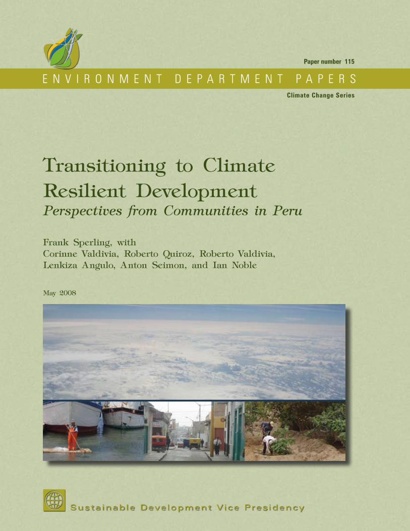
ENVIRONMENT DEPARTMENT PAPERS Sustainable Development Vice Presidency Paper number 115 Climate Change Series Transitioning to Climate Resilient Development Perspectives from Communities in Peru Frank Sperling, with Corinne Valdivia, Roberto Quiroz, Roberto Valdivia, Lenkiza Angulo, Anton Seimon, and Ian Noble May 2008
Transcript
Printed on recycled, environmentally-fiendly paper stock, using soy inks.
E N V I R O N M E N T D E P A R T M E N T P A P E R S
Susta inab le Deve lopment V ice Pres idency
Environment DepartmentT H E W O R L D B A N K
1818 H Street, NWWashington, D.C. 20433Telephone: 202-473-3641Facsimile: 202-477-0565
Paper number 115
Climate Change Series
Transitioning to Climate Resilient DevelopmentPerspectives from Communities in Peru
Frank Sperling, with Corinne Valdivia, Roberto Quiroz, Roberto Valdivia, Lenkiza Angulo, Anton Seimon, and Ian Noble
May 2008
Transitioning to C
limate R
esilient Developm
ent P
erspectives from C
ommunities in P
eru
Papers in this series are not formal publications of the World Bank. They are circulated to encourage thought and discussion. The use and citation of this paper should take this into account. The views expressed are those of the authors and should not be attributed to the World Bank. Copies are available from the Environment Department of the World Bank by calling 202-473-3641.
Transitioning to Climate Resilient DevelopmentPerspectives from Communities in Peru
Frank Sperling
with Corinne Valdivia Roberto Quiroz Roberto Valdivia Lenkiza Angulo Anton Seimon Ian Noble
Manufactured in the United States of AmericaFirst printing May 2008
The findings, interpretation, and conclusions presented in this report are those of the author and should not be attributed to the World Bank, its affiliated organizations, or to members of its Board of Executive Directors or the countries they represent. The presentation of material in this document and the geographical designations employed do not imply expression of any opinion on the part of the World Bank concerning the legal status of a country, territory or area, or concerning the delimitation of its boundaries.
Design: Jim CantrellCover photos: Frank Sperling
iiiClimate Change Series
Contents
Acknowledgments vii
executive summAry 1
introduction — climAte resilient development 5
Chapter 1: Climate Resilient Development — A Country Perspective 9
Disaster Risk — An Overview 11El Niño’s Influence on Peru’s Climate 11
Forecasting El Niño 14Institutional Structures for Disaster and Climate Risk Management 16
Climate Change — Challenge and Institutional Response 18Climate Change and El Niño 19
Chapter 2: Climate Resilient Development — Community Perspectives 21
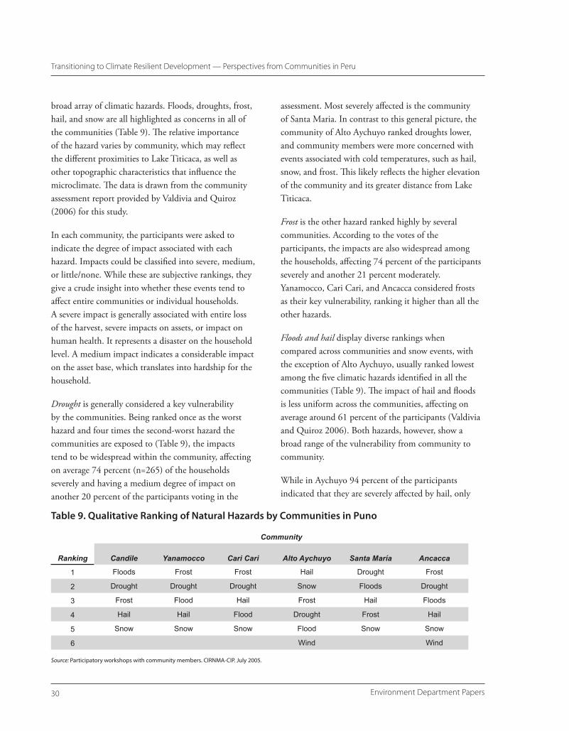
Approach 21Perspectives from Communities in Piura and Puno 25Disaster Risks and Impacts 25
Piura 25Puno 29Spatial Disaster Risk 31Temporal Exposure to Climatic Risks 32Impacts 34Comparison of Risk Exposure of Communities in Piura and Puno 36
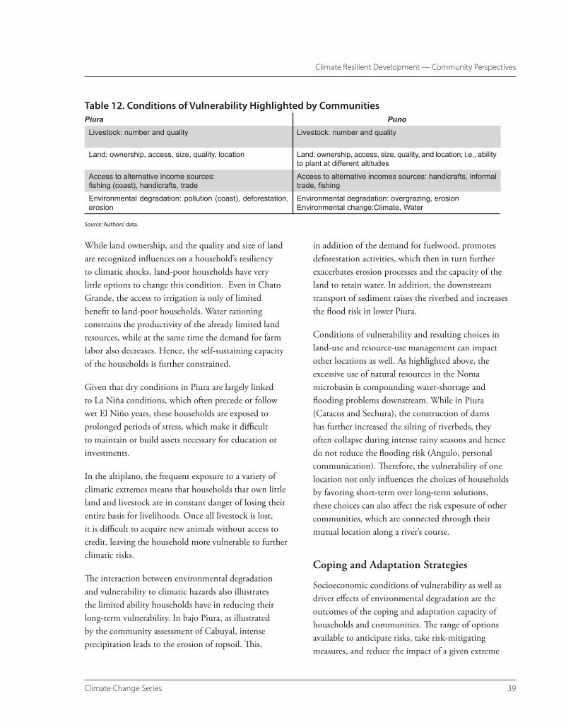
Vulnerability 36Socioeconomic Vulnerability 37Environmental Vulnerability 38Long-term Consequences of Vulnerability 38Key Aspects of Vulnerability 38
Coping and Adaptation Strategies 39Coping Strategies 40Adaptation Practices 41External Assistance and Barriers 43
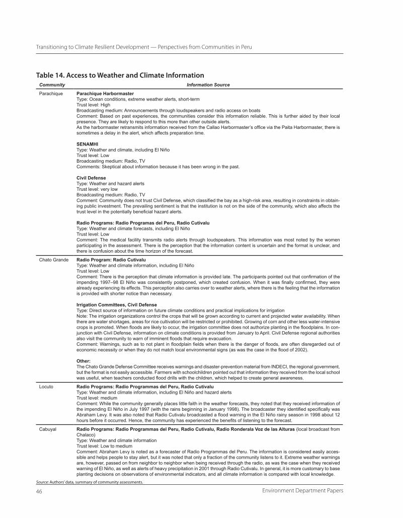
External Information—Weather Forecasts, Early Warning, and Seasonal Climate Outlooks 44Access to and Use of Information in Piura 45Weather and Climate Information in Puno 47Reflections on Community Responses 48
Use of Local Knowledge in the Prediction of Climatic and Environmental Changes 50
Environment Department Papersiv
Transitioning to Climate Resilient Development — Perspectives from Communities in Peru
Piura 50Puno 50Gauging the Role and Validity of Indicators 56
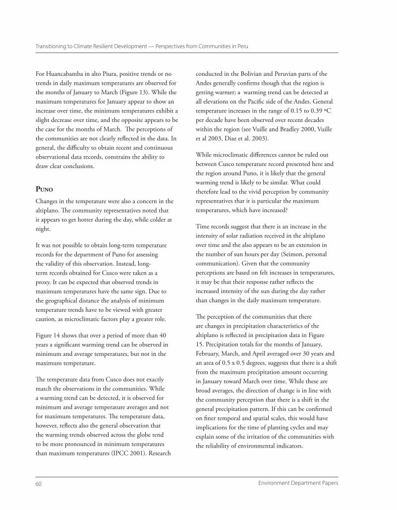
Perceptions of Changing Climate Conditions 57Piura: Perceived Climatic Changes in Northwestern Peru 57Puno: Perceived Climatic Changes in the Peruvian Altiplano 57Are These Perceptions True? 58
Piura 58Puno 60
Chapter 3: Conclusions and Recommendations 65
Use of Climate Information 66Research 66
Environmental Risks and Change 67Climate Forecasts and Local Indicators 67Agriculture and Livestock Management and Market Research 67Incentive Systems 67Tracking Progress 68
Community Action on Climate Risk Management 68Awareness Building 68Community-Level Investments 69
Enabling Frameworks: Institutional Coordination and Support 70
references 73
Appendixes
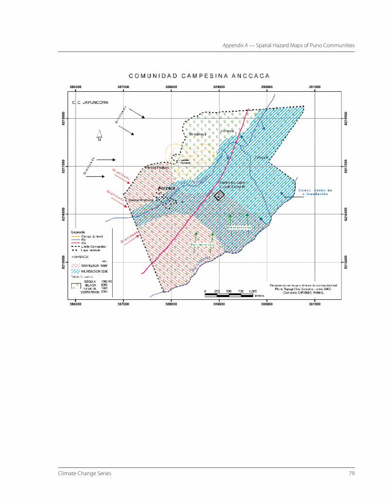
Appendix A: Spatial Hazard Maps of Puno Communities 77
Appendix B: Warm (El Niño) and Cold (La Niña) Phases of ENSO 83
Appendix C: Precipitation Totals in Relation to Seasonal SST Anomalies in Esperanza 85
Appendix D: Community-Specific Recommendations 89
Parachique 89Measures that Do Not Require Outside Assistance 89Measures that Require Outside Assistance 89
Chato Grande 90Measures the Community Could Take without Outside Assistance 90Measures that Require Outside Assistance 90
Locuto 91Measures the Community Could Take without External Assistance (according to July 13 workshop) 91Measures that Require Outside Assistance (according to July 13 workshop) 92Measures that Could Be Implemented by the Community without External Assistance (part of the development plan for the left bank of the Piura River, in Tambogrande) 92Measures that Require External Assistance (part of the development plan for the left bank of the Piura River, in Tambogrande) 93
Cabuyal 94Measures the Community Could Take without Outside Assistance 94Measures that Require Outside Assistance 94
vClimate Change Series
Contents
Appendix E: Project Proposal for Follow-Up Activities in the Altiplano 97
Background 97Development Objective 97Expected Contribution to Development Outcomes/Results 98Expected Outputs and Results 98Key Performance Indicators 98
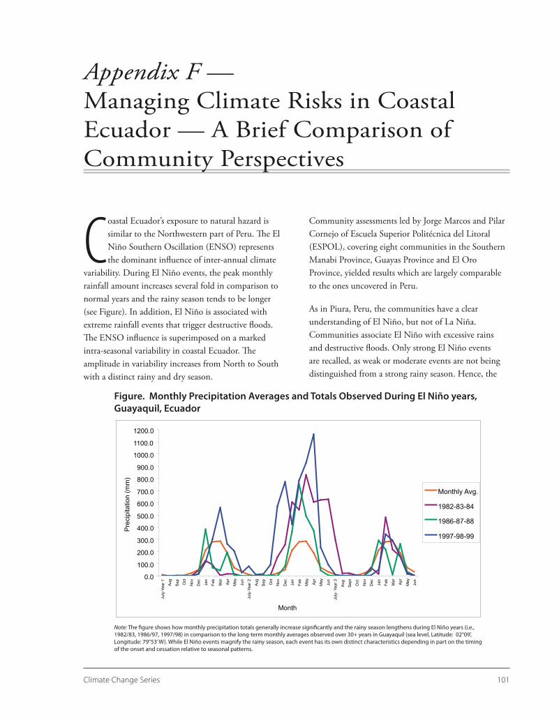
Appendix F: Managing Climate Risks in Coastal Ecuador — A Brief Comparison of Community Perspectives 101
figures
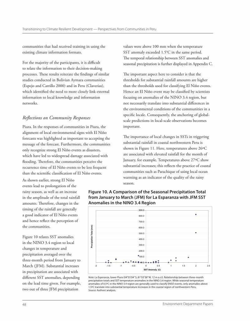
1. Monthly Precipitation for (A) La Esperanza, and (B) Huancabamba 12 2. Piura, Northern Peru 13 3. Monthly Precipitation Averages for Puno from 1931–73 14 4. The NINO Regions 14 5. NINO 3.4 Forecasts: Lead Time by Month and Predictive Skill 15 6. Diagram of Information Flow through ERFEN Network in Peru 17 7. NINO 3 Region Climate Trends 20 8. Spatial Exposure to Hydrometeorological Hazards of the Community of Santa Maria 31 9. Time Line of Major Natural Hazard Events Recalled by the Communities 32 10. A Comparison of the Seasonal Precipitation Total from January to March (JFM) for La Esparanza with JFM
SST Anomalies in the NINO 3.4 Region 48 11. Comparison between January Precipitation in La Esperanza and SST Values of the
NINO 1.2 Region 49 12. Average (A) Annual, (B) Monthly Maximum, and (C) Monthly Minimum Temperatures for Esperanza,
Northwestern Coastal Peru 59 13. Average Monthly (A) Maximum and (B) Minimum Temperatures for Huancabamba, Sierras, Upper Piura
Watershed 61 14. Long-term Temperature Record for (A) Minimum, (B) Maximum, and (C) Average Temperature in Cusco,
Peru 62 15. Precipitation Averaged over 30-year Periods for January to April for the Peruvian Altiplano Region 63
mAps
1. The Country of Peru 10 2. Location of Communities Assessed in Piura 22 3. Location of Communities in Puno 23
tAbles
1. Annual GDP Growth Rates in Percent by Year, Peru 10
Environment Department Papersvi
Transitioning to Climate Resilient Development — Perspectives from Communities in Peru
2. Disasters in Peru (Recorded by District from 2000–04) 11 3. Three-Month Temperature Anomalies for Classification of El Niño (EN) and La Niña (LN) Conditions, in
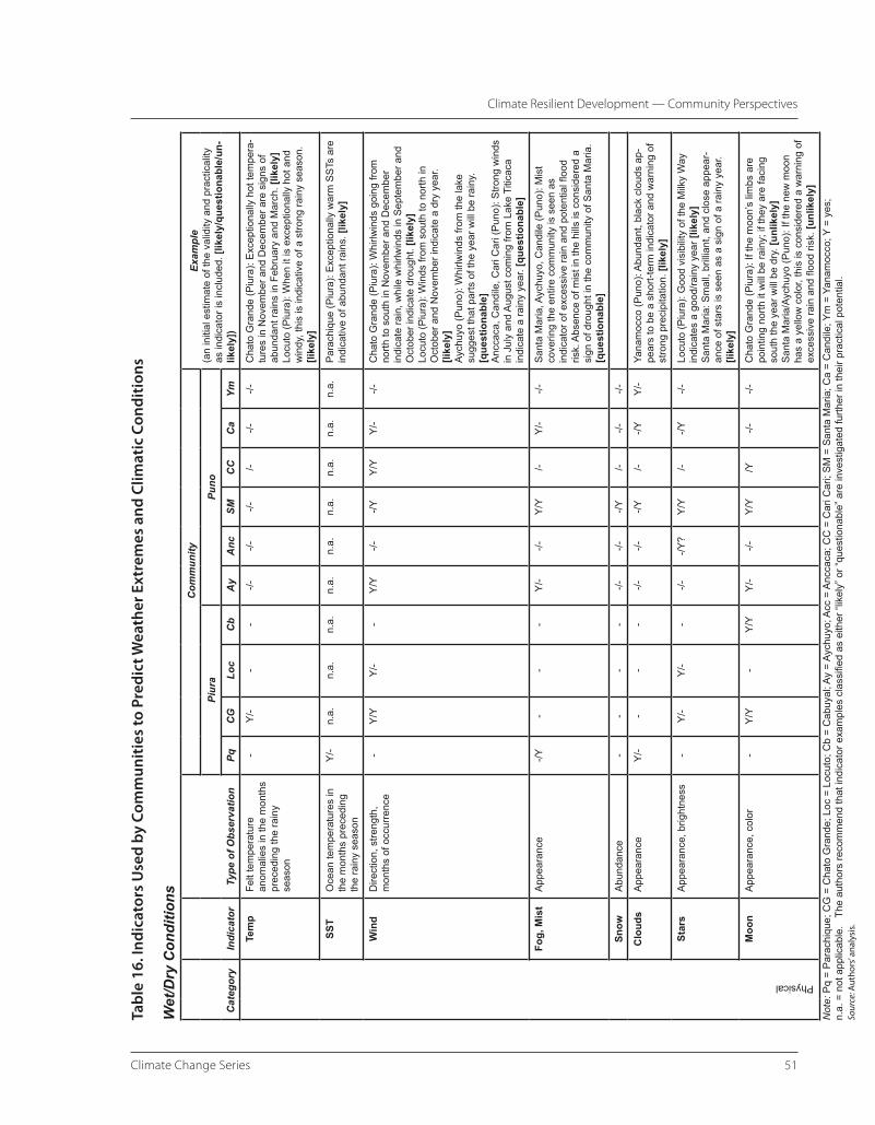
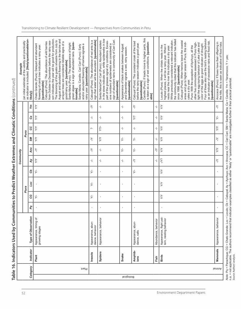
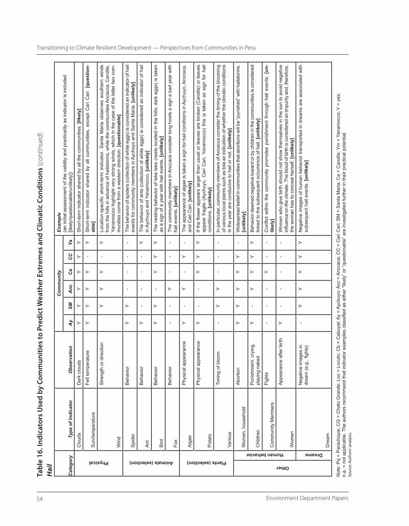
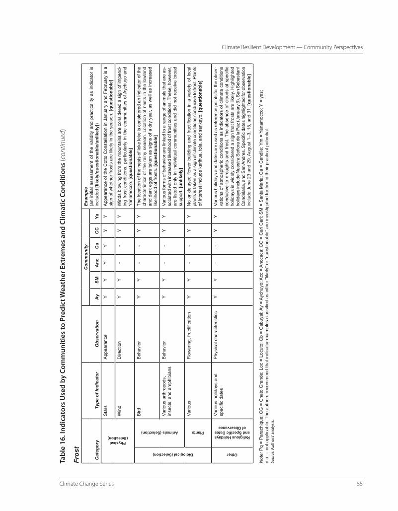
Degrees Celsius 15 4. Members of ENFEN–Peru 17 5. Community Characteristics, Piura 22 6. Community Characteristics, Puno 24 7. Disaster Events, as Recalled and Ranked by Communities in Piura, Peru 26 8. Impacts of Climate Hazards Identified in the Community Assessments in Piura 27 9. Qualitative Ranking of Natural Hazards by Communities in Puno 30 10. Livelihood Impacts of Drought and Floods, Communities of Puno 35 11. Livelihood Impacts of Hail and Frost, Communities of Puno 36 12. Conditions of Vulnerability Highlighted by Communities 39 13. Destinations of Push Migration, Piura Communties 41 14. Access to Weather and Climate Information 46 15. Awareness, Use, and Trust of El Niño Information in Six Puno Communities, 2005 Workshop 47 16. Indicators Used by Communities to Predict Weather Extremes and Climatic Conditions 51
viiClimate Change Series
Acknowledgments
This report is an output of the project Adaptation Strategies to the Environmental and Socioeconomic Impacts of El Niño for Rural Communities in Ecuador and Peru
supported by the Trust Fund for Environmental and Socially Sustainable Development (TFESSD) and led by the Climate Change Team of the World Bank’s Environment Department.
This report has been authored by Frank Sperling. It draws upon two major consultancy studies in Piura, northwestern Peru and in Puno, the region of the Peruvian altiplano, which were carried out by the Intermediate Technology Development Group (ITDG) and Centro de Investigacion de Recursos Naturales y Medio Ambiente (Research Center for Natural Resources and Environment; CIRNMA) under the supervision and guidance of the Centro International de la Papa (International Potato Center; CIP) in collaboration with the University of Missouri. The author would especially like to acknowledge the contributions provided by Roberto Quiroz (CIP), Corinne Valdivia (University of Missouri), Roberto Valdivia (CIRNMA), and Lenkiza Angulo (ITDG). Their knowledge and insights were of great importance in describing the situation of the communities in coping and adapting to climatic risks. In addition, Anton Seimon of Columbia University provided advice and shared valuable information, which is gratefully recognized. The author would also like to thank Ian Noble, the Task Team Leader of the Project, for this support and ideas.
The report would not have been possible without the participation of the communities of Parachique, Chato Grande, Locuto, and Cabuyal in the Department of Piura and the communities of Santa Maria, Ancacca, Yanamocco, Candile, Accopata, and Alto Achuyo in the Department of Puno. Their willingness and openness for sharing their perspectives on vulnerability to climate risk, coping and adaptive capacities, institutional support, and existing barriers are gratefully acknowledged.
Furthermore, our gratitude is extended to the institutions working on climate and disaster risk management issues in Peru, who shared information and provide insights about the challenges Peru is facing through the climatic changes associated with El Niño Southern Oscillation (ENSO) and global warming. Thanks are particularly due to Julio Garcia and staff at Consejo Nacional del Ambiente (National Council for the Environment; CONAM) for sharing data for this report. Also staff at Servicio Nacional de Meteorologia e Hidrologia (National Meteorology and Hydrology Service; SENAMHI), Instituto Nacional de Defensa Civil (National Institute of Civil Defense; INDECI), Instituto del Mar del Peru (Peruvian Marine Research Institute; IMARPE), and Ministerio de Agricultura (Ministry of Agriculture; MINAG) provided the team with helpful background information. Tony Barnston and colleagues at the International Research Institute of Climate and Society (IRI) at Columbia kindly shared information about their research.
Environment Department Papersviii
Transitioning to Climate Resilient Development — Perspectives from Communities in Peru
The project team would also like to express its gratitude to Liliana Sánchez (Universidad Nacional Agraria la Molina) for organizing the workshops in Puno and assisting in the coordination of the assessments. Hugo Li Pun, Victor Mares, Oscar Hildago, Pili Byrne, and Martha Huanes (all CIP) organized and facilitated the workshops in Piura and Lima. We are most grateful for their help and time. We also like to thank Jorge de la Cruz for preparing the maps of the study region included in this report. Finally, Frank Sperling would like to thank Graciete Moura for her support.
This report is accompanied by a consultancy commissioned on early warning systems and institutional disaster prevention structures in Peru and Ecuador, which was jointly carried out by Senter for utvikling og miljø (Center for Development and the Environment, SUM), Center for International Climate
and Environmental Research (CICERO), and Norway, which led to the report Seasonal Climate Forecasts and Community Responses: Summary of Experiences in Peru and Ecuador by Jemima García-Godos, Desmond McNeill, Karen O’Brien, and Lars Otto Næss. The report is available upon request. Finally, Ajay Mathur, Walter Vergara, Laura Tlaiye and Renan Poveda are gratefully recognized as current (or former) World Bank staff who provided helpful general support and insights throughout different stages of this project initiative.
Further inquiries about this report or the project should be directed to the Climate Change Team (Environment Department, ENV) of the World Bank or directly to Ian Noble, [email protected] or Frank Sperling, [email protected].
�Climate Change Series
Executive Summary
In the face of global environmental change, climate risk management is increasingly recognized for its essential role of ensuring the sustainability of development processes. Climate change is
altering the exposure of developing countries to weather-related hazards, often exacerbating already existing vulnerabilities. Over recent decades, the worldwide occurrence of weather-related disasters and socioeconomic impacts have increased. This is linked to a variety of factors, including demographic, economic, and environmental trends. High economic losses associated with disasters and the importance of climate-sensitive sectors for the economic progress of many developing countries have strengthened the call for climate-proofing development processes by proactively managing current and future climate risks.
Peru is among the countries highly vulnerable to climatic variability and extremes. The Andean mountain range acts as formidable barrier to air masses and helped shape contrasting climatic zones. In addition, the El Niño Southern Oscillation (ENSO) exerts a strong influence on the climatic variability. The warm (El Niño) and cold (La Niña) phases of ENSO have been linked to the occurrence of climatic extremes in coastal Northwestern Peru and high plateau (altiplano) extending southward from Peru.
Climatic changes triggered by El Niño events have caused substantial economic losses. El Niño has been associated with above normal rainfall conditions and floods in the northwestern Peru and more frequent drought conditions in the altiplano. The strong 1997–98 El Niño event caused losses of 3.6 billion USD in
Peru. Given high levels of rural poverty, many impacts, however, reside outside mainstream economy affecting nonmonetary assets of rural people.
Understanding how to address the semiperiodic occurrence of climatic patterns associated with ENSO, as well as the multi-hazard environment of Peru, provide important insights into capacity-building needs to prepare for long-term climate change, while also being of immediate benefit. Within this context, the community assessments of this study compare information and capacity-building needs in Northern Peru, where El Niño exerts a dominating influence on climatic conditions, with the situation of communities in the Peruvian altiplano, where the effects of El Niño are superimposed on a generally high degree of climate variability.
The major challenge for communities in Northern Peru is to forge livelihoods out of a semiarid environment. El Niño events represent both a challenge and an opportunity when the additional rainfall amount turns from a relief to destruction in the short term, but to green forests in the medium term. Climate risk management in this region means adapting to and coping with either too much or too little water, but also taking advantage of the positive effects of climate variability.
The challenge for communities in the altiplano of Peru is to cope with a highly variable climate on an annual and interannual basis. While El Niño is often associated with drought conditions in the altiplano, the communities may be exposed to a range of climatic
Environment Department Papers�
Transitioning to Climate Resilient Development — Perspectives from Communities in Peru
extremes in any year. During the planting season, droughts, floods, hail, cold spells, and snow may impact livelihoods. This situation has made it very difficult for households to accumulate and sustain assets, reinforcing high levels of poverty.
While climate forecasts have the potential to support communities in improving their agricultural outputs, current communication formats are limited in their value, as they are not well integrated into the general knowledge networks and decision-making processes of the communities. Climate forecasts tend to be compared with biological and physical indicators of local environmental conditions. Forecasts are disseminated predominantly through the radio. Disagreement between the communities’ interpretation of traditional indicators and the message of the forecast creates confusion, given that the one-way communication process of scientific forecasts does not provide opportunity for consultation or feedback. While forecasts are probabilistic, if this information is falsely interpreted it generates a general distrust toward using external information. The acceptance of seasonal climate forecasts and early warnings is furthermore dependent on who communicates the information, as government institutions are often not trusted, while radio is a trusted source.
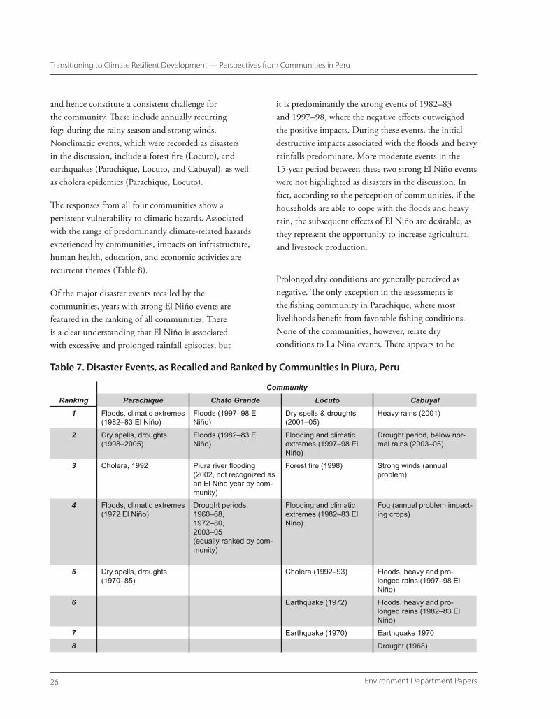
Communities tend to recall El Niño events according to the magnitude of negative impacts they have caused. In coastal Ecuador and Northern Peru, the floods associated with strong 1982–83 and 1997–98 El Niño events are remembered. Weaker events are generally not linked by communities to disasters. This may in part be explained by the fact that additional moisture supplied during El Niño years to the semiarid environment is, with the exception of the flooding events, largely beneficial for the communities, as it recharges aquifers and allows for the expansion of rain-fed agriculture and livestock. Therefore, in the perception of the communities of coastal Ecuador and Northern Peru, the return period of El Niño events differs from the scientific definition, as focus is
predominantly placed on the major events. This needs to be taken into account when issuing El Niño forecasts to communities.
El Niño events do not represent a core concern to communities in Southern Peru, as their effect is masked by the multi-hazard environment. Communities relate El Niño events largely to impacts in Northern Peru and the coast and not to their own situation. While El Niño events have been shown to suppress moisture transport to the altiplano, and hence are associated with drought conditions, the continuous exposure to climatic extremes makes it difficult to recognize the specific impact of El Niño. It is therefore questionable whether an emphasis on strengthening awareness about El Niño would be useful; rather, climate information should reflect the interest of the communities in learning more about their disaster risks and the general strengthening of early-warning capabilities for floods and droughts as well as other hazards, and association with sea surface temperature (SST) forecasts in the Pacific.
Specific measures aimed at explaining, forecasting, and responding to climatic risk can further reduce climate-related development processes. A better understanding of spatial vulnerabilities to specific climatic hazards is needed. Climate forecasts and early-warning systems need to be linked to traditional knowledge systems and decision-making bodies.
The ability to cope with climatic hazards is dependent on assets and the ability to diversify income sources. Particularly in the altiplano, the possession of livestock mitigates the impact of disasters. As access to credit is generally lacking and monetary assets are limited, the sale of livestock often provides the only opportunity to acquire medicines, seeds, and building materials after a disaster. Households that can resort to alternative sources of income, such as off-farm employment, are able to store forage for and protect their livestock, and can plant different crop varieties and adjust other agricultural practices to better cope
�Climate Change Series
Executive Summary
with climate extremes. Communal support systems and sharecropping can also play an important role in reducing the impact of climate-related hazards. In poorer households, where land quality is low and access to resources or communal support is limited, family members may be forced to migrate to urban areas or other regions in search for alternative income sources. Linkages built outside the community are essential because hazards are shared by a high proportion of families.
Development can improve the general resilience to climatic shocks, if the hazard risks are appropriately considered when addressing basic development needs. While communities are exposed to a range of climate-related hazards, vulnerabilities are often directly linked to basic development issues, such as the absence of health care facilities, inappropriate housing and infrastructure, limited access to markets, lack of educational and technical training opportunities, and weak institutional support. In this context, it is crucial that development activities, such as improving infrastructure, consider the local climatic conditions. In the altiplano, this means recognizing the exposure of development activities to extremely cold and hot,
as well as dry and wet, conditions. In Northern Peru, this means considering the effect of sporadically extremely wet conditions on infrastructure, human health, and agriculture during El Niño years, while strengthening the capacity of communities to maintain assets during the otherwise prevalent dry conditions. Training in crop and pest management for specific climatic conditions, strengthening access to credit for households or communities, and improving awareness about institutional support systems for emergency relief are also likely to significantly reduce climate-related vulnerabilities of community-level development processes.
Research activities need to be strengthened to support the design of climate-resilient development processes by responding to community-level training and capacity-building needs. Priority concerns are the validation of biological and physical indicators, evaluating the impact of environmental change, identifying effective entry points for scientific climate forecasts, evaluation of crop and livestock management options, exploring viable credit and insurance schemes, and the role of markets in fostering climate-resilient production and natural resources management.
�Climate Change Series
Introduction — Climate Resilient Development
The international quest for eradicating poverty and sustainable development not only has to address tremendous demographic and socioeconomic challenges, but also needs to adapt to a changing
global environment. Global warming will alter average climatic conditions in which development processes take place and affect the exposure to extreme events. The changes to the climate system are increasingly visible through their impacts on physical and biological systems around the globe (e.g. IPCC 2001a, b, IPCC 2007 a,b; Parmesan 2003, Stott et al. 2004, Emanuel 2005, and others). These changes occur against a backdrop of already existing vulnerabilities to natural disasters, which are particularly high in terms of loss of life and relative economic damages in developing countries (World Bank 2005). Climate change also interacts with other environmental changes, such as land degradation, habitat fragmentation, biodiversity loss, and air pollution (e.g., IPCC 2001, 2007). It is particularly the poor countries, where the livelihoods and economic growth depend on climate-sensitive sectors and adaptive capacity is low in terms of institutional and socioeconomic capital, that are at the receiving end of these changes.
In recognition of these problems, 10 bi- and multilateral agencies came together to jointly author the report Poverty and Climate Change, which emphasized the importance of integrating climate risk management into the development processes if sustainable progress toward and especially beyond the Millennium Development Goals (MDGs) is to be made (AfDB et al. 2003). The importance of an integrative approach of addressing climate change was recently reiterated
in the World Bank’s Investment Framework for Clean Energy and Development (World Bank 2006), which also addresses adaptation to climate change. A first estimate suggests that around 40 percent of the development project portfolio is at significant risk due to climate change. As the fingerprints of climate change are increasingly becoming visible, there is clearly the need to understand what practical measures can be undertaken to improve the resilience to current and future climate risks.
The challenge lies in addressing the pressing development needs of today, without locking into rigid development paths that only promise short-term relief and not a sustainable solution to these problems, because of their inability to adapt to a dynamic environment.
The aim of adaptation to climate change is to reduce the exposure to climate hazards and/or the underlying vulnerabilities to climatic changes. In contrast to the necessary complementary efforts to mitigate the rate and magnitude of climate change through the reduction and sequestration of greenhouse gases, adaptation is less tangible. It requires different measures that depend on the scale, geography, and time horizon of the development sector targeted. Human health, agriculture and fisheries, forestry, and infrastructure are among the development sectors most vulnerable to climate change and associated impacts (IPCC 2007b), illustrating that practical efforts to adapt to climate change will need to cover a broad array of professional disciplines and cultures. This is further complicated by the variety of physical changes in the environment that are triggered
Environment Department Papers�
Transitioning to Climate Resilient Development — Perspectives from Communities in Peru
by climate change, including sea level rise, climatic extremes, changes in temperature, precipitation, and other effects. These changes are not uniformly distributed across the globe, but are associated with impacts that play out over different temporal and spatial scales.
The term climate-resilient development implies that adaptation to climate change should not be seen as a separate process, but a continuous and integrated one that addresses present and future climate risks. The starting point in this process is to identify and address existing vulnerabilities to current climate variability and change. Addressing existing adaptation “deficits” can provide important learning lessons for tackling climate change (Burton and van Aalst 2004), while also providing immediate benefits.
Some caveats apply. When addressing vulnerabilities to current climatic conditions, adaptation measures which are part of longer-term processes should be flexible so they are capable of being adjusted to further change. The knowledge of change already has implications as it means that our experiences may only be of limited use in addressing future climatic conditions (Sperling and Szekely 2005). Hence, addressing current vulnerabilities is the first step; only the beginning of a process that needs to be adjusted and reevaluated over time. But making this first step is crucial as it reflects a change in attitudes; a shift from coping (ex post) to prevention and vulnerability reduction (ex ante).
Scope and Rationale of Study
The paper focuses on the abilities of communities in Peru to cope with climate variability, drawing on the results of project financed by the Trust Fund for Environmental and Socially Sustainable Development (TFESSD). The climatic changes induced by the semiperiodic occurrence of El Niño and La Niña represent a learning opportunity of processes that influence adaptive capacities and could hence provide
important lessons for preparing for the challenges of climate change.
The northwestern coastal areas of Peru, as well as the altiplano in the South, are under the influence of the El Niño Southern Oscillation (ENSO). ENSO represents a natural ocean atmosphere phenomenon, which is associated with changes in SST along the equatorial Pacific and off the coast of Ecuador and Peru and fluctuations in the intertropical surface pressure pattern in the Pacific (and Indian) Ocean. The two extreme phases of ENSO, El Niño and La Niña, affect the climate of the tropical Pacific and beyond. Besides influencing average climatic conditions and climate variability, they have also been associated with the occurrence of extreme events, which have triggered disasters with macroeconomic impacts in Peru and elsewhere.
In recent years, the scientific capacity to forecast ENSO extremes and warn of impeding El Niño events has increased considerably. This is complemented by a growing institutional emphasis on proactive disaster risk management, which aims to not only respond to but also prevent the occurrence of disasters through reduction of underlying vulnerability factors.
The semiperiodic occurrence of El Niño and La Niña events represents the opportunity to explore how these scientific and institutional advances have benefited vulnerable communities, such as the ones in Peru, in increasing their resilience to associated climatic extremes.
Specifically, the TFESSD study set out to capture the perspectives and opinions of communities concerning their vulnerability to climatic hazards, and the role of weather and climate information in relation to other nonformal information sources for anticipating and adapting to climatic extremes. The communities were also asked about perceived changes in their environment. Building on these discussions the communities then identified, first individually and then
�Climate Change Series
Climate Resilient Development — A Country Perspective
jointly with institutional representatives, measures that need to be taken to strengthen their adaptive capacity to ENSO events and general climate variability.
This study uses a bottom-up approach. The livelihoods of communities in rural areas of Peru are predominantly dependent on climate-sensitive sectors such as agriculture. Given their close connection with the environment, the understanding of how these communities perceive risks and how they adapt to and cope with climate hazards is important for identifying entry points for efforts aimed at building resilience. In this context, it is assumed that the successful use of climate information will depend on appropriate information formats that fit the decision-making structure of communities as stakeholders and also have their trust. In connection with collecting information of community knowledge on environmental predictors of
weather and climatic conditions and recommendations for capacity-building needs, it is hoped that the report will provide valuable, initial guidance on which elements play an important role in strengthening the adaptive capacity of communities to climate variability and change.
The objective of Part I is to place climate variability and change into the broader development of Peru and outline risk management structures. This overview will then be contrasted with the perceptions of risks and vulnerabilities and coping and adaptation strategies at the community level described in Part II for Northwestern Peru and the altiplano, which are regions considered highly vulnerable to climate-related hazards. The report concludes by developing a set of overarching and locale-specific recommendations.
�Climate Change Series
1
Peru is a country characterized by a diverse range of climates and an abundance of natural resources and environments. The Andes divide the country into three regions.
The semiarid to arid coastal area includes the capital of Lima and represents the region with the most industrialized and westernized urban centers. Agricultural activities are either under large-scale irrigation or, as is often the case of the more poor and vulnerable communities, dependent on seasonal river flows and highly variable rainfall.
About 50 percent of Peru’s population of roughly 28 million lives in sierra, the highland plateau between the two ranges of the Andean mountains. Most Peruvians of indigenous origin live in the Sierras. Rural livelihoods still rely heavily on subsistence farming and traditional livestock rearing, such as llama and alpaca.
The eastern region of Peru is comprised of the Amazon lowlands, characterized by a tropical climate and rainforests. It is the region that is most sparsely populated.
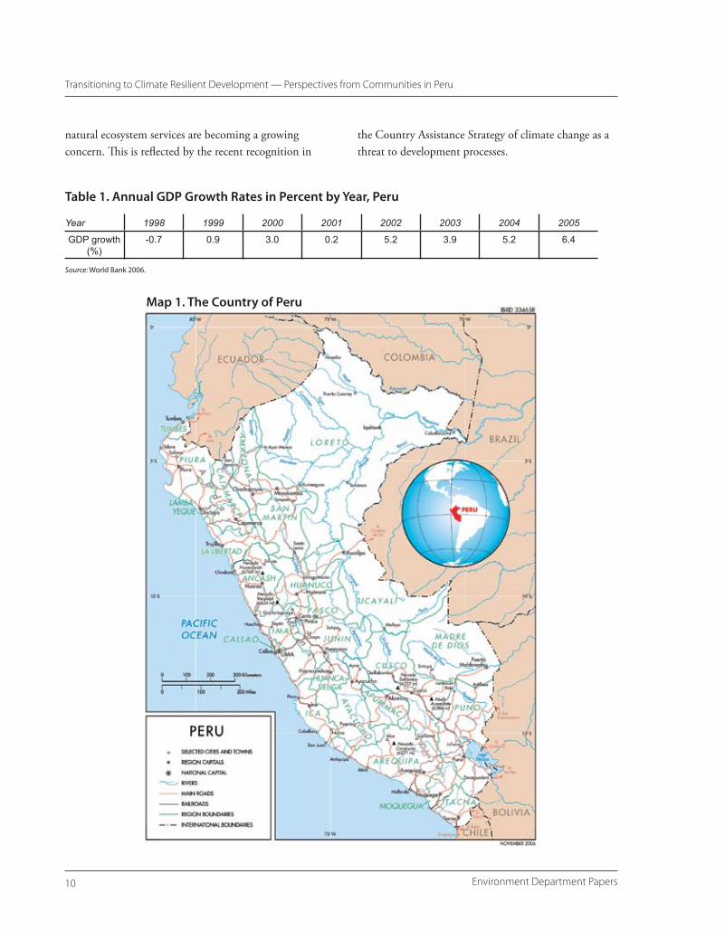
Over the recent years, Peru has experienced a stable macroeconomic situation, which has been attributed to sound economic policies and a favorable external environment (World Bank 2006). Since 2002, GDP growth rates have been around 4 percent and higher. High levels of poverty still persist, however.
One in two Peruvians is poor (World Bank 2006). The rural populations and especially the indigenous people
are the most vulnerable with the least economic means. On the national level, 64 percent of indigenous people live below the poverty line, and almost 80 percent of the rural indigenous population is poor (World Bank 2006; see also Hall and Patrinos 2005). In contrast, 40 and 66 percent of the nonindigenous are poor at the national level and in rural areas, respectively.
While economic shocks more greatly affect the urban population, it is particularly the rural population that is most affected by natural disasters (World Bank 2006). A recent analysis of the world’s disaster hotspots conducted by the World Bank and Columbia University ranked Peru among the 50 countries most vulnerable to natural disasters (World Bank 2005).
As will be discussed in the subsequent sections, climate-related hazards feature prominently in Peru’s disaster risk profile, especially climatic extremes associated with the semiperiodic occurrence of El Niño events. The economic and structural losses associated with the 1982–83 El Niño were estimated to be 3.38 billion USD (6.2 percent of 1983 gross domestic product [GDP]), while the estimated loss of the 1997–98 El Niño amounted to approximately 3.5 billion USD, which represents about 3 percent of the 1998 GDP. 1998 represents a year characterized by a decline in GDP (Table 1). Given the existing vulnerability to interannual climate variability and the high dependency of livelihoods and economic activities on natural resources, the implications of climate change for the exposure to extreme events and the provision of
Climate Resilient Development— A Country Perspective
Environment Department Papers�0
Transitioning to Climate Resilient Development — Perspectives from Communities in Peru
natural ecosystem services are becoming a growing concern. This is reflected by the recent recognition in
Table 1. Annual GDP Growth Rates in Percent by Year, Peru
Year 1998 1999 2000 2001 2002 2003 2004 2005
GDP growth (%)
-0.7 0.9 3.0 0.2 5.2 3.9 5.2 6.4
Source: World Bank 2006.
the Country Assistance Strategy of climate change as a threat to development processes.
Map 1. The Country of Peru
��Climate Change Series
Climate Resilient Development — A Country Perspective
Disaster Risk — An Overview
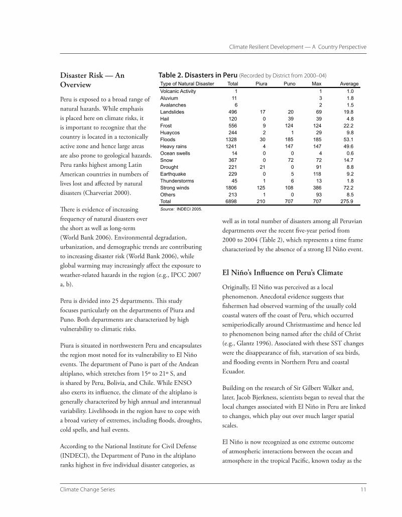
Peru is exposed to a broad range of natural hazards. While emphasis is placed here on climate risks, it is important to recognize that the country is located in a tectonically active zone and hence large areas are also prone to geological hazards. Peru ranks highest among Latin American countries in numbers of lives lost and affected by natural disasters (Charveriat 2000).
There is evidence of increasing frequency of natural disasters over the short as well as long-term (World Bank 2006). Environmental degradation, urbanization, and demographic trends are contributing to increasing disaster risk (World Bank 2006), while global warming may increasingly affect the exposure to weather-related hazards in the region (e.g., IPCC 2007 a, b).
Peru is divided into 25 departments. This study focuses particularly on the departments of Piura and Puno. Both departments are characterized by high vulnerability to climatic risks.
Piura is situated in northwestern Peru and encapsulates the region most noted for its vulnerability to El Niño events. The department of Puno is part of the Andean altiplano, which stretches from 15º to 21º S, and is shared by Peru, Bolivia, and Chile. While ENSO also exerts its influence, the climate of the altiplano is generally characterized by high annual and interannual variability. Livelihoods in the region have to cope with a broad variety of extremes, including floods, droughts, cold spells, and hail events.
According to the National Institute for Civil Defense (INDECI), the Department of Puno in the altiplano ranks highest in five individual disaster categories, as
well as in total number of disasters among all Peruvian departments over the recent five-year period from 2000 to 2004 (Table 2), which represents a time frame characterized by the absence of a strong El Niño event.
El Niño’s Influence on Peru’s Climate
Originally, El Niño was perceived as a local phenomenon. Anecdotal evidence suggests that fishermen had observed warming of the usually cold coastal waters off the coast of Peru, which occurred semiperiodically around Christmastime and hence led to phenomenon being named after the child of Christ (e.g., Glantz 1996). Associated with these SST changes were the disappearance of fish, starvation of sea birds, and flooding events in Northern Peru and coastal Ecuador.
Building on the research of Sir Gilbert Walker and, later, Jacob Bjerkness, scientists began to reveal that the local changes associated with El Niño in Peru are linked to changes, which play out over much larger spatial scales.
El Niño is now recognized as one extreme outcome of atmospheric interactions between the ocean and atmosphere in the tropical Pacific, known today as the
Table 2. Disasters in Peru (Recorded by District from �000–04)
Environment Department Papers��
Transitioning to Climate Resilient Development — Perspectives from Communities in Peru
El Niño Southern Oscillation (ENSO). The ENSO counterpart of El Niño is La Niña. Both phenomena are exerting a strong influence on the global climate, affecting regional temperature and precipitation patterns as well as extreme events.
During non–El Niño years, the atmospheric pressure in the eastern Southern Pacific (east of Tahiti) is higher
department of Piura, El Niño events are associated with a prolonged and intensified rainy season (Figure 1). While there is commonality in the direction of change, each El Niño event has its individual temporal and spatial characteristics.
While El Niño events are often accompanied by climatic extremes in northwestern Peru, it also has some
Figure 1. Monthly Precipitation for (A) La Esperanza, and (B) Huancabamba
than in the west (near Darwin, Australia). As El Niño conditions evolve, this pressure gradient weakens, turning off the engine fueling trade winds. The Intertropical Convergence Zone (ITCZ) is displaced southward while SSTs warm along the eastern equatorial Pacific and off the Peruvian coast. This results in rainfall anomalies in coastal regions of Northern Peru. Furthermore, the warming of the coastal waters and weakening of the winds chokes off the upwelling of cooler nutrient-rich waters, which leads to the migration of fish stocks.
Due to the ENSO phenomenon, Peru is exposed to large climatic interannual variations. The climatic changes associated with El Niño and La Niña, however, differ considerably between the coastal region of northwestern Peru and the altiplano in the south.
In northwestern Peru, which includes the
A
B
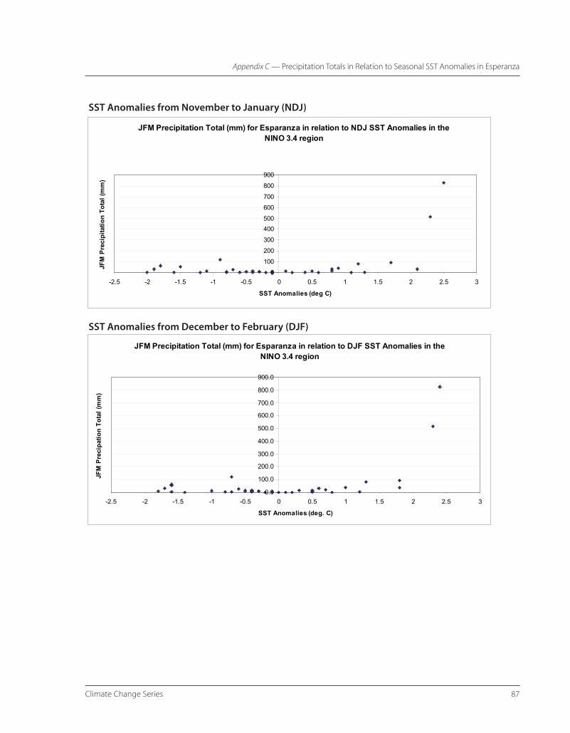
Note: Monthly precipitation averages for (a) La Esperanza (latitude: 04°55’04”, longitude: 81°03’38”; altitude: 12 meters [m] above sea level [a.s.l.]), 1960–2000, and (b) Huancabamba (05°15’, 79°43’, 1,952 m) 1970–96, Peru. La Esperanza, representing the coastal region of northwestern Peru, shows a clear increase in rainfall during El Niño years, in particular during the strong events of 1982–83 and 1997–98. El Niño years are also associated with spikes in precipitation in the sierras, as reflected in the rainfall record of Huancabamba, but rainfall in the highlands (alto) is generally more variable than in the low (bajo) and middle (medio) Piura. Source: Authors’ analysis, based on data provided by CONAM.
��Climate Change Series
Climate Resilient Development — A Country Perspective
beneficial effects. The usually prevalent arid conditions limit agricultural activities to areas with (largely seasonal) water supply from the rivers or access to irrigation. The extra water input during El Niño years also increases visibly the ecosystem productivity of the region (Figure 2). El Niño should therefore not solely be associated with disasters, but its positive effects also have to be recognized.
In contrast to northwestern Peru, the altiplano, which includes the department of Puno, is exposed to high annual and interannual climate variability. A variety of extreme events, including droughts, cold spells, floods, hail, and unseasonable snowfall are frequently
experienced and represent a challenge to livelihoods based on agricultural practices (see Table 1).
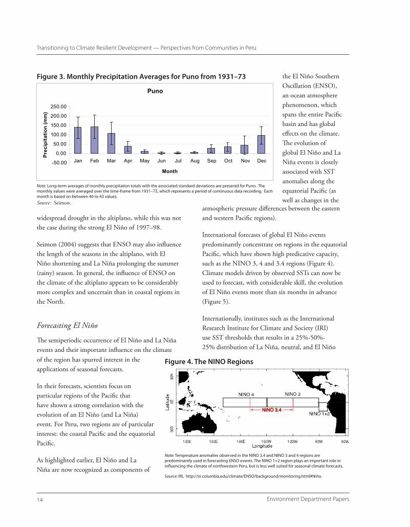
The climate is generally semiarid and the rainy season largely confined to austral summer months. Substantial precipitation events usually begin around mid-December and last until April (Figure 3). As a result, agricultural activities are mainly limited to one planting season. While in Northwestern Peru rainfall totals are substantially lower, two to three annual planting cycles can be possible during years with abundant water supply due to the widespread use of irrigation.
Another general characteristic of the climate in the altiplano is a pronounced diurnal temperature range. The difference between daily maximum and minimum temperatures can be 35º C or more (Jordan 1991).
The effects of El Niño on the South American altiplano are more variable. El Niño conditions are associated with below-normal rainfall conditions or drought conditions, while La Niña appears to favor wetter conditions. The ENSO signals not as consistent as in northwestern Peru, however, and important exceptions occur.
El Niño conditions tend to suppress the moisture transport from Amazonian lowlands into the altiplano by limiting the number of days with easterly flow due to the associated warming of the lower atmosphere (Garreaud and Aceituno 2001). During La Niña years the opposite occurs. Increases in days with easterly winds promote the upslope transport of moist air into the altiplano, hence favoring wet conditions.
While consequently El Niño is associated with drought conditions and La Niña with floods, this is not always the case, as the ENSO influence is highly sensitive to positive and negative anomalies in the flow of easterly winds (Garreaud and Aceituno 2001). Hence, other local-to-mesoscale disturbances can support or offset the influence of ENSO on the climate of the altiplano. For example, the strong El Niño of 1982–83 led to
Figure 2. Piura, Northern Peru
Note: The satellite image shows (a) the revitalized vegetation in the coastal regions during the April 1998, an El Niño year, in comparison to (b) the prevalent dry environment during the same month in 2001, a non–El Niño year. Source: CIP.
A
B
Environment Department Papers�4
Transitioning to Climate Resilient Development — Perspectives from Communities in Peru
widespread drought in the altiplano, while this was not the case during the strong El Niño of 1997–98.
Seimon (2004) suggests that ENSO may also influence the length of the seasons in the altiplano, with El Niño shortening and La Niña prolonging the summer (rainy) season. In general, the influence of ENSO on the climate of the altiplano appears to be considerably more complex and uncertain than in coastal regions in the North.
Forecasting El Niño
The semiperiodic occurrence of El Niño and La Niña events and their important influence on the climate
atmospheric pressure differences between the eastern and western Pacific regions).
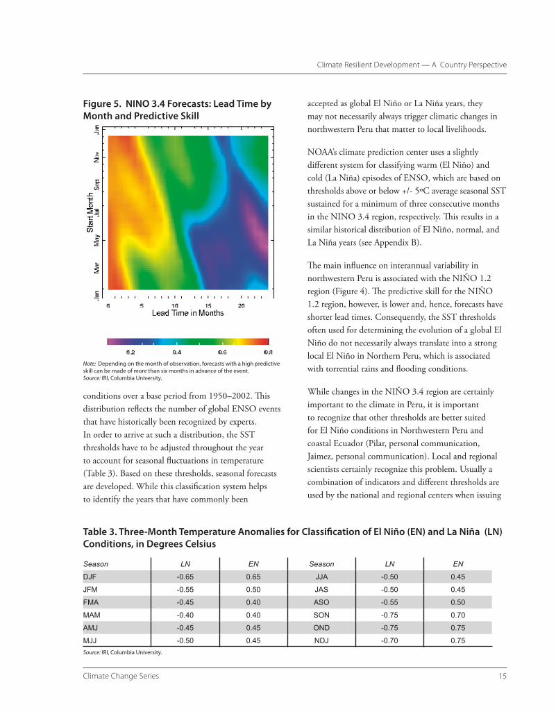
International forecasts of global El Niño events predominantly concentrate on regions in the equatorial Pacific, which have shown high predicative capacity, such as the NINO 3, 4 and 3.4 regions (Figure 4). Climate models driven by observed SSTs can now be used to forecast, with considerable skill, the evolution of El Niño events more than six months in advance (Figure 5).
Internationally, institutes such as the International Research Institute for Climate and Society (IRI) use SST thresholds that results in a 25%-50%-25% distribution of La Niña, neutral, and El Niño
Figure 3. Monthly Precipitation Averages for Puno from 1931–73
Puno
-50.00
0.00
50.00
100.00
150.00
200.00
250.00
Jan Feb Mar Apr May Jun Jul Aug Sep Oct Nov Dec
Month
Prec
ipita
tion
(mm
)
Note: Long-term averages of monthly precipitation totals with the associated standard deviations are presentd for Puno. The monthly values were averaged over the time-frame from 1931–73, which represents a period of continuous data recording. Each month is based on between 40 to 43 values.Source: Seimon.
the El Niño Southern Oscillation (ENSO), an ocean atmosphere phenomenon, which spans the entire Pacific basin and has global effects on the climate. The evolution of global El Niño and La Niña events is closely associated with SST anomalies along the equatorial Pacific (as well as changes in the
Figure 4. The NINO Regions
Note: Temperature anomalies observed in the NINO 3.4 and NINO 3 and 4 regions are predominantly used in forecasting ENSO events. The NINO 1+2 region plays an important role in influencing the climate of northwestern Peru, but is less well suited for seasonal climate forecasts.
of the region has spurred interest in the applications of seasonal forecasts.
In their forecasts, scientists focus on particular regions of the Pacific that have shown a strong correlation with the evolution of an El Niño (and La Niña) event. For Peru, two regions are of particular interest: the coastal Pacific and the equatorial Pacific.
As highlighted earlier, El Niño and La Niña are now recognized as components of
��Climate Change Series
Climate Resilient Development — A Country Perspective
conditions over a base period from 1950–2002. This distribution reflects the number of global ENSO events that have historically been recognized by experts. In order to arrive at such a distribution, the SST thresholds have to be adjusted throughout the year to account for seasonal fluctuations in temperature (Table 3). Based on these thresholds, seasonal forecasts are developed. While this classification system helps to identify the years that have commonly been
accepted as global El Niño or La Niña years, they may not necessarily always trigger climatic changes in northwestern Peru that matter to local livelihoods.
NOAA’s climate prediction center uses a slightly different system for classifying warm (El Niño) and cold (La Niña) episodes of ENSO, which are based on thresholds above or below +/- 5ºC average seasonal SST sustained for a minimum of three consecutive months in the NINO 3.4 region, respectively. This results in a similar historical distribution of El Niño, normal, and La Niña years (see Appendix B).
The main influence on interannual variability in northwestern Peru is associated with the NIÑO 1.2 region (Figure 4). The predictive skill for the NIÑO 1.2 region, however, is lower and, hence, forecasts have shorter lead times. Consequently, the SST thresholds often used for determining the evolution of a global El Niño do not necessarily always translate into a strong local El Niño in Northern Peru, which is associated with torrential rains and flooding conditions.
While changes in the NIÑO 3.4 region are certainly important to the climate in Peru, it is important to recognize that other thresholds are better suited for El Niño conditions in Northwestern Peru and coastal Ecuador (Pilar, personal communication, Jaimez, personal communication). Local and regional scientists certainly recognize this problem. Usually a combination of indicators and different thresholds are used by the national and regional centers when issuing
Figure 5. NINO 3.4 Forecasts: Lead Time by Month and Predictive Skill
Note: Depending on the month of observation, forecasts with a high predictive skill can be made of more than six months in advance of the event.Source: IRI, Columbia University.
Table 3. Three-Month Temperature Anomalies for Classification of El Niño (EN) and La Niña (LN) Conditions, in Degrees Celsius
Season LN EN Season LN EN
DJF -0.65 0.65 JJA -0.50 0.45
JFM -0.55 0.50 JAS -0.50 0.45
FMA -0.45 0.40 ASO -0.55 0.50
MAM -0.40 0.40 SON -0.75 0.70
AMJ -0.45 0.45 OND -0.75 0.75
MJJ -0.50 0.45 NDJ -0.70 0.75Source: IRI, Columbia University.
Environment Department Papers��
Transitioning to Climate Resilient Development — Perspectives from Communities in Peru
their forecasts; however, this information is often not published in international scientific journals.
The altiplano of Peru is predominantly influenced by changes in the equatorial in the SST along the equatorial Pacific; i.e., changes in the NINO 3.4 region.
Despite the widespread influence of ENSO on climatic conditions, there is no uniform definition of El Niño conditions that automatically would apply also to local climatic conditions. In the case of Peru, the experience developed by national and regional meteorological organizations in identifying thresholds that are locally relevant is of considerable importance. SENAMHI and other organizations do evaluate the accuracy of forecasts; however, much of this knowledge and information on thresholds is not published internationally or is at least publicly available.
As there are different classifications for El Niño events based on the ever-evolving indexes and practices on the national and international level, this may lead to conflicting messages. The Climate Outlook Forums represented a promising effort to develop a consensus view on the status of El Niño events in various regions of the world (IRI 2001); however, it has not translated into continuous coordination efforts for scientific forecasts in this region.
Given the strong influence of ENSO on climatic characteristics, forecasts have not only focused on alerting for El Niño events, but also on providing more continuous insights into the climatic conditions of the region. These forecasts are presented as probabilistic assessments of whether a particular region will be faced with drier, wetter, or average climatic conditions.
Institutional Structures for Disaster and Climate Risk Management
Over the last five years, there has been an increasing shift away from a reactive approach predominantly focused on disaster mitigation and toward building
an integrative framework that also strongly focuses on disaster prevention, by identifying risks and vulnerabilities (World Bank 2006).
The Plan Nacional de Prevencion y Atencion de Desastres (National Plan for the Prevention and Attention to Disasters) was approved in 2004. The plan includes objectives and identifies specific strategies, aimed at improving the risk assessment, vulnerability reduction, integration of risk management into public planning, strengthening institutions and the participation of communities. However, there are currently no clear definitions of the responsibilities of the individual institutions and their specific operational roles (World Bank 2006).
Given the vulnerability to hydrometeorological hazards and the strong influence of ENSO, the growing emphasis on vulnerability reduction is also reflected in institutional efforts to collect and disseminate climate information, aimed at reducing the vulnerabilities of climate-sensitive sectors.
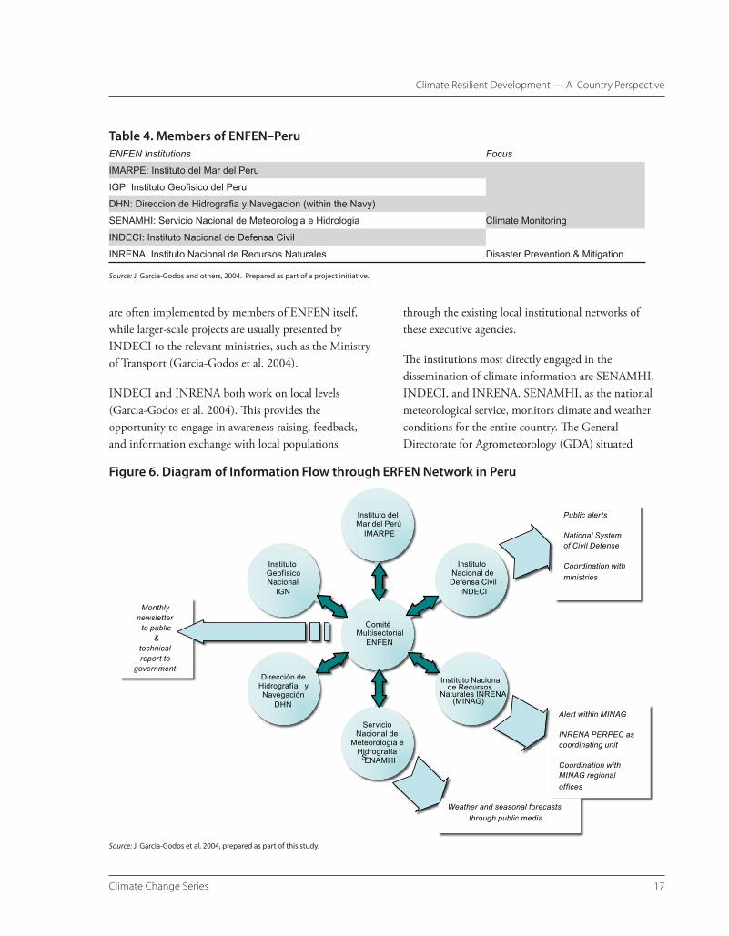
Disaster preparedness efforts focused on ENSO events are coordinated by the National Study of the El Niño Phenomenon (Estudio Nacional del Fenomeno El Niño; ENFEN), which addresses the national component of the Regional Study of the El Niño Phenomenon (Estudio Regional del Fenomeno El Niño; ERFEN). ERFEN was established as a program by the Permanent Commission for the South Pacific (Comisión Permanente del Pacifico Sur) in 1974 and guided by national committees from its four member countries. Aside from Peru, these include Colombia, Ecuador, and Chile (Garcia-Godos et al. 2004).
ENFEN Peru is comprised of six national institutions (Table 4). The information flow between the various institutions is presented in Figure 6.
The climate and oceanic conditions are monitored by IMARPE, IGP, DHN, and SENAMHI. Based on a collective and consensus-finding process, El Niño forecasts are being issued. Smaller-scale interventions
��Climate Change Series
Climate Resilient Development — A Country Perspective
are often implemented by members of ENFEN itself, while larger-scale projects are usually presented by INDECI to the relevant ministries, such as the Ministry of Transport (Garcia-Godos et al. 2004).
INDECI and INRENA both work on local levels (Garcia-Godos et al. 2004). This provides the opportunity to engage in awareness raising, feedback, and information exchange with local populations
through the existing local institutional networks of these executive agencies.
The institutions most directly engaged in the dissemination of climate information are SENAMHI, INDECI, and INRENA. SENAMHI, as the national meteorological service, monitors climate and weather conditions for the entire country. The General Directorate for Agrometeorology (GDA) situated
Table 4. Members of ENFEN–PeruENFEN Institutions Focus
IMARPE: Instituto del Mar del Peru
Climate Monitoring
IGP: Instituto Geofisico del Peru
DHN: Direccion de Hidrografia y Navegacion (within the Navy)
SENAMHI: Servicio Nacional de Meteorologia e Hidrologia
INDECI: Instituto Nacional de Defensa Civil
Disaster Prevention & MitigationINRENA: Instituto Nacional de Recursos Naturales
Source: J. Garcia-Godos and others, 2004. Prepared as part of a project initiative.
Figure 6. Diagram of Information Flow through ERFEN Network in Peru
Source: J. Garcia-Godos et al. 2004, prepared as part of this study.
Instituto Geofísico Nacional
IGN
Dirección de Hidrografía y Navegación
DHN
Servicio Nacional de
Meteorología e Hidrografía
SENAMHI
Instituto Nacional de Recursos
Naturales INRENA (MINAG)
Instituto Nacional de Defensa Civil
INDECI
Instituto del Mar del Perú
IMARPE
Comité Multisectorial
ENFEN
Weather and seasonal forecasts through public media
Alert within MINAG
INRENA PERPEC as coordinating unit
Coordination with MINAG regional offices
Public alerts
National System of Civil Defense
Coordination with ministries
Monthly newsletter to public
&technical report to
government
Environment Department Papers�8
Transitioning to Climate Resilient Development — Perspectives from Communities in Peru
MINAG combines statistical production data with climate information from SENAMHI. The agricultural data is collected by staff from agrarian agencies working at the district level, which constitutes the lowest administrative unit in Peru. The data is based largely on assessments and estimates and does not include systematic surveys (Garcia-Godos et al. 2004). After the analysis, the information generated by MINAG is then passed on to agrarian agencies at the provincial and district level. The information, however, does not always get there due to bottlenecks in the distribution path. Other information arrives with a time lag of 20 days or more (Garcia-Godos et al. 2004). Consequently, the forecasting aspect for the end user may be lost, limiting the practical relevance of the information in guiding strategies aimed at vulnerability reduction or disaster preparedness.
Climate Change — Challenge and Institutional Response
Over the past 100 years (1906–2005), the earth’s annual surface temperature has increased by about 0.74ºC (IPCC 2007). The rate of warming is accelerating. A total of 11 of the 12 warmest years on record have occurred in the past 12 years, and the projected increase in global mean surface temperature between 1990 and 2100 is projected to lie between 1.0 to 6.3ºC. As global warming of this century will be more pronounced than the trends observed in the last century, it is expected to bring more drastic changes in climate and associated environmental responses.
Given the diverse climates and ecosystems, steep topographies, existing disaster risk, and high dependency of livelihoods on natural resources in Peru, climate change poses an additional threat to the sustainable development prospects of the country. There is a need to understand how climate change will impact climatic conditions across temporal and spatial scales, affect the provision of ecosystem services, and alter the exposure to climatic extremes. Given the influence of ENSO on Peru’s climate and disaster risk,
within SENAMHI, focuses on the generation of agrometeorological forecasts. Relevant data on crop productivity is collected on a weekly basis by a locally recruited agent, who is usually a local farmer trained by SENAMHI. The data is then usually transmitted via phone, which also allows for passing on other potentially important information, such as local knowledge of environmental indicators. Consultations with GDA suggest, however, while staff are aware of this knowledge, there are currently now systematic efforts to collect and evaluate such knowledge and compare it with scientific forecasts (Garcia-Godos et al. 2004).
GDA also monitors the phonological development of crops in relation to weather conditions in more than 400 observatories across the country. The information gathered by GDA is made publicly available in three types of bulletins: one bulletin focused on short-term trends is published every 10 days, and two monthly reports, focused on hydrometeorological and agroclimatic conditions, also provide information on tendencies and forecasts.
While SENAMHI aims to provide information for authorities and farmers, the main user of the climate information collected by GDA is indeed the Ministry of Agriculture (MINAG), and the General Directorate of Agrarian Information edits the information into a more user-friendly format and distributes it to its regional directorates. The detailed agroclimatic information, however, requires access to the internet. A pilot project has been launched by SENAMHI and MINAG in the Cañete Valley of Peru to assist farmers with Internet access to utilize this information for improving crop production. In general, the distribution channels of these forecasts are still limited, as this requires adequate literacy and access to a computer (Garcia-Godos et al. 2004). Consequently, the main communication of climate information occurs through radio broadcasts, which receive information updates from SENAMHI.
��Climate Change Series
Climate Resilient Development — A Country Perspective
it is furthermore important to gain insights into the implications of global warming on the occurrence and magnitude of El Niño and La Niña events. Improving such knowledge will be essential to guiding longer-term development-planning processes and complementing existing efforts aimed at reducing vulnerabilities to current climatic risks.
It is interesting that Peru’s efforts in climate change so far have been more focused on the international policy dialogue and on mitigation options for the emission of greenhouse gases (World Bank 2006). Only recently has Peru increased its emphasis on identifying and implementing adaptation measures to climate change.
The institutional landscape for managing environmental and natural hazards in Peru is undergoing change itself. The country is setting up for the first time a Ministry of Environment. Most of the efforts to mainstream climate change policies into national development in Peru have been led by the Consejo Nacional Ambiental (National Council for the Environment (CONAM), which has been chairing the National Commission on Climate Change. The new ministry will place a strong emphasis on addressing climate change, likely building CONAM’s experiences through the PROCLIM project and emphasis of a holistic approach, which focuses on mitigation (reduction of greenhouse gases) and adaptation.
As part of its efforts to assess climate change risks, CONAM has also assessed the potential implications of climate change for the occurrence of El Niño events. Using a range of climate change models, CONAM found an increase of the SST in the NINO 3 region under global warming scenarios (Figure 7), which suggests that conditions may become more conducive to the evolution of El Niño events.
The World Bank is engaged in research focused on identifying climate change impacts and vulnerabilities and developing project activities that promote adaptation to climate change in Peru and other Latin
American countries (see Vergara 2005 for details on project activities).
Of major concern are the implications of climate change for the water balance for the Andean region and the associated economic consequences (Vergara et al. 2007). The majority of Peru’s population and economic activities are located along the coast and in highlands. Both regions are predominantly dry and highly dependent on runoff from the cordilleras. Recent research confirms a massive retreat of glaciers, which is in line with overall warming trends and an upward shift in freezing point isotherm (Kaser 2001, Francou et al. 2003). The retreat of glaciers results in an initial temporary increase in runoff, followed by a decline and shutoff of water supply as the glacier disappears. Given that glaciers have been shown to contribute considerably to the overall water balance in river basins in the Andes, the downstream implications of a decline in this freshwater resource represents a considerable and growing challenge to agricultural activities and hydropower generation in the region (Vergara et al. 2007).
Climate Change and El Niño
Another concern is the influence of climate change on atmospheric and oceanic circulation patterns and associated consequences for such phenomena as ENSO. Current scientific thinking suggests that the climate will enter a weak El Niño–like mean state, with El Niño events resembling strong El Niño events of today (e.g. IPCC 2001a). This is echoed by results of a recent climate change study conducted by CONAM, which shows a warming trend in SST for NINO 3, a region where SST anomalies are correlated with the occurrence of ENSO events (Figure 7).
Since 1976, more warm El Niño episodes than cold La Niña episodes have been observed, but it is currently not clear whether this can be attributed to climate change.
Environment Department Papers�0
Transitioning to Climate Resilient Development — Perspectives from Communities in Peru
Figure 7. NINO 3 Region Climate Trends
Note: Climate simulations suggest a general warming trend for the NINO 3 region. As positive anomalies in SSTs are associated with El Niño conditions, this may suggest a shift toward a more El Niño–like climate conditions. The colors show different simulation runs by Global Climate Models for the NINO 3 region, all of which point toward an increase in sea surface temperature.Source: CONAM.
With more El Niño–like general climatic conditions and an increased frequency of strong El Niño events, one may expect wetter conditions in Northern Peru and
drier conditions in the altiplano, but the link between El Niño and climate change is not fully resolved and hence such effects are still largely speculative.
The previous sections have presented an overview of the exposure of Peru to natural hazards with a strong emphasis on the influence of El Niño on climate risks and then described the existing
institutional structures for disaster prevention and preparedness. In this context, climate change has been recognized for its threat to sustainable development due to its potential implications for the natural and water resources effects and the associated consequences for Peru’s economy.
In light of climate change, the existing vulnerabilities associated with the annual and interannual climate variability and ENSO underscore the importance of adaptive measures that enhance the resilience of livelihoods and economic processes in Peru. Adaptation to climate change hence has to begin with better managing current climate risks and should be viewed as a continuous process. Adaptive measures range from strategies, policies, and investment frameworks enacted at the national level to efforts at the local level. The time horizon of adaptive strategies and measures has to be tailored according to the scope of the activity and capacity of the target groups.
This chapter focuses on how communities perceive the risks of their environment and how they cope and adapt. The experiences of communities in living in the department of Piura, northwestern Peru, are juxtaposed with the situation of communities in the department of Puno, representing the Peruvian altiplano. Both regions have in common an interannual climate variability influenced by ENSO. The effects of El Niño and La Niña on the climate, however, differ considerably, as
does the overall risk profile. Based on these responses and in recognition of national risk management structures, adaptive capacity-building needs aimed at increasing the resilience to climate variability and change are discussed.
Approach
Under coordination by the Centro Internacional de la Papa (CIP), the community assessments were carried out by the Intermediate Technology Development Group (ITDG) in the department of Piura and Centro de Investigacion de Recursos Naturales y Medio Ambiente (Research Center for Natural Resources and Environment; CIRNMA) in the department of Puno.
In Piura, a total of four communities were selected covering a transect from the coast to the sierras in the proximity of the Piura river (Map 2, Piura). The assessment included the coastal community of Parachique (sea level, bajo Piura), Chato Grande (30 m a.s.l, bajo Piura), Locuto (80 m a.s.l, medio Piura) and Cabuyal in sierras of Piura (1,470 m a.s.l., alto Piura). A description of the individual community characteristics is provided in Table 5.
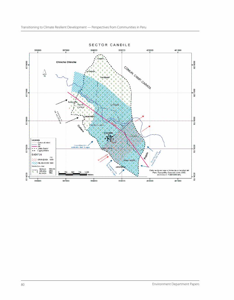
For the assessments in Puno, six communities in different proximity to Lake Titicaca were selected, including the communities of Santa Maria (3,862 m a.s.l), Ancacca (3,950–4,050 m a.s.l.), Yanamocco (3,841 m a.s.l.), Candile (3,834 m a.s.l.), Cari Cari (3,950 m a.s.l) and Alto Achuyo (3,947 m a.s.l.). Further information on the individual communities is provided in Table 6, and spatial information
Environment Department Papers��
Transitioning to Climate Resilient Development — Perspectives from Communities in Peru
concerning the location of communities relative to Lake Titicaca is given in Map 3.
A participatory process was chosen to elicit information from the communities. The assessments first focused on the perceptions of each community concerning their exposure to environmental risks and hazards. Participants were asked to recall events that constituted a major disaster to the community by significantly affecting human health, infrastructure, or production systems.
In Piura, the community members voted on the
Table 5. Community Characteristics, Piura
Department of Piura, N-Peru
Parachique (5°45’51” S/ 80°51’53” W, sea level): Representing bajo (lower) Piura, this coastal community located at the fringes of the Sechura desert largely depends on fishing activities. Four types of fishermen can be distinguished: artisan fisherman, who use lines or nets; shellfish divers; boat owners; and industrial fishermen, who harvest fish of up to 50 metric tons (MT), predomi-nantly for the fish meal industry. The poorest segments of Parachique’s inhabitants do not participate in fishing activities and solely depend on dryland farming and products of the dry forest. Many women obtain income by processing shellfish.
Chato Grande (5°21’20” S/ 80°40’3” W/ 30 m a.s.l): An inland community of bajo Piura, Chato Grande is located in the lower watershed of the Piura river. Fertile soils are interspersed with tropical dry forest. Having access to irrigation, the community’s main activity is crops (cotton, rice, maize, beans). Goats and poultry are also raised.
Locuto (4°54’53” S, 80°20’56” W, 80 m a.s.l): Located in the tropical dry forest in medio (middle) Piura, the carob tree (algarrobo, Prosopis limensis) plays a central role in the livelihood of Locuto’s inhabitants, who harvest the beans and also use the tree for fuelwood and charcoal. The carob tree is also an important resource for handicrafts (along with two other tree species: Cordia rotudifolia, Cappais angulata). Farming activities are concentrated in the riverbed areas, which have sufficient moisture for plant-ing sweet potatoes, maize, beans, and various fruits. Depending on rainfall, planting activities (mainly beans and watermelon) are occasionally extended in forest areas cleared for production. Livestock includes predominantly sheep and goats. Beekeeping is also common activity.
Cabuyal (5°02’17” S, 79°49’42” W, 1,470 m a.s.l.): The area of this highland community of alto (higher) Piura extends from 1,400–2,000 m above sea level, with nucleated population center being located at around 1,470 m a.s.l. Agricultural activities are diversified, including dryland farming of maize, wheat, beans, and green peas, along with fruit trees and coffee at lower elevations. Livestock production is also of importance. With respect to climate, it is important to note the specific characteristics of this part of the sierras. At these lower elevations of the sierra, southeast winds bringing humidity from the Amazon meet westerly airflows from the Pacific. As a result, this area experiences heavy rainfalls, which is unique in the highlands.
Map 2. Location of Communities Assessed in Piura
Source: CIP.
��Climate Change Series
Climate Resilient Development — Community Perspectives
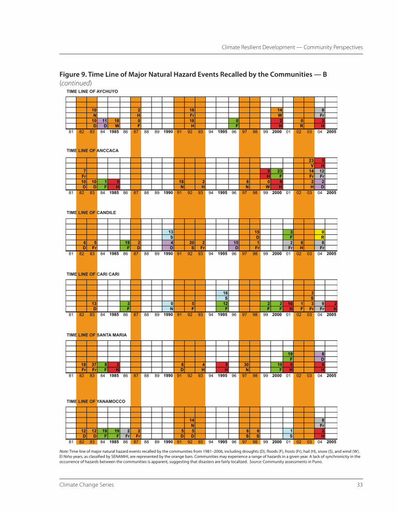
severity of the events and ranked them accordingly. In Puno, the communities first ranked the hazards according to their level of concern and general impact. As the number of hazard events recalled by the communities in Puno was too high, it was decided to solely focus on major disaster events. A time line for these events was then constructed. The individual events were discussed in focus groups, including stakeholders involved in managing risks or who most affected by the event. In Puno, CIRNMA also developed spatial risk maps with the focus groups, detailing the impact zone of major disaster events in the communities.
Following the discussion of hazard risks, disaster events, and vulnerabilities, the discussions then concentrated on the availability and use of weather and climate information. Community members were asked whether and how they obtain access to external information, the trust they place in the various information sources, and whether and how they respond to the information content. In this context, community participants were
also presented with various information formats and asked to provide feedback on the value of this information for practical information needs.
Besides formal information sources, community representatives were asked to describe the type of local indicators or other informal sources of information that they consider of value in warning of climatic extremes or predicting the climate characteristics of forthcoming seasons.
The assessments then discussed which coping
Map 3. Location of Communities in Puno
and adaptation mechanisms the community members currently employ to lessen their vulnerability to and the impact of extreme climatic events.
The goal of the discussions was also to identify the current challenges and barriers communities perceive in managing climatic conditions. These discussions focused on information needs, constraints within the community, and external barriers.
Based on these discussions, each community then developed recommendations of action that could be undertaken without and with external assistance to strengthen the resilience to climatic hazards. The results of the individual community assessments were then presented in regional workshops in the cities of Piura and Lima, where community representatives from Piura and Puno were brought together with representatives from governmental institutions and researchers engaged in disaster preparedness. Together the participants identified cross-cutting issues and prioritized the core issues that needed to be addressed.
Environment Department Papers�4
Transitioning to Climate Resilient Development — Perspectives from Communities in Peru
Table 6. Community Characteristics, PunoDepartment of Puno, altiplano, S-Peru
Santa Maria (16°07’08” S, 69°39’30” W, 3,862 m a.s.l): This Aymara peasant community is located 4 km away from Ilave, consisting of 130 families. In recent years, young adults are migrating to Tacna, Ilo, and Arequipa in search of work. The community is mainly dedicated to crop production. Approxi-mately 70% of the land is planted with potato, quinoa, ollucos, and forages like alfalfa and oats. Land constitutes a limiting resource, with the community covering 340 hectares (ha). Production areas include pampa (60%), hillside (20%), and hills (20%). Approximately 25 ha are cultivated. Cattle, sheep, and small animals represent complementary income sources. On average, a family owns three cattle, six sheep, two pigs, four chicken. Some families also have guinea pigs.Terraces are used or being built for agricultural activities. There is no access to irrigation. Planting decisions are made through the aynoka system, mean-ing decisions on when and where to plant are made collectively, but the farming activity is made collectively. Organizations working in the community: PRONAMACHS, mother’s club.
Ancacca (16°07’42” S, 70°02’22” W, 3,950–4,050 m a.s.l.): The peasant community of Anccaca has a population of 66 Aymara families, and is 38 km southwest of the city of Puno. It belongs to the Pichacani district, in the province of Laraqueri. It has 842.5 ha of land of individual access, and 270 ha given through agrarian reform for communal use. It has a board that oversees the community. Two-thirds of the land is managed individually, while a third is communal. Even though some crops are grown in this region, the risk of loss is high, making livestock production their main economic activity. Seventy percent of the land is in the pampas. There is cultivation of potato, quinoa, and cañiwa for food, and forages for livestock. Wells for irrigation were constructed in 1987, but these do not work well. The community has a communal building, a preschool, an elementary school, a storage facility for potato seed, and dip for sheep. There is electricity in the homes, and a reservoir of potable water. The main institution working with the community is the Corredor Economico Puno-Cusco (Economic Corridor of Puno-Cusco) which provides technical assistance for livestock, handicrafts, and husbandry of small animals. This community has a strong organization, meeting every 30 days. In the last year, they suffered from frost and drought from January to March (growing season). Young people migrate to other provinces in search of farming jobs.
Yanamocco (5°40’28” S, 70°05’15” W, 3,841 m a.s.l.): This peasant community is located in the Suni A agroecological zone, 35 km from Lake Titicaca in the province of Atuncolla. It is a Quechua community of 43 families that are registered, and 44 that are not. This community has approximately 133 ha. It also has land received during the Land Reform. It has 470 ha of grazing land appropriate for South American camelids, and 96 ha of agricultural land. Most of Yanamocco is located in the pampas, in the watershed of river Illpa. The land is suitable for pastures such as alfalfa. The limited crop production is mainly for household consumption. It has its own governing committee that includes defense, rondas campesinas (peasant patrols), an el vaso de leche committee (glass of milk committee), a committee for electricity, one for forages, and a mother’s club and neighbor’s committee. Because most of the landscape is pampa, it is prone to floods and frost. Dairy production is the main economic activity. CIRNMA, CARITAS Puno, and the municipality have been working on forage production. There is also processing of dairy products and an improvement in cattle breeding. All of the production is in the pampa. The community has some raised fields (Waru Warus), a pre-Inca technology, to manage flood risks and improve micro-climatic conditions for crop plannting,, and eight terraces (Andenes).
A study of economic conditions (CIRNMA 2004) showed that families with greater resources have on average 25 cattle, 62 sheep, 9 pigs, 16 chicken, and two to 10 alpacas. Those in the middle of the economic spectrum have 13 cattle, 22 sheep, three pigs, and three chickens, and some have alpacas. Those with lesser resources have on average seven cattle, 11 sheep, one pig, seven chickens, and no alpacas. Regarding infrastructure, they own a local community building, a potato seed center, a health facility, and a preschool facility (daycare, or wawahuasi). Organizations in the region work with CARE on training in agriculture, CIRNMA on credit and training in livestock production, the Corredor Economico Puno-Cusco on training and technical assistance, Caritas Puno on setting up cultivated pastures, and the Ministry of Agriculture on training in animal production and health. Some families are producing yogurt and cheese. The resource-endowed women work on handicrafts such as blankets, sweaters, and socks in the evenings.
Candile (15°35’31” S, 69°56’47” W, 3,834 m a.s.l.): Candile represents a sector of the larger peasant community of Carata. The population is predominantly Quechua and consists of 100 families and an additional 10 migrant families. Crops are the main activity. These include potato, quinoa, cañiwa, barley grain and forage, and oats. Livestock production also plays an important role. There are approximately 740 cattle, 900 sheep, and 150 pigs. Fishing represents an additional income source. The total extension of land is 610 ha, of which 300 ha are used for grazing and 300 ha for crop planting. Waru warus, or raised fields, a pre-Inca technology to manage water floods on crops fields, are found in Candile (in the community of Yanamocco).
Cari Cari (15°46’33” S, 70°21’42” W, 3,950 m a.s.l): The population center of Accopata, Cari Cari, is a Quechua community located 40 km northeast of Puno. This is not a registered center. It belongs to a peasant organization, Central Accopata, recognized in 1967. It is located in Mañazo, 40 km northeast of Puno. It has approximately 100 families. Cari Cari has 212 ha managed individually, and 1,425 ha that are managed by the community. It has mostly a pampas landscape. There are 160 ha suitable for crops. Potatoes, quinoa, and faba beans, along with forages, are the main crops. Cattle, sheep, and alpaca are the main types of animals kept. Wealthier families own on average 30 cattle, 55 sheep, six alpacas, and two pigs. A middle-income family owns nine cattle, 17 sheep, three alpacas, and one pig. Low-income families own three cattle, 14 sheep, two alpacas, and one pig, on average. Young adults migrate to other regions when natural disasters occur. Only a few families own trees. There is a primary and a secondary school, although the latter is too small to adequately accommodate all children. There is a preschool and a health building, but no health care provider. The community is currently working with CIRNMA on microfinance and livestock technical support, and with the Universidad Nacional del Altiplano Puno on potato production al partir (sharecropping). Caritas Puno and the municipality of Mañazo have been working there since 2002 to establish forages). PECSA provides support on animal health. Youth migrate in search of work when there are unfavorable climatic conditions for agricultural activities.
Alto Achuyo (16°14’28” S, 69°01’45” W, 3,947 m a.s.l.): Representing an Aymara population center, 100 families live in this community, which extends across 210 ha of land. Alto Achuyo represents one of six sectors of Achuyo, which is recognized as a community and has its own public officials. The hillsides of the community are predominantly used for cultivation. Alto Achuyo is located near Lake Titicaca and the Winaymarka. Both lakes influence the climate of the community. Crops constitute the main activity, followed by livestock and handicrafts. The crop rotation consists of potatoes, followed by oca, faba beans, wheat or barley, forages, Tarwi, and fallow. All families own plots on all of the hillsides in the aynocas. The community has old terraces that are still used. No irrigation projects exist. Families usually possess three cattle, 15 sheep, four pigs, and three chickens, on average. Organizations working in the community include PRONAMACHS, Intervida, the church, and PRADERA.
��Climate Change Series
Climate Resilient Development — Community Perspectives
Perspectives from Communities in Piura and Puno
The following sections are structured around the following themes: 1) Disaster Risks and Impacts, 2) Vulnerability, 3) Coping with and Adapting to Climate Hazards, 4) Information: Weather Forecasts, Early Warning, and Seasonal Climate Outlooks, and 5) Traditional Information and Knowledge. Each theme is briefly introduced in its relevance to climate resilient development. The results of community assessments in northwestern Peru and Piura are then presented and subsequently discussed, drawing on data records, publications, and complementary interviews.
Disaster Risks and Impacts
This section sets the stage for the subsequent discussions by outlining the exposure to natural hazards and impacts on the livelihoods of the community. The community assessments outline their personal perceptions of disaster risks and how the individual hazard types have translated into disaster events that have adversely affected human health, assets, or development prospects. The disaster impacts of the communities are not only a function of the exposure to a particular hazard event, but also the outcome of the underlying vulnerability factors. Therefore, the discussions here are closely linked to the subsequent sections on vulnerability, coping and adaptive capacities, and information access.
Piura
The recollection of disaster events by the communities in Piura illustrate the challenge of coping with too wet and too dry conditions (Table 7) in the coastal (bajo Piura) and lowlands (medio Piura). Cabuyal, the community assessed in the sierra (alto Piura), is exposed to extremely wet conditions. It suffers less from too dry conditions as the rainy season is more consistent, but the community representatives highlight other climatic extremes that frequently destroy their assets.
Concerning the relevance of El Niño in the risk perceptions of the communities, it is striking that only strong El Niño events are recalled as disasters. The communities either directly identified these events as disasters (Parachique) or clearly linked the observed heavy rains and flooding to El Niño in the recollection of disaster events (Chato Grande, Locuto, and Cabuyal).
Cabuyal is the only community that recalled a disastrous rainfall episode that was not linked to El Niño. The heavy precipitation experience in 2001 was in fact considered the most severe disaster in the recollection of the community.
The flooding event experienced by Chato Grande in 2002 was not linked by the community to El Niño (despite being classified as an El Niño year; see Appendix B). The community associated El Niño and associated floods with intense rainfall episodes, which did not occur as that time. 2002 was the first time in the memory of the community participants that a flood occurred without preceding intense rainfall.
The communities all highlighted various drought episodes that significantly impacted their livelihood. During the time of the assessment (2005), the current drought period was a shared concern. The starting and end dates of the dry periods assigned to the recent and preceding drought periods differed between the communities. Aside from the recent dry period, the 1960s, and in particular, 1968, were remembered as times when the community severely suffered under drought conditions, as highlighted in the assessments in Chato Grande and Cabuyal. Other dry periods were individually reported by the communities, but not shared. The coastal community of Parachique also equates dry periods with colder-than-usual temperatures.
In Cabuyal in the sierras of Piura (alto Piura), experiences also highlighted a range of other climatic hazards, which are experienced on an annual basis
Environment Department Papers��
Transitioning to Climate Resilient Development — Perspectives from Communities in Peru
and hence constitute a consistent challenge for the community. These include annually recurring fogs during the rainy season and strong winds. Nonclimatic events, which were recorded as disasters in the discussion, include a forest fire (Locuto), and earthquakes (Parachique, Locuto, and Cabuyal), as well as cholera epidemics (Parachique, Locuto).
The responses from all four communities show a persistent vulnerability to climatic hazards. Associated with the range of predominantly climate-related hazards experienced by communities, impacts on infrastructure, human health, education, and economic activities are recurrent themes (Table 8).
Of the major disaster events recalled by the communities, years with strong El Niño events are featured in the ranking of all communities. There is a clear understanding that El Niño is associated with excessive and prolonged rainfall episodes, but
it is predominantly the strong events of 1982–83 and 1997–98, where the negative effects outweighed the positive impacts. During these events, the initial destructive impacts associated with the floods and heavy rainfalls predominate. More moderate events in the 15-year period between these two strong El Niño events were not highlighted as disasters in the discussion. In fact, according to the perception of communities, if the households are able to cope with the floods and heavy rain, the subsequent effects of El Niño are desirable, as they represent the opportunity to increase agricultural and livestock production.
Prolonged dry conditions are generally perceived as negative. The only exception in the assessments is the fishing community in Parachique, where most livelihoods benefit from favorable fishing conditions. None of the communities, however, relate dry conditions to La Niña events. There appears to be
Table 7. Disaster Events, as Recalled and Ranked by Communities in Piura, Peru
Ranking
Community
Parachique Chato Grande Locuto Cabuyal
1 Floods, climatic extremes (1982–83 El Niño)
Floods (1997–98 El Niño)
Dry spells & droughts (2001–05)
Heavy rains (2001)
2 Dry spells, droughts (1998–2005)
Floods (1982–83 El Niño)
Flooding and climatic extremes (1997–98 El Niño)
Drought period, below nor-mal rains (2003–05)
3 Cholera, 1992 Piura river flooding (2002, not recognized as an El Niño year by com-munity)
Forest fire (1998) Strong winds (annual problem)
4 Floods, climatic extremes (1972 El Niño)
Drought periods:1960–68,1972–80,2003–05(equally ranked by com-munity)
Flooding and climatic extremes (1982–83 El Niño)
Fog (annual problem impact-ing crops)
5 Dry spells, droughts (1970–85)
Cholera (1992–93) Floods, heavy and pro-longed rains (1997–98 El Niño)
6 Earthquake (1972) Floods, heavy and pro-longed rains (1982–83 El Niño)
7 Earthquake (1970) Earthquake 1970
8 Drought (1968)
��Climate Change Series
Climate Resilient Development — Community Perspectives
no clear conceptual understanding of La Niña as the counterpart of El Niño.
Table 8. Impacts of Climate Hazards Identified in the Community Assessments in PiuraImpacts Highlighted in:
EventParachique
(coastal, bajo Piura)Chato Grande (bajo Piura)
Locuto (medio Piura)
Cabuyal (alto Piura)
El Niño Housing & infrastructure:Destroyed houses (eastern sector of bay most affected)School building destroyedIsolation (road to Sechura and bridge affected)
Education:Delay in education (classes suspended in 1972 & 1983)
Health:Increase in vector-borne diseasesMalnutrition; food supply low during flooding events
Fisheries:Negative impact for small-scale fisheries, which suffer from migration of fish stocks
Agriculture:Initial adverse impacts from floods are followed by subse-quent benefits from revitalized dry forest and ecosystems. Increased pasture and planting areas.
•
••
•
•
Housing & infrastructure:Collapsed houses; impact on school buildingAfter flooding in 1983, 24% of the community was relocated to Nuevo Chato Grande, which is perceived as a disintegra-tion of the village’s social structureLoss of schooling time due to building damage isolation. Children were withdrawn from classes for extended period due to the adverse economic situation of some families.
Health:Increase in vector-borne diseases, lack of clean water associated with increase in diarrhea, and respitatory problems.
Agriculture & livestock:Loss of crops and seeds,destroyed harvest of the long (Feb & March) and short (July) planting season in 1997–98; simi-lar impact in 1982–83.During heavy rains and floods, loss of pasture. Increase in pests and ani-mal diseases; decrease in livestockIrrigation channels were partially destroyed or silted up. Migration of resource-poor householdsLonger-term positive effect:Rains reactivated oc-casional fields, where farming is dependent on rain.Increase in pasture after floods receded; increase in livestock
•
•
•
•
•
•
•
•
•
•
Housing & infrastructure:Isolation
Health:Increase in malaria
Agriculture & livestock:Loss of crops; during the 1997–98 event, the Piura river changed course and destroyed fields in its path; compounding effects of increases in pests. Afterward, agrochemi-cals were introduced to improve yields.High mortality in livestock due to lack of protection. Compounding effects from increases in disease and parasites.
Positive effect:
Revitalization of dry forestReactivation and expan-sion of occasional fields.
El Niño events are generally recognized for their positive longer-term effect on agricul-ture and livestock activities.
•
•
•
••
While Cabuyal usually receives considerable rainfall during the ra-iny season, El Niño events increase the length, and sometimes also the intensity, of the rainy season, and the preceding months are charac-terized by high levels of humidity (Angulo, personal communication)
Infrastructure & housing:Isolation due to collapse of Carras-quillo bridge and road blockage from landslides
Agriculture & livestock:Loss of crops and seedsLoss of fertile land (landslides and erosion)Increases in fungal diseases; about half of the crops were lost in 1997–98 Loss of livestockIncrease in livestock diseases (e.g., anthrax and foot and mouth, and emergence of oth-ers, such as Tupe) Decline in livestock sale priceIncrease in cattle theft and crime
Community structure:Migration of resource-poor household members in search for additional income
Positive, subsequent effect:Increase in pasturesIncrease in livestock numbers
••
•
••
••
••
Environment Department Papers�8
Transitioning to Climate Resilient Development — Perspectives from Communities in Peru
Impacts Highlighted in:
EventParachique
(coastal, bajo Piura)Chato Grande (bajo Piura)
Locuto (medio Piura)
Cabuyal (alto Piura)
Drought Agriculture & livestock:No rain-fed agriculture possi-ble; degradation of dry forest; decimation of livestock
Beneficiaries:The cold and nutrient-rich waters improve fishing condi-tions. Families can increase income.
Agriculture & livestock:Impact reduced due to access to irrigation.Planting and crop selec-tion constrained. Lack of pastureDrop in milk production, increase of animal dis-eases and mortality Drop in sale prices for livestock
Education:Resource-poor families withdraw children from school to help with income-generating activities (male children over eight, girls did not receive education becau-se of this situation)
Community structure:Resource-poor families or families who lost land during preceding 2002 flood could not generate enough inco-me; family members forced to temporarily migrate.
•
•
••
•
Human health:Malnutrition, especially in children, associated with a drop in school performance. Increase in gastroin-testinal and respiratory diseases associated with lack of water and bad quality.
Agriculture & livestock:Lack of water made it impossible to plant in the floodplain (usual planting area) in 2002 and 2003; iIn 2004, these fields could only be planted us-ing a reduced sowing rate Scarcity of pasture and food for animals. Lack of water Increases of diseases such as plague and diarrhea and parasites in animals; malnutrition of livestock, loss of weight No milk production from goats Drop of sales price, buy-ers exploit situationQuantity of syrup from the carob tree in the dry forest reduced; reduced production of honey.
Environmental Degrada-tion:Increase in deforestation due to the collection of fue-lwood as alternative income source.
•
•
•
•
••
•
•
•
The drought of 1968 is present in the collective memory of the com-munity, as the absence of rain trig-gered widespread migration. The recent dry period is associated with below-normal rainfall conditions for several years.
Agriculture & livestock:Pastures dried up in 1968; farmers were forced to sell livestock or land to obtain food and compensate for losses. No milk and cheese production.The recent dry period is less severe but has led to a significant decline in agriculture output.
Human health:Increase in malnutrition, particularly among children (deaths of children and elderly were highlighted for 1968).
Education:School performance decreases; resource-poor families withdraw children as they cannot cover education-related expenses.
Other Cholera epidemic 1972:Deaths of children and elderly
Earthquake:Destruction of houses
Flood of 2002:Impacts similar to above, but shorter in duration. The community has not been able to fully recover the partially destroyed irrigation channels, which further constrained the planting options during the subsequent drought.Positive effects: Revital-ization of the occasional fields and extension of pasture after the flood receded.
Cholera 1992:Deaths of children and adults
Earthquakes 1970, 1972:Caused a spilt in the Piura riverbed.
Heavy rains, 2001:Collapse of houses, isola-tion due to damages to roads and bridges, loss of animals, erosion.
Strong winds:Occur annually in May and June, sometimes lasting into July; knock down crops and trees and cause damage to houses and an increase in erosion.
Fog:Occurs annually during the rainy season and usually con-tinues until May and June. The persistent humidity promotes the proliferation of pests and hence impacts the income sources of the population.
��Climate Change Series
Climate Resilient Development — Community Perspectives
The challenge for the communities in Piura lies in being able to overcome the destructive effects of El Niño and to utilize its benefits in order to build up assets that carry them through marginally productive dry years. For highland community Cabuyal, the smaller but annually recurring climate hazards represent additional constraints in securing livelihoods. The ability to anticipate and prepare for climate events such as El Niño should therefore theoretically help to reduce the existing vulnerabilities.
During strong El Niño events, the excessive rainfall collecting in the Piura River basin triggers often massive increases in water levels and water volumes transported over time. For example, in 1998 the average level of the Piura river was 721 percent above normal (CAF 2000). During El Niño conditions that developed in December 1997 and March 1998, the river carried the greatest amount of water. The water flow peaked at 4,424 m3/s on March 12, which represents the date when Chato Grande was flooded.
The flooding reported in Chato Grande in 2002 was triggered by two intense rainfall periods in the upper Piura River basin. The first rainfall period occurred April 1–4, and the second April 6–7, while no intense precipitation occurred in the lower river basin at the same time. The water discharge from the highlands into the Piura river resulted in maximum water-flow volumes of 3,750 m3/s (Angulo, personal communication). Consequently, Chato Grande and other communities were flooded when the crops were in full growth.
Concerning the reporting of drought periods, it is important to stress that lower (bajo) Piura is generally characterized by low rainfall. According to the climate profile for the Piura River developed by SENAMHI, the rainfall for the Sechura coast averages 65 mm during a normal rain period (Angulo, personal. communication). The water input is therefore minimal considering the high rates of evaporation. It is only during the strong El Niño events that the coastal areas receive significant amounts of rainfall; e.g., 400 mm
from September 1982 to April 1983 and 1,000 mm from September 1997 to April 1998.
Given the general absence of pronounced rainfall during normal years, dry years as classified by the coastal community of Parachique, Chato Grande, and Locuto are predominantly associated with lack of water supply from the Piura River during the rainy season. It is the resulting impact on the agricultural productivity that then leads to the classification of years as drought years. Given that the communities refer to agricultural droughts, this may explain the different start and end dates of some of the drought periods highlighted by the individual communities in the assessments. Also, drought conditions do not always develop uniformly throughout the Piura River basin, as was the case in 1960s, where lower and upper Piura was simultaneously affected. The selectivity of human memory also has to be accounted for, although it can be expected that significant events that directly impact on livelihoods within the communities will be recalled fairly accurately.
The exposure to climatic hazards differs between the lower, middle, and higher parts of the river basin. On the coast, air temperature increases in the months preceding the heavy rains during 1997 further affected flowering and fruit production of crops. In the highlands (sierras), the relative humidity increases. Cabuyal is located in the central sierra of Piura, where the lower height of the Andes allows for moisture transport from the Amazon region. In general, the rainy season lasts for six months, with approximately 80 percent of the rainfall occurring from December to April. During El Niño years, regular moisture and rainfall conditions tend to intensify, but significant rainfall episodes are also possible in normal years, such as 2001 (Angulo, personal communication).
Puno
The communities assessed in the department of Puno in the Peruvian altiplano all express concerns for a
Environment Department Papers�0
Transitioning to Climate Resilient Development — Perspectives from Communities in Peru
broad array of climatic hazards. Floods, droughts, frost, hail, and snow are all highlighted as concerns in all of the communities (Table 9). The relative importance of the hazard varies by community, which may reflect the different proximities to Lake Titicaca, as well as other topographic characteristics that influence the microclimate. The data is drawn from the community assessment report provided by Valdivia and Quiroz (2006) for this study.
In each community, the participants were asked to indicate the degree of impact associated with each hazard. Impacts could be classified into severe, medium, or little/none. While these are subjective rankings, they give a crude insight into whether these events tend to affect entire communities or individual households. A severe impact is generally associated with entire loss of the harvest, severe impacts on assets, or impact on human health. It represents a disaster on the household level. A medium impact indicates a considerable impact on the asset base, which translates into hardship for the household.
Drought is generally considered a key vulnerability by the communities. Being ranked once as the worst hazard and four times the second-worst hazard the communities are exposed to (Table 9), the impacts tend to be widespread within the community, affecting on average 74 percent (n=265) of the households severely and having a medium degree of impact on another 20 percent of the participants voting in the
assessment. Most severely affected is the community of Santa Maria. In contrast to this general picture, the community of Alto Aychuyo ranked droughts lower, and community members were more concerned with events associated with cold temperatures, such as hail, snow, and frost. This likely reflects the higher elevation of the community and its greater distance from Lake Titicaca.
Frost is the other hazard ranked highly by several communities. According to the votes of the participants, the impacts are also widespread among the households, affecting 74 percent of the participants severely and another 21 percent moderately. Yanamocco, Cari Cari, and Ancacca considered frosts as their key vulnerability, ranking it higher than all the other hazards.
Floods and hail display diverse rankings when compared across communities and snow events, with the exception of Alto Aychuyo, usually ranked lowest among the five climatic hazards identified in all the communities (Table 9). The impact of hail and floods is less uniform across the communities, affecting on average around 61 percent of the participants (Valdivia and Quiroz 2006). Both hazards, however, show a broad range of the vulnerability from community to community.
While in Aychuyo 94 percent of the participants indicated that they are severely affected by hail, only
Table 9. Qualitative Ranking of Natural Hazards by Communities in Puno
Ranking
Community
Candile Yanamocco Cari Cari Alto Aychuyo Santa María Ancacca
1 Floods Frost Frost Hail Drought Frost
2 Drought Drought Drought Snow Floods Drought
3 Frost Flood Hail Frost Hail Floods
4 Hail Hail Flood Drought Frost Hail
5 Snow Snow Snow Flood Snow Snow
6 Wind Wind
Source: Participatory workshops with community members. CIRNMA-CIP. July 2005.
��Climate Change Series
Climate Resilient Development — Community Perspectives
47 percent of participants in the assessment of Cari Cari indicated that they are severely impacted. Candile, which is at a lower elevation and in the vicinity of Lake Titicaca, is most concerned about floods (with 86 percent being severely affected); hail events are less of a nuisance (62 percent severely affected) than in communities located at higher elevations, such as Alto Aychuyo. Alto Aychuyo and Ancacca also highlighted as a concern their exposure to strong winds.
Spatial Disaster Risk
All the communities highlighted their exposure to multiple climatic hazards. In order to further understand to what extent the spatial exposure to
table. While displaying similar characteristics in terms of overlapping spatial exposure to climatic hazards, the impacts on livelihoods are different. Santa Maria places a greater emphasis on crops, while Yanamocco concentrates on dairy cattle production.
Cari Cari and Ancacca place different emphases on livestock and crops, which may be related in part to different spatial exposure to hazard risk. In comparison, Ancacca has more areas of overlapping events. In addition, most of the land is located in the pampas (flatland). The community focuses on livestock production, as agricultural activities are very risky. While Cari Cari also has pampas, the areas with overlapping hazard risks are smaller. The community has a greater proportion of land under cultivation, while also possessing pastures to support livestock.
these hazards overlaps, CIRNMA asked communities to describe the approximate area that was severely affected by the individual hazards. Focus groups focused on specific hazard events and described the spatial extent of the impact in relationship to major landmarks. A Global Positioning System (GPS) was then used to develop spatial risk maps for each community. Figure 8 shows an example of a spatial risk map for the community of Santa Maria. The maps for the individual communities can be viewed in detail in Appendix A.
Santa Maria and Yanamocco (Appendix) show that basically the entire region of the communities is exposed to hail events. This is also the case for drought, frost, and snow. Floods are more spatially confined. In Santa Maria, floods result from river overflow, while in Yanamocco it is the combination of river floods and a high water
Figure 8. Spatial Exposure to Hydrometeorological Hazards of the Community of Santa Maria
Environment Department Papers��
Transitioning to Climate Resilient Development — Perspectives from Communities in Peru
While being exposed to the same hazard types, the spatial exposure differs considerably between the communities of Aychuyo and Candile. Aychuyo, which is located near the border with Bolivia at a higher elevation and at a greater distance from Lake Titicaca, is highly exposed to hail. Flood areas are confined to the vicinity of the river. By contrast, large areas of Candile
are exposed to floods due to its flat topography and proximity to Lake Titicaca.
Temporal Exposure to Climatic Risks
In each community assessment in the altiplano, time lines of major climate-related disasters were
Figure 9. Time Line of Major Natural Hazard Events Recalled by the Communities — A
Note: Time line of major natural hazard events recalled by the communities through 1980, including droughts (D), floods (F), frosts (Fr), hail (H), snow (S), and wind (W). El Niño years, as classified by SENAMHI, are represented by the orange bars. Communities may experience a range of hazards in a given year. A lack of synchronicity in the occurrence of hazards between the communities is apparent, suggesting that disasters are fairly localized. Source: Community assessments in Puno.
Climate Resilient Development — Community Perspectives
Figure 9. Time Line of Major Natural Hazard Events Recalled by the Communities — B(continued)
Note: Time line of major natural hazard events recalled by the communities from 1981–2006, including droughts (D), floods (F), frosts (Fr), hail (H), snow (S), and wind (W). El Niño years, as classified by SENAMHI, are represented by the orange bars. Communities may experience a range of hazards in a given year. A lack of synchronicity in the occurrence of hazards between the communities is apparent, suggesting that disasters are fairly localized. Source: Community assessments in Puno.
Transitioning to Climate Resilient Development — Perspectives from Communities in Peru
reconstructed (Figure 9). While only featuring events that severely impacted the community, these time lines illustrate that the households often face several climatic extremes within a year or consecutive years.
The recollections by the communities in Puno show an absence of synchronicity between most types of disaster events. While drought impacts are more widespread and uniform, the impacts of the other hazards are more localized. This applies in particular to hail events. As a result, it is difficult to ascertain whether the hazard really occurred at this point in time or not, as the disaster reports tend to provide spatially aggregated impacts.
Looking at the OFDA/CRED Emergency Disasters Database (EM-DAT), for example, various droughts are listed as disasters in Puno. This includes the drought of 1982–83, which was listed by five communities. It was associated with a strong El Niño at the time, which caused drier conditions than usual in the entire altiplano region. Interestingly, the strong El Niño of 1997–98 did not have the same effect. The database also lists the drought of 1966, which is a year apart from drought conditions reported from Anccaca. With the absence of local climate data, however, it is not possible to say whether the recollection of the community is off by one year, the reporting is inaccurate, or these are two different events taking place in Puno. It should be kept in mind that communities’ responses refer to agricultural droughts, which are visible in yield reductions rather than meteorological drought conditions.
EM-DAT also includes reports of floods in 1984 and 1994 that closely coincide with flood-related disasters reported by the communities of Santa Maria (1984), Candile (1986), Aychuyo (1986), and Cari Cari (1986, 1995). The flood of 1986 also matches the record-high stand of Lake Titicaca (Seimon, personal communication).
Cold spells that occurred since 1990 are documented in EM-DAT for 1991, 2003, and 2004. Only 2004 is featured in the recollection of the communities of Candile and Anccaca. It is interesting that the recollection of frost-related disasters is more noteworthy for events that occurred in the 1960s and 1970s than in recent periods. This may reflect a decreased vulnerability or a lower frequency of events in recent years. In the ranking of hazards, however, frost events are featured as major concerns to the communities. The impact of cold temperatures on children’s health and inadequate housing also contradicts this impression.
Overall, the recollection of disaster events show that all hazard types have translated into disasters at the community level over time, illustrating a general adaptation deficit to the prevalent climatic conditions. This reflects the general picture of a high range of climate-related disasters reported for Puno (Table 2).
Impacts
After the identification and ranking of the hydrometeorological risks, the altiplano communities, in focus groups, identified the type of impacts associated with flood, drought, hail, and frost events in the past (Tables 10 and 11).
The recollection of the communities shows a pervasive impact on conditions essential to reducing poverty across disaster types. These include immediate impacts on human health and household assets, as well as impacts on the long-term prospects of advancement of households through loss of schooling time.
As illustrated by the broad scope of impacts, the communities are currently equipped to cope with and adapt to the range of climate conditions they are exposed to. Housing structures are, for example, inadequate for the risk profile of the region, not providing enough insulation against cold conditions and being impacted by flood and hail.
��Climate Change Series
Climate Resilient Development — Community Perspectives
The limited adaptive capacity also becomes apparent in the frequently highlighted livestock sales during times of disasters. Community members resort to short-term
coping strategies that alleviate the immediate impact of the disaster event but deplete their asset base, and hence make them more vulnerable in the long run.
Table 10. Livelihood Impacts of Drought and Floods, Communities of Puno
Impacts
Sector Drought (community) Flood (community)
Health - Malnutrition (all)- Diseases: cough, fever, stomach, and skin irritations (all)- Increased child mortality (all)- Measles epidemic (SM, Acc)
- Diseases, mainly stomachal and respitatory (all)- Malnutrition, especially children and elderly (Cd, Ym, CC)- Increased child mortality (Ym)- Skin problems and bone aches (Cd, Ay, Acc)
Education - Somnolence, lack of concentration (Cd, CC)- School desertion for work & lack of resources (all)
- School desertion (all)- School closure (Ay, SM, Acc)- Low educational achievement (Cd, CC)- Increase in the time required to reach school (Cd, Ym)
Housing &Infrastructure
- House ceiling dries up (all)- Shortage of totora for roof rebuilding (all)- Drying of wells (Cd)
- Destruction of houses (all)- Road destruction (all, except SM)- Destruction of wells (all, except Ay and SM)- Migration (Cd, CC)- Destruction of bridge (CC, Ay, SM)- Latrine destruction (Cd, Ym)- Destruction of community site (Cd)- Destruction of church (Cd)
Agriculture &Livestock
- Loss of all crops (all)- Pest outbreaks (all)- Migration of young people and adults looking for work (all)- Food shortage (all)
- Shortage of fodder (all)- Increased livestock mortality (all)- Weight loss in livestock (all)- Increase in skin parasites (all)- Price reduction for livestock sales (all)
- Loss of crops (all; with exception of Ay, the communities indicate that the entire harvests were lost)- Increase of weeds- Lack of animal fodder (all)- Increased livestock mortality (all)- Weight loss (all)- Increase in livestock diseases, especially pneu-monia and diarrhea (all)- Hoof softening (all, except YM)- Low livestock prices, difficult to sell (Ym, CC)
Handicrafts - Shortage of wool (Cd, CC, Ay, Acc)- Lack of resources to purchase wool (Cd)- Increased preparation of handicrafts (Ym, SM)- Low price for handicrafts (Ym)- Handworks were not carried out (Ay, Acc)
- Loss of handicrafts (Cd)- Loss/shortage of raw material (all, except YM) - Reduction of wool quality
Note: Communities: Acc = Anccaca, Ay = (Alto) Aychuyo, CC = Cari Cari, Cd = Candile, Ym = Yanamocco, SM = Santa Maria.Source: Authors’ data, summary of community assessments.
Environment Department Papers��
Transitioning to Climate Resilient Development — Perspectives from Communities in Peru
Table 11. Livelihood Impacts of Hail and Frost, Communities of PunoImpacts
Sector Hail (community) Frost (community)
Health - Disease: Respiratory, colds (all)- Increased child and elderly mortality (Ym, Ay)
- Disease: Respiratory, colds (all)- Increased mortality of children (all) and elderly (Cd)
Education - Absence from school classes (all)- Repetition of school year (all, except: Ym, CC)- School desertion due to migration (Ay, SM)
- Absence from school or delay of classes (all)- School desertion & migration (all except Cd)
Housing &Infrastructure
- Damage of house ceiling (all)- Damage to school (Cd)- Damage to wells (all)
- Low temperatures inside the houses (all)- Damage to the house ceiling (Ym, CC)- Frozen wells (all)- Very low temperatures in school buildings (all)
Agriculture &Livestock
- Damage to crops (all)- Increase in plant diseases and pests - Shortage of food - Shortage of seed- Increased livestock mortality (all)- Weight loss of livestock- Increase in livestock diseases and ailments (all) - Low milk production (Ay)- Forced sale of livestock (all)- Livestock theft
- Loss of all the crops (all)- Shortage of food (all)- Shortage of seeds for the next planting cycle (all)- Migration (all)- Increase in pests (CC, Acc)- Freezing of grass, shortage of pasture (all)- Increase in livestock mortality (all)- Weight loss of livestock (all)- Increase in parasites and animal diseases (Ay, SM, Acc)- Low milk production (all)- Forced livestock sale at low price (all)
Handicrafts - Low wool production (all except Ym, SM)- Greater production of woven fabrics (Ym)
- Poor quality of wool (CC, Ay)- Shortage of wool (Acc, Ay)- Greater production of wool fabrics (Ym, Ay, SM)- Smaller production (CC, Acc)- No handicraft production (Cd)
Note: Communities: Acc = Anccaca, Ay = (Alto) Aychuyo, CC = Cari Cari, Cd = Candile, Ym = Yanamocco, SM = Santa Maria.Source: Authors’ data, summary of community assessments.
Comparison of Risk Exposure of Communities in Piura and Puno
Comparing the responses from the community assessments in Piura and Puno, it is apparent that the altiplano communities face the challenge of building adaptive capacity to a broad spectrum of climatic hazards with very different characteristics. In Puno, communities have dealt with high daily fluctuations in daily temperatures and exposure to extreme events, such as hail, cold spells, droughts, and flooding. Often, these climatic extremes overlap in space and time.
By contrast, the communities assessed in Piura face climatic extremes that are associated with either too wet or too dry conditions, representing a bimodal risk exposure. Furthermore, the risk exposure is more clearly linked to El Niño and La Niña conditions than in the altiplano, making the challenges more predicable in
northwestern Peru. Another difference is that climatic changes associated with El Niño may not be entirely negative. Depending on the strength of the event, the increase in precipitation and the associated positive effects on ecosystem productivity can offset negative impacts and actually help households to develop their asset base.
The broad range of impacts highlighted by communities in Piura and Puno showcase a general awareness within the communities of their exposure and vulnerability, as well as a limited capacity to do something about it.
Vulnerability
Within the context of this report, vulnerability is understood as the characteristics of the communities
��Climate Change Series
Climate Resilient Development — Community Perspectives
that influence their ability to anticipate, cope, and adapt to climate-related hazards. Both socioeconomic and environmental factors influence conditions of vulnerability. Vulnerability is therefore a dynamic concept, driven by various causal agents and processes (Vogel and O’Brien 2004). Changes in the local environment, market conditions, or climate change can increase or decrease the degree of vulnerability by affecting the exposure to a given hazard as well as the ability to cope or adapt to it. The sections below describe the feedback from the communities concerning their perceptions of which activities, livelihood aspects, and environmental factors affect their vulnerability to the climatic hazards experienced in Piura and Puno.
Socioeconomic Vulnerability
The communities deemed those groups most vulnerable who had the least assets to absorb climatic shocks and limited capacity to spread risks and adjust their income sources to changing environmental conditions.
In general, the communities assessed in Piura and Puno considered livelihoods based solely on agricultural practices most at risk. The communities differentiate groups that are less or more vulnerable according to the amount and quality of land and livestock they own. The area and location of land allows households to decrease the likelihood of catastrophic losses, while the type and number of livestock represents an important additional income source as well as an asset, which allows households to cope better with a climatic extreme.
For example, in the community of Chato Grande in Piura, the most vulnerable group is families of young farmers who possess little or no land and predominantly depend on work as farm laborers. According to the participants in the assessment, this holds true for approximately 20 percent of the population. Also highly vulnerable are large families (eight to nine children) that own only small patches of land (1/2 ha or even less). This group is also dependent on complementary income as farm laborers. If their small
area of land is lost, there is very little opportunity for this group to recover from the shock, as farm laborers tend to loose their jobs in the times of crisis.
In addition to the size of the land, the community of Cabuyal in the sierras of Piura and the communities of the Peruvian altiplano noted that the vulnerability is influenced by the ability to plant at different altitudes.
The possession of livestock is another factor that influences the vulnerability within the community. In general, the communities possess only limited monetary assets, livestock constitutes their “checking and savings account” (R. Quiroz, personal communication; Valdivia 2001). It also represents an insurance against climatic shocks, enabling households to ensure food security, acquire seeds, and building material. In the assessment, groups that possess only small numbers of livestock were considered more vulnerable.
In Piura, resource-poor families raise domestic fowl, pigs, sheep, and goats, but do not possess cattle. It was pointed out that households owning larger numbers of livestock may lose a greater number of animals in a flood, but poorer households are in danger of losing their entire livestock. Thereby their asset base for paying for the education of their children and recover from future shocks is depleted medium- to long-term, reinforcing conditions of poverty.
Another aspect of vulnerability raised in the community assessments was the ability of household to adjust their livelihoods to the prevalent environmental conditions. For example, in Parachique community representatives considered households that only live from the dry forest most vulnerable. For these households, food security and income depends on the ability to grow crops for flour and cereals from sparse rainfall during the rainy season.
Families in Parachique, which use the marine resources during the normal and La Niña years and incorporate farming activities in their activities during El Niño years, are considered generally less vulnerable. Among
Environment Department Papers�8
Transitioning to Climate Resilient Development — Perspectives from Communities in Peru
the fishermen, however, different levels of vulnerability were identified. The most vulnerable groups are the Pinteros, who possess only small boats and fish on a small scale using hooks and lines. Their catch is sold for local consumption. In Parachique, Pinteros are either young men who are just beginning to learn to fish or immigrants.
For communities in Piura, which are located inland, the ability to combine income activities from agricultural and fishing activities is not an option. Therefore, the communities define vulnerability largely according to land access, size, and quality and the possession of livestock. Alternative income sources are comprised of labor in nearby cities. Income can also be replenished during rainy years by expanding agricultural productivity to the occasional fields.
In the altiplano, the communities highlighted handicrafts and informal trade as alternative income sources. Tables 10 and 11, however, show that in some communities these alternative income sources are impacted adversely at the same time as the main livelihood activities and hence play only a limited role in reducing the impact of climatic shocks on the assets of a household.
Environmental Vulnerability
In Piura and the altiplano, the compounding effect of environmental degradation and change with the vulnerability to climatic shocks was recognized.
In Parachique, community members highlighted inadequate health and hygiene conditions and the pollution of the ocean as major problems, as it has reduced fish stocks and also limited their ability to sell fishing products on the market. These environmental conditions therefore compound the adverse impacts of El Niño events on the fishing sector and constrain the ability of the community to acquire monetary assets. In alto Piura, the community of Cabuyal recognized the conflict between land demand for agricultural activities
and the increase of erosion due to clearance of forest cover. While the community recognizes deforestation as a short-term solution, it also feels there are few alternatives when fertile soil is lost due to intense precipitation or strong winds.
In the altiplano, overgrazing of land resources is a recognized problem, but during the workshop in Lima, community members expressed particular concern over changing climatic conditions and dwindling water supplies, which further increases the uncertainty and vulnerability of their agricultural practices. This will be discussed in further detail in the section on perceived changes in climatic conditions.
Long-term Consequences of Vulnerability
A shared concern of the communities in Piura and Puno is the vulnerability of the children and youth to climatic risks. In the altiplano, malnutrition and increased child mortality are highlighted by community members for multiple climatic hazards. Aside from the concern for the health of the children, it is also the long-term consequences resulting from the climatic hazards that are emphasized. Reduced schooling time has been cited both on Piura and the altiplano. There is the strong perception that this limits the opportunities of the children for the future. For example, in the community assessments it was stressed that with their education, community children cannot compete with children from larger cities, and therefore the existing, risk-exposed livelihoods represent their only option.
Key Aspects of Vulnerability
The community assessments reveal a keen awareness among the participants about which factors contribute to the vulnerability to environmental risks (Table 12). There is also the recognition, however, that some of these conditions of vulnerability are beyond their control.
��Climate Change Series
Climate Resilient Development — Community Perspectives
While land ownership, and the quality and size of land are recognized influences on a household’s resiliency to climatic shocks, land-poor households have very little options to change this condition. Even in Chato Grande, the access to irrigation is only of limited benefit to land-poor households. Water rationing constrains the productivity of the already limited land resources, while at the same time the demand for farm labor also decreases. Hence, the self-sustaining capacity of the households is further constrained.
Given that dry conditions in Piura are largely linked to La Niña conditions, which often precede or follow wet El Niño years, these households are exposed to prolonged periods of stress, which make it difficult to maintain or build assets necessary for education or investments.
In the altiplano, the frequent exposure to a variety of climatic extremes means that households that own little land and livestock are in constant danger of losing their entire basis for livelihoods. Once all livestock is lost, it is difficult to acquire new animals without access to credit, leaving the household more vulnerable to further climatic risks.
The interaction between environmental degradation and vulnerability to climatic hazards also illustrates the limited ability households have in reducing their long-term vulnerability. In bajo Piura, as illustrated by the community assessment of Cabuyal, intense precipitation leads to the erosion of topsoil. This,
in addition of the demand for fuelwood, promotes deforestation activities, which then in turn further exacerbates erosion processes and the capacity of the land to retain water. In addition, the downstream transport of sediment raises the riverbed and increases the flood risk in lower Piura.
Conditions of vulnerability and resulting choices in land-use and resource-use management can impact other locations as well. As highlighted above, the excessive use of natural resources in the Noma microbasin is compounding water-shortage and flooding problems downstream. While in Piura (Catacos and Sechura), the construction of dams has further increased the silting of riverbeds, they often collapse during intense rainy seasons and hence do not reduce the flooding risk (Angulo, personal communication). Therefore, the vulnerability of one location not only influences the choices of households by favoring short-term over long-term solutions, these choices can also affect the risk exposure of other communities, which are connected through their mutual location along a river’s course.
Coping and Adaptation Strategies
Socioeconomic conditions of vulnerability as well as driver effects of environmental degradation are the outcomes of the coping and adaptation capacity of households and communities. The range of options available to anticipate risks, take risk-mitigating measures, and reduce the impact of a given extreme
Table 12. Conditions of Vulnerability Highlighted by Communities Piura Puno
Livestock: number and quality Livestock: number and quality
Land: ownership, access, size, quality, location Land: ownership, access, size, quality, and location; i.e., ability to plant at different altitudes
Access to alternative income sources:fishing (coast), handicrafts, trade
Access to alternative incomes sources: handicrafts, informal trade, fishing
Environmental degradation: overgrazing, erosionEnvironmental change:Climate, Water
Source: Authors’ data.
Environment Department Papers40
Transitioning to Climate Resilient Development — Perspectives from Communities in Peru
event will influence the asset base and opportunities for advancement of households (Valdivia et al. 2003).
In addressing climate risks, one can distinguish between coping measures, which are focused at mediating the specific impact of a hazard that has occurred, and adaptation strategies, which are focused on systematically reducing underlying vulnerabilities to hazards with the goal of avoiding disastrous impacts.
Coping Strategies
While the disaster risk profile in Northwestern Peru and the altiplano differ in many ways, coping mechanisms highlighted in both areas during the community assessments show considerable commonalities. In both regions selling livestock and other assets and migration represent pervasive coping mechanisms to dampen the magnitude of a disaster event at the household level.
Selling of Livestock. In the face of climatic shocks, a common coping strategy is to sell livestock to obtain essential food supplies and recover seeds for the next planting season and construction material. The possession of livestock represents, therefore, an insurance to households, when harvests fail and investments are required for recovery. As a coping strategy, the selling of livestock is associated with several caveats.
The assets of farmers in the communities largely consist of the livestock they own. Monetary income tends to be spent immediately on food and education. If there is a surplus, this will be used to improve housing conditions, obtain livestock, or diversify activities.
The sale of livestock in response to a hazard event is a strategy shared throughout the communities. The communities of the altiplano note that the various climatic hazards are all associated with a drop in the sales price. Because many community representatives employ this coping strategy at the same time, there is a high supply of animals, which in times of climate
shocks are often also malnourished, resulting in low prices. It therefore reduces the immediate impact of the climatic shock but also depletes the asset base of the household.
Where families are forced to sell their entire livestock, this solely represents a short-term remedy, which likely increases vulnerability in the medium to long term to subsequent climate risks, as the household becomes more dependent on more climate-sensitive agricultural activities (if it cannot replenish its assets by acquiring livestock or diversifying income sources).
Migration. When harvests are destroyed and the household has no ability to liquefy assets to recover, migration of household members often represents the only option to support the family. Migration is not really a choice, but an option of last resort. In Piura and Puno, the communities highlighted the disruption of the social networks and family structures as well as the impact on the educational opportunities of the children.
When households lack alternatives, household members or entire families migrate in search for jobs to industrial centers at the coast or the Amazonian lowlands. Table 13 summarizes the migration destinations of members from the communities assessed in Piura and Puno, showing that the destination also sometimes depends on the type of hazard. Droughts and floods have different impact durations and hence pose different requirements for alternative income sources.
The lack of education and marketable skills forces the farmers to take low-wage jobs in unfavorable working conditions, but this remains the only option to compensate for losses and ensure the food security.
Migration is unwanted and does not really represent a choice, but rather a lack of alternative income opportunities. Communities highlighted the adverse effects on family structure, social networks, and local knowledge.
4�Climate Change Series
Climate Resilient Development — Community Perspectives
Adaptation Practices
Adaptive measures taken by humans to address climate risks can be anticipatory and reactive. In general, adaptation leads to a reduction of vulnerabilities. Ideally, adaptive measures should prevent climate hazards from turning into disasters and enable stakeholders to maintain and develop their asset base. In contrast to coping measures, adaptation in the context of this paper should be considered as a planned response that is informed by early warning of extreme events, traditional knowledge and practices, and/or intrinsic understanding and evaluation risk factors and remedial options, which are also influenced by available assets. In contrast to coping measures that mitigate the near-term impact of a given hazard event, adaptation measures should ideally lead to sustained vulnerability reduction of the household and community.
Diversification of Income Activities. This is crucial in reducing vulnerabilities to climatic risks. When discussing aspects of vulnerability, it was, for example, noted that coastal communities such as Parachique households that combine fishing and agricultural activities tend to be less vulnerable than the ones who only focus on agriculture (impacted by droughts and floods, benefiting from extra moisture input during El Niño) or artisan fisheries (impacted by El Niño).
In the altiplano, communities supplement their income through handicrafts and weaving. When highlighting impacts, however, in the majority of the communities these activities were often also affected
by the disaster event due to a drop in sales price or limited supply of raw material, such as wool. Only two communities, Yanamocco and Santa Maria, did not indicate an impact on handicrafts dependent on wool supply. Yanamocco residents highlighted increased production during these events. This may suggest that in Yanamocco (and Santa Maria) there is some foresight planning, ensuring sufficient supply of raw material. By contrast, the other communities face dwindling supplies in the aftermath of the events when there would be a need to compensate for losses in livestock and agricultural productivity.
Livestock Management. Livestock has been already been highlighted as an important coping strategy. The possession of livestock becomes an adaptation strategy when it allows the household to minimize the impact of climate risks to maintain and expand its asset base. The household may sell some of its livestock in times of disaster, but possess enough animals to subsequently increase its livestock size.
In Piura, community members pointed out that less-vulnerable households succeed in maintaining a core livestock throughout flooding events in El Niño years and are then able to increase livestock numbers when the positive effects of increased pasture size materialize in the wake of the additional moisture input. As a consequence, El Niño turns into a benefit, allowing these households to increase their livestock numbers and hence their assets for investments in housing, education, or health care.
Table 13. Destinations of Push Migration, Piura CommuntiesCommunity Main Destinations
Parachique Flood: Following the 1982–83 floods, part of the community relocated to Ciudad del Pe-scador, a settlement nearby
Chato Grande Drought: Tumbes, Sullana, Chepen, Huaraz, LimaFlood (more temporary): Lambayeque, Chiclayo, Chimbote, Lima
Locuto Drought (men in search of farm labor): Bajo (lower) Piura, Chiclayo; (women working as maids): Tambogrande, Piura (city)
Cabuyal Drought: Towns in the Peruvian Amazon, e.g., Jaen, Nuevo Cajamarca, San Ignacio, Saramerisa, Pueblo Nuevo de Maray
Source: Authors’ data.
Environment Department Papers4�
Transitioning to Climate Resilient Development — Perspectives from Communities in Peru
Households that can maintain livestock throughout extreme climatic events are able to sell animals in an anticyclical manner, at times when there is greater demand and hence better prices. Livestock products such as milk and cheese further supplement diet and income during this time.
The challenge for households lies in maintaining a critical number of livestock throughout the occurrence of climatic hazards. In Piura, this means ensuring livestock health through flood and drought conditions, while in Puno livestock needs to be protected against floods, drought, frosts, and hail and associated implications for food security. In the altiplano, the number of livestock per household roughly increased with altitude and distance to water bodies such as Lake Titicaca, which buffers against climatic fluctuations and offers some protection from cold spells for agricultural productivity.
In the altiplano, the communities also recognize the importance of protecting the livestock against not only extreme events, but also high diurnal temperature variations. As will be discussed in the recommendations, research has shown that gains of livestock productivity and, hence, the ability to increase income, are substantial when using shelters and in combination with improved animal feed. Despite this recognition, feedback from community members suggests that investments in the construction of shelters is too costly without access to affordable credit.
Expansion of Agricultural Activities. In Piura, communities utilize the added ecosystem productivity during El Niño years, expanding planting areas and exploiting products of the revitalized dry forest. In the assessments, the different options available to households depending on their affluence (access to seeds, fertilizer, land, number of livestock) was highlighted.
According to responses from community representatives, resource-poor households will focus
on making an immediate profit from the improved productivity. More affluent households can afford to wait, processing agricultural products and then selling them at higher returns later.
In the altiplano (as well as Cabuyal), farmers focus on spreading risks by planting at different altitudes and using a variety of crops. This option is, however, only available to the more affluent groups in the communities.
Traditional Adaptation Measures. The assessment in Piura did not reveal the use of traditional water-harvesting structures or cropping systems to address existing environmental risks. This stands in contrast to reports from coastal communities in Ecuador (Marcos, personal communication), which face a similar risk exposure (see appendix F for further information on Ecuador). In coastal Ecuador, communities still use albarradas, ancient structures that collect excess water during El Niño years. Being built as u-shaped dams on semipermeable soil, the water percolates, recharging the aquifer. This allows for better water supply during dry conditions, turning aspects of El Niño into an advantage.
The absence of such structures in the communities in Piura may in part be explained by the history of the region. Large-scale farming predominated until, during a land revolution, the land was divided and distributed to laborers. The previous large-scale production for export may not have favored the existence of these structures and hence led to their destruction. Another possibility is that the drier climatic conditions did not favor these water-harvesting structures as much as in coastal Ecuador. It may be worthwhile to explore whether the traditional water-harvesting techniques could also be of relevance to managing agricultural production risk in Piura.
In the communities of Candile and Yanamocco, “raised fields,” also called waru warus, are still in use. Waru warus consist of mounds of fertile soil, which
4�Climate Change Series
Climate Resilient Development — Community Perspectives
are intersected by small water channels. The resulting structure creates a microclimate that provides moisture and also buffers against temperature fluctuations. Raised fields are also found in areas of northwestern Peru (although they have not been documented in the community assessments in Piura; Quiroz, personal communication), but more elaborate and permanent structures are characteristic of the altiplano highlands. Other structures aimed at adapting to prevailing climatic conditions include sunken fields (coastal dry areas) and conchas (highlands).
In the altiplano, traditional social networks also play an important role in mitigating the impact of climatic risks on households. The aynoka system represents a traditional decision-making process, where community members decide what crops are planted and where, but farming activities are then carried out individually. This allows for a collective assessment of risk and additional guidance for planting decisions. It may also provide a valuable entry point for external climate information. In the community assessments, Santa Maria and Alto Aychuyo use the collective decision-making process associated with the aynoka system.
In times of crisis, Anyi is used as a traditional communal mechanism, where access to food and housing is provided in exchange for communal work. Community representatives in Yanamocco, for example, highlighted Anyi as a response mechanism to climatic impacts.
External Assistance and Barriers
The external support highlighted by the communities in Piura was predominantly focused on coping with particular disasters. Exceptions are the communities of Parachique and Chato Grande, where the hazard-risk exposure and disaster events triggered efforts to relocate the communities.
The bay area, where Parachique lies, was classified as a high-risk area by Civil Defense due to its vulnerability
to El Niño–related flooding, storm surges, and earthquakes. Following the destructive impacts of the 1982–83 El Niño, the settlement Ciudad del Pescador was created on an elevation nearby and the population was urged to permanently relocate.
The majority of the population, however, returned to Parachique. Reasons highlighted in discussions with community representatives included the fear that boats and fishing equipment would be stolen. While Parachique residents own homes in Ciudad del Pescador, the majority does not live there permanently now.
The risk classification has caused resentment toward authorities, because it limits the use of public funds for improving the infrastructure in the community and hygiene standards in the bay. The resettlement promoted by the authorities is not recognized by the community as an initiative for them, but as an action against them.
In Chato Grande, houses were frequently destroyed during flooding events associated with the strong El Niño events during 1982–83 and 1997–98. With the encouragement of families relocated to a new settlement called Nuevo Chato Grande, institutions provided reservoirs for water supply and latrines in each house (ITDG 1998). It was highlighted, however, that many community members use dual residencies as a strategy for adapting to the prevalent climatic conditions, rather than relocating permanently to the safer location of Nuevo Chato Grande. Others have chosen to remain in Chato Grande, despite being aware that this old settlement is more risk-prone. Obstacles cited by the community members to permanent relocation are the absence of electricity and development projects, as well as the greater distance to cropping and herding places. As in Parachique, living away from the livestock and workplaces increases the danger of losing assets through theft.
In the altiplano, the communities highlighted a range of development activities that would also strengthen their
Environment Department Papers44
Transitioning to Climate Resilient Development — Perspectives from Communities in Peru
resilience to climatic shocks. This includes, for example, technical assistance in livestock management, animal husbandry, and handicrafts by the Corredor Economico Puno-Cusco for the communities of Ancacca and Yanamocco. Caritas is supporting Yanamocco in setting up cultivated pastures and, with the Ministry of Agriculture, provides training in animal production and health. Caritas also works with the community of Accopata in establishing animal forage (now in collaboration with the Municipality of Mañazo). CIRNMA works on credit and microfinance schemes with the communities of Accopata and Yanamocco, and also provides support in livestock management. Other organizations that have worked with the communities include PRONAMACHS (Alto Aychuyo, Santa Maria), PECSA (Accopata), INTERVIDA (Alto Achuyo) and PRADERA (Alto Achuyo).
The responses from the communities showcase the great variety of external support focused on improving livestock health and productivity and providing frameworks for communities to strengthen their asset base. The responses, however, also illustrate differences in the access of communities to development organizations. The activities are usually very specific in their scope and not part of integrative framework; rather, they reflect the specialization of the organizations.
When the community representatives were brought together to discuss the findings of the individual community assessments, it was the first time they had met. The information exchange and hence the learning benefit from successful project activities is thus very limited.
Concerning the support of government institutions, community members expressed their confusion about who to go to in times of crisis. The governance structure and support mechanisms appeared not to be sufficiently clear.
A shared concern emerging in the discussions with communities in Piura and Puno is the lack of access to credit. In Parachique, the fishermen had access to a development fund called Fondo Nacional de Desarrollo Pesquero (National Fund for Fisheries Development), which helped them to finance improvements to boats and fishing equipment with low-interest loans. This fund is no longer available, leaving especially the most vulnerable group, the artisanal fishermen, without viable financing options. In the altiplano, community members complained about the access to agricultural banks. In their absence, the microfinance initiatives piloted by organizations like CIRNMA can benefit individual communities by providing important insights into lending to households in high-risk environments, but they cannot provide widespread relief to the region.
External Information—Weather Forecasts, Early Warning, and Seasonal Climate Outlooks
Within the context of adaptation, timely release of climate forecasts as well as warnings can help communities minimize damages by allowing them to take risk-mitigating measures. The community assessments explored to what extent individual communities have access to information and whether they trust and respond to available information.
Both communities in Piura and Puno receive climate forecasts through the radio, which is the preferred medium. Low levels of literacy and limited access to TV make other media transmission channels less favorable.
El Niño forecasts are predominantly utilized in northwestern Peru. Whether adaptation measures are undertaken, however, depends largely on the alignment of the forecast with local environmental indicators, such as excessive temperatures and relative humidity in the months preceding El Niño events. If there is a disagreement between the forecasts and local indicators, communities tend to follow the indicators. It is also
4�Climate Change Series
Climate Resilient Development — Community Perspectives
important who transmits the forecasts—government institutions are generally not well trusted, while certain radio broadcasters have credibility with the community (despite the fact that they basically use the same source of information, e.g., SENAMHI in Peru).
Another problem is the late release of El Niño forecasts to public channels that reach the communities, a delay largely attributable to political and economic reasons. The public declaration of an El Niño event triggers emergency response programs, which are costly. Therefore, there is a hesitation to release forecasts early.
Access to and Use of Information in Piura
While all of the communities have access to weather and climate information, the trust placed in external information sources is generally low (Table 14). Local sources receive more attention and are usually given priority when responding to warnings.
In all communities, the most important medium for outside information is the radio (see Table 14 for information on stations). TV and print media represent additional sources, but are limited in their reach. The access to written information in all communities is constrained by low literacy. The highland community of Cabuyal also has no regular access to newspapers, which can only be obtained during visits to nearby towns.
In the discussions, it became apparent that the communities do not differentiate between the accuracy of weather and climate forecasts. If the experience with weather forecasts is not positive, this will also affect trust in longer-term climate warnings.
Aside from the content, the messenger of weather and climate information is also important. Trust in government agencies is generally low. For example, official warnings from SENAMHI and Civil Defense are questioned in the community of Parachique. Part of the reason is that Civil Defense classified the bay as a high-risk area, which makes it difficult for the
community to obtain public funds. As authorities are perceived as not being on the side of the community, members of Parachique also question whether the weather and climate warnings are intended for their benefit.
In contrast, great trust is placed in the Parachique Harbormaster’s office, which transmits information on ocean conditions and warnings of extreme weather via loudspeakers and radio. Experience has shown that this information is reliable and is furthermore aided by the local presence of the office. In the case of conflicting messages from SENAMHI and the harbormaster’s office, the community tends to disregard information from SENAMHI, which in their perception is less reliable and not in tune with the local environmental conditions.
Presenters on radio stations also receive more attention than government agencies, although these are the original source of information. The radio programs present the message in a more accessible language to the communities, in addition to being popular and not perceived as driven by ulterior motives. Abraham Levy of Radio Programas del Peru was cited as an important information source.
Concerning El Niño warnings, the community of Chato Grande displayed frustration with the uncertainty and late timing of the forecasts. Community members highlighted the confirmation of an evolving El Niño in 1997 being postponed several times; they heard conflicting messages and when it was finally confirmed, the impacts were already visible.
In addition, the case of Chato Grande also illustrates the importance of a match between forecasts and local environmental signs. In 2002, the community received flood warnings from the authorities. Most of the community, however, did not believe the warnings, because floods usually only occur when there is heavy rain. This was not the case for the first time in the experience of the communities in 2002, as the Piura
Environment Department Papers4�
Transitioning to Climate Resilient Development — Perspectives from Communities in Peru
Table 14. Access to Weather and Climate InformationCommunity Information Source
Parachique Parachique HarbormasterType: Ocean conditions, extreme weather alerts, short-termTrust level: HighBroadcasting medium: Announcements through loudspeakers and radio access on boatsComment: Based on past experiences, the communities consider this information reliable. This is further aided by their local presence. They are likely to respond to this more than other outside alerts. As the harbormaster retransmits information received from the Callao Harbormaster’s office via the Paita Harbormaster, there is sometimes a delay in the alert, which affects preparation time.
SENAMHIType: Weather and climate, including El NiñoTrust level: LowBroadcasting medium: Radio, TVComments: Skeptical about information because it has been wrong in the past.
Civil DefenseType: Weather and hazard alertsTrust level: very lowBroadcasting medium: Radio, TVComment: Community does not trust Civil Defense, which classified the bay as a high-risk area, resulting in constraints in obtain-ing public investment. The prevailing sentiment is that the institution is not on the side of the community, which also affects the trust level in the potentially beneficial hazard alerts.
Radio Programs: Radio Programas del Peru, Radio CutivaluType: Weather and climate forecasts, including El NiñoTrust level: LowComment: The medical facility transmits radio alerts through loudspeakers. This information was most noted by the women participating in the assessment. There is the perception that the information content is uncertain and the format is unclear, and there is confusion about the time horizon of the forecast.
Chato Grande Radio Program: Radio CutivaluType: Weather and climate information, including El NiñoTrust level: LowComment: There is the perception that climate information is provided late. The participants pointed out that confirmation of the impending 1997–98 El Niño was consistently postponed, which created confusion. When it was finally confirmed, they were already experiencing its effects. This perception also carries over to weather alerts, where there is the feeling that the information is provided with shorter notice than necessary.
Irrigation Committees, Civil Defense Type: Direct source of information on future climate conditions and practical implications for irrigationNote: The irrigation organizations control the crops that will be grown according to current and projected water availability. When there are water shortages, areas for rice cultivation will be restricted or prohibited. Growing of corn and other less water-intensive crops is promoted. When floods are likely to occur, the irrigation committee does not authorize planting in the floodplains. In con-junction with Civil Defense, information on climate conditions is provided from January to April. Civil Defense regional authorities also visit the community to warn of imminent floods that require evacuation.Comment: Warnings, such as to not plant in floodplain fields when there is the danger of floods, are often disregarded out of economic necessity or when they do not match local environmental signs (as was the case in the flood of 2002).
Other:The Chato Grande Defense Committee receives warnings and disaster-prevention material from INDECI, the regional government, but the format is not easily accessible. Farmers with schoolchildren pointed out that information they received from the local school was useful, when teachers conducted flood drills with the children, which helped to create general awareness.
Locuto Radio Programs: Radio Programmas del Peru, Radio CutivaluType: Weather and climate information, including El Niño and hazard alertsTrust level: mediumComment: While the community generally places little faith in the weather forecasts, they noted that they received information of the impending El Niño in July 1997 (with the rains beginning in January 1998). The broadcaster they identified specifically was Abraham Levy. It was also noted that Radio Cutivalu broadcasted a flood warning in the El Niño rainy season in 1998 about 12 hours before it occurred. Hence, the community has experienced the benefits of listening to the forecast.
Cabuyal Radio Programs: Radio Programmas del Peru, Radio Cutivalu, Radio Ronderala Voz de las Alturas (local broadcast from Chalaco)Type: Weather and climate informationTrust level: Low to mediumComment: Abraham Levy is noted as a forecaster of Radio Programmas del Peru. The information is considered easily acces-sible and helps people to stay alert, but it was noted that only a fraction of the community listens to it. Extreme weather warnings are, however, passed on from neighbor to neighbor when being received through the radio, as was the case when they received warning of El Niño, as well as alerts of heavy precipitation in 2001 through Radio Cutivalu. In general, it is more customary to base planting decisions on observations of environmental indicators, and all climate information is compared with local knowledge.
Source: Authors’ data, summary of community assessments.
4�Climate Change Series
Climate Resilient Development — Community Perspectives
river flood was solely triggered by heavy precipitation in the highlands.
In the highlands, Cabuyal noted the positive experience with earlier warnings of heavy rains in 2001, which proved to be accurate. In contrast with Chato Grande, the community also received El Niño warnings in June 1997, well before the rains started in January 1998. The community members, however, also noted that climate information generally plays a small role in their planting decision, as they tend to trust their reading of the local environmental conditions in judging the quality of the planting season.
Weather and Climate Information in Puno
Given the complex hazard risks communities face in the altiplano, it was of interest to the assessments to gain insights into the extent communities relate to El Niño events and whether they respond to weather and climate forecasts.
The assessments carried out by CIRNMA suggest that almost half of the total participants have heard
of El Niño events. Yet the majority of the community participants relate alerts of El Niño predominantly to the northern coast and not their own situation in the altiplano.
Concerning climate forecasts for the altiplano region, the communities were presented with forecasting formats from SENAMHI to determine whether they trust the information and consider it useful. The responses show that around 47 percent (Table 15) listen to the forecasts. Of this subgroup, 59 percent trusted the content of the information, and a slightly smaller percentage (54) said they would also act upon this information.
The assessments, however, also displayed a great disparity in the degree of trust of external information. Participants from Santa Maria and Ancacca displayed they highest proportion of knowledge and trust in climate information and willingness to act upon it. These communities had previously participated in the NOAA Andes Climate Variability Project in 2000 and 2001 (Valdivia et al. 2003), in contrast to the other
Table 15. Awareness, Use, and Trust of El Niño Information in Six Puno Communities, 2005 Workshop
Community TotalMain Information
Source Did ListenDid not Listen
USE Trust
Did Not VOTEYES NO Yes No
Aychuyo 42 Radio 12 30 4 7 4 7 0
Santa María 46 Radio 23 21 16 6 14 9 2
Yanamocco 31 Radio 9 13 5 4 5 4 9
Anccaca 56 Radio, TV 31 14 17 14 20 11 11
Candile 53 Radio, TV 27 12 12 15 13 14 14
Cari Cari 37 Radio 22 3 13 9 17 5 12
TOTAL 265 124 93 67 55 73 50 48
Note: Favorite Radio Stations: Pachamama (Puno, subregional), Onda azul (Puno, subregional), Campesina Juli (subregional), San Gabriel (Bolivia, regional/altiplano), Radio Programas del Peru (Lima, national).Source: Authors’ data, based on community feedback.
Environment Department Papers48
Transitioning to Climate Resilient Development — Perspectives from Communities in Peru
communities that had received training in using the existing climate information formats.
For the majority of the participants, it is difficult to relate the information to their decision-making processes. These results reiterate the findings of similar studies conducted in Bolivian Aymara communities (Espejo and Carrillo 2000) and in Peru (Claverias), which identified the need to more closely link external information to local knowledge and information networks.
Reflections on Community Responses
Piura. In the responses of communities in Piura, the alignment of local environmental signs with El Niño forecasts was highlighted as important to accepting the message of the forecast. Furthermore, the communities only recognize strong El Niño events as disasters, which have led to widespread damage associated with flooding. Therefore, the communities perceive the recurrence time of El Niño events to be less frequent than the scientific classification of El Niño events.
values were above 100 mm when the temperature SST anomaly exceeded 1.5°C in the same period. The temporal relationship between SST anomalies and seasonal precipitation is further displayed in Appendix C.
The important aspect here to consider is that the thresholds for substantial rainfall amounts are higher than the thresholds used for classifying El Niño events. Hence an El Niño event may be classified by scientists focusing on anomalies of the NINO 3.4 region, but not necessarily translate into substantial differences in the environmental conditions of the communities in a specific locale. Consequently, the anchoring of global-scale predictions in local-scale observations becomes important.
The importance of local changes in SSTs in triggering substantial rainfall in coastal northwestern Peru is shown in Figure 11. Here, temperatures above 26ºC are associated with elevated rainfall for the month of January, for example. Temperatures above 27ºC show substantial increases; this reflects the practice of coastal communities such as Parachique of using local ocean warming as an indicator of the quality of the rainy season.
0.0
100.0
200.0
300.0
400.0
500.0
600.0
700.0
800.0
900.0
-2 -1.5 -1 -0.5 0 0.5 1 1.5 2 2.5
SST Anomaly (C)
Prec
ipia
tion
Tota
l(m
m)
Figure 10. A Comparison of the Seasonal Precipitation Total from January to March (JFM) for La Esparanza with JFM SST Anomalies in the NINO 3.4 Region
Note: La Esperanza, lower Piura (04°55’04” S, 81°03’38” W, 12 m a.s.l). Relationship between three-month precipitation totals and SST temperature anomalies in the NINO 3.4 region. While seasonal temperature anomalies of 0.5ºC in the NINO 3.4 region are generally used to classify ENSO events, only anomalies above 1.5ºC translate into substantial temperature increases in the coastal region of northwestern Peru.Source: Authors’ analysis.
As shown earlier, strong El Niño events lead to prolongation of the rainy season, as well as an increase in the amplitude of the total rainfall amounts. Therefore, changes in the timing of the rainfall are generally a good indicator of El Niño events and hence reflect the perception of the communities.
Figure 10 relates SST anomalies in the NINO 3.4 region to local changes in temperature and precipitation averaged over the three-month period from January to March (JFM). Substantial increases in precipitation are associated with different SST anomalies, depending on the lead time given. For example, two out of three JFM precipitation
4�Climate Change Series
Climate Resilient Development — Community Perspectives
Accordingly, the national meteorological service uses a variety of indicators to forecast El Niño events, which includes the NINO 3.4 and 1.2 regions, as well as measurements of coastal SST and land-surface temperatures. Based on conversations with SENAMHI staff, the NINO 3.4 is used as a preliminary alert of possible impending El Niño conditions. The NINO 1.2 region, as well as other observational data, is then evaluated to confirm whether local El Niño conditions are evolving closer in time to the rainy season.
The problem of late confirmation of El Niño forecasts is recognized in part as an outcome of the due diligence process within the ENFEN system, which requires a consensus view. While a uniform message on ENSO conditions is desirable, there appears to be a trade-off concerning the timing of the forecast during this consensus-building process.
At the same time, the information is complementing international announcements and Web postings on the status of El Niño, which may use different classification systems. For example, international institutes such as the IRI use SST thresholds that result in a 25%-50%-25% distribution of La Niña, normal, and El Niño conditions. These thresholds are, however, not necessarily relevant to changes in climatic conditions in northwestern Peru.
of this knowledge and information on thresholds, however, is not published internationally or made available to the public.
Puno. In contrast with northwestern Peru, it is particularly the NINO 3.4 region that exerts an influence on the climatic conditions of the altiplano. While El Niño in the altiplano tends to be associated with an increased likelihood of drought conditions, these effects may be modulated by other local and regional climatic factors. Furthermore, the multihazard environment in the altiplano means that a variety of climatic extremes may be experienced in any given year. This masks the signal of El Niño events and may explain why the communities in the altiplano consider El Niño events more an issue for the coastal regions in the North.
While advancement in seasonal forecasting techniques and dissemination methods may also yield benefits to the communities in the highlands, awareness and understanding of the multihazard environment already exists. Hence, a strong emphasis should be placed on better integrating this awareness in the design and implementation of development activities to reduce the documented vulnerabilities in housing and infrastructure, human health, livestock health, and management and agricultural activities.
Figure 11. Comparison between January Precipitation in La Esperanza and SST Values of the NINO 1.2 Region
0.0
50.0
100.0
150.0
200.0
250.0
300.0
350.0
22 24 26 28 30
SST (C)
Prec
ipita
tion
(mm
)
Note: SSTs above 26ºC are viewed as indicative of local El Niño conditions in northwestern Peru.Source: Authors’ analysis.
Despite the widespread influence of ENSO on climatic conditions, there is no uniform definition of El Niño conditions that are also automatically apply to local climatic conditions. In the case of Peru, the experience developed by national and regional meteorological organizations in identifying thresholds that are locally relevant is of considerable importance. SENAMHI and other organizations do evaluate the accuracy of forecasts. Much
Environment Department Papers�0
Transitioning to Climate Resilient Development — Perspectives from Communities in Peru
Use of Local Knowledge in the Prediction of Climatic and Environmental Changes
The assessments also included an inventory of physical and biological indicators used within the communities to warn of impeding weather extremes or forecast the planting season (Table 16). Some of these indicators are based on long-term observations of the abiotic and biotic environment, while others are rooted in belief systems and superstitions. A challenge is to separate reliable indicators with good a correlation of climate events from indicators which are counterproductive. This is particularly important in relation to establishing better entry points for official climate information, given that the communities tend to trust more information originating from the immediate environment than from outside sources. The communities also expressed concern with some of their indicators becoming less reliable due to climatic changes and an erosion of knowledge due to migration.
Piura
Reflecting the predominant hazards in Piura, all communities highlighted environmental indicators for forecasting wet or dry conditions. The composition of indicators varied considerably between the communities. The participants from the coastal community of Parachique, where livelihoods are largely focused on fishing activities, only focused on the description of physical indicators. The other communities also highlighted observations of plants and species as important signals for judging climate conditions (Table 16).
Cabuyal, as a community located in the highlands of Piura, differed from the other communities in its more-complex risk profile. This was also reflected in a broader use of indicators for forecasting weather and climate conditions (resembling more the importance of indicators).
The trust levels in local knowledge appeared to vary between the communities. In Parachique and
Cabuyal, participants place considerable trust in their interpretation of environmental clues as warnings of weather extremes or insights into seasonal climatic conditions.
When participants in Chato Grande were asked about their use of environmental indicators, it was referred to as a practice of the elder people, viewed as something of the past. In contrast to the other communities, Chato Grande has access to irrigation, making the community less vulnerable to climatic fluctuations. Hence, the reasons for this somewhat dismissive response toward traditional indicators may reflect the perception that such knowledge, or admitting to the use of it, is no longer appropriate. It may also simply reflect the socioeconomic changes that the community went through, which may have eroded the knowledge and confidence in interpreting traditional indicators.
Yet in the process of the conversation, participants in the Chato Grande assessment also highlighted a range of indicators. The importance of environmental clues furthermore became apparent in the discussion of the flood of 2002. The community ignored warnings from outside sources, because floods were previously only experienced in conjunction with preceding heavy rains. As there were no rains, the warnings did not appear credible. The flood was triggered by heavy rains in the highlands.
Puno
The communities in Puno highlighted a broad number of indicators for the range of climatic risks they are exposed to (Table 16). While there is, however, a general confidence in forecasting wet or dry climate conditions or obtaining at least some warning of flood or frost conditions, there is low confidence in predicting hail events. Hail events are not understood and are strongly related to superstitious beliefs, being considered a form of punishment for the communities. This is reflected by indicators named by communities for hail events, which are predominantly linked to human behavior associated with guilt.
��Climate Change Series
Climate Resilient Development — Community Perspectives
Tabl
e 16
. Ind
icat
ors
Use
d by
Com
mun
itie
s to
Pre
dict
Wea
ther
Ext
rem
es a
nd C
limat
ic C
ondi
tion
s
Wet
/Dry
Con
ditio
ns
Cat
egor
yIn
dica
tor
Type
of O
bser
vatio
n
Com
mun
ityEx
ampl
e(a
n in
itial
est
imat
e of
the
valid
ity a
nd p
ract
ical
ity
as in
dica
tor i
s in
clud
ed. [
likel
y/qu
estio
nabl
e/un
-lik
ely]
)
Piur
aPu
no
PqC
GLo
cC
bA
yA
ncSM
CC
Ca
Ym
Physical
Tem
pFe
lt te
mpe
ratu
re
anom
alie
s in
the
mon
ths
prec
edin
g th
e ra
iny
seas
on
-Y
/--
--/-
-/--/-
/--/-
-/-C
hato
Gra
nde
(Piu
ra):
Exc
eptio
nally
hot
tem
pera
-tu
res
in N
ovem
ber a
nd D
ecem
ber a
re s
igns
of
abun
dant
rain
s in
Feb
ruar
y an
d M
arch
. [lik
ely]
Locu
to (P
iura
): W
hen
it is
exc
eptio
nally
hot
and
w
indy
, thi
s is
indi
cativ
e of
a s
trong
rain
y se
ason
. [li
kely
]
SST
Oce
an te
mpe
ratu
res
in
the
mon
ths
prec
edin
g th
e ra
iny
seas
on
Y/-
n.a.
n.a.
n.a.
n.a.
n.a.
n.a.
n.a.
n.a.
n.a.
Par
achi
que
(Piu
ra):
Exc
eptio
nally
war
m S
STs
are
in
dica
tive
of a
bund
ant r
ains
. [lik
ely]
Win
dD
irect
ion,
stre
ngth
, m
onth
s of
occ
urre
nce
-Y
/YY
/--
Y/Y
-/--/Y
Y/Y
Y/-
-/-C
hato
Gra
nde
(Piu
ra):
Whi
rlwin
ds g
oing
from
no
rth to
sou
th in
Nov
embe
r and
Dec
embe
r in
dica
te ra
in, w
hile
whi
rlwin
ds in
Sep
tem
ber a
nd
Oct
ober
indi
cate
dro
ught
. [lik
ely]
Locu
to (P
iura
): W
inds
from
sou
th to
nor
th in
O
ctob
er a
nd N
ovem
ber i
ndic
ate
a dr
y ye
ar.
[like
ly]
Aych
uyo
(Pun
o): W
hirlw
inds
from
the
lake
su
gges
t tha
t par
ts o
f the
yea
r will
be
rain
y.
[que
stio
nabl
e]A
ncca
ca, C
andi
le, C
ari C
ari (
Pun
o): S
trong
win
ds
in J
uly
and
Aug
ust c
omin
g fro
m L
ake
Titic
aca
indi
cate
a ra
iny
year
. [qu
estio
nabl
e]
Fog,
Mis
tA
ppea
ranc
e-/Y
--
-Y
/--/-
Y/Y
/-Y
/--/-
San
ta M
aria
, Ayc
huyo
, Can
dile
(Pun
o): M
ist
cove
ring
the
entir
e co
mm
unity
is s
een
as
indi
cato
r of e
xces
sive
rain
and
pot
entia
l floo
d ris
k. A
bsen
ce o
f mis
t in
the
hills
is c
onsi
dere
d a
sign
of d
roug
ht in
the
com
mun
ity o
f San
ta M
aria
. [q
uest
iona
ble]
Snow
Abu
ndan
ce-
--
--/-
-/--/Y
/--/-
-/-
Clo
uds
App
eara
nce
Y/-
--
--/-
-/--/Y
/--/Y
Y/-
Yana
moc
co (P
uno)
: Abu
ndan
t, bl
ack
clou
ds a
p-pe
ars
to b
e a
shor
t-ter
m in
dica
tor a
nd w
arni
ng o
f st
rong
pre
cipi
tatio
n. [l
ikel
y]
Star
sA
ppea
ranc
e, b
right
ness
-Y
/-Y
/--
-/--/Y
?Y
/Y/-
-/Y-/-
Locu
to (P
iura
): G
ood
visi
bilit
y of
the
Milk
y W
ay
indi
cate
s a
good
/rain
y ye
ar [l
ikel
y]S
anta
Mar
ia: S
mal
l, br
illia
nt, a
nd c
lose
app
ear-
ance
of s
tars
is s
een
as a
sig
n of
a ra
iny
year
. [li
kely
]
Moo
nA
ppea
ranc
e, c
olor
-Y
/Y-
Y/Y
Y/-
-/-Y
/Y/Y
-/--/-
Cha
to G
rand
e (P
iura
): If
the
moo
n’s
limbs
are
po
intin
g no
rth it
will
be
rain
y; if
they
are
faci
ng
sout
h th
e ye
ar w
ill b
e dr
y. [u
nlik
ely]
San
ta M
aria
/Ayc
huyo
(Pun
o): I
f the
new
moo
n ha
s a
yello
w c
olor
, thi
s is
con
side
red
a w
arni
ng o
f ex
cess
ive
rain
and
floo
d ris
k. [u
nlik
ely]
Not
e: P
q =
Par
achi
que;
CG
= C
hato
Gra
nde;
Loc
= L
ocut
o; C
b =
Cab
uyal
; Ay
= Ay
chuy
o; A
cc =
Anc
caca
; CC
= C
ari C
ari;
SM
= S
anta
Mar
ia; C
a =
Can
dile
; Ym
= Y
anam
occo
; Y =
yes
; n.
a. =
not
app
licab
le.
The
aut
hors
reco
mm
end
that
indi
cato
r exa
mpl
es c
lass
ified
as
eith
er “l
ikel
y” o
r “qu
estio
nabl
e” a
re in
vest
igat
ed fu
rther
in th
eir p
ract
ical
pot
entia
l.So
urce
: Aut
hors
’ ana
lysi
s.
Environment Department Papers��
Transitioning to Climate Resilient Development — Perspectives from Communities in PeruC
ateg
ory
Indi
cato
rTy
pe o
f Obs
erva
tion
Com
mun
ityEx
ampl
e(a
n in
itial
est
imat
e of
the
valid
ity a
nd p
ract
ical
ity
as in
dica
tor i
s in
clud
ed. [
likel
y/qu
estio
nabl
e/un
-lik
ely]
)
Piur
aPu
no
PqC
GLo
cC
bA
yA
ncSM
CC
Ca
Ym
Biological
PlantPl
ant
App
eara
nce,
tim
ing
of
grow
ing
stag
es-
Y/-
-Y
/-Y
/Y-/Y
Y/Y
Y/Y
Y/Y
Y/Y
Cha
to G
rand
e (P
iura
): D
alay
ed a
nd a
bund
ant
flow
erin
g of
car
ob tr
ee in
dica
tes
a ra
iny
year
. [q
uest
iona
ble]
Cab
uyal
(Piu
ra):
The
abun
danc
e of
wild
ber
ries
from
Oct
ober
to D
ecem
ber b
efor
e th
e ra
iny
sea-
son
indi
cate
s th
e ye
ar w
ill b
e go
od fo
r pro
duct
ion.
Th
e bl
oom
ing
of th
e gu
abo
silv
estre
from
Jul
y to
A
ugus
t and
abu
ndan
t flow
erin
g in
the
lanc
he a
nd
arra
yan
trees
are
con
side
red
relia
ble
sign
s of
a
good
/rain
y ye
ar. [
ques
tiona
ble]
San
ta M
aria
(Pun
o): T
he a
ppea
ranc
e of
brig
ht
gree
n al
gae
is a
sig
n of
abu
ndan
t rai
ns. [
ques
-tio
nabl
e]S
anta
Mar
ia, C
andi
le, C
ari C
ari (
Pun
o): E
arly
an
d/or
abu
ndan
t flow
erin
g of
kar
iwa
sign
als
a ra
iny
year
. [qu
estio
nabl
e]
Animal
Inse
cts
App
eara
nce,
abu
n-da
nce,
beh
avio
r-
Y/-
Y/-
Y/-
-/--/Y
-/Y?
-/--/Y
Cab
uyal
(Piu
ra):
The
abun
danc
e of
red
ants
is a
si
gn th
at w
ater
will
be
abun
dant
. [qu
estio
nabl
e]
Spid
ers
App
eara
nce,
beh
avio
r-
--
--/-
-/-Y
/YY
?/-
-/--/-
San
ta M
aria
/Car
i Car
i (P
uno)
: Abu
ndan
t spi
ders
in
the
stra
w in
dica
te ra
in, w
hile
spi
derw
ebs
in lo
w
part
of th
e gr
asse
s si
gnal
dry
con
ditio
ns. E
xces
-si
ve n
umbe
rs o
f spi
derw
ebs
are
cons
ider
ed a
si
gn o
f abu
ndan
t rai
ns in
com
mun
ity o
f Car
i Car
i. [q
uest
iona
ble]
Snak
e-
--
--/-
Y/-
Y/-
-/--/-
-/-A
ppea
ranc
e of
bla
ck s
nake
s be
twee
n A
ugus
t an
d D
ecem
ber s
igna
ls a
wet
, rai
ny s
easo
n.
[que
stio
nabl
e]
Am
phib
-ia
nsA
ppea
ranc
e, a
bun-
danc
e, c
alls
--
-Y
/--/Y
Y/-
?/-
-/-Y
/?-/Y
Cab
uyal
(Piu
ra):
The
cons
tant
cro
ak o
f the
toad
be
fore
the
rain
y se
ason
indi
cate
s a
good
yea
r. [q
uest
iona
ble]
Can
dile
(Pun
o): I
f toa
ds m
ove
to h
ighe
r par
ts, t
his
is ta
ken
as a
sig
n of
wet
con
ditio
ns. [
ques
tion-
able
]
Fish
Abu
ndan
ce, b
ehav
ior
-/--/Y
-/--/-
-/--/-
Bird
sA
ppea
ranc
e, fl
ight
pat
-te
rn, n
estin
g be
havi
or-
Y/Y
Y/Y
Y/Y
-/Y?
Y/Y
Y/Y
Y/Y
Y/Y
Y/Y
Locu
to (P
iura
): W
hen
the
chila
lo n
ests
in th
e hi
ghes
t pla
ces,
it w
ill b
e a
rain
y ye
ar. W
hen
it ne
sts
near
the
river
this
indi
cate
s a
dry
year
. W
hile
pre
viou
sly
cons
ider
ed a
rele
vant
indi
cato
r, th
e co
mm
unity
not
ed th
at th
is in
dica
tor h
as fa
iled
sinc
e 19
98. [
ques
tiona
ble]
C
abuy
al (P
iura
): W
hen
hero
ns le
ave
the
coas
tal
area
s an
d go
to h
ighe
r are
as in
Piu
ra, t
his
indi
-ca
tes
a dr
y ye
ar.
Pun
o: W
ith th
e ex
cept
ion
of A
ychu
yo, a
ll th
e ot
her fi
ve c
omm
uniti
es a
sses
sed
in P
uno
high
-lig
ht th
e eg
g-la
ying
beh
avio
r of L
eke
Leke
and
co
lor o
f the
egg
s as
goo
d in
dica
tor o
f dro
ught
. Fo
ur o
f the
se a
lso
use
the
bird
’s n
estin
g be
havi
or
as a
n in
dica
tor o
f exc
essi
ve ra
ins
and
flood
risk
. [q
uest
iona
ble]
Mam
mal
sA
ppea
ranc
e, b
ehav
ior
--
--
-/YY
/Y-/Y
Y/Y
Y/-
-/YA
ncca
ca (P
uno)
: If f
oxes
hav
e th
eir o
ffspr
ing
in
the
hills
, thi
s is
see
n as
indi
cativ
e of
floo
d ris
ks.
Tabl
e 16
. Ind
icat
ors
Use
d by
Com
mun
itie
s to
Pre
dict
Wea
ther
Ext
rem
es a
nd C
limat
ic C
ondi
tion
s (c
ontin
ued)
Not
e: P
q =
Par
achi
que;
CG
= C
hato
Gra
nde;
Loc
= L
ocut
o; C
b =
Cab
uyal
; Ay
= Ay
chuy
o; A
cc =
Anc
caca
; CC
= C
ari C
ari;
SM
= S
anta
Mar
ia; C
a =
Can
dile
; Ym
= Y
anam
occo
; Y =
yes
; n.
a. =
not
app
licab
le. T
he a
utho
rs re
com
men
d th
at in
dica
tor e
xam
ples
cla
ssifi
ed a
s ei
ther
“lik
ely”
or “
ques
tiona
ble”
are
inve
stig
ated
furth
er in
thei
r pra
ctic
al p
oten
tial.
Sour
ce: A
utho
rs’ a
naly
sis.
��Climate Change Series
Climate Resilient Development — Community Perspectives
Cat
egor
yIn
dica
tor
Type
of O
bser
vatio
n
Com
mun
ityEx
ampl
e(a
n in
itial
est
imat
e of
the
valid
ity a
nd p
ract
ical
ity
as in
dica
tor i
s in
clud
ed. [
likel
y/qu
estio
nabl
e/un
-lik
ely]
)
Piur
aPu
no
PqC
GLo
cC
bA
yA
ncSM
CC
Ca
Ym
Other
Rel
igio
us
Hol
iday
sLi
nk w
ith p
hysi
cal
obse
rvat
ion
--
--
YY
YY
YY
Rel
igio
us h
olid
ays
are
used
to re
fere
nce
poin
ts in
tim
e. P
hysi
cal o
bser
vatio
ns a
t the
tim
e of
relig
ious
ev
ents
are
then
take
n as
indi
cato
rs o
f the
cha
rac-
teris
tics
of t
he u
pcom
ing
rain
y se
ason
. H
olid
ays
high
light
ed w
hen
obse
rvat
ions
con
cern
ing
the
qual
ity o
f th
e ra
iny
seas
on a
re m
ade
incl
ude
Con
cepc
ion,
San
Jua
n, S
an A
ndre
s, S
an A
nton
io,
San
Jos
e, S
an P
edro
, and
San
ta T
eres
a. W
heth
er
ther
e ar
e re
leva
nt li
nks
betw
een
the
obse
rvat
ions
an
d th
e ch
arac
teris
tics
of th
e ra
iny
seas
on n
eeds
to
be e
valu
ated
for t
he v
ario
us d
ates
of t
he h
olid
ays.
[q
uest
iona
ble]
Link
with
hum
an
beha
vior
--
--
--
Y-
-Y
Her
e, o
bser
vatio
ns a
t re
ligio
us h
olid
ays
refle
ct
supe
rstit
ious
bel
iefs
of
inte
rlink
ings
bet
wee
n hu
-m
an b
ehav
ior (
good
/bad
) and
the
appe
aran
ces
and
qual
ity o
f th
e ra
iny
seas
on.
Pre
dict
ive
rele
vanc
e fo
r cl
imat
ic c
ondi
tions
can
be
rule
d ou
t, bu
t th
e im
porta
nce
of s
uch
ingr
aine
d be
liefs
to c
omm
uniti
es
need
s to
be
cons
ider
ed.
[unl
ikel
y]
Tabl
e 16
. Ind
icat
ors
Use
d by
Com
mun
itie
s to
Pre
dict
Wea
ther
Ext
rem
es a
nd C
limat
ic C
ondi
tion
s (c
ontin
ued)
Not
e: P
q =
Par
achi
que;
CG
= C
hato
Gra
nde;
Loc
= L
ocut
o; C
b =
Cab
uyal
; Ay
= Ay
chuy
o; A
cc =
Anc
caca
; CC
= C
ari C
ari;
SM
= S
anta
Mar
ia; C
a =
Can
dile
; Ym
= Y
anam
occo
; Y =
yes
; n.
a. =
not
app
licab
le. T
he a
utho
rs re
com
men
d th
at in
dica
tor e
xam
ples
cla
ssifi
ed a
s ei
ther
“lik
ely”
or “
ques
tiona
ble”
are
inve
stig
ated
furth
er in
thei
r pra
ctic
al p
oten
tial.
Sour
ce: A
utho
rs’ a
naly
sis.
Environment Department Papers�4
Transitioning to Climate Resilient Development — Perspectives from Communities in PeruH
ail
Cat
egor
yTy
pe o
f Ind
icat
orO
bser
vatio
n
Com
mun
ityEx
ampl
e(a
n in
itial
ass
essm
ent o
f the
val
idity
and
pra
ctic
ality
as
indi
cato
r is
incl
uded
[li
kely
/que
stio
nabl
e/un
likel
y])
Ay
SMA
ncC
aC
CYa
Physical
Clo
uds
Dar
k cl
ouds
Y
YY
YY
YS
hort-
term
indi
cato
r sha
red
by a
ll th
e co
mm
uniti
es. [
likel
y]
Sun
/tem
pera
ture
Felt
tem
pera
ture
YY
YY
-Y
Sho
rt-te
rm in
dica
tor
shar
ed b
y al
l com
mun
ities
, ex
cept
Car
i Car
i. [q
uest
ion-
able
]
Win
d
Stre
ngth
or d
irect
ion
YY
Y-
YLo
catio
n-sp
ecifi
c sh
ort-t
erm
indi
cato
r. S
anta
Mar
ia o
bser
ves
sout
hern
win
ds
from
the
hills
in a
dvan
ce o
f hai
lsto
rms,
whi
le th
e co
mm
uniti
es A
ncac
ca, C
andi
le,
Yana
moc
co h
ighl
ight
ver
y st
rong
win
ds, w
hich
in th
e ca
se o
f the
latte
r tw
o co
m-
mun
ities
com
e fro
m a
wes
tern
dire
ctio
n. [q
uest
iona
ble]
Animals (selection)
Spi
der
Beh
avio
rY
Y-
--
-Th
e be
havi
or o
f spi
ders
(col
lect
ion
of w
hite
egg
s) is
con
side
red
an in
dica
tor o
f hai
l ev
ents
for c
omm
unity
mem
bers
in A
ychu
yo a
nd S
anta
Mar
ia. [
unlik
ely]
Ant
Beh
avio
rY
--
--
YTh
e be
havi
or o
f ant
s (c
olle
ctio
n of
whi
te e
ggs)
is c
onsi
dere
d an
indi
cato
r of h
ail
in A
ychu
yo a
nd Y
anam
occo
. [un
likel
y]
Bird
Beh
avio
rY
Y-
YY
YTh
e ne
stin
g be
havi
or o
f lek
e le
ke (n
ests
loca
ted
in th
e hi
lls; d
ark
eggs
) is
take
n as
a s
ign
of a
yea
r with
hai
l eve
nts.
[unl
ikel
y]
Fox
Beh
avio
r-
- Y
--
-Th
e co
mm
unity
mem
bers
in A
ncca
ca c
onsi
der l
ong
how
ls a
sig
n a
bad
year
with
ha
il ev
ents
. [un
likel
y]
Plants (selection)
Alg
aeP
hysi
cal a
ppea
ranc
eY
-Y
-Y
-Th
e ap
pear
ance
of a
lgae
is ta
ken
a si
gn fo
r hai
l con
ditio
ns in
Ayc
huyo
, Anc
caca
, an
d C
ari C
ari.
[unl
ikel
y]
Pot
ato
Phy
sica
l app
eara
nce
Y-
-Y
YY
If th
e flo
wer
app
ears
larg
er th
an u
sual
or l
eave
s ar
e br
oken
(Can
dile
) or l
eave
s ap
pear
fra
gile
(Ay
chuy
o, C
ari C
ari,
Yana
moc
co)
this
is t
aken
as
sign
for
hai
l co
nditi
ons.
[unl
ikel
y]
Vario
us
Tim
ing
of b
loom
-Y
Y-
--
In p
artic
ular
, com
mun
ity m
embe
rs o
f Anc
acca
con
side
r the
tim
ing
of th
e bl
oom
ing
of v
ario
us lo
cal p
lant
s su
ch a
s to
la a
n in
dica
tion
of w
heth
er th
e cl
imat
ic c
ondi
tions
in
the
year
are
con
duci
ve to
hai
l or n
ot. [
unlik
ely]
Other
Human behavior
Wom
en, h
ouse
hold
Abo
rtion
Y
YY
YY
-W
ides
prea
d be
lief i
n co
mm
uniti
es th
at a
borti
ons
will
be “p
unis
hed”
with
hai
lsto
rms.
[u
nlik
ely]
Chi
ldre
nP
unis
hmen
t, cr
ying
, pl
ayin
g na
ked
Y-
YY
YY
Beha
vior
dee
med
neg
ativ
e to
war
d or
by
child
ren
in th
e co
mm
uniti
es is
con
side
red
linke
d to
the
subs
eque
nt o
ccur
renc
e of
hai
l. [u
nlik
ely]
Com
mun
ity M
embe
rsFi
ghts
--
-Y
--
Con
flict
with
in t
he c
omm
unity
pro
mot
es p
unis
hmen
t th
roug
h ha
il ev
ents
. [u
n-lik
ely]
Wom
en
App
eara
nce
afte
r birt
hY
--
--
-W
omen
who
giv
e bi
rth s
houl
d no
t sho
w th
emse
lves
in th
e su
n to
avo
id n
egat
ive
influ
ence
on
the
clim
ate.
The
blo
od o
f birt
h is
con
side
red
an im
purit
y an
d, th
eref
ore,
th
e w
oman
has
to c
once
al h
erse
lf. [u
nlik
ely]
Dreams
Dre
am
Neg
ativ
e im
ages
in
drea
m (e
.g.,
fight
s)-
YY
YY
YN
egat
ive
imag
es o
f hum
an b
ehav
ior t
rans
porte
d in
dre
ams
are
asso
ciat
ed w
ith
subs
eque
nt h
ail e
vent
s. [u
nlik
ely]
Tabl
e 16
. Ind
icat
ors
Use
d by
Com
mun
itie
s to
Pre
dict
Wea
ther
Ext
rem
es a
nd C
limat
ic C
ondi
tion
s (c
ontin
ued)
Not
e: P
q =
Par
achi
que;
CG
= C
hato
Gra
nde;
Loc
= L
ocut
o; C
b =
Cab
uyal
; Ay
= Ay
chuy
o; A
cc =
Anc
caca
; CC
= C
ari C
ari;
SM
= S
anta
Mar
ia; C
a =
Can
dile
; Ym
= Y
anam
occo
; Y =
yes
; n.
a. =
not
app
licab
le. T
he a
utho
rs re
com
men
d th
at in
dica
tor e
xam
ples
cla
ssifi
ed a
s ei
ther
“lik
ely”
or “
ques
tiona
ble”
are
inve
stig
ated
furth
er in
thei
r pra
ctic
al p
oten
tial.
Sour
ce: A
utho
rs’ a
naly
sis.
��Climate Change Series
Climate Resilient Development — Community Perspectives
Fros
t
Cat
egor
yTy
pe o
f Ind
icat
orO
bser
vatio
n
Com
mun
ityEx
ampl
e(a
n in
itial
ass
essm
ent o
f the
val
idity
and
pra
ctic
ality
as
indi
cato
r is
in
clud
ed [l
ikel
y/qu
estio
nabl
e/un
likel
y])
AySM
Anc
Ca
CC
Ya
Physical(Selection)
Sta
rsA
ppea
ranc
e Y
YY
YY
YA
ppea
ranc
e of
the
Cot
to C
onst
ella
tion
in J
anua
ry a
nd F
ebru
ary
is a
si
gn o
f whe
ther
fros
ts a
re li
kely
in th
e se
ason
. [qu
estio
nabl
e]
Win
dD
irect
ion
YY
--
YY
Win
ds b
low
ing
from
the
mou
ntai
ns a
re c
onsi
dere
d a
sign
of i
mpe
nd-
ing
frost
con
ditio
ns, p
artic
ular
ly in
the
com
mun
ities
of A
ychu
yo a
nd
Yana
moc
co. [
ques
tiona
ble]
Biological (Selection)
Animals (Selection)
Bird
Beh
avio
rY
Y-
-Y
YTh
e lo
catio
n of
the
nest
s of
leke
leke
is c
onsi
dere
d an
indi
cato
r of t
he
char
acte
ristic
s of
the
rain
y se
ason
. Loc
atio
n of
nes
ts in
the
low
land
an
d da
rk e
ggs
are
take
n as
sig
ns o
f a d
ry y
ear,
as w
ell a
s in
crea
sed
likel
ihoo
d of
fros
ts. [
ques
tiona
ble]
Vario
us a
rthro
pods
, in
sect
s, a
nd a
mph
ibia
nsB
ehav
ior
YY
--
YY
Vario
us fo
rms
of b
ehav
ior a
re li
nked
to a
rang
e of
ani
mal
s th
at a
re a
s-so
ciat
ed w
ith in
crea
sed
likel
ihoo
d of
fros
t con
ditio
ns. T
hese
, how
ever
, ar
e lis
ted
only
in in
divi
dual
com
mun
ities
and
did
not
rec
eive
bro
ad
supp
ort.
[unl
ikel
y]
Plants
Vario
usFl
ower
ing,
fruc
tifica
tion
YY
--
YY
No
or d
elay
ed fl
ower
bui
ldin
g an
d fru
ctifi
catio
n in
a v
arie
ty o
f loc
al
plan
ts is
take
n as
a s
ign
of c
limat
e co
nditi
ons
cond
uciv
e to
fros
t. Pl
ants
of
inte
rest
incl
ude
karih
ua, t
ola,
and
san
kayo
. [qu
estio
nabl
e]
Other
Religious Holidays and Specific Dates
of Observance
Vario
us h
olid
ays
and
spec
ific
date
sP
hysi
cal c
hara
cter
istic
sY
Y-
-Y
YVa
rious
hol
iday
s an
d da
tes
are
used
as
refe
renc
e po
ints
for t
he o
bser
-va
tions
of a
tmos
pher
ic c
ondi
tions
as
indi
cato
rs o
f clim
ate
cond
ition
s co
nduc
ive
to d
roug
hts
and
frost
. The
abs
ence
of c
loud
s at
spe
cific
ho
liday
s is
wid
ely
cons
ider
ed a
sig
n th
at fr
osts
are
like
ly. H
ighl
ight
ed
holid
ays
incl
ude
Nue
stra
Señ
ora
de la
Paz
(Jan
uary
6),
San
Seba
stia
n/C
ande
laria
, and
San
And
res.
Spe
cific
dat
es h
ighl
ight
ed fo
r obs
erva
tion
incl
ude
June
23
and
29, A
ugus
t 1–3
, 15,
and
31.
[que
stio
nabl
e]
Not
e: P
q =
Par
achi
que;
CG
= C
hato
Gra
nde;
Loc
= L
ocut
o; C
b =
Cab
uyal
; Ay
= Ay
chuy
o; A
cc =
Anc
caca
; CC
= C
ari C
ari;
SM
= S
anta
Mar
ia; C
a =
Can
dile
; Ym
= Y
anam
occo
; Y =
yes
; n.
a. =
not
app
licab
le. T
he a
utho
rs re
com
men
d th
at in
dica
tor e
xam
ples
cla
ssifi
ed a
s ei
ther
“lik
ely”
or “
ques
tiona
ble”
are
inve
stig
ated
furth
er in
thei
r pra
ctic
al p
oten
tial.
Sour
ce: A
utho
rs’ a
naly
sis.
Tabl
e 16
. Ind
icat
ors
Use
d by
Com
mun
itie
s to
Pre
dict
Wea
ther
Ext
rem
es a
nd C
limat
ic C
ondi
tion
s (c
ontin
ued)
Environment Department Papers��
Transitioning to Climate Resilient Development — Perspectives from Communities in Peru
Gauging the Role and Validity of Indicators
Piura. The physical indicators highlighted by the communities of Piura warrant further investigation concerning their reliability and potential to complement scientific forecasts.
The association of exceptionally warm SSTs in the months preceding the rainy season represents a valid observation of the evolution of local El Niño conditions, which are associated with the cold, nutrient-rich waters with warm ocean (correntada) currents. Exceptional land-surface temperatures are also a consequence of local El Niño conditions in the months preceding and during the rainy season.
As local El Niño conditions are associated with the prolongation and intensification of the rainy season, early precipitation events generally represent a valid signal for the communities to prepare for an intense rainy season as well as heightened flood risk.
While intense precipitation events represent a warning of possible flooding in the Piura River basin, the absence of rainfall in the lower Piura River basin does not necessarily preclude a flood risk. The flooding of Chato Grande in 2002, where warnings were largely ignored due to the absence of intense rainfall, illustrates the need to strengthen the capacity of the communities in the river basin to relate their local observation with more regional forecasts. This applies also to the dissemination approach of scientific climate forecasts and early warning, which must recognize the important influence of local observations.
Wind direction was also highlighted by communities in Piura as an important indicator of wet or dry conditions. This appears to be a valid indicator for the coastal areas of northwestern Peru, which also has been noted in coastal Ecuador (Cornejo, personal communication). During El Niño years, the southward displacement of the Intertropical Convergence Zone would introduce a circulation anomaly, which may be observable in the prevalent wind directions or
cloud movements. To gain further confidence in this indicator, the reliability of these observations would need to be tested with a high-resolution time series on wind patterns, which was not available in time for this report.
With the exception of Parachique, all communities in Piura highlighted a range of biological indicators. Given that changes in temperature, humidity, and radiation affect the physiology of plants, the semiperiodic fluctuation between dry (cool) and wet (hot) conditions due to ENSO makes it likely that these local plants may provide valuable clues to the characteristics of the rainy season. Similarly, animals can function as indicators if their appearance or behavior is closely tied to temperature or moisture profiles associated with El Niño events or dependent on plant species that are linked to these climatic conditions. Longer-term observations would be required to identify the lead times and reliability of local plant and animal species as indicators and to differentiate these indicators from spurious correlations and false knowledge.
Puno. Research has shown that the practice of indigenous Andean communities of forecasting the quality of the rainy season according to the brightness of the Pleiades is based on sound observation and yields equal or better predictive capabilities than some climate forecasts for the region (Orlove et al. 2000). In the assessments, the communities placed their highest confidence in predicting dry or wet conditions, while they only had low confidence in forecasting hail conditions.
For forecasting the rainy season and associated flood risk, the communities highlighted a range of physical and biological indicators. Aside from the observance of stars, the observation of wind direction and strength is given considerable attention. Easterly winds are likely to be a valid physical indicator of a strong rainy season and heightened flood risk, as highlighted by the community of Candile. It has been shown that precipitation events during the austral summer months
��Climate Change Series
Climate Resilient Development — Community Perspectives
are associated with mid-tropospheric winds with a large easterly component, which allows for the transport of moisture from the Amazonian lowlands into the altiplano (Garraud et al. 2003). Increases in these easterly flows would cause increases in precipitation.
Another indicator of wet conditions is ground fog, which is indicative of high soil-moisture content and reflects on the atmospheric moisture content of the region. The frequent observations could hence provide a valid near-term indicator of conditions conducive to intense precipitation or lakeside flooding, as indicated by the communities of Santa Maria, Aychuyo, and Candile.
The observation of clear skies is considered an indicator of dry conditions favoring the occurrence of frosts. Given the high altitude of the altiplano, this is likely to be a valid inference if clear skies are persistent during the night and the day (Seimon 2006). This would be indicative of pronounced atmospheric moisture deficit, which would favor strong cooling overnight due to the absence of insulating cumulus clouds.
Another likely valid short-term indicator of frosts in the Titicaca region is southwest winds. Southwest winds would be downslope winds descending from cordilleras in the west, displacing moist air from the Amazonian basin (Seimon 2006). If this anomalous wind direction is sustained, it would lead to a drying of the atmosphere (boundary layer) and hence favor conditions that promote overnight cooling (as described above).
Concerning the physical data, meteorological observations in communication with the communities would help in providing further detail on the lead times and reliability of these observations. As already pointed out for the Piura assessments, this could also help to relate micro- and mesoscale observations with larger-scale regional forecasts. The absence of accessible meteorological data with high temporal resolution and longer-term records represents a major obstacle in validating the observations from the communities.
Nevertheless, systematically recording the observations of the communities and relating them to the occurrence of climatic extremes and scientific forecasts could provide important clues in relating regional scientific forecasts and local knowledge.
Perceptions of Changing Climate Conditions
Assessments in northwestern Peru and the altiplano region of southern Peru independently revealed a concern among the communities about observed climatic and environmental changes. The perceptions described below are the outcomes of discussions with community representatives during the synthesis workshops in Piura (communities from Piura) and Lima (communities from Puno).
Piura: Perceived Climatic Changes in Northwestern Peru
In northwestern Peru, a major concern is the perceived increase in daily maximum temperatures, while nighttime temperatures have become colder. While dry conditions are the norm in this region of Peru, the coastal communities felt that the drought conditions they have been exposed to over the recent years were unusual in their duration and pervasiveness.
Puno: Perceived Climatic Changes in the Peruvian Altiplano
In the altiplano region, communities are also experiencing increases in daily maximum temperatures, saying they need to wear more sun-protective clothes such as hats than they used to when working in the field. Nighttime temperatures also appear to have become colder, falling more often below freezing. This adversely affects important crops such as sweet potatoes during the planting season.
Environment Department Papers�8
Transitioning to Climate Resilient Development — Perspectives from Communities in Peru
A major concern in the altiplano is the perceived change in the timing and magnitude of precipitation during the rainy season. Rains started around mid-December 15 to 20 years ago and used to peak in intensity around February and March before fading out in April, which is closely resembles the historical data record for Puno from the 1930s to 70s (see Fig. 3) While the beginning of the rainy season does not seem to have changed, communities repeatedly noted that no rains or only very little rainfall occurs during February and March. Instead, more frequent cold spells are observed. This is particularly detrimental to the potato harvest, as during this time, the plant is flowering and most vulnerable. Heavy rains are now observed in April, when the potatoes would usually be harvested.
Another worry is the decrease in water flows. The community representatives felt if this trend continues, they will have little or no water within the next one to two decades.
Are These Perceptions True?
A continuous challenge in validating community perceptions about climatic changes is the access to relevant data. In the case of Peru, the raw data may have been collected by the meteorological service (SENAMHI), but has not been processed aside from the main meteorological stations due to staffing limitation (personal communication with representatives from SENAMHI). Data can only be provided through costly formal requests, which are in part needed for covering staffing costs, but are also a common practice in many developing countries.
Besides accessibility, the quality of data may be a constraining factor. Short or discontinuous climatic records make it difficult to detect and validate trends. The lack of access to quality meteorological data constrains research efforts and may lead to a late detection of climatic signals, which ultimately have practical implications for climate-sensitive development processes, such as agriculture.
Another challenge is to correctly relate the scale of observations by the communities with the resolution of the data and presentation of data. Monthly or seasonal averages compiled may smooth out and hence mask signals, which are recognized by farmers and other individuals living closely with the environment.
The discussion presented below does not pretend to be comprehensive; rather it is an attempt to obtain an initial insight into whether some of the community perceptions are reflected in meteorological observations. Emphasis is placed on the main climatic parameters; i.e., average, maximum, and minimum temperatures and precipitation. Monthly and seasonal summaries are usually presented. Where possible, additional analysis is included or reference to published research is made.
The analysis below should be considered a start in guiding further analysis. In order to detect climatic signals at the community level, it appears to be valuable to include more systematic observations from farmers.
Piura
Figure 12 shows a warming trend in the daily maximum temperature for the months of January, February, and March for Esperanza in the coastal region of northwestern Peru. The discontinuous record initially also shows increases in the daily minimum temperatures for the same months. Following data gaps more recent values show a steep increase in maximum temperatures and a steep drop in minimum temperatures. Whether this reflects the recent perceptions of the communities that daytime temperatures are getting warmer while nighttime temperatures are getting cooler or is simply the result of other factors, such as changes in instrumentation is unclear. Given the discontinuous record, this interpretation has to be viewed with caution. It also contradicts the general global trend of decreasing diurnal temperature ranges (e.g., IPCC 2001).
��Climate Change Series
Climate Resilient Development — Community Perspectives
Figure 12. Average Monthly (A) Maximum and (B) Minimum Temperatures for Esperanza, Northwestern Coastal Peru
A
B
Note: For the monthly averages of the hot months of January, February and March an increase in the (a) maximum temperatures can be observed from 1972 to 1996 can be observed. For the continuous data period from 1972–1993 (b) minimum temperatures also appear to be increasing. It is unclear, based on the limited measurement points, whether the steep increase in maximum temperatures and drop in minimum temperatures after the data gap is a result of change in instrumentation or reflects the more recent perceptions of the communities.
Source: CONAM.
28
29
30
31
32
33
34
1972
1974
1976
1978
1980
1982
1984
1986
1988
1990
1992
1994
1996
1998
2000
Year
Tem
pera
ture
(C)
JanMaximumFeb
Mar
15
17
19
21
23
25
27
1972
1974
1976
1978
1980
1982
1984
1986
1988
1990
1992
1994
1996
1998
2000
Year
Tem
pera
ture
(C)
JanMinimumFeb
Mar
Environment Department Papers�0
Transitioning to Climate Resilient Development — Perspectives from Communities in Peru
For Huancabamba in alto Piura, positive trends or no trends in daily maximum temperatures are observed for the months of January to March (Figure 13). While the maximum temperatures for January appear to show an increase over time, the minimum temperatures exhibit a slight decrease over time, and the opposite appears to be the case for the months of March. The perceptions of the communities are not clearly reflected in the data. In general, the difficulty to obtain recent and continuous observational data records, constrains the ability to draw clear conclusions.
Puno
Changes in the temperature were also a concern in the altiplano. The community representatives noted that it appears to get hotter during the day, while colder at night.
It was not possible to obtain long-term temperature records for the department of Puno for assessing the validity of this observation. Instead, long-term records obtained for Cusco were taken as a proxy. It can be expected that observed trends in maximum temperatures have the same sign. Due to the geographical distance the analysis of minimum temperature trends have to be viewed with greater caution, as microclimatic factors play a greater role.
Figure 14 shows that over a period of more than 40 years a significant warming trend can be observed in minimum and average temperatures, but not in the maximum temperature.
The temperature data from Cusco does not exactly match the observations in the communities. While a warming trend can be detected, it is observed for minimum and average temperature averages and not for maximum temperatures. The temperature data, however, reflects also the general observation that the warming trends observed across the globe tend to be more pronounced in minimum temperatures than maximum temperatures (IPCC 2001). Research
conducted in the Bolivian and Peruvian parts of the Andes generally confirms though that the region is getting warmer; a warming trend can be detected at all elevations on the Pacific side of the Andes. General temperature increases in the range of 0.15 to 0.39 ºC per decade have been observed over recent decades within the region (see Vuille and Bradley 2000, Vuille et al 2003, Diaz et al. 2003).
While microclimatic differences cannot be ruled out between Cusco temperature record presented here and the region around Puno, it is likely that the general warming trend is likely to be similar. What could therefore lead to the vivid perception by community representatives that it is particular the maximum temperatures, which have increased?
Time records suggest that there is an increase in the intensity of solar radiation received in the altiplano over time and the also appears to be an extension in the number of sun hours per day (Seimon, personal communication). Given that the community perceptions are based on felt increases in temperatures, it may be that their response rather reflects the increased intensity of the sun during the day rather than changes in the daily maximum temperature.
The perception of the communities that there are changes in precipitation characteristics of the altiplano is reflected in precipitation data in Figure 15. Precipitation totals for the months of January, February, March, and April averaged over 30 years and an area of 0.5 x 0.5 degrees, suggests that there is a shift from the maximum precipitation amount occurring in January toward March over time. While these are broad averages, the direction of change is in line with the community perception that there is a shift in the general precipitation pattern. If this can be confirmed on finer temporal and spatial scales, this would have implications for the time of planting cycles and may explain some of the irritation of the communities with the reliability of environmental indicators.
��Climate Change Series
Climate Resilient Development — Community Perspectives
Figure 13. Average Monthly (a) Maximum and (b) Minimum Temperatures for Huancabamba, Sierras, Upper Piura Watershed
A
B
Note: Monthly averaged (a) maximum and (b) minimum temperatures are displayed. Positive trends or no trends in daily maximum are observed for the months of January to March. While the maximum temperatures for January appear to show an increase over time, the minimum temperatures exhibit a slight decrease over time, and the opposite appears to be the case for the months of March. The perceptions of the communities are not clearly reflected.
Source: CONAM.
20.0
22.0
24.0
26.0
1984 1986 1988 1990 1992 1994 1996 1998
Year
Tem
pera
ture
(C)
Jan MaximumFebMar
10.0
11.0
12.0
13.0
14.0
15.0
16.0
1984 1986 1988 1990 1992 1994 1996 1998
Year
Tem
pera
ture
(C)
Jan MinimumFebMar
Environment Department Papers��
Transitioning to Climate Resilient Development — Perspectives from Communities in Peru
Figure 14. Long-term Temperature Record for (a) Minimum, (b) Maximum, and (c) Average Temperature in Cusco, Peru
A
B
Note: While no trend in the maximum temperature can be detected, a warming trend in minimum and average temperatures can be detected (processed data courtesy A. Seimon).
��Climate Change Series
Climate Resilient Development — Community Perspectives
While further detail is needed to explore the interaction with interannual and interdecadal climate variability, the perceptions of changing climatic conditions and concern for water resources voiced by the communities should be taken serious. Aside from scientific trends, adaptation responses are already being reported. Halloy et al. (2005) have documented an upward shift in the area of cultivation in some parts of the altiplano. A shift in the precipitation patterns in conjunction with the ongoing glacial melt would have considerable implications for agricultural activities in the altiplano.
Figure 14. Long-term Temperature Record for (a) Minimum, (b) Maximum, and (c) Average Temperature in Cusco, Peru (continued)
C
Note: While no trend in the maximum temperature can be detected, a warming trend in minimum and average temperatures can be detected (processed data courtesy A. Seimon).
Figure 15. Precipitation Averaged over 30-year Periods for January to April for the Peruvian Altiplano Region
Note: The data suggest a possible shift in timing of the rainy season over time. Data source: Climatic Research Unit, provided by CIP.
The assessments illustrate that strengthening the adaptive capacity to climatic shocks is vital to the sustainable development of the coastal and highland regions of Peru. A major challenge for
the communities in Piura and Puno is to protect critical assets in order to avoid a poverty spiral. The important aspect here to consider is that development activities have to be conducted with a full appreciation of the risk envelope of the communities.
Both in northwestern Peru and in the altiplano, managing risks across the entire spectrum of climate variability becomes more important in light of climate change. In Piura, this means better managing the fluctuations between dry and wet climatic conditions. El Niño events have to be managed not only in terms of flood risks, but also viewed as an opportunity to livelihoods due to the above normal water supply, revitalized vegetation, and so on. These positive effects for natural-resource-dependent livelihoods,can only be utilized, however, if these livelihoods are better (i) buffered against the destruction of infrastructure, disease outbreaks, and other impacts associated with the climatic extremes of strong El Niño events, and (ii) equipped to utilize the subsequently improved environmental conditions through access to markets and credit. The semiperiodic occurrence of ENSO events and the fairly clear-cut risk exposure provides a good planning framework for strengthening the resilience of communities to climatic risks.
In Puno, managing climatic risks means strengthening resilience to a broad spectrum of climatic extremes
Conclusions and Recommendations3
that can occur in short sequence. These risks make it very difficult for communities to accumulate assets or regain them once they are lost in a disaster event. There is a need to improve the yield of existing natural-resource-based livelihood practices, while also providing the opportunity for diversifying into income-generating activities that are more climate-resilient. The multihazard environment makes access to credit and insurance mechanisms paramount to minimize the impact of climate-related shocks on households. Here, innovative initiatives suited to this high-risk environment are needed.
The report represents only a point-in-time investigation of the perceptions of communities concerning their exposure to climatic risks and capacity to adapt and cope. The exercise has shown, however, a strong willingness and interest by the communities to better manage environmental risks. But the communities are certainly aware of their limitations, and in order to improve their situation outside support is needed in terms of information that supports the identification of risk factors (especially helping to clarify causal and spatial relationships), informs them about adaptive measures, and provides an enabling environment for creating more climate-resilient livelihoods. The sections below highlight a range of interventions that can be undertaken at the national, department, and community level and are likely to reduce vulnerabilities. Only general cross-cutting issues that apply to Piura and/or Puno communities are identified, while community-specific interventions are listed in Appenix D.
Environment Department Papers��
Transitioning to Climate Resilient Development — Perspectives from Communities in Peru
Use of Climate Information
The assessments have illustrated that building a bridge between external information and internal decision-making structures and knowledge are important in the adaptive management of climate risks.
El Niño forecasts are predominantly recognized by Piura communities and not communities in Puno, where the effects of El Niño are masked by the multihazard environment. Even in Piura, however, the recognition of El Niño events differs considerably from scientific classification. Only the strong El Niño events of 1982–83 and 1997–98 were picked up by the communities, while more moderate events in between this time frame were usually not recognized by the communities as El Niño events. Furthermore, La Niña is not a concept the communities tend to be familiar with. This has to be reflected in the dissemination of early warnings of ENSO events.
For the communities of Puno, the climate-risk profile makes more holistic access to weather and climate forecasts more important than warnings of particular El Niño events. In both cases, it is important the information formats fit into the local knowledge and decision-making structures.
The review of local indicators on climate and environmental conditions suggest that they are still of considerable importance to the communities, although the knowledge of these indicators appears often rudimentary or confined to a smaller group.
Through ENFEN, the government of Peru has a promising network of institutions engaged in information collection and forecasting. The main constraints that form the perspective of communities concerning the use of information based on these forecast capabilities of El Niño conditions appear to be lack of trust toward some of the information providers and the dissemination method.
In Puno, efforts need to be more focused on improving the understanding of climate risks in their spatial dimension at the community level and providing climate information that is more directly linked to the production systems of the altiplano. A major constraint is the dissemination format, since such a format needs to take into account the low literacy levels of the communities.
Activities focused on improving the integration of climate information into the decision-making processes at the community level could include:
(i) Trust-building exercises between information providers and communities through local meet-ings;
(ii) Development (staffing/training) of multiple extension services that link information on climate risks with practical guidance on natural resource management, agricultural and livestock practices, health and hygiene practices, and disaster preven-tion and allow for a two-way dialogue process with the communities;
(iii) Collection and assessment of local knowledge of environmental indicators building on existing information collection structures by the General Directorate for Agrometeorology (GDA) within SENAMHI and other institutional structures; and
(iv) Review and reform of the consensus-finding process on ENSO conditions to allow for more timely dissemination of forecasts based on a more participatory dissemination process, enabling a more detailed communication of uncertainties and improvement.
Research
The focus of the recommendations herein is on applied research that aims to relate the scientific analysis of the physical and economic environment to the practical needs of the communities.
��Climate Change Series
Conclusions and Recommendations
Environmental Risks and Change
The discussions with the communities have shown that there is a widespread perception of change. Some of these changes could be confirmed in data records. There is, however, the need for more in-depth investigation of climatic data and environmental signs at scales that are most relevant to the livelihood frameworks of the communities. It is not only important to detect whether there are changes in the absolute monthly or annual values over time, but to what extent changes are occurring at temporal scales that are directly relevant to the livelihoods of the communities (e.g., changes in the characteristics of the rainy season).
Given the sensitivity of Piura and Puno to changes in water resources, it is important that a continuous monitoring of relevant climatic parameters is ensured in the regions. Availability and access to data is essential for the early detection of climate signals in these regions, as this may have profound implications for the development.
In light of climate change, detailed profiles of current and projected climatic conditions for the various departments of Peru, and understanding how these profiles relate to the prevalent livelihoods, is becoming ever more important. CONAM has embarked on evaluating climate change in various departments, conducting basin-wide assessments under, for example, the ProClim program. This is a promising development; however, based on the consultations for this report, access to climate data is difficult for external researchers and often comes at a considerable cost. There is a need to make climate data more easily accessible to stimulate research activities on Peru, given its high vulnerability to climate variability and change.
Initiatives should particularly be focused on promoting research and facilitating exchange of methodologies and knowledge concerned with information on (i) climate baseline, (ii) climatic trends at scales relevant to development intervention, and (iii) refinement of detailed future climate scenarios.
There is also a need to strengthen the exchange between Spanish- and English-speaking research activities by supporting partnerships and translating important knowledge products.
Climate Forecasts and Local Indicators
The assessments in Piura and Puno illustrated a range of indicators that could help to relate forecasts to more-local climatic conditions. Given the importance of environmental signals to the acceptance of climate forecasts, further efforts should include a systematic assessment of the validity of promising biophysical indicators.
Agriculture and Livestock Management and Market Research
Research initiatives focused on promoting climate-resilient agricultural practices, pest management, and the protection of livestock needs to be promoted to improve the portfolio of practical options to reduce the impact of environmental hazards on the assets of the households. This should be connected with exploring market opportunities, such as identifying niche markets for (native) crops well-suited for the climatic conditions of the altiplano.
Incentive Systems
Communities in Piura and Puno both noted the absence of credit systems adequate for their specific needs. In Puno, organizations like CIRNMA have been successfully piloting credit schemes; however, there is a need to understand how such credit schemes and insurance mechanisms could be upscaled and sustained.
The effects of environmental degradation on households were also recognized in the assessments. There is a need to provide communities with options and incentives to reduce local environmental impacts, which exacerbate risk exposure. Creating, for example, incentives for
Environment Department Papers�8
Transitioning to Climate Resilient Development — Perspectives from Communities in Peru
afforestation in the upper Piura River basin would not only help to counteract erosion processes in communities in Cabuyal, but also help to reduce the silting of the riverbed in lower Piura and, thereby, flood risks. In this context it may be worthwhile to explore potential revenue streams to communities created through the emergence of the carbon market for afforestation activities.
Tracking Progress
Given the advances in climate information and natural resource management practices, there is the opportunity to develop a comprehensive risk management strategy for communities. In order to assess the success of such efforts, however, it would be crucial to track progress over time. This should include monitoring the uptake of external information and risk management strategies in targeted communities. By tracking household assets and climate hazards over time, this should provide insights into how successful current risk management options are in improving the resilience of communities. If successful, households should be able to increase their asset base over time while facing the same or increasing hazard exposure. This needs to be validated through long-term monitoring efforts.
These systems could be designed in such a way that they can also function as bottom-up early warning systems, which trigger emergency response mechanisms when household assets fall below critical thresholds. Such mechanisms have, for example, been successfully developed in Kenya with financing from the World Bank.
Community Action on Climate Risk Management
The above section has already highlighted the need to tailor climate information more specifically to community-specific needs and improve communication structures that allow for feedback mechanisms and
integration of local knowledge. The adaptive capacity of communities needs to be strengthened through a combination of awareness-raising activities and targeted investments. A strong emphasis on awareness of risks and appropriate adaptation measures is needed in order to empower communities to make decisions on how they can address these risks and create ownership of local-level actions.
Awareness Building
While communities are aware of their vulnerability and some constraining factors to adaptive actions, the assessments have also shown that there often is still a limited knowledge of the mechanisms that increase vulnerabilities to a particular hazard, lack of understanding of spatial extent of disaster risk and linkages between environmental degradation and climate-related vulnerabilities, and a need for improved knowledge of adaptation options. Furthermore, there is also a lack of understanding of how changes outside their immediate environment could affect a community.
In Piura, Chato Grande serves as a case in point. By relating flooding conditions solely to the local presentation of rain, the community ignored warning of a flood, which was triggered elsewhere in the Piura River basin. In Puno, the communities lack, for example, an understanding of the mechanisms that trigger hail and hence link its occurrence to superstitious beliefs. When the communities engaged with CIRNMA in a dialogue on and spatial mapping of disaster risk, this sparked an increase in understanding the evolution of hazards and identifying areas at risk.
Activities focused on building community-level awareness and knowledge include
(i) spatial mapping of disaster-prone areas using a participatory process that provides a learning environment;
��Climate Change Series
Conclusions and Recommendations
(ii) training on natural resource, agricultural, and livestock management techniques to mitigate the impact of climate risk and associated effects, and
(iii) Initiation and strengthening of dialogue processes to strengthen knowledge exchange of adaptation and coping practices and promote community-owned solutions to risk management strategies that require intercommunity collaboration; e.g., community-focused flood early- warning systems and river-basin environmental management.
Community-Level Investments
It is suggested that awareness-raising efforts in the communities are coupled with concrete investments, which place an emphasis on community-centered microprojects. With the focus on risk management, communities could go through a modified community-driven development process aimed at creating ownership and commitment toward risk-mitigating measures.
Microprojects could be clustered around the following themes:
(i) Information Access/Infrastructure. Microprojects under this category are focused on investments that improve communication infrastructure to better access information on climate risks, adapta-tion measures, and market information. Various dissemination tools such as mobile phones, radios, and computers could be tested with the communi-ties based on community preferences and technical feasibility. This component would be coupled with training or education activities.
(ii) Livelihood Enhancement and Diversification. Mi-croprojects are focused on enhancing the resilience of current livelihood practices to climate risks, including, for example, promotion of technical interventions, application of intercropping and soil conservation techniques, and introduction of more resilient crop varieties, but also providing training
in alternative and less climate-dependent income sources.
(iii) Human Health. Vector- and water-borne diseases have been closely linked to ENSO and are further affected by increased climatic variability, as evidenced in the repeated outbreaks of malaria (coastal Peru) and cholera. In the altiplano, the extreme fluctuations in temperature and inad-equate protection of households constitute a major concern. Microprojects will focus on investments in hygiene and protection that minimize exposure to this risk. This also should be coupled with structural investments (see vii) .
(iv) Livestock Health. Investments aimed at improv-ing livestock health by minimizing exposure and improving monitoring and treatment options are more urgently needed in the face of climate change.
(v) Environmental Rehabilitation. Environmental degradation is a shared concern among communi-ties in Piura and Puno, and training an targeted in investments in environmental rehabilitation and natural resource management are needed.
(vi) Credit and Microinsurance: Microprojects may include the piloting of community-focused, small-scale credit and insurance mechanisms to facilitate the adoption of new agricultural practices and other livelihood strategies.
(vii) Structural Investments: This component would place an emphasis on strengthening the ability of communities to be prepared for increased climate variability and manage across the entire spectrum of climate conditions. This includes, for example, investments in water harvesting and storage tech-nologies and erosion-control measures. Particularly in the altiplano, investments would also focus on reinforcing and improving the insulation of houses against extreme temperature fluctuations and providing low-cost options for the construction of shelters to better protect livestock and enhance productivity. Construction of safe storage facilities for seeds and forage represents another promising
Environment Department Papers�0
Transitioning to Climate Resilient Development — Perspectives from Communities in Peru
investment for reducing the vulnerabilities of communities.
Structural investments would also focus on rehabilitating and training communities in the management of ancient structures or testing simple interventions based on transfer of knowledge from other regions, which have been shown to improve water use or reduce vulnerability to the extreme climate variability. In the altiplano, such efforts may include rehabilitation and training in the maintenance of waru warus (raised fields). In northwestern Peru, this may entail testing the suitability of albarradas (u-shaped detention ponds, pre-Inca technology that is still used in coastal Ecuador to capture excessive run-off and recharge aquifers) or sand dams, which can help hold water longer into the dry season.
Enabling Frameworks: Institutional Coordination and Support
The assessments have highlighted a range of initiatives, which are currently undertaken to reduce risks at the community level. However, most of these activities are confined to particular communities and there is a need to build a more comprehensive risk management framework.
There is a need for promoting partnerships at various levels, which lead to a more coordinate approach to managing climate-related risks. The workshops in Peru, which brought together community representatives and institutional representatives, illustrated how such meetings can break down barriers and provide learning opportunities between the various stakeholders. The communities from Puno (altiplano region) expressed the desire to continue this dialogue. Institutions may help to facilitate such meetings or use them to create awareness about their work. There is currently a rather weak link with municipalities resulting in a feeling of exclusion by the communities; strengthening these linkages through outreach events or by other means would help to increase awareness of options in the
face of disasters. The goal should be working with and expanding on the existing structures and integrating external partners where appropriate.
External assistance to communities focused on coping with a specific disaster should focus on solutions that also reduce vulnerabilities to future hazard exposure. Communities in northern Peru and the altiplano repeatedly noted the inadequacy of building design and infrastructure for the prevalent risk profiles. The destruction of school buildings or the lack of insulation to protect them from extreme temperatures had cascading effects on the development prospects of the communities by affecting the educational opportunities of the children. Therefore, incorporating risk profiling and mapping and building safety standards needs to be promoted when engaging with the communities in reconstruction efforts. Solutions will need to go beyond the immediate alleviation of the suffering in the face of extreme events by also focusing on reducing the likelihood of recurrence of such suffering. The emerging signs of climate change make the focus on preventive and adaptive measures to climate risks in Peru ever more urgent.
Peru’s growing emphasis on disaster risk prevention and adaptation to climate change needs to be supported and developed. Given the high prevalence of natural disaster and the increasingly visible effects of climate change, risk management efforts have to be understood as an integral part of development processes and not as an add-on. Community-focused microprojects, such as the ones outlined above, represent the opportunity to pilot and then upscale interventions aimed at reducing the vulnerabilities of the poor. Such local efforts also need to be better linked to the relevant national and sub-regional support structures. While there is currently a range of governmental, non-governmental and scientific expertise available, initiatives are often limited in their scope and reach. While some communities have access to several organizations, others receive little or no support. It remains a challenge to build a broader enabling framework that helps to disseminate and
��Climate Change Series
Climate Resilient Development — Community Perspectives
replicate positive experiences in managing climatic risks and promoting development in the region.
Aside from an emphasis on reducing the existing adaptation deficit to currently observed climate variability and change, institutional efforts need to continue strategic planning efforts for managing the medium- to long-term implications of climate change. This means stimulating research and knowledge sharing
in basic climate science for Peru, as well as targeting applied research into risk management options for vulnerable development sectors. In conjunction with developing the knowledge basis, efforts need to be made to identify processes in policies and education that need to be initiated now to ensure that future Peruvians have the option to pursue livelihood strategies that are less vulnerable to the impacts of climate change.
��Climate Change Series
AfDB (African Development Bank, ADB (Asian Development Bank), DFID (Department for International Development, U.K.), BMZ (Federal Ministry for Economic Cooperation and Development, Germany), DGIS (Ministry of Foreign Affairs—Development Cooperation, The Netherlands), OECD (Organisation for Economic Cooperation and Development), UNDP (United Nations Development Programme), UNEP (United Nations Environment Program), and the World Bank. 2003. Poverty and Climate Change: Reducing the Vulnerability of the Poor through Adaptation. Interagency report, F. Sperling, ed. Washington, DC. 43 pp.
Burton, I., and M. van Aalst. 2004. “Look Before You Leap: A Risk Managment Approach for Incorporating Climate Change Adaptation into World Bank Operations.” Environment Department Paper. World Bank, Washington, D.C.
Emanuel, K. 2005. “Increasing Destructiveness of Tropical Cyclones over the Past 30 Years”. Nature 436, 686-688.
CAF (Corporacion Andina de Fomento). 2000. Las lecciones de El Nino. Memorias del Fenomeno El Nino 1997–1998 Retos y propuestas para la region andina. Volumen V: Peru. CAF Publication. Caracas, Venezuela.
Charveriat, C. 2000. Natural Disasters in Latin America and the Caribbean: An Overview of Risk. Washington, DC: Inter-American Development Bank.
Francou, B., M. Vuille, P. Wagnon, J. Mendoza, and J.-E. Sicart. 2003. “Tropical Climate Change Recorded by a Glacier in the Central Andes during the Last Decades of the 20th Century: Chacaltaya, Bolivia, 16° S.” Journal of Geophysical Research Letters, Vol. 108: D5, 4154.
Francou, B., P. Ribstein, P. Wagnon, E. Ramirez, and B. Pouyaud. 2005. “Glaciers of the Tropical Andes: Indicators of the Global Climate Variability.” In: Global Change and Mountain Regions: A State of Knowledge Overview. U. Huber, K. M. Harald, and M. A. Reasoner, eds. New York: Springer: pp. 197–204.
Garcia-Godos, J., D. McNeill, K. O’Brien, and L. O. Naess. 2004. “Seasonal Climate Forecasts and Community Responses: Summary of Experiences in Peru and Ecuador.” Consultancy Report submitted to the Climate Change Team, World Bank.
Garreaud, R., and P. Aceituno. 2001. “Interannual rainfall variability over the South American Altiplano.” Journal of Climatology, 14: 2779-2789.
Garreaud, R., M. Vuille, and A. Clement. 2003. “The Climate of the Altiplano: Observed Current Conditions and Mechanisms of Past Changes.” Palaeogeography, Palaeoclimatology, Palaeoecology 194(1–3):5–22.
Glantz, M. 1996. “Currents of Change: El Niño’s Impact on Climate and Society.” Cambridge, U.K.: Cambridge University Press.
Hall, G., and H. A. Patrinos. 2005. Indigenous Peoples, Poverty and Human Development in Latin America, 1994–2004. World Bank, Washington, DC.
Halloy, S.R.P., Seimon A., Yager K. et al. 2005. “Multidimensional (Climate, Biodiversity, Socioeconomics, Agriculture) Context of Changes in Land Use in the Vilcanota Watershed, Peru.” In: Land Use Changes and Mountain Biodiversity, E.M. Spehn, M. Liberman Cruz, and C. Koerner, eds. CRC Press LLC, Ft. Lauderdale, pp. 323-337.
IPCC (Intergovernmental Panel of Climate Change). 2007. “Climate Change 2007: The Physical Science
References
Environment Department Papers�4
Transitioning to Climate Resilient Development — Perspectives from Communities in Peru
Basis.” Contribution of Working Group I to the Intergovernmental Panel of Climate Change, S. Solomon, D. Qin, M. Manning, Z. Chen, M. Marquis, K. B. Averyt, M. Tigner, and H. L. Miller, eds. Cambridge, U. K. and New York: Cambridge University Press.
IPCC (Intergovernmental Panel on Climate Change). 2001a. “Climate Change 2001: The Scientific Basis.” Contribution of the Working Group I to the Third Assessment Report of the Intergovernmental Panel on Climate Change, J. T. Hougthon, Y. Ding, D. J. Griggs, M. Noguer, P. J. van der Linden, X. Dai, K. Maskell, and C. A. Johnson, eds. Cambridge, U.K.: Cambridge University Press.
IPCC (Intergovernmental Panel on Climate Change). 2001b. “Climate Change 2001: Impacts, Adaptation and Vulnerability.” A Contribution of the Working Group II to the Third Assessment Report of the Intergovernmental Panel on Climate Change, J. J. McCarthy, O. F. Canziani, N. A. Leary, D. J. Dokken, and K. S. White, eds. Cambridge, U.K.: Cambridge University Press.
IPCC (Intergovernmental Panel on Climate Change). 2007a. Climate Change 2007: The Physical Science Basis. Contribution of the Working Group I to the Fourth Assessment Report of the Intergovernmental Panel on Climate Change, ed. Salomon S., D. Qin, M. Manning, M. Marquis, K.B. Averyt, M. Tignor and H.L. Miller. Cambridge University Press, Cambridge, United Kingdom and New York, NY, USA, 996 pp.
IPCC (Intergovernmental Panel on Climate Change). 2007b. Climate Change 2007: Impacts, Adaptation and Vulnerability. Contribution of the Working Group II to the Fourth Assessment Report of the Intergovernmental Panel on Climate Change, ed. Parry M.L., O.F. Canziani, J.P. Palutikof, P.J. van der Linden and C.E. Hanson. Cambridge University Press, Cambridge, UK, 976 pp.
IRI (International Research Institute for Climate and Society). 2001. Coping with Climate—A Way Forward. A multistakeholder review of regional climate outlook forums concluded at an international workshop. New York: IRI Publications.
Jordan, E. 1991. “Die Gletscher der bolivianischen Anden: eine photogrammetische-kartographische Bestandsaufnahme der Gletscher Boliviens als Grundlage für klimatische Deutungen und Potential für die wirtschaftliche Nutzung”. Erdwissenschaftliche Forschung, Akademie der Wissenschaft und Literatur, Mainz, 23, Stuttgart.
Kaser, G. 2001. “Glacier–Climate Interaction at Low Latitudes.” Journal of Glaciology 47(157):195–204.
Orlove, B. S., J. C. H. Chiang, and M. A. Cane. 2000. “Forecasting Andean Rainfall and Crop Yield from the Influence of El Niño on Pleiades Visibility.” Nature 403:68–71.
Parmesan, C., and G. Yohe. 2003. A Globally Coherent Fingerprint of Climate Change Impacts Across Natural Systems.” Nature 421: 37-42.
Seimon, A. 2004. Unpublished Report.
Seimon, A. 2006. “Adaptation Strategies to the Environmental and Socioeconomic Impacts of El Niño for Rural Communities in Ecuador and Peru: Climatological and Meteorological Contexts.” Consultancy Paper to Climate Change Team, World Bank.
Sperling, F., and F. Szekely. 2005. “Disaster Risk Management in a Changing Climate.” Informal Discussion Paper prepared for the World Conference on Disaster Reduction on behalf of the Vulnerability and Adaptation Resource Group (VARG). Washington, D.C.
Stott, P.A., D.A. Stone and M.R. Allen. 2003. “Human Contribution to the European Heatwave in 2003”. Nature 432: 610-614.
Valdivia, C., and R. Quiroz. 2006. “Adaptation Strategies to the Environmental and Socioecononomic Impacts of El Niño for Rural Communities in Ecuador and Peru.” Consultancy Report of Community Assessments in Peru conducted by Centro International de la Papa in collaboration with ITDG and CIRNMA. Submission to the Climate Change Team, World Bank.
Valdivia, C., and J. Gilles. 2001. “Gender and Resource Management: Households and Groups,
��Climate Change Series
References
Strategies and Transitions.” Journal of Agriculture and Human Values 18(1):5–9.
Valdivia, C. 2001. “Gender, livestock Assets, Resource Management, and Food Security: Lessons from the SR-CRSP.” Journal of Agriculture and Human Values 18(1):27–39.
Valdivia, C., J. L. Gilles, C. Jetté, R. Quiroz, and R. Espejo. 2003. “Coping and Adapting to Climate Variability: The Role of Assets, Networks, Knowledge and Institutions.” In: Insights and Tools for Adaptation: Learning from Climate Variability, 189–199. Washington, D.C.: NOAA Office of Global Programs, Climate and Societal Interactions.
Valdivia, C. 2004. “Andean Livelihoods and the Livestock Portfolio.” Culture and Agriculture 26(Spring 1&2):19–29.
Vergara, V. 2005. “Adapting to Climate Change—Lessons Learned, Work in Progress, and Proposed Next Steps for the World Bank in Latin America.” Latin America and Caribbean Region Sustainable Development Working Paper 25. World Bank, Washington, DC.
Vergara, W., Deeb. A.M., Valencia. A.M., Bradley R.S., Francou B., Zarzar A., Grünwaldt A., Haeussling S.M. 2007. “Economic Impacts of Rapad Glaciar Retreta in
the Andes” EOS, Transactions American Geophysical Union, Vol. 88, No. 25, 261-268.
Vogel, C., and K. O’Brien. 2004. “Vulnerability to Global Environmental Change.” AVISO policy note, published by GECHS Project (www.gechs.org).
Vuille, M. and R.S. Bradley. 2000. “Mean Annual Temperature Trends and Their Vertical Structure in the Tropical Andes”. Geophysical Research Letters, 27: 3885-3888.
Vuille, M., R. S. Bradley, and F. Keimig. 2000. “Climate Variability in the Andes of Ecuador and Its Relation to Tropical Pacific and Atlantic Sea Surface Temperature Anomalies. Journal of Climate 13(14):2520–2535.
Vuille, M., R. S. Bradley, M. Werner, and F. Keimig. 2003. “20th Century Climate Change in the Tropical Andes: Observations and Model Results.” Climatic Change 59(1–2):75–99.
World Bank. 2005. “Natural Disaster Hotspots: A Global Risk Analysis.” Washington, DC: World Bank, 132 pp.
World Bank. 2006. “Country Partnership Strategy for the Republic of Peru.” Washington, DC: World Bank.
��Climate Change Series
Appendix A — Spatial Hazard Maps of Puno Communities
Environment Department Papers�8
Transitioning to Climate Resilient Development — Perspectives from Communities in Peru
��Climate Change Series
Appendix A — Spatial Hazard Maps of Puno Communities
Environment Department Papers80
Transitioning to Climate Resilient Development — Perspectives from Communities in Peru
8�Climate Change Series
Appendix A — Spatial Hazard Maps of Puno Communities
8�Climate Change Series
Appendix B — Warm (El Niño) and Cold (La Niña) Phases of ENSO
Definition: Conditions for a warm (cold) phase of ENSO are met if SST anomalies above 5ºC (below – 5ºC) are sustained for a minimum of three consecutive months.
Appendix C — Precipitation Totals in Relation to Seasonal SST Anomalies in Esperanza
Seasonal precipitation totals in relation to seasonal SST anomalies in the NINO 3.4 region in Esperanza, coastal northwestern Peru
JFM Precipitation Total (mm) for Esparanza in comparison with MJJ SST Anomalies in NINO3+4 region of the preceding year
0
100
200
300
400
500
600
700
800
900
-1.5 -1 -0.5 0 0.5 1 1.5 2
SST Anomalies
JFM
Prec
ipita
tion
Tota
l(m
m)
JFM Precipitation Total (mm) for Esparanza in relation to JAS SST anomalies in theNINO 3.4 region of the preceding year
0
100
200
300
400
500
600
700
800
900
-2 -1.5 -1 -0.5 0 0.5 1 1.5 2 2.5
SST Anomalies (deg C)
JFM
Prec
ipita
tion
Tota
l(m
m)
SST Anomalies from May to July (MJJ) of the Preceding Year
SST Anomalies from June to August (JJA) of the Preceding Year
The graphs show examples of different lead times for SST anomalies in the NINO 3.4 region in relation to the later observed precipitation total measured for Esperanza from January to March (JFM).
Environment Department Papers8�
Transitioning to Climate Resilient Development — Perspectives from Communities in Peru
SST Anomalies from August to September (ASO) of the Preceding Year
SST Anomalies from October to December (SON) of the Preceding Year
JFM Precipitation Total (mm) for Esparanza in relation to ASO SST Anomalies in theNINO 3.4 region of the preceding year
0
100
200
300
400
500
600
700
800
900
-2 -1.5 -1 -0.5 0 0.5 1 1.5 2 2.5
SST Anomalies (deg C)
JFM
Prec
ipita
tion
Tota
l(m
m)
JFM Precipitation Total (mm) for Esparanza in relation to SON SST Anomalies in theNINO 3.4 region of the preceding year
0
100
200
300
400
500
600
700
800
900
-2 -1.5 -1 -0.5 0 0.5 1 1.5 2 2.5 3
SST anomalies (deg C)
JFM
Prec
ipita
tion
Tota
l(m
m)
8�Climate Change Series
Appendix C — Precipitation Totals in Relation to Seasonal SST Anomalies in Esperanza
SST Anomalies from November to January (NDJ)
SST Anomalies from December to February (DJF)
JFM Precipitation Total (mm) for Esparanza in relation to NDJ SST Anomalies in theNINO 3.4 region
0
100
200
300
400500
600
700
800
900
-2.5 -2 -1.5 -1 -0.5 0 0.5 1 1.5 2 2.5 3
SST Anomalies (deg C)
JFM
Prec
ipita
tion
Tota
l(m
m)
JFM Precipitation Total (mm) for Esparanza in relation to DJF SST Anomalies in theNINO 3.4 region
0.0
100.0
200.0
300.0
400.0
500.0
600.0
700.0
800.0
900.0
-2.5 -2 -1.5 -1 -0.5 0 0.5 1 1.5 2 2.5 3
SST Anomalies (deg. C)
JFM
Prec
ipat
ion
Tota
l(m
m)
8�Climate Change Series
Appendix D — Community-Specific Recommendations
Parachique
When the groups were asked about future measures that the community and its families could implement to strengthen their ability to adapt and respond to
climate events, the responses from the men’s and women’s groups were different. The men mentioned policy proposals that would let them manage the resources that they generate for developing the fishing community (an expression of the situation of conflict with the Municipality of Sechura and with central government organizations, by whom they feel ignored), support for improving artisanal fishing activities, making the bay healthier, coastal defense, and organizing and training the population. The women proposed measures at the family and daily level (they expressed a great deal of concern during the workshop about the safety conditions in their homes and in the bay).
Measures that Do Not Require Outside Assistance
Measures proposed by the men’s group:
· Continue with the climate information provided by the Parachique Harbormaster’s Office, because it is reliable.
· Comply with the Parachique Harbormaster Office’s permission to leave port for any boat heading out to sea.
· Involve the entire family, including women and young children, in discussions about the future of Parachique.
Measures proposed by the women’s group:
· Believe in religion, which helps people to cope with disasters.
· Secure homes well to keep water out.
Measures that Require Outside Assistance
Measures proposed by the men’s group:
Work for legislation and standards that favor the town’s desires
· Get the community recognized as a Minor Population Center (Centro Poblado Menor) with represented municipality functions, so that its tax contributions to the Municipality of Sechura are reinvested in Parachique.
· Surveillance and compliance with the laws that protect artisanal fishing.
· Get the Ministry of Fisheries to return the amount of taxes collected from the community, to be used for reinforcing the seawall.
Support the improvement of artisanal fishing activities
· Create a fund to finance the improvement and updating of fishing boats and methods, so that fishermen can also catch the new species that appear with El Niño, and finance navigation and radio communication equipment for the boats.
· Promote diversification between artisanal fishing and other activities.
· Support the installation of a refrigeration chamber to preserve artisanal fishing products.
Environment Department Papers�0
Transitioning to Climate Resilient Development — Perspectives from Communities in Peru
· Get practical technical training related to fishing activities.
Improve health conditions in the bay
· Improve the area’s health conditions in order to protect the people’s health and improve fishing production (they don’t have health certification for the fishing products).
Protection, safety, information
· Improve and expand coastal defense.· Install a communications system for direct warn-
ings between the Callao Harbormaster’s Office and the Parachique Harbormaster’s Office in case of ocean phenomena.
· Establish weather stations in Parachique, especially for reading ocean temperature and measuring winds.
· Support the installation of a hyperbaric chamber for rapid first aid to shellfish divers.
· Establish a climate change office in Parachique (they say there are young university students who could staff it).
Organization and training
· Support better organization of the group that represents the entire town.
· Conduct massive training workshops to promote the population’s awareness and consideration regarding its attitude toward weather phenomena.
Communications equipment
· Install a public telephone for receiving calls and using the Internet.
· Install a parabolic antenna for retransmitting TV broadcasts.
Measures proposed by the women’s group:
· Have family vegetable gardens.
· Build homes in the higher section for those that do not have them.
· Develop an adult education school.
Chato Grande
The participants of each group were asked about future measures that the community and its families could implement to strengthen their ability to adapt and respond to climate events. They identified the following:
Measures the Community Could Take without Outside Assistance
Water Management
· Generate agreements with the Irrigation Users Committee to improve water management;
· Develop crops that require little water, such as black-eyed peas and corn; and
· Greater concern for and monitoring of irrigation water turns.
Social Participation
· Involve young people and teachers in communal work and efforts.
Preventive Evacuation
· Move to Nuevo Chato Grande sufficiently in advance. This evidently involves a “learned lesson,” since they have no actual plans to move because they consider Nuevo Chato Grande too distant from their income sources.
Measures that Require Outside Assistance
Flood-risk mitigation
· Improve river-bank defenses by raising the levees.· Dredge the river to remove the silt.· Change the river’s course and provide it with an
outlet into the sea (14 km) with the involvement
��Climate Change Series
Appendix D — Community-Specific Recommendations
of the central government (Ministry of Agricul-ture) and the regional government. This is a deeply felt need; the participants said it could be done, be-cause they have heard proposals in this regard; but machinery and a major investment are required.
Water and environmental management
· Improve management of irrigation and human-consumption water management.
· Train residents and farmers on water management and use vis-à-vis major drought issues.
· Protect the forest by planting more trees and controlling logging.
· Promote a fair distribution of irrigation water.· Reinforce environmental education at the school
level.
Diversifying of activities
· Develop training centers and workshops for technical works such as plumbing, masonry, etc.
· Promote forming of microbusinesses for income generation.
· Seek, in an organized manner, income-generating alternatives for drought periods (pottery, weaving, beekeeping).
Improvement of agriculture, raising livestock, and promotion of processing activities
· Promote and support production of profitable crops of short vegetative periods that require little water (such as peanuts, soybeans, black-eyed peas, pigeon peas, grapes, watermelon, and squash).
· Improve pig raising.· Provide technical advisory, training, and credit for
the development of agroforestry systems to protect crops.
· Promote the development of activities that add value to local products and further employment; for instance, carob-processing activities.
Infrastructure improvement
· Improve the road between Nuevo Chato Grande and Chato Grande Antiguo (Old Chato Grande).
Preparation and prevention for El Niño effects and climatic variability
· Create a family fund to cope with El Niño events.· Train and organize the population for preparedness
and better coping with contingencies.· Provide access to clear and easily understandable
climate information to aid the farmers’ decision making, including practical advice for their plant-ing decisions.
· Access to timely information to issue flood warn-ings on time.
· Build the local promoters’ capacities. This proposal emerged from the group’s discussion as a reflection on the need to have a preventive attitude and to encourage the population to adopt changes.
Locuto
The participants were asked about future measures that the community and its families could implement to strengthen their ability to adapt and respond to climate events. They identified the following:
Measures the Community Could Take without External Assistance
· Sensitize the population (especially children) about climate changes and El Niño.
· Strengthen the community’s ability to form and maintain organization.
· Promote recognition of women’s value in the community.
· Take advantage of local resources in production and agribusiness.
· Promote diversification of forest-related activities.· Promote growing of tamarind and other species
that require little water.
Environment Department Papers��
Transitioning to Climate Resilient Development — Perspectives from Communities in Peru
· Each family could plant two tamarind plants on their land now, which would start producing in three to four years.
· In the future, select a variety of seeds for reforesta-tion: carob, overal, sapote.
· Promote changes in eating habits that increase consumption of local products (carob coffee, carob powder, and milk consumption).
Measures that Require Outside Assistance
· Improve education quality.· Investigate possible low-risk production on land
in the dry forest area, using well water or pumped river water.
· Investigate the use of subsoil water and tubular wells for human consumption on the left river-bank.
· Organize and train the population for preparations and prevention.
· Prepare a rational forest management plan.· Develop a genetic improvement plan for sheep to
be used for meat.· Develop organic beekeeping methods using the
virgin forests.· They are currently working with Plan Piura
(formerly Plan Internacional) to develop organic fertilizers and better stoves, and the educational centers are conducting projects to process carob products. Cofinancing and management are needed from the regional and central governments and from nongovernmental organizations.
The community of Locuto is part of an area called the left bank of the Piura River in Tambogrande. In this area and in others within the district, they recently began a participatory planning process to formulate a development plan, directed by the Municipality of Tambogrande and with technical support from the Ceproda Minga and Cooperación nongovernmental organizations. The measures discussed, identified in a workshop held on July 13, 2005 became the framework
of the proposed development plan for the area and are listed below:
Measures that Could Be Implemented by the Community without External Assistance (part of the development plan for the left bank of the Piura River, in Tambogrande)
· Storage of carob for feeding livestock.· Coordination with SENASA, local government,
and nongovernmental organizations to run livestock disease prevention campaigns.
· Improvement of livestock pens.· Organization to implement production initiatives.· Improved strategies for aiding the most vulnerable
families.· Diversified production and income-generating
activities.· Tree thinning and pruning as part of a dry-forest
management strategy.· Communitywide control measures to reduce
logging and charcoal production.· Make the decision to relocate the homes of families
affected by the 1997–98 El Niño.· Plan to plant the occasional and floodplain fields
as a community, promoting diversification with resistant varieties and reducing dependency on the use of agrochemicals.
· Agree not to increase the areas intended for use as occasional fields, promoting diversification of production activities.
· Encourage the consumption of yupisin to combat anemia and malnutrition.
· Improve corrals to protect livestock.· Encourage and promote the population’s participa-
tion through these organizations.· Work with public and private institutions.· Hold meetings to identify and teach the lessons
learned during the 1982–83 and 1997–98 El Niño events.
��Climate Change Series
Appendix D — Community-Specific Recommendations
Measures that Require External Assistance (part of the development plan for the left bank of the Piura River, in Tambogrande)
Planning and regulation
· Formulate a territorial organization plan, with participation and with a focus on prevention, to divide the forest into zones based on the local population’s production, extraction, and reproduc-tion activities; use it as the planning unit for the entire dry-forest ecosystem on the left bank of the Piura River, with jurisdiction in the Districts of Tambogrande and Chulucanas.
· With participation, develop a dry forest manage-ment plan covering the four farming communities on the left bank of the Piura River, Tambogrande District.
· Develop a forest fire prevention and control plan.· Design an organizational plan of areas to be used
for housing and services.
Technical studies and projects
· Conduct a technical study on risk evaluation and assignment by territory.
· Conduct the technical study and construct a potable water system for the left bank of the Piura River in the District of Tambogrande.
· Conduct a technical study on soil conditions in the current occasional field areas to determine the level of degradation, potential use, and recovery efforts needed, as well as low-risk production possibilities using subsoil water.
· Complete the technical study for building a bridge over the Piura River.
· Drill community-chain pump wells to supply water for family consumption and to improve productive activities such as raising small livestock.
· Build firebreak ditches in areas where forest fires are common.
· Construct a drainage system in inhabited areas to accommodate the rainy seasons.
· Execute projects and take measures to control wa-tercourses and gullies with appropriate techniques using local resources.
Improvement of rural production systems
· Control carob pests and diseases using methods based on ecological principles and management that reinforces the natural vegetation’s diversity.
· Conduct research on the diversity of pests that affect carob flowering and fruit production, given the importance of the carob pods in forest-produc-tion activities.
· Promote the construction of family carob silos.· Promote rural agribusiness and diversification of
production activities based on proper management of the dry forest.
· Establish a permanent community animal health program.
· Conduct genetic improvement in sheep to use for meat.
· Introduce tamarind, a variety that is well adapted to dry forest conditions and for which there is a market demand.
· Create a seed bank with varieties adapted to El Niño conditions for planting in the occasional and floodplain fields.
· Conduct training, credit, technical-assistance, and market-access programs to improve beekeeping and rural agribusiness and to promote agroecologi-cal production.
· Certify products as organic. · Promote ecological tourism.
Nutrition, health, and social aspects
· In all municipalities, institute the procurement of soluble carob powder to supplement the Glass of Milk Program’s allotments.
· Promote the construction of better stoves to reduce wood consumption and improve women’s health conditions.
Environment Department Papers�4
Transitioning to Climate Resilient Development — Perspectives from Communities in Peru
· Implement nutritional support and food-for-work programs for highly vulnerable families in drought situations.
· Institute a program for disease prevention and for treating the symptoms and aftereffects of malaria.
Organizational strengthening, capacity building, and education
· Strengthening the Locuto community’s social organizations, developing prevention, and response capabilities.
· Build the organizational capacities of Locuto’s Apóstol Juan Bautista Peasant Community and the settlements it comprises, promoting recognition of women’s value in society.
· Support the promotion of leadership and reinforce-ment in productive and commercial organizations.
· Implement permanent environmental education programs, with a preventive focus, that promote sustainable management of the dry forest.
Response organization and preparation
· Implementation of a community early warning system, incorporating local knowledge.
· Training and equipment for civil defense commit-tees.
· Adequate and timely access to weather forecasts.
Cabuyal
The participants were asked about future measures that the community and its families could implement to strengthen their ability to adapt and respond to climate events. They identified the following:
Measures the Community Could Take without Outside Assistance
Improvement of farming-production systems
· Recover and spread cultivation of native food crops (such as the pajuro and vitalicio bean, etc.) that were substituted by introduced species.
· Change planting dates according to climate condi-tions to reduce risks.
Improvement of livestock production systems
· Processing of harvest residues to feed livestock (using bagasse and stubble in livestock feed).
· Develop a sanitary calendar to control livestock.
Resource management and conservation
· Perform soil conservation practices such as the construction of hillside terraces, fallowing, and crop rotation.
· Reforestation with native species in gullies, such as planting sangoyuyo to protect water sources.
Education, information, organization, and social practices
· Promote sharing information with farmers from other places.
· Recover and strengthen traditional social, eco-nomic, and cultural networks and practices that contribute to the risk-reduction strategies in the community and the families (for instance, save the seed in the Andean plateau, as a protection strategy against extreme weather events).
Production Infrastructure
· Improve irrigation systems by strip cropping (the field is divided into small 5-meter strips crosswise to the slope of the field and ditches that run paral-lel to each strip are dug to irrigate the crops).
Measures that Require Outside Assistance
Improvement of farm-production systems
· Promote growing crops that are profitable crops and less sensitive to climate variability (resistant to water excess and shortage) such as sugarcane, pigeon peas, etc.
��Climate Change Series
Appendix D — Community-Specific Recommendations
· Recover the use of true potato seed to produce po-tato for consumption and seed potato, as a strategy for quick food production under crisis situations; for which native potato seeds could be bought in Huancabamba and in the Andean plateau.
· Facilitate market access to improve the price of agricultural and livestock products.
· Disseminate agroecological farming practices,1 such as the use of organic fertilizers and pesticides.
· Plan the agricultural calendar using local knowl-edge and scientific forecasts.
· Recover traditional knowledge on climate; study its indicators and accuracy level.
Improvement of livestock-production systems
· Improve techniques for livestock-related activities, through changes in extensive and intensive (stalls) raising systems, and planning livestock develop-ment based on the load capacity of the land.
· Improve livestock (meat and milk).· Appropriately manage livestock and pastures. · Request technical assistance to governmental
agencies (Ministry of Agriculture).· Perform sanitary control of livestock (Tupe in
cows).
Education, information, organization, and social practices
· Promote further sensitizing of the population in regard to climate change.
· Train the population on disaster prevention and response.
· Strengthen social organizations to recover and build their capacity for collective action (solidarity, reciprocity, and community work practices) and management.
· Establish a link between the school and the major issues and aspirations of the community.
Social infrastructure
· Plan the housing sites where the houses will be located to reduce the risk of houses collapsing due to erosion and activation of watercourses during heavy rains.
· Perform technical studies to ensure a safer site for the potable water system.
Production infrastructure
· Improve and protect the irrigation system, dimin-ishing the extent of infiltration and its vulnerability to landslides.
· Make studies on the water supply of the Ñoma River available to the population, to use them as a basis for crop planning.
· Upgrade and equip the panela sugarcane mills.
��Climate Change Series
Appendix E — Project Proposal for Follow-Up Activities in the Altiplano
Background
The Bolivian and Peruvian altiplano is among the regions in Latin America with the highest incidence of extreme and persistent rural poverty. In a highly variable climate, livelihoods based
on farming practices are consistently challenged. Frequent extreme events, including droughts, floods, hail, and cold spells make it difficult for households to accumulate assets and often reinforce conditions of poverty. From 1970–1999, estimates for Bolivia suggest that total accumulated economic losses associated with natural disasters add up to 1 percent of annual GDP. In Peru, extreme poverty is especially widespread in the rural areas of the highlands and among the indigenous population. This is particularly striking, as according to INDECI, Puno in the Peruvian altiplano ranked highest among all departments in terms of emergencies reported from 2000 to 2004 linked to climatic hazards. Research by Valdivia, Quiroz and others has shown that prolonged and repeated climatic shocks have triggered migration in Bolivia and Peru, transposing poverty to urban areas.
This vulnerability is being exacerbated by environmental and socioeconomic changes. Mountain ecosystems are particularly exposed to climate change (IPCC 2001), as the effects of global warming are more pronounced at high altitudes. Significant warming trends are already visible in the Andes, raising concerns about the effects on ecosystems and water resources, and associated downstream effects for agricultural activities in the altiplano, which are already under pressure from environmental degradation.
These changes in physical conditions are becoming visible while economic pressures have reduced the diversity of agroecosystems (Valdivia, personal communication)—making them more vulnerable to environmental change. In particular, the largely indigenous communities (Quechua and Aymara) in the altiplano are faced with the challenging task of adapting their traditional livelihoods to these tremendous socioeconomic and environment pressures.
Development Objective
The objective of the project is to increase the resilience of rural livelihoods to climatic shocks by responding directly to capacity-building needs expressed in drawing on participatory assessments conducted by the World Bank, University of Missouri, Center for International Potato Research (CIP), local nongovernmental organizations, and others in the altiplano of Bolivia and Peru. In accordance with these identified needs, indigenous communities will receive training in natural resource management and agricultural practices best suited for the climate characteristics of the region. This includes education about environmentally suitable crops, planting techniques and pest management, markets for sustainable crops, and institutional support mechanisms. The content of the training will be informed by information from seasonal climate forecasts and spatial hazard-risk mapping for various climatic hazards, incorporating also historical experiences and knowledge of the communities. The proposed project will develop training initiatives and expand these to communities in the highlands of
Environment Department Papers�8
Transitioning to Climate Resilient Development — Perspectives from Communities in Peru
Bolivia, as the exposure and vulnerabilities to climatic shocks in the Bolivian altiplano largely mirror the challenges faced in Peru and hence allow for a broader regional focus.
Expected Contribution to Development Outcomes/Results
The seventh Millennium Development Goals acknowledge the importance of environmental sustainability to the overarching objective of poverty alleviation. In a 10-agency report, “Poverty and Climate Change,” led by the World Bank, the importance of addressing current and future climate risks for sustaining progress toward and beyond the MDGs. The World Conference on Disaster Reduction and the United Nations Framework Convention on Climate Change called upon the international community to address the links between disaster risk management, adaptation to climate change, and development.
This link between development and environment is particularly evident in the altiplano, where livelihoods are threatened by natural hazards and environmental degradation. The forthcoming Country Environmental Assessment for Peru highlights the high vulnerability of the altiplano to disaster risks and emphasizes the general need for improving the risk management framework. Climate-change projections further reinforce this picture by exacerbating the pressure on natural resources.
By developing practical risk management options for rural livelihoods in the altiplano, the project addresses community-level capacity-building needs, while generally contributing to an improved practical understanding of how the resilience of development processes to exogenous shocks and global change can be improved.
Expected Outputs and Results
The key output, which directly aims at improving development prospects, is the provision of practical training to communities for increasing the resilience to climatic shocks. The goal is to train a minimum of six communities in the Peruvian altiplano and in Bolivia. The project will consolidate local knowledge networks and partnerships initiated during a previous World Bank trust–funded project in Peru and the research activities of our collaborating partners in Bolivia.
The training will provide linkages between producer and expert knowledge systems; it is therefore conducted as a highly interactive process between researchers and communities. For wider regional use and replication of the approach, the following documents will be produced: i) Methodology on participatory hazard-risk mapping, ii) methodology on converting climate forecasts into information formats relevant to rural Andean communities, iii) report on risk-mitigating options in natural resource management and agricultural practices, iv) crossregional workshop (intended for optional third year of project) discussing natural resource management in marginal regions in Latin America, Africa, and Asia (focusing on countries with related environmental challenges; envisioned target countries include Ethiopia, Eritrea, Bhutan, and Mongolia), and v) report on lessons learnt for building comprehensive risk-management strategies for rural livelihoods exposed to natural hazards and environmental change (with an emphasis on Latin America, but with a crosscomparison with projects in other regions, drawing on workshop input).
Key Performance Indicators
Quantifiable indicators include i) the number of communities trained (with the objective of improving linkages between producer and expert-knowledge systems, which promote the application of risk-
��Climate Change Series
Appendix E — Project Proposal for Follow-Up Activities in the Altiplano
mitigating strategies by rural households), ii) practical guidance (reports and briefing notes) to the World Bank and other development agencies supporting the integration of risk mitigation into rural development
processes, and iii) (long-term) improved resilience of targeted communities to climatic shocks, exemplified by the ability to accumulate and develop assets, and the reduced number of household-level disasters.
�0�Climate Change Series
Appendix F — Managing Climate Risks in Coastal Ecuador — A Brief Comparison of Community Perspectives
Coastal Ecuador’s exposure to natural hazard is similar to the Northwestern part of Peru. The El Niño Southern Oscillation (ENSO) represents the dominant influence of inter-annual climate
variability. During El Niño events, the peak monthly rainfall amount increases several fold in comparison to normal years and the rainy season tends to be longer (see Figure). In addition, El Niño is associated with extreme rainfall events that trigger destructive floods. The ENSO influence is superimposed on a marked intra-seasonal variability in coastal Ecuador. The amplitude in variability increases from North to South with a distinct rainy and dry season.
Community assessments led by Jorge Marcos and Pilar Cornejo of Escuela Superior Politécnica del Litoral (ESPOL), covering eight communities in the Southern Manabi Province, Guayas Province and El Oro Province, yielded results which are largely comparable to the ones uncovered in Peru.
As in Piura, Peru, the communities have a clear understanding of El Niño, but not of La Niña. Communities associate El Niño with excessive rains and destructive floods. Only strong El Niño events are recalled, as weak or moderate events are not being distinguished from a strong rainy season. Hence, the
Figure. Monthly Precipitation Averages and Totals Observed During El Niño years, Guayaquil, Ecuador
Note: The figure shows how monthly precipitation totals generally increase significantly and the rainy season lengthens during El Niño years (i.e., 1982/83, 1986/97, 1997/98) in comparison to the long-term monthly averages observed over 30+ years in Guayaquil (sea level, Latitude: 02°09’, Longitude: 79°53’ W). While El Niño events magnify the rainy season, each event has its own distinct characteristics depending in part on the timing of the onset and cessation relative to seasonal patterns.
0.0
100.0
200.0
300.0
400.0
500.0
600.0
700.0
800.0
900.0
1000.0
1100.0
1200.0
July
-Yea
r 1 Aug
Sep
Oct
Nov
Dec Jan
Feb
Mar Ap
r
May
Jun
July
-Yea
r 2 Aug
Sep
Oct
Nov
Dec Jan
Feb
May Ap
r
May
Jun
July
- Yea
r 3
Aug
Sept
Oct
Nov
Dec Jan
Feb
Mar Ap
r
May
Jun
Month
Prec
ipita
tion
(mm
)
Monthly Avg.
1982-83-84
1986-87-88
1997-98-99
Environment Department Papers�0�
Transitioning to Climate Resilient Development — Perspectives from Communities in Peru
period between individual El Niño events in the eyes of the communities is longer than the return period of El Niño events, when using scientific classifications.
There is no clear understanding of La Niña as a concept. In fact the term can be misleading. La Niña is sometimes understood by community members as a more extreme El Niño. As a female version of El Niño (“the boy child”), it is associated with more “crying” and hence more rainfall. This interpretation runs contrary to the scientific definition, where La Niña represents the cold phase of ENSO and is linked to drier than normal conditions in coastal Ecuador. In addition, there was a wide-spread perception among community members that the diurnal temperature cycle has become more extreme and the seasons have become less reliable.
Communities are particularly vulnerable to climate related impacts on human health, infrastructure and agriculture. El Niño events are associated with an increase in water and vector borne diseases, such as malaria, dengue and cholera. Given the pervasive absence of adequate health facilities, returning migrant works represent an additional health risk. Floods triggered by excessive rainfall events have led to destruction of houses, roads and bridges. Communities highlighted the difficulty of accessing the markets during El Niño events and years with strong rainfall. This constrains the coping options of households, as they cannot sell livestock or acquire new seeds. The loss of infrastructure has also interrupted of schooling time of their children. Agriculture and livestock during excessively wet periods is affected through destruction of planting sites, increase in plant pests and animal diseases. Medium-term effects of El Niño for agriculture can be positive as the environment is revitalized and planting areas can be expanded.
Given the heavy dependency of livelihoods on agricultural activities, failed or erratic rainy seasons lead to the depletion of assets or force members of households to migrate to urban centers in search of
labor. There was a wide-spread perception among communities that the diurnal temperature cycle has become more extreme over recent years and the rainy season less reliable. Where access to irrigation is not available, traditional water collection structures can help reduce vulnerabilities against drought conditions.
In contrast to the assessments in Piura, traditional water storage structures, known as Albarradas or Jagüeyes are used by communities to minimize the effects of floods and droughts. Albarradas are u-shape detention ponds, which are build on semi-permeable surfaces. During rainfall events, run-off collects in these structures and recharges the aquifer, which can then be tapped during dry years through the construction of dry wells. Since the water percolates through the soil and collects below ground, evaporation rates are reduced. As a result the excessive rainfall during strong El Niño years is turned into an asset, helping communities to manage the dry periods.
There is archeological evidence that Albarradas have been constructed by the local populations as an adaptation strategy for over 3000 years. While Albarradas were in use in several of the communities visited in Ecuador, no such structures were discovered in the community assessments in Peru. The reasons for this are unclear, but may be linked to the different country histories and land-use policies. As the knowledge of the maintenance and with it the use of these ancient human-made structures is fading, it may be worthwhile to consider whether this trend should be reversed and examined in the broader regional applicability as a community level alternative to technological interventions for managing climate variability.
The scope of recommendations, which emerged from the community meetings and discussions with government stakeholders, echo the issues of the Peru assessments. These include (i) the improvement of climate information formats through a stronger engagement of communities and recognition of local
�0�Climate Change Series
Appendix F — Managing Climate Risks in Coastal Ecuador — A Brief Comparison of Community Perspectives
knowledge systems, (ii) strengthening awareness of health hazards in relation to climatic events and improving access to preventive measures, (iii) support the maintenance of water harvesting and storage structures, (iv) research and training on natural resource management, (v) sustainable use of the tropical dry forest, and (vi) improved access to credit, where payment schemes take into account the timing of agricultural practices.
A range of regional and national institutions, government ministries and universities are engaged in research and policy initiatives aimed at strengthening climate risk management efforts in Ecuador, including the Centro Internacional de Investigaciones de
Fenomeno del El Niño (CIIFEN), Escuela Superior Politecnica del Litoral (ESPOL), Instituto Nacional de Meteorología e Hidrologia (INAMHI), Instituto Nacional de Pesca (INP), Ministerio de Agricultura and Ministerio del Ambiente. The recommendations of the community assessments are suited for a range of community driven development (CDD) or micro-projects. These could be used as a vehicle to further strengthen the linkage between scientific advances, institutional awareness, and local needs.
This brief summary is based on submissions by, and personal communication with, J. Marcos and P. Cornejo, ESPOL.
Printed on recycled, environmentally-fiendly paper stock, using soy inks.
E N V I R O N M E N T D E P A R T M E N T P A P E R S
Susta inab le Deve lopment V ice Pres idency
Environment DepartmentT H E W O R L D B A N K
1818 H Street, NWWashington, D.C. 20433Telephone: 202-473-3641Facsimile: 202-477-0565
Paper number 115
Climate Change Series
Transitioning to Climate Resilient DevelopmentPerspectives from Communities in Peru
Frank Sperling, with Corinne Validivia, Roberto Quiroz, Roberto Valdivia, Lenkiza Angulo, Anton Seimon, and Ian Noble