Key words surface rupture – Kachchh earthquake – thrust fault 1. Introduction The 2001 Bhuj-Kachchh earthquake was one of the largest events in the Stable Continental Regions (SCR) of the world. Comparable events are the New Madrid earthquakes of 1811-1812, the Charleston earthquake of 1886, and the 1819 Kachchh (Allah Bund) earthquake (fig. 1). Therefore, the 2001 Bhuj-Kachchh earthquake (M w 7.7) is an important event for the compara- tive study of two big earthquakes in the same tectonic province. Kachchh has a long history of earthquakes and has experienced two major events and tens of smaller events within the past 200 years. The vast wastelands and salty playas are prob- ably the result of a few major earthquakes in the past 3000-4000 years. The nature and the dates of all those earthquakes, except the 1819 event and its penultimate event (Rajendran et al., 1998; Rajendran and Rajendran, 1999, 2001; Rajendran, 2000), are yet to be known. In the present paper we attempt to relate the nature of the 2001 Bhuj earthquake with the regional structures, especially with the 937 ANNALS OF GEOPHYSICS, VOL. 46, N. 5, October 2003 Mailing address: Dr. James P. McCalpin, GEO-HAZ Consulting Inc., P.O. Box 837, Crestone, CO 81131 U.S.A.; e-mail: [email protected]2001 Bhuj-Kachchh earthquake: surface faulting and its relation with neotectonics and regional structures, Gujarat, Western India James P. McCalpin ( 1 ) and Mahesh G. Thakkar ( 2 ) ( 1 ) GEO-HAZ Consulting Inc., Crestone, CO, U.S.A. ( 2 ) Department of Geology, Shri R.R. Lalan College, Bhuj, Kachchh (Gujarat), India Abstract Primary and secondary surface deformation related to the 2001 Bhuj-Kachchh earthquake suggests that thrusting movement took place along an E-W fault near the western extension of the South Wagad Fault, a synthetic fault of the Kachchh Mainland Fault (KMF). Despite early reconnaissance reports that concluded there was no pri- mary surface faulting, we describe an 830 m long, 15-35 cm high, east-west-trending thrust fault scarp near where the seismogenic fault plane would project to the surface, near Bharodiya village (between 23°34.912 N, 70°23.942 E and 23°34.304 N, 70°24.884 E). Along most of the scarp Jurassic bedrock is thrust over Quaternary deposits, but the fault scarp also displaces Holocene alluvium and an earth dam, with dips of 13° to 36° south. Secondary co-seismic features, mainly liquefaction and lateral spreading, dominate the area south of the thrust. Transverse right-lateral movement along the «Manfara Fault» and a parallel fault near Bharodiya suggests seg- mentation of the E-W master faults. Primary (thrust) surface rupture had a length of 0.8 km, maximum displa- cement of about 35 cm, and average displacement of about 15 cm. Secondary (strike-slip) faulting was more extensive, with a total end-to-end length of 15 km, maximum displacement of 35 cm, and average displacement of about 20 cm.
Transcript
Key words surface rupture – Kachchh earthquake –thrust fault
1. Introduction
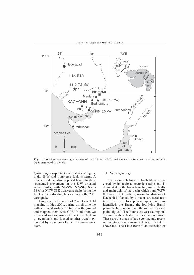
The 2001 Bhuj-Kachchh earthquake was oneof the largest events in the Stable ContinentalRegions (SCR) of the world. Comparable eventsare the New Madrid earthquakes of 1811-1812,the Charleston earthquake of 1886, and the 1819 Kachchh (Allah Bund) earthquake (fig. 1).
Therefore, the 2001 Bhuj-Kachchh earthquake(Mw 7.7) is an important event for the compara-tive study of two big earthquakes in the sametectonic province.
Kachchh has a long history of earthquakesand has experienced two major events and tensof smaller events within the past 200 years.The vast wastelands and salty playas are prob-ably the result of a few major earthquakes inthe past 3000-4000 years. The nature and thedates of all those earthquakes, except the 1819event and its penultimate event (Rajendran et al., 1998; Rajendran and Rajendran, 1999,2001; Rajendran, 2000), are yet to be known.In the present paper we attempt to relate the nature of the 2001 Bhuj earthquake withthe regional structures, especially with the
937
ANNALS OF GEOPHYSICS, VOL. 46, N. 5, October 2003
Mailing address: Dr. James P. McCalpin, GEO-HAZConsulting Inc., P.O. Box 837, Crestone, CO 81131 U.S.A.;e-mail: [email protected]
2001 Bhuj-Kachchh earthquake: surfacefaulting and its relation with neotectonics
and regional structures, Gujarat, Western India
James P. McCalpin (1) and Mahesh G. Thakkar (2)(1) GEO-HAZ Consulting Inc., Crestone, CO, U.S.A.
(2) Department of Geology, Shri R.R. Lalan College, Bhuj, Kachchh (Gujarat), India
AbstractPrimary and secondary surface deformation related to the 2001 Bhuj-Kachchh earthquake suggests that thrustingmovement took place along an E-W fault near the western extension of the South Wagad Fault, a synthetic faultof the Kachchh Mainland Fault (KMF). Despite early reconnaissance reports that concluded there was no pri-mary surface faulting, we describe an 830 m long, 15-35 cm high, east-west-trending thrust fault scarp nearwhere the seismogenic fault plane would project to the surface, near Bharodiya village (between 23°34.912 N,70°23.942 E and 23°34.304 N, 70°24.884 E). Along most of the scarp Jurassic bedrock is thrust over Quaternarydeposits, but the fault scarp also displaces Holocene alluvium and an earth dam, with dips of 13° to 36° south.Secondary co-seismic features, mainly liquefaction and lateral spreading, dominate the area south of the thrust.Transverse right-lateral movement along the «Manfara Fault» and a parallel fault near Bharodiya suggests seg-mentation of the E-W master faults. Primary (thrust) surface rupture had a length of 0.8 km, maximum displa-cement of about 35 cm, and average displacement of about 15 cm. Secondary (strike-slip) faulting was moreextensive, with a total end-to-end length of 15 km, maximum displacement of 35 cm, and average displacementof about 20 cm.
Quaternary morphotectonic features along themajor E-W and transverse fault systems. Aunique model is also proposed herein to showsegmented movement on the E-W orientedactive faults, with NE-SW, NW-SE, NNE-SSW or NNW-SSE transverse faults being thelimit of the individual blocks, during the 2001earthquake.
This paper is the result of 2 weeks of fieldmapping in May 2001, during which time theauthors traced surface ruptures on the groundand mapped them with GPS. In addition weexcavated one exposure of the thrust fault in a streambank and logged another trench ex-cavated by a previous French reconnaissanceteam.
1.1. Geomorphology
The geomorphology of Kachchh is influ-enced by its regional tectonic setting and isdominated by the basin bounding master faultsand main axis of the basin which runs WSW(Biswas, 1981). Each physiographic division ofKachchh is flanked by a major structural fea-ture. There are four physiographic divisionsidentified, the Ranns, the low-lying Banniplain, the hilly regions and the southern coastalplain (fig. 2a). The Ranns are vast flat regionscovered with a fairly hard salt encrustation.These are the areas of large continental, recentsedimentary basins rising not more than 4 mabove msl. The Little Rann is an extension of
938
James P. McCalpin and Mahesh G. Thakkar
Pakistan
KACHCHH
Hyderabad
1819 (7.5 Mw)
Bharodiya
Budharmora2001 (7.7 Mw)
1956 (6.0 Mw)Bhuj Anjar
Manfara
Ahmedabad
Broach
Sabar
mat
i R.
Mah
i R.
Porbundar
Arabian Sea
Gulf of Kachchh
Gulfof
Cambaykm
N
0 100
24
68 70 72 E
22
°°
°
°
° °26 N
INDIA
GUJARAT
INDIA
GUJARAT
INDIA
Thar Desert
Sab
arm
ati R
.M
ahi R
.
Narmada R.
Tapti R.
Mumbai
Delhi
Fig. 1. Location map showing epicenters of the 26 January 2001 and 1819 Allah Bund earthquakes, and vil-lages mentioned in the text.
the gulf of Kachchh when the sea level washigh during the Holocene transgression. TheGreat Rann of Kutch is bounded by the NagarParker Fault on the north and the Island BeltFault and the Plain of Banni (a low alluvialtableland between the Mainland of Kachchhand the Great Rann) on the south. The Banni isa smooth and nearly flat saline grassland.
The uplifted hilly region of Kachchh con-sists of three uplifts: 1) 4 separate anticlinesthat compose the Island Belt Fault Zone; 2) theKachchh Mainland uplift, and 3) the Wagaduplift. The Island Belt Fault Zone comprisesfour «islands», viz. Pachchham, Khadir, Belaand Chorar, controlled and separated by theright-lateral transverse and strike-slip faults.The northern boundaries of these «islands» arecontrolled mainly by the Island Belt Fault,where steep scarps and colluvial fans are com-mon. The table-like region with low dip due
south and southwest of Khadir and Bela Islandsis known as the Wagad Highland. The KachchhMainland uplift is composed of rocky terrainhaving two sub-parallel E-W trending hillranges; the Katrol Hill range in the middle andthe dome-dominated northern hill range. TheMainland also comprises a strip of coastal plainin the south.
1.2. Regional structure and tectonics
Rifting at the western margin of the Indianplate was controlled by the NE-SW trend of theDelhi (Pre-Cambrian) fold belt that swings toE-W in Kachchh. The E-W striking masterfaults are resurgent basement faults (Biswas,1987) that controlled the structural style of thebasin. In the post rifting stage, Kachchh wasunder a compressional regime when the foot-
2001 Bhuj-Kachchh earthquake: surface faulting and its relation with neotectonics and regional structures, Gujarat, Western India
Bhuj
Bhachau
Anjar
MundraMandvi
Suthri
Naliya
BANNI PLAINS
SAURASHTRA
LITTLERANN
PU
Legend
Streams
PU, KU Pachham, KhadirBU, CU Bela, Chorar Uplift
Great Rann of Kachchh
23°00
70° 71°69° 00´ 00´ 00´
Gulf of Kachchh
ARABIAN SEA
N
0 20
km
Gandhidham
Lakhpat
Koteshwar
Bhujpur
CU
Ranns
Mudflats
023
30`
BUKU
Island Belt Fault
Northern Hill Range
K M FRocky Plain
Katrol Hill Range
K H F
Coastal Alluvial Plain
KMF Kachchh Mainland FaultKHF Katrol Hill FaultSWF South Wagad FaultGDF Gora Dungar Fault
Khavda
Rapar
Nagar Parker Fault
WAGADHIGLAND(UPLIFT)
F
F
F
F
SWF
F
F
F
F
FFGedi Fault
North Kathiyawad Fault
Kachchh Mainland (Uplift)
GDF
Fig. 2a. Map showing major geomorphic subdivisions, mountain fronts, and Late Cenozoic faults on the main-land of Kachchh. KMF = Kachchh Mainland Fault.
939
wall blocks uplifted along the E-W masterfaults and formed the highlands, and interven-ing half-grabens formed the plainlands. It isduring this stage the blocks tilted towardssouth, and therefore the nature of the masterfaults also changed from normal to reverse andstrike slip. The uplifts are oriented E-W alongfive parallel faults: 1) Nagar Parkar Fault; 2)Island Belt Fault; 3) South Wagad Fault (SWF);4) Kachchh Mainland Fault (KMF); 5) NorthKathiawar Fault (NKF) (fig. 2a). In addition tothe E-W striking master faults, the associateduplifts are extensively affected by oblique sec-ondary faults of later age. The secondary faultstrend NE-SW or NW-SE and offset the primaryfaults, so are termed transverse strike slip faults.
1.3. Neotectonics
Systematic study of Quaternary tectonic activ-ity in Kachchh was begun only in the past decade, so there is no sizable amount of workavailable. However, Thakkar et al. (1999) andMaurya et al. (2002, 2003) constructed a Qua-ternary stratigraphy and tectonic evolution ofmainland Kachchh, respectively. Quaternary tec-tonic uplift took place in two major phases. The Early Quaternary tectonic activity took placealong the E-W trending faults while the LatePleistocene phase took place along the NNE-SSWto NNW-SSE trending transverse faults. The E-Wtrending faults were more active during EarlyQuaternary, as evidenced by miliolites overlap-ping the colluvial deposits along the Katrol HillFault (Thakkar et al., 1999). This geometry sug-gests that the present configuration of the land-scape came into being during the Early Quaternarydue to differential uplift along E-W faults, viz. theKMF and KHF (fig. 2a). The Early Quaternaryphysiographic setting has been modified by theLate Pleistocene-Holocene tectonic activity alongtransverse faults (Thakkar et al., 2001).
The Kachchh region has experienced largeand moderate earthquakes in historic times. The1819 Kachchh earthquake (Mw 7.5) is the largestevent to have occurred in the Rann of Kachchhnear the India-Pakistan border during historictime, and the 1956 Anjar earthquake (Mw 6.0)is the largest during the instrumental period. The
Anjar event was located nearly 40 km west of theepicenter of the 2001 event. It originated at afocal depth of 15 km and is believed to haveoccurred on the KMF (one of the southernboundary of the Kachchh rift), whereas the 1819earthquake occurred on the northern boundary ofthe Kachchh rift about 140 km NW of the 2001event. Morphological evidence of maximum up-lift of about 6 m in 1819 showing a northerlyslope suggests that it was associated with thrustmotion on a north-dipping fault (Oldham, 1926;Bilham, 1998; Rajendran and Rajendran, 1999).Apart from the major events, minor earthquakesare also recorded in the area and appear to clus-ter along the active fault lines.
Neotectonic landforms of the area suggestthat most large Holocene earthquakes haveoccurred along transverse faults. Malik et al.(1999) concluded that the seismicity of MainlandKachchh was confined to the KMF and KHF, buta large number of epicentral plots of earthquakesof historic period compiled by them around Bhujshow distinct clustering around transverse faults,indicating that the latest phase of tectonic activi-ty was more along the transverse faults. Thak-kar et al. (1999) suggested that the compressivestresses accumulating on the E-W latitudinalfaults of Mainland Kachchh, due to locking upof the Indian plate in the NE, are transmitted tothe NNE-SSW and NNW-SSE transverse faults.The change in tectonic environment from exten-sional to compressional is also responsible forthe activity of transverse strike-slip faults inKachchh. The focal mechanism of the 2001 Bhujand 1956 Anjar earthquakes suggested by USGSalso indicates tectonic reversal in the region. Thestress field oriented in the N-S to NNE-SSWdirection is considered to be responsible for thisreversal of movement and the ongoing deforma-tion (Rajendran et al., 2001).
2. The 26 January, 2001 Bhuj earthquake
The 26th January 2001 Bhuj earthquake isthe most disastrous earthquake in the post-instru-mental era in India. The 2001 Bhuj earthquakeoriginated at 08:46:41 IST with the focal depthof 22 km and a magnitude of 7.7 Mw, with theepicenter located at 23.36°N, 70.34°E (Bendick
940
James P. McCalpin and Mahesh G. Thakkar
et al., 2001; our fig. 1). The number of lives lostduring 2001 Bhuj earthquake exceeded 25.000and nearly 200.000 people were injured. About400.000 houses suffered severe to complete dam-age and twice as many were partially damaged.According to the preliminary analysis of part of the aftershock data collected by the MiddleAmerica Earthquake Center, the coseismic faultplane dips 40°-50° south. Projection of this planeto the surface predicts an intersection 7-8 kmnorth of Bharodiya village.
Kayal et al. (2002) concluded that the bestlocated aftershocks define two major fracturedirections, one trending NE and the other NW,and the ruptures meet at a zone 10 km south of main shock epicenter. Further, Kayal et al.(2002) obtained two well constrained solutionsfor two clusters of aftershocks at the mid-crustaldepth. The NW cluster of events shows purereverse faulting with SW dipping, NW-SE-strik-ing preferred fault plane, and a NE clustershows reverse faulting with a large strike-slipcomponent on SE dipping, NE-SW-strikingfault plane.
This earthquake generated huge liquefactionand related deformational features in the epicen-tral area around Bhachau (Jain and Lettis, 2001;Singh et al., 2001; Tuttle et al., 2002). TheRanns and the plains of Banni, being made up ofunconsolidated Holocene sediments, served asvast grounds for liquefaction. The liquefactionwas mainly concentrated along the concealedmajor faults of the region. It was accompaniedby lateral spreads, sand blows, and water spouts,mainly between the Khadir Uplift and the east-ern part of the Mainland Uplift. Complete docu-mentation of all liquefaction and related featuresin the Ranns was very difficult, because the areais too marshy with the quick sands, which underliquefaction become dangerous to travel across.However, Rajendran et al. (2001) documentedmany of the features and provide the best post-earthquake study.
3. Primary surface faulting
Rajendran et al. (2001) concluded that pri-mary surface deformation possibly existed 2 kmnorth of Bharodiya village, in what we refer to
herein as the Northern Dextral Fault Zone (fig.2b). We began our reconnaissance at a NW-trending «monocline» in this fault zone, firstobserved by Arch Johnston and Paul Bodin ofCERI in February 2001, and later visited onFebruary 18-19, 2001 by C.P. and K. Rajen-dran, M. Thakkar, and Tish Tuttle (Rajendran etal., 2001). From the «monocline» we continuednorthwest and southeast, following a N30-40W-trending, 0.9 km long Northern DextralFault Zone (described later under SecondarySurface Deformation).
The right-lateral faulting continued to about23°34.697 N, 70°24.572 E, at which point therupture zone abruptly turned west and became a830 m long, east-west-striking, north vergingthrust fault (fig. 3). Because this scarp has thesame orientation and sense of slip as the main-shock, and exists close to where the mainshockplane would project to the surface, we treat it asprimary surface faulting. The eastern 320 m ofthe thrust lies at the base of a low E-W bedrockridge underlain by Jurassic sandstone (WagarFormation), and the remainder crosses an allu-viated plain. At the eastern end of the thrust,faults are short (10-30 m long) and en échelon,and expose bedrock on both the hanging walland footwall. Small tent structures and articu-lated monoclines (fig. 3) are common, as if the2001 surface displacement was insufficient forthe south-dipping thrust plane to break cleanlyto the surface. In places a small north-dippingbackthrust existed at the crest of the monocline.
Most of the thrust scarp at the base of thebedrock ridge was developed in thin sandy col-luvium or slopewash, and ranged from a sinu-ous trace to a linear trace (fig. 4). Scarp heightvaried from 15 to 25 cm. The most commonscarp morphology was a hanging wall collapsescarp, where the overhanging tip of colluviumfailed after (or during) thrusting (see McCalpin,1996, p. 193). The thrust scarp continues anoth-er 135 m west of the bedrock ridge, and then is truncated by a N20E-striking, 30 m long rightstepover zone of dextral faults and tensioncracks. Average displacement in the stepover is20 cm right-lateral (fig. 3).
West of the stepover the thrust crosses aplain underlain by thicker alluvial deposits, andthe height and sinuousity of the scarp increase
941
2001 Bhuj-Kachchh earthquake: surface faulting and its relation with neotectonics and regional structures, Gujarat, Western India
2001 Bhuj-Kachchh earthquake: surface faulting and its relation with neotectonics and regional structures, Gujarat, Western India
Fig. 3. Reconnaissance GPS map of surface faulting north of Bharodiya village. The northwest-trending faultzones on either end display dextral slip, whereas the east-west-trending, 1.2 km long scarp between them dis-plays northward thrusting with a small dextral component. We classify the thrust faulting as primary faulting andthe strike slip faulting as secondary (tear) faulting, following Seeber et al. (2001). Total length of surface fault-ing is 2.6 km (measured between the ends) or 3.0 km (measured along the fault).
(fig. 5). The most common scarp morpholo-gies here are: 1) sinuous hanging wall collapsescarp; 2) tent structures, and 3) less sharp mole-tracks. The upthrown (south) side of the scarp ischaracterized by horizontal Jurassic bedrock atthe surface, whereas north of the scarp bedrockis buried everywhere by Quaternary deposits ofunknown thickness. These observations indi-cate that the total vertical separation of bedrockacross the fault is significantly greater than the15-25 cm of throw in 2001, and presumablyresulted from prehistoric fault movements,which are as yet unstudied.
3.1. Exposure of the 2001 thrust in a Streambank
About 275 m west of the bedrock ridge (at N.23°34.70 , E.70°24.21 ), the 2001 thrustscarp crosses a 1-1.5 m deep stream channeland the fault plane is exposed in the westernstreambank (fig. 6). The fault cuts Late Plei-stocene and Holocene (?) fluvial deposits andcreates a 22 to 25-cm high mole track on thesurface with tent structures. The thrust dips 13°south and displaces a small channel margin(late Pleistocene/.Holocene contact?) with a net
944
James P. McCalpin and Mahesh G. Thakkar
Fig. 5. Sinuous thrust scarp west of the bedrock ridge; white dashed line follows the scarp crest. Note cow for scale infar distance to left of dashed line. Faulted material here is a thicker Quaternary sandy alluvium that contains a hardpansoil profile about 30 cm thick. The tent structure in the foreground (at 23°34.699 N, 70°24.282 E) was formed by hori-zontal compression and breakage of the hardpan layer. Scarp height ranges from 20 to 30 cm. View to the west.
Fig. 4. Straight section of thrust scarp (between white arrows) near eastern end of the rupture, at 23°34.695 N,70°24.413 E view to southwest. Scarp is developed in thin sandy alluvium overlying Jurassic sandstone.
slip of 22 cm (fig. 7). This fortuitous exposurepermitted us to observe how tent structureswere created by low-angle thrusting and howtheir dimensions are related geometrically tofault slip (see next section).
From the streambank exposure the sinuousthrust scarp continues west, characterized bymoletracks and hanging wall collapse scarps 15-30 cm high. About 120 m west of the stream-bank the scarp continues up and over a north-trending, 2.3 m high earth dam (fig. 8) andforms a degraded scarp at its crest 20 cm high.The fault trace migrates 3.25 m northward as itclimbs the 2.3 m high embankment, resulting inan apparent dip of about 36° south. This angle isconsiderably steeper than that observed in thestreambank.
From the dam the thrust scarp continueswest as a sinuous hanging wall collapse scarpor moletrack (fig. 9). Individual thrust scarplobes have a wavelength of 5-10 m and an am-plitude of 2-3 m in plan view. In this area thrustscarps reach their greatest height (27-35 cm, at
23°34.701 N, 70°24.073 E). Farther west thethrust scarp/moletrack dies out and is replacedby a N20W-trending zone of small and widelyspaced dextral cracks. These dextral cracksaverage 1-2 cm of net slip and are about 50 mlong, after which they step left and form a smallnorth-facing thrust scarp or moletrack of simi-lar length. Northwest of about 23°34.812 N,70°24.019 E even the dextral cracks vanish, andwe were unable to find further surface faulting,despite a lengthy search.
3.2. Displacement estimates from tent structures
It was difficult to measure displacement onthe 2001 thrust fault because vertical exposureswere rare. Our first estimates assumed that afault plane dipping south at 15° to 35° had cre-ated a simple thrust scarp 15-35 cm high, whichimplied a net slip vector ranging from 26 cm(35° fault dip and 15 cm high scarp) to 135 cm
945
2001 Bhuj-Kachchh earthquake: surface faulting and its relation with neotectonics and regional structures, Gujarat, Western India
Fig. 6. Exposure of the thrust fault in a streambank at 23°34.700 N, 70°24.210 E. The 2001 thrust fault (be-tween thick white arrows) dips 13° south and the sense of movement is shown by the thin white arrow. At thebottom of the hardpan layer the fault steepens to subvertical, probably following a subvertical crack caused byground shaking, and creates a tent structure.
946
Fig. 7. Log of the streambank exposure.
(15° fault dip and 35 cm high scarp). This widediscrepancy shows the difficulty in making anaccurate net slip estimates solely from scarpheight. However, the streambank exposureshowed that the low-angle thrust fault did notcontinue propagating at 13° once it hit the baseof the hardpan layer (carbonate-cemented sandon fig. 7), but instead steepened to subvertical,probably following a subvertical crack createdduring earthquake shaking of the hardpan. Thisrefraction of the fault plane created head-oncompression of the broken hardpan layer, re-sulting in upward arching of hardpan slabs andthe resultant tent structure.
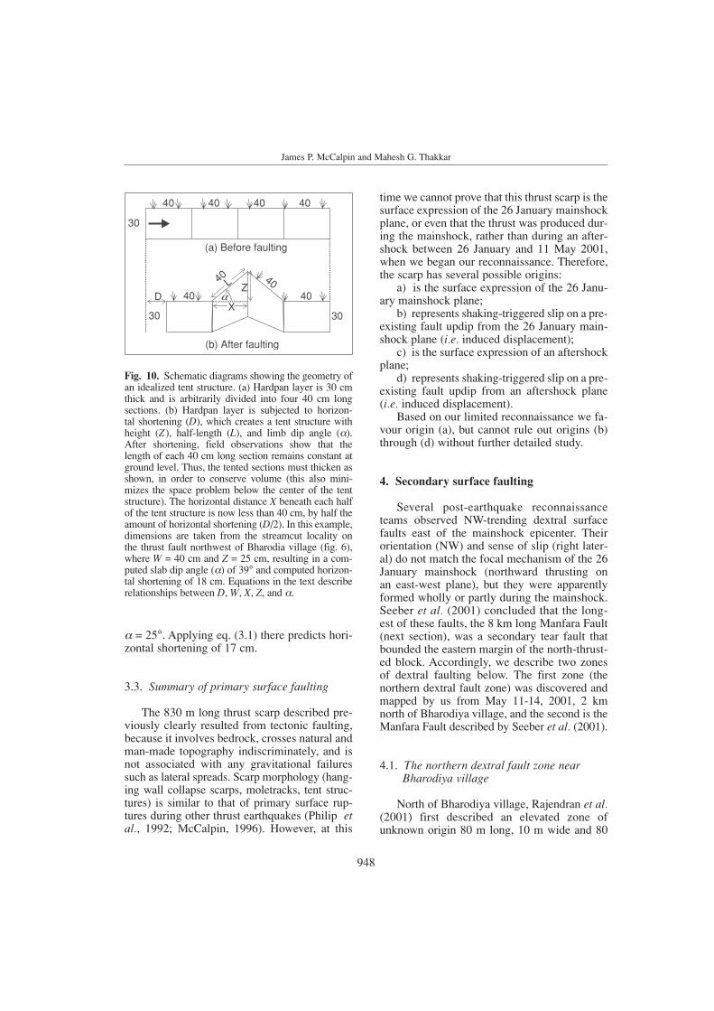
Based on the streambank exposure, we pro-pose a simple geometric model that relates hor-izontal tectonic shortening to the surface di-mensions of the tent structure (fig. 10). We ob-served that the ground surface in the tent struc-ture is uplifted and tilted but not horizontallycompressed, and inelastic deformation appearslimited to thickening of the hardpan layer in thetent structure. Therefore, the amount of hori-zontal shortening (D) can be related to the tentstructure as follows:
D = 2(L (Lcos )) (3.1)
where D = horizontal shortening; L = length ofone limb of the tent structure; = dip angle ofthe limb.
The height of the tent structure is given by
Z = Lsin (3.2)
where Z = height of the tent structure.For example, 5 m west of the streambank
exposure (where net slip was 22 cm on a 13°dipping fault) is a symmetrical tent structurewith Z = 25 cm and L = 40 cm. According to eq.(3.2), the dip of the limbs is 39°. Entering thatvalue into eq. (3.1), we can compute a horizon-tal shortening of 18 cm. This compares with 21 cm of horizontal shortening observed in thestreambank exposure. The value computedfrom the tent structure is much smaller than thenet slip required for an unrefracted 13° dippingfault to create a scarp 25 cm high. In contrast,the computed 18 cm of horizontal shortening isonly 15% smaller than the value measured in avertical cut, which suggests that a small amountof inelastic shortening (crushing?) did occur inhardpan layer in the tent structure. Farther east,the tent structure shown in fig. 5 is asymmetri-cal, with a right (north) limb of L = 90 cm and
James P. McCalpin and Mahesh G. Thakkar
947
2001 Bhuj-Kachchh earthquake: surface faulting and its relation with neotectonics and regional structures, Gujarat, Western India
Fig. 9. Photograph of the sinuous trace of the thrust scarp west of the dam shown in fig. 11a,b. View is to thewest from the crest of the earth dam. Dashed line follows the crest of the scarp. Thrust crosses a faint road roadin upper center at 23°34.701 N, 70°24.111 E.
Fig. 8. Thrust scarp (between dashed lines) crossing the axis of a north-south-trending, 2.3 m-high earth dam (dike),at 23°34.705 N, 70°24.140 E. The scarp reaches a maximum height of 20 cm at the dam crest, and is slightly higheron the western side of the crest than on the eastern side, implying a small component of dextral slip in addition tonorth-directed thrusting. The apparent dip of the fault as it ascends the east side of the earth dam is 36° south.
948
James P. McCalpin and Mahesh G. Thakkar
= 25°. Applying eq. (3.1) there predicts hori-zontal shortening of 17 cm.
3.3. Summary of primary surface faulting
The 830 m long thrust scarp described pre-viously clearly resulted from tectonic faulting,because it involves bedrock, crosses natural andman-made topography indiscriminately, and isnot associated with any gravitational failuressuch as lateral spreads. Scarp morphology (hang-ing wall collapse scarps, moletracks, tent struc-tures) is similar to that of primary surface rup-tures during other thrust earthquakes (Philip etal., 1992; McCalpin, 1996). However, at this
time we cannot prove that this thrust scarp is thesurface expression of the 26 January mainshockplane, or even that the thrust was produced dur-ing the mainshock, rather than during an after-shock between 26 January and 11 May 2001,when we began our reconnaissance. Therefore,the scarp has several possible origins:
a) is the surface expression of the 26 Janu-ary mainshock plane;
b) represents shaking-triggered slip on a pre-existing fault updip from the 26 January main-shock plane (i.e. induced displacement);
c) is the surface expression of an aftershockplane;
d) represents shaking-triggered slip on a pre-existing fault updip from an aftershock plane(i.e. induced displacement).
Based on our limited reconnaissance we fa-vour origin (a), but cannot rule out origins (b)through (d) without further detailed study.
4. Secondary surface faulting
Several post-earthquake reconnaissanceteams observed NW-trending dextral surfacefaults east of the mainshock epicenter. Theirorientation (NW) and sense of slip (right later-al) do not match the focal mechanism of the 26January mainshock (northward thrusting on an east-west plane), but they were apparentlyformed wholly or partly during the mainshock.Seeber et al. (2001) concluded that the long-est of these faults, the 8 km long Manfara Fault(next section), was a secondary tear fault thatbounded the eastern margin of the north-thrust-ed block. Accordingly, we describe two zonesof dextral faulting below. The first zone (thenorthern dextral fault zone) was discovered andmapped by us from May 11-14, 2001, 2 kmnorth of Bharodiya village, and the second is theManfara Fault described by Seeber et al. (2001).
4.1. The northern dextral fault zone near Bharodiya village
North of Bharodiya village, Rajendran et al.(2001) first described an elevated zone ofunknown origin 80 m long, 10 m wide and 80
40
40
4040
40
40
40 40
30
30 30X
DL Z
(a) Before faulting
(b) After faulting
Fig. 10. Schematic diagrams showing the geometry ofan idealized tent structure. (a) Hardpan layer is 30 cmthick and is arbitrarily divided into four 40 cm long sections. (b) Hardpan layer is subjected to horizon-tal shortening (D), which creates a tent structure withheight (Z.), half-length (L), and limb dip angle ( ).After shortening, field observations show that thelength of each 40 cm long section remains constant atground level. Thus, the tented sections must thicken asshown, in order to conserve volume (this also mini-mizes the space problem below the center of the tentstructure). The horizontal distance X beneath each halfof the tent structure is now less than 40 cm, by half theamount of horizontal shortening (D/2). In this example,dimensions are taken from the streamcut locality on the thrust fault northwest of Bharodia village (fig. 6),where W = 40 cm and Z = 25 cm, resulting in a com-puted slab dip angle ( ) of 39° and computed horizon-tal shortening of 18 cm. Equations in the text describerelationships between D, W, X, Z, and .
cm high, gently dipping towards the northeast.We traced this zone to its northwest and south-east terminations from May 11-14, and foundthat it connects with the eastern end of the thrustscarp described previously. This «northern dex-tral fault zone» trends N.30°-40°W (fig. 3) and iscomposed of: 1) a 325 m long northern sectionof east facing linear mounds, that intersects theeastern end of the primary thrust scarp; 2) a 310m long central dextral fault zone, and 3) a 275 mlong southern section of west-facing, linearmounds. Both linear mounds exist on the edges
of cultivated fields and their surface geometry(described below) may have been influenced bythe presence of the fields.
The northern linear mound section trendsN35°W and parallels the western edge of a cul-tivated field (fig. 11a,b). The mound is up to0.6 m high and 6-12 m wide and is asymmet-rical, bounded by a slightly sinuous thrustscarp on its steeper eastern side and by a moregentle, monoclinal fold on its western side.Large tension cracks up to 5 cm wide and 1.1 mdeep exist on the mound crest and trend
2001 Bhuj-Kachchh earthquake: surface faulting and its relation with neotectonics and regional structures, Gujarat, Western India
tension cracks
dextral thrust
WP45
S60W
Vertical exaggeration= 5x
1 m
0.4
0
0 2 4 6 8 10 12 14 16 18 m
Fig. 11a,b. Southern part of the northern linear mound zone. a) Photograph of the mound looking northwest.White dashed line follows the crest of the thrust scarp that bounds the mound on the east. White arrows showaxial tension cracks. Small black pack to right of scarp in center, and to left of standing figure, is at 23°34.575 N,70°24.657 E. b) Topographic profile across the mound at the site of the pack, with subsurface structures inferred.Note vertical exaggeration of 5x. Total height of the mound ranges from 40 to 60 cm.
949
a
b
N20W, or about 15°-20° more westerly thanthe mound itself. The sinuousity of the thrustscarp lobes varies from south (wavelength of4.5-5.5 m, amplitude of 1.5-2 m in plan view)to north (wavelength 8-12 m, amplitude 2-3 min plan view).
The 310 m long central dextral fault zonecoincides with uncultivated, native scrublandand is dominated by dextral faults, but also con-tains small, parallel thrust scarps and small lin-ear mounds. At the road crossing in its northernpart, the zone is composed of a 22 cm highthrust scarp on the west, and 30 m to the east, aparallel zone of dextral cracks with 7-10 cmdisplacement. This is the only place where thedextral-reverse slip is partitioned between twodiscrete, parallel faults. Directly south of thefaulted road (fig. 3), the dextral fault zonetrends N-S and is composed of en échelon, left-stepping, N20°E-striking dextral cracks joinedby small thrust faults (fig. 12). Total dextral off-set across this zone is 10-15 cm.
The southern part of the dextral rupturezone is characterized by a low (15-33 cm high),broad (6-12 m wide) linear mound (fig. 13a,b).The mound is bounded on the west by a sinu-ous, low, degraded thrust scarp (7-20 cm high)and on the east by a weak monocline. Fresh ten-sion cracks with apertures 3-6 cm wide rundown the axis of the mound. The tension crackswere not observed on February 18-19, 2001 byRajendran et al. (2001), and cut through slope-wash deposits from a rainstorm of April 12-15.Thus, although the mound and its degradedthrust scarp were probably formed during the26 January 2001 mainshock, the axial tensioncracks must have resulted from some after-shocks between April 15 and May 11, when wefirst observed them.
The 275 m long southern linear mound sec-tion trends N35W along the eastern edge of acultivated field, and is composed of two linear mounds that trend N45W and step right.The northern part of this section comprises the
James P. McCalpin and Mahesh G. Thakkar
Fig. 12. Strike-slip fault zone (between dashed lines) south of the road shown in fig. 3; view is to south. Thesurface rupture is composed of a system of left-stepping dextral cracks that trend oblique to the strike of the faultzone. At each left step a small north-verging thrust fault is formed (thick black line, teeth on upthrown block).Largest thrust at center is at 23°34.495 N, 70°24.682 E. At lower right the rupture becomes a thrust scarp whichcontinues to road shown in fig. 15.
950
«monocline» described by Rajendran et al. (2001)and is about 100 m long. This asymmetrical lin-ear mound is 0.6 m high and 12 m wide, bound-ed by a slightly sinuous thrust scarp on its steep-er western side and by a more gentle, monocli-nal fold on its eastern side. In other words, itfaces the opposite direction to the northern lin-ear mound, and faces the cultivated field. In thecenter of this section is a stepover zone 30 mlong that contains no visible deformation. Southof the stepover is another linear mound 170 mlong, 75 cm high at its northern end, and 62 cmhigh at the southern boundary of the field, which
slowly dies out southeast of the field. This moundhas the same asymmetry as the «monocline»mound, but unlike the that mound, also containsaxial tension cracks 10-15 m long, some ofwhich had vented liquefied sand.
The linear mounds represent a new style ofsurface deformation previously unreported inSCR earthquakes, but due to lack of exposureswe are unsure exactly what type of structuresunderlie them. Because the rupture that crossesunmodified terrain shows 15-20 cm of dextral-reverse offset, and because other NW-trendingfaults such as the Manfara Fault show similar
2001 Bhuj-Kachchh earthquake: surface faulting and its relation with neotectonics and regional structures, Gujarat, Western India
951
tension cracksdextral thrust
WP15
vertical exaggeration=7x
N60E0.4 m
0.2
0
0 2 4 6 8 10 12 14 16 m
Fig. 13a,b. The welt north of the southern plowed field, at 23°34.465 N, 70°24.737 E. a) Photograph of theN30W-trending welt, looking east. The welt is 16 cm high and 6.3 m wide here, bounded on the west by a sin-uous, 7.5 cm, high thrust scarp (dashed line, teeth on upthrown block) and on the east by a smoother monocline(dashed line). Arrows show axial tension cracks, 3-5 cm wide. b) Topographic profile across the welt, with sub-surface structures inferred. Note the large vertical exaggeration required to show the welt’s shape.
a
b
James P. McCalpin and Mahesh G. Thakkar
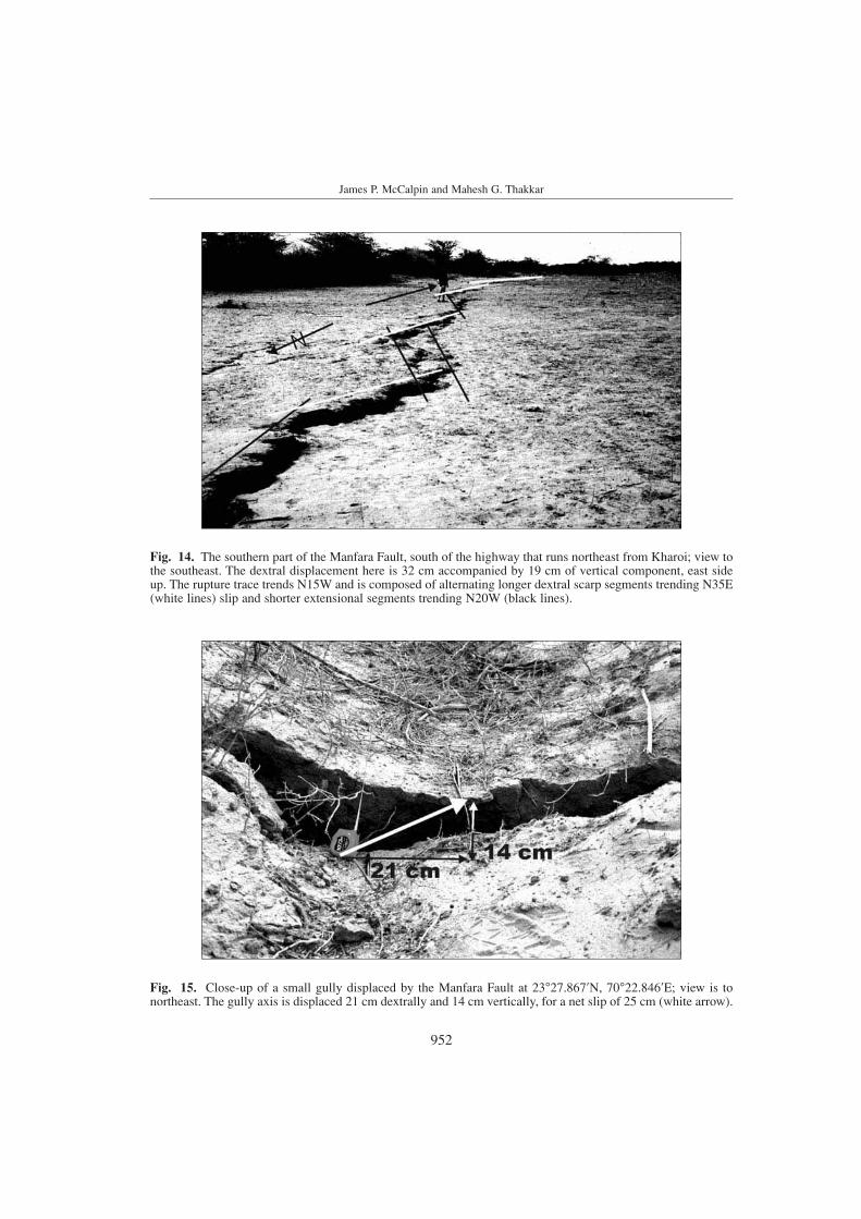
Fig. 15. Close-up of a small gully displaced by the Manfara Fault at 23°27.867 N, 70°22.846 E; view is tonortheast. The gully axis is displaced 21 cm dextrally and 14 cm vertically, for a net slip of 25 cm (white arrow).
Fig. 14. The southern part of the Manfara Fault, south of the highway that runs northeast from Kharoi; view tothe southeast. The dextral displacement here is 32 cm accompanied by 19 cm of vertical component, east sideup. The rupture trace trends N15W and is composed of alternating longer dextral scarp segments trending N35E(white lines) slip and shorter extensional segments trending N20W (black lines).
952
953
2001 Bhuj-Kachchh earthquake: surface faulting and its relation with neotectonics and regional structures, Gujarat, Western India
sense of slip, we presume that the mounds arealso underlain by a decimeter-scale dextral re-verse fault zone. Their peculiar morphology mayresult from the presence of a wet, topographical-ly lower field adjacent to the rupture. We hypoth-esize that the subvertical dextral rupture planepropagated nearly to the surface, but then«flopped over» toward the field, forming the sin-uous thrust scarps that bound the field side ofeach linear mound. The cross-sections of figs.11b and 13b show this inferred geometry, as wellas that of the axial tension cracks. The deepesttension cracks were 1.0-1.1 m deep, so any flat-tening of the fault must have occurred slightlybelow that depth. Tensional forces in the hangingwall above the fault bend then created the ten-sion cracks. Confirming this subsurface geome-try would require trenching, which was beyondthe scope of this reconnaissance study.
4.2. Manfara Fault
Close to Manfara village, at 23.46°N 70.38°E,the Manfara Fault ruptured during the earth-quake and was first reported by Seeber et al.(2001). The fault strikes NW and runs for 8 kmwith a maximum 32 cm of dextral displacementand 19 cm of vertical displacement, typicallyeast side up (figs. 14 and 15). Therefore, thefault was interpreted as a «tear fault» in thehanging wall of the master thrust (Rajendran et al., 2001). The surface trace is composed ofmeter-scale linear segments of different strikethat give the rupture a zig-zag appearance (fig.14). This shape may be inherited from preexist-ing fractures in the bedrock that underlies thethin alluvium along the fault trace. Sand blowswere also reported at many places along thisfault. For more details, see Seeber et al., (2001)and Jain and Lettis (2001).
4.3. Summary of secondary surface faulting
The secondary surface faulting does notmatch the orientation of the mainshock focalplane, so it presumably represents some type oftear faulting above the eastern margin of thethrusted block. However, when measuring thedimensions of the 2001 surface faulting weshould probably include both the primary andsecondary faulting, because in databases such asWells and Coppersmith (1994) no distinction ismade between the two. Table I shows the dimen-sional parameters of surface faulting, based onour mapping and that of Seeber et al. (2001).
5. Landslide north of Budharmora village
The area around the epicenter was intenselyaffected by lateral spreads in soft alluvial deposits(Rajendran et al., 2002). We studied one particu-lar lateral spread 1 km north of Budharmora vil-lage where the ground slopes about 1° towards thenorth. The farmer that owns the field closest to the reservoir shown in fig. 16 reported that he wasstanding in the field with his family when the 26January 2001 mainshock struck. He said that mem-bers of his family «were pushed up into the airand thrown 3 m to the northwest» by the main-shock. Water also sloshed out of the reservoir andspilled out of its northwest corner.
Farm fields here were cracked at severalplaces and extensional cracks were developedwith an E-W orientation, while 150-200 mnorth of the extensional cracks, there was a 600m long zone of E-W compressional ridges (fig.16). In farm fields, irrigation pipe lines initiallyemplaced 1.5 m below the surface appearedseverely broken into pieces and were protrud-ing from the surface, overriding each other(Rajendran et al., 2001). Our reconnaissance
Table I. Dimensions of surface faulting in the 2001 Bhuj earthquake.
Maximum displacement (cm) 35 35Average displacement (cm) 15 20
GPS mapping of the deformed area (fig. 16) sup-ports the interpretation of Seeber et al. (2001),Jain and Lettis (2001), and Tuttle et al. (2002)that the feature is a lateral spread landslide. How-ever, the large ground accelerations here mayalso indicate that the lateral spread overlies a fault(probably the KMF) that moved during the 2001mainshock, as well as in prehistoric times, asdescribed next.
A French reconnaissance team dug twobackhoe trenches across the toe thrust of the lat-eral spread prior to May 2001 (west trench andeast trench in fig. 16), perhaps because shortlyafter the earthquake, this ridge was thought torepresent primary tectonic surface rupture ofthe KMF. We deepened and relogged the west-ern wall of the west trench to see if fault geom-etry supported a tectonic or a landslide origin.The log of the trench (fig. 17) shows that thefault planes beneath the compressional ridgeflatten about 1.5 m beneath the ridge crest, andcontinue south at a dip of about 10°, parallel tobedding in the Holocene sandy alluvium. In
reality, the 2001 fault planes were extremelydifficult to see once they paralleled bedding,but we infer that the failure plane lay at thebase of a gravelly sand unit in the trench wall.Because the fault does not displace obviousstratigraphic markers and deformation beneaththe pressure ridge was partly ductile, we couldnot measure net displacement. A relativelyweak soil profile is developed on the sandyalluvium, consisting of ACk1 and ACk2 hori-zons (weakly organic horizons with Stage Icalcium carbonate, after the classification ofGile et al. (1966)) and a Cox horizon (oxidizedparent material). This degree of soil develop-ment suggests a mid-Holocene age for thealluvial deposit.
The surprising feature in the trench is thestrong soil profile at the northern end of thetrench, which is bent down to the south andthen truncated by an older, north-dipping faultthat was not reactivated in 2001 (fig. 17). Thissoil is developed on a hard gray clay parentmaterial that is also truncated by the older
James P. McCalpin and Mahesh G. Thakkar
123
45
678910111213141516
17
18
2582200 m
2582100 m
2582000 m
2581900 m
621,
700
m
621,
800
m
621
900
m
622
000
m
622
100
m
622
200
m
622
300
m
622
400
m
N100 m
road road
reservoir
pipeline
faultedpipeline
West trench East trenchfieldboundaries
5 m wide,flat bottomedditch
Budharmora village,1 km
scarp endsabruptly
scarp diesout
2 sharperscarps
4 lowanticlinalridges
scarp diesout
zone of extensional cracks
headscarpof lateral spread
Fig. 16. Reconnaissance GPS map of the lateral spread north of Budharmora village. Coordinates are UTMmeters, Zone 42, WGS84 datum. Thick black lines show the margins of the spread, with hachures indicatingextensional scarps and teeth indicating compressional scarps or anticlinal ridges. The log of the west trenchacross the toe thrust is shown in fig. 17. Both extensional and compressional scarps die out to the east.
954
fault. The lower half of the clay is riddled withsubvertical, rootlike bodies of sand that looklike dikes of liquefied sand injected into theclay. However, these sand dikes are also over-printed by soil calcium carbonate, so theywere formed in the Middle Holocene or earli-er, not in the 2001 earthquake.
The combination of an older fault and olderliquefaction features indicates that prehistoricdeformation occurred here, but it is unclear ex-actly when that deformation occurred or whetherit was associated with a lateral spread (asoccurred in 2001) or with tectonic surface fault-ing of the KMF. Those questions can only beanswered by future studies. It does appear thatthe 2001 lateral spread failure plane was forcedto the surface at this location by the buttressingeffect of this hard clay deposit.
6. Discussion
To understand the nature of past and presentseismicity in a stable continental region such asKachchh, Quaternary tectonic features are the
best indicators. Thrusting in Kachchh is mostlyalong the pre-Tertiary faults (such as the KMFand KHF) developed in an older extensionalregime. Furthermore, the KMF and KHF showgeomorphic indicators of segmentation, e.g., sharpchanges in orientation of the fault, intersectionwith branch (transverse) faults, abrupt changes indip, and changes in net-slip. Knuepfer (1989) concluded such features are very common struc-tural indicators of possible segment boundaries.
The 2001 thrust scarp and the mole tracks wemapped north of Bharodiya village are parallel to the major plane of rupture of the main shock,and are linked to two zones of dextral faulting (the northern dextral fault zone and the ManfaraFault). If these dextral fault zones define theboundary of the north-thrusted block, it followsthat the 2001 seismogenic fault which underliesthe thrusted block must project to the surfacesomewhat north of the dextral faults. This con-straint appears to rule out the KMF as the seismo-genic fault, as does the fact that the 2001 epicen-ter lies slightly north of the surface trace of theKMF. In addition, the dextral slip on these faultsrules out the South Wagad Fault as a candidate.
955
Fig. 17. Log of the western wall of the west trench. The 2001 failure plane is inferred to parallel bedding in thesouthern part of the trench, and then to rise to the surface in a steplike fashion beneath the toe thrust pressureridge. An older fault zone of unknown origin and sense of slip underlies the steep section of the 2001 thrust, butwas not reactivated in 2001. The 2001 thrust may have been forced to the surface at this location by the but-tressing effect of the hard gray clay and overprinted carbonate soil at the northern end of the trench.
2001 Bhuj-Kachchh earthquake: surface faulting and its relation with neotectonics and regional structures, Gujarat, Western India
Instead, the 2001 mainshock plane must havebeen a nearly blind thrust parallel to but 30 kmnorth of the KMF. We say nearly blind becausethe 0.8 km long thrust scarp was created, and mayrepresent the only location where primary dis-placement propagated all the way to the surface.However, based on our reconnaissance data wecannot rule out the possibility that the Mw 7.7event was completely blind, and that the mappedthrust scarp was secondary (passive) thrusting in-duced on a preexisting fault by strong, channeledground motion extending updip from the seismo-genic plane.
Acknowledgements
The post-earthquake studies, especially thestudy of the primary surface ruptures of the 2001Bhuj earthquake, were supported by NSF fundingto Boise State University, Idaho, U.S.A. We grate-fully acknowledge this support and the coopera-tive efforts of Jim Zollweg at Boise State.
REFERENCES
BENDICK, R., R. BILHAM, E. FIELDING, V.K. GAUR, S.E. HOUGH,G. KIER, M. N. KULKARNI, S. MARTIN, K. MUELLER and M.MUKUL (2001): The 26 January 2001 «Republic Day» earth-quake, India, Seismol. Res. Lett., 72, 328-335.
BISWAS, S.K. (1981): Basin framework, paleo-environment anddepositional history of the Mesozoic sediments of Kutchbasin, Western India, Q. J. Geol. Min. Metall. Soc. India, 53(1-2), 56-85.
BISWAS, S.K. (1987): Regional tectonic framework, structure andevolution of the western marginal basins of India, Tec-tonophysics, 135, 302-327.
GILE, L.H., F.F. PETERSON and R.B. GROSSMAN (1966):Morphological and genetic sequences of carbonate accumu-lation in desert soils, Soil Sci., 101, 347-360.
JAIN, S.K. and W.R. LETTIS (2001): Preliminary observations onthe origin and effects of the January 26, 2001 Bhuj (Gujarat,India) earthquake, Earthquake Eng. Res. Inst. Spec. Earth-quake Rep., EERI Newsletter, 1-16.
KAYAL, J.R., R. DE, S. RAM, B.V. SRIRAMA and S.G. GAONKAR
(2002): Aftershocks of the 26 January Bhuj earthquake inWestern India and its seismotectonic implications, J. Geol.Soc. India, 59 (5), 395-417.
KNEUEPFER, P.L.K. (1989): Implications of the characteristics ofend-points of historical surface fault ruptures for the natureof fault segmentation, in Fault Segmentation and Controls ofRupture Initiation and Termination, edited by D.P.SCHWARTZ and R.H. SIBSON, U.S. Geol. Sur., Open FileRep., 89-315.
MALIK, J.N, P.S. SOHONI, R.V. KARANTH and S.S. MERH (1999):Modern and historic seismicity of Kachchh peninsula,Western India, J. Geol. Soc. India, 54, 545-550.
MAURYA, D.M, M.G. THAKKAR and L.S. CHAMYAL (2002):Quaternary geology of the arid zone of Kachchh: terraincognita, in Proc. Ind. Nat. Sci. Acad. (communicated).
MAURYA, D.M., S. BHANDARI, M.G THAKKAR and L.S. CHAMYAL
(2003): Late Quaternary fluvial sequences of SouthernMainland Kachchh, Western India: lithostratigraphy andneotectonics implications, Curr. Sci., 84 (8), 1056-1064.
MCCALPIN, J.P. (1996): Paleoseismology (Academic Press, NewYork), pp. 588.
OLDHAM, R.D. (1926): The Cutch (Kachh) earthquake of 16thJune 1819 with a revision of the great earthquake of 12thJune 1897, Mem. Geol. Surv. India, 46, 71-147
PHILIP, H., E. ROGOZHIN, A. CISTERNAS, J.C. BOUSQUET, B.BORISOV and A. KARAKHANIAN (1992): The American earth-quake of 1988 December 7; faulting and folding, neotecton-ics and paleoseismicity, Geophys. J. Int., 110, 141-158.
RAJENDRAN, C.P. (2000): Using geological methods for earth-quake studies: a perspective from peninsular India, Curr.Sci., 79 (9), 1251-1258.
RAJENDRAN, K and C.P. RAJENDRAN (1999): Seismogenesis inthe stable continental interiors: an appraisal based on twoexamples from India, Tectonophysics, 305, 355-370.
RAJENDRAN, C.P. and K. RAJENDRAN (2001): Characteristics ofdeformation and past seismicity associated with the 1819Kutch earthquake, Northwestern India, Bull. Seismol. Soc.Am., 91, 407-426.
RAJENDRAN, C.P., K. RAJENDRAN and B. JOHN (1998): Surfacedeformation related to the 1819 Kachchh earthquake: evi-dence for recurrent activity, Curr. Sci., 75 (6) 623-626.
RAJENDRAN, K., C.P. RAJENDRAN, M.G. THAKKAR and M.P.TUTTLE (2001): 2001 Kachchh (Bhuj) earthquake: coseis-mic surface features and their significance, Curr. Sci., 80(11), 1397-1405.
RAJENDRAN, K., C.P. RAJENDRAN, M.G. THAKKAR and R. GARTIA
(2002): The sand blows from the 2001 Bhuj earthquakereveal clues on past seismicity, Curr. Sci., 83 (5), 603-610.
SEEBER, N., D. RAGONA, T. ROCKWELL, S. BABU, R. BRIGGS andS.G. WESNOUSKY (2001): Field observations bearing on thegenesis of the January 26, 2001 Republic Day earthquakeof India resulting from a field survey of the epicentralregion, Web Document, Version of February 28, 2001.
SINGH, R.P., S. BHOI, A.K. SAHOO, U. RAJ and S. RAVINDRAN
(2001): Surface manifestations after the Gujarat earth-quake, Curr. Sci., 81 (2), 164-166.
THAKKAR, M.G., D.M MAURYA, R. RACHNA and L.S. CHAMYAL
(1999): Quaternary Tectonic history and terrain evolution ofthe area around Bhuj, Mainland Kachchh, Western India,J. Geol. Soc. India, 53 (5), 601-610.
THAKKAR, M.G., D.M. MAURYA, R. RACHNA and L.S. CHAMYAL
(2001): Morphotectonic analysis of Khari River Basin ofMainland Kachchh: evidence for Neotectonic activity alongtransverse fault, Bull. Indian Geol. Assoc., 34, 205-220.
TUTTLE, M.P., J. HENGESH, K.B. TUCKER, W. LETTIS, S.L.DEATON and J.D. FROST (2002): Observations and compar-isons of liquefaction features and related effects induced bythe Bhuj earthquake, Earthquake Spectra, 18 (suppl. A),79-100.