Stockton-on-Tees Level 2 Strategic Flood Ris Final Report June 2010 Matthew Clifford Spatial Planning Stockton-on-Tees Borough C Gloucester House Church Road Stockton-on-Tees TS18 1TW s BC sk Assessment Council W
Transcript
Stockton-on-Tees BC
Level 2 Strategic Flood Risk Assessment
Final Report June 2010
Matthew Clifford Spatial Planning Stockton-on-Tees Borough Council Gloucester House Church Road Stockton-on-Tees TS18 1TW
Tees BC
Level 2 Strategic Flood Risk Assessment
Tees Borough Council
Tees TS18 1TW
2009s0156 SBC Level 2 SFRA V2.2.docx i
JBA Office JBA Consulting The Brew House Wilderspool Park Greenalls Avenue Warrington WA4 6HL
JBA Project Manager Jonathan Cooper
Revision History
Revision Ref / Date Issued
Amendments Issued to
Draft Report (v.1.0) September
1 Digital Copy (as a pdf) to Matthew Clifford and Cameron Sked
Final Report (v.2.2) June 2010
Updated following comments from SBC and EA.
1 Digital Copy (as a pdf) to Matthew Clifford
Contract This report describes work commissioned by Stockton-on-Tees Borough Council under Order Number P1 1867691. Stockton-on-Tees Borough Council’s representative for the contract was Matthew Clifford. Sam Wingfield of JBA Consulting carried out the work.
Prepared by ........................................... Samuel Wingfield BSc MRes
Analyst
Reviewed by .......................................... Jonathan Cooper BEng MSc CEng MICE MCIWEM MloD DipCD
Purpose This document has been prepared as a Final Level 2 SFRA for Stockton-on-Tees Borough Council. JBA Consulting accepts no responsibility or liability for any use that is made of this document other than by the Client for the purposes for which it was originally commissioned and prepared.
Carbon Footprint First publication of this document resulted in a carbon footprint of 223g.
283g
Further printed copies of this document will result in a carbon footprint of 223g if 100% post-consumer recycled paper is used and 283g if primary-source paper is used. These figures assume the report is printed in black and white and in duplex.
JBA is a carbon neutral company and the carbon emissions from our activities are offset.
2009s0156 SBC Level 2 SFRA V2.2.docx iii
Executive Summary
Introduction
This Level 2 SFRA follows on from Volumes I, II and III which formed the level 1 SFRA.
The purpose of this report is to provide an assessment of flood risk at key development and regeneration locations within Stockton BC. These areas have been identified in the Level 1 SFRA as being at risk of flooding but also necessary for Stockton's regeneration and development plans. These proposed regeneration allocations are:
• Bowesfield North Phase 1 and Phase 2 - on the fluvial River Tees. • Boathouse Lane and Chandlers Wharf - on the fluvial River Tees. • Tees Marshalling Yard (TMY) - by the Old River Tees and tidal Tees. • Seal Sands (also includes North Tees Pools and Port Clarence sites) - by the
tidal Tees. • Haverton Hill (also includes Casebourne and Billingham Reach sites) - by the
Tidal Tees.
Existing Flood Risk Management The first section of this report reviews the flood defences in Stockton BC. It is important to understand where the flood defences are, and what level of protection they provide. The Environment Agency's Flood Zone maps do not take into account flood defences so flood risk to defended areas will vary depending on the standard of the defences and the type of flooding they are subject to.
The fluvial River Tees has significant stretches of raised defences along its course. The majority of these are agricultural defences and upstream of Stockton BC. There are some defences protecting small settlements by the River Tees in Stockton BC, e.g. Yarm. However, on the lower reaches, where the Bowesfield North (Phase 1 and 2), Boathouse Lane and Chandlers Wharf development sites are, the floodplains are undefended.
The Tees Marshalling Yard (TMY) site is separated from the tidal Tees by an area of raised land. Whilst not considered a formal flood defence it has a significant role to play in reducing flood risk. Adjacent to the TMY, on the Old River Tees, there are raised defences, protecting the retail centre from tidal flooding.
The tidal Tees has a number of formal and informal flood defence structures near to the proposed development allocations. On the north Tees Estuary boundary, the original frontage has been raised, which protects the hinterland from more frequent floods. The Port Clarence railway embankment partially blocks a tidal flood pathway to the Haverton Hill allocations (although this is not a flood defence structure). A defunct embankment to the west of Seal Sands prevents inundation from high probability flooding to the lower areas, although this embankment is considered (by the Environment Agency) to provide no flood defence benefits and is therefore not a formal flood defence. The Greatham Creek flood defence embankments have the greatest influence on flood risk in the area. These defences have been known to breach in the past and although improvements have been made, they are the main flood risk pathway to the allocations.
2009s0156 SBC Level 2 SFRA V2.2.docx iv
Flood risk to the Level 2 allocations
The Bowesfield North (Phase 1 and 2), Boathouse Lane and Chandlers Wharf sites are at risk of flooding from the River Tees. Parts of Bowesfield North Phase 1 are at risk from more frequent flooding while the remainder of the Bowesfield sites are at risk from less frequent flooding. Climate change increases the flood risk to these sites, especially due to tidal flooding when the predicted increase in sea levels is factored in.
The Tees Marshalling Yard site has been predicted to be at risk of tidal flooding through modelling from the Old River Tees and the River Tees. However, only a very small part of the site is at risk of high probability flooding but the majority of the site is flooded when the effects of climate change are added.
The Haverton Hill and Seal Sands sites are at risk of tidal flooding from the Tees Estuary. A breach in the Greatham Creek tidal defences is the primary flood pathway for both sets of allocations. The Haverton Hill sites are at risk of high probability flooding. A large proportion of the Seal Sands sites are free from flooding (even when climate change is added) but they are cut off by flood waters to the west and the Tees Estuary to the east.
Outcomes The detailed modelling for the sites has produced flood extents, depths and hazards for different probability flood events, including the impacts of climate change. From these outputs it has been possible to provide evidence as to whether an allocation can be brought forward for development safely, without increasing flood risk elsewhere. This evidence has been presented to fulfil part c) of the Exception Test.
It is recommended that the element of the Bowesfield North Phase 2 site at risk of high probability flooding, should be kept free from development by integrating this area into masterplans as green infrastructure or public open space
It would be technically possible to provide flood mitigation as part of a development proposal for the area of the Bowesfield North Phase 2 site at risk of medium probability flooding. However, sequentially it is more difficult to justify development of a greenfield site which is at risk of flooding under the Sequential Test in PPS25. This site will also be at greater risk of flooding in the future.
The Boathouse Lane and Chandlers Wharf sites could be developed with mitigation measures in place. The areas at risk from medium probability flooding should be relatively easy to mitigate. However, the Boathouse Lane site also includes an area at risk of high probability flooding (Boathouse Lane 2). The development layout within this area will need to factor in first floor only development (allowing the ground floor to flood) if development in this area is to go ahead.
The Tees Marshalling Yard can be brought forward for a wide range of uses including residential development as the small area at risk of high probability flooding could be left free from development. Mitigation options for reducing flood risk from the more extreme flood events include land raising and tying in access roads to the high land to the north of the site. Two other mitigation options (including raised defences) were modelled for this site.
The Haverton Hill sites can be brought forward for development if some ground and floor raising and raised access roads (or pedestrian access roads) can be implemented. The Seal Sands sites can be brought forward, although there are two sections of this allocation that are at risk of deep flooding. Planning permission for
2009s0156 SBC Level 2 SFRA V2.2.docx v
significant land raising has already been submitted for one of these areas. The main issue with Seal Sands is emergency access and egress. Measures to mitigate this are proposed which includes further consultation and planning with Stockton BC's emergency planning department.
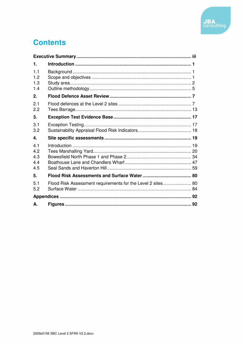
4.� Site specific assessments .................................................................... 19�
4.1� Introduction ............................................................................................. 19�4.2� Tees Marshalling Yard ............................................................................. 20�4.3� Bowesfield North Phase 1 and Phase 2 ................................................... 34�4.4� Boathouse Lane and Chandlers Wharf .................................................... 47�4.5� Seal Sands and Haverton Hill .................................................................. 59�
5.� Flood Risk Assessments and Surface Water ...................................... 80�
5.1� Flood Risk Assessment requirements for the Level 2 sites ...................... 80�5.2� Surface Water ......................................................................................... 84�
Figure 1 - Stockton BC's proposed development allocations and the Level 2 SFRA sites ............................................................................... 4�
Figure 2 - Breach of the south Greatham embankment ................................ 9�
Figure 3 - Flooding at Port Clarence .............................................................. 11�
Figure 4 - Flood Zone maps at TMY ............................................................... 23�
Figure 5 - Undefended modelled extents at TMY (also see Figure A8 in Appendix A) .... 24�
Figure 6 - 1 in 200 year+cc tidal depth areas at the TMY for Mitigation Option 4 ................................................................................................ 28�
Figure 7 - Flood Zone maps at Bowesfield North (Phase 1 and 2) ............... 38�
Figure 8 - Modelled extents at Bowesfield North (Phase 1 and 2)also see
Figure A18 in Appendix A ................................................................................... 40�
Figure 9 – Boathouse Lane and Chandlers Wharf development areas ....... 48�
Figure 10 - Flood Zone maps at Boathouse Lane and Chandlers Wharf ..... 51�
Figure 11 - Modelled extents at Boathouse Lane and Chandlers Wharf (also see Figure A18 in Appendix A) ........................................................................ 53�
Figure 12 – Seal Sands development areas .................................................. 60�
Figure 13 – Haverton Hill development areas ............................................... 61�
Figure 14 - Flood Zone map at Seal Sands .................................................... 64�
Figure 15 - Modelled extents at Seal Sands (also see Figure A25 in Appendix A) ........... 65�
Figure 16 - SSSI and Ramsar sites at Seal Sands ......................................... 71�
Figure 17 - Flood Zone map at Haverton Hill, Casbourne and Billingham Reach ................................................................................. 73�
Figure 18 - Modelled extents at Haverton Hill, Casbourne and Billingham Reach (also see Figure A25 in Appendix A) ......................................... 74�
�
2009s0156 SBC Level 2 SFRA V2.2.docx
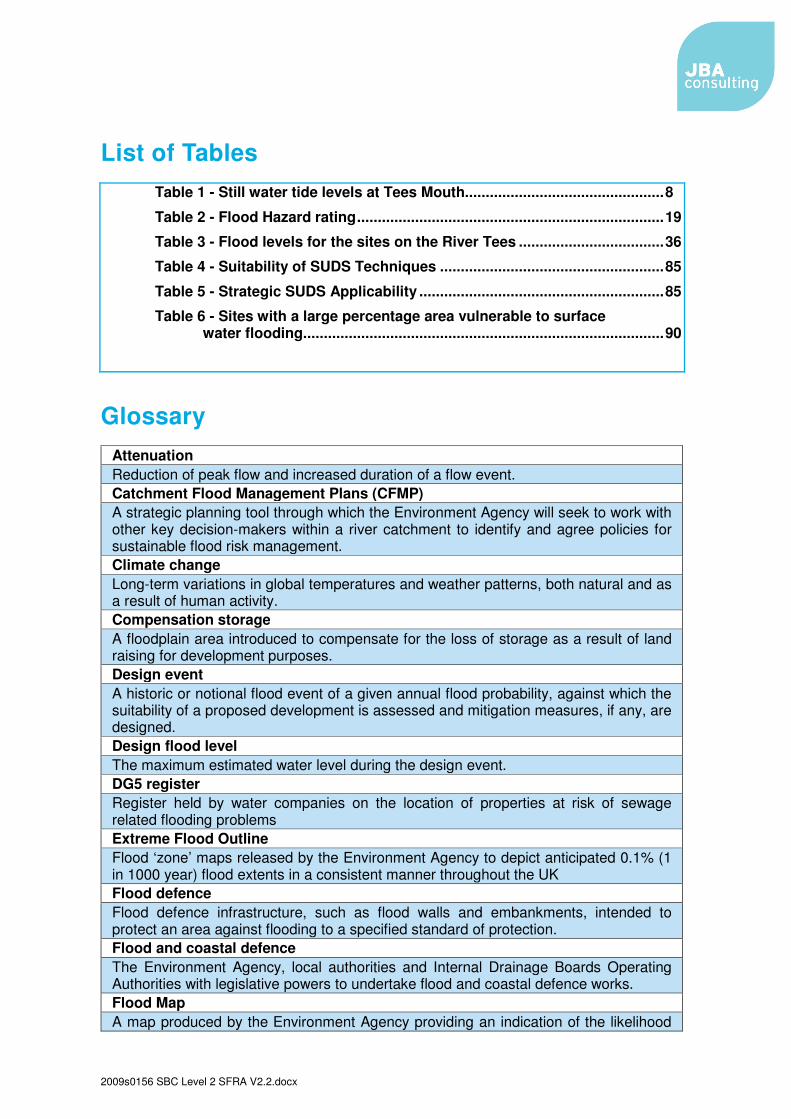
List of Tables Table 1 - Still water tide levels at Tees Mouth................................................ 8�
Table 6 - Sites with a large percentage area vulnerable to surface water flooding ....................................................................................... 90�
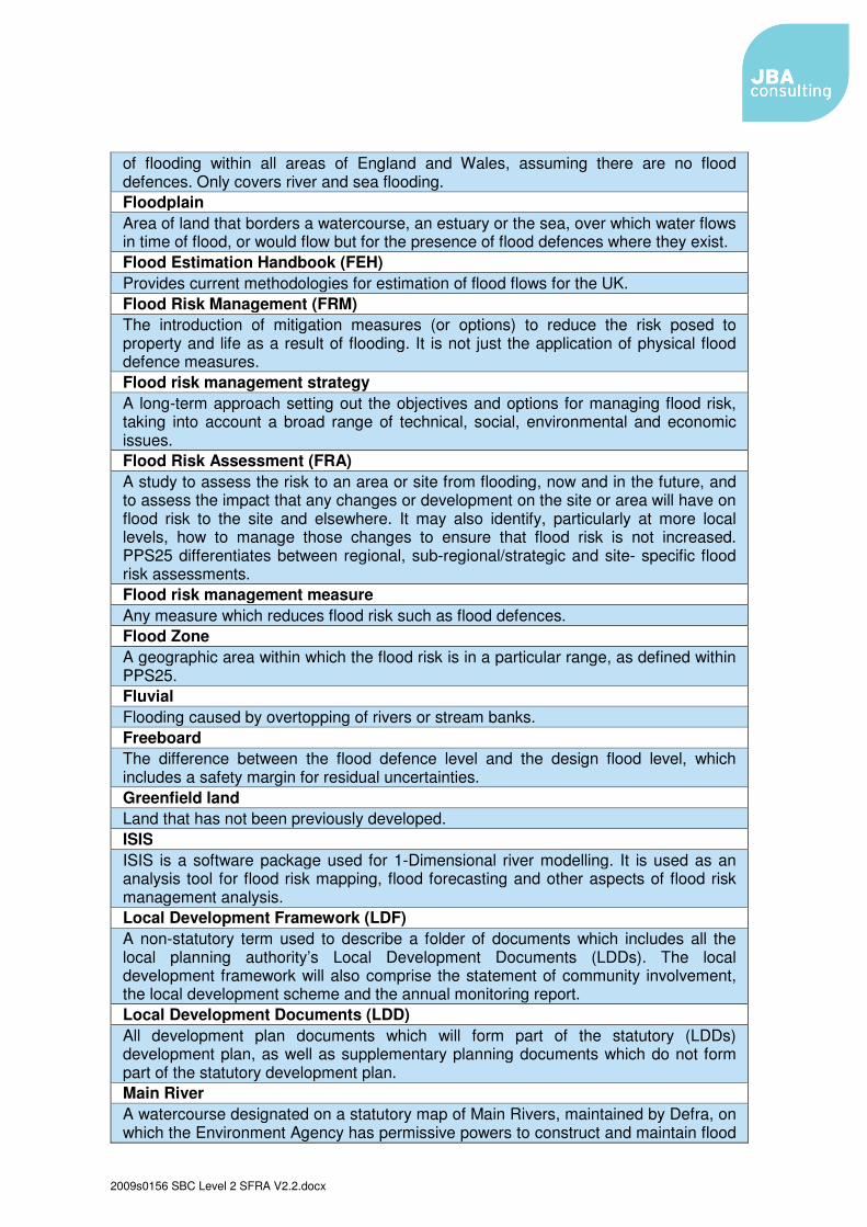
Glossary Attenuation Reduction of peak flow and increased duration of a flow event. Catchment Flood Management Plans (CFMP) A strategic planning tool through which the Environment Agency will seek to work with other key decision-makers within a river catchment to identify and agree policies for sustainable flood risk management. Climate change Long-term variations in global temperatures and weather patterns, both natural and as a result of human activity. Compensation storage A floodplain area introduced to compensate for the loss of storage as a result of land raising for development purposes. Design event A historic or notional flood event of a given annual flood probability, against which the suitability of a proposed development is assessed and mitigation measures, if any, are designed. Design flood level The maximum estimated water level during the design event. DG5 register Register held by water companies on the location of properties at risk of sewage related flooding problems Extreme Flood Outline Flood ‘zone’ maps released by the Environment Agency to depict anticipated 0.1% (1 in 1000 year) flood extents in a consistent manner throughout the UK Flood defence Flood defence infrastructure, such as flood walls and embankments, intended to protect an area against flooding to a specified standard of protection. Flood and coastal defence The Environment Agency, local authorities and Internal Drainage Boards Operating Authorities with legislative powers to undertake flood and coastal defence works. Flood Map A map produced by the Environment Agency providing an indication of the likelihood
2009s0156 SBC Level 2 SFRA V2.2.docx
of flooding within all areas of England and Wales, assuming there are no flood defences. Only covers river and sea flooding. Floodplain Area of land that borders a watercourse, an estuary or the sea, over which water flows in time of flood, or would flow but for the presence of flood defences where they exist. Flood Estimation Handbook (FEH) Provides current methodologies for estimation of flood flows for the UK. Flood Risk Management (FRM) The introduction of mitigation measures (or options) to reduce the risk posed to property and life as a result of flooding. It is not just the application of physical flood defence measures. Flood risk management strategy A long-term approach setting out the objectives and options for managing flood risk, taking into account a broad range of technical, social, environmental and economic issues. Flood Risk Assessment (FRA) A study to assess the risk to an area or site from flooding, now and in the future, and to assess the impact that any changes or development on the site or area will have on flood risk to the site and elsewhere. It may also identify, particularly at more local levels, how to manage those changes to ensure that flood risk is not increased. PPS25 differentiates between regional, sub-regional/strategic and site- specific flood risk assessments. Flood risk management measure Any measure which reduces flood risk such as flood defences. Flood Zone A geographic area within which the flood risk is in a particular range, as defined within PPS25. Fluvial Flooding caused by overtopping of rivers or stream banks. Freeboard The difference between the flood defence level and the design flood level, which includes a safety margin for residual uncertainties. Greenfield land Land that has not been previously developed. ISIS ISIS is a software package used for 1-Dimensional river modelling. It is used as an analysis tool for flood risk mapping, flood forecasting and other aspects of flood risk management analysis. Local Development Framework (LDF) A non-statutory term used to describe a folder of documents which includes all the local planning authority’s Local Development Documents (LDDs). The local development framework will also comprise the statement of community involvement, the local development scheme and the annual monitoring report. Local Development Documents (LDD) All development plan documents which will form part of the statutory (LDDs) development plan, as well as supplementary planning documents which do not form part of the statutory development plan. Main River A watercourse designated on a statutory map of Main Rivers, maintained by Defra, on which the Environment Agency has permissive powers to construct and maintain flood
2009s0156 SBC Level 2 SFRA V2.2.docx
defences. Major development A major development is: a) where the number of dwellings to be provided is ten or more, or the site area is 0.5 Ha or more or b) non-residential development, where the floorspace to be provided is 1,000 m2 or more, or the site area is 1 ha or more. Ordinary watercourse All rivers, streams, ditches, drains, cuts, dykes, sluices, sewers (other than public sewer) and passages through which water flows which do not form part of a Main River. Local authorities and, where relevant, Internal Drainage Boards have similar permissive powers on ordinary watercourses, as the Environment Agency has on Main Rivers. Permitted development rights Qualified rights to carry out certain limited forms of development without the need to make an application for planning permission, as granted under the terms of the Town and Country Planning (General Permitted Development) Order 1995. Planning Policy Statement (PPS) A statement of policy issued by central Government to replace Planning Policy Guidance notes. Previously-developed land Land which is or was occupied by a permanent structure, including the (often referred to brownfield land) curtilage of the developed land and any associated fixed surface infrastructure (PPS3 annex B) Ramsar Site Sites identified or meeting criteria set out in The RAMSAR Convention on Wetlands of International Importance. This definition has no legal status, but such sites are designated as SSSIs under the Wildlife and Countryside Act 1981 (as amended). Regional Spatial Strategy (RSS) A broad development strategy for a region for a 15 to 20 year period prepared by the Regional Planning Body. Reservoir (large raised) A reservoir that holds at least 25,000 cubic metres of water above natural ground level, as defined by the Reservoirs Act, 1975. Residual risk The risk which remains after all risk avoidance, reduction and mitigation measures have been implemented. Resilience Constructing the building in such a way that although flood water may enter the building, its impact is minimised, structural integrity is maintained and repair, drying & cleaning are facilitated. Resistance Constructing a building in such a way as to prevent flood water entering the building or damaging its fabric. This has the same meaning as flood proof. Return period The long-term average period between events of a given magnitude which have the same annual exceedence probability of occurring. Risk The threat to property and life as a result of flooding, expressed as a function of probability (that an event will occur) and consequence (as a result of the event
2009s0156 SBC Level 2 SFRA V2.2.docx
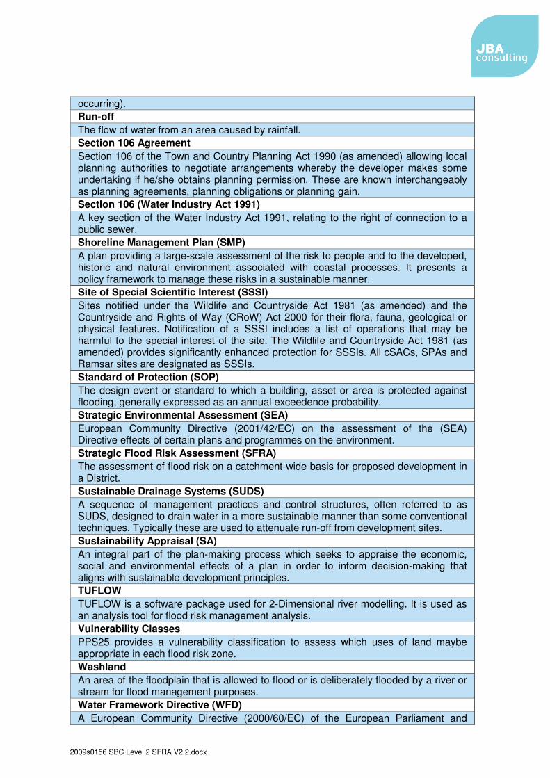
occurring). Run-off The flow of water from an area caused by rainfall. Section 106 Agreement Section 106 of the Town and Country Planning Act 1990 (as amended) allowing local planning authorities to negotiate arrangements whereby the developer makes some undertaking if he/she obtains planning permission. These are known interchangeably as planning agreements, planning obligations or planning gain. Section 106 (Water Industry Act 1991) A key section of the Water Industry Act 1991, relating to the right of connection to a public sewer. Shoreline Management Plan (SMP) A plan providing a large-scale assessment of the risk to people and to the developed, historic and natural environment associated with coastal processes. It presents a policy framework to manage these risks in a sustainable manner. Site of Special Scientific Interest (SSSI) Sites notified under the Wildlife and Countryside Act 1981 (as amended) and the Countryside and Rights of Way (CRoW) Act 2000 for their flora, fauna, geological or physical features. Notification of a SSSI includes a list of operations that may be harmful to the special interest of the site. The Wildlife and Countryside Act 1981 (as amended) provides significantly enhanced protection for SSSIs. All cSACs, SPAs and Ramsar sites are designated as SSSIs. Standard of Protection (SOP) The design event or standard to which a building, asset or area is protected against flooding, generally expressed as an annual exceedence probability. Strategic Environmental Assessment (SEA) European Community Directive (2001/42/EC) on the assessment of the (SEA) Directive effects of certain plans and programmes on the environment. Strategic Flood Risk Assessment (SFRA) The assessment of flood risk on a catchment-wide basis for proposed development in a District. Sustainable Drainage Systems (SUDS) A sequence of management practices and control structures, often referred to as SUDS, designed to drain water in a more sustainable manner than some conventional techniques. Typically these are used to attenuate run-off from development sites. Sustainability Appraisal (SA) An integral part of the plan-making process which seeks to appraise the economic, social and environmental effects of a plan in order to inform decision-making that aligns with sustainable development principles. TUFLOW TUFLOW is a software package used for 2-Dimensional river modelling. It is used as an analysis tool for flood risk management analysis. Vulnerability Classes PPS25 provides a vulnerability classification to assess which uses of land maybe appropriate in each flood risk zone. Washland An area of the floodplain that is allowed to flood or is deliberately flooded by a river or stream for flood management purposes. Water Framework Directive (WFD) A European Community Directive (2000/60/EC) of the European Parliament and
2009s0156 SBC Level 2 SFRA V2.2.docx
Council designed to integrate the way water bodies are managed across Europe. It requires all inland and coastal waters to reach “good status” by 2015 through a catchment-based system of River Basin Management Plans, incorporating a programme of measures to improve the status of all natural water bodies. Windfall sites Sites which become available for development unexpectedly and are therefore not included as allocated land in a planning authority’s development plan.
2009s0156 SBC Level 2 SFRA V2.2.docx 1
1. Introduction
1.1 Background
1.1.1.1 JBA Consulting was commissioned in April 2009 by Stockton-on-Tees Borough Council (Stockton BC) to undertake a Level 1 and Level 2 Strategic Flood Risk Assessment (SFRA). The draft Level 1 SFRA was submitted in June 2009. This Level 2 SFRA provides more detail in specific areas and follows on from the Level 1 reports.
1.1.1.2 The SFRAs for Stockton BC has been prepared in accordance with current best practice, Planning Policy Statement 25 Development and Flood Risk (PPS25) and the PPS25 Practice Guide (December 2009). This document comprises the Level 2 assessment.
1.2 Scope and objectives
1.2.1.1 The purpose of this investigation is to provide an assessment of flood risk at key areas where development and regeneration are proposed within Stockton BC. This flood risk information will inform the Local Development Framework (LDF) and the policies and proposals produced for the development.
1.2.1.2 The Stockton BC Level 1 SFRA (Volume II) has provided sufficient data and information to inform the application of the Sequential Test. This information was based on current available information, including:
1.2.1.3 However, it was acknowledged at the scoping stage of the SFRA work, that due to key regeneration sites being situated along the fluvial and tidal River Tees, a Level 1 SFRA would not be detailed enough for these sites.
1.2.1.4 A more thorough study is required to truly understand the mechanisms of flood risk around these key regeneration sites. It is also recognised that the Sequential and Exceptions Tests would need to be successfully applied whilst trying to balance the need for continued growth and regeneration. This has been aided by the drafting of four flood risk sustainability indicators (which are based on the Exception Test - see section 3.2). These flood risk indicators been produced for Stockton BC's Sustainability Appraisal of the Regeneration DPD and will be used to show which sites are acceptable on flood risk grounds.
1.2.1.5 A key objective of the Level 2 SFRA is therefore to inform the application of the Sequential Test, by assessing the development sites at medium and high flood risk, and assist Stockton BC in establishing whether the requirements of the Exception Test can be met as outlined below:
2009s0156 SBC Level 2 SFRA V2.2.docx 2
a. It must be demonstrated that the development provides wider sustainability benefits to the community that outweigh flood risk, informed by a SFRA where one has been prepared. If the LDD has reached the ‘submission’ stage (see Figure 4.1 of PPS12: Local Development Frameworks) the benefits of the development should contribute to the Core Strategy’s Sustainability Appraisal (SA);
b. The development must be on developable previously-developed land or, if it is not on previously-developed land, that there are no reasonable alternative sites on developable previously-developed land; and
c. A site-specific Flood Risk Assessment must demonstrate that the development will be safe, without increasing flood risk elsewhere, and, where possible, will reduce flood risk overall.
1.2.1.6 These three elements of the Exception Test have been used to produce four Flood Risk Indicators to be used in the Sustainability Appraisal.
1.2.1.7 Whilst the Exception Test process makes it possible to identify areas where developments can be built safely, it must not been seen as an opportunity to place inappropriate development in flood risk areas. It is a useful planning tool that can justify the acceptability of the residual risks remaining after the mitigation measures have been applied.
1.2.1.8 In order to establish whether applying the Exception Test is justified or can then be satisfied, namely part c), the Level 2 SFRA considers the detailed nature of flood hazard, taking account of the presence of flood risk management measures such as flood defences. The detail nature of the flood hazard within a flood zones includes:
• Flood probability; • Flood depth; • Flood Velocity; and • Rate of onset of flooding.
1.2.1.9 These factors can be significantly affected by the presence of flood defences or any other infrastructure which acts as a flood defences. Flooding behind such infrastructure can occur either as a result of:
o Constructional or operation failure of the defence, either in whole or in part (breach); or
o Water levels rising to exceed the level of the defence (overtopping); or o Overloading of the surface water drainage system, either due to its
own limited capacity, or being unable to discharge due to high water levels outside the defended area.
1.2.1.10 By facilitating the application of the Exception Test, the Level 2 SFRA technical work will also provide supporting evidence to the possible mitigation measures that would enable the development to proceed.
1.3 Study area
1.3.1.1 A number of residential and employment sites have been identified during the Scoping Stage and Level 1 SFRA. The Environment Agency's Flood Zone maps show that these sites are at a high risk of flooding but they are also key regeneration sites. These proposed residential and employment allocations
2009s0156 SBC Level 2 SFRA V2.2.docx 3
have been put into five different groups for this Level 2 SFRA. These are as follows:
• Bowesfield North Phase 2 and South • Boathouse Lane and Chandlers Wharf • Tees Marshalling Yard (TMY) • Seal Sands (also includes North Tees Pools and Port Clarence sites) • Haverton Hill (also includes Casebourne and Billingham Reach sites)
1.3.1.2 The Bowesfield, Boathouse Lane and Chandlers Wharf sites are on the west bank of the River Tees, west of Thornaby. They are currently shown to be at risk of fluvial flooding from the River Tees. However, the risk of tidal flooding will become an issue in the future due to climate change. These sites are hydraulically linked by the River Tees which means developing within the floodplain may have an affect on the developments downstream.
1.3.1.3 The Tees Marshalling Yard is south of the River Tees (north of Thornaby). The Old River Tees runs through the centre of the Tees Marshalling Yard (TMY). This watercourse along with the River Tees puts the TMY at risk of tidal flooding.
1.3.1.4 The Seal Sands employment allocations are located in the eastern most part of Stockton BC, on the north bank of the Tees Estuary. Parts of these sites are at risk of tidal flooding. The Haveton Hill allocations are further upstream and are also at tidal flood risk from the River Tees.
1.3.1.5 Figure 1 below shows all of Stockton BC's development allocations and identifies the Level 2 SFRA sites
2009s0156 SBC Level 2 SFRA V2.2.docx 4
Figure 1 - Stockton BC's proposed development allocations and the Level 2 SFRA sites
1.4.1.1 As previously mentioned, the Level 1 SFRA was based on currently available information such as the Environment Agency Flood Map and data collected from key stakeholders during the consultation process. To ensure the scale and nature of the risks are truly understood, the Level 2 SFRA is based on new detailed modelling information.
1.4.1.2 Flood outlines are normally derived from 1D hydraulic models simply by extrapolating a predicted water level in the channel across the floodplain using topographical data to estimate those areas that will be inundated. Whilst this method is suitable to create the Environment Agency Flood Maps, as used within the Level 1 SFRA, this approach is not always appropriate in instances where there are likely to be complex flow patterns and where water levels in the floodplain may differ significantly from those in the watercourse. This approach is now also seen as crucial in urban areas, to simulate the conveyance of flood waters across the floodplain and to gain a more detailed understanding of the flood risk.
1.4.1.3 The new modelling includes: 1. Combined 1D/2D floodplain modelling of The River Tees, alongside the
Bowesfield, Boathouse Lane and Chandlers Wharf development allocations. 2. Combined 1D/2D floodplain modelling of The Old River Tees, through the
Tees Marshalling Yard and the retail park 3. 2D tidal modelling of the Seals Sands and Haverton Hill area.
1.4.1.4 The modelling included simulating a number of scenarios including: • Undefended modelling for the tidal model • Defended modelling for the tidal model • Seals Sands and Haverton Hill sites developed for the tidal model • Bowesfield, Boathouse Lane and Chandlers Wharf developed and
undeveloped • Old River Tees defended with the TMY developed and undeveloped
1.4.1.5 These scenarios were completed for the following flood events: • 1 in 200 year (tidal) and 1 in 100 year (fluvial) events • 1 in 100 year fluvial event with +100 years climate change • 1 in 200 year tidal event with +100 years climate change • 1 in 1000 year event
1.4.1.6 The results of the modelling and the mapping outputs are discussed in Chapter 4 of this report. This includes a summary of the modelling completed, the results and how this impacts on the proposed development allocations (i.e. can they be developed safely without increasing risk to others and what mitigation measures would be required to make them so).
1.4.1.7 Within this report, different flood events are referred to for example the 1 in 5 year event. A 1 in 5 year event is one that has a 20% chance of happening in any year-this is a relatively minor flood. A 1 in 100 year flood has only a 1% chance of happening in any year, but its effects can be enormous.
6
1.4.1.8 Where climate change flood events have been modelled, this is referred to as the 1 in 100 year event +cc. The climate change scenarios have been modelled by increasing fluvial flows by 20% or by adding the predicted 100 year increase in sea levels (approximately 900mm).
7
2. Flood Defence Asset Review
2.1 Flood defences at the Level 2 sites
2.1.1.1 This section reviews the formal Environment Agency flood defences and also any defences / embankment that may provide some flood defence benefits for the Level 2 development allocations. Much of this section is based on tidal flood defences and the Tees Tidal Strategy has provided the majority of the background information. There are fluvial flood defences on the River Tees, but these are not in the vicinity of the sites being studied.
2.1.1.2 It is important to understand where the flood defences are, and what level of protection they provide. The Environment Agency's Flood Zone maps do not take into account flood defences. This means that the Flood Zone maps do not graduate flood risk but they are mapping using a precautionary approach to ensure that all areas at risk of flooding are identified. Information on the flood defences will show how well protected an area is or whether an area may be subject to a defence breach in the future. A breach can present a significant flood hazard. Significant flood defences built to a high standard will result in an area is at a lower residual risk than indicated on the Flood Zone maps.
2.1.1.3 The Tees Tidal Strategy has been referred to on what the preferred option is for future flood risk management in the tidal reaches. The Catchment Flood Management Plan (CFMP) and Shoreline Management Plan (SMP) has also been reviewed with regard to what the long term flood risk management policy is.
2.1.1.4 The strategy and policy coming from these studies will be important when considering the sustainability of future development allocations. For example, it would not be sustainable and in line with long term policy if an allocation were proposed in a location where a realignment from the existing defences was the preferred option.
2.1.1.5 The location of the official raised defences can be seen in Figure D in Appendix A, Volume II of the Level 1 SFRA. The tide levels for a number of different return periods can be seen in Table 1 below. These are the accepted Environment Agency water levels and are taken from the Tees Tidal Strategy.
8
Table 1 - Still water tide levels at Tees Mouth
(Draft Tees Tidal Strategy, Environment Agency, February 2008)
2.1.2 Defences at the Seal Sands allocations
Greatham Creek
2.1.2.1 Greatham Creek extends westwards from the Tees Estuary and is to the north west of Seal Sands. Greatham Creek is the main pathway of tidal flood risk to the Seal Sands employment sites. The Creek has raised defences alongside it which were built in the 19th century. In the past, these defences have been breached to the east and west of the A178 (in 1953 and 1983).
2.1.2.2 Because of concerns over the level of protection the defences offer, the condition of the defences were investigated in the early 1990s. The embankments were found to comprise a mixture of clay, sand, gravel and slag boulders. Their composition, profile, face protection and crest level vary along their length. The embankments were considered to be in good condition in general, although appropriate face protection is critical where the embankment is sandy. A section of these defences east of the A178 was reconstructed in the mid 1990s and raised to a level of 4.1m above ordnance datum (AOD). A 2002 survey of the defences indicates that the crest levels east of the A178 range from 3.81 to 4.19m AOD. West of the A178, crests levels range from 3.21 to 4.60m AOD. The existing defences within the south east are of substantial construction following the works to the embankments during the 1990s. Those in the south west are less robust with a narrow crest.
9
Figure 2 - Breach of the south Greatham embankment
1983 – Breach of Greatham South embankment, downstream of A178. Greater than the 1 in 10 year event, with a peak water level of
3.65m AOD. Draft Tees Tidal Strategy, Environment Agency, February 2008.
2.1.2.3 The Tees Tidal Strategy made an assessment on the standard of protection that these defences currently offer. This is based on defence crest height and past breaches.
• Greatham Creek west of the A178 - on average to the 1 in 2 year event • Greatham Creek east of the A178 - on average to the 1 in 120 year event
2.1.2.4 This means that these defence embankments are prone to breaching and will do so before the 1 in 200 year event. The main source of risk to the Seal Sands employment sites is a breach in the Greatham Creek defences. It is therefore wholly appropriate to consider the risk of breaching and overtopping. The Flood Zone map is starting point for this and the Level 2 modelling has taken this risk of a breach into account.
Informal defences to the west of Seal Sands
2.1.2.5 Tying into the Greatham Creek defences is an embankment extending south, called 'The Long Drag'. This embankment was constructed during the reclamation of the Tees between 1889 and 1923. Limited survey works were undertaken in 2002 along a 100m length and it was noted that the crest falls in a southerly direction from 5.88m to 5.55m AOD. The embankment does provide a degree of flood protection to the cell along its eastern boundary. However, this is not a formal defence and the Environment Agency's flood defence dataset states that during significant flood events, this embankment offers no flood defence benefits as it would breach.
2.1.2.6 To the north of the Seal Sands allocations, the emergency access road from the petrochemical complex provides some degree of flood protection. A limited length of the access road has been surveyed and its level ranges from 4.81 to 5.03m AOD.
2.1.2.7 In general, the Seal Sands area is protected by high ground, which forms the frontage to the oil refinery. Levels along the oil refinery's internal access road,
10
which is adjacent to the River Tees, range from 4.20m to 5.44m AOD. This means that much of this area will be free from flooding during the extreme tidal flood events (see levels in Table). However, lower ground levels to the west means access and egress routes may be at flood risk.
Catchment Flood Management Plan Policy
2.1.2.8 The CFMP policy for the area that includes these defences is to ‘take further action to reduce flood risk’. This is because a large area of existing development is at an unacceptably high current risk of tidal flooding and will be at even greater risk in the future if flood risk management action is not taken. The Tees Tidal Strategy outlines the specific actions that need to be carried out in the area to manage the risk of flooding now and in the future.
Tees Tidal Strategy Future Management Option
2.1.2.9 The preferred option is to raise the existing defences at Greatham Creek and block any flow routes to Port Clarence. This option also includes bunding the underpasses through the Port Clarence railway embankment and raising the level of the emergency access road in the north. This is recommended for the first 5 years of the strategy.
2.1.3 Defences at the Haverton Hill allocations
Transporter Bridge defences near to Haverton Hill
2.1.3.1 There is a raised embankment between the Transporter Bridge and an area of high ground to the east. The level of the defence ranges from 4.06 to 4.45m AOD. This is to the east of the Haverton Hill allocations. According to the levels quoted in Table 1, these defences could be overtopped at the 1 in 100 year event.
Port Clarence railway embankment
2.1.3.2 One source of flood risk to the Haverton Hill employment allocations (Haverton Hill, Casebourne and Billingham Reach) is a breach in the Greatham Creek embankment with the floodwater reaching the sites by flowing through Port Clarence railway embankment (two pedestrian subways and a road tunnel pass through it). The embankment does reduce the level of flood risk from this source to the Haverton Hill sites but it is not aformal flood defence structure.
2.1.3.3 The photo below from the draft Tees Tidal Strategy (February 2008) shows Port Clarence to the left and the railway embankment to the right during the 1953 tidal flooding event.
11
Figure 3 - Flooding at Port Clarence
Flooding of Port Clarence (left) and the railway embankment (right). Draft Tees Tidal Strategy, Environment Agency, February 2008.
2.1.3.4 The existing frontage to the Swan Hunter shipyard (Haverton Hill employment site) also provides a defence against the higher probability flood events. The level of the frontage ranges from 3.2 to 4.6m AOD. Sections of this frontage could overtop at the 1 in 1 year event while other sections would not overtop until the 1 in 200 year + 100 years climate change event. Levels along the rear access road within Swan Hunter range from 3.76 to 3.97m AOD.
Catchment Flood Management Plan Policy
2.1.3.5 The CFMP policy for the area that includes these defences is to ‘take further action to reduce flood risk’. This is because a large area of existing development is at an unacceptably high current risk of tidal flooding and will be at even greater risk in the future if flood risk management action is not taken. The Tees Tidal Strategy outlines the specific actions that need to be carried out in the area to manage the risk of flooding now and in the future.
Tees Tidal Strategy Future Management Option
2.1.3.6 The preferred option is to raise the frontage here which includes the Billingham Reach allocations (within the first 5 years of the strategy). It is recommended that these defences are maintained to a 1 in 100-year standard of protection (by the end of its design life). Improved flood defences would provide benefit to the industries, situated both inside and outside the flood risk area.
2.1.3.7 The bunding of the underpasses through the Port Clarence railway embankment will also benefit these allocations.
12
2.1.4 Defences at the Tees Marshalling Yard allocations
Old River Tees defences downstream of the TMY
2.1.4.1 There are 1.04km of raised defences along this watercourse to the south of the Tees Marshalling Yard. The earth embankments near Teesside Retail Park (which separates the retail development from the Old River Tees) could be breached or overtopped. There is also the “Old River Tees Tidal Control Structure” (as named in NFCDD). This features two reinforced concrete headwalls with wingwalls, situated under the flood embankment system protecting the Old River Tees from high flows in the Fleet and Tees rivers1. However, when the site was visited, there did not appear to be a flapped structure there (which would prevent tidal ingress).
Raised land separating the River Tees from the TMY
2.1.4.2 The Tees Marshalling Yard (TMY) is separated from the River Tees by an area of higher ground. It is believed to be composed mainly of tipped spoil. This area is broad enough to act as an effective flood defence but is not considered a formal defence asset.
Catchment Flood Management Plan Policy
2.1.4.3 The Draft Tees CFMP policy for these defences is to ‘continue with existing or alternate actions to manage flood risk at the current level’. This means that there is unlikely to be any improvements in the standard of protection provided by flood defences. However, it should be emphasised that this does not mean existing defences will be left to decay and there may still be specific localised improvements in standards of protection. Indeed, the Draft Tees Tidal Strategy proposes some improvements (see below)
Tees Tidal Strategy Future Management Option
2.1.4.4 The Tees Tidal Strategy states that the preferred option is a barrage at the confluence of the Old River Tees. The existing defences currently offer a high standard of protection and therefore works are not essential until after the initial 25 years of the strategy. However, the strategy recommends that this is implemented at the earliest opportunity. It is recommended that the barrage is built to provide a 1 in 25 year SoP by the end of its design life (this would be in excess of a 1 in 1000 year event now. The Tees Tidal Strategy also recommends maintaining and reconstructing the local defences as necessary in the long term.
1 Environment Agency. 2008. Dales Area Structural Asset Survey Tees Catchment. Old River Tees Tidal Control Structure NFCDD Reference: 122220118010LR03001. Report Prepared by Royal Haskoning.
13
2.2 Tees Barrage 2.2.1 Introduction
2.2.1.1 It is important to understand how the Tees Barrage operates and what this means for flood risk to Stockton, this section aims to cover this with the information that was made available from British Waterways and the Environment Agency. Operational details of the Tees Barrage are provided in section 2.10.4 of the Level 1 SFRA (Volume II).
2.2.1.2 British Waterways are responsible for the operation of the Tees Barrage. The primary aim of the barrage is to provide a large range of environmental and planning benefits to the tidal River Tees.
2.2.1.3 The Tees Barrage forms an artificial barrier between the Tees Estuary and the upstream catchment. Although primarily designed for environmental purposes, the barrage does provide some flood defence and drainage capability.
2.2.1.4 As a result, there is no long-term management strategy for the barrage with regards to its flood defence function. The Environment Agency hold no responsibility for ensuring its flood defence function continues into the future. This is confirmed in the Tees Tidal Strategy. The only time the barrage is mentioned in the strategy is to state that it is not a flood defence asset and there is therefore no future management strategy for it.
2.2.1.5 British Waterways do not have a management plan but they do have a Scheme of Operation for the barrage (see 4.5.4), but this is concerned with its amenity function, not its flood defence capabilities.
2.2.2 Flood defence benefits
2.2.2.1 The Tees Barrage is perceived as playing an important role in reducing flood risk to Stockton. Before assessing the risks associated with the barrage malfunctioning or being overtopped due to climate change, the existing risk, should be summarised.
2.2.2.2 The Tees Barrage is located upstream of the main urban area of Stockton and upstream of the main tidal flood risk in Stockton. This means that the majority of Stockton, that is at tidal flood risk, is fully exposed to the extreme tide levels and does not gain any flood defence benefits from the barrage. This is unlike the Thames Barrier which is located downstream of the main urban centre of London. The means, when the barrier is raised, the majority of London is protected from the extreme tide levels.
2.2.2.3 The Tees Barrage is capable of holding back tides of up to 5.0m AOD (the level of the adjacent side walls of the structure). This level is approximately equivalent to the 1 in 1000 year tidal flood event + 75 years of climate change. However at the 1 in 200 year event with 100 years climate change, the height of the barrage is exceeded. This would lead to overtopping, but only by a very small amount.
2.2.2.4 In order to estimate what the barrage is protecting (from tidal flooding), ground levels upstream of the barrage have been looked at. Upstream of the barrage,
14
the area north of the Tees is on higher ground (~ > 8m AOD). However, south of the Tees (between the barrage to the meander) ground levels fall to between 4 and 5m AOD (this is the area around the university). Further upstream, the land west of the Tees now falls to around 3.5 and 4.5m AOD at Boathouse Lane and Chandlers Wharf. The east bank of the Tees is on higher ground until the allotments opposite Bowesfield at between 3 and 3.5m AOD. West of the Tees here (at Bowesfield) is also on lower ground (around 4.5m AOD).
2.2.2.5 From looking at these levels, the following conclusions can be made if the Tees Barrage was not there:
• The areas below 4.2m AOD would be at risk from 1 in 200 year tidal flood (Flood Zone 3).
• The areas below 4.4m AOD would be at risk from 1 in 1000 year tidal flood (Flood Zone 3).
• The areas below 5.1m AOD would be at risk from 1 in 200 year tidal flood in 100 years time (climate change).
• Some of the lowest lying areas (parts of Boathouse Lane and the allotments opposite Bowesfield) would be at risk from lower return period events (e.g.1 in 5 year event).
2.2.2.6 This means the barrage protects parts of the university area of Stockton, Boathouse Lane, Chandlers Wharf and Bowesfield from the 1 in 200 and 1 in 1000 year floods. However, due to climate change, the 1 in 200 year flood will increase from 4.2m AOD to 5.1m AOD. This would overtop the Tees Barrage, increasing flood risk to the areas mentioned above.
2.2.2.7 However, when this event was modelled, it was shown to have a minimal impact. This is because the climate change tide event (5.1m AOD) is only fractionally above the Tees Barrage (5m AOD). This means that the barrage would only overtop for a short period of time, at the peak of the tide cycle (i.e. the top of the extreme tide curve). The impact on upstream development would therefore be minimal. The only way the downstream tide levels would be experienced upstream is if the gates were left open, the gates failed or the gates were breached (the chances of this occurring are discussed below).
2.2.2.8 It should be noted that the upstream area at risk is not significant when compared to tidal flood risk downstream of the barrage. In addition, the majority of the Bowesfield, Boathouse Lane and Chandlers Wharf areas are not developed and if they were to be brought forward, mitigation measures would be required to reduce risk from the climate change event.
2.2.3 Impact of the barrage and potential malfunction
2.2.3.1 The barrage gates are raised to prevent high tides flowing upstream of the barrage (and to prevent ingress by slat/polluted water into the upstream lake formed by the barrage). The impact of raising the barrage for the high tidal event was modelled and the following impacts were shown:
2.2.3.2
15
• During normal fluvial flows with a future 1 in 200 year tidal event (5.1m AOD), the barrage is raised to its maximum level (5m AOD). Overall, the modelling shows that this will lower upstream peak water levels compared to a scenario with the barrage removed. This is because the barrage is restricting the tide levels going further upstream, with only minor overtopping of the barrage. The backing up effect of the normal fluvial flows upstream of the barrage does not exceed the impact of the tidal event.
• Raising the gates potentially raises tidal levels downstream of the barrage, due the backing up of tidal waters, but the effect would be minimal.
• As the maximum height the barrage can go is 5m AOD, there will be a small amount of overtopping for the future 1 in 200 year event (5.1m AOD). This will only occur for a short period and by a small amount (i.e. the maximum height of the extreme tide) and therefore will not increase upstream levels.
Fluvial event malfunction
2.2.3.3 When the barrage was being designed, it was modelled to show the impact on fluvial flood flows with one or more of the gates closed.
2.2.3.4 The results showed that during the 1 in 100 year fluvial flood flow with one gate closed, flood levels are raised by 440mm upstream of the barrage.
2.2.3.5 A fluvial flood event was modelled during this study to see what impact a flood event would have on upstream development, if the gates were mistakenly left closed (by a human or technical error). This showed a 1 in 20 year fluvial event flood levels would increase by around 20mm. However, as explained above, the likelihood of this occurring is very low due to the robust contingency measures in place.
Combined tidal/fluvial event
2.2.3.6 Raising the barrage during an extreme high tide event should not increase fluvial flood risk to the upstream developments as it is unlikely that a fluvial flood event would occur at the same time as high tidal event. However, the impact of this low probability event is discussed below.
2.2.3.7 The impact of a 1 in 20 year fluvial flow combined with the future 1 in 200 year tidal event was modelled. In the model, the barrage was raised to restrict the 1 in 200 year tide event from progressing upstream. The modelling showed that this causes significant backing up of the 1 in 20 year fluvial event. This fluvial backing up increases levels at Boathouse Lane and Bowesfield by around 20mm, compared to the situation if the barrage was not there.
2.2.3.8 In summary, during the fluvial flood event, the barrage will be lowed to reduce any upstream fluvial flood risk. During the tidal flood event, the gates can be raised to the 1 in 1000 year event, preventing upstream tidal flooding. However, during a combined tidal/fluvial event, the presence of the barrage increases flood risk upstream. But it should be noted that this event is very unlikely and the event modelled has a combined probability in excess of the 1 in 1000 year event.
16
2.2.3.9 The Yarm Flood Alleviation Scheme took into account the potential for raised water levels at Yarm, due the presence of the barrage.
2.2.4 Future management, impact and summary
2.2.4.1 British Waterways (BW) are responsible for the Tees Barrage. BW operates the barrage and there is a “Scheme of Operation” which outlines the operational objectives and priorities for operation. Although these objectives are predominantly environmental, the Scheme of Operation is approved by the Environment Agency every 5 years so that they can confirm any changes would not increase flood risk.
2.2.4.2 The Scheme of Operation is currently being reviewed and agreed with the Environment Agency to take into account alterations of the canoe slalom (installation of pumps to allow use during all phases of the tidal cycle).
2.2.4.3 No additional features or enhancements have been included or considered in the Scheme of Operation to take account of the impact of climate change (e.g. increase in extreme tide levels). As a result, the expected increase in flood risk to parts of Stockton due to climate change (described in 4.5.2) will not be mitigated against.
2.2.4.4 The barrage was completed in September 1994 with a specified design life in excess of 100 years. It is therefore unlikely that the barrage will be replaced and upgraded before the impacts of climate change are seen.
2.2.5 Bowesfield
No flood defences present.
17
3. Exception Test Evidence Base
3.1 Exception Testing
3.1.1.1 Strategic Flood Risk Assessments are undertaken in two stages. A Level 1 SFRA is initially undertaken to identify where the major risk issues are. Where for reasons of sustainable development flood risk cannot be avoided by allocating in lower flood risk zones, a more detailed strategic assessment is required. This is the purpose of this Level 2 SFRA report and feeds directly into the Sustainability Appraisal (SA) of the Regeneration DPD by using four SA Flood Risk Indicators (see section 3.2).
3.1.1.2 Essentially these assessments are an outline flood risk assessment which looks at not just an individual plot but at the wider spatial issues into which development is planned. The assessments are primarily focussed on:
• Will the development be safe? Can all the risks be designed out and can the residual risks to people and property be managed by an emergency plan or by limiting the type of land use?
• Will the site be deliverable? This involves a review of design aspects, together with an understanding of how complicated the assessment will need to be and how “exceptional” the development would need to be.
• How well does the development fit with the current mix of land uses and future provision of flood management measures? Can development reduce flood risk to other areas or will it require further more expensive provision of flood defence infrastructure?
3.1.1.3 These are all elements that will need to be considered in the delivery of the Exception Test, but an SFRA needs to be suitably precautionary, applying a longer term holistic approach to ensuring development does not compromise future flood management measures and vice versa. The Exception Test is not black and white, and needs to assess the acceptability of the residual risks. Where the residual risks are significant it is unlikely that further investment would exceptionally be justified, particularly if it introduces significantly more people into the flood risk area.
3.1.1.4 The next section will summarise the actual risk to the proposed development areas following detailed modelling. In addition to this, it needs to be shown that these risks (and residual risks) can be managed for current and future development. If they can not, the Local Planning Authority (LPA) should seriously consider avoiding development in these locations.
3.1.1.5 After the assessment of flood risk, the need for a mitigation strategy is identified and the likelihood of these developments passing the Exception Test. This section will outline the preferred mitigation strategies required to bring the sites safely forward for development.
3.1.1.6 For the development sites, the following areas will be addressed: • To what extent do the different Flood Zones affect the sites? If a significant
part of the site is within Flood Zone 3b, the development can not go ahead so can the design layout be adapted to put the development outside of Flood Zone 3b? Is there a significant proportion of the site within Flood Zone 3a?
18
Can the layout be adapted or will further detail on managing the risk be required? Does the extent of flooding mean access and egress can not be provided?
• Is it likely that the existing flood risk (depth, hazard, rate of onset, velocity) can be safely managed? What issues are there that may prevent development (even with mitigation) going ahead e.g. flood depths or rate of onset etc, could the depths be designed out or not?
• If the development goes ahead, will there be off site effects (from the development and mitigation strategy). Could the scale of this effect be managed? Could development reduce risk?
• What are the residual risks e.g. SoP, condition, probability of breach and will the defences overtop within climate change. Is residual risk significant and can it be successfully managed?
3.2 Sustainability Appraisal Flood Risk Indicators As well as following the guidance of PPS25, Stockton BC has integrated the above requirements of the ST into their Sustainability Appraisal (SA). The bullet points in 3.1.1.6 have been used to draft four SA Flood Risk Indicators. These have been produced for Stockton BC's SA of the Regeneration DPD and will be used to show which sites are acceptable on flood risk grounds. The four draft indicators are as follows:
1. Are the flood risks (depths and hazards), prior to mitigation, significant enough to impact on urban design and could result in a risk of loss life to people using the site?
2. Can the development be made safe once developed and are residual risks acceptable?
3. Is the increase in risk posed by climate change easily adapted to and/or can the development build in climate change resilience?
4. Can flood risk to adjacent lands stay the same or be reduced as a result of the development and its mitigation measures?
The assessment of the individual sites will be based around these four indicators. Evidence from the modelling will be given for the four indicators to show whether there is a negative or positive response to them.