28
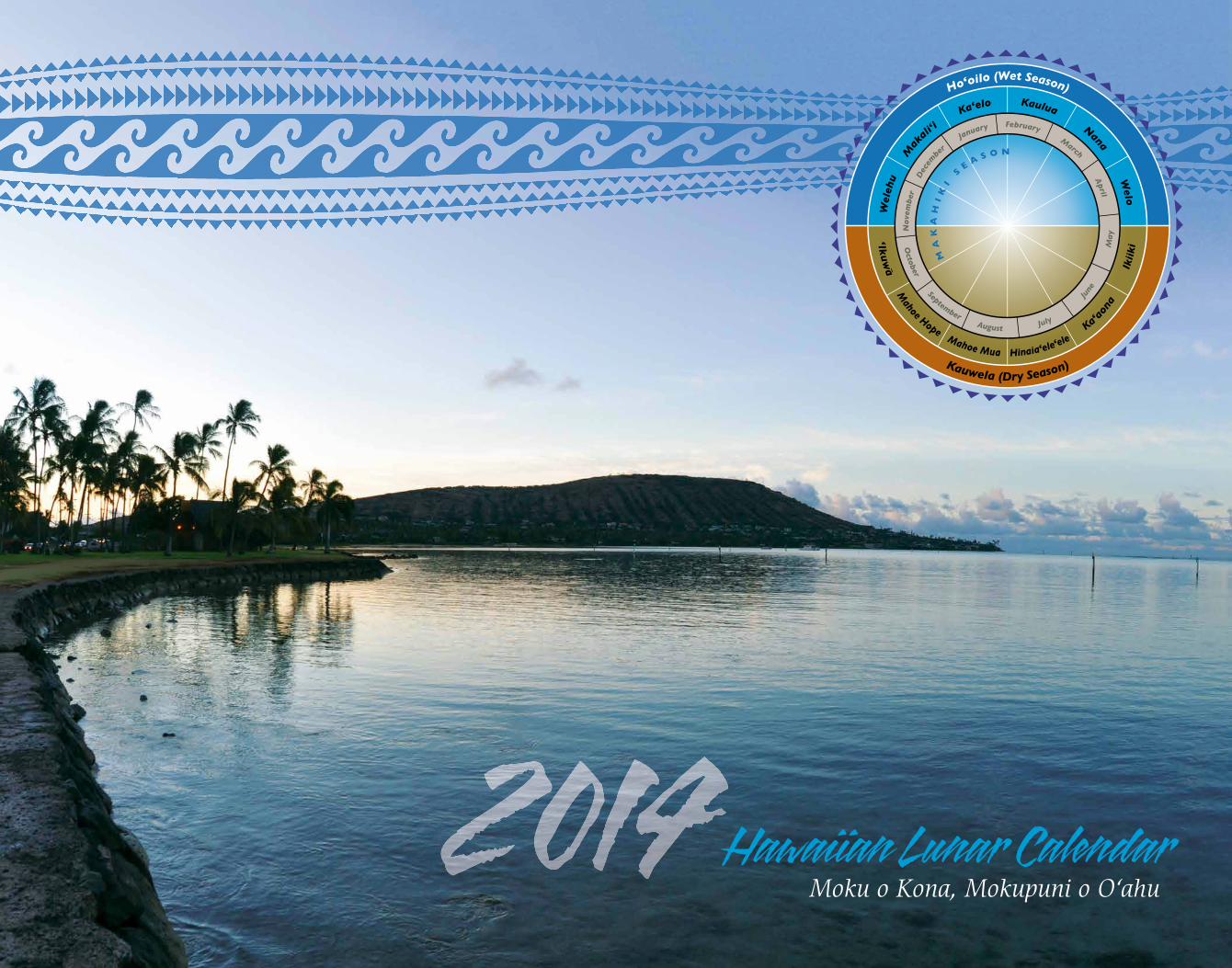
Hawaiian Lunar Calendar Moku o Kona, Mokupuni o O‘ahu
| Date post: | 12-Mar-2016 |
| Category: |
Documents |
| Upload: | western-pacific-regional-fishery-management-council |
| View: | 214 times |
| Download: | 0 times |
Hawaiian Lunar CalendarMoku o Kona, Mokupuni o O‘ahu
A publication of the Western Pacific Regional Fishery Management Council pursuant to NOAA Award FNA12NMF4410217.
© 2014, Western Pacific Regional Fishery Management Council978-1-937863-12-8
Cover photo of Maunalua Bay courtesy of D. Ramey Logan (Wikimedia Commons)Cover image depicting the Hawaiian lunar cycle, © 2010, Western Pacific Regional Fishery Management CouncilAbove illustration by Catherine C. Summers, Bishop MuseumBack cover photo by Eleventh Photo Section, A.C. Luke Field, Territory of Hawai‘i
Western Pacific Regional Fishery Management Council1164 Bishop Street, Suite 1400Honolulu, Hawaii 96813phone: (808) 522-8220Fax: (808) 522-8226Email: [email protected]: www.wpcouncil.org
He hānai ali‘i, he ‘ai ahupua‘a.The rearing of a chief is the ruling of an ahupua‘a. A person in whose care a young chief was placed was often rewarded with a large tract of land.Ōlelo No‘eau #566 “[Pukui, M. 1983. Honolulu: Bishop Museum Press]
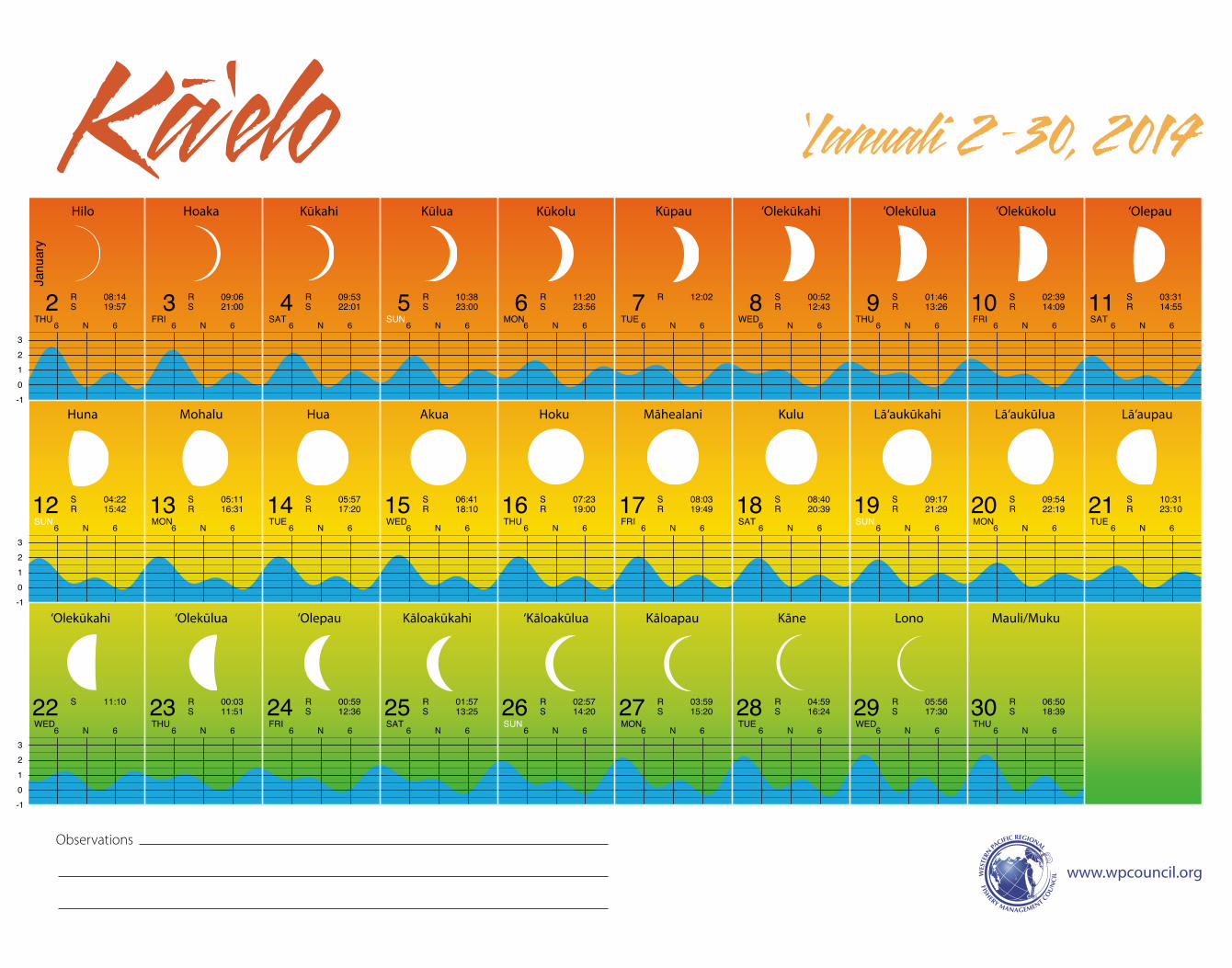
This Hawaiian lunar calendar features the Moku o Kona (District of Kona) on the island of O‘ahu (Mokupuni o O‘ahu) and the ahupua‘a (smaller geographical and political subdivisions) within it. The calendar provides information on cultural places and contemporary stewardship and educational initiatives related to the ahupua‘a. The traditional system of natural resource management in the Hawai‘i archipelago prior to Western contact was based on management at the moku level. It is said that Mā‘ilikūkahi, a great chief on O‘ahu, divided the lands into moku in about the 13th century. High chiefs were assigned to each of the six moku of O‘ahu and lesser chiefs to each of the ahupua‘a.1 On July, 9, 2012, Gov. Neil Abercrombie signed into law Act 288, which formally recognizes the ‘Aha Moku (Moku Council) system of natural resource management.
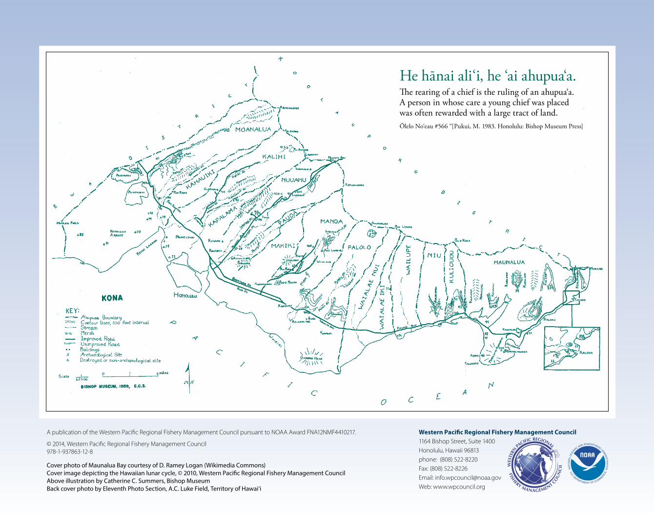
The 1959 Bishop Museum map of the Kona Moku was used as guidance for selecting the featured ahupua‘a in this calendar. This map depicts 15 ahupua‘a. It is unclear if Kapalama was an ‘ili (smaller division within an ahupua‘a) or an ahupua‘a, and it is not included in the calendar. Historically, Pauoa was believed to be an ‘ili of Nu‘uanu2 so it is not included on the calendar. There is also reference to a Lihu‘e ahupua‘a in Kona, but it is not on the reference map and is not included it in the calendar. Wai‘alae nui and Wai‘alae iki seem to have been drawn from an older ahupua‘a called Wiliwilinui. Wai‘alae is included on the calendar. An historical reference says Maunalua was an ‘ili of Waimanalo though there was no indication of how or why. Maunalua is included in the calendar.
The HM Nautical Almanac Office (HMNAO at astro.ukho.gov.uk/websurf) and the QuickPhase Pro version 3.3.5 program were used as guidance for calculating the moon phases. Traditionally, each day (the night before and the following day) was named for the lunar phase visible by the naked eye the night before. Those wishing to participate in a worldwide project to better predict sightings of the first crescent moon, which determines the start of a lunar month, are encouraged to go to http://astro.ukho.gov.uk/ and click on Crescent Moon Watch. A space for observations is provided for each month where you can record the date you saw the first crescent moon and other features of the lunar month.
Moon phase and moon month names may vary by island. This calendar uses the moon phases for O‘ahu listed in the Hawaiian Almanac by Clarice Taylor (1995. Honolulu: Mutual Publishing).
In the traditional Hawaiian calendar, the lunar month was determined by the 29.5-day cycles of mahina (moon). The moon cycle was divided into three 10-day periods known as anahulu. The first 10-day period was called ho‘onui (growing bigger), beginning on the first crescent. The second anahulu was poepoe (round or full). The nights of the bright moon (Akua, Hoku and Mahealani) were referred to as nā pō mahina kōnane (bright moonlight nights).3 The last anahulu was emi (decreasing).
Traditionally, lunar phases are used to determine when specific activities should take place. Daniel Kaha‘ulelio in Ka ‘Oi Hana Lawai‘a: Hawaiian Fishing Traditions explained the relationship between the moon phases and fishing:
The days that are good for going to sea to fish are the three La‘au days; for the fish will take the bait continuously in all kinds of fishing; Akua too, for the fish had voracious appetites. They ate like akua, supernatural beings. On the day named Mohalu the fish open their mouths wide for food; on Mahealani the fish eat one after the other and on ‘Olepau, the fish consume all, pau, taking, ho‘olawe, like Kaho‘olawe, which has been fished all around by your writer; that was with my parents and grandparents. On the three Kū nights the fish ate greedily. This my grandfolks taught me; it is useless to go fishing on any other time.4
This 2014 Hawaiian lunar calendar was produced by the Western Pacific Regional Fishery Management Council with special thanks to Erron Yoshioka (Moanalua High School), Al Keali‘i Chock, Joni Bagood and Kahaulani Kupihea (Mokauea Fishermen’s Association), Mahina Duarte (Halau Ku Mana Charter School), Lucas Moxey (NOAA OceanWatch Central Pacific), Alia Thompson (Kaimuki Middle School), Randy Jackson (Wai‘alae Elementary Public Charter School), Darrah Brown (Niu Valley Middle School), Rae DeCoito (Mālama Maunalua), John Thompson (Shrimp Mart), Tia Reber (Bishop Museum), Dore Minatodani (Hawaiian Collection, University of Hawai‘i at Mānoa Library), Melissa Shimonishi (Hawai‘i State Archives), Dennis Drake and Kenneth Hays (US Army Garrison Hawai‘i), Gavin Hirano (State Survey Office, DAGS Land Survey Division), David Robinson and Anne Grant (OceanFun Publishing), and Eric Woo, Miho Owada and Randall Chun (Eric Woo Design, Inc.).
About This Calendar
1 http://www.kumukahi.org/units/ka_honua/onaepuni/ahupuaa2 Elihu Root collection of United States documents: Ser. A.-F., Vol. 1, Foreign Relations of the United States Affairs in Hawaii. 1894. Washington, DC: GPO. p. 8893 Kamakau, SM. Works of the People of Old (Na Hana a ka Poe Kahiko) 17; Malo, D. Hawaiian Antiquities 31-32; in Hawaiian Voyaging Traditions (http://pvs.kcc.hawaii.edu/ike/hookele/hawaiian_lunar_month.html).4 Translated by Mary Kawena Puku`i. Edited by M. Puakea Nogelmeier. 2006. Honolulu: Bishop Museum Press. pp. 67–69. Note: The reference is for Maui, so there might be some differences on O‘ahu.
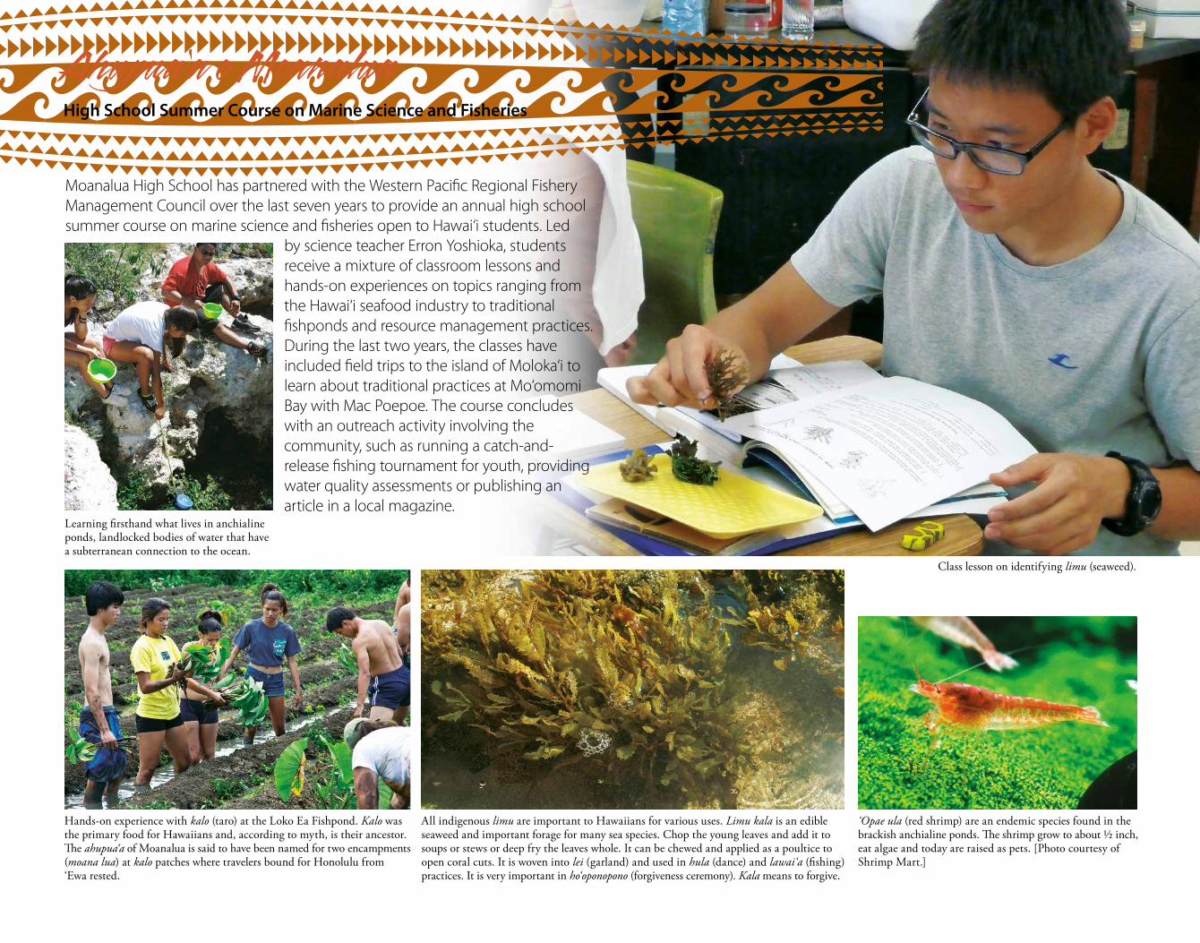
All indigenous limu are important to Hawaiians for various uses. Limu kala is an edible seaweed and important forage for many sea species. Chop the young leaves and add it to soups or stews or deep fry the leaves whole. It can be chewed and applied as a poultice to open coral cuts. It is woven into lei (garland) and used in hula (dance) and lawai‘a (fishing) practices. It is very important in ho‘oponopono (forgiveness ceremony). Kala means to forgive.
Hands-on experience with kalo (taro) at the Loko Ea Fishpond. Kalo was the primary food for Hawaiians and, according to myth, is their ancestor. The ahupua‘a of Moanalua is said to have been named for two encampments (moana lua) at kalo patches where travelers bound for Honolulu from ‘Ewa rested.
‘Opae ula (red shrimp) are an endemic species found in the brackish anchialine ponds. The shrimp grow to about ½ inch, eat algae and today are raised as pets. [Photo courtesy of Shrimp Mart.]
Moanalua High School has partnered with the Western Pacific Regional Fishery Management Council over the last seven years to provide an annual high school summer course on marine science and fisheries open to Hawai‘i students. Led
by science teacher Erron Yoshioka, students receive a mixture of classroom lessons and hands-on experiences on topics ranging from the Hawai‘i seafood industry to traditional fishponds and resource management practices. During the last two years, the classes have included field trips to the island of Moloka‘i to learn about traditional practices at Mo‘omomi Bay with Mac Poepoe. The course concludes with an outreach activity involving the community, such as running a catch-and-release fishing tournament for youth, providing water quality assessments or publishing an article in a local magazine.
Ahupua‘a o Moanalua High School Summer Course on Marine Science and Fisheries
Learning firsthand what lives in anchialine ponds, landlocked bodies of water that have a subterranean connection to the ocean.
Class lesson on identifying limu (seaweed).
2 3 4 5 6 7 8 9 10 11
12 13 14 15 16 17 18 19 20 21
22 23 24 25 26 27 28 29 30
TASIRFUHTDEWEUTNOMNUSTASIRFUHT
EUTNOMNUSTASIRFUHTDEWEUTNOMNUS
UHTDEWEUTNOMNUSTASIRFUHTDEW
Janu
ary
R 08:14S 19:57
R 09:06S 21:00
R 09:53S 22:01
R 10:38S 23:00
R 11:20S 23:56
R 12:02 S 00:52R 12:43
S 01:46R 13:26
S 02:39R 14:09
S 03:31R 14:55
S 04:22R 15:42
S 05:11R 16:31
S 05:57R 17:20
S 06:41R 18:10
S 07:23R 19:00
S 08:03R 19:49
S 08:40R 20:39
S 09:17R 21:29
S 09:54R 22:19
S 10:31R 23:10
S 11:10 R 00:03S 11:51
R 00:59S 12:36
R 01:57S 13:25
R 02:57S 14:20
R 03:59S 15:20
R 04:59S 16:24
R 05:56S 17:30
R 06:50S 18:39
Ka-‘elo ‘Ianuali 2 –30, 2014
-10123
-10123
-10123
6 N 6 6 N 6 6 N 6 6 N 6 6 N 6 6 N 6 6 N 6 6 N 6 6 N 6
6 N 6 6 N 6 6 N 6 6 N 6 6 N 6 6 N 6 6 N 6 6 N 6 6 N 6 6 N 6
6 N 6 6 N 6 6 N 6 6 N 6 6 N 6 6 N 6 6 N 6 6 N 6 6 N 6 6 N 6
Hilo Hoaka Kūkahi Kūlua Kūkolu Kūpau ‘Olekūlua‘Olekūkahi ‘Olekūkolu ‘Olepau
Huna Mohalu Hua Akua Hoku Māhealani Kulu Lā‘aukūkahi Lā‘aukūlua Lā‘aupau
‘Olekūkahi ‘Olekūlua ‘Olepau Kāloakūkahi ‘Kāloakūlua Kāloapau Kāne Lono Mauli/Muku
www.wpcouncil.org
Observations
C
M
Y
CM
MY
CY
CMY
K
1_LunarCal_Hawwaian14_11x14.pdf 1 1/8/14 3:06 PM
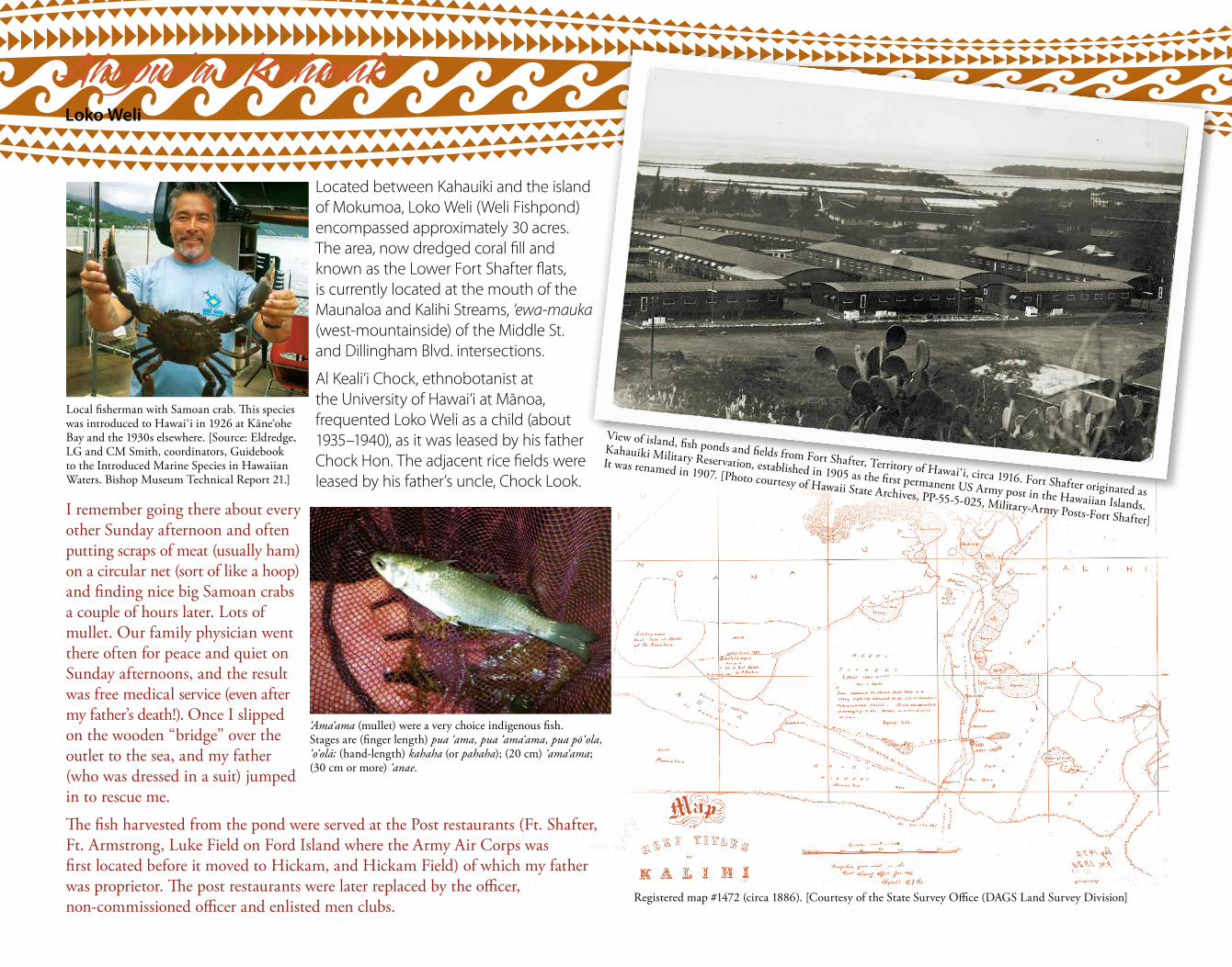
View of island, fish ponds and fields from Fort Shafter, Territory of Hawai‘i, circa 1916. Fort Shafter originated as
Kahauiki Military Reservation, established in 1905 as the first permanent US Army post in the Hawaiian Islands.
It was renamed in 1907. [Photo courtesy of Hawaii State Archives, PP-55-5-025, Military-Army Posts-Fort Shafter]
Registered map #1472 (circa 1886). [Courtesy of the State Survey Office (DAGS Land Survey Division]
Ahupua‘a o KahauikiLoko Weli
Located between Kahauiki and the island of Mokumoa, Loko Weli (Weli Fishpond) encompassed approximately 30 acres. The area, now dredged coral fill and known as the Lower Fort Shafter flats, is currently located at the mouth of the Maunaloa and Kalihi Streams, ‘ewa-mauka (west-mountainside) of the Middle St. and Dillingham Blvd. intersections.
Al Keali‘i Chock, ethnobotanist at the University of Hawai‘i at Manoa, frequented Loko Weli as a child (about 1935–1940), as it was leased by his father Chock Hon. The adjacent rice fields were leased by his father’s uncle, Chock Look.
I remember going there about every other Sunday afternoon and often putting scraps of meat (usually ham) on a circular net (sort of like a hoop) and finding nice big Samoan crabs a couple of hours later. Lots of mullet. Our family physician went there often for peace and quiet on Sunday afternoons, and the result was free medical service (even after my father’s death!). Once I slipped on the wooden “bridge” over the outlet to the sea, and my father (who was dressed in a suit) jumped in to rescue me.
The fish harvested from the pond were served at the Post restaurants (Ft. Shafter, Ft. Armstrong, Luke Field on Ford Island where the Army Air Corps was first located before it moved to Hickam, and Hickam Field) of which my father was proprietor. The post restaurants were later replaced by the officer, non-commissioned officer and enlisted men clubs.
Local fisherman with Samoan crab. This species was introduced to Hawai‘i in 1926 at Kāne‘ohe Bay and the 1930s elsewhere. [Source: Eldredge, LG and CM Smith, coordinators, Guidebook to the Introduced Marine Species in Hawaiian Waters. Bishop Museum Technical Report 21.]
‘Ama‘ama (mullet) were a very choice indigenous fish. Stages are (finger length) pua ‘ama, pua ‘ama‘ama, pua po‘ola, ‘o‘ola; (hand-length) kahaha (or pahaha); (20 cm) ‘ama‘ama; (30 cm or more) ‘anae.
31 1 2 3 4 5 6 7 8 9
10 11 12 13 14 15 16 17 18 19
20 21 22 23 24 25 26 27 28 1
NUSTASIRFUHTDEWEUTNOMNUSTASIRF
DEWEUTNOMNUSTASIRFUHTDEWEUTNOM
TASIRFUHTDEWEUTNOMNUSTASIRFUHT
Janu
ary
Febr
uary
Mar
ch
R 07:41S 19:42
R 08:28S 20:44
R 09:13S 21:44
R 09:57S 22:41
R 10:40S 23:38
R 11:23 S 00:33R 12:07
S 01:26R 12:53
S 02:18R 13:39
S 03:07R 14:27
S 03:54R 15:16
S 04:39R 16:06
S 05:22R 16:56
S 06:02R 17:46
S 06:41R 18:35
S 07:18R 19:25
S 07:55R 20:16
S 08:32R 21:07
S 09:11R 21:59
S 09:51R 22:53
S 10:34R 23:49
S 11:21 R 00:46S 12:12
R 01:46S 13:07
R 02:44S 14:07
R 03:41S 15:10
R 04:35S 16:14
R 05:27S 17:18
R 06:15S 18:21
R 07:01S 19:24
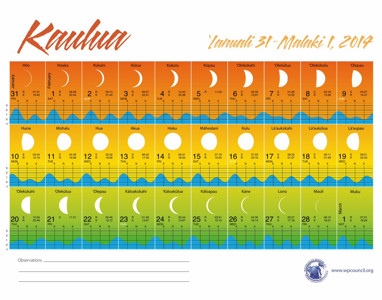
Kaulua ‘Ianuali 31 –Malaki 1, 2014
-10123
-10123
-10123
6 N 6 6 N 6 6 N 6 6 N 6 6 N 6 6 N 6 6 N 6 6 N 6 6 N 6 6 N 6
6 N 6 6 N 6 6 N 6 6 N 6 6 N 6 6 N 6 6 N 6 6 N 6 6 N 6 6 N 6
6 N 6 6 N 6 6 N 6 6 N 6 6 N 6 6 N 6 6 N 6 6 N 6 6 N 6 6 N 6
Hilo Hoaka Kūkahi Kūlua Kūkolu Kūpau ‘Olepau
Huna Mohalu Hua Akua Hoku Māhealani Kulu Lā‘aukūkahi Lā‘aukūlua Lā‘aupau
‘Olekūkahi ‘Olekūlua ‘Olepau Kāloakūkahi ‘Kāloakūlua Kāloapau Kāne Lono Mauli Muku
‘Olekūlua‘Olekūkahi ‘Olekūkolu
www.wpcouncil.org
Observations
C
M
Y
CM
MY
CY
CMY
K
2_LunarCal_Hawn2014_11x14_press.pdf 1 1/2/14 4:36 PM
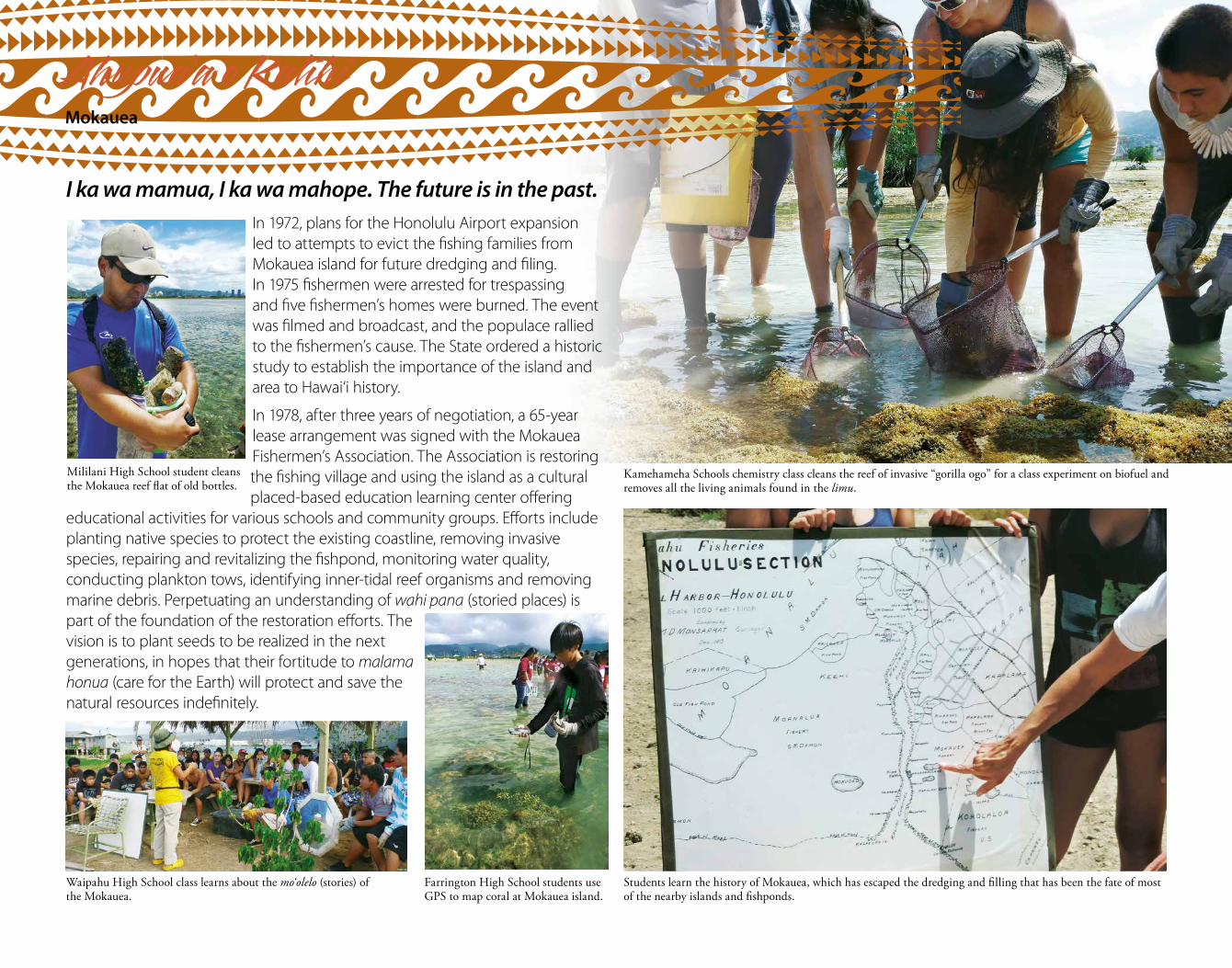
I ka wa mamua, I ka wa mahope. The future is in the past.In 1972, plans for the Honolulu Airport expansion led to attempts to evict the fishing families from Mokauea island for future dredging and filing. In 1975 fishermen were arrested for trespassing and five fishermen’s homes were burned. The event was filmed and broadcast, and the populace rallied to the fishermen’s cause. The State ordered a historic study to establish the importance of the island and area to Hawai‘i history.
In 1978, after three years of negotiation, a 65-year lease arrangement was signed with the Mokauea Fishermen’s Association. The Association is restoring the fishing village and using the island as a cultural placed-based education learning center offering
educational activities for various schools and community groups. Efforts include planting native species to protect the existing coastline, removing invasive species, repairing and revitalizing the fishpond, monitoring water quality, conducting plankton tows, identifying inner-tidal reef organisms and removing marine debris. Perpetuating an understanding of wahi pana (storied places) is part of the foundation of the restoration efforts. The vision is to plant seeds to be realized in the next generations, in hopes that their fortitude to malama honua (care for the Earth) will protect and save the natural resources indefinitely.
Mililani High School student cleans the Mokauea reef flat of old bottles.
Waipahu High School class learns about the mo‘olelo (stories) of the Mokauea.
Kamehameha Schools chemistry class cleans the reef of invasive “gorilla ogo” for a class experiment on biofuel and removes all the living animals found in the limu.
Farrington High School students use GPS to map coral at Mokauea island.
Students learn the history of Mokauea, which has escaped the dredging and filling that has been the fate of most of the nearby islands and fishponds.
Ahupua‘a o KalihiMokauea
2 3 4 5 6 7 8 9 10 11
12 13 14 15 16 17 18 19 20 21
22 23 24 25 26 27 28 29 30
EUTNOMNUSTASIRFUHTDEWEUTNOMNUS
IRFUHTDEWEUTNOMNUSTASIRFUHTDEW
NUSTASIRFUHTDEWEUTNOMNUSTAS
Mar
ch
R 07:46S 20:24
R 08:31S 21:23
R 09:15S 22:20
R 10:01S 23:16
R 10:47 S 00:09R 11:34
S 01:01R 12:22
S 01:49R 13:11
S 02:35R 14:01
S 03:19R 14:50
S 04:00R 15:40
S 04:39R 16:30
S 05:17R 17:20
S 05:55R 18:10
S 06:32R 19:02
S 07:11R 19:54
S 07:51R 20:49
S 08:33R 21:44
S 09:19R 22:41
S 10:09R 23:39
S 11:02 R 00:37S 11:59
R 01:33S 12:59
R 02:27S 14:00
R 03:17S 15:02
R 04:05S 16:04
R 04:51S 17:05
R 05:36S 18:06
R 06:20S 19:06
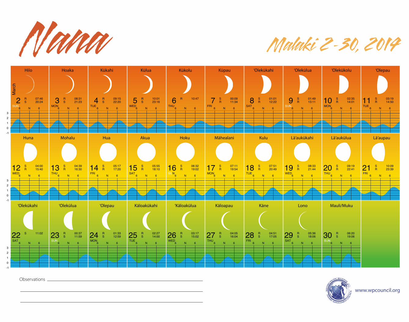
Malaki 2-30, 2014Nana
-10123
-10123
-10123
6 N 6 6 N 6 6 N 6 6 N 6 6 N 6 6 N 6 6 N 6 6 N 6 6 N 6
6 N 6 6 N 6 6 N 6 6 N 6 6 N 6 6 N 6 6 N 6 6 N 6 6 N 6 6 N 6
6 N 6 6 N 6 6 N 6 6 N 6 6 N 6 6 N 6 6 N 6 6 N 6 6 N 6 6 N 6
Hilo Hoaka Kūkahi Kūlua Kūkolu Kūpau ‘Olekūlua‘Olekūkahi ‘Olekūkolu ‘Olepau
Huna Mohalu Hua Akua Hoku Māhealani Kulu Lā‘aukūkahi Lā‘aukūlua Lā‘aupau
‘Olekūkahi ‘Olekūlua ‘Olepau Kāloakūkahi ‘Kāloakūlua Kāloapau Kāne Lono Mauli/Muku
www.wpcouncil.org
Observations
C
M
Y
CM
MY
CY
CMY
K
3_LunarCal_Hawn2014_11x14_press.pdf 1 1/2/14 5:15 PM
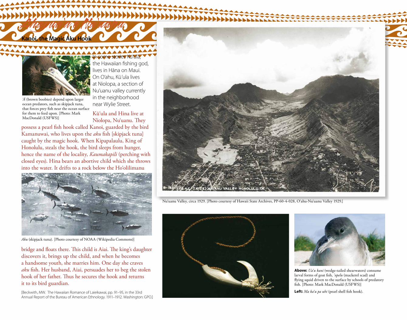
In some stories Ku‘ula, the Hawaiian fishing god, lives in Hāna on Maui. On O‘ahu, Ku‘ula lives at Niolopa, a section of Nu‘uanu valley currently in the neighborhood near Wylie Street.
Ku‘ula and Hina live at Niolopa, Nu‘uanu. They
possess a pearl fish hook called Kanoi, guarded by the bird Kamanuwai, who lives upon the aku fish [skipjack tuna] caught by the magic hook. When Kipapalaulu, King of Honolulu, steals the hook, the bird sleeps from hunger, hence the name of the locality, Kaumakapili (perching with closed eyes). Hina bears an abortive child which she throws into the water. It drifts to a rock below the Ho‘olilimanu
bridge and floats there. This child is Aiai. The king’s daughter discovers it, brings up the child, and when he becomes a handsome youth, she marries him. One day she craves aku fish. Her husband, Aiai, persuades her to beg the stolen hook of her father. Thus he secures the hook and returns it to its bird guardian.[Beckwith, MW. The Hawaiian Romance of Laieikawai, pp. 91–95, in the 33rd Annual Report of the Bureau of American Ethnology. 1911–1912. Washington: GPO.]
Aku (skipjack tuna). [Photo courtesy of NOAA (Wikipedia Commons)]
‘Ā (brown boobies) depend upon larger ocean predators, such as skipjack tuna, that forces prey fish near the ocean surface for them to feed upon. [Photo: Mark MacDonald (USFWS)]
Above: Ua‘u kani (wedge-tailed shearwaters) consume larval forms of goat fish, ‘opelu (mackerel scad) and flying squid driven to the surface by schools of predatory fish. [Photo: Mark MacDonald (USFWS)]
Left: Ma ka‘u pa uhi (pearl shell fish hook).
Ahupua‘a o Nu‘uanuKanoi, the Magic Aku Hook
Nu‘uanu Valley, circa 1929. [Photo courtesy of Hawaii State Archives, PP-60-4-028, O‘ahu-Nu‘uanu Valley 1929.]
31 1 2 3 4 5 6 7 8 9
10 11 12 13 14 15 16 17 18 19
20 21 22 23 24 25 26 27 28 29
DEWEUTNOMNUSTASIRFUHTDEWEUTNOM
TASIRFUHTDEWEUTNOMNUSTASIRFUHT
EUTNOMNUSTASIRFUHTDEWEUTNOMNUS
Mar
ch
April
R 07:05S 20:04
R 07:51S 21:02
R 08:37S 21:57
R 09:25S 22:50
R 10:14S 23:41
R 11:03 S 00:28R 11:53
S 01:14R 12:43
S 01:56R 13:33
S 02:36R 14:22
S 03:14R 15:12
S 03:52R 16:02
S 04:29R 16:53
S 05:07R 17:46
S 05:47R 18:40
S 06:30R 19:36
S 07:15R 20:34
S 08:05R 21:33
S 08:58R 22:31
S 09:55R 23:28
S 10:54 R 00:23S 11:54
R 01:14S 12:55
R 02:02S 13:55
R 02:47S 14:55
R 03:31S 15:54
R 04:14S 16:52
R 04:58S 17:50
R 05:42S 18:47
R 06:28S 19:44
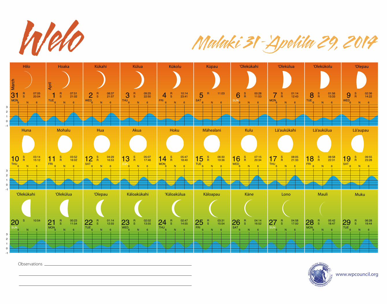
Malaki 31 – ‘Apeli la 29, 2014Welo
-10123
-10123
-10123
6 N 6 6 N 6 6 N 6 6 N 6 6 N 6 6 N 6 6 N 6 6 N 6 6 N 6 6 N 6
6 N 6 6 N 6 6 N 6 6 N 6 6 N 6 6 N 6 6 N 6 6 N 6 6 N 6 6 N 6
6 N 6 6 N 6 6 N 6 6 N 6 6 N 6 6 N 6 6 N 6 6 N 6 6 N 6 6 N 6
Hilo Hoaka Kūkahi Kūlua Kūkolu Kūpau ‘Olepau
Huna Mohalu Hua Akua Hoku Māhealani Kulu Lā‘aukūkahi Lā‘aukūlua Lā‘aupau
‘Olekūkahi ‘Olekūlua ‘Olepau Kāloakūkahi ‘Kāloakūlua Kāloapau Kāne Lono Mauli Muku
‘Olekūlua‘Olekūkahi ‘Olekūkolu
www.wpcouncil.org
Observations
C
M
Y
CM
MY
CY
CMY
K
4_LunarCal_Hawn2014_11x14_press.pdf 1 1/2/14 4:37 PM
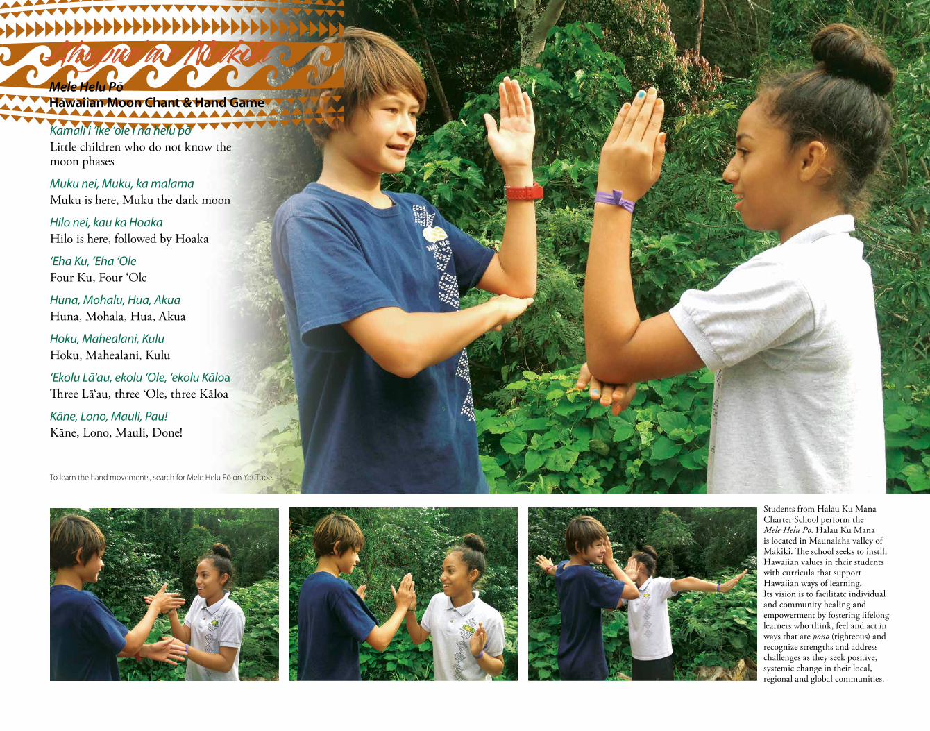
Kamali‘i ‘ike ‘ole i na helu pōLittle children who do not know the moon phases
Muku nei, Muku, ka malamaMuku is here, Muku the dark moon
Hilo nei, kau ka HoakaHilo is here, followed by Hoaka
‘Eha Ku, ‘Eha ‘OleFour Ku, Four ‘Ole
Huna, Mohalu, Hua, AkuaHuna, Mohala, Hua, Akua
Hoku, Mahealani, KuluHoku, Mahealani, Kulu
‘Ekolu Lā‘au, ekolu ‘Ole, ‘ekolu KāloaThree Lā‘au, three ‘Ole, three Kāloa
Kāne, Lono, Mauli, Pau!Kāne, Lono, Mauli, Done!
To learn the hand movements, search for Mele Helu Pō on YouTube.
Students from Halau Ku Mana Charter School perform the Mele Helu Pō. Halau Ku Mana is located in Maunalaha valley of Makiki. The school seeks to instill Hawaiian values in their students with curricula that support Hawaiian ways of learning. Its vision is to facilitate individual and community healing and empowerment by fostering lifelong learners who think, feel and act in ways that are pono (righteous) and recognize strengths and address challenges as they seek positive, systemic change in their local, regional and global communities.
Ahupua‘a o Makiki Mele Helu PōHawaiian Moon Chant & Hand Game
30 1 2 3 4 5 6 7 8 9
10 11 12 13 14 15 16 17 18 19
20 21 22 23 24 25 26 27 28
IRFUHTDEWEUTNOMNUSTASIRFUHTDEW
NOMNUSTASIRFUHTDEWEUTNOMNUSTAS
DEWEUTNOMNUSTASIRFUHTDEWEUT
April
May
R 07:15S 20:39
R 08:04S 21:31
R 08:54S 22:20
R 09:44S 23:07
R 10:34S 23:50
R 11:24 S 00:32R 12:14
S 01:11R 13:03
S 01:48R 13:53
S 02:25R 14:43
S 03:03R 15:35
S 03:41R 16:28
S 04:23R 17:24
S 05:07R 18:21
S 05:55R 19:21
S 06:48R 20:21
S 07:45R 21:20
S 08:46R 22:17
S 09:47R 23:10
S 10:49
R 00:00S 11:50
R 00:47S 12:50
R 01:30S 13:48
R 02:13S 14:45
R 02:55S 15:42
R 03:38S 16:38
R 04:22S 17:34
R 05:08S 18:29
R 05:56S 19:22
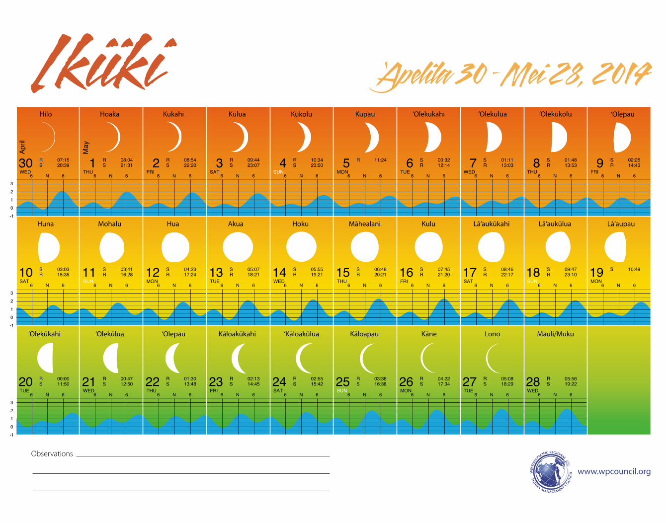
‘Apelila 30 –Mei 28, 2014Ikiiki
-10123
-10123
-10123
6 N 6 6 N 6 6 N 6 6 N 6 6 N 6 6 N 6 6 N 6 6 N 6 6 N 6
6 N 6 6 N 6 6 N 6 6 N 6 6 N 6 6 N 6 6 N 6 6 N 6 6 N 6 6 N 6
6 N 6 6 N 6 6 N 6 6 N 6 6 N 6 6 N 6 6 N 6 6 N 6 6 N 6 6 N 6
Hilo Hoaka Kūkahi Kūlua Kūkolu Kūpau ‘Olekūlua‘Olekūkahi ‘Olekūkolu ‘Olepau
Huna Mohalu Hua Akua Hoku Māhealani Kulu Lā‘aukūkahi Lā‘aukūlua Lā‘aupau
‘Olekūkahi ‘Olekūlua ‘Olepau Kāloakūkahi ‘Kāloakūlua Kāloapau Kāne Lono Mauli/Muku
www.wpcouncil.org
Observations
C
M
Y
CM
MY
CY
CMY
K
5_LunarCal_Hawn2014_11x14_press.pdf 1 1/2/14 4:38 PM
Photos courtesy of the University of Hawaii GEARUP (Gaining Early Awareness and Readiness for Undergraduate Programs) and NOAA OceanWatch Central Pacific.
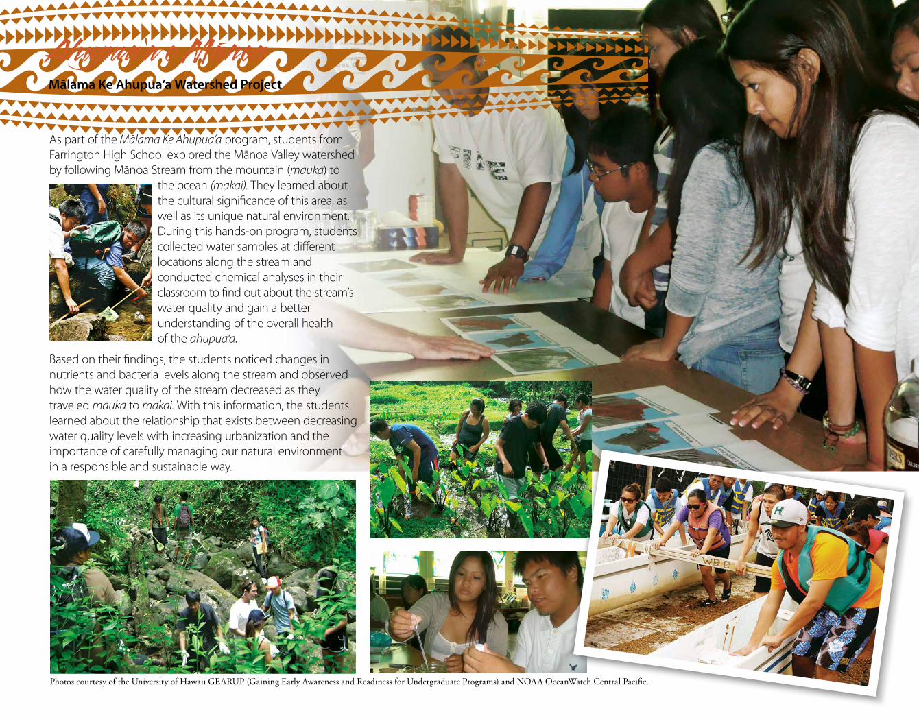
Ahupua‘a o Ma-noaMālama Ke Ahupua‘a Watershed Project
As part of the Mālama Ke Ahupua‘a program, students from Farrington High School explored the Mānoa Valley watershed by following Mānoa Stream from the mountain (mauka) to
the ocean (makai). They learned about the cultural significance of this area, as well as its unique natural environment. During this hands-on program, students collected water samples at different locations along the stream and conducted chemical analyses in their classroom to find out about the stream’s water quality and gain a better understanding of the overall health of the ahupua‘a.
Based on their findings, the students noticed changes in nutrients and bacteria levels along the stream and observed how the water quality of the stream decreased as they traveled mauka to makai. With this information, the students learned about the relationship that exists between decreasing water quality levels with increasing urbanization and the importance of carefully managing our natural environment in a responsible and sustainable way.
Ka‘aona29 30 31 1 2 3 4 5 6 7
8 9 10 11 12 13 14 15 16 17
18 19 20 21 22 23 24 25 26 27
TASIRFUHTDEWEUTNOMNUSTASIRFUHT
EUTNOMNUSTASIRFUHTDEWEUTNOMNUS
IRFUHTDEWEUTNOMNUSTASIRFUHTDEW
May
June
R 06:45S 20:13
R 07:36S 21:01
R 08:26S 21:45
R 09:17S 22:27
R 10:06S 23:06
R 10:56S 23:44
R 11:45 S 00:21R 12:34
S 00:59R 13:24
S 01:37R 14:16
S 02:16R 15:09
S 02:58R 16:06
S 03:44R 17:04
S 04:35R 18:05
S 05:30R 19:06
S 06:30R 20:05
S 07:33R 21:02
S 08:37R 21:55
S 09:41R 22:44
S 10:43R 23:30
S 11:43 R 00:13S 12:41
R 00:56S 13:38
R 01:38S 14:34
R 02:21S 15:29
R 03:06S 16:23
R 03:52S 17:17
R 04:40S 18:08
R 05:30S 18:57
R 06:20S 19:42
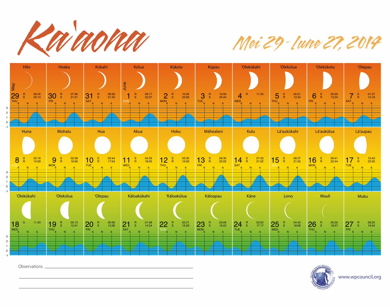
Mei 29 –Iune 27, 2014
-10123
-10123
-10123
6 N 6 6 N 6 6 N 6 6 N 6 6 N 6 6 N 6 6 N 6 6 N 6 6 N 6 6 N 6
6 N 6 6 N 6 6 N 6 6 N 6 6 N 6 6 N 6 6 N 6 6 N 6 6 N 6 6 N 6
6 N 6 6 N 6 6 N 6 6 N 6 6 N 6 6 N 6 6 N 6 6 N 6 6 N 6 6 N 6
Hilo Hoaka Kūkahi Kūlua Kūkolu Kūpau ‘Olepau
Huna Mohalu Hua Akua Hoku Māhealani Kulu Lā‘aukūkahi Lā‘aukūlua Lā‘aupau
‘Olekūkahi ‘Olekūlua ‘Olepau Kāloakūkahi ‘Kāloakūlua Kāloapau Kāne Lono Mauli Muku
‘Olekūlua‘Olekūkahi ‘Olekūkolu
www.wpcouncil.org
Observations
C
M
Y
CM
MY
CY
CMY
K
6_LunarCal_Hawn2014_11x14_press.pdf 1 1/2/14 5:59 PM
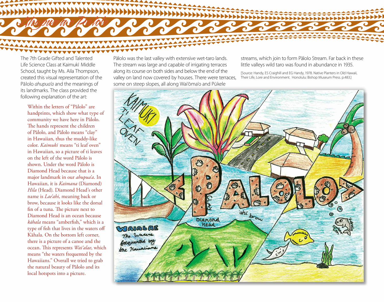
Ahupua‘a o Palolo
The 7th Grade Gifted and Talented Life Science Class at Kaimukı Middle School, taught by Ms. Aila Thompson, created this visual representation of the Palolo ahupua‘a and the meanings of its landmarks. The class provided the following explanation of the art:
Within the letters of “Palolo” are handprints, which show what type of community we have here in Palolo. The hands represent the children of Palolo, and Palolo means “clay” in Hawaiian, thus the muddy-like color. Kaimukı means “ti leaf oven” in Hawaiian, so a picture of ti leaves on the left of the word Palolo is shown. Under the word Palolo is Diamond Head because that is a major landmark in our ahupua‘a. In Hawaiian, it is Kaimana (Diamond) Hila (Head). Diamond Head’s other name is Lae‘ahi, meaning back or brow, because it looks like the dorsal fin of a tuna. The picture next to Diamond Head is an ocean because kahala means “amberfish,” which is a type of fish that lives in the waters off Kahala. On the bottom left corner, there is a picture of a canoe and the ocean. This represents Wai‘alae, which means “the waters frequented by the Hawaiians.” Overall we tried to grab the natural beauty of Palolo and its local hotspots into a picture.
Palolo was the last valley with extensive wet-taro lands. The stream was large and capable of irrigating terraces along its course on both sides and below the end of the valley on land now covered by houses. There were terraces, some on steep slopes, all along Wai‘oma‘o and Pukele
streams, which join to form Palolo Stream. Far back in these little valleys wild taro was found in abundance in 1935. [Source: Handy, ES Craighill and EG Handy, 1978. Native Planters in Old Hawaii, Their Life, Lore and Environment. Honolulu: Bishop Museum Press. p.483.]
Hinaia‘ele‘ele28 29 30 1 2 3 4 5 6 7
8 9 10 11 12 13 14 15 16 17
18 19 20 21 22 23 24 25 26
NOMNUSTASIRFUHTDEWEUTNOMNUSTAS
UHTDEWEUTNOMNUSTASIRFUHTDEWEUT
TASIRFUHTDEWEUTNOMNUSTASIRF
June
July
R 07:10S 20:24
R 08:01S 21:05
R 08:50S 21:43
R 09:39S 22:20
R 10:28S 22:56
R 11:17S 23:33
R 12:07 S 00:11R 12:58
S 00:52R 13:52
S 01:35R 14:48
S 02:22R 15:47
S 03:14R 16:47
S 04:11R 17:47
S 05:13R 18:46
S 06:18R 19:43
S 07:24R 20:35
S 08:28R 21:24
S 09:31R 22:10
S 10:32R 22:54
S 11:31R 23:38
S 12:29 R 00:21S 13:25
R 01:05S 14:20
R 01:51S 15:13
R 02:38S 16:05
R 03:27S 16:54
R 04:16S 17:41
R 05:06S 18:25
R 05:56S 19:04
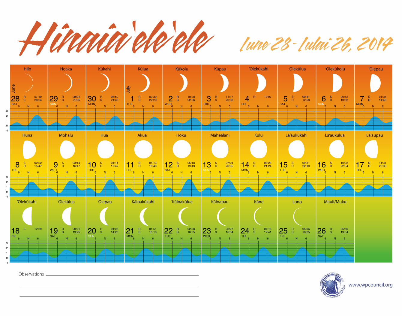
Iune 28 – Iulai 26, 2014
-10123
-10123
-10123
6 N 6 6 N 6 6 N 6 6 N 6 6 N 6 6 N 6 6 N 6 6 N 6 6 N 6
6 N 6 6 N 6 6 N 6 6 N 6 6 N 6 6 N 6 6 N 6 6 N 6 6 N 6 6 N 6
6 N 6 6 N 6 6 N 6 6 N 6 6 N 6 6 N 6 6 N 6 6 N 6 6 N 6 6 N 6
Hilo Hoaka Kūkahi Kūlua Kūkolu Kūpau ‘Olekūlua‘Olekūkahi ‘Olekūkolu ‘Olepau
Huna Mohalu Hua Akua Hoku Māhealani Kulu Lā‘aukūkahi Lā‘aukūlua Lā‘aupau
‘Olekūkahi ‘Olekūlua ‘Olepau Kāloakūkahi ‘Kāloakūlua Kāloapau Kāne Lono Mauli/Muku
www.wpcouncil.org
Observations
C
M
Y
CM
MY
CY
CMY
K
7_LunarCal_Hawn2014_11x14_press.pdf 1 1/2/14 4:40 PM
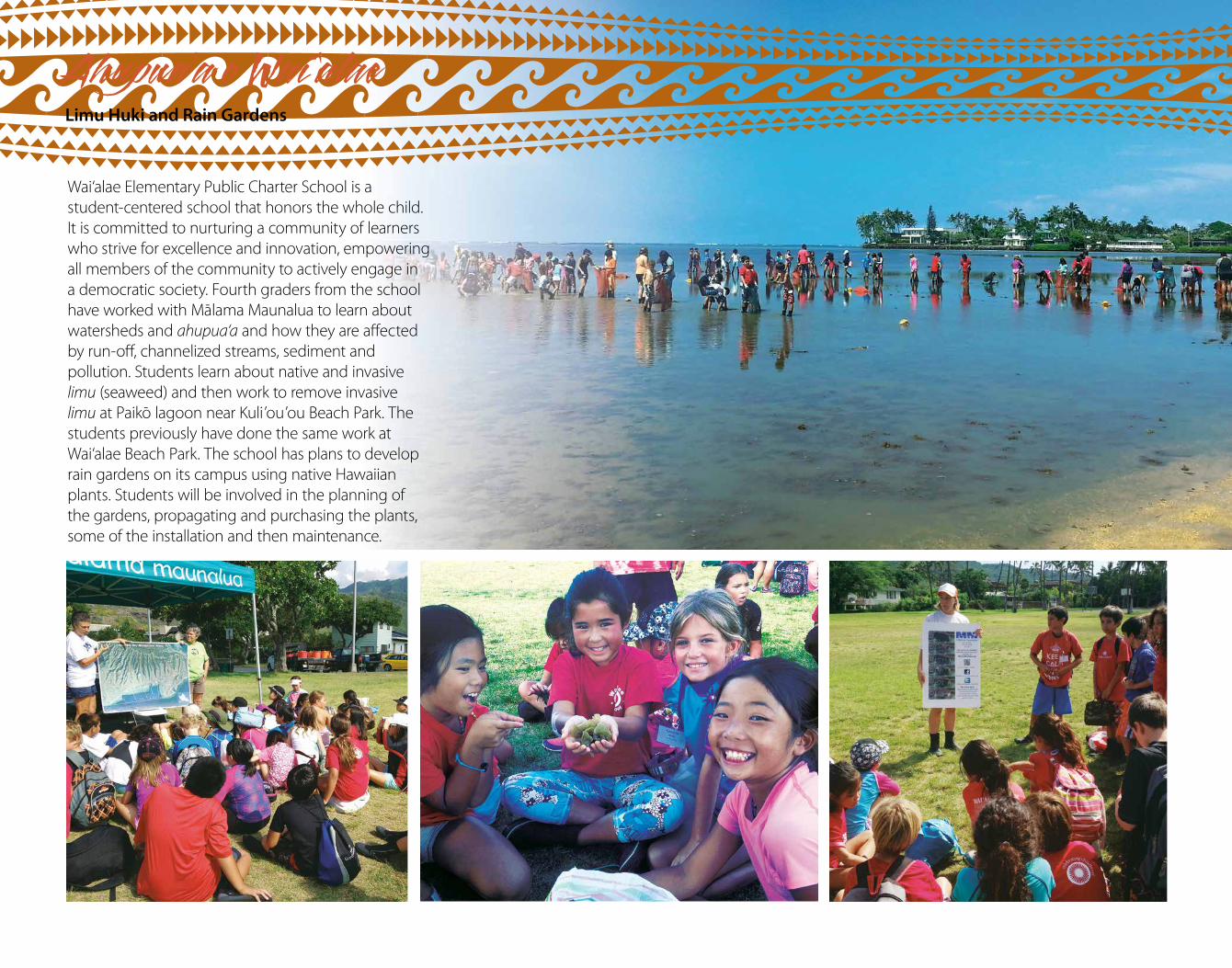
Wai‘alae Elementary Public Charter School is a student-centered school that honors the whole child. It is committed to nurturing a community of learners who strive for excellence and innovation, empowering all members of the community to actively engage in a democratic society. Fourth graders from the school have worked with Malama Maunalua to learn about watersheds and ahupua‘a and how they are affected by run-off, channelized streams, sediment and pollution. Students learn about native and invasive limu (seaweed) and then work to remove invasive limu at Paiko lagoon near Kuli’ou’ou Beach Park. The students previously have done the same work at Wai‘alae Beach Park. The school has plans to develop rain gardens on its campus using native Hawaiian plants. Students will be involved in the planning of the gardens, propagating and purchasing the plants, some of the installation and then maintenance.
Ahupua‘a o Wai ‘alaeLimu Huki and Rain Gardens
27 28 29 30 31 1 2 3 4 5
6 7 8 9 10 11 12 13 14 15
16 17 18 19 20 21 22 23 24 25
EUTNOMNUSTASIRFUHTDEWEUTNOMNUS
IRFUHTDEWEUTNOMNUSTASIRFUHTDEW
NOMNUSTASIRFUHTDEWEUTNOMNUSTAS
July
Augu
st
R 06:46S 19:43
R 07:35S 20:20
R 08:24S 20:57
R 09:13S 21:33
R 10:02S 22:10
R 10:52S 22:49
R 11:44S 23:30
R 12:37
S 00:15R 13:33
S 01:03R 14:31
S 01:56R 15:29
S 02:54R 16:28
S 03:56R 17:25
S 05:01R 18:20
S 06:07R 19:12
S 07:12R 20:00
S 08:16R 20:47
S 09:18R 21:33
S 10:18R 22:18
S 11:16R 23:03
S 12:13R 23:49
S 13:08
R 00:36S 14:01
R 01:24S 14:51
R 02:13S 15:38
R 03:03S 16:23
R 03:52S 17:05
R 04:42S 17:45
R 05:31S 18:23
R 06:21S 18:58
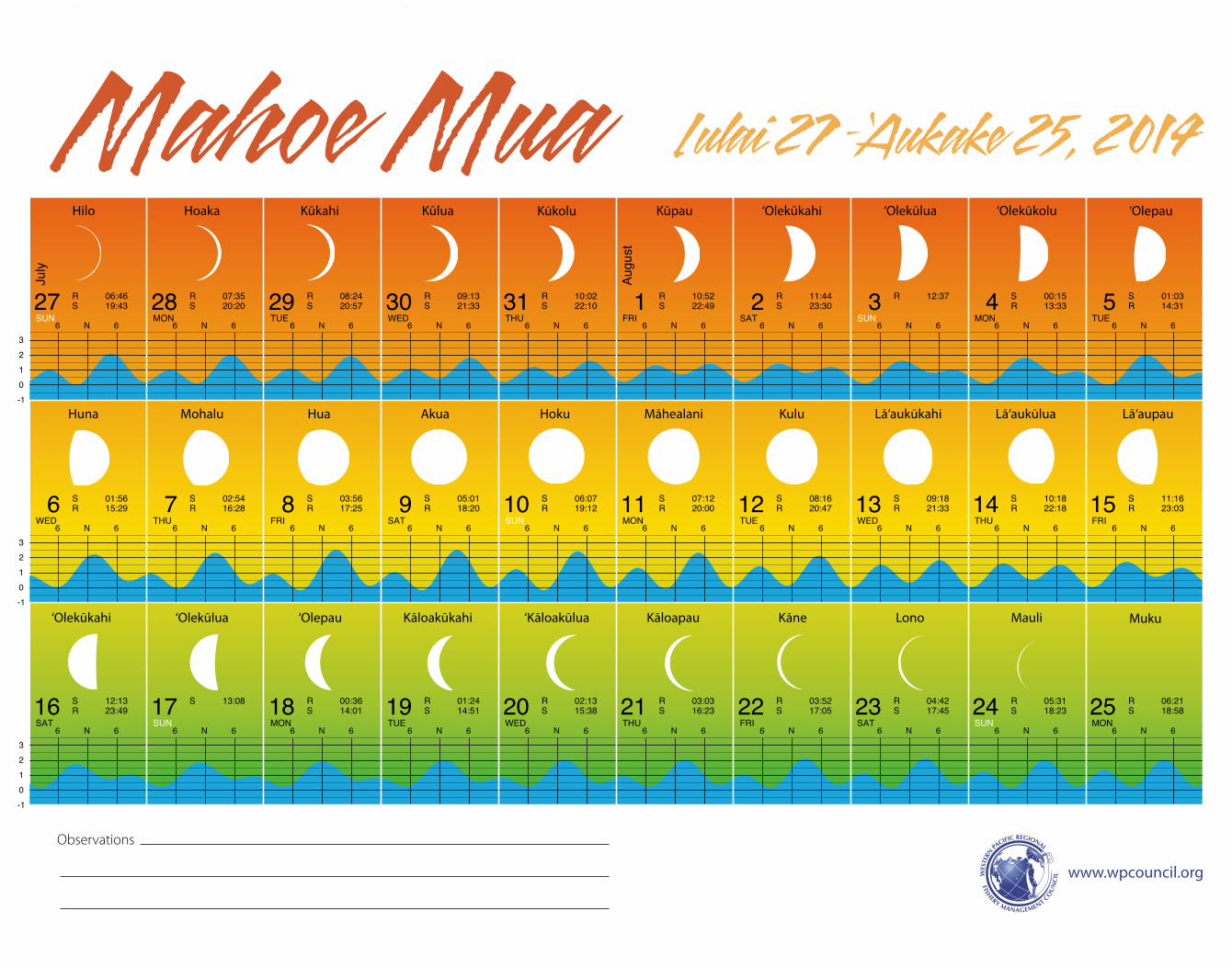
Iulai 27 –‘Aukake 25, 2014Mahoe Mua
-10123
-10123
-10123
6 N 6 6 N 6 6 N 6 6 N 6 6 N 6 6 N 6 6 N 6 6 N 6 6 N 6 6 N 6
6 N 6 6 N 6 6 N 6 6 N 6 6 N 6 6 N 6 6 N 6 6 N 6 6 N 6 6 N 6
6 N 6 6 N 6 6 N 6 6 N 6 6 N 6 6 N 6 6 N 6 6 N 6 6 N 6 6 N 6
Hilo Hoaka Kūkahi Kūlua Kūkolu Kūpau ‘Olepau
Huna Mohalu Hua Akua Hoku Māhealani Kulu Lā‘aukūkahi Lā‘aukūlua Lā‘aupau
‘Olekūkahi ‘Olekūlua ‘Olepau Kāloakūkahi ‘Kāloakūlua Kāloapau Kāne Lono Mauli Muku
‘Olekūlua‘Olekūkahi ‘Olekūkolu
www.wpcouncil.org
Observations
C
M
Y
CM
MY
CY
CMY
K
8_LunarCal_Hawn2014_11x14_press.pdf 1 1/2/14 5:02 PM
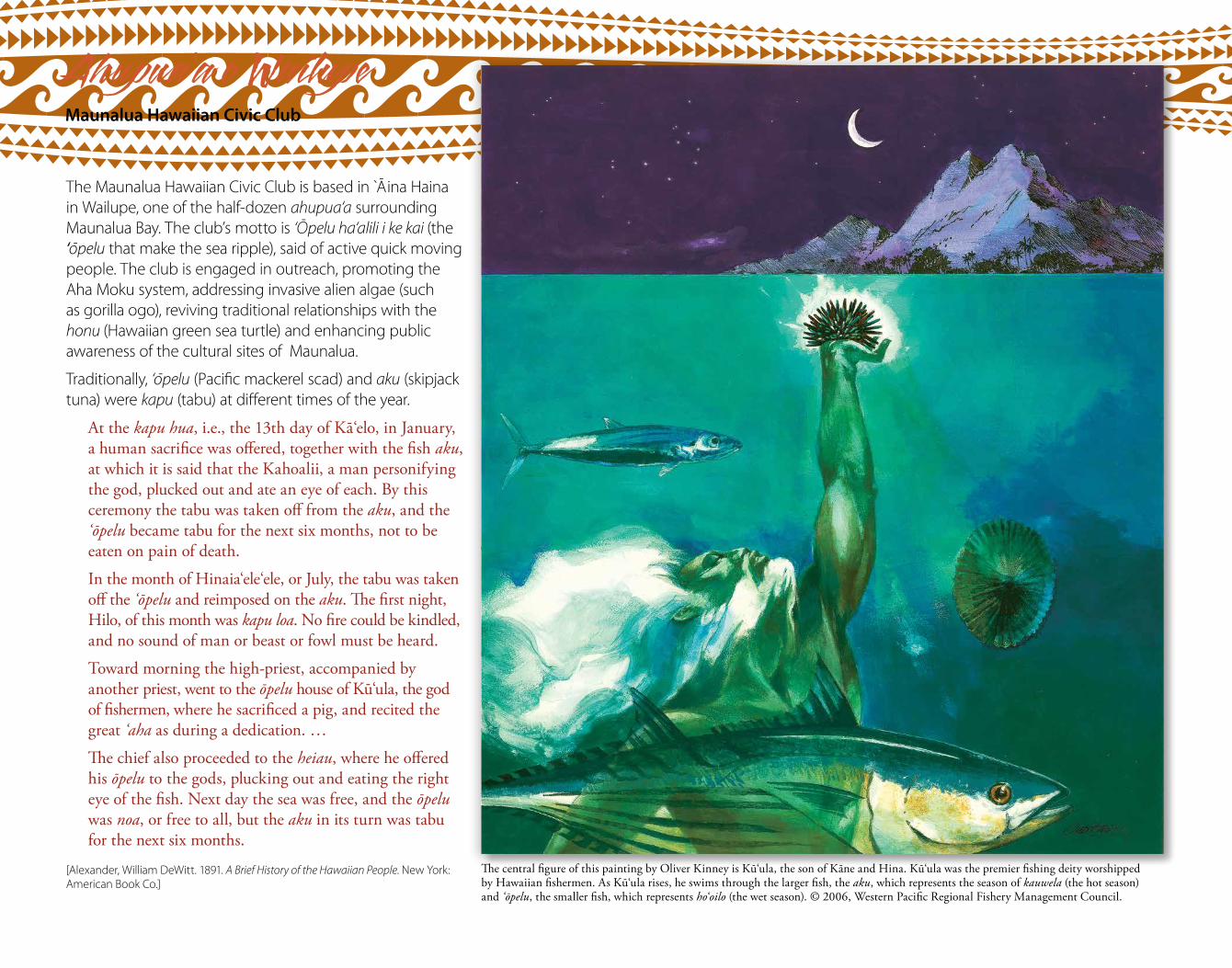
The central figure of this painting by Oliver Kinney is Ku‘ula, the son of Kane and Hina. Ku‘ula was the premier fishing deity worshipped by Hawaiian fishermen. As Ku‘ula rises, he swims through the larger fish, the aku, which represents the season of kauwela (the hot season) and ‘opelu, the smaller fish, which represents ho‘oilo (the wet season). © 2006, Western Pacific Regional Fishery Management Council.
Ahupua‘a o WailupeMaunalua Hawaiian Civic Club
The Maunalua Hawaiian Civic Club is based in Aina Haina in Wailupe, one of the half-dozen ahupua‘a surrounding Maunalua Bay. The club’s motto is ‘Opelu ha‘alili i ke kai (the ‘opelu that make the sea ripple), said of active quick moving people. The club is engaged in outreach, promoting the Aha Moku system, addressing invasive alien algae (such as gorilla ogo), reviving traditional relationships with the honu (Hawaiian green sea turtle) and enhancing public awareness of the cultural sites of Maunalua.
Traditionally, ‘opelu (Pacific mackerel scad) and aku (skipjack tuna) were kapu (tabu) at different times of the year.
At the kapu hua, i.e., the 13th day of Ka‘elo, in January, a human sacrifice was offered, together with the fish aku, at which it is said that the Kahoalii, a man personifying the god, plucked out and ate an eye of each. By this ceremony the tabu was taken off from the aku, and the ‘opelu became tabu for the next six months, not to be eaten on pain of death.
In the month of Hinaia‘ele‘ele, or July, the tabu was taken off the ‘opelu and reimposed on the aku. The first night, Hilo, of this month was kapu loa. No fire could be kindled, and no sound of man or beast or fowl must be heard.
Toward morning the high-priest, accompanied by another priest, went to the opelu house of Ku‘ula, the god of fishermen, where he sacrificed a pig, and recited the great ‘aha as during a dedication. …
The chief also proceeded to the heiau, where he offered his opelu to the gods, plucking out and eating the right eye of the fish. Next day the sea was free, and the opelu was noa, or free to all, but the aku in its turn was tabu for the next six months.
[Alexander, William DeWitt. 1891. A Brief History of the Hawaiian People. New York: American Book Co.]
26 27 28 29 30 31 1 2 3 4
5 6 7 8 9 10 11 12 13 14
15 16 17 18 19 20 21 22 23 24
UHTDEWEUTNOMNUSTASIRFUHTDEWEUT
NUSTASIRFUHTDEWEUTNOMNUSTASIRF
DEWEUTNOMNUSTASIRFUHTDEWEUTNOM
Augu
st
Sept
embe
r
R 07:10S 19:34
R 07:59S 20:11
R 08:49S 20:49
R 09:40S 21:29
R 10:32S 22:12
R 11:26S 22:58
R 12:21S 23:49
R 13:18 S 00:42R 14:14
S 01:40R 15:10
S 02:42R 16:05
S 03:45R 16:57
S 04:50R 17:47
S 05:54R 18:35
S 06:58R 19:22
S 08:00R 20:08
S 09:01R 20:55
S 10:00R 21:42
S 10:58R 22:30
S 11:53R 23:19
S 12:45 R 00:09S 13:34
R 00:58S 14:20
R 01:48S 15:04
R 02:37S 15:44
R 03:27S 16:23
R 04:16S 17:00
R 05:05S 17:37
R 05:54S 18:14
R 06:45S 18:50
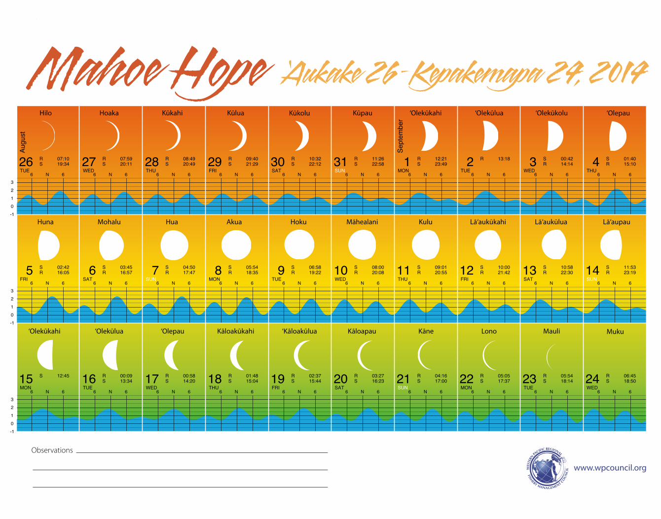
‘Aukake 26–Kepakemapa 24, 2014Mahoe Hope
-10123
-10123
-10123
6 N 6 6 N 6 6 N 6 6 N 6 6 N 6 6 N 6 6 N 6 6 N 6 6 N 6 6 N 6
6 N 6 6 N 6 6 N 6 6 N 6 6 N 6 6 N 6 6 N 6 6 N 6 6 N 6 6 N 6
6 N 6 6 N 6 6 N 6 6 N 6 6 N 6 6 N 6 6 N 6 6 N 6 6 N 6 6 N 6
Hilo Hoaka Kūkahi Kūlua Kūkolu Kūpau ‘Olepau
Huna Mohalu Hua Akua Hoku Māhealani Kulu Lā‘aukūkahi Lā‘aukūlua Lā‘aupau
‘Olekūkahi ‘Olekūlua ‘Olepau Kāloakūkahi ‘Kāloakūlua Kāloapau Kāne Lono Mauli Muku
‘Olekūlua‘Olekūkahi ‘Olekūkolu
www.wpcouncil.org
Observations
C
M
Y
CM
MY
CY
CMY
K
9_LunarCal_Hawn2014_11x14_press.pdf 1 1/2/14 5:01 PM
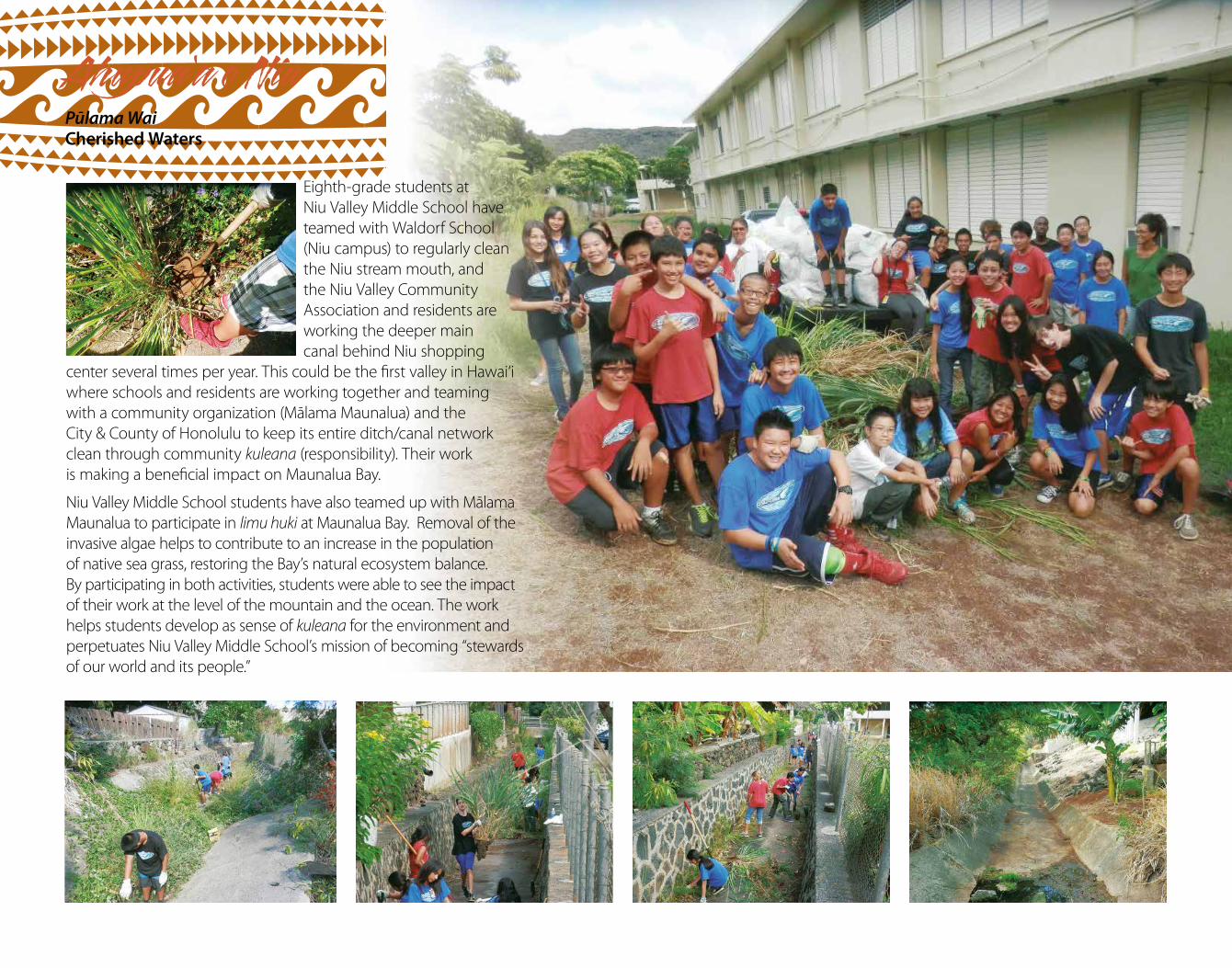
Ahupua‘a o NiuPūlama Wai Cherished Waters
Eighth-grade students at Niu Valley Middle School have teamed with Waldorf School (Niu campus) to regularly clean the Niu stream mouth, and the Niu Valley Community Association and residents are working the deeper main canal behind Niu shopping
center several times per year. This could be the first valley in Hawai‘i where schools and residents are working together and teaming with a community organization (Mālama Maunalua) and the City & County of Honolulu to keep its entire ditch/canal network clean through community kuleana (responsibility). Their work is making a beneficial impact on Maunalua Bay.
Niu Valley Middle School students have also teamed up with Mālama Maunalua to participate in limu huki at Maunalua Bay. Removal of the invasive algae helps to contribute to an increase in the population of native sea grass, restoring the Bay’s natural ecosystem balance. By participating in both activities, students were able to see the impact of their work at the level of the mountain and the ocean. The work helps students develop as sense of kuleana for the environment and perpetuates Niu Valley Middle School’s mission of becoming “stewards of our world and its people.”
25 26 27 28 29 30 1 2 3 4
5 6 7 8 9 10 11 12 13 14
15 16 17 18 19 20 21 22 23
TASIRFUHTDEWEUTNOMNUSTASIRFUHT
EUTNOMNUSTASIRFUHTDEWEUTNOMNUS
UHTDEWEUTNOMNUSTASIRFUHTDEW
Sept
embe
r
Oct
ober
R 07:36S 19:29
R 08:28S 20:12
R 09:22S 20:57
R 10:17S 21:46
R 11:12S 22:38
R 12:08S 23:34
R 13:02 S 00:31R 13:55
S 01:31R 14:46
S 02:33R 15:35
S 03:35R 16:23
S 04:38R 17:09
S 05:40R 17:56
S 06:41R 18:43
S 07:42R 19:30
S 08:42R 20:19
S 09:40R 21:09
S 10:35R 22:00
S 11:26R 22:51
S 12:15R 23:42
S 13:00 R 00:31S 13:41
R 01:20S 14:21
R 02:09S 14:59
R 02:58S 15:36
R 03:48S 16:12
R 04:38S 16:50
R 05:29S 17:29
R 06:22S 18:10
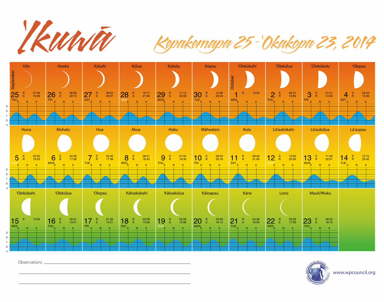
Kepakemapa 25 –‘Okakopa 23, 2014‘Ikuwa-
-10123
-10123
-10123
6 N 6 6 N 6 6 N 6 6 N 6 6 N 6 6 N 6 6 N 6 6 N 6 6 N 6
6 N 6 6 N 6 6 N 6 6 N 6 6 N 6 6 N 6 6 N 6 6 N 6 6 N 6 6 N 6
6 N 6 6 N 6 6 N 6 6 N 6 6 N 6 6 N 6 6 N 6 6 N 6 6 N 6 6 N 6
Hilo Hoaka Kūkahi Kūlua Kūkolu Kūpau ‘Olekūlua‘Olekūkahi ‘Olekūkolu ‘Olepau
Huna Mohalu Hua Akua Hoku Māhealani Kulu Lā‘aukūkahi Lā‘aukūlua Lā‘aupau
‘Olekūkahi ‘Olekūlua ‘Olepau Kāloakūkahi ‘Kāloakūlua Kāloapau Kāne Lono Mauli/Muku
www.wpcouncil.org
Observations
C
M
Y
CM
MY
CY
CMY
K
10_LunarCal_Hawn2014_11x14_press.pdf 1 1/2/14 4:42 PM
Mullet school
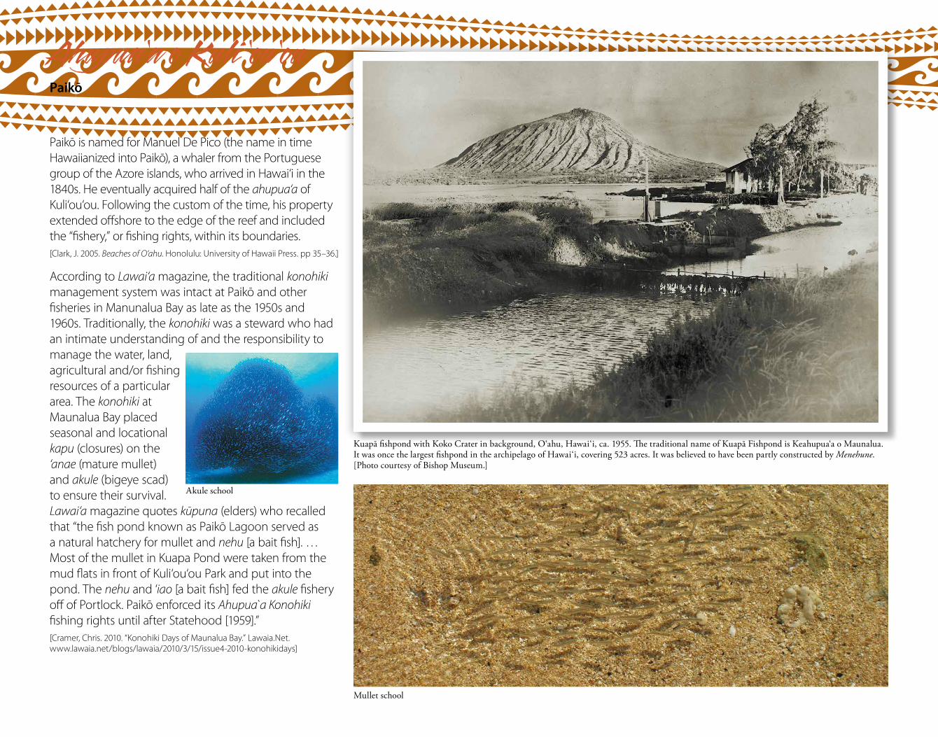
Ahupua‘a o Kuli ‘ou‘ouPaikō
Paikō is named for Manuel De Pico (the name in time Hawaiianized into Paikō), a whaler from the Portuguese group of the Azore islands, who arrived in Hawai‘i in the 1840s. He eventually acquired half of the ahupua‘a of Kuli‘ou‘ou. Following the custom of the time, his property extended offshore to the edge of the reef and included the “fishery,” or fishing rights, within its boundaries. [Clark, J. 2005. Beaches of O‘ahu. Honolulu: University of Hawaii Press. pp 35–36.]
According to Lawai‘a magazine, the traditional konohiki management system was intact at Paikō and other fisheries in Manunalua Bay as late as the 1950s and 1960s. Traditionally, the konohiki was a steward who had an intimate understanding of and the responsibility to manage the water, land, agricultural and/or fishing resources of a particular area. The konohiki at Maunalua Bay placed seasonal and locational kapu (closures) on the ‘anae (mature mullet) and akule (bigeye scad) to ensure their survival. Lawai‘a magazine quotes kūpuna (elders) who recalled that “the fish pond known as Paikō Lagoon served as a natural hatchery for mullet and nehu [a bait fish]. … Most of the mullet in Kuapa Pond were taken from the mud flats in front of Kuli‘ou‘ou Park and put into the pond. The nehu and ‘iao [a bait fish] fed the akule fishery off of Portlock. Paikō enforced its Ahupua a Konohiki fishing rights until after Statehood [1959].” [Cramer, Chris. 2010. “Konohiki Days of Maunalua Bay.” Lawaia.Net. www.lawaia.net/blogs/lawaia/2010/3/15/issue4-2010-konohikidays]
Kuapā fishpond with Koko Crater in background, O‘ahu, Hawai‘i, ca. 1955. The traditional name of Kuapā Fishpond is Keahupua‘a o Maunalua. It was once the largest fishpond in the archipelago of Hawai‘i, covering 523 acres. It was believed to have been partly constructed by Menehune. [Photo courtesy of Bishop Museum.]
Akule school
24 25 26 27 28 29 30 31 1 2
3 4 5 6 7 8 9 10 11 12
13 14 15 16 17 18 19 20 21 22
NUSTASIRFUHTDEWEUTNOMNUSTASIRF
DEWEUTNOMNUSTASIRFUHTDEWEUTNOM
TASIRFUHTDEWEUTNOMNUSTASIRFUHT
Oct
ober
Nov
embe
r
R 07:16S 18:54
R 08:11S 19:43
R 09:08S 20:35
R 10:04S 21:29
R 10:59S 22:27
R 11:52S 23:26
R 12:43 S 00:25R 13:31
S 01:25R 14:17
S 02:25R 15:02
S 03:25R 15:47
S 04:25R 16:32
S 05:25R 17:19
S 06:25R 18:07
S 07:24R 18:57
S 08:21R 19:48
S 09:15R 20:40
S 10:06R 21:32
S 10:53R 22:23
S 11:37R 23:13
S 12:17 R 00:01S 12:56
R 00:50S 13:33
R 01:39S 14:09
R 02:29S 14:46
R 03:19S 15:24
R 04:11S 16:04
R 05:05S 16:48
R 06:01S 17:34
R 06:58S 18:27
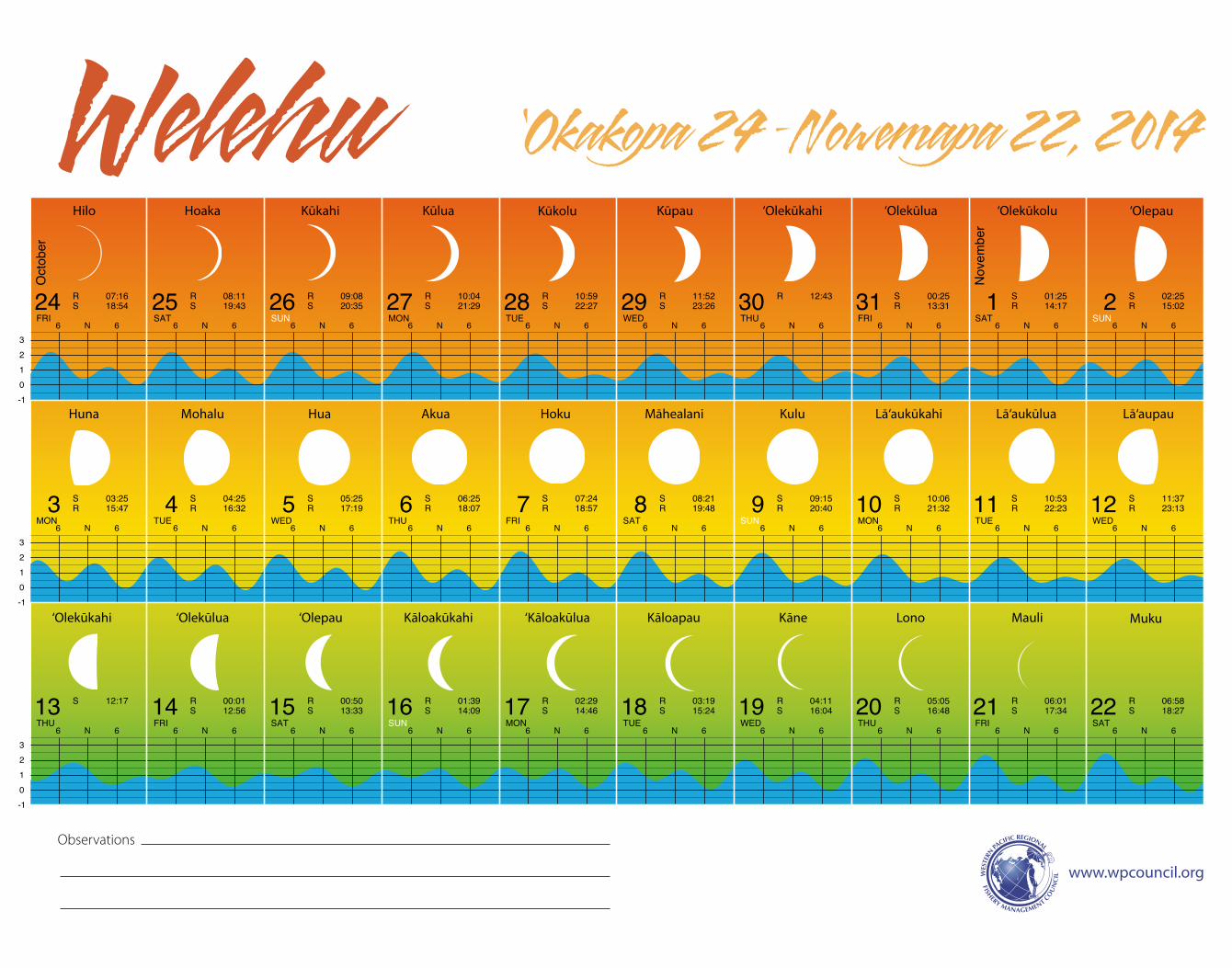
‘Okakopa 24 –Nowemapa 22, 2014Welehu
-10123
-10123
-10123
6 N 6 6 N 6 6 N 6 6 N 6 6 N 6 6 N 6 6 N 6 6 N 6 6 N 6 6 N 6
6 N 6 6 N 6 6 N 6 6 N 6 6 N 6 6 N 6 6 N 6 6 N 6 6 N 6 6 N 6
6 N 6 6 N 6 6 N 6 6 N 6 6 N 6 6 N 6 6 N 6 6 N 6 6 N 6 6 N 6
Hilo Hoaka Kūkahi Kūlua Kūkolu Kūpau ‘Olepau
Huna Mohalu Hua Akua Hoku Māhealani Kulu Lā‘aukūkahi Lā‘aukūlua Lā‘aupau
‘Olekūkahi ‘Olekūlua ‘Olepau Kāloakūkahi ‘Kāloakūlua Kāloapau Kāne Lono Mauli Muku
‘Olekūlua‘Olekūkahi ‘Olekūkolu
www.wpcouncil.org
Observations
C
M
Y
CM
MY
CY
CMY
K
11_LunarCal_Hawn2014_11x14_press.pdf 1 1/2/14 4:43 PM
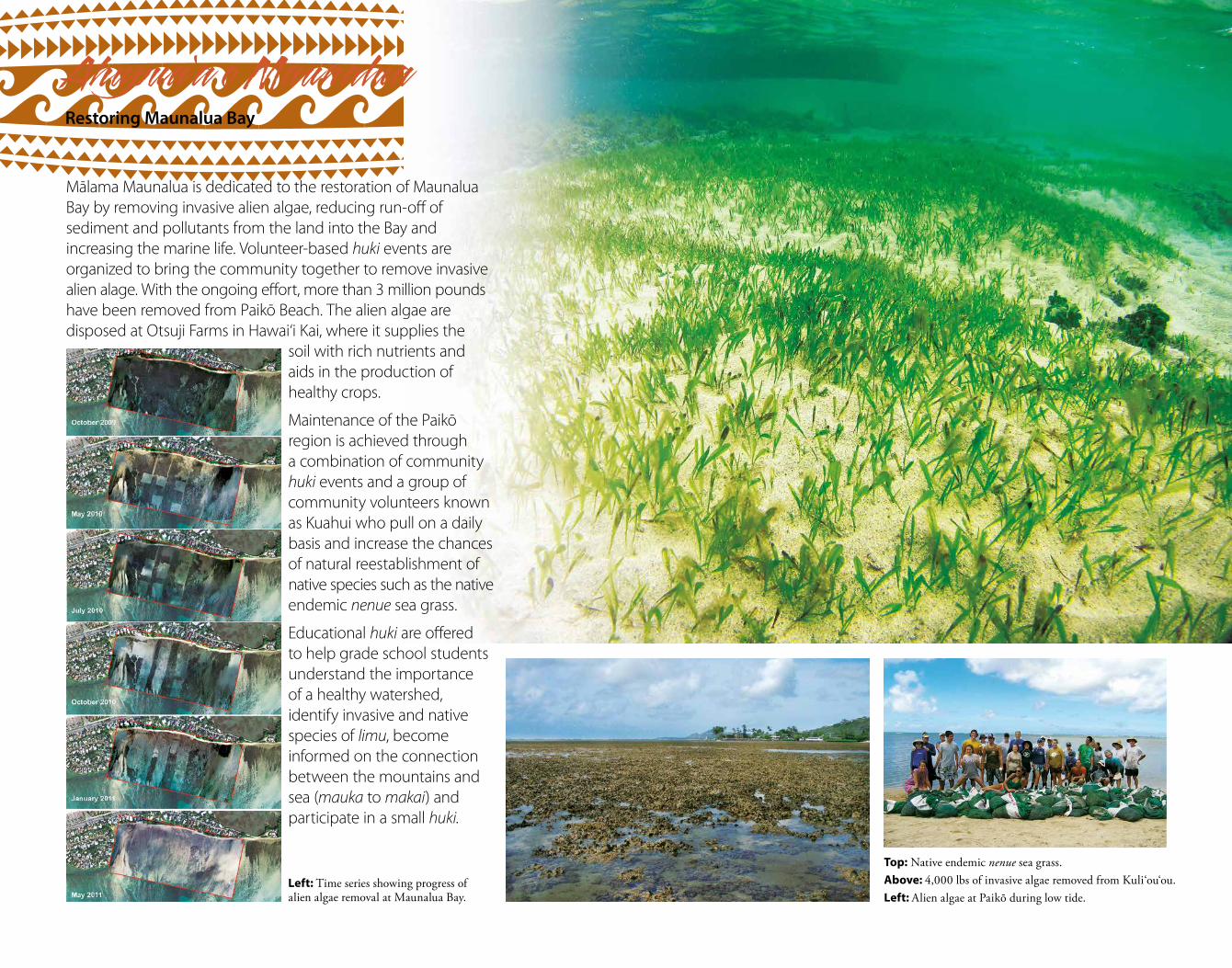
Left: Time series showing progress of alien algae removal at Maunalua Bay.
Top: Native endemic nenue sea grass.Above: 4,000 lbs of invasive algae removed from Kuli‘ou‘ou.Left: Alien algae at Paikō during low tide.
Mālama Maunalua is dedicated to the restoration of Maunalua Bay by removing invasive alien algae, reducing run-off of sediment and pollutants from the land into the Bay and increasing the marine life. Volunteer-based huki events are organized to bring the community together to remove invasive alien alage. With the ongoing effort, more than 3 million pounds have been removed from Paikō Beach. The alien algae are disposed at Otsuji Farms in Hawai‘i Kai, where it supplies the
soil with rich nutrients and aids in the production of healthy crops.
Maintenance of the Paikō region is achieved through a combination of community huki events and a group of community volunteers known as Kuahui who pull on a daily basis and increase the chances of natural reestablishment of native species such as the native endemic nenue sea grass.
Educational huki are offered to help grade school students understand the importance of a healthy watershed, identify invasive and native species of limu, become informed on the connection between the mountains and sea (mauka to makai) and participate in a small huki.
Ahupua‘a o MaunaluaRestoring Maunalua Bay
23 24 25 26 27 28 29 30 1 2
3 4 5 6 7 8 9 10 11 12
13 14 15 16 17 18 19 20 21 22
EUTNOMNUSTASIRFUHTDEWEUTNOMNUS
IRFUHTDEWEUTNOMNUSTASIRFUHTDEW
NOMNUSTASIRFUHTDEWEUTNOMNUSTAS
Nov
embe
r
Dec
embe
r
R 07:56S 19:23
R 08:53S 20:21
R 09:48S 21:20
R 10:40S 22:20
R 11:30S 23:20
R 12:16 S 00:19R 13:01
S 01:18R 13:45
S 02:17R 14:28
S 03:15R 15:13
S 04:13R 15:59
S 05:11R 16:47
S 06:08R 17:37
S 07:03R 18:28
S 07:56R 19:20
S 08:45R 20:13
S 09:31R 21:04
S 10:13R 21:54
S 10:53R 22:44
S 11:31R 23:33
S 12:07 R 00:19S 12:43
R 01:09S 13:20
R 01:59S 13:58
R 02:52S 14:39
R 03:46S 15:24
R 04:43S 16:13
R 05:41S 17:06
R 06:40S 18:04
R 07:37S 19:08
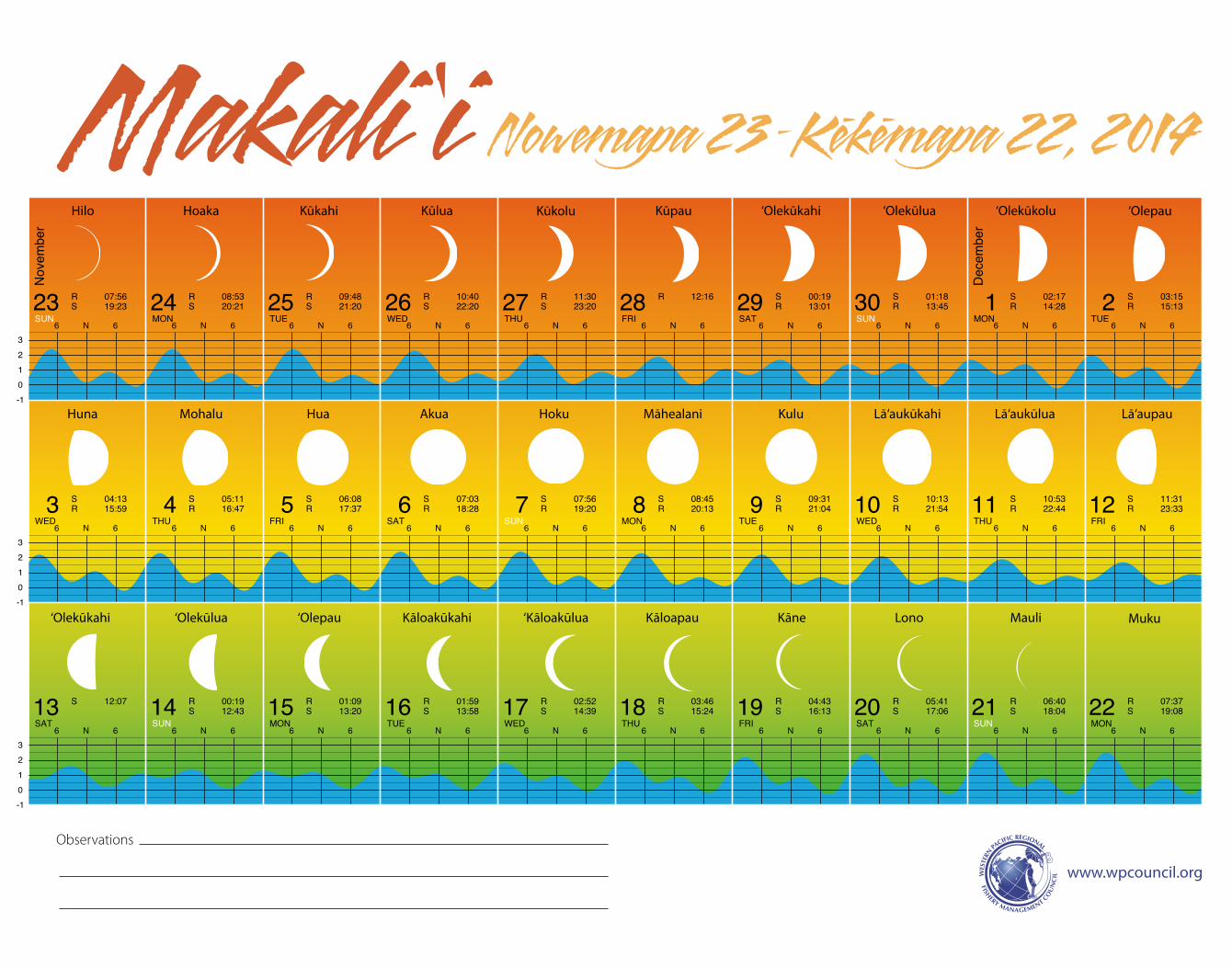
Nowemapa 23 –Kekemapa 22, 2014Makali ‘i
-10123
-10123
-10123
6 N 6 6 N 6 6 N 6 6 N 6 6 N 6 6 N 6 6 N 6 6 N 6 6 N 6 6 N 6
6 N 6 6 N 6 6 N 6 6 N 6 6 N 6 6 N 6 6 N 6 6 N 6 6 N 6 6 N 6
6 N 6 6 N 6 6 N 6 6 N 6 6 N 6 6 N 6 6 N 6 6 N 6 6 N 6 6 N 6
Hilo Hoaka Kūkahi Kūlua Kūkolu Kūpau ‘Olepau
Huna Mohalu Hua Akua Hoku Māhealani Kulu Lā‘aukūkahi Lā‘aukūlua Lā‘aupau
‘Olekūkahi ‘Olekūlua ‘Olepau Kāloakūkahi ‘Kāloakūlua Kāloapau Kāne Lono Mauli Muku
‘Olekūlua‘Olekūkahi ‘Olekūkolu
www.wpcouncil.org
Observations
C
M
Y
CM
MY
CY
CMY
K
12_LunarCal_Hawn2014_11x14_press.pdf 1 1/2/14 4:43 PM
Western Pacific Regional Fishery Management Council1164 Bishop Street, Suite 1400Honolulu, Hawai‘i 96813phone: (808) 522-8220Fax: (808) 522-8226Email: [email protected]: www.wpcouncil.org
A publication of the Western Pacific Regional Fishery Management Council pursuant to NOAA Award FNA12NMF4410217.
ISBN 978-1-937863-12-8
About the Kona Moku
“This area is subject to the cyclonic southerly (kona) storms in winter months, but through most of the year is cooled by trade winds sweeping through low gaps in the Ko‘olau range at the top of Moanalua, Kalihi, Nu uanu and Mānoa valleys. There were abundant rain, ever flowing streams, springs, pools, verdant interior valleys, broad slopes and well-watered lowlands, fishpond areas, harbors, beaches, and lagoons. Altogether Kona was, for O‘ahu, the area richest in natural resources and most pleasant for abundant and comfortable living.”
[Handy, ESC and EG Handy. 1978. Native Planters in Old Hawaii, Their Life, Lore and Environment. Honolulu: Bishop Museum Press.]
About the Western Pacific Regional Fishery Management Council
The Western Pacific Regional Fishery Management Council is a federal instrumentality created by Congress in 1976 to manage federal fisheries in Hawai‘i and other US Pacific Islands. The Council has worked with communities in Hawai‘i, American Samoa, Guam and the Commonwealth of the Northern Mariana Islands since 2006 to produce traditional lunar calendars to promote ecosystem-based fisheries management, support indigenous fishing and management practices, and enhance community involvement in the fisheries management decision-making process. If your moku is interested in working with the Council on a calendar, please contact us at [email protected].


