130
NPU-H Master Plan 2020 10.27.2020 Doctor’s Memorial Park (TSW, 2019) A Vision for Adamsville

1
NPU-H Master Plan
2020
10.27.2020Doctor’s Memorial Park (TSW, 2019)
A Vision for Adamsville

2
AcknowledgmentsTHANK YOU FOR SUPPORTING THIS PLAN!
STEERING COMMITTEERuth Lyles Bailey, NPU-HAlicia Boyard, Boulder Park Estates CommunityLamont Bynum, NPU-HVernelle Cowan, NPU-HKathy Crawford, NPU-HNoki Crew, NPU-HJoy Dixon, NPU-HPatricia Floyd, NPU-HDelores Lattimore, Carroll HeightsBarbara Leath, Boulder Park Civic CenterKhalifa Lee, NPU-HBarbara Miller, NPU-HLena Reed, ABCPHerman E. Sims, NPU-HErika Smith, Invest AtlantaJames Stembridge, NPU-HGreg Watson, NPU-H
TSWSarah McColley, Project ManagerWoody Giles, Planner
This master plan was conducted with NPU-H residents, Invest Atlanta staff, non-profit/community based organizations, business community representatives, and other local leaders.
Mural at Collier Park (TSW, 2019)
NPU-H CHAIRR.R. Harris, Current NPU-H ChairKathy Crawford, Former NPU-H Chair
MAYOR & CITY COUNCIL MEMBERSMayor Keisha Lance BottomsFelicia A. Moore, PresidentCarla Smith, District 1Amir R. Farokhi, District 2Antonio Brown, District 3Cleta Winslow, District 4Natalyn Mosby Archibong, District 5Jennifer N. Ide, District 6Howard Shook, District 7J.P. Matzigkeit, District 8Dustin R. Hillis, District 9Andrea L. Boone, District 10Marci Collier Overstreet, District 11Joyce Sheperd, District 12Michael Julian Bond, Post 1Matt Westmoreland, Post 2Andre Dickens, Post 3
CITY PLANNING DEPARTMENT Jessica Lavandier, Strategic Planning Assistant DirectorNate Hoelzel, Urban Planner IIIKeyetta Holmes, Director, Office of Zoning and DevelopmentSusan Coleman, Planner & NPU-H Planner

3
ContentsEXECUTIVE SUMMARYCHAPTER 1: EXISTING CONDITIONSLocation
Mapping
Demographics
Public Health
Previous Plans & Progress
CHAPTER 2: PUBLIC OUTREACHOutreach Process
Steering Committee
Public Kick-off Meeting
Survey Results
Design Workshop
Public Open House (2019)
Draft Plan Open House (2020)
CHAPTER 3: RECOMMENDATIONSVision and Goals
Framework Plan
Public Safety & Quality of Life
Potential Redevelopment Node Concept Plans
Typical Street Sections
CHAPTER 4: IMPLEMENTATIONPriority Projects
Proposed Future Land Use
Proactive Rezoning
Redevelopment Criteria
Long-Term Initiatives
APPENDIXCPTED Guidelines
Codes Violated
CDP Quality of Life Element Vote
NPU-H CDP Policies
41214
16
28
30
32
4850
54
56
58
62
64
65
6668
72
74
76
82
8486
87
94
100
104
110112
116
117
119

4
Executive SummaryNeighborhood Planning Unit H (NPU-H), located along the western boundary of the Atlanta city limits, features great access to major arterials such as Interstate 285, Interstate 20, Martin Luther King, Jr. (MLK, Jr.) Drive, Fulton Industrial Boulevard, Donald Lee Hollowell Parkway, and Fairburn Road. A CSX rail corridor crosses the southern part of the study area, Interstate I-20 bisects the study area, and I-285 serves as the eastern edge. Unincorporated Fulton County is to the west.
Residents of the 17 neighborhoods included in NPU-H have access to arts, entertainment, and culture, with the added benefit of living in an affordable area. Located approximately five (5) miles from downtown Atlanta, NPU-H is primarily served by the Hamilton E. Holmes MARTA Station (located approximately 1.5 miles east of the eastern boundary of NPU-H), and MARTA bus routes 73, 201, 850, 853, and 865.
Although NPU-H is close to many in-town neighborhoods including downtown, it is primarily auto-oriented and often unsafe for pedestrians and bicyclists. Streets tend to be curved and form cul-de-sacs, which makes accessibility to needed services and destinations difficult to access by foot or bike.

5
6
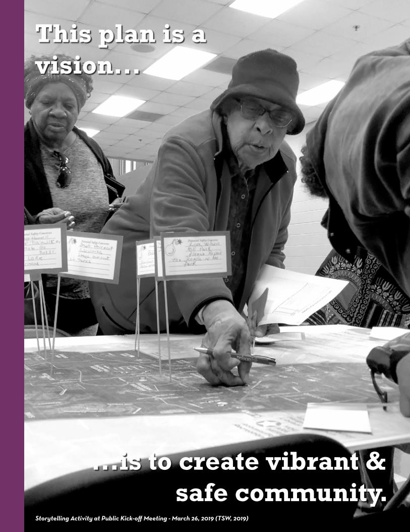
This plan is a vision...
...is to create vibrant & safe community.
Storytelling Activity at Public Kick-off Meeting - March 26, 2019 (TSW, 2019)

7
Project Purpose
Master Plan ChaptersFollowing the executive summary, this master plan contains four (4) chapters:
Existing ConditionsCommunity planning has been evident in NPU-H since 2004. In 2010, a group of concerned residents began addressing issues, concerns, and the need for an official document. In January 2017 contact was initiated with the Department of City Planning for NPU-H neighborhoods. The first official meeting with City Planning was held in June 2017. Aligning ongoing, recent, and past planning efforts that impact NPU-H and surrounding Atlanta neighborhoods was a critical component of initial planning efforts. Many planning efforts are in progress and many projects are being implemented that directly affect the neighborhoods in NPU-H.
The Planning Team examined existing conditions, including demographics, land use and zoning, and development patterns. The analysis established a baseline understanding that informed how the Planning Team approached the public engagement process and the concept plans and policy recommendations. The Team also mapped and analyzed transportation connectivity, community assets, environmental conditions, crime statistics, and building code complaints.
Community Engagement In preparing this plan, the Planning Team reached out to the NPU-H community in a variety of ways, including online, through the mail, surveys, and in-person public meetings. The plan reflects
This Master Plan is first and foremost a collective vision for the future of NPU-H’s neighborhoods. It is also a strategy for its residents, property owners, stakeholders, and businesses to spur growth and development. The plan of action is to preserve and protect the quality of life while promoting growth in appropriate areas by building on the community’s existing assets, and identifying catalytic sites and projects that will encourage redevelopment
a the shared community vision guided by a steering committee.
RecommendationsRecommendations include lighting and code enforcement, streetscape changes, and concept plans for three redevelopment nodes: Bolton Road, MLK, Jr. Drive and Fairburn Road (Adamsville Village), and Benjamin E. Mays Drive and Fairburn Road.
ImplementationThe Implementation Chapter proposes future changes to land use and zoning along with a set of criteria for redevelopment. A defining feature of this Master Plan that sets it apart from past planning efforts, is that it empowers community members of NPU-H to use the criteria when evaluating development proposals in their neighborhoods.
in the future, all by utilizing an action plan and implementation strategy. The plan expands on the community’s history and existing character by:
• Building on previous planning efforts;
• Developing a vision that guides growth and development for the 17 neighborhoods within NPU-H;
• Identifying a set of goals that the NPU-H community can strive towards;
• Illustrating ways to implement the vision and goals;
• Proposing a list of new policies and future projects that align with the overall vision and goals of this plan; and
• Establishing equitable programs and facilities to create economic sustainability for community members;
8
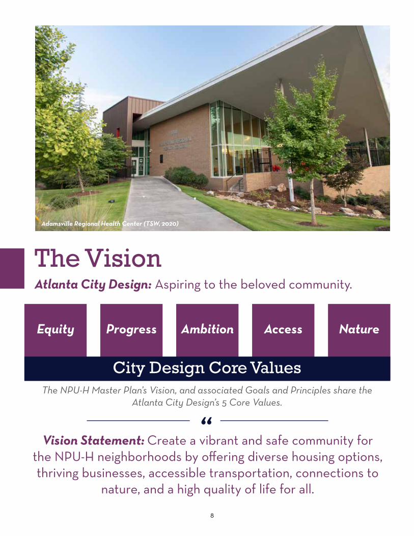
“Vision Statement: Create a vibrant and safe community for
the NPU-H neighborhoods by offering diverse housing options, thriving businesses, accessible transportation, connections to
nature, and a high quality of life for all.
The VisionAtlanta City Design: Aspiring to the beloved community.
Equity
City Design Core Values
Progress Ambition Access Nature
The NPU-H Master Plan’s Vision, and associated Goals and Principles share the Atlanta City Design’s 5 Core Values.
Adamsville Regional Health Center (TSW, 2020)

9
NPU-H Goals & PrinciplesCreate a high quality of life for all residents
Focus redevelopment on priority vacant properties and abandoned structures
Promote inclusiveness for all people
Improve the cleanliness and appearance of properties, streets, and parks
Improve mobility by investing in existing infrastructure, increasing safety and security of transportation modes, and expanding transportation options.
1. Engage local educational partnerships with community organizations, non-profits, and recreation centers to increase the quality of education for people of all ages
2. Encourage developers to provide usable green space in all redevelopment and use green infrastructure where possible
3. Attract a diversity of businesses that meet the needs of the community, including daily needs shopping and a variety of restaurants
4. Increase access to healthy, fresh food through redevelopment, community partnerships, and urban food gardens
5. Take a proactive stance on public health and mitigate the negative impacts of industries on Fulton Industrial Boulevard
6. Maintain parks and offer programming for residents of all ages
1. Implement strategic rezoning that benefits residents and meets the goals set forth in this plan
2. Determine development criteria for priority redevelopment sites 3. Promote redevelopment of key commercial nodes and aging
apartment complexes4. Minimize flooding by maintaining natural terrain and using best
practices for stormwater management
1. Foster aging in place through design and policy recommendations2. Increase the rate of homeownership in the community3. Promote awareness of existing and future homeownership programs
and bill assistance programs4. Promote home rehabilitation programs and alternative energy
sources to mitigate the cost of living for current homeowners5. Engage renters in the community and encourage them to stay6. Preserve naturally occurring / subsidized affordable housing units7. Preserve the character of the single-family areas
1. Enforce zoning, building codes, and public safety 2. Prevent dumping of trash, illegal parking, and illegal land uses3. Improve City of Atlanta responsiveness to code violations4. Establish community clean-up initiatives 5. Promote community pride and ownership
1. Integrate the Martin Luther King, Jr. Drive and Fairburn Road corridor projects into this plan
2. Slow traffic and make major corridors walkable and safe3. Promote walkability by expanding the network of safe sidewalks4. Add street lighting to low lit areas5. Improve access to existing parks for all modes of transportation
1
2
3
4
5

A Roadmap to Use these Recommendations
Framework PlanCallout potential redevelopment sites & priority corridors
FROM VISION
Node 1: Bolton Road
Node 2: Adamsville Village
Node 3: Benjamin E. Mays & Fairburn Road
Exa
mp
le C
once
pt P
lan
s th
at S
up
por
t th
e V
isio
n
(Pag
es 7
6 to
81)
NPU-H
Strategic Future Land Use Changes
&Proactive Re-zoning
on Key Properties
10
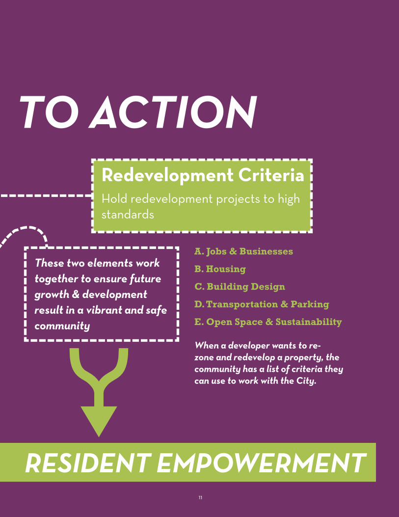
Redevelopment CriteriaHold redevelopment projects to high standards
These two elements work together to ensure future growth & development result in a vibrant and safe community
A. Jobs & Businesses
B. Housing
C. Building Design
D. Transportation & Parking
E. Open Space & Sustainability
When a developer wants to re-zone and redevelop a property, the community has a list of criteria they can use to work with the City.
RESIDENT EMPOWERMENT
TO ACTION
11

12
Existing Conditions
Cascade Family Skating on MLK, Jr. Drive at I-285 (TSW, 2019)

13
Chapter 1Location
Mapping
Demographics
Public Health
Previous Plans & Progress

14
Neighborhood Planning Unit H (NPU-H) is located on the western edge of the City of Atlanta and made up of 4,058 acres. It is bound to the north by Donald Lee (D.L.) Hollowell Parkway / Highway 278, the Fulton Industrial District of unincorporated Fulton County to the west, the City of South Fulton to the south and Interstate 285 to the east. It is approximately five miles from downtown Atlanta. Most of NPU-H is in City Council District 10, but the northern tip is in Council District 9. NPU-H is comprised of primarily residential neighborhoods with the Martin Luther King, Jr. (MLK, Jr.) Drive
Caption (Right): Fulton Industrial Boulevard and the uses along it were identified as potential health hazards for res-idents of NPU-H; however, the area serves as an important employment and industrial center.
Caption (Below): Streets wind throughout the study area and many do not have sidewalks on both sides.
commercial corridor running east / west, an industrial and a mixed residential commercial area in the north and a commercial/
employment area at the intersection of Fairburn Road and Benjamin E. Mays Drive.
Location
UPS Customer Center (TSW, 2019)
Fairburn Road (TSW, 2019)

15
UPS Customer Center (TSW, 2019)

16
NPU-H covers parts of northwest and southwest Atlanta, where there are 17 official City of Atlanta neighborhoods within its borders. Each neighborhood has a unique offering, and single- family residential neighborhoods and multi-family communities are dispersed throughout the area. Many of the homes were constructed after World War II, but some new residential developments have been built in recent decades. Retail uses are focused in Adamsville around Fairburn Road, Fairburn-Mays at Fairburn Road, and Bankhead Bolton at Bolton Road. Industrial uses are located on Fulton Industrial Boulevard west of NPU-H’s borders.
The early history of this area was closely tied to the roads that led from ferries and bridges at the Chattahoochee River to downtown Atlanta. The Adamsville community grew up around the junction of these
roads and most likely served as a community center for the surrounding land area. The land area that is now called Adamsville was called the Lick Skillet Settlement during the Civil War (1861-1864). It may have been so named when the area was in Dekalb County. In 1853, western land lots of Dekalb County became Fulton County. Prior to that, land lots were issued to white farmers and planters who were qualified through several Georgia Land Lottery Acts. The people who settled in the Lick Skillet area came from Franklin County, Georgia, South Carolina, North Carolina, and Alabama. Eventually the ethnicities of a mixture of people were in the area: white descendants of European immigrants, Creek Indians, and enslaved Blacks. The Lick Skillet name faded away due to the change in the ethnic climate and governance. Planters and slaveholders died. Land was sold or auctioned. One source
Neighborhoods
indicates that after the Civil War ended, Adamsville became a common referenced title for the area and by 1906 the official name became Adamsville. The community name changed to Adamsville in 1870, one year after the founding of the Adams Lodge, a Masonic organization organized by George W. Adams. In 1871, Adams deeded the property with a two-story house to the Adamsville Lodge Number 171 for meeting purposes.
An 1883 Fulton County map indicates “Adamsville as a Militia District” (George Cram Map housed at the Digital Library of Georgia and GeorgiaInfo.com). Franklin M. Garrett in his book Atlanta and Environ: A Chronical of Its People and Events, Volume I lists Adamsville, Sandtown, and other familiar name places as a ‘District’ for elections and collecting taxes.
Important PlacesCommunity institutions were built throughout the area. First Saint John Missionary Baptist Church, which was organized as Saint John Baptist Church in 1883, is still located on Fairburn Road. However, the present church building was constructed in 1972. Fain Elementary School is apparently the descendant of Hemphill School, which is shown on an 1893 map of Fulton County. Fain Elementary School, built in 1927, is named for Margaret Fain, whose family resided in this area for many years. In 1930, the population of the Adamsville District was 1,176, reflecting a rather sparse settlement.
Sign at G.A. Towns Elementary School (TSW, 2019)

17
Bakers Ferry
Old Gordon
Oakcliff
Adamsville
Wisteria Gardens
Mays
Fairburn Road / Wisteria Lane
Fairburn Mays
Bankhead/Bolton
Bankhead Courts
Ridgecrest Forest
Boulder Park
Baker Hills
Carroll Heights
Fairburn Heights
Wilson Mill Meadows
Wildwood
In the 1950’s and early 1960’s development reached West Atlanta. This growth is reflected in the number of subdivisions, commercial outlets, and schools built at the time. The initial phase of the Boulder Park subdivision was platted in 1951. In 1958, Carroll Heights, Fairburn Heights, and other subdivisions were planned.
Collier Heights Plaza was developed in Adamsville in the early 1960’s to accommodate the growing residential community. Schools were also constructed to serve the increased school age population. G.A. Towns Elementary (1935), Harper High School (1963), Miles Elementary, and Adamsville Elementary are named for distinguished graduates of colleges in the Atlanta University Center Complex: George Towns (1870-1861) Charles Lincoln Harper (1877-1966) Leonora P. Miles (1872-1973). Interstates 20 and 285 were also constructed during the 1960s. Although Atlanta Public Schools is in the process of a facilities planning effort (pages 18-19) and schools in NPU-H have been affected, many residents made it clear during the public engagement process that these schools, including Margaret Fain Elementary and G.A. Towns Elementary, should be repurposed because of their significance to the neighborhoods.
In 1973 during the first Mayoral Administration of Maynard H. Jackson, Adamsville” became the name of a City of Atlanta Neighborhood in the
Neighborhood Planning Unit-H land area or geography. The State of Georgia Department of Transportation recognizes the historical significance of the ‘Adamsville’ name place because it appears on the Exit 9 sign of I-285.”
The remains of the Judge William Wilson House and site, which was located at 501 Fairburn Road SW, were demolished in December 2015, according to the Atlanta Preservation Center. The original plan was to preserve the remains
of the antebellum home as a historic garden. NPU-H residents noted that a grave site of enslaved people may still remain, which should be preserved and noted for the history. This recommendation is listed in the Long-Term Initiatives in Chapter 4 as a project to undertake with the Urban Design Commission and Historic Preservation Studio.

18
Community FacilitiesParksThere are 110 acres of parks and usable open space in NPU-H. Although the spaces are not easily accessible by walking and biking, many are beautiful forested areas with designated parking. Approximately 133 people are served per park acre in NPU-H versus 93 people per park acre in the city of Atlanta (Trust for Public Land). This means residents in NPU-H do not have the same access to parks as most Atlantans.
• Adamsville Gym Park is a 0.8-acre neighborhood park adjacent to the Old Adamsville Recreation Center in the Adamsville neighborhood.
• Adamsville Triangle is a 0.05-acre greenspot at the intersections of Fairburn/MLK, Jr. Dr./Bakers Ferry Road in the Adamsville neighborhood.
• Collier Park is a mostly forested 16-acre community park in Fairburn Heights. It has the Collier Park Recreation Center, a ball field, tennis courts, and a recreation building,
• Wilson Mill Park is a 35.5-acre neighborhood park on Wilson Mill Road in the Fairburn Road/Wisteria Lane neighborhood. It has ball fields, basketball and tennis courts, and a playground.
• The Doctor’s Memorial Park, dedicated in 2016, is a 2-acre park in Fairburn Mays.
• Herbert Green Nature Preserve is 56 acres in the Boulder Park neighborhood. The forested and creek area is shared by the Department of Parks and Recreation, the Department of Watershed Management because of the Utoy Creek basin that flows to the Chattahoochee River. Park Pride worked with the community to develop a Vision Plan in 2009. Although there is a parking area, there are no facilities, so walking and hiking only are recommended.
• Old Adamsville Recreation Center: The Office of Recreation provides senior programs, including physical fitness, social networking, arts & crafts, and educational seminars. In addition, it is used as a warming center and emergency shelter as needed.
Public Safety• Atlanta Fire Rescue Fire
Station 9, provides fire and emergency services.
• Atlanta Police- NPU-H is served by two police zones. Zone 1 covers the area north of MLK, Jr. Drive and Zone 4 is south of MLK, Jr. Dr.
Fulton County• Adamsville-Collier Heights
Atlanta Fulton County Library is located in the Adamsville neighborhood.
• Adamsville Regional Health Center is located in the
Adamsville neighborhood. The Fulton County Board of Health provides Women, Infants and Children (WIC) Nutrition Program as well as nursing services and a Communicable Disease Clinic.
• Harriett G. Darnell Senior Multipurpose Facility in the Fairburn Heights neighborhood, is operated by the Fulton County Department of Senior Service. It provides life enrichment classes, nutrition, education, fitness, leisure and other activities for active adults age 55 and older.
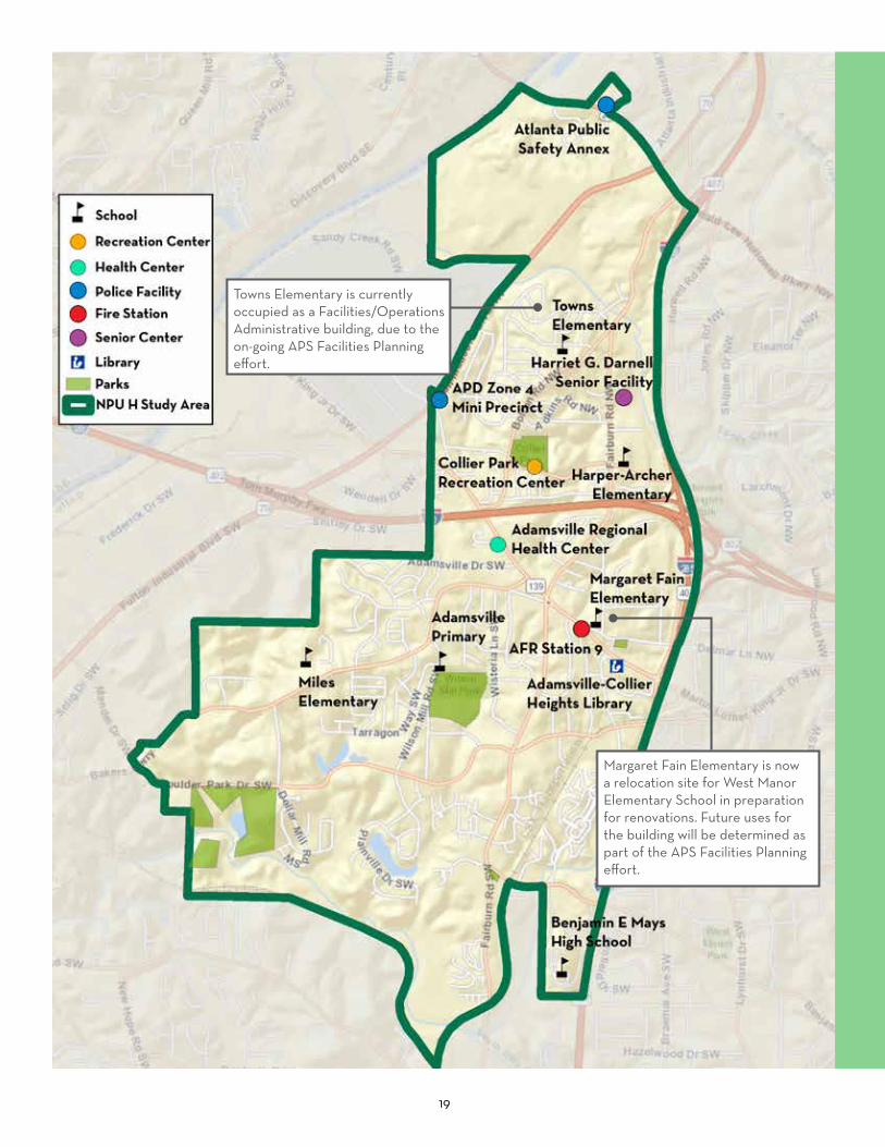
Atlanta Public SchoolsNPU-H is in both the Mays and Douglass Clusters. In 2017-2018 and during this process, APS was closing and consolidating schools, some of which were located in NPU-H: Fain, Adamsville, and Towns Elementary Schools.
• Benjamin E. Mays Cluster, located south on MLK Jr. Dr., has an International Baccalaureate (IB) program. Benjamin E. Mays High School, Miles Intermediate, and Kindezi West Lake are in NPU-H.
• The Douglass Cluster, located north of MLK Jr. Dr., has a Science, Engineering, Technology and Math (STEM) focus. Harper-Archer Elementary and KIPP Soul High School are in NPU-H.
19
Towns Elementary is currently occupied as a Facilities/Operations Administrative building, due to the on-going APS Facilities Planning effort.
Margaret Fain Elementary is now a relocation site for West Manor Elementary School in preparation for renovations. Future uses for the building will be determined as part of the APS Facilities Planning effort.

20
Future Land UseThe map to the right shows the City of Atlanta’s official Future Land Use (FLU) in NPU-H, which is part of the Comprehensive Development Plan (CDP). The residential portions of the NPU-H neighborhoods predominantly have Single-Family residential land use designations, and a portion of the Fairburn Mays neighborhood at the southern end of NPU-H has a Low-Density Residential land use designation. Atlanta Public Schools and other public facilities have a Community Facility land use designation, and City of Atlanta Parks have an Open Space land use designation. Three areas in NPU-H have a mix of uses: D.L. Hollowell Parkway at Fulton Industrial Boulevard / Bolton Road, the MLK, Jr. Dr. corridor, and the Benjamin E. Mays Drive and Fairburn Road node.
D.L. Hollowell Parkway at Fulton Industrial Boulevard / Bolton Road and I-285 are at the northern end of the Fulton Industrial District and near the Atlanta Industrial District. This area is dominated by Industrial land uses and commercial uses fronting D.L. Hollowell Parkway. High- and Medium-Density Residential uses are adjacent to these and provide a transition to the Single Family Residential.
The MLK, Jr. Drive corridor between I-285 and 1-20 has a large concentration of Mixed-Use and Office-Institutional land uses.
On either side of I-20 at Fulton Industrial Boulevard, the land use is Medium-Density and Low-Density Commercial.
The Benjamin E. Mays Drive and Fairburn Road node has Office-Institutional, Low-Density
Commercial, and Medium-Density Residential land uses. A small area of Industrial is located adjacent to the rail corridor.
Caption: A variety of land uses with different types of buildings are distributed throughout the NPU.
Margaret Fain Elementary on Hemphill School Road (TSW, 2019)
New Housing Example (TSW, 2019)Jackson Memorial Baptist Church in Fairburn Heights (TSW, 2019)

21

22
Existing ZoningThe zoning classifications of most parcels in NPU-H mirror the land use designations. Most of the parcels have conventional zoning, and some that have been recently rezoned have “Quality of Life” zoning districts. Most of the single-family sections of neighborhoods have Single-Family Residential zoning (R-3 and R-4). There are small areas Planned Development Housing (PDH) and Two-Family zoning (R-5).
D.L. Hollowell Parkway at Fulton Industrial Boulevard / Bolton Road and I-285 has Industrial (I-1 and I-2) zoning districts with Commercial zoning (C-1, C-2 and MRC-2) fronting on D.L. Hollowell Parkway. This transitions to multi-family residential (RG-2, RG-3, MR-2, MR-3 and MR-4B) to the south.
The MLK, Jr. Dr. corridor between I-285 and 1-20 has commercial zoning (RL-C, and C-1). On either side of I-20 the parcels have Multi-Family Residential zoning (RG-3) and Low-Density Commercial (C-1) and Industrial zoning (I-1) at the intersection with Fulton Industrial Boulevard.
The Benjamin E. Mays Drive and Fairburn Road node near Doctor’s Memorial Park has an Office-Institutional zoning and adjacent parcels have Commercial (C-1) zoning. The area around it has some multi-family zoning (RG-2 and RG-3) with a small area of
Industrial (I-1) zoning adjacent to the rail line.
Chapter 4 makes recommendations to update the City’s Future Land Use (FLU) Map to meet the vision established in this Master Plan and better align the zoning classifications
Caption: (Top) Multi-family senior housing communities are located throughout NPU-H. This one is located on MLK, Jr. Drive near Fairburn Road. (Bottom) Commercial buildings in NPU-H are typically set far from the street with parking in front.
with the land use in three priority redevelopment nodes. Some parcels are identified for the City to proactively rezone. All of the others with recommended changes on the FLU map also have a recommended zoning classification where needed.
Adamsville Green Senior Apartments on MLK, Jr. Drive (TSW, 2019)
Family Dollar on MLK, Jr. Drive (TSW, 2019)

23

24
TransportationNPU-H has a primarily auto-oriented development pattern. It is bisected by I-20 and contains high-volume arterials and truck routes, including Fulton Industrial Boulevard (S.R. 70), D.L. Hollowell Parkway (U.S. 78), and MLK, Jr. Drive (S.R. 139). Branching off from the arterials are collectors connecting to local streets owned by the City. Local, residential streets tend to be curved and form cul-de-sacs, rather than a grid pattern. A CSX rail corridor crosses the southern part of the study area, and Fulton County Brown Field, a general aviation airport, is adjacent to NPU-H in unincorporated Fulton County.
NPU-H is served by MARTA bus routes 73, 201, 850, 853, and 865. Commuter buses travel along I-20 with CobbLinc and GRTA Express operating Monday through Friday with service to Downtown. The nearest MARTA rail station is the Hamilton E. Holmes station, located about 1.5 miles east of the eastern boundary of NPU-H (I-285).
Benjamin E. Mays Drive is a designated bike route, and sidewalks are located on portions of some roads, but many lack sidewalks on both sides. Fairburn Road was identified as a “High Injury Network,” which are roadway segments where investments in safety improvements can reduce fatal and injury crashes. Fairburn Road connects most of NPU-H and includes multiple nodes and development types. More information is on page 82.
Traffic and Sidewalk Conditions on MLK, Jr. Drive (TSW, 2019)
Traffic and Sidewalk Conditions on MLK, Jr. Drive (TSW, 2019)
Typical MARTA Bus Stop (TSW, 2019)

25

26
Public Safety & Quality of LifeQuality of Life and Code EnforcementThe map shows a prevalence of building code complaints in NPU-H. Some buildings have been demolished due to code complaints and violations, including 940, 950, and 1020 Bolton Road, 114 and 184 Hemphill School Road, 740 Amber Place, and 4010 and 4014 Boulder Park Drive. Many locations, noted in dark red on the map, are identified as “Highly Hazardous Conditions,” which means the buildings are vacant, open and unsecured, or are dilapidated, decayed, unsafe, unsanitary, or pose an unreasonable risk to public health. Many of these properties are located along Fairburn Road and Bolton Road.
NPU-H residents identified some of the quality of life code violations that occur regularly, often on the same properties (listed below), including parking violations, tree removal, using a residential property for a business, and tenant-landlord lease issues where the landlord is unaware the tenant is conducting a business on the property. For many issues, residents do not know who to call. Specific codes are listed in the appendix.
• Parking on the front lawn
• Parking junk vehicles in a driveway with no tag
• Never moving a vehicle parked in driveway
2018 Building Code Complaints in NPU-H
• Parking vehicles on public streets indefinitely
• Using the sidewalk area as a parking area at the same time parking on the street.
• Fences/walls exceeding maximum height in residential
and commercial districts
• Illegal signs including portable signs, flags, banners, balloons
• Parking of large commercial vehicles on residential property
27
• Parking vehicles in the required front yard or lawn
• Operating retail sales from residential property
• Auto repair shop on residential property and on residential public streets
• Building a room addition too close to neighbor’s property
• Illegal rooming house
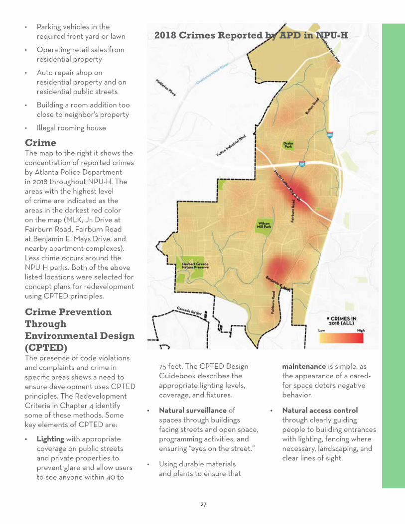
CrimeThe map to the right it shows the concentration of reported crimes by Atlanta Police Department in 2018 throughout NPU-H. The areas with the highest level of crime are indicated as the areas in the darkest red color on the map (MLK, Jr. Drive at Fairburn Road, Fairburn Road at Benjamin E. Mays Drive, and nearby apartment complexes). Less crime occurs around the NPU-H parks. Both of the above listed locations were selected for concept plans for redevelopment using CPTED principles.
Crime Prevention Through Environmental Design (CPTED)The presence of code violations and complaints and crime in specific areas shows a need to ensure development uses CPTED principles. The Redevelopment Criteria in Chapter 4 identify some of these methods. Some key elements of CPTED are:
• Lighting with appropriate coverage on public streets and private properties to prevent glare and allow users to see anyone within 40 to
75 feet. The CPTED Design Guidebook describes the appropriate lighting levels, coverage, and fixtures.
• Natural surveillance of spaces through buildings facing streets and open space, programming activities, and ensuring “eyes on the street.”
• Using durable materials and plants to ensure that
2018 Crimes Reported by APD in NPU-H
maintenance is simple, as the appearance of a cared-for space deters negative behavior.
• Natural access control through clearly guiding people to building entrances with lighting, fencing where necessary, landscaping, and clear lines of sight.
28
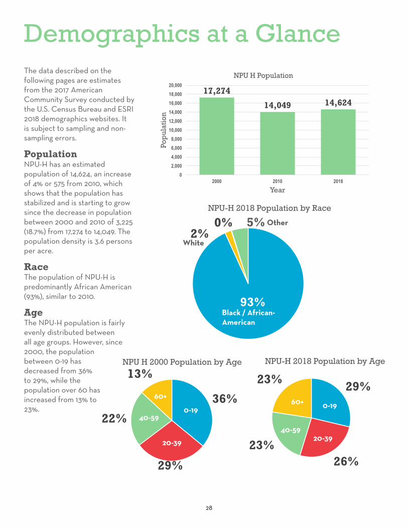
Demographics at a GlanceThe data described on the following pages are estimates from the 2017 American Community Survey conducted by the U.S. Census Bureau and ESRI 2018 demographics websites. It is subject to sampling and non-sampling errors.
PopulationNPU-H has an estimated population of 14,624, an increase of 4% or 575 from 2010, which shows that the population has stabilized and is starting to grow since the decrease in population between 2000 and 2010 of 3,225 (18.7%) from 17,274 to 14,049. The population density is 3.6 persons per acre.
RaceThe population of NPU-H is predominantly African American (93%), similar to 2010.
AgeThe NPU-H population is fairly evenly distributed between all age groups. However, since 2000, the population between 0-19 has decreased from 36% to 29%, while the population over 60 has increased from 13% to 23%.
17,274
14,049 14,624
02,0004,0006,0008,000
10,00012,00014,00016,00018,00020,000
2000 2010 2018
Pop
ulat
ion
Year
NPU H Population
29%
26%23%
23%
NPU-H 2018 Population by Age
0-19
20-39
40-59
60+
0-19
20-3940-59
60+36%
29%
22%
13%NPU H 2000 Population by Age
0-19
20-39
40-59
60+
0-19
20-39
40-59
60+
93%
2%0% 5%
NPU-H 2018 Population by Race
African American
White
Asian
Other
Black / African-American
White
Other

29
HousingThere are approximately 6,550 housing units in NPU-H, an increase of 173 units (2%) since 2000. Most of the housing units (55%) are single-family homes. Approximately 85% are occupied, leaving 15% of units vacant, similar to 2010. According to the Census, a third of the homes were built in the 1960s.
Housing TenureMost housing units are renter-occupied 60% and 40% are owner-occupied. The percentage of renter-occupied housing has increased from 53% in 2010 to 60% in 2018. The median home value is $116,369 and increase from $107,362 in 2012.
IncomeThe average per capita income in NPU-H is $14,100, a slight increase from $13,424 from 2012. The poverty rate is 32.94%, a slight decrease from 33.6%.
Household SizeThe number of people in each household has been decreasing since 2000 from 2.87 persons per household to 2.23 in 2018. This decrease is household size is consistent with the decrease in the number of people 0-19.
EmploymentEmployment in NPU-H is spread throughout many sectors, but the largest employment bases are Health Care / Social Assistance (14%), Retail Trade (17%), Transportation / Warehousing (11%), Admin / Support (11%).
5%6% 2%
17%
11%
2%2%2%2%
11%
14%
6%
1%
12%
3%4%
NPU-H Employment Construction
Manufacturing
Wholesale Trade
Retail Trade
Transportation/Warehousing
Information
Finance/Insurance
Real Estate/Rental/Leasing
Professional/Scientific
Admin/Support
Health Care/SocialAssistanceEducational Services
Arts/Entertainment
Accommodation/FoodServices
40%
60%
NPU -H 2018 Housing Tenure
OwnerOccupied
Renter-Occupied
Owner-Occupied
48%53%
NPU-H 2010 Housing Tenure
Owner Occupied
Renter Occupied
Renter-Occupied
Owner-Occupied
83.70% 84.78%
16.30%
50.00%
60.00%
70.00%
80.00%
90.00%
100.00%
2010 2018
Housing Occupancy
Occupied Vacant
15.24%

30
Public HealthThe information in this section is provided by the Center for Disease Control and Prevention’s 500 Cities Program. This section will discuss trends that appear to be present within the data. NPU-H’s residents are primarily over the age of 35, which means that they are more susceptible to certain types of diseases than areas of the City with a lower average age.
Sleep Patterns & Mental HealthA large proportion of NPU-H receive less than 7 hours of sleep pet night. Sleep deprivation can lead to increased mental health disorders, as well as increasing the risk of high blood pressure, heart disease, obesity, and
diabetes (National Institute of Health). Sleep deprivation is likely to be at play, at least partially, for some health data for the community. The community has a higher rate of mental health issues than most of the City, one of the highest obesity rates, and one of the highest rates of diagnosed diabetes in adults. A high percentage of the residents report having no leisure time. Lack of exercise and sleep deprivation, in combination with obesity, is likely to contribute to the community’s high rate of diabetes.
Chronic DiseaseNPU-H has very high prevalence of high blood pressure, and a large percentage of the community takes blood pressure
medication. There is also a high rate of coronary heart disease compared to the rest of Atlanta. This correlates with the higher cholesterol rates, smoking rates, diabetes, obesity, and lack of physical activity; all are risk factors for coronary heart disease. The community has higher levels of chronic kidney disease (CKD), which makes sense, as diabetes, high blood pressure, and heart disease are leading causes to CKD development (National Institute of Health).
Stroke is also highly prevalent in the community, with some of the highest rates in the city. Strokes are typically caused by high blood pressure and smoking. Strokes occur more
Fulton Industrial Boulevard has many car lanes and narrow, unsafe sidewalks (TSW, 2019)

31
often in African American, Alaska Native, and American Indian adults than in white, Hispanic, or Asian American adults (National Institute of Health).
HabitsBinge drinking is very low in this community, but smoking rates are moderate, and in some neighborhoods high. Chronic obstructive pulmonary disease rates are high throughout NPU-H. The leading risk factor for this disease is smoking, and other factors that can lead to this disease include air pollution, chemical fumes, and dusts (National Institutes of Health). Air pollution, chemical fumes, and dust could be prevalent in NPU-H because of the proximity to Fulton Industrial Boulevard and the Atlanta Industrial Park. Asthma prevalence in this community is high for the City of Atlanta, which could be partially due to the higher smoking rates and the location of the NPU, adjacent to two major interstates, traffic arterials, and truck routes.
NPU-H showed fairly high levels of high cholesterol and moderate levels of cancer compared to the rest of Atlanta. NPU-H showed higher levels of arthritis, potentially because more than one-fourth of the population is over 50 years old.
The community also showed high rates of residents with all teeth lost, which correlates with the low percentage of individuals attending dentist appointments.
Potential ContributorsMany of these health conditions could arise from aging individuals
and a lack of access to health insurance, but the proximity to interstates, Fulton Industrial Boulevard, and MLK, Jr. Drive likely contribute to health issues.
At this time, many healthcare centers are located in NPU-H, including Adamsville Regional Health Center, Fulton County Resource Center, Emory Dialysis Center, and the Atlanta Medical Research Center. Although a high percentage of individuals are receiving routine check-ups, many citizens are not receiving clinical preventative services, including flu shots, pneumococcal shots, colorectal cancer screening, and mammograms. Other preventative services that residents are not receiving as often include fecal occult blood tests, sigmoidoscopies, colonoscopies, and papanicolaou smears. However, this community does receive higher rates of cholesterol screening, likely due to community history.
2010 NPU-H Health & Environment SurveyNPU-H conducted a community-based environmental health assessment in order to create a profile of the community’s environmental health status. The proximity to truck routes, the Fulton Industrial District, and the high rate of asthma increased NPU-H residents’ awareness and concern for health. NPU-H presented information about air, water, personal health, violence prevention, safety, litter, and more at 14 events between February and May 2010. NPU-H also conducted a Health and Environment survey
with questions about health and disease, transportation and walking, traffic, pollution, safety, healthcare facilities, quality of life, and the environment. A total of 911 surveys were completed. 538 of these were from zip code 30331, which is located in NPU-H. Some of the survey results were:
• 274 respondents in 30331 indicated that having sidewalks was of the highest importance;
• 391 respondents in 30331 indicated that having a hospital was of the highest importance, and 292 respondents in 30331 said that having a medical clinic was moderately important;
• 371 respondents indicated that potholes were of high importance;
• 279 respondents indicated that having a recreation center nearby was of the highest importance;
• 224 respondents in 30331 indicated that having a senior assisted facility in 30331 was moderately important;
• 347 respondents indicated that littering / dumping was of the highest importance to address; and
• 254 respondents indicated that maintenance of vacant property was moderately important.
The original documentation for this survey is included in the appendix.

32
Previous Plans & Projects
1 13
2 14
315
4 16
517
618
7
198
209
21
10
22
11
23
24
25
26
27
28
29
Ongoing NPU-H Master Planning + Community Engagement, NPU-H
2020 Chattahoochee Riverlands, City of Atlanta, Atlanta Regional Commission
2018 Atlanta’s Transportation Plan, City of Atlanta
2018 Urban Ecology Framework, City of Atlanta
2018 Envision: ATL Parks + Recreation Comprehensive Plan, City of Atlanta
2018 More MARTA Atlanta, MARTA + City of Atlanta
2017 Atlanta City Design: Aspiring to the Beloved Community, City of Atlanta
2017 Resilient Atlanta: Actions to Build an Equitable Future, City of Atlanta
2017 Vision 2022: Live. Work. Thrive., Atlanta Housing Authority
2017 Creating New Connections, Invest Atlanta
2017 Utoy, Sandy, + Camp Watershed Improvement Plan, City of Atlanta
2016 Comprehensive Development Plan, City of Atlanta
2016 Capital Improvements Program + Community Work Program, City of Atlanta
2016 Atlanta Community Engagement Playbook, City of Atlanta
2015 Cargo Atlanta: A Citywide Freight Study, City of Atlanta
2015 Atlanta’s 2015-2019 Consolidated Plan, City of Atlanta
2014 Assessing Urban Tree Canopy: A Baseline Canopy Study, City of Atlanta
2013 Creating Linkages + Eliminating Barriers: The Strategic Community Investment Report, City of Atlanta
2011 NPU-G Community Master Plan, City of Atlanta + Georgia Conservancy
2010/2013 Fulton Industrial Blvd Redevelopment Framework + Fulton Industrial CID Master Plan, Fulton County
2010 D.L. Hollowell Parkway/Veterans Memorial Hwy LCI Study, City of Atlanta, Cobb County + Atlanta Regional Commission
2009 The Herbert Greens Nature Preserve: A Conceptual Vision, Park Pride
2006 Collier Heights Conceptual Park Master Plan, Park Pride
2009 Atlanta’s Project Greenspace, City of Atlanta
2007 Westside Atlanta: Blueprints for Successful Communities, Georgia Conservancy
2006-2013 Hollowell/MLK Redevelopment Plan + Tax Allocation District, Invest Atlanta
2005 MLK Jr. Drive Corridor Transportation Study, City of Atlanta
2004 NPU-H/Adamsville Community Comprehensive Development Plan, NPU-H
2004 Donald L. Hollowell Parkway Redevelopment Plan, City of Atlanta
2001 City of Atlanta Public Art Master Plan
2000 Northwest Atlanta Framework Plan, City of Atlanta
Many previous planning efforts have been completed, which will affect the NPU-H neighborhoods. An extensive analysis was done to assure that this Master Plan reflects the main themes and recommendations found throughout the plans. Below is a list of these plans and projects.
30
31
12

3333

34
Previous Plans & ProjectsNPU-H Master Planning and Community EngagementNPU-H has been engaging the community in a variety of ways and started a master planning process in 2010. These activities are documented in a file shared with the City planning staff. Activities include a Neighborhood Nexus grant (2012); health and environmental survey (2010) described on pages 30-31; the community dialogue event in 2004 (as well as the Herbert Greene study); Georgia Conservancy 2008 Blueprints Workshop; and visioning for the I-285 and MLK interchange with the Atlanta Business and Community Partnership in 2010.
Chattahoochee RiverlandsChattahoochee RiverLands (2020) is a vision for a 100-mile public realm between Buford Dam at Lake Lanier to Chattahoochee Bend State Park. It was developed between 2018-2020 by the City of Atlanta, Cobb County, Trust for Public Land, Atlanta Regional Commission (ARC) and countless community members. The highlight of this new public place is a continuous paved greenway that follows the Chattahoochee River as it goes through 19 cities, including the entire 7-mile riverbank of Atlanta. The Chattahoochee RiverLands vision is to bring people to the river. Tributary trails will connect the main greenway to regional trails (e.g., Silver Comet and Atlanta
BeltLine) as well as nearby neighborhoods and streams, including NPU-H’s neighborhoods and Utoy and Sandy Creeks. In addition to promoting a safe and connected corridor with more river access, the RiverLands emphasizes ecological restoration, stewardship, and education. The Chattahoochee RiverLands is a multi-generational project that builds from previous decades of activism and policymaking.
Atlanta’s Transportation Plan (ATP)The ATP is the update to the Connect Atlanta Plan, the City’s first comprehensive transportation plan adopted in 2008. Guided by the Atlanta City Design vision of an Atlanta less dependent on cars, less congested, more accessible, and supportive of sustainable economic development, the ATP proposes new action strategies to commit to transportation investments for an inclusive Atlanta. It addresses both current and future needs and will position Atlanta to have a safe, mobile, and affordable transportation system. The plan provides policy and project recommendations that will leverage local funding sources through the MARTA and T-SPLOST sales taxes and the Renew Atlanta infrastructure bond program, and it suggests tapping into regional and federal funding opportunities through the ARC.
Urban Ecology Framework The ongoing Urban Ecology Framework study is the first of its kind for Atlanta. Guided by the Atlanta City Design vision of future growth, and building on the momentum of Atlanta’s Project Greenspace, Assessing Urban Tree Canopy, City of Atlanta’s Watershed Improvement Plans and Resilient Atlanta, the City is undertaking this 18-month collaborative planning process to identify Atlanta’s unique ecosystems and habitats and align development priorities with these characteristics. The project is implementing Atlanta City Design’s value of Nature; immediate policy outcomes will be a re-write to Atlanta’s Tree Preservation Ordinance and to designate areas for conserving habitats and biodiversity, increase building and population density with lower natural and environmental justice impacts, and connect more people to greenspace. Planning participants may identify significant ideas for natural systems, growth areas, and greenspace accessibility in NPU-H neighborhoods.
Envision: ATL Parks and Recreation Comprehensive PlanBuilding on the City’s 2009 Greenspace Plan and updating the 2013-2017 Strategic Plan for Parks and Recreation, the Envision: ATL Parks and Recreation Comprehensive Plan is Atlanta’s Department of

35
Parks and Recreation ongoing planning effort to expand the City’s parks, events, and programs. The City has a goal for bringing all Atlanta residents within a half-mile walking distance of greenspace. The Office of Park Design has been leading the City’s efforts to develop a Facilities Provision Plan which will guide future investments in parkland, trails, greenways and other greenspaces under this comprehensive plan.
More MARTA AtlantaThe More MARTA Atlanta program is a collaborative partnership between MARTA and the City of Atlanta to develop and implement a program of transit projects that will create a world-class, sustainable transportation system for the growing and evolving city. After months of public input, technical analysis, and performance measures, the MARTA Board of Directors officially adopted the plan recommendations in October 2018. It set in motion the city’s largest transit expansion in more than four decades. In NPU-H, this means more transit options in terms of greater frequency in bus service, especially through the Adamsville neighborhood, and a lower priority, but still an identifiable project, the expansion of MARTA rail service to I-285 and MLK, Jr. Drive.
Resilient Atlanta: Actions to Build an Equitable Future Resilient Atlanta is the City’s strategy for urban development in response to changes, no matter if these are chronic stresses or sudden shocks. Cities around
the world must become more resilient to the physical, social and economic challenges of the 21st century. In response to this, the strategy applies a resilience lens to existing and future planning ideas for Atlanta. Individuals, communities, businesses, governments, and all types of systems will be able to respond to adverse events and crises, and be more able to implement plans and thrive for generations to come. The strategy ties together numerous City planning initiatives, such as adapting to climate change, expanding energy- and water-efficient infrastructure, tackling environmental justice and brownfields, and creating a healthy food system.
Vision 2022: Live. Work. Thrive.Atlanta Housing Authority’s (AHA) five-year strategic plan, Vision 2022: Live. Work. Thrive., renews the organization’s focus on affordable housing throughout Atlanta. Aligned with the City’s Comprehensive Development Plan, AHA acknowledges that the number and type of housing constructed and preserved are major factors affecting population growth. Affordability and equity are top priorities, and this plan identifies three pressing needs: 1) attract a diverse population at all income levels; 2) promote growth in slow growth/declining population areas; and, 3) meet the needs of a growing senior population by providing affordable housing and opportunities to age in place.
Invest Atlanta +Hollowell/Martin Luther King Redevelopment Plan, Tax Allocation District and Program Description, and Application for FundingIn 2006, the Donald Lee Hollowell Parkway/Martin Luther King Jr. Drive Tax Allocation District (TAD) was created and Invest Atlanta (formerly Atlanta Development Authority) was designated as the redevelopment authority. The Redevelopment Plan (2006) and Program Description and Application for Funding (2013) guide the use of revenues collected in the TAD to encourage private investment for redeveloping the two corridors. The TAD financial incentives are targeted in redeveloping primarily mixed-use, transit-oriented development (TOD) and industrial areas along the corridors. A few of these “nodes” of activity are in NPU-H, including Bankhead Courts and surrounding industrial and commercial areas as well as the commercial areas at the intersections of Fairburn Road and MLK Jr. Drive in Adamsville and Bolton Road and MLK Jr. Drive in Old Gordon. The TAD’s objectives build on the past community-driven plans—specifically, Northwest Atlanta Framework Plan and Donald L. Hollowell Parkway Redevelopment Plan. Redevelopment projects in the TAD are evaluated, in part, on their community benefits, such as job creation, alternative modes of transportation, affordable housing, access to healthy foods and placemaking.
36
Noted Community Concerns regarding Invest Atlanta and the TAD:
The Hollowell Parkway/Martin Luther King Jr. Drive TAD (#8) is one of 4 Commercial Corridor TADs in the City of Atlanta. TAD #8 has never been activated, even though NPU-H community residents and the former NPU-H Chair (Kathy Crawford, 2013-2019) submitted proper documentation for community participation on the Advisory Committee. Community residents also initiated a meeting and met with Invest Atlanta representatives (Jennifer Fine and Vanessa Angulo) who promised to conduct an NPU-H fair event for small businesses in 2019; however, the event and follow-up have not occurred. Other attendees at this very important session were Kathy Crawford, Delores Lattimore, Vernelle Cowan, Megan McCullough, Council District 10 Senior Staff person, and Interim Director of the Department of City Planning Keyetta Holmes. Other invitees who could not attend include Councilmember Andrea Boone and Invest Atlanta CEO Eloisa Klementich. Agenda Items included Rezoning Issues; MLK Convenience Store Issues; Invest Atlanta Concerns; Public Safety and Quality of Life Issues; Formal Complaint Process Needed; NPU-H Master Plan; and Fulton Industrial Boulevard District. Email correspondence
and informal discussions for this meeting are available. The residents hope TAD #8 will become a strong, useful tool for the business community in NPU-H.
Utoy, Sandy, and Camp Creeks Watershed Improvement PlanThe Utoy and Sandy Creeks traverse NPU-H. This means that all development decisions in the NPU play a critical role in the future health of these
urban streams. This report not only presents baseline and existing conditions of the water quality within the Utoy and Sandy Creek watersheds, but it also summarizes and compares various models based on potential development scenarios. These analyses recognize previous small area planning efforts—Tax Allocation District plans, Livable Centers Initiatives and others—to not necessarily predict how development will
Previous Plans & Projects
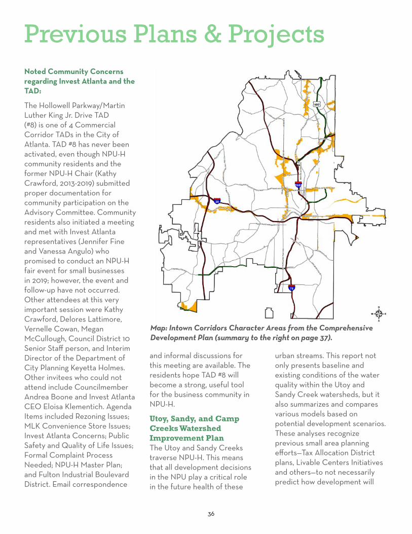
Map: Intown Corridors Character Areas from the Comprehensive Development Plan (summary to the right on page 37).
37
occur, but to acknowledge that new development will likely take place within much of the watersheds, and its impact should be considered in any future watershed investments. As such, the plan identifies a host of specific stream restoration, stormwater control, and green infrastructure projects. These project ideas are further assessed for their suitability and constructibility through desktop exercises and field visits..1
Comprehensive Development PlanThe City of Atlanta adopted its most recent CDP in November 2016. The CDP establishes the visions, goals, and objectives for development throughout Atlanta. It establishes the framework for evaluating and identifying zoning, land use, design, and other planning ideas at the city to community levels. Planning takes on many forms in Atlanta from city-wide to neighborhood and corridor plans. These plans are incorporated in the CDP when Atlanta City Council approves them. The City completely updates the CDP every five years with each Neighborhood Planning Unit (NPU) proposing their own development policies and priorities—making the CDP a dynamic, community-driven policy document and an important guide for reaching decisions on Atlanta’s future.
2017-2021 Capital Improvements Program and Community Work ProgramThe Capital Improvements Program (CIP) plan is the City’s 5-year implementation strategy for funding, constructing,
maintaining, and renovating public facilities and infrastructure. The Community Work Program (CWP) is a longer-view, fifteen-year strategy for unfunded and funded, capital and non-capital projects that implement Atlanta’s CDP. Projects listed in city-wide and small area plans adopted by the City, and projects proposed by Neighborhood Planning Units (NPU) are included in the CWP. A project must be included in the CWP before it can be prioritized in the CIP. The CIP/CWP must be reviewed by the Atlanta Regional Commission (ARC) and the Georgia Department of Community Affairs (DCA) and adopted by the City of Atlanta by October 31st each year.
Atlanta Community Engagement Playbook The Atlanta Community Engagement Playbook is one tool created by the City and a group of Atlanta residents and institutions to implement effective public engagement. This “playbook” is a collection of lessons learned over an eighteen-month collaborative process and related best practices intended to increase the civic capacity of city officials, city residents, community groups, and service providers. It proposes some principles and practical advice to help guide specific community engagement during planning processes.
Cargo Atlanta: A Citywide Freight StudyCargo Atlanta is a comprehensive study and baseline assessment of freight and goods movement within Atlanta. It centers around two themes: mobility and
livability. Demand for freight transportation will continue to grow, which will further strain Atlanta’s aging infrastructure and raise funding demands for transportation projects. This plan underscores the importance of integrating freight policy, land use planning and development projects citywide. In particular, Fulton Industrial Boulevard, Bolton Road., D. L. Hollowell Parkway and MLK, Jr. Drive are critical truck routes crisscrossing NPU-H. Cargo Atlanta recommends a few specific projects in NPU-H.
Atlanta’s 2015-2019 Consolidated PlanFunds allocated to the City of Atlanta from the U.S. Department of Housing and Urban Development (HUD) are managed according to Atlanta’s Consolidated Plan, which must be updated every five years. These funds are from annual entitlements, including Community Development Block Grants (CDBG), Emergency Shelter Grants (ESG), Home Investment Partnership Program (HOME), and Housing Opportunities for Persons with AIDS (HOPWA). Based on identified needs, market conditions, and collaborative planning processes with community stakeholders, the City prioritizes these funds for affordable housing, reducing homelessness, and economic development in low- to moderate-income neighborhoods.

38
Assessing Urban Tree Canopy in the City of Atlanta: A Baseline Canopy Study Nearly half of Atlanta is covered by the urban tree canopy. The tree canopy covers slightly more land in NPU-H. This is quite remarkable as trees in cities contribute to a wide variety of aesthetic, recreational, and environmental benefits. Published in 2014, this is the first comprehensive study of Atlanta’s urban tree canopy and it led the current policy discussion about how best to update the City’s long-standing tree ordinance and the best potential planting locations in Atlanta. The report makes the case to understand the tree canopy within each NPU and throughout the city as the first planning step to expanding the canopy’s benefits for all Atlantans.
Creating Linkages and Eliminating Barriers: The Strategic Community Investment Report Referred to as the Strategic Community Investment (SCI) Report, this city-wide assessment of housing conditions provides a unique perspective on Atlanta’s residential neighborhoods (map to the right). It includes an overview on housing vacancy and occupancy and observed residential parcel conditions and neighborhood investment. The report uses a windshield survey and common indicators
Previous Plans & Projects
Map: Neighborhood Typology from the Strategic Community Investment Report
of healthy neighborhoods—such as, quality of life, physical conditions, amenities, return on public and private investments and demographics and diversity—to rank neighborhoods from exceptional to fragile investment areas. In turn, strategies for improving neighborhoods can be tailored to existing conditions.
While this report is just a snapshot, the City is partnering with Neighborhood Nexus to combine the report’s data with other common neighborhood indicators, which are updated, so neighborhood progress and changes to indicators can be tracked over time.

39
Fulton Industrial Boulevard Redevelopment Framework and Fulton Industrial CID Master PlanFulton Industrial Boulevard has been a significant generator of industrial and commercial jobs in and around NPU-H for decades. However, the corridor competes with new, suburban industrial parks and struggles to retain and attract businesses. In 2010, the Fulton County Board of Commissioners adopted the Fulton Industrial Boulevard Redevelopment Framework and established a Community Improvement District (CID) from Campbellton Road to the I-20 interchange/Fulton County Airport-Brown Field to carry-out the corridor’s revitalization. A CID is a self-taxing district led by its businesses. In 2013, a collaborative planning process produced the Fulton Industrial CID Master Plan. Local businesses and other stakeholders assessed specific strengths, weaknesses, opportunities, and threats for the corridor and laid out a vision, implementation strategy, and work plan for its redevelopment. The Urban Land Institute of Atlanta provided advisory services and produced a 2012 Technical Assistance Program study to help further understand the existing conditions and potential of Fulton Industrial Boulevard.
D. L. Hollowell Parkway/Veterans Memorial Highway LCI StudyARC’s Livable Centers Initiative (LCI) is a grant program encouraging local governments
to collaboratively plan for more vibrant, walkable places with greater access to transportation, jobs, services, and healthy lifestyles. ARC provides funds for planning studies and for transportation projects proposed in LCI plans. The D. L. Hollowell Parkway/Veterans Memorial Highway LCI Study is the only LCI study so far in NPU-H. The study area stretches 4.5 miles along the corridor across I-285 between Buckner Road in Cobb County and Commercial Avenue in Atlanta. Planning participants focused on the challenges and opportunities to:
• Improve transportation access to MARTA, I-285 and I-20 and connectivity to Downtown Atlanta, Midtown, Fulton Industrial Boulevard and other nearby employment and service centers;
• Redevelop vacant and underutilized land;
• Support aging in place, senior living, and affordable housing;
• Link local recreational areas with the broader greenspace system, the Chattahoochee River and nearby streams;
• Create industrial jobs in and around Atlanta Industrial Park and workforce to fill those jobs;
• Preserve historical resources and neighborhoods; and,
• Create a greater sense of place with more inviting community gathering spots and retail, restaurant, grocery, and entertainment options.
The Herbert Greene Nature Preserve: A Conceptual VisionTotaling over 50 acres, The Herbert Greene Nature Preserve is a popular natural area located in NPU-H in the Boulder Park neighborhood, just outside of I-285, adjacent to Fulton County’s Utoy Boulder Park. Visitors can experience old growth trees and trails that access the Utoy Creek. City of Atlanta Departments of Watershed Management and Parks and Recreation acquired land for the preserve in 2004, indicating the importance of the greenspace for both local water quality and recreation. With all the planning efforts revolving around nature and development near the Herbert Greene Nature Preserve, including the current Urban Ecology Framework, it may be an opportune time to revisit this conceptual vision and its implementation progress.
Collier Heights Park Conceptual Master PlanPark Pride and community residents led the conceptual master plan for Collier Heights Park in 2006. The Visioning List included many items, the largest including: pavilions, a playground canopy, a splash pad and additional playground, trails, improved landscaping, wetland restoration, a gym, sports fields and courts improvements, public restrooms, and site lighting and furnishings.
Atlanta’s Project Greenspace As Atlanta grows over the next decade, greenspaces—city parks, natural habitats, stream buffers, urban gardens, greenways,

40
tree-lined streets, and shaded gathering spaces—will be critically important to the quality of life, economy, environment, and sense of community in Atlanta. Atlanta’s Project Greenspace establishes an action strategy to create these spaces and achieve a world-class greenspace system. Atlantans consistently expressed the desire for high-quality, accessible, safe, and well-maintained greenspace. City leaders are responding through bold initiatives, such as the Atlanta BeltLine, Westside Reservoir Park, AgLanta, an urban ecology study, and city-wide watershed improvements and green infrastructure.
Westside Atlanta: Blueprints for Successful CommunitiesThis Blueprints planning process involved the West Atlanta Neighborhoods in NPU-H as well as NPUs D, G, I, J, K, L, and T. The study frames challenges Westside Atlanta faces and recommends several short- to long-term goals around four main community-driven concerns: 1) land use and urban design, 2) housing and community development, 3) transportation, and 4) the environment. The relative minor focus in NPU-H neighborhoods along with the age of the plan may make several findings and recommendations inconsequential or stale, but the study is one of the early planning documents bringing up broader themes impacting NPU-H, including redeveloping
Previous Plans & Projectsbrownfields, connecting greenspace to major commercial and transportation corridors and addressing environmental justice.
Martin Luther King, Jr. Drive Corridor Transportation StudyMLK, Jr. Drive is a major commercial and transportation corridor cutting through the Adamsville and Old Gordon neighborhoods in NPU-H. The corridor connects Westside Atlanta residents, visitors, workers, and commercial trucks to Fulton Industrial Boulevard and Downtown and points in between. This report is the basis for several plans and implementation projects along the corridor in the last decade. It focuses on redevelopment challenges and possibilities in certain activity nodes along the corridor, including at Fairburn Road and at I-285. This planning effort led to others along the corridor such as the TAD, LCI, and the recently-funded MLK, Jr. Drive Innovation Corridor project. While improving transit and increasing multi-modal transportation dominated the planning discourse, other ideas—enhancing safety and public services, creating jobs, preserving neighborhood character and history, protecting greenspace, and allowing affordable housing—were incorporated into the community’s goals and objectives for this plan.
NPU-H/Adamsville Community Comprehensive Development PlanAdamsville is a long-established, mixed-use neighborhood in Atlanta and faces challenges like many other older residential and employment centers. In 2004, Neighborhood Planning Unit-H hosted a dialogue with the community to explore these challenges as well as the opportunities for improving Adamsville. What followed was an effort to understand how to tap into the City of Atlanta’s comprehensive development planning process, and this eventually led to preparing the NPU-H / Adamsville Community Comprehensive Development Plan. During the planning process, dialogue expanded, surveys were taken, and data were analyzed to support specific goals, strategies, and action steps for Adamsville. This report, while nearly fifteen years old, coupled with specific NPU development policies and priorities in the city-wide Comprehensive Development Plan, offers a solid starting point for planning at the neighborhood-level in Adamsville.
Donald Lee Hollowell Parkway Redevelopment PlanThe D.L. Hollowell Parkway Redevelopment Plan builds upon the Northwest Atlanta Framework Plan recommendations for specific land use, urban design, transportation, housing, and

41
economic development changes and strategies to improve the conditions contributing to disinvestment and inefficient use of properties along the D.L. Hollowell Parkway corridor. The corridor is a significant connector between Downtown and Midtown Atlanta and Cobb County for neighborhoods in north NPU-H.
Northwest Atlanta Framework PlanAn often-referenced document when planning in NPU-H and surrounding vicinity over the last two decades, the Northwest Atlanta Framework Plan focuses on D.L. Hollowell Parkway (formerly Bankhead Highway), Bolton Road, Marietta Boulevard, Perry Boulevard, Hollywood Road, Chattahoochee Avenue, and nearby areas that are potentially impacted by these corridors. The plan prioritizes public-private partnerships and funding—for example, tax increment financing—to spur neighborhood revitalization, economic development and sustainability.
City of Atlanta Public Art Master PlanThe City of Atlanta Public Art Master Plan aims to give structure to public art stewardship and sets forth policies and processes for the City to implement its objectives. The plan references all public art programs administered by the City. The goals for public art included defining the types and locations, strengthening inter-agency coordination for the planning, siting, and conservation of art, increasing community
awareness and ownership of art, using processes that reflect community values and identity, and coordinating among citywide public art interests. Methods for funding public art and establishing a more organized structure were included in the plan. Currently, there is a 1.5% public art requirement for capital projects.

42
Recent Progress & InitiativesMajor Implementation ProjectsMany projects from the previous studies summarized above have been implemented. The list below indicates the major projects that affect NPU-H neighborhoods.
• Renew Atlanta: Martin Luther King, Jr. Drive streetscape improvements. See page 46 for more detail.
• Atlanta Transportation Plan and Renew Atlanta: Fairburn Road streetscape improvements (in design process as of plan writing). See the appendix for details.
• Creation of the MLK TAD: Invest Atlanta created the MLK TAD (see pages 35-36).
• Code Enforcement Efforts: Demolition of 1020 Bolton Road.
• Department of Watershed Management: Sewer and water line improvements.
NPU-H Community-Led InitiativesThe NPU-H community has been working hard to implement some projects, build community pride, help during the 2020 COVID-19 pandemic, and identify grant funding. Below are some on-going and recent successes.
Collier Park ImprovementsPark Pride awarded a 2019 Legacy Grant to the Friends of Collier Heights Park for a new play area. The park improvements included the construction of
a retaining wall, new rubber safety surfacing, and new play equipment, fitness equipment, and benches.
Friends of Collier Heights Park Educational programs: The Friends Group organizes educational trips to Atlanta City Hall and Washington, D.C. to learn about government and civics, and they also provide books to students. The STEM program offers coding and robotics programs for students at Atlanta Heights Charter School, and the STEM Festival brings 15-20 organizations and companies to the school.
Public ArtNPU-H is working with community members and artists to design and install a mural at the entrance of Adamsville on Martin Luther King Jr. Drive.
Fresh Food & Urban AgricultureNPU-H is considered to be a low income low access (LILA) food area because there are not enough grocery stores, supercenters, neighborhood markets, or farmers’ markets to serve the neighborhoods. To increase access to fresh food, and to work towards the goal of 85% of Atlanta residents within a half-mile of fresh affordable food by 2022, the City developed the Grows-A-Lot program. The program seeks to promote urban gardens and farms designated as food deserts, such as NPU-H. The Grows-A-Lot program works with individuals and organizations
to adopt vacant, City-owned properties to start urban gardens or urban farms. Two farms are located in NPU-H. Gratitude Botanical Farm is located on an easement on Collier Drive. Their mission is to educate, grow, feed, and serve the community through organic urban agriculture. They grow produce and herbs and farm related products for sale and to donate to seniors. Farm Awry cultivates medicinal herbs, dye, and fiber plants.
Adamsville We Care Food Share Program: Fulton County Covid-19 Emergency Fund awarded $25,000 to NPU-H for health and wellness programs. They will provide healthy food to NPU-H residents. In addition, they partnered with the Association of Black Cardiologists and Morehouse School of Medicine to provide health and nutrition education.
Young Generation Movement (YGM): Since 2012, YGM has been advocating and empowering youth ages two to twelve to become role models and leaders in their community. They have a health and wellness program that teaches cooking, gardening, and healthy lifestyles. YGM’s Movement Community Center is located in NPU-H. YGM hosted a produce give-away in September 2020.
Grows-A-Lot and YGM are listed as potential partners for projects in the Long-Range Initiatives, Open Space and Sustainability section in Chapter 4.

43
A community mural on MLK, Jr. Drive (Community Photo, date unknown)
A community mural on MLK, Jr. Drive (Community Photo, date unknown)
NPU-H residents, leaders, and community organizations have a long history of building community pride and advancing the quality of life for their neighbors. The photos of the murals above and the descriptions of on-going and recent initiatives provide examples of this commitment to the community.
44
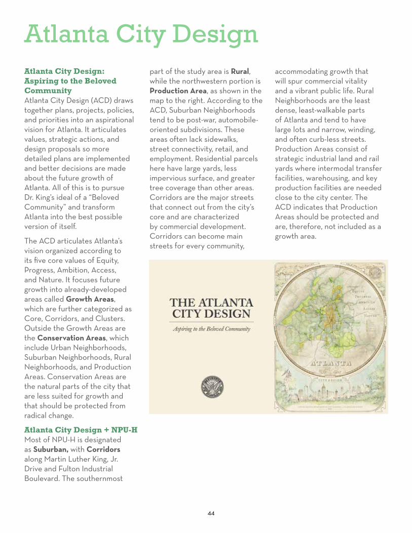
Atlanta City DesignAtlanta City Design: Aspiring to the Beloved CommunityAtlanta City Design (ACD) draws together plans, projects, policies, and priorities into an aspirational vision for Atlanta. It articulates values, strategic actions, and design proposals so more detailed plans are implemented and better decisions are made about the future growth of Atlanta. All of this is to pursue Dr. King’s ideal of a “Beloved Community” and transform Atlanta into the best possible version of itself.
The ACD articulates Atlanta’s vision organized according to its five core values of Equity, Progress, Ambition, Access, and Nature. It focuses future growth into already-developed areas called Growth Areas, which are further categorized as Core, Corridors, and Clusters. Outside the Growth Areas are the Conservation Areas, which include Urban Neighborhoods, Suburban Neighborhoods, Rural Neighborhoods, and Production Areas. Conservation Areas are the natural parts of the city that are less suited for growth and that should be protected from radical change.
Atlanta City Design + NPU-HMost of NPU-H is designated as Suburban, with Corridors along Martin Luther King, Jr. Drive and Fulton Industrial Boulevard. The southernmost
part of the study area is Rural, while the northwestern portion is Production Area, as shown in the map to the right. According to the ACD, Suburban Neighborhoods tend to be post-war, automobile-oriented subdivisions. These areas often lack sidewalks, street connectivity, retail, and employment. Residential parcels here have large yards, less impervious surface, and greater tree coverage than other areas. Corridors are the major streets that connect out from the city’s core and are characterized by commercial development. Corridors can become main streets for every community,
accommodating growth that will spur commercial vitality and a vibrant public life. Rural Neighborhoods are the least dense, least-walkable parts of Atlanta and tend to have large lots and narrow, winding, and often curb-less streets. Production Areas consist of strategic industrial land and rail yards where intermodal transfer facilities, warehousing, and key production facilities are needed close to the city center. The ACD indicates that Production Areas should be protected and are, therefore, not included as a growth area.

45
Atlanta City Design + NPU-H
• Mostly “Suburban” Conservation Area
• “Corridors” along MLK, Jr. Drive and northern end of Fulton Industrial Boulevard
• “Rural” on the southern edges of the NPU
• These Growth Areas will determine how development occurs in the future to accommodate Atlanta’s increasing population.
• The NPU-H Master Plan Vision and Goals are tied to the Atlanta City Design on pages 68 to 69.
Caption: The Atlanta Region is growing and the City will capture a large share of the new growth (to increase to 1.2 million people). The ACD aims to direct growth to the designated Growth Areas and create Production Areas to ensure industrial employment areas are still available and Conservation Areas to ensure the preservation of nature and tree canopy. This method continues At-lanta’s typical growth patterns to-date.

46
MLK, Jr. Drive Innovation Corridor Project & Public Art
Innovation ProjectThis $27 million project, funded by Renew Atlanta, spans approximately 7.2 miles from Northside Drive to Fulton Industrial Boulevard and includes a combination of federal, state, and local funding. The project will provide additional pedestrian and bicycle facilities: multi-use trails; linear park; raised landscape medians; pedestrian crossing islands; repaired sidewalks; ADA upgrades; two-way cycle track; traffic signal improvements; upgraded signs and markings; and lighting improvements.
The section in NPU-H is a State Route, so Atlanta Department of Transportation (formerly, part of DPW) had limited options to make changes to roadway, including the existing median with HAWK signal in front of CT Martin Recreation Center and crosswalk and sidewalk repairs.
Gateway Public ArtThe Adamsville 285 Gateway Monument will be created by Atlanta artist Ayokunle Odeleye, who was commissioned by the City of Atlanta to design this stainless steel gateway monument. This signature public art installation will become one of the most unique, recognizable, and highly visible public artworks in the city. The monument, which
City of Atlanta was awarded a $10 million TIGER Grant for the MLK, Jr. Drive Innovation Corridor Project, now nearly 100% constructed.
Rendering of forthcoming Gateway Monument at MLK, Jr. Drive & I-285 (Department of Public Works)
will be placed at the center of the roundabout at the exit ramp, will be accessible and viewable for all citizens and visitors in the city as they drive, bike, or walk down the MLK, Jr. Drive Innovation Corridor at the I-285 exit ramp
for Adamsville. The artwork will stand 30’ tall and 27’ wide and will depict music, arts, and culture that represents the southwest Atlanta and the community. The budget is $250,000, and should be complete in June 2021.
Rendering of streetscape changes in front of Adamsville Recreation Center (Department of Public Works)
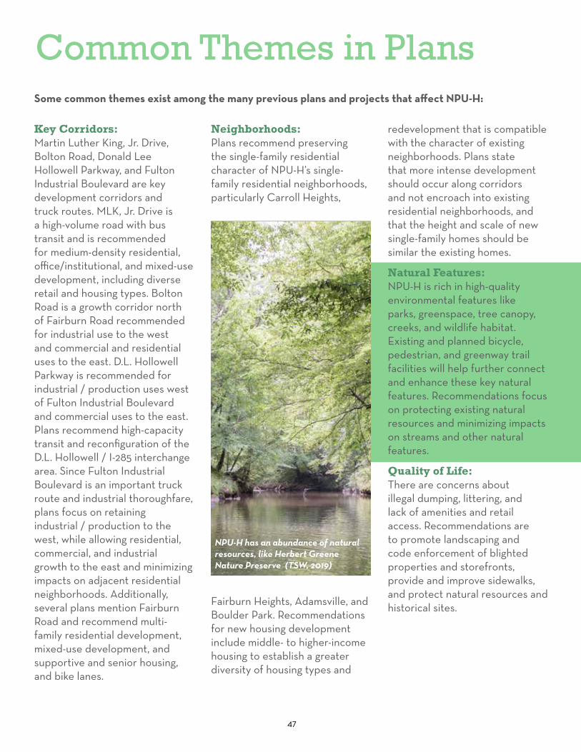
47
Common Themes in PlansSome common themes exist among the many previous plans and projects that affect NPU-H:
Key Corridors: Martin Luther King, Jr. Drive, Bolton Road, Donald Lee Hollowell Parkway, and Fulton Industrial Boulevard are key development corridors and truck routes. MLK, Jr. Drive is a high-volume road with bus transit and is recommended for medium-density residential, office/institutional, and mixed-use development, including diverse retail and housing types. Bolton Road is a growth corridor north of Fairburn Road recommended for industrial use to the west and commercial and residential uses to the east. D.L. Hollowell Parkway is recommended for industrial / production uses west of Fulton Industrial Boulevard and commercial uses to the east. Plans recommend high-capacity transit and reconfiguration of the D.L. Hollowell / I-285 interchange area. Since Fulton Industrial Boulevard is an important truck route and industrial thoroughfare, plans focus on retaining industrial / production to the west, while allowing residential, commercial, and industrial growth to the east and minimizing impacts on adjacent residential neighborhoods. Additionally, several plans mention Fairburn Road and recommend multi-family residential development, mixed-use development, and supportive and senior housing, and bike lanes.
Neighborhoods: Plans recommend preserving the single-family residential character of NPU-H’s single-family residential neighborhoods, particularly Carroll Heights,
Fairburn Heights, Adamsville, and Boulder Park. Recommendations for new housing development include middle- to higher-income housing to establish a greater diversity of housing types and
redevelopment that is compatible with the character of existing neighborhoods. Plans state that more intense development should occur along corridors and not encroach into existing residential neighborhoods, and that the height and scale of new single-family homes should be similar the existing homes.
Natural Features: NPU-H is rich in high-quality environmental features like parks, greenspace, tree canopy, creeks, and wildlife habitat. Existing and planned bicycle, pedestrian, and greenway trail facilities will help further connect and enhance these key natural features. Recommendations focus on protecting existing natural resources and minimizing impacts on streams and other natural features.
Quality of Life: There are concerns about illegal dumping, littering, and lack of amenities and retail access. Recommendations are to promote landscaping and code enforcement of blighted properties and storefronts, provide and improve sidewalks, and protect natural resources and historical sites.
NPU-H has an abundance of natural resources, like Herbert Greene Nature Preserve (TSW, 2019)

48
Community Engagement

49
Chapter 2Outreach Process
Steering Committee
Public Kick-off Meeting
Survey Results
Design Workshop
Final Public Open House
Story-telling activity at the Public Kick-off Meeting (TSW, 2019)

50
Outreach Process
INITIATE & UNDERSTAND ENGAGE & EXPLORE
• First Steering Committee Meeting
• Kick-off Meeting with community to introduce the process and collect information on key issues and opportunities
• Meet with the City of Atlanta Department of City Planning
• Visit NPU-H to analyze physical conditions
• Analyze existing conditions, demographics, and previous plans
• Review information from Kick-off Meeting and first Steering Committee Meeting
• Second Steering Committee Meeting
• Design Workshop with community to design and planning concepts, present preliminary findings, and receive feedback
The diagram below summarizes the public outreach through each state of the planning process. The Steering Committee (described further on pages 54 to 55) played a huge part in making sure this plan is feasible for the NPU-H community and providing more detailed ideas for recommendations. In addition to a project website updated throughout the process, other means were used to engage the community, including online and paper surveys, 3 public meetings, and engagements at neighborhoods events.
Getting the Word Out
• Postcards mailed to all addresses in NPU-H for kick-off meeting.
• Flyers placed in libraries, recreation centers, health centers, NPU-H meetings.
Online & Paper Survey Available
Getting the Word Out
• Yard signs placed at key intersections
• Flyers placed in libraries, recreation centers, health centers, NPU-H meetings.
Spring 2019 Summer 2019 - Spring 2020

51
GUIDE THE FUTURE FINALIZE REPORT
City Council Adoption
• Prepare preliminary recommendations and draft concept plans for redevelopment nodes
• Develop additional maps and visioning graphics
• Continue to engage with Atlanta Department of City Planning Staff in addition to engaging other City Departments and Invest Atlanta.
• Refine recommendations from Design Workshop
• Third Steering Committee Meeting to review draft Redevelopment Criteria and concept plans
• Plan Open House & Presentation
• Produce a final plan document
• Fourth Steering Committee Meeting to review draft plan document
• Present final plan at NPU-H meeting
• CD/HS Public Hearing and Committee Meeting Vote
Online & Paper Survey Available
Summer 2019 - Spring 2020 Summer - Fall 2020

52
Engagement Overview
The creation of this master plan involved a robust community engagement process focused on meaningful conversations with stakeholders and residents. The Planning Team reached out to the NPU-H community using various platforms, including online and in-person methods of communication and interaction. Through roundtable discussion, online and paper surveys, and community visioning workshops, this plan reflects a shared vision for NPU-H that encapsulates the wants and needs of those who live the 17 neighborhoods. The following pages summarize the engagement results during this planning process.
“I really feel we need to brand our area [...] When people feel they have entered a community it will
help build community unity, feel, and respect.”
Top Left: The first Steering Committee meeting involved a “Funnel Activity” to identify major challenges and opportunities that could be developed into project goals.
Top Right: The Kick-off Meeting had a variety of input activities, including a Story Telling board that allowed participants to tell their personal memories and stories.
Bottom: The Design Workshop began with a presentation summarizing previous input and analysis.
Steering Committee (TSW, 2019)
Kick-off Meeting (TSW, 2019)
Design Workshop (TSW, 2019)

The NPU-H Master Plan was a Collaborative Process that included:
3 Community Meetings
4 Steering Committee Meetings
100Kick-off Meeting Attendees
51Workshop Attendees
50Final Public Meeting Attendees
38Online & Paper Surveys
53

54
The Steering Committee’s roles and responsibilities were to:
• Identify strengths, weaknesses, opportunities, and threats in the community;
• Provide comment and recommendations on community input activities;
• Promote the plan to neighbors, friends, relatives, and others in the community;
• Provide thoughts on the plan recommendations and how best to conduct public meetings that solicit feedback.
Caption: The Funnel Activity identified major challenges and opportunities that were used to define plan goals (TSW, 2019).
Steering Committee Meeting #1March 14, 2019, 5:30 PM @ C.T. Martin Recreation Center
The first Steering Committee meeting was attended by 13 members of the Committee. The Planning Team gave a brief presentation about the existing conditions analysis and input activities for the Public Kick-off Meeting. The remainder of the meeting was dedicated to a “Funnel Activity” (photo above) to identify the major issues and opportunities that this plan should address. All of the ideas were written then organized by
overall themes. The top 5 items to address were: 1. Quality of Life; 2. Infrastructure and Streets; 3. Cleanliness; 4. Inclusiveness; and, 5. Redevelopment. The results of this activity were used to write the Vision Statement and Goals and Principles (pages 68-69).
Steering Committee Meeting #2April 18, 2019, 6:00 PM @ C.T. Martin Recreation Center
The second Steering Committee meeting was attended by 5 members of the Committee. A brief presentation detailed feedback heard at the Public
Steering Committee

55
Quality of Life
Transportation
Housing
Jobs & Businesses
Kick-off Meeting, the draft Vision and Goals and Principles, and ideas for the forthcoming Design Workshop. The planning team led the Committee members through re-writing the Vision Statement and Goals and Principles to more accurately reflect the needs and desires of the entire NPU. A second activity helped identify the key locations for which to draw concept plans to illustrate how the Vision could be achieved.
Steering Committee Meeting #3June 13, 2019, 6:00 PM @ C.T. Martin Recreation Center
The focus of the third Committee Meeting was on revising Redevelopment (or Rezoning) Criteria based on comments collected at the Design Workshop in the Developers Wish List activity. The planning team and Committee reviewed each criterion word for word, and Committee members raised a red or green card to indicate whether or not they agreed with the criterion. If not, discussion led to the appropriate ways to phrase the criteria, or removal.
Steering Committee Meeting #4 (Re-set)June 25, 2020, 6:00 PM, Video Conference Call
The fourth Steering Committee meeting occurred via ZOOM Conference Call due to the COVID-19 pandemic. Ten Committee members and five City of Atlanta staff members attended the meeting. The planning team gave a brief presentation that described progress to-date, next steps, and an overview of the recommendations. Then, the planning team led the Committee through a discussion of all of the Long-Term Initiatives individually to determine which ones seemed appropriate for the NPU to lead and to receive feedback on the ideas.
Results of the Funnel Activity (TSW, 2019)
All below photos were taken throughout NPU-H (TSW, 2019)
Adamsville Green Senior
Housing
MLK, Jr. Drive
Atlanta Center for Medical Research
Home in Boulder Park Neighborhood

56
Public Kick-off MeetingCommunity input is a key component of developing a plan’s vision, goals, and recommendations. The first public outreach effort was the Kick-off Meeting, which took place on March 26, 2019, at the C.T. Martin Natatorium and Recreation Center. Approximately 100 members of the community were present. The Planning Team presented the initial analysis of the NPU-H community, including previous plans assessment, existing conditions, and demographics.
After the presentation, meeting attendees participated in these activities:
• Vision statement and goals board to help determine top priorities
• Completed paper copies of the surveys and comment cards
• SWOT Analysis to help determine NPU-H’s greatest strengths, weaknesses, opportunities, and threats. Participants shared their opinions using sticky notes on boards for each topic.
• Story Telling Exercise that asked participants to do two things: place stickers
on a map to mark areas for places they love and want to keep, where they live, where development could occur, where long- and short-term improvements could be made; and secondly, to place flags on landmarks that designate a personal memory or event, an enjoyable social event, a potential safety concern, or an event of historical significance.
Caption (all photos): Activities at the Public Kick-off Meeting on March 26, 2019 (TSW, 2019).

57
• History and generations of families
• Neighbors who look out for each other
• Good location and access to Downtown, I-20, I-285, and the airport
• Tree coverage and nature
• Lack of street lighting, especially on major thoroughfares
• Procedures for resident input about zoning
• Lack of affordable housing for aging-in-place
• Lack of sidewalks
• Property maintenance
• Lack of restaurant, shopping, services options
• Traffic congestion on major streets
• Lack of sidewalks or narrow sidewalks
• Inadequate police and fire protection
• Dumping trash and lack of property maintenance
• Too many low-cost retail options and no diversity of restaurants and retail
• Encourage black-owned businesses
• Re-open pools and recreation centers
• Traffic calming on key corridors like Benjamin E. Mays and Adamsville Drive
• Add low-cost grocery stores
• Encourage mixed-use development that doesn’t cause displacement
• Promote community get-togethers for clean-up, and education about healthy living
Strengths Weaknesses Opportunities Threats
• Crime and gunfire
• Speeding traffic on Cascade Road, Bakers Ferry Road, Lynn Circle, Brownlee Road
• Condition of roads - Baker Hill, Boulder Park Drive, and others
• Youth truancy
• Tire and trash dumping
• G.A. Towns Elementary School building (1962) - International Style structure by architect Richard Aech
• Ruins of the Judge William A. Wilson house - built circa 1856 (demolished 2015)
• Atlanta Center for Medical Research Building
• Attended elementary school at Towns and High School at Harper
• I moved into this nice neighborhood 35 years ago, now I’m afraid to leave my house
• The KKK passed by our house in May 1961 from the American Legion. The American Legion is now run by African Americans
• Picnics with neighbors and card playing
• Educational community events for kids
• Most loved places were Margaret Fain Elementary School, Boulder Park neighborhood, Herbert Greene Nature Preserve, Wildwood neighborhood, Oakcliff neighborhood, and Collier Park
Safety Concerns Enjoyable Social Events
Events of Historical Significance
Personal Memory

58
Most respondents believe that NPU-H is heading in the right direction, and that it is a good place for residents to live no matter their age. It’s seen as a good place to raise a family, and most agree that there are enough senior services and programs. However, respondents are divided about the quality of youth services and youth programs.
Respondents had a wide range of opinions about whether the community has a strong identity, that it feels safe, that it has good access to health services, and that the community has good connections to parks and nature.
Quality of life feedback shared by most respondents includes:
• NPU-H needs better access to healthy foods and different places for shopping, eating and drinking, and entertainment. Respondents suggest that perhaps the community can attract a quality, affordable grocery store, such as Trader Joe’s or Aldi.
• NPU-H needs fewer fast food and discount stores, like Family Dollar and Dollar General.
• Improve public safety and address vacancy and blight.
• Invest in the community’s main corridors and encourage housing, retail, and other types of commercial development on vacant and underutilized properties.
• Foster community pride. While this appears to be an agreed-upon goal, common planning tactics to encourage ownership suggested in the survey, such as creative placemaking; encouraging dense, walkable communities; branding and marketing; and, supporting community events/gatherings, did not receive significant support.
• Preserve and improve the community’s parks, recreation, and cultural spaces.
Housing feedback shared by most respondents includes:
• Renovate existing houses and encourage greater options for housing, especially for affordable options.
• Promote transit around new and existing housing development.
Transportation feedback shared by most respondents includes:
• Fix the community’s roads.
• Improve busy intersections.
• Invest in bike lanes, sidewalks, crosswalks, and street lighting.
Survey ResultsAn online survey was available from March 26th, 2019, through Friday, May 10th, 2019. Paper surveys were offered at the Kick-off Meeting and Design Workshop, and also available at the City of Atlanta Department of City Planning office for people to complete.
A total of 38 surveys (paper and online responses) were received. The survey included questions about how respondents currently view the NPU-H area and the vision for NPU-H in the future regarding quality of life, housing, transportation, and jobs and businesses. The survey also asked about the types of development that are appropriate in NPU-H and which goals the NPU-H Master Plan should prioritize. The infographics on the following pages illustrate the survey results.
89% of survey takers indicated that they live in an NPU-H neighborhood.

59
My Vision for a Higher Quality of Life in NPU-H...
My Vision for Transportation in NPU-H...
My Vision for Jobs & Businesses in NPU-H...
My Vision for Housing in NPU-H...
Improve Public Safety
Increase local access to healthy foods
Diversify the types of local businesses
Attract & retain living wage jobs
Help entrepreneurs start local business
Invest in street lighting
Fix streets & intersections
#1
#1
#1
#3
#3#3
#2
#2
#2
#1
#2
Address vacancy & blight
Renovate existing houses Add
affordable housing
Encourage housing diversity

60
Survey Results
It has a strong community
identity
It is not clean, attractive, or
well-maintained
It has senior services & programs
It is heading in the right direction
Not a lot of places for
shopping or entertainment
It has good transit service
It does not have great access to fresh, healthy
foods
It’s a good place to live
& raise a family
Does not have good sidewalks, bike routes, or roads
What do you think about the NPU-H Study Area?
My Vision for development in NPU-H....Build More
• Sit-down Restaurants
• Grocery Stores
• Local Retail Shops
• Medical Facilities
Keep Same
• Gas stations & car repair shops
• Warehousing & industrial
Build Less
• Discount Retail

61
“I would like to see more stores owned by local residents and incentives for locals to
open a business.”
Which goals should the NPU-H Community Plan prioritize?
Jobs & Business Development feedback includes:
• More should be done to diversify the types of local businesses.
• Improve the look of storefronts.
• Economic development priorities should have a “people” focus.
• Build more offices and hotels.
Highest Priorities
• Invest and maintain the community’s main corridors and local streets.
• Preserve community’s parks, recreation, and cultural spaces.
• Improve the “look and feel” of the community.
• Encourage housing development on vacant, underutilized properties.
• Prioritize neighborhood focused development, such as retail, sit-down restaurants, grocery stores, coffee shops, and medical facilities.
• Support local entrepreneurs and start-ups, teachers, police, and firefighters.
• Attract and retain living wage jobs for residents.
• Improve education opportunities for young adults.

Design WorkshopThe Design Workshop was held on Saturday, May 4th, 2019, at the C.T. Martin Recreation Center from 10:00 AM to 2:00 PM. Invest Atlanta presented information on the Tax Allocation District, and the planning team presented results from the previous steering committee and public meetings, analysis on crime, demographics, and code enforcement in NPU-H, and shared the draft Vision Statement and Project Goals. The attendees participated in multiple input activities:
• Visual Preference Survey (VPS) & Concept Drawing Table for potential redevelopment sites. Images for three potential redevelopment sites were shown to gather input on how the built environment should look if the sites are redeveloped. The planning team used the input to sketch preliminary ideas for potential redevelopment sites.
• Developer Wish List - Participants voted for items in a list of criteria for redevelopment projects, resulting in a bar chart noting priorities (right).
• Streets and Access - This activity asked about current transportation experiences, preferred experiences for the future, and inhibitors to those experiences now. In addition, a “Build Your Own Streetscape” activity allowed attendees to design an ideal street for Fairburn Road.
Top Items on the Wish List• Housing for all ages and
incomes
• Quality restaurants and grocery stores
• Creative methods to collect and store stormwater
• Create a local hiring program
• Architectural excellence
• Increase street and private property lighting
• Add bus shelters, benches, or other amenities on MARTA routes
Dev
elop
er W
ish
Lis
tThis activity informed the Redevelopment Criteria in Chapter 4.
Presentation during the Design Workshop (TSW, 2019)
Developer Wish List Activity at the Design Workshop (TSW, 2019)
62

63
MLK, Jr. Drive & Fairburn Road
Bolton Road & I-285 Fairburn Road & Benjamin E. Mays Drive
VPS & Redevelopment Site Concept Plans - Top Images
Streets & AccessHow do you get to your destinations today?• The vast majority (31) take
their cars
• 1 takes the train, and one 1 bikes
What discourages you from taking a preferred mode?• Needed services are too far
away (13)
• Crime / safety (8)
• Trash / cleanliness (8)
• Lack of sidewalks (7)
How do you want to get there in the future• Most people want to WALK
(16)
• Only 2 want to drive
• Others want to take the bus (5) or train (5)
2-Story Mixed-Use
Park / Neighborhood Square
Cottage Court Houses
Small Single-Family Houses
Horizontal Mixed-Use
Missing Middle Housing(Ryan Terry)
Sidewalk-Oriented Retail
Small Pocket Parks
Current & Preferred Experiences Getting to
Destinations
Photo credits: Images of preferred development types from TSW architectural and planning image library (TSW). All photos taken by TSW staff except where specifically noted on the photo.
Journey Mapping Activity (TSW, 2019)

Public Open House - July 2019A Public Open House was held on Thursday, July 25th, 2019, at the C.T. Martin Recreation Center from 6:30 - 8:30 PM. The planning team presented results from the previous steering committee and public meetings, draft vision and goals, draft concept plans for the three potential redevelopment nodes, draft concept drawings for Fairburn Road street sections, and the Redevelopment Criteria. The majority of the meeting was spent answering individual questions from the attendees directly after the presentation; however, the activities below were available for voting and comments after the Q&A session. The Q&A session resulted in the final plan document name: NPU-H Master Plan.
• Vision, Goals, and Principles to determine if these were the final version.
• Development Policies and Recommendations - Participants voted about whether the draft versions of these policies was correct, and if not, to provide suggestions. These were refined based on the results of the Developer Wish List from the May Workshop and June Steering Committee meeting.
• Redevelopment Node Concept Plans - Final draft concept plans were displayed with character images and Development Policies that they address for each of the three redevelopment nodes: Adamsville Village, Doctors’ Memorial Park, and Bolton Road. Participants voted on how well the plans met the vision established throughout the planning process.
• Fairburn Road Street Sections - Final draft concept drawings for changes to Fairburn Road were displayed and participants could note whether they were appropriate or not.
Because of the extended time for Q&A, few people voted on the exercises or filled out comment forms. The comment forms noted that a little over half who completed them support or somewhat support the vision, goals, principles, and concept plans. Many were undecided, and the street sections for Fairburn Road received less agreement. Some of the comments included:
• Support for the street lighting on Fairburn Road;
• Concerns about bike lanes;
• More green space is needed.
Example of one of the boards for public feedback at the meeting.
64

65
Plan Reset & Approval - 2020June 2020
• Steering Committee meets to review report draft and final recommendations on June 25, 2020 via video conference call.
• Additional residents added to the Steering Committee
July 2020
• Steering Committee provides additional comments on report. Report draft revised and re-submitted.
• AgLanta attends July 9, 2020 NPU-H meeting to discuss potential and on-going partnerships for community gardens and urban agriculture.
• City of Atlanta posts the full report draft on the project website for public review and comment.
August 2020
• City of Atlanta presents the final recommendations at the August 6, 2020 NPU-H meeting.
• Steering Committee provides additional comments on report. Report draft revised.
September - November 2020
• City of Atlanta presents final recommendations at September 3, 2020 NPU-H Meeting.
• City of Atlanta presents the final recommendations at the September 10, 2020 NPU-H Meeting for a vote
• NPU-H Vote on Ordinance to adopt plan - November 5, 2020
• CD / HS Public Hearing on November 30, 2020
• CD / HS Committee Meeting Vote on December 1, 2020
December 2020
• City of Atlanta presents final master plan to City Council on December 7, 2020, for a vote and adoption into the CDP.
• Final NPU-H Master Plan document submitted.

66
RecommendationsDoctor’s Memorial Park (TSW, 2019)

67
Chapter 3Vision & Goals
Framework Plan
Public Safety & Quality of Life
Concept Plans
Typical Street Sections

68
Nature
“Vision Statement: Create a vibrant and safe community for
the NPU-H neighborhoods by offering diverse housing options, thriving businesses, accessible transportation, connections to
nature, and a high quality of life for all.
The VisionAtlanta City Design: Aspiring to the beloved community.
Equity
City Design Core Values
Progress Ambition Access Nature
The NPU-H Master Plan’s Vision, and associated Goals and Principles share the Atlanta City Design’s 5 Core Values.
Adamsville Regional Health Center (TSW, 2020)

69
NPU-H Goals & PrinciplesCreate a high quality of life for all residents
Focus redevelopment on priority vacant properties and abandoned structures
Promote inclusiveness for all people
Improve the cleanliness and appearance of properties, streets, and parks
Improve mobility by investing in existing infrastructure, increasing safety and security of transportation modes, and expanding transportation options.
1. Engage local educational partnerships with community organizations, non-profits, and recreation centers to increase the quality of education for people of all ages
2. Encourage developers to provide usable green space in all redevelopment and use green infrastructure where possible
3. Attract a diversity of businesses that meet the needs of the community, including daily needs shopping and a variety of restaurants
4. Increase access to healthy, fresh food through redevelopment, community partnerships, and urban food gardens
5. Take a proactive stance on public health and mitigate the negative impacts of industries on Fulton Industrial Boulevard
6. Maintain parks and offer programming for residents of all ages
1. Implement strategic rezoning that benefits residents and meets the goals set forth in this plan
2. Determine development criteria for priority redevelopment sites 3. Promote redevelopment of key commercial nodes and aging
apartment complexes4. Minimize flooding by maintaining natural terrain and using best
practices for stormwater management
1. Foster aging in place through design and policy recommendations2. Increase the rate of homeownership in the community3. Promote awareness of existing and future homeownership programs
and bill assistance programs4. Promote home rehabilitation programs and alternative energy
sources to mitigate the cost of living for current homeowners5. Engage renters in the community and encourage them to stay6. Preserve naturally occurring / subsidized affordable housing units7. Preserve the character of the single-family areas
1. Enforce zoning, building codes, and public safety 2. Prevent dumping of trash, illegal parking, and illegal land uses3. Improve City of Atlanta responsiveness to code violations4. Establish community clean-up initiatives 5. Promote community pride and ownership
1. Integrate the Martin Luther King, Jr. Drive and Fairburn Road corridor projects into this plan
2. Slow traffic and make major corridors walkable and safe3. Promote walkability by expanding the network of safe sidewalks4. Add street lighting to low lit areas5. Improve access to existing parks for all modes of transportation
1
2
3
4
5

A Roadmap to Use these Recommendations
Framework PlanCallout potential redevelopment sites & priority corridors
FROM VISION
Node 1: Bolton Road
Node 2: Adamsville Village
Exa
mp
le C
once
pt P
lan
s th
at S
up
por
t th
e V
isio
n
(Pag
es 7
4 to
79)
NPU-H
Strategic Future Land Use Changes
&Proactive Re-zoning
on Key Properties
70
Node 3: Benjamin E. Mays & Fairburn Road

71
Redevelopment CriteriaHold redevelopment projects to high standards
These two elements work together to ensure future growth & development result in a vibrant and safe community
A. Jobs & Businesses
B. Housing
C. Building Design
D. Transportation & Parking
E. Open Space & Sustainability
When a developer wants to re-zone and redevelop a property, the community has a list of criteria they can use to work with the City.
RESIDENT EMPOWERMENT
TO ACTION
71
72
Framework PlanThe Framework Plan establishes priority redevelopment areas within NPU-H and key corridors to improve in order to implement the Vision and reach the Goals listed on pages 68-69. Priority Redevelopment Sites are identified to show where infill development should be encouraged. Many of these are located along Fairburn Road or Bolton Road. Another site is the former Bankhead Courts housing site. This list is not a comprehensive, but they are underutilized or vacant sites, either identified through public feedback or analysis.
Concept PlansIn order to show how the Redevelopment Criteria in Chapter 4 could be implemented on the priority redevelopment sites or other sites within NPU-H, three concept plans were developed (pages 76 to 81). These are ideas for how the sites could be redeveloped, but do not guarantee that development will occur or will occur the way it is shown on the plans.
Concept Plan 1 - Bolton Road is located in the northern part of NPU-H near the Fulton County Airport and I-285. This plan considers the existing residential uses on Bolton Road and provides a mix of housing types and some mixed-use development that could include office and retail uses.
Concept Plan 2 - Adamsville Village is centered on the MLK, Jr. Drive and Fairburn Road
intersection. This area has commercial uses built in suburban patterns - retail buildings with large parking lots in front, many access drives to individual businesses, disconnected residential areas, and closed-off apartment communities. During the public meetings, participants repeatedly identified this intersection as an opportunity for improvement with mixed-use development, more housing options to reach a variety of incomes, ages, and lifestyles, and a large park. The concept plan on page 79 shows how this area could be redeveloped with sidewalk-oriented, mixed-use development, increased retail options, multiple housing options, streetscape changes to Fairburn Road, more multi-family housing options, and a central green space that ties together retail buildings and multi-family residential communities. Some existing commercial buildings along MLK, Jr. Drive that currently front the street are preserved and infill is recommended around them. Existing businesses can also lease or acquire new space in the new buildings.
Concept Plan 3 - Benjamin E. Mays & Fairburn Road is centered on the intersection, which is where the Doctor’s Memorial Park is located. Public feedback supported office buildings, small pocket parks, retail, and many housing options for this node. The park has been recently constructed with a lawn,
plaza, playground, and parking, but no buildings enclose the park, and it is difficult to cross the streets to get there. This is an opportunity to increase park usage and the perception of security by orienting new mixed-use buildings toward the park.
The Atlanta Center for Medical Research and Fulton County DFCS create a large campus of office space and parking lots. Adjacent, smaller building types and a variety of land uses can effectively blend this site into the surrounding residential neighborhoods. The concept plan on page 81 recommends offices, residential units, a connected street network, pocket parks, and some retail that can be used by existing and future residents.
StreetsAs noted in Chapter 1, the street network in NPU-H is disconnected and suburban in nature. The Atlanta Department of Transportation (formerly Department of Public Works) is currently working on corridor improvements for MLK, Jr. Drive, as indicated in blue on the Framework Plan, and Fairburn Road, as indicated in green. These improvements are integrated into the concept plan for Adamsville Village and detailed on page 82. Fairburn Road is identified as a High Injury Network in the Atlanta Transportation Plan (page 82), is planned as an on-street bicycle network, and connects many of the priority redevelopment sites.

73
Adamsville Village
Benjamin E. Mays & Fairburn Road Node
0’ 1250’ 2500’ 5000’
1” = 2500’
North
Bolton Road Mixed-Use Node
DRAFT

74
Public Safety & Quality of LifeWhile the analysis (pages 26-27) shows that building code enforcement calls in 2018 were spread throughout the NPU, there are concentrations in the northern section straddling Bolton Road, and at MLK, Jr. Drive and Fairburn Road. Many of the issues run along the Fairburn Road and MLK, Jr. Drive Corridors. Some of the areas with the highest concentration of code enforcement issues are also aligned with the highest concentrations of reported crime, notably at MLK, Jr. Drive at Fairburn Road and Fairburn Road at Benjamin E. Mays Drive, and the nearby apartment complexes. In addition to the CPTED principles outlined in the Redevelopment Criteria, this plan also recommends some overarching methods to improve code compliance and crime rates. However, design for public safety is evolving as local police department reforms occur across the country. Relying on redevelopment only can result in piecemeal results, but the City, Georgia Power, and Atlanta Police Department can coordinate on larger efforts.
Street LightingPrioritize MLK, Jr. Drive, Benjamin E. Mays, and Fairburn Road for street light improvements. The City currently has streetscape projects in progress for both MLK, Jr. Drive and Fairburn Road, and these include new street lighting. However, as lights go out or are damaged, they should be fixed as soon as possible. In addition, any lighting on these
Example Redevelopment Criteria (Ch.4) that Address Public Safety and Quality of Life Recommendations
C.1 Design with crime prevention and informal supervision in mind.
C.8 8. Provide proper levels of lighting to ensure real and perceived security, based on CPTED principles (Table 4-1 in the appendix)
C.9 Use full cut-off lighting fixtures to prevent unnecessary glare in adjacent areas
C.10 Provide security cameras that connect to Atlanta Police Department precincts
D.2 New developments along a MARTA bus route should coordinate with MARTA to provide a trash cans and a new shelter, or add a shelter, to an existing bus stop
D.3 Provide adequate street lighting on all streets to ensure real and perceived security, based on CPTED principles (see appendix)
E.5 Design public spaces to be integrated and activated by their surroundings by being surrounded by streets or buildings
corridors should ensure that glare is reduced for pedestrian visibility and safety. Benjamin E. Mays Road should be studied for street light coverage and prioritized if lighting is insufficient. Other public streets, such as Boulder Park Drive and Bolton Road, should also have adequate lighting.
NPU-H Public Safety ChairpersonPer the NPU by-laws, NPU-H could appoint a volunteer designated public safety committee chairperson that would update the City of Atlanta or Atlanta Police Department about code complaints and issues with street lights from other residents. NPU-H residents also suggested creating a BACE (board, authority, commission, etc.) to investigate the idea of repeat offenders being penalized
with a fine that is increased each time the property is cited. The property owner of record at the time would be notified of fees and increases.
Georgia Power & APD CoordinationThe City could facilitate coordination between the Atlanta Police Department and Georgia Power to ensure that broken or burned-out light fixtures are fixed promptly.
Community Clean-up Initiatives NPU-H could organize community clean-up initiatives, which could be a potential partnership with the Keep Atlanta Beautiful Commission. This partnership, also supported by DPW, would provide supplies for the clean-ups and can help with tire removal and other recycling.

75
0’ 1250’ 2500’ 5000’
1” = 2500’
North
DRAFT

76
Bolton Road Mixed-Use Node
Key ElementsExample Redevelopment Criteria (Ch.4) Met by Bolton Road Mixed-use Node Concept Plan
A.3 Provide space for small, local businesses, rather than large or national chains, through multiple techniques
B.4 Provide a mix of housing types and units that accommodates a diversity of people
C.1 Design with crime prevention and informal supervision in mind
C.6 Completely screen parking from view with active uses or landscaping
D.1 Design internal streets to slow traffic, prioritize pedestrians, and include all modes of transportation
D.4 Use shared parking agreements to encourage the best use of parking within a development or with adjacent properties
D.5 Construct on-street parking on at least one side of all new streets
E.5 Design public spaces to be integrated and activated by their surroundings by being surrounded by streets or buildings
E.9 Ensure that required open space is publicly accessible and large enough to be usable
Bolton Road Mixed-Use & ResidentialThis concept plan blends the existing residential uses on Bolton Road with a mix of housing types and some mixed-use development that could include office and retail uses. At the Design Workshop, participants supported 1-2 story mixed-use development, sidewalk-oriented retail, missing middle housing, cottage court housing, and small pocket parks for this node. All of these elements are represented in the concept plan to the right.
Mixed-use development that
includes residential and live/work units fronts a new green space, with on-street parking on proposed new streets, and parking behind new mixed-use buildings. Multi-family units are located around the new green space in stand-alone buildings and above commercial (retail and office). Townhouses, live/work units, small single-family houses, and cottage court houses overlooking green space extend to the north, connected by proposed new streets and alleys. The mix of housing types are intended to serve a diversity of residents and support aging-
in-place. Additionally, landscape buffers for I-285 and the Fulton-County Airport-Brown Field are preserved.
New streets with on-street parking connect to Bolton Road, forming a street grid on both sides of the street, which can be expanded for future development as needed. All residential and commercial units are accessed by vehicle with alleys and rear parking lots. Trails could be built along Sandy Creek on the land owned by Fulton County, providing more recreation options, access to nature, and connectivity.
Mixed-Use Infill• Commercial (retail and office)
in mixed-use buildings around a large green space
• Shared parking between uses
Housing Options• Residential units adjacent
to existing multi-family and single-family residences
• Many housing types: single-family houses, townhouses, multi-family units, live-work, cottage courts
Connected Streets• New streets create a street
grid promoting connected developments
• Alleys provide access to residential units
• SA
NDY
CREEK

77
New Street
P
P
Town-houses
Cottage Court Houses facing into green space & existing forest
Alley-loaded single-family houses
Bolto
n Ro
ad
New Street
Mixed-use: commercial & residential
Multi-family units
Mixed-use: commercial & residential
P
New
Str
eet
Multi-family units
Greenspace
Single-family houses
Buffer
Buffer
Town-houses
New Street
Alle
y
Alley-loaded Single-Family Houses (TSW)
Cottage Court Houses (TSW)
Greenspace
Two-Story Mixed-Use (TSW)
New Street
New
Str
eet
Town-houses
Live/work
New Street
New Street
Existing single-family residential
I-285
Multi-family units
Alle
y
0’ 150’ 300’ 600’
1” = 300’
North
**NOTES: These concept plans are illustrative only. It is intended to show one option for long-term development that meets many of the criteria in Chapter 4. All development must conform to zoning.Existing businesses can be added into new buildings.
DRAFTParks/Open Space
Existing Buildings
Single-family/Missing middle housing
Proposed Buildings (white boxes)
ParkingP
Legend:
Potential for trails to and along Sandy Creek
Potential for trails along Sandy Creek
• SA
NDY
CREEK
77

78
Adamsville Village
Key Elements
MLK, Jr. Drive & Fairburn RoadThis concept plan is approximately the boundaries of the Adamsville Village from the Hollowell / MLK TAD, created in 2006. This concept fits many of the criteria set forth in Chapter 4 for future development and re-zoning projects. At the public workshop, attendees noted that mixed-use development and a neighborhood square were needed in this area, in addition to a mix of housing options. The City’s current MLK, Jr. Drive corridor project is shown along the street, and it is recommended
Mixed-Use Infill• Commercial space for retail
and office
• Buildings located closer to the streets
• Green space in private developments and public space between developments
• Parking moved to the rear
Housing Options• Senior housing: assisted and
independent living options
• Renovated apartment buildings
• New multi-family buildings
• Single-family houses
• Cottage-style houses
that street lighting is improved where necessary along this street. The Fairburn Road street section is re-designed to accommodate pedestrians and cyclists (page 82).
While this plan is focuses on mixed-use development ideas, it also aims to preserve existing buildings, businesses, and affordable housing. The plan to the right shows some of the existing buildings at Fairburn Gordon Apartments as renovated, and some new buildings are added to increase the number of units.
Additionally, a large, shared civic green is recommended to directly connect the apartment community to the retail on MLK, Jr. Drive. This green space can be used for markets, community events, or as a gathering space. Retail buildings east of Fairburn Road on MLK, Jr. Drive are preserved, and additional infill mixed-use and multi-family buildings are recommended between them and around them. Finally, housing options for a variety of ages and incomes, such as multi-family units, senior housing, cottage houses, and single-family houses, are included in this plan.
Example Redevelopment Criteria (Ch.4) Met by Adamsville Village Concept Plan
A.3 Provide space for small, local businesses, rather than large or national chains, through multiple techniques
B.2 Preserve existing and subsidized multi-family, affordable housing units by renovating existing units and replacing others at a 1:1 ratio.
B.3 Provide housing for seniors.
B.4 Provide a mix of housing types and units that accommodates a diversity of people
C.1 Design with crime prevention and informal supervision in mind.
D.1 Design internal streets to slow traffic, prioritize pedestrians, and include all modes of transportation
D.4 Use shared parking agreements to encourage the best use of parking within a development or with adjacent properties
E.5 Design public spaces to be integrated and activated by their surroundings by being surrounded by streets or buildings

79
400 scale
**NOTES: These concept plans are illustrative only. It is intended to show one option for long-term development that meets many of the criteria in Chapter 4. All development must conform to zoning.Existing businesses can be added into new buildings.
P
P
P
P
Commercial (office or retail)
Green space preserved due to topography & stream
Potential for additional housing & re-design
Fairburn Gordon Apartments: Most buildings preserved & renovated. New buildings with more units added.
Park / Civic Green connects apartments and retail
Planet Fitness
Existingbuilding
Newretail building
Seniorhousing
Single-familyhouses
Seniorhousing: cottages
Existingbuilding
Multi-family units
OfficeNewretail building
P
Gas station oriented to the street
Mixed-use (retail & residential)
AT&T
Multi-family units w/ parking under (topography allows)
New retail buildings
New Street
Connects to Wisteria Lane
Martin Luther King, Jr. Drive
Fair
burn
Roa
d
Bakers Ferry Road
DaVita Bakers Ferry Dialysis
FB.1
FB.2
0’ 200’ 400’ 800’
1” = 400’
North
Park / Civic Green (TSW)
2-story Mixed-Use (TSW)Missing Middle Housing (TSW)
10 units/flr 4/flr
5/flr 10 units/flr
10 units/flr
Newretail
12 units/flr8 units/flr
8 units/flr
Parks/Open Space
Existing Buildings
Single-family/Missing middle housing
Proposed Buildings (white boxes)
ParkingP
Legend:
I-20
Wis
teri
a La
ne
Fairburn
Road
79

80
Benjamin E. Mays Drive & Fairburn Road
Key ElementsExample Redevelopment Criteria (Ch.4) Met by Doctor’s Memorial Park Node Concept Plan
A.3 Provide space for small, local businesses, rather than large or national chains, through multiple techniques
B.4 Provide a mix of housing types and units that accommodates a diversity of people
C.1 Design with crime prevention and informal supervision in mind.
D.1 Design internal streets to slow traffic, prioritize pedestrians, and include all modes of transportation
D.4 Use shared parking agreements to encourage the best use of parking within a development or with adjacent properties
D.5 Construct on-street parking on at least one side of all new streets
E.5 Design public spaces to be integrated and activated by their surroundings by being surrounded by streets or buildings
E.9 Ensure that required open space is publicly accessible and large enough to be usable
Benjamin E. Mays and Fairburn RoadThis concept plan blends the existing residential and office uses along Fairburn Road by concentrating development around the Doctor’s Memorial Park and connecting new streets to existing streets or driveways. At the Design Workshop, participants supported 2-3-story office buildings, mixed-use development, sidewalk-oriented retail, missing middle housing, and small pocket parks for this node.
In this plan, mixed-use development that includes residential units with rear parking directly fronts the Doctor’s Memorial Park, creating the potential for a small park expansion, shared parking agreements, and retail serving the adjacent senior and multi-family communities.
Multi-family units that connect to the existing apartment community west of Fairburn Road (Elite at City Park), townhouses, and alley-loaded single-family houses act as a
transition between the offices and the existing single-family neighborhoods. In the northwest corner of the concept plan area, a 1.6-acre green space is preserved and used as a park because of the floodplain and stream.
New streets connect to Richard Allen Boulevard and Fairburn Road, all of which include street trees, lighting, sidewalks on both sides, and at least one side of on-street parking. These streets can connect to existing driveways and potential future development south of the Atlanta Center for Medical Research.
Mixed-Use Infill• Office infill around the Atlanta
Center for Medical Research and Fulton County DFCS
• Mixed-use fronts the Doctor’s Memorial Park
• Shared parking between existing and new office on Richard Allen Boulevard
Housing Options• Residential units adjacent
to existing multi-family and single-family residences
• Many housing types: single-family houses, townhouses, multi-family units
Connected Streets• New streets connect to
existing parking lot driveways and streets

81
300 scale
0’ 150’ 300’ 600’
1” = 300’
North
FB.2
Fulton County DFCS
Summerset Assisted Living
Atlanta Handicap Manor
FairburnTownhouses
Elite at City Park Apartment Homes
Connects to parking lot
Connects to parking lot
New StreetN
ew S
tree
t
New
Str
eet
New
Str
eet
New
Str
eet
New Street
Entrance drive moved
Big Bethel Village
PP
P
P
P
Doctor’sMemorial
Park
Potential parkexpansion
Offices
Multi-family units
Multi-family units
Townhouses
Green space preserved & used for park due to stream
Single-family houses
Offices
OfficesOffices
Fairb
urn
Road
Potentialstreet extension
Benjamin E. Mays Drive Atlanta Center for Medical Research
Richard Allen Blvd.
Mixed-use: retail & residential
Mixed-use: office & residential
Railr
oad
Trac
ks
2-3 Story Offices (TSW)
Sidewalk-oriented Retail (TSW)
Small Pocket Parks (TSW)
Horizontal Mixed-Use (TSW)
**NOTES: These concept plans are illustrative only. It is intended to show one option for long-term development that meets many of the criteria in Chapter 4. All development must conform to zoning.Existing businesses can be added into new buildings.
Parks/Open Space
Existing Buildings
Single-family/Missing middle housing
Proposed Buildings (white boxes)
ParkingP
Legend:
81

82
Typical Street SectionsThroughout this process, Fairburn Road was used as an example for how major corridors could be reconfigured to accommodate cars, buses, pedestrians, and cyclists. Although Fairburn Road is shown, these community preferences and street sections can be applied to other streets in the area that may need improvement, such as Boulder Park Drive, Bakers Ferry Road, Collier Drive, and others. Atlanta Department of Transportation has a current streetscape project to improve Fairburn Road (see appendix for more details).
The Atlanta Transportation Plan Fairburn Road is currently identified as a “High Injury Network” in the Atlanta Transportation Plan. These are roadway segments where investments in safety improvements can reduce fatal and injury crashes in the City. This street connects a large part of NPU-H from north to south and includes multiple nodes of activity and a range of development types. The Atlanta Transportation Plan marked Fairburn Road to be an “On-Street Bike Network,” which are core bicycle connections along the city street network.
Community PreferencesAs shown in Chapter 2, the Design Workshop included a “Build Your Own Streetscape” exercise where participants could design their preferred versions of Fairburn Road. The following
items were common preferences:• Buffered bike lanes
• Street trees and tree buffers
• Narrower travel lanes (currently the lanes are 14’ to 15’ wide)
• Wider sidewalks
• Central medians
New Street SectionsThe current right-of-way (ROW) widths and conditions constrain streetscape improvements, but more could be implemented if additional ROW is acquired. Utility poles, varying ROW
widths, and zoning districts will affect the exact configuration of any streetscape. In order to accommodate bike lanes, tree lawns with street trees and street lights, and sidewalks on both sides, a central median was not provided in these options. Two options for cyclists are provided to show how it can change with different ROW widths: sharrows painted in car lanes and two-way bike lanes. Sidewalks are provided on both sides with better buffers between pedestrians and cars.
FB.1 Fairburn Road | North of MLK, Jr. Drive, Facing North
Existing*
Proposed*
*Actual dimensions may vary depending on zoning district and ROW widths

83
FB.2
0’ 5’ 10’ 20’
1” = 10’
FB.1
FB.2
MLK
Fairburn Road | South of MLK, Jr. Drive, Facing North
Existing*
Proposed*
*Actual dimensions may vary depending on zoning district and ROW widths
Build Your Own Streetscape Activity at the Design Workshop (TSW, 2019)
Green InfrastructureWhere feasible, green infrastructure, such as stormwater planters and permeable pavers in the car lanes, should be added into street improvements in
order to mitigate stormwater run-off issues. These measures have been taken in other neighborhoods in Atlanta, such as Peoplestown and Midtown.
*Actual dimensions may vary depending on zoning district and ROW widths

84
Implementation
Adamsville Green Senior Apartments on MLK, Jr. Drive (TSW, 2019)
85
Chapter 4Priority Projects
Proposed Future Land Use
Proactive Rezoning
Redevelopment Criteria
Long-Term Initiatives

86
Priority ProjectsMany projects could occur as a result of the concept plans and Redevelopment Criteria set forth in this plan. It is important to reiterate that concept plans shown in Chapter 3 are one idea for how future development could look and function to meet this plan’s vision. Individual private development will occur as the market allows, but the City of Atlanta and NPU-H can encourage redevelopment through public-private partnerships, incentives, and Redevelopment Criteria for what residents want (see pages 100 -103 for more detail). The priority projects listed below are the first steps for promoting appropriate redevelopment.
Proactive RezoningThe future land use categories shown in this master plan are broad. A variety of zoning districts could be compatible with these categories and result in buildings with the recommended scale and character; however, the
Short-Term Implementation Projects
Project Name Timeline Responsible Party
Future Land Use Changes and Proactive Rezoning (see pages 88 to 93) 0 to 1 year City of Atlanta
MLK, Jr. Drive Streetscape & Lighting Improvements (see page 46) In progress City of Atlanta
Fairburn Road Streetscape & Lighting Improvements (see page 82) In progress City of Atlanta
Appoint an NPU-H Public Safety Committee Chairperson or create a BACE
0 to 1 year City of Atlanta, NPU-H
Start partnership between APD and Georgia Power 0 to 1 year City of Atlanta
Use Quality of Life Recommendation during the City’s CDP Update 1 year NPU-H, City of Atlanta
charts on pages 96 to 99 show the recommended zoning, should a developer initiate a rezoning application for redevelopment. All rezonings outside of the proactive rezonings listed should be developer-initiated. This will give the community the opportunity to review development proposals and deliberate with developers to ensure that their proposals are consistent with the plan’s vision.
Public Safety & Quality of LifeChapter 3 listed a variety of recommendations for improving street lighting, lighting on private properties, and code compliance issues. The two priority projects are to add adequate street lighting on Fairburn Road and Martin Luther King, Jr. Drive as part of the Streetscape improvements projects listed below. The other immediate actions that the City of Atlanta and NPU-H can take are to appoint a volunteer Public Safety
Committee and Chairperson for NPU-H or create a BACE (page 74), and start the conversations for a partnership between Georgia Power and the Atlanta Police Department.
At the April 2019 monthly meeting, NPU-H residents voted to add a Quality of Life Element to the City of Atlanta CDP legislation based on Section 6.3013 of Article B (see the appendix). As the City updates the CDP in 2021, NPU-H can provide this research and background and use it as a guide to craft and update policy contributions in the CDP (current policies in the appendix).
City of Atlanta Streetscape ProjectsThe streetscape enhancement projects are part of the Renew Atlanta effort and are currently in progress for MLK Jr., Drive, Fairburn Road, and a public art gateway at MLK, Jr. Drive and I-285.

87
Proposed Future Land UseThis Master Plan recommends amending the City of Atlanta’s Comprehensive Development Plan (CDP) Future Land Use (FLU) Map for key parcels in the three concept plan nodes to align the FLU map with the vision established during this planning process. These nodes are the focus because the public engagement process identified them as priority locations for redevelopment. The map and chart on the following pages shows the location, address, parcel number, current and proposed FLU, and current and recommended zoning. The recommended zoning is indicated
so that when developers choose to redevelop and / or rezone the property, the City of Atlanta and neighborhoods have a starting point. When this occurs, the developers must also coordinate with the community and the City to ensure that their development plan adheres to the agreed-upon Redevelopment Criteria on pages 100 to 103.
In addition to the parcels listed in the chart, many parcels in the Adamsville Village (Martin Luther King, Jr. Drive and Fairburn Road) Node already have a FLU of MU - Mixed-Use; however, the zoning is currently C-1 Commercial. The recommended zoning for
these parcels is MRC-1 or MRC-2, which are mixed-use districts that would allow development similar to what is shown on the concept plan on page 79. Parcels that are indicated for Proactive Rezoning by the City of Atlanta are mapped on pages 94 to 99.
Much of the land is zoned to accommodate auto-oriented suburban-style development, which does not meet the criteria on pages 100 to 103 or the vision established in this master plan.
Planet Fitness on MLK, Jr. Drive at Fairburn Road (TSW, 2019)

88
Proposed Future Land UseBolton Road Node
# Location Current FLU
Proposed FLU
Current Zoning
Proposed Zoning
Justification
1 0 Bolton Road NW Parcel # 17 026800010943
MDR - Medium-Density Residential
MU-MD - Mixed-Use
RG-3 MRC-1 or MRC-2
Land is vacant; to create a mixed-use node as requested by community
2 1020 Bolton Road NW Parcel # 17 02680003083 (multiple)
MDR - Medium-Density Residential
HDR - High Density Residential
RG-3 MR-4A Land is vacant; to accommodate multi-family and townhouse units
3 1004 Bolton Road NWParcel # 17 026800010505
MDR - Medium-Density Residential
HDR - High Density Residential
RG-3 MR-4A Land is vacant; to accommodate multi-family and townhouse units
4 974 Bolton Road NWParcel # 17 026800010752
MDR - Medium-Density Residential
MU-MD - Mixed-Use
RG-3 MRC-1 or MRC-2
Land is vacant; to create a mixed-use node as requested by community
5 950 Bolton Road NW Parcel # 17 02680004059 (multiple)
MDR - Medium-Density Residential
MU-MD - Mixed-Use
RG-3 MRC-1 or MRC-2
Land is vacant; to create a mixed-use node as requested by community

89
Bolto
n Ro
ad
I-285
0’ 150’ 300’ 600’
1” = 300’
North
Existing FLU with Recommended Changes
89

90
Adamsville Village Node (MLK, Jr. Drive & Fairburn Road)
# Location Current FLU
Proposed FLU
Current Zoning
Proposed Zoning
Justification
6 3669 Martin Luther King, Jr. Drive SW Parcel # 14F0015 LL0801
SFR - Single-Family Residential and MU-Mixed-Use
MDR - Medium-Density Residential
RG-2 and C-1
RG-3 or MR-3
Preserve naturally-occurring affordable housing; zoning and land use are split on the parcel
7 3620 Martin Luther King, Jr. Drive SW Parcel # 14F001400010461
SFR - Single-Family Residential and MU-Mixed-Use
MU-MD - Mixed-Use
C-1 and R-4
MRC-1 or MRC-2
Zoning and land use are split on the parcel
8 3650 Bakers Ferry Rd SW Parcel # 14F0014 LL0588
SFR - Single-Family Residential
MDR - Medium-Density Residential
MR-3-C MR-4A Adjacent to MU and SFR; serve as a transition with multi-family units
9 3640 Bakers Ferry Rd SW Parcel # 14F0014 00040153
SFR - Single-Family Residential and MU-Mixed-Use
MU-MD - Mixed-Use
C-1 and R-4
MRC-1 or MRC-2
Zoning and land use are split on the parcel
10 3620 Bakers Ferry Rd SW Parcel #14F001400040138
SFR - Single-Family Residential and MU-Mixed-Use
MU-MD - Mixed-Use
C-1 and R-4
MRC-1 or MRC-2
Zoning and land use are split on the parcel
11 34 Fairburn Road SWParcel # 14 024300030484
SFR - Single-Family Residential
MDR - Medium-Density Residential
RG-2 Keep as-is or rezone to MR-2 or MR-3
Parcel is vacant; to allow for multi-family units
12 38 Fairburn Road SWParcel #14 024300030476
SFR - Single-Family Residential
MDR - Medium-Density Residential
RG-2 None Preserve naturally-occurring affordable housing
Proposed Future Land Use

91
Fairburn Gordon Apartments
AT&T
Martin Luther King, Jr. Drive
Fair
burn
Roa
d
Bakers Ferry Road
DaVita Bakers Ferry Dialysis
0’ 200’ 400’ 800’
1” = 400’
North
Fairb
urn
Road
Existing FLU with Recommended Changes
91

92
Proposed Future Land UseBenjamin E. Mays & Fairburn Road Node
# Location Current FLU
Proposed FLU
Current Zoning
Proposed Zoning
Justification
13 501 Fairburn Road SWParcel #14F0012 LL0408 (This parcel spans across the concept plan area line)
O-I - Office / Institutional
MU - Mixed-Use
O-I MRC-1 or MRC-2
Focus mixed-use around Doctor’s Memorial Park; improve connectivity and use on land between developments
14 475 Fairburn Road SWParcel #14F0012 LL0325
O-I - Office / Institutional
MU - MD Mixed-Use
O-I MRC-1 or MRC-2
15 3711 Benjamin E. Mays Drive SWParcel # 14F0012 LL0368(This parcel spans across the concept plan area line)
LDC - Low-Density Commercial and MDR - Medium-Density Residential
MU - MD Mixed-Use
C-1 MRC-1 or MRC-2
Align FLU and Zoning; land use is currently split on the parcel; preserve housing
16 490 Fairburn Road SWParcel # 14F0012 LL0259
LDC - Low-Density Commercial
MU - MD Mixed-Use
C-1 MRC-1 or MRC-2
Focus a mixed-use node around Doctor’s Memorial Park17 0 Fairburn Road SW
Parcel # 14F0012 LL0382LDC - Low-Density Commercial
MU - MD Mixed-Use
C-1 MRC-1 or MRC-2
18 550 Fairburn Road SWParcel # 14F0012000 10083
O-I - Office / Institutional
MU - MD Mixed-Use
O-I-C MRC-1 or MRC-2
19 0 Fairburn Road SWParcel # 14F0012 LL0374
O-I - Office / Institutional
MU - MD Mixed-Use
C-1 MRC-1 or MRC-2
20 0 Fairburn Road SWParcel # 14F0011 LL0086
LDR - Low-Density Residential
MU - MD Mixed-Use
RG-3 MRC-1 or MRC-2
21 500 Fairburn Road SWParcel # 14F0012 LL2495
LDC- Low-Density Commercial
OS - Open Space
C-1 None To align parcel’s current use as a park with FLU

93 North
0’ 150’ 300’ 600’
1” = 300’
North
Summerset Assisted Living
Atlanta Handicap Manor
FairburnTownhouses
Elite at City Park Apartment Homes
Big Bethel Village
Doctor’sMemorial
ParkFa
irbur
n Ro
ad
Benjamin E. Mays Drive Atlanta Center for Medical Research
Richard Allen Blvd.
Railr
oad
Trac
ks
Existing FLU with Recommended Changes
93

94
Proactive RezoningTo ensure that future development meets the vision of this plan, the City of Atlanta will proactively rezone key parcels in the concept plan nodes. This will require an additional public process, during which the City and NPU-H can add conditions to the new zoning on the sites. These conditions will be derived from the Redevelopment Criteria. The key numbers as indicated on the following maps differ from the numbers for the proposed Future Land Use changes because not all properties in each node will be proactively re-zoned.
Adamsville Village (MLK, Jr. Drive & Fairburn Road)Proactive rezoning in this node focuses on properties currently zoned C-1. Because of this, all of them are listed with one identifier, but each address and parcel number is included. Many of the properties in this node are currently zoned C-1 - Community Business Commercial, which allows typical suburban style commercial development. Much of the existing commercial development in this area is built that way - low-density retail with surface parking between the street and the building. The zoning on these sites does not align with the Future Land Use designation in the CDP.
Today, a developer could obtain a permit and build on a property meeting the current
code requirements without consulting the community or this plan. By proactively rezoning these sites, the community’s preferences can be added into the zoning conditions, and the zoning and CDP will match. The recommended rezoning on these properties is medium density mixed-use, or a MRC-1 or MRC-2 zoning designation. The public process will determine which zoning designation is preferred and which conditions to apply to the properties. The map and chart on pages 96 to 98 indicate which parcels should be rezoned.
Benjamin E. Mays Drive & Fairburn RoadAll of the properties in this node, except for Doctor’s Memorial Park and the property with Atlanta Handicap Manor are recommended to be rezoned to MRC-1 or MRC-2 in order to create a mix of uses around the park. This rezoning will also align with the proposed FLU. Both the zoning and CDP will need to be updated to reflect these changes. The public process between the City of Atlanta and the neighborhoods will determine which zoning designation is preferred and which conditions to apply to the properties. The map and chart on pages 98 to 99 indicate which parcels should be rezoned.

95
Current commercial development at Adamsville Village (MLK, Jr. Drive and Fairburn Road) with expansive surface parking in front of the buildings (TSW, 2019).
Current office development at Doctor’s Memorial Park (Benjamin E. Mays Drive and Fairburn Road). The concept plan recommends integrating other uses around the existing buildings (TSW, 2019).

96
Adamsville Village Node (MLK, Jr. Drive & Fairburn Road)
# Address Parcel # Current Zoning
Proposed Zoning
Justification
1 0 Bakers Ferry Road SW0 Delmar Lane NW0 Fairburn Road SW0 MLK, Jr. Drive NW0 MLK, Jr. Drive NW0 MLK, Jr. Drive NW0 MLK, Jr. Drive NW176 Fairburn Road NW184 Fairburn Road NW2 Fairburn Road NW3 Fairburn Road SW3500 MLK, Jr. Drive SW3509 MLK, Jr. Drive NW3534 MLK, Jr. Drive SW3537 MLK, Jr. Drive NW3541 MLK, Jr. Drive SW3550 MLK, Jr. Drive SW3552 MLK, Jr. Drive SW3553 MLK, Jr. Drive SW3558 MLK, Jr. Drive SW3561 MLK, Jr. Drive SW3566 MLK, Jr. Drive SW3599 MLK, Jr. Drive SW3601 MLK, Jr. Drive SW3604 Bakers Ferry Road SW3610 MLK, Jr. Drive SW3611 MLK, Jr. Drive SW3615 MLK, Jr. Drive SW3615 MLK, Jr. Drive SW3617 MLK, Jr. Drive SW3620 Bakers Ferry Road SW3620 MLK, Jr. Drive SW3640 Bakers Ferry Road SW3640 MLK, Jr. Drive SW3650 MLK, Jr. Drive SW3657 MLK, Jr. Drive SW3660 MLK, Jr. Drive SW3665 MLK, Jr. Drive SW3690 Adamsville Drive SW
14F00140001046114 02430007016714 02430003073214 02430007012614 02430007041514F00140001054514F00140001032114 02430009045414 02430009044714 02430003060914F00140001065114 02430003029414 02430007010014 02430003077314 02430007040714 02430007037314 02430003068214 02430003067414 02430007006814 02430003069014 02430007032414 02430003071614 02430007031614 02430009001714F00140004014614F00140001051114 02430009043914F00140001070114F00140001069314F00140001041214F00140004013814F00140001052914F00140004015314F00140001019814F00140001033914F00140001035414F00140001044614F0015 LL079314F001400010644
C-1 on all parcels. Some are split with R-4 and RG-2, as shown on the map.
MRC-1 or MRC-2
Community prefers mixed-use development.
Redevelopment Criteria on pages 100 to 103 should be considered in rezoning process.
Zoning and land use are split on some parcels.
Proactive Rezoning

97
Fairburn Gordon Apartments
AT&T
Martin Luther King, Jr. Drive
Fair
burn
Roa
d
Bakers Ferry Road
DaVita Bakers Ferry Dialysis
0’ 200’ 400’ 800’
1” = 400’
North
Fairb
urn
Road
Existing Zoning with Recommended Changes
Adamsville Village Node (MLK, Jr. Drive & Fairburn Road)
# Address Parcel # Current Zoning
Proposed Zoning
Justification
1 0 Bakers Ferry Road SW0 Delmar Lane NW0 Fairburn Road SW0 MLK, Jr. Drive NW0 MLK, Jr. Drive NW0 MLK, Jr. Drive NW0 MLK, Jr. Drive NW176 Fairburn Road NW184 Fairburn Road NW2 Fairburn Road NW3 Fairburn Road SW3500 MLK, Jr. Drive SW3509 MLK, Jr. Drive NW3534 MLK, Jr. Drive SW3537 MLK, Jr. Drive NW3541 MLK, Jr. Drive SW3550 MLK, Jr. Drive SW3552 MLK, Jr. Drive SW3553 MLK, Jr. Drive SW3558 MLK, Jr. Drive SW3561 MLK, Jr. Drive SW3566 MLK, Jr. Drive SW3599 MLK, Jr. Drive SW3601 MLK, Jr. Drive SW3604 Bakers Ferry Road SW3610 MLK, Jr. Drive SW3611 MLK, Jr. Drive SW3615 MLK, Jr. Drive SW3615 MLK, Jr. Drive SW3617 MLK, Jr. Drive SW3620 Bakers Ferry Road SW3620 MLK, Jr. Drive SW3640 Bakers Ferry Road SW3640 MLK, Jr. Drive SW3650 MLK, Jr. Drive SW3657 MLK, Jr. Drive SW3660 MLK, Jr. Drive SW3665 MLK, Jr. Drive SW3690 Adamsville Drive SW
14F00140001046114 02430007016714 02430003073214 02430007012614 02430007041514F00140001054514F00140001032114 02430009045414 02430009044714 02430003060914F00140001065114 02430003029414 02430007010014 02430003077314 02430007040714 02430007037314 02430003068214 02430003067414 02430007006814 02430003069014 02430007032414 02430003071614 02430007031614 02430009001714F00140004014614F00140001051114 02430009043914F00140001070114F00140001069314F00140001041214F00140004013814F00140001052914F00140004015314F00140001019814F00140001033914F00140001035414F00140001044614F0015 LL079314F001400010644
C-1 on all parcels. Some are split with R-4 and RG-2, as shown on the map.
MRC-1 or MRC-2
Community prefers mixed-use development.
Redevelopment Criteria on pages 100 to 103 should be considered in rezoning process.
Zoning and land use are split on some parcels.
97

98
Proactive RezoningBenjamin E. Mays Drive & Fairburn Road Node
# Address Parcel # Current Zoning
Proposed Zoning
Justification
2 501 Fairburn Road SW(This parcel spans across the concept plan area line)
14F0012 LL0408 O-I MRC-1 or MRC-2
Focus mixed-use around Doctor’s Memorial Park; improve connectivity and use on land between developments
3 475 Fairburn Road SW 14F0012 LL0325 O-I MRC-1 or MRC-2
4 3711 Benjamin E. Mays Drive SW(This parcel spans across the concept plan area line)
14F0012 LL0368 C-1 MRC-1 or MRC-2
Align FLU and Zoning; land use is currently split on the parcel; preserve housing
5 490 Fairburn Road SW 14F0012 LL0259 C-1 MRC-1 or MRC-2
Focus a mixed-use node around Doctor’s Memorial Park
6 0 Fairburn Road SW 14F0012 LL0382 C-1 MRC-1 or MRC-2
7 550 Fairburn Road SW 14F0012000 10083 O-I-C MRC-1 or MRC-2
8 0 Fairburn Road SW 14F0012 LL0374 C-1 MRC-1 or MRC-2
9 0 Fairburn Road SW 14F0011 LL0086 RG-3 MRC-1 or MRC-2

99 North
0’ 150’ 300’ 600’
1” = 300’
North
Summerset Assisted Living
Atlanta Handicap Manor
FairburnTownhouses
Elite at City Park Apartment Homes
Big Bethel Village
Doctor’sMemorial
Park
Fairb
urn
Road
Benjamin E. Mays Drive Atlanta Center for Medical Research
Richard Allen Blvd.
Railr
oad
Trac
ks
Existing Zoning with Recommended Changes
99

100
The Redevelopment Criteria are items that are community preferences for future growth and development. Some, indicated with a star, could be requirements for a developer to rezone a property, and they are negotiating tactics that the NPU can use during the rezoning approval process. Developments that are consistent with these considerations and the City’s Comprehensive Plan should be prioritized. Negotiations between the NPU and developers should emphasize these considerations, which go beyond the
requirements of zoning, but could become rezoning conditions.
Although the land use recommendations of this plan take economics into consideration, there may be cases where a developer requests rezoning to a density, height, or use that is different from what is recommended. In these cases, the applications should only be approved when they express exceptional commitment to the considerations below.
The Redevelopment Criteria chart is divided by category, and
Redevelopment Criteria
which NPU-H Master Plan Goals and Atlanta City Design Core Values are met by each criteria. All of them meet the following NPU-H Master Plan Goal: B.2 Determine development criteria for priority redevelopment sites.
Empowering NPU-H community members to have a say in the future growth and development of their neighborhoods.
Recently Renovated Affordable Metropolitan Gardens Apartments (TSW, 2020)

101
A. Jobs & Businesses
# Redevelopment Criteria NPU-H Goals
City Design Core Values
A.1Create permanent (not just construction) jobs at a variety of wage levels that meet a living wage and accessible to nearby residents with a variety of education levels
A.3, B.2 Ambition, Progress, Equity
A.2 Offer jobs to local residents firstA.3, B.2 Ambition, Progress,
Equity
A.3
Provide space for local businesses rather than large or national chains through one or more of the following techniques:
1. For redevelopment sites with existing small businesses, offer commercial spaces to those existing businesses first
2. Offer commercial spaces that will be affordable to small businesses
3. Provide spaces with month-to-month leases, pop-ups, and co-working spaces
4. Complete basic improvements (HVAC, drywall, electrical, etc.) before leasing to reduce the cost of tenant improvements
A.3, B.2, B.3 Ambition, Access, Progress, Equity
A.4Lease space to quality grocery stores that offer fresh food and produce for customers with a variety of income levels
A.3, A.4, A.5, B.2
Access, Equity
A.5Lease space to quality restaurants (sit-down, fast-casual, and fine dining) for customers with a variety of income levels
A.3, A.4, B.2 Access, Equity
B. Housing
# Redevelopment Criteria NPU-H Goals
City Design Core Values
B.1Ensure that at least 20% of multi-family residential units in new developments are accessible to those earning 50-80% of area median income (AMI) or lower
B.2, C.5 Equity
B.2Preserve existing and subsidized multi-family, affordable housing units by renovating existing units (where the units cannot be preserved, replace them at a 1:1 ratio)
B.2, C.5, C.6 Equity
B.3 Provide housing for seniors (55+ units, assisted living, etc.) B.2, C.1, C.5 Equity
B.4Provide a mix of housing types and unit sizes that accommodates a diversity of people (studios, shared living, three-bedroom units, tiny houses, cottage courts)
B.2, C.1, C.2, C.4, C.5, C.6
Equity
Potential Rezoning Criterion

102
C. Building & Site Design
# Redevelopment CriteriaNPU-H Goals
City Design Core Values
C.1 Design with crime prevention and informal supervision in mind B.2, C.5, E.4 Equity, Progress
C.2 Promote stormwater management best practices A.2, B.2, B.4 Nature, Progress
C.3Use high-quality facade materials, such as brick, stone, and new durable, environmentally-friendly materials
B.2 , D.5 Progress
C.4 Encourage public art that involves local artists B.2, D.5 Equity, Progress
C.5Achieve green architectural excellence, meaning that the building design meets or exceeds the aesthetic, environmental, and ecological standards of the NPU
B.2, D.5 Progress, Ambition, Nature
C.6Completely screen parking from view with active uses or landscaping and include green infrastructure features
B.2, D.1, D.5 Progress, Nature
C.7 Preserve historic buildings or structures B.2, C.6, D.5 Equity
C.8Provide proper levels of lighting to ensure real and perceived security, based on CPTED principles (CPTED Guide) Table 4-1
B.2, D.5, E.4 Equity
C.9Use full cut-off lighting fixtures to prevent unnecessary glare in adjacent areas
B.2, D.5, E.4 Equity
C.10Provide security cameras that connect to Atlanta Police Department precincts
B.2, D.1, D.2, D.5, E.4
Equity
C.11 Place recycling and trash receptacles abundantly to reduce litter Progress, Nature
D. Transportation & Parking
# Redevelopment Criteria NPU-H Goals
City Design Core Values
D.1Design internal streets to slow traffic, prioritize pedestrians, and include all modes of transportation
B.2, E.2, E.3 Access, Equity, Progress
D.2New developments along a MARTA bus route should coordinate with MARTA to provide a trash cans and a new shelter, or add a shelter, to an existing bus stop
B.2, E.2, E.3 Access, Equity, Progress
D.3Provide adequate street lighting on all streets to ensure real and perceived security, based on CPTED principles (see guide above)
B.2, E.4 Access
D.4Use shared parking agreements to encourage the best use of parking within a development or with adjacent properties in mixed-use nodes and developments.
B.2 Access
D.5 Construct on-street parking on at least one side of all new streets B.2, E.2 Access

103
D.6Encourage developers to offer transit discounts or incentives to tenants or residents
B.2 Access, Equity
E. Open Space & Sustainability
# Redevelopment Criteria NPU-H Goals
City Design Core Values
E.1Use high reflectivity roof materials, solar panels, or green roofs on multi-family or commercial developments
B.2, B.4 Nature
E.2Encourage building design to meet a minimum of LEED Silver or similar certification
B.2, D.5 Nature, Progress, Ambition
E.3Generate energy on site from renewable sources, such as solar panels
B.2 Nature, Progress, Ambition
E.4Use stormwater best practices to collect and filter rainwater, including pervious materials, bioswales, and planters, particularly along streetscapes
B.2, B.4 Nature, Progress, Ambition
E.5Design public spaces to be integrated and activated by their surroundings by being surrounded by streets or buildings
A.2, B.2 Nature, Progress, Equity, Access
E.6 Use native, adaptive, or edible plant species in landscaping A.5, B.2, B.4 Nature, Equity
E.7Use creative methods to reuse stormwater, HVAC condensate, and recycled gray water on site
B.2, B.4 Nature, Progress, Ambition
E.8Educate building occupants on sustainability – signs, materials, events, recycling programs
A.1, B.2, D.5 Nature, Progress, Ambition
E.9Ensure that required open space is publicly accessible and large enough to be usable
A.2, B.2 Nature, Equity, Access
E.10Encourage open spaces and parks to include community food gardens and garden centers
A.5, B.2, B.4 Nature, Equity
Potential Rezoning Criterion

104
Long-Term InitiativesMany projects could be implemented as a result of the NPU’s efforts. It is important to reiterate that the concept plans in Chapter 3 are only one idea for future development that meets the plan’s vision. Private development will occur as the market allows, but the City of Atlanta and NPU-H can encourage appropriate redevelopment through public-private partnerships, incentives, and the Redevelopment Criteria. It will be key to develop partnerships with agencies that can help with implementation, such as Invest Atlanta, the City of Atlanta Departments of Parks and Recreation, Transportation, and Public Works, Georgia Power, Atlanta Housing, Fulton County, community organizations, the Atlanta Regional Commission, and MARTA.
These proposed initiatives, projects, and ideas are organized into the same categories as the Redevelopment Criteria. The list is intended to provide some ideas for how the major goals of this plan can be accomplished and resources for partnerships and information. Many of the ideas have similar timelines; members of NPU-H will need to determine the capacity they have to work on the projects and prioritize the key initiatives and partnerships they want to pursue.
Jobs & BusinessesNPU-H and the City of Atlanta should continue to work with Invest Atlanta to attract and
retain well-paying jobs and new businesses to the area, including opportunities for small business owners.
HousingIn addition to providing incentives for developers to add affordable housing options, and requiring different types of housing options through the Redevelopment Criteria, NPU-H and the City can partner with Invest Atlanta and Atlanta Housing to determine the best way to develop properties they own in the area.
Building & Site DesignNPU-H and the City can work together to establish architectural and design standards for new buildings in key areas of the NPU, and ensure the preservation of historic buildings. NPU-H can also work with the City of Atlanta Office of Cultural Affairs to hire local artists for pieces in parks, public spaces, and redevelopment projects.
TransportationTransportation projects, including streetscape improvements, like lighting and seating, should be identified. Projects can be added to the TSPLOST list, the City and NPU-H could determine a location to apply for an Atlanta Regional Commission planning grant in order to make transportation improvements funding available, or the Department of Transportation can prioritize certain projects on key corridors, such as Fairburn Road and Bolton Road, for
sidewalk, lighting, and safety improvements. Boulder Park Drive, Bakers Ferry Road, and Collier Drive could be other priority streets to redesign. Finally, the City and NPU-H can partner with MARTA to ensure that bus stops are improved as new development occurs.
Open Space & SustainabilityThe Department of Parks and Recreation can work with NPU-H to ensure a regular maintenance schedule in parks, expand programming for residents of all ages, and make sure that lighting and other security measures make the parks safe. As new public spaces are created in redevelopment projects, the City should coordinate with developers to ensure that they are usable, accessible, and secure. Food access, community gardens, and stormwater management were key topics the Steering Committee discussed. NPU-H can create a coordinated approach to community gardens through multiple partnerships described on page 107.
Other InitiativesOther initiatives and projects that address the goals of this master plan could include community clean-up initiatives, public health improvements, educational partnerships with community organizations, and building relationships with residents to encourage them to stay and be part of change in the community.
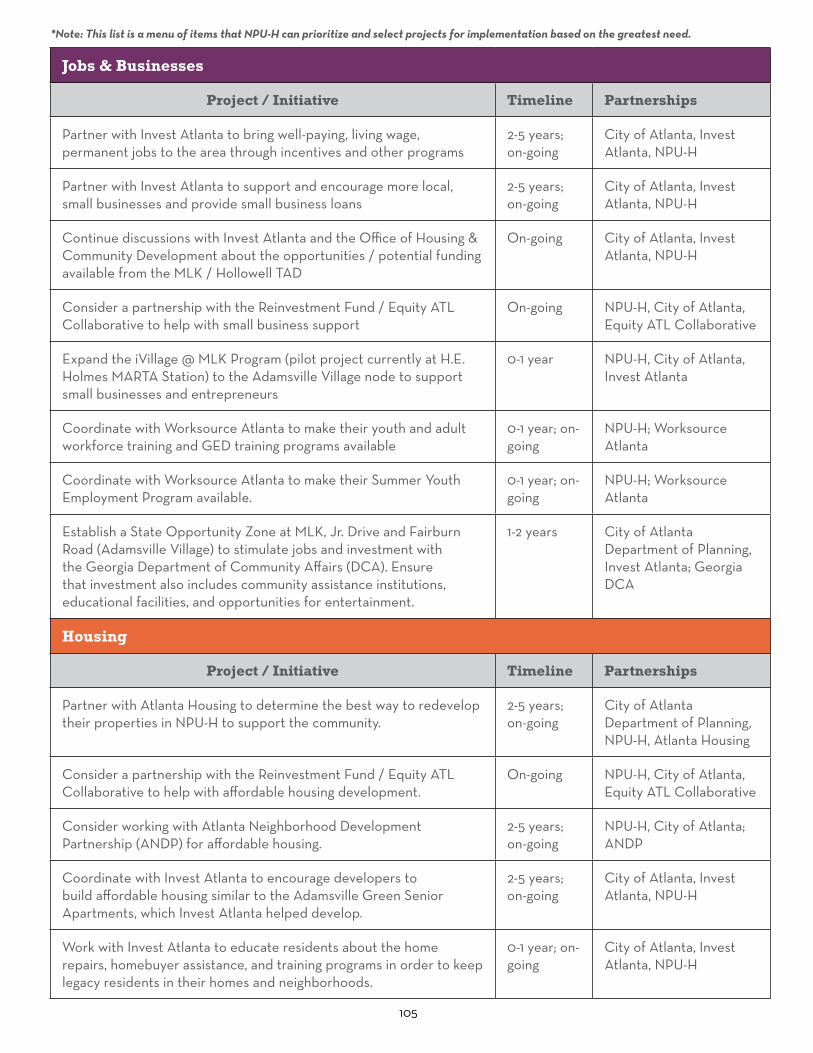
105
Jobs & Businesses
Project / Initiative Timeline Partnerships
Partner with Invest Atlanta to bring well-paying, living wage, permanent jobs to the area through incentives and other programs
2-5 years; on-going
City of Atlanta, Invest Atlanta, NPU-H
Partner with Invest Atlanta to support and encourage more local, small businesses and provide small business loans
2-5 years; on-going
City of Atlanta, Invest Atlanta, NPU-H
Continue discussions with Invest Atlanta and the Office of Housing & Community Development about the opportunities / potential funding available from the MLK / Hollowell TAD
On-going City of Atlanta, Invest Atlanta, NPU-H
Consider a partnership with the Reinvestment Fund / Equity ATL Collaborative to help with small business support
On-going NPU-H, City of Atlanta, Equity ATL Collaborative
Expand the iVillage @ MLK Program (pilot project currently at H.E. Holmes MARTA Station) to the Adamsville Village node to support small businesses and entrepreneurs
0-1 year NPU-H, City of Atlanta, Invest Atlanta
Coordinate with Worksource Atlanta to make their youth and adult workforce training and GED training programs available
0-1 year; on-going
NPU-H; Worksource Atlanta
Coordinate with Worksource Atlanta to make their Summer Youth Employment Program available.
0-1 year; on-going
NPU-H; Worksource Atlanta
Establish a State Opportunity Zone at MLK, Jr. Drive and Fairburn Road (Adamsville Village) to stimulate jobs and investment with the Georgia Department of Community Affairs (DCA). Ensure that investment also includes community assistance institutions, educational facilities, and opportunities for entertainment.
1-2 years City of Atlanta Department of Planning, Invest Atlanta; Georgia DCA
Housing
Project / Initiative Timeline Partnerships
Partner with Atlanta Housing to determine the best way to redevelop their properties in NPU-H to support the community.
2-5 years; on-going
City of Atlanta Department of Planning, NPU-H, Atlanta Housing
Consider a partnership with the Reinvestment Fund / Equity ATL Collaborative to help with affordable housing development.
On-going NPU-H, City of Atlanta, Equity ATL Collaborative
Consider working with Atlanta Neighborhood Development Partnership (ANDP) for affordable housing.
2-5 years; on-going
NPU-H, City of Atlanta; ANDP
Coordinate with Invest Atlanta to encourage developers to build affordable housing similar to the Adamsville Green Senior Apartments, which Invest Atlanta helped develop.
2-5 years; on-going
City of Atlanta, Invest Atlanta, NPU-H
Work with Invest Atlanta to educate residents about the home repairs, homebuyer assistance, and training programs in order to keep legacy residents in their homes and neighborhoods.
0-1 year; on-going
City of Atlanta, Invest Atlanta, NPU-H
*Note: This list is a menu of items that NPU-H can prioritize and select projects for implementation based on the greatest need.

106
Building & Site Design
Project / Initiative Timeline Partnerships
Review and revise NPU-H’s CDP design-focused policies (in appendix) to reflect this Master Plan and include green infrastructure, such as green roofs, food access, environmentally sustainable materials, stormwater mitigation, and green energy standards.
0-1 years City of Atlanta Department of Planning, NPU-H
Explore interest in neighborhood design guidelines, with a potential SPI Overlay district, for the residential portions of NPU-H.
2-5 years City of Atlanta Department of Planning, NPU-H
Update lot standards and other design standards during the forthcoming Atlanta Zoning update.
2-5 years City of Atlanta Department of Planning, NPU-H
Work with Office of Cultural Affairs to bring more public art to the area in parks, public spaces, and redevelopment projects. Potential first locations: Georgia Power property, open space near Cascade Skating, and the bridge over I-28 .
0-1 years; on-going
City of Atlanta Office of Cultural Affairs, NPU-H
Apply for an ARC Community Development Assistance Program (CDAP) grant to work on specific placemaking recommendations.
1-2 years NPU-H, City of Atlanta Department of Planning
Work with property and business owners and the Office of Housing and Community Development to improve building aesthetics through the Storefront Facade Improvements program. Potential first buildings: historic buildings in Adamsville Village the community wants to preserve.
1-2 years NPU-H, City of Atlanta Office of Housing and Community Development; property and business owners
Host education sessions and virtual or in-person tours of other neighborhoods in Atlanta to understand how they have attracted investment and preserved their history and character.
On-going NPU-H; City of Atlanta Office of Design Historic Preservation Studio, Department of Planning, Urban Design Commission
Consider designating a historic district to preserve eligible residential neighborhoods or designate specific buildings or sites as historic or as a landmark through the Office of Design Historic Preservation Studio. This will require significant time and commitment from the community. Potential first projects: ranch houses in Collier Heights, former Judge William Wilson House site and grave site.
3-4 years NPU-H; City of Atlanta Office of Design Historic Preservation Studio; Urban Design Commission
Transportation & Parking
Project / Initiative Timeline Partnerships
Identify potential TSPLOST projects (trails, streets, sidewalks, bike lanes). Potential streets: Boulder Park, Bakers Ferry, Collier Drive.
2-5 years City of Atlanta DOT, NPU-H
*Note: This list is a menu of items that NPU-H can prioritize and select projects for implementation based on the greatest need.
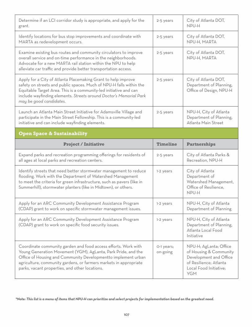
107
Determine if an LCI corridor study is appropriate, and apply for the grant.
2-5 years City of Atlanta DOT, NPU-H
Identify locations for bus stop improvements and coordinate with MARTA as redevelopment occurs.
2-5 years City of Atlanta DOT, NPU-H, MARTA
Examine existing bus routes and community circulators to improve overall service and on-time performance in the neighborhoods. Advocate for a new MARTA rail station within the NPU to help alleviate car traffic and provide better transportation access.
2-5 years City of Atlanta DOT, NPU-H, MARTA
Apply for a City of Atlanta Placemaking Grant to help improve safety on streets and public spaces. Much of NPU-H falls within the Equitable Target Area. This is a community-led initiative and can include wayfinding elements. Streets around Doctor’s Memorial Park may be good candidates.
2-5 years City of Atlanta DOT, Department of Planning, Office of Design, NPU-H
Launch an Atlanta Main Street Initiative for Adamsville Village and participate in the Main Street Fellowship. This is a community-led initiative and can include wayfinding elements.
2-5 years NPU-H, City of Atlanta Department of Planning, Atlanta Main Street
Open Space & Sustainability
Project / Initiative Timeline Partnerships
Expand parks and recreation programming offerings for residents of all ages at local parks and recreation centers.
2-5 years City of Atlanta Parks & Recreation, NPU-H
Identify streets that need better stormwater management to reduce flooding. Work with the Department of Watershed Management to meet the criteria for green infrastructure, such as pavers (like in Summerhill), stormwater planters (like in Midtown), or others.
1-2 years City of Atlanta Department of Watershed Management, Office of Resilience, NPU-H
Apply for an ARC Community Development Assistance Program (CDAP) grant to work on specific stormwater management issues.
1-2 years NPU-H, City of Atlanta Department of Planning
Apply for an ARC Community Development Assistance Program (CDAP) grant to work on specific food security issues.
1-2 years NPU-H, City of Atlanta Department of Planning, Atlanta Local Food Initiative
Coordinate community garden and food access efforts. Work with Young Generation Movement (YGM), AgLanta, Park Pride, and the Office of Housing and Community Developmentto implement urban agriculture, community gardens, or farmers markets in appropriate parks, vacant properties, and other locations.
0-1 years; on-going
NPU-H; AgLanta; Office of Housing & Community Development and Office of Resilience; Atlanta Local Food Initiative; YGM
*Note: This list is a menu of items that NPU-H can prioritize and select projects for implementation based on the greatest need.

108
Open Space & Sustainability, Continued.
Project / Initiative Timeline Partnerships
Create a vacant properties analysis to find properties suitable for additional community gardens or urban farms. Use this analysis to apply for an AgLanta Grows-A-Lot project. AgLanta also has a list of grants from other organizations on their website.
0-1 year City of Atlanta to conduct analysis; NPU-H and City to apply for grant
Identify a fresh food community liaison in NPU-H to coordinate with AgLanta
0-1 year NPU-H, City of Atlanta Department of Planning and Office of Resilience, AgLanta
Schedule an education session at an NPU-H meeting with AgLanta / the Urban Farm at 3301 Collier Drive to learn about volunteer and educational opportunities at Farm Awry and Gratitude Botanical.
Another option is an education session and partnership with Roots Down for urban agriculture.
Completed July 2020; on-going
NPU-H; AgLanta; Roots Down
Apply for Park Pride’s Park Visioning Program for Wilson Mill Park or other green spaces in the area (these plans were created for Collier Park in 2006 and Herbert Greene Nature Preserve in 2009).
2-5 years NPU-H
Acquire additional greenspace. The Urban Ecology Plan identified NPU-H as having substantial forested areas. These areas can be acquired with Tree Preservation Fund and be developed with trails for public use.
5-10 years City of Atlanta
Identify locations where street trees are needed, organize volunteers, and coordinate with Trees Atlanta through their Neighborhood Tree Planting Program. Tree Atlanta uses recompense funding to plant trees.
1-2 years; on-going
NPU-H; individual neighborhood groups; Trees Atlanta
Educate residents on home renovations with green energy options, such as wind and solar power, and environmentally sustainable materials, such as hempcrete and others, to save money on utilities.
1-2 years; on-going
NPU-H; City of Atlanta
*Note: This list is a menu of items that NPU-H can prioritize and select projects for implementation based on the greatest need.

109
Other Initiatives
Project / Initiative Timeline Partnerships
Create a community clean-up program; consider a partnership with the Keep Atlanta Beautiful Commission to obtain supplies and other assistance or work with YGM to schedule clean-ups.
0-1 year; on-going
NPU-H; Keep Atlanta Beautiful Commission; Department of Public Works; YGM Atlanta
Mitigate public health risks by making contingency plans for public health concerns and to reduce the impacts of industry along Fulton Industrial Boulevard.
0-5 years; on-going
NPU-H, Emory University HERCULES Community Engagement Core
Create educational partnerships with community organizations, non-profits, schools, and the Department of Parks and Recreation to offer classes in specific topics, professional education, and workforce training.
0-5 years; on-going
NPU-H, City of Atlanta Parks & Recreation, Community or Technical colleges
Participate in the APS Facilities Master Plan to determine future use of Margaret Fain Elementary and GA Towns Elementary schools.
0-1 year NPU-H; Atlanta Public Schools
Start a community outreach group that builds relationships with homeowners and renters to encourage them to stay in their neighborhoods and participate in neighborhood efforts.
0-5 years; on-going
NPU-H
*Note: This list is a menu of items that NPU-H can prioritize and select projects for implementation based on the greatest need.

110
Additional Information
Herbert Green Nature Preserve (TSW, 2019)

111
AppendixCPTED Guidelines
Codes Violated
CDP Quality of Life Proposal
NPU-H Health Survey
Fairburn Road Project
NPU-H CDP Policies

112
Crime Prevention Through Environmental Design (CPTED) Lighting Guidelines The International CPTED Association published guidebooks for different elements of CPTED. The Excerpts on the following pages are part of the Lighting guidebook. The first chart shows lighting design ideas and what they accomplish, while the second chart describes the appropriate lighting levels in foot-candles (FC) for different land uses and conditions.
More information can be found at: https://www.cpted.net/E-guidebooks

113
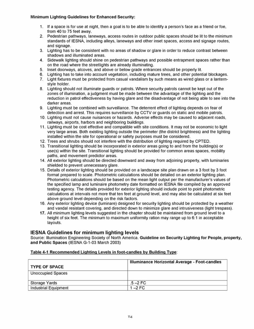
114

115
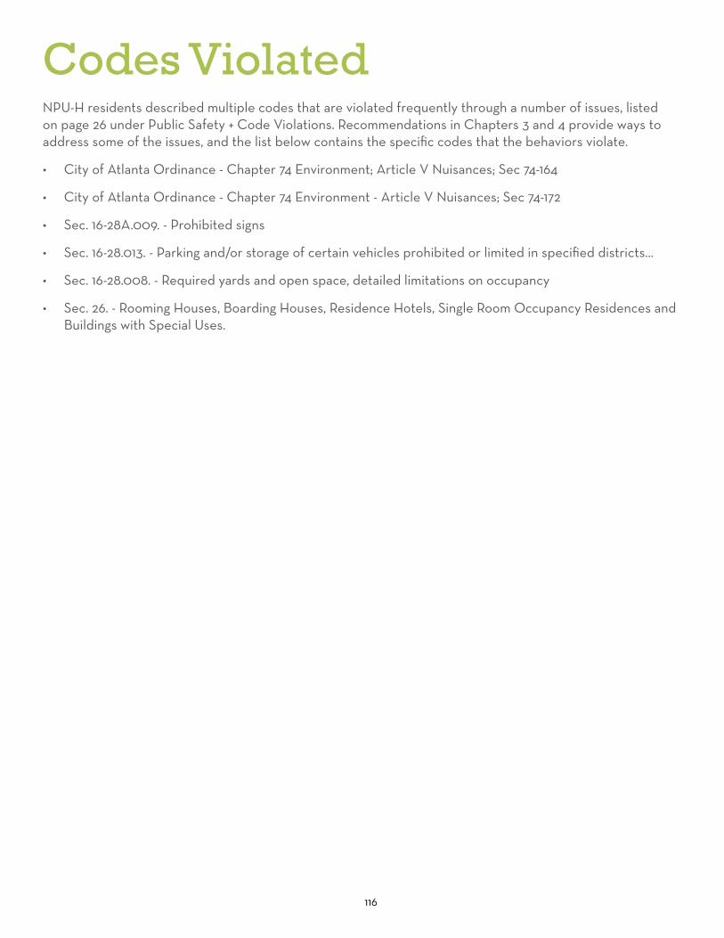
116
NPU-H residents described multiple codes that are violated frequently through a number of issues, listed on page 26 under Public Safety + Code Violations. Recommendations in Chapters 3 and 4 provide ways to address some of the issues, and the list below contains the specific codes that the behaviors violate.
• City of Atlanta Ordinance - Chapter 74 Environment; Article V Nuisances; Sec 74-164
• City of Atlanta Ordinance - Chapter 74 Environment - Article V Nuisances; Sec 74-172
• Sec. 16-28A.009. - Prohibited signs
• Sec. 16-28.013. - Parking and/or storage of certain vehicles prohibited or limited in specified districts...
• Sec. 16-28.008. - Required yards and open space, detailed limitations on occupancy
• Sec. 26. - Rooming Houses, Boarding Houses, Residence Hotels, Single Room Occupancy Residences and Buildings with Special Uses.
Codes Violated

117
NPU-H CDP Quality of Life Proposal & Vote
Why should you vote in NPU-H meeting to add a new plan element to the Atlanta Comprehensive Development Plan? It will start the process to add it to the Comprehensive Development Plan and notify the Atlanta Office of Zoning that NPU-H residents want future land use legislation to consider public health, welfare, public safety, etc.
What is the Comprehensive Development Plan (CDP) and why is it important? A county or city/town must be chartered in the State of Georgia. The CDP is legislation that is required of all Georgia cities (towns) and counties to maintain their charter status and to received state funding. Every four to 5 years each local government in Georgia must update their Comprehensive Development Plan and submit that plan to the Georgia Department of Community Affairs (DCA). The CDP is comprised of plan elements. Counties and cities/towns must update and address each plan element, specifically, land use, housing, transportation, economic development, community goals, needs opportunities, community program, broadband and capital improvements. The CDP legislation is important because the plan elements affect your life, wellbeing, workplace, living quarters, and the use of the land where you live.
Why does Atlanta need a Quality of Life Plan Element? To address health, welfare and public safety added traffic congestion in the Comprehensive Development Plan; address citizen reporting of nuisance violations and offenses to the proper city office or department. In addition, the city of Atlanta has never had a Quality Of Life Plan Element in its Comprehensive Development Plan.
If a Quality of Life Plan Element is so important, why hasn’t the city of Atlanta added it in the past? No official, NPU or official body has ever chosen to add Quality of Life to the CDP and Atlanta officials in past administrations have been primarily concerned with development, developers, massive growth rather than residents’ health, welfare, added traffic congestion, reporting nuisances in residential areas.. Is a Quality of Life (QOL) Plan Element unusual for a Comprehensive Development plan? No. Gwinnett County has QOL codes; the city of Buffalo NY has QOL codes; the city of Snellville has a QOL plan element in their CDP.
What happens next if NPU-H votes to support a Quality of Life Plan Element? NPU-H Chair would send a recommendation to the Office of Zoning and Development including the results of the vote, documentation & the Office of Zoning & Development would review the package and determine the next step.
Q&A’s
1 of 2
Residents of NPU-H are being asked to vote for adding a Quality of Life Plan Element to the city of Atlanta’s Comprehensive Development Plan. The motion would be, but not limited to - - (1)Add public health, welfare, public safety, added traffic congestion to an already heavily congested area conditions to proposed land use legislation so that NPUs may address these concerns when asked to support or not support land use legislation. (Note: The current official list of conditions for NPUs to consider for land use change legislation are fencing, buffering, number of trucks, curve cuts, d-cell lanes, operations time and idling time.)
(2)Add a new plan element entitled, “Quality of Life” to the Atlanta Comprehensive Development Plan. A new Quality of Life Plan Element would address, but not be limited to, concerns when proposed land use legislation might infringe on health, welfare, environment, traffic congestion, air pollution and other health and welfare and concerns.
(3)A Quality of Life Plan Element would also address, but not be limited to, constituents reporting dilemma. Currently, citizens are bounced around from one department or another trying to report minor offences or violations. It is confusing because it’s unc lear what department enforces what offense or violation. Constituents are repeatedly told to contact another office. This is stressful and frustrating. Because of this situation, minor offenses and violations continue for years. (Examples of minor nuisances are (but not limited to) parking violations, license tag violations, dogs barking on the premises of vacant properties; loud boon box noises, children playing in the street after 11pm, individuals repairing vehicles and conducting businesses, portable basketball stands in residential neighborhoods.)
VOTE “yes” FOR A QUALITY OF LIFE PLAN ELEMENT

118
Why should you vote in NPU-H meeting to add a new plan element to the Atlanta Comprehensive Development Plan? It will start the process to add it to the Comprehensive Development Plan and notify the Atlanta Office of Zoning that NPU-H residents want future land use legislation to consider public health, welfare, public safety, etc.
What is the Comprehensive Development Plan (CDP) and why is it important? A county or city/town must be chartered in the State of Georgia. The CDP is legislation that is required of all Georgia cities (towns) and counties to maintain their charter status and to received state funding. Every four to 5 years each local government in Georgia must update their Comprehensive Development Plan and submit that plan to the Georgia Department of Community Affairs (DCA). The CDP is comprised of plan elements. Counties and cities/towns must update and address each plan element, specifically, land use, housing, transportation, economic development, community goals, needs opportunities, community program, broadband and capital improvements. The CDP legislation is important because the plan elements affect your life, wellbeing, workplace, living quarters, and the use of the land where you live.
Why does Atlanta need a Quality of Life Plan Element? To address health, welfare and public safety added traffic congestion in the Comprehensive Development Plan; address citizen reporting of nuisance violations and offenses to the proper city office or department. In addition, the city of Atlanta has never had a Quality Of Life Plan Element in its Comprehensive Development Plan.
If a Quality of Life Plan Element is so important, why hasn’t the city of Atlanta added it in the past? No official, NPU or official body has ever chosen to add Quality of Life to the CDP and Atlanta officials in past administrations have been primarily concerned with development, developers, massive growth rather than residents’ health, welfare, added traffic congestion, reporting nuisances in residential areas.. Is a Quality of Life (QOL) Plan Element unusual for a Comprehensive Development plan? No. Gwinnett County has QOL codes; the city of Buffalo NY has QOL codes; the city of Snellville has a QOL plan element in their CDP.
What happens next if NPU-H votes to support a Quality of Life Plan Element? NPU-H Chair would send a recommendation to the Office of Zoning and Development including the results of the vote, documentation & the Office of Zoning & Development would review the package and determine the next step.
Q&A’s
1 of 2
Residents of NPU-H are being asked to vote for adding a Quality of Life Plan Element to the city of Atlanta’s Comprehensive Development Plan. The motion would be, but not limited to - - (1)Add public health, welfare, public safety, added traffic congestion to an already heavily congested area conditions to proposed land use legislation so that NPUs may address these concerns when asked to support or not support land use legislation. (Note: The current official list of conditions for NPUs to consider for land use change legislation are fencing, buffering, number of trucks, curve cuts, d-cell lanes, operations time and idling time.)
(2)Add a new plan element entitled, “Quality of Life” to the Atlanta Comprehensive Development Plan. A new Quality of Life Plan Element would address, but not be limited to, concerns when proposed land use legislation might infringe on health, welfare, environment, traffic congestion, air pollution and other health and welfare and concerns.
(3)A Quality of Life Plan Element would also address, but not be limited to, constituents reporting dilemma. Currently, citizens are bounced around from one department or another trying to report minor offences or violations. It is confusing because it’s unc lear what department enforces what offense or violation. Constituents are repeatedly told to contact another office. This is stressful and frustrating. Because of this situation, minor offenses and violations continue for years. (Examples of minor nuisances are (but not limited to) parking violations, license tag violations, dogs barking on the premises of vacant properties; loud boon box noises, children playing in the street after 11pm, individuals repairing vehicles and conducting businesses, portable basketball stands in residential neighborhoods.)
VOTE “yes” FOR A QUALITY OF LIFE PLAN ELEMENT
2 of 2
State of Georgia Recommendations & Health Status Map References
Health and Welfare regarding land use zoning is recommended by the Georgia Department of Community Affairs in the 2009 Zoning Procedures Law (O.C.G.A. § 36-66-1 ) § 36-66-5 (b) - Adoption of hearing policies and procedures and standards for exercise of zoning power (b) In addition to policies and procedures required by subsection (a) of this Code section, each local government shall adopt standards governing the exercise of the zoning power, and such standards may include any factors which the local government finds relevant in balancing the interest in promoting the public health, safety, morality, or general welfare against the right to the unrestricted use of property. Such standards shall be printed and copies thereof shall be available for distribution to the general public. § 36-67-2 - Legislative findings The General Assembly finds that the increasing urbanization of those local governments subject to this article requires that such local governments should use zoning procedures which may not be necessary in other less urbanized areas. The General Assembly finds that the procedures required by this article will help to ensure that governing authorities will make zoning decisions consistently and wisely and in keeping with the long-range requirements of the public health, safety, and welfare. The General Assembly further finds that the procedures required by this article will help to ensure that zoning decisions are made on the basis of a record which will contain matters necessary to the consistent and wise decision of zoning matters in highly urban areas. The General Assembly further finds that the procedures required by this article will help citizens of the affected local governments in presenting and articulating their viewpoints on zoning matters. The General Assembly further finds that the procedures required by this article will help to ensure that court decisions, when courts are required to intervene in zoning matters, will be made on the basis of a record which will contain matters necessary to the consistent and wise judicial decision of such zoning matters. § 36-67A-5(c) - Appointment of disinterested special master if governing authority unable to attain a quorum (c) The special master shall consider any factors relevant in balancing the interest in promoting the public health, safety, morality, or general welfare against the right to the unrestricted use of property. Health and Welfare is recommended by the Georgia Department of Community Affairs Board in the Board’s 2018 Georgia's Quality Community Objectives, Recommendation 10 reads: "Ensure that all community residents, regardless of age, ability, or income, have access to critical goods and services, safe and clean neighborhoods, and good work opportunities. This may be achieved by providing services to support the basic needs of disadvantaged residents, including the disabled; instituting programs to improve public safety; promoting programs that foster better health and fitness; or otherwise providing all residents the opportunity to improve their circumstances in life and to fully participate in the community." The Georgia Department of Public Health, Office of Health Indicators for Planning (OHIP) prepared a report for Fulton County entitled "Adamsville Area Demographics and Health Status maps" - Data created with OASIS: 12-24-2017 3:05 PM - https://oasis.state.ga.us - Data Classification Method: Natural Breaks (Jenks). NPU-H and other nearby NPUs are included in the Adamsville Area demographics and status maps. Two excerpt passages are Major Cardiovascular Disease “In 2002-2006, some of the highest percentages of deaths due to major cardiovascular disease were in central and south Fulton. By 2007- 2011 the percentages of deaths due to major cardiovascular disease increased and some of the highest percentages were again in central and south Fulton. By 2012-2016 the percentages of deaths due to major cardiovascular disease decreased to a level better than the 2002- 2006 level yet some of the highest percentages were again in central and south Fulton” Asthma map entitled, Number of Discharges by Census Tract of Residence, Fulton County, Asthma, 2007-2011 Asthma analysis Adamsville Area Map: “There were more roughly 1½ times more hospital discharges for asthma in central and south Fulton than the in other parts of the County. “

119
NPU-H Health SurveyIn 2010, NPU-H residents conducted a Health Survey, as described on page 31 in the Public Health section. The following pages show the original survey questions.Previous Plans and Projects
2010 NPU-H Health & Environment Paper Survey
Schedule February 16, 2010 – Jackson Memorial Church – 1:00pm-3:00pm February 23, 2010 – Jackson Memorial Church – 1:00 p.m. – 3:00 p.m. February 25, 2010 – Mays High PTSA meeting 7:00pm-8:30pm March 1, 2010 – Darnell Senior Center after luncheon Movie/Survey & Popcorn 12:30pm-1:30pm March 4, 2010 – NPU-H Meeting at the Darnell Center - 7:00 p.m. – 9:00 p.m. March 6, 2010 – Adamsville Recreation Center Open House 12:00-4:00pm March 20, 2010 – Adamsville Beautification Fair 11:00am – 2:00pm at Zion Hill Baptist Church April 1, 2010 – NPU-H Monthly meeting at the Darnell Center – 7pm – 9pm April 3, 2010 – Adamsville Health Fair at Recreation Center – 10:00 a.m. – 2:00 p.m. April 5, 2010 – Darnell Senior Center Movie Survey during Lunch – 11:30am-12:30pm April 15, 2010 – Big Bethel Homeowners Association – 6:30 p.m. – 8:30 p.m. April 17, 2010 – Adamsville Earth Day Clean Up assemble at Collier Plaza – 10am – 2:00pm April 23, 2010 – Jackson Memorial Church – 6:30 p.m. – 8:30 p.m. May 2, 2010 – Celebrity Cook-Off by the Adamsville Business & Community Partnership at Adamsville Recreation Center – 2:30pm – 4:00pm
Purpose Why Was the NPU-H Survey Needed? Highest rate of child asthma in Fulton County in 2010 Three (3) dialysis clinics are in high demand from Southwest Atlanta residents NPU-H borders the Fulton Industrial Boulevard Corridor where there is a documented high particulate emissions. FIB is the largest trucking corridor in the Southeaster U.S. and the second largest trucking corridor in the U.S. Residents’ health is a priority No previously documented surveys in NPU-H geographical area Residents felt they are a forgotten community.
Background Our community with collaboration from the Centers for Disease Control, Fulton County Health Services conducted a community based environmental health assessment study to create an accurate and verifiable profile of the community's environmental health status. Using the Protocol for Assisting Community Excellence in Environmental Health (PACE-EH) guidebook as the framework for the project, we completed 4 of 13 task required for completion. To accomplish task 5, we sought funding to conduct a community awareness campaign by hosting a series of movie nights/days to view presentations about air, water, personal health, violence prevention, safety, litter, food, etc. to collect data on community concerns, knowledge, attitudes, behavior, and perceptions. At the conclusion of this task we will have created a manageable list of issues. We located funding to complete Task 5 and move forward to complete the project by December 2010.
Grant funded by Community Foundation of Greater Metropolitan Atlanta Neighborhood Fund
January-June 2010
Survey Design Team and Co-coordinators of Survey Events Cathy Richards Michelle Uchiyama Vernelle Cowan
Paper Survey 1 of 4
Tené Traylor Program Officer The Community Foundation for Greater Atlanta
Jessica Daniels Assigned Community Coach The Community Foundation for Greater Atlanta

120
Previous Plans and Projects
2010 NPU-H Health & Environment Paper Survey
Grant funded by Community Foundation of Greater Metropolitan Atlanta Neighborhood Fund
January-June 2010
Results Of NPU-H 2010 Health and Environment Survey Community Foundation of Greater Metropolitan Atlanta ‘ Neighborhood Fund- January-June 2010 Resident participation was anonymous. Actual completed surveys are available.
FEEDBACK SUMMARIZED 911 completed surveys were collected. 538 of the above lived in 30331, NPU-H's primary zip code area (1)Transportation and Walking Traffic 274 respondents in 30331 indicated that having sidewalks was of the highest importance. (2)Health Care Facilities 391 respondents in 30331 indicated that having a hospital near by was of the highest importance. 292 respondents in 30331 indicated that having a medical clinic nearby was moderately important. (3)Safety 371 respondents indicated that potholes were of the highest importance. (4)Quality of Life 279 respondents indicated that having a recreation center nearby was of the highest importance. 224 respondents indicated that having a senior assisted facility in the 30331 area was moderately important. (5)Care of the Environment 347 respondents indicated that littering and dumping was of the highest importance. 254 respondents indicated that maintenance of vacant property was moderately important. Major issues covered in the 2010 NPU-H Health and Environment Survey were: Health & Disease; Transportation & Walking Traffic; Pollution; Safety; Healthcare facilities needed; Quality of Life needed; Care of the Environment Respondents rated the sub-areas under the major issues on a scale of 1 to 5. 1 = high importance for me; 2 = moderately important for me; 3 = somewhat important for me; 4 = no importance; 5 = no comment; Other = A space was provided for respondents to include other issues or additional information. DOCUMENT - End of Grant Report dated July 12, 2010 submitted to Neighborhood Fund
END OF GRANT REPORT COVER PAGE
Paper Survey 2 of 4

121
Previous Plans and Projects
2010 NPU-H Health & Environment Paper Survey Grant funded by
Community Foundation of Greater Metropolitan Atlanta Neighborhood Fund January-June 2010
PAPER SURVEY PAGE 1
Paper Survey 3 of 4

122
2010 NPU-H Health & Environment Paper Survey Grant funded by
Community Foundation of Greater Metropolitan Atlanta Neighborhood Fund January-June 2010
Previous Plans and Projects Paper Survey 4 of 4
PAPER SURVEY PAGE 2

123
Fairburn Road Project - Atlanta DOT & Renew AtlantaThe Atlanta Department of Transportation (DOT) and Renew Atlanta are leading an effort to improve the Fairburn Road streetscape to make it safer for pedestrians, cyclists, and drivers, as a result of the Atlanta Transportation Plan completed in 2018. The goal is to make Fairburn Road a “Complete Street.”
The July 2019 presentation noted the following design criteria:• Provide opportunities for
multiple users• Maintain curb lines where
possible• Improve safety along the
corridor while improving accessibility
• Use rectangular rapid flashing beacons (RRFB) for safe pedestrian crossings
• Improve infrastructure (consider green strategies)
• Improve aesthetics
The same presentation noted the following scope for the project: The Fairburn Road Complete Street project consist of the redesign of the Fairburn roadway for approximately 2.1 miles from Martin Luther King Jr. Drive south to the city limits near Cascade Road. The improvement will incorporate a road diet narrowing the existing traffic lanes. The project will have 5 foot dedicated bike lanes on
portions of the east and west side of Fairburn Road from Mays Crossing to Benjamin E. Mays Drive, whereby bike traffic on the west side will crossover to the east side of the roadway at Mays Crossing connecting to a 10 foot multi use path. The multi use path heading north begins at Mays Crossing and terminates at Boulder Park Drive. The dedicated bike lanes on the east and west side of the roadway will continue from Boulder Park Drive to Martin Luther King Jr. Drive. New concrete sidewalks will be constructed on the west side of the roadway along with new curbs in various sections on both sides of Fairburn Road. The roadway will be resurfaced and have new curb ramps, decorative retaining walls where needed, new street trees and pedestrian LED lighting, new street signs and pavement markings along with several pedestrian hybrid beacon devices at mid block crossings. In addition, the project will implement drainage improvements to facilitate proper drainage to help alleviate the flooding occurrences of the past. In 2017 and 2018, on certain segments of the roadway the pavement was resurfaced due to the deteriorated pavement condition and could not wait for the implementation of this improvement. Therefore, the current design took into account of the resurfacing work. The
traffic signal at Mays Crossing and Fairburn Road is currently being replaced and upgraded under a separate contract.
The slides on the next page are pulled from the July 2019 update presentation.

124
2
Project Location:
6
PAVEMENT CONDITION:
7
PAVEMENT CONDITION CONT.:
Project Location Map:
Pavement Conditions Photos

125
8
PAVEMENT CONDITION CONT.:
9
Drainage Issues:
FAIRBURN ROAD COMPLETE STREET UPDATE
17/29/2019
7/29/2019
Pavement Conditions Photos
Conceptual Street Section:

126
NPU-H Policies from 2016 CDP
NPU POLICIES
�et�een �e�i�� �ensities �evelop�ent alon� �oll��oo� �oa� �orri�or to e�istin� sin�le �a�il� resi�ential neighborhoods using mid to low-rise mixed-use development.
����� �n�o�ra�e t�e �tili�ation o� �n�evelope� lan� alon� t�e ��a�a�oo��ee �iver �or a par�� �i�e trail an� �iver�al� Atlanta � �ile �reen�a� ��i�� �o�l� in�l��e Atlanta �n��strial �ar�� ��a�a�oo��ee �ri�� an� ��lton �o�nt� properties.
����� �n�o�ra�e pe�estrian �o�ilit� �� �o�pletin� t�e si�e�al�s t�ro��� ����� an� �p�ra�in� an� a��in� �ross-�al�s. ��prove pe�estrian a�enities s��� as street trees an� �i�e si�e�al�s to ��rt�er en�o�ra�e pe�estrian travel. �n�o�ra�e sa�e an� responsi�le �rivin� pa�erns t�ro���o�t t�e ����� t�ro��� i�ple�entation o� tra�-�� �al�in� �eas�res an� en�or�e�ent o� spee� li�its.
����� �is�o�ra�e in�ll �evelop�ent t�at is not �o�pati�le �it� t�e e�istin� ��ara�ter o� t�e nei���or�oo� �e.�. rear or si�e�o��t�e��o�se �rive�a�s� �ara�es or �arports� lot �overa�e� �oor�to�area ratio� ��il�in� �ei��t� an� �all�fence height of nearby homes.)
����� �ontrol t�e �evelop�ent o� ��sinesses� s��� as li��or stores an� non�ta� �ontri��tin� entities.
G-17: Open space land use that preserves for Public Park, cemetery, or greenspace the following: Gun Club Park, Gun �l�� �an��ll an� t�e ol� �in�� s��ool site.
NPU-H Policies
�esi�ential �o�sin�
���� �reserve t�e sin�le��a�il� resi�ential ��ara�ter o� ����� in all nei���or�oo�s espe�iall� t�e �arroll �ei��ts� Fairburn Heights, Adamsville, and Boulder Park Neighborhoods.
���� �n�o�ra�e in�ll �evelop�ent t�at is �o�pati�le �it� s�rro�n�in� �ses.
H-3: Middle to high income housing is encouraged to establish a more diverse housing market in NPU-H.
���� ��pport an� en�o�ra�e �artin ��t�er �in� �r. �rive an� �air��rn �oa� are areas �evelope� �or ��lti�a�il� ��ellin�s� �i� �se �evelop�ent� an� s�pportive �o�sin�.
���� �o� in�o�e �o�sin� �onstr��tion is not en�o�ra�e� ��e to t�e lar�e vol��e o� �no���pie� lo� in�o�e sin�le an� ��lti��a�il� ��ellin�s t�at ��rrentl� e�ist in �����.
���� �n�o�ra�e ��lti��a�il� �evelop�ent o� ��� a�res or �ore s��� as apart�ents� ��ple�es� senior �a�ilities to in-�l��e a se�tion o� �reenspa�e � pla� area� e�orts s�o�l� �e �a�e to in�l��e o�t�oor ��iet spots �it� �en��es for residents, with walking trail for larger developments
���� ��pport t�e preservation an� t�e �evelop�ent o� senior �o�sin� �nits an� parti��larl� a�or�a�le �o�sin� �nits along Fairburn Rd.
�esi�ential � �n�evelope���a�ant
���� �n�o�ra�e ne� �o�sin� �evelop�ent t�at is �o�pati�le �it� t�e ��ara�ter o� e�istin� nei���or�oo�s to repla�e the blighted development areas, and accelerate the razing of structures on the following sites: 914 Bolton Rd ��� ��� �olton �� ��� ��� �olton �� ��� ���� �olton �� ��
Commercial - Industrial
���� �e�a�ilitate an��or repla�e t�e e�istin� ol�er �o��er�ial ��il�in�s ��ere appropriate on �ar�n ��t�er �in� �r. �r. �et�een ����� an� �est to Atlanta �it� li�its� �it� t�e �elp o� t�e e�istin� �ollo�ell��.�.���A� an� �nvest Atlanta initiatives.
347347

127
NPU POLICIES
����� �nco�rage diversit� o� co��ercial ��sinesses on M.L. King Jr. Dr s�c� as grocer� stores� �ve�star resta�rants� �ig� end �o�ti��es to co�pli�ent t�e senior �ig� rise c�aracter �o�sing along t�is corridor.
����� ��pport �ni�ed develop�ent o� t�e �da�sville co��ercial area and its associated co���nit� �acilities �it�o�t encroac�ing into ad�acent residential areas.
����� �nco�rage t�e develop�ent o� o�ce�instit�tional �ses along Martin L�t�er King Jr. Drive �ro� t�e �da�sville co��ercial area to t�e e�isting co��ercial �se at t�e ����� interc�ange �it�o�t encroac�ing into ad�acent resi-dential areas.
����� �nco�rage t�e re��oning �ro� ���� to Mi�ed �se Develop�ent �ro� on Martin L�t�er King Jr. Drive �ro� �olton �oad to ��lton �nd�strial �o�levard �it�o�t encroac�ing into ad�acent single �a�il� residential areas.
H-14: Discourage shabby un-kept commercial storefronts. Encourage adding when possible, greenery such as grass, �o�ers and or s�r���er�.
����� �nco�rage ne� ��siness �it� accepta�le store�ront designs according to g�idelines identi�ed in t�e ������ �d-a�sville ���� �o�pre�ensive Develop�ent Master �lan
����� Maintain t�e �o�ndaries o� co��ercial� ind�strial� and instit�tional �ses �it�o�t encroac�ing into lo��densit� residential areas.
����� �onsolidate strip co��ercial �ses in order to create a �ni�ed develop�ent �aving a �ini��� n���er o� c�r� cuts and turn lanes.
����� �etain ind�strial �ses. �rovide landscaped or arc�itect�ral ���ers to �ini�i�e t�eir potential i�pacts on ad�a-cent residential areas.
����� �reserve� protect� and �aintain �ood plain areas in t�eir nat�ral states
����� �nco�rage developers and private o�ners to install side�al�s t�ro�g�o�t ����� ��ic� �ill eli�inate residents� especially children walking in the street.
����� ��pport t�e preservation and t�e develop�ent o� senior �o�sing �nits and partic�larl� a�orda�le �o�sing �nits along M.L. K Jr Drive.
Transportation
����� �nco�rage additional stor� drains on streets ��ere street �ooring occ�rs d�ring �eav� rain.
����� �nco�rage t�e creation o� t�rn lanes on �a�or t�oro�g� �ares �M. L. King Jr. Drive� �air��rn �oad� �olton �oad� �o�lder �ar� Drive� �a�es �err� �oad� Del�ar Lane� at all intersections.
����� �nco�rage t�e creation and designation o� �i�e Lanes on �a�or t�oro�g� �ares �M.L. King Jr Drive � �air��rn Road).
����� �nco�rage t�e creation o� ��s �top Lanes in �ront o� s�opping areas� apart�ent co�ple�es� c��rc�es� �edi-cal �acilities� and ot�er properties ��ere large n���ers o� riders �a� load and �nload t�e ��s on M.L. King Jr. Drive and Fairburn Road; shall be included in the development plans of all new retail/commercial projects and ��lti�a�il� �o�sing co�ple� in �����
����� �nco�rage t�e �it� to install pedestrian crossings e��ipped �it� co�nt do�n signals� �rig�t street lig�ting� and �ell de�ned crossing �al�.
����� �nco�rage t�e �it� to install Tra�c �al�ing tec�ni��es and devices in co���nit� areas ��ere tra�c violation iss�es are creating pro�le�s �or co���nit� sa�et� and �ell��eing.
348348127

128
NPU POLICIES
����� ������t an� �nc���age c�nnectiv�t� s�c� as ma��e� ���tes, ��s ���tes, �al��ng �at�s t� ��e �eltl�ne a�ea ��� ����ng, �al��ng an� �t�e� lan� �se activ�ties ��� ����� ���c� �s ��ts��e �� ��e �eltl�ne �es�gnate� ge�g�a���.
Planning and Urban Design
����� �n ne� �evel��ment �� �e��evel��ment �� ����e�ties g�een s�ace �s enc���age� ��� �la� a�ea ��� �am�l�es.
����� �n m�lti�am�l� �evel��ment, a c�mm�n�t���am�l� activ�t� cente� �s enc���age� t� all�� ��� �es��ents t� ��st small events, meetings, etc.
����� �es��ential �� ��mme�c�al �evel��ment t�at st��s �� alte�s t�e nat��al ��� �� �ate� �n c�ee�s, st�eams, �� la�es is not encouraged.
����� �e� �evel��ment ��t� t��ee st��� ��mes t�at ��se t�� st���es a��ve t�e nea�est ��mes ��t��n ��� �a��s �� t�e new development is not encouraged.
����� �e� �evel��ment �el�� st�eet level t�at ��ll �e����e se�age t� �e ��m�e� �� t� t�e ma�n se�age l�ne �s not encouraged.
�lann�ng an� ���an �es�gn��a��s �ec�eati�n � ��lt��al ��a��s ������nati�n
����� ��st���c ��ese�vati�n �e��cati�n �� t�e ����s, ����s � ea�l� ����s ���t���nt� �� ����� �s enc���age� �n t�e form of workshops, digital records, family roots study, and street history of the NPU-H geography and nearby neighborhoods.
����� �nc���age c�mm�n�t� cente� an� �ec�eati�n cente� �evel��ment �� ��� ac�es �� m��e �ncl��e a secti�n �� g�eens�ace � �la� a�ea. �en��� �ac�l�ties � e���ts s���l� �e ma�e t� �ncl��e ��t���� �enc��s�����et s��t ��� residents. Walking trail(s) would be encouraged for larger developments.
H-36: Encourage the maintenance of public and private greenspace areas
����� ������t �nstallati�n �� �ell�l�t, sa�e �e�est��an �al��a�s an� �at�s a���n� ��t� �� �tlanta �a��s, ���l�c �ac�l�ties.
�at��al �es���ces an� ��st���c �es�gnati�ns �g�een s�aces, �etlan�s�
H-38: Protect and enhance natural resources and historical sites:
• �t�� ����ngs � ���l�e� �a�� ���ve, ���l�e� �a�� �e�g�������� � �an� ��t ������ � �a�cel � ������� �����• �at�m �a�e � ���l�e� �a�� ���ve, ��ls�n ��ll �ea���s �e�g�������� �an� ��t ������ � �a�cel � �������
�����• �e��e�t ��eene �at��e ��ese�ve � ���l�e� �a�� �e�g�������� �an� ��t ������ � �a�cel � ������� �����• �at��al ���l�e� ��c� ga��en ��a�e� ��lls �e�g�������� �an� ��t ������ � �a�cel � ������� �����• Bethlehem UMC Church Cemetery on 4195 Bakers Ferry Road, Wilson Mill Meadows Neighborhood - Land Lot
������ �a�cel � ������� ������• Mayson Church Cemetery on Hollowell Parkway - Bankhead-Bolton Neighborhood - Land Lot 17-261 - Parcel
� �� �����������• �t ���n ��ss��na�� �a�tist ����c� �emete�� ��amsv�lle �e�g��������, �a�����n �� �an� ��t ������ � �a�cel
� �� �����������• �e��g�a ��tan�cal �a��en ���st���cal s�te� � ����s �ec�eati�n �en�e � �a�e�s �e��� �e�g�������� � �an� ��t
14F-51 (and LL 23 in Fulton County)• ��e ���ge ��ll�am �s���� ��ls�n ���se ���st���cal s�te� � ����entl� ��������t ��g� ���ns, a g�eens�ace ��� ��e
���ge ��ls�n ���se an� �a��ens, ��� �a�����n ��a�, �a�����n��a�s �e�g�������� � �an� ��t ������ � �a�cel � ������� �����
349349

130
NPU-H Master Plan completed in partnership between NPU-H residents and:


