31 January 2014 P1 AGENDA ITEM: 3.2 Application No: 155/M002/14 KNET Reference: #8621587 Applicant: FA Marmac Pty Ltd Proposal: Demolition of existing buildings and structures including one Local Heritage place, removal of a Regulated Tree and construction of a mixed use development comprising 54 residential dwellings, 3 SoHo products, a retail store and commercial offices together with above ground car parking and related works. Subject Land: 54-60 King William Street, Kent Town Relevant Authority: Inner Metropolitan Development Assessment Committee of the Development Assessment Commission Role of the Commission: Schedule 10(4C) of the Development Regulations 2008: Development that involves the construction of a building that exceeds 4 storeys in height within the Urban Corridor Zone Zone / Policy Area: Urban Corridor Zone, Business Policy Area Categorisation: Category 2 Notification: Yes Representations: Nil Lodgement Date: 6 June, 2014 Council: The Corporation of the City of Norwood Payneham and St Peters Development Plan: Norwood Payneham and St Peters (City) Consolidated 31 October 2014 Statutory Referral Agencies: Government Architect (Pre-lodgement agreement) Renewal SA (Pre-lodgement agreement) Officers Report: Concetta Parisi Recommendation: Planning Consent subject to conditions EXECUTIVE SUMMARY Introduction This development proposal, according to the Planning Statement, aims to provide “a mid-scale privately funded “inner-metro” integrated mixed use project at sale price points that will offer small businesses commercial premises more suitably sized at lower cost, and offer the residential home market more affordable housing in an otherwise high demand area”. The project will also utilise innovative and cost effective construction methods (Cross Laminated Timber). In summary, and of particular note, the proposal demonstrates policy alignment in the following key areas: the proposal is considered to satisfy the primary objectives of the Zone the contemporary nature and the ‘continuous hard edge’ of the built form is consistent with the future desired character for development in the zone the proposal will not exceed the height limitation of 5 storeys the proposal will provide a mix of apartment types, (one to two bedroom), including provision of 15 per cent affordable housing commercial office land uses will front King William Street, enhancing activation of the ground level public realm and satisfying the desired characteristics for the zone the residential component of the development has been designed to maximise apartment amenity with particular regard to solar access, privacy and ventilation
Transcript
31 January 2014
P1
AGENDA ITEM: 3.2
Application No: 155/M002/14
KNET Reference: #8621587
Applicant: FA Marmac Pty Ltd
Proposal: Demolition of existing buildings and structures including one Local Heritage place, removal of a Regulated Tree and construction of a mixed use development comprising 54 residential dwellings, 3 SoHo products, a retail store and commercial offices together with above ground car parking and related works.
Subject Land: 54-60 King William Street, Kent Town
Relevant Authority: Inner Metropolitan Development Assessment Committee of the Development Assessment Commission
Role of the Commission: Schedule 10(4C) of the Development Regulations 2008: Development that involves the construction of a building that exceeds 4 storeys in height within the Urban Corridor Zone
Zone / Policy Area: Urban Corridor Zone, Business Policy Area
Categorisation: Category 2
Notification: Yes
Representations: Nil
Lodgement Date: 6 June, 2014
Council: The Corporation of the City of Norwood Payneham and St Peters
Development Plan: Norwood Payneham and St Peters (City) Consolidated 31 October 2014
Statutory Referral Agencies:
Government Architect (Pre-lodgement agreement) Renewal SA (Pre-lodgement agreement)
Officers Report: Concetta Parisi
Recommendation: Planning Consent subject to conditions
EXECUTIVE SUMMARY
Introduction
This development proposal, according to the Planning Statement, aims to provide “a mid-scale privately funded “inner-metro” integrated mixed use project at sale price points that will offer small businesses commercial premises more suitably sized at lower cost, and offer the residential home market more affordable housing in an otherwise high demand area”. The project will also
utilise innovative and cost effective construction methods (Cross Laminated Timber).
In summary, and of particular note, the proposal demonstrates policy alignment in the following key areas:
the proposal is considered to satisfy the primary objectives of the Zone the contemporary nature and the ‘continuous hard edge’ of the built form is consistent
with the future desired character for development in the zone the proposal will not exceed the height limitation of 5 storeys the proposal will provide a mix of apartment types, (one to two bedroom), including
provision of 15 per cent affordable housing commercial office land uses will front King William Street, enhancing activation of the
ground level public realm and satisfying the desired characteristics for the zone the residential component of the development has been designed to maximise apartment
amenity with particular regard to solar access, privacy and ventilation
31 January 2014
P2
the integration of ESD initiatives which will result in a minimum 6 star Energy Efficiency rating for 100 per cent of the residential apartments and 4 star Green Star rating for the commercial components.
The project has received positive support from the Government Architect and reached an agreement with Renewal SA for the provision of affordable housing. While it was publicly notified,
no public submissions were received. The fundamental planning issue associated with the proposal includes demolition of the Local Heritage Place. This has been examined thoroughly, with independent advice sought in relation to the matter. Other issues which have been raised during the assessment include the insufficient provision of car parking and the appearance of the built form. A Regulated Tree is also proposed for removal.
On balance, the proposal will achieve the main objectives of the zone and is considered to demonstrate sufficient merit to warrant planning consent. ASSESSMENT REPORT BACKGROUND/INTRODUCTION
Strategic context In 2013, the City of Norwood Payneham & St Peters, Kent Town and The Parade Strategic Growth Development Plan Amendment (DPA) was gazetted, which allows for medium density residential living above mixed use development. More specifically, the rezoning included the introduction of the Urban Corridor Zone within Kent Town and along parts of The Parade to encourage a new form of urban living that enables more people to enjoy the benefits of an inner city lifestyle. Policies encourage mixed-use forms of development complemented by well-designed and contemporary housing that reflects the way people want to live—close to public transport, jobs and vibrant places. Three policy areas were also introduced, including the Business Policy Area applicable to this site which allows for buildings up to 5 stories.
Pre lodgement process The proposal has completed two pre lodgement panel meetings and three Design Review sessions. The pre lodgement panel members included representatives from the Council’s Administration, and representatives from Office of Design and Architecture SA and Renewal SA. Key changes to the project arising from pre-lodgement:
Improvements to visual connection between King William Street and Little Rundle Street via the vehicle access lane Improved access and facilities for commercial tenancies facing King William Street.
Improved configuration of residential entry lobby to support better safety and amenity. Revision of serviced apartments to incorporate SOHO type dwellings on Little Rundle
Street. Reconfiguration and detailing of north facing apartments to improve performance of light
wells. Reconfiguration of central atrium to incorporate good natural cross ventilation and to
support noise attenuation.
31 January 2014
P3
A pre lodgement agreement was reached with Renewal SA in relation to the provision of affordable housing. Although the proponent chose to lodge the application before an agreement could be reached with the Government Architect, the proposal was developing in a positive direction, which has resulted in support from the Government Architect. Policy overview
The site is located within the Urban Corridor Zone, and more specifically, the Business Policy Area. The zone seeks to accommodate a range of compatible non residential and medium and high density land uses, oriented towards a high frequency public transport corridor. Non residential land uses should occur on the ground floor levels of King William Street, with residential development above.
Development within the zone should exhibit architectural merit which favours contemporary leading edge design, and have regard to best practice energy efficiency principles. Car parking at grade should be located behind active frontages and should not be visible from Primary Road Corridors. The Desired Character anticipates Little Rundle Street continuing to provide vehicular access to the rear of buildings for loading and service requirements or access to car parking areas.
New development should be respectful of local heritage character and setting and ensure that it sensitively interfaces with the original building form. An assessment of the proposal against the relevant policies and the zone will be provided further in the report. 2. DESCRIPTION OF PROPOSAL Application details are contained in the ATTACHMENTS.
The proposal includes Demolition of a Local Heritage Place, removal of a Regulated Tree and development of a mixed use building comprising 54 apartments (dispersed throughout all five levels); 8 serviced apartments; 3 small office/ home office (SOHO) products; a shop and two
commercial offices.
The proposal is to be constructed using ‘Cross-laminated timber’ (CLT) technology which facilitates ‘rapid construction time’ and ‘generates less waste’.
A summary of the proposal is as follows:
Building height Maximum building height of 18.5 metres and five levels including the rooftop.
Description of levels
Ground Floor: A convenience store (approximately 140m2), two commercial offices, four serviced apartments (40m2 to 50m2), three Soho products and reception area. First Floor: Three offices (ranging in size from 80m2 to 90m2)
and four serviced apartments (40m2 to 50m2). Second to fifth floor: One and two bedroom apartments, each with a private balcony ranging in size from 12-16.5 square metres.
Third floor: A central communal open space plaza of 420m2 at the centre that is open to the sky and residential apartments.
Site Access Vehicular access is proposed via a dedicated service lane off
31 January 2014
P4
Little Rundle Street and a dual crossover along King William Street. Loading Bay and Service Lane is proposed to be provided off Little Rundle Street at the western edge of the site. A dual
access is provided off King William Street and Little Rundle Street.
Parking 68 car and four motorbike parking spaces are proposed 62 bicycle parking spaces proposed for residential use are spread across the three different secured bicycle storage areas. A wall mounted bicycle parking bracket is provided for the retail and office component of the proposal. End-of-trip facilities
(showers etc) are proposed for four of the five office tenancies.
Staging 1. – Demolition of existing structures including a Local Heritage Place and removal of regulated tree 2. - Construction
In relation to the built form, the building will be constructed on the front property boundary of King William Street and along the rear boundary of Little Rundle Street. The building will be partially situated along the western property boundary at the ground floor, but then setback a minimum of 2.5 metres from the side boundary thereafter. The building will have a setback of some five metres at its closest point to the eastern property boundary.
3. SITE AND LOCALITY Site Description The subject site consists of four contiguous allotments comprising 54, 56 and 58-60 King William Street and 63 Little Rundle Street in the suburb of Kent Town; the legal description of the site is described as follows:
Lot No Plan Street Number and
Street Name
Suburb Hundred CT Reference
Lt 173 F211769 A173 54 King William Street Kent Town ADELAIDE CT5720/848
Lt 91 F108223 A7 56 King William Street Kent Town ADELAIDE CT5192/227
Lt 18 F100071A18 58-60 King William Street
Kent Town ADELAIDE CT5088/529
Lt 17 F100071A17 63 Little Rundle Street Kent Town ADELAIDE CT5088/528
The site is rectangular in shape and has dual public road access. The primary road frontage extends some 60 metres along the King William Street and the rear boundary extends 60 metres along Little Rundle Street. The site is generally flat with a gentle fall of some two metres across the total site from the south-east to the north-west. The site contains a transformer in the north-west corner. Overhead powerlines existing on the public road reserves, on both roads; the applicant is liaising with SA Power Networks to relocate the powerlines on King William Street underground. A Local Heritage Place is located at 56 King William Street Kent Town. The building is a late Victorian era bluestone cottage with double gable roof and concave verandah. This is proposed to
be demolished.
31 January 2014
P5
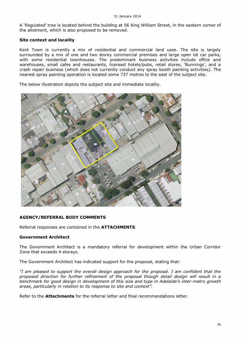
A ‘Regulated’ tree is located behind the building at 56 King William Street, in the eastern corner of the allotment, which is also proposed to be removed. Site context and locality Kent Town is currently a mix of residential and commercial land uses. The site is largely
surrounded by a mix of one and two storey commercial premises and large open lot car parks, with some residential townhouses. The predominant business activities include office and warehouses, small cafes and restaurants, licensed hotels/pubs, retail stores, ‘Bunnings’, and a crash repair business (which does not currently conduct any spray booth painting activities). The nearest spray painting operation is located some 737 metres to the east of the subject site. The below illustration depicts the subject site and immediate locality.
AGENCY/REFERRAL BODY COMMENTS Referral responses are contained in the ATTACHMENTS. Government Architect The Government Architect is a mandatory referral for development within the Urban Corridor Zone that exceeds 4 storeys.
The Government Architect has indicated support for the proposal, stating that: “I am pleased to support the overall design approach for the proposal. I am confident that the proposed direction for further refinement of the proposal though detail design will result in a benchmark for good design in development of this size and type in Adelaide’s inter-metro growth areas, particularly in relation to its response to site and context”. Refer to the Attachments for the referral letter and final recommendations letter.
31 January 2014
P6
Renewal SA The Minister administering the Housing and Urban Development (Administrative Arrangements) Act 1995 is a mandatory ‘advice’ referral for proposals that ‘purport’ to include affordable housing.
During the pre lodgement service, the proponent indicated his interest to provide 15 per cent affordable housing; a Pre Lodgement Agreement with Renewal SA was entered into which is contained in the ATTACHMENTS. Corporation of the City of Norwood, Payneham and St Peters Although there is no formal statutory referral to the City of Norwood Payneham and St Peters, the
Council has been informally consulted on the proposal through the case management pre lodgement process. Council’s administration Council’s administration has provided comments as follows:
there are no local traffic or waste service strategies that will affect the proposal supportive of the access point from King William Street and Little Rundle Street
there is no objection to the verandah encroachment concern relating to the demolition of the Local Heritage Place suggest that the building is considered overly simplistic and has little regard to the existing
and historic development pattern of the street; additional articulation is recommended. concern with regards to the short fall in car parking spaces; the proposal is providing 60
car parking spaces when it requires at least 88 car parking spaces Noting specific policies relating to the removal of Regulated Trees.
Council’s administration has sought that the proponent confirms the use of the ‘commercial’ tenancies; the generic ‘commercial’ term could imply that service trade premises or other undesirable land uses can operate from the tenancies. The proponent has confirmed that the tenancies will be used for ‘commercial office purposes’. A copy of the letter is contained in the ATTACHMENTS.
PLANNING ASSESSMENT The subject site is located within the Urban Corridor Zone and more specifically the Business Policy Area. The application has been assessed against the relevant provisions of the Norwood Payneham St Peters (City) Development Plan. The application is consistent with the majority of the provisions, with the exception of a few where the level of variation is considered minor. A detailed assessment of the development against the relevant provisions is provided within ATTACHMENT A. In summary, and of particular note, the proposal demonstrates policy alignment in the following key areas:
the proposal is considered to satisfy the primary objectives of the Zone the contemporary nature and the ‘continuous hard edge’ of the built form is consistent
with the future desired character for development in the zone the proposal is within the desired height limit of 5 storeys the proposal will provide a mix of apartment types, (1 to 2 bedroom), including 15 per
cent affordable housing commercial office land uses will front King William Street, enhancing activation of the
ground level public realm and satisfying the desired characteristics for the zone the residential component of the development has been designed to maximise apartment
amenity with particular regard to solar access, privacy and ventilation
31 January 2014
P7
the integration of ESD initiatives which will result in a minimum 6 star Energy Efficiency rating for 100 per cent of the residential apartments and 4 star Green Star rating for the commercial components.
The primary areas of discussion include:
design and appearance acoustic measures demolition of a local heritage place removal of a regulated tree parking and traffic.
Design and Appearance
The Urban Corridor Zone envisages contemporary building design, “which incorporates bold materials and shapes” and will form “a continuous hard edge along the King William Street frontage’. The proposed design is of contemporary style and built to the boundary of King William Street. The Government Architect indicates the following via the referral Letter contained in the
Attachments: “Along the length of the King William and Little Rundle Street frontages to the proposed treatment of the facade at ground and first levels provide a generally high quality public realm and a positive precedent for future development of similar size in the precinct. I am of the view that the proposed architectural expression and the material treatment of each facade will deliver a distinctive and high quality contribution to the streetscape”. The proposal provides a strong pedestrian entrance onto King William Street. The building has incorporated setbacks from side boundaries which provide the opportunity to minimise the visual appearance of blank walls. Overall, the proposal is considered to be a high quality design which will set the benchmark for future development within the zone. Acoustic Measures
The proponent has engaged Resonate Acoustics to consider key aspects of the development, in particular noise transmission from the light wells into apartments; and from the communal space into bedrooms. To address noise transfer from the light court into bedrooms; openable bedroom windows within the same apartment have been designed to face each other across the light well. However, openable windows from adjacent apartments have visual screening (baffle) and are offset. In addition, baffles are included in windows in the middle of the light well that are to be constructed from an acoustically absorbent material to be resolved in detailed design development. The potential noise transfer between bedroom with south facing bedrooms to the Common Open Space has been managed by windows being fixed and high level, but with openable windows located adjacent the entry for ventilation. Windows near the entrances will need to have rubber
compression seals to minimise noise transfer. The proposal is considered to adequately address the issue of noise abatement. The detailed recommendations of the Resonate Acoustic report will be supported through conditions.
31 January 2014
P8
Demolition of a Local Heritage Place The allotment at 56 King William Street contains a Local Heritage Place; it is described as an early Victorian bluestone cottage with double gable roof and concave front verandah. The building is in poor condition, but nevertheless, restorable.
According to the Council Wide Principle of Development Control 376: A Local Heritage Place should not be demolished or removed, in whole or in part, unless: (a) that portion of the place to be demolished or removed does not contribute to the heritage value of the place; or (b) it can be demonstrated that the structural condition of the place is seriously unsound and
cannot be rehabilitated, which is verified by appropriate independent, qualified expert advice; and (c) in either of the circumstances described above, a heritage impact statement has been prepared by an independent qualified heritage expert, reviewing the heritage values of the place and including an assessment of the proposed demolition or removal on the heritage value of the place. The proposed demolition does not satisfy the above provisions.
However, when assessing the demolition of a Local Heritage Place, the policy relating to retention of Heritage Places is but one of a number of provisions against which the development must be assessed. In addition, in “weighing competing principles of the Development Plan which call for the preservation of Local Heritage Places with those which call for substantial, mixed use medium and high density residential and compatible non residential development, it is necessary to look at the relative heritage value of the dwelling”, (Botten Levinson correspondence dated 26 May 2014 and lodged by the proponent). The proponent engaged DASH Architects to undertaken an assessment of the Local Heritage Place and its heritage value. The assessment concludes that the extent of character contribution of the dwelling on the subject site is negligible and there are several other buildings within the locality (both heritage listed and not heritage listed) that are of same provenance and also display the heritage attributes to a greater extent than the building on the site.
Council’s Heritage Advisor, Mr David Brown reviewed the report from Dash Architects and undertook research on the history of the Place. Mr Brown concluded that the Local Heritage Place has a strong relationship to the early development of Kent Town and strong links to the themes of brewing and early horse drawn trams in the area. Mr Brown also advised that the house is in surprisingly good condition for its age. A copy of the report by Mr David Brown is contained in the ATTACHMENTS. Accordingly, Council’s administration have indicated that the following clause from the Desired Character Statement for the Urban Corridor Zone needs to be considered to determine whether more weight should be given to the retention of the Local Heritage Place as opposed to supporting the development as proposed: “Development adjacent to, or on the same site as a State or Local Heritage Place, will be
respectful of its heritage character and setting and ensure that new development sensitively interfaces with the original building form. This may, in some circumstances, limit the scale and intensity of development on a site.” Independent review of the advice provided by Council was sought from the Department’s Paul Stark. His advice is contained within the ATTACHMENTS. Mr Stark is of the view that further investigation indicates there is serious doubt as to the extent to which the heritage value of this property should be tied to the 1850s or George Smith and the 1860s. He also indicates that when assessing competing principles (that is, retain heritage places versus development), then the
31 January 2014
P9
relative value of similar heritage properties should be observed. In this instance, there are doubts concerning the relative value of the Local Heritage Place and its character and setting. When assessing the proposal against the objectives of the zone and more specifically the policy area, together with the relevant provisions of the Council Wide section, the proposal demonstrates sufficient merit to warrant support.
Removal of a Regulated Tree The site contains a Eucalyptus camaldulensis (River Red Gum) which is identified as a Regulated Tree under the provisions of the Development Act 1993. According to Council Wide Principle of Development Control 423, “a regulated tree should not be
removed or damaged other than where it can be demonstrated that one or more of the following apply: (d) development that is reasonable and expected would not otherwise be possible”. The proponent engaged Arborman Tree Solutions to assess the tree who advises the following:
“While the subject tree achieves both a regulated trunk circumference as well as aesthetic and environmental qualities that suggest it is a tree worthy of retention, it also achieves criteria that indicate that its removal is an appropriate management option. It is therefore my opinion given the above information, that under the current provisions of the Development Act 1993 the removal of the subject Eucalyptus camaldulensis (River Red Gum) within the garden of 56 King William Road Kent Town is reasonable” Based on the above assessment and the Council Wide Principle of Development Control 423, the removal of the tree is considered acceptable as its retention significantly constraints the ability to achieve the desired development intent of the Urban Corridor Zone. Parking and Traffic Based on the Council Wide Principle of Development Control 123, a total of 87 car parking spaces
are required. Although the car parking numbers provided are 19 less spaces than required, Council Wide Principle of Development Control 125 indicates that a lesser on-site car parking rate may be applied where development includes affordable housing or if it is within 200 metres to public transport, which will be the case in this instance. The shortfall in car parking is not considered to be a critical variance considering that the proposal provides a car parking space for each apartment, except those dwellings which are identified for affordable housing and SoHo products. There are also sufficient car parking spaces for the office and ‘retail convenience store’ components. The proposal provides a total of 62 bicycle parks which will be located within secured bicycle parking stores and adjacent to vehicle parking spaces in the form of wall mounted brackets. A
total of 45 are required based on Council Wide Principle of Development Control 112. Therefore, adequate bicycle parking is provided, together with provision for end-of-trip facilities for most of the commercial offices. In terms of traffic movement, the proponent engaged Phil Weaver and associates to assess the traffic generation and vehicle manoeuvrability for the development. Mr Weaver concluded:
There will be negligible traffic impacts on the adjoining road network
31 January 2014
P10
The proposed access point on Little Rundle Street has been designed appropriately to enable sight distances, an appropriate width to accommodate access into the site and an accessible ramp
Overall, the proposal is considered to provide sufficient car and bicycle parking spaces to meet demand for occupants and visitors and will ensure that vehicles can safely enter and exit the site.
Waste management Waste will be managed using a private contractor. The proposal provides for a common waste management bin storage area located on the ground floor and will be directly accessed from the private access way.
6. PUBLIC NOTIFICATION AND REPRESENTATIONS The development is deemed a Category 2 development by virtue of PDC 20 of the Urban Corridor Zone. No representations were received during the public notification period. CONCLUSION
In considering the proposal against the relevant provisions of the Development Plan, it is considered that the proposed development satisfies the majority of the relevant provisions of the Development Plan and subsequently warrants Provisional Development Plan Consent subject to the following conditions. 9. RECOMMENDATION 1) RESOLVE that the proposed development is NOT seriously at variance with the
policies in the Development Plan. 2) RESOLVE to grant Development Plan Consent to the proposal by FA Marmac Pty Ltd
for the demolition of existing buildings and structures including one Local Heritage place, removal of a Regulated Tree and construction of a mixed use development comprising 54
residential dwellings, 3 SoHo products, a retail store and commercial offices together with above ground car parking and related works at 54-60 King William Street, Kent Town, subject to the following reserved matter and conditions of consent.
Planning Conditions: 1. Except where minor amendments may be required by other relevant Acts, or by
conditions imposed by this application, the development shall be established in strict accordance with the details and plans, as submitted in Development Application 020/0010/14A including: Plans by Proske Architects
Plan No. Revision Date
13.071.PL01.A A 2 June 2014
13.071.PL02.A A 4 June 2014
13.071.PL03.B B 12 June 2014
13.071.PL04.A A 4 June 2014
13.071.PL05.A A 4 June 2014
13.071.PL06.A A 4 June 2014
13.071.PL07.A A 4 June 2014
13.071.PL08.A A 4 June 2014
13.071.PL09.A A 2 June 2014
13.071.PL010.A A 4 June 2014
13.071.PL011.A A 4 June 2014
31 January 2014
P11
Reports / Correspondence
Planning Assessment Report in support of the development (June 2014) – Final Version, Revision 2B.
2. The acoustic attenuation measures recommended in the Resonate report, ref A1149192,
dated 12 May 2014, forming part of this consent shall be undertaken within the Development to the reasonable satisfaction of the Development Assessment Commission. Such acoustic measures shall be made operational prior to the occupation or use of the Development and any additional measures implemented as required when plant and equipment details are finalised.
3. Mechanical plant or equipment, shall be designed, sited and screened to minimise noise impact on adjacent premises or properties to the satisfaction of the Development Assessment Commission.
4. A Construction Environment Management Plan (CEMP) shall be prepared and implemented in accordance with current industry standards – including the EPA publication “Environmental Management of On-site Remediation” - to minimise environmental harm and disturbance during construction.
The management plan must incorporate, without being limited to, the following matters:
5.1 air quality, including odour and dust
5.2 surface water including erosion and sediment control
5.3 soils, including fill importation, stockpile management and prevention of soil contamination
5.4 groundwater, including prevention of groundwater contamination
5.5 noise
5.6 occupational health and safety
For further information relating to what Site Contamination is, refer to the EPA
Guideline: 'Site Contamination – what is site contamination?': www.epa.sa.gov.au/pdfs/guide_sc_what.pdf A copy of the CEMP shall be provided to the prior to the commencement of site works.
6. All stormwater design and construction shall be in accordance with Australian Standards
and recognised engineering best practices to ensure that stormwater does not adversely affect any adjoining property or public road.
7. The proposed car parking layout shall be designed and constructed to conform to the Australian Standard 2890.1:2004 for Off-Street Parking Facilities; Australian Standard 2890.6-2009 Parking facilities.
8. The on-site Bicycle Parking facilities shall be designed in accordance with Australian
Standard 2890.3-1993 and the AUSTROADS, Guide to Traffic Engineering Practice Part 14 – Bicycles.
Advisory Notes:
a) The approval does not include any signage (other than directional), which would need to
be the subject of a separate application to the relevant planning authority. b) The applicant is reminded of its general environmental duty, as required by Section 25
of the Environment Protection Act 1993, to take all reasonable and practical measures
to ensure that the activities on the whole site, including during construction, do not pollute the environment in a way which causes or may cause environmental harm.
c) Any information sheets, guidelines documents, codes of practice, technical bulletins etc.
that are referenced in this response can be accessed on the following web site: http://www.epa.sa.gov.au/pub.html
d) The applicant must ensure there is no objection from any of the public utilities in
respect of underground or overhead services and any alterations that may be required are to be at the applicant’s expense.
e) As work is being undertaken on or near the boundary, the applicant should ensure that
the boundaries are clearly defined, by a Licensed Surveyor, prior to the commencement
of any building work.
f) The emission of noise from the premises is subject to control under the Environment Protection Act and Regulations, 1993 and the applicant (or person with the benefit of this consent) should comply with those requirements.
g) That the air conditioning or air extraction plant or ducting shall be screened such that no
nuisance or loss of amenity is caused to residents and users of properties in the locality to the reasonable satisfaction of the Development Assessment Commission.
h) The development must be substantially commenced within three (3) years of the date of
this Notification, unless this period has been extended by the Development Assessment Commission.
i) Should the development be favourably considered, it is recommended that demolition of
this heritage place, be subject to a Condition that prior to Building Rules Consent, the subject house be measured (plans and elevations) and photographically recorded at the applicant’s expense, to the satisfaction of the local council.
j) An application for an authorisation pursuant to Section 22.1 of the Local Government Act
will need to lodged and approved by the City of Norwood, Payneham and St Peters for
any encroachments.
k) You are also advised that any act or work authorised or required by this Notification must be completed within five (5) years of the date of the Notification unless this period is extended by the Commission.
l) You will require a fresh consent before commencing or continuing the development if
you are unable to satisfy these requirements.
m) You have a right of appeal against the conditions which have been imposed on this Development Plan Consent or Development Approval. Such an appeal must be lodged at the Environment, Resources and Development Court within two months of the day on which you receive this notice or such longer time as the Court may allow. Please contact the Court if you wish to appeal. The Court is located in the Sir Samuel Way Building,
Victoria Square, Adelaide, (telephone number 8204 0300). ………………………………………………….
Connie Parisi OFFICER POSITION STATUTORY PLANNING BRANCH PLANNING DIVISION (DPTI)
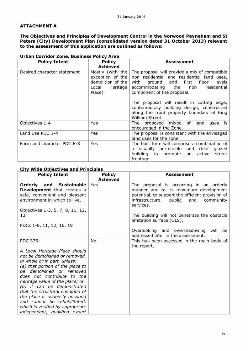
ATTACHMENT A The Objectives and Principles of Development Control in the Norwood Payneham and St Peters (City) Development Plan (consolidated version dated 31 October 2013) relevant to the assessment of this application are outlined as follows:
Urban Corridor Zone, Business Policy Area
Policy Intent Policy Achieved
Assessment
Desired character statement Mostly (with the exception of the demolition of the
Local Heritage Place)
The proposal will provide a mix of compatible non residential and residential land uses, with ground and first floor levels
accommodating the non residential component of the proposal. The proposal will result in cutting edge, contemporary building design, constructed along the front property boundary of King William Street.
Objectives 1-4 Yes The proposed mixed of land uses is encouraged in the Zone.
Land Use PDC 1-4 Yes The proposal is consistent with the envisaged land uses for the zone.
Form and character PDC 6-8 Yes The built form will comprise a combination of a visually permeable and clear glazed building to promote an active street frontage.
City Wide Objectives and Principles
Policy Intent Policy Achieved
Assessment
Orderly and Sustainable Development that creates a
safe, convenient and pleasant environment in which to live. Objectives 1-3, 5, 7, 8, 11, 12, 13 PDCs 1-8, 11, 12, 16, 19
Yes The proposal is occurring in an orderly manner and to its maximum development
potential, to support the efficient provision of infrastructure, public and community services. The building will not penetrate the obstacle limitation surface (OLS). Overlooking and overshadowing will be addressed later in the assessment.
PDC 376: A Local Heritage Place should not be demolished or removed, in whole or in part, unless:
(a) that portion of the place to be demolished or removed does not contribute to the heritage value of the place; or (b) it can be demonstrated that the structural condition of the place is seriously unsound and cannot be rehabilitated, which is verified by appropriate independent, qualified expert
No This has been assessed in the main body of the report.
31 January 2014
P14
advice; and (c) in either of the circumstances described above, a heritage impact statement has been prepared by an independent qualified
heritage expert, reviewing the heritage values of the place and including an assessment of the proposed demolition or removal on the heritage value of the place.
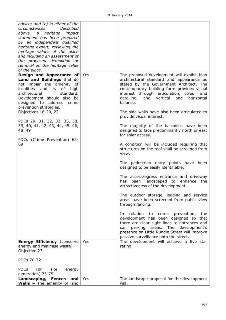
Design and Appearance of
Land and Buildings that do not impair the amenity of localities and is of high architectural standard. Development should also be designed to address crime prevention strategies.
architectural standard and appearance as stated by the Government Architect. The contemporary building form provides visual interest through articulation, colour and detailing, and vertical and horizontal balance.
The side walls have also been articulated to provide visual interest. The majority of the balconies have been designed to face predominantly north or east for solar access.
A condition will be included requiring that structures on the roof shall be screened from view. The pedestrian entry points have been designed to be easily identifiable. The access/egress entrance and driveway has been landscaped to enhance the attractiveness of the development. The outdoor storage, loading and service areas have been screened from public view through fencing.
In relation to crime prevention, the development has been designed so that there are clear sight lines to entrances and car parking areas. The development’s presence on Little Rundle Street will improve passive surveillance onto the street.
Energy Efficiency (conserve energy and minimise waste) Objective 23 PDCs 70-72 PDCs (on site energy
generation) 73-75
Yes The development will achieve a five star rating.
Landscaping, Fences and Walls – The amenity of land
Yes The landscape proposal for the development will:
31 January 2014
P15
and development enhanced with appropriate planting and landscaping. Objectives 24-25
PDCs 76-79, 81-82
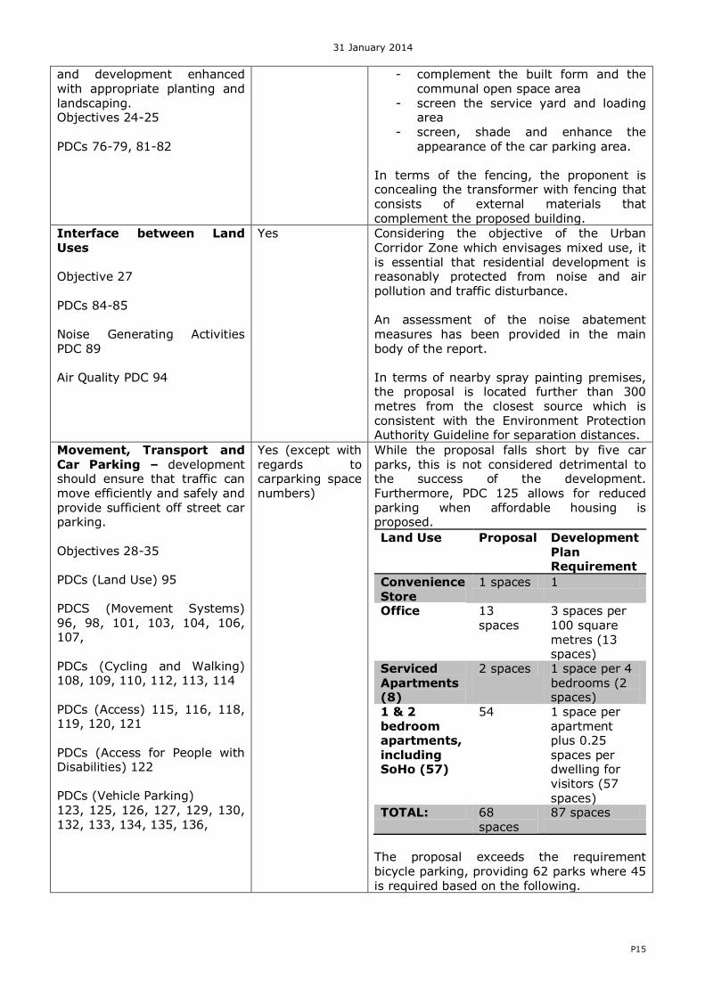
- complement the built form and the communal open space area
- screen the service yard and loading area
- screen, shade and enhance the
appearance of the car parking area.
In terms of the fencing, the proponent is concealing the transformer with fencing that consists of external materials that complement the proposed building.
Corridor Zone which envisages mixed use, it is essential that residential development is reasonably protected from noise and air pollution and traffic disturbance. An assessment of the noise abatement measures has been provided in the main
body of the report. In terms of nearby spray painting premises, the proposal is located further than 300 metres from the closest source which is consistent with the Environment Protection Authority Guideline for separation distances.
Movement, Transport and Car Parking – development should ensure that traffic can move efficiently and safely and provide sufficient off street car parking.
PDCs (Access for People with Disabilities) 122 PDCs (Vehicle Parking) 123, 125, 126, 127, 129, 130, 132, 133, 134, 135, 136,
Yes (except with regards to carparking space numbers)
While the proposal falls short by five car parks, this is not considered detrimental to the success of the development. Furthermore, PDC 125 allows for reduced parking when affordable housing is proposed.
Land Use Proposal Development
Plan Requirement
Convenience Store
1 spaces 1
Office 13 spaces
3 spaces per 100 square metres (13 spaces)
Serviced Apartments (8)
2 spaces 1 space per 4 bedrooms (2 spaces)
1 & 2 bedroom apartments,
including SoHo (57)
54 1 space per apartment plus 0.25
spaces per dwelling for visitors (57 spaces)
TOTAL: 68 spaces
87 spaces
The proposal exceeds the requirement bicycle parking, providing 62 parks where 45 is required based on the following.
31 January 2014
P16
Land Use Development Plan bike park rate
Residential
component of a multi storey building/residential flat building
1 per 2 dwellings
plus 1 per 5 dwellings for visitors
Office 1 per 100 square metres plus 3 for visitors
Convenience Store 1 per 150 square metres plus 1 for visitors
Yes The proposal will be efficiently and effectively using existing infrastructure. The visual impact of the proposed power line will be minimised as the proponent is seeking to place the power line underground.
should residential development occur on abutting sites, reasonable access to sunlight will still occur. It is expected that that the abutting sites will be redeveloped at some stage in the future with similar taller buildings.
Private open space in the form of balconies is designed to be accessed directly from the internal living areas. The amount of private open space satisfies the provisions of the Development Plan, particularly given the proposed communal open space.
Overall, the proposal will providing a mix in the range of dwelling types in a location which makes use of existing public and transport infrastructure.
Medium and High Rise Development (3 or more storeys)
Objectives 60-63 PDCs Design and Appearance: 287-289 Visual Privacy 290 Building Separation and Outlook 291
Dwelling Configuration 292-293 Adaptability
Yes All apartments include ventilation slots, windows and doors.
South facing apartments that have bedrooms located adjacent to the Central Communal Open Space have high level windows which are fixed; however, for ventilation, the apartments have openable windows adjacent to the entry.
The extension of the vertical building wall blades creates privacy for most aspects of the apartment.
31 January 2014
P17
294 Environmental 295-297 Site facilities and storage 298-301
The 21 apartments include a light court which allows filtered solar access but also ventilation.
There are no living areas/kitchen areas that rely on ‘borrowed’ light.
Heritage Objectives 107-112 PDCs 376 (demolition of a Local Heritage Place)
No The proposal will involve the demolition of a Local Heritage Place; an assessment of this matter has been provided in the main body of the report.
Regulated Trees Objectives 117-118 PDCs 422-423
Yes A ‘regulated’ gum tree is located at the centre of the allotment at 56 King William Street. Whilst there are no structural concerns with the tree, the location of the tree would make the redevelopment unachievable.
Overlays
Affordable Housing Overlay Objectives 1 and 2 PDC 1
Yes The site is subject to the Affordable Housing Overlay; the proponent has entered into an Agreement with Renewal SA to provide affordable housing.
Noise and Air Emissions Overlay Objective 1 PDC 1
Yes This matter has been addressed in the main body of the report.
31 January 2014
P18
DETAILED ASSESSMENT REPORT The Objectives and Principles of Development Control in the Development Plan most relevant to the assessment of the application are outlined as follows. These are contained in the Norwood Payneham and St Peters (City) Development Plan (Consolidated 31 Oct 2013).
URBAN CORRIDOR ZONE, BUSINESS POLICY AREA Desired Character The Business Policy Area will continue to develop as the core area for the location of business related uses within Kent Town, with a strong focus on digital media, advertising, publishing and
design activities. Residential development may be established above compatible ground and first floor level non-residential uses. Wholly commercial buildings are also appropriate. Retail activity, including shops will comprise smaller scale lunch bars and cafes, which serve local businesses.
While light industry and warehouses are not the primary land uses in the Policy Area, some light industry uses and warehousing may be appropriate in circumstances where it can be accommodated within high quality buildings and where it will not unreasonably compromise the level of amenity expected in a mixed-use area.
Cutting edge, contemporary building design, which incorporates bold materials and shapes, will be encouraged within the Business Policy Area. The built form will comprise buildings of up to five (5) storeys, forming a continuous hard edge along the King William Street frontage.
On-site car parking will be located behind or below buildings fronting the primary street, with access from Little King William Street and Little Rundle Street.
On-street car parking will continue to be maintained along the length of King William Street to
contribute the shorter term visitor parking needs of local businesses and provide some separation between the vehicle carriageway and the footpaths. Objective 1: A mixed use business policy area that accommodates a range of commercial
and light industrial land uses together with compatible medium and high density residential development.
Objective 2: Development that minimises any adverse impacts upon the amenity of the locality within the zone.
Objective 3: A high standard of development which promotes distinctive contemporary building, landscape and streetscape design, with high visual and environmental amenity.
Objective 4: Development that contributes to the desired character of the policy area.
Land Use 1 The following types of development, or combination thereof, are envisaged in the Business
Policy Area and are additional to those identified in the zone: Light industry Service industry Store
31 January 2014
P19
Warehouse
2 Land uses on the ground and first floor levels of buildings should be non-residential. 3 Shop or group of shops should have a gross leasable floor area of less than 500 square
metres.
4 Light industry should comprise high technology and/or research and development related
uses.
Form and Character 6 Development should be consistent with the desired character for the policy area.
7 The ground floor of buildings should be built to dimensions including a minimum floor to
ceiling height of 3.5 metres to allow for adaptation to a range of land uses including retail, office and residential without the need for significant change to the building.
8 A minimum of 50 percent of the width of the ground floor primary frontage of buildings should be visually permeable, transparent or clear glazed to promote active street
frontages and maximise passive surveillance.
CITY WIDE Orderly and Sustainable Development Objective 1: Orderly and economic development that creates a safe, convenient and
pleasant environment in which to live.
Objective 2: A proper distribution of living, working and recreational activities by the allocation of suitable areas of land for those purposes.
Objective 3: The provision of such facilities as are required for accommodation,
employment, recreation, health and welfare
Objective 5: Development occurring in an orderly and compact form to support the efficient provision of public services and community facilities.
Objective 7: Rational distribution of land uses to avoid incompatibility between them. Objective 8: Compatibility of new buildings with the desired environment around them Objective 11: Provision of a choice of lifestyles within the law and custom of the
community.
Objective 12: Maintenance and increase of employment opportunities.
Objective 13: Provision of services to encourage and provide for visitors to the City. 1 Development should be orderly and economic. 2 Development should:
(a) form a compact and continuous extension of an existing built-up area; (b) be located to achieve economy in the provision and use of public services and infrastructure; and
31 January 2014
P20
(c) create a safe, convenient and pleasant place to live.
3 Development should take place on land which is suitable for the intended use of that land, having regard to the location and condition of that land and the provisions for the relevant Zone and Policy Area.
4 Development should take place in a manner which will not: (a) interfere with the effective and proper use of any other land; and (b) prevent the attainment of the objectives for that other land.
5 Development should be undertaken in accordance with the Norwood Payneham and St
Peters (City) Structure Plan, Map NPSP/1 (Overlay 1) Parts A & B.
6 Development should not take place excessively in advance of a demonstrated need for the use for which it provides.
7 Development should be located and take place with reasonable and effective precautions being taken against hazards from fire and flooding.
8 Buildings and structures should not adversely affect, by way of their height and location,
the long term operational, safety and commercial aviation requirements of Adelaide International Airport and Parafield Airport.
11 Buildings should be designed so as not to unreasonably overlook or overshadow indoor or
outdoor living areas of adjacent dwellings.
12 Development should take place in a manner which is not liable to cause an unreasonable nuisance to neighbours or the community or significantly detrimentally affect the amenity, use or enjoyment of nearby properties by: (a) the emission beyond the site boundaries of noise, vibration, odour, atmospheric liquid or other pollutants, waste water, waste products, electrical interference, light overspill or loss of privacy; or (b) stormwater or the drainage of run-off from the land.
16 Land used for the erection of buildings should be stable.
19 Vacant or underutilised land should be developed in an efficient and co-ordinated manner so as to not prejudice the orderly development of adjacent land.
Design and Appearance of Land and Buildings Objective 18: The amenity of localities not impaired by the appearance of land, buildings
and objects.
Objective 19: Development of a high architectural standard and appearance that responds
to and reinforces positive aspects of the local environment and built form.
Objective 20: Architectural excellence allowing for design innovation consistent with sound design principles.
29 The appearance of land and buildings should not impair the amenity of the locality in which they are situated.
31 January 2014
P21
31 Buildings should be designed to minimise their visual bulk and provide visual interest through design elements such as: (a) articulation; (b) colour and detailing;
(c) materials, patterns, textures and decorative elements; (d) vertical and horizontal components; (e) design and placement of windows;
(f) window and door proportions; (g) roof form and pitch; (h) verandahs and eaves; and (i) variations to facades.
32 The design and location of buildings should ensure that adequate natural light is available
to adjacent dwellings, with particular consideration given to: (a) windows of habitable rooms, particularly the living areas of adjacent buildings; (b) ground-level private open space of adjacent dwellings; (c) upper level private balconies that provide the primary open space area for any dwelling; and (d) access to solar energy.
33 The height of buildings, structures and associated component parts should not exceed the
number of storeys or height in metres above the natural ground level prescribed in the relevant Zone and/or Policy Area.
35 Buildings should be designed and sited to avoid creating extensive areas of uninterrupted walls facing areas exposed to public view.
38 Balconies should:
(a) be integrated with the overall architectural form and detail of the building; (b) be sited to face predominantly north or east to provide solar access; (c) be self-draining and plumbed to minimise runoff; and
(d) be recessed where wind would otherwise make the space unusable.
39 The external walls and roofs of buildings should not incorporate highly reflective materials which will result in excessive glare.
40 Structures located on the roofs of buildings to house plant and equipment, should be screened from view and should form an integral part of the building design in relation to external finishes, shaping and colours.
31 January 2014
P22
41 Building design should emphasise all pedestrian entry points to provide all users with perceptible and direct access from public street frontages and vehicle parking areas.
42 Buildings, landscaping, paving and signage should have a coordinated appearance that maintains and enhances the visual attractiveness of the locality.
43 Buildings (other than ancillary buildings, group dwellings or buildings located on hammerhead, battleaxe or similar configuration allotments) should be designed so that their main facade faces the primary street frontage of the land on which they are situated.
44 Development should be designed and sited so that outdoor storage, loading and service areas, fire escapes and plant and equipment hatches are screened from public view through the use of an appropriate combination of built form, solid fencing and/or
landscaping. 45 Outdoor storage, loading and service areas should be located and designed to enable the
convenient manoeuvring of service and delivery vehicles and sited away from sensitive land uses.
46 Development should:
(a) protect existing site features, including mature vegetation and trees from damage; and (b) not result in damage to neighbouring trees
48 Development should not, in respect to its appearance, interfere with the attainment of the
Objectives for the relevant Zone or Policy Area or otherwise impact upon the existing character of scenic or environmentally important areas.
49 Outdoor lighting should not result in light spillage on adjacent land. Crime Prevention 62 Development should be designed to maximise surveillance of public spaces through the
incorporation of clear lines of sight, appropriate lighting and the use of visible permeable barriers wherever practicable.
63 Buildings should be designed to overlook public and communal open spaces and streets to allow casual surveillance.
64 Buildings should be designed to minimise and discourage access between roofs, balconies
and windows of adjoining dwellings.
65 Development, including car park facilities should incorporate signage and lighting that indicate the entrances and pathways to, from and within the site.
66 Site planning, buildings, fences, landscaping and other features should clearly differentiate
between public, communal and private areas.
67 Development should avoid pedestrian entrapment spots and routes and paths that are
predictable or unchangeable and offer no choice to pedestrians.
68 Development fronting an alleyway, laneway (including a service lane), or other minor or unserviced street should be located and designed to maximise safety and security.
69 Development fronting a laneway (including a service lane), or other minor or unserviced street should maximise the potential for passive surveillance by ensuring that the building can be seen from nearby buildings and the laneway/minor streets/unserviced streets.
31 January 2014
P23
Energy Efficiency Objective 23: Development designed and sited to conserve energy and minimise waste.
70 Development should provide for efficient solar access to buildings and open space all year
round.
71 Buildings should be sited and designed to ensure: (a) that the main living areas and the private open space associated with the main living areas, face north to maximise exposure to winter sun; and
(b) adequate natural light and winter sunlight is available to the main internal living areas and principal private open spaces of adjacent properties.
72 Development should be designed to minimise energy consumption by incorporating, where practicable, energy efficient building design elements, techniques and materials, such as: (a) the sizing, orientation and shading of windows to reduce summer heat load and take
advantage of winter sun; (b) the use of deciduous trees, pergolas, eaves, verandas and awnings, to allow penetration of heat and light from the sun in winter and to provide shade in summer; (c) openings designed to maximise the potential for natural cross-ventilation to enable cooling breezes to reduce internal temperatures in the summer months; or (d) the use of colours on external surfaces such as roofs and walls, to minimise energy consumption.
On-Site Energy Generation 73 Development should facilitate the efficient use of solar collectors, such as solar hot water
systems and photovoltaic cells by: (a) taking into account overshadowing from neighbouring buildings and trees; and (b) designing roof orientation and pitch to maximise exposure to direct sunlight.
74 Development should maintain solar access, for a minimum of 3 hours between 9am and 3pm on 21 June, to: (a) any existing solar collectors (such as solar hot water systems and photovoltaic cells) on adjoining properties; or (b) an area of at least 10m² on the north facing roof of the existing building/s, in the event that there are no existing solar panels and/or photovoltaic cells on the adjoining
property. Development should not increase the overshadowed area by more than 20 percent in cases where overshadowing already exceeds these requirements.
75 Development should not incorporate vegetation or landscape elements which are likely to overshadow existing or proposed solar collectors (including solar hot water systems and photovoltaic cells).
31 January 2014
P24
Landscaping, Fences and Walls Objective 24: The amenity of land and development enhanced with appropriate planting
and landscaping, which uses locally indigenous plant species where possible.
Objective 25: Functional fences and walls that enhance the attractiveness of development Landscaping 76 Development should incorporate open space and landscaping and minimise the use of hard
paved surfaces in order to:
(a) complement built form and reduce the visual impact of larger buildings (for example locating taller and broader plants against taller and bulkier building components); (b) enhance the visual appearance from the street frontage; (c) screen service yards, loading areas and outdoor storage areas;
(d) define and enhance the appearance of outdoor spaces, including car parking areas; (e) minimise heat absorption and reflection; (f) provide shade and shelter; (g) assist in climate control within and around buildings; (h) allow for natural infiltration of surface waters through permeable treatments; (i) contribute to the viability of ecosystems and species; and (j) promote water and biodiversity conservation.
77 Landscaped areas should:
(a) where practicable, have a width of not less than two metres; (b) be protected from damage by vehicles and pedestrians; (c) result in the appropriate clearance from powerlines and other infrastructure being maintained; (d) be designed to incorporate the re-use of stormwater for irrigation purposes; and (e) include the planting of locally indigenous species where practical.
78 Landscaping should be used to assist in discouraging crime by:
(a) screen planting areas susceptible to vandalism; (b) planting trees or ground covers, rather than shrubs, alongside footpaths; and (c) planting vegetation other than ground covers a minimum distance of two metres from footpaths to reduce concealment opportunities.
31 January 2014
P25
79 Landscaping of non-residential development should be provided and maintained in order
to: (a) establish a buffer between the non-residential development and the development on adjacent sites;
(b) complement the landscaping provided by adjacent development and enhance the visual appearance and character of the area; (c) shade, define and create windbreaks for pedestrian paths and spaces; (d) screen, shade and enhance the appearance of car parking areas;
(e) screen service yards, loading areas and outdoor storage areas; and (f) re-establish local indigenous plant species where it is practical to do so.
81 Landscaping should not:
(a) unreasonably restrict solar access to adjoining development; (b) cause damage to buildings, paths, infrastructure/services and other landscaping from root invasion, soil disturbance or plant overcrowding; (c) remove opportunities for passive surveillance; (d) increase leaf fall into watercourses; and (e) introduce pest plants and/or increase the risk of weed invasion.
Fences and Walls
82 Fences and walls, including retaining walls, should: (a) not result in damage to neighbouring trees; (b) be compatible with the associated development and with existing predominant, attractive fences and walls in the locality; (c) enable some visibility of buildings from and to the street or laneway (only where it is the primary street) to allow casual surveillance; (d) incorporate articulation or other detailing, where there is a large expanse of wall facing the street; (e) assist in highlighting building entrances;
(f) be sited and limited in height, to ensure adequate sight lines for motorists and pedestrians especially on corner sites; (g) in the case of side and rear boundaries, be of sufficient height to maintain privacy and/or security without adversely affecting the visual amenity or access to sunlight of adjoining land; and (h) be constructed of non-flammable materials.
31 January 2014
P26
Interface between Land Uses Objective 27: Protect community health and amenity from the adverse impacts of
development and support the continued operation of all desired land uses
84 Residential development adjacent to a non-residential land use or zone or within a non-residential zone should be located, designed and sited in a manner which: (a) protects residents from any adverse effects of non-residential activities; and (b) minimises negative impact on existing and potential future land uses considered appropriate in the locality.
85 Non-residential development in residential zones should:
(a) not detrimentally impact on the amenity of nearby residents; (b) provide adequate protection for residents of adjoining sites from air and noise pollution, traffic disturbance and other harmful effects on health or amenity; and
(c) not negatively impact on adjoining open space, mature trees or vegetation.
Noise Generating Activities 89 Development that emits noise (other than music noise) should include noise attenuation
measures that achieve the relevant Environment Protection (Noise) Policy criteria when assessed at the nearest existing noise sensitive premises.
Air Quality 94 Chimneys or exhaust flues associated with commercial development (including cafes,
restaurants and fast food outlets) should be designed to ensure they do not cause a nuisance or health concerns to nearby sensitive receivers by:
(a) incorporating appropriate treatment technology before exhaust emissions are released to the atmosphere; and (b) ensuring that the location and design of chimneys or exhaust flues maximises dispersion and takes into account the location of nearby sensitive uses.
Movement, Transport and Car Parking Objective 28: A comprehensive, integrated and efficient public and private transport
system which will:
(a) provide access to adequate transport services for all people, at an acceptable cost;
(b) effectively support the economic development of metropolitan Adelaide and the State;
(c) ensure a high level of safety; and
(d) maintain the options for the introduction of suitable new transport technologies.
31 January 2014
P27
Objective 29: A road hierarchy to form the basis of development controls and serve as a guide to the investment of road funds in order to ensure a safe and efficient traffic flow and to promote the saving of fuel and time. Arterial roads will provide for major traffic movements.
Objective 30: A safe, convenient and clearly defined network of roads, paths and tracks
throughout the City that also links to networks beyond the City and accommodates a variety of vehicular, cycle and pedestrian traffic.
Objective 31: A compatible arrangement between land uses and the transport system
which will:
(a) ensure minimal noise and air pollution;
(b) protect amenity of existing and future land uses;
(c) provide adequate access; and
(d) ensure maximum safety.
Objective 32: A form of development adjoining main roads which will:
(a) ensure traffic can move efficiently and safely;
(b) discourage commercial ribbon development;
(c) prevent large traffic-generating uses outside designated shopping/centre zones;
(d) provide for adequate off-street parking; and
(e) provide limited and safe points of access and egress.
Objective 33: Control of the movement of traffic according to a defined hierarchy of roads
which seeks to improve safety and to limit the speed and volume of traffic in local residential streets without unreasonably restricting access opportunities.
Objective 34: Development which provides adequate and safe car parking appropriate to
the demands generated.
Objective 35: Provision of an effective public transport system to facilitate travel to, from and within the City.
Land Use 95 Land uses arranged to support the efficient provision of sustainable transport networks
and encourage their use.
Movement Systems 96 Development should be integrated with existing transport networks, particularly major rail,
road and public transport corridors, and designed to minimise its potential impact on the functional performance of the transport network.
98 Land uses that generate large numbers of visitors such as shopping centres, places of
employment, schools, hospitals and medium to high density residential uses should be located so that they can be serviced by the public transport network and encourage
31 January 2014
P28
walking and cycling.
101 Development should provide safe and convenient access for all anticipated modes of transport
103 Driveway crossovers affecting pedestrian footpaths should maintain the level and surface
colour of the footpath.
104 Driveway crossovers should be appropriately separated and the number minimised to maintain streetscape character, preserve street trees and optimise the provision of on-street visitor parking (where on-street parking is appropriate)
106 Industrial/commercial vehicle movements should be separated from passenger vehicle car
parking areas.
107 Development should include appropriate on-site provision to enable the parking, loading, unloading, turning and fuelling of vehicles.
Cycling and Walking
108 Development should ensure that a permeable street and path network is established that encourages walking and cycling through the provision of safe, convenient and attractive routes with connections to adjoining streets, paths, open spaces, schools, pedestrian crossing points on arterial roads, public and community transport stops and activity centres.
109 Development should provide access, and accommodate multiple route options, for pedestrians and cyclists by enhancing and integrating with: (a) open space networks, recreational trails, parks, reserves, and sport and recreation
(b) Adelaide’s principal cycling network (Bikedirect), which includes arterial roads, local
roads and off-road paths.
110 New developments should give priority to and not compromise existing designated bicycle routes.
112 Development should encourage and facilitate cycling as a mode of transport by incorporating end-of journey facilities including: (a) showers, changing facilities and secure lockers; (b) signage indicating the location of bicycle facilities; and (c) bicycle parking facilities provided at the rate set out in Table NPSP/10
113 On-site secure bicycle parking facilities should be:
(a) located in a prominent place; (b) located at ground floor level; (c) located undercover; (d) located where surveillance is possible; (e) well lit and well signed;
31 January 2014
P29
(f) close to well used entrances; and (g) accessible by cycling along a safe, well lit route.
114 Pedestrian and cycling facilities and networks should be designed and provided in accordance with relevant provisions of the Australian Standards and Austroads Guides.
Access 115 Development should have direct access from an all-weather public road.
116 Development should be provided with safe and convenient access which:
(a) avoids unreasonable interference with the flow of traffic on adjoining roads; (b) provides appropriate separation distances from existing roads or level crossings; (c) accommodates the type and volume of traffic likely to be generated by the development or land use and minimises induced traffic through over-provision; and
(d) is sited and designed to minimise any adverse impacts on the occupants of and visitors to neighbouring properties.
118 On-site parking and manoeuvring areas servicing development abutting arterial roads should be designed to enable all vehicles to enter and exit the site in a forward direction.
119 Structures such as canopies and balconies that encroach onto the footpath of an arterial road should not cause visual or physical obstruction to: (a) signalised intersections; (b) heavy vehicles; (c) street lighting;
(d) overhead electricity lines; (e) street trees; or (f) bus stops.
120 Driveways and parking areas should be designed and constructed to: (a) follow the natural contours of the land; (b) minimise excavation and/or fill; (c) minimise the potential for erosion from surface runoff;
(d) avoid the removal of existing vegetation, including street trees; and (e) be consistent with Australian Standard AS: 2890 – Parking facilities.
121 Driveways should: (a) not exceed a gradient of 1 in 5 at any point and have a near level gradient (of 1 in 20) at either end for a length of at least 5 metres and connect to any existing paved footpath
31 January 2014
P30
surface at a level that does not require any modification to the level of any public infrastructure; (b) be designed, located and constructed in a manner which enables safe and convenient access, with surfaces providing adequate traction for the wheels of vehicles; and
(c) be designed and located so that they are not constructed closer than 1.5 metres to any street tree.
Access for People with Disabilities 122 Development should be sited and designed to provide convenient access for people with a
disability.
Vehicle Parking 123 Development should provide off-street vehicle parking in accordance with rates contained
in Tables NPSP/8 and 9 125 Within the Urban Corridor Zone and the District Centre (Norwood) Zone, a lesser on-site
car parking rate may be applied to applicable elements of a development in any of the following circumstances: (a) development includes affordable housing or student accommodation; or (b) sites are located within 200 metres walking distance of a convenient and frequent service fixed public transport stop; or (c) mixed use development including residential and non-residential development has respective peak demands for parking occurring at different times; or (d) the proposed development is on or adjacent to the site of a heritage place, or includes retention of a desired traditional building and its features, which hinders the provision of on-site parking or the most effective use of the spaces within the site;
(e) the parking shortfall is met by contribution to a Car Parking Fund (where one is available); or (f) the development qualifies for certification under the Green Energy rating program, or similar program.
126 Development should provide carparking which is consistent with Australian Standard AS:
2890 - Parking facilities.
127 Vehicle parking areas should be sited and designed to: (a) facilitate safe and convenient pedestrian linkages to the development and areas of significant activity or interest in the vicinity of the development;
(b) include safe pedestrian and bicycle linkages that complement the overall pedestrian and cycling network; (c) not inhibit safe and convenient traffic circulation; (d) result in minimal conflict between customer and service vehicles; (e) avoid the necessity to use public roads when moving from one part of a parking area to another;
31 January 2014
P31
(f) minimise the number of vehicle access points onto public roads; (g) avoid the need for vehicles to reverse onto public roads; (h) where practical, provide the opportunity for shared use of car parking and integration
of car parking areas with adjoining development to reduce the total extent of vehicle parking areas and the requirement for access points; (i) not dominate the character and appearance of the development when viewed from public roads or spaces; (j) provide landscaping that will shade and enhance the appearance of the vehicle parking
areas; and (k) where practicable, include infrastructure such as underground cabling and connections to power infrastructure that will enable the recharging of electric vehicles.
129 Vehicle parking areas that are likely to be used during non-daylight hours should provide floodlit entry and exit points and site lighting directed and shaded in a manner that will not
cause nuisance to adjacent properties or users of the parking area.
130 Vehicle parking areas should be sealed or paved to minimise dust and mud nuisance. 132 Vehicle parking areas should be line-marked to delineate parking bays, movement aisles
and direction of traffic flow.
133 On-site visitor parking spaces should be sited and designed to: (a) not dominate internal site layout; (b) be clearly defined as visitor spaces not specifically associated with any particular dwelling; and
(c) be accessible to visitors at all times.
Vehicle Parking for Mixed Use and Corridor Zones
134 Loading areas and designated parking spaces for service vehicles should: (a) be provided within the boundary of the site; and (b) not be located in areas where there is parking provided for any other purpose.
135 Vehicle parking spaces and multi-level vehicle parking structures within buildings should: (a) enhance active street frontages by providing land uses such as commercial, retail or other non-car park uses along ground floor street frontages;
(b) complement the surrounding built form in terms of height, massing and scale; and (c) incorporate facade treatments along major street frontages that are sufficiently enclosed and detailed to complement neighbouring buildings consistent with the desired character of the locality.
136 In mixed use buildings, the provision of vehicle parking may be reduced in number and shared where the operating hours of commercial activities complement the residential use of the site.
31 January 2014
P32
Infrastructure Objective 37: The efficient and cost-effective use of existing infrastructure.
Objective 38: Infrastructure provided in an economical and environmentally sensitive
manner Objective 41: The visual impact of infrastructure facilities minimised. 138 Development should not occur without the provision of adequate utilities and services,
including:
(a) electricity supply; (b) water supply; (c) drainage and stormwater systems; (d) waste disposal;
(e) effluent disposal systems; (f) formed all-weather public roads; (g) telecommunications services; (h) social infrastructure, community services and facilities; and (i) gas service.
139 Electricity supply serving new development should be installed underground.
140 Development should provide for the suitable drainage of stormwater either into the public
stormwater system or using alternative methods of stormwater control (including the collection and re-use of water), where appropriate standards can be satisfied.
141 The treatment and disposal of effluent and other waste material from any development or use of land should, having regard to the location or design of the development or use, be able to be achieved without risk to health or impairment to the environment.
142 Development should incorporate provision for the supply of infrastructure services to be located within common service trenches, where practical.
143 Development should not take place until adequate and coordinated drainage of land is assured.
144 Development should enable economic and effective servicing for public transport, recycling
and waste collection, fire protection and street lighting.
Residential Development Objective 55: Safe, pleasant, convenient, and healthy-living environments that meet the
full range of needs and preferences of the community.
Objective 56: An increased mix in the range and number of dwelling types available within the City to cater for changing demographics, particularly smaller household sizes, housing for seniors and supported accommodation.
31 January 2014
P33
Objective 57: Increased dwelling densities in areas close to centres, public transport and
significant public open spaces.
Objective 58: The retention and rehabilitation of structurally sound housing that contributes to the desired character of a location, on land suitable for
residential use.
Objective 59: Affordable housing and housing for seniors provided in appropriate locations.
Medium and High Rise Development (3 or more storeys) Objective 60: Medium and high rise development that provides housing choice and
employment opportunities.
Objective 61: Residential development that provides a high standard of amenity and adaptability for a variety of accommodation and living needs.
Objective 62: Commercial, office and retail development that is designed to create a
strong visual connection to the public realm and that contributes to the
vitality of the locality.
Objective 63: Buildings designed and sited to be energy and water efficient. Design and Appearance 287 Buildings should:
(a) achieve a human scale at ground level through the use of elements such as canopies, verandahs or building projections; (b) provide shelter over the footpath where minimal setbacks are desirable; and (c) ensure walls on the boundary that are visible from public land include visually
interesting treatments to break up large blank facades.
288 The ground floor level of buildings (including the foyer areas of residential buildings) should be designed to enable surveillance from public land to the inside of the building at night.
289 Entrances to multi-storey buildings should: (a) be oriented towards the street; (b) be clearly identifiable; (c) provide shelter, a sense of personal address and transitional space around the entry; and
(d) provide separate access for residential and non-residential land uses.
Visual Privacy 290 The visual privacy of ground floor dwellings within multi-storey buildings should be
protected through the use of design features such as the elevation of ground floors above street level, setbacks from the street and the location of verandahs, windows, porticos or the like
Building Separation and Outlook
31 January 2014
P34
291 Residential buildings (or the residential floors of mixed use buildings) should:
(a) have adequate separation between habitable room windows and balconies from other buildings to provide visual and acoustic privacy for dwelling occupants and allow the infiltration of daylight into interior and outdoor spaces; and
(b) ensure living rooms have, at a minimum, a satisfactory short range visual outlook to public or communal space.
Dwelling Configuration 292 Buildings comprising more than 20 dwellings should provide a variety of dwelling sizes and
a range in the number of bedrooms per dwelling.
293 Dwellings with three or more bedrooms located on the ground floor of medium and high rise buildings should, where possible, have the windows of habitable rooms overlooking internal courtyard space or other public space.
Adaptability
294 Multi-storey buildings should include a variety of internal designs that will facilitate
(a) minimise detrimental micro-climatic and solar access impacts on adjacent land or buildings, including effects of patterns of wind, temperature, daylight, sunlight, glare and shadow; and (b) incorporate roof designs that enable the provision of rain water tanks (where they are not provided elsewhere), photovoltaic cells and other features that enhance sustainability.
296 Green roofs (which can be a substitute for private or communal open space provided they
can be accessed by occupants of the building) are encouraged on all new residential, commercial or mixed use buildings.
297 Development of five or more storeys, or 18.5 metres or more in building height (excluding the rooftop location of mechanical plant and equipment), should be designed to minimise the risk of wind tunnelling effects on adjacent streets by adopting one or more of the following: (a) a podium at the base of a tall tower which is aligned with the street to deflect wind away from the street; (b) substantial verandahs around a building to deflect downward travelling wind flows over
pedestrian areas; or (c) the placement of buildings and use of setbacks to deflect the wind at ground level.
Site facilities and storage 298 Each dwelling within a multi-storey building should provide a covered storage area of not
less than 8 cubic metres in one or more of the following areas: (a) in the dwelling (but not including a habitable room);
31 January 2014
P35
(b) in a garage, carport or outbuilding; or (c) within an on-site communal facility.
299 The design of driveway crossovers, parking areas, accessways and elements that interact with the public realm should safely and efficiently accommodate the collection of waste
and recycling materials.
300 Development should provide a dedicated area for the on-site storage, collection and sorting of recyclable materials and waste that is consistent with the following: (a) easily and safely accessible to the collection point;
(b) easily and safely accessible to residents and collection service providers; (c) well screened to prevent vandalism and theft; and (d) designed to reduce odour and discourage vermin.
301 Development with a gross floor area of 2000 square metres or more should provide for the
communal storage, collection and management of waste.
Heritage Objective 107: The identification, conservation and enhancement of land, buildings and
structures and their settings, which are of indigenous, non-indigenous and natural heritage and that display aesthetic, architectural, historic, social, economic, cultural, archaeological, technological, spiritual, geological or scientific significance.
Objective 108: Conservation of places and objects registered, designated or listed pursuant
to the Heritage Places Act 1993.
Objective 109: Conservation of items of Aboriginal heritage importance that are subject to
the control of the Aboriginal Heritage Act 1988.
Objective 110: Development that retains the heritage value of State and Local Heritage Places such that the heritage value of the place, locality and the Council area is reinforced through:
(a) the conservation and complementary development of such places; and
(b) the complementary development of land and sites adjacent to such places.
Objective 111: Development which conserves and reinforces the historic integrity of the
Council area and is compatible with the desired character of the appropriate zone and policy area.
Objective 112: The continued use, or adaptive reuse, of State and Local Heritage Places
that supports their ongoing retention and conservation.
376 A Local Heritage Place should not be demolished or removed, in whole or in part, unless:
(a) that portion of the place to be demolished or removed does not contribute to the heritage value of the place; or
31 January 2014
P36
(b) it can be demonstrated that the structural condition of the place is seriously unsound and cannot be rehabilitated, which is verified by appropriate independent, qualified expert advice; and (c) in either of the circumstances described above, a heritage impact statement has been prepared by an independent qualified heritage expert, reviewing the heritage values of the
place and including an assessment of the proposed demolition or removal on the heritage value of the place.
Regulated Trees Objective 117: The conservation of regulated trees that provide important aesthetic and/or
environmental benefit.
Objective 118: Development in balance with preserving regulated trees that demonstrate one or more of the following attributes:
(a) significantly contributes to the character or visual amenity of the locality;
(b) indigenous to the locality;
(c) a rare or endangered species;
(d) an important habitat for native fauna.
422 Development should have minimum adverse effects on regulated trees.
423 A regulated tree should not be removed or damaged other than where it can be demonstrated that one or more of the following apply: (a) the tree is diseased and its life expectancy is short; (b) the tree represents a material risk to public or private safety;
(c) the tree is causing damage to a building; (d) development that is reasonable and expected would not otherwise be possible; (e) the work is required for the removal of dead wood, treatment of disease, or is in the general interests of the health of the tree.
Affordable Housing Overlay Objective 1: Affordable housing that is integrated into residential and mixed use
development.
Objective 2: Development that comprises a range of affordable dwelling types that caters for a variety of household structures.
1 Development comprising 20 or more dwellings should include a minimum of 15 percent
affordable housing (as defined by the South Australian Housing Trust Regulations 2010 as amended), unless it can be demonstrated that any shortfall in affordable housing from a preceding stage of development will be accommodated in a subsequent stage or stages.
Noise and Air Emissions Overlay
31 January 2014
P37
Objective 1: Protect community health and amenity from adverse impacts of noise and air emissions.
1 Noise and air quality sensitive development located adjacent to high noise and/or air pollution sources should:
(a) shield sensitive uses and areas through one or more of the following measures: (i) placing buildings containing less sensitive uses between the emission source and sensitive land uses and areas; (ii) within individual buildings, place rooms more sensitive to air quality and noise impacts (e.g. bedrooms) further away from the emission source;
(iii) erecting noise attenuation barriers provided the requirements for safety, urban design and access can be met; (b) use building design elements such as varying building heights, widths, articulation, setbacks and shapes to increase wind turbulence and the dispersion of air pollutants provided wind impacts on pedestrian amenity are acceptable; and
(c) locate ground level private open space, communal open space and outdoor play areas within educational establishments (including childcare centres) away from the emission source