4.5-1 4.5 Geology and Soils Huntington Beach Senior Center EIR 4.5 GEOLOGY AND SOILS This EIR section analyzes the potential for adverse impacts on existing geologic and soil conditions resulting from implementation of the proposed project. The Initial Study/Notice of Preparation (IS/NOP [Appendix 1]) identified the potential for impacts associated with hazards that would result from strong seismic groundshaking; seismic-related ground failure, including liquefaction; landslides; potential soil erosion; development on an unstable geologic unit; and development on expansive soil. Issues scoped out from detailed analysis in the EIR include: rupture of a known earthquake fault, as delineated on the most recent Alquist-Priolo Earthquake Fault Zoning Map; and development on soils incapable of adequately supporting the use of septic tanks or alternative wastewater disposal systems. Data used to prepare this section were taken primarily from the Preliminary Geotechnical Evaluation prepared for the proposed project by Ninyo & Moore (included as Appendix 6), which is summarized herein. A separate Geotechnical feasibility study was prepared concurrently with the Preliminary Geotechnical Evaluation, which included subsurface evaluation. The information obtained from the subsurface evaluation was utilized in the Preliminary Geotechnical Evaluation of the project site characteristics. In addition, the City’s General Plan Environmental Hazards Element and the Master Environmental Impact Report for Master Plan of Recreation Uses for Central Park (Central Park Master Plan EIR) were also used for background information on the project area. All comments received in response to the Initial Study/Notice of Preparation (IS/NOP) circulated for the proposed project were taken into consideration during preparation of this Environmental Impact Report, and if relevant, have been addressed in this section or others within this document. 4.5.1 Environmental Setting The proposed project site consists of approximately 5 acres within an undeveloped, 14-acre site in the Huntington Beach Central Park. The site is located southwest of the intersection of Goldenwest Street and Talbert Avenue (Library Drive). The 5-acre site is situated in a relatively low-lying area bordered by ascending slopes on the north, east, and south sides of the project site. A stockpile of soil, or earthen berm, is on the north approximately 8 feet high, 15 and to the west there is open parkland (landscaped group picnic and open turf areas) that gradually slopes downward, away from the project area. The earthen berm, which frames the northern boundary of the site, slopes from Goldenwest Street towards the west bisecting the approximate center of the 14-acre undeveloped area. The 5-acre project site is bordered on the east by a slope ascending up to Goldenwest Street and on the south by a slope ascending up to the disc golf course facility. These slopes are located at an elevation of approximately 39 feet mean sea level (MSL). 16 Therefore, these areas are elevated between approximately 13 and 25 feet above the project site. 15 SWCA, Cultural Resources Survey and Testing Report, 2007. 16 Fuscoe Engineering, Conceptual Grading and Utility Plan, 2007 (Figure 3-7 [Project Description])
Transcript
4.5-1
4.5 Geology and Soils
Huntington Beach Senior Center EIR
4.5 GEOLOGY AND SOILS This EIR section analyzes the potential for adverse impacts on existing geologic and soil conditions resulting from implementation of the proposed project. The Initial Study/Notice of Preparation (IS/NOP [Appendix 1]) identified the potential for impacts associated with hazards that would result from strong seismic groundshaking; seismic-related ground failure, including liquefaction; landslides; potential soil erosion; development on an unstable geologic unit; and development on expansive soil. Issues scoped out from detailed analysis in the EIR include: rupture of a known earthquake fault, as delineated on the most recent Alquist-Priolo Earthquake Fault Zoning Map; and development on soils incapable of adequately supporting the use of septic tanks or alternative wastewater disposal systems.
Data used to prepare this section were taken primarily from the Preliminary Geotechnical Evaluation prepared for the proposed project by Ninyo & Moore (included as Appendix 6), which is summarized herein. A separate Geotechnical feasibility study was prepared concurrently with the Preliminary Geotechnical Evaluation, which included subsurface evaluation. The information obtained from the subsurface evaluation was utilized in the Preliminary Geotechnical Evaluation of the project site characteristics. In addition, the City’s General Plan Environmental Hazards Element and the Master Environmental Impact Report for Master Plan of Recreation Uses for Central Park (Central Park Master Plan EIR) were also used for background information on the project area.
All comments received in response to the Initial Study/Notice of Preparation (IS/NOP) circulated for the proposed project were taken into consideration during preparation of this Environmental Impact Report, and if relevant, have been addressed in this section or others within this document.
4.5.1 Environmental Setting The proposed project site consists of approximately 5 acres within an undeveloped, 14-acre site in the Huntington Beach Central Park. The site is located southwest of the intersection of Goldenwest Street and Talbert Avenue (Library Drive). The 5-acre site is situated in a relatively low-lying area bordered by ascending slopes on the north, east, and south sides of the project site. A stockpile of soil, or earthen berm, is on the north approximately 8 feet high,15 and to the west there is open parkland (landscaped group picnic and open turf areas) that gradually slopes downward, away from the project area. The earthen berm, which frames the northern boundary of the site, slopes from Goldenwest Street towards the west bisecting the approximate center of the 14-acre undeveloped area. The 5-acre project site is bordered on the east by a slope ascending up to Goldenwest Street and on the south by a slope ascending up to the disc golf course facility. These slopes are located at an elevation of approximately 39 feet mean sea level (MSL).16 Therefore, these areas are elevated between approximately 13 and 25 feet above the project site.
15 SWCA, Cultural Resources Survey and Testing Report, 2007. 16 Fuscoe Engineering, Conceptual Grading and Utility Plan, 2007 (Figure 3-7 [Project Description])
4.5-2
Chapter 4 Environmental Analysis
Huntington Beach Senior Center EIR
Currently, the project site slopes to the west from an elevation of approximately 26 feet above MSL near the southeast corner to approximately 14 feet MSL near the southwest corner of the site. Huntington Lake (man-made) is located approximately 400 feet southwest of the site.
Regional Geology The site is situated along the northern margin of the uplifted Huntington Beach Mesa within the central block of the Los Angeles Basin of the Transverse Ranges Geomorphic Province. The central block of the basin is bordered on the south by the active Newport Inglewood fault zone, approximately ¾ mile southwest of the site, and the Whittier-Elsinore fault zone, approximately 16 miles northeast of the site. The inactive Bolsa-Fairview fault is located approximately ¼ mile south of the site. The project site is also situated along the northwest margin of the Huntington Beach Oil Field. No oil wells are known to be present within the site boundaries.
The City of Huntington Beach lies on a coastal plain underlain by relatively recent sediments ranging from Quaternary deposits from the Pleistocene (11,000 to 1,700,000 years) to Holocene (less than 11,000 years) (Figure 4.5-1). The older sediments are typically shallow marine terrace deposits that have been uplifted and eroded to form the Bolsa Chica and Huntington Beach mesas. The mesas are bordered by younger (unconsolidated) alluvial soils that fill the gaps near Seal Beach, Bolsa Chica, and the Santa Ana River. Older alluvial and/or terrace deposits are present at the site. These sediments are estimated to be in excess of 50 feet thick.
Regional and Local Faults According to the Preliminary Geotechnical Report, the ground surface in the vicinity of the project site is not mapped as being transected by a known active or potentially active fault; therefore, the potential for surface fault rupture is considered to be low. The site is not located within a State of California Earthquake Fault Zone (Alquist-Priolo Special Studies Zone, Hart and Bryant, 1997). However, the project site is located in a seismically active area, as is the majority of southern California, and the potential for strong ground motion at the site is considered significant. Figure 4.5-2 shows the approximate site location relative to the major faults in the region.
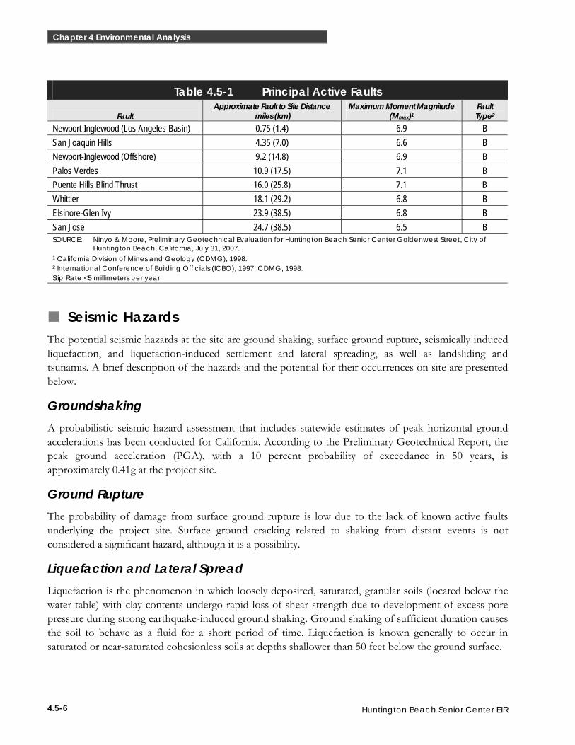
Table 4.5-1 lists selected principal known active faults that may affect the project site, as well as the maximum moment magnitude (Mmax), and the type of fault as defined in Table 16-U of the Uniform Building Code (UBC).
FIGURE 4.5-1Regional Geologic Map
D21314.00A division of
Huntington Beach Senior Center EIR
Source: Ninyo & Moore, 2007.
0605
7 | J
CS
| 07
NORTH
FIGURE 4.5-2Fault Location Map
D21314.00A division of
Huntington Beach Senior Center EIR
Source: Ninyo & Moore, 2007.
0605
7 | J
CS
| 07
NORTH
4.5-6
Chapter 4 Environmental Analysis
Huntington Beach Senior Center EIR
Table 4.5-1 Principal Active Faults
Fault Approximate Fault to Site Distance
miles (km) Maximum Moment Magnitude
(Mmax)1 Fault Type2
Newport-Inglewood (Los Angeles Basin) 0.75 (1.4) 6.9 B San Joaquin Hills 4.35 (7.0) 6.6 B Newport-Inglewood (Offshore) 9.2 (14.8) 6.9 B Palos Verdes 10.9 (17.5) 7.1 B Puente Hills Blind Thrust 16.0 (25.8) 7.1 B Whittier 18.1 (29.2) 6.8 B Elsinore-Glen Ivy 23.9 (38.5) 6.8 B San Jose 24.7 (38.5) 6.5 B SOURCE: Ninyo & Moore, Preliminary Geotechnical Evaluation for Huntington Beach Senior Center Goldenwest Street, City of
Huntington Beach, California, July 31, 2007. 1 California Division of Mines and Geology (CDMG), 1998. 2 International Conference of Building Officials (ICBO), 1997; CDMG, 1998. Slip Rate <5 millimeters per year
Seismic Hazards The potential seismic hazards at the site are ground shaking, surface ground rupture, seismically induced liquefaction, and liquefaction-induced settlement and lateral spreading, as well as landsliding and tsunamis. A brief description of the hazards and the potential for their occurrences on site are presented below.
Groundshaking A probabilistic seismic hazard assessment that includes statewide estimates of peak horizontal ground accelerations has been conducted for California. According to the Preliminary Geotechnical Report, the peak ground acceleration (PGA), with a 10 percent probability of exceedance in 50 years, is approximately 0.41g at the project site.
Ground Rupture The probability of damage from surface ground rupture is low due to the lack of known active faults underlying the project site. Surface ground cracking related to shaking from distant events is not considered a significant hazard, although it is a possibility.
Liquefaction and Lateral Spread Liquefaction is the phenomenon in which loosely deposited, saturated, granular soils (located below the water table) with clay contents undergo rapid loss of shear strength due to development of excess pore pressure during strong earthquake-induced ground shaking. Ground shaking of sufficient duration causes the soil to behave as a fluid for a short period of time. Liquefaction is known generally to occur in saturated or near-saturated cohesionless soils at depths shallower than 50 feet below the ground surface.
4.5-7
4.5 Geology and Soils
Huntington Beach Senior Center EIR
Lateral spreading is the horizontal movement of loose, unconfined sedimentary and fill deposits during seismic activity, often directly resulting from liquefaction events. Lateral spreading typically occurs as a form of horizontal displacement of relatively flat-lying alluvial material toward an open or “free” face, such as an open body of water or channel. This movement may often be associated with liquefaction.
The project site is not located in an area mapped as susceptible to liquefaction (Figure 4.5-3). Based on the subsurface exploration performed at the project site, the materials below the groundwater are relatively dense and liquefaction and associated hazards (e.g., lateral spreading) are not considered a potential constraint at the project site.
Settlement Settlement is defined as areas that are prone to different rates of surface settling and densification (differential compaction), and are underlain by sediments that differ laterally in composition or degree of existing compaction. Differential settlement can damage structures, pipelines, and other subsurface entities. Strong groundshaking can cause soil settlement by vibrating sediment particles into more tightly compacted configurations, thereby reducing pore space.
The project site is underlain by undocumented fill soils, which are likely compressible under loading from additional fill or structures. Accordingly, structures situated in areas underlain by the undocumented fill soils may be impacted by differential settlement resulting from compression of these soils.
Subsidence Land subsidence is the condition where the elevation of a land surface decreases due to the withdrawal of fluid. The location of major oil drilling areas and state-designated oil fields are areas with subsidence potential within the City. However, the project site is not located within an area subject to subsidence.
Landsliding The site is located in an area of relatively flat terrain. There are no mapped landslides onsite or adjacent to the site. Accordingly, seismic induced landsliding is not considered to be a potential hazard at the site.
Tsunamis and Seiches Tsunamis are long wavelength, seismic, sea waves generated by the sudden movements of the ocean floor during submarine earthquakes, landslides, or volcanic activity. Seiches are waves generated in a large, enclosed body of water. The project site is not mapped within an area considered susceptible to tsunamis or seiche inundation. The site is not expected to be affected by seiches due to the lack of a large landlocked body of water at or adjacent to the site. The Huntington Lake is approximately 400 feet southwest and down-gradient of the site. Accordingly, the lake would not impact the project site from a seiche event.
4.5-8
Chapter 4 Environmental Analysis
Huntington Beach Senior Center EIR
Project Site Geology and Soil Types Based on geologic reconnaissance, review of the referenced geologic maps, and subsurface exploration, the majority of the site is underlain by Pleistocene age older alluvial and/or terrace deposits.17 Artificial fill associated with previous grading activities mantles the natural deposits to variable depths. Based on review of stereoscopic aerial photographs and site reconnaissance, the project site is not underlain by deep-seated landslides.
Based on observation of the materials encountered in the borings and test pits for the feasibility study, the fill soils are generally comprised of loose to medium dense, clayey and silty sand with some oversize concrete and asphalt rubble to depths possibly up to approximately 15 feet. The fill soils are generally underlain by reddish to yellowish brown, medium dense to very dense, silty to poorly graded sand with some clayey silt older alluvium and/or terrace deposits to the maximum depths explored of approximately 50 feet. The on-site soils are relatively sandy and generally possess a low expansion potential. The more clayey natural soils, however, possess a medium to high expansion potential. Collapsible soils were not encountered at the site. However, as noted above, potentially compressible soils were encountered, the effects of which are addressed below in Section 4.5.3 (Project Impacts and Mitigation).
Groundwater Groundwater was encountered in some of the borings recently drilled at the site at depths ranging from approximately 18 to 27 feet below the ground surface at the time of the drilling. Historic high groundwater levels at the project site have been estimated to be at depths ranging from approximately 10 feet along the west side of the site to approximately 30 feet along the east side of the site. For the purpose of planning, groundwater is anticipated to be at a depth of approximately 10 feet or more below the ground surface within the project site. However, fluctuations in the level of groundwater may occur due to variations in ground surface topography, subsurface stratification, rainfall, irrigation practices, and other factors that may not have been evident at the time of the field evaluation. Groundwater may, therefore, be shallower or deeper at the time of construction than the depth encountered during the subsurface evaluation.
State Alquist Priolo Earthquake Fault Zoning Act The state legislation protecting the population of California from the effects of fault-line ground-surface rupture is the Alquist-Priolo Earthquake Fault Zoning Act. In 1972, California began delineating Earthquake Fault Zones (called Special Studies Zones prior to 1994) around active and potentially active faults to reduce fault-rupture risks to structures for human occupancy. This Act has resulted in the preparation of maps delineating Earthquake Fault Zones. The Act provides for special seismic design considerations if developments are planned in areas adjacent to active or potentially active faults. The project site is not located within a State of California Earthquake Fault Zone. However, as discussed in greater detail within Section 4.5.3 (Project Impacts and Mitigation) below, the active Newport-Inglewood fault zone is located approximately ¾ mile southwest of the site.
California Building Code California Code of Regulations (CCR), Title 24, Part 2, the California Building Code (CBC), provides minimum standards for building design in the state. The CBC is based on the current UBC, but contains Additions, Amendments and Repeals that are specific to building conditions and structural requirements in the State of California. Local codes are permitted to be more restrictive than Title 24, but are required to be no less restrictive. Chapter 16 of the CBC deals with General Design Requirements, including (but not limited to) regulations governing seismically resistant construction (Chapter 16, Division IV) and construction to protect people and property from hazards associated with excavation cave-ins and falling debris or construction materials. Chapters 18 and A33 deal with site excavations, foundations, retaining walls, and grading, including (but not limited to) requirements for seismically resistant design, foundation investigations, stable cut and fill slopes, and drainage and erosion control. Construction activities are subject to occupational safety standards for excavation, shoring, and trenching as specified in Cal-OSHA regulations (CCR, Title 8). The City of Huntington Beach has adopted the 2001 CBC as the Huntington Beach Building Code (Title 17, Chapter 17.04 of the Huntington Beach Municipal Code). Additional requirements have been adopted in the City of Huntington Beach Grading and Excavation Code (Title 17, Chapter 17.05 of the Huntington Beach Municipal Code).
Among other things, the CBC defines different building regions in the state and ranks them according to their seismic hazard potential. There are four types of these regions: Seismic Zones 1 through 4, with Zone 1 having the least seismic potential and Zone 4 having the highest seismic potential. The project site is in Seismic Zone 4, as is about 45 percent of California. Accordingly, any future development would be required to comply with all design standards applicable to Seismic Zone 4, the most stringent in the state.
NPDES Phase I (General Construction Activity Stormwater Permit) As discussed in further detail in Section 4.7 (Hydrology and Water Quality), a Stormwater Pollution Prevention Plan (SWPPP) prepared in compliance with an National Pollutant Discharge Elimination
4.5-12
Chapter 4 Environmental Analysis
Huntington Beach Senior Center EIR
System (NPDES) Phase I Permit describes the project site, erosion and sediment controls, runoff water quality monitoring, means of waste disposal, implementation of approved local plans, control of sediment and erosion control measures and maintenance responsibilities, and non-stormwater management controls. Dischargers are also required to inspect construction sites before and after storms to identify stormwater discharge from construction activity, and to identify and implement controls where necessary.
Seismic Hazards Mapping Act The CGS provides guidance with regard to seismic hazards. Under CGS Seismic Hazards Mapping Act, seismic hazard zones are identified and mapped to assist local governments in land use planning. The intent of this Act is to protect the public from the effects of strong groundshaking, liquefaction, landslides, ground failure, or other hazards caused by earthquakes.
Local The City of Huntington Beach advances public safety and welfare in the City through its General Plan and compliance with applicable local regulations in the Huntington Beach Municipal Code. General Plan policies specific to geologic, soil, and seismic hazards are listed in the Environmental Hazards Element. In addition, site development work in the City is required to comply with the Huntington Beach Building Code and all State requirements pertaining to geologic, soil, and seismic hazards.
General Plan Environmental Hazards Element The Environmental Hazards Element identifies various policies addressing natural and human-related hazards and the potential methods to reduce risks associated with those hazards. The discussion below identifies goals and objectives presented in the Environmental Hazards Element of the General Plan related to geologic resources that are potentially relevant to the proposed project.
Goal EH 1 Ensure that the number of deaths and injuries, levels of property damage, levels of economic and social disruption, and interruption of vital services resulting from seismic activity and geologic hazards shall be within acceptable levels of risk.
Objective EH 1.1 Ensure that land use planning in the City accounts for seismic and geologic risk, including groundshaking, liquefaction, subsidence, soil and slope stability, and water table levels. Policy EH 1.1.4 Evaluate the levels of risk based on the nature
of the hazards and assess acceptable risk based on the human, property, and social structure damage compared to the cost of corrective measures to mitigate or prevent damage.
Objective EH 1.2 Ensure that new structures are designed to minimize damage resulting from seismic hazards, ensure that existing unsafe structures are retrofitted to reduce hazards and mitigate other existing unsafe conditions. Policy EH 1.2.1 Require appropriate engineering and building
practices for all new structures to withstand
4.5-13
4.5 Geology and Soils
Huntington Beach Senior Center EIR
groundshaking and liquefaction such as stated in the Uniform Building Code.
Goal EH 2 Reduce the potential for mesa edge and bluff erosion hazards, and the potential for beach sand loss.
Objective EH 2.1 Ensure that land use planning and City policy account for bluff and coastal sand erosion. Policy EH 2.1.1 Minimize bluff and mesa edge erosion.
Goal EH 4 Eliminate, to the greatest degree possible, the risk from flood hazards to life, property, public investment and social order in the City of Huntington Beach.
Objective EH 4.1 Ensure that the City’s flood prevention standards and practices provide satisfactory safeguards for public and private development. Policy EH 4.1.1 During major redevelopment or initial
construction, require specific measures to be taken by developers, builders, or property owners in flood prone areas, to prevent or reduce damage from flood hazards and the risks upon human safety.
Goal EH 6 Ensure the safety of the City’s businesses and residents from peat hazards.
Objective EH 6.2 Minimize peat hazards through the regulation of construction Policy EH 6.2.1 Establish standards of construction within
identified peat zones.
Consistency Analysis The Senior Center structure would be constructed in accordance with design for structures located in Seismic Zone 4 as well as applicable provisions of the Huntington Beach Building Code regarding seismic hazards and structural design. The project would incorporate the required site preparation and structural design recommendations included in the geotechnical report prepared for the project site, including measures related to groundshaking, erosion, and soil stability. The incorporated measures would ensure that earthquake survivability is a primary concern in the design and construction of the proposed project. In addition, although the project site is located within Zone X, the overall parcel that contains the project site is partially located in flood Zone A. Therefore, in accordance with city code, the building would be constructed at an elevation of one foot higher than the base flood elevation (BFE). The BFE for the project site is approximately 9.5 feet. However, because the elevation of the project site ranges from 14 feet above MSL to 26 feet above MSL, the building would not have to be further elevated. However, a flood elevation certificate would have to be completed for the project. Further, although mining of peat, sand, and gravel was evident on properties farther east and southwest of the site, no deep excavations associated with mining activities were evident at the project site. Thus, peat hazards are not anticipated to be a construction concern. Implementation of the proposed project would not conflict with these applicable policies.
4.5-14
Chapter 4 Environmental Analysis
Huntington Beach Senior Center EIR
City of Huntington Beach Municipal Code
Building Code and Grading and Excavation Code Site development in the City of Huntington Beach is required to comply with the Huntington Beach Building Code and all State requirements pertaining to geologic, soil, and seismic hazards. The California Building Code (CBC) has been incorporated and adopted into the Huntington Beach Building Code. The CBC, discussed previously under State regulations, is adopted by the City as Chapter 17.04, Building Code, of the Municipal Code. The Building Code, as adopted, includes minor variations to the CBC related to minimum slab thickness, fire-extinguishing systems, building security, and methane district regulations. The Grading and Excavation Code (adopted by the City as Chapter 17.05, Grading and Excavation Code, of the Municipal Code) sets forth rules and regulations to control excavation, grading, earthwork and site improvement construction and establishes administrative requirements for issuance of permits and approvals of plans and inspection of grading construction. Specifically, the Grading and Excavation Code identifies, defines, and regulates hazardous conditions, plans and specifications, soils and geology reports, fills, setbacks, drainage and terracing, asphalt concrete pavement, and erosion control systems.
4.5.3 Project Impacts and Mitigation
Analytic Method Project-specific geologic information, soil characteristics, and liquefaction potential were obtained from Ninyo & Moore’s Preliminary Geotechnical Evaluation prepared for the project site. In addition, widely available industry sources were examined to document regional and local geology. Information regarding regional geology and seismically induced hazards was taken from various sources of the CGS and the USGS. Where potential geological hazards are identified on the project site, such hazards are expected to affect the proposed project and any potential development. The following analysis considers the potential effects of components of the proposed project described in Chapter 3 (Project Description).
Thresholds of Significance The following thresholds of significance are based on Appendix G to the 2007 CEQA Guidelines. For purposes of this EIR, implementation of the proposed project may have a significant adverse impact if it would do any of the following:
Expose people or structures to potential substantial adverse effects, including the risk of loss, injury, or death involving > Rupture of a known earthquake fault, as delineated on the most recent Alquist-Priolo
Earthquake Fault Zoning Map issued by the State Geologist for the area or based on other substantial evidence of known fault
Result in substantial soil erosion, loss of topsoil, or changes in topography or unstable soil conditions from excavation, grading, or fill
4.5-15
4.5 Geology and Soils
Huntington Beach Senior Center EIR
Be located on a geologic unit or soil that is unstable, or that would become unstable as a result of the project, and potentially result in on- or off-site landslide, lateral spreading, subsidence, liquefaction, or collapse
Be located on expansive soil, as defined in Table 18-1-A of the California Building Code (2001), creating substantial risks to life or property
Have soils incapable of adequately supporting the use of septic tanks or alternative waste water disposal systems where sewers are not available for the disposal of waste water
Effects Not Found to Be Significant Threshold Would the project expose people or structures to potential substantial adverse
effects, including the risk of loss, injury, or death involving rupture of a known earthquake fault, as delineated on the most recent Alquist-Priolo Earthquake Fault Zoning Map issued by the State Geologist for the area or based on other substantial evidence of a known fault?
The project site is not located within an identified Alquist-Priolo Fault Zone and there are no known faults (active, potentially active, or inactive) onsite. The possibility of fault rupture is considered very low. No impacts from fault rupture would result and no further analysis is required.
Threshold Would the project have soils incapable of adequately supporting the use of septic tanks or alternative waste water disposal systems where sewers are not available for the disposal of wastewater?
The proposed project would be provided sanitary sewer service by the City of Huntington Beach, and no septic tanks or alternative wastewater systems are proposed. No impact would occur, and no further analysis of this issue is required.
Impacts and Mitigation Measures Threshold Would the project expose people or structures to potential substantial adverse
effects, including the risk of loss, injury, or death involving
■ strong seismic ground shaking?
■ seismic-related ground failure, including liquefaction?
Impact 4.5-1 The proposed project would not significantly expose people or structures to effects of seismic ground shaking or liquefaction.
The proposed project site is situated in a seismically active area. During the design life of the development, strong ground shaking may occur. The closest active fault is the Newport Inglewood fault zone approximately ¾ mile south of the site. An estimated earthquake magnitude of 6.9 could occur on this fault zone, producing a peak horizontal ground acceleration of 0.41g at the project site. Damage from an earthquake of this range in intensity could include general damage to foundations, shifting of frame structures if not bolted, and breaking of underground pipes. In addition, active and potentially active regional faults are capable of producing seismic shaking at the project site, and it is anticipated that the project site would periodically experience ground acceleration as a result of exposure to small and
4.5-16
Chapter 4 Environmental Analysis
Huntington Beach Senior Center EIR
moderate magnitude earthquakes occurring on active distant and blind thrust faults. Accordingly, the proposed structures and improvements could be adversely impacted by the seismic ground shaking if proper mitigation measures are not implemented.
As discussed under existing conditions, the proposed project site is not within a liquefaction hazard zone. Soil samples taken from the project site do not indicate the potential for liquefaction to occur on site. As such, potential effects of liquefaction would not be expected to occur on-site.
In order to reduce the risks associated with seismically induced groundshaking, the design of foundations and structures must consider the location and type of subsurface materials on the project site. Because the project site is in Seismic Zone 4, structures are required to be designed in accordance with applicable parameters of the current CBC. Specific engineering design and construction measures required by the CBC for the construction of new buildings and/or structures would be implemented to anticipate and avoid the potential for adverse impacts to human life and property caused by seismically induced groundshaking. In addition, a detailed Geotechnical feasibility study was prepared for the project, which included results of subsurface geotechnical evaluation and laboratory testing of materials. Implementation of mitigation measure MM 4.5-1 would ensure that design recommendations identified within the Geotechnical feasibility project site implemented.
MM 4.5-1 Detailed design measures contained within the Geotechnical Evaluation prepared for the project shall be implemented, including those related to: earthwork, seismic design consideration, foundations, building floor slabs, retaining wall, exterior flatwork, shoring, corrosion, concrete, site drainage, storm drain infiltration system, and preliminary pavement design.
Consequently, adherence to the identified design measures would reduce substantial adverse effects related to groundshaking and this impact would be less than significant.
Threshold Would the project expose people or structures to potential substantial adverse effects, including the risk of loss, injury, or death involving landslides?
Impact 4.5-2 The proposed project could expose people or structures to effects of landslides.
Based on reconnaissance and review of readily available aerial photographs, the project site is not underlain by landslides. The site is relatively flat, and no existing landslides were observed or mapped on site. Slopes should be generally stable if constructed at inclinations of 2 to 1 (horizontal to vertical) or flatter, as proposed to occur for the project.
Based on the latest conceptual plan (see Figure 3-7 [Conceptual Grading and Utility Plan], the proposed project and associated site improvements will generally not impact the adjacent slopes to the west and south. There will be some grading, however, along the north side adjacent to the proposed access driveway off Goldenwest Street. Therefore, surficial sliding and erosion along this slope face could result in damage to the proposed project. Implementation of mitigation measure MM 4.5-2 would address these effects:
MM 4.5-2 In order to mitigate the erosion potential of the slopes adjacent to the site, the near surface soils shall be compacted along the slope face where the site improvements encroach upon the existing slopes (i.e., the
4.5-17
4.5 Geology and Soils
Huntington Beach Senior Center EIR
northern slope or earthen berm). The slope shall then be covered with an appropriate erosion protection device and drought tolerant plants. Surface water runoff must be diverted away from the top of the slope to reduce the likelihood of surficial sliding and erosion.
Additionally, although not part of the project and provided funding is available, the City is proposing to hydroseed and irrigate the existing slopes located adjacent to the eastern and southern boundaries of the project site concurrently with the construction of the senior center. This project will include the removal of two diseased eucalyptus trees along the eastern slope and the removal of several myoporum trees on the southern slope. The hydroseed will include groundcover, trees and shrubs and would also serve to stabilize the soil and vegetation until it takes root. New tree species will include Pinus torreyana (Torrey Pine) and Quercus agrifolia (California Oak). Although some amount of topsoil will be introduced to the site and recontouring may be required, no fill materials are proposed.
Implementation of mitigation measure MM 4.5-2 would ensure that impacts would be reduced to less-than-significant levels.
Threshold Would the project result in substantial soil erosion, loss of topsoil, or changes in topography or unstable soil conditions from excavation, grading, or fill?
Impact 4.5-3 Project implementation could result in soil erosion and the loss of topsoil.
For the purposes of this analysis, erosional effects consider whether or not the effects of project activities would accelerate the natural erosional processes. Erosion of adjacent slopes potentially affecting proposed development is discussed above, under Impact 4.5-2.
Because the project site is currently undeveloped, it is already exposed to erosional processes. Construction activities could result in the loss of topsoil or expose areas of soil to erosion by wind or water. Operational activities such as the addition of paved and landscaped areas would, over the long term, decrease the potential for erosion because less exposed soil would exist on the project site.
Earth-disturbing activities associated with construction would be temporary. Specific erosion impacts would depend largely on the areas affected and the length of time soils are subject to conditions that would be affected by erosion processes. The proposed site is approximately 5 acres in size, and is subject to the provisions of the General Construction Activity Stormwater Permit adopted by the State Water Resources Control Board (SWRCB). The Applicant for the proposed project must submit a Notice of Intent (NOI) to the SWRCB for coverage under the Statewide General Construction Activity Stormwater Permit and must comply with all applicable requirements, including the preparation of a Stormwater Pollution Prevention Plan (SWPPP), applicable NPDES Regulations, and best management practices (BMP). The SWPPP must describe the site, the facility, erosion and sediment controls, runoff water quality monitoring, means of waste disposal, implementation of approved local plans, control of sediment and erosion control measures, maintenance responsibilities, and non-stormwater management controls. Inspection of construction sites before and after storms is required to identify stormwater discharge from the construction activity and to identify and implement controls where necessary.
In addition, all construction activities would comply with Chapter 33 of the CBC, which regulates excavation activities and the construction of foundations and retaining walls; Appendix Chapter 33 of the
4.5-18
Chapter 4 Environmental Analysis
Huntington Beach Senior Center EIR
CBC, which regulates grading activities, including drainage and erosion control; and the City of Huntington Beach Grading and Excavation Code, which identifies and enforces requirements specific to earthwork conditions in the City. Compliance with the NPDES permit process, the CBC requirements, and the City Codes would minimize the effects from erosion. Therefore, such compliance would ensure that erosion and other soil instability impacts resulting from project construction would be less than significant.
Threshold Would the project be located on a geologic unit or soil that is unstable, or that would become unstable as a result of the project, and potentially result in on or off-site landslide, lateral spreading, subsidence, liquefaction or collapse?
Impact 4.5-4 Development of the proposed project would be located on potentially unstable (compressible and corrosive) soils, which could result in on site settlement.
The potential for landslides are addressed under Impact 4.5-2, while liquefaction is addressed under Impact 4.5-1. As discussed in Section 4.5.1 (Existing Conditions), associated liquefaction hazards (lateral spreading) and subsidence are not considered a potential hazard at the project site. In addition, the collapse of underlying soils at the project site is also considered to have a negligible potential of occurrence. However, compressible soils were encountered at the project site and this impact addresses the potential hazards associated with such soils.
Settlement Undocumented fill soils are expected at the site up to approximately 15 feet deep below the ground surface. Details regarding the placement and compaction of the fill soils, as well as the original ground preparation, are unknown. Accordingly, the fill soils are considered to be potentially compressible under future loading from new fills or foundations. Structures situated in areas underlain by the undocumented fill soils may be impacted by differential settlement resulting from compression of these soils.
The natural soils underlying the fill soils are expected to be comprised of relatively consolidated, older alluvial and/or terrace deposits. Organic clay or peat deposits are not expected at the site. Based on recent subsurface exploration and past experience with similar soils, it is not anticipated the natural deposits will be compressible under the currently proposed fill and foundation loads.
The fill and natural soils at the site are generally suitable for reuse during the proposed grading. Existing oversize materials, such as concrete rubble, however, are present within the fill soils and would be encountered during grading and construction. Trash and other debris were not observed in the old fill materials on site but may be encountered during grading. These materials are unsuitable for reuse. If left in the soil, these materials could affect the integrity of the proposed project. Mitigation measures MM 4.5-4(a) and (b) would address these issues. Mitigation measure MM 4.5-4(b) also satisfies Measure Geology-2 identified in the Central Park Master Plan EIR. The language in this measure has been modified to reflect project-specific components of the proposed senior center where necessary, although the intent remains the same. The original measures from the Central Park Master Plan EIR appear in Table 4-1 of this EIR.
4.5-19
4.5 Geology and Soils
Huntington Beach Senior Center EIR
For the purposes of this document, the City shall implement mitigation measures MM 4.5-4(a) and MM 4.5-4(b), which would address impacts associated with settlement.
MM 4.5-4(a) Oversize materials, more than approximately four inches in size, such as concrete rubble shall be disposed of off site. Trash and other debris shall be selectively removed and disposed off site.
MM 4.5-4(b) (This MM incorporates Measure Geology-2 from the Central Park Master Plan EIR) Remedial grading to remove compressible soils and replace them with appropriately compacted fill shall occur in order to address potential settlements. Fill soils to be used for backfill around utilities shall be compacted to 90 percent relative compaction.
Groundwater was recently encountered at a depth of 18 or more feet below the ground surface at the site. Based on historical data provided by CDMG, groundwater may be as high as 10 feet below the ground surface. Provided no deep excavations are made, groundwater is not anticipated to impact the grading and proposed improvements.
Corrosive Soils Data pertaining to the corrosivity of the on-site soils were not available for review. The corrosion potential of soils will influence the type of construction materials that may be used for structures and pipelines on the project. Where corrosive soils are present, selection of corrosion resistant material types for underground improvements and/or providing corrosion protection to surfaces in contact with corrosive soils may be used. Concrete protection against sulfate bearing soils may include the use of corrosive resistant cement type and limiting the water-cement ratio of the concrete mix. As such, mitigation measure MM 4.5-4(c) would address potential impacts.
MM 4.5-4(c) (This MM incorporates Measure Geology-6 from the Central Park Master Plan EIR) Corrosivity testing of the on-site soils should be performed during the design phase. Corrosivity testing may also need to be considered for soils that are imported for use as fill during construction.
Implementation of the above-described mitigation measures would ensure that impacts associated with lateral spreading, subsidence, and corrosive soils would be less than significant.
Threshold Would the project be located on expansive soil, as defined in Table 18-1-A of the California Building Code (2001), creating substantial risks to life or property?
Impact 4.5-5 The proposed project could be located on expansive soil.
Based on past experience with similar soils and available geotechnical literature, the alluvium and existing fills at the site generally possess a low to moderate expansion potential. The more clayey natural soils, however, possess a medium to high expansion potential. Due to the potential for volume changes with fluctuations in moisture, expansive soils present a risk of distress to pavement, foundation elements, and other structures where present. Expansive soils generated from excavations are undesirable for use as fill within three feet of slab-on-grade areas. Implementation of mitigation measure MM 4.5-5 would ensure that development on expansive soil would not occur in a manner that would adversely affect development.
4.5-20
Chapter 4 Environmental Analysis
Huntington Beach Senior Center EIR
MM 4.5-5 (This MM incorporates Measure Geology-5 from the Central Park Master Plan EIR) The soil expansion potential shall be evaluated in detail prior to the issuance of grading permits. If expansive soils are present near design grades, potential for heaving or cracking of rigid structures shall be addressed through soil removal, chemical treatment, or other equivalent measures.
Incorporation of mitigation measure MM 4.5-5 into the proposed project would ensure that impacts associated with expansive soil are reduced to a less-than-significant level.
4.5.4 Cumulative Impacts The geographic context for the analysis of impacts resulting from geologic hazards generally is site-specific, rather than cumulative in nature, because each project site has unique geologic considerations that would be subject to uniform site development and construction standards. As such, the potential for cumulative impacts to occur is limited.
Impacts associated with potential geologic hazards related to soil or other conditions occur at individual building sites. These effects are site-specific, and impacts would not be compounded by additional development. Buildings and facilities in the City of Huntington Beach would be sited and designed in accordance with appropriate geotechnical and seismic guidelines and recommendations consistent with the Building Code. Adherence to all relevant plans, codes, and regulations with respect to project design and construction would provide adequate levels of safety, and the cumulative impact would be less than significant. Adherence by the project to all relevant plans, codes, and regulations would ensure that the proposed project would not result in a cumulatively considerable contribution to cumulative impacts regarding geologic hazards, and the cumulative impact of the project would, therefore, be less than significant.
Impacts from erosion and loss of topsoil from site development and operation can be cumulative in effect within a watershed. The Westminster Watershed forms the geographic context of cumulative erosion impacts. Development throughout Orange County and the City of Huntington Beach is subject to state and local runoff and erosion prevention requirements, including the applicable provisions of the general construction permit, BMPs, and Phases I and II of NPDES permit process, as well as implementation of fugitive dust control measures in accordance with SCAQMD Rule 403 (see Section 4.2 (Air Quality) of this EIR). These measures are implemented as conditions of approval of project development and subject to continuing enforcement. As a result, it is anticipated that cumulative impacts on the Westminster Watershed due to runoff and erosion from cumulative development activity would be less than significant. The project’s contribution to cumulative impacts would not be cumulatively considerable and would, therefore, also be less than significant.
4.5.5 References Alquist-Priolo Earthquake Fault Zoning Act, California Public Resources Code, Division 2, “Geology, Mines,
and Mining,” Chapter 7.5 “Earthquake Fault Zones,” Sections 2621 through 2630; signed into law 22 December 1972, most recently amended 07 October 1997.
4.5-21
4.5 Geology and Soils
Huntington Beach Senior Center EIR
Hart, E.W., and Bryant, W.A., Fault-Rupture Hazard Zones in California, Alquist-Priolo Earthquake Fault Zoning Act with index to Earthquake Fault Zones Maps, California Geological Survey, Special Publication 42, revised 1997, Supplements 1 and 2, 1999, Supplement 3, 2003.
Huntington Beach, City of. 1996. The City of Huntington Beach General Plan.
International Conference of Building Officials, Uniform Building Code, Volumes 1, 2 & 3; Chapter 16, Structural Forces (earthquake provisions); Chapter 18, Foundations and Retaining Walls; appendix Chapter A33, Evacuation and Grading, Whittier, CA, 1994.
Ninyo & Moore. Preliminary Geotechnical Evaluation, Huntington Beach Senior Center, Goldenwest Street, City of Huntington Beach, California. July 31, 2007
Ninyo & Moore, Geotechnical Evaluation, Huntington Beach Senior Center, Goldenwest Street, City of Huntington Beach, California, June 1, 2007.