Taking Track THE SIDE With some of the most diverse terrain on earth, this spectacular stretch of red dirt is one side track worth exploring WORDS BY BEN MURPHY, PHOTOGRAPHY BY MATT FEHLBERG LAKEFIELD NATIONAL PARK, QLD REAL 4WDING 058 WWW.4WDACTION.COM.AU
Transcript
TakingTrackTHE SIDE
With some of the most diverse terrain on earth, this spectacular stretch
of red dirt is one side track worth exploring
WORDS BY BEN MURPHY, PHOTOGRAPHY BY MATT FEHLBERG
LA
KE
FIE
LD
NA
TIO
NA
L P
AR
K,
QL
DR
EAL
4WD
ING
058
WW
W.4
WD
AC
TIO
N.C
OM
.AU
WW
W.4W
DA
CTIO
N.C
OM
.AU
059
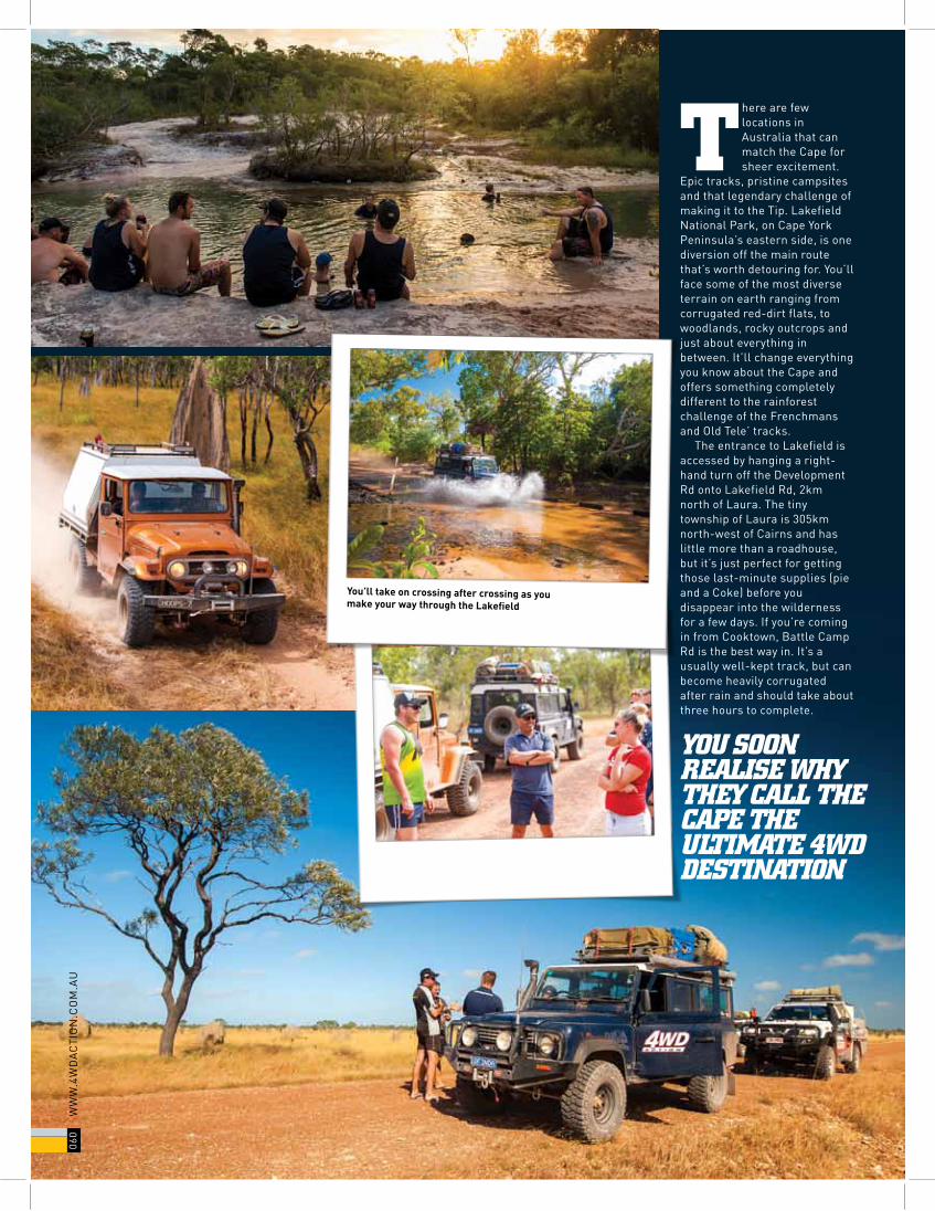
There are few locations in Australia that can match the Cape for sheer excitement.
Epic tracks, pristine campsites and that legendary challenge of making it to the Tip. Lakefield National Park, on Cape York Peninsula’s eastern side, is one diversion off the main route that’s worth detouring for. You’ll face some of the most diverse terrain on earth ranging from corrugated red-dirt flats, to woodlands, rocky outcrops and just about everything in between. It’ll change everything you know about the Cape and offers something completely different to the rainforest challenge of the Frenchmans and Old Tele’ tracks.
The entrance to Lakefield is accessed by hanging a right-hand turn off the Development Rd onto Lakefield Rd, 2km north of Laura. The tiny township of Laura is 305km north-west of Cairns and has little more than a roadhouse, but it’s just perfect for getting those last-minute supplies (pie and a Coke) before you disappear into the wilderness for a few days. If you’re coming in from Cooktown, Battle Camp Rd is the best way in. It’s a usually well-kept track, but can become heavily corrugated after rain and should take about three hours to complete.
YOU SOON REALISE WHY THEY CALL THE CAPE THE ULTIMATE 4WD DESTINATION
You’ll take on crossing after crossing as you make your way through the Lakefield
060
WW
W.4
WD
AC
TIO
N.C
OM
.AU
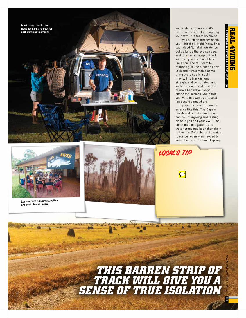
These two tracks intersect at the Old Laura Homestead. The Lakefield National Park was once a thriving cattle station and the now ruined Laura Homestead was the station headquarters. The historic old buildings of the homestead are well worth exploring, and it’s here that you’ll reach the first campsite. These sites are located down by the river and are the perfect places to spend the night. Most of the camp-sites throughout the park will require you to be completely self-sufficient and have few facilities. You can collect firewood within the park, and there’s always plenty lying around on the ground for those huge campfires at night.
There can be plenty of water lying around along the tracks, and if you venture further into the park you’ll encounter plenty of creek crossings and mud. The river systems that run through the park fill up and flood the lower-lying areas
during the wet season, then subside to leave pockets of water and mud that can make the drive through a wet one, even well into the dry season. The corrugations on the long stretches of red-dirt track will give your suspension a workout as well, but hey, this is the Cape after all!
Be prepared for plenty of mud and water, even long into the dry season
WW
W.4W
DA
CTIO
N.C
OM
.AU
061
REA
L 4WD
ING
LA
KE
FIE
LD
NA
TIO
NA
L P
AR
K, Q
LD
bmurphy
Sticky Note
Swap image with image of sign below and move caption to suit
bmurphy
Sticky Note
Add caption - Most of the campsites throughout Lakefield are pure bush camping
Detouring east before the ranger station will take you down to the central campsites, including Kalpowar Crossing. This campsite situated on the Normanby River offers a few more facilities including toilets and showers, and is another good option for spending the night. There’s good fishing either sides of the crossing and the barra are always bighting. There’s been the occasional croc sighting here, so keep your eyes peeled for these scaly buggers too.
The track crosses the river and heads out towards the coast of Cape Melville National Park. Towards either end of the wet season, you’ll encounter a fair bit of water on this crossing, but if the weather’s been good towards the middle of the dry season, it will be easy going. On the way out to Cape Melville veering off to the left will take you down to Kalpowar Recreation Reserve and out to Bathurst Bay.
The tracks out to the bay involve plenty of low-range action, and it can take up to five hours to tackle this 35km section of track from the boundary of the national park out to the campsites at the bay. Deep ruts, tidal creek crossings and soft sand will all put your skills and your truck to the test, and you’ll soon start to realise why they call the Cape the ultimate 4WD destination.
The beachfront campsites at Bathurst Bay are the icing on the cake when you finally arrive, and setting up camp with a few coldies around the fire with views over the Great Barrier Reef and surround-ing islands will top off the end of a spectacular day of driving. These campsites are best for self-sufficient campers as there are no facilities and you’re a long way from anything out here. The views and serenity are certainly worth roughing it for, though, and once you spend a night here, you’ll find it hard to leave.
To continue on the trip north, head back in to Lakefield National Park and onto Lakefield Rd. Passing the ranger station will bring you across a little attraction that’s worth pulling over and having a look at. The White Lily and Red Lily lagoons are set amongst the wetlands, and have a viewing board walk that takes you into the heart of the lagoon for some cracking wildlife photo opportunities. The birdlife flocks to these
The tracks out to Bathurst Bay are a mix of deep ruts, soft sand and tidal creeks
Be sure to carry plenty of spares, as you’re a long way from anything out here
062
WW
W.4
WD
AC
TIO
N.C
OM
.AU
wetlands in droves and it’s prime real estate for snapping your favourite feathery friend.
If you push on further north, you’ll hit the Nilfold Plain. This vast, dead flat plain stretches out as far as the eye can see, and this barren strip of track will give you a sense of true isolation. The tall termite mounds give the plain an eerie look and it resembles some-thing you’d see in a sci-fi movie. The track is long, straight and corrugated, and with the trail of red dust that plumes behind you as you chase the horizon, you’d think you were in a Central Austral-ian desert somewhere.
It pays to come prepared in an area like this. The Cape’s harsh and remote conditions can be unforgiving and testing on both you and your 4WD. The constant corrugations and water crossings had taken their toll on the Defender and a quick roadside repair was needed to keep the old girl afloat. A group
LOCAL’S TIP
THIS BARREN STRIP OF TRACK WILL GIVE YOU A
SENSE OF TRUE ISOLATION
Most campsites in the national park are best for self-sufficient camping
Last-minute fuel and supplies
are available at Laura
WW
W.4W
DA
CTIO
N.C
OM
.AU
063
REA
L 4WD
ING
LA
KE
FIE
LD
NA
TIO
NA
L P
AR
K, Q
LD
bmurphy
Sticky Note
Add - Andrew from Cape York Tours has spent plenty of time travelling the Cape and reckons that the best place to experience a croc sighting is at the Hann River Campsite at night. "If you've never heard a croc bark at night, it will be a unique experience for you at Lakefield National Park."
bmurphy
Cross-Out
bmurphy
Inserted Text
the
fAcT fILE
WHERE:Lakefield National Park is located 340km north-west of Cairns on the Cape York Peninsula. Access is via Battle Camp Rd from Cooktown or Lakefield Rd, off the Peninsula Development Rd via Cairns.
INFORMATION:Located on the central eastern side of the Cape York Peninsula, Rinyirru (Lakefield) National Park is the traditional land of the Lama Lama and Kuku Thaypan peoples. It’s a remote and diverse park made up of a mixture of grassed flats, woodlands, wetlands, sandstone outcrops and mudflats. It’s one of those must-see locations on a trip to the Cape, as it offers something a little different to the rainforests.
CAMPING:There are several campsites spread throughout the park including Old Laura Homestead and Welcome Waterhole in the south to Saltwater Crossing and Annie River campsites in the north of the park.
FACILITIES AND AMENITIES:A lot of the campsites in the park are bush camping with very little to no facilities in true typical Cape fashion. However, there are options here for everyone and Kalpowar Crossing campsite offers toilets, showers and picnic tables.
WHAT TO TAKE:Take what you need to be fully self-sufficient for the duration of your stay. Take all the fuel, fresh water and food you need. Carry plenty of spares and spare fuel, especially if your trip to Lakefield is part of a bigger trip to the tip.
BEST TIME TO TRAVEL:May through to October, during the dry season is the only time that the park is open, with June and July providing the best consistent temperatures for travelling.
FUEL AND SUPPLIES:Fuel and major supplies are available at Cairns or Cooktown. Fuel and minor supplies are available at the Palmer River Roadhouse.Palmer River RoadhouseDieseL: $1.78/LULP: $1.76/L
TRIP STANDARD:Trips are rated A through E, with A meaning suited only to vehicles with an extreme level off-road modification, and E meaning perfectly suited to all types of 4WD. Most of the national park is a D, well maintained but corrugated tracks. Towards either end of the wet season tracks can become more difficult with crossings becoming deeper making it a C.
MAPS AND GUIDES:Cape York by Hema Maps.
TRIP TIME OF THE YEAR:June.
RESTRICTIONS AND PERMITS:Camping permits are required at all campsites and are available from Queensland Parks and Wildlife Service. The park is closed during the wet season, and there are restrictions on alcohol in some Cape York communities.
CONTACTS:CAPe YORK AUsTRALiA W: www.cape-york-australia.comQUeeNsLAND DePARTMeNT OF NATiONAL PARKs PH: 13 74 68 W: www.nprsr.qld.gov.auCOOKTOWN AND CAPe YORK VisiTORs iNFORMATiON CeNTRe PH: (07) 4069 6004 W: www.cooktownandcapeyork.com
BROUGHT TO YOU BUY
Travelling in groups is recommended when heading into remote regions of the Cape
it’s an epic trip out to Bathurst Bay for some of
the finest campsites the Cape has to offer
064
WW
W.4
WD
AC
TIO
N.C
OM
.AU
bmurphy
Sticky Note
Change contact to: CAPE YORK TOUR PH: 1800 994 620 W: www.capeyorktour.com
bmurphy
Cross-Out
BEST 4WD TRACKThe track out to Bathurst Bay camping areas from Wakooka is a mix
of deep ruts, soft sand and tidal creek crossings. It’s a challenging
run out to some spectacular campsites, and when the conditions are
right it can take up to five hours to complete the 35km section. There
are spectacular campsites at the end, which gives you even more
reason to complete the track. As if you needed any more reasons!
IT CAN TAKE UP TO FIVE HOURS TO
TACKLE THIS 35KM SECTION OF TRACK plan was put together (mostly
to bag the driver), the repair done and we were back battling the bulldust and corrugations before we knew it.
You’ll pass the last lot of campsites at Saltwater Crossing, and it’s another top spot to pull up stumps for the night before heading off to complete your trip to the tip. There are more riverside campsites here and basic bush camping. You’ll cross the Saltwater Creek and head out of the park towards Musgrave and back onto the Peninsula Development Rd for the trip north.
It’s well worth venturing off the beaten track and making the trip into Lakefield National Park. It’s got everything from cracking tracks, spectacular scenery and campsites that will make you wish that you never had to leave. Its diverse terrain is something that you won’t find anywhere else in the country and it will make your Cape York experience something extra special. It’s one little side track worth exploring.