7.1 Summary 7.1.1 An assessment of the development site’s hydrology and hydrogeology found that it has
a low sensitivity with respect to the surface water and groundwater environment. The majority of the development site comprises of soils and drift of low permeability, which overlie Jurassic sedimentary rocks of medium to low permeability.
7.1.2 There is the potential for significant effects on the hydrology of the development site to occur during the construction phase; to a lesser extent potential effects could also occur during the operational and decommissioning phases. The activities from which potential effects could occur on-site include the construction, maintenance and decommissioning of access tracks, watercourse crossings, turbine foundations and crane pads as well as other general construction work.
7.1.3 The avoidance of hydrological receptors, such as, avoiding construction within 20m of all watercourses (inherent in the design layout) together with implementation of all appropriate pollution prevention measures will ensure that the surface water and groundwater environments are sufficiently protected from any potentially significant effects.
7.1.4 Following discussions with the Environment Agency it was confirmed that the pro-forma in Planning Policy Statement 25 (PPS25): Development and Flood Risk would be sufficient to meet PPS25 requirements for a Flood Risk Assessment.
7.1.5 No significant residual effects on hydrology and hydrogeology are anticipated.
7.2 Introduction and overview of methodology 7.2.1 This chapter sets out the methodology for and findings of an assessment of the potential
effects on hydrology and hydrogeology during the construction, operation and decommissioning of the proposed Winwick Wind Farm, taking into account the potential need for micro-siting up to 50m. A summary of the underlying geology is provided to put the hydrology and hydrogeology into context.
7.2.2 Following a summary of relevant policy and legislation, the chapter outlines the data gathering methodology that was adopted as part of the assessment. This leads on to a description of the overall baseline conditions, the environmental measures that have been incorporated into the scheme and the scope of the assessment. The chapter concludes with a summary of residual effects and an evaluation of their significance following the implementation of environmental measures.
7.2.3 The ‘pro-forma’ or checklist provided in the Practice Guide for Planning Policy Statement 25 (PPS25): Development and Flood Risk has been completed (Appendix 7.A) to guide the reader to sections regarding flood risk and management. Following
discussions with the Environment Agency (EA) it was confirmed that the pro-forma in PPS25 would be sufficient to meet PPS25 requirements for a Flood Risk Assessment.
7.2.4 The assessment has been undertaken primarily using a semi-quantitative approach, based on professional judgement, environmental legislation and general guidance measures related to the water environment. A list relevant terminology and abbreviations used in the chapter is presented in Section 7.9.
7.3 Policy and legislative context
Policy context 7.3.1 Planning policies related to the water environment (and relevant to this chapter) must be
taken into consideration so that the proposed development complies with the relevant policy issues.
7.3.2 National planning policy includes:
• Planning Policy Statement 1: Delivering Sustainable Development (PPS1) sets out the Government’s overall planning policies on the delivery of sustainable development through the planning process. As part of this process, the statement promotes the consideration of environmental issues such as flood risk and the impacts of climate change in development plan policies; and
• Planning Policy Statement 25: Development and Flood Risk (PPS25) sets out Government policy on development and flood risk. Its aims are to ensure that flood risk is taken into account at all stages in the planning process to avoid inappropriate development in areas at risk of flooding, to direct development away from areas of highest risk and to prevent new development increasing flood risk.
7.3.3 The East Midlands Regional Plan is the Regional Spatial Strategy (RSS) and was adopted in March 2009. Policy 35 refers to a regional approach to managing flood risk and states that development should not be permitted if, alone or in conjunction with other new development, it would:
• Be at unacceptable risk from flooding or create such an unacceptable risk elsewhere.
• Inhibit the capacity of the floodplain to store water.
• Impede the flow of floodwater in a way which would create an unacceptable risk elsewhere.
• Have a detrimental impact upon infiltration of rainfall to ground water storage.
• Otherwise unacceptably increase flood risk.
7.3.4 There are no local planning policies relevant to the water environment.
7.3.5 General guidance relating to the water environment includes the following:
• Environment Agency (EA) Policy and Practice for the Protection of Groundwater;
- PPG 1 General guide to the prevention of water pollution;
- PPG 2 Above ground oil storage tanks;
- PPG 3 Use and design of oil separators in surface water drainage systems;
- PPG 4 Disposal of sewage where no mains drainage is available;
- PPG 5 Works in, near or liable to affect watercourses;
- PPG 6 Working at construction and demolition sites;
- PPG 8 Safe storage and disposal of used oils; and
- PPG 21 Pollution incident response planning.
• Construction Industry Research and Information Association (CIRIA) Report C532: Control of Water Pollution from Construction Sites;
• CIRIA Report C502: Environmental Good Practice on Site;
• CIRIA Culvert Design and Operation Guide (RP901)88;
• BS6031: 1981 Code of Practice for Earth Works;
• Good Practice Guide for Handling Soils (MAFF, 2000); and
• Local and Regional Land Drainage Byelaws.
Legislative requirements 7.3.6 The European Water Framework Directive (WFD) (2000/60/EC) is the most substantial
piece of European water legislation to date, and is focused on delivering an integrated approach to the protection and sustainable use of the water environment on a river basin scale. One of the primary objectives of the Directive is for water bodies to achieve ‘good status’ which, for surface water bodies, requires both good ecological status and good chemical status to be achieved. For groundwater bodies, good status is achieved when both quantitative status and chemical status are at least good.
7.3.7 The Water Resources Act 1991 states that it is an offence to cause or knowingly permit polluting, noxious, poisonous or any solid waste matter to enter controlled waters. The Act was revised by the Water Act (2003) which sets out regulatory controls for water abstraction, discharge to water bodies, water impoundment and protection of water resources. Important for the proposed development is the requirement to obtain a licence for dewatering of engineering works and to ensure that any impact on the environment can be mitigated.
7.3.8 The Groundwater Regulations 1998 (SI 1998/2746) require the prevention of List I substances (such as mercury, cadmium, polyaromatic hydrocarbons) entering
88 The CIRIA Culvert design and operation guide (RP901) is due to replace the current CIRIA Culvert Design Manual, Report 168.
groundwater and the control of List II substances (such as heavy metals, nutrients, phenols) to avoid pollution of groundwater. Within the context of the WFD, the groundwater daughter directive was brought into force in January 2009, which will seek to prevent deterioration in groundwater quality.
7.3.9 The Land Drainage Act 1991 & 1994 places responsibility for maintaining flows in watercourses on landowners. The Acts give the Local Authorities powers to serve a notice on landowners to ensure works are carried out to maintain flow of watercourses.
7.3.10 A Floods and Water Management Act has also recently been published. It sets out the Government’s proposals to improve flood risk management, water quality and ensure water supplies are more secure. In December 2009, the Flood Risk Regulations were published, which transpose the EU Floods Directive into UK law and these cover the flood issues from the Floods and Water Management Bill.
7.3.11 These new regulations include recommendations for the Environment Agency (EA) to take on wider duties, such as the strategic overview in England, and for Local Authorities to have a leadership role for local flood risk management. This would include ensuring that flood risk from all sources, including surface run-off, groundwater and ordinary watercourses, is identified and managed as part of locally agreed work programmes, leading new local partnerships and responsibility for sustainable drainage systems (SuDS). This will also give effect in England to a number of commitments in the UK Government’s ‘Making Space for Water’ flood management strategy and in the ‘Future Water’ strategy document for England.
7.3.12 Other relevant legislation includes:
• The Environment Act (1995); and
• The Environmental Protection Act (1990), which introduced the concept of integrated pollution control.
7.4 Data gathering methodology
Desk study and consultation 7.4.1 The assessment involved the collection and interpretation of a wide range of data and
information from published material, plus consultations relating to the local and wider hydrological environment with statutory consultees, principally the Environment Agency (EA) and Daventry District Council (DDC).
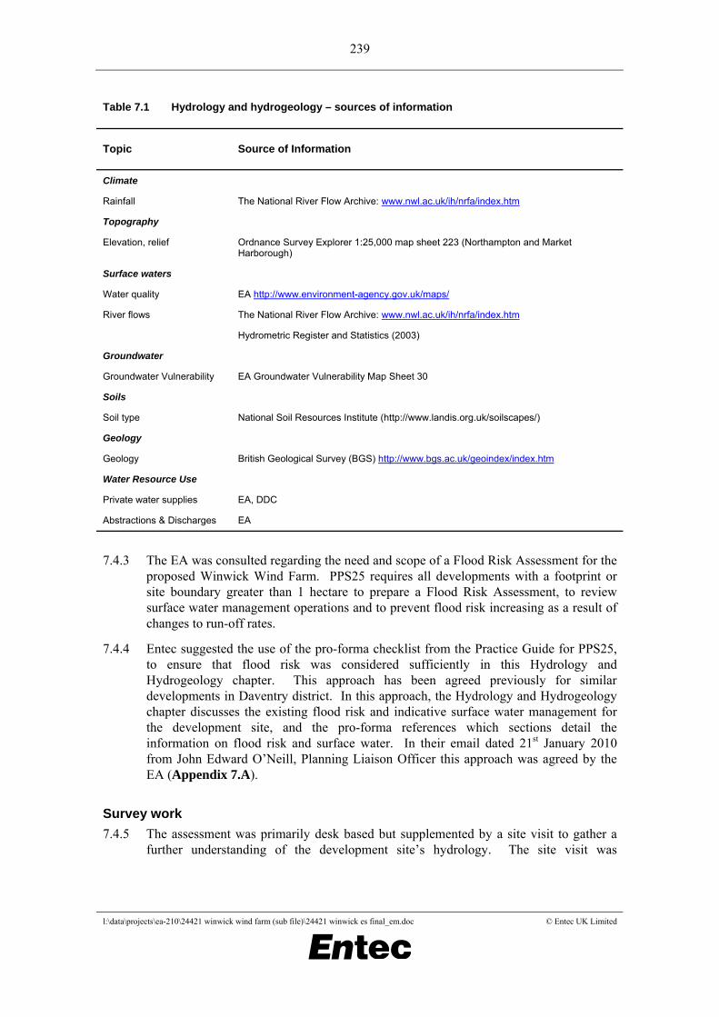
7.4.2 The data and sources of information collected are listed in Table 7.1.
Table 7.1 Hydrology and hydrogeology – sources of information
Topic Source of Information
Climate
Rainfall
The National River Flow Archive: www.nwl.ac.uk/ih/nrfa/index.htm
Topography
Elevation, relief
Ordnance Survey Explorer 1:25,000 map sheet 223 (Northampton and Market Harborough)
Surface waters
Water quality
River flows
EA http://www.environment-agency.gov.uk/maps/
The National River Flow Archive: www.nwl.ac.uk/ih/nrfa/index.htm
Hydrometric Register and Statistics (2003)
Groundwater
Groundwater Vulnerability
EA Groundwater Vulnerability Map Sheet 30
Soils
Soil type
National Soil Resources Institute (http://www.landis.org.uk/soilscapes/)
Geology
Geology
British Geological Survey (BGS) http://www.bgs.ac.uk/geoindex/index.htm
Water Resource Use
Private water supplies
Abstractions & Discharges
EA, DDC
EA
7.4.3 The EA was consulted regarding the need and scope of a Flood Risk Assessment for the proposed Winwick Wind Farm. PPS25 requires all developments with a footprint or site boundary greater than 1 hectare to prepare a Flood Risk Assessment, to review surface water management operations and to prevent flood risk increasing as a result of changes to run-off rates.
7.4.4 Entec suggested the use of the pro-forma checklist from the Practice Guide for PPS25, to ensure that flood risk was considered sufficiently in this Hydrology and Hydrogeology chapter. This approach has been agreed previously for similar developments in Daventry district. In this approach, the Hydrology and Hydrogeology chapter discusses the existing flood risk and indicative surface water management for the development site, and the pro-forma references which sections detail the information on flood risk and surface water. In their email dated 21st January 2010 from John Edward O’Neill, Planning Liaison Officer this approach was agreed by the EA (Appendix 7.A).
Survey work 7.4.5 The assessment was primarily desk based but supplemented by a site visit to gather a
further understanding of the development site’s hydrology. The site visit was
undertaken on February 23rd 2009 and comprised a site walkover to determine the overall hydrological regime and ground conditions on the development site.
7.5 Overall hydrology and hydrogeology baseline 7.5.1 This section describes the present hydrological and hydrogeological conditions on the
development site and predicts what the site baseline would be in the future in the absence of the proposed development. A summary of the underlying geology in the region is provided only to put the hydrology and hydrogeology into context.
Current baseline
Topography and land use 7.5.2 The proposed Winwick Wind Farm site (the development site) is situated about 10km
east of Rugby, adjacent to Winwick Warren Farm, in Northamptonshire. The development site covers approximately 131 ha and is roughly centred on the national grid reference (NGR) E464046, N274687.
7.5.3 The development site predominantly comprises agricultural farmland used for arable crops. Land in the southern part of the development site is divided by the valley of Yelvertoft Brook, a small tributary of the River Avon. The farm fields of Winwick Warren slope toward the channel of Yelvertoft Brook, from approximately 175m Above Ordnance Datum (AOD) on the western development site boundary and 190m AOD on the eastern development site boundary, to 140m AOD in the watercourse channel at the southern development site boundary.
7.5.4 North of Yelvertoft Brook, a strip of land running north towards Cold Ashby is also included in the development site boundary. This part of the development site also comprises agricultural fields, and is intersected by another small tributary of the River Avon. Ground levels are higher in this section of the development site, rising to 209m AOD at Lichfield Farm toward the northern development site boundary.
Climate 7.5.5 The Flood Estimation Handbook provides catchment descriptions across the UK. For
the Yelvertoft Brook catchment to NGR SP 637 744, the annual average rainfall is 676mm. The average annual rainfall for the UK is 832mm (source: Met Office, Centre for Ecology and Hydrology, Wallingford, UK) therefore the development site experiences slightly (about 18% less) lower rainfall than UK average.
Surface hydrology 7.5.6 The hydrology of the development site is presented in Figure 7.1.
7.5.7 The development site’s hydrology is mainly controlled by the Yelvertoft Brook. A topographical divide runs through the development site, along the line of a public byway between West Haddon Road on the eastern development site boundary, and Winwick village, south west of the development site’s boundary. To the north of this divide a small tributary of Yelvertoft Brook issues and flows west. It joins the main brook just upstream of Yelvertoft village.
7.5.8 South of the catchment divide, Yelvertoft Brook issues just east of the development site and generally meanders westward toward the River Avon at Lilbourne. Yelvertoft Brook flows through the development site in a southerly direction via one small offline pond (NGR SP 641 747) and through one larger online pond (NGR SP 640 747). One additional offline pond is present on the development site, located at NGR SP 639 742. There is also a small (almost dry) offline pond at NGR SP 644 746. Surface run-off from the agricultural fields on the development site is controlled by perimeter field drains which direct run-off towards Yelvertoft Brook.
7.5.9 The National River Flows Archive contains flow data for one gauge on the River Avon in close proximity to the development site. The gauge is located at Lilbourne, approximately 7km north west of the development site at the point where the Yelvertoft Brook joins the River Avon. The mean flow recorded is 0.57m3/s. There are no recorded flows for the tributaries on the development site.
Flood risk 7.5.10 According to the EA website, the development site lies entirely within Flood Zone 1,
the lowest probability flood zone. Despite its location in Flood Zone 1, consideration of the impact on flooding from the development is required. Future drainage will be required to be limited to the existing ‘greenfield’ (undeveloped) run-off rate to prevent increases in flow downstream.
7.5.11 Indicative calculations indicate that the 1 in 2 year return period flow (QMED) is 5.7 litres per second per hectare, using the Interim Code of Practice method in the WinDes drainage software (Version 11.4). This method makes use of the Institute of Hydrology Report 124: Estimation of Flow in Small Catchments. This provides an indication of the run-off rates to be used in design of future drainage on the development site. Run-off rates to be used in the design of the drainage control measures will be verified during the detailed design stage.
Surface water quality 7.5.12 The tributaries on the development site are classified within the Severn River Basin
Management Plan (RBMP). Water in rivers, estuaries and other wetlands will improve under measures set out in RBMPs, drawn up for catchments across England and Wales under the Water Framework Directive. The Plans are the nation’s plans for improving water and wetlands, they contain the main issues for the River Basin District and the actions needed to deal with them. The tributaries fall within the Warwickshire Avon catchment of the Severn RBMP.
7.5.13 The upper tributaries of the River Avon are classified as low, calcareous, small water body types, representing low altitude (<200m AOD, calcareous geology and between 10 and 100 km2 catchment area).
7.5.14 According to the EA’s website, the Yelvertoft Brook from Winwick to the confluence with the River Avon is classified as having ‘moderate’ ecological status in comparison to the required target of ‘good’ ecological status. This relates to high water quality in respect of ammonia concentrations, dissolved oxygen and pH and but poor water quality in relation to phosphorous concentrations.
7.5.15 There are no monitoring points for water quality on the development site.
7.5.16 The development of the site has the potential to include environmental measures to help meet the objectives of the RBMP and WFD. Such measures could include assistance to help reduce nutrient and pesticide run-off from the surrounding agricultural land, such as, a monitoring regime on the development site for nitrates / phosphates / suspended sediment; nutrient management and advice on the farmland; a downstream wetland to capture run-off from a number of farms in the area; and provision of storage on the farms for manure if required. Such measures should be discussed with the surrounding farmers and the Environment Agency.
Geology 7.5.17 The development site is underlain by the Mesozoic Lias Group bedrock geology, which
comprises mudstones, sandstones, siltstones and limestones. The southern part of the development site is predominantly underlain by Whitby Mudstone, whilst the Northampton Sand Formation underlies the northern part of the development site. Overlying the bedrock, superficial deposits of Till diamicton (clayey glacial deposits) are generally present, although in the far northern part of the development site the surface is drift free, and on the western hills of the Yelvertoft Brook valley in the southern part of the development site, there is a small outcrop of Glaciofluvial Deposits of sand and gravels. The geology of the development site is shown in Figure 7.2.
Soils 7.5.18 The soils of the development site are described on the Cranfield University website as
being slightly acid loamy and clayey soils with impeded drainage. In the northern part of the development site, the soils are described as being freely draining, slightly acid but base-rich soils.
Groundwater 7.5.19 The Groundwater Vulnerability Map of the region classifies the development site as
Non-Aquifer where the Whitby Mudstone Formation is present, and as being Minor Aquifer, over the Northampton Sand Formation and Glaciofluvial Deposits representing a formation with relatively low permeability unlikely to yield large volumes of groundwater but important for providing groundwater to local supplies and baseflow to rivers. The soils are classified as having intermediate to low leaching potential.
7.5.20 There are no groundwater Source Protection Zones (SPZ) located on the development site or in the surrounding area. The nearest SPZ is located near Ravensthorpe Reservoir, approximately 7 km south east of the development site.
Abstractions and discharges 7.5.21 The EA holds information on one licensed abstraction within the 2km search radius of
the development site boundary. The license is located on the development site at NGR E63800, N74300 for Spray Irrigation from surface water. The location of abstractions is presented on Figure 7.1
7.5.22 The EA has also provided licence reference information for a surface water abstraction from the River Avon for Cold Ashby Golf Club; however, the location details of the abstraction have not been provided. The Cold Ashby Golf Club is located to the north of the development site and downstream of the northern section, through which a small tributary of the River Avon flows.
7.5.23 DDC was contacted to obtain records of small private abstractions that do not require a licence from the EA. Seven properties within 2km of the development site boundary are on DDC’s records as having private water supplies. Details of the properties and water supplies are provided in Table 7.2.
Table 7.2 Private water supplies (source: Daventry District Council)
Property Property Location (NGR)
Supply Supply Location (NGR)
Additional Information
Lovells Lodge Farm E465700 N275400 Spring E465700 N275100 Domestic supply
Honey Hill Lodge E463900 N276700 Well E463900 N276700 Non domestic
Flinthill E461200 N273700 Spring Unknown Domestic supply category E (up to 25 people)
Manor Farm E461800 N275300 Unknown Unknown
Thornby Grange E465900 N274900 Spring Unknown
Thonby Grange Farm E465800 N274700 Spring Unknown
Firetail Cottage E466100 N275100 Spring Unknown
3 Properties believed to be served by same spring or by two springs
7.5.24 Active discharge consents provided by the EA are presented in Table 7.3.
Table 7.3 Active discharge consents
Consent Number
Date Issued
Name Address Easting Northing Type
S/10/04289/S 13-May-57 Lodge Farm House
Elkington Road, Yelvertoft
461300 274501 Undefined or Other
S/10/07017/S 19-Jun-75 New House Farm
Winwick, West Haddon
461300 274500 Sewage disposal works - other
S/10/26299/O 29-Sep-04 Winwick Sps (New Works)
Winwick, Northamptonshire
462150 274120 Sewerage Network - Pumping Station - water company
S/10/26300/R 29-Sep-04 Winwick Sps (New Works)
Winwick, Northamptonshire
462150 274120 Sewerage Network - Pumping Station - water company
PR5LF3052 27-Jun-67 West Haddon Playing Field Pavilion
Northampton Road, West Haddon
463434 271781 Domestic Property (Single)
S/10/25195/S 04-Apr-97 Honey Hill Farm
Elkington, Northampton
463750 276410 Sewage disposal works - other
S/10/26715/SG 19-Oct-06 Cold Ashby Golf Club
Cold Ashby Golf Club, Stanford Road
464020 275830 Recreational and Cultural
PRNNF01639 05-Feb-92 Stone Gnome Farm
West Haddon Road, Guilsborough
465430 273680 Sewage disposal works - other
GWNLF40591 18-Jul-00 Thornby Farms
Thornby House, Thornby
465300 275500 Mixed Farming
AWNNF13917 15-Feb-07 Cold Ashby Cso
Cold Ashby, Daventry
465520 276040 Sewage Disposal Works - water company
Predicted future baseline 7.5.25 Hydrological systems are in a state of constant flux. Two main influences on the
hydrology of the development site have been identified, namely land use and climate change, which have the potential to change the ground permeability (changes in land use), and river flow regime (through changes in rainfall patterns as a result of climate change).
7.5.26 The nature of the land type and elevations within the development site mean that the land use and therefore permeability is unlikely to change substantially during the lifetime of the proposed Winwick Wind Farm.
7.5.27 Climate may prove more variable, with observed historical and predicted future changes in global climate due to a combination of both natural and human causes. The main human influence on global climate is increasing emissions of greenhouse gases such as carbon dioxide and methane. For this region of England, the latest climate change predictions indicate decreases in summer rainfall of up to 20% by the 2050s. This is predicted to be accompanied by increases in winter rainfall of between 15% and 20% by the 2050s.89 As a result river flows may be expected to increase in the winter, with more frequent storm events occurring throughout the year.
89 United Kingdom Climate Change Impacts Programme 2002 (UKCIP02)
Information gaps 7.5.28 The majority of information requested on the water environment has been provided by
the EA and DDC. Whilst every effort has been made to locate private water supplies, there is the potential for unrecorded private supplies to be present. Furthermore, the exact location of the Cold Ashby Golf Club abstraction point has not been provided. The EA restrict the information supplied on water abstractions for security purposes, therefore it might not be possible to obtain this information.
7.6 Environmental measures incorporated into the scheme
7.6.1 Following the identification of potentially significant effects at scoping stage, environmental measures (as follows) have been incorporated into either the wind farm design, or the methods of construction and operation, to reduce or eliminate adverse effects anticipated.
Scheme design 7.6.1 The wind turbines will be situated within the southern part of the development site, either side of Yelvertoft Brook, with development site centre at NGR E464046, N274687. The layout of the proposed Winwick Wind Farm is shown in Figure 3.1.
7.6.2 The main hydrological constraints for the proposed development (Figure 7.1) are areas adjacent to surface watercourses. These constraints will need to be adhered to in micro- siting any turbines up to 50m.
7.6.3 In order to minimise any potential effects, the turbines have been located at least 20m from watercourses and waterbodies (e.g. ponds) located on the development site (as detailed in the following sections). Furthermore, a 50m buffer is applied to the spring issuing to the west of Winwick Warren Farm.
7.5.29 Drainage control measures to be considered for the development site include track-side vegetated swales and ditches to control run-off from the newly constructed access tracks. In line with SuDS principles, these will be designed to control run-off at source where possible. This means that run-off from the access track surfaces will be encouraged to infiltrate into the surrounding vegetation with the trackside swales. The presence of the Northampton Sand Formation and freely draining soils in the northern part of the development site indicates a high potential for infiltration, where ground conditions are relatively permeable. The Whitby Mudstone which comprises lower permeability clays and clayey soils in the southern section are less likely to permit infiltration. Nevertheless, infiltration potential is very site specific and requires tests in accordance with BRE Digest 365: Soakaway Design.
Site working practices 7.6.4 Standard construction working practices will be implemented during construction and
any maintenance works to ensure adherence to the EA pollution prevention guidance, CIRIA guidance and other current best practice, including the EA guidance note “Silt Pollution and How to Avoid It”.
7.6.5 The main purpose of such environmental measures is to prevent silt and suspended sediment arsing from ground disturbance reaching the watercourses and disrupting the aquatic ecology. This is seen as the main risk to surface water quality, although the risk of accidental spillages/discharges of other chemicals and pollutants used in construction is also present. An emergency response protocol will be developed by EC&R’s Contractors to ensure that any accidental spillages are intercepted and that there are procedures for site staff to follow. Spill containment equipment (e.g. absorbent material) will be provided on-site.
7.6.6 The implementation of advice in the EA’s pollution prevention guidance and additional environmental controls in respect of accidental discharges will ensure that there is no significant deterioration in the water quality of the receiving waters.
7.6.7 Other environmental measures include storage of all chemicals within areas of hardstanding and bunded so that a protected volume of 110% of the stored capacity is provided. Construction stores will be located at least 20m away from any surface watercourses, drains and ponds. Plant and machinery used during construction will be well maintained to minimise the risks of oil leaks or similar issues. Maintenance and refuelling of machinery will be undertaken off-site or within designated areas of temporary hardstanding. In these designated areas contingency plans will be implemented to ensure that the risks of accidental spillages are minimised. Placing a drip tray beneath plant and machinery during refuelling and maintenance can contain small spillages. It should be noted that the above measures are to also be implemented when storing and using fuel oils and chemicals during site operation, for example, when maintaining generators (or other equipment) and refilling oil tanks.
7.6.8 Dust covers over vehicles and stockpiles, dampening down of work areas, clearance of dust and mud from tracks and the provision of wheel washing facilities will be implemented to reduce the risk of sediment entrainment in run-off.
7.5.30 Drainage control measures during construction are likely to include:
• placing excavated soils on the downhill slopes and lateral drainage ditches on the uphill slopes, and working only small stretches of access track at any one time;
• temporary drainage routes will be provided while upgrading existing access tracks, where necessary;
• silt traps will be used to capture suspended solids generated during construction, supplemented by settlement ponds and attenuation areas where necessary, as recommended in PPG25; and
• construction of suitable passage on a temporary and/or permanent basis will be undertaken where necessary to facilitate naturally occurring drainage beneath the access tracks.
7.6.9 EC&R will directly appoint suitable experienced Contractors for construction and maintenance works. During the tendering process the expected environmental requirements will be included in EC&R’s tender documents so that all Contractors allow for standard environmental control measures in their method statements and staffing and budgetary provisions. The EA Special Requirements for Water Pollution
Prevention from Civil Engineering Contracts contain a definitive list of clauses for incorporation into civil engineering contract documents.
7.6.10 The construction period and maintenance works are governed by a range of constraints other than hydrology, such that it is not always possible to plan construction or maintenance during the drier summer months when the likelihood of sediments becoming entrained in run-off is generally lowest. However, the selected Contractors will demonstrate that they can adequately plan and control surface run-off in accordance with EA/CIRIA guidance for the range of weather conditions anticipated.
Access tracks 7.6.11 The turbines will be accessed via approximately 3.6km of on-site access track (Figure
3.1) that will be constructed specifically for the proposed Winwick Wind Farm. The tracks will typically be about 5m wide increasing at bends as necessary. The track lengths have been kept to a minimum, routed as close to field boundaries as possible to minimise the impact on agricultural management in consultation with landowners, and to avoid the various hydrological protection buffer zones.
7.6.12 Newly constructed access tracks will use granular material to encourage surface water to infiltrate where possible. They will have drainage ditches, cross drains and catchpits/check dams to control run-off and potential spillages or silt laden run-off during the construction, operational and decommissioning phases. If necessary settlement ponds will be implemented to prevent the drainage ditches discharging directly into watercourses. During the construction of new access tracks on sloping ground, drainage will be controlled by placing excavated soils on the downhill slopes and lateral drainage ditches on the uphill slopes and by working only small stretches of track at any one time.
7.6.13 Wherever possible drainage will be discharged into surrounding vegetation rather than directly into watercourses via silt traps. Drainage will be designed to ensure that Greenfield rates are not exceeded and that an allowance for climate change impacts on rainfall is included.
7.6.14 More details regarding these precautions will be provided in construction method statements to be prepared after planning permission is granted.
Watercourse crossings 7.6.15 The course of the on-site access tracks has been designed so that only two watercourse
crossings are required. Watercourse crossings cannot be avoided on the development site, which is bisected by the Yelvertoft Brook, with turbines proposed on both sides of the brook. New crossings of the Yelvertoft Brook will be required to access Turbine 1 and Turbine 4.
7.6.16 The key to minimising the impacts to watercourses is in successful design of the crossings. The designs for the culvert structures will be sized to ensure that flow is not impeded following prolonged precipitation and the design will be agreed with the EA during detailed design. A simple culvert type construction will be employed, using a cross sectional area that will not impede flow of water (minimum 400mm culverts would be used).
7.6.17 Design of culverts shall be to at least CIRIA Culvert Design and Operation Guide (RP901). Typical culvert details are shown in Figure 3.8.
Electric cable laying 7.6.18 The electric cable laying has the potential to damage soils and introduce new drainage
pathways that could generate silty run-off.
7.6.19 To minimise disturbance impacts, it is intended that cables will be laid in small trenches along the side of the on-site access tracks as far as possible. This layout will ensure they will not be located close to any key hydrological features, except for essential watercourse crossings.
7.6.20 The trenches will be dug during drier periods, in sections, and kept open for only a short period (less than a day) to reduce the possibility of them acting as alternative drainage channels. Temporary silt traps and/or clay bunds will be provided in the longer trench runs, if necessary, during construction.
Wind turbine foundations and crane pads 7.6.21 The turbine foundation will comprise a concrete base of approximately 18m radius
(Figure 3.5). Shallow concrete pad foundations will be used where possible to minimise excavation works, depending on the ground stability. Each turbine will require a hardstanding crane area of up to 40m x 20m for construction and maintenance. A typical example of a crane hardstanding is presented in Figure 3.6.
7.6.22 During the design stage the impact of turbine foundation and crane pad construction was considered, resulting in a decision not to locate any such features within 20m of a surface watercourse. Most of the turbines are located at a much greater distance than 20m from the watercourses, where not constrained by other environmental features.
7.6.23 Careful scheme design will be supplemented by pollution prevention measures described in the EA’s pollution prevention guidance and other environmental controls, including the following:
• Installation of cut-off drains around the working areas to intercept uncontaminated surface run-off and divert it around the works;
• Minimising the stockpiling of materials and locating essential stockpiles as far away as possible from watercourses;
• Drainage control to ensure run-off does not exceed the Greenfield run-off rates; and
• Re-vegetation of foundation and crane pad working areas as soon as possible after construction.
7.6.24 In accordance with BS6031 1981 Code of Practice for Earth Works, land disturbance will be kept to a minimum, and disturbed areas will be stabilised as soon as possible after construction. Soil movement will be undertaken with reference to best practice guidelines available from the Department of the Environment Food and Rural Affairs (DEFRA) in the form of the Good Practice Guide for Handling Soils (MAFF, 2000).
7.6.25 To prevent disruption of the flow pathways in agricultural drainage pipes that are often present on farmland, new piping will be installed along the upstream edge of the turbine foundations and crane pads to divert drainage around the excavations and turbine footings. The piping will be dug and connected prior to foundation and crane pad excavation so that the land around the turbines will continue to be drained for agricultural use.
7.6.26 Spill response measures will be developed in anticipation of any accidental spillages. Pumping of groundwater from foundations may also be required and will be treated by way of a sump and silt trap before discharging to surrounding watercourses or into vegetated ground. The use of deep foundations is to be discouraged and, given the ground conditions present, these are unlikely to be required.
Control building and temporary construction compound 7.6.27 The control building will be located alongside the on-site access track in the central part
of the development site (Figure 3.4) and the construction compound (an example of which is shown in Figure 3.9) will be situated adjacent to the main access track into the development site. The location of the control building and temporary construction compound are constrained by the topography of the development site, with most of the site sloping toward the Yelvertoft Brook and with limited flat land only available closest to the watercourse. Nevertheless the location of the control building and the construction compound adheres to the hydrological constraints of the proposed Winwick Wind Farm, maintaining a distance of at least 20 m from any watercourse.
7.6.28 Suitable drainage measures will be incorporated into the design and construction of the control building and construction compound, such as, silt traps, careful stockpiling and the adoption of spill response measures. The drainage will be designed to ensure that run-off rates do not exceed the Greenfield run-off rates, in accordance with PPS25. Foul water provisions are likely to include a septic tank on the development site.
7.6.29 Table 7.4 summarises the environmental measures that have been incorporated. These measures are considered best practice for controlling water quality and quantity from construction sites to prevent deterioration in water quality.
Table 7.4 Rationale for incorporation of environmental measures
Potential receptor Predicted changes and potentially significant effects in absence of environmental measures
Incorporated measure
Watercourses and ponds
Risk of soil erosion, accidental spillages or concrete pollution entering the water environment and affecting water quality and aquatic ecology.
Risk of increased run-off volumes from increased hardstanding on previously undeveloped ground causing flooding.
Risk of reduced infiltration of rainfall into groundwater where impermeable surfaces are introduced.
Adoption of pollution prevention measures and other environmental controls to control drainage quality and quantity.
20m buffer around all watercourses with the exception of essential crossings included in scheme design.
Scheme design has reduced the amount of watercourse crossings required.
Culvert crossing design to be agreed with the EA.
Preparation of an emergency spill response plan.
Provision of hardstanding and bunding for all chemicals and oils.
Provision of controlled wash down area for vehicles.
Preparation of construction method statements prior to works taking place.
Construction environmental management plan will be prepared by the appointed contractor detailing the environmental measures to be implemented during construction
Local springs Risk of contamination by surface and groundwater drainage.
Adoption of pollution prevention measures and other environmental controls to control drainage quality and quantity and to prevent changes in the hydrological regime.
People and property downstream
Risk of increased run-off volumes from increased hardstanding on previously undeveloped ground causing flooding to locations downstream.
Ensure run-off rates are controlled to existing Greenfield run-off rates and climate change allowance included.
Implementation of environmental measures 7.6.30 The parties responsible for implementing the proposed environmental measures and the
compliance mechanisms are summarised in Table 7.5.
Table 7.5 Implementation of environmental measures
Environmental measure Responsibility for implementation
Compliance mechanism
Construction method statements detailing standard construction practice, pollution prevention guidance and emergency spill response measures to be followed on site.
EC&R
Contractor
Planning condition.
Compliance with PPG notes and CIRIA guidance.
Management of surface water run-off and site drainage to ensure no increase in flow/levels or change in quality/morphology of receiving waters.
EC&R
Contractor
Planning condition.
Flood Defence90 Consent required for watercourse crossings and diversion.
EC&R Granting of consent by EA.
7.7 Scope of the assessment 7.7.1 This section details the potential receptors that could be affected by the proposed development and potentially significant environmental effects that have been reduced or eliminated by the incorporation of environmental measures into the scheme as detailed above.
Potential receptors 7.7.1 Following the data gathering and analysis exercise, the potential hydrological and
hydrogeological receptors were identified within an approximate 2km radius of the centre of the development site. This search radius was considered appropriate for the assessment, based on a conceptual knowledge of the area and previous assessment experience.
7.7.2 The main categories of receptor are summarised as follows:
• Watercourses and features (and associated surface water abstractions); and
• Property and people downstream of the development site.
7.7.3 The potential receptors within these categories are identified in Figure 7.1 and Table 7.6.
7.7.4 Sensitivity for hydrological and hydrogeological receptors is normally related to the relative importance of the surface water or groundwater feature that might be at risk from effects. For example, a shallow well might be considered to be of local importance, whereas a Major Aquifer would be considered of regional or national importance. As the geology of the development site is relatively impermeable and is classified as Minor Aquifer and Non-Aquifer on-site, it is highly unlikely that the groundwater quantity or quality will be affected by the development, however, the local spring on-site is considered as a potential receptor.
90 Formerly known as Land Drainage consent; this is required for any works within 7m of the bank tops of any Main Rivers.
Table 7.6 Potential hydrological and hydrogeological receptors
Reference Number
Name Location (including NGR, where appropriate)
Watercourses and Features
1 Yelvertoft Brook Flowing through centre of the development site
2 Tributary of Yelvertoft Brook Flowing through northern section of the development site
3 Ponds on site SP 640 747 SP 641 747 SP 639 742
4 Local spring on site (groundwater)
SP 64159 74188
Property and People
4 Site users or downstream site users
On-site or downstream of the development site
Potentially significant effects 7.7.5 Assessment of each of the following potentially significant effects has led to the
conclusion that they are not likely to be significant and hence do not require further assessment.
Effects on surface water quality on local water features on site from sediment-entrained run-off 7.7.6 The potential for sediments entrained in run-off reaching the Yelvertoft Brook, its
tributary and ponds on-site and thus affecting aquatic ecology is considered low, as environmental controls will be implemented for the stripping of vegetation and soils during access track and turbine foundation construction to prevent significant effects on water quality.
7.7.7 Silt traps will be used to capture suspended solids generated during construction, supplemented by settlement ponds and attenuation areas where necessary. Drainage measures, such as track-side vegetated swales and ditches, will be incorporated into the design of track drainage, providing temporary storage for run-off and reducing run-off rates to ‘greenfield’ rates (calculations to be undertaken during detailed design). Therefore, it is considered that this potential effect on water quality is not significant and does not require further assessment.
Effects on water quality on local water features on site from accidental pollution events 7.7.8 The construction phase will involve the storage and use of oils and chemicals on-site.
Spillage or leaks from such fluids have the potential to be entrained in run-off and degrade the water quality of the Yelvertoft Brook. Appropriate environmental measures include the incorporation of EA pollution prevention guidance notes and CIRIA guidance into the construction method statements. These include measures such as the bunding of chemical and fuel stores to 110% of capacity, the design of a pollution incidence response plan to deal with any accidental spillages or leaks and the maintenance and re-fuelling of vehicles and equipment on hardstanding. Therefore it is
considered that this potential effect is not significant and does not require further assessment.
Effects on water quantity run-off to people and properties downstream from increased hardstanding 7.7.9 Post construction, the run-off rates from the development site will be controlled so that
they are equal to existing Greenfield run-off rates through the use of sustainable drainage systems and attenuation techniques. Appendix 7.A includes the pro-forma detailing how flood risk measures have been considered in this assessment in accordance with the requirements of PPS 25: Development and Flood Risk. It concludes that the alteration to the existing landscape is unlikely to adversely affect flooding at the development site and downstream of the development and therefore effects on people and property are considered to be not significant.
7.7.10 It is envisaged that as part of the planning conditions, a detailed drainage assessment will be prepared to size the necessary attenuation volumes to restrict run-off to Greenfield rates (indicative calculations indicate this to be 5.7 l/s/ha).
Assessment of effects 7.7.11 The incorporation into the scheme of the environmental measures detailed in Table 7.4
is considered sufficient to ensure that there will be no significant effect to the listed receptors from those causes identified above in Sections 7.7.2 to 7.7.10.
7.7.12 Further detail on measures to protect terrestrial and aquatic ecology can be found in Chapter 8 (terrestrial and aquatic ecology).
7.7.13 The detail of all environmental measures to protect the water environment will be agreed with the EA before the commencement of construction. Appropriate controls for the enforcement of these environmental measures are detailed in Table 7.5 and will also be detailed in method statements to be prepared by the Contractors prior to works taking place. Emergency procedures will be employed to protect controlled waters against accidental spillages and releases of chemicals and other pollutants; this will minimise any residual effects and risks.
7.8 Conclusions of significance evaluation 7.8.1 As described in the preceding section, the proposed Winwick Wind Farm will have no
significant effects on hydrology and hydrogeology. The incorporation into the development of the environmental measures detailed in Table 7.4 is considered sufficient to ensure that there will be no significant residual effects to the listed receptors in the water environment from the causes identified above in Sections 7.7.2 to 7.7.10.
7.8.3 Therefore, it is concluded that the proposed Winwick Wind Farm would have no significant effects on hydrology and hydrogeology.
Table 7.7 Summary of effects and evaluation of significance
KEY:
1. S = Significant
NS = Not-significant
2. International = Important on a European or global level
National = Important in the UK or Scotland
Regional = Important in the context of the Midlands
Local = Important within the watersheds to which the development site drains
Receptor and summary of predicted effects
Significance1 and importance of receptor2
Summary rationale
Yelvertoft Brook; tributary of the brook; ponds on site; and local spring.
Potential temporary effect on water quality if sediments from disturbed ground become entrained in site runoff, or from accidental spills and leaks of chemicals/oils used on site. Disturbance in watercourses from new culvert crossings may impact on quality.
NS Local Scheme design and the implementation of environmental measures will prevent as far as practicable contaminants entering the watercourses and impacts on surface water quality.
Chemical stores will be in designated areas with procedures in place to deal with spillages, following best practice guidance. Any leaks will be small, away from watercourses and quickly controlled.
Culverts will remain in watercourses but will be monitored and remedial action undertaken if necessary.
No activities are proposed within the catchment of the local spring.
People and property downstream of site.
Potential to increase flood risk if drainage is uncontrolled and increases post development.
NS Local The increase in run-off from permeable surfaces is considered negligible as the built footprint represents a small percentage of the river catchment. There is very limited land take across the development site. Nevertheless, drainage will be designed to ensure that the run-off rates from the proposed Winwick Wind Farm do not increase above existing Greenfield rates, and are designed to cope with storm events and predicted changes in rainfall due to climate change.
The potential effect is therefore considered to be not significant.
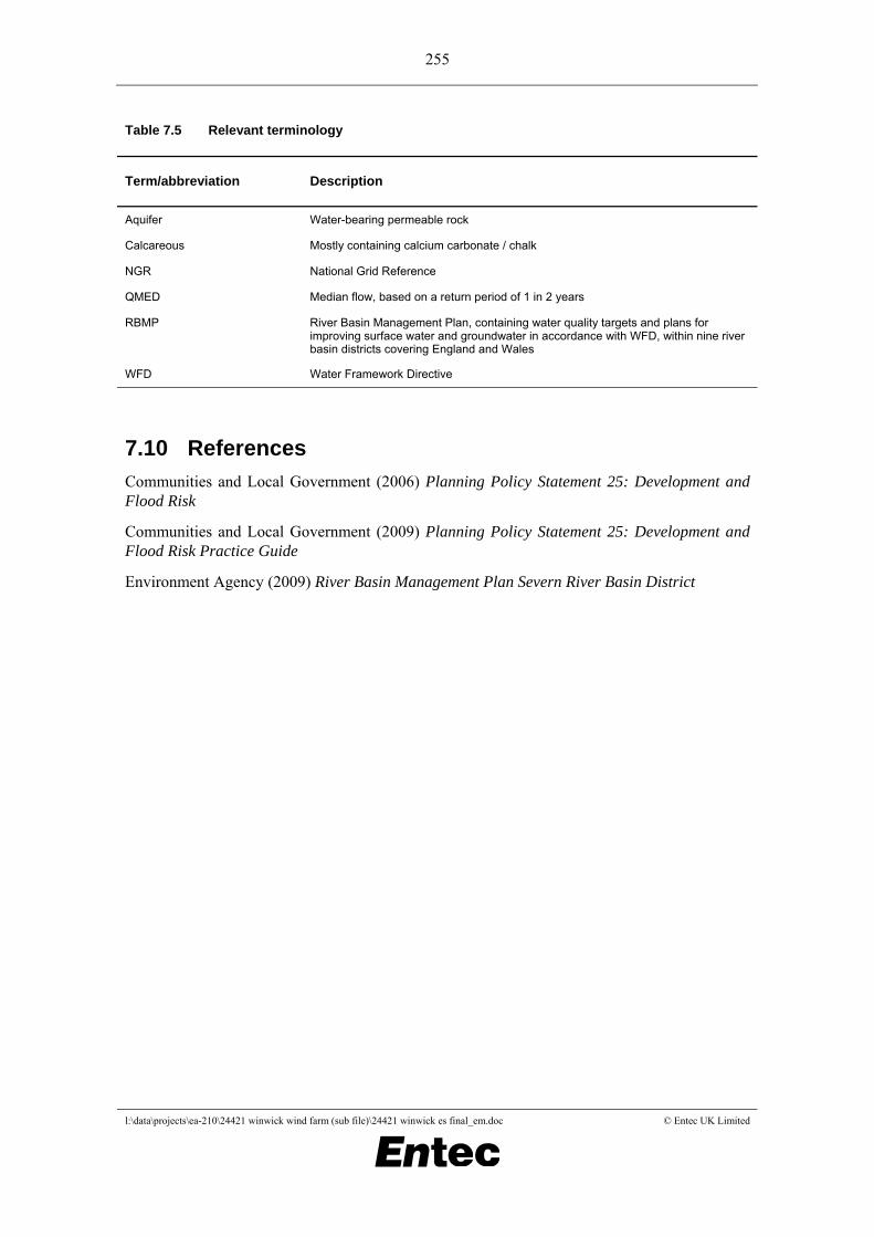
7.9 Relevant terminology 7.9.1 A list relevant terminology and abbreviations used in the chapter is presented in Table
QMED Median flow, based on a return period of 1 in 2 years
RBMP River Basin Management Plan, containing water quality targets and plans for improving surface water and groundwater in accordance with WFD, within nine river basin districts covering England and Wales
WFD Water Framework Directive
7.10 References Communities and Local Government (2006) Planning Policy Statement 25: Development and Flood Risk
Communities and Local Government (2009) Planning Policy Statement 25: Development and Flood Risk Practice Guide
Environment Agency (2009) River Basin Management Plan Severn River Basin District