Proposed Power Plant at Derrygreenagh, Co. Offaly Mott MacDonald Pettit Environmental Impact Statement BNME 24319000062N 243190-N-R-02-A Page 1 of 27 7 Soils, Geology and Hydrogeology 7.1 Introduction This chapter of the EIS describes the existing environment in relation to Soils, Geology and Hydrogeology in the proposed development area, predicts the relevant impacts arising from the proposed development and, where considered appropriate, mitigation measures have been specified. It is divided into the following sub-sections: 7.1 Introduction 7.2 Methodology - Desk Based Assessment - Field Study - Impact Assessment Methodology - Site Contamination Assessment Methodology 7.3 Overview of Water Requirements - Heat Recovery Steam Generator - NOx Control 7.4 Receiving Environment - Background - Topography - Geology and Ground Conditions - Hydrogeology - Hydrology - Radon - Geological Heritage Areas 7.5 Impact Assessment - Soil and Groundwater Condition - Construction Phase Impacts - Operational Phase Impacts 7.6 Mitigation - Pre-Construction Mitigation Requirements - Mitigation of Construction Impacts - Mitigation of Operational Impacts 7.7 Residual Impacts
Transcript
Proposed Power Plant at Derrygreenagh, Co. Offaly Mott MacDonald Pettit
Environmental Impact Statement BNME
24319000062N
243190-N-R-02-A Page 1 of 27
7 Soils, Geology and Hydrogeology
7.1 Introduction
This chapter of the EIS describes the existing environment in relation to Soils, Geology and
Hydrogeology in the proposed development area, predicts the relevant impacts arising from the
proposed development and, where considered appropriate, mitigation measures have been specified. It
is divided into the following sub-sections:
7.1 Introduction
7.2 Methodology
- Desk Based Assessment
- Field Study
- Impact Assessment Methodology
- Site Contamination Assessment Methodology
7.3 Overview of Water Requirements
- Heat Recovery Steam Generator
- NOx Control
7.4 Receiving Environment
- Background
- Topography
- Geology and Ground Conditions
- Hydrogeology
- Hydrology
- Radon
- Geological Heritage Areas
7.5 Impact Assessment
- Soil and Groundwater Condition
- Construction Phase Impacts
- Operational Phase Impacts
7.6 Mitigation
- Pre-Construction Mitigation Requirements
- Mitigation of Construction Impacts
- Mitigation of Operational Impacts
7.7 Residual Impacts
Proposed Power Plant at Derrygreenagh, Co. Offaly Mott MacDonald Pettit
Environmental Impact Statement BNME
24319000062N
243190-N-R-02-A Page 2 of 27
7.2 Methodology
7.2.1 Desk-Based Study
Geological information has been obtained for this section of the EIS from the following sources:
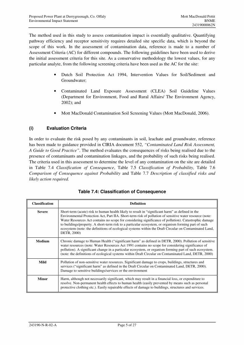
In order to evaluate the risk posed by any contaminants in soil, leachate and groundwater, reference
has been made to guidance provided in CIRIA document 552, “Contaminated Land Risk Assessment,
A Guide to Good Practice”. The method evaluates the consequences of risks being realised due to the
presence of contaminants and contamination linkages, and the probability of such risks being realised.
The criteria used in this assessment to determine the level of any contamination on the site are detailed
in Table 7.4 Classification of Consequence, Table 7.5 Classification of Probability, Table 7.6
Comparison of Consequence against Probability and Table 7.7 Description of classified risks and
likely action required.
Table 7.4: Classification of Consequence
Classification Definition
Severe Short-term (acute) risk to human health likely to result in “significant harm” as defined in the
Environmental Protection Act, Part IIA. Short-term risk of pollution of sensitive water resource (note:
Water Resources Act contains no scope for considering significance of pollution). Catastrophic damage
to buildings/property. A short-term risk to a particular ecosystem, or organism forming part of such
ecosystem (note: the definitions of ecological systems within the Draft Circular on Contaminated Land,
DETR, 2000)
Medium Chronic damage to Human Health (“significant harm” as defined in DETR, 2000). Pollution of sensitive
water resources (note: Water Resources Act 1991 contains no scope for considering significance of
pollution). A significant change in a particular ecosystem, or organism forming part of such ecosystem.
(note: the definitions of ecological systems within Draft Circular on Contaminated Land, DETR, 2000)
Mild Pollution of non-sensitive water resources. Significant damage to crops, buildings, structures and
services (“significant harm” as defined in the Draft Circular on Contaminated Land, DETR, 2000).
Damage to sensitive buildings/services or the environment
Minor Harm, although not necessarily significant, which may result in a financial loss, or expenditure to
resolve. Non-permanent health effects to human health (easily prevented by means such as personal
protective clothing etc.). Easily repairable effects of damage to buildings, structures and services.
Proposed Power Plant at Derrygreenagh, Co. Offaly Mott MacDonald Pettit
Environmental Impact Statement BNME
24319000062N
243190-N-R-02-A Page 6 of 27
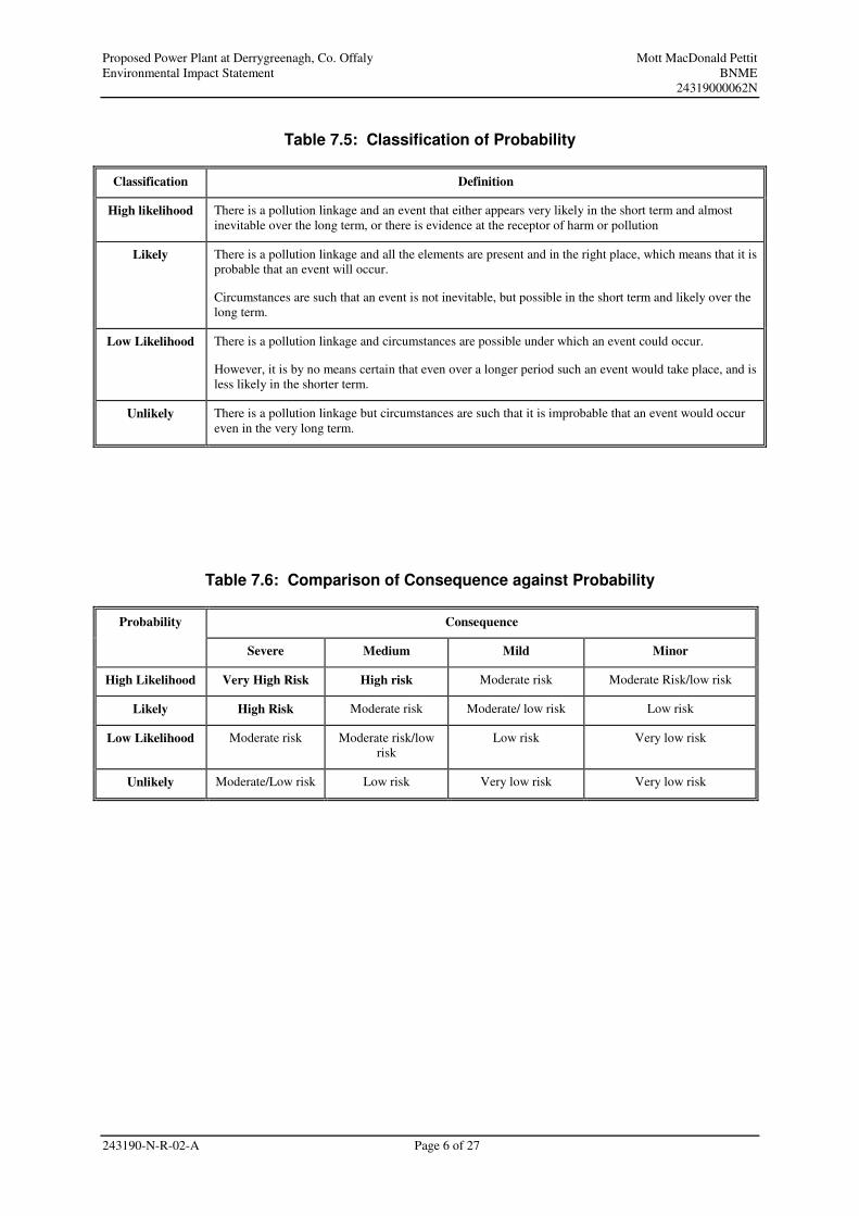
Table 7.5: Classification of Probability
Classification Definition
High likelihood There is a pollution linkage and an event that either appears very likely in the short term and almost
inevitable over the long term, or there is evidence at the receptor of harm or pollution
Likely There is a pollution linkage and all the elements are present and in the right place, which means that it is
probable that an event will occur.
Circumstances are such that an event is not inevitable, but possible in the short term and likely over the
long term.
Low Likelihood There is a pollution linkage and circumstances are possible under which an event could occur.
However, it is by no means certain that even over a longer period such an event would take place, and is
less likely in the shorter term.
Unlikely There is a pollution linkage but circumstances are such that it is improbable that an event would occur
even in the very long term.
Table 7.6: Comparison of Consequence against Probability
Consequence Probability
Severe Medium Mild Minor
High Likelihood Very High Risk High risk Moderate risk Moderate Risk/low risk
Likely High Risk Moderate risk Moderate/ low risk Low risk
Low Likelihood Moderate risk Moderate risk/low
risk
Low risk Very low risk
Unlikely Moderate/Low risk Low risk Very low risk Very low risk
Proposed Power Plant at Derrygreenagh, Co. Offaly Mott MacDonald Pettit
Environmental Impact Statement BNME
24319000062N
243190-N-R-02-A Page 7 of 27
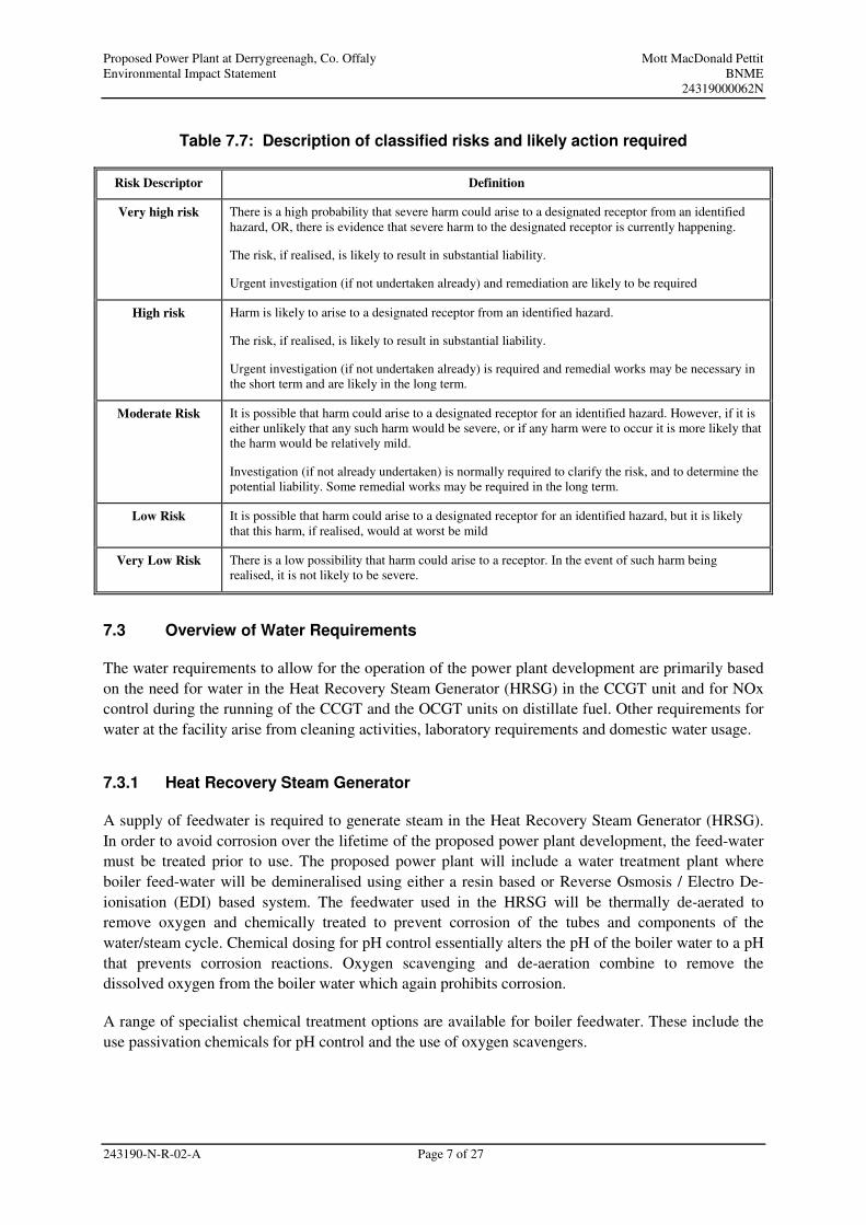
Table 7.7: Description of classified risks and likely action required
Risk Descriptor Definition
Very high risk There is a high probability that severe harm could arise to a designated receptor from an identified
hazard, OR, there is evidence that severe harm to the designated receptor is currently happening.
The risk, if realised, is likely to result in substantial liability.
Urgent investigation (if not undertaken already) and remediation are likely to be required
High risk Harm is likely to arise to a designated receptor from an identified hazard.
The risk, if realised, is likely to result in substantial liability.
Urgent investigation (if not undertaken already) is required and remedial works may be necessary in
the short term and are likely in the long term.
Moderate Risk It is possible that harm could arise to a designated receptor for an identified hazard. However, if it is
either unlikely that any such harm would be severe, or if any harm were to occur it is more likely that
the harm would be relatively mild.
Investigation (if not already undertaken) is normally required to clarify the risk, and to determine the
potential liability. Some remedial works may be required in the long term.
Low Risk It is possible that harm could arise to a designated receptor for an identified hazard, but it is likely
that this harm, if realised, would at worst be mild
Very Low Risk There is a low possibility that harm could arise to a receptor. In the event of such harm being
realised, it is not likely to be severe.
7.3 Overview of Water Requirements
The water requirements to allow for the operation of the power plant development are primarily based
on the need for water in the Heat Recovery Steam Generator (HRSG) in the CCGT unit and for NOx
control during the running of the CCGT and the OCGT units on distillate fuel. Other requirements for
water at the facility arise from cleaning activities, laboratory requirements and domestic water usage.
7.3.1 Heat Recovery Steam Generator
A supply of feedwater is required to generate steam in the Heat Recovery Steam Generator (HRSG).
In order to avoid corrosion over the lifetime of the proposed power plant development, the feed-water
must be treated prior to use. The proposed power plant will include a water treatment plant where
boiler feed-water will be demineralised using either a resin based or Reverse Osmosis / Electro De-
ionisation (EDI) based system. The feedwater used in the HRSG will be thermally de-aerated to
remove oxygen and chemically treated to prevent corrosion of the tubes and components of the
water/steam cycle. Chemical dosing for pH control essentially alters the pH of the boiler water to a pH
that prevents corrosion reactions. Oxygen scavenging and de-aeration combine to remove the
dissolved oxygen from the boiler water which again prohibits corrosion.
A range of specialist chemical treatment options are available for boiler feedwater. These include the
use passivation chemicals for pH control and the use of oxygen scavengers.
Proposed Power Plant at Derrygreenagh, Co. Offaly Mott MacDonald Pettit
Environmental Impact Statement BNME
24319000062N
243190-N-R-02-A Page 8 of 27
7.3.2 NOx Control
NOx emissions to air increase significantly when distillate is used as the fuel for running a turbine.
Water injection will be employed when either the OCGT or CCGT unit is running on distillate fuel.
Water will be injected directly into the combustion chamber to minimise the production of NOx. The
water and steam act as a heat sink in the flame zone of the combustion chamber, reducing the
temperature and therefore the likelihood of thermal NOX formation. It also has the added affect of
increasing the gas turbine output due to the additional mass added by the water and steam.
7.4 Receiving Environment
7.4.1 Background
This section of the chapter outlines the baseline geology, soils and hydrogeology that exist on the site
and in the vicinity of the proposed development. The information detailed below is based on the desk-
based and field studies described in Section 7.2.1 Desk Based Study and 7.2.2. Field Study.
The proposed development site has a history of previous industrial usage and is currently occupied by
a workshop, stores and office complex that supports Bord na Móna’s peat harvesting activities. The
complex includes workshops for mobile plant overhaul and for wagon and locomotive maintenance
which are used for haulage of milled peat to the Edenderry Power Station. The remaining area consists
of a mix of acid grassland and made ground in the southern and western side of the site and the only
apparent area of peat is located in the northern corner of the site. The site is bounded to the west, north
and east by areas of cutaway bog, where the last recorded peat harvesting extraction was in 2000/01,
and farmland to the south. The proposed development occupies a total area of 25.4 ha. The site
occupies an area of 22.8 ha with the main site occupying an area of 17.5 ha and the adjacent
switchyard site on the western side of the R400 roadway, occupying 5.3 ha. The proposed discharge
pipeline to the Yellow occupies an area of 2.6 ha.
The historical development of the site has been assessed from ‘The Proposed Extraction of Sand and
Gravel at Derryarkin and Drumman, Co. Offaly and Co. Westmeath – An Environmental Impact
Statement’, Bord na Móna, April 2001. During the nineteenth century the Derryarkin, Derrygreenagh
and Drumman bogs were a rich source of iron ore. According to the report, ore from Derrygreenagh
Bog was loaded onto canal boats in Daingean, approximately 10 km south of the site.
The Derryarkin and Drumman bogs were acquired by Bord na Móna in 1952 and milled peat
harvesting began in 1958 to supply the ESB peat fired Rhode Power Station, which was located
approximately 4 km to the south west of the site, and the Croghan briquette factory. Both of these
facilities are now closed. While some commercial peat extraction still continues within the areas, the
Derryarkin and Drumman bogs are no longer in milled peat production and the area comprises of
cutaway peatland. There are sand and gravel extraction sites located within these bogs. The Derryarkin
extraction site lies 1.5 km to the west and the Drumman extraction site is located 2 km to the
northeast.
Proposed Power Plant at Derrygreenagh, Co. Offaly Mott MacDonald Pettit
Environmental Impact Statement BNME
24319000062N
243190-N-R-02-A Page 9 of 27
Both the geology and soils play an important part in determining the environmental characteristics of
the area in general and of the site in particular. The underlying geology has a major influence on
landform and rocks provide the parent material from which soils are created. The nature of the rock
helps to determine not just the nature and chemistry of the soil formed, but also the rate at which it
forms. This in turn strongly affects the natural vegetation and the type of agriculture or horticulture
that can be sustained.
The receiving environment of the proposed development site is described below under the following
headings:
• Topography;
• Geology and Ground Conditions;
• Hydrogeology;
• Hydrology
• Radon; and
• Geological Heritage Areas
7.4.2 Topography
Topography refers to the surface features of a place or region. The proposed development site lies
within an area of peatland which is designated as an area of “moderate sensitivity” in Chapter 16
Landscape and Amenities of the Draft Offaly County Development Plan 2009-2015. The area is
characterised by a generally low relief and level terrain dominated by the flat featureless expanses of
the peatland area. Further to this, the natural topography of the area has been modified by the historic
extraction of peat from the surrounding peatlands. This extraction process has resulted in a significant
drop in the level of peatland areas relative to other aspects of the landscape, such as the R400
roadway. There is a c. 3 m height differential between the R400 roadway and adjacent cut over bog
areas. The surrounding peatlands are also characterised by a network of parallel drainage channels c.
15 m apart.
The proposed development site consists of a “mineral island” and is slightly elevated over the levels of
the surrounding cut over peatland areas. The site for the proposed development is gently sloping from
the north eastern extent of the site, from c. 82 metres OD (Ordnance Datum Malin Head) to c. 87
metres OD at the south western edge of the site. Just to the south of the proposed development site
there is a further elevated area consisting of agricultural land which slopes up to a maximum height of
92 metres OD. The adjacent site on the opposite side of the R400 roadway to be used for the electrical
switchyard is slightly lower than the main site area with a minimum level of c. 79 metres OD
increasing to a level of c. 84 metres OD
Proposed Power Plant at Derrygreenagh, Co. Offaly Mott MacDonald Pettit
Environmental Impact Statement BNME
24319000062N
243190-N-R-02-A Page 10 of 27
7.4.3 Geology and Ground Conditions
Based on desk-study information, and the Geological Survey of Ireland (GSI) Bedrock and
Quarternary maps show that the solid geology of the site is likely to consist of Marine Basinal Facies,
known as the Lucan, or “Calp” Formation of the Visean Age (part of the Mississipian sub-period,
commonly known as the Early Carboniferous sub-period). This formation usually consists of
argillaceous and cherty limestone and shale. (See Figure 7.2 Bedrock Geology).
The drift deposits on site were assessed using data collected in the ground investigation undertaken by
GSIL. There was a large variation across the site. The general stratigraphy encountered over the site
was as follows:
• Made Ground;
• Peat and soft clay/silts (northern end of site) (superficial deposits);
• Glacial clay (superficial deposits);
• Completely to highly weathered limestone and karst clays; and
• Limestone (‘Calp’ Formation).
(i) Made Ground
Made Ground was encountered across most of the site, but prevalent to the south of the existing
workshop buildings to the north of the site. The Made Ground encountered comprised of a firm to
stiff, occasionally soft, slightly sandy slightly gravelly clay fill. The Made Ground encountered at the
northern end of the site included much greater peat content. The Made Ground was generally overlain
by topsoil to a maximum depth of 0.25 m. The original topsoil was encountered in a number of
boreholes to the north west of the site to a depth of 1.40 m underlying the Made Ground. The
thickness of the original topsoil ranged from 0.15 m to 0.25 m.
(ii) Superficial Deposits: Peat and Soft Clay/Silts
The ground investigation identified that the northern end of the site, and the area surrounding the site,
was underlain by peat. Peat deposits are described as plastic to spongy cream to dark brown/black
amorphous to fibrous slightly sandy slightly silty occasionally gravely peat with occasional to many
cobbles and boulders.
Underlying the peat deposits, a soft clay/silt or clay was usually encountered. This is a common
feature in peat where siltier material, often weaker than the peat itself, underlies the strata.
(iii) Superficial Deposits: Glacial Clay
Glacial clay deposits were encountered at locations across the site. The main deposits are described as
firm, becoming very stiff, yellow/grey brown, slightly sandy gravelly clay.
Proposed Power Plant at Derrygreenagh, Co. Offaly Mott MacDonald Pettit
Environmental Impact Statement BNME
24319000062N
243190-N-R-02-A Page 11 of 27
(iv) Completely to Highly Weathered Limestone and Karst Clays
Medium to very dense dark brown to black clayey, occasionally sandy fine to coarse gravel with many
cobbles and boulders was encountered across the site with proven stratum thickness of between 2 m
and 22.4 m. The gravel was underlain by limestone bedrock where found.
Reduced limestone weathering was encountered to the east of the site where dense sandy gravely
cobbles and boulders was present at depths from 9 m to 16.5 m below ground level. A thin layer of
cobbles was also encountered from 5 m to 5.6 m below ground level near the workshops to the north
of the site.
Clay deposits were encountered at the northern end of the site at depths up to 25.2 m and below
ground level. As these deposits are underlying very dense gravels they have been considered
separately from the glacial clays. These deposits are thought to indicate the presence of karst features
in the site. Karst is a name given to the process of dissolution that is often found to have occurred in
limestones.
(v) Limestone Bedrock
The bedrock under the site has been described as moderately strong to strong (occasionally very
strong) grey fine to medium grained limestone with calcite veining and has been classified as slightly
to moderately weathered rock. The limestone was encountered between 7.8 m and 24 m depth below
ground level.
7.4.4 Hydrogeology
Groundwater is described as water that is stored in and moves through the pores and cracks in subsoils
and bedrock. Aquifers are rocks that contain sufficient voids to store water and are permeable enough
to allow water to flow through them in significant quantities. Lower Palaeozoic rocks, which underlie
the study area, generally have a low permeability and are regarded as poor aquifers.
The GSI Bedrock Aquifer map classifies the aquifer to be of ‘Local Importance in which bedrock is
Moderately Productive only in Local Zones’ (See Figure 7.3 Aquifer Map). The GSI define a Locally
Important Aquifer as having an area of outcrop or recharge zone, of normally >1 km², with a
Regionally Important Aquifer having an area of outcrop of normally >10 km².
Groundwater vulnerability as defined by the GSI is the ease with which groundwater may be
contaminated by human activity related to the intrinsic geology and hydrogeological characteristics of
the area. In this instance, the groundwater vulnerability is classified as being Moderate.
The result of a well search of the GSI databases (2007 dataset) indicates that the nearest recorded
groundwater abstraction well is located approximately 1.3 km from the site. The approximate
locations (coordinates provided by the GSI) of groundwater wells in the vicinity of the site are shown
on Figure 7.4 Water Mains and Wells within 2 km of the Proposed Development Site.
With the exception of the borehole currently in use on the Derrygreenagh site, an analysis of the GSI
Wells dataset and consultation with Offaly Co. Co., have identified that there are no other water
abstractions from groundwater within 1.3 km of the site.
Proposed Power Plant at Derrygreenagh, Co. Offaly Mott MacDonald Pettit
Environmental Impact Statement BNME
24319000062N
243190-N-R-02-A Page 12 of 27
The nearest residences to the proposed development are those located on the Knockdrin road. This
road is serviced by a water main and so water requirements arising from the residences on this road are
met from this source. The proposed development site is approximately 4 km North West of the
nearest Source Protection Area (See Figure 7.5 Source Protection Area Map).
(i) Groundwater Resource
During the ground investigation undertaken by GSIL, groundwater was encountered in all cable
percussive boreholes drilled at the site. Most groundwater strikes occurred near, or within 2 m of the
top of the weathered limestone. Other smaller seepages were encountered at the base of the Made
Ground and at the top of the soft clay/silt (underlying peat). Most of the strikes encountered within the
weathered limestone were at depths of between 6 m and 10 m below ground level. In the main test
pumping well on the site, groundwater table measurements undertaken prior to the start of the
pumping test showed a depth of approximately 6.5m below ground level
Following the completion of all drilling activities on-site by GSIL, a pumping test was undertaken to
ascertain the sustainable yield of groundwater available in the aquifer beneath the site. This pumping
test was carried out in order to determine if there was a sufficient water resource available to supply
the proposed power plant development with the required quantity of water without having any
negative impacts on the groundwater resource in the area. The pumping tests undertaken by GSIL
identified that the pumping well had sufficient capacity to supply up to 630m3/day on an ongoing
basis.
7.4.5 Hydrology
The site is located within the Eastern River Basin District (ERBD) and within the River Boyne
catchment area. The nearest rivers to the site are the Mongagh River 0.7 km to the north of the site and
the Yellow River 1.4 km to the south of the site. Both of these rivers are tributaries of the River
Boyne. The Mongagh River is a tributary of the Yellow and flows into the Yellow c. 15 km
downstream. The Yellow River flows into the River Boyne a further 2 km downstream. A detailed
assessment of the surface water resources and potential impacts on them arising from the proposed
development are discussed in Chapter 6 Water Quality.
7.4.6 Radon
Information obtained from the Radiological Protection Institute of Ireland (www.rpii.ie) indicates that
the site is located in a High Radon Area (See Figure 7.6 Radon Levels Map), where greater than 20%
of dwellings are predicted to have radon levels in excess of 200 Bq/m³. The Radiological Protection
Institute of Ireland has set a safe level of radon of 200 Bq/m3 and protective measures are likely to be
required where this threshold is exceeded.
7.4.7 Geological Heritage Areas
A Geological Heritage Area is one which contains geological or geomorphological features considered
to be of national interest and recommended for Natural Heritage Area (NHA) designation by the GSI
under the Wildlife (Amendment) Act 2000.
Proposed Power Plant at Derrygreenagh, Co. Offaly Mott MacDonald Pettit
Environmental Impact Statement BNME
24319000062N
243190-N-R-02-A Page 13 of 27
A consultation response letter received from the Geological Survey of Ireland (26th May 2008) has
identified that there are no geological heritage sites currently on the GSI database for the area or near
the area. (See Appendix 1D: Consultation Responses).
7.5 Impact Assessment
7.5.1 Soil and Groundwater Condition
Potential sources of contamination have been identified following the ground investigation. Elevated
levels of TPH, nickel and other contaminants have been detected, in various concentrations, in soils
and groundwater during the site investigation. Isolated pockets of industrial waste materials were also
identified in some of the trial pits. The locations of the exploratory holes are shown on Figure 7.1
Ground Investigations.
A risk assessment was used to identify any risk arising from onsite contamination. Risk assessment
involves identification of the hazards and evaluation of the risks associated with these hazards. Risk
assessment requires an evaluation of a conceptual “source – pathway – receptor” linkage model and
can be qualitative or quantitative.
Based on the available information for the site, the following potential contamination sources have
been identified from an assessment of historic and current activities on or in close proximity to the
site:
• S1: Made Ground consisting of construction related fill or imported materials
(source unknown) to a shallow depth across the majority of the site area.
Concentrations of metals and hydrocarbons were found above the limit of detection
in samples from this material;
• S2: The nearby, and still operational, narrow gauge railway. Fuel storage tanks are
present on site for the servicing of rail haulage and milled peat production
equipment;
• S3: Old machinery located in various areas around the site;
• S4: Oil and grease from operational machinery moving around the site;
• S5: Off site sources. The site is surrounded on all sides by former peat extraction
areas, providing a potential source of organic materials and ammoniacal nitrogen to
groundwater in the vicinity of the site;
• S6: Structures. Existing structures on the site are to be demolished prior to the
commencement of construction. These structures may contain asbestos, plus stores
of other potential contaminants.
(i) Potential Contaminant Pathways
The following potential contamination pathways have been identified on the site:
• P1: Inhalation, ingestion and direct contact;
Proposed Power Plant at Derrygreenagh, Co. Offaly Mott MacDonald Pettit
Environmental Impact Statement BNME
24319000062N
243190-N-R-02-A Page 14 of 27
• P2: Groundwater movement through superficial deposits and the underlying aquifer;
• P3: Groundwater movement onto site from areas of former peat extraction;
• P4: Surface runoff;
• P5: Gas migration;
• P6: Root uptake.
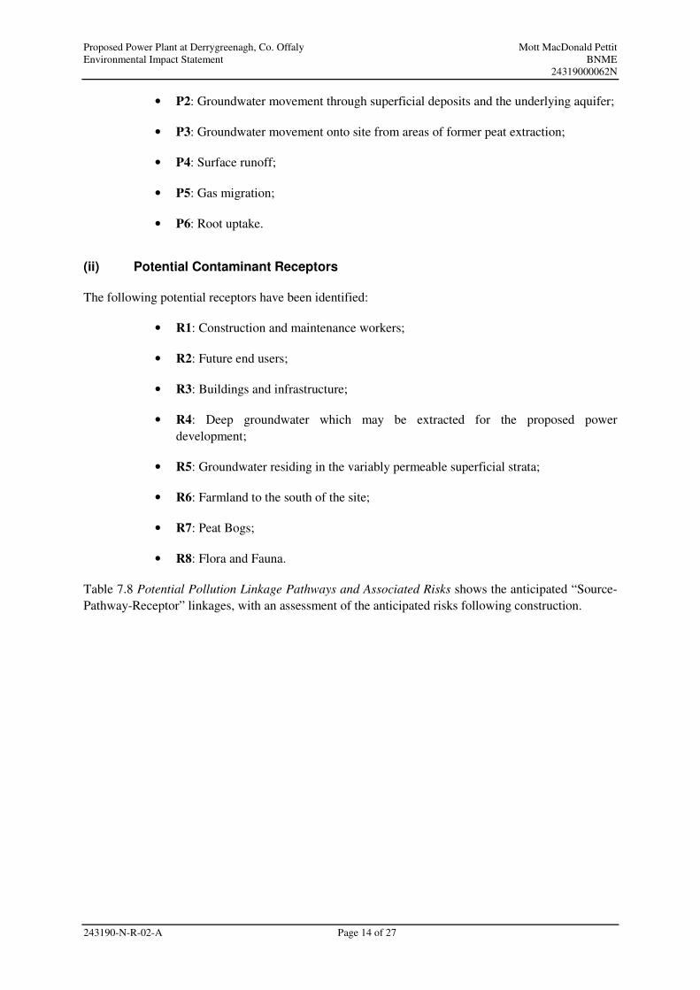
(ii) Potential Contaminant Receptors
The following potential receptors have been identified:
• R1: Construction and maintenance workers;
• R2: Future end users;
• R3: Buildings and infrastructure;
• R4: Deep groundwater which may be extracted for the proposed power
development;
• R5: Groundwater residing in the variably permeable superficial strata;
• R6: Farmland to the south of the site;
• R7: Peat Bogs;
• R8: Flora and Fauna.
Table 7.8 Potential Pollution Linkage Pathways and Associated Risks shows the anticipated “Source-
Pathway-Receptor” linkages, with an assessment of the anticipated risks following construction.
Proposed Power Plant at Derrygreenagh, Co. Offaly Mott MacDonald Pettit
Environmental Impact Assessment BNME
24319000062N
243190-N-R-02-A Page 15 of 27
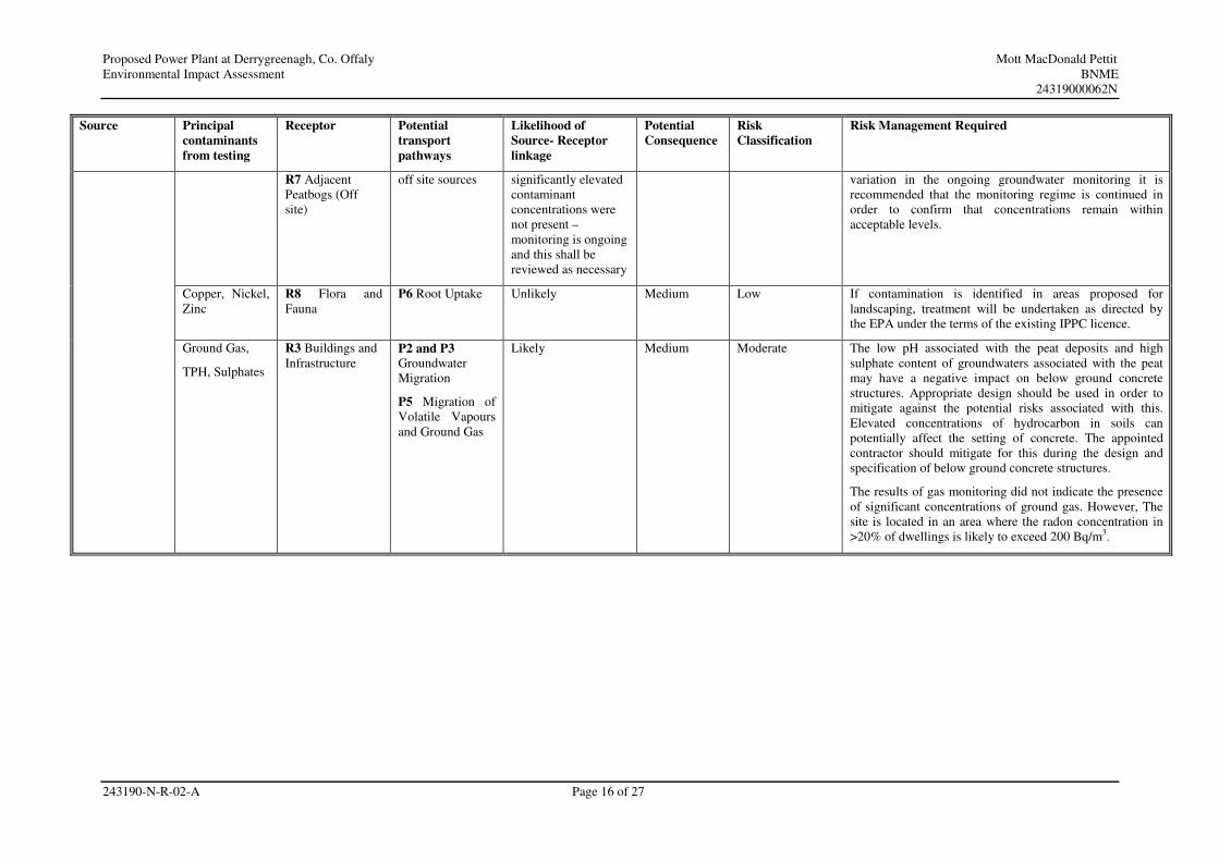
Table 7.8: Potential Pollution Linkage Pathways and Associated Risks
Source Principal
contaminants
from testing
Receptor
Potential
transport
pathways
Likelihood of
Source- Receptor
linkage
Potential
Consequence
Risk
Classification
Risk Management Required
TPH, Nickel,
(soils),
TPH,
Ammoniacal
Nitrogen,
Chromium,
Copper, Iron,
Nickel, Zinc,
pH
(groundwaters),
asbestos in
existing
structures
(assumed)
R1 Construction
and Maintenance
Workers
R2 Future End
Users
P1 Human Uptake
Pathways:
Likely during
construction –
unlikely post
construction
Medium Moderate for pre
construction
phase and
Construction
Phase
Low for post
construction
phase.
Further investigation and remediation of the identified
TPH, VOC, Nickel and industrial waste contamination will
be agreed with the EPA under the terms of the existing
IPPC licence. However, the results at present do not
indicate significant risks to human health following
construction.
During construction appropriate working practices should
be put in place to minimise contact with areas of
contaminated soils, including but not limited to the use of
PPE, dust suppression, use of machines to excavate instead
of hand digging, stockpiling of contaminated soils
separately from the bulk of the excavations and other
measures as appropriate. These measures are set out in the
following sections of this report.
Following construction the site is likely to be overlain by
impermeable hardstanding which will prevent human
contact with the identified areas of contamination. Where
areas of the site are proposed to be landscaped, further
investigation may be required in order to determine the
remedial requirements in these areas as directed by the
EPA under the terms of the existing IPPC licence. Capping
with clean topsoil, capillary break layer and basal geo-
textile may be required if contamination is identified in
these areas.
S1 Made
Ground
S2 Narrow
Gauge
Railway
S3 Disused
Machinery
S4 Operational
Tractors
and Peat
Extraction
Machinery
S5 Off site
Sources
S6 Structures
TPH,
Ammoniacal
Nitrogen,
Chromium,
Copper, Iron,
Nickel, Zinc,
pH
R4 Underlying
Aquifer
R5 Shallow
Groundwater
R6 Adjacent
farmland (Off
site)
P2 Groundwater
movement
through
superficial
deposits and the
underlying aquifer
P3 Groundwater
migration from
Unlikely –
concentrations have
been decreasing
throughout the
monitoring and the
most recent
groundwater
monitoring round
indicated that
Medium Low The results of groundwater monitoring indicated marginally
elevated concentrations of ammoniacal nitrogen and nickel.
Concentrations of TPH were initially elevated when testing
for TPH and DRO. However, analysis for TPH CWG,
which removes interference from naturally occurring
organic compounds, did not record concentrations of TPH
above the detection limits of the laboratory. The risks to
groundwater and the other identified receptors are therefore
not considered significant. However, given the observed
Proposed Power Plant at Derrygreenagh, Co. Offaly Mott MacDonald Pettit
Environmental Impact Assessment BNME
24319000062N
243190-N-R-02-A Page 16 of 27
Source Principal
contaminants
from testing
Receptor
Potential
transport
pathways
Likelihood of
Source- Receptor
linkage
Potential
Consequence
Risk
Classification
Risk Management Required
R7 Adjacent
Peatbogs (Off
site)
off site sources
significantly elevated
contaminant
concentrations were
not present –
monitoring is ongoing
and this shall be
reviewed as necessary
variation in the ongoing groundwater monitoring it is
recommended that the monitoring regime is continued in
order to confirm that concentrations remain within
acceptable levels.
Copper, Nickel,
Zinc
R8 Flora and
Fauna
P6 Root Uptake Unlikely Medium Low If contamination is identified in areas proposed for
landscaping, treatment will be undertaken as directed by
the EPA under the terms of the existing IPPC licence.
Ground Gas,
TPH, Sulphates
R3 Buildings and
Infrastructure
P2 and P3
Groundwater
Migration
P5 Migration of
Volatile Vapours
and Ground Gas
Likely Medium Moderate The low pH associated with the peat deposits and high
sulphate content of groundwaters associated with the peat
may have a negative impact on below ground concrete
structures. Appropriate design should be used in order to
mitigate against the potential risks associated with this.
Elevated concentrations of hydrocarbon in soils can
potentially affect the setting of concrete. The appointed
contractor should mitigate for this during the design and
specification of below ground concrete structures.
The results of gas monitoring did not indicate the presence
of significant concentrations of ground gas. However, The
site is located in an area where the radon concentration in
>20% of dwellings is likely to exceed 200 Bq/m3.
Proposed Power Plant at Derrygreenagh, Co. Offaly Mott MacDonald Pettit
Environmental Impact Statement BNME
24319000062N
243190-N-R-02-A Page 17 of 27
(iii) Summary of Baseline Risks
The risks in the vicinity of the proposed development associated with the baseline environmental
conditions are anticipated to comprise the following:
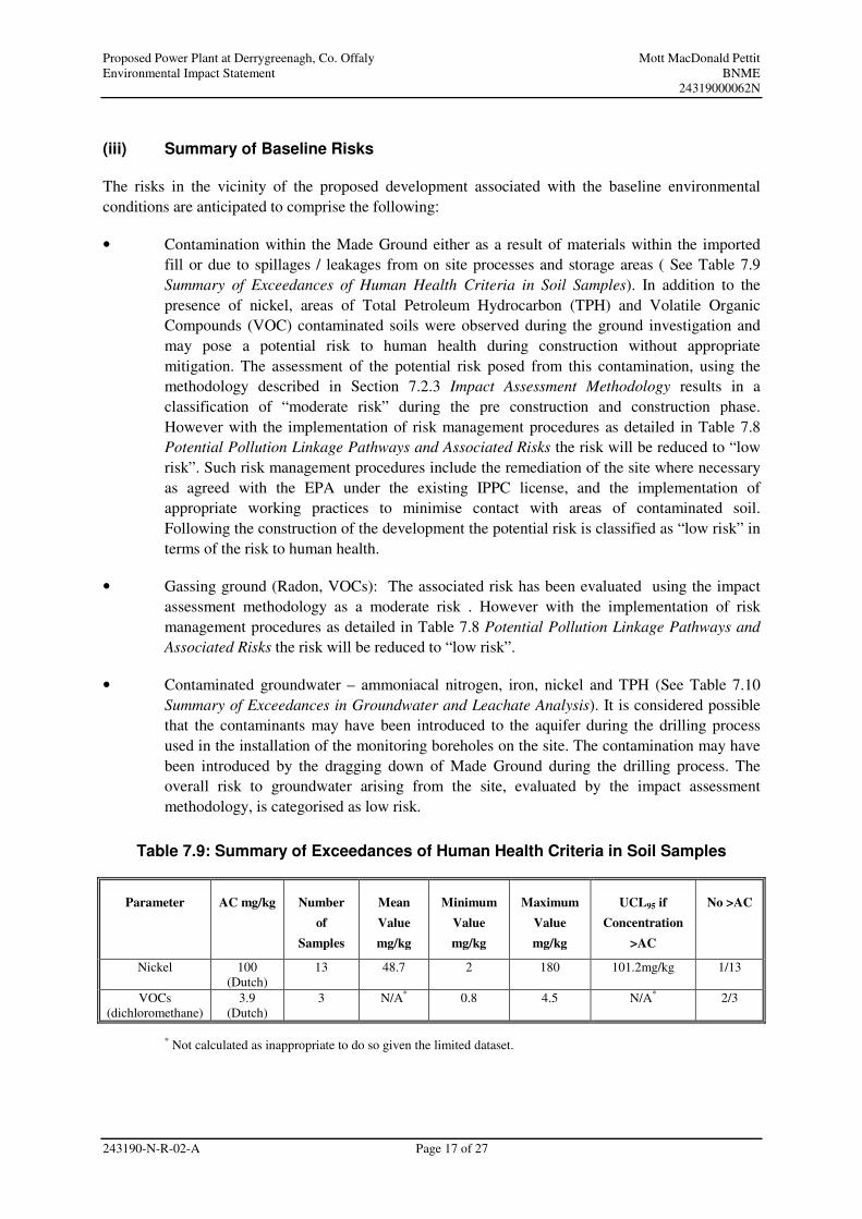
• Contamination within the Made Ground either as a result of materials within the imported
fill or due to spillages / leakages from on site processes and storage areas ( See Table 7.9
Summary of Exceedances of Human Health Criteria in Soil Samples). In addition to the
presence of nickel, areas of Total Petroleum Hydrocarbon (TPH) and Volatile Organic
Compounds (VOC) contaminated soils were observed during the ground investigation and
may pose a potential risk to human health during construction without appropriate
mitigation. The assessment of the potential risk posed from this contamination, using the
methodology described in Section 7.2.3 Impact Assessment Methodology results in a
classification of “moderate risk” during the pre construction and construction phase.
However with the implementation of risk management procedures as detailed in Table 7.8
Potential Pollution Linkage Pathways and Associated Risks the risk will be reduced to “low
risk”. Such risk management procedures include the remediation of the site where necessary
as agreed with the EPA under the existing IPPC license, and the implementation of
appropriate working practices to minimise contact with areas of contaminated soil.
Following the construction of the development the potential risk is classified as “low risk” in
terms of the risk to human health.
• Gassing ground (Radon, VOCs): The associated risk has been evaluated using the impact
assessment methodology as a moderate risk . However with the implementation of risk
management procedures as detailed in Table 7.8 Potential Pollution Linkage Pathways and
Associated Risks the risk will be reduced to “low risk”.
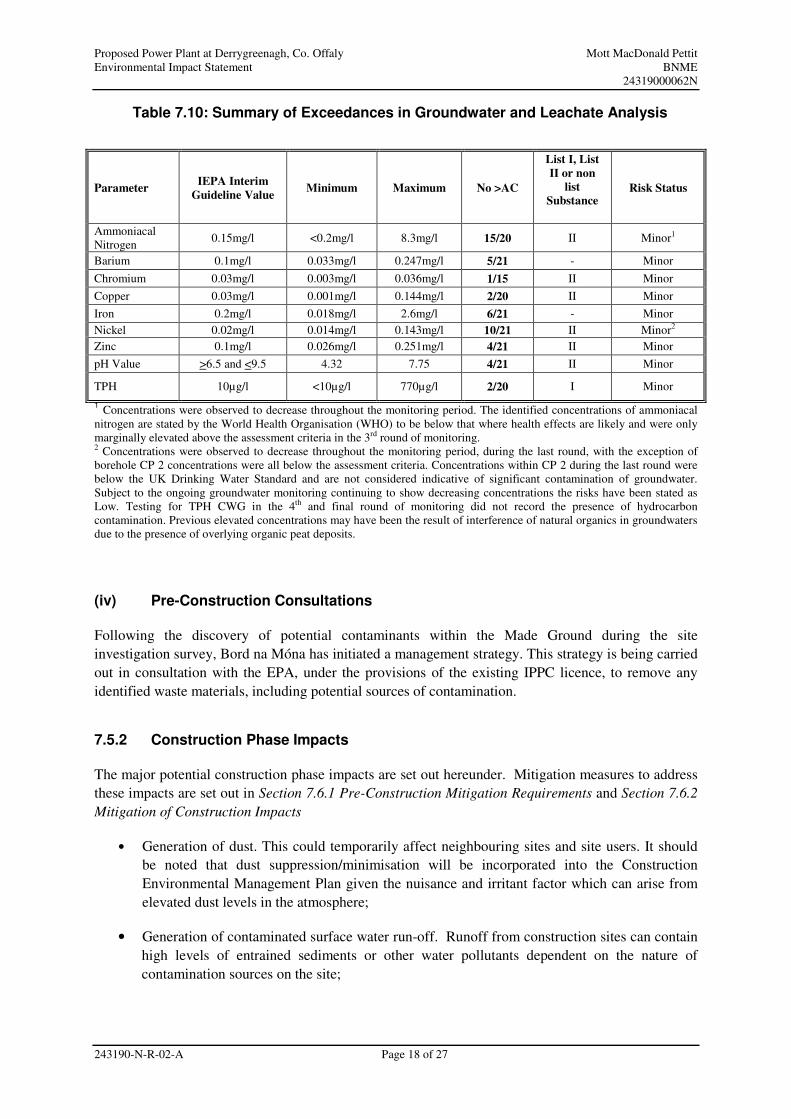
• Contaminated groundwater – ammoniacal nitrogen, iron, nickel and TPH (See Table 7.10
Summary of Exceedances in Groundwater and Leachate Analysis). It is considered possible
that the contaminants may have been introduced to the aquifer during the drilling process
used in the installation of the monitoring boreholes on the site. The contamination may have
been introduced by the dragging down of Made Ground during the drilling process. The
overall risk to groundwater arising from the site, evaluated by the impact assessment
methodology, is categorised as low risk.
Table 7.9: Summary of Exceedances of Human Health Criteria in Soil Samples
Parameter AC mg/kg Number
of
Samples
Mean
Value
mg/kg
Minimum
Value
mg/kg
Maximum
Value
mg/kg
UCL95 if
Concentration
>AC
No >AC
Nickel 100
(Dutch)
13 48.7 2 180 101.2mg/kg 1/13
VOCs
(dichloromethane)
3.9
(Dutch)
3 N/A* 0.8 4.5 N/A* 2/3
* Not calculated as inappropriate to do so given the limited dataset.
Proposed Power Plant at Derrygreenagh, Co. Offaly Mott MacDonald Pettit
Environmental Impact Statement BNME
24319000062N
243190-N-R-02-A Page 18 of 27
Table 7.10: Summary of Exceedances in Groundwater and Leachate Analysis
1 Concentrations were observed to decrease throughout the monitoring period. The identified concentrations of ammoniacal
nitrogen are stated by the World Health Organisation (WHO) to be below that where health effects are likely and were only
marginally elevated above the assessment criteria in the 3rd round of monitoring. 2 Concentrations were observed to decrease throughout the monitoring period, during the last round, with the exception of
borehole CP 2 concentrations were all below the assessment criteria. Concentrations within CP 2 during the last round were
below the UK Drinking Water Standard and are not considered indicative of significant contamination of groundwater.
Subject to the ongoing groundwater monitoring continuing to show decreasing concentrations the risks have been stated as
Low. Testing for TPH CWG in the 4th and final round of monitoring did not record the presence of hydrocarbon
contamination. Previous elevated concentrations may have been the result of interference of natural organics in groundwaters
due to the presence of overlying organic peat deposits.
(iv) Pre-Construction Consultations
Following the discovery of potential contaminants within the Made Ground during the site
investigation survey, Bord na Móna has initiated a management strategy. This strategy is being carried
out in consultation with the EPA, under the provisions of the existing IPPC licence, to remove any
identified waste materials, including potential sources of contamination.
7.5.2 Construction Phase Impacts
The major potential construction phase impacts are set out hereunder. Mitigation measures to address
these impacts are set out in Section 7.6.1 Pre-Construction Mitigation Requirements and Section 7.6.2
Mitigation of Construction Impacts
• Generation of dust. This could temporarily affect neighbouring sites and site users. It should
be noted that dust suppression/minimisation will be incorporated into the Construction
Environmental Management Plan given the nuisance and irritant factor which can arise from
elevated dust levels in the atmosphere;
• Generation of contaminated surface water run-off. Runoff from construction sites can contain
high levels of entrained sediments or other water pollutants dependent on the nature of
contamination sources on the site;
Parameter IEPA Interim
Guideline Value Minimum Maximum No >AC
List I, List
II or non
list
Substance Risk Status
Ammoniacal
Nitrogen 0.15mg/l <0.2mg/l 8.3mg/l 15/20 II Minor1
Barium 0.1mg/l 0.033mg/l 0.247mg/l 5/21 - Minor
Chromium 0.03mg/l 0.003mg/l 0.036mg/l 1/15 II Minor
Copper 0.03mg/l 0.001mg/l 0.144mg/l 2/20 II Minor
Iron 0.2mg/l 0.018mg/l 2.6mg/l 6/21 - Minor
Nickel 0.02mg/l 0.014mg/l 0.143mg/l 10/21 II Minor2
Zinc 0.1mg/l 0.026mg/l 0.251mg/l 4/21 II Minor
pH Value >6.5 and <9.5 4.32 7.75 4/21 II Minor
TPH 10µg/l <10µg/l 770µg/l 2/20 I Minor
Proposed Power Plant at Derrygreenagh, Co. Offaly Mott MacDonald Pettit
Environmental Impact Statement BNME
24319000062N
243190-N-R-02-A Page 19 of 27
• As set out previously in this chapter, levels of TPH and other contaminants have been detected
in varying concentrations during the site investigation. As a consequence, and having regard
to the fact that the current site activities are controlled by an Integrated Pollution Prevention
Control licence, the Environmental Protection Agency has been informed of same. Any
further investigations, monitoring or intrusive works to be completed will be in accordance
with an agreed strategy with the Environmental Protection Agency paying due regard to the
associated environmental and health and safety risks and implementing the necessary controls;
• The site is located within an area where >20% of premises are likely to exceed a radon
concentration of 200 Bq/m3. The potential presence of radon is unlikely to affect the
workforce as it is known to dissipate rapidly on contact with the open air. Comprehensive
radon monitoring will be conducted on site during the construction phase in accordance with
Radiological Protection Institute of Ireland guidelines. It is anticipated that a radon gas barrier
will be required however the requirement for same in addition to any further mitigation
measures will be agreed with the Radiological Protection Institute of Ireland based on the
monitoring results obtained in order to prevent build-up of radon gas in enclosed areas;
• Groundwater as a result of excavations on-site as part of the construction phase, which require
disposal, will be treated in advance of discharge to adjacent watercourses in agreement with
the Eastern Regional Fisheries Board. Such waters will be treated appropriately (e.g.
sedimentation ponds/oil interceptors) to ensure that they pose no risk of pollution to the
receiving watercourses;
• Spillages / leaks of chemicals or hydrocarbons during construction can result in pollution of
soil, surface and groundwaters; and
• Appropriate toilet and treatment facilities will be provided for ‘domestic nature’ sewage
generated on-site during the construction stage.
7.5.3 Operational Phase Impacts
The major potential operational phase impacts are set out in this section. Mitigation measures are
discussed in Section 7.6.3 Mitigation of Operational Impacts of this report:
(i) Predicted Water Requirements
Water for the power plant will be provided from a borehole located at the eastern side of the site. As
part of the hydrogeological assessment of the site, a pumping well was drilled and tested. The
pumping tests indicated that a sustainable yield, of 630 m3/day, could be obtained from the aquifer
underlying the site.
There are a number of processes in the operation of the power plant which consume water. Certain
processes require water with a high level of purity, to prevent corrosion or damage in the boiler and
the gas turbines. This high purity water, referred to as demineralised or ‘demin water’, is produced in
the water treatment plant.
Proposed Power Plant at Derrygreenagh, Co. Offaly Mott MacDonald Pettit
Environmental Impact Statement BNME
24319000062N
243190-N-R-02-A Page 20 of 27
The water treatment plant takes raw water from the groundwater source and removes the constituent
salts, which are then disposed of, either as a waste sludge, or in effluent which is discharged to the
process wastewater tank. The estimated efficiency of the treatment plant for the proposed development
is 75%, which means that 100 m3 of raw water is required to make 75 m
3 of demin water, with the
other 20 m3 being removed as process wastewater.
The main processes that require demin water in the power plant are:
• Make up water for the water/steam cycle in the CCGT unit, to replace ‘blow down’ and other
water losses from the system. ‘Blow down’ is a continuous purge of water required to
maintain the correct water quality in the boiler.
• The gas turbines inject water with the fuel to abate NOx emissions, when fired on distillate.
This is a very large potential demand for water, equating to about 95 m3/h for the CCGT gas
turbine and 57 m3/h for the OCGT turbine. However, the turbines use a dry NOx suppression
system when fired on gas, which consumes no water.
• There are other processes which consume a relatively minor quantity of demin water,
including gas turbine cleaning, and continuous sampling for boiler water quality monitoring.
It can be taken that, while a small proportion of the demand is independent of the running profile of
the power plant, the majority of this demand will only occur when the power generating units are
operating.
In addition to the process demands for demin water, there is a small demand for raw water on the site,
including potable water supply and supplies for cleaning and sanitation. This demand is independent
of the running profile of the power plant.
The demin water consumption of the plant is therefore highly variable, depending on how the plant is
dispatched, and the fuel that is used. In order to manage this variability, the plant has a large capacity
of storage for demin water, amounting to 21,000 m3, which acts as a reserve for periods of very high
demin water demand. During periods when the demand for demin water is low, the reserves are
replenished by the water treatment system.
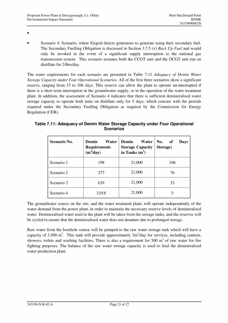
In order to assess the adequacy of the demineralised water storage capacity, a number of operational
scenarios for the plant were considered as detailed below.
• Scenario 1: Running of both units on natural gas with a projected annual running profile of
6,000 hours for the CCGT unit and 500 hours for the OCGT unit, which is equivalent to 16.4
hrs/day and 1.4 hrs/day on average for the respective units;
• Scenario 2: The same running profile as Scenario 1, but with the OCGT unit fired on distillate
fuel. Whilst it is not possible to categorically state the daily running hours of the proposed
plant as this will be dictated by the demand for electricity generation arising from Eirgrid, It is
considered that this scenario represents the typical daily operational profile of the proposed
power plant
• Scenario 3: The CCGT unit running on natural gas at maximum output (24 hrs/day), whilst the
OCGT unit runs on distillate for a period of 6.6 hrs/day. This scenario covers the operation of
the proposed power plant for short term peak potential demand, and
Proposed Power Plant at Derrygreenagh, Co. Offaly Mott MacDonald Pettit
Environmental Impact Statement BNME
24319000062N
243190-N-R-02-A Page 21 of 27
•
• Scenario 4: Scenario, where Eirgrid directs generators to generate using their secondary fuel.
The Secondary Fuelling Obligation is discussed in Section 3.7.5 (v) Back Up Fuel and would
only be invoked in the event of a significant supply interruption to the national gas
transmission system. This scenario assumes both the CCGT unit and the OCGT unit run on
distillate for 24hrs/day.
The water requirements for each scenario are presented in Table 7.11 Adequacy of Demin Water
Storage Capacity under Four Operational Scenarios. All of the first three scenarios show a significant
reserve, ranging from 33 to 106 days. This reserve can allow the plant to operate un-interrupted if
there is a short term interruption in the groundwater supply, or in the operation of the water treatment
plant. In addition, the assessment of Scenario 4 indicates that there is sufficient demineralised water
storage capacity to operate both units on distillate only for 5 days, which concurs with the periods
required under the Secondary Fuelling Obligation as required by the Commission for Energy
Regulation (CER).
Table 7.11: Adequacy of Demin Water Storage Capacity under Four Operational Scenarios
Scenario No. Demin Water
Requirements
(m3/day)
Demin Water
Storage Capacity
in Tanks (m3)
No. of Days
Storage)
Scenario 1 198 21,000 106
Scenario 2 277 21,000 76
Scenario 3 639 21,000 33
Scenario 4 3,918 21,000 5
The groundwater source on the site, and the water treatment plant, will operate independently of the
water demand from the power plant, in order to maintain the necessary reserve levels of demineralised
water. Demineralised water used in the plant will be taken from the storage tanks, and the reserves will
be cycled to ensure that the demineralised water does not denature due to prolonged storage.
Raw water from the borehole source will be pumped to the raw water storage tank which will have a
capacity of 3,500 m3. This tank will provide approximately 3m
3/day for services, including canteen,
showers, toilets and washing facilities. There is also a requirement for 500 m3 of raw water for fire
fighting purposes. The balance of the raw water storage capacity is used to feed the demineralised
water production plant.
Proposed Power Plant at Derrygreenagh, Co. Offaly Mott MacDonald Pettit
Environmental Impact Statement BNME
24319000062N
243190-N-R-02-A Page 22 of 27
The adequacy of water supply from the borehole was assessed by considering the maximum potential
demand over the course of the year, as short term variations in the supply/demand balance are buffered
by the demineralised water storage on the site, as discussed above. As a worst case, the maximum
possible load factor for the CCGT unit was used, equating to approximately 8,000 hours per year. It is
assumed that the unit will be fired on gas, but two days running on distillate per year is included for
testing of fuel changeover arrangements. In addition, it is assumed as a worst case that the OCGT unit
runs on distillate for 900 hours, equivalent to an annual load factor of 10%, which is estimated as an
upper limit for operating the unit on distillate alone.
The total demand from this scenario, and the supply available from the borehole, is detailed in Table
7.12 Assessment of the Adequacy of the Water Supply from the Borehole, below:
Table 7.12: Assessment of the Adequacy of the Water Supply from the Borehole
Water Demand Process
Demin Water Consumption
Raw Water Consumption
Raw Water Equivalent
Operating hours
Total
CCGT - gas 11 m3/h 15 m
3/h 8,000 h/yr 120,000 m
3/yr
CCGT - Distillate 106 m3/h 141 m
3/h 48 h/yr 6,768 m
3/yr
OCGT - Distillate 57 m3/h 76 m
3/h 900 h/yr 68,400 m
3/yr
Other 30 m3/day 30 m
3/day 365 day/yr 10,950 m
3/yr
Total - Maximum Annual Raw Water Demand 206,118 m3/yr
Annual yield from borehole 630 m3/day 365 day/yr 229,950 m
3/yr
Ratio of maximum raw water demand to supply 88%
The table shows that the borehole can meet the maximum possible annual demand for raw water from
the power plant, with a reserve margin of 12%.
In conclusion there is sufficient water available from the aquifer, with a sustainable yield of
630m3/day at the proposed development site, to supply the maximum possible demand of the proposed
power plant. There is also sufficient water storage reserves held on the site to allow for the prolonged
operation of the facility under different scenarios as described above, without negatively impacting on
the groundwater resource under the site.
Based on the results of the site investigation and pumping test conducted on site a cone of drawdown
would extend up to 300 m from the abstraction well. The cone of drawdown does not extend beyond
the site boundary. It is considered that it would be unlikely that there would be any change in the
effective stress beyond the cone of drawdown, therefore dewatering related settlement would be
unlikely to occur beyond this point. It is anticipated that there will be no hydrogeological impact on
the R400 road from water abstraction at the proposed pumping well on the site.
Proposed Power Plant at Derrygreenagh, Co. Offaly Mott MacDonald Pettit
Environmental Impact Statement BNME
24319000062N
243190-N-R-02-A Page 23 of 27
The impact of the drawdown on the proposed development site within 300 m of the pumping well was
also assessed. By calculating the change in effective stress, as a result of the change in groundwater
level, the settlement of each soil layer below the groundwater table can be estimated. It was usually
found to be the case that the peat and soft clay/silt layers were above the groundwater table and
therefore these deposits were not generally affected by any drawdown. The maximum predicted
settlement was found to be approximately 10 mm, adjacent to the pumping well in OB1/BH04,
reducing to less than a millimetre in BH02 at the south east corner of the site. The settlement at the
well location, based on a 5.2 m of drawdown, was estimated to be between 15 mm and 20 mm. The
cone of drawdown does not extend to the R400 roadway and it is not anticipated to impact on the road.
Abstraction of the groundwater in the limestone aquifer for use as process water in the proposed
development is considered not to have a significant effect on the abstraction of groundwater from
neighbouring properties. The nearest off site abstraction point is located approximately 1.3 km away.
Based on the well coordinates provided by GSI, the approximate positions of these wells are shown in
Figure 7.4 Water Mains and Wells within 2 km of the Proposed Development Site. The majority of the
buildings in the vicinity of the proposed development are served by water mains and will therefore be
unaffected by the proposed abstraction.
The abstraction of water from the pumping well is unlikely to have any impact on surface water
resources in the area such as the Mongagh River, which is located c. 0.7 km north of the site, or the
Yellow River, located c. 1.4 km to the south of the site, due to the fact these resources are significantly
outside the cone of drawdown. There are no sensitive water dependent ecosystems within the
predicted cone of drawdown and so it is not anticipated that there will be any significant impacts on
any such resources.
(ii) Other potential impacts
• The site is in an area where levels of radon above the action level of 200 Bq/m3 may occur in
buildings. It is considered that mitigation measures to prevent gas ingress will be required to
be incorporated into the buildings during the design and construction in order to mitigate
against the risks to operating personnel;
• The risks posed by contaminated surface water run-off are potentially high, given the
vulnerability of the surrounding peat bog, which is likely to provide baseflow to the
neighbouring watercourses and itself comprises a wetland area;
Proposed Power Plant at Derrygreenagh, Co. Offaly Mott MacDonald Pettit
Environmental Impact Statement BNME
24319000062N
243190-N-R-02-A Page 24 of 27
• The risks to groundwaters following construction and commissioning of the CCGT and OCGT
units are considered to be low. Evidence of contaminated groundwaters was noted during the
Glovers site investigation and is summarised in Table 7.8. Potential Pollution Linkage
Pathways and Associated Risks. However, the proposed development will require the
abstraction of significant volumes of groundwater, up to 630 m3 per day, for use as process
water, which will cause drawdown towards the abstraction well. This would mean that the
potential for migration of the identified contamination would be reduced. Ongoing monitoring
of the groundwater indicated that concentrations have reduced and the most recent
groundwater monitoring round did not record significantly elevated concentrations of
contaminants. It is considered possible that the contaminants may have arisen due to the
intrusive nature of the drilling process. Any further investigations, monitoring or intrusive
works to be carried out will be in accordance with an agreed strategy with the Environmental
Protection Agency, paying due regard to the associated environmental and health and safety
risks and implementing the necessary controls.
7.6 Mitigation Measures
7.6.1 Pre-Construction Mitigation Requirements
Variable concentrations of TPH and other contaminants were detected during the site investigation.
As a consequence, and having regard to the fact that the current site activities are controlled by an
Integrated Pollution Prevention Control licence, the Environmental Protection Agency has been
informed of same. Any further investigations, monitoring or intrusive works to be carried out will be
in accordance with an agreed strategy with the Environmental Protection Agency paying due regard to
the associated environmental and health and safety risks and implementing the necessary controls.
Aquifer protection measures will be employed during the piling in accordance with the current best
practice: Piling and Penetrative Ground Improvement in Land Affected by Contamination: Guidance
on Pollution Prevention (Environment Agency, 2001).
The site is located within a high radon area. Comprehensive radon monitoring will be conducted on
site during the construction phase in accordance with Radiological Protection Institute of Ireland
guidelines. It is anticipated that a radon gas barrier will be required however the requirement for same
in addition to any further mitigation measures will be agreed with the Radiological Protection Institute
of Ireland based on the monitoring results obtained to prevent build-up of radon gas in enclosed areas.
Prior to the demolition of existing structures on-site a Construction and Demolition Waste
Management Plan will be developed in accordance with the Department of the Environment, Heritage
and Local Government’s Guidelines on the Preparation of Waste Management Plans (WMP) for
Construction and Demolition Waste Projects (DEHLG, 2006). This plan will address all wastes to be
generated during the demolition and construction phases of the project, including asbestos, or asbestos
containing materials, which may be present in the structures proposed for demolition.
7.6.2 Mitigation of Construction Impacts
The environmental effects likely to arise during the construction phase of the project will be identified
and managed through a Construction Environmental Management Plan (CEMP). The CEMP shall, as
a minimum, address the following issues relating to effects arising from contaminated ground, as well
as other more general environmental impacts:
Proposed Power Plant at Derrygreenagh, Co. Offaly Mott MacDonald Pettit
Environmental Impact Statement BNME
24319000062N
243190-N-R-02-A Page 25 of 27
• Water pollution will be prevented through the effective management and storage of chemicals
and hydrocarbons. This will include the development of designated impervious and bunded
chemical storage locations in addition to the installation of paved and ramped areas for
refuelling. Such areas will be provided with a hydrocarbon interceptor for the treatment of
surface waters generated at such locations;
• A comprehensive and integrated approach for water quality protection during construction
will be implemented as part of the Construction Environmental Management Plan to prevent
impacts to water quality in watercourses adjacent the construction site. This will incorporate
such principles as silt control measures, such as sedimentation ponds, stabilisation of exposed
soils which pose a risk of generation of contaminated surface water run-off and regular
inspections and testing if considered necessary following consultation with the Eastern
Regional Fisheries Board;
• Chemicals and hydrocarbons will not be stored within 10 metres of any surface waters or 50
metres of a borehole or well. Designated areas where chemicals or hydrocarbons are
delivered, stored and dispensed will be isolated from the surface water drainage system, open
ground or other porous surfaces. This will be achieved using drainage grids, gullies or kerbs in
conjunction with surfaces impermeable to the products used. Potentially contaminated water
and spills will be directed through an oil separator and prevented from seeping into the soil
and groundwater below the site. The separator will be of an adequate size to serve the
appropriate surface area catchment of the site;
• Bunds for the storage of chemicals and hydrocarbons will be lined or constructed of materials
resistant to damage by the materials stored therein. In addition the capacity of such bunds will
be a minimum of 110% of the volume of the largest container stored therein or 25% of the
total volume, whichever is the greater. Bunds will be designed in accordance with
Environmental Protection Agency guidance in relation to the storage of potentially polluting
liquids (“IPC Guidance Note on Storage and Transfer of Materials for Scheduled Activities”,
2004) paying due regard to procedures for emptying potentially contaminated rainwater, if
uncovered, orientation of fill/discharge points, valves and other risk connections within the
bund structure;
• Portable toilets will be provided on site for the construction phase of the project and
arrangements will be made to transport all waste generated to an appropriately licensed off site
facility;
• All plant and equipment on site will be regularly maintained and inspected. Leaks will be
repaired immediately prior to use of the affected item. Drip trays will be provided and used for
all stationary plant. If wash down is required, a designated wash down area will be used,
served by oil / water separators and isolated from the surface water drainage;
• Spill kits will be maintained near working areas. All spills / leaks will be cleaned up
immediately. An emergency response plan will be put in place as part of the Construction
Environmental Management Plan detailing the measures to be undertaken should pollution be
identified;
• A Construction and Demolition Waste Management Plan will be developed and implemented
in accordance with the Department of the Environment, Heritage and Local Government’s
Guidelines on the Preparation of Waste Management Plans (WMP) for Construction and
Proposed Power Plant at Derrygreenagh, Co. Offaly Mott MacDonald Pettit
Environmental Impact Statement BNME
24319000062N
243190-N-R-02-A Page 26 of 27
Demolition Waste Projects (DEHLG, 2006). The focus of this plan will be effective
identification, quantification and recording of wastes generated on and removed from the
construction site. The plan will also demonstrate how compliance is being achieved with all
relevant national legislation for waste management and clearly identify all waste contractors
utilised for the disposal, recycling or recovery of waste materials generated on-site;
• Construction activities will be carried out in accordance with the CIRIA Document C650
Environmental Good Practice on Site, (CRIA, 2005); and
• Using the methodology set out in Concrete in Aggressive Ground (BRE, 2005), and assuming
mobile groundwater conditions, buried concrete will be designed for a design sulphate class of
DS-2 and for an aggressive chemical environment for concrete (ACEC) class of AC-5z. This
ACEC class considers the whole site, including the more acidic areas where peat is prevalent.
However, due to the variable ground conditions on site, it is recommended that further tests
are carried out on soils and groundwater during detailed design and in advance of
commencement of construction activities to confirm this classification.
7.6.3 Mitigation of Operational Impacts
The major operational phase mitigation measures associated with the proposed development are
considered to comprise the following:
• Pre-treatment of the abstracted groundwaters will be required to ensure its suitability for use
as boiler / process water. Monitoring of all discharged waters will be required under the IPPC
license for the development, in order to ensure that the effluent water quality is in compliance
with the licence conditions;
• Storage of hydrocarbons and other hazardous or potentially polluting materials will be
undertaken in accordance with best practice (See IPC Guidance Note on Storage and Transfer
of Materials for Scheduled Activities, EPA, (2004)) and the conditions detailed for the IPPC
licence for the site;
• An emergency response plan, setting out the procedures to be followed in the event of
spillages or other pollution events, will be put in place in accordance with the requirements of
the Integrated Pollution Prevention Control Licence for the site;
• Waste water, including potentially contaminated runoff, will be treated in dedicated systems to
the appropriate standards, prior to discharge off site in accordance with the conditions set out
in the Integrated Pollution Prevention Control Licence for the site;
• The proposed maximum abstraction of groundwater, at 630 m3/day, is likely to cause
settlement of the ground within the cone of drawdown. There is an associated risk of
settlement related damage to structures on site. In order to mitigate against this potential risk
all structures on the site will be designed to tolerate such settlement; and
• The maximum abstraction from the pumping well at the proposed development site will be
630m3/day.
Proposed Power Plant at Derrygreenagh, Co. Offaly Mott MacDonald Pettit
Environmental Impact Statement BNME
24319000062N
243190-N-R-02-A Page 27 of 27
7.7 Residual Impacts
The mitigation strategy above recommends actions which can be taken to reduce or offset the scale,
significance and duration of the known and potential impacts on soils, geological and hydrogeological
resource. The purpose of this statement is to specify mitigation measures, where appropriate, to
minimise the ‘risk factor’ to all aspects of these resources on site.
It is anticipated that with the implementation of mitigation measures detailed above neither the
construction nor operational phases of the development will impact significantly on the geology,
hydrology or hydrogeology of the area.
Proposed Power Plant at Derrygreenagh, Co. Offaly Mott MacDonald Pettit
Environmental Impact Statement BNME
24319000062N
243190-N-R-02-A Page 1 of 27
7 Soils, Geology and Hydrogeology
7.1 Introduction
This chapter of the EIS describes the existing environment in relation to Soils, Geology and
Hydrogeology in the proposed development area, predicts the relevant impacts arising from the
proposed development and, where considered appropriate, mitigation measures have been specified. It
is divided into the following sub-sections:
7.1 Introduction
7.2 Methodology
- Desk Based Assessment
- Field Study
- Impact Assessment Methodology
- Site Contamination Assessment Methodology
7.3 Overview of Water Requirements
- Heat Recovery Steam Generator
- NOx Control
7.4 Receiving Environment
- Background
- Topography
- Geology and Ground Conditions
- Hydrogeology
- Hydrology
- Radon
- Geological Heritage Areas
7.5 Impact Assessment
- Soil and Groundwater Condition
- Construction Phase Impacts
- Operational Phase Impacts
7.6 Mitigation
- Pre-Construction Mitigation Requirements
- Mitigation of Construction Impacts
- Mitigation of Operational Impacts
7.7 Residual Impacts
Proposed Power Plant at Derrygreenagh, Co. Offaly Mott MacDonald Pettit
Environmental Impact Statement BNME
24319000062N
243190-N-R-02-A Page 2 of 27
7.2 Methodology
7.2.1 Desk-Based Study
Geological information has been obtained for this section of the EIS from the following sources:
In order to evaluate the risk posed by any contaminants in soil, leachate and groundwater, reference
has been made to guidance provided in CIRIA document 552, “Contaminated Land Risk Assessment,
A Guide to Good Practice”. The method evaluates the consequences of risks being realised due to the
presence of contaminants and contamination linkages, and the probability of such risks being realised.
The criteria used in this assessment to determine the level of any contamination on the site are detailed
in Table 7.4 Classification of Consequence, Table 7.5 Classification of Probability, Table 7.6
Comparison of Consequence against Probability and Table 7.7 Description of classified risks and
likely action required.
Table 7.4: Classification of Consequence
Classification Definition
Severe Short-term (acute) risk to human health likely to result in “significant harm” as defined in the
Environmental Protection Act, Part IIA. Short-term risk of pollution of sensitive water resource (note:
Water Resources Act contains no scope for considering significance of pollution). Catastrophic damage
to buildings/property. A short-term risk to a particular ecosystem, or organism forming part of such
ecosystem (note: the definitions of ecological systems within the Draft Circular on Contaminated Land,
DETR, 2000)
Medium Chronic damage to Human Health (“significant harm” as defined in DETR, 2000). Pollution of sensitive
water resources (note: Water Resources Act 1991 contains no scope for considering significance of
pollution). A significant change in a particular ecosystem, or organism forming part of such ecosystem.
(note: the definitions of ecological systems within Draft Circular on Contaminated Land, DETR, 2000)
Mild Pollution of non-sensitive water resources. Significant damage to crops, buildings, structures and
services (“significant harm” as defined in the Draft Circular on Contaminated Land, DETR, 2000).
Damage to sensitive buildings/services or the environment
Minor Harm, although not necessarily significant, which may result in a financial loss, or expenditure to
resolve. Non-permanent health effects to human health (easily prevented by means such as personal
protective clothing etc.). Easily repairable effects of damage to buildings, structures and services.
Proposed Power Plant at Derrygreenagh, Co. Offaly Mott MacDonald Pettit
Environmental Impact Statement BNME
24319000062N
243190-N-R-02-A Page 6 of 27
Table 7.5: Classification of Probability
Classification Definition
High likelihood There is a pollution linkage and an event that either appears very likely in the short term and almost
inevitable over the long term, or there is evidence at the receptor of harm or pollution
Likely There is a pollution linkage and all the elements are present and in the right place, which means that it is
probable that an event will occur.
Circumstances are such that an event is not inevitable, but possible in the short term and likely over the
long term.
Low Likelihood There is a pollution linkage and circumstances are possible under which an event could occur.
However, it is by no means certain that even over a longer period such an event would take place, and is
less likely in the shorter term.
Unlikely There is a pollution linkage but circumstances are such that it is improbable that an event would occur
even in the very long term.
Table 7.6: Comparison of Consequence against Probability
Consequence Probability
Severe Medium Mild Minor
High Likelihood Very High Risk High risk Moderate risk Moderate Risk/low risk
Likely High Risk Moderate risk Moderate/ low risk Low risk
Low Likelihood Moderate risk Moderate risk/low
risk
Low risk Very low risk
Unlikely Moderate/Low risk Low risk Very low risk Very low risk
Proposed Power Plant at Derrygreenagh, Co. Offaly Mott MacDonald Pettit
Environmental Impact Statement BNME
24319000062N
243190-N-R-02-A Page 7 of 27
Table 7.7: Description of classified risks and likely action required
Risk Descriptor Definition
Very high risk There is a high probability that severe harm could arise to a designated receptor from an identified
hazard, OR, there is evidence that severe harm to the designated receptor is currently happening.
The risk, if realised, is likely to result in substantial liability.
Urgent investigation (if not undertaken already) and remediation are likely to be required
High risk Harm is likely to arise to a designated receptor from an identified hazard.
The risk, if realised, is likely to result in substantial liability.
Urgent investigation (if not undertaken already) is required and remedial works may be necessary in
the short term and are likely in the long term.
Moderate Risk It is possible that harm could arise to a designated receptor for an identified hazard. However, if it is
either unlikely that any such harm would be severe, or if any harm were to occur it is more likely that
the harm would be relatively mild.
Investigation (if not already undertaken) is normally required to clarify the risk, and to determine the
potential liability. Some remedial works may be required in the long term.
Low Risk It is possible that harm could arise to a designated receptor for an identified hazard, but it is likely
that this harm, if realised, would at worst be mild
Very Low Risk There is a low possibility that harm could arise to a receptor. In the event of such harm being
realised, it is not likely to be severe.
7.3 Overview of Water Requirements
The water requirements to allow for the operation of the power plant development are primarily based
on the need for water in the Heat Recovery Steam Generator (HRSG) in the CCGT unit and for NOx
control during the running of the CCGT and the OCGT units on distillate fuel. Other requirements for
water at the facility arise from cleaning activities, laboratory requirements and domestic water usage.
7.3.1 Heat Recovery Steam Generator
A supply of feedwater is required to generate steam in the Heat Recovery Steam Generator (HRSG).
In order to avoid corrosion over the lifetime of the proposed power plant development, the feed-water
must be treated prior to use. The proposed power plant will include a water treatment plant where
boiler feed-water will be demineralised using either a resin based or Reverse Osmosis / Electro De-
ionisation (EDI) based system. The feedwater used in the HRSG will be thermally de-aerated to
remove oxygen and chemically treated to prevent corrosion of the tubes and components of the
water/steam cycle. Chemical dosing for pH control essentially alters the pH of the boiler water to a pH
that prevents corrosion reactions. Oxygen scavenging and de-aeration combine to remove the
dissolved oxygen from the boiler water which again prohibits corrosion.
A range of specialist chemical treatment options are available for boiler feedwater. These include the
use passivation chemicals for pH control and the use of oxygen scavengers.
Proposed Power Plant at Derrygreenagh, Co. Offaly Mott MacDonald Pettit
Environmental Impact Statement BNME
24319000062N
243190-N-R-02-A Page 8 of 27
7.3.2 NOx Control
NOx emissions to air increase significantly when distillate is used as the fuel for running a turbine.
Water injection will be employed when either the OCGT or CCGT unit is running on distillate fuel.
Water will be injected directly into the combustion chamber to minimise the production of NOx. The
water and steam act as a heat sink in the flame zone of the combustion chamber, reducing the
temperature and therefore the likelihood of thermal NOX formation. It also has the added affect of
increasing the gas turbine output due to the additional mass added by the water and steam.
7.4 Receiving Environment
7.4.1 Background
This section of the chapter outlines the baseline geology, soils and hydrogeology that exist on the site
and in the vicinity of the proposed development. The information detailed below is based on the desk-
based and field studies described in Section 7.2.1 Desk Based Study and 7.2.2. Field Study.
The proposed development site has a history of previous industrial usage and is currently occupied by
a workshop, stores and office complex that supports Bord na Móna’s peat harvesting activities. The
complex includes workshops for mobile plant overhaul and for wagon and locomotive maintenance
which are used for haulage of milled peat to the Edenderry Power Station. The remaining area consists
of a mix of acid grassland and made ground in the southern and western side of the site and the only
apparent area of peat is located in the northern corner of the site. The site is bounded to the west, north
and east by areas of cutaway bog, where the last recorded peat harvesting extraction was in 2000/01,
and farmland to the south. The proposed development occupies a total area of 25.4 ha. The site
occupies an area of 22.8 ha with the main site occupying an area of 17.5 ha and the adjacent
switchyard site on the western side of the R400 roadway, occupying 5.3 ha. The proposed discharge
pipeline to the Yellow occupies an area of 2.6 ha.
The historical development of the site has been assessed from ‘The Proposed Extraction of Sand and
Gravel at Derryarkin and Drumman, Co. Offaly and Co. Westmeath – An Environmental Impact
Statement’, Bord na Móna, April 2001. During the nineteenth century the Derryarkin, Derrygreenagh
and Drumman bogs were a rich source of iron ore. According to the report, ore from Derrygreenagh
Bog was loaded onto canal boats in Daingean, approximately 10 km south of the site.
The Derryarkin and Drumman bogs were acquired by Bord na Móna in 1952 and milled peat
harvesting began in 1958 to supply the ESB peat fired Rhode Power Station, which was located
approximately 4 km to the south west of the site, and the Croghan briquette factory. Both of these
facilities are now closed. While some commercial peat extraction still continues within the areas, the
Derryarkin and Drumman bogs are no longer in milled peat production and the area comprises of
cutaway peatland. There are sand and gravel extraction sites located within these bogs. The Derryarkin
extraction site lies 1.5 km to the west and the Drumman extraction site is located 2 km to the
northeast.
Proposed Power Plant at Derrygreenagh, Co. Offaly Mott MacDonald Pettit
Environmental Impact Statement BNME
24319000062N
243190-N-R-02-A Page 9 of 27
Both the geology and soils play an important part in determining the environmental characteristics of
the area in general and of the site in particular. The underlying geology has a major influence on
landform and rocks provide the parent material from which soils are created. The nature of the rock
helps to determine not just the nature and chemistry of the soil formed, but also the rate at which it
forms. This in turn strongly affects the natural vegetation and the type of agriculture or horticulture
that can be sustained.
The receiving environment of the proposed development site is described below under the following
headings:
• Topography;
• Geology and Ground Conditions;
• Hydrogeology;
• Hydrology
• Radon; and
• Geological Heritage Areas
7.4.2 Topography
Topography refers to the surface features of a place or region. The proposed development site lies
within an area of peatland which is designated as an area of “moderate sensitivity” in Chapter 16
Landscape and Amenities of the Draft Offaly County Development Plan 2009-2015. The area is
characterised by a generally low relief and level terrain dominated by the flat featureless expanses of
the peatland area. Further to this, the natural topography of the area has been modified by the historic
extraction of peat from the surrounding peatlands. This extraction process has resulted in a significant
drop in the level of peatland areas relative to other aspects of the landscape, such as the R400
roadway. There is a c. 3 m height differential between the R400 roadway and adjacent cut over bog
areas. The surrounding peatlands are also characterised by a network of parallel drainage channels c.
15 m apart.
The proposed development site consists of a “mineral island” and is slightly elevated over the levels of
the surrounding cut over peatland areas. The site for the proposed development is gently sloping from
the north eastern extent of the site, from c. 82 metres OD (Ordnance Datum Malin Head) to c. 87
metres OD at the south western edge of the site. Just to the south of the proposed development site
there is a further elevated area consisting of agricultural land which slopes up to a maximum height of
92 metres OD. The adjacent site on the opposite side of the R400 roadway to be used for the electrical
switchyard is slightly lower than the main site area with a minimum level of c. 79 metres OD
increasing to a level of c. 84 metres OD
Proposed Power Plant at Derrygreenagh, Co. Offaly Mott MacDonald Pettit
Environmental Impact Statement BNME
24319000062N
243190-N-R-02-A Page 10 of 27
7.4.3 Geology and Ground Conditions
Based on desk-study information, and the Geological Survey of Ireland (GSI) Bedrock and
Quarternary maps show that the solid geology of the site is likely to consist of Marine Basinal Facies,
known as the Lucan, or “Calp” Formation of the Visean Age (part of the Mississipian sub-period,
commonly known as the Early Carboniferous sub-period). This formation usually consists of
argillaceous and cherty limestone and shale. (See Figure 7.2 Bedrock Geology).
The drift deposits on site were assessed using data collected in the ground investigation undertaken by
GSIL. There was a large variation across the site. The general stratigraphy encountered over the site
was as follows:
• Made Ground;
• Peat and soft clay/silts (northern end of site) (superficial deposits);
• Glacial clay (superficial deposits);
• Completely to highly weathered limestone and karst clays; and
• Limestone (‘Calp’ Formation).
(i) Made Ground
Made Ground was encountered across most of the site, but prevalent to the south of the existing
workshop buildings to the north of the site. The Made Ground encountered comprised of a firm to
stiff, occasionally soft, slightly sandy slightly gravelly clay fill. The Made Ground encountered at the
northern end of the site included much greater peat content. The Made Ground was generally overlain
by topsoil to a maximum depth of 0.25 m. The original topsoil was encountered in a number of
boreholes to the north west of the site to a depth of 1.40 m underlying the Made Ground. The
thickness of the original topsoil ranged from 0.15 m to 0.25 m.
(ii) Superficial Deposits: Peat and Soft Clay/Silts
The ground investigation identified that the northern end of the site, and the area surrounding the site,
was underlain by peat. Peat deposits are described as plastic to spongy cream to dark brown/black
amorphous to fibrous slightly sandy slightly silty occasionally gravely peat with occasional to many
cobbles and boulders.
Underlying the peat deposits, a soft clay/silt or clay was usually encountered. This is a common
feature in peat where siltier material, often weaker than the peat itself, underlies the strata.
(iii) Superficial Deposits: Glacial Clay
Glacial clay deposits were encountered at locations across the site. The main deposits are described as
firm, becoming very stiff, yellow/grey brown, slightly sandy gravelly clay.
Proposed Power Plant at Derrygreenagh, Co. Offaly Mott MacDonald Pettit
Environmental Impact Statement BNME
24319000062N
243190-N-R-02-A Page 11 of 27
(iv) Completely to Highly Weathered Limestone and Karst Clays
Medium to very dense dark brown to black clayey, occasionally sandy fine to coarse gravel with many
cobbles and boulders was encountered across the site with proven stratum thickness of between 2 m
and 22.4 m. The gravel was underlain by limestone bedrock where found.
Reduced limestone weathering was encountered to the east of the site where dense sandy gravely
cobbles and boulders was present at depths from 9 m to 16.5 m below ground level. A thin layer of
cobbles was also encountered from 5 m to 5.6 m below ground level near the workshops to the north
of the site.
Clay deposits were encountered at the northern end of the site at depths up to 25.2 m and below
ground level. As these deposits are underlying very dense gravels they have been considered
separately from the glacial clays. These deposits are thought to indicate the presence of karst features
in the site. Karst is a name given to the process of dissolution that is often found to have occurred in
limestones.
(v) Limestone Bedrock
The bedrock under the site has been described as moderately strong to strong (occasionally very
strong) grey fine to medium grained limestone with calcite veining and has been classified as slightly
to moderately weathered rock. The limestone was encountered between 7.8 m and 24 m depth below
ground level.
7.4.4 Hydrogeology
Groundwater is described as water that is stored in and moves through the pores and cracks in subsoils
and bedrock. Aquifers are rocks that contain sufficient voids to store water and are permeable enough
to allow water to flow through them in significant quantities. Lower Palaeozoic rocks, which underlie
the study area, generally have a low permeability and are regarded as poor aquifers.
The GSI Bedrock Aquifer map classifies the aquifer to be of ‘Local Importance in which bedrock is
Moderately Productive only in Local Zones’ (See Figure 7.3 Aquifer Map). The GSI define a Locally
Important Aquifer as having an area of outcrop or recharge zone, of normally >1 km², with a
Regionally Important Aquifer having an area of outcrop of normally >10 km².
Groundwater vulnerability as defined by the GSI is the ease with which groundwater may be
contaminated by human activity related to the intrinsic geology and hydrogeological characteristics of
the area. In this instance, the groundwater vulnerability is classified as being Moderate.
The result of a well search of the GSI databases (2007 dataset) indicates that the nearest recorded
groundwater abstraction well is located approximately 1.3 km from the site. The approximate
locations (coordinates provided by the GSI) of groundwater wells in the vicinity of the site are shown
on Figure 7.4 Water Mains and Wells within 2 km of the Proposed Development Site.
With the exception of the borehole currently in use on the Derrygreenagh site, an analysis of the GSI
Wells dataset and consultation with Offaly Co. Co., have identified that there are no other water
abstractions from groundwater within 1.3 km of the site.
Proposed Power Plant at Derrygreenagh, Co. Offaly Mott MacDonald Pettit
Environmental Impact Statement BNME
24319000062N
243190-N-R-02-A Page 12 of 27
The nearest residences to the proposed development are those located on the Knockdrin road. This
road is serviced by a water main and so water requirements arising from the residences on this road are
met from this source. The proposed development site is approximately 4 km North West of the
nearest Source Protection Area (See Figure 7.5 Source Protection Area Map).
(i) Groundwater Resource
During the ground investigation undertaken by GSIL, groundwater was encountered in all cable
percussive boreholes drilled at the site. Most groundwater strikes occurred near, or within 2 m of the
top of the weathered limestone. Other smaller seepages were encountered at the base of the Made
Ground and at the top of the soft clay/silt (underlying peat). Most of the strikes encountered within the
weathered limestone were at depths of between 6 m and 10 m below ground level. In the main test
pumping well on the site, groundwater table measurements undertaken prior to the start of the
pumping test showed a depth of approximately 6.5m below ground level
Following the completion of all drilling activities on-site by GSIL, a pumping test was undertaken to
ascertain the sustainable yield of groundwater available in the aquifer beneath the site. This pumping
test was carried out in order to determine if there was a sufficient water resource available to supply
the proposed power plant development with the required quantity of water without having any
negative impacts on the groundwater resource in the area. The pumping tests undertaken by GSIL
identified that the pumping well had sufficient capacity to supply up to 630m3/day on an ongoing
basis.
7.4.5 Hydrology
The site is located within the Eastern River Basin District (ERBD) and within the River Boyne
catchment area. The nearest rivers to the site are the Mongagh River 0.7 km to the north of the site and
the Yellow River 1.4 km to the south of the site. Both of these rivers are tributaries of the River
Boyne. The Mongagh River is a tributary of the Yellow and flows into the Yellow c. 15 km
downstream. The Yellow River flows into the River Boyne a further 2 km downstream. A detailed
assessment of the surface water resources and potential impacts on them arising from the proposed
development are discussed in Chapter 6 Water Quality.
7.4.6 Radon
Information obtained from the Radiological Protection Institute of Ireland (www.rpii.ie) indicates that
the site is located in a High Radon Area (See Figure 7.6 Radon Levels Map), where greater than 20%
of dwellings are predicted to have radon levels in excess of 200 Bq/m³. The Radiological Protection
Institute of Ireland has set a safe level of radon of 200 Bq/m3 and protective measures are likely to be
required where this threshold is exceeded.
7.4.7 Geological Heritage Areas
A Geological Heritage Area is one which contains geological or geomorphological features considered
to be of national interest and recommended for Natural Heritage Area (NHA) designation by the GSI
under the Wildlife (Amendment) Act 2000.
Proposed Power Plant at Derrygreenagh, Co. Offaly Mott MacDonald Pettit
Environmental Impact Statement BNME
24319000062N
243190-N-R-02-A Page 13 of 27
A consultation response letter received from the Geological Survey of Ireland (26th May 2008) has
identified that there are no geological heritage sites currently on the GSI database for the area or near
the area. (See Appendix 1D: Consultation Responses).
7.5 Impact Assessment
7.5.1 Soil and Groundwater Condition
Potential sources of contamination have been identified following the ground investigation. Elevated
levels of TPH, nickel and other contaminants have been detected, in various concentrations, in soils
and groundwater during the site investigation. Isolated pockets of industrial waste materials were also
identified in some of the trial pits. The locations of the exploratory holes are shown on Figure 7.1
Ground Investigations.
A risk assessment was used to identify any risk arising from onsite contamination. Risk assessment
involves identification of the hazards and evaluation of the risks associated with these hazards. Risk
assessment requires an evaluation of a conceptual “source – pathway – receptor” linkage model and
can be qualitative or quantitative.
Based on the available information for the site, the following potential contamination sources have
been identified from an assessment of historic and current activities on or in close proximity to the
site:
• S1: Made Ground consisting of construction related fill or imported materials
(source unknown) to a shallow depth across the majority of the site area.
Concentrations of metals and hydrocarbons were found above the limit of detection
in samples from this material;
• S2: The nearby, and still operational, narrow gauge railway. Fuel storage tanks are
present on site for the servicing of rail haulage and milled peat production
equipment;
• S3: Old machinery located in various areas around the site;
• S4: Oil and grease from operational machinery moving around the site;
• S5: Off site sources. The site is surrounded on all sides by former peat extraction
areas, providing a potential source of organic materials and ammoniacal nitrogen to
groundwater in the vicinity of the site;
• S6: Structures. Existing structures on the site are to be demolished prior to the
commencement of construction. These structures may contain asbestos, plus stores
of other potential contaminants.
(i) Potential Contaminant Pathways
The following potential contamination pathways have been identified on the site:
• P1: Inhalation, ingestion and direct contact;
Proposed Power Plant at Derrygreenagh, Co. Offaly Mott MacDonald Pettit
Environmental Impact Statement BNME
24319000062N
243190-N-R-02-A Page 14 of 27
• P2: Groundwater movement through superficial deposits and the underlying aquifer;
• P3: Groundwater movement onto site from areas of former peat extraction;
• P4: Surface runoff;
• P5: Gas migration;
• P6: Root uptake.
(ii) Potential Contaminant Receptors
The following potential receptors have been identified:
• R1: Construction and maintenance workers;
• R2: Future end users;
• R3: Buildings and infrastructure;
• R4: Deep groundwater which may be extracted for the proposed power
development;
• R5: Groundwater residing in the variably permeable superficial strata;
• R6: Farmland to the south of the site;
• R7: Peat Bogs;
• R8: Flora and Fauna.
Table 7.8 Potential Pollution Linkage Pathways and Associated Risks shows the anticipated “Source-
Pathway-Receptor” linkages, with an assessment of the anticipated risks following construction.
Proposed Power Plant at Derrygreenagh, Co. Offaly Mott MacDonald Pettit
Environmental Impact Assessment BNME
24319000062N
243190-N-R-02-A Page 15 of 27
Table 7.8: Potential Pollution Linkage Pathways and Associated Risks
Source Principal
contaminants
from testing
Receptor
Potential
transport
pathways
Likelihood of
Source- Receptor
linkage
Potential
Consequence
Risk
Classification
Risk Management Required
TPH, Nickel,
(soils),
TPH,
Ammoniacal
Nitrogen,
Chromium,
Copper, Iron,
Nickel, Zinc,
pH
(groundwaters),
asbestos in
existing
structures
(assumed)
R1 Construction
and Maintenance
Workers
R2 Future End
Users
P1 Human Uptake
Pathways:
Likely during
construction –
unlikely post
construction
Medium Moderate for pre
construction
phase and
Construction
Phase
Low for post
construction
phase.
Further investigation and remediation of the identified
TPH, VOC, Nickel and industrial waste contamination will
be agreed with the EPA under the terms of the existing
IPPC licence. However, the results at present do not
indicate significant risks to human health following
construction.
During construction appropriate working practices should
be put in place to minimise contact with areas of
contaminated soils, including but not limited to the use of
PPE, dust suppression, use of machines to excavate instead
of hand digging, stockpiling of contaminated soils
separately from the bulk of the excavations and other
measures as appropriate. These measures are set out in the
following sections of this report.
Following construction the site is likely to be overlain by
impermeable hardstanding which will prevent human
contact with the identified areas of contamination. Where
areas of the site are proposed to be landscaped, further
investigation may be required in order to determine the
remedial requirements in these areas as directed by the
EPA under the terms of the existing IPPC licence. Capping
with clean topsoil, capillary break layer and basal geo-
textile may be required if contamination is identified in
these areas.
S1 Made
Ground
S2 Narrow
Gauge
Railway
S3 Disused
Machinery
S4 Operational
Tractors
and Peat
Extraction
Machinery
S5 Off site
Sources
S6 Structures
TPH,
Ammoniacal
Nitrogen,
Chromium,
Copper, Iron,
Nickel, Zinc,
pH
R4 Underlying
Aquifer
R5 Shallow
Groundwater
R6 Adjacent
farmland (Off
site)
P2 Groundwater
movement
through
superficial
deposits and the
underlying aquifer
P3 Groundwater
migration from
Unlikely –
concentrations have
been decreasing
throughout the
monitoring and the
most recent
groundwater
monitoring round
indicated that
Medium Low The results of groundwater monitoring indicated marginally
elevated concentrations of ammoniacal nitrogen and nickel.
Concentrations of TPH were initially elevated when testing
for TPH and DRO. However, analysis for TPH CWG,
which removes interference from naturally occurring
organic compounds, did not record concentrations of TPH
above the detection limits of the laboratory. The risks to
groundwater and the other identified receptors are therefore
not considered significant. However, given the observed
Proposed Power Plant at Derrygreenagh, Co. Offaly Mott MacDonald Pettit
Environmental Impact Assessment BNME
24319000062N
243190-N-R-02-A Page 16 of 27
Source Principal
contaminants
from testing
Receptor
Potential
transport
pathways
Likelihood of
Source- Receptor
linkage
Potential
Consequence
Risk
Classification
Risk Management Required
R7 Adjacent
Peatbogs (Off
site)
off site sources
significantly elevated
contaminant
concentrations were
not present –
monitoring is ongoing
and this shall be
reviewed as necessary
variation in the ongoing groundwater monitoring it is
recommended that the monitoring regime is continued in
order to confirm that concentrations remain within
acceptable levels.
Copper, Nickel,
Zinc
R8 Flora and
Fauna
P6 Root Uptake Unlikely Medium Low If contamination is identified in areas proposed for
landscaping, treatment will be undertaken as directed by
the EPA under the terms of the existing IPPC licence.
Ground Gas,
TPH, Sulphates
R3 Buildings and
Infrastructure
P2 and P3
Groundwater
Migration
P5 Migration of
Volatile Vapours
and Ground Gas
Likely Medium Moderate The low pH associated with the peat deposits and high
sulphate content of groundwaters associated with the peat
may have a negative impact on below ground concrete
structures. Appropriate design should be used in order to
mitigate against the potential risks associated with this.
Elevated concentrations of hydrocarbon in soils can
potentially affect the setting of concrete. The appointed
contractor should mitigate for this during the design and
specification of below ground concrete structures.
The results of gas monitoring did not indicate the presence
of significant concentrations of ground gas. However, The
site is located in an area where the radon concentration in
>20% of dwellings is likely to exceed 200 Bq/m3.
Proposed Power Plant at Derrygreenagh, Co. Offaly Mott MacDonald Pettit
Environmental Impact Statement BNME
24319000062N
243190-N-R-02-A Page 17 of 27
(iii) Summary of Baseline Risks
The risks in the vicinity of the proposed development associated with the baseline environmental
conditions are anticipated to comprise the following:
• Contamination within the Made Ground either as a result of materials within the imported
fill or due to spillages / leakages from on site processes and storage areas ( See Table 7.9
Summary of Exceedances of Human Health Criteria in Soil Samples). In addition to the
presence of nickel, areas of Total Petroleum Hydrocarbon (TPH) and Volatile Organic
Compounds (VOC) contaminated soils were observed during the ground investigation and
may pose a potential risk to human health during construction without appropriate
mitigation. The assessment of the potential risk posed from this contamination, using the
methodology described in Section 7.2.3 Impact Assessment Methodology results in a
classification of “moderate risk” during the pre construction and construction phase.
However with the implementation of risk management procedures as detailed in Table 7.8
Potential Pollution Linkage Pathways and Associated Risks the risk will be reduced to “low
risk”. Such risk management procedures include the remediation of the site where necessary
as agreed with the EPA under the existing IPPC license, and the implementation of
appropriate working practices to minimise contact with areas of contaminated soil.
Following the construction of the development the potential risk is classified as “low risk” in
terms of the risk to human health.
• Gassing ground (Radon, VOCs): The associated risk has been evaluated using the impact
assessment methodology as a moderate risk . However with the implementation of risk
management procedures as detailed in Table 7.8 Potential Pollution Linkage Pathways and
Associated Risks the risk will be reduced to “low risk”.
• Contaminated groundwater – ammoniacal nitrogen, iron, nickel and TPH (See Table 7.10
Summary of Exceedances in Groundwater and Leachate Analysis). It is considered possible
that the contaminants may have been introduced to the aquifer during the drilling process
used in the installation of the monitoring boreholes on the site. The contamination may have
been introduced by the dragging down of Made Ground during the drilling process. The
overall risk to groundwater arising from the site, evaluated by the impact assessment
methodology, is categorised as low risk.
Table 7.9: Summary of Exceedances of Human Health Criteria in Soil Samples
Parameter AC mg/kg Number
of
Samples
Mean
Value
mg/kg
Minimum
Value
mg/kg
Maximum
Value
mg/kg
UCL95 if
Concentration
>AC
No >AC
Nickel 100
(Dutch)
13 48.7 2 180 101.2mg/kg 1/13
VOCs
(dichloromethane)
3.9
(Dutch)
3 N/A* 0.8 4.5 N/A* 2/3
* Not calculated as inappropriate to do so given the limited dataset.
Proposed Power Plant at Derrygreenagh, Co. Offaly Mott MacDonald Pettit
Environmental Impact Statement BNME
24319000062N
243190-N-R-02-A Page 18 of 27
Table 7.10: Summary of Exceedances in Groundwater and Leachate Analysis
1 Concentrations were observed to decrease throughout the monitoring period. The identified concentrations of ammoniacal
nitrogen are stated by the World Health Organisation (WHO) to be below that where health effects are likely and were only
marginally elevated above the assessment criteria in the 3rd round of monitoring. 2 Concentrations were observed to decrease throughout the monitoring period, during the last round, with the exception of
borehole CP 2 concentrations were all below the assessment criteria. Concentrations within CP 2 during the last round were
below the UK Drinking Water Standard and are not considered indicative of significant contamination of groundwater.
Subject to the ongoing groundwater monitoring continuing to show decreasing concentrations the risks have been stated as
Low. Testing for TPH CWG in the 4th and final round of monitoring did not record the presence of hydrocarbon
contamination. Previous elevated concentrations may have been the result of interference of natural organics in groundwaters
due to the presence of overlying organic peat deposits.
(iv) Pre-Construction Consultations
Following the discovery of potential contaminants within the Made Ground during the site
investigation survey, Bord na Móna has initiated a management strategy. This strategy is being carried
out in consultation with the EPA, under the provisions of the existing IPPC licence, to remove any
identified waste materials, including potential sources of contamination.
7.5.2 Construction Phase Impacts
The major potential construction phase impacts are set out hereunder. Mitigation measures to address
these impacts are set out in Section 7.6.1 Pre-Construction Mitigation Requirements and Section 7.6.2
Mitigation of Construction Impacts
• Generation of dust. This could temporarily affect neighbouring sites and site users. It should
be noted that dust suppression/minimisation will be incorporated into the Construction
Environmental Management Plan given the nuisance and irritant factor which can arise from
elevated dust levels in the atmosphere;
• Generation of contaminated surface water run-off. Runoff from construction sites can contain
high levels of entrained sediments or other water pollutants dependent on the nature of
contamination sources on the site;
Parameter IEPA Interim
Guideline Value Minimum Maximum No >AC
List I, List
II or non
list
Substance Risk Status
Ammoniacal
Nitrogen 0.15mg/l <0.2mg/l 8.3mg/l 15/20 II Minor1
Barium 0.1mg/l 0.033mg/l 0.247mg/l 5/21 - Minor
Chromium 0.03mg/l 0.003mg/l 0.036mg/l 1/15 II Minor
Copper 0.03mg/l 0.001mg/l 0.144mg/l 2/20 II Minor
Iron 0.2mg/l 0.018mg/l 2.6mg/l 6/21 - Minor
Nickel 0.02mg/l 0.014mg/l 0.143mg/l 10/21 II Minor2
Zinc 0.1mg/l 0.026mg/l 0.251mg/l 4/21 II Minor
pH Value >6.5 and <9.5 4.32 7.75 4/21 II Minor
TPH 10µg/l <10µg/l 770µg/l 2/20 I Minor
Proposed Power Plant at Derrygreenagh, Co. Offaly Mott MacDonald Pettit
Environmental Impact Statement BNME
24319000062N
243190-N-R-02-A Page 19 of 27
• As set out previously in this chapter, levels of TPH and other contaminants have been detected
in varying concentrations during the site investigation. As a consequence, and having regard
to the fact that the current site activities are controlled by an Integrated Pollution Prevention
Control licence, the Environmental Protection Agency has been informed of same. Any
further investigations, monitoring or intrusive works to be completed will be in accordance
with an agreed strategy with the Environmental Protection Agency paying due regard to the
associated environmental and health and safety risks and implementing the necessary controls;
• The site is located within an area where >20% of premises are likely to exceed a radon
concentration of 200 Bq/m3. The potential presence of radon is unlikely to affect the
workforce as it is known to dissipate rapidly on contact with the open air. Comprehensive
radon monitoring will be conducted on site during the construction phase in accordance with
Radiological Protection Institute of Ireland guidelines. It is anticipated that a radon gas barrier
will be required however the requirement for same in addition to any further mitigation
measures will be agreed with the Radiological Protection Institute of Ireland based on the
monitoring results obtained in order to prevent build-up of radon gas in enclosed areas;
• Groundwater as a result of excavations on-site as part of the construction phase, which require
disposal, will be treated in advance of discharge to adjacent watercourses in agreement with
the Eastern Regional Fisheries Board. Such waters will be treated appropriately (e.g.
sedimentation ponds/oil interceptors) to ensure that they pose no risk of pollution to the
receiving watercourses;
• Spillages / leaks of chemicals or hydrocarbons during construction can result in pollution of
soil, surface and groundwaters; and
• Appropriate toilet and treatment facilities will be provided for ‘domestic nature’ sewage
generated on-site during the construction stage.
7.5.3 Operational Phase Impacts
The major potential operational phase impacts are set out in this section. Mitigation measures are
discussed in Section 7.6.3 Mitigation of Operational Impacts of this report:
(i) Predicted Water Requirements
Water for the power plant will be provided from a borehole located at the eastern side of the site. As
part of the hydrogeological assessment of the site, a pumping well was drilled and tested. The
pumping tests indicated that a sustainable yield, of 630 m3/day, could be obtained from the aquifer
underlying the site.
There are a number of processes in the operation of the power plant which consume water. Certain
processes require water with a high level of purity, to prevent corrosion or damage in the boiler and
the gas turbines. This high purity water, referred to as demineralised or ‘demin water’, is produced in
the water treatment plant.
Proposed Power Plant at Derrygreenagh, Co. Offaly Mott MacDonald Pettit
Environmental Impact Statement BNME
24319000062N
243190-N-R-02-A Page 20 of 27
The water treatment plant takes raw water from the groundwater source and removes the constituent
salts, which are then disposed of, either as a waste sludge, or in effluent which is discharged to the
process wastewater tank. The estimated efficiency of the treatment plant for the proposed development
is 75%, which means that 100 m3 of raw water is required to make 75 m
3 of demin water, with the
other 20 m3 being removed as process wastewater.
The main processes that require demin water in the power plant are:
• Make up water for the water/steam cycle in the CCGT unit, to replace ‘blow down’ and other
water losses from the system. ‘Blow down’ is a continuous purge of water required to
maintain the correct water quality in the boiler.
• The gas turbines inject water with the fuel to abate NOx emissions, when fired on distillate.
This is a very large potential demand for water, equating to about 95 m3/h for the CCGT gas
turbine and 57 m3/h for the OCGT turbine. However, the turbines use a dry NOx suppression
system when fired on gas, which consumes no water.
• There are other processes which consume a relatively minor quantity of demin water,
including gas turbine cleaning, and continuous sampling for boiler water quality monitoring.
It can be taken that, while a small proportion of the demand is independent of the running profile of
the power plant, the majority of this demand will only occur when the power generating units are
operating.
In addition to the process demands for demin water, there is a small demand for raw water on the site,
including potable water supply and supplies for cleaning and sanitation. This demand is independent
of the running profile of the power plant.
The demin water consumption of the plant is therefore highly variable, depending on how the plant is
dispatched, and the fuel that is used. In order to manage this variability, the plant has a large capacity
of storage for demin water, amounting to 21,000 m3, which acts as a reserve for periods of very high
demin water demand. During periods when the demand for demin water is low, the reserves are
replenished by the water treatment system.
In order to assess the adequacy of the demineralised water storage capacity, a number of operational
scenarios for the plant were considered as detailed below.
• Scenario 1: Running of both units on natural gas with a projected annual running profile of
6,000 hours for the CCGT unit and 500 hours for the OCGT unit, which is equivalent to 16.4
hrs/day and 1.4 hrs/day on average for the respective units;
• Scenario 2: The same running profile as Scenario 1, but with the OCGT unit fired on distillate
fuel. Whilst it is not possible to categorically state the daily running hours of the proposed
plant as this will be dictated by the demand for electricity generation arising from Eirgrid, It is
considered that this scenario represents the typical daily operational profile of the proposed
power plant
• Scenario 3: The CCGT unit running on natural gas at maximum output (24 hrs/day), whilst the
OCGT unit runs on distillate for a period of 6.6 hrs/day. This scenario covers the operation of
the proposed power plant for short term peak potential demand, and
Proposed Power Plant at Derrygreenagh, Co. Offaly Mott MacDonald Pettit
Environmental Impact Statement BNME
24319000062N
243190-N-R-02-A Page 21 of 27
•
• Scenario 4: Scenario, where Eirgrid directs generators to generate using their secondary fuel.
The Secondary Fuelling Obligation is discussed in Section 3.7.5 (v) Back Up Fuel and would
only be invoked in the event of a significant supply interruption to the national gas
transmission system. This scenario assumes both the CCGT unit and the OCGT unit run on
distillate for 24hrs/day.
The water requirements for each scenario are presented in Table 7.11 Adequacy of Demin Water
Storage Capacity under Four Operational Scenarios. All of the first three scenarios show a significant
reserve, ranging from 33 to 106 days. This reserve can allow the plant to operate un-interrupted if
there is a short term interruption in the groundwater supply, or in the operation of the water treatment
plant. In addition, the assessment of Scenario 4 indicates that there is sufficient demineralised water
storage capacity to operate both units on distillate only for 5 days, which concurs with the periods
required under the Secondary Fuelling Obligation as required by the Commission for Energy
Regulation (CER).
Table 7.11: Adequacy of Demin Water Storage Capacity under Four Operational Scenarios
Scenario No. Demin Water
Requirements
(m3/day)
Demin Water
Storage Capacity
in Tanks (m3)
No. of Days
Storage)
Scenario 1 198 21,000 106
Scenario 2 277 21,000 76
Scenario 3 639 21,000 33
Scenario 4 3,918 21,000 5
The groundwater source on the site, and the water treatment plant, will operate independently of the
water demand from the power plant, in order to maintain the necessary reserve levels of demineralised
water. Demineralised water used in the plant will be taken from the storage tanks, and the reserves will
be cycled to ensure that the demineralised water does not denature due to prolonged storage.
Raw water from the borehole source will be pumped to the raw water storage tank which will have a
capacity of 3,500 m3. This tank will provide approximately 3m
3/day for services, including canteen,
showers, toilets and washing facilities. There is also a requirement for 500 m3 of raw water for fire
fighting purposes. The balance of the raw water storage capacity is used to feed the demineralised
water production plant.
Proposed Power Plant at Derrygreenagh, Co. Offaly Mott MacDonald Pettit
Environmental Impact Statement BNME
24319000062N
243190-N-R-02-A Page 22 of 27
The adequacy of water supply from the borehole was assessed by considering the maximum potential
demand over the course of the year, as short term variations in the supply/demand balance are buffered
by the demineralised water storage on the site, as discussed above. As a worst case, the maximum
possible load factor for the CCGT unit was used, equating to approximately 8,000 hours per year. It is
assumed that the unit will be fired on gas, but two days running on distillate per year is included for
testing of fuel changeover arrangements. In addition, it is assumed as a worst case that the OCGT unit
runs on distillate for 900 hours, equivalent to an annual load factor of 10%, which is estimated as an
upper limit for operating the unit on distillate alone.
The total demand from this scenario, and the supply available from the borehole, is detailed in Table
7.12 Assessment of the Adequacy of the Water Supply from the Borehole, below:
Table 7.12: Assessment of the Adequacy of the Water Supply from the Borehole
Water Demand Process
Demin Water Consumption
Raw Water Consumption
Raw Water Equivalent
Operating hours
Total
CCGT - gas 11 m3/h 15 m
3/h 8,000 h/yr 120,000 m
3/yr
CCGT - Distillate 106 m3/h 141 m
3/h 48 h/yr 6,768 m
3/yr
OCGT - Distillate 57 m3/h 76 m
3/h 900 h/yr 68,400 m
3/yr
Other 30 m3/day 30 m
3/day 365 day/yr 10,950 m
3/yr
Total - Maximum Annual Raw Water Demand 206,118 m3/yr
Annual yield from borehole 630 m3/day 365 day/yr 229,950 m
3/yr
Ratio of maximum raw water demand to supply 88%
The table shows that the borehole can meet the maximum possible annual demand for raw water from
the power plant, with a reserve margin of 12%.
In conclusion there is sufficient water available from the aquifer, with a sustainable yield of
630m3/day at the proposed development site, to supply the maximum possible demand of the proposed
power plant. There is also sufficient water storage reserves held on the site to allow for the prolonged
operation of the facility under different scenarios as described above, without negatively impacting on
the groundwater resource under the site.
Based on the results of the site investigation and pumping test conducted on site a cone of drawdown
would extend up to 300 m from the abstraction well. The cone of drawdown does not extend beyond
the site boundary. It is considered that it would be unlikely that there would be any change in the
effective stress beyond the cone of drawdown, therefore dewatering related settlement would be
unlikely to occur beyond this point. It is anticipated that there will be no hydrogeological impact on
the R400 road from water abstraction at the proposed pumping well on the site.
Proposed Power Plant at Derrygreenagh, Co. Offaly Mott MacDonald Pettit
Environmental Impact Statement BNME
24319000062N
243190-N-R-02-A Page 23 of 27
The impact of the drawdown on the proposed development site within 300 m of the pumping well was
also assessed. By calculating the change in effective stress, as a result of the change in groundwater
level, the settlement of each soil layer below the groundwater table can be estimated. It was usually
found to be the case that the peat and soft clay/silt layers were above the groundwater table and
therefore these deposits were not generally affected by any drawdown. The maximum predicted
settlement was found to be approximately 10 mm, adjacent to the pumping well in OB1/BH04,
reducing to less than a millimetre in BH02 at the south east corner of the site. The settlement at the
well location, based on a 5.2 m of drawdown, was estimated to be between 15 mm and 20 mm. The
cone of drawdown does not extend to the R400 roadway and it is not anticipated to impact on the road.
Abstraction of the groundwater in the limestone aquifer for use as process water in the proposed
development is considered not to have a significant effect on the abstraction of groundwater from
neighbouring properties. The nearest off site abstraction point is located approximately 1.3 km away.
Based on the well coordinates provided by GSI, the approximate positions of these wells are shown in
Figure 7.4 Water Mains and Wells within 2 km of the Proposed Development Site. The majority of the
buildings in the vicinity of the proposed development are served by water mains and will therefore be
unaffected by the proposed abstraction.
The abstraction of water from the pumping well is unlikely to have any impact on surface water
resources in the area such as the Mongagh River, which is located c. 0.7 km north of the site, or the
Yellow River, located c. 1.4 km to the south of the site, due to the fact these resources are significantly
outside the cone of drawdown. There are no sensitive water dependent ecosystems within the
predicted cone of drawdown and so it is not anticipated that there will be any significant impacts on
any such resources.
(ii) Other potential impacts
• The site is in an area where levels of radon above the action level of 200 Bq/m3 may occur in
buildings. It is considered that mitigation measures to prevent gas ingress will be required to
be incorporated into the buildings during the design and construction in order to mitigate
against the risks to operating personnel;
• The risks posed by contaminated surface water run-off are potentially high, given the
vulnerability of the surrounding peat bog, which is likely to provide baseflow to the
neighbouring watercourses and itself comprises a wetland area;
Proposed Power Plant at Derrygreenagh, Co. Offaly Mott MacDonald Pettit
Environmental Impact Statement BNME
24319000062N
243190-N-R-02-A Page 24 of 27
• The risks to groundwaters following construction and commissioning of the CCGT and OCGT
units are considered to be low. Evidence of contaminated groundwaters was noted during the
Glovers site investigation and is summarised in Table 7.8. Potential Pollution Linkage
Pathways and Associated Risks. However, the proposed development will require the
abstraction of significant volumes of groundwater, up to 630 m3 per day, for use as process
water, which will cause drawdown towards the abstraction well. This would mean that the
potential for migration of the identified contamination would be reduced. Ongoing monitoring
of the groundwater indicated that concentrations have reduced and the most recent
groundwater monitoring round did not record significantly elevated concentrations of
contaminants. It is considered possible that the contaminants may have arisen due to the
intrusive nature of the drilling process. Any further investigations, monitoring or intrusive
works to be carried out will be in accordance with an agreed strategy with the Environmental
Protection Agency, paying due regard to the associated environmental and health and safety
risks and implementing the necessary controls.
7.6 Mitigation Measures
7.6.1 Pre-Construction Mitigation Requirements
Variable concentrations of TPH and other contaminants were detected during the site investigation.
As a consequence, and having regard to the fact that the current site activities are controlled by an
Integrated Pollution Prevention Control licence, the Environmental Protection Agency has been
informed of same. Any further investigations, monitoring or intrusive works to be carried out will be
in accordance with an agreed strategy with the Environmental Protection Agency paying due regard to
the associated environmental and health and safety risks and implementing the necessary controls.
Aquifer protection measures will be employed during the piling in accordance with the current best
practice: Piling and Penetrative Ground Improvement in Land Affected by Contamination: Guidance
on Pollution Prevention (Environment Agency, 2001).
The site is located within a high radon area. Comprehensive radon monitoring will be conducted on
site during the construction phase in accordance with Radiological Protection Institute of Ireland
guidelines. It is anticipated that a radon gas barrier will be required however the requirement for same
in addition to any further mitigation measures will be agreed with the Radiological Protection Institute
of Ireland based on the monitoring results obtained to prevent build-up of radon gas in enclosed areas.
Prior to the demolition of existing structures on-site a Construction and Demolition Waste
Management Plan will be developed in accordance with the Department of the Environment, Heritage
and Local Government’s Guidelines on the Preparation of Waste Management Plans (WMP) for
Construction and Demolition Waste Projects (DEHLG, 2006). This plan will address all wastes to be
generated during the demolition and construction phases of the project, including asbestos, or asbestos
containing materials, which may be present in the structures proposed for demolition.
7.6.2 Mitigation of Construction Impacts
The environmental effects likely to arise during the construction phase of the project will be identified
and managed through a Construction Environmental Management Plan (CEMP). The CEMP shall, as
a minimum, address the following issues relating to effects arising from contaminated ground, as well
as other more general environmental impacts:
Proposed Power Plant at Derrygreenagh, Co. Offaly Mott MacDonald Pettit
Environmental Impact Statement BNME
24319000062N
243190-N-R-02-A Page 25 of 27
• Water pollution will be prevented through the effective management and storage of chemicals
and hydrocarbons. This will include the development of designated impervious and bunded
chemical storage locations in addition to the installation of paved and ramped areas for
refuelling. Such areas will be provided with a hydrocarbon interceptor for the treatment of
surface waters generated at such locations;
• A comprehensive and integrated approach for water quality protection during construction
will be implemented as part of the Construction Environmental Management Plan to prevent
impacts to water quality in watercourses adjacent the construction site. This will incorporate
such principles as silt control measures, such as sedimentation ponds, stabilisation of exposed
soils which pose a risk of generation of contaminated surface water run-off and regular
inspections and testing if considered necessary following consultation with the Eastern
Regional Fisheries Board;
• Chemicals and hydrocarbons will not be stored within 10 metres of any surface waters or 50
metres of a borehole or well. Designated areas where chemicals or hydrocarbons are
delivered, stored and dispensed will be isolated from the surface water drainage system, open
ground or other porous surfaces. This will be achieved using drainage grids, gullies or kerbs in
conjunction with surfaces impermeable to the products used. Potentially contaminated water
and spills will be directed through an oil separator and prevented from seeping into the soil
and groundwater below the site. The separator will be of an adequate size to serve the
appropriate surface area catchment of the site;
• Bunds for the storage of chemicals and hydrocarbons will be lined or constructed of materials
resistant to damage by the materials stored therein. In addition the capacity of such bunds will
be a minimum of 110% of the volume of the largest container stored therein or 25% of the
total volume, whichever is the greater. Bunds will be designed in accordance with
Environmental Protection Agency guidance in relation to the storage of potentially polluting
liquids (“IPC Guidance Note on Storage and Transfer of Materials for Scheduled Activities”,
2004) paying due regard to procedures for emptying potentially contaminated rainwater, if
uncovered, orientation of fill/discharge points, valves and other risk connections within the
bund structure;
• Portable toilets will be provided on site for the construction phase of the project and
arrangements will be made to transport all waste generated to an appropriately licensed off site
facility;
• All plant and equipment on site will be regularly maintained and inspected. Leaks will be
repaired immediately prior to use of the affected item. Drip trays will be provided and used for
all stationary plant. If wash down is required, a designated wash down area will be used,
served by oil / water separators and isolated from the surface water drainage;
• Spill kits will be maintained near working areas. All spills / leaks will be cleaned up
immediately. An emergency response plan will be put in place as part of the Construction
Environmental Management Plan detailing the measures to be undertaken should pollution be
identified;
• A Construction and Demolition Waste Management Plan will be developed and implemented
in accordance with the Department of the Environment, Heritage and Local Government’s
Guidelines on the Preparation of Waste Management Plans (WMP) for Construction and
Proposed Power Plant at Derrygreenagh, Co. Offaly Mott MacDonald Pettit
Environmental Impact Statement BNME
24319000062N
243190-N-R-02-A Page 26 of 27
Demolition Waste Projects (DEHLG, 2006). The focus of this plan will be effective
identification, quantification and recording of wastes generated on and removed from the
construction site. The plan will also demonstrate how compliance is being achieved with all
relevant national legislation for waste management and clearly identify all waste contractors
utilised for the disposal, recycling or recovery of waste materials generated on-site;
• Construction activities will be carried out in accordance with the CIRIA Document C650
Environmental Good Practice on Site, (CRIA, 2005); and
• Using the methodology set out in Concrete in Aggressive Ground (BRE, 2005), and assuming
mobile groundwater conditions, buried concrete will be designed for a design sulphate class of
DS-2 and for an aggressive chemical environment for concrete (ACEC) class of AC-5z. This
ACEC class considers the whole site, including the more acidic areas where peat is prevalent.
However, due to the variable ground conditions on site, it is recommended that further tests
are carried out on soils and groundwater during detailed design and in advance of
commencement of construction activities to confirm this classification.
7.6.3 Mitigation of Operational Impacts
The major operational phase mitigation measures associated with the proposed development are
considered to comprise the following:
• Pre-treatment of the abstracted groundwaters will be required to ensure its suitability for use
as boiler / process water. Monitoring of all discharged waters will be required under the IPPC
license for the development, in order to ensure that the effluent water quality is in compliance
with the licence conditions;
• Storage of hydrocarbons and other hazardous or potentially polluting materials will be
undertaken in accordance with best practice (See IPC Guidance Note on Storage and Transfer
of Materials for Scheduled Activities, EPA, (2004)) and the conditions detailed for the IPPC
licence for the site;
• An emergency response plan, setting out the procedures to be followed in the event of
spillages or other pollution events, will be put in place in accordance with the requirements of
the Integrated Pollution Prevention Control Licence for the site;
• Waste water, including potentially contaminated runoff, will be treated in dedicated systems to
the appropriate standards, prior to discharge off site in accordance with the conditions set out
in the Integrated Pollution Prevention Control Licence for the site;
• The proposed maximum abstraction of groundwater, at 630 m3/day, is likely to cause
settlement of the ground within the cone of drawdown. There is an associated risk of
settlement related damage to structures on site. In order to mitigate against this potential risk
all structures on the site will be designed to tolerate such settlement; and
• The maximum abstraction from the pumping well at the proposed development site will be
630m3/day.
Proposed Power Plant at Derrygreenagh, Co. Offaly Mott MacDonald Pettit
Environmental Impact Statement BNME
24319000062N
243190-N-R-02-A Page 27 of 27
7.7 Residual Impacts
The mitigation strategy above recommends actions which can be taken to reduce or offset the scale,
significance and duration of the known and potential impacts on soils, geological and hydrogeological
resource. The purpose of this statement is to specify mitigation measures, where appropriate, to
minimise the ‘risk factor’ to all aspects of these resources on site.
It is anticipated that with the implementation of mitigation measures detailed above neither the
construction nor operational phases of the development will impact significantly on the geology,