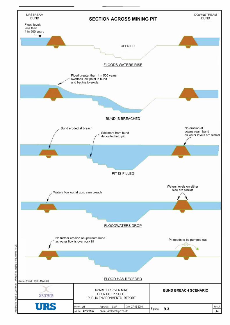
McArthur River Mine Open Cut Project Public Environmental Report Section 9 Surface Water - Flood Protection Bund 9-1 9 Surface Water - Flood Protection Bund 9.0 Surface Water - Flood Protection Bund 9.1 Summary This section provides the results of an analysis of the stability and integrity of the flood protection bund. The bund has been designed as water storage dam in accordance with the Australian Committee on Large Dams (ANCOLD, 1999) requirements and has been based on extensive geotechnical site investigations and recent site experience with the Test Pit bund. The external and internal faces of the bund will be rock- filled with NAF rock to protect its internal clay core against erosion, and to provide geotechnical stability. The bund will be high enough to protect the mine pit from a 1 in 500-year ARI flood event. The design has considered all relevant aspects that could affect the bund’s stability including erosion, seepage, internal failure, and liquefaction. Stability analysis has shown that the bund will have a factor of safety that complies with best practice engineering design, and demonstrates that it will be stable in the short term and long term during flood events in both the McArthur River and Barney Creek. The risk that the flood protection bund will be overtopped by a flood event larger than the 1 in 500-year ARI design event has been calculated as 0.2% during the first two years of operation and 1.2% during the subsequent 23 years of operation. Although this risk is extremely low and is acceptable to MRM, the likely impact of embankment overtopping has been considered. The bund has been designed to include an emergency overflow section which, if overtopping occurs, would erode in a small area in a controlled manner and at a pre-determined rate. The eroded material would flow into the mine pit. In this way the vast majority of the bund would remain intact, and there would be minimal discharge of eroded material downstream in the McArthur River. 9.2 Flood Bund Integrity 9.2.1 Introduction The flood protection bund will be constructed around the open cut to protect the working areas and associated infrastructure from inundation during flood events. The alignment of the flood protection bund has been selected to provide maximum opportunity for the future development of the McArthur River deposit as well as taking greatest advantage of the natural topography to minimise earthworks. In addition, the alignment has been selected to provide adequate separation between the proposed diversion channels and the bund, and to maintain regulatory separation between the bund crest and the flight path for the McArthur River airstrip as defined by the Civil Aviation Safety Authority. Although the flood protection bund will be required to prevent flooding of the open cut for only a short period of time each year, the standards adopted for its design are those which would normally be adopted
Transcript
McArthur River Mine
Open Cut Project Public Environmental Report
Section 9
Surface Water - Flood Protection
Bund
9-1
9 Surface Water - Flood Protection Bund
9.0 Surface Water - Flood Protection Bund
9.1 Summary
This section provides the results of an analysis of the stability and integrity of the flood protection bund.
The bund has been designed as water storage dam in accordance with the Australian Committee on Large
Dams (ANCOLD, 1999) requirements and has been based on extensive geotechnical site investigations
and recent site experience with the Test Pit bund. The external and internal faces of the bund will be rock-
filled with NAF rock to protect its internal clay core against erosion, and to provide geotechnical stability.
The bund will be high enough to protect the mine pit from a 1 in 500-year ARI flood event.
The design has considered all relevant aspects that could affect the bund’s stability including erosion,
seepage, internal failure, and liquefaction. Stability analysis has shown that the bund will have a factor of
safety that complies with best practice engineering design, and demonstrates that it will be stable in the
short term and long term during flood events in both the McArthur River and Barney Creek.
The risk that the flood protection bund will be overtopped by a flood event larger than the 1 in 500-year
ARI design event has been calculated as 0.2% during the first two years of operation and 1.2% during the
subsequent 23 years of operation. Although this risk is extremely low and is acceptable to MRM, the
likely impact of embankment overtopping has been considered.
The bund has been designed to include an emergency overflow section which, if overtopping occurs,
would erode in a small area in a controlled manner and at a pre-determined rate. The eroded material
would flow into the mine pit. In this way the vast majority of the bund would remain intact, and there
would be minimal discharge of eroded material downstream in the McArthur River.
9.2 Flood Bund Integrity
9.2.1 Introduction
The flood protection bund will be constructed around the open cut to protect the working areas and
associated infrastructure from inundation during flood events. The alignment of the flood protection bund
has been selected to provide maximum opportunity for the future development of the McArthur River
deposit as well as taking greatest advantage of the natural topography to minimise earthworks.
In addition, the alignment has been selected to provide adequate separation between the proposed
diversion channels and the bund, and to maintain regulatory separation between the bund crest and the
flight path for the McArthur River airstrip as defined by the Civil Aviation Safety Authority.
Although the flood protection bund will be required to prevent flooding of the open cut for only a short
period of time each year, the standards adopted for its design are those which would normally be adopted
McArthur River Mine
Open Cut Project Public Environmental Report
Section 9
Surface Water - Flood Protection
Bund
9-2
for the design of a water retaining structure that would be required to permanently contain water. These
standards are provided in guidelines published by ANCOLD (1999).
Engineering design of the flood protection bund has been undertaken on behalf of MRM by Brisbane
based consultants Kellog Brown & Root Pty Ltd (KBR) and geotechnical consultants Golder Associates.
KBR has undertaken the necessary design and have prepared drawings and technical specifications for
construction. The Design Basis Report and Technical Specification for the McArthur River Mine
Expansion civil works, including the flood protection bund, are included in Appendix B.
9.2.2 Design Basis
The design of the flood protection bund has been based on:
Foundation investigations undertaken for the flood protection bund and diversions
Experience with the construction of the Test Pit bund
ANCOLD guidelines on the design and construction of water storage dams.
A comprehensive geotechnical investigation of the flood protection bund footprint, and the proposed
construction materials to be sourced from the excavations for the McArthur River and Barney Creek
diversions, was undertaken by independent specialist geotechnical consultants Golder Associates.
The investigations were undertaken in accordance with Australian Standard AS1726-1993 (Geotechnical
Site Investigations) and consisted of the following:
31 drill holes at approximately 250 m centres along the bund centreline, supplemented by a number
of groundwater monitoring bores and probe holes;
Seismic refraction traverses (total 2,790 m length) along selected areas of the bund centreline
10 drill holes, 16 test pits and 4,330 m of seismic refraction traverses along the McArthur River
realignment
6 drill holes, 10 test pits and 2,330 m of seismic refraction traverses along the Barney Creek
realignment.
The investigations provided information on the strength and permeability of the foundations for the flood
protection bund and the quantity and quality (strength and permeability) of materials for the bund
construction. The results of this investigation are provided in Golder Associates (2004).
The Test Pit flood protection bund was constructed in August and September 2005 to provide flood
immunity for the 6 ha test pit at McArthur River Mine. The bund was constructed with earth-fill sourced
from overburden from the Test Pit.
The bund was built to a crest level of RL38 (6 m below the top of the proposed flood protection bund for
the Open Cut Project) and with a maximum height of 15 m. The outer face (McArthur River side) of the
bund was protected by a layer of rock sourced from the Test Pit.
McArthur River Mine
Open Cut Project Public Environmental Report
Section 9
Surface Water - Flood Protection
Bund
9-3
The construction of the Test Pit bund confirmed the practicality of providing a key trench beneath the
bund, together with moisture conditioning and compacting the natural clayey materials to the specified
density.
During the 2005/2006 wet season, the McArthur River rose to within approximately 5 m of the crest of
the Test Pit bund (Plate 9.1). No erosion was observed on the outer slopes of the bund, nor was there any
under-seepage beneath the bund into the pit.
Only minor rill erosion of the unprotected inside earth-fill batter occurred as a result of runoff and
incident rainfall (Plate 9.2) during the wet season. This type of erosion can be readily repaired as
necessary. However, for the Open Cut Project bund, it is proposed that both the inner and outer walls
would be protected by rock armour. This is discussed further in Section 9.2.4.
Plate 9.1
Outer Face of Test Pit During 2005/2006 Wet Season
McArthur River Mine
Open Cut Project Public Environmental Report
Section 9
Surface Water - Flood Protection
Bund
9-4
Plate 9.2
Minor Rilling of Inner Face of Test Pit Bund at End of 2005/2006 Wet Season
9.2.3 Construction Program
Subject to project approval, construction of the flood protection bund is proposed to commence in the
second half of 2006 and continue through to 2009.
It is proposed to construct a zoned-fill water-retaining bund during the 2006 and 2007 dry seasons. The
bund, designed to ANCOLD standards, would comprise an inner clay earth-fill zone to provide a low
permeability barrier to seepage, and an outer rock-fill zone to provide protection against erosion and
scouring of floodwaters and stability as the floodwater recedes. A typical cross section of the bund is
shown in Figure 9.1 (Initial Construction).
Clay earth-fill and rock-fill used for this part of the bund construction would be sourced from the
McArthur River and Barney Creek diversions. The materials zoning proposed for the bund maximises
the use of the materials that will be extracted from the diversions of Barney Creek and the McArthur
River. Sandy alluvium from the diversions that is not suitable for use in the flood protection bund will be
placed as a weighting zone (for added stability) on the downstream side of the river sections of the bund.
Construction of the flood protection bund has been staged to allow the following goals to be met:
Continued mining of the Test Pit Southern Extension and operation of the processing plant
Efficient use of materials from the diversion channels and the Test Pit Southern Extension
INITIAL CONSTRUCTION
FINAL ARRANGEMENT
9.1
FLOOD PROTECTION BUND
A4
A
42625552
27-06-2006
42625552-g-178.cdr
VH
McARTHUR RIVER MINEOPEN CUT PROJECT
PUBLIC ENVIRONMENTAL REPORT
CMP
Source: Connell HATCH, May 2006 NOT TO SCALE
Rev.Drawn: Approved:
File No.
Date:
Job No.:Figure:
Thi
sdr
awin
gis
subj
ect t
oC
OP
YR
IGH
T.It
rem
ains
the
prop
erty
ofU
RS
Aus
tral
iaP
tyLt
d.
McArthur River Mine
Open Cut Project Public Environmental Report
Section 9
Surface Water - Flood Protection
Bund
9-5
Optimisation of haul distances and construction equipment usage
Passage of normal flood flows without erosion of the partially completed bunds and diversions.
The extent of construction proposed during the 2006 and 2007 dry seasons is shown on Drawing
BEE508-C-DWG-005 in Appendix B. During the 2006 dry season, it is proposed to construct the flood
protection bund to its full height between chainages 0-1800, 3200-6000 and 6800-7450. During the 2007
dry season, the remainder of the bund will be constructed using earth-fill and rock-fill sourced from the
remainder of the McArthur River diversion.
Commencing during the 2007 dry season and continuing through to 2009, NAF materials from the Test
Pit Southern Extension and then from the open cut, will be placed against the inner and outer slopes of the
initial flood protection bund to flatten the overall batter slopes from 50% (1V:2H) to 25% (1V:4H).
The flatter outer slopes of the bund will increase the long-term stability of the embankment, and will
allow immediate and progressive rehabilitation by topsoil and seeding. In addition to flattening the
batters, the NAF will also be used to raise the crest of the flood protection bund by 1 m thereby providing
greater protection against flooding. The final arrangement of the flood protection bund is shown on
Figure 9.1.
During 2006, the flood protection bund between chainage 0-1800 may be constructed to the final
arrangement (1V:4H batters) to maximise material won from the Barney Creek diversion. If this is the
case, the bund will be constructed with compacted earth-fill and a protective layer of rock armour will be
placed over the outer wall of the bund.
9.2.4 Design Considerations
To ensure both the long-term and short-term integrity of the flood protection bund, the following aspects
of the bund design were considered:
Crest level
Stability
Liquefaction of sand layers in the bund foundations (from seismic or blasting activity)
Seepage beneath the bund
Internal erosion
Erosion of the outer batters
Erosion of the inner batters
Inspection and monitoring during operation.
A detailed discussion of each of these issues is provided in Golder Associates (2006) which is included in
Appendix B. A summary of the above design issues is provided in the following sections.
McArthur River Mine
Open Cut Project Public Environmental Report
Section 9
Surface Water - Flood Protection
Bund
9-6
Crest Level
The magnitude and frequency of flooding in the McArthur River was determined using flood frequency
procedures detailed in IE Aust (1987) and based on actual flood data for the McArthur River for the
period 1969 to 2003. Inflow from tributary catchments was scaled from the McArthur River data based
on catchment area.
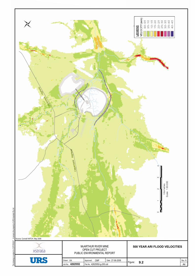
Hydraulic modelling using ‘state of the art’ two-dimensional (2D) hydraulic modelling software,
developed by WL/Delft Hydraulics of the Netherlands, was undertaken by KBR to determine the water
levels for floods in the McArthur River with various return intervals. MRM adopted a flood with a return
interval of 1 in 500-year as the design event for the flood protection bund, as this was considered to
provide an acceptable level of risk for the project.
The crest level of the bund has been set at 0.9 m above the 1 in 500-year ARI flood event for the initial
construction, and 2 m above the design flood event for the final arrangement. Assuming flood level and
wind speed are independent of each other, the probability that the flood protection bund will be
overtopped is 0.2% in the first 2 years of the project and 1.2% over the 25 year life of the project.
Hydraulic modelling using the one-dimensional (1D) hydraulic modelling software HEC-RAS, as
described in Section 5 of this PER, was also undertaken to estimate water levels for flood flows in the
Barney Creek diversion channel, assuming no concurrent flooding in the McArthur River. The HEC-
RAS results, as presented in Appendix F.2, show that a flood in Barney Creek with a return interval of 1
in 500 years would not overtop the flood protection bund.
Stability
The stability of the flood protection bund was determined for critical loading conditions using the slope
stability software program Slope/W. Unlike water storage dams, where water is permanently stored
against the face of the dam, the face of the flood protection bund will be intermittently subject to
inundation during each year as flood waters rise and fall. Seepage forces resulting from this periodic
inundation were determined using the seepage analysis program Seep/W.
The factors of safety (FoS) determined from the analyses, together with the minimum FoS recommended
in ANCOLD guidelines and current best practice, are presented in Table 9.1.