SECTION 9.7: TOWN OF DEWITT DMA 2000 Hazard Mitigation Plan – Onondaga County, New York 9.7-1 December 2011 9.7 TOWN OF DEWITT This section presents the jurisdictional annex for the Town of DeWitt. A.) HAZARD MITIGATION PLAN POINT OF CONTACT Primary Point of Contact Alternate Point of Contact Eugene J. Conway, Chief of Police 5400 Butternut Drive, E. Syracuse, NY 13057 (315) 449-3640 [email protected]Brian Maxwell, Highway Superintendant 5400 Butternut Drive, E. Syracuse, NY 13057 (315) 437-8331 [email protected]B.) TOWN PROFILE Population 24,403 (estimated 2007 U.S. Census) Location The Town of DeWitt is in east-central Onondaga County, immediately east of the City of Syracuse. The town is a suburb of Syracuse. It is also bordered by the Towns of Cicero to the north, Salina and Onondaga to the east, Lafayette and Pompey to the south, and Manlius to the east. The Village of East Syracuse is wholly within the boundaries of DeWitt. The Town is the site of most of the campus and all of the academic buildings of Le Moyne College. The northern portion of the Town is developed with a mixture of industrial, commercial and residential sections; and the central portion of the Town is primarily residential. The southern, hilly portion of the Town is generally mixed forests and fields with limited residential development and stone quarry operation. The major streams in the Town are Ley Creek and Butternut Creek. Interstate 481 is the major highway in DeWitt crossing the center of the Town, turning northward along the east side of DeWitt. I-481 intersects Interstate 690 in the eastern part of the Town and Interstate 90 (New York State Thruway) in the northern part of the Town. New York State Route 92 conjoined with New York State Route 5 intersects I-481 in the east part of DeWitt. New York State Route 91 has its northern terminus at New York State Route 173, which crosses the southern part of the Town, at Jamesville. New York State Route 298 crosses the north part of the Town while New York State Route 290 crosses the middle portion of the Town. Other state routes of note include New York State Route 598 in the extreme northwest portion of Town and New York State Route 635 which straddles the western Town boundary with the city of Syracuse. According to the U.S. Census Bureau, the Town has a total area of 33.9 square miles (87.8 km²), with 33.8 square miles (87.7 km²) of it land and 0.1 square miles (0.1 km²) of it (0.15-percent) water. Climate Onondaga County generally experiences seasonable weather patterns characteristic of the northeastern U.S. Cyclonic systems and cold air masses affect the County’s weather, making winters cold with snow. During the summer and parts of spring and autumn, temperatures rise during the daytime and fall rapidly after sunset. Summer temperatures typically range from about 76°F to 81°F (Fahrenheit). Winter high temperatures are usually in the middle to upper 30°F, with minimum temperatures of 14°F expected.
Transcript
SECTION 9.7: TOWN OF DEWITT
DMA 2000 Hazard Mitigation Plan – Onondaga County, New York 9.7-1 December 2011
9.7 TOWN OF DEWITT
This section presents the jurisdictional annex for the Town of DeWitt.
A.) HAZARD MITIGATION PLAN POINT OF CONTACT
Primary Point of Contact Alternate Point of Contact
Eugene J. Conway, Chief of Police 5400 Butternut Drive, E. Syracuse, NY 13057 (315) 449-3640 [email protected]
Brian Maxwell, Highway Superintendant 5400 Butternut Drive, E. Syracuse, NY 13057 (315) 437-8331 [email protected]
B.) TOWN PROFILE Population 24,403 (estimated 2007 U.S. Census) Location The Town of DeWitt is in east-central Onondaga County, immediately east of the City of Syracuse. The town is a suburb of Syracuse. It is also bordered by the Towns of Cicero to the north, Salina and Onondaga to the east, Lafayette and Pompey to the south, and Manlius to the east. The Village of East Syracuse is wholly within the boundaries of DeWitt. The Town is the site of most of the campus and all of the academic buildings of Le Moyne College. The northern portion of the Town is developed with a mixture of industrial, commercial and residential sections; and the central portion of the Town is primarily residential. The southern, hilly portion of the Town is generally mixed forests and fields with limited residential development and stone quarry operation. The major streams in the Town are Ley Creek and Butternut Creek. Interstate 481 is the major highway in DeWitt crossing the center of the Town, turning northward along the east side of DeWitt. I-481 intersects Interstate 690 in the eastern part of the Town and Interstate 90 (New York State Thruway) in the northern part of the Town. New York State Route 92 conjoined with New York State Route 5 intersects I-481 in the east part of DeWitt. New York State Route 91 has its northern terminus at New York State Route 173, which crosses the southern part of the Town, at Jamesville. New York State Route 298 crosses the north part of the Town while New York State Route 290 crosses the middle portion of the Town. Other state routes of note include New York State Route 598 in the extreme northwest portion of Town and New York State Route 635 which straddles the western Town boundary with the city of Syracuse. According to the U.S. Census Bureau, the Town has a total area of 33.9 square miles (87.8 km²), with 33.8 square miles (87.7 km²) of it land and 0.1 square miles (0.1 km²) of it (0.15-percent) water. Climate Onondaga County generally experiences seasonable weather patterns characteristic of the northeastern U.S. Cyclonic systems and cold air masses affect the County’s weather, making winters cold with snow. During the summer and parts of spring and autumn, temperatures rise during the daytime and fall rapidly after sunset. Summer temperatures typically range from about 76°F to 81°F (Fahrenheit). Winter high temperatures are usually in the middle to upper 30°F, with minimum temperatures of 14°F expected.
SECTION 9.7: TOWN OF DEWITT
DMA 2000 Hazard Mitigation Plan – Onondaga County, New York 9.7-2 December 2011
Overall, the average high temperature for the County is approximately 57°F and the average low temperature is approximately 37°F. Snow accumulates to an average depth of 121 inches each year. Brief History
DeWitt’s history dates to the Revolutionary War when soldiers were offered 500 acres of virgin land in exchange for three years of military service. DeWitt was created in 1835 by the division of Manlius. The name honors Major Moses DeWitt, judge and soldier. DeWitt’s growth reflects the adventurous spirit of the industrial revolution. The Erie Canal opening in 1825 was followed closely by railroad construction through East Syracuse in 1839. Together these events populated the Town of DeWitt with over 2,800 residents as people and commerce moved west. The Syracuse and Utica Railroad became the major east/west transportation route. In northern DeWitt the New York Central Railroad bought land in 1872 for its rail yards in what would become the incorporated Village of East Syracuse. The earliest pioneers settled three hamlets: Morehouse Flats – above the present day hamlet of Jamesville; Youngsville – later to be named Orville and now central DeWitt; and Britton’s Settlement at the present day Collamer hamlet. Expansive residential growth followed both world wars, with DeWitt’s population peaking in 1970 at 29,000 people.
Governing Body Format The Town of DeWitt is governed by a supervisor and five councilors. Growth/Development Trends According to the Syracuse-Onondaga County Planning Agency, as of 2009, the Town of DeWitt will be either in the process of completing or will be in the process of planning to build one residential subdivision, Steinway Heights with 8 lots. The location is provided in the hazard area map at the end of this annex.
C.) NATURAL HAZARD EVENT HISTORY SPECIFIC TO THE TOWN
Type of Event
FEMA Disaster #
(if applicable) Date Preliminary Damage Assessment
Snowstorm / Extreme Cold Not applicable February, 1961 $80,000 (countywide)
Flood Not applicable July, 1970 $250,000 (countywide)
Snowstorm Not applicable March, 1971 $806,000 (countywide)
Snowstorm / Extreme cold Not applicable February, 1972 $803,000 (countywide)
Flood Not applicable March, 1973 $200,000 (countywide)
Snowstorm Not applicable December, 1973 $83,000 (countywide)
Severe Storms and Flooding DR-447 July, 1974 $7,200,000 (countywide)
Severe Storms, Heavy Rain, Landslides, Flooding
DR-487 September, 1975 $6,300,000 (countywide)
Flood Not applicable April, 1976 $313,000 (countywide)
Blizzard Not applicable January, 1977 $2,100,000 (countywide)
Flood Not applicable October, 1981 $833,000 (countywide)
Tornado (F3) Not applicable May, 1983 $2,500,000 (countywide)
SECTION 9.7: TOWN OF DEWITT
DMA 2000 Hazard Mitigation Plan – Onondaga County, New York 9.7-3 December 2011
Type of Event
FEMA Disaster #
(if applicable) Date Preliminary Damage Assessment
Snowstorm Not applicable February, 1984 $156,000 (countywide)
Tornado (F1) Not applicable July, 1986 $250,000 (countywide)
Blizzard and Extreme Cold EM-3107 March, 1993 $455,000 (countywide)
Snowstorm Not applicable April, 1993 $100,000 (countywide)
Thunderstorm / Winds Not applicable August, 1993 $600,000 (countywide)
Severe Storm and Flooding DR-1095 January, 1996 $7,600,000 (countywide)
Flood Not applicable November, 1996 $100,000 (countywide)
Thunderstorm / Winds / Tornado
Not applicable May, 1998 $200,000 (countywide)
Thunderstorm / Winds Not applicable August, 1998 $200,000 (countywide)
Severe Storm DR-1244 September, 1998 $90,000,000, 3 fatalities, 7 injuries
(countywide)
Thunderstorm / Winds Not applicable July, 1999 $750,000 (countywide)
Severe Storms DR-1335 May/September, 2000 Not available
Snowstorms Not applicable December, 2002 /
January, 2003 $353,000 (countywide)
Flood Not applicable June, 2002 $2,000,000 (countywide)
Snowstorm (President’s Day Storm)
Not applicable February, 2003 $153,000 (countywide)
Ice Storm DR-1467 April, 2003 $2,900,000 (countywide)
Severe Storms and Flooding DR-1564 August / September
2004 $2,000,000 (countywide)
Severe Storm and Flooding Not applicable April, 2005 $100,000 (countywide); road
closures and flooded basements
Flood Not applicable July, 2005 $500,000 (countywide)
Severe Storms and Flooding Not applicable June/July, 2006 $29,000 (countywide); the basement of over 100 homes in the Town were
inundated
Lake Effect Snowstorm / Extreme Cold
Not applicable February, 2007 $3,000,000 (countywide)
Number of FEMA Identified Repetitive Flood Loss Properties: 5 Number of FEMA Identified Severe Repetitive Flood Loss Properties: 1 Source: FEMA Region II, 2009 Note: Repetitive loss and severe repetitive loss data as of February 2009.
SECTION 9.7: TOWN OF DEWITT
DMA 2000 Hazard Mitigation Plan – Onondaga County, New York 9.7-4 December 2011
D.) NATURAL HAZARD RISK/VULNERABILITY RISK RANKING
Rank # Hazard type
Estimate of Potential Dollar Losses to Structures
Vulnerable to the Hazard a,c
Probability of Occurrence
Risk Ranking Score (Probability x
Impact) Hazard
Ranking b
3 Earthquake $157,501,393 c,e Rare 16 Low
2 Flood $121,019,000 c,e Frequent 36 Medium
4 Ground Failure Not available f Rare 6 Low
1 Severe Storm $0 c,d,g Frequent 48 High
1 Severe Winter
Storm $155,639,550 c,d Frequent 48 High
a. Building damage ratio estimates based on FEMA 386-2 (August 2001) b. High = Total hazard priority risk ranking score of 40 and above Medium = Total hazard priority risk ranking of 20 - 39 Low = Total hazard risk ranking below 20 c. The valuation of general building stock and loss estimates determined in Onondaga County were based on the default
general building stock database provided in HAZUS-MH MR3 (RSMeans 2006). d. Severe storm and severe winter storm hazard 500-year MRP loss estimate is structural value only; does not include the
value of contents. For severe winter storm, the loss estimate is 5% of total general building stock value. e. Loss estimates for both structure and contents (500-year MRP for the flood hazard and 2,500-year MRP for the
earthquake hazard). f. Approximately 31% of the Town's general building stock is located within the landslide hazard area. g. Potential losses for severe storm are underestimated by HAZUS.
E.) CAPABILITY ASSESSMENT This section identifies the following capabilities of the local jurisdiction:
Legal and regulatory capability
Administrative and technical capability
Fiscal capability
Community classification.
SECTION 9.7: TOWN OF DEWITT
DMA 2000 Hazard Mitigation Plan – Onondaga County, New York 9.7-5 December 2011
E.1) Legal and Regulatory Capability
Regulatory Tools (Codes, Ordinances., Plans)
Lo
cal
Au
tho
rity
(Y
or
N)
Pro
hib
itio
ns
(Sta
te o
r F
eder
al)
(Y o
r N
)
Hig
her
Ju
risd
icti
on
al
Au
tho
rity
(Y
or
N)
Sta
te
Man
dat
ed
(Y o
r N
)
Code Citation
(Section, Paragraph, Page Number, date of adoption)
1) Building Code Y N Y Y New York State Building Code, Ch. 94 – 7/15/07
2) Zoning Ordinance Y N N N Ch. 192, Adopted: 12/10/07
3) Subdivision Ordinance Y N N N Ch. 164, Adopted: 10/25/04
4) NFIP Flood Damage Prevention Ordinance
Y Y Y Y Ch. 100, Adopted: 3/23/87
5) Growth Management Y N N N Ch. 3 DeWitt Comprehensive Plan 2002
6) Floodplain Management / Basin Plan
N Y Y N
7) Stormwater Management Plan/Ordinance
Y N N Y Ch. 160, Adopted: 10/22/07
8) Comprehensive Plan / Master Plan/ General Plan
Y N N N Town of DeWitt Comprehensive Plan, 2002
9) Capital Improvements Plan N N N N
10) Site Plan Review Requirements
Y Y Y N Ch. 192, Adopted: 12/10/07
11) Open Space Plan Y N N N Ch. 4 DeWitt Comprehensive Plan 2002
12) Economic Development Plan N N N N
13) Emergency Response Plan Y N N Y Police Department Operations Manual
14) Post Disaster Recovery Plan N N N N
15) Post Disaster Recovery Ordinance
N N N N
16) Real Estate Disclosure req. N N Y N
17) Other [Special Purpose Ordinances (i.e., critical or sensitive areas)]
N N N N
SECTION 9.7: TOWN OF DEWITT
DMA 2000 Hazard Mitigation Plan – Onondaga County, New York 9.7-6 December 2011
E.2) Administrative and Technical Capability
Staff/ Personnel Resources
Ava
ilab
le
(Y o
r N
)
Department/ Agency/Position
1) Planner(s) or Engineer(s) with knowledge of land development and land management practices
Y Town of DeWitt Planning Board Town of DeWitt Dept. of Development & Operations O’Brien & Gere Engineers
2) Engineer(s) or Professional(s) trained in construction practices related to buildings and/or infrastructure
Y Town of DeWitt Dept. of Development & Operations O’Brien & Gere Engineers
3) Planners or engineers with an understanding of natural hazards
Y Town of DeWitt Dept. of Development & Operations O’Brien & Gere Engineers
4) NFIP Floodplain Administrator Y Richard T. Robb, Commissioner of Building, Planning and Zoning
5) Surveyor(s) Y O’Brien & Gere Engineers
6) Personnel skilled or trained in “GIS” applications Y O’Brien & Gere Engineers
7) Scientist familiar with natural hazards in the Town of Ashland.
Y O’Brien & Gere Engineers
8) Emergency Manager Y Chief of Police
9) Grant Writer(s) Y Kim Bau, Director of Parks & Recreation Ed Mickarenko, Supervisor
10) Staff with expertise or training in benefit/cost analysis
Y Comptroller O’Brien & Gere Engineers
E.3) Fiscal Capability
Financial Resources Accessible or Eligible to use (Yes/No/Don’t
know)
1) Community development Block Grants (CDBG) Yes, Certain Parts of Town Used Many Times
2) Capital Improvements Project Funding Yes, Used many Times Through Special
Districts
3) Authority to Levy Taxes for specific purposes Yes
4) User fees for water, sewer, gas or electric service Yes
5) Impact Fees for homebuyers or developers of new development/homes
No
6) Incur debt through general obligation bonds Yes
7) Incur debt through special tax bonds Yes, Special Improvement Districts
8) Incur debt through private activity bonds No
9) Withhold public expenditures in hazard-prone areas No
10) State mitigation grant programs (e.g. NYSDEC, NYCDEP) No
11) Other Member Items – NYS Elected Officials
SECTION 9.7: TOWN OF DEWITT
DMA 2000 Hazard Mitigation Plan – Onondaga County, New York 9.7-7 December 2011
E.4) Community Classifications
Program Classification Date Classified
Community Rating System (CRS) NP N/A
Building Code Effectiveness Grading Schedule (BCEGS) --- ---
Public Protection --- ---
Storm Ready NP N/A
Firewise NP N/A
N/A = Not applicable. NP = Not participating. - = Unavailable. The classifications listed above relate to the community’s effectiveness in providing services that may impact it’s vulnerability to the natural hazards identified. These classifications can be viewed as a gauge of the community’s capabilities in all phases of emergency management (preparedness, response, recovery and mitigation) and are used as an underwriting parameter for determining the costs of various forms of insurance. The CRS class applies to flood insurance while the BCEGS and Public Protection classifications apply to standard property insurance. CRS classifications range on a scale of 1 to 10 with class one (1) being the best possible classification, and class 10 representing no classification benefit. Firewise classifications include a higher classification when the subject property is located beyond 1000 feet of a creditable fire hydrant and is within 5 road miles of a recognized Fire Station.
Criteria for classification credits are outlined in the following documents:
The Community Rating System Coordinators Manual
The Building Code Effectiveness Grading Schedule
The ISO Mitigation online ISO’s Public Protection website at http://www.isomitigation.com/ppc/0000/ppc0001.html
The National Weather Service Storm Ready website at http://www.weather.gov/stormready/howto.htm
The National Firewise Communities website at http://firewise.org/
SECTION 9.7: TOWN OF DEWITT
DMA 2000 Hazard Mitigation Plan – Onondaga County, New York 9.7-8 December 2011
F.) PROPOSED HAZARD MITIGATION INITIATIVES
In
itia
tive
#
Mitigation Initiative
Applies to New and/or
Existing Structures* H
azar
d(s
) M
itig
ated
Go
als
/ O
bje
ctiv
es
Met
Lea
d
Ag
ency
Est
imat
ed
Co
st
Sources of Funding
Tim
e-lin
e
TDW-0
Conduct and facilitate community and public education and outreach for residents and businesses to include, but not be limited to, the following to promote and effect natural hazard risk reduction:
Provide and maintain links to the Onondaga County HMP website, and regularly post notices on the municipal homepage referencing the Onondaga County HMP webpages.
Prepare and distribute informational letters to flood vulnerable property owners and neighborhood associations, explaining the availability of mitigation grant funding to mitigate their properties, and instructing them on how they can learn more and implement mitigation.
Use the village email notification systems and newsletters to better educate the public on flood insurance, the availability of mitigation grant funding, and personal natural hazard risk reduction measures.
Work with neighborhood associations, civic and business groups to disseminate information on flood insurance and the availability of mitigation grant funding.
Municipal outreach activities to be supported by the County, as identified at County initiative OC-0.
See above. N/A All Hazards All Goals
Municipal officials and floodplain
administrators supported by the County (through
SOCPA and EM)
Low
County and Municipal Budgets; grant eligible for a defined outreach
program
Short
TDW-1a
Where appropriate, support retrofitting of structures located in hazard-prone areas to protect structures from future damage, with repetitive loss and severe repetitive loss properties as priority. Identify facilities that are viable candidates for retrofitting based on cost-effectiveness versus relocation. Where retrofitting is determined to be a viable option, consider implementation of that action
Existing Flood, Severe Storm
1-1, 1-2, 1-6; 2-5, 2-6; 3-2, 3-5; 6-1
Municipality (likely through
NFIP Floodplain
Administrator)
High FEMA Mitigation
Grant Programs and local match
Long-term
SECTION 9.7: TOWN OF DEWITT
DMA 2000 Hazard Mitigation Plan – Onondaga County, New York 9.7-9 December 2011
In
itia
tive
#
Mitigation Initiative
Applies to New and/or
Existing Structures* H
azar
d(s
) M
itig
ated
Go
als
/ O
bje
ctiv
es
Met
Lea
d
Ag
ency
Est
imat
ed
Co
st
Sources of Funding
Tim
e-lin
e
based on available funding.
TDW-1b
Where appropriate, support purchase, or relocation of structures located in hazard-prone areas to protect structures from future damage, with repetitive loss and severe repetitive loss properties as priority. Identify facilities that are viable candidates for relocation based on cost-effectiveness versus retrofitting. Where relocation is determined to be a viable option, consider implementation of that action based on available funding.
Existing Flood, Severe Storm
1-1, 1-2, 1-6; 2-5, 2-6; 3-2, 3-5; 6-1
Municipality (likely through
NFIP Floodplain
Administrator)
High FEMA Mitigation
Grant Programs and local match
Long-term
TDW-2
Begin the process to apply to participate in the Community Rating System (CRS) to further manage flood risk and reduce flood insurance premiums for NFIP policyholders. This shall start with the submission to FEMA-DHS of a Letter of Intent to join CRS, followed by the completion and submission of an application to the program once the community’s current compliance with the NFIP is established.
NA Flood, Severe Storms
1-1, 1-3, 1-7; Goal
2 – All Objectives
NFIP Floodplain
Administrator with support
from NYSDEC,
SOEM, FEMA
Low Municipal Budget Short (year 1)
TDW-3
Continue to support the implementation, monitoring, maintenance, and updating of this Plan, as defined in Section 7.0
New & Existing
All Hazards All Goals
and Objectives
Municipality (through mitigation
planning point of contacts)
Low
Local Budget, possibly FEMA Mitigation Grant
Funding for 5-year update
Ongoing
TDW- Maintain compliance with and New & Flood 2-4; 3-5, Municipality Low Local Budget Ongoing
SECTION 9.7: TOWN OF DEWITT
DMA 2000 Hazard Mitigation Plan – Onondaga County, New York 9.7-10 December 2011
In
itia
tive
#
Mitigation Initiative
Applies to New and/or
Existing Structures* H
azar
d(s
) M
itig
ated
Go
als
/ O
bje
ctiv
es
Met
Lea
d
Ag
ency
Est
imat
ed
Co
st
Sources of Funding
Tim
e-lin
e
4 good-standing in the NFIP including adoption and enforcement of floodplain management requirements (e.g. regulating all new and substantially improved construction in Special Hazard Flood Areas), floodplain identification and mapping, and flood insurance outreach to the community. Further meet and/or exceed the minimum NFIP standards and criteria through the following NFIP-related continued compliance actions identified as Initiatives TDW-0, 1a, 1b, 2, and 8 through 27.
Existing 3-6 (likely through NFIP
Floodplain Administrator)
TDW-5
Continue to develop, enhance, and implement existing emergency plans.
New & Existing
All Hazards
1-4; 5-5; Goal 6 –
All Objectives
Municipal Emergency
Manager with support from County OEM and SEMO
Low - Medium
Local Budget Ongoing
TDW-6
Create/enhance/ maintain mutual aid agreements with neighboring communities.
New & Existing
All Hazards
3-3; 5-2, 5-3, 5-5, 5-6; 6-5,
6-6
Local Emergency
Management, DPW and
Roads
Low - Medium
Local Budget Ongoing
TDW-7
Support County-wide initiatives identified in Section 9.1 of the County Annex.
New & Existing
All Hazards All Goals
and objectives
Local departments
(as applicable for specific initiative)
Low - High Existing programs and grant funding where applicable
Ongoing – Long-term depending
on initiative
TDW-8
Support/Participate in the Stream Team program offered by the Onondaga County
N/A Flood, Severe Storms
1-3, 1-7; 2-3; 4-1,4-4; 5-1, 5-
County, OCSWCD
(Mark Burger) Medium Local Budget Short-term
SECTION 9.7: TOWN OF DEWITT
DMA 2000 Hazard Mitigation Plan – Onondaga County, New York 9.7-11 December 2011
In
itia
tive
#
Mitigation Initiative
Applies to New and/or
Existing Structures* H
azar
d(s
) M
itig
ated
Go
als
/ O
bje
ctiv
es
Met
Lea
d
Ag
ency
Est
imat
ed
Co
st
Sources of Funding
Tim
e-lin
e
SWCD, to assist in the removal of debris, log jams, etc. in flood vulnerable stream sections.
2, 5-3
TDW-9
Investigate and implement acquisition/purchase/moving residential homes in the Franklin Park/DunRovin area that experience frequent flooding (high risk areas); this may include but is not limited to participating in homeowner partnership programs.
Existing Flood, Severe Storms
1-1, 1-6; 2-1, 2-5, 2-6; 3-8;
5-1
Municipality; homeowners
Low – High Municipality;
Homeowners; FEMA HMP grants
DOF
TDW-10
Investigate and implement a Ley Creek Drainage Basin flood control project. Ley Creek and Butternut Creek overflow their banks during heavy rain-fall events.
New & Existing
Flood, Severe Storms
1-3; 4-1; 5-1, 5-2, 5-3, 5-4
Municipality Low – High Municipality; FEMA
HMP grants DOF
TDW-11
Address flooding along Butternut Drive that has damaged structures and infrastructures (property damage, business closures).
New & Existing
Flood, Severe Storms
1-1, 1-3, 1-6; 3-2, 2-5; 3-8; 5-1, 5-4
Municipality Low – High Municipality; FEMA
HMP grants DOF
TDW-12
Address flooding and stream-bank erosion along Meadowbrook Creek.
New & Existing
Flood, Severe Storms
1-3; 3-8; 4-1, 4-4,
4-5 Municipality Low – High
Municipality; FEMA HMP grants
DOF
TDW-13
As identified in the 2006 Beartrap-Ley Creek Drainage District Study, the confluence of the Ley Creek North and South Branches, and the nearby Sanders Creek ‘bottleneck’ from Townline Road to the confluence with Ley Creek – North Branch and Ley Creek – South Branch. Support a detailed survey within
N/A Flood, Severe Storms
1-3; 4-1, 4-2
OC Dept of Water
Environment Protection;
Beartrap-Ley Creek
Drainage District; Town
Medium FEMA HMA; OC
and/or local budget DOF
SECTION 9.7: TOWN OF DEWITT
DMA 2000 Hazard Mitigation Plan – Onondaga County, New York 9.7-12 December 2011
In
itia
tive
#
Mitigation Initiative
Applies to New and/or
Existing Structures* H
azar
d(s
) M
itig
ated
Go
als
/ O
bje
ctiv
es
Met
Lea
d
Ag
ency
Est
imat
ed
Co
st
Sources of Funding
Tim
e-lin
e
the area to allow for a more precise determination of the limits of flooding impacts because the Beartrap-Ley Creek Drainage Study (2006) was based on 10-foot contours and the inundation mapping created may be conservative. The Ley Creek Main stem flows through the City of Syracuse and the Towns of Salina and Dewitt.
TDW-14
As identified in the 2006 Beartrap-Ley Creek Drainage District Study, continue to support existing Beartrap-Ley Creek District channel maintenance and inspection programs within Ley Creek – Main Stem to ensure that debris does not accumulate in the watercourse. The Ley Creek Main stem flows through the City of Syracuse and the Towns of Salina and Dewitt.
New & Existing
Flood, Severe Storms
1-2, 1-6; 4-1, 4-2
OC Dept of Water
Environment Protection;
Beartrap-Ley Creek
Drainage District; Town
Low to Medium
County/ District/
Local Budgets Ongoing
TDW-15
As identified in the 2006 Beartrap-Ley Creek Drainage District Study, continue to support existing maintenance and inspection activities of Ley Creek – North Branch and its culverts to ensure they remain clear of debris, structurally sound and operable.
Existing Flood, Severe Storms
1-2, 1-6; 4-1, 4-2;
5-1
OC Dept of Water
Environment Protection;
Beartrap-Ley Creek
Drainage District; Town
Low - Medium
County/ District/
Local Budgets Ongoing
TDW-16
As identified in the 2006 Beartrap-Ley Creek Drainage District Study, support improvement of conveyance
N/A Flood, Severe Storms
4-2, 4-4, 4-5; 5-1
OC Dept of Water
Environment Protection;
Medium FEMA HMA/ District/
County or Local Budgets
DOF
SECTION 9.7: TOWN OF DEWITT
DMA 2000 Hazard Mitigation Plan – Onondaga County, New York 9.7-13 December 2011
In
itia
tive
#
Mitigation Initiative
Applies to New and/or
Existing Structures* H
azar
d(s
) M
itig
ated
Go
als
/ O
bje
ctiv
es
Met
Lea
d
Ag
ency
Est
imat
ed
Co
st
Sources of Funding
Tim
e-lin
e
conditions by removing remaining obstructions from the watercourse where the abandoned CSX Railroad crossing washed out in the July 12, 2005 storm.
Beartrap-Ley Creek
Drainage District; Town
TDW-17
As identified in the 2006 Beartrap-Ley Creek Drainage District Study, support the increase of culvert crossing size and capacity between Thompson Road and CSX Railroad crossing to improve conveyance capacity of the Ley Creek- South Branch watercourse. These improvements would lower upstream water surface elevations and improve flooding conditions. Culvert crossings identified to increase size and capacity include the following crossing locations: 1) Exeter Street; 2) Thompson Road; 3) two private access roads identified in the Beartrap-Ley Creek Drainage District Study; and 4) washed-out abandoned CSX Railroad crossing
Existing Flood, Severe Storms
1-2, 1-6; 4-2, 4-4, 4-5; 5-1
OC Dept of Water
Environment Protection;
Beartrap-Ley Creek
Drainage District; Town
High to Medium
FEMA HMA/ District/ County or Local
Budgets DOF
TDW-18
As identified in the 2006 Beartrap-Ley Creek Drainage District Study, support continue existing maintenance and inspection activities of Ley Creek-South Branch and its culverts to ensure they remain clear of debris, structurally sound and operable.
Existing Flood, Severe Storms
1-2, 1-6; 5-1
OC Dept of Water
Environment Protection;
Beartrap-Ley Creek
Drainage District; Town
Low - Medium
County/ District/
Local Budgets Ongoing
SECTION 9.7: TOWN OF DEWITT
DMA 2000 Hazard Mitigation Plan – Onondaga County, New York 9.7-14 December 2011
In
itia
tive
#
Mitigation Initiative
Applies to New and/or
Existing Structures* H
azar
d(s
) M
itig
ated
Go
als
/ O
bje
ctiv
es
Met
Lea
d
Ag
ency
Est
imat
ed
Co
st
Sources of Funding
Tim
e-lin
e
TDW-19
As identified in the 2006 Beartrap-Ley Creek Drainage District Study, support the increase the culvert capacity and modify channels upstream and downstream of culvert improvements at five locations to decrease surface water elevation in the upper reaches of Sanders Creek, extending to the Franklin Park neighborhood, to alleviate flooding: 1) three private access roads; 2) grassed non-vehicular crossing; and 3) private parking lot. Specific locations on map included in Beartrap-Ley Creek District Drainage Study (2006).
Existing Flood, Severe Storms
1-2, 1-6; 4-2; 5-1
OC Dept of Water
Environment Protection;
Beartrap-Ley Creek
Drainage District; Town
Medium - High
FEMA HMA/ District/ County or Local
Budgets DOF
TDW-20
As identified in the 2006 Beartrap-Ley Creek Drainage District Study, support a more detailed survey of the lower limits of the Sanders Creek at its confluence with Ley Creek-South Branch which are impacted by flooding and have very flat channel overbanks to allow for a more precise determination of the limits of flooding impacts.
N/A Flood, Severe Storms
1-3; 5-1
OC Dept of Water
Environment Protection;
Beartrap-Ley Creek
Drainage District; Town
Medium
FEMA HMA; County/ District/
Local Budgets
DOF
TDW-21
As identified in the 2006 Beartrap-Ley Creek Drainage District Study, continue the support of existing maintenance and inspection activities of Sanders Creek and its culverts to ensure they remain clear of debris, structurally sound and operable.
Existing Flood, Severe Storms
1-2, 1-6; 5-1
OC Dept of Water
Environment Protection;
Beartrap-Ley Creek
Drainage District; Town
Low - Medium
County/ District/
Local Budgets Ongoing
SECTION 9.7: TOWN OF DEWITT
DMA 2000 Hazard Mitigation Plan – Onondaga County, New York 9.7-15 December 2011
In
itia
tive
#
Mitigation Initiative
Applies to New and/or
Existing Structures* H
azar
d(s
) M
itig
ated
Go
als
/ O
bje
ctiv
es
Met
Lea
d
Ag
ency
Est
imat
ed
Co
st
Sources of Funding
Tim
e-lin
e
TDW-22
As identified in the 2006 Beartrap-Ley Creek Drainage District Study, along Teall Brook, widen channel and/or reroute just upstream of the underground piped section at East Hampton Place to increase conveyance capacity of the channel up to the underground section. Two alternatives are summarized in the Beartrap-Ley Creek Drainage District Study (2006) from a 2003 report: 1) Remove the bridge at the north end of the Norwood Park athletic fields near Eastridge Drive and widen the channel throughout the length of Norwood Park area; 2) Reroute and cover the existing channel in the area of the Norwood Park athletic fields and widen the remainder of the channel within the Norwood Park area. The 2006 study indicates these improvements would result in limited reductions in water surface elevation upstream but would still be valid for small storm events (5-year or less) but will not provide adequate conveyance of the design event.
Existing Flood, Severe Storms
1-2, 1-6; 5-1
OC Dept of Water
Environment Protection;
Beartrap-Ley Creek
Drainage District; Town
Low - High
FEMA HMA; County/ District/
Local Budgets
DOF
TDW-23
Conduct/support a more detailed study of the Franklin Park neighborhood (in the Town of Dewitt) and the area surrounding the confluence of Ley Creek – Main Stem, Ley Creek – North
N/A Flood, Severe Storms
1-3; 4-2; 5-1
OC Dept of Water
Environment Protection;
Beartrap-Ley Creek
Low – Medium
(Dependant on
initiative)
FEMA HMA; County/ District/
Local Budgets
DOF
SECTION 9.7: TOWN OF DEWITT
DMA 2000 Hazard Mitigation Plan – Onondaga County, New York 9.7-16 December 2011
In
itia
tive
#
Mitigation Initiative
Applies to New and/or
Existing Structures* H
azar
d(s
) M
itig
ated
Go
als
/ O
bje
ctiv
es
Met
Lea
d
Ag
ency
Est
imat
ed
Co
st
Sources of Funding
Tim
e-lin
e
Branch and Ley Creek – South Branch. According to the Beartrap-Ley Creek Drainage Study (2006), these are two of the most critical areas within the Beartrap-Ley Creek Drainage District and two locations where grade data outside of channel banks can be better defined. A more comprehensive survey within these areas would allow for a more accurate representation of flooding limits and would provide for the development of further improvement opportunities.
Drainage District; Town
TDW-24
The Beartrap-Ley Creek Drainage District is flat and heavily urbanized making the lowest areas extremely vulnerable to rain-event flooding that approach or exceed 5-year storms. Conduct /support a more detailed topographic study in the identified critical areas in the 2006 Beartrap-Ley Creek Drainage District Study to determine which individual properties are most at risk to assist with determining mitigation actions.
N/A Flood, Severe Storms
1-2, 1-3; 5-1
OC Dept of Water
Environment Protection;
Beartrap-Ley Creek
Drainage District; Village
Low-Medium
FEMA HMA; District/County/Local
budgets DOF
TDW-25
Determine if a Community Assistance Visit (CAV) or Community Assistance Contact (CAC) is needed, and schedule if needed.
NA Flood, Severe Storms
All Goals
NFIP Floodplain
Administrator, with support
from NYSDEC,
Low Municipal Budget Short (year 1)
SECTION 9.7: TOWN OF DEWITT
DMA 2000 Hazard Mitigation Plan – Onondaga County, New York 9.7-17 December 2011
In
itia
tive
#
Mitigation Initiative
Applies to New and/or
Existing Structures* H
azar
d(s
) M
itig
ated
Go
als
/ O
bje
ctiv
es
Met
Lea
d
Ag
ency
Est
imat
ed
Co
st
Sources of Funding
Tim
e-lin
e
SOEM, FEMA
TDW-26
Participate in RL/SRL property owner outreach and education activities, provided by FEMA, as initiated and coordinated by the County initiative OC-35, described herein. Within the first year of Plan adoption, request FEMA to conduct a mitigation workshop targeting those communities with significant numbers of flood vulnerable properties and Repetitive Loss/Severe Repetitive Loss (RL/SRL) properties (e.g. Towns of Cicero, DeWitt, Elbridge, Lafayette, Lysander, Manlius; Village of Skaneateles; City of Syracuse). This program should address the specific interests and concerns of these flood vulnerable communities in the County which includes:
Gaining a better understanding of the available mitigation grant programs, including the procedural requirements of a RL/SRL community under this program;
Understanding how flood vulnerable and RL/SRL communities can enhance their efforts to encourage and support property owners to mitigate their properties,
Understanding how flood vulnerable and RL/SRL communities can best leverage existing data, information and studies (e.g. NFIP data) to target specific properties for mitigation, and
Learning what resources are available to conduct/complete Repetitive Loss Area Analyses, and gather critical data (e.g. structure elevations) to screen and move properties through the applicable mitigation grant programs.
The County shall promote this workshop through established groups and forums including the OC SWCD and the ongoing County Hazard Mitigation Planning Committee. Further, the County shall continue to conduct meetings as needed with these flood vulnerable communities, with the support of NYSOEM and FEMA, to assist communities as they work to address their flood vulnerable and RL/RSL properties.
See description above Existing Flood, Severe Storm
1-1; 2-1, 2-5, 2-6; 3-6, 3-7; 5-4, 5-6
Local floodplain
administrator working with
County Hazard
Mitigation Coordinator
L Existing Budgets Short (year 1)
TDW-27
Participate in regional, county and/or state level projects and programs to develop improved structure and facility inventories and hazard datasets to support enhanced risk assessment efforts. Such programs may include developing a detailed inventory of critical facilities based upon FEMA’s Comprehensive Data Management System (CDMS) which could be used for various planning and emergency management purposes including:
Support the performance of enhanced risk and vulnerability assessments for hazards including flooding, earthquake, wind, and land failure. Support state, county and local planning efforts including mitigation (including updates to the State HMP), comprehensive emergency
management, debris management, and land use. Improved structural and facility inventories could incorporate flood, wind and seismic-specific parameters (e.g. first floor elevations, roof types, structure types) based on FEMA-154 “Rapid Visual Screening of Buildings for Potential Seismic Hazards” methodologies, or “Rapid Observation of Vulnerability
SECTION 9.7: TOWN OF DEWITT
DMA 2000 Hazard Mitigation Plan – Onondaga County, New York 9.7-18 December 2011
In
itia
tive
#
Mitigation Initiative
Applies to New and/or
Existing Structures* H
azar
d(s
) M
itig
ated
Go
als
/ O
bje
ctiv
es
Met
Lea
d
Ag
ency
Est
imat
ed
Co
st
Sources of Funding
Tim
e-lin
e
and Estimation of Risk - ROVER. It is recognized that these programs will likely need to be initiated and supported at the Regional and/or State level, and will likely require training, tools and funding provided at the regional, state and/or federal level.
See above. Existing All Hazards
1-2, 1-4, 1-6; 2-3; 3-2; 5-2, 5-3; 6-2, 6-3, 6-5
Local building code official
and/or engineer
working with OC EM
M-H
Regional funding; Mitigation grant
programs (PDM or HMGP) with local
match
Long
Notes: DOF = Depending on Funding. FEMA = Federal Emergency Management Agency. Long = 5 years or greater. N/A = Not applicable. Short = 1 to 5 years. TBD = To be determined *Does this mitigation initiative reduce the effects of hazards on new and/or existing buildings and/or infrastructure?
SECTION 9.7: TOWN OF DEWITT
DMA 2000 Hazard Mitigation Plan – Onondaga County, New York 9.7-19 December 2011
G.) ANALYSIS OF MITIGATION ACTIONS This table summarizes the participant’s mitigation actions by hazard of concern and the six mitigation types to illustrate that the Town has selected a comprehensive range of actions/projects.
Notes: 1. Prevention: Government, administrative or regulatory actions or processes that influence the way land and buildings are developed and built. These actions also include
public activities to reduce hazard losses. Examples include planning and zoning, floodplain local laws, capital improvement programs, open space preservation, and storm water management regulations.
2. Property Protection: Actions that involve (1) modification of existing buildings or structures to protect them from a hazard or (2) removal of the structures from the hazard area. Examples include acquisition, elevation, relocation, structural retrofits, storm shutters, and shatter-resistant glass.
3. Public Education and Awareness: Actions to inform and educate citizens, elected officials, and property owners about hazards and potential ways to mitigate them. Such actions include outreach projects, real estate disclosure, hazard information centers, and school-age and adult education programs.
4. Natural Resource Protection: Actions that minimize hazard loss and also preserve or restore the functions of natural systems. These actions include sediment and erosion control, stream corridor restoration, watershed management, forest and vegetation management, and wetland restoration and preservation.
5. Emergency Services: Actions that protect people and property, during and immediately following, a disaster or hazard event. Services include warning systems, emergency response services, and the protection of essential facilities.
SECTION 9.7: TOWN OF DEWITT
DMA 2000 Hazard Mitigation Plan – Onondaga County, New York 9.7-20 December 2011
6. Structural Projects: Actions that involve the construction of structures to reduce the impact of a hazard. Such structures include dams, setback levees, floodwalls, retaining walls, and safe rooms.
SECTION 9.7: TOWN OF DEWITT
DMA 2000 Hazard Mitigation Plan – Onondaga County, New York 9.7-21 December 2011
H.) PRIORITIZATION OF MITIGATION INITIATIVES
Init
iati
ve #
# o
f O
bje
ctiv
es m
et
Ben
efit
s
Co
sts
Do
Ben
efit
s eq
ual
or
exc
eed
Co
sts
?
(Yes
or
No
)
Is p
roje
ct G
ran
t el
igib
le?
(Y
es o
r N
o)
Can
Pro
ject
be
fun
ded
u
nd
er e
xist
ing
p
rog
ram
s/b
ud
get
s?
(Yes
or
No
)
Pri
ori
ty
(Hig
h,
Med
., L
ow
)
TDW-0 38 M L Y Y (for defined
outreach project)
Y H
TDW-1a 8 H H Y Y N M-H*
TDW-1b 8 H H Y Y N M-H*
TDW-2 9 M L Y N Y H
TDW-3 38 M M Y N (Yes for 5 year update)
Y H
TDW-4 3 H L Y N Y H
TDW-5 8 M L Y N Y H
TDW-6 7 M L Y N Y H
TDW-7 38 M-H L-M Y Dependant on
specific initiative
Dependant on specific initiative
M-H (dependant)
TDW-8 8 H L - H Y Y Dependant on
specific initiative M
TDW-9 7 H L-H Y Y Y (local match only) M
TDW-10 6 H L-H Y Dependant on
specific initiative
Y (local match only) M
TDW-11 8 H L-H Y Dependant on
specific initiative
Y (local match only) M
TDW-12 5 H L-H Y Dependant on
specific initiative
Y (local match only) M
TDW-13 3 M L-M Y Y N M
TDW-14 4 M M Y N Y H
TDW-15 5 M L - M Y N Y H
TDW-16 4 M M Y Y Y (local match?) M
TDW-17 6 H H-M Y Y Y (local match?) M
TDW-18 3 M L-M Y N Y H
TDW-19 4 H M-H Y Y Y (local match?) M
TDW-20 2 M M Y Y Y (local match?) M
SECTION 9.7: TOWN OF DEWITT
DMA 2000 Hazard Mitigation Plan – Onondaga County, New York 9.7-22 December 2011
Init
iati
ve #
# o
f O
bje
ctiv
es m
et
Ben
efit
s
Co
sts
Do
Ben
efit
s eq
ual
or
exc
eed
Co
sts
?
(Yes
or
No
)
Is p
roje
ct G
ran
t el
igib
le?
(Y
es o
r N
o)
Can
Pro
ject
be
fun
ded
u
nd
er e
xist
ing
p
rog
ram
s/b
ud
get
s?
(Yes
or
No
)
Pri
ori
ty
(Hig
h,
Med
., L
ow
)
TDW-21 3 M L-M Y N Y H
TDW-22 3 H L-H Y Dependant on
specific initiative
Y (local match?) M
TDW-23 3 M L-M Y Y Y (local match) DOF
TDW-24 3 M L-M Y Y Local Match
Dependant on specific initiative
M
TDW-25 38 L L Y N TBD M
TDW-26 8 M L Y N Y H
TDW-27 8 M-H M-H Y Y N M
Notes: H = High. L = Low. M = Medium. N = No. N/A = Not applicable. Y = Yes. * This initiative has a “Medium” priority based on the prioritization scheme used in this planning process (implementation dependent on grant funding), however it is recognized that addressing repetitive and severe repetitive loss properties is considered a high priority by FEMA and SEMO (as expressed in the State HMP), and thus shall be considered a “High” priority for all participants in this planning process.
Explanation of Priorities
High Priority - A project that meets multiple objectives (i.e., multiple hazards), benefits exceeds cost, has funding secured or is an on-going project and project meets eligibility requirements for the Hazard Mitigation Grant Program (HMGP) or Pre-Disaster Mitigation Grant Program (PDM) programs. High priority projects can be completed in the short term (1 to 5 years).
Medium Priority - A project that meets goals and objectives, benefits exceeds costs, funding has not been secured but project is grant eligible under, HMGP, PDM or other grant programs. Project can be completed in the short term, once funding is completed. Medium priority projects will become high priority projects once funding is secured.
Low Priority - Any project that will mitigate the risk of a hazard, benefits do not exceed the costs or are difficult to quantify, funding has not been secured and project is not eligible for HMGP or PDM grant funding, and time line for completion is considered long term (1 to 10 years). Low priority projects may be eligible other sources of grant funding from other programs. A low priority project could become a high priority project once funding is secured as long as it could be completed in the short term.
Prioritization of initiatives was based on above definitions: Yes
Prioritization of initiatives was based on parameters other than stated above: Not applicable.
SECTION 9.7: TOWN OF DEWITT
DMA 2000 Hazard Mitigation Plan – Onondaga County, New York 9.7-23 December 2011
I.) FUTURE NEEDS TO BETTER UNDERSTAND RISK/VULNERABILITY None at this time.
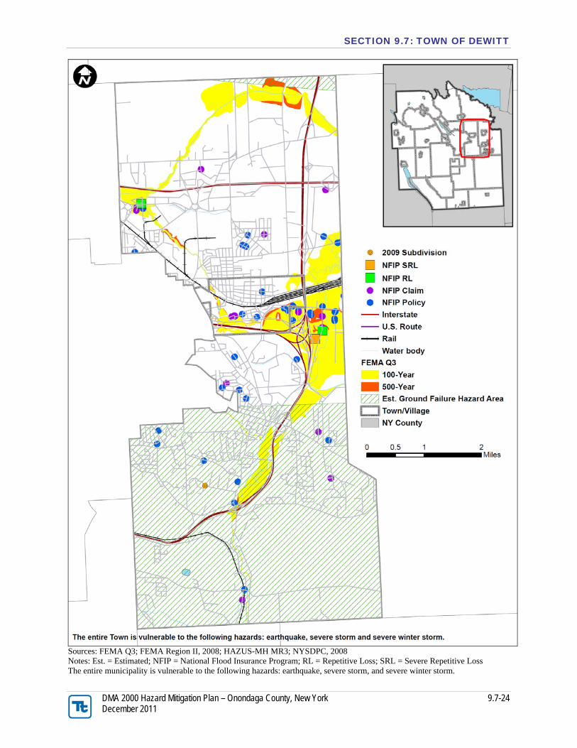
J.) HAZARD AREA EXTENT AND LOCATION A hazard area extent and location map has been generated and is provided below for the Town of DeWitt to illustrate the probable areas impacted within the Town. The map below is based on the best available data at the time of the preparation of this Plan, and is considered to be adequate for planning purposes. Maps have only been generated for those hazards that can be clearly identified using mapping techniques and technologies, and for which the Town of DeWitt has significant exposure. The County maps are provided in the hazard profiles within Section 5.4, Volume I of this Plan. K.) ADDITIONAL COMMENTS No additional comments at this time.
SECTION 9.7: TOWN OF DEWITT
DMA 2000 Hazard Mitigation Plan – Onondaga County, New York 9.7-24 December 2011
Sources: FEMA Q3; FEMA Region II, 2008; HAZUS-MH MR3; NYSDPC, 2008 Notes: Est. = Estimated; NFIP = National Flood Insurance Program; RL = Repetitive Loss; SRL = Severe Repetitive Loss The entire municipality is vulnerable to the following hazards: earthquake, severe storm, and severe winter storm.