Land Information Council of Jamaica/ National Spatial Data Management Division URBN A geospatial approach to analyzing real estate values - Case Study: King’s Cross Saint Pancras TOD GIS Business Executive Forum 2014 Enhancing the Local Real Estate Industry using GIS Tarik Dixon 14|11| 2014 GIS Analyst National Spatial Data Management Division Land Information Council of Jamaica GIS & Real Estate
Transcript
URBN LOFTS
1837 LOFT STREET, ANYTOWN, NY 50080
URBN LOFTS
Land Information Council of Jamaica/
National Spatial Data Management Division
URBN LOFTS
A geospatial approach to analyzing real estate
values - Case Study: King’s Cross Saint Pancras TOD
GIS Business Executive Forum 2014 Enhancing the Local Real Estate Industry using GIS
Tarik Dixon
14|11| 2014
GIS Analyst
National Spatial Data Management Division
Land Information Council of Jamaica
GIS & Real Estate
URBN LOFTS
1837 LOFT STREET, ANYTOWN, NY 50080
URBN LOFTS
Land Information Council of Jamaica/
National Spatial Data Management Division
Land Information Council of Jamaica/
National Spatial Data Management Division
Eights years experience in the real estate industry (London & Jamaica)
Eights years experience in GIS sector
A member of the National Association of Realtors (NAR)
Top Producer (2012 & 2013) at Century 21 Heave-Ho Properties
Licentiate member of the Royal Town Planning Institute (RTPI)
Licentiate of the Royal Institution of Chartered Surveyors (RICS)
MSc. Spatial Planning
BSc. Urban and Regional Planning
Pursuing GISP certification
2
Profile
URBN LOFTS
1837 LOFT STREET, ANYTOWN, NY 50080
URBN LOFTS
Land Information Council of Jamaica/
National Spatial Data Management Division
Land Information Council of Jamaica/
National Spatial Data Management Division
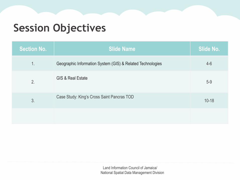
Section No. Slide Name Slide No.
1. Geographic Information System (GIS) & Related Technologies 4-6
2.GIS & Real Estate
5-9
3.Case Study: King’s Cross Saint Pancras TOD
10-18
Session Objectives
URBN LOFTS
1837 LOFT STREET, ANYTOWN, NY 50080
URBN LOFTS
Land Information Council of Jamaica/
National Spatial Data Management Division
Land Information Council of Jamaica/
National Spatial Data Management Division
Definition of Terms
Geographic Information System (GIS): is a system of hardware, software,
data, people, organizations and institutional arrangements for the collecting, storing,
analysing and disseminating information about areas of the earth .(Duiker and Kjerne
1989)
Public Transport Accessibility Levels (PTALs): are measures of the
accessibility of specific location to public transport network (comprising bus, rail, light rail
and tube services. (URS Corporation Limited and Taylor, 2006)
Transit Oriented Development (TOD): is a development strategy, which
typically involves creating medium/high density areas of mixed land use concentrated a
within 800 metre walking distance of significant transit stops. (Curtis, 2012)
4
URBN LOFTS
1837 LOFT STREET, ANYTOWN, NY 50080
URBN LOFTS
Land Information Council of Jamaica/
National Spatial Data Management Division
Land Information Council of Jamaica/
National Spatial Data Management Division
How GIS Works
List of Fundamentals
5
Hypsography
Land Use
Cadastral
Transportation
Governmental Units
Geodetic Control
Geographic Names
Hydrography
Ortho-imagery
Source: Kate Lance March 2004
URBN LOFTS
1837 LOFT STREET, ANYTOWN, NY 50080
URBN LOFTS
Land Information Council of Jamaica/
National Spatial Data Management Division
Land Information Council of Jamaica/
National Spatial Data Management Division6
Location!
GIS
Real Estate
GIS & Real Estate
URBN LOFTS
1837 LOFT STREET, ANYTOWN, NY 50080
URBN LOFTS
Land Information Council of Jamaica/
National Spatial Data Management Division
Land Information Council of Jamaica/
National Spatial Data Management Division
GIS & Real Estate
7
GIS - is a technology which allows you to
represent real world features within a
computer based environment
Real World
URBN LOFTS
1837 LOFT STREET, ANYTOWN, NY 50080
URBN LOFTS
Land Information Council of Jamaica/
National Spatial Data Management Division
Land Information Council of Jamaica/
National Spatial Data Management Division
Why do we need to marry GIS and Real Estate?
Climate Change
Land topography
Hazards (eg: Earthquakes, Hurricanes, Tsunamis)
Creative Class
Knowledge Economy
Smart Cities
Urbanization
Migration
Population
8
Natural FactorsSocio-economic Factors
URBN LOFTS
1837 LOFT STREET, ANYTOWN, NY 50080
URBN LOFTS
Land Information Council of Jamaica/
National Spatial Data Management Division
Land Information Council of Jamaica/
National Spatial Data Management Division
Factors Affecting Property Values
Location
Accessibility
Amenities
Natural Geography
Others - keeping up with the Joneses
9
GIS can help us:
Determine land Value Uplift from public investments
Identify & help unlock land values embedded within urban Brownfield lands
Analyze the inextricable linkage between urban structure and mobility (Source: CfIT)
Delivery sustainability by paradigm shift from land use planning to spatial planning (Hall, 1992)
URBN LOFTS
1837 LOFT STREET, ANYTOWN, NY 50080
URBN LOFTS
Land Information Council of Jamaica/
National Spatial Data Management Division
Land Information Council of Jamaica/
National Spatial Data Management Division
Research Topic
A spatio-temporal analysis on the effects of Transit Oriented Developments (TODs) on
existing residential property values – A case study of the King’s Cross St Pancras
transit station catchment area
10
Using GIS to analyze property values in Cities
URBN LOFTS
1837 LOFT STREET, ANYTOWN, NY 50080
URBN LOFTS
Land Information Council of Jamaica/
National Spatial Data Management Division
Land Information Council of Jamaica/
National Spatial Data Management Division
1:150,000
Location of Study Area
Case Study: Property prices in the King’s Cross Saint Pancras TOD
11
URBN LOFTS
1837 LOFT STREET, ANYTOWN, NY 50080
URBN LOFTS
Land Information Council of Jamaica/
National Spatial Data Management Division
Land Information Council of Jamaica/
National Spatial Data Management Division
1. To examine the spatio-temporal fluctuations of property prices within
the King’s Cross St Pancras transit station catchment area and to
explore how these compare with other areas within the borough.
2. To determine whether a key event such as the opening of High Speed
One (HS1) and simultaneous transferral of international Eurostar
services from Waterloo to St Pancras station had a perceptible effect
on property prices.
3. To determine how a spatio-temporal analysis of property prices could
assist in developing spatial planning strategies to help achieve
sustainability within Camden.
12
Research Objectives:
URBN LOFTS
1837 LOFT STREET, ANYTOWN, NY 50080
URBN LOFTS
Land Information Council of Jamaica/
National Spatial Data Management Division
Land Information Council of Jamaica/
National Spatial Data Management Division
King’s Cross Europe map railway connections
King’s Cross St Pancras:
– is the best connected location in Europe
– benefitted from £2.5 billion investment on
transport infrastructure alone
– has the highest PTAL ratings (PTAL 6B)
13
(Source: King’s Cross, 2014)
URBN LOFTS
1837 LOFT STREET, ANYTOWN, NY 50080
URBN LOFTS
Land Information Council of Jamaica/
National Spatial Data Management Division
Land Information Council of Jamaica/
National Spatial Data Management Division
Housing Price Index: Price Paid DataData Item Explanation where appropriate
Transaction unique identifier A reference number which is generated automatically recording each published sale. The number is uniqueand will change each time a sale is recorded.
Price Sale price stated on the Transfer deed.
Date of Transfer Date when the sale was completed, as stated on the Transfer deed.
Postcode
Property Type D-Detached S-Semi-Detached T-Terraced F-Flats/Maisonettes
Old/New Y = a newly built property N = an established residential building
Duration Relates to the tenure.F-FreeholdL-Leasehold etc.
PAON Primary Addressable Object Name. If there is a sub-building for example the building is divided into flats, seeSecondary Addressable Object Name (SAON).
SAON Secondary Addressable Object Name. If there is a sub-building, for example the building is divided into flats,there will be a SAON.
Street
Locality
Town/City
District
County
Record Status - monthly file only Indicates additions, changes and deletions to the records (please see guide below).
What do the abbreviations mean in the price paid data?The data is published in columns in the order set out below:The date field - the date of the Transfer deed lodged with us for registration.- See more at: http://www.landregistry.gov.uk/market-trend-data/public-data/price-paid-faq#m1
14
URBN LOFTS
1837 LOFT STREET, ANYTOWN, NY 50080
URBN LOFTS
Land Information Council of Jamaica/
National Spatial Data Management Division
Land Information Council of Jamaica/
National Spatial Data Management Division
Housing Price Index 10yr Analysis
Created from Land Registry’s (2014) Housing Price Index
15
URBN LOFTS
1837 LOFT STREET, ANYTOWN, NY 50080
URBN LOFTS
Land Information Council of Jamaica/
National Spatial Data Management Division
Land Information Council of Jamaica/
National Spatial Data Management Division
• Property prices increased within the study area 4.92% above
London average, despite 51.44% more properties being sold
after transport intervention.
• Flats/Maisonettes were the dominant property type within study
area and the borough but minimum property prices increased by
approx 46.27% in the former and only 3.87% in the latter.
• Maximum price for flats/maisonettes in the study area went up by
almost 238.24% and only 75% in the borough.
16
Key Research Findings
URBN LOFTS
1837 LOFT STREET, ANYTOWN, NY 50080
URBN LOFTS
Land Information Council of Jamaica/
National Spatial Data Management Division
Building Stock
COHORTS # OF TRANSACTIONS
PROPERTY TYPE
DetachedSemi
Detached TerraceFlats/
MaisonettesCOHORT ONE[13/11/2002
-13/11/2007]
18,265 242 666 1,854 15,503
COHORT TWO
[14/11/2007 -
14/11/2012]
12,061 207 440 1316 10,098
URBN LOFTS
1837 LOFT STREET, ANYTOWN, NY 50080
URBN LOFTS
Land Information Council of Jamaica/
National Spatial Data Management Division
Land Information Council of Jamaica/
National Spatial Data Management Division
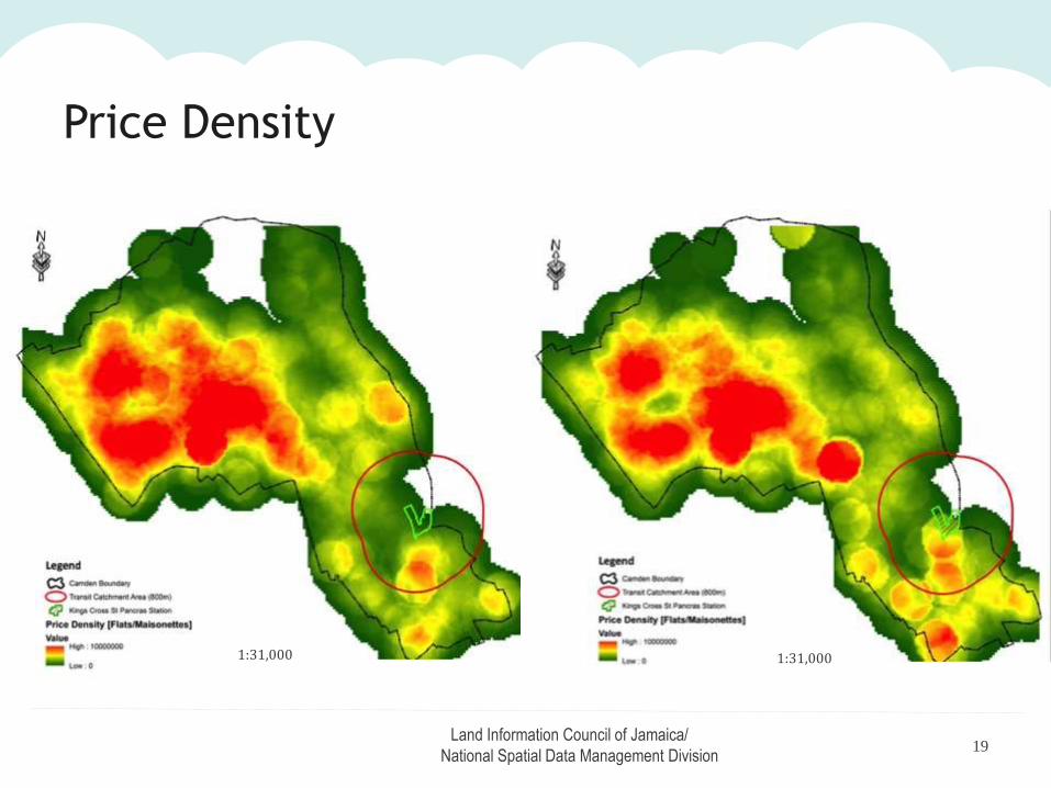
Price Distribution
1:31,000
Old Flats or maisonettes sold in Camden 5 years before HS1 Old flats or maisonettes sold in Camden within 5 year of HS1 opening