A Multi-State Conservation Plan For The Black-tailed Prairie Dog, Cynomys ludovicianus, in the United States Addendum to the Black-tailed Prairie Dog Conservation Assessment and Strategy November 3, 1999 Edited by: Bob Luce, Interstate Coordinator, Prairie Dog Conservation Team P.O. Box 2095, Sierra Vista, AZ 85636 February 1, 2002 RECOMMENDED CITATION Luce, R. J. 2003. A Multi-State Conservation Plan For The Black-tailed Prairie Dog, Cynomys ludovicianus, in the United States – an addendum to the Black-tailed Prairie Dog Conservation Assessment and Strategy, November 3, 1999. Acknowledgments We wish to thank the following for their assistance and comment during development of the early drafts of this document: Pete Gober and Pat Mehlhop, U.S. Fish and Wildlife Service; Leonard Benson, South Dakota Working Group; Shaun Grassel, Lower Brule Sioux tribe; David Schmidt, South Dakota NRCS; Minette Johnson, Defenders of Wildlife; Kristy Bly Honness, Turner Endangered Species Foundation; John Sidle, U.S. Forest Service; Bill Van Pelt and Tim Snow, Arizona Game and Fish Department; Bob Sullivan and Paul Robertson, Texas Parks and Wildlife Department; Chuck Hayes and Greg Schmitt, New Mexico Department of Game and Fish; George Vandel and Eileen Dowd Stukel, South Dakota Department of Game, Fish and Parks; Larry Gabriel and George Williams, South Dakota Department of Agriculture; Gary Skiba and Francie Pusateri, Colorado Division of Wildlife; Mike Fritz, Nebraska Game and Parks Commission; Harry Harju, Reg Rothwell and Bob Oakleaf, Wyoming Game and Fish Department; Julianne Hoagland, Oklahoma Department of Wildlife Conservation; Jeb Williams, Michael McKenna, and Sandy Hagen, North Dakota Game and Fish Department; Heidi Youmans, Ron Stoneberg and Dennis Flath, Montana Dept. of Fish, Wildlife and Parks; Mike Mitchener and Keith Sexson, Kansas Dept. of Wildlife and Parks; Jonathan Proctor, Predator Conservation Alliance; Catherine Johnson and Sterling Miller, National Wildlife Federation; and the Black- tailed Prairie Dog Working Groups in Nebraska, South Dakota, and Wyoming. We also wish to thank the blue-ribbon task force consisting of Bill Andelt, Colorado State University; Len Carpenter, The Wildlife Society; Dan Hubbard, South Dakota State University; Rob Manes, Wildlife Management Institute; and John Sidle, USDA Forest Service for their November 15, 2001 evaluation of Draft #2. A special thanks to Aaron Clark and Garth Smith, PIC Technologies of Denver for developing much of the GIS information used in this document, and Andrea Ernst for creating the Bailey Ecoregion maps and develop- ing the acreage data from which the 10-year objectives were determined. We wish to thank the following for their review and comment during the 60-day public comment period: Penny Dumas; Judy Enderle, Rocky Mountain Animal Defense; Steve Forrest; Nancy Hilding, Prairie Hill Audubon Society of Western South Dakota; Catherine Johnson, Rocky Mountain Natural Resource Center; Brian Miller, Denver Zoo; Ralph Morgenweck, U. S. Fish and Wildlife Service; Stephanie Nichols-Young; Jonathan Proctor, Predator Conservation Alliance; Curtis Freese, World Wildlife Fund; Andrea Lococo, The Fund for Animals; Erin Robertson, Center for Native Ecosystems; Nicole J. Rosmarino, Forest Guardians; Angie Young, Biodiversity Associates; Richard Reading, Denver Zoological Foundation; Mike Seidman, Phoenix Zoo; Bette Stallman, The Humane Society of the United States; Joe Truett, Turner Endangered Species Fund; Pam Wanek, Prairie Dog Coalition. 1
Transcript
A Multi-State Conservation Plan For The Black-tailed Prairie Dog, Cynomys ludovicianus,in the United States
Addendum to the Black-tailed Prairie Dog Conservation Assessment and StrategyNovember 3, 1999
Edited by:Bob Luce, Interstate Coordinator, Prairie Dog Conservation Team
P.O. Box 2095, Sierra Vista, AZ 85636
February 1, 2002
RECOMMENDED CITATION
Luce, R. J. 2003. A Multi-State Conservation Plan For The Black-tailed Prairie Dog, Cynomys ludovicianus,in the United States – an addendum to the Black-tailed Prairie Dog Conservation Assessment and Strategy,November 3, 1999.
AcknowledgmentsWe wish to thank the following for their assistance and comment during development of the early drafts of thisdocument: Pete Gober and Pat Mehlhop, U.S. Fish and Wildlife Service; Leonard Benson, South DakotaWorking Group; Shaun Grassel, Lower Brule Sioux tribe; David Schmidt, South Dakota NRCS; MinetteJohnson, Defenders of Wildlife; Kristy Bly Honness, Turner Endangered Species Foundation; John Sidle, U.S.Forest Service; Bill Van Pelt and Tim Snow, Arizona Game and Fish Department; Bob Sullivan and PaulRobertson, Texas Parks and Wildlife Department; Chuck Hayes and Greg Schmitt, New Mexico Departmentof Game and Fish; George Vandel and Eileen Dowd Stukel, South Dakota Department of Game, Fish andParks; Larry Gabriel and George Williams, South Dakota Department of Agriculture; Gary Skiba and FranciePusateri, Colorado Division of Wildlife; Mike Fritz, Nebraska Game and Parks Commission; Harry Harju, RegRothwell and Bob Oakleaf, Wyoming Game and Fish Department; Julianne Hoagland, Oklahoma Departmentof Wildlife Conservation; Jeb Williams, Michael McKenna, and Sandy Hagen, North Dakota Game and FishDepartment; Heidi Youmans, Ron Stoneberg and Dennis Flath, Montana Dept. of Fish, Wildlife and Parks;Mike Mitchener and Keith Sexson, Kansas Dept. of Wildlife and Parks; Jonathan Proctor, PredatorConservation Alliance; Catherine Johnson and Sterling Miller, National Wildlife Federation; and the Black-tailed Prairie Dog Working Groups in Nebraska, South Dakota, and Wyoming.
We also wish to thank the blue-ribbon task force consisting of Bill Andelt, Colorado State University; LenCarpenter, The Wildlife Society; Dan Hubbard, South Dakota State University; Rob Manes, WildlifeManagement Institute; and John Sidle, USDA Forest Service for their November 15, 2001 evaluation of Draft #2.
A special thanks to Aaron Clark and Garth Smith, PIC Technologies of Denver for developing much of theGIS information used in this document, and Andrea Ernst for creating the Bailey Ecoregion maps and develop-ing the acreage data from which the 10-year objectives were determined.
We wish to thank the following for their review and comment during the 60-day public comment period:Penny Dumas; Judy Enderle, Rocky Mountain Animal Defense; Steve Forrest; Nancy Hilding, Prairie HillAudubon Society of Western South Dakota; Catherine Johnson, Rocky Mountain Natural Resource Center;Brian Miller, Denver Zoo; Ralph Morgenweck, U. S. Fish and Wildlife Service; Stephanie Nichols-Young;Jonathan Proctor, Predator Conservation Alliance; Curtis Freese, World Wildlife Fund; Andrea Lococo, TheFund for Animals; Erin Robertson, Center for Native Ecosystems; Nicole J. Rosmarino, Forest Guardians;Angie Young, Biodiversity Associates; Richard Reading, Denver Zoological Foundation; Mike Seidman,Phoenix Zoo; Bette Stallman, The Humane Society of the United States; Joe Truett, Turner EndangeredSpecies Fund; Pam Wanek, Prairie Dog Coalition.
COMPARISON OF STATE BLACK-TAILED PRAIRIE DOG MANAGEMENT PLANS AND PROGRAMS ........58
3
EXECUTIVE SUMMARY
In 1998, the National Wildlife Federation and Predator Conservation Alliance, Biodiversity Legal Foundation andJon Sharps, filed petitions to list the black-tailed prairie dog as a threatened species. The U.S. Fish and WildlifeService (Service) issued a “warranted but precluded” finding in February 2000. The petition and the finding bothestimated the occupied acreage to be 768,000 acres range-wide, with 676,000 acres in the United States.
The eleven states within the range of the black-tailed prairie dog began a multi-state conservation effort in1998 by forming the Interstate Black-tailed Prairie Dog Conservation Team. The Conservation Team devel-oped the Black-tailed Prairie Dog Conservation Assessment and Strategy (CA&S) in 1999. The Multi-stateConservation Plan (MSCP) is an addendum to the CA&S, and was prepared to provide guidelines under whichmanagement plans will be developed by individual states and their respective working groups. The state man-agement plans will contain the specific and measurable actions, deadlines, and objectives for that state. Thetarget objectives in the MSCP are minimum values based on a range-wide analysis, and the states will buildupon those minimum recommendations.
The MSCP, and eleven state management plans, are based on an adaptive management strategy. Therefore, theconcepts and recommendations presented are considered a starting point from which to begin the conservationeffort. The states do not assume that these initial measures alone will be effective in conserving the species forthe long-term. The MSCP is based on first achieving the 10-year objectives, then modifying management asdictated by changing and evolving conditions.
Threats to the Species
The threats to the black-tailed prairie dog that were identified in the Service’s 12-month finding and addressedin the Risk Assessment in the CA&S were:
• The present or threatened destruction, modification, or curtailment of its habitat or range,
• Over-utilization for commercial, recreational, scientific, or educational purposes,
• Disease or predation,
• Inadequacy of existing regulatory mechanisms,
• Other natural or man-made factors affecting its continued existence
Summary of the Threats
Habitat loss: Population declines related to loss of habitat across the range can be traced to conversion ofgrassland to farmland, urbanization, habitat conversion and habitat fragmentation. The Service’s 12-monthfinding rated habitat loss as a moderate threat. The 2002 Candidate Assessment concluded that habitat destruc-tion is not a threat, but that habitat modification remains a moderate threat and habitat curtailment a low threat.
Over-utilization/Unregulated shooting: Over-utilization of the black-tailed prairie dog is related to shooting.Prairie dog shooting was uncontrolled in all 11 states within the range in 1998. The Service rated shooting as alow threat in the 12-month finding. The 2002 Candidate Assessment concluded that effects due to recreationalshooting do not rise to the level of a threat pursuant to the definitions and constraints of the ESA. Colorado,South Dakota, Arizona, and Montana now have closed seasons for the shooting of black-tailed prairie duringthe spring. All other states except Wyoming and New Mexico have the authority to establish seasons.
4
Sylvatic Plague: Plague is the disease most commonly affecting black-tailed prairie dogs on a significant scaleand is the major threat to the species. It has the potential to decimate complete colonies or complexes withinone season. There is currently no treatment for plague in prairie dogs or a known preventative measure that iseffective. Plague was rated as a moderate threat in the 12-month finding, and the 2002 Candidate Assessmentconcluded that impacts due to this disease continue to be a moderate threat.
Inadequate Regulatory Mechanisms: The lack of adequate state regulatory mechanisms was rated as a moder-ate threat in the 12-month finding. The 2002 Candidate Assessment concluded, "concerns still remain, includ-ing the general absence of efforts to better monitor and regulate chemical control, the failure of most states toformally approve management plans, and the lack of acceptance by some states (Montana, North Dakota, andOklahoma) of the 10-year occupied habitat objective developed by the Black-tailed Prairie Dog ConservationTeam. Collectively, these limitations continue to constitute a moderate threat to the species." However, theService believes the threat to be non-imminent compared to a previous imminent status because the threat islargely a potential threat.
Other Natural or Man-made Factors: Control by poisoning was rated as a moderate threat in the 12-monthfinding. The 2002 Candidate Assessment concluded that impacts to the species due to chemical control pro-grams are a low-magnitude threat at present, and that the threats are non-imminent.
Elements of the Conservation Strategy
1) Develop interstate cooperation among the state wildlife agencies in the historic range,
2) Develop intrastate agency cooperation in each state between the wildlife agency, agriculture andother state agencies with an interest in black-tailed prairie dog issues,
3) Integrate management programs of state and federal agencies and Native American tribal governments,
4) Involve all public and private entities interested in black-tailed prairie dog management in theprocess,
5) Develop a multi-state management approach that includes acreage objectives,
6) Develop individual state management plans under the multi-state guideline,
7) Develop a map of the range delineating occupied and suitable habitat, and land ownership,
8) Identify potential conservation focus areas that will receive management emphasis.
State Actions That Have Been Accomplished
1) Eleven state wildlife agencies formed the Conservation Team and each designated a representativeto attend range-wide planning meetings (December 1998),
2) Nine state wildlife agencies signed a Memorandum of Understanding (MOU) agreeing to a multi-state management approach (North Dakota and Colorado declined to sign) (February 2000),
3) The states agreed to integrate state planning efforts with those of the eight Native American tribesthat form the Inter-Tribal Prairie Ecosystem Restoration Consortium (November 1999),
5
4) A Conservation Assessment and Strategy was developed (November 1999),
5) Although two states were not signatories to the MOU, all 11 state wildlife agencies have activelyparticipated on the Conservation Team and agreed to the following:
• Formation in each state of a Working Group that includes all major stakeholders in the black-tailed prairie dog planning process (November 1999),
• Agreement to work towards completion of state black-tailed prairie dog management plans byOctober 2001 (see Appendix F for state by state schedule),
• Agreement to use state in-kind expenditures to match National Fish and Wildlife Foundationfunds to support an Interstate Coordinator position (September 2000)
Goal:
The goal of the Conservation Assessment Strategy, the Multi-state Conservation Plan, and eleven state man-agement plans is to remove enough threats to the black-tailed prairie dog that long-term conservation of thespecies is assured.
Target Objectives
1) Maintain at least the currently occupied acreage of black-tailed prairie dogs in the U.S.
2) Increase to at least 1,693,695 acres of occupied black-tailed prairie dog acreage in the U.S by 2011
3) Maintain at least the current black-tailed prairie dog occupied acreage in the two complexes greaterthan 5,000 acres that now occur on and adjacent to Conata Basin-Buffalo Gap National Grassland,South Dakota and Thunder Basin National Grassland, Wyoming.
4) Develop and maintain a minimum of 9 additional complexes greater than 5,000 acres (with eachstate managing or contributing to at least one complex greater than 5,000 acres) by 2011.
5) Maintain at least 10 % of total occupied acreage in colonies or complexes greater than 1000 acresby 2011,
6) Maintain distribution over at least 75% of the counties in the historic range or at least 75% of thehistoric geographic distribution.
Summary and Status of MSCP Proposed Actions (Completion or Projected Completion Date)
1) Develop a multi-state management approach that provides guidelines for development of state management plans (January 2003)
2) Develop and implement within each state a black-tailed prairie dog management plan (Completionor projected completion dates are shown in Appendix F)
3) Complete a black-tailed prairie dog inventory in each state to document current acreage, distributionof colonies, complexes of colonies, and land ownership of complexes (Baseline surveys completed inall states in 2002)
6
4) Delineate "conservation focus areas" that contain suitable habitat and within which intensive black-tailed prairie dog management can be carried out, and where the majority of landowner incentives willbe directed (Process begun September 2002)
5) Develop a monitoring method applicable across the eleven states and monitor occupied habitat anddistribution approximately every three years (In process).
6) Develop an occupied acreage target objective and other target objectives for the range in the U.S.and for each state (January 2003). Incorporate objectives into individual state management plans ineach of the eleven states (In process).
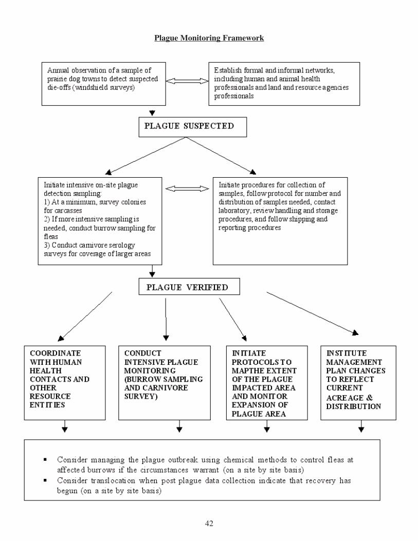
7) Implement the Plague Protocol in the MSCP in all eleven states in cooperation with privatelandowners and other entities in order to document and react to significant sylvatic plague events.
8) Determine the long term potential for plague to preclude attainment of objectives. Develop adequatemanagement approaches to mitigate the impacts of plague (Plague Protocol in the MSCP).
9) Develop programs to provide financial incentives for private landowners to voluntarily maintainprairie dog colonies on portions of their lands (In process)
10) Cooperate with federal, state, and private entities to make available/redirect funding for USDA-Wildlife Services, local Weed and Pest Control Districts, State Animal Damage Control agencies, orother approved entity (will vary by state) to fund control of prairie dogs where needed to meet statemanagement plan objectives and agreements with private landowners. (In process)
11) Compatible with the goals and objectives in the state management plan, retain shooting opportuni-ties in all eleven states. Develop regulatory authority for conservation of prairie dogs by establishing,through law or regulation, the ability of the state wildlife agency to limit or prohibit take by shooting(Four states have seasonal closures, all have regulatory authority except New Mexico and Wyoming)
12) Compatible with the goals and objectives in the state management plan, acquire or maintain ade-quate regulatory authority for conservation of prairie dogs by establishing through law, regulation, orcooperative agreement the ability of the state to limit or prohibit take by poisoning (In process)
13) Create/designate a coordinator position and/or other positions as needed in each state to conduct orsupervise prairie dog conservation (All states have a full or part time coordinator)
14) Develop and implement strategies to monitor and reduce conversion of black-tailed prairie doghabitat to other land uses in each state (In process - Appendix G)
15) Cooperate with the Service to use the Bailey Eco-region habitat model target acreage objectives asa method for establishing a standard for state-federal Candidate Conservation Agreements withAssurances (CCAAs) (In process)
16) Continue to encourage development of an adequate and reliable long-term funding source for a pri-vate landowner incentive program (In process – conceptual plan in the MSCP)
17) Through state management plans coordinate with federal agencies (Being addressed through stateworking groups and management plans)
18) Cooperate with private conservation organizations on habitat protection, prioritization of areas, etc.(In process)
7
Introduction
The eleven states within the range of the black-tailed prairie dog (Cynomys ludovicianus) (Arizona, Colorado,Kansas, Montana, Nebraska, New Mexico, North Dakota, Oklahoma, South Dakota, Texas, and Wyoming)began a multi-state conservation effort for the species in 1998 by forming the Interstate Black-tailed Prairie DogConservation Team (Conservation Team). The Conservation Team collaborated to develop the Black-tailedPrairie Dog Conservation Assessment and Strategy (CA&S)(Van Pelt 1999). This Multi-state ConservationPlan (MSCP) is written as an addendum to the CA&S, and is not a stand-alone document, but rather buildsupon the CA&S. Therefore it does not address issues that were treated in the parent document. The MSCP wasprepared to provide guidelines under which management plans will be developed by individual states and theirrespective working groups. The state management plans will contain the specific and measurable actions,deadlines, and objectives for that state. The target objectives in the MSCP are minimum values based on a range-wide analysis, and the states, via their management plans, will build upon those minimum recommendations.
The eleven state wildlife agencies represented on the Conservation Team believe that a multi-state approachwill be more effective in providing long-term management of the black-tailed prairie dog than would eitherfederal listing and protection under the Endangered Species Act (ESA) or disparate state planning efforts.
The CA&S determined the status of the species in 1999, and identified actions necessary for implementationof the strategy to conserve and manage the black-tailed prairie dog over the range in the U.S. Specifically,Item #3, Species Distribution, Status, and Monitoring, identified the need for the Conservation Team and stateworking groups to develop long-term occupied habitat objectives for the range in the U. S. Development andimplementation of a methodology with which to establish those objectives is the primary thrust of the MSCP.
In the MSCP we provide a guiding document for the states to use as a template, leaving decisions on developingstate management plans and adequate regulatory mechanisms up to the individual state wildlife agencies andworking groups. The situations in the states are diverse and cannot be addressed specifically in a guidelinedocument. The states’ most pressing need is to engage all of the partners necessary to bring about effectivechange in laws, statutes, attitudes, and management strategies for the prairie dog, and we believe that the stateworking groups are the best avenue for that task. The respective states must work with their broad constituenciesto integrate prairie dog conservation into existing land uses.
The 11-state target objective, as proposed in the CA&S, was to be expressed in number of occupied acres andnumber of individual complexes, be equitably distributed over the states, and be used as a template fromwhich to develop acreage and distribution objectives for each state’s management plan. Objectives areexpressed in terms of acres of occupied habitat rather than number of animals or population size, assumingthat with suitable habitat available, prairie dogs will occupy that habitat at a density that will maintain a viablepopulation. The MSCP, and also the 11 state management plans, for reasons explained in detail within theplans, are based on an adaptive management strategy. The concepts and recommendations presented are astarting point from which to begin the conservation effort.
The states make no assumption as to whether or not these initial measures will be effective in conserving thespecies over the long-term. The MSCP is based on first achieving the 10-year objectives, then modifyingmanagement as dictated by changing and evolving conditions during that period.
The state management plans developed under the MSCP guidelines and approved by the respective agency/citizenworking groups are expected to have support in the state and in local communities. If accepted by the Serviceas the best approach from a biological and scientific standpoint, implementation of the eleven state managementplans could remove the need for the Service to list the species as threatened under the ESA, and eventuallyresult in removal of the black-tailed prairie dog from the ESA Candidate List.
8
Background
In 1998, the National Wildlife Federation and Predator Conservation Alliance, Biodiversity Legal Foundationand Jon Sharps, filed two petitions to list the black-tailed prairie dog as a threatened species under the ESA.The Service placed the black-tailed prairie dog on the ESA Candidate List by issuing a "warranted but pre-cluded" finding in February 2000 (U.S. Fish and Wildlife Service 2000).
The black-tailed prairie dog is somewhat unique among species proposed for ESA listing in that several millionindividuals currently exist over a large acreage in the wild. The actual number of animals present dependsupon the density of animals in a particular colony or complex. The Service’s 12-month finding estimated theoccupied acreage to be 768,000 acres range-wide, with 676,000 acres in the United States. However, althoughwidespread, the species occurs to a significant extent in remnant, segregated populations that may have limitedpotential for long-term persistence.
Elements of the Conservation Strategy
The MSCP addresses the following elements from the Conservation Strategy:
1) Develop interstate cooperation among the state wildlife agencies in the historic range,
2) Develop intrastate agency cooperation in each state between the wildlife agency, agriculture andother state agencies with an interest in black-tailed prairie dog issues,
3) Integrate management programs of state and federal agencies and Native American tribal governments,
4) Involve all public and private entities interested in black-tailed prairie dog management in the process,
5) Develop a multi-state management approach that includes acreage objectives,
6) Develop individual state management plans under the multi-state guideline,
7) Develop a map of the range delineating occupied and suitable habitat, and land ownership,
8) Identify potential conservation focus areas that will receive management emphasis.
State Actions
The following state actions were developed in response to the above listed elements:
1) Eleven state wildlife agencies formed the Conservation Team and each designated a representativeto attend range-wide planning meetings (December 1998),
2) Nine state wildlife agencies signed a Memorandum of Understanding (MOU) agreeing to amulti-state management approach (North Dakota and Colorado declined to sign) (February 2000),
3) The states agreed to integrate state planning efforts with those of the eight Native American tribesthat form the Inter-Tribal Prairie Ecosystem Restoration Consortium (November 1999),
9
4) A Conservation Assessment and Strategy was developed (Van Pelt 1999),
5) Although two states were not signatories to the MOU, all 11 state wildlife agencies have activelyparticipated on the Conservation Team and agreed to the following:
• A strict implementation schedule that set dates for completing various stages of the process(November 1999),
• Formation in each state of a Working Group that includes all major stakeholders in theblack-tailed prairie dog planning process (November 1999),
• Agreement to work towards completion of state black-tailed prairie dog management plans byOctober 2001 (see Appendix F for state by state schedule),
• Agreement to use state in-kind expenditures to match National Fish and Wildlife Foundationfunds to support an Interstate Coordinator position (September 2000)
Purpose of this Document
The Conservation Assessment and Strategy identified the need for development of a multi-state approach toblack-tailed prairie dog management in the United States. The purpose of the MSCP is to list the actions theeleven states represented on the Conservation Team propose to implement to provide long-term conservationof the black-tailed prairie dog, and thus preclude the need for ESA listing. This multi-state approach will alsoestablish a standard for umbrella Candidate Conservation Agreement with Assurances (CCAAs) between theService and the respective states that choose to use the CCAA approach.
Goal:
The goal of the CA&S, the MSCP, and eleven state management plans is to remove enough threats to theblack-tailed prairie dog that long-term conservation of the species is assured.
Threats to the Species
The threats to the black-tailed prairie dog that were identified in the Service’s 12-month finding (in order oflisting) were:
1) The present or threatened destruction, modification, or curtailment of its habitat or range,
2) Over-utilization for commercial, recreational, scientific, or educational purposes,
3) Disease or predation,
4) Inadequacy of existing regulatory mechanisms,
5) Other natural or man-made factors affecting its continued existence
10
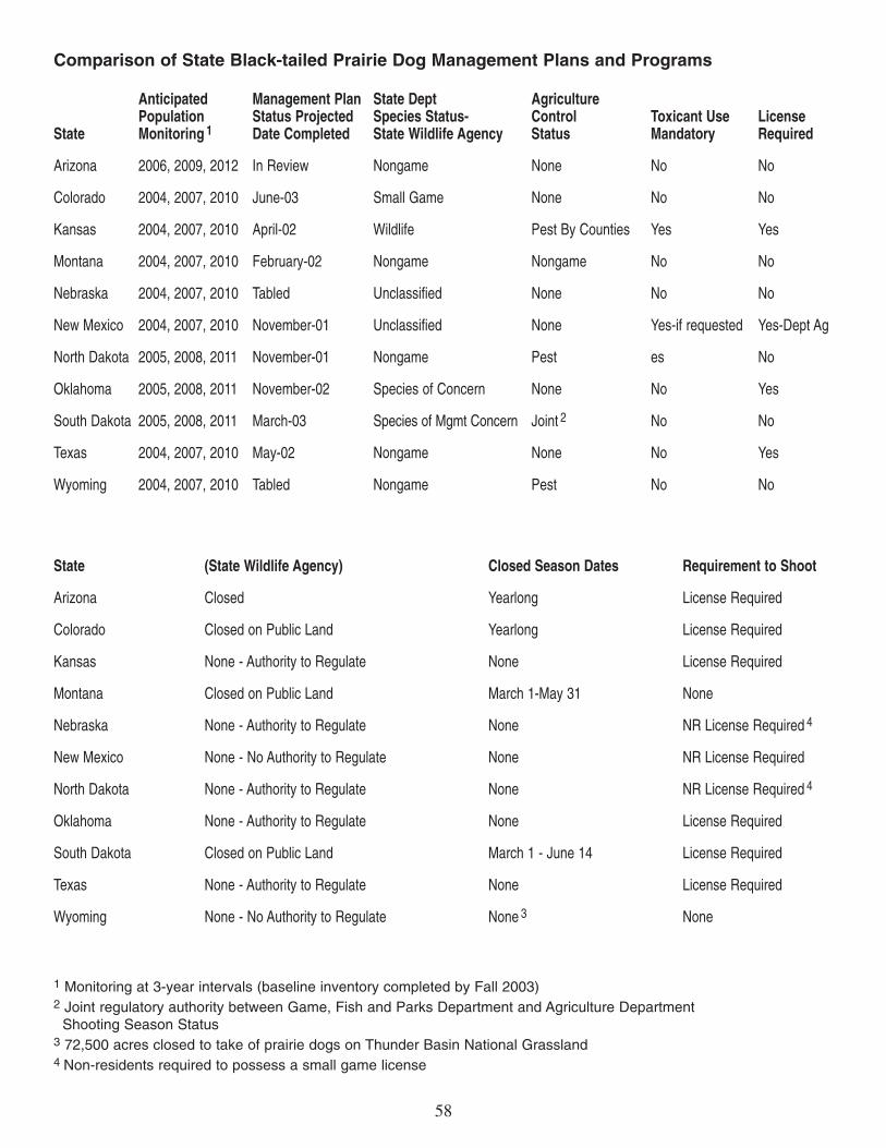
Summary of the Threats
Habitat loss: Population declines related to loss of black-tailed prairie dog habitat across its range can be tracedto conversion of grassland to farmland, urbanization, habitat conversion (conversion of grassland and savanna toshrubs), and habitat fragmentation. The Service’s 12-month finding rated habitat loss as a moderate threat.
The Service’s March 18, 2002 Candidate Assessment concluded that habitat destruction is not a threat, but thathabitat modification remains a moderate threat and habitat curtailment a low threat.
Over-utilization/Unregulated Shooting: Over-utilization refers primarily to shooting in the case of the black-tailed prairie dog. Under certain circumstances, shooting may contribute to population fragmentation andreduction in colony productivity and health, may cause some loss of non-target species, and may preclude ordelay recovery of colonies reduced by other factors such as sylvatic plague (Vosburgh, 1998). Shooting canimpact colonies in areas where shooting is intense or persistent over an entire year (Vosburgh, 1998). Prairiedog shooting was uncontrolled in all eleven states within the range in 1998. The Service rated shooting as alow threat in the 12-month finding.
The Service’s 2002 Candidate Assessment concluded that states with significant amounts of public land areexperiencing greater shooting pressure on prairie dogs than previously estimated, and are implementing regu-lations to better monitor and control this activity. The Service stated: "we are not aware of data that support aconclusion that reductions in density are sufficient to reduce population persistence at a given site", and that"no information is available that demonstrates that any black-tailed prairie dog population has been extirpatedor nearly extirpated by this activity." The conclusion was that effects due to recreational shooting do not rise tothe level of a threat pursuant to the definitions and constraints of the ESA.
The following is a summary of the current status of state shooting regulations:
1) Colorado - Beginning September 2001, public lands (federal and state) were closed to the shootingof black-tailed prairie dogs year-round, but private landowners are allowed to control black-tailedprairie dogs in damage situations on private land without a license.
2) South Dakota - Beginning March 2001, the shooting of black-tailed prairie dogs on public lands(federal and state) was closed annually for the period March 1 to June 14, with no restrictions on pri-vate lands.
3) Arizona - Public and private lands are closed to take of black-tailed prairie dogs year-round. It isrelevant to note that public and private lands are closed to take of Gunnison’s prairie dogs from April 1to June 15.
4) Montana - Beginning February 2002, the shooting of black-tailed prairie dogs on federal publiclands was closed annually for the period March 1 to May 31, with no restrictions on private lands.
5) Wyoming - The state does not have the authority to regulate shooting on public or private lands. The U.S. Forest Service closes public land on 72,500 acres of Thunder Basin National
Grassland to take of black-tailed prairie dogs yearlong.
6) Kansas – The state has the authority to regulate shooting but no season has been established
7) Nebraska - The state has the authority to regulate shooting but no season has been established
11
8) North Dakota - The state has the authority to regulate shooting but no season has been established
9) Oklahoma - The state has the authority to regulate shooting but no season has been established
10) Texas - The state has the authority to regulate shooting but no season has been established
11) New Mexico - The state requires out-of-state shooters to possess a license, and shooting on statetrust lands is prohibited. The state does not otherwise have the authority to regulate shooting
12) Black-footed ferret reintroduction sites in Conata Basin/Buffalo Gap National Grassland in SouthDakota, Charles M. Russell National Wildlife Refuge, and BLM "40" Complex in Montana are closedyearlong to the shooting of prairie dogs.
Sylvatic Plague: Plague is the major disease affecting black-tailed prairie dogs and has the potential todecimate complete colonies or complexes within one season. There is currently no treatment for plague inprairie dogs or a known preventative measure that is effective. Plague was rated as a moderate threat in the12-month finding. The Service’s 2002 Candidate Assessment concluded that impacts due to this diseasecontinue to be a moderate threat.
Inadequate Regulatory Mechanisms: Pest Status and Unregulated Poisoning: The black-tailed prairie dogwas classified as a pest by nine states within its historic range at the time the listing petition was filed in 1998.The states of New Mexico and Oklahoma did not classify the black-tailed prairie dog as a pest under state law.Most state statutes required eradication (New Mexico and Oklahoma were exceptions) and all states, exceptOklahoma, permitted uncontrolled take in 1998 (Van Pelt 1999). The major federal land management agencies,Bureau of Land Management and Forest Service, manage prairie dog habitat to meet multiple-use objectives,and allowed poisoning before the black-tailed prairie dog was added to the candidate species list. Control bypoisoning on U.S. Fish and Wildlife Service, Bureau of Land Management, and Forest Service lands is cur-rently allowed only for protection of human health. The National Park Service conducts control at the discre-tion of individual National Parks and Monuments according to its good neighbor policy. The lack of adequateregulatory mechanisms was rated as a moderate threat in the 12-month finding. The Service’s 2002 CandidateAssessment concluded that "concerns still remain, including the general absence of efforts to better monitorand regulate chemical control, the failure of most states to formally approve management plans, and the lackof acceptance by some states (Montana, North Dakota, and Oklahoma) of the 10-year occupied habitat objec-tives developed by the Black-tailed Prairie Dog Conservation Team. Collectively, these limitations continue toconstitute a moderate threat to the species." However, the Service believes the threat to be non-imminent com-pared to a previous imminent status because the threat is largely a potential threat.
Other Natural or Man-made Factors: Extensive poisoning was conducted throughout most of the black-tailedprairie dog’s range from 1912 to 1972 in order to reduce the perceived forage competition between prairiedogs and domestic livestock. Control by poisoning occurs at a lesser but significant rate today (U.S. Fish andWildlife Service, 2000). Currently, USDA-Wildlife Services is the primary federal agency contributing toprairie dog control either through assistance to private landowners, direct control programs, or grants-in-aid tostates. In some states, county weed and pest districts or the state department of agriculture provide financial orextension assistance to landowners for control of prairie dogs. Control by poisoning was rated as a moderatethreat in the 12-month finding. The Service’s 2002 Candidate Assessment concluded that impacts on the speciesdue to chemical control programs are a low-magnitude threat at present, and that the threats are non-imminent.
12
Proposed Actions
Actions proposed by the 11-state Conservation Team to implement a multi-state approach to address thethreats described above include:
1) Develop a multi-state management approach that provides guidelines for development of state man-agement plans
2) Develop and implement within each state a black-tailed prairie dog management plan (completionor projected completion dates are shown in Appendix F)
A. Management plans will be written by state wildlife agencies with oversight and review byagency/citizen working groups representing a cross section of the various interested parties ineach state
B. Public comment periods will be incorporated into the planning process. Management planswill be dynamic, relying on the principles of adaptive management, and future revisions areanticipated to reflect new and evolving conditions
C. Federal agency roles, and management commitments required of federal agencies, will beidentified in the state management plans. The states will work with federal agencies toincorporate black-tailed prairie dog objectives into all federal management planning documentsand processes, especially Bureau of Land Management Resource Management Plans and U.S.Forest Service National Grassland Plans
3) Complete a black-tailed prairie dog inventory in each state to document current acreage, distribution of colonies, complexes of colonies, and land ownership of complexes
4) Delineate "conservation focus areas" that contain suitable habitat and within which intensive black-tailed prairie dog management can be carried out and where the majority of landowner incentives will bedirected. Participation by private landowners will occur only with agreement by, and cooperation from,individual landowners. Conservation focus areas will be counties, groups of counties, or large units ofland with suitable habitat or extensive public lands, and will be unique to each state management plan.
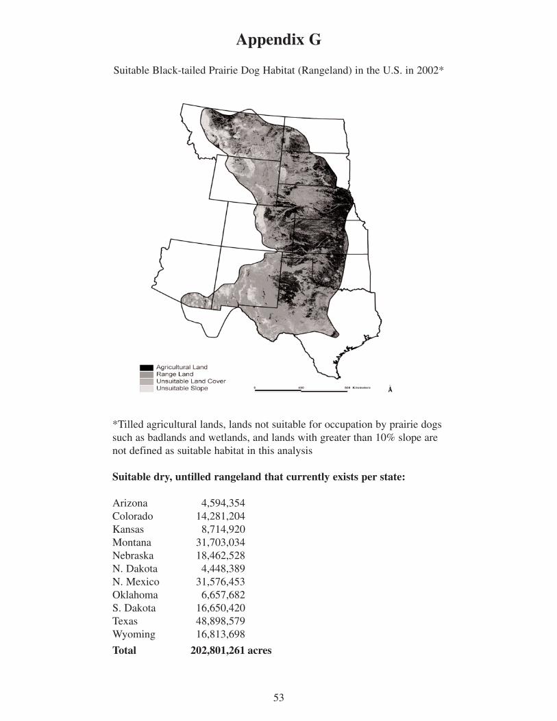
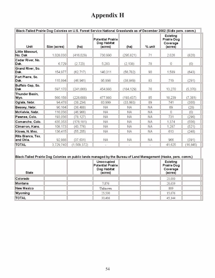
National Grasslands and Bureau of Land Management public lands in the black-tailed prairie dogrange that could potentially contain core lands around which conservation focus areas could bedeveloped, and the acreage of potential and existing black-tailed prairie dog acreage in each, areshown in Appendix H.
Categories for Conservation Focus Areas (conservation focus area and complex are defined inAppendix A)
A. An area of public land containing suitable habitat, preferably with an existing complex ofgreater than 1,000 occupied black-tailed prairie dog acres in one or more colonies,
B. An area of mixed public and private or tribal land containing suitable habitat, preferably withan existing complex of greater than 1,000 occupied black-tailed prairie dog acres in one ormore colonies,
C. An area of tribal lands or a combination of tribal and private lands within or adjacent to theexterior boundaries of Tribal reservations containing suitable habitat, preferably with an existingcomplex of greater than 1,000 occupied black-tailed prairie dog acres in one or more colonies,
13
D. An area on private lands owned or managed by a private conservation organization (TheNature Conservancy, Turner Endangered Species Fund, or others) containing suitable habitat,preferably with an existing complex of greater than 1,000 occupied black-tailed prairie dogacres in one or more colonies,
E. An area on other private lands containing suitable habitat, preferably with an existingcomplex of greater than 1,000 occupied black-tailed prairie dog acres in one or more colonies
5) Develop a monitoring method applicable across the eleven states and monitor occupied habitat anddistribution approximately every three years.
A. Contract with the U.S. Geological Survey or a university cooperative research unit to house range-wide survey data and other pertinent data layers
B. Work towards development of a range-wide monitoring protocol similar to the National Wetland Inventory under which a statistically valid sampling procedure can be executed every three years using remote sensing, aerial transecting or other standard technique
C. Contract with the U.S. Geological Survey or a university cooperative research unit to conduct surveys and report data to states, Native American tribes, and other contributors
1. Pool financial resources from all entities that will use the survey results
2. Develop standard reporting method, reporting method, etc. among the contributors
D. Develop interagency agreements and coordinate resources to use state, tribal, federal agency or private personnel to conduct a statistically valid ground-truthing of surveys conducted by remote sensing, aerial transecting, or other method.
6) Develop an occupied acreage target objective and other target objectives for: 1) the range in theU.S., and 2) for each state. Incorporate objectives into individual state management plans in each of theeleven states.
A. Reserve Design Model
A reserve design model with which to predict the occupied acreage and distribution necessaryfor long-term viability of the species is not currently available for the black-tailed prairie dog.This is due at least partially to the lack of predictability of plague events and impacts westof roughly the 103rd Meridian. Therefore absolute values for the acreage and distributionnecessary to maintain the species for the long-term are also not available. In the absence ofprecise information, the Conservation Team has chosen to use an adaptive managementstrategy based on the relative importance of different habitats to black-tailed prairie dogs.The Service’s Candidate Conservation Agreement with Assurances (CCAA) policy supportssuch an adaptive management approach regarding species with population characteristicslike the black-tailed prairie dog. Several adaptive management approaches were proposedand evaluated as a means to conserve black-tailed prairie dogs as an 11-state population.The Bailey Eco-region habitat model was determined to be a viable approach for establishinga baseline occupied acreage target for each state, an equitable distribution of target acreagesbetween the eleven states based on the relative value of eco-regions from both a biologicaland a socio-political standpoint, and a reasonable 11-state occupied acreage objective forthe next ten years.
14
B. Development of Acreage and Distribution Objectives
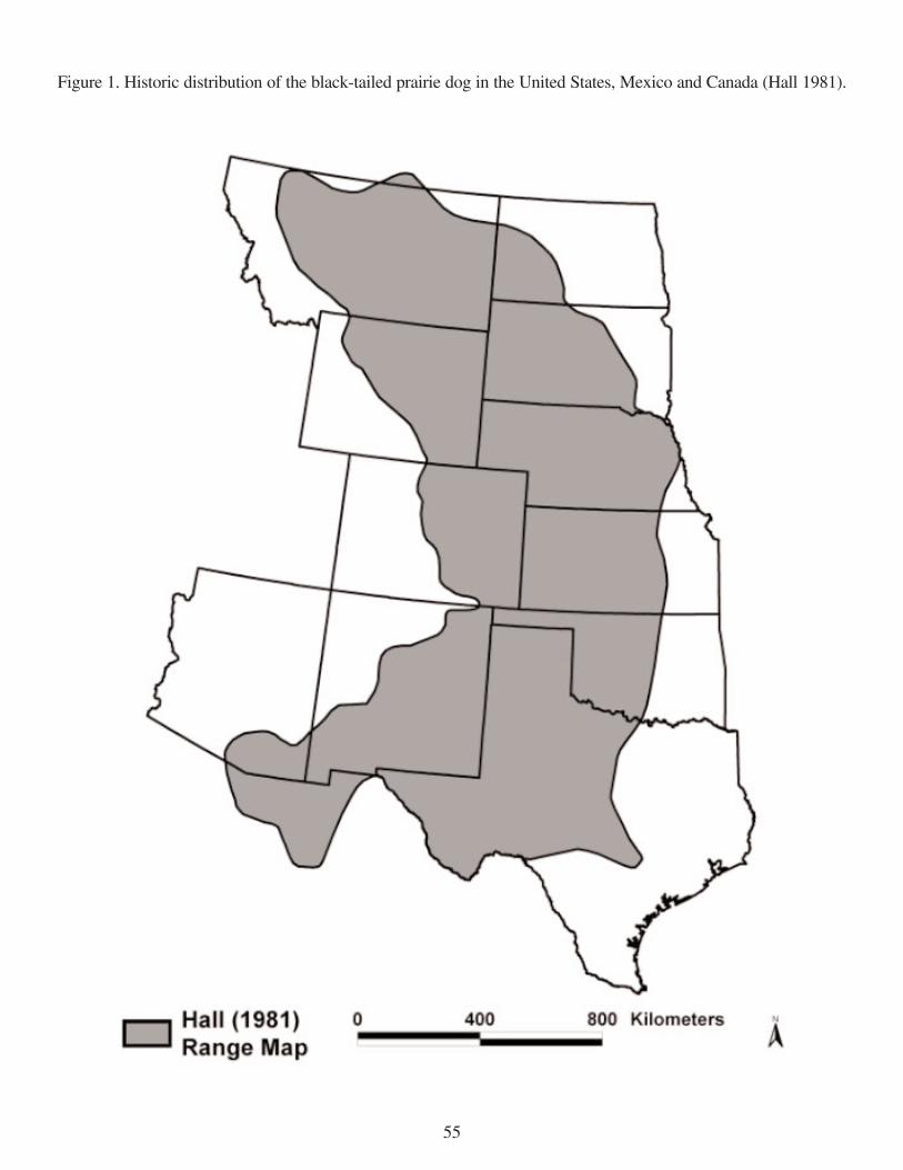
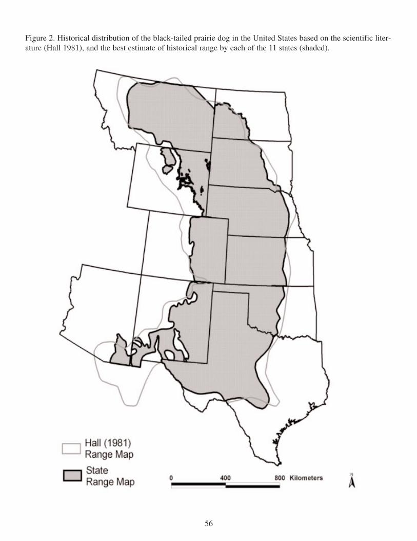
1. A few states used state-specific research data to develop detailed land use/land covermaps to delineate historic range and suitable habitat by examining vegetation and soils datafor their state. Although more precise than the Bailey Ecoregion habitat model, state-specificcoverages and applications were not available for most of the states, were inconsistentamong the states that did have the data, and could not be combined into a multi-stateapproach. However, state data were factored into the Bailey Eco-region habitat model(Figures 1 and 2).
2. The Conservation Team reviewed land cover/land use maps and data based on U.S.Geological Survey 1:250,000 scale data layers for 10 states, and Landsat TM imagery(1:100,000) for Wyoming, to evaluate the potential for using 1% of historic range as a multi-state standard for developing habitat conservation acreage objectives. Data were assembledby PIC Technologies (PIC Technologies, October 2000, pers comm.). Land use/land coverdata were aggregated into three categories: grasslands/shrublands, agricultural lands, andother lands. Areas with more than 10% slope were identified. Arc Info GIS software was usedto determine the acreage of each land use/land cover type per state, and the gross historicrange in each state. Although this methodology was able to derive target acreages that wereequitable between the states since it was based on the historic habitat in each state, it wasrejected as a multi-state approach. The historic range figures far exceeded the best acreageestimates derived independently by the states, and the data allowed the acreage objectives tobe based only on gross range rather than historic suitable habitat.
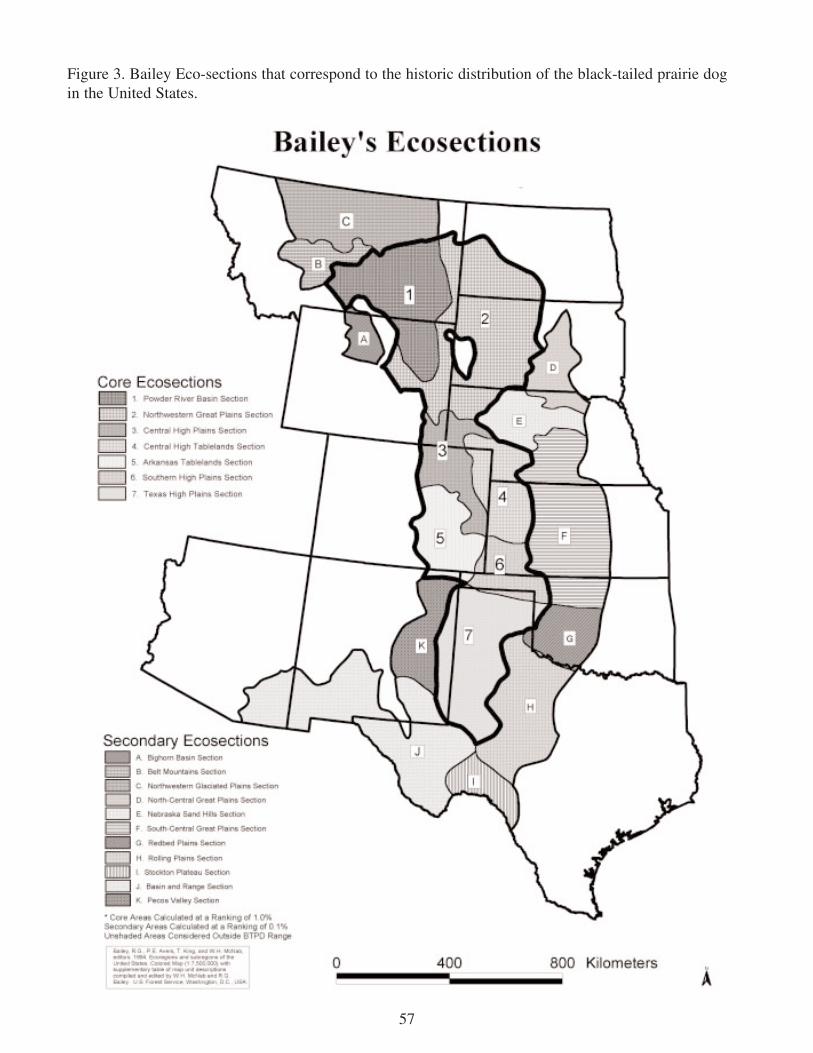
3. Eco-regions and the sections into which they have been divided have well-defined soil,climate, floral, and faunal descriptions. Eco-regions are used by a variety of organizationswhen planning at a landscape level. Terrestrial eco-regions as defined by Ricketts et al.(1999) and Bailey et al. (1994) were explored by the Conservation Team in cooperationwith the Service as a method for defining historic range over an 11-state area and calculatinga target acreage for the entire range and for each state, respectively. Bailey Eco-regions,which are divided into sections, and are more refined than those in Ricketts et al., were chosenas the preferred method for defining black-tailed prairie dog historic range and developingtarget acreages for habitat conservation.
Appendix B contains an explanation of the methods used to gather the existing GIS coverages,incorporate the Hall (1981) range map and the range map created by the states, overlayBailey Ecoregions and sections, and calculate non-suitable habitat and acreages.
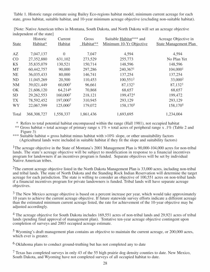
a. GIS data based on Bailey Eco-regions established the total historic range of theblack-tailed prairie dog as 368,308,727 acres within the 11 states in the U.S. Thisfigure is less than the total historic range estimate of 391,427,199 acres derived using11-state GIS land cover/land use data (PIC Technologies October 2000, pers comm).
b. The historic acreage estimate using the Bailey Eco-region habitat model does notstrictly compare with the data available for some states, but it has the advantage ofbeing comparable across the states and therefore is best suited for establishing amulti-state acreage objective and an equitable acreage objective for each state(Table 1).
15
4. Three data sets were identified related to the black-tailed prairie dog range:
a. Historic distribution (range) from the scientific literature
This is the range identified in the scientific literature (Hall 1981) that includes allspecimen records and defines the furthermost extremes of the area where thespecies was found historically (Figure 1). This includes temporary expansion areas,marginal habitats, and areas occupied by disjunct populations.
b. Historic distribution (range) from the states best available data
This was developed using state-specific distribution data, wherein each state delin-eated historic range excluding temporary expansion areas, marginal habitats, and thearea occupied by disjunct populations, based on their best available data (Figure 2).
c. Historic distribution (range) based on the Bailey Eco-region habitat model
Bailey Eco-regions and sections were overlaid on the Hall (1981) historic rangemap and the state-delineated historic range map to designate core and secondaryrange based on the states’ estimate of where the best potential exists for prairie dogmanagement in the next ten years. The designations were based on eco-region andecosection descriptions of soils, fauna, flora, and climate (Figure 3 and Table 2).Eco-section descriptions of habitat and fauna are summarized in Appendix C. Withsome exceptions, Bailey, eco-sections with optimal habitat (dominated by shortgrassprairie plant species) for black-tailed prairie dogs and mention of the black-tailedprairie dog in the list of native fauna were rated as core range. Eco-sections with lessthan optimal habitat (dominated by plant species other than those associated withshortgrass prairie), or eco-sections with historically suitable habitat but having acurrent socio-political situation that does not favor prairie dog management, even ifthe black-tailed prairie dog was listed as a native fauna, were rated as secondary range.
Eco-sections historically composed primarily of mixed-grass prairie were rated assecondary range. Regardless of the historic value of these lands to prairie dogs,much of this area has been converted to cultivated agriculture and those areas are anunlikely place, biologically, socially or politically, in which to manage significantacreages of grassland or populations of grassland dependent wildlife species.
Most of the land conversion from native prairie to cropland between 1850 and 1950took place in the mixed-grass prairies. Although mixed-grass prairies were habitatfor black-tailed prairie dogs historically, due to current conflicts with human uses ofthe land, their current and future value is lessened. In the opinion of the biologistson the Conservation Team, the shortgrass prairie is, with some exceptions, the coreof the current range for the black-tailed prairie dog and will remain so for the next10 years. Comparing the area the MSCP designates as "core range" with maps ofthe shortgrass prairie as it exists in 2003, not as it existed in 1850, shows that theyclosely coincide.
Additionally, forty-nine percent of historic black-footed ferret specimen recordswere from the shortgrass area identified in this MSCP as Core Range, and onlynineteen percent occurred in mixed grass areas identified as Secondary Range.
16
The remainder occurred outside of the black-tailed prairie dog range (Anderson et al.1986). These figures indicate that the shortgrass region was the core of the historicrange for the black-footed ferret, and given the significant loss of historic habitat inthe mixed grass region, is most suited for modern-day recovery of the species.
This does not imply that what is now mixed-grass prairie, largely converted tocropland by 1920, with the possible exception of Native American reservations inSouth Dakota, is not suitable black-tailed prairie dog habitat. However, the bestchance for expansion of occupied acreage on state jurisdiction (non-tribal) lands isin the shortgrass prairie. We believe, for the reasons stated above, that the relativevalue of the mixed grass and shortgrass prairies to prairie dogs, which may havefared best in the mixed-grass region pre-settlement, is not the same today. In addition,the states do not consider all shortgrass prairie to be suitable for significant expansionof black-tailed prairie dogs in the next 10 years. For this reason, based on biological,economic, political, and social parameters, some Bailey Eco-sections that currentlycontain shortgrass prairie are excluded from the core range.
Peripheral habitat can be important for survival of a species, and obviously in thecase of the black-footed ferret was critical to survival since the last extant populationwas in white-tailed prairie dog habitat outside of the core range of the species(Anderson et al.1986). However, dependence upon peripheral, and perhaps marginal,habitat is not the best long-term solution for survival of a species, especially if suitablehabitat remains in the core range. Conservation of a species and its habitat in thecore range is the preferred alternative for long-term survival.
5. The following definitions are used for the purposes of this document:
The weighting of the value of core and secondary ranges’ is necessarily subjectivesince no real data exist from which to differentiate the value of core versus secondaryrange based on their current value to prairie dogs. Order of magnitude differencesare real differences and are the last resort for determining weighting factors. TheU.S. Fish and Wildlife Service’s 12-month finding addresses order of magnitude ina way similar to that presented in the MSCP. The classification of parts of the historicrange as secondary range in 2003 does not imply that state management plans willnot include objectives to aggressively manage lands within that area for prairie dogswhere the opportunity presents itself.
Core Range - for the purposes of this document, defined as the area within whichblack-tailed prairie dogs occupy suitable habitat, and which comprises the core ofthe population. Each acre of the Core Range was multiplied by a factor of one (1),i.e. rated at full value as black-tailed prairie dog habitat (Table 2).
Secondary Range - for the purposes of this document, defined as the area historicallyoccupied by prairie dog populations at least partially dependent upon vegetativemanipulation by large herbivores to maintain habitat suitability, and in some cases,occupied only periodically. Each acre of Secondary Range was multiplied by a factorof one-tenth (1/10), i.e. 1/10 the value of the Core Range (Table 2).
Conservation Area - for the purposes of this document, defined as the Core Range +Secondary Range.
17
Target Objective - this figure constitutes the minimum 10-year target acreageobjective for the range and for each state. Historic range, current acreage, and targetacreage per state are shown in Table 1.
C. Target Objectives
The Conservation Team reviewed all available science before recommending a mini-mum complex size. Since data do not exist to define the minimum complex sizeneeded for black-tailed prairie dogs, the Conservation Team reviewed the scientificliterature for associated species. The black-footed ferret recovery program currentlyrecommends a minimum complex size of 10,000 acres (Lockhart, pers. comm.). Thescientific literature does not support complexes of this size as necessary for prairiedogs, burrowing owl, mountain plover, ferruginous hawk, or swift fox. There are twopotential justifications for the 10,000-acre recommendation. It was first proposedbased on data from the last remaining population of black-footed ferrets atMeeteetse, Wyoming, where the complex size, perhaps by circumstance alone, wasjust over 12,000 acres.
The Meeteetse complex is occupied by white-tailed prairie dogs, which occur at lessthan one-half the density of black-tailed prairie dogs (Center for Native Ecosystems,et al. 2002), implying that black-footed ferrets could survive in much smaller complex-es in black-tailed prairie dog habitat.
This in fact may be the case if one looks at the existing colony and complex sizeswhere reintroduced ferrets are surviving in South Dakota. The Conata Basin black-footed ferret reintroduction site consists of three sub-complexes: Sage Creek, Agate,and Heck Table, with a total of 12,856 acres of black-tailed prairie dogs withinapproximately 64,000 acres of grassland (Perry, pers comm.)
Sage Creek and Agate sub-complexes are about two miles apart and there is inter-change of black-footed ferrets between them, however there is not evidence that theinterchange is necessary to the viability of either sub-complex (Perry, pers. comm.).Heck Table is isolated since it is about eight miles from Sage Creek and ten milesfrom Agate sub-complexes, respectively. There is little black-footed ferret inter-change with other sub complexes.
The Sage Creek sub-complex contains 7,654 acres of occupied prairie dog habitatwithin approximately 30,000 acres of grassland, and in 2001 supported 50 adult ferrets,with 32 litters born. It is considered a stable population.
The Agate sub-complex contains 3,538 acres of occupied prairie dog habitat (1-1,600acre colony) within approximately 20,000 acres of grassland, and in 2001 supported30-35 adult black-footed ferrets, with 20-25 litters born per year for 4 years. It isconsidered a stable population.
The Heck Table sub-complex contains 1,664 acres of occupied prairie dog habitatwithin approximately 15,000 acres of grassland, and in 2001 supported 20 adultblack-footed ferrets, with 8 litters born per year for the last 3 years. Black-footedferrets move off of the 1,664-acre complex into marginal habitat each year. Thispotentially indicates this habitat block is too small for a self-sustaining population.
18
The U.S. Forest Service’s plan for the Fall River District on Buffalo Gap NationalGrassland is to expand the existing complex of 1,200-1,500 acres. Burn and livestockmanagement programs are planned to increase the complex size to create and maintain3,000 – 5,000 acres of occupied prairie dog habitat within 25,000 acres of grasslandand manage the area as a black-footed ferret reintroduction site. This indicates thatthe Forest Service considers the site to be adequate to maintain a viable black-footedferret population (Perry, pers. comm.).
The Conservation Team believes the scientific justification exists for using 5,000acres as a minimum complex size for black-tailed prairie dogs and associatedspecies. A significant value of this approach is that it will both allow each of theeleven states to actively participate in creation and maintenance of at least one largecomplex, and allow states with several complexes to manage one or more at anobjective level that exceeds the 5,000-acre minimum.
The rationale for development of target acreage objectives at the level presented in this document rests with historic and recent trends in occupied habitat. The bestavailable data indicate that black-tailed prairie dogs could have occupied as much as100 million acres historically. The best estimate of acreage in 1998, at the time thelisting petitions were filed, and two years later at the time of the Service’s 12-monthfinding, was approximately 800,000 acres in the range in the U.S., Mexico, andCanada. The estimate for the U.S. was 676,000 acres. The first objective developedby the Conservation Team was to maintain the acreage present in 1998 (slightly lessthan 1% of historic range).
Data gathered from 1999 to 2003 indicate that a larger acreage was probably presentin 1998 than was known, but surveys had not been adequate to provide a betterestimate than 676,000 acres. The objective to retain at least the occupied acreagepresent in 1998, whatever the actual figure, remains implicit in the entire planningeffort. Secondly, an objective was developed to increase occupied acreage to a levelabove 1%. The objectives presented in this plan set an adaptive management strategytarget to increase occupied acreage by 2011. If the objective is reached, and betterbiological data, a population viability analysis, associated species considerations, orother factors indicate a need to increase the objectives, the states will evaluate thatneed no later than 2011.
As stated in the Service’s 12-month finding, recent, widely separated, site-specificdeclines have occurred in 50% of the historic range, where 60% of current range-widepopulations occur. Using Montana as an example, from 1986 to 1998, 50% of black-tailed prairie dog occupied habitat was lost, largely due to plague. Plague is anunknown factor in black-tailed prairie dog management west of the "plague line",roughly the 103rd Meridian. Fortunately the "plague line" appears stable at thecurrent time (Antolin et. al. 2002)
Also as stated in the 12-month finding, occupied habitat has decreased over the lastcentury by at least two orders of magnitude (from approximately 100 million acresto approximately 1 million acres). Based on that historical perspective, if declinesdue to plague continue, it is conceivable that black-tailed prairie dog occupied habitatcould decline to 100,000 acres or less (10% or less of the current estimate of occupiedacreage in the U.S.).
19
The MSCP proposes to address plague, the major threat to the species, by develop-ing objectives that not only increase occupied acres but also develop widely distrib-uted large and small complexes, and retain small colonies throughout the range bymaintaining distribution in at least 75% of the counties in which the species occurredhistorically. Widely separated, unconnected complexes or colonies are the onlydefense against plague west of the 103rd Meridian at the current time.
Target objectives for the U.S.
1. Maintain at least the currently occupied acreage of black-tailed prairie dogs in the U.S.(Table 1)
2. Increase to at least 1,693,695 acres of occupied black-tailed prairie dog acreage in theU.S by 2011
3. Maintain at least the current black-tailed prairie dog occupied acreage in the twocomplexes greater than 5,000 acres that now occur on and adjacent to Conata Basin-BuffaloGap National Grassland, South Dakota and Thunder Basin National Grassland, Wyoming.
4. Develop and maintain a minimum of 9 additional complexes greater than 5,000 acres (witheach state managing or contributing to at least one complex greater than 5,000 acres) by 2011.A state could contribute to a 5,000 acre complex that occurred along a state line by cooperatingwith the adjacent state to conserve part of the complex in one state and part in another. A simi-lar agreement could be developed between a state and a Native American tribe.
5. Maintain at least 10 % of total occupied acreage in colonies or complexes greater than1,000 acres by 2011,
6. Maintain distribution over at least 75% of the counties in the historic range or at least75% of the historic geographic distribution (refer to historical range definition). All elevenstates currently meet this objective except Arizona in which the black-tailed prairie dog wasextirpated. This objective addresses the need to maintain all prairie dog colonies, whateverthe size or location, throughout the range. State management plans will deal directly withmanagement of individual, isolated colonies.
7) Implement the Plague Protocol in all eleven states in cooperation with private landowners and otherentities in order to document and react to significant sylvatic plague events (Appendix D).
8) Determine the long term potential for plague to preclude attainment of objectives. Develop adequatemanagement approaches to mitigate the impacts of plague.
A. Implement a reporting, investigation, and monitoring system for the occurrence of sylvaticplague epizootics in wild rodents,
B. Encourage research on a national scale to develop adequate management or mitigation tech-niques for sylvatic plague epizootics,
C. Develop and implement a plague protocol for states to follow when conducting plague moni-toring or managing a plague episode (Appendix D).
20
9) Develop programs to provide financial incentives for private landowners to voluntarily maintainprairie dog colonies on portions of their lands (Appendix E). Private lands in conservation focus areas(Proposed Action #4) will be given priority, but all lands and complexes/colonies will be consideredand evaluated.
A. Develop a Landowner Incentive Program to provide an economic incentive to landowners that agreeto maintain or expand occupied prairie dog habitat. This program will be designed and implementedsimilarly to existing Farm Bill and state-funded landowner incentive programs. Financial incentiveprograms should be developed for a minimum of ten years, and if possible coincide with statemanagement plan review periods. Livestock grazing and burning would be allowed on enrolledlands as per the state management plan. These practices could be used to improve habitat for prairiedogs, not only on occupied lands, but also on lands upon which tall grasses or shrubs currentlyexclude occupation by prairie dogs. Enrollment of lands in this program for the purposes of prairiedog habitat protection would not include public or agency access, except as agreed to by thelandowner and administering agency for the purposes of monitoring compliance with the agreement.
These terms will be clearly presented in the enrollment agreement. Initial and on-going discussions(Appendix E) have assumed a rate of two to ten dollars per acre per year based on a ten-yearenrollment. The program will be flexible in terms of enrollment period, allowing for twenty-year,thirty-year, or permanent easements, at the discretion of individual enrollees. The Farm BillConservation Reserve Program and similar programs, state incentive programs, local and/or stateland evaluations, etc. will all be considered when developing the final formula.
B. Other potential incentives for private landowners include cost sharing on range improvementprograms through existing farm programs, or participation in either individual Candidate ConservationAgreements with Assurances (CCAA) or a state umbrella CCAA with the Service. A CCAA would givethe participating party assurances that it will only be responsible for the terms of the CCAA, even if theblack-tailed prairie dog is listed as threatened in the future.
The states will aid and facilitate incentive programs through:
1. Development and dissemination of public informational materials and programs to informlandowners of available incentives programs for prairie dog habitat conservation,
2. Personal contacts with owners of key habitat tracts, particularly in conservation focus areas,and any other landowner who expresses an interest in the program,
3. Annual monitoring of compliance with agreements.
4. Development of a site management plan for each landowner’s enrolled lands, or his or herentire property, at the discretion of the landowner.
a. With the assistance of the landowner, survey the lands proposed for enrollment and theentire property of that landowner to document and map existing prairie dog colonies,
b. The site plan and enrollment agreement will include the provision that if prairie dogsexpand beyond the enrolled acreage, the landowner has the right to control the populationoutside of the enrolled acreage,
21
c. With the assistance of the enrolled landowner, contact adjacent landowners, explain theterms of the agreement on the enrolled lands, and request permission to document occupiedacreage of prairie dogs within 7 km (4.35 mi) of enrolled lands,
d. Annually monitor the occupied prairie dog acreage and expansion area, if any.
10) The Conservation Team will continue to encourage development of an adequate and reliablelong-term funding source for a private landowner incentive program. This program may be crucial tothe success of the entire black-tailed prairie dog conservation effort. This program could be fundedfrom any of several sources:
A. Federal funding dedicated to grassland habitat protection, with emphasis on the black-tailedprairie dog as a keystone species of the shortgrass prairie.
B. The 2002 Farm Bill Grassland Reserve Program contains provisions for protection ofnative and restorable native rangelands. This program could recognize needs related to grasslandwildlife species and dedicate a portion of its funding for protection of grassland habitatsspecifically to address prairie wildlife species-at-risk, including the black-tailed prairie dog.Other Farm Bill programs may also be used.
11) Cooperate with federal, state, and private entities to make available/redirect funding for USDA-Wildlife Services, local Weed and Pest Control Districts, State Animal Damage Control agencies, orother approved entity (will vary by state) to fund control of prairie dogs where needed to meet statemanagement plan objectives and agreements with private landowners.
The state wildlife agencies view this as a situation where funding for control is shifted rather thanincreased. The objective is to increase occupied acreage over the range in the U.S., in other words,achieve a net gain in acreage. The state agencies believe this can be done in combination with limitedcontrol, possibly under the auspices of a landowner incentive program. Agricultural interests believethe control issue to be extremely significant, and will not endorse management plans that do not pro-vide for limited control.
An example where control would be necessary: Landowner A is being paid for enrolled acres andLandowner B, an adjacent neighbor who does not want prairie dogs on his land, has prairie dogs mov-ing onto his land from Landowner A’s lands. Rather than create a conflict between the two neighbors,the incentive program must provide quick- no questions asked- relief for Landowner B, and neitherLandowner must bear any financial liability. Otherwise, Landowner A will have a disincentive to partic-ipate. With participation by Landowner A, a net gain of occupied acreage is achieved if Landowner Asigns up a land area that exceeds his existing acreage at the time of the contract and allows prairie dogsto expand to occupy that habitat. No net loss will occur if prairie dogs are controlled on Landowner Bbecause he would have had that option even in the absence of a landowner incentive program.
Elements of the program will include:
A. The enrollment agreement could stipulate that the enrolled landowner can request theappropriate agency in that state control prairie dogs that expand outside of the enrolledacreage onto his or her adjacent lands
B. The cost of control will be born by the designated agency, not the landowner, as long as thecriteria of the agreement are met
22
C. The administering agency will contact all landowners within 7 km (4.35 mi) of enrolledlands and inform them that if they allowed documentation and mapping of prairie dogoccupied habitat at the time of enrollment of a neighbors lands, they have the right torequest control of any new colonies that develop on their land for the duration of theneighbor’s enrollment agreement. If the landowner did not consent to mapping, he or shewill have no recourse on prairie dog control under the auspices of the program.
D. The cost of control of new colonies on non-enrolled lands adjacent to enrolled lands will beborn by the designated agency, not the landowner, as per Section C (above)
These provisions guarantee that private landowners living within 7 km (4.35 mi) of enrolled lands havethe option to either enroll their lands and receive direct payment, or be relieved of the burden ofremoval of colonies created by enrollment of their neighbor. It should be noted that currently, if prairiedogs move from neighboring lands, control is the financial responsibility of the landowner whose landsare occupied by immigrating prairie dogs.
The control provisions in the enrollment agreement will be in effect even if the state as a whole isbelow its 10-year target acreage objective as long as the state is increasing towards its occupied prairiedog acreage as presented in the state management plan.
Control of black-tailed prairie dogs that occur more than 7 km (4.35 mi) from lands enrolled in theLandowner Incentives Program, or colonies that are within 7 km (4.35 mi) but existed prior to enrollment,will be the responsibility of individual private landowners - as is currently the case. Based on informationprovided by various entities, control costs range from $6/acre to $25/ acre (Reichenbach, pers comm.).
12) Compatible with the goals and objectives in the state management plan, retain shooting opportunitiesin all eleven states. Develop regulatory authority for conservation of prairie dogs by establishing,through law or regulation, the ability of the state wildlife agency to limit or prohibit take by shooting.Implementation of seasonal or yearlong closures to control take may be necessary to maintain theobjectives in the state management plan. Individual states will retain the option to close the seasonyearlong or seasonally on all lands under their jurisdiction within the state, or only on public lands.Institution of seasonal or yearlong closures on tribal lands will be done only under the authority of therespective tribal governments. Seasonal closure during the whelping and dependent young period,March 1 to June 30, to address a decline in occupied habitat will be an option that can be evaluatedannually. If an individual state has the regulatory authority to close the shooting season, it may chooseto apply the closure or restriction if shooting appears to be an imminent threat to long-term viability ofany segment of the statewide population.
To be most effective, the program should include the following elements:
A. Require all prairie dog shooters to obtain a permit,
B. Annual field checks and mail surveys to collect data on harvest, hunter days per county, andhunter days/harvested animal,
The data collected will provide quantification of the extent of prairie dog shooting, allowextrapolation of the economic value to the state, provide data from which to judge the impact ofshooting on populations, and indicate where shooting regulations may be required to limit take.
23
C. Annual collation and reporting of information on location and amount of shooting to gaugethe impact of shooting on black-tailed prairie dogs in each county, conduct trend analysis, andevaluate of the need for shooting restrictions in following years. Shooter survey informationcould be also used to direct shooting pressure to control prairie dogs that are above acreageobjectives in local areas.
13) Compatible with the goals and objectives in the state management plan, acquire or maintainadequate regulatory authority for conservation of prairie dogs by establishing through law, regulation,or cooperative agreement the ability of the state to limit or prohibit take by poisoning. This authoritywould need to be invoked only if the objectives in the state management plan were not being met.To address the threat to the species posed by unregulated poisoning, the states must not only have theregulatory authority, but also be willing to use it.
States should pursue putting regulations in-place to control take whether or not the prairie dog has peststatus in the state. Development of a Memorandum of Understanding between the State Department ofAgriculture, Weed and Pest Board, or other entity, and the state wildlife agency is an option. Under thisMOU, agencies could agree to limit control of prairie dogs if necessary to meet the acreage objectivesin the state management plan.
14) Create/designate a coordinator position and/or other positions as needed in each state to conduct orsupervise the following:
A. Black-tailed prairie dog surveys and data compilation,
B. Administration of a landowner incentive program, including monitoring enrolled lands forcompliance with the terms of the agreement,
C. Compilation of shooter data,
D. Act as a clearinghouse for plague reporting, investigation, and documentation
1. Develop windshield survey routes in the prairie dog range,
2. Coordinate intensive on-site plague surveys if necessary
3. Develop and initiate mapping protocols to document the extend of plague outbreaks
4. Review/revise management plans to reflect current prairie dog management needs
E. Develop a permitting system to evaluate applications to control prairie dogs to determinewhether the proposed action is warranted based on current occupied acreage data,
1. Coordinate with control agencies on requests for control,
2. Annually document location of chemical control and acreage controlled,
3. Annually compile information on black-tailed prairie dog chemical control by county and evaluate the impact of control measures on amount of occupied habitat,
4. Annually report, as long as the black-tailed prairie dog is a Candidate Species, to the
24
Service on how the toxicant permit system, as part of the state’s management plan, wasused to address threats to the species, and move towards the three-year mileposts and the10-year objective in the management plan.
F. Once every three years, monitor the amount of land conversion to document reduction ofprairie dog occupied or suitable habitat and number of acres lost, and analyze the potential ofthe loss to impact the ability of the state to maintain or increase toward objective.
G. Pursue funding sources to fund surveys, ground-truthing, and other program needs
H. Annually report to the Service the progress of the state in completing the proposed actions inthe MSCP, and implementation of the state management plan
15) Develop and implement strategies to reduce conversion of black-tailed prairie dog habitat to otherland uses in each state.
A. Monitor habitat conversions and cumulative effects over the range on a three-year basis incooperation with NRCS and state agricultural statistics agencies,
B Document reduction of prairie dog occupied or suitable habitat, number of acres lost, andanalyze the potential of the loss to impact the ability of the state to maintain or increase towardobjective.
C. Cooperate with USDA and the state agricultural agency to emphasize protection of prairiedog habitat in the administration of agricultural programs and policies,
D. Develop appropriate management responses if monitoring indicates habitat conversiontrends that appear to significantly threaten maintenance of, (if the target objective has beenmet), or progress towards, prairie dog objectives.
16) The Conservation Team will cooperate with the Service to use the Bailey Eco-region habitat modeltarget acreage objectives (Table 1) as a method for establishing a standard for state-federal CandidateConservation Agreements with Assurances (CCAA) for the black-tailed prairie dog. The standardwould be applied uniformly such that each of the eleven states can both demonstrate a commitment to amulti-state management approach and meet the "other necessary properties" standard for an umbrellaCCAA between a state and the Service.
Development of an umbrella CCAA between a state wildlife agency and the Service could aid in con-serving the black-tailed prairie dog while providing assurances that the regulatory restrictions of ESAwill not be invoked. The states that sign an umbrella CCAA with the Service will receive regulatoryassurance that their state, including all participating private landowners within that state, will avoid therestrictions of the ESA for the black-tailed prairie dog if the species is federally listed, as long as theterms of the CCAA are maintained. It will be advantageous for all eleven states to have similarly struc-tured management plans and CCAAs, and to meet the multi-state standard established by the BaileyEcoregion habitat model.
In it’s draft CCAA Handbook the Service defines the CCAA standard as follows: for a property owner(or Umbrella CCAA holder) to receive assurances, the Service must determine that the benefits of theconservation measures to be implemented, when combined with those benefits that would be achievedif it is assumed that the conservation measures were also to be implemented on other necessary proper-
25
ties, would preclude or remove any need to list the covered species. Adoption of the target objectivespresented in this document as CCAA standards would ensure broad distribution of the black-tailedprairie dog across its range and provide one of the few strategies available to the states to combat theimpacts of sylvatic plague. This benefit will be realized by achieving and maintaining widely distrib-uted black-tailed prairie dog complexes and colonies, with sufficient space between them to thwart thespread of plague.
17) Through state management plans coordinate with the Bureau of Land Management, U. S. ForestService, U.S. Fish and Wildlife Refuge System, National Park Service, Department of Defense, andother federal agencies to maximize the conservation potential.
A. Identify colonies, complexes, and suitable habitat on federal lands
B. Conduct state review of Resource Management Plans, Allotment Management Plans and otherplanning documents to assure that grassland wildlife species’ habitat are given due considera-tion, and that federal agencies are assisting the state in implementing its management plan
18) Cooperate with interested private conservation organizations on habitat protection, prioritization ofconservation focus areas, etc.
Summary and Status of Proposed Actions (Completion or Projected Completion Date)
1) Develop a multi-state management approach that provides guidelines for development of state managementplans (January 2003)
2) Develop and implement a black-tailed prairie dog management plan within each state (Completion orprojected completion dates are shown in Appendix F)
3) Complete a black-tailed prairie dog inventory in each state to document current acreage, distribution ofcolonies, complexes of colonies, and land ownership of complexes (Extensive baseline surveys completed inall states in 2002)
4) Delineate "conservation focus areas" that contain suitable habitat and within which intensive black-tailedprairie dog management can be carried out and where the majority of landowner incentives will be directed(In process)
5) Develop a monitoring method applicable across the eleven states and monitor occupied habitat and distributionapproximately every three years (In process).
6) Develop an occupied acreage target objective and other target objectives for the range in the U.S. and foreach state (January 2003). Incorporate objectives into individual state management plans in each of the elevenstates (In process).
7) Implement the plague protocol in all eleven states in cooperation with private landowners and other entitiesin order to document and react to significant sylvatic plague events (In process – see protocol in this document)
8) Determine the long term potential for plague to preclude attainment of objectives. Develop adequatemanagement approaches to mitigate the impacts of plague (In process – see protocol in this document). 9) Develop programs to provide financial incentives for private landowners to voluntarily maintain prairie dog
26
colonies on portions of their lands (In process)
10) Cooperate with federal, state, and private entities to make available/redirect funding for USDA-WildlifeServices, local Weed and Pest Control Districts, State Animal Damage Control agencies, or other approvedentity (will vary by state) to fund control of prairie dogs where needed to meet state management plan objectivesand agreements with private landowners. (In process)
11) Compatible with the goals and objectives in the state management plan, retain shooting opportunities in alleleven states. Develop regulatory authority for conservation of prairie dogs by establishing, through law orregulation, the ability of the state wildlife agency to limit or prohibit take by shooting (Four states have seasonalclosures, all have regulatory authority except Wyoming and New Mexico)
12) Compatible with the goals and objectives in the state management plan, acquire or maintain adequateregulatory authority for conservation of prairie dogs by establishing through law, regulation, or cooperativeagreement the ability of the state to limit or prohibit take by poisoning (In process)
13) Create/designate a coordinator position and/or other positions as needed in each state to conduct orsupervise prairie dog conservation (All states have a full or part time coordinator)
14) Develop and implement strategies to monitor and reduce conversion of black-tailed prairie dog habitat toother land uses in each state (GIS level map and table – Appendix G)
15) Cooperate with the Service to use the Bailey Eco-region habitat model target acreage objectives (Table 1)as a method for establishing a standard for state-federal Candidate Conservation Agreements with Assurances(CCAAs) (In process)
16) Continue to encourage development of an adequate and reliable long-term funding source for a privatelandowner incentive program (In process – conceptual plan in this document)
17) Through state management plans coordinate with federal agencies (Being addressed through state workinggroups and management plans)
18) Cooperate with interested private conservation organizations on habitat protection, prioritization ofconservation focus areas, etc. (In process)
27
Table 1. Historic range estimate using Bailey Eco-regions habitat model, minimum current acreage for eachstate, gross habitat, suitable habitat, and 10-year minimum acreage objective (excluding non-suitable habitat).
[Note: Native American tribes in Montana, South Dakota, and North Dakota will set an acreage objectiveindependent of the state]
Historic Current Gross Suitable Habitat*** and Acreage Objective in State Habitat* Habitat Habitat** Minimum 10-Yr Objective State Management Plan
AZ 7,047,137 0 7,047 4,594 4,594CO 27,352,880 631,102 273,529 255,773 No Plan YetKS 35,835,079 130,521 150,714 148,596 148,596MT 60,442,757 90,000 297,286 240,3671 104,0001
Total 368,308,727 1,558,337 1,861,436 1,693,695 1,234,004
* Refers to total potential habitat encompassed within the range (Hall 1981), not occupied habitat ** Gross habitat = total acreage of primary range x 1% + total acres of peripheral range x .1% (Table 2 and
Figure 3)*** Suitable habitat = gross habitat minus habitat with >10% slope, or other unsuitability factors
(Agricultural lands were included in suitable habitat if they fit the slope and suitability factors)
1The acreage objective in the State of Montana’s 2001 Management Plan is 90,000-104,000 acres for non-triballands. The state’s acreage objective will be subject to modification in response to a financial incentivesprogram for landowners if an incentives program is funded. Separate objectives will be set by individualNative American tribes.
2The current acreage objective listed in the North Dakota Management Plan is 33,000 acres, including non-tribaland tribal lands. The state of North Dakota and the Standing Rock Indian Reservation will determine the targetacreage for each jurisdiction. The state is willing to consider an objective of 100,551 acres on non-tribal landsif a financial incentives program for private landowners is funded. Tribal lands will have separate acreageobjectives.
3 The New Mexico acreage objective is based on a percent increase per year, which would take approximately10 years to achieve the current acreage objective. If future statewide survey efforts indicate a different acreagethan the estimated minimum current acreage listed, the rate for achievement of the 10-year objective may beadjusted accordingly.
4 The acreage objective for South Dakota includes 169,551 acres of non-tribal lands and 29,921 acres of triballands (pending final approval of management plan). Tentative ten-year acreage objective contingent uponcompletion of surveys and 2003 occupied acreage estimate.
5 Wyoming’s draft management plan contains an objective to maintain the current acreage, or 200,000 acres,which ever is greater.
6 Oklahoma plans to conduct ground-truthing but has not completed any to date
7 Texas has completed surveys in only 43 of the 55 high prairie dog density counties to date. New Mexico,South Dakota, and Wyoming have not completed surveys of all occupied habitat to date.
28
Table 2. Bailey ecoregion sections, rank of each section, acres in each section, total available habitat,and suitable habitat per state.
Acres in Total Habitat Suitable HabitatState Name Bailey Ecoregion Sections Rank Ecoregion by Ecoregion by Ecoregion
Sections Section Section
AZ Basin and Range Section 0.1 7047137 7047 4594AZ Total 7047137 7047 4594
CO Arkansas Tablelands Section 1 13735052 137351 123683CO Central High Plains Section 1 9760525 97605 94025CO Central High Tablelands Section 1 3217220 32172 31696CO Southern High Plains Section 1 640083 6401 6368CO Total 27352880 273529 255773
KS Central High Tablelands Section 1 7933483 79335 78590KS South-Central Great Plains Section 0.1 23070784 23071 22520KS Southern High Plains Section 1 4830811 48308 47486KS Total 35835079 150714 148596
ND Northwestern Great Plains Section 1 11045269 110453 100551ND Total 11045269 110453 100551
NE Central High Plains Section 1 2836999 28370 26603NE Central High Tablelands Section 1 5293363 52934 50088NE Nebraska Sand Hills Section 0.1 11851079 11851 11227NE North-Central Great Plains Section 0.1 2539076 2539 2346NE Northwestern Great Plains Section 1 4170304 41703 38002NE South-Central Great Plains Section 0.1 9344612 9345 8988NE Total 36035433 146741 137254
NM Arkansas Tablelands Section 1 858886 8589 4930NM Basin and Range Section 0.1 20220207 20220 16632NM Pecos Valley Section 0.1 12396873 12397 11295NM Texas High Plains Section 1 5545482 55455 54275NM Total 39021449 96661 87132
OK Arkansas Tablelands Section 1 369482 3695 3260OK Pecos Valley Section 0.1 43967 44 44OK Redbed Plains Section 0.1 10506098 10506 9711OK Rolling Plains Section 0.1 128378 128 121OK South-Central Great Plains Section 0.1 5454133 5454 5210OK Southern High Plains Section 1 4327363 43274 42665OK Texas High Plains Section 1 776699 7767 7647OK Total 21606120 70868 68657
29
Acres in Total Habitat Suitable HabitatState Name Bailey Ecoregion Sections Rank Ecoregion by Ecoregion by Ecoregion
Sections Section Section
SD Nebraska Sand Hills Section 0.1 131297 131 129SD North-Central Great Plains Section 0.1 8146940 8147 7654SD Northwestern Great Plains Section 1 20984316 209843 191689SD Total 29262553 218121 199472
TX Basin and Range Section 0.1 19400712 19401 16058TX Redbed Plains Section 0.1 746020 746 728TX Rolling Plains Section 0.1 24765218 24765 22319TX Southern High Plains Section 1 1123183 11232 11561TX Stockton Plateau Section 0.1 7863594 7864 6109TX Texas High Plains Section 1 24693724 246937 236354TX Total 78592452 310945 293129
WY Bighorn Basin Section 0.1 4622666 4623 3604WY Central High Plains Section 1 2353920 23539 22719WY Northwestern Great Plains Section 1 8400021 84000 71723WY Powder River Basin Section 1 6690993 66910 60125WY Total 22067599 179072 158170
Grand Total 368308727 1861436 1693695
Literature Cited
Anderson, E., S.C. Forrest, T.W. Clark, and L. Richardson. 1986. Paleobiology, biogeography, and systematicsof the black-footed ferret, Mustela nigripes (Audubon and Bachman), 1851. Great Basin NaturalistMemoirs (8) 11-62.
Antolin, M. F., P. Gober, B. Luce, D. E. Biggins, W.E. Van Pelt, D.B. Seery, M. Lockhart, and M. Ball. 2002.The influence of sylvatic plague on North American wildlife at the landscape level, with specialemphasis on black-footed ferret and prairie dog conservation. Transactions of the 67th North AmericanWildlife and Natural Resources Conference. Wildlife Management Institute, Washington, D.C.
Bailey, R.G., P.E. Avers, T. King, and W.H. McNab (editors). 1994. Ecoregions and subecoregions of theUnited States. Washington, D.C.: USDA Forest Service
Biggins, D.C. and K.A. Fagerstone. 1984. Movements and activity of black-footed ferrets (Mustela nigripes).American Society of Mammalogists, 64th Annual Meeting. Abstract.
Biggins, D.C., B.J. Miller, L.R. Hanebury, B. Oakleaf, A.H. Farmer, R. Crete and A. Dood. 1993. A techniquefor evaluating black-footed ferret habitat in Management of prairie dog complexes for reintroductionof the black-footed ferret, U.S. Fish and Wildlife Service, Biological Report 13.
Center for Native Ecosystems, Biodiversity Conservation Alliance, Southern Utah Wilderness Alliance,American Lands Alliance and Forest Guardians. 2002. Petition to List the White-tailed Prairie Dog, 11July 2002.
30
Hall, E.R. 1981. The mammals of North America. John Wiley and Sons, New York. 1181 pp.
Hoogland, J.L. 1995. The black-tailed prairie dog: social life of a burrowing mammal. The University ofChicago Press, Chicago. 577 pp.
Knowles, C.J. 1985. Observations on prairie dog dispersal in Montana. Prairie Nat. 17:33-39.
Kotliar, C.B., B.W. Baker, A.D. Whicker, and G. Plumb. 1999. A critical review of assumptions about theprairie dog as a keystone species. Environ. Management 24: 177-192
Richardson, L., T.W. Clark, S.C. Forrest, and T.M. Campbell, III. 1987. Winter ecology of black-footed ferrets(Mustela nigripes) at Meeteetse, Wyoming. American Midland Naturalist 117:225-239.
Ricketts, T.H., E.Dinerstein, D.M. Olson and CJ. Loucks, W. Eichbaum, D. Dellasala, K. Kavanagh, P. Hedao,P.T. Hurley, K.M. Carney, R Abell and S. Walters. 1999. Terrestrial ecosystems of North America: aconservation assessment. World Wildlife Fund. 485pp.
Smith, R.E. 1967. Natural history of the prairie dog in Kansas. Kansas Univ. Nat. Hist. Misc. Publ. 49.
U.S. Fish and Wildlife Service. 1999. Positive 90-day finding for a petition to list the black-tailed prairie dog. Unpublished Report. 50pp.
U.S. Fish and Wildlife Service. 2000. 12-month finding for a petition to list the black-tailed prairie dog asthreatened. Federal Register, February 4, 2000 (Volume 65, Number 24, pages 5476-5488).
Van Pelt, W.E. 1999. The black-tailed prairie dog conservation assessment and strategy. Arizona Game andFish Department, Phoenix, Arizona. 55pp.
Vosburgh, T.C. and L.R. Irby. 1998. Effects of recreational shooting on prairie dog colonies. J. WildlifeManage 62: 363-372.
Appendix A
Glossary
[Compiled by the Arizona Game and Fish Department and the Black-tailed Prairie Dog Conservation Teamfrom the Cambridge Illustrated Dictionary of Natural History (Lincoln and Boxshall (1987), and the US Fishand Wildlife Service web page]
Adaptive management- The process of monitoring results of implemented conservation efforts, then adjust-ing those efforts according to what was learned (Announcement of Draft Policy for Evaluation ofConservation Efforts When Making Listing Decisions, Federal Register June 13, 2000 (Volume 65,pages 37102-37108).
Associated Species- Species that benefit from black-tailed prairie dogs, either directly or indirectly, but arenot dependent on prairie dogs for survival.
31
Candidate Conservation Agreement with Assurances (CCAA)- Voluntary agreement between a state(umbrella) or a landowner and the US Fish and Wildlife Service that identifies actions necessary toconserve a declining (proposed or candidate) species. In exchange, the Service provides the assurancethat no additional conservation measures or land-use restrictions will be required above that indicatedin the CCAA should the species be listed as threatened or endangered in the future. For a state orlandowner to receive assurances, the Service must determine that the benefits of the conservationmeasures to be implemented, when combined with those benefits that would be achieved if it isassumed that the conservation measures were also to be implemented on other necessary properties,would preclude or remove the need to list the covered species. Assurances only apply to non-federalentities and do not apply to federal lands.
Candidate Species- Plants and animals that the US Fish and Wildlife Service, through review of availableinformation, has determined should be proposed for addition to the federal threatened or endangeredspecies list.
Colony- A concentration of black-tailed prairie dogs with an average density of at least ten prairie dogs per acre.
Complex- A group of prairie dog colonies distributed such that individual prairie dogs can physically dispersefrom one colony to another. For the purposes of this document, this is defined as 7 km (4.3 mi) whichis the longest nightly movement recorded for the black-footed ferret, an obligate predator on prairiedogs. Inter-colony movements of black-tailed prairie dogs are typically confined to approximately 8 km (5 mi).
Summary of justification for definition of a complex from the scientific literature: Black-tailed prairiedog movement between colonies is most often confined to about 8 km (5 mi) (Smith 1967). Ten km(6 mi) movement has been documented but is considered rare (Knowles 1985). Garrett and Franklin(1988) documented movement of up to 5.2 km (3 mi). The longest nightly moves by black-footed ferrets at Meeteetse, Wyoming was 7 km (4.3 mi) (Biggins and Fagerstone 1984, Richardson et al.1987, Biggins et al. 1993).
Conservation- (a) From section 3(3) of the federal Endangered Species Act: "… the use of all methods andprocedures which are necessary to bring any endangered species or threatened species to the point atwhich the measures provided under {the} Act are no longer necessary;" (b) The retention of naturalbalance, diversity, and evolutionary change in the environment.
Conservation Easement- A voluntary land-protection tool that places restrictions on a piece of property toprotect associated natural or man-made resources. A landowner can either sell or donate an easementand it is a legally binding agreement.
Conservation Focus Area- An area of greater than 1000 acres of suitable prairie dog habitat, encompassingeither an existing complex of occupied prairie dog colonies or an area where a complex of coloniescan be created to sustain a viable population of prairie dogs for long-term management.
Control Measures- Actions taken to reduce the numbers and/or occupied acreage of prairie dogs, primarilythrough lethal means.
Corrective Measures- Actions taken to increase the numbers and/or occupied acreage of prairie dogs, perhaps following a plague outbreak or some other event which may have caused occupied acreageto fall below target levels.
32
Coterie- A territorial, harem-polygynous family group of prairie dogs, typically consisting of a breeding adultmale, two or three adult females, and several yearlings or juveniles (Hoogland 1995).
Dispersal- The outward spreading of organisms from their point of origin or release; the outward extensionsof a species’ range.
Ecosystem- Dynamic and interrelating complex of plant and animal communities and their associated nonliv-ing (e.g., physical and chemical) environment.
Endangered Species- A species in danger of extinction within the near future throughout all or a significantportion of its range.
Extirpated Species- A species no longer occurring in a region that was once part of its range.
Habitat- The local environment occupied by an organism and those components required to complete its lifecycles, including air, food, cover, water, and spatial requirements.
Historic Range- Those geographic areas the species was known or believed to occupy in the past.
Incentive- Assistance, financial payment or other action which encourages individuals or organizations to par-ticipate in an effort or activity, or which offsets any sacrifices an individual or organization may maketo participate in an effort or activity.
Keystone Species- A species that (1) has a large overall effect on ecosystem structure or function, (2) has adisproportionately large effect relative to its abundance, and (3) has a unique function in the systemnot provided by other species (Power et al. 1996, Kotliar et al. 1999).
Listing- The formal process through which the US Fish and Wildlife Service adds species to the Federal Listof Threatened and Endangered Wildlife and Plants.
Petition (for Listing)- A formal request, with the support of adequate biological data, suggesting that aspecies be listed, reclassified, or delisted, or that critical habitat be revised for a listed species.
Occupied Acreage- Land (acreage) that has animals in residence.
Obligate Species- Species that, either directly or indirectly, are dependent on black-tailed prairie dogs for survival.
Population- All individuals of one species occupying a defined area and usually isolated to some degree fromother similar groups.
Range- The geographic area a species is known or believed to occupy.
Re-establish- To restore (reintroduce) a species to an area that it historically inhabited.
Species- A group of individuals that can actually or potentially breed with each other and produce fertile off-spring under natural conditions, but cannot breed with other such groups.
Species of Concern- An informal term, conferring no legal status, given to species that are of managementconcern due to declining numbers and/or loss of habitat. State wildlife agencies maintain a list ofspecies of special concern that identifies species whose occurrence may be in jeopardy.
33
State Trust lands- Lands entrusted to the state by the Federal government and managed by the State LandDepartment for revenue for Trust beneficiaries (e.g., public schools, colleges, hospitals, charitableinstitutions). These are not public lands except in Arizona, Montana and Wyoming (access permitrequired) and South Dakota (no access permit required).
Subspecies- A group of interbreeding natural populations differing morphologically and genetically, and oftenisolated geographically from other such groups within a biological species but interbreeding success-fully with them where their ranges overlap.
Sylvatic Plague- An acute, infectious disease caused by the bacteria Yersinia pestis that primarily affectsrodents, rabbits, and associated carnivore and scavenger species. The agent is transmitted through thebite of an infected flea or through direct contact with an infected carcass. It is known as bubonicplague in humans and sylvatic plague in the wild. This disease causes almost 100% mortality ininfected black-tailed prairie dogs.
Threatened Species- A species that is likely to become endangered within the near future throughout all or asignificant portion of its range.
Appendix B
Methods used to create Bailey ecoregion habitat model section maps and acreage estimates(Ernst, pers. comm. 2001)
1. Acquisition of GIS Data
Pre-existing GIS coverages were collected via the Internet:
State Boundaries: USGS Digital map of state boundaries of the conterminous United States. Source: http://water.usgs.gov
County Boundaries: USGS Digital map of county boundaries of the conterminous United States. Source: http://water.usgs.gov
Bailey's Ecoregions: Bailey, R.G., P. E. Avers, T. King, and W.H. McNab, editors. 1994.Ecoregions and subregions of the United States. Colored Map (1:7,500,000) with supplemen-tary table of map unit descriptions compiled and edited by W.H. McNab and R.G. Bailey. U.S.Forest Service, Washington, D.C., USA. Source: www.fs.fed.us/institute/geolink
Landuse/Landcover: U.S. Environmental Protection Agency's (EPA) Office of InformationResources Management (OIRM). 1994. 1:250,000 Scale Quadrangle of Landuse/LandcoverGIRAS Spatial Data in the Conterminous United States.
Digital Elevation Model: U.S.G.S. 1:250,000 Digital Elevation Models.
Hall (1981) BTPD distribution map and the state modified range maps (2000) were obtainedfrom PIC Technologies, Inc.
34
2. Processing Digital Layers to create the black-tailed prairie dog GIS:
Ancillary data: state, county, ecoregion, and the individual state range maps were converted toArc/Info format. The Albers Equal-Area Projection was chosen for two reasons: 1) It was theexisting projection of the state boundaries, and 2) The Albers projection is used in the UnitedStates and other large countries with a larger east-west than north-south extent. In addition, anequal-area map projection portrays areas over the entire map so that mapped areas have thesame proportional relationship to the areas on Earth that they represent. Therefore, all digitaldata layers imported into the BTPD GIS were projected to Albers Equal-Area. The function ofclean/build was performed to build polygon topology.
LULC data: These data come in individual 1:250 quadrangles, therefore each piece was map-joined to make one entire layer for the each individual state. The state LULC layer was thenprojected and clipped to the individual state boundary. The data layer was then converted to agrid format with 30m cell size and cell values depicting the Anderson Level I classificationscheme.
Digital Elevation Data (DEM) data: These data come in individual 1:250 quadrangles, thereforeeach piece was map-joined to make one entire layer for the each individual state. The stateDEM layer was then projected and clipped to the individual state boundary. These data exist ina grid format with a 30m cell size but cell values contain elevation data. Therefore, PercentSlope was calculated based on 10 percent increments and then reclassified into four categoriesof interest for the black-tailed prairie dog.
3. Ecoregion Section Analysis
Total available habitat by section: The ecoregion map was reclassified to delineate ecosectionboundaries. The ecosection coverage was then clipped to the BTPD range map boundaries,resulting in an ecosection map cut by BTPD boundaries. The clipped coverages were thenunioned with the state boundaries. This resulted in Area (M2) by state in ecoregion. Area wasmultiplied to create acres, and exported into Excel.
Suitable habitat by section: ArcView Spatial Analyst was used to overlay the slope and LULCdata layers, outputting a grid depicting the combination of habitat variables. These variableswere reclassified to 4 categories based on the suitable/unsuitable characteristics. Once the suit-able layer was complete, areas were tabulated and exported to Excel.
It is important to note these calculations were accomplished by using ArcView 3.2 GIS soft-ware and the use of other software or different map projections may result in a slight differencein acreage estimates.
35
Appendix C
Brief Summary of Bailey Eco-Section Vegetation and Fauna Descriptions
Core Range
Arkansas Tablelands
Potential Natural Vegetation – Predominant vegetation consists of short grass and mid grass prairie, and somewoodlands. Kuchler classified vegetation as grama-buffalo grass prairie, sandsage-bluestem prairie, andjuniper-pinyon woodland.
Fauna – Black-tailed prairie dog not mentioned, black-footed ferret mentioned.
Central High Plains
Potential Natural Vegetation – Predominant vegetation is short and mid grass prairie. Kuchler classified vege-tation as grama-buffalograss prairie and sandsage-bluestem prairie.
Fauna – Black-tailed prairie dog is mentioned.
Central High Tablelands
Potential Natural Vegetation – Predominant vegetation is short grass prairie. Kuchler classified vegetation asgrama-buffalograss prairie, bluestem-grama prairie, sandsage-bluestem prairie, and wheatgrass-bluestem-needlegrass prairie.
Fauna – Black-tailed prairie dog is mentioned.
Northwestern Great Plains
Potential Natural Vegetation – Kuchler mapped vegetation as wheatgrass-needlegrass. Common speciesinclude blue grama, bluebunch wheatgrass, green needlegrass, needle-and-thread grass, western wheatgrass,and buffalo grass.
Fauna – Black-tailed prairie dog is mentioned.
Powder River Basin
Potential Natural Vegetation – Kuchler mapped vegetation as grama-needlegrass-wheatgrass. Common speciesinclude western wheatgrass, blue grama, green needlegrass, bluebunch wheatgrass, and needle-and-threadgrass.
Fauna – Black-tailed prairie dog is mentioned
Southern High Plains
Potential Natural Vegetation – Predominant vegetation is short to mid-height grasslands. Kuchler classifiedvegetation as sandsage-bluestem prairie and bluestem-grama prairie. Common species include blue grama,buffalograss, hairy grama and little bluestem.
Fauna – Black-tailed prairie dog is mentioned
36
Texas High Plains
Potential Natural Vegetation – Kuchler classified vegetation as grama-buffalo grass and shinnery oak. The pre-dominant vegetation is short grass communities composed of bunchgrasses with a sparse shrub layer. Commonspecies include blue grama and buffalograss, sagebrush, mesquite and yucca.
Fauna – Black-tailed prairie dog is mentioned
Secondary Range
Basin and Range
Potential Natural Vegetation – Kuchler classified vegetation as trans-Pecos shrub savanna, grama-tobosa desertgrasslands, oak-juniper woodland, and mesquite-tarbush desert scrub.
Fauna – Black-tailed prairie dog not mentioned.
Belt Mountains
Potential Natural Vegetation – Kuchler classified vegetation as foothills prairie (75%) and Douglas-fir forest(25%).
Fauna – Black-tailed prairie dog not mentioned.
Bighorn Basin
Potential Natural Vegetation – Kuchler classified vegetation as saltbush-greasewood, wheatgrass-needlegrass-shrubsteppe, and sagebrush steppe.
Fauna – White-tailed and black-tailed prairie dogs are mentioned.
Nebraska Sandhills
Potential Natural Vegetation – Mid and tall grass plant communities are present including Nebraska sandhillsprairie (bluestem and sandreed). Kuchler classified vegetation as sandhills prairie, and wheatgrass-bluestem-needlegrass prairie.
Potential Natural Vegetation – Kuchler mapped vegetation as grama-needlegrass-wheatgrass. Common speciesinclude blue grama, bluebunch wheatgrass, green needlegrass, needle-and-thread grass, western wheatgrass,and basin wildrye.
Fauna – White tailed and black-tailed prairie dog are mentioned.
Pecos Valley
Potential Natural Vegetation – Vegetation consists of grama and galleta grass, pinyon-juniper and mesquite bush.
Fauna – Black-tailed prairie dog is not mentioned.
Redbed Plains
Potential Natural Vegetation – Kuchler classified vegetation as bluestem-grama prairie and cross timbers, shin-nery, and sandsage-bluestem prairie.
Fauna – Black-tailed prairie dog is not mentioned, black-footed ferret historic occurrence.
Rolling Plains
Potential Natural Vegetation – Kuchler classified vegetation as mesquite-buffalograss. Predominant vegetationis medium-tall grassland with sparse shrub cover.
Fauna – Black-tailed prairie dog is not mentioned, black-footed ferret historic occurrence.
South-Central Great Plains
Potential Natural Vegetation – Predominant vegetation is grass and prairie communities. Kuchler mapped veg-etation as bluestem-grama prairie, sandsage-bluestem prairie, northern flood plain forests, and buffalograss.
Fauna – Black-tailed prairie dog is mentioned.
Stockton Plateau
Potential Natural Vegetation – Kuchler classified vegetation as trans-Pecos shrub savanna. Common speciesinclude desert shrubs in association with short to mid-height grasses and oak savannas.
Fauna – Black-tailed prairie dog is not mentioned.
38
Appendix D
Black-tailed Prairie Dog Sylvatic Plague Monitoring Protocol
Since its documented appearance in wild rodents on the Pacific Coast of North America in the early 1900s,sylvatic plague has spread eastward to approximately the 103rd Meridian, affecting sciurid and cricetidrodents, insectivores, lagomorphs, carnivores, and humans (bubonic plague) (Barnes 1982, Cully 1993).Prairie dog species are extremely susceptible to this typically flea-borne disease and may serve as "amplifyinghosts" (Barnes 1993).
Plague epizootics may originate from focal areas, with possible maintenance in non-focal areas betweenepizootics. During epizootics, plague can spread over great distances and in the process affect humans, mostoften during and shortly following epizootics (Cully 1993). Several wildlife species are considered enzooticor maintenance species for sylvatic plague, meaning individuals have some or considerable resistance to thedisease. Examples include the California vole (Microtus californicus) in San Mateo County California,kangaroo rats (Dipodomys spp.), deer mice (Peromyscus maniculatus), and northern grasshopper mice(Onychomys leucogaster) (Cully 1993).
In the past, plague has been monitored for the protection of human health and conservation of prairie dogpopulations for ecosystem values, particularly protection of reintroduced populations of black-footed ferrets.As part of a range-wide commitment to black-tailed prairie dog management, the Interstate Prairie DogConservation Team is developing this plague protocol to monitor and react to the threat of sylvatic plague on arange-wide basis.
Application of Deltadust Insecticide, a prophylactic treatment for flea control in burrows, is sometimes usedprior to prairie dog relocation into plague-affected colonies (Dave Seery, pers. comm.) This technique mayhave limited applicability for flea control in other situations and is the only active treatment method currentlyavailable.
Sylvatic plague surveillance methods are summarized below.
Description
General observations of prairie dog towns to detect die-offs, with fol-lowup evaluations needed to confirm cause and status. Coordinationwith health professionals, field personnel, and private landowners will be important to achieve a valid sample of colonies statewide
Prairie dogs often die in burrows, but a small percentage of thoseexposed to plague die above-ground and can be picked up if colonies are regularly surveyed for dead and dying prairie dogs
This technique has had widespread use as a surveillance technique forhuman health concerns. It is a part of the Shirley Basin/Medicine Bowblack-footed ferret plague contingency plan in Wyoming (Luce andOakleaf 1994). Young et al. reported on using this technique on FortBelknap Agency, Montana, and the Pueblo Chemical Depot in centralColorado
39
Technique
"Windshield surveys"
Collection and analysis of deadprairie dogs
Collection and analysis of fleasfrom prairie dog burrows
DescriptionAlthough such species as badgers and coyotes can become infected withplague, their primary role in the disease cycle is the transport of plague-infected fleas (Poland and Barnes 1979 cited in Gage et al. 1994).Nobuto blood-sampling papers have been used extensively, since the tech-nique does not require access to refrigerators and requires only 0.2 ml ofblood (Wolff and Hudson 1974, Gage et al. 1994).
This technique has recently been used in association with black-footedferret reintroduction, either via collection of blood samples from liveanimals, dead animals collected for this purpose, or animals killed dur-ing animal damage control activities (Anderson et al. no date, Williamset al. 1998, Matchett 2001). In addition, black-footed ferrets capturedfor removal of radio collars, for implantation of transponder chips, or forcanine distemper vaccination can be bled for disease analysis samples.
This technique can easily be incorporated into blood collection for otherpurposes, such as genetic analyses (NPWRC 1999).
Barnes (1982) reported using domestic dogs as sentinels for exhibitingantibodies to plague. This technique has been effective on NativeAmerican reservations in the Southwest to detect seroconversion beforeplague was observed in rodents or humans.
Certain rodent species appear to be resistant to plague and may serve asmaintenance or enzootic hosts that maintain plague between epizootics(Cully 1993, Gage et al. 1994).
The Wyoming Game and Fish Department has monitored small mam-mals for plague seroconversion in Shirley Basin, Wyoming (Luce et al.1994, 1996, 1997). Trapping efforts focused on deer mice and grasshop-per mice, with the assumption that active plague would be detectable byantibodies produced during the short life span of these rodents. Theseinvestigations detected a relationship between seroprevalence of plaguein deer and grasshopper mice and status of white-tailed prairie dog popu-lations in Shirley Basin.
ACTIONS:
1. State wildlife agencies will initiate a public information program to inform landowners, hunters, and othermembers of the public concerning the need to notify the agency of die-offs of prairie dogs or ground squirrels.
2. State wildlife agency prairie dog coordinators, in cooperation with state public health officials, will take thelead to inform state Department of Agriculture, USDA-Wildlife Services, NRCS, veterinarians, and localgovernment personnel that deal with animal control, or have regular contact with landowners and the public,of the need for reporting die-offs.
3. State wildlife agency prairie dog coordinators, in cooperation with state public health officials, will take thelead in providing information and training for state Department of Agriculture, USDA-Wildlife Services,
40
TechniqueCollection of blood samplesfrom members of OrderCarnivora, especially coyotesand badgers
Collection of blood samplesfrom domestic dogs
Collection of blood from potentially resistant small mammals
NRCS, veterinarians, and local government personnel that deal with animal control, on protocols for collectionof dead prairie dogs and ground squirrels, packaging and record keeping.
The CDC and Wyoming State Veterinary Laboratory (WSVL) both have extensive experience conductingdisease surveillance in wild mammals. CDC does not charge for diagnostic services, but has limited laboratorycapacity. The eleven black-tailed prairie dog states will use CDC, individual state diagnostic labs, or WSVLdiagnostic services for examination of prairie dog and ground squirrel carcasses for disease detection. Althoughother laboratories can provide a similar service as the WSVL, there would be a significant advantage in havingall of the diagnostic examination done at a lab that is familiar with the procedures, will produce consistentresults, and will report them state by state for the eleven states as the WSVL has done for black-footed ferretreintroduction sites for several years. In addition to testing for plague, specimens will be tested for tularemia,pasteurellosis, undetected poisoning, drowning, and predator kill.
4. State prairie dog coordinators will develop windshield survey routes throughout the prairie dog range to beconducted annually by wildlife agency or other personnel in each county, or smaller unit where prairie dogsoccur, during March and April. Windshield surveys will follow the CDC protocol (Enscore pers.comm.)(Appendix 1). Significant decline in any colony or complex should be immediately reported to the stateprairie dog coordinator.
In the event of a suspected die-off (if a windshield survey route reports a significant loss of prairie dogs orground squirrels), the state will implement the plague contingency plan immediately (Appendix 2).
A. Make local inquiries to determine whether or not the colony was poisoned, or whether mortalities were due to heavy shooting
B. If neither shooting nor poisoning occurred, the colony or complex should be searched forprairie dog and ground squirrel carcasses as soon as possible after discovery of the populationdecline. Carcasses should be handled in the field according to protocol (Appendix 2)
C. In the event that carcasses cannot be found, and the disappearance of prairie dogs is verifiedas recent, burrow swabbing should be conducted to collect fleas according to CDC protocol(Appendix 3)
6. If plague is verified, the prairie dog coordinator, in cooperation with state public health officials and CDC,should immediately notify, and make plague contingency recommendations to, the following: landowners andwildlife agency personnel in the affected area, state Department of Agriculture, USDA-Wildlife Services,NRCS, veterinarians, and local government personnel that deal with animal control, and the general publicthrough local media sources.
7. Post-plague monitoring of prairie dog colonies should be conducted annually in March or April to documentthe rate of re-colonization and verify occupied acreage. Initial monitoring, which will take place from one toseveral years, should consist of windshield surveys. When visual surveys indicate prairie dog colonies arerecovering, a quantitative survey method should be initiated. The recommended method, due to widespreaduse, particularly on black-footed ferret reintroduction sites, is transecting using the Biggins method (Bigginset. al. 1993) that equates active and inactive burrow densities to population density.
8. The prairie dog coordinator and the prairie dog working group should evaluate the extent of the impact ofthe epizootic as it effects the acreage and distribution objectives in the management plan. The group shoulddetermine whether or not there is a need to modify prairie dog management in the plague area, and potentiallyelsewhere in the state, if occupied acreage is below the objectives in the state management plan.
41
Plague Monitoring Framework
42
Appendix 1
Centers for Disease ControlProcedure for Visual Evaluation of Prairie Dog Colonies for
Plague in the Southwestern United States
Citation: Enscore, R. personal communication. Undated. Centers for Disease Control and Prevention, NCID, Division of Vector Borne Infectious Diseases, Plague Section, Fort Collins, Colorado. 3pp.
A. HEALTHY COLONY
OBSERVATION: The vast majority of burrows show signs of recent use, unless it has rained within the past24 hours – in which case the colony should be reexamined following a period of at least 24 hours withoutprecipitation. Active prairie dogs are observed during periods of acceptable weather conditions. Only a relatively few (<10%) burrow openings appear inactive (lack of disturbed dirt, presence of cobwebs orwind-blown vegetation over the entrance). An occasional carcass or dried bones may be present as a result ofnon-plague death or predation.
EVALUATION: Unless recently (days) introduced, plague is not likely to be present. Fleas are not likely totest positive.
SAMPLE RECOMMENDATIONS: No samples recommended.
B. DEAD COLONY
OBSERVATION: The colony appears completely inactive. Burrows show no signs of recent use (re-examine ifit has rained within 24 hours). An occasional desiccated carcass and bones may be present, and have likelybeen scavenged.
EVALUATION: 1) Make inquiries to determine if the colony was poisoned. This is especially likely if itappears that dirt was shoveled into the burrows. If there is no evidence of poisoning and the food supplyappears ample: 2) it is likely that plague or some other zoonotic disease killed the colony. An experiencedobserver can usually make an estimate (recently, 1 season, or 2 seasons) on how long the colony has beeninactive by considering the soil type and degree of burrow degeneration.
SAMPLE RECOMMENDATIONS: Sample only if there is no evidence of poisoning. A recent (same season)die-off might produce many fleas through burrow swabbing. Older die-offs will likely produce few or no fleas.Typically, many burrows (dozens or even hundreds) may be swabbed with only a few producing flees. Ifburrowing owls are using the inactive burrows, small black stick-tight fleas may be present in large numbers(in contrast to the larger, reddish-brown prairie dog fleas). Fresh or desiccated prairie dog carcasses may alsobe collected for analysis.
C. SCATTER PATTERN:
OBSERVATION: Inactive burrows constitute an unusually high (typically 20-90%) percentage of the totalburrows. Active burrows however are clearly evident and active prairie dogs are observed during periods ofacceptable weather. Active and inactive burrows are scattered amongst each other in no particular pattern (seebelow), keeping in mind that family units may have multiple burrow openings and hence an inactive unit mayproduce a small cluster of 2-5 inactive burrow openings. An occasional carcass (fresh or desiccated) and bonesmay be present.
43
EVALUATION: Several scenarios could account for these observations – and more than one scenario may bein play at the same place and time. Presented in order of likelihood: 1) Make inquiries to determine if thecolony was poisoned. This is especially likely if it appears that dirt was shoveled into the burrows. This scatterpattern could be produced if the application of poison was scattered and not comprehensive, 2) If there is noevidence of poisoning, assess the available food supply. Such a pattern of death could also be attributable to apopulation crash as a result of lost carrying capacity of the site or over-population, 3) If there is no evidence ofpoisoning or population crash, hunting by humans or excessive predation by carnivores or birds of prey arehighly likely. Human hunting usually produces physical evidence such as footprints, tire tracks and spentammunition shells. Depending upon the local culture, human hunters may collect their prey (many NativeAmerican groups regard prairie dogs as a delicacy) or leave it for scavengers. Experienced observers canoften spot carnivore tracks and recognize hunting and attack patterns in these tracks near burrow entrances,4) Finally, a zoonotic disease could be responsible, but given this mortality pattern, a disease with a lowermortality rate than plague is more likely.
SAMPLE RECOMMENDATIONS: If there is no evidence of poisoning, population crash, or excessive humanhunting: collect fleas by swabbing burrows – especially inactive burrows – and collect fresh or desiccatedprairie dog carcasses if available.
D. DEAD ZONE
OBSERVATION: Within an otherwise healthy appearing colony, there is a zone of inactive burrows. This zonemay encompass a relatively small or large proportion of the colony, and may be located anywhere in the colony.Eventually it spreads to encompass a section of the colony and appears to be spreading, along a discernableline of demarcation over the remaining section of the colony. Experienced observers can often clearly distinguishand mark (flagging tape) this demarcation line between active and inactive regions. Marking allows for periodicre-examination to assess the rate of spread and facilitates sampling. Fresh or desiccated carcasses may bepresent. Near the demarcation line, recently inactive burrows may reveal the odor of decaying carcasses andflies may be common at burrow entrances.
EVALUATION: 1) There is a high probability that plague is active in such a colony. Although other zoonoticdiseases are possible, plague is most likely, 2) Depending upon the location of the dead zone with respect toother human activity (homes, barns, etc.) poisoning is also a possibility and should be investigated.
SAMPLE RECOMMENDATIONS: Collect fleas by swabbing burrows immediately along both sides of thedemarcation line, concentrating a majority of your efforts immediately along (within 10meters) the inactive(dead) side of the line. Fleas are likely to be numerous. You may wish to apply extra insect repellent but beextremely cautious not to directly or indirectly get repellent on your burrow swab! (If this happens: discardit, wash your hands, and start with a new one). If others in a group are getting fleas and you are not, and youare swabbing essentially the same area, you likely have repellent on your swab. Collect any available rodentcarcasses (fresh or desiccated, prairie dog or other rodent) for testing.
Additional Notes: Please include GPS coordinates for all samples. One set of coordinates per colony is acceptable.Specify the type of inactivity pattern noted for each sampled colony: dead colony, scatter pattern, dead zone.Analysis of samples from "dead zone colonies" will receive laboratory priority.
The above activity patterns are typical for the warm months. Visual examination during winter months is moredifficult due to decreased daily activity among even healthy animals.
44
Appendix 2
Field Procedures for Collecting and Handling Carcasses as Diagnostic Specimens
1. Search prairie dog colonies systematically using walking or 4-wheeler transects spaced at about 50 meters.
2. When a carcass is discovered, ascertain if possible, whether or not the animal was shot. If mortality byshooting is confirmed there is no need to collect the specimen.
3. Before you collect a carcass, prepare a tag with the following information: species, date, location (both legaldescription and UTM is recommended), name of collector, agency or affiliation of collector, telephone numberand address of collector, brief description of circumstances for collection.
4. When collecting a carcass, the collector should wear leather or latex gloves, and a long sleeved shirt orjacket that is tight at the wrist, to ward off fleas.
5. Invert a one-gallon plastic ziplock freezer bag over your hand, grasp the carcass in your hand, quickly foldthe bag over the carcass, roll the bag on the ground, away from your body, to expel the air, and seal theziplock.
6. Immediately place in a second ziplock bag, put in the tag, roll and seal the second bag.
7. As soon as possible after collection, freeze the specimen.
8. Sample Size:
1) If specimens are from a single sample area (one prairie dog colony or area) collect as many specimensas is practical up to 15, but initially ship only the freshest five specimens to the diagnostic lab.
2) Freeze the additional specimens that were collected, up to ten, and save for further testing needs,depending upon the results from the testing of the first five specimens. Keep the samples until notifiedby the WSVL or other lab that results were obtained form the first five samples and that the additionalspecimens will not be needed.
9. Ship the frozen specimen to WSVL, CDC, or designated lab.
(DO NOT USE UPS). U.S. Postal System or FEDEX can ship carcasses that are sealed in plastic bags and a cardboard box. Their regulations require:
1) Carcasses must be individually labeled and bagged in watertight bags (minimum triple bag in ziplocks)
2) Placement of absorbent packing material around the carcass (crumpled newspaper, etc.)
3) Use of approved laboratory shippers or hard-sided containers, adequately taped closed
45
4) Marking of the container with "Biomedical Material" label (for U.S. Postal Service) or shipped ashazardous material by Federal Express (requires a special form and should be labeled as DiagnosticBiomedical Material on the form. Labels and forms may be obtained from the U.S. Postal Service orFederal express.
5) Carcasses should be frozen or packed with frozen ice packs (no wet ice).
10. Cost: WSVL cost for testing for plague, tularemia, pasteurellosis, undetected poisoning, and predator kill isa maximum of $60.00 per specimen. CDC testing is free but the Ft Collins laboratory has limited capacity andcan handle no more than 50 specimens per year.
11. Contact before shipping:
Dr. Beth Williams Wyoming State Veterinary Lab 1174 Snowy Range RoadLaramie, WY 82070307-742-6638
or
(Shipment by U.S. Postal System)CDC/Bacterial Zoonoses Branchc/o Mr. Leon CarterP.O.Box 2087
Ft. Collins, CO 80522
(Shipment by FEDEX)CDC/Bacterial Zoonoses Branchc/o Mr. Leon CarterRampart Road (CSU Foothills Campus)Fort Collins, CO 80521
46
Appendix 3
Centers for Disease ControlProcedure for Flagging (Swabbing) Rodent Burrows
Citation: Gage, K. Personnel Communication. Undated. Centers for Disease Control, Ft. Collins, CO. 3pp.
Leon Carter: 970-221-6444 (Biologist, Diagnostic and Reference Section - Responsible for handling specimens and doing much of the plague-associated laboratory work at CDC.)
Ken Gage: 970-221-6450 (Plague Section Chief - Responsible for CDC’s plague surveillance and control program. Trained as medical entomologist/zoologist)
Some important flea vectors of plague infest rodent species that live in burrows. Although these fleas usuallycan be found in abundance on live hosts, they also can be collected by a procedure known as burrow flaggingor burrow swabbing.
This procedure requires:
1) Burrow swabbing device consisting of a flexible cable, wire, or strong rubber hose with spring-loaded clipattached to the end. We prefer a steel plummer's "snake" that has an alligator clip screwed on the end as ameans of attaching the flag. A simple burrow swab can be made by attaching a flag to the end of a piece ofwire (about the thickness of a coat hanger), but this primitive swab allows only the top 2 or 3 feet of a burrowto be swabbed and will miss some fleas. Despite the shortcomings of the latter technique, it can be usefulwhen die-offs are encountered unexpectedly and more sophisticated means of swabbing fleas are not available.
2) Flags consisting of white flannel cloth squares (approx. 25 cm2 or 10 in2). We prefer white flannelbecause it is easier to see the fleas on white cloth than on cloths of other colors. Flannel is better than most other cloths because of its deep nap, which increases the likelihood that fleas will continue to cling to the cloth flag after it is removed from the burrow.
3) Plastic bags (approx. 20-40 cm2 or 8-15 inches)(Zip-loc type are best)
4) Insect repellent (DEET) to spray on clothes and exposed skin on arms, legs, etc. Although this is recom-mended for safety reasons, care must be taken not to apply repellents to hands because the repellent is likely totransfer to the flagging material, thus preventing fleas from jumping onto the flag. Note: Clothing also can betreated with permethrin-containing sprays but these sprays should not be applied directly to the skin.
Procedure:
1. Attach a flag to the clip on the end of the burrow swab.
2. Force the flag as far as possible down the burrow. The fleas confuse the flag with their normal host and cling to it as it passes through the burrow.
3. Slowly withdraw the flag from the burrow after approximately 30 seconds.
47
4. Quickly place the flag in a plastic bag.
5. Seal the bag to prevent the fleas from escaping.
6. Keep track of the number of burrows swabbed so that a burrow index can be calculated. Burrow index = no. fleas collected/no. burrows sampled - This value often increases dramatically duringdie-offs among prairie dogs, rock squirrels, California ground squirrels, or other ground squirrel species)
7. Place another flag on the swab and repeat steps 1-6 for each burrow.
8. Transport flags back to laboratory in the plastic bags. Keep the bags in a reasonably cool place to preventdessication of the flea samples (Yersinia pestis is very susceptible to death by dessication) or death of theplague bacilli due to excessive heat (remember pick-up hoods can get very hot in direct sunlight! Friedsamples will come back negative for plague everytime!).
9. Place bags in freezer overnight to kill the fleas.
10. Place the flags and loose contents of the plastic bags in a white enamel pan. Fleas may be picked fromthe flags and bottom of the pan with forceps.
11. Place fleas in vials containing 2% saline and a very small amount of Tween-80 detergent (<0.0001% ofsolution). Remember the detergent is added to reduce surface tension and allow the fleas to sink to thebottom of the vial. Too much detergent will kill the plague bacteria and prevent successful isolation. Fleascan be submitted in 2% saline without Tween-80, but an effort should be made to submerge the fleas. Ifthe fleas have been killed by freezing, this should not be a problem. Although not recommended for routinecollecting, some investigators occasionally remove live fleas directly from the flags and place them in vialsof saline. Live fleas placed in saline containing the Tween-80 detergent will be unable to float on thesurface of the liquid, thus ensuring that they will drown soon after being placed in the saline. Without thedetergent, surface tension can become a problem because the numerous bristles and setae found on fleasenable them to remain afloat on the surface of saline. This can be a potential safety problem becausefloating fleas often survive shipment and arrive at the laboratory ready to jump onto lab personnel. Rapidfreezing of the fleas obviously eliminates this problem, but adding Tween-80 to the saline also helpsreduce the growth of fungi on flea samples. Dead fleas trapped in the surface tension at the air-salineinterface rapidly become overgrown with fungi making identifications more difficult.
12. Vials containing 2% saline and fleas can be shipped to CDC for taxonomic identification and analysis ofthe fleas for Yersinia pestis infection. The fleas can be shipped at ambient temperature in the vials of 2%saline. For best results, ship the specimens as soon as possible because the fleas will start to decay soonafter collection. Be sure and double wrap the vials in a leak-proof material and then place them in a crush-proof box or metal mailing tube for shipment to CDC.
13. CDC Address: (Shipment by U.S. Postal System)CDC/Bacterial Zoonoses Branchc/o Mr. Leon CarterP.O.Box2087Ft. Collins, CO 80522
(Shipment by FEDEX)CDC/Bacterial Zoonoses Branchc/o Mr. Leon CarterRampart Road (CSU Foothills Campus)Fort Collins, CO 80521
48
Literature Cited:
Anderson, N., R. Stoneberg, and T. Vosburgh. Undated. Review of disease surveys of carnivores in associationwith black-footed ferret reintroduction efforts, 1993-1998.
Barnes, A.M. 1982. Surveillance and control of bubonic plague in the United States. Symp. Zool. Soc. Lond.50:237-270.
Barnes, A.M. 1993. A review of plague and its relevance to prairie dog populations and the black-footed ferret.Pages 28-37 in Proc. of the Symp. on the management of prairie dog complexes for the reintroductionof the black-footed ferret. U.S. Dept. of Interior, U.S. Fish and Wildlife Serv. Biol. Rept. 13.
Biggins, D.C., B.J. Miller, L.R. Hanebury, B. Oakleaf, A.H. Farmer, R. Crete and A. Dood. 1993. A techniquefor evaluating black-footed ferret habitat in Management of prairie dog complexes for reintroductionof the black-footed ferret, U.S. Fish and Wildlife Service, Biological Report 13.
Carter, L., K. Gage, R. Enscore, and J. Montenieri. Undated. Procedure for flagging (swabbing) rodent bur-rows. Centers for Disease Control – Bacterial Zoonoses Branch, Ft. Collins, CO. 3pp.
Cully, J.F., Jr. 1993. Plague, prairie dogs, and black-footed ferrets. Pages 38-49 in Proc. of the Symp. on themanagement of prairie dog complexes for the reintroduction of the black-footed ferret. U.S. Dept. ofInterior, U.S. Fish and Wildlife Serv. Biol. Rept. 13.
Enscore, R. Undated. Visual examination of prairie dog colonies for plague in the southwestern U.S. Centersfor Disease Control and Prevention, NCID, Division of Vector Borne Infectious Diseases, PlagueSection, Ft. Collins, CO. Personnel Communication. 3pp.
Gage, K.L. Undated. Procedure for Flagging (Swabbing) Rodent Burrows. Centers for Disease Control.Personnel Communication. 3pp.
Gage, K.L., J. Montenieri, and R.E. Thomas. 1994. The role of predators in the ecology, epidemiology, andsurveillance of plague in the United States. Pages 200-206 in Proc. 16th Vertebr. Pest Conf., Univ. ofCalif., Davis.
Luce, B. and B. Oakleaf. 1994. Shirley Basin/Medicine Bow black-footed ferret management area sylvaticplague contingency plan. Pages 97-105 in 1993 Annual Completion Report, April 15, 1993 – April 14,1994, Black-footed Ferret Reintroduction Shirley Basin, Wyoming. Wyoming Game and Fish Dept.
Luce, B., T.D. Silvia, E.S. Williams, and S. Anderson. 1996. Small mammal trapping to monitor the distribu-tion and rate of seroprevalence of sylvatic plague in Shirley Basin, Wyoming in 1995. Pages 8-14 inLuce, B., B. Oakleaf, E.T. Thorne, and E.S. Williams, editors. Black-footed ferret reintroduction inShirley Basin, Wyoming, 1996. Wyoming Game and Fish Department, Cheyenne.
Luce, B., R. Lockman, E.S. Williams, and S. Anderson. 1997. Small mammal trapping to monitor the distribu-tion and rate of seroprevalence of sylvatic plague in Shirley Basin, Wyoming in 1996. Pages 10-16 inLuce, B., B. Oakleaf, E.T. Thorne, and E.S. Williams, editors. Black-footed ferret reintroduction inShirley Basin, Wyoming, 1997. Wyoming Game and Fish Department, Cheyenne.
Matchett, R. 2001. January 31, 2001 memo to Pete Gober, State Supervisor, FWS-ES, Pierre, SD, subject:plague surveillance results from Montana.
49
Northern Prairie Wildlife Research Center 1999. Animal care protocol for collecting, handling, and storage ofblood from canids. U.S.G.S.-BRD Northern Prairie Wildlife Research Center, Jamestown, ND. 5pages.
Poland, J.D. and A.M. Barnes. 1979. Plague. Pages 515-597 in J.F. Steele, editor. CRC Handbook Series inZoonoses, Section A: Bacterial, Rickettsial, and Mycotic Diseases. Vol. I. pp. 515-556 (ed.) J.F. Steele.CRC Press, Boca Raton, Florida.
Seery, Dave. pers. comm. U.S. Fish and Wildlife Service, Rocky Mountain Arsenal National Wildlife Refuge,Commerce City, Colorado, phone 303-289-0537.
Van Pelt, W.E. 1999. The black-tailed prairie dog conservation assessment and strategy – final draft. Nongameand Endangered Wildlife Program. Arizona Game and Fish Dept., Phoenix.
Williams, E.S., J. Edwards, W. Edwards, A. McGuire, S. Dubay, W. Cook, S. Anderson, and P. Jaeger. 1998.Survey of carnivores for diseases in the Conata Basin/Badlands black-footed ferret reintroduction site,1996-1997. Report to South Dakota Dept. of Game, Fish and Parks.
Wolff, K.L. and B.W. Hudson. 1974. Paper-strip blood-sampling technique for the detection of antibody to theplague organism Yersinia pestis. Applied Microbiology 28(2):323-325.
Young, P.J., D.J. Mead, F. Ramberg, K.M. Canestorp, and T. Vosburgh. no date. Plague surveillance and fleacommunities on black-tailed prairie dog towns (abstract only).
Appendix E Incentives for the Conservation of Short- and Mixed-grass Prairie Ecosystems, the
Black-tailed Prairie Dog, and Associated Species on Private and Tribal Lands
Conceptual Proposal
Goal: To establish a voluntary, incentive-based program to foster ecological conservation of short- andmixed-grass prairie ecosystems on private and tribal lands, with emphasis on conservation and restoration ofblack-tailed prairie dogs and associated species.
Background: No ecosystem type in America reflects more dramatic declines than the continent’s grasslands.The nation’s prairies continue to disappear under development, crop production, fragmentation, and ill-con-ceived management. The loss of native grasslands has predictably entailed the decline of prairie species, manyof which are now imperiled. The black-tailed prairie dog is representative of declining species and ecosystemsin the short- and mixed-grass prairies.
The prairie dog is an important ecological component of the western landscape, considered by many scientiststo be a keystone species of the short- and mixed-grass prairies, meaning its presence is critical to, and indicativeof, overall ecosystem health. Studies have identified more than 140 wildlife species associated with prairiedog colonies. Their burrowing and feeding habits create unique micro-topography and plant communitycharacteristics that attract a wide variety of birds, mammals, and reptiles. As occupied acreage of black-tailedprairie dogs has been reduced, populations of many associated species have declined as well, including themountain plover, burrowing owl, black-footed ferret, prairie falcon, swift fox, golden eagle, ferruginous hawk,and others. Restoring and conserving the prairie dog’s habitat will improve populations of many declining andsensitive wildlife species, helping to avoid future needs and costs for regulatory protection.
50
The black-tailed prairie dog’s range historically encompassed an estimated 400 million acres in what is nowthe western United States, including parts of Arizona, Colorado, Kansas, Montana, Nebraska, New Mexico,North Dakota, Oklahoma, South Dakota, Texas, and Wyoming. At any one time, their colonies may havecovered as many as 100 million acres within that range. Today, the occupied acreage has been reduceddramatically (currently estimated at roughly one percent of the historic level), by concerted efforts to exterminatethem from grazing lands, by the impacts of the introduced disease sylvatic plague, and by conversion of nativeprairie to cropland and other uses.
In July of 1998, the National Wildlife Federation petitioned the U.S. Fish and Wildlife Service (FWS) todeclare the black-tailed prairie dog as threatened under the Endangered Species Act (ESA) throughout its11-state range. The FWS found that the species warranted threatened status and protection, but that listing wasprecluded by higher priority species needs.
Subsequently, the state wildlife agencies in the 11-state historic range of the black-tailed prairie dog convenedthe Interstate Black-tailed Prairie Dog Conservation Team to coordinate efforts to ensure the long-term viabilityof the species and preclude the need for ESA listing and protection. Each state wildlife agency is developing a prairie dog management plan for long-term conservation of the species within its jurisdiction. Severaltribal governments within the historic range of the black-tailed prairie dog are developing similar plans. Thecumulative effect of these plans, when implemented, will conserve large areas of native short- and mixed-grassprairie and significantly reduce threats to the black-tailed prairie dog and associated species.
It is not possible to fully implement these plans without the participation of private landowners and NativeAmerican tribal governments, because more than two-thirds of the land that is currently occupied and potentialhabitat for black-tailed prairie dogs is in private and tribal ownership. Such participation is unlikely withoutfinancial incentives for landowners and tribal officials who voluntarily agree to sustain and enhance prairiedog habitat and populations, by maintaining their native prairies. Farmers, ranchers, and tribal governmentsrely on these lands for their livelihood.
For more than a century, ranchers and farmers have considered prairie dogs as pests, and many landownersand government agencies have invested significant effort and resources in eradicating the species. These longtraditions will not change easily. Engendering landowner and tribal government support for prairie dog habitatconservation and persuading landowners and tribal governments to accommodate sustained or expandedcolonies on their properties will require financial incentives. These incentives will need to address the long-termprotection of native grasslands and the habitat needs of many wildlife species in these ecosystems.
The development of a financial incentive program to compensate private and tribal landowners for nativegrassland conservation would not only help to recover the black-tailed prairie dog, and thus preclude the needfor ESA listing, it would also benefit a host of associated species including, mountain plover, burrowing owl,swift fox, ferruginous hawk, prairie falcon, and golden eagle, and others. This approach, addressing multiplespecies needs, will magnify the effect, efficiency, and public and landowner benefits of investments in short-and mixed-grass prairie conservation.
Proposed Program: The goal of a financial incentive program for native grassland conservation should be toachieve long-term persistence of the ecosystem, prairie dogs, and allied species. The program would benefiteconomic sustainability in the region, by compensating private landowners or tribal governments who voluntarilyagree to maintain native grasslands and not to control prairie dogs or significantly alter their habitat withinagreed-upon areas. Livestock grazing and other compatible uses could continue on lands under contract.
The program would rely upon short- and long-term agreements, selected by mutual consent of each landownerand the authorized agency. All such agreements would be voluntary and initiated only at the discretion of
51
individual landowners or tribal governments. The Interstate Black-tailed Prairie Dog Conservation Team hasset a 10-year objective to establish and protect just less than 1.7 million acres of occupied habitat, distributedover 11 states, including the lands of eight Native American tribes. At least two-thirds of the total area wouldneed to be on private and tribal lands. This level of land enrollment provides a minimum of the acreage need-ed for long-term conservation of the nation’s short- and mixed-grass prairies.
The program would direct the establishment of landowner agreements primarily to "focus areas" identified ineach state and tribal black-tailed prairie dog conservation plan, and would utilize a habitat suitability index torank applications according to their ecological importance and associated costs and benefits. Some preferencewould be given to the development and protection of large prairie dog complexes. Each of these measureswould help to optimize both the conservation benefits and economic value of the program. Importantly, such aprogram would provide needed financial assistance to many rangeland owners, who have not received suchbenefits through federal agriculture policy to date.
Possible Delivery and Funding Mechanisms: Such a program could be established and implemented under theConservation Title of the Farm Bill. Its goals and landowner-friendly mechanisms are compatible with theFarm Bill’s existing incentive-based programs and could be implemented as a component of the ConservationReserve Program (CRP), the proposed Grasslands Reserve Program, or a new provision. Alternatively, theFWS is authorized to administer such a program, but would need funds specifically designated for this purpose.
Projected Costs: The estimated investment necessary to achieve long-term conservation of short- and mixed-grass prairie ecosystems, black-tailed prairie dogs, and associated species is approximately $40 million annuallyfor the first three years, excluding administrative costs. Program expenses may vary in outlying years.
Appendix F
Status of State Management Plans
Completed plans:
North Dakota November 2001New Mexico November 2001Montana February 2002 Kansas April 2002Texas May 2002Oklahoma November 2002
Projected plan completion date:
South Dakota June 2003Colorado June 2003
Status of additional plans:
Arizona Conducting a 12-step reintroduction evaluation Nebraska No date established – mapping continuesWyoming No date established – mapping continues
52
Appendix G
Suitable Black-tailed Prairie Dog Habitat (Rangeland) in the U.S. in 2002*
*Tilled agricultural lands, lands not suitable for occupation by prairie dogssuch as badlands and wetlands, and lands with greater than 10% slope arenot defined as suitable habitat in this analysis
Suitable dry, untilled rangeland that currently exists per state:
Figure 1. Historic distribution of the black-tailed prairie dog in the United States, Mexico and Canada (Hall 1981).
56
Figure 2. Historical distribution of the black-tailed prairie dog in the United States based on the scientific liter-ature (Hall 1981), and the best estimate of historical range by each of the 11 states (shaded).
57
Figure 3. Bailey Eco-sections that correspond to the historic distribution of the black-tailed prairie dog in the United States.
Comparison of State Black-tailed Prairie Dog Management Plans and Programs
Anticipated Management Plan State Dept AgriculturePopulation Status Projected Species Status- Control Toxicant Use License
State Monitoring 1 Date Completed State Wildlife Agency Status Mandatory Required
Arizona 2006, 2009, 2012 In Review Nongame None No No
Colorado 2004, 2007, 2010 June-03 Small Game None No No
Kansas 2004, 2007, 2010 April-02 Wildlife Pest By Counties Yes Yes
Montana 2004, 2007, 2010 February-02 Nongame Nongame No No
Nebraska 2004, 2007, 2010 Tabled Unclassified None No No
New Mexico 2004, 2007, 2010 November-01 Unclassified None Yes-if requested Yes-Dept Ag
North Dakota 2005, 2008, 2011 November-01 Nongame Pest es No
Oklahoma 2005, 2008, 2011 November-02 Species of Concern None No Yes
South Dakota 2005, 2008, 2011 March-03 Species of Mgmt Concern Joint 2 No No
Texas 2004, 2007, 2010 May-02 Nongame None No Yes
Wyoming 2004, 2007, 2010 Tabled Nongame Pest No No
State (State Wildlife Agency) Closed Season Dates Requirement to Shoot
Arizona Closed Yearlong License Required
Colorado Closed on Public Land Yearlong License Required
Kansas None - Authority to Regulate None License Required
Montana Closed on Public Land March 1-May 31 None
Nebraska None - Authority to Regulate None NR License Required 4
New Mexico None - No Authority to Regulate None NR License Required
North Dakota None - Authority to Regulate None NR License Required 4
Oklahoma None - Authority to Regulate None License Required
South Dakota Closed on Public Land March 1 - June 14 License Required
Texas None - Authority to Regulate None License Required
Wyoming None - No Authority to Regulate None 3 None
1 Monitoring at 3-year intervals (baseline inventory completed by Fall 2003)2 Joint regulatory authority between Game, Fish and Parks Department and Agriculture Department
Shooting Season Status3 72,500 acres closed to take of prairie dogs on Thunder Basin National Grassland4 Non-residents required to possess a small game license