Review of Historical Geography and Toponomastics, vol. VIII no. 15-16, 2013, pp. 95-108 A TALE OF TWO COMMUNES FROM THE BIRDA- MORAVIŢA PLAIN Raluca COVACI PhD student, ‘Anghel Saligny’ School, Banloc, Timiş County, Romania, e-mail: [email protected]Abstract: A Tale of Two Communes from the Birda-Moraviţa Plain. This paper aims to present the main issues related to the geographical-historical evolution of two communes (‘comune’) from the Banat Plain since ancient times. I use documents, old books and photos from the Archive of the Timis county and I base my study on historical methods of selecting and interpreting them. The history of the two analysed areas fits into the specific evolution of the Banat region due to the archaeological remains belonging to the Bronze Age, Iron Age and Neolithic artifacts and cultures showing that these places have been inhabited since old times. The Turkish occupation and later the Austro- Hungarian occupation left its scars on the territory of the three villages, signs materialized in poverty, bitter suffering, and loss of lives. But we can say that after 1700 all the three villages have seen a process of cultural and economic development, a process that was manifested by the establishment of libraries and male choirs, peasant land reform etc. Also, the religious life has played an extremely important role in the two villages, the multitude of churches certifying a true denominational mosaic. Rezumat: O prezentare istorică a două comune din Câmpia Birda-Moraviţa. Scopul acestei lucrări este acela de a prezenta principalele probleme legate de evoluţia istorico-geografică a două comune din Câmpia Banatului din cele mai vechi timpuri. Am folosit documente, cărţi vechi şi fotografii din Arhiva judeţului Timiş şi mi-am bazat cercetarea pe metode istorice de selectare şi interpretare a lor. Istoricul celor două areale analizate se încadrează în specificul evoluţiei regiunii Banat datorită rămăşiţelor arheologice aparţinătoare Epocii Bronzului şi Fierului, precum şi artefactelor din Neolitic şi culturilor care demonstrează că aceste locuri au fost locuite încă din cele mai vechi timpuri. Ocuparea turcească şi, mai târziu, cea Austro-Ungară, şi-au lăsat amprenta pe teritoriul celor trei sate, semne materializate prin gradul de sărăcie, suferinţe amare şi pierderi de vieţi omeneşti. Dar putem
Transcript
Review of Historical Geography and Toponomastics, vol. VIII no. 15-16, 2013, pp. 95-108
A TALE OF TWO COMMUNES FROM THE BIRDA-MORAVIŢA PLAIN
Abstract: A Tale of Two Communes from the Birda-Moraviţa Plain. This paper aims to present the main issues related to the geographical-historical evolution of two communes (‘comune’) from the Banat Plain since ancient times. I use documents, old books and photos from the Archive of the Timis county and I base my study on historical methods of selecting and interpreting them. The history of the two analysed areas fits into the specific evolution of the Banat region due to the archaeological remains belonging to the Bronze Age, Iron Age and Neolithic artifacts and cultures showing that these places have been inhabited since old times. The Turkish occupation and later the Austro-Hungarian occupation left its scars on the territory of the three villages, signs materialized in poverty, bitter suffering, and loss of lives. But we can say that after 1700 all the three villages have seen a process of cultural and economic development, a process that was manifested by the establishment of libraries and male choirs, peasant land reform etc. Also, the religious life has played an extremely important role in the two villages, the multitude of churches certifying a true denominational mosaic. Rezumat: O prezentare istorică a două comune din Câmpia Birda-Moraviţa. Scopul acestei lucrări este acela de a prezenta principalele probleme legate de evoluţia istorico-geografică a două comune din Câmpia Banatului din cele mai vechi timpuri. Am folosit documente, cărţi vechi şi fotografii din Arhiva judeţului Timiş şi mi-am bazat cercetarea pe metode istorice de selectare şi interpretare a lor. Istoricul celor două areale analizate se încadrează în specificul evoluţiei regiunii Banat datorită rămăşiţelor arheologice aparţinătoare Epocii Bronzului şi Fierului, precum şi artefactelor din Neolitic şi culturilor care demonstrează că aceste locuri au fost locuite încă din cele mai vechi timpuri. Ocuparea turcească şi, mai târziu, cea Austro-Ungară, şi-au lăsat amprenta pe teritoriul celor trei sate, semne materializate prin gradul de sărăcie, suferinţe amare şi pierderi de vieţi omeneşti. Dar putem
Raluca COVACI
96
menţiona că, după anul 1700, toate cele trei sate au cunoscut un proces de dezvoltare culturală şi economică, un proces care s-a manifestat prin înfiinţarea de biblioteci şi coruri masculine, reforme agrare ţărăneşti etc. Totodată, viaţa religioasă a jucat un rol extrem de important în cele două sate, multitudinea bisericilor certificând un adevarat mozaic confesional.
Key words: village, historical evolution, cultural and economic development. Cuvinte cheie: sat/comună, evoluţie istorică, dezvoltare culturală şi economică.
1. INTRODUCTION
I chose to write this article because of my desire to know in detail the geographical-historical evolution of the three neighboring villages of the village where I was born, history which may be considered representative of the entire region of Banat.The Jebel and Voiteg villages worth being studied historically because they present evidence of a troubled past because of the Turkish and Austro-Hungarian occupations, the wars and the communist regime.The deep left scars not only by the Turks, Austrians or communism but also by the two World Wars, are preserved today in the form of monuments erected in the memory of the fallen heroes on the battlefield.
2. METHODOLOGY
Our aims both at students of geography, professionals and all those interested in
historical geography. As this article speaks about, I tried to structure this article in two parts: In the first part of the article I wanted to present the geographical-historical evolution of Jebel commune. The second part of the article offers to the reader information about Voiteg village, history that I have tried to present in detail since ancient times until now, presentation where I have introduced the village Folea too, which is part of its administrative area. To offer a more clear and more complex image, not only on the history of Banat region, but also on each village, I add old maps from different historical periods using the state archives as a main source.
I used a research method that is quite marginalised in the conventional social surveys. The documentary research method refers to the analysis of documents that contain information about the phenomenon we intend to study (Bailey, 1994). Through this technique the techniques I categorise, investigate, interpret and identify the main items of historical evolutions (Payne and Payne, 2004). As Scott (1990) mentioned, a document is an artefact which has as its central feature an inscribed text. I selected secondary documents as documents produced by people who were not present at the scene but who received eye-witness accounts to compile the documents, or have read eye-witness accounts (Bailey 1994: 194). As quality control criteria, I checked the authencity, credibility and representitivess, as well as the meaning of the sources, so that to give more depth to the analysed documents.
The fulfillment of the historical research on the evolution of these villages from the Middle Ages (information regarding archaeological findings and the toponymy) until present is one of the most important methods used in the article. These two villages belong to a complex area (Birda-Moravita field), information connected with their geo-historical
A Tale of Two Communes from the Birda-Moraviţa Plain
97
evolution from old ages until present are considered relevant at the level of the entire studied zone (the peculiarity of the habsburg domination, of the two World Wars etc) the method of synthesis is representative in that direction.
Nevertheless the detailed presentation of the historical facts that took place in the reminded aeons and the description of the historical and cultural peculiarity of this area are studied using the method of the geo-historical analysis.
3. THE CASE STUDY OF JEBEL
3.1. Location Jebel village is situated in the Southern-Eastern part of Timi County. The geographical coordinates of this village are 45 33 36 north latitude and 21 1:19 eastern longitude.n Geographically, Jebel village is part of Timi Plain (Birda Plain according to Posea), and is situated in the northern part of the field of Birda (fig. 1).
Figure 1: The field of Birda-Moravi a. Geographical Position of Jebel village
(source: after Posea, 1997)
3.2. The Geographical-Historical evolution The founding date of Jebel village is uncertain, without being mentioned in the
scripts of any scholar of that day. In 1319 it appears as royal property under the name of
Raluca COVACI
98
Schebel. But in the papal tithe records of 1332-1337 the village is mentioned as Zephel and Jebag (Iliesiu, dos I, 15). Later, because of the station located there, the Turks called it Chebel (Avant Garde). The Jebel village was named by the Hungarians as Széphely and Szebely which means beautiful place (Cornean, 1940, p.360). But people have always used the name of Jebel.
One thing that this curious results from the fact that this purely Romanian village appears in the records of papal tithe as if its population from that period was not Roman-Orthodox, but Catholic. The explanation is found in the work entitled Timisoara, Historical Monograph, vol I, book written by Nicolae Iliesiu. In this paper it is noted that in 1316 King Charles Robert of Hungary says that the Orthodox Church should contribute to tithe.
In 1397 the village of Jebel is owned by Nicolae Trentul. In the year 1425 is mentioned a city on the site the one destroyed in 1401, the latter belonging to the Romanian nobleman Nicholas Trent (Barbu, 2010, p.236). The new city was built in the forest nearby. Also in 1425 the city had the right to hold fairs and there were several water mills on Timis River.In 1479 Iob of Sava sells to Nicolae and Iosif Banffy the city of Zadya from Had and Sarad County with the territories belonging to it. This includes Zephel too.
A learned and experienced Turkish traveler Evlya Celebi, who has passed through Asia, Africa and Europe, noted various information related to the journes he had made, describing it in ten volumes. In 1660, he, together with Ali, the Turk in charge with Timisoara region, visits the Jebel village and describes the village as being inhabited by Christians Romanians, as all the villages of Banat, which has a special historical value. The Jebel area, under the Turkish occupation, is represented as having large reserves of grain, livestock, forests and vast stretches of fruit trees. In 1696, in the village of Jebel, as well as throughout Banat, there is a war between Turks and Austrians, which affected particularly the communication lines and the fortifications Jebel-Moravia-Varset.
The year 1716 coincides with the occupation of Timisoara by the Austrians through Prince Eugene of Savoy of French origin. On July 21, 1718 the Peace of Passarovitz is signed and it marks the end 164 years of Turkish rule throughout Banat. During the Turkish occupation, Jebel represented a special strategic importance, the security, defense and supply systems being extremely important. As a consequence, the census of 1717 mentions Jebel as having 200 houses and belonging to Ciacova district (Iliesiu, Ibid). In these circumstances, it was one of the largest villages in the entire Banat, but it was devastated by war, plague and cholera, diseases which caused the death of a large number of people. During this time, Jebel is mentioned by the learnt Turkish traveler as being inhabited mostly by Romanians, with well-defined social and economic functions.
This argument refutes the biased claims of a chauvinistic bourgeoisie who had intended to present the plain of Timis as being a stretch of wilderness, so that to justify the colonization that could not extend into the Romanian society.Vienna organized the agricultural system and built a sustainable agriculture in Banat. During this period, Jebel undergone a series of work towards modernization, like the sewage and drainage systems; mulberry trees are planted early in 1740s in Banat and various measures are brought into question towards exploitation. In 1761, Jebel had a post office just like the village of Dent (Barbu, ibid). The Josephine map was completed around the same time (1769-1772) when the village appears under the name of the Schebel.
In Jebel history, marked by economic concerns, there have not been any significant events until 1848, when, during the revolution, the Serbs rebel and cause serious damage to the village. As a result, the inhabitants of Jebel rose against the Serbs, joining the
A Tale of Two Communes from the Birda-Moraviţa Plain
99
hosts of Kosuth. In 1863, due to a severe drought, the village suffered from famine, and in 1869, due to floods Jebel was for several days under water (Ilie iu, ibid). Other significant historical events took place in 1877, when because of the war of independence many young people lost their lives. For those injured in the war, some money was raised from all the villages. In Jebel, the responsible for raising the money was the teacher Vasile Ciuta. In 1900, the male choir is founded, and by 1924 Jebel is very well developed, this being proved by the 4000 inhabitants. During World War I (1914) 138 people from Jebel lost their lives, and to their memory, a monument was erected in 1924 in front of the Orthodox Church, upon which is engraved the inscription: In the memory of our heroes from Jebel that have lost their lives during World War of 1914-1918 (Photo 1).
Photo 1: The Heroes’ Monument
(Covaci, 2011)
An important moment for the history of the village was when, those who had returned from the battlefields, devastated the city hall, the shops, the pubs and the well-supplied stores of the wealthy from Jebel... The Cereals, the food, the agricultural tools and some means of traction that had been seized by the rebels, were mostly divided to the poor and to the war widows. On November 3, 1918 two carts full of constables, whom joined some Hungarians and Germans from the village, formed a real band of repression. They patrolled the streets in armed groups beating and torturing innocent people. Surprised by the brutal intervention, the people had no time to fight back so that between 3 and 7 November the constables create a real terror in the village shooting people and devastating the village. As the tribute people had paid during the four years of war was not enough, these cold-blooded murders upraises the village for the second time. Upon the arrival of the Serbian army in Jebel, the Hungarian White Guard withdrew. Under the Serbian occupation there were no special events but it should be noted that when they withdrew, they took a large number of animals.
At the Assembly of Alba Iulia on December 1, 1918, the inhabitants of Jebel showed a huge enthusiasm although they had not any delegates. On September 1, 1939
Raluca COVACI
100
starts World War II, 30 deaths being recorded in Jebel. On September 19, 1939 start a series of Romanian-Yugoslav treaties concerning a bloc of neutrality between some Balkan countries and the Central Europe, treaties that fail after a few months. The discussions from Jebel were held at in railway station in a special wagon (a diplomatic one).On March 23, 1945 was enacted the agrarian reform. 1468000 ha of arable land were expropriated and divided to 990 000 families.
On 11 June 1948 was adopted the law for the nationalization of industrial enterprises. On this occasion, two mills and an oil pressure were nationalized and in Jebel. The agricultural tax is introduced in 1949. Those who could not pay this tax were put under the quota system which consisted of the immediate seizure of the cereals after harvest. According to a directive given in 1951, there were made some deportations to Baragan. To ensure the security zone on the border with Yugoslavia, some dangerous items were deployed at a depth of 25 km. The object of dislocation is formed of categories to which belonged some of the wealthy people of the village. They would be deployed based on the ratings tables drawn by the General Militia (Marineasa, Vighi, 1994, pg.199-200). The deportation area stopped at Voiteni. But from these decisions the inhabitants of Jebel suffered because the rich have started to be persecuted and some young people were taken to work in the Anina and Lupeni coal mines, where the had to accomplish their military stage. In 1956 the area was part of the Timisoara region, belonging to Ciacova district. In 1955 it starts process of collectivization of agriculture at Jebel, which was intended to destroy some wealthy families and to integrate the poor peasants in collectives, which was done in conditions of maximum terror. The process of collectivization ended in April 1962, upon which farmers lost their land, agricultural tools and animals. In 1966 Jebel was part of Banat region, belonged to the Deta district, and it had 4141 inhabitants. The village continued to expand, so that in 1972 it was part of Timi county with 4389 inhabitants. Moreover, at this time, the village of Padureni, with 2136 inhabitants, belonged to Jebel. So Jebel had, at that time, 6525 inhabitants (Drinovan, 1973, p.202). December 1989 left deep marks within this village: it is the year when a young man, called Belice Radian (23 years), lost his life. After the revolution, Jebel began to develop so much that according to the 2002 census, it had 3356 inhabitants.
3.3. Local religious monuments as markers of cultural history Besides a troubled history, there is a wide diversity of religious life in Jebel,
diversity embodied in the existence of several churches on the territoriy of the village. The oldest of them is the Romanian Orthodox Church (Photo 2), church with a considerable past.
Thus, in a 1424 document, besides other villages, appears Jebel with the largest number of houses (149), having a church made of stone and a tower: ecclesiam lapidea cum una turri. The document has an exceptional value for Jebel parish, because at the time, most of the villages from Banat had churches made of wood. The present Romanian Orthodox Church was built on the place of the old church between 1750-1752. The present church is a massive building built in the Baroque style.
A Tale of Two Communes from the Birda-Moraviţa Plain
101
Photo 2: The Romanian Orthodox Church from Jebel
(Covaci, 2011)
Jebel village played an important role in the religious life of Banat. From ancient times it was the seat of deanery, among the deans being great people such as: Vladislav Veselinovici, Ioan Suboni, Martin Suboni, under whose leadership the present church was built between 1750-1752. The Church life from Jebel, headquartering the deanery with the same name, was carried out with the same force till the end of the 19th century when the center was moved to Buzias. The Greek Catholic parish was founded in 1845. But nobody knows exactly where the religious services were held. After 1900 the services were officiated in a so-called chapel inside the parish house. The church was built between 1932-1936 (Photo 3).
Photo 3: Greek Catholic Church Jebel
(Covaci, 2011)
Raluca COVACI
102
Baptistism entered Jebel in 1905 through Rusalin Elijah who provided a personal room from his home to serve as church. The Baptist Church can be seen in Photo 4. The name of the church is the Pentecostal Church Betania and it was built in 1994 (Photo 5).
Photo 4: Baptist Church Jebel
(Covaci, 2011)
Photo 5: The Pentecostal Church Betania, Jebel
(Covaci, 2011)
A Tale of Two Communes from the Birda-Moraviţa Plain
103
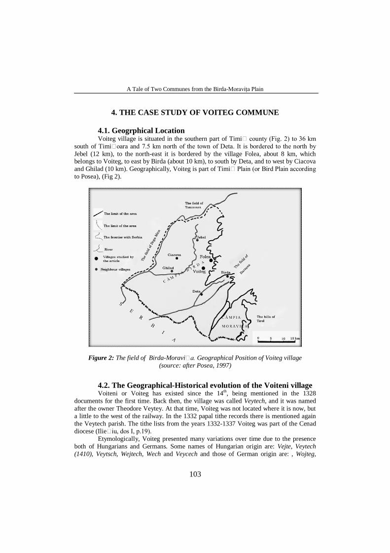
4. THE CASE STUDY OF VOITEG COMMUNE 4.1. Geogrphical Location Voiteg village is situated in the southern part of Timi county (Fig. 2) to 36 km
south of Timi oara and 7.5 km north of the town of Deta. It is bordered to the north by Jebel (12 km), to the north-east it is bordered by the village Folea, about 8 km, which belongs to Voiteg, to east by Birda (about 10 km), to south by Deta, and to west by Ciacova and Ghilad (10 km). Geographically, Voiteg is part of Timi Plain (or Bird Plain according to Posea), (Fig 2).
Figure 2: The field of Birda-Moravi a. Geographical Position of Voiteg village (source: after Posea, 1997)
4.2. The Geographical-Historical evolution of the Voiteni village Voiteni or Voiteg has existed since the 14th, being mentioned in the 1328
documents for the first time. Back then, the village was called Veytech, and it was named after the owner Theodore Veytey. At that time, Voiteg was not located where it is now, but a little to the west of the railway. In the 1332 papal tithe records there is mentioned again the Veytech parish. The tithe lists from the years 1332-1337 Voiteg was part of the Cenad diocese (Ilie iu, dos I, p.19).
Etymologically, Voiteg presented many variations over time due to the presence both of Hungarians and Germans. Some names of Hungarian origin are: Vejte, Veytech (1410), Veytsch, Wejtech, Wech and Veycech and those of German origin are: , Wojteg,
Raluca COVACI
104
Woitek, Wojtek, Voitek, and finally Voiteg. The Romanian administration of Banat brought the name of Voivodeni (1924) (Barbu,2010, p.381). To complete the series of names, the railway station is called Voiteni.
In 1329 the owners of the village are Theodore Veytey and his sons Nicolae and Ioan. In order to establish the border of Veytech, King Louis issued a commission formed from the bishop of Cenad and the Magistrate Stefan of Pouse, commission which goes into the village sets its border between 1361-1373. In 1390 the owner of the village is Nicole, the son of Teodor of Veyteh. All these names indicate that the owners of the village were Romanians since ancient times. As the family Voitec sided with the enemies in the battles which were given against King Sigismund, he seized the royal properties of the family Voitec and gave them to Mayus family (Iliesiu, ibid). Thus, following the 1410 diploma, he donated the royal possession Veytech to Laurentiu Mayus, the ban of Severin, earning him great favours. The Mayus family owns the area only until the death of King Sigismund, after which the village gets into the possession of Hagymas family. Dr. Szenthlaray said that after the disaster of Mohacs (1526), the Catholic parish of Voiteg disappeared, and the Valachs invaded the village only in the 17th century. But these statements are considered as having no basis, because there is no evidence about the existence of Catholicism in the village, the tithe lists did not record the existence of a Catholic parish. Also, there is no evidence that the Romanians came here in the 17th century, being well- known that the whole Banat was inhabited by Romanians. The village also existed during the Turkish occupation because the census of 1717 remembers it as having 28 houses and belonging to the Ciacova district (Iliesiu, ibid). The name of Voitek appears on the map of Mercy from 1723. On Griselini's map (1776), the village is known as Neu Voitec (Iliesiu, ibid). During Joseph II the village was called Voiteh.
Photo 6: The Romanian Orthodox Church from Voiteg
(Covaci, 2011)
A Tale of Two Communes from the Birda-Moraviţa Plain
105
The German colonists settle in the village in 1824, and the Romanian administration of Banat brought the name of Voivodeni in 1924. There was a male choir in the village and a library with over 400 volumes before 1918 (Iliesiu, ibid). Regarding the economic life of that period, is worth taking into account the gradual rise of the Romanian element. Thus, the Romanians bought from the Swabians 400 hectares of land between 1904-1914. The year 1907 is also considered very important in the village life, because this year coincides with the building of the Romanian Orthodox Church (Photo 6). The church is dedicated to the Great Martyr George.
Many Swabian families are deported from Voiteg to Baragan and Russian camps between 1951-1956. In their memory, there is a commemorative board (Photo 7) which is found on the gate of the Roman Catholic Church (Photo 8) in the village.
Photo 7: The commemorative board in the honour of
those deported to Baragan and Russian camps in Voiteni (Covaci, 2011)
Photo 8: The Roman Catholic Church from Voiteni
(Covaci, 2011)
Raluca COVACI
106
In order to prevent the conflicts caused by the Romanians that have returned from the front, a national council is set up under the leadership of the teacher Alexandru Taran, but the council has been dissolved upon the arrival of the Serbs.The Serbs had a hostile attitude towards the inhabitants of the village. Upon their withdrawal from the village, they took some animals (100 horses and 60 cows) along with the villagers’ goods (Iliesiu, ibid). After 1989 there are changes in the ethnic structure of the village mainly due to the mass emigration of German population between 1990-1991. An earthquake destroyed and damaged over 500 buildings including the local railway station in 1991. Starting with 2000 and until now, the village has been in the middle of a social and economic boom; in the 2002 census it recorded a total of 2 148 inhabitants (Barbu, ibid). 4.3. A short historical overview on Folea, the village belonging to Voiteg commune
Administratively, the village of Folea belongs to Voiteg area.The village of Folea is bordered to the south by Bird, by Voiteg to the west, to the east by Sipet, and to the north by Liebling and Jebel. Folea dates at least from the Middle Ages. It is mentioned documentarily for the first time in the Hungarian documents from 1332-1337, under the name of Vaja (Iliesiu, dos., III, p.221). It is also mentioned in the Hungarian documents from 1341 and 1349, under the names of Ffele and Fele (Felea) ( Suciu, DILT, I,p.245). Data are not known from the Ottoman period, but the historical thread is resumed at the end of this period. In 1717, after the Austrians conquered Banat, there was a general census of Banat, where Folea is mentioned as a village with 20 houses under the name Folle (Iliesiu, ibid).
The village was a "Valach" one, that is Romanian. Moreover, the Romanian character remained constant over time, although other nationalities have settled here, especially Germans and Hungarians, but which have always been in minority. We can say even that the population was purely Romanian until the second half of the 18th century when there were brought Germans (Swabians) in Banat. Even if during the Ottoman domination the documents regarding the history of Folea are missing, still we can place the village in the historical context Banat Plain. Thus, on July 30, 1552, the Turks conquered the city of Timisoara, which becomes the residence of the Turk ruler and a considerable part of Banat becomes an area controlled by the Ottoman Empire. Often contrary to the principles formulated, the Ottoman regime had some positive consequences, being relatively favorable for the freedom of the native population, which allowed them to use their land. The Ottoman rule has also manifested through a wide religious tolerance. However, the pace of social and economic development was slowed. Under the Habsburg rule the territory was divided into districts, headed by an administrator and a vice-administrator in the large villages. The newly-founded villages by the German settlers were led by a soltuz and the local ones (the Romanian and Serbian) by a cneaz. According to Mercy's map of 1723, the village belongs to the Ciacova district, and it appears under the name of Follia (Iliesiu, ibid).
During this period there is a remarkable economic boom because heavy work is done throughout the region for draining marshes and improving the courses of rivers and, instead of muddy land, there appeared land with cereals. Thus is introduced the rice culture, the potato cultivation is increased, and that of some technical plants. Along the much more
A Tale of Two Communes from the Birda-Moraviţa Plain
107
improved roads, there were series of mulberry trees planted (brought in Banat in 1740) to support the silk factories. Under Joseph II the village was called Folio. In 1776 the village had 109 houses. In 1782 Folea was bought by Iosif Bieliczky and George Andreovits (Iliesiu, ibid). Billiczky family owns this place till the middle of 19th century and Andreovits; part was bought by John Klaniczay in 1790 and from him it was bought by George Csiki in 1859; from 1874 it was inherited by his descendants.
There were no significant events in Folea until 1848. In this year, the revolution which has passed several times through Timisoara- Varset, there was damage caused by the Serbs that rebelled. In 1914 started World War I, which meant great difficulties both for Folea and for the entire region of Banat, in the meantime being acquired large quantities of agricultural products, additional financial contributions being compulsory, called war loans. The war also made many victims. World War II also made many victims and slowed the economic development of the village, leaving its mark on people by the mobilizing and requisitions made. In 1950, the year in which were formed the regions and districts, Folea belonged to Banat region, and was part of the Deta district. According to an order given in 1951, there were deportations made in Baragan, and in 1955 begins the collectivization of agriculture in Folea, a process which was to be completed in April 1962.
5. CONCLUSIONS
Analysing entirely the elements I have pointed out we can draw some conclusions
which emphasise the truthfulness of the research concerning the geographico-historical evolution of the two villages.In the content of this article I have researched and interpreted features of the historical evolution of the two villages through some methods of interpretation particular to historical georaphy.using the me thod of the historical documents(Bailey1994,Prayne and Payne 2004, Scott 1990) and consulting the geographical and historical works of profile .(corneanu 1940,Suciu 1977,Cretan si Fratila 2007) Drinovan 1973,
The two villages under discution identify themselves through a welthered past characterized by development or decline starting with the old document attestation (from the Middle Age) and continuing with the period of turkish domination, the period of Habsburgic domination,the deportation in Baragan and the two World Wars, with their devastating effect on the population of the two villages. The picture painted with the help of the methods of geographico-historical analysis ,cartographical and synthesis presents in a whole the specific of the Field part of Banat a historical specific remarcable through the amplitude of the events occured in the periods mentioned above.
REFERENCES
Barbu, D. (2010), Mic atlas al judetului Timis, Edit. Art Press, Timişoara. Bailey, K. (1994), Methods of Social Research, Fourth Edition: The Free Press, New York. Corneanu, N. (1940), Monografia Eparhiei Caransebes, Edit. Autorului, Caransebeş.
Raluca COVACI
108
Creţan, R., Frăţilă, V. (2007), Dictionar geografico-istoric si toponimic al judetului Timis, Edit. Universităţii de Vest, Timişoara.
Drinovan, G. (1973), Micromonografia judetului Timis, Comitetul judetean de cultură, Timişoara.
Marineasa, V., Vighi D. (1994), Fragmente din deportarea in Baragan, Timişoara. Payne, G. and Payne, J. (2004), Key Concepts in Social Research, Sage Publications, London. Posea, G. (1997), Campia de Vest a Romaniei, edit. Fundatia Romania de Mâine, Bucureşti. Scott, J. (1990), A Matter of Record, Documentary Sources in Social Research,