CENTERIS 2013 - Conference on ENTERprise Information Systems / ProjMAN 2013 - International Conference on Project MANagement / HCIST 2013 - International Conference on Health and Social
Care Information Systems and Technologies
A Web & Mobile City Maintenance Reporting Solution Jorge Santosa,c *, Fátima Rodriguesb, Lino Oliveirac
aInstituto Superior de Engenharia do Porto, Rua Dr. António Bernardino de Almeida, 4200-072 Porto, Portugal b Grupo de Investigação em Engenharia do Conhecimento e Apoio à Decisão, Instituto Superior de Engenharia, Instituto Politécnico do
Porto, Rua Dr. António Bernardino de Almeida, 4200-072 Porto, Portugal cINESC TEC (anteriormente INESC Porto), Campus da FEUP, R. Dr. Roberto Frias, 4200-465 Porto, Portugal
Abstract
In an era marked by the growing dominance of mobile computing, the systematic use of a smartphone or tablet to perform daily life tasks creates new business opportunities and drives innovation and redesign of organizations traditional work methods. With recent technological advances, space emerges for civic-oriented systems, in which citizens can promote the growth of their community through small acts of citizenship in favor of the community, allowing local management authorities to save human and financial resources. Urban problems solving is one of those areas, and the arrival of mobile technologies has revolutionized the way citizens report non-emergency situations to the responsible authorities for the local community, providing ideal conditions for the local government to respond quickly and effectively. This paper describes a proposed solution for a system capable of reporting and managing notifications of non-urgent urban situations, to foster the active participation of citizens in the community. The solution allows citizens to report a particular set of problems via a Web browser or mobile device, in a location based environment, and documenting the submitted reports with any type of multimedia information, added with the capability of automatically identify and underline the most usual problems spotted in images.
In the present context, cost containment and cutting services that make use of public funds is the motto regarding measures to be adopted to increase the economic growth of countries worldwide (Lusa [1]). This means that local governments have to do more with each time less, forcing their departments to reinvent their methods and procedures while seeking to maintain the quality of life of its citizens through programs that consume fewer resources. The appearance of new paradigms for interaction between people and systems, including interaction with mobile systems and sensor-based / context-aware programs, aroused the awareness of companies for developing applications with civic shed and sensitized them to provide services especially targeted to citizens (Tamilin et al. [2]). For businesses, the return on investment in this segment of applications is justified by the booming market of mobile devices (according to Reed [3], the number of Android devices activated until March 2013 is around 750 million devices) and this exponential growth serves as a lever to such systems, since the audience is in constantly technologic advance.
Civic duty oriented systems are no longer new (Foth et al. [4]), however due to the widespread use of mobile devices, the way citizens interact with the entities of local government management has suffered major changes.
Considering the above business opportunities, coupled with the need for integration of sectorial applications in an existing geographic information system, met the ideal conditions for the development of an application oriented to the citizen and to the act of exercising citizenship. The application that will be presented will allow citizens to notify the competent authorities of urban non-urgent problems that occur in a locality. Following the mold of existing applications on the market, and policies resulting from standardization and structuring of these applications (Open311 specification, Open311 [5]), the application will enable the creation of incident reports of problems as local roads damaged, damaged urban furniture, graffiti, garbage in public roads, objects blocking the roadway, among others. Besides supporting the most common tasks of a civic reporting application, it is foreseen the development of a module for automation of the demarcation of the most recurring problems in photographs of sent occurrences, facilitating not only the work done by the staff responsible for processing these events, but also the task of describing a problem for a common user.
This paper describes a proposed solution for a system capable of reporting and managing notifications of non-urgent urban problems, primarily seeking to foster the active participation of citizens in the community. Firstly, the underlying concept was presented in this introduction. Next follows a study to explore the most influential tools existing in the market in this area, moving to the description of the approach taken under the project context and the decision of how best to tackle the design problem. Finally, the key ideas for future developments and conclusions are presented, drawn on the work here done.
2. Related Work
Among the various projects analyzed, the ones presented below represent the state of the art systems for civic reporting, offering a wide range of features and services to citizens, municipal entities and local media. Also in this section, these solutions will be compared in order to clarify divergent and joint points, and identified common gaps of all these systems.
2.1. FixMyCity
One of the applications analyzed was FixMyCity (http://www.fixmycity.de), a modular platform for the creation of "Citizen Reporting" systems, developed by the FOKUS Fraunhofer Institute. This solution enables
citizens to report problems they encounter on public roads (mostly in their area of residence), to notify and inform the various organs of government management of the location and severity of those situations. In this project, the combination of the various components that make up the solution "Fix My City" establishes bidirectional channels between citizens and local public administration, being possible the monitoring and involvement of both entities in the evolution of a given problem, since its detection until its resolution (Fraunhofer FOKUS [6]). The project aims to reach the maximum number of citizens as possible, establishing as a priority the support for a wide variety of devices / operating systems and tight integration with social networks (Fraunhofer FOKUS [6]).
At the time of writing of this article, this solution is not yet available to the general public, while still in the initial phase of its disclosure as a product.
2.1.1. Main features Sharing on various social networks; Submission of simple occurrences; Distributed Architecture (API separation of the various applications and social networks); Georeferenced context (view reports in a catchment area) Categorization of occurrences; Promoting discussion occurrences; Generating alerts for local Media.
2.2. FixMyStreet
FixMyStreet is a solution to enable UK citizens to view, report and discuss problems they encounter in their town. It is a modular solution, and consists of several components: a web platform, mobile applications in major operating systems for citizens reporting situations, and a Backoffice platform for local governments to follow up occurrences. It is a tool of Citizen Reporting specialized in the area of the existing problems on the road, supporting a closed set of objects that can be reported: Vehicles abandoned, Graffiti’s, Waste (roadside glasses), lampposts damaged, holes in the road, among others. Since its launch in 2007, has expanded to other countries and also inspired the development of similar projects like FixMyStreet.ca (Canada), Mark-a-Spot (Germany), FixmyStreet.kr (Korea) (Steinberg T. [8]). This project was developed by mySociety, a non-profit organization dedicated to the development of projects with social impact (mySociety [7]).
Based on the model of a true open-source project born and raised in the community, all the source code is available in the GIT repository https://github.com/mysociety/fixmystreet, giving the possibility for any person to help in the development of the project.
This was one of the first projects that tested the potential of crowd-sourcing (Foth et al. [4]), allowing the sending of events all over the Web anonymously. The public availability of the occurrences reported avoids duplicative issue reporting, while it encourages online discussion of local issues. The discussion and exchange of ideas by citizens demonstrates a civic sense from people, and often solutions proposed by the citizens themselves are adopted.
2.2.1. Main features Stats occurrences per municipality; Search events by municipality; Subscription to alerts of events that occur in a particular area (the user can select a municipality, or select a
radius around a specific street); Submission of photographs about events; Discussion on incident reports.
The project CitySourced is a platform that promotes the participation and involvement of citizens in the United States in the management of non-priority events (non-urgent) in real time. It is defined as a simple and intuitive platform, allowing residents of a particular locality to report problems (situations that put into question the public safety, quality of life, environmental issues, among others) to the entities belonging to the local government responsible for future resolution. CitySourced provides local management governments the opportunity to use the system to obtain feedback from its residents, promoting a positive, rich and collaborative interaction allowing local management to save time and money in the detection of this type of urban problems (CitySourced [9]).
2.3.1. Main features Tight integration with existing applications in municipal management is a big advantage of CitySourced.
The different ways to report a problem are also an innovative feature. Citizens can report situations using various media, such as photos, videos, or even audio. All reports sent have intrinsically associated GPS coordinates and information about the direction that the user is looking.
2.4. SeeClickFix
The project SeeClickFix allows citizens of the United States of America (currently has broadened the scope of the project to include countries outside the U.S.) reporting problems in their area of residence. This project follows a modular architecture, and consists of several components: a web platform, mobile applications, and an API that allows access to all information.
With a strong ideology about the need for involvement and pro-activeness of citizens with regard to the role they can play in support of the local community where they reside, the creators of the project SeeClickFix (originating from New Haven, Connecticut, USA) seek to make the world a better place by giving voice to citizens to point problematic situations in their area and interact directly with local government entities responsible for the resolution of these problems (SeeClickFix [10]), thus approaching the community with municipal entities.
2.4.1. Main features Possibility of setting questions by municipality, for various types of problems to report (all types of
problems are configurable, as well as questions related to these themes, all set up also at the municipal level);
Sharing of all occurrences in various social networks; Focus on citizens (civic points, sharing in social networks); Promotes discussion on occurrences; Prioritization system (more notoriety for most shared occurrences); Definition of a control area (on which citizens can receive notifications of new occurrences) by the free
demarcation of boundaries on a map.
2.5. Projects comparison
All projects mentioned above were put together side by side for feature comparison following a set of well established criteria. For the sake of brevity, all common features and services offered were not considered in this analysis.
CitySourced Yes Yes No No Yes Yes Multimedia Yes, by user selection
SeeClickFix Yes Yes No Yes Yes Yes Multimedia Yes, by user selection and
Q&A† module
Our analysis showed that although SeeClickFix’s solution is far more complete than the competition, it is
still not widely spread as it could (its adoption in some countries has not yet been made). Besides, the categorization method applied to new reports is useful for the local government, but requires people to answer far more questions than feasible, resulting in some users giving up on its use.
3. The Proposed Solution
The perspective adopted for the development of this project followed the logic already implemented in a GIS (Geographic Information System) portal, in which the system allows the coupling of new specialized applications in a given area, but contribute all together equally to the geographic definition of a region. The web portal provides maps with geo-referenced information about points of interest (POI) existing in a region, obtaining dynamic information about the POI through various sources (imaging services, search engines, wiki's) relying always on the geographical location of the point. Besides providing information about POI’s, the portal already developed allows the dynamic definition of areas (lines and polygons), which are capable to logically represent subareas of the region, using standards defined by the Open Geospatial Consortium (OGC) for the representation of geographic information (KML, WFS and WMS).
The portal architecture enables the integration of new sectorial applications, capable of dealing with the specific logic of a subset of POI (or a new set of points, separated from the portal), counting already with an application for managing logistics associated with the collection of urban waste. Following this line of thought, the solution to develop will be built as a sectorial application belonging to the portal, inheriting all its features of representation and manipulation of information on maps, as well as the entire infrastructure of publishing services KML, WFS and WMS, allowing interoperability with other georeferenced systems, other applications or other Spatial Data Infrastructures. In the following figure, the link between the portal and the sectorial applications is exposed, together with the logic and software distribution by physical nodes:
Fig. 1. GIS Portal and sectorial applications relationship
4. Project Design
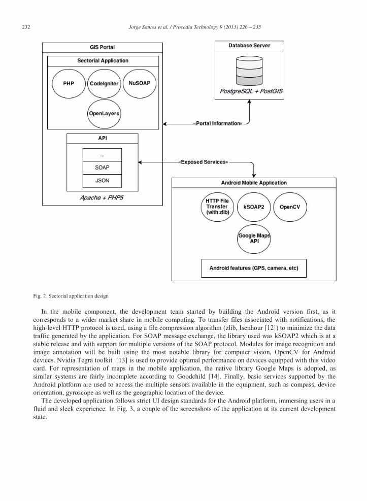
The design adopted for the development of this project reuses all the infrastructure set in GIS Portal,resulting in the architecture presented in Fig. 2.
Based on PHP5 and Apache technologies, frameworks and libraries to speed up development and allow application scalability were integrated into the GIS portal. For the construction of the Web application server component, the PHP language was used together with the CodeIgniter framework (with minimal impact toother applications or even to the portal itself). The Web Servicesff specific to the sectorial application are beingdeveloped with the aid of NuSOAP library, compatible with various versions of the SOAP specification. In the graphic component, OpenLayers is used for drawing and representing information on maps, allowing theabstraction of the mapping technology used (easily switch from Bing to Google Maps using the same codebase, for example).m
In the mobile component, the development team started by building the Android version first, as it corresponds to a wider market share in mobile computing. To transfer files associated with notifications, thehigh-level HTTP protocol is used, using a file compression algorithm (zlib, Isenhour [12]) to minimize the datatraffic generated by the application. For SOAP message exchange, the library used was kSOAP2 which is at astable release and with support for multiple versions of the SOAP protocol. Modules for image recognition andimage annotation will be built using the most notable library for computer vision, OpenCV for Androiddevices. Nvidia Tegra toolkit [13] is used to provide optimal performance on devices equipped with this videocard. For representation of maps in the mobile application, the native library Google Maps is adopted, assimilar systems are fairly incomplete according to Goodchild [14]. Finally, basic services supported by theAndroid platform are used to access the multiple sensors available in the equipment, such as compass, deviceorientation, gyroscope as well as the geographic location of the device.
The developed application follows strict UI design standards for the Android platform, immersing users in afluid and sleek experience. In Fig. 3, a couple of the screenshots of the application at its current development state.
Fig. 3. (a) Information about an individual issue; (b) Closest issues listing
All the information received by the application is carefully cached and stored in a local SQLite database easing the process of sorting, filtering, and manipulating all visible objects. The application implements several Object Oriented Programming guidelines, among which the most relevant are the lazy instantiation principle in conjunction with the singleton pattern, allowing the application to load only the absolute essential content as necessary.
At the time of writing this paper, the team is focused on optimizing the performance of the application by reducing the amount of data transferred over the network and making heavy use of data compression algorithms. In parallel, efforts are being made to increase the application’s usability and comprehension, with the use of native Android icons, colors and images, as well as the inclusion of a welcome screen with a guided tour over the main features of the application.
5. Conclusions and Future Work
In conducting this research, it was possible to identify gaps in existing civic reporting applications, including the lack of a component of demarcation in photographs of the pathology reported. This feature is of particular interest for officials in charge of processing and forwarding instances correctly, since the team dispatched to the site for problem solving may differ, depending on the type of object identified and how fast it can be identified. The authors also found no developments made in the field of automatic recognition of pathologies in the specific area of civic reporting. This work provided the basis for developing a complete solution that will meet not only the common features of an application for civic reporting, but the demarcation and automatic recognition of problem areas in photographs as well. The developed solution will integrate in the existing GIS
portal, and will be publicized and distributed primarily in the Portuguese market, which presents a marked deficit in this area.
As proposals for improvements and future work, the authors aim to implement a pattern recognition algorithm in photographs of the pathologies most commonly reported, such as potholes, damaged light poles and obstacles obstructing the public highway. Efforts were already made to investigate the most feasible methods for detection on mobile devices. According to recent studies, the detection of pathologies in the pavement is already in an advanced stage when using the algorithms of modeling automation (Koch, Brilakis [10]), and will soon reach a stage of maturity that will allow the inclusion of these technologies in commercial products. At this point, the team has already integrated a feature recognition algorithm to detect objects in reported images (potholes were the primary focus) based on Viola et al. [15] and Lienhart et al. [16] boosted cascade classifiers, using the OpenCV library. Besides the automatic detection of pathologies, it is planned to implement a mechanism to allow users the manual demarcation of the faulty element on the photographs submitted, facilitating the process of automatically filtering and forwarding to employees responsible for handling these events. The following figure illustrates a possible case of detection:
Fig. 4. Detection of a pothole in a submitted report
This will allow local authorities to dispatch teams to the field faster, and equipped with the right tools for the job. It will also provide citizens a way to visually underline problems, together with the common textual description.
Acknowledgements
The authors would like to gratefully acknowledge all referenced websites, articles and papers in this work for sustaining accurate information. Furthermore, the authors would like to put a word of appreciation to all that, directly or indirectly, contributed to the development of this work.
This work is funded (or part-funded) by the ERDF – European Regional Development Fund through the COMPETE Programme (operational programme for competitiveness) and by National Funds through the FCT – Fundação para a Ciência e Tecnologia (Portuguese Foundation for Science and Technology) within project «FCOMP - 01-0124-FEDER-022701».
References
[1] Lusa, Agência, “Governo vai acelerar cortes nas despesas públicas”, Visão website: http://visao.sapo.pt/governo-vai-acelerar-cortes-nas-despesas-publicas=f722630. Accessed April 9, 2013.
[2] Tamilin, A, Carreras I., Ssebaggala E, Opira A., Conci N., 2012. “Context-aware mobile crowdsourcing”, In Proceedings of the 2012 ACM Conference on Ubiquitous Computing (UbiComp '12) ACM, New York, NY, USA, 717-720.
[3] Reed, Brad, “Android’s steady march to 1 billion activations gets visualized”, BGR website: http://bgr.com/2013/03/13/android-activation-growth-analysis-373572/. Accessed April 2, 2013.
[4] Foth M., Schroeter R., Anastasiu I., 2011. “Fixing the City One Photo at a Time: Mobile Logging of Maintenance Requests”, Proceeding OzCHI '11 Proceedings of the 23rd Australian Computer-Human Interaction Conference Pages 126-129
[5] OpenPlans, Open311 initiative website: http://open311.org/learn/. Accessed February 21, 2013. [6] Fraunhofer FOKUS, FixMyCity website: http://www.fixmycity.de/. Accessed February 16, 2013. [7] mySociety, FixMyStreet website: http://www.fixmystreet.com/. Accessed February 14, 2013. [8] Steinberg, T., “FixMyStreet in Norway”, mySociety Blog: http://www.mysociety.org/2011/03/07/fixmystreet-in-norway/. Accessed
February 14, 2013. [9] CitySourced, CitySourced website: http://www.citysourced.com. Accessed February 21, 2013. [10] SeeClickFix, SeeClickFix website: http://seeclickfix.com/. Accessed March 8, 2013. [11] Koch, C., Brilakis I., 2011. “Pothole detection in asphalt pavement images”, Advanced Engineering Informatics, Volume 25, Issue 3,
August 2011, Pages 507–515. [12] Isenhour, P., “Compressing Data Sent Over a Socket, Java Techniques website: http://javatechniques.com/blog/compressing-data-sent-
Accessed April 10, 2013. [14] Goodchild, M.F.,2007. “Citizens as sensors: the world of volunteered geography”. GeoJournal 69 (4): 211–221 [15] Lienhart R., Kuranov A., Pisarevsky V., 2002. “Empirical Analysis of Detection Cascades of Boosted Classifiers for Rapid Object Detection”, 25th DAGM Symposium, Magdeburg, Germany, September 10-12, 2003. Proceedings, pp 297-304. [16] Viola, P.; Jones, M., 2001. “Rapid object detection using a boosted cascade of simple features, ” Computer Vision and Pattern
Recognition. CVPR 2001. Proceedings of the 2001 IEEE Computer Society Conference on , vol.1, no., pp.I-511,I-518 vol.1, 2001.