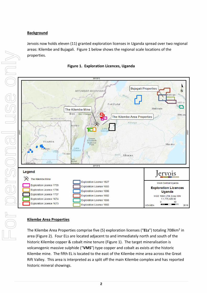
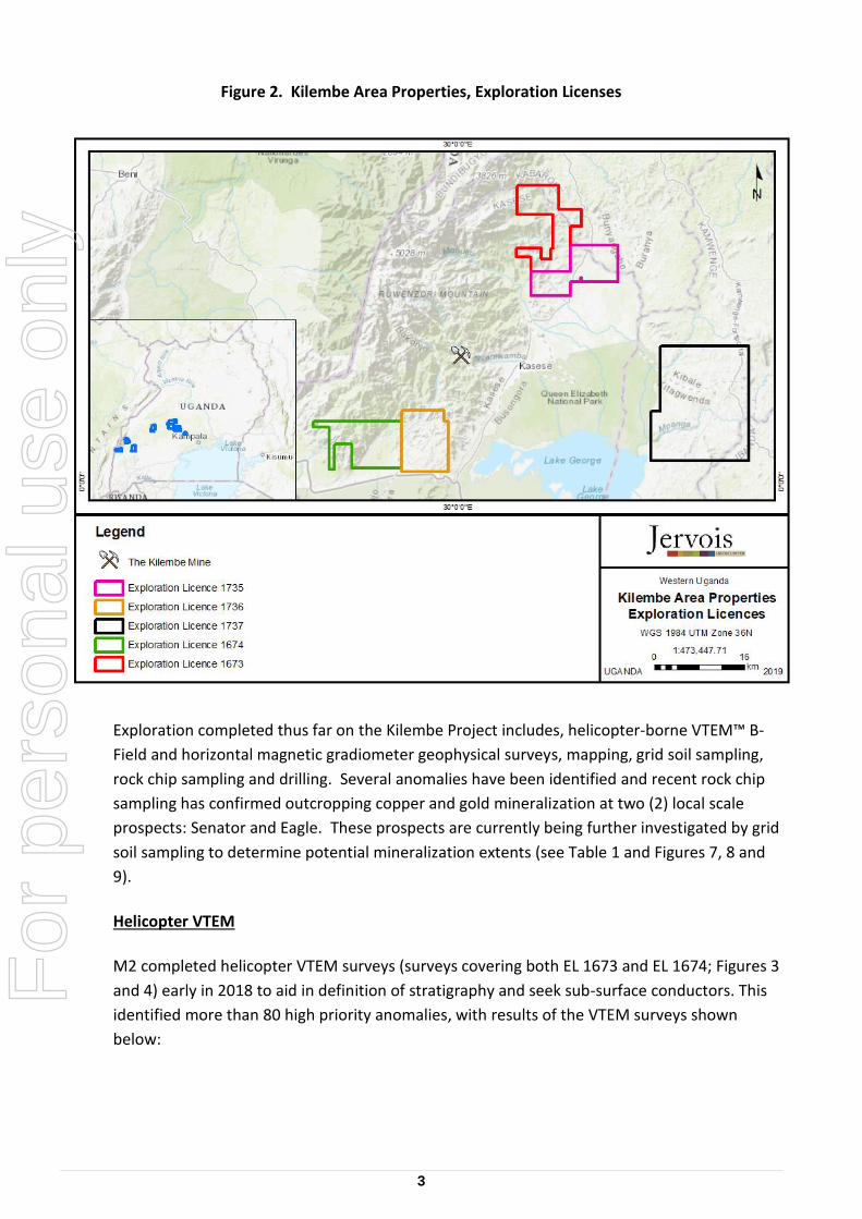
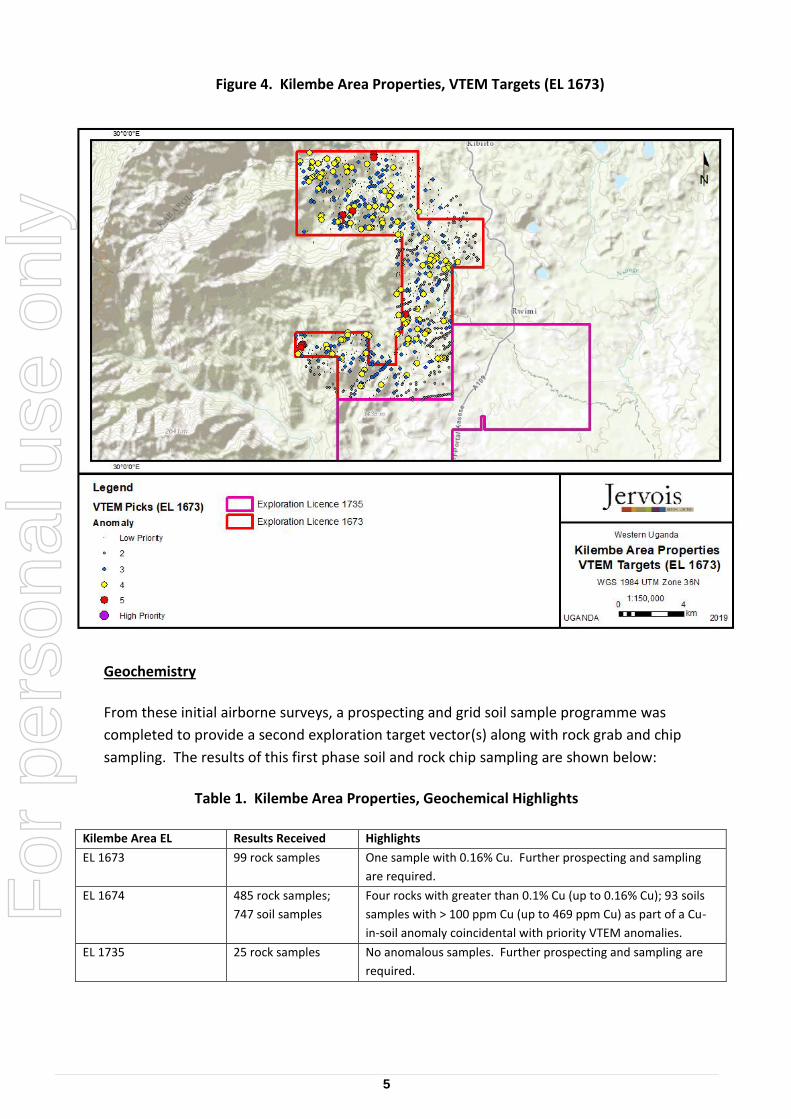
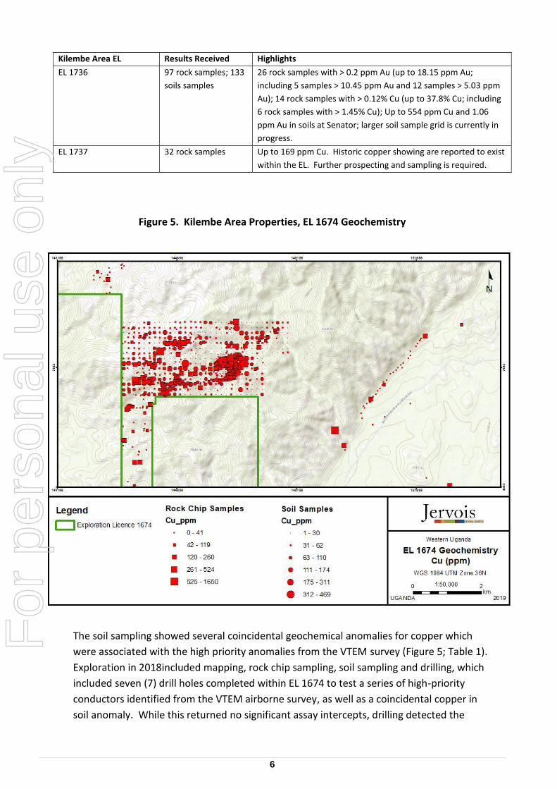
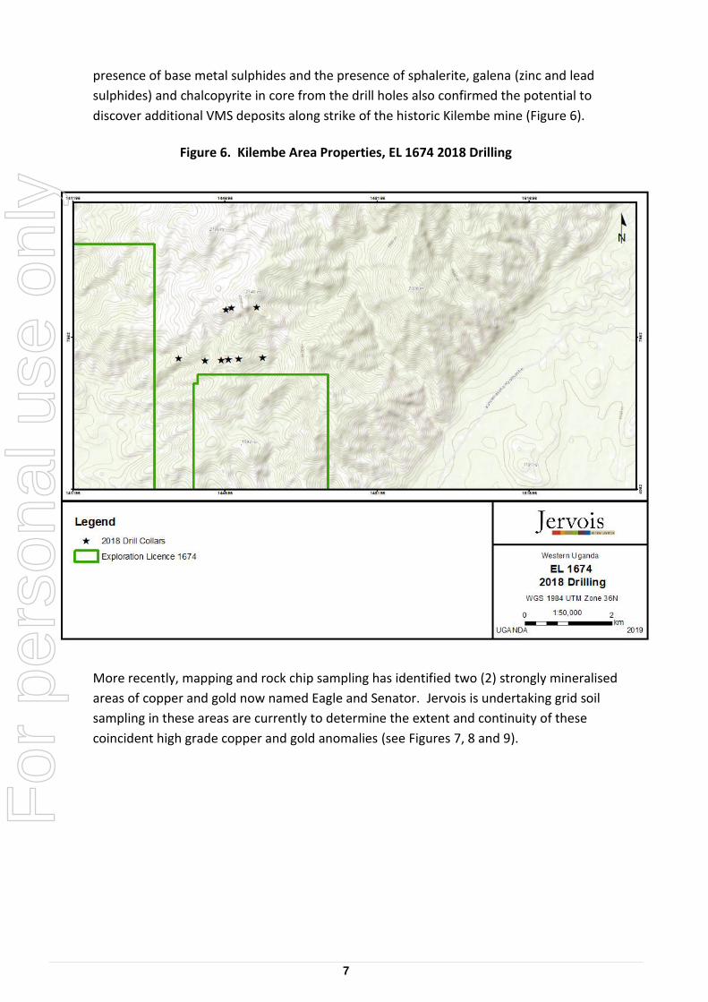
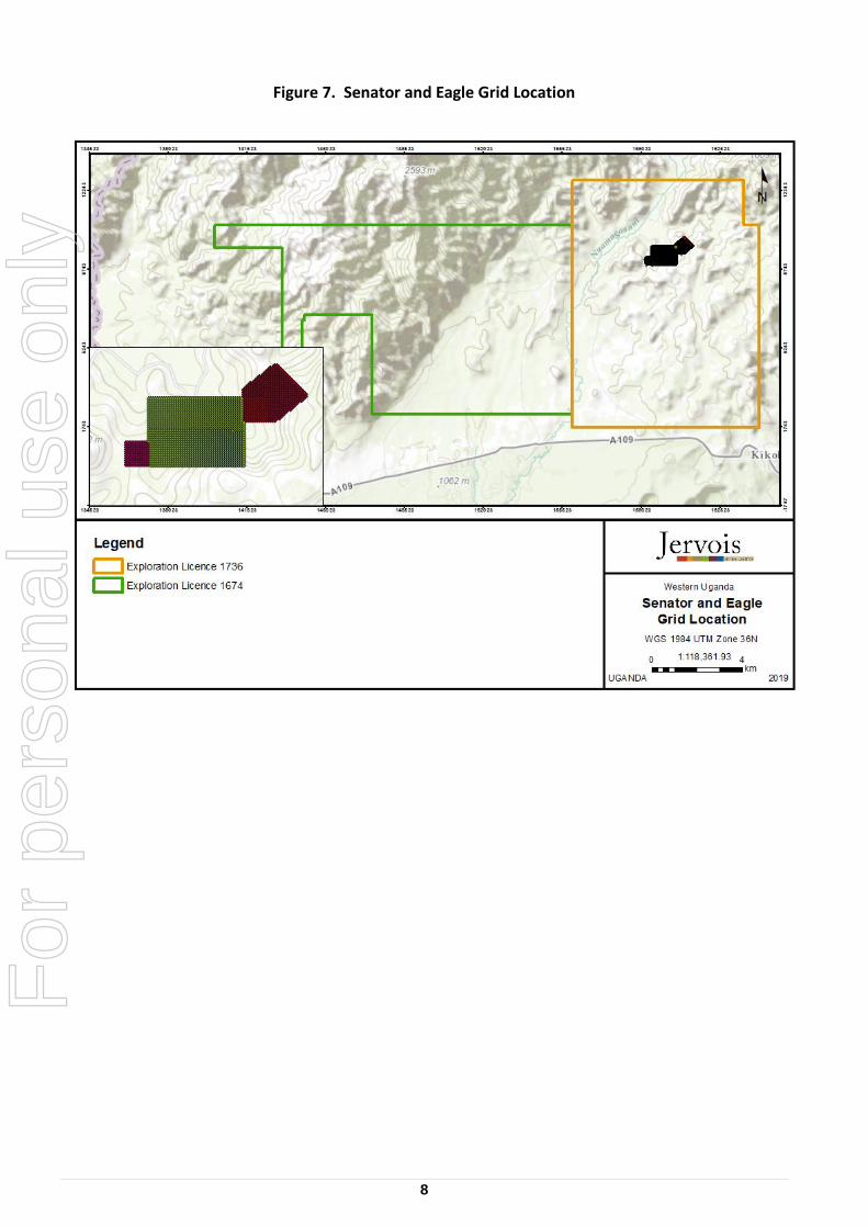
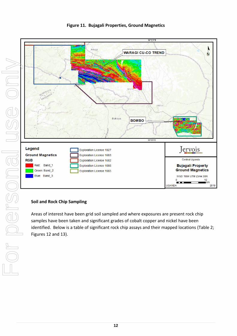
A.B.N. 52 007 626 575 24 June 2019 ASX/TSXV: JRV Jervois Mining progresses Ugandan exploration; drilling underway HIGHLIGHTS During 2018 and early 2019, M2 Cobalt collected 2,518 rock chip samples at 17,336 soil samples at its highly prospective Bujagali and Kilembe properties in Uganda. Jervois continues to target significant cobalt, base metal and gold anomalies defined in 2018-19 in its exploration. Two localised, surficial copper-gold showings have been discovered within the Kilembe Area exploration licenses, named Eagle and Senator respectively. At Eagle, rock grab samples include showings of 37.8% copper and 18.2 g/t gold. Senator has showings up to 7.8% copper and 16.3 g/t gold (including 10 samples > 5.0 g/t gold). Jervois cautions that rock grab samples are by their nature selective and are not necessarily indicative of the general geology or grade within the property. Work programme includes further ground geophysics and geochemistry (infill sampling) at Bujagali and Kilembe. Drilling is also underway at Bujagali, initially targeting the Bombo nickel, copper, cobalt and Waragi copper, cobalt anomalies. Jervois expects results from this during Q3 CY19. Jervois Mining Limited (ASX/TSXV: JRV) is pleased to provide an update on exploration of its Uganda prospects following the successful merger with M2 Cobalt. M2 Cobalt previously conducted extensive surface exploration within its Ugandan exploration licenses in both the Kilembe area in western Uganda and Bujagali in the south central region. Jervois will now continue with the exploration programme. At the time the merger was closed, M2 had drawn US$1.8 million of a US$3.0 million secured convertible loan provided by Jervois as part of the transaction. For personal use only
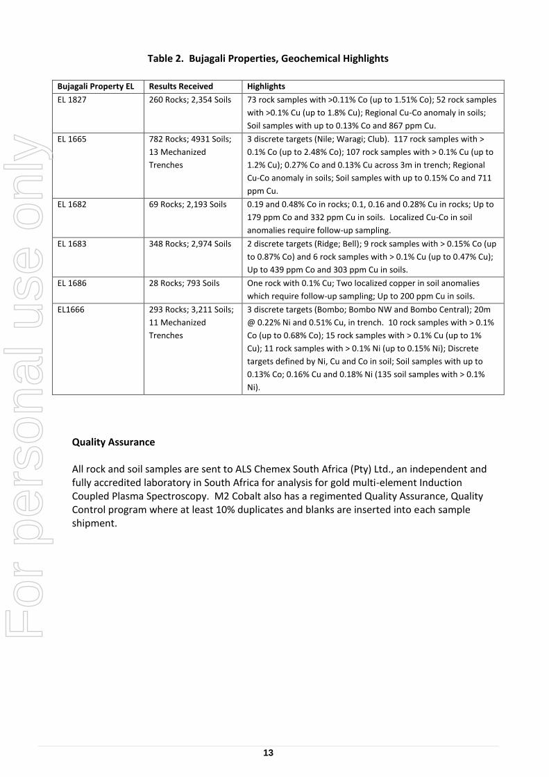
EL 1827 260 Rocks; 2,354 Soils 73 rock samples with >0.11% Co (up to 1.51% Co); 52 rock samples
with >0.1% Cu (up to 1.8% Cu); Regional Cu-Co anomaly in soils;
Soil samples with up to 0.13% Co and 867 ppm Cu.
EL 1665 782 Rocks; 4931 Soils;
13 Mechanized
Trenches
3 discrete targets (Nile; Waragi; Club). 117 rock samples with >
0.1% Co (up to 2.48% Co); 107 rock samples with > 0.1% Cu (up to
1.2% Cu); 0.27% Co and 0.13% Cu across 3m in trench; Regional
Cu-Co anomaly in soils; Soil samples with up to 0.15% Co and 711
ppm Cu.
EL 1682 69 Rocks; 2,193 Soils 0.19 and 0.48% Co in rocks; 0.1, 0.16 and 0.28% Cu in rocks; Up to
179 ppm Co and 332 ppm Cu in soils. Localized Cu-Co in soil
anomalies require follow-up sampling.
EL 1683 348 Rocks; 2,974 Soils 2 discrete targets (Ridge; Bell); 9 rock samples with > 0.15% Co (up
to 0.87% Co) and 6 rock samples with > 0.1% Cu (up to 0.47% Cu);
Up to 439 ppm Co and 303 ppm Cu in soils.
EL 1686 28 Rocks; 793 Soils One rock with 0.1% Cu; Two localized copper in soil anomalies
which require follow-up sampling; Up to 200 ppm Cu in soils.
EL1666 293 Rocks; 3,211 Soils;
11 Mechanized
Trenches
3 discrete targets (Bombo; Bombo NW and Bombo Central); 20m
@ 0.22% Ni and 0.51% Cu, in trench. 10 rock samples with > 0.1%
Co (up to 0.68% Co); 15 rock samples with > 0.1% Cu (up to 1%
Cu); 11 rock samples with > 0.1% Ni (up to 0.15% Ni); Discrete
targets defined by Ni, Cu and Co in soil; Soil samples with up to
0.13% Co; 0.16% Cu and 0.18% Ni (135 soil samples with > 0.1%
Ni).
Quality Assurance All rock and soil samples are sent to ALS Chemex South Africa (Pty) Ltd., an independent and fully accredited laboratory in South Africa for analysis for gold multi-element Induction Coupled Plasma Spectroscopy. M2 Cobalt also has a regimented Quality Assurance, Quality Control program where at least 10% duplicates and blanks are inserted into each sample shipment.
For
per
sona
l use
onl
y
14
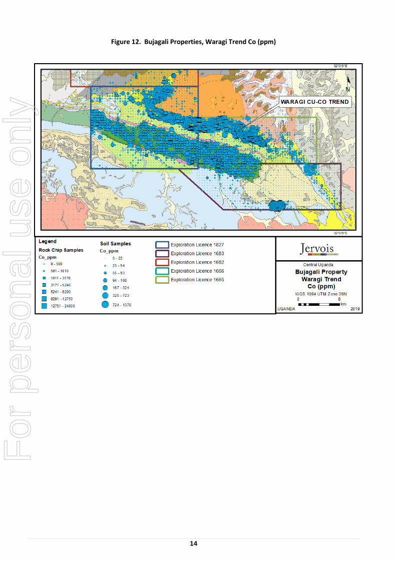
Figure 12. Bujagali Properties, Waragi Trend Co (ppm)
For
per
sona
l use
onl
y
15
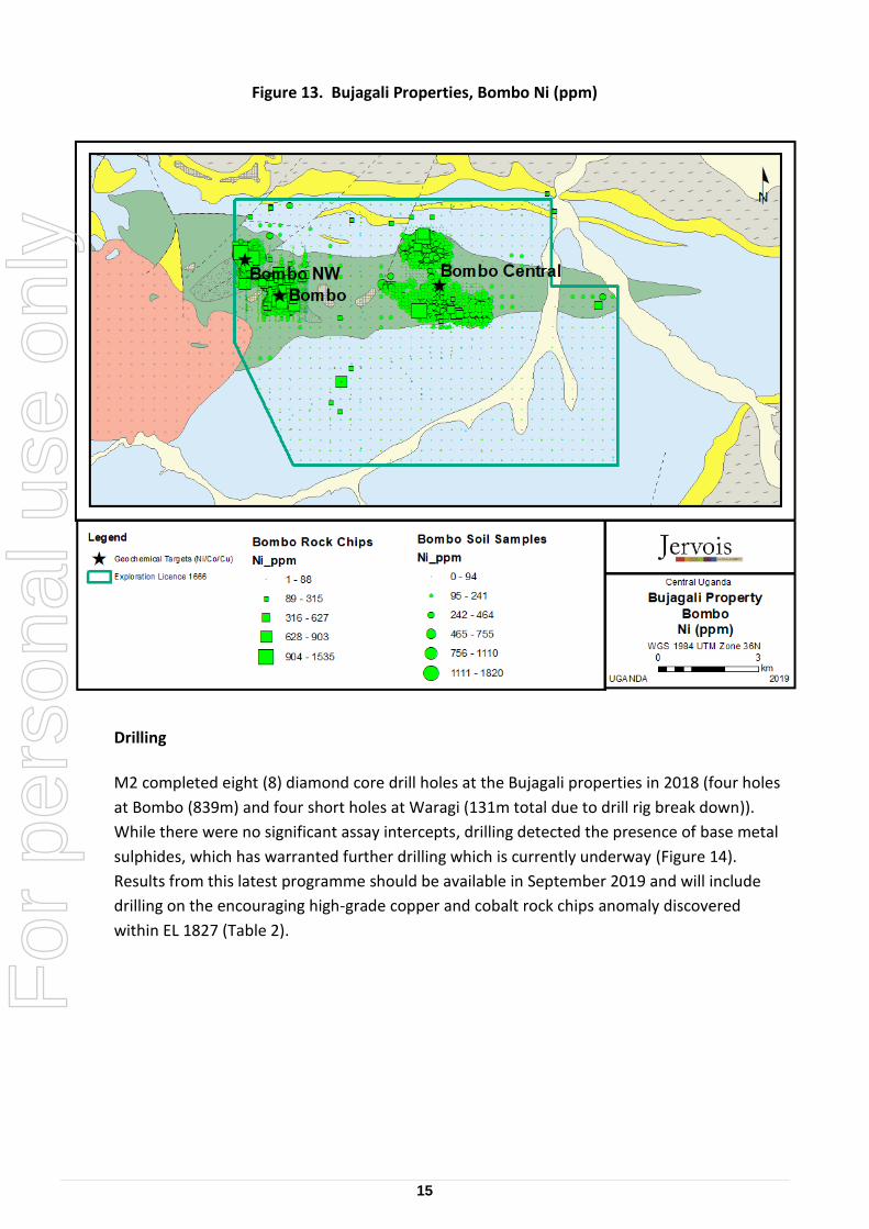
Figure 13. Bujagali Properties, Bombo Ni (ppm)
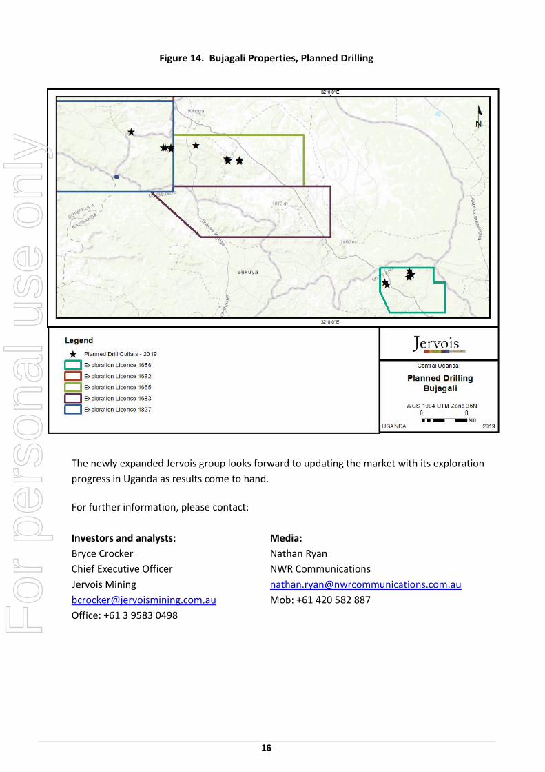
Drilling
M2 completed eight (8) diamond core drill holes at the Bujagali properties in 2018 (four holes
at Bombo (839m) and four short holes at Waragi (131m total due to drill rig break down)).
While there were no significant assay intercepts, drilling detected the presence of base metal
sulphides, which has warranted further drilling which is currently underway (Figure 14).
Results from this latest programme should be available in September 2019 and will include
drilling on the encouraging high-grade copper and cobalt rock chips anomaly discovered
within EL 1827 (Table 2).
For
per
sona
l use
onl
y
16
Figure 14. Bujagali Properties, Planned Drilling
The newly expanded Jervois group looks forward to updating the market with its exploration
Competent Person’s Statement The information in this release that relates to Mineral Exploration is based on information compiled by David Selfe who is full time employee of the company and a Member of the Australasian Institute of Mining and Metallurgy and Dean Besserer, P.Geol. who is a consultant to the company and a member of The Association of Professional Engineers and Geoscientists of Alberta. Both David Selfe and Dean Besserer have sufficient experience which is relevant to the style of mineralisation and type of deposit under consideration and to the activity which they are undertaking to qualify as a Competent Person as defined in the 2012 Edition of the ‘Australasian Code for Reporting of Exploration Results, Mineral Resources and Ore Reserves’. David Selfe and Dean Besserer consent to the inclusion in the release of the matters based on their information in the form and context in which it appears.
For
per
sona
l use
onl
y
18
JORC Code, 2012 Edition – Table 1
Section 1 Sampling Techniques and Data
Criteria JORC Code explanation Commentary
Sampling techniques
Nature and quality of sampling (eg cut channels, random chips, or specific specialised industry standard measurement tools appropriate to the minerals under investigation, such as down hole gamma sondes, or handheld XRF instruments, etc). These examples should not be taken as limiting the broad meaning of sampling.
Sampling to date includes 807 diamond drill samples (from 9 diamond core drill holes); 17,798 soil samples; 2471 rock samples, 26 Heavy Mineral Concentrates; 25 stream silt samples; 1258 trench samples (rock); and, 379 trench samples (soil).
All drill core was generally sampled on 1m intervals, contingent on geology and core recovery:
Core was collected directly from the core barrel into core boxes, and Core samples were split in half, with the top half of the core analysed and other half retained as reference core in the tray. Core trays were clearly labelled with the hole number, tray number and metre intervals marked. Bottom-of-hole orientation line was marked prior to geological logging and sampling.
Soil samples (B Horizon) are collected using a pick and spade to dig small pits which are filled back in after the sample is collected. The samples are collected in 4x6’ kraft bags and closed/sealed with a zip tie. All sample information is recorded on hand-held devices utilizing the Fulcrum App. ALS Sample tag books are utilized for sample identifiers which are scanned and/or entered manually. The sample identifier is written on the bag and a tag is placed in the bag. Sample and site photos are recorded at every site. Devices are downloaded daily are all information is stored to the cloud.
Rock samples (typically grab samples) are collected using a rock hammer. The samples are selective and are not necessarily indicative of mineralization. The samples are collected in 12x20 plastic ore bags and closed/sealed with a zip tie. All sample information is recorded on hand-held devices utilizing the Fulcrum App. ALS Sample tag books are utilized for sample identifiers which are scanned and/or entered manually. The
For
per
sona
l use
onl
y
19
Criteria JORC Code explanation Commentary
Include reference to measures taken to ensure sample representivity and the appropriate calibration of any measurement tools or systems used.
sample identifier is written on the bag and a tag is placed in the bag. Sample and site photos are recorded at every site. Devices are downloaded daily are all information is stored to the cloud.
Samples were cut along the orientation line before being correctly placed back into the tray. The half-core was sampled, ensuring that the same side is consistently sampled, and placed into sample bags labelled with the assigned sample number. Orientation lines are determined using a Reflex ACTIII orientation tool. Downhole measurements are recorded using a Reflex EZ-Gyro Kit at multiple intervals down each hole and always at the end of every hole. Field sampling followed Jervois protocols including industry standard quality control procedures.
All samples were sent to ALS Chemex South Africa (Pty) Ltd., an independent and fully accredited laboratory in South Africa (“ALS”) for analysis for gold multi-element Induction Coupled Plasma Spectroscopy (“ICP”). Jervois also has a regimented Quality Assurance, Quality Control (“QA/QC”) programme where at least 10% duplicates and blanks are inserted into each sample shipment.
Sample representativity is ensured by:
Diamond Core: For all drilling core was halved for sub‐sampling with a diamond saw. Sample intervals range from 0.1 to 1 m in length, with majority of samples assayed over 1 m intervals.
Rock grab samples are by their nature selective and are not necessarily indicative of the general geology of the property.
For
per
sona
l use
onl
y
20
Criteria JORC Code explanation Commentary
Aspects of the determination of mineralisation that are Material to the Public Report.
In cases where ‘industry standard’ work has been done this would be relatively simple (eg ‘reverse circulation drilling was used to obtain 1 m samples from which 3 kg was pulverised to produce a 30 g charge for fire assay’). In other cases more explanation may be required, such as where there is coarse gold that has inherent sampling problems. Unusual commodities or mineralisation types (eg submarine nodules) may warrant disclosure of detailed information.
Handheld XRF instruments were used to spot check rock grab and/or drill core for mineralization, however those results were not relied on. All sample results reported on are from ALS Chemex South Africa (Pty) Ltd. Drill holes were lined with PVC piping and in most holes, downhole Electromagnetics were completed after drilling was complete.
All of the drilling was diamond drill core (HQ/NQ). Typically, drill core was sampled on nominal 1m half core samples.
All sample analyses were completed at ALS Chemex South Africa (Pty) Ltd. and/or ALS Chemex Vancouver, Canada. ALS is a global independent laboratory which is ISO accredited.
Samples are received at the laboratory: Bar codes are scanned and logged; samples are weighed and dried; samples are crushed and pulverized (-180 mesh soils; -75microns rocks) then riffle split; all samples are analyzed for 35 elements using ICP-AES and gold using 30 gram fire assay for soils and 50 gram Fire assay for rocks, both with an AA finish. Any samples with over-limits specific to base metals or gold are re-analyzed.
Drilling techniques
Drill type (eg core, reverse circulation, open-hole hammer, rotary air blast, auger, Bangka, sonic, etc) and details (eg core diameter, triple or standard tube, depth of diamond tails, face-sampling bit or other type, whether core is oriented and if so, by what method, etc).
HQ casing/coring within saprolite yet the majority of the core was NQ
Holes were generally angled from 60 to 90 degrees at varying azimuths. Reflex Orientation tool was used for structural orientations, and depths varied from 8.85m to 243m.
Drill sample recovery
Method of recording and assessing core and chip sample recoveries and results assessed.
Measures taken to maximise sample recovery and ensure representative
All holes are teched and all intervals are measured for recovery and RQD’s are calculated. Recovery % recorded in the geotechnical records as equivalent to the length of core recovered, as a percentage of the drill run.
Excellent recoveries were obtained from Diamond drilling.
For
per
sona
l use
onl
y
21
Criteria JORC Code explanation Commentary
nature of the samples.
Whether a relationship exists between sample recovery and grade and whether sample bias may have occurred due to preferential loss/gain of fine/coarse material.
There is no bias noted between sample recovery and grade. Excellent recoveries were obtained from Diamond drilling.
Logging Whether core and chip samples have been geologically and geotechnically logged to a level of detail to support appropriate Mineral Resource estimation, mining studies and metallurgical studies.
Whether logging is qualitative or quantitative in nature. Core (or costean, channel, etc) photography.
The total length and percentage of the relevant intersections logged.
Diamond drilling:
Drill core is photographed and logged prior to sampling;
Core has been geologically and geotechnically logged to a level of detail appropriate to support mineral resource estimation and mining studies.
Logging has been conducted both qualitatively and quantitatively; full description of lithologies, alteration and comments are noted, as well as percentage estimates on veining and sulphides.
In total, 2027 m of diamond drill core have been completed. All drill holes are logged in their entirety.
Sub-sampling techniques and sample preparation
If core, whether cut or sawn and whether quarter, half or all core taken.
If non-core, whether riffled, tube sampled, rotary split, etc and whether sampled wet or dry.
For all sample types, the nature, quality and appropriateness of the sample preparation technique.
Core was half-cut lengthwise using a diamond saw along the orientation line. The half-core was sampled, generally on metre intervals.
Samples are received at the laboratory: Bar codes are scanned and logged; samples are weighed and dried; samples are crushed and pulverized (-75microns rocks) then riffle split; all samples are analyzed for 35 elements using ICP-AES and gold using 50 gram Fire assay with an AA finish. Any samples with over-limits specific to base metals or gold are re-analyzed.
For
per
sona
l use
onl
y
22
Criteria JORC Code explanation Commentary
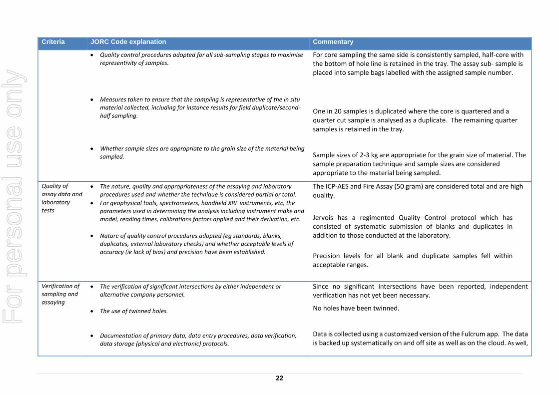
Quality control procedures adopted for all sub-sampling stages to maximise representivity of samples.
Measures taken to ensure that the sampling is representative of the in situ material collected, including for instance results for field duplicate/second-half sampling.
Whether sample sizes are appropriate to the grain size of the material being sampled.
For core sampling the same side is consistently sampled, half-core with the bottom of hole line is retained in the tray. The assay sub- sample is placed into sample bags labelled with the assigned sample number.
One in 20 samples is duplicated where the core is quartered and a quarter cut sample is analysed as a duplicate. The remaining quarter samples is retained in the tray.
Sample sizes of 2-3 kg are appropriate for the grain size of material. The sample preparation technique and sample sizes are considered appropriate to the material being sampled.
Quality of assay data and laboratory tests
The nature, quality and appropriateness of the assaying and laboratory procedures used and whether the technique is considered partial or total.
For geophysical tools, spectrometers, handheld XRF instruments, etc, the parameters used in determining the analysis including instrument make and model, reading times, calibrations factors applied and their derivation, etc.
Nature of quality control procedures adopted (eg standards, blanks, duplicates, external laboratory checks) and whether acceptable levels of accuracy (ie lack of bias) and precision have been established.
The ICP-AES and Fire Assay (50 gram) are considered total and are high quality.
Jervois has a regimented Quality Control protocol which has consisted of systematic submission of blanks and duplicates in addition to those conducted at the laboratory.
Precision levels for all blank and duplicate samples fell within acceptable ranges.
Verification of sampling and assaying
The verification of significant intersections by either independent or alternative company personnel.
The use of twinned holes.
Documentation of primary data, data entry procedures, data verification, data storage (physical and electronic) protocols.
Since no significant intersections have been reported, independent verification has not yet been necessary.
No holes have been twinned.
Data is collected using a customized version of the Fulcrum app. The data is backed up systematically on and off site as well as on the cloud. As well,
For
per
sona
l use
onl
y
23
Criteria JORC Code explanation Commentary
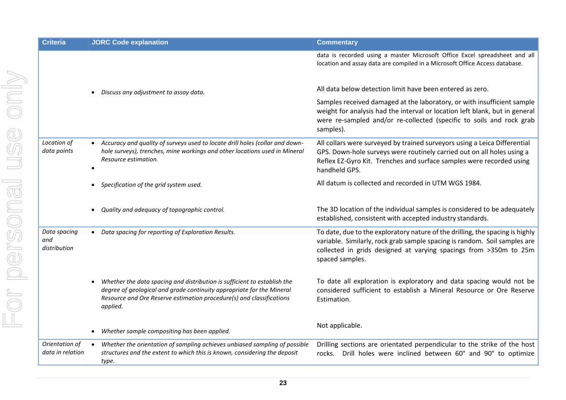
Discuss any adjustment to assay data.
data is recorded using a master Microsoft Office Excel spreadsheet and all location and assay data are compiled in a Microsoft Office Access database.
All data below detection limit have been entered as zero.
Samples received damaged at the laboratory, or with insufficient sample weight for analysis had the interval or location left blank, but in general were re-sampled and/or re-collected (specific to soils and rock grab samples).
Location of data points
Accuracy and quality of surveys used to locate drill holes (collar and down-hole surveys), trenches, mine workings and other locations used in Mineral Resource estimation.
Specification of the grid system used.
Quality and adequacy of topographic control.
All collars were surveyed by trained surveyors using a Leica Differential GPS. Down-hole surveys were routinely carried out on all holes using a Reflex EZ-Gyro Kit. Trenches and surface samples were recorded using handheld GPS.
All datum is collected and recorded in UTM WGS 1984.
The 3D location of the individual samples is considered to be adequately established, consistent with accepted industry standards.
Data spacing and distribution
Data spacing for reporting of Exploration Results.
Whether the data spacing and distribution is sufficient to establish the degree of geological and grade continuity appropriate for the Mineral Resource and Ore Reserve estimation procedure(s) and classifications applied.
Whether sample compositing has been applied.
To date, due to the exploratory nature of the drilling, the spacing is highly variable. Similarly, rock grab sample spacing is random. Soil samples are collected in grids designed at varying spacings from >350m to 25m spaced samples.
To date all exploration is exploratory and data spacing would not be considered sufficient to establish a Mineral Resource or Ore Reserve Estimation.
Not applicable.
Orientation of data in relation
Whether the orientation of sampling achieves unbiased sampling of possible structures and the extent to which this is known, considering the deposit type.
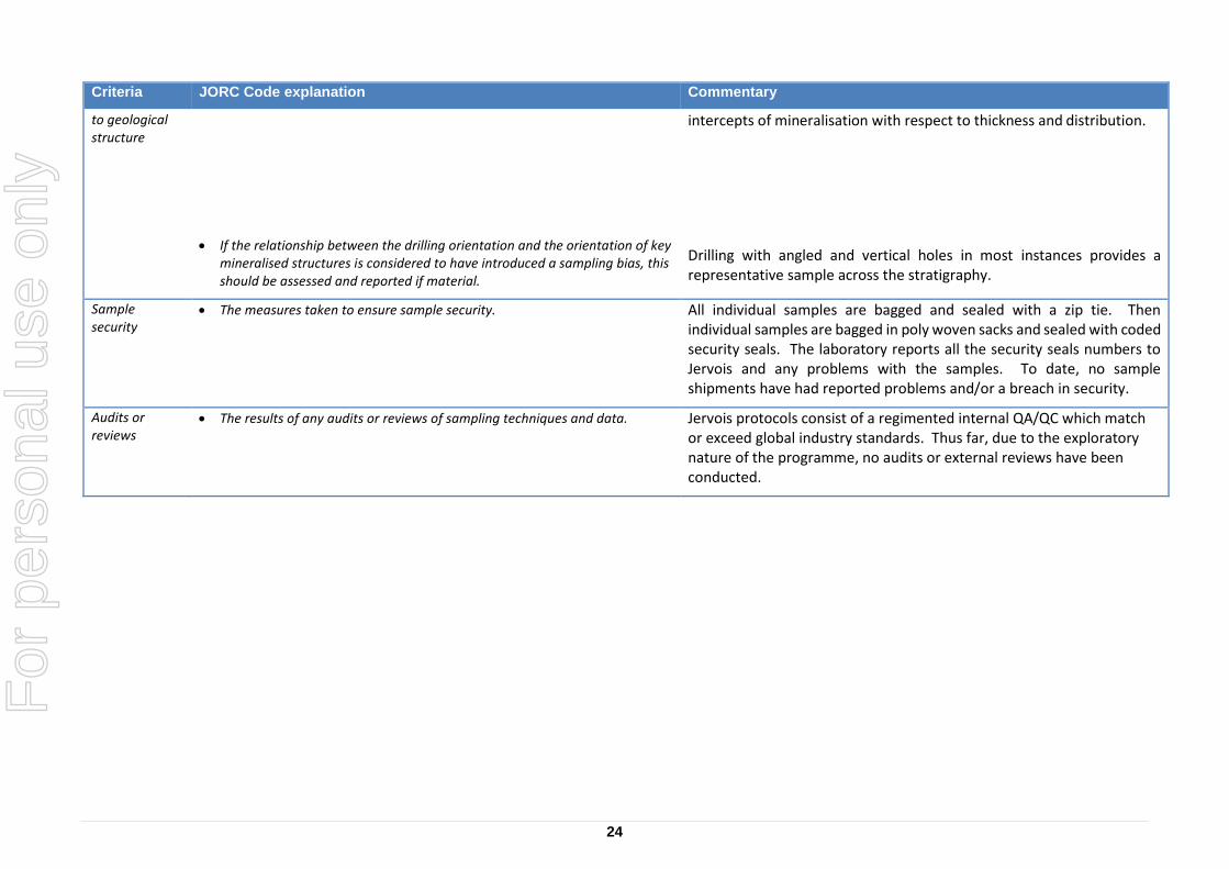
Drilling sections are orientated perpendicular to the strike of the host rocks. Drill holes were inclined between 60° and 90° to optimize
For
per
sona
l use
onl
y
24
Criteria JORC Code explanation Commentary
to geological structure
If the relationship between the drilling orientation and the orientation of key mineralised structures is considered to have introduced a sampling bias, this should be assessed and reported if material.
intercepts of mineralisation with respect to thickness and distribution.
Drilling with angled and vertical holes in most instances provides a representative sample across the stratigraphy.
Sample security
The measures taken to ensure sample security. All individual samples are bagged and sealed with a zip tie. Then individual samples are bagged in poly woven sacks and sealed with coded security seals. The laboratory reports all the security seals numbers to Jervois and any problems with the samples. To date, no sample shipments have had reported problems and/or a breach in security.
Audits or reviews
The results of any audits or reviews of sampling techniques and data. Jervois protocols consist of a regimented internal QA/QC which match or exceed global industry standards. Thus far, due to the exploratory nature of the programme, no audits or external reviews have been conducted.
For
per
sona
l use
onl
y
25
Criteria JORC Code explanation Commentary
Sampling techniques
Nature and quality of sampling (eg cut channels, random chips, or specific specialised industry standard measurement tools appropriate to the minerals under investigation, such as down hole gamma sondes, or handheld XRF instruments, etc). These examples should not be taken as limiting the broad meaning of sampling.
Sampling to date includes 807 diamond drill samples (from 9 diamond core drill holes); 17,798 soil samples; 2471 rock samples, 26 Heavy Mineral Concentrates; 25 stream silt samples; 1258 trench samples (rock); and, 379 trench samples (soil).
All drill core was generally sampled on 1m intervals, contingent on geology and core recovery:
Core was collected directly from the core barrel into core boxes, and Core samples were split in half, with the top half of the core analysed and other half retained as reference core in the tray. Core trays were clearly labelled with the hole number, tray number and metre intervals marked. Bottom-of-hole orientation line was marked prior to geological logging and sampling.
Soil samples (B Horizon) are collected using a pick and spade to dig small pits which are filled back in after the sample is collected. The samples are collected in 4x6’ kraft bags and closed/sealed with a zip tie. All sample information is recorded on hand-held devices utilizing the Fulcrum App. ALS Sample tag books are utilized for sample identifiers which are scanned and/or entered manually. The sample identifier is written on the bag and a tag is placed in the bag. Sample and site photos are recorded at every site. Devices are downloaded daily are all information is stored to the cloud.
Rock samples (typically grab samples) are collected using a rock hammer. The samples are selective and are not necessarily indicative of mineralization. The samples are collected in 12x20 plastic ore bags and closed/sealed with a zip tie. All sample information is recorded on hand-held devices utilizing the Fulcrum App. ALS Sample tag books are utilized for sample identifiers which are scanned and/or entered manually. The sample identifier is written on the bag and a tag is placed in the bag. Sample and site photos are recorded at every site. Devices are downloaded daily are all information is stored to the cloud.
For
per
sona
l use
onl
y
26
Criteria JORC Code explanation Commentary
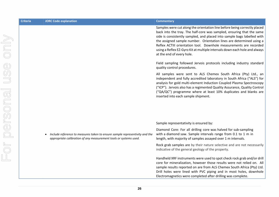
Include reference to measures taken to ensure sample representivity and the appropriate calibration of any measurement tools or systems used.
Samples were cut along the orientation line before being correctly placed back into the tray. The half-core was sampled, ensuring that the same side is consistently sampled, and placed into sample bags labelled with the assigned sample number. Orientation lines are determined using a Reflex ACTIII orientation tool. Downhole measurements are recorded using a Reflex EZ-Gyro Kit at multiple intervals down each hole and always at the end of every hole. Field sampling followed Jervois protocols including industry standard quality control procedures.
All samples were sent to ALS Chemex South Africa (Pty) Ltd., an independent and fully accredited laboratory in South Africa (“ALS”) for analysis for gold multi-element Induction Coupled Plasma Spectroscopy (“ICP”). Jervois also has a regimented Quality Assurance, Quality Control (“QA/QC”) programme where at least 10% duplicates and blanks are inserted into each sample shipment.
Sample representativity is ensured by:
Diamond Core: For all drilling core was halved for sub‐sampling with a diamond saw. Sample intervals range from 0.1 to 1 m in length, with majority of samples assayed over 1 m intervals.
Rock grab samples are by their nature selective and are not necessarily indicative of the general geology of the property. Handheld XRF instruments were used to spot check rock grab and/or drill core for mineralization, however those results were not relied on. All sample results reported on are from ALS Chemex South Africa (Pty) Ltd. Drill holes were lined with PVC piping and in most holes, downhole Electromagnetics were completed after drilling was complete.
For
per
sona
l use
onl
y
27
Criteria JORC Code explanation Commentary
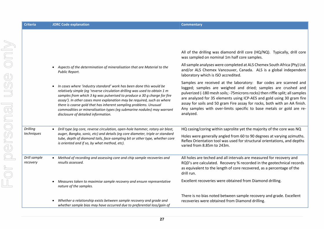
Aspects of the determination of mineralisation that are Material to the Public Report.
In cases where ‘industry standard’ work has been done this would be relatively simple (eg ‘reverse circulation drilling was used to obtain 1 m samples from which 3 kg was pulverised to produce a 30 g charge for fire assay’). In other cases more explanation may be required, such as where there is coarse gold that has inherent sampling problems. Unusual commodities or mineralisation types (eg submarine nodules) may warrant disclosure of detailed information.
All of the drilling was diamond drill core (HQ/NQ). Typically, drill core was sampled on nominal 1m half core samples.
All sample analyses were completed at ALS Chemex South Africa (Pty) Ltd. and/or ALS Chemex Vancouver, Canada. ALS is a global independent laboratory which is ISO accredited.
Samples are received at the laboratory: Bar codes are scanned and logged; samples are weighed and dried; samples are crushed and pulverized (-180 mesh soils; -75microns rocks) then riffle split; all samples are analyzed for 35 elements using ICP-AES and gold using 30 gram fire assay for soils and 50 gram Fire assay for rocks, both with an AA finish. Any samples with over-limits specific to base metals or gold are re-analyzed.
Drilling techniques
Drill type (eg core, reverse circulation, open-hole hammer, rotary air blast, auger, Bangka, sonic, etc) and details (eg core diameter, triple or standard tube, depth of diamond tails, face-sampling bit or other type, whether core is oriented and if so, by what method, etc).
HQ casing/coring within saprolite yet the majority of the core was NQ
Holes were generally angled from 60 to 90 degrees at varying azimuths. Reflex Orientation tool was used for structural orientations, and depths varied from 8.85m to 243m.
Drill sample recovery
Method of recording and assessing core and chip sample recoveries and results assessed.
Measures taken to maximise sample recovery and ensure representative nature of the samples.
Whether a relationship exists between sample recovery and grade and whether sample bias may have occurred due to preferential loss/gain of
All holes are teched and all intervals are measured for recovery and RQD’s are calculated. Recovery % recorded in the geotechnical records as equivalent to the length of core recovered, as a percentage of the drill run.
Excellent recoveries were obtained from Diamond drilling.
There is no bias noted between sample recovery and grade. Excellent recoveries were obtained from Diamond drilling.
For
per
sona
l use
onl
y
28
Criteria JORC Code explanation Commentary
fine/coarse material.
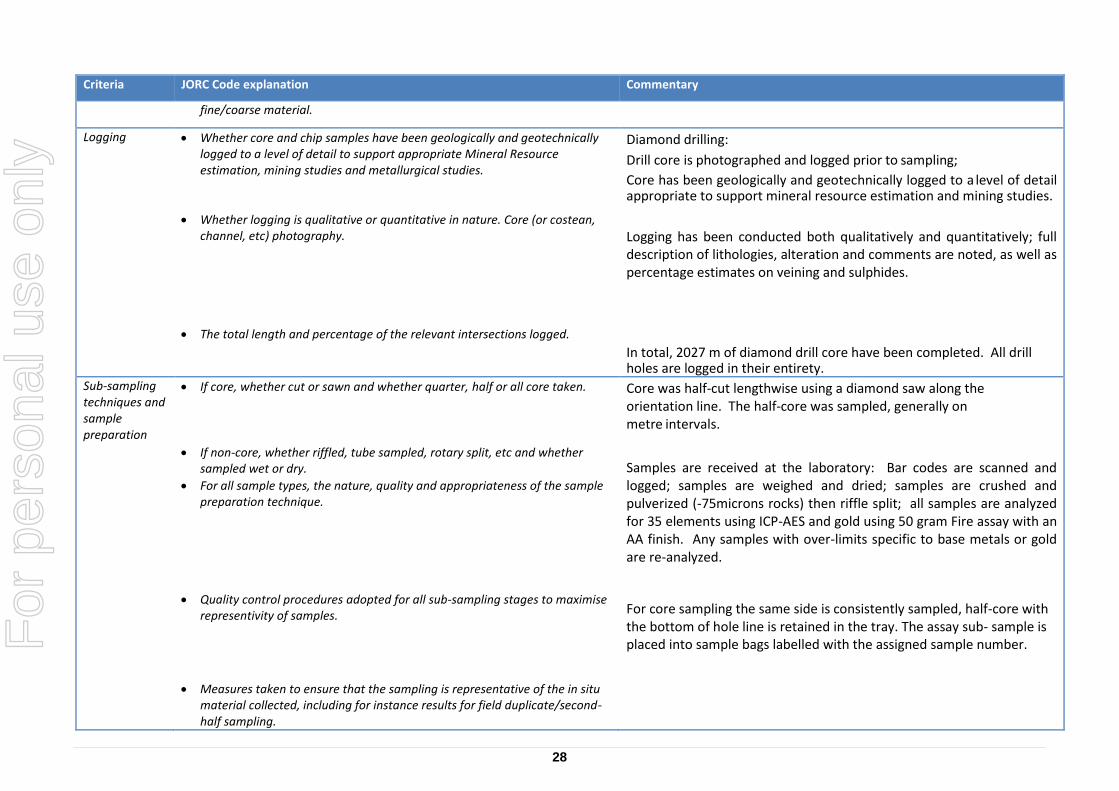
Logging Whether core and chip samples have been geologically and geotechnically logged to a level of detail to support appropriate Mineral Resource estimation, mining studies and metallurgical studies.
Whether logging is qualitative or quantitative in nature. Core (or costean, channel, etc) photography.
The total length and percentage of the relevant intersections logged.
Diamond drilling:
Drill core is photographed and logged prior to sampling;
Core has been geologically and geotechnically logged to a level of detail appropriate to support mineral resource estimation and mining studies.
Logging has been conducted both qualitatively and quantitatively; full description of lithologies, alteration and comments are noted, as well as percentage estimates on veining and sulphides.
In total, 2027 m of diamond drill core have been completed. All drill holes are logged in their entirety.
Sub-sampling techniques and sample preparation
If core, whether cut or sawn and whether quarter, half or all core taken.
If non-core, whether riffled, tube sampled, rotary split, etc and whether sampled wet or dry.
For all sample types, the nature, quality and appropriateness of the sample preparation technique.
Quality control procedures adopted for all sub-sampling stages to maximise representivity of samples.
Measures taken to ensure that the sampling is representative of the in situ material collected, including for instance results for field duplicate/second-half sampling.
Core was half-cut lengthwise using a diamond saw along the orientation line. The half-core was sampled, generally on metre intervals.
Samples are received at the laboratory: Bar codes are scanned and logged; samples are weighed and dried; samples are crushed and pulverized (-75microns rocks) then riffle split; all samples are analyzed for 35 elements using ICP-AES and gold using 50 gram Fire assay with an AA finish. Any samples with over-limits specific to base metals or gold are re-analyzed.
For core sampling the same side is consistently sampled, half-core with the bottom of hole line is retained in the tray. The assay sub- sample is placed into sample bags labelled with the assigned sample number.
For
per
sona
l use
onl
y
29
Criteria JORC Code explanation Commentary
Whether sample sizes are appropriate to the grain size of the material being sampled.
One in 20 samples is duplicated where the core is quartered and a quarter cut sample is analysed as a duplicate. The remaining quarter samples is retained in the tray.
Sample sizes of 2-3 kg are appropriate for the grain size of material. The sample preparation technique and sample sizes are considered appropriate to the material being sampled.
Quality of assay data and laboratory tests
The nature, quality and appropriateness of the assaying and laboratory procedures used and whether the technique is considered partial or total.
For geophysical tools, spectrometers, handheld XRF instruments, etc, the parameters used in determining the analysis including instrument make and model, reading times, calibrations factors applied and their derivation, etc.
Nature of quality control procedures adopted (eg standards, blanks, duplicates, external laboratory checks) and whether acceptable levels of accuracy (ie lack of bias) and precision have been established.
The ICP-AES and Fire Assay (50 gram) are considered total and are high quality.
Jervois has a regimented Quality Control protocol which has consisted of systematic submission of blanks and duplicates in addition to those conducted at the laboratory.
Precision levels for all blank and duplicate samples fell within acceptable ranges.
Verification of sampling and assaying
The verification of significant intersections by either independent or alternative company personnel.
The use of twinned holes.
Documentation of primary data, data entry procedures, data verification, data storage (physical and electronic) protocols.
Discuss any adjustment to assay data.
Since no significant intersections have been reported, independent verification has not yet been necessary.
No holes have been twinned.
Data is collected using a customized version of the Fulcrum app. The data is backed up systematically on and off site as well as on the cloud. As well,
data is recorded using a master Microsoft Office Excel spreadsheet and all location and assay data are compiled in a Microsoft Office Access database.
All data below detection limit have been entered as zero.
Samples received damaged at the laboratory, or with insufficient sample weight for analysis had the interval or location left blank, but in general
For
per
sona
l use
onl
y
30
Criteria JORC Code explanation Commentary
were re-sampled and/or re-collected (specific to soils and rock grab samples).
Location of data points
Accuracy and quality of surveys used to locate drill holes (collar and down-hole surveys), trenches, mine workings and other locations used in Mineral Resource estimation.
Specification of the grid system used.
Quality and adequacy of topographic control.
All collars were surveyed by trained surveyors using a Leica Differential GPS. Down-hole surveys were routinely carried out on all holes using a Reflex EZ-Gyro Kit. Trenches and surface samples were recorded using handheld GPS.
All datum is collected and recorded in UTM WGS 1984.
The 3D location of the individual samples is considered to be adequately established, consistent with accepted industry standards.
Data spacing and distribution
Data spacing for reporting of Exploration Results.
Whether the data spacing and distribution is sufficient to establish the degree of geological and grade continuity appropriate for the Mineral Resource and Ore Reserve estimation procedure(s) and classifications applied.
Whether sample compositing has been applied.
To date, due to the exploratory nature of the drilling, the spacing is highly variable. Similarly, rock grab sample spacing is random. Soil samples are collected in grids designed at varying spacings from >350m to 25m spaced samples.
To date all exploration is exploratory and data spacing would not be considered sufficient to establish a Mineral Resource or Ore Reserve Estimation.
Not applicable.
Orientation of data in relation to geological structure
Whether the orientation of sampling achieves unbiased sampling of possible structures and the extent to which this is known, considering the deposit type.
If the relationship between the drilling orientation and the orientation of key
Drilling sections are orientated perpendicular to the strike of the host rocks. Drill holes were inclined between 60° and 90° to optimize intercepts of mineralisation with respect to thickness and distribution.
Drilling with angled and vertical holes in most instances provides a
For
per
sona
l use
onl
y
31
Criteria JORC Code explanation Commentary
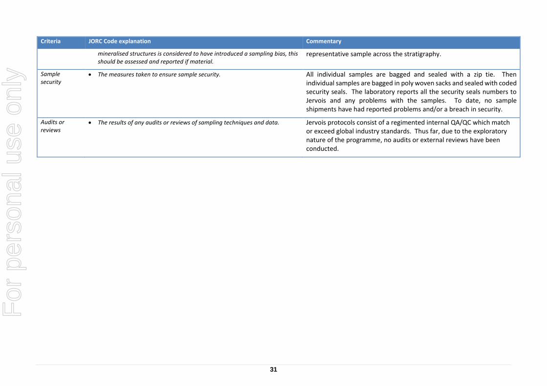
mineralised structures is considered to have introduced a sampling bias, this should be assessed and reported if material.
representative sample across the stratigraphy.
Sample security
The measures taken to ensure sample security. All individual samples are bagged and sealed with a zip tie. Then individual samples are bagged in poly woven sacks and sealed with coded security seals. The laboratory reports all the security seals numbers to Jervois and any problems with the samples. To date, no sample shipments have had reported problems and/or a breach in security.
Audits or reviews
The results of any audits or reviews of sampling techniques and data. Jervois protocols consist of a regimented internal QA/QC which match or exceed global industry standards. Thus far, due to the exploratory nature of the programme, no audits or external reviews have been conducted.


![Dies Irae - Requiem in D Minor K. 626 [K. 626]](https://static.documents.pub/doc/80x56/616e2e726c1eb666d037d848/dies-irae-requiem-in-d-minor-k-626-k-626.jpg)


