13
Delivering sustainable solutions in a more competitive world Additional Site Assessments following Progress Update August 2009
Delivering sustainable solutions in a more competitive world
Additional Site Assessments following Progress Update August 2009

West of England Partnership
Additional Site Assessments following Progress Update August 2009
Prepared by Shay Bayford, Kirsten Berry & Natalie Maletras
For and on behalf of Environmental Resources Management Approved by: Paul Fletcher ______________ Signed: ________________________________ Position: Partner ________________________ Date: 20 August 2009 ____________________
This report has been prepared by Environmental Resources Management the trading name of Environmental Resources Management Limited, with all reasonable skill, care and diligence within the terms of the Contract with the client, incorporating our General Terms and Conditions of Business and taking account of the resources devoted to it by agreement with the client. We disclaim any responsibility to the client and others in respect of any matters outside the scope of the above. This report is confidential to the client and we accept no responsibility of whatsoever nature to third parties to whom this report, or any part thereof, is made known. Any such party relies on the report at their own risk.
ENVIRONMENTAL RESOURCES MANAGEMENT WEST OF ENGLAND PARTNERSHIP
1
1 INTRODUCTION
In July 2009 the West of England Partnership requested comments as part of the Joint Waste Core Strategy Progress Update. In response to representations made during the Progress Update, two further sites were appraised to identify their suitability as sites to locate strategic residual waste treatment facilities. The two sites appraised within the report are:
IS8 Warne Road, Weston Super Mare, North Somerset IS10 Cabot Park, Moorhouse Lane, Bristol
A full explanation of the method used to appraise the sites is included within the Revised Detailed Site Assessment, Final Report V2, June 2009 available at www.westofengland.org.
CLIENT: SIZE: TITLE:
DATE: 07/08/2009
DRAWN: CO
CHECKED: NM
APPROVED: PF
PROJECT: 0089422
SCALE: 1: 5,000
DRAWING: REV:
West of EnglandPartnership
A4 Site IS8: Warne Road,Weston-super-Mare
IS8.mxd 0
KEY:
Special Area of Conservation
Special Protection Area
RAMSAR
Historic Parks and Gardens
Scheduled Ancient Monuments
Area of Outstanding Natural Beauty
Sites of Special Scientific Interest
Ancient & Semi-Natural Woodland
Ancient Replanted Woodland
Listed Building
SOURCE: Reproduced from Ordnance Survey digital map data. © Crowncopyright, All rights reserved. 2008 License number 0100031673.
PROJECTION: British National Grid
File:0089422WofE_IG_NM\MAPS\IndividualSites\IS8.mxd
ERM
Eaton HouseWallbrook CourtNorth Hinksey LaneOxford, OX2 0QSTelephone: 01865 384800Facsimile: 01865 204982
.0 100
Metres
©ERM This print is confidential and is supplied on the understanding that it will be used only as a record to identify or inspect parts, concepts or designs and that it is not disclosed to other persons or to be used for construction purposes without permission.

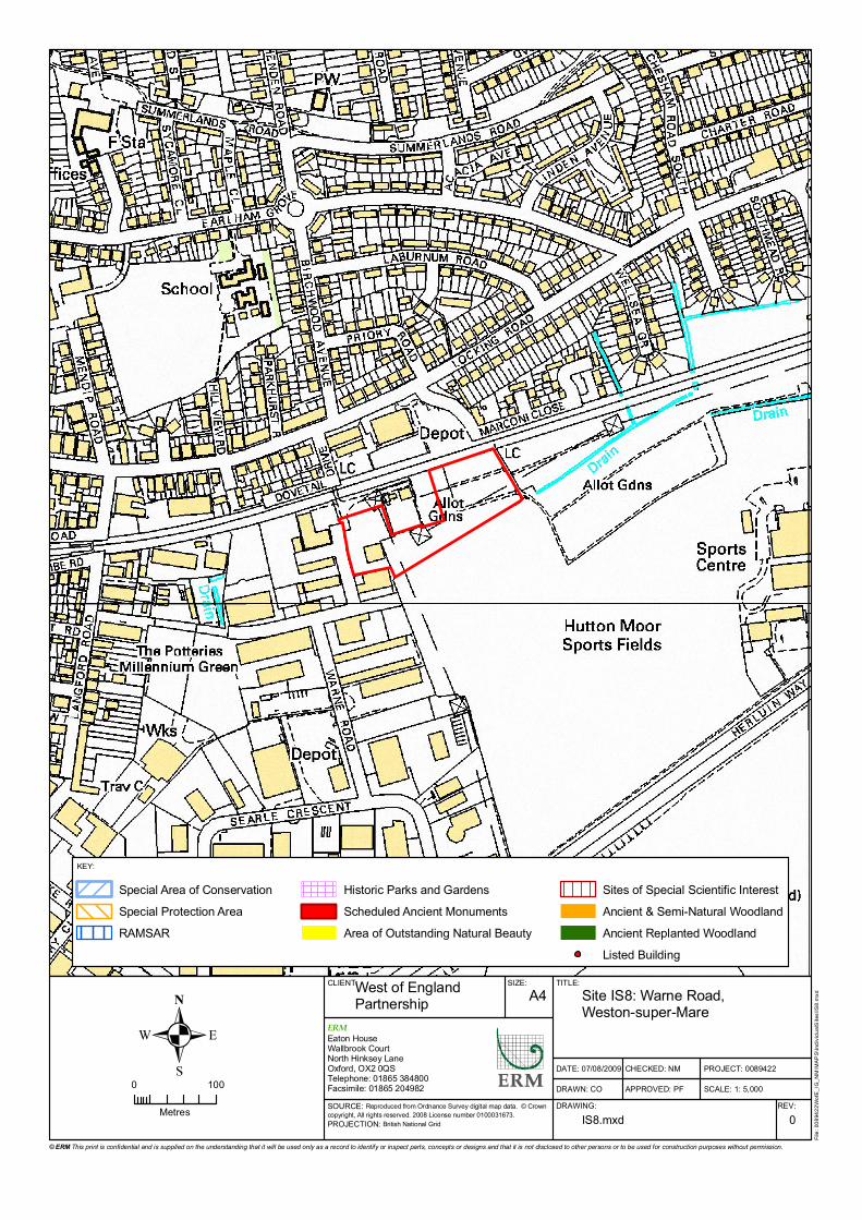
SITE IS8 WARNE ROAD, WESTON-SUPER-MARE
Criteria Description
Site Area 1.4 ha
Surrounding Uses The u-shaped site is located towards the rear of a busy industrial estate. The railway line borders the site to the north, there are numerous residential properties and a leisure centre immediately opposite the site to the north (across the railway line). An electricity sub-station, including large pylons, is located in the centre of the site. There are allotments to the east and playing fields to the south east of the site. An auto-repair shop and tyre specialists are within close proximity to the site within the industrial estate.
Traffic and Transport Warne Road leads off Searle Crescent which joins the A370 at two points either side of a busy roundabout (Herluin Way and Winterstoke Road).
The nearest motorway junction is 4.5 km away and the nearest trunk road is 500 m away.
Planning Policy The North Somerset Replacement Local Plan, Adopted 2007
The site falls within the Town centre getaway and outer commercial area – Policy E1B. This policy states that development would be permitted if it demonstrates comprehensive redevelopment of previously developed land, doesn’t harm the viability and vitality of the town centre regeneration sub area, minimises car travel and is compatible with the existing uses.
The site falls within a floodplain – Policy GDP 2
Part of the site is an existing allotment – Policy CF4
The site is part of Forest of Avon – Policy ECH 9
To the immediate south lies a safeguarded site for a proposed major recreational project - Policy CF4
Protected species and their habitats lie adjacent to the site – Policy ECH1
Joint Waste Core Strategy Development Plan Document, West of England Partnership, Preferred Option Document, January 2009
The site has not been referred to in the Joint Waste Core Strategy
Planning History In 2006 an application was refused for increasing the stack height of stored material from three to six metres.
In 2007 permission was granted, subject to conditions, for the erection of a building for the storage and processing of top soil for recycling.
In 2008 permission was granted, subject to conditions, for the erection of an extension to an existing building and a waste recycling building.
In 2008, a decision was made that an Environmental Impact Assessment (EIA) is necessary (formal screening opinion) for a Proposed Thermal Waste Treatment Plant.
Landscape Designations
Landscape Character
There are no landscape designations for the site. The site is 2.6 km from the Mendip Hills AONB.
The site is within the character area of Somerset Levels and Moors.

Criteria Description
Ecology and Nature Conservation
The site is within 1.3 km of an Ancient Woodland and is 1.6 km from a SSSI.
Groundwater Quality The site is 3 km from SPZ 2..
Surface Water Quality The site is 1.8 km from the Severn Estuary. The quality of this water course is not known.
Strategic Flood Risk Assessment (SFRA)
Recommended subject to mitigation conditions.
Full conclusions and recommendations are provided within a separate SFRA report.
Habitats Regulation Assessment
The site is 1.8 km from a Ramsar site, 1.8 km from a SAC and 1.8 km from a SPA.
The HRA is currently being undertaken. Conclusions will be uploaded at a later date.
Historic Environment The closest listed building is 23.4 km from the site. There is a SAM 1.9 km from the site and a Historic Park and Garden is located 1.8 km from the site.
Recreational Activities There are allotments and playing fields to the east of the site.
Air Quality/Noise/ Issues of Environmental Nuisance
There are no AQMA is North Somerset.
Proximity to Waste Arisings
The site is approximately 1 km from Weston-super-Mare.
Proximity to Existing Waste Facilities
In addition to the activities on site, there are three waste transfer stations within 3 km (Aisecombe Way, Oldmixon Trading Estate & Worle Quarry) and a MRF within 1 km.
Visual/Landscape Impacts The site located within an industrial estate but is over looked by some housing to the north (across the railway line) where limited screening is currently provided by vegetation.
Availability The site is currently available.

SITE IS8 WARNE ROAD, WESTON-SUPER-MARE Site Description
The site at Warne Road is located within a busy industrial estate. The site is u-shaped with an electricity substation, owned by Western Power, located at the centre of the site. A materials recycling facility (MRF) which handles approximately 70 ktpa of waste, is currently operating on the site and is situated on the western section of the site. The eastern side of the site is used for reprocessing inert waste (~ 30 ktpa). Key Issues
The access to the site, via the A370 (Herluin Way) has very good links to the M5. Searle Crescent, the access road into the industrial estate, is a very busy route leading from Herluin Way. Parked cars along the bend of the crescent made it difficult for two HGV to pass each other. Warne Road, leading onto the site, is wide and is suitable for HGV. Access to and from Site IS8 is via separate entrance and exit gates which facilitates good traffic flow. Some of the land within the site boundary is currently rented from Western Power, discussions with personnel during the site visit, indicated that this arrangement has been in place for a number of years and is set to continue. Western Power owns the forecourt where HGV turn around in the west of the site, as well as a small band of land to the east of the sub station (~ 10 m wide). Residential properties are located along the northern boundary of the site with views looking directly into the site. Given the nature of the activities currently taking place at Warne Road, further waste related development need not result in an increased detrimental visual impact. However, any redevelopment of this site would need to consider, and to demonstrate that adverse impact to the residential amenity at these properties was avoided or appropriately mitigated. Preliminary Conclusion
Final conclusions will be made following receipt of the Habitats Regulation Assessment. ERM recommends that Site IS8 is allocated within the JWCS for development of a strategic waste management facility. Any proposal would need to give particular attention to: Visual and amenity impacts to neighbouring residential properties; and Appropriate access arrangements, particularly along Searle Crescent.

Figure 0.1 IS8, Warne Road, Weston-super-Mare
Figure 0.2 IS8, Warne Road, Weston-super-Mare

CLIENT: SIZE: TITLE:
DATE: 11/08/2009
DRAWN: IG
CHECKED: NM
APPROVED:
PROJECT: 0089422
SCALE: 1:10,000DRAWING: REV:
KEY: West of England Partnership A4 Site IS10: Cabot Park
AllIndividualSites.mxd 0
Boundary of Site Area Considered
SOURCE: Reproduced from Ordnance Survey digital map data. © Crowncopyright, All rights reserved. 2009 License number 0100031673.PROJECTION: British National Grid
File:
0089
422W
ofE_IG
_NM\
MAPS
\Indiv
idualS
ites\A
llIndiv
idualS
ites.m
xd
ERMEaton HouseWallbrook CourtNorth Hinksey LaneOxford, OX2 0QSTelephone: 01865 384800Facsimile: 01865 204982.0 200
Metres© ERM This print is confidential and is supplied on the understanding that it will be used only as a record to identify or inspect parts, concepts or designs and that it is not disclosed to other persons or to be used for construction purposes without permission.

SITE IS10 LAND ADJACENT TO CABOT PARK
Criteria Description
Site Area 4.8 ha
Surrounding Uses The northern edge of the site is bordered by the railway line and Moorhouse Lane. The length of the eastern boundary lies adjacent to the M49. The land to the west is highly industrial (Cabot Park) with several very large and newly built warehouses present. An occupied caravan is located to the west of the site.
Traffic and Transport Vehicular access to the site is gained via Moorhouse Lane. The narrow single track lane is blocked off to vehicles just beyond the north west corner of the site. Moorhouse Lane leads to Hallen and the wider road network.
The nearest motorway junction is 4.5 km away and the nearest trunk road is 1 km away.
Planning Policy Bristol Local Plan, Proposed Alterations including Minerals and Waste Policies, February 2003
Most of the site is a designated Wildlife Network Site – Policy NE6.
Industrial and Warehousing areas lie to the immediate north and west of the site – Policy EC4A. There are several areas around the site with the same proposed use.
The site is a part of the High Risk Flood Zone – Policy ME9.
A trail of Severnside Rhines forms the western boundary of the site – Policy NE2
Bristol Development Framework, Core Strategy, Preferred Options, January 2008 and the Core Strategy Preferred Option Review, 2009
In the emerging Core Strategy Avonmouth is identified as a priority area for industrial and warehousing development including port-related activities, manufacturing, distribution, waste management and environmental technologies – Policy BCS06
Joint Waste Core Strategy Development Plan Document, West of England Partnership, Preferred Option Document, January 2009
The site has not been referred to in the Joint Waste Core Strategy
Planning History No planning applications have been made on the site over the last 5 years.
Landscape Designations
Landscape Character
There are no landscape designations for the site.1 km. The site is 12.7 km from the Wye Valley AONB.
The site is within the character area of Bristol, Avon Valleys and Ridges.
Ecology and Nature Conservation
The site is within 1.3 km of an Ancient Woodland and is 2 km from a SSSI.
Groundwater Quality The site is 9 km from SPZ 1.
Surface Water Quality There are numerous drains and Rhines in close proximity to the site. The quality of these water courses in unknown.
Strategic Flood Risk Assessment (SFRA)
Recommended subject to mitigation conditions.
Full conclusions and recommendations are provided within a separate SFRA report.
Criteria Description
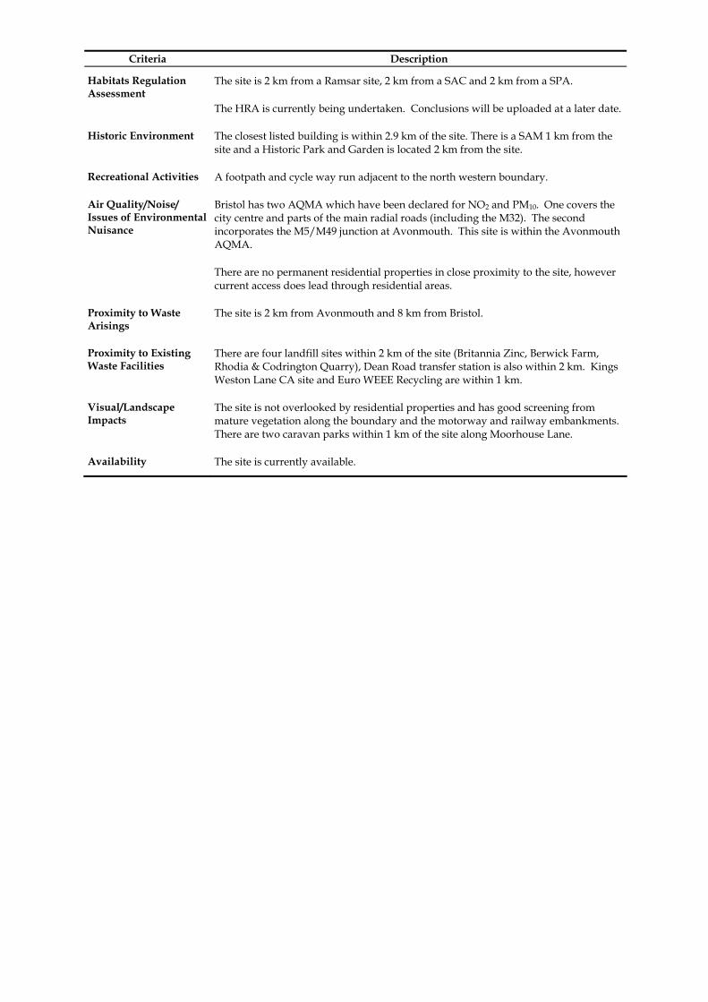
Habitats Regulation Assessment
The site is 2 km from a Ramsar site, 2 km from a SAC and 2 km from a SPA.
The HRA is currently being undertaken. Conclusions will be uploaded at a later date.
Historic Environment The closest listed building is within 2.9 km of the site. There is a SAM 1 km from the site and a Historic Park and Garden is located 2 km from the site.
Recreational Activities A footpath and cycle way run adjacent to the north western boundary.
Air Quality/Noise/ Issues of Environmental Nuisance
Bristol has two AQMA which have been declared for NO2 and PM10. One covers the city centre and parts of the main radial roads (including the M32). The second incorporates the M5/M49 junction at Avonmouth. This site is within the Avonmouth AQMA.
There are no permanent residential properties in close proximity to the site, however current access does lead through residential areas.
Proximity to Waste Arisings
The site is 2 km from Avonmouth and 8 km from Bristol.
Proximity to Existing Waste Facilities
There are four landfill sites within 2 km of the site (Britannia Zinc, Berwick Farm, Rhodia & Codrington Quarry), Dean Road transfer station is also within 2 km. Kings Weston Lane CA site and Euro WEEE Recycling are within 1 km.
Visual/Landscape Impacts
The site is not overlooked by residential properties and has good screening from mature vegetation along the boundary and the motorway and railway embankments. There are two caravan parks within 1 km of the site along Moorhouse Lane.
Availability The site is currently available.

SITE IS10 CABOT PARK Site Description
The triangular shaped site is a level open greenfield site which is currently used for agricultural purposes. There is a caravan present on the north west corner (Shadow Patch) which appears to have been there for several years. Large electricity pylons are located immediately to the east and south of the site, cables hang overhead in the southern most corner. Key Issues
The only access currently available is via Hallen, using a single track called Moorhouse Lane. This is unsuitable for HGV and leads through a number of residential areas. It is understood that alternative access options have been considered through the south of the site or via the Cabot Park industrial area, involving widening the pedestrian and cycle path to accommodate vehicles. However given the network of Rhines in the immediate area and the degree of engineering works required the potential impact on nature conservation is expected to be significant. Preliminary Conclusion
Final conclusions will be made following receipt of the Habitats Regulation Assessment. ERM does not recommend that Site IS10 is allocated within the JWCS for the development of a strategic waste management facility, primarily due to it being a greenfield site and the poor access issues outlined above. Although it is noted that alternative access options for the site may be available, the scale of engineering required to ensure suitable vehicular access is likely to impact upon the deliverability of this site for residual waste treatment. Further, ERM considers that there are a number of alternative and more deliverable sites in the Avonmouth / Severnside area.

Figure 0.1 IS10, Land Adjacent to Cabot Park
Figure 0.2 IS10, Land Adjacent to Cabot Park


