ARCHAEOLOGICAL EXCAVATIONS ON THE FORMER AUSTRALIAN GAS LIGHT C'OMPANY SITE HAYMARKET, SYDNEY A Report for Australian Construction Services ( NSW Region) Department of Administrative Services by Rosemary Annable October 1989 VOLUME 2 : FIGURES
Transcript
-------------------~~ ARCHAEOLOGICAL EXCAVATIONS ON THE
FORMER AUSTRALIAN GAS LIGHT C'OMPANY SITE
HAYMARKET, SYDNEY
A Report for Australian Construction Services ( NSW Region)
Department of Administrative Services
by
Rosemary Annable
October 1989
VOLUME 2 : FIGURES
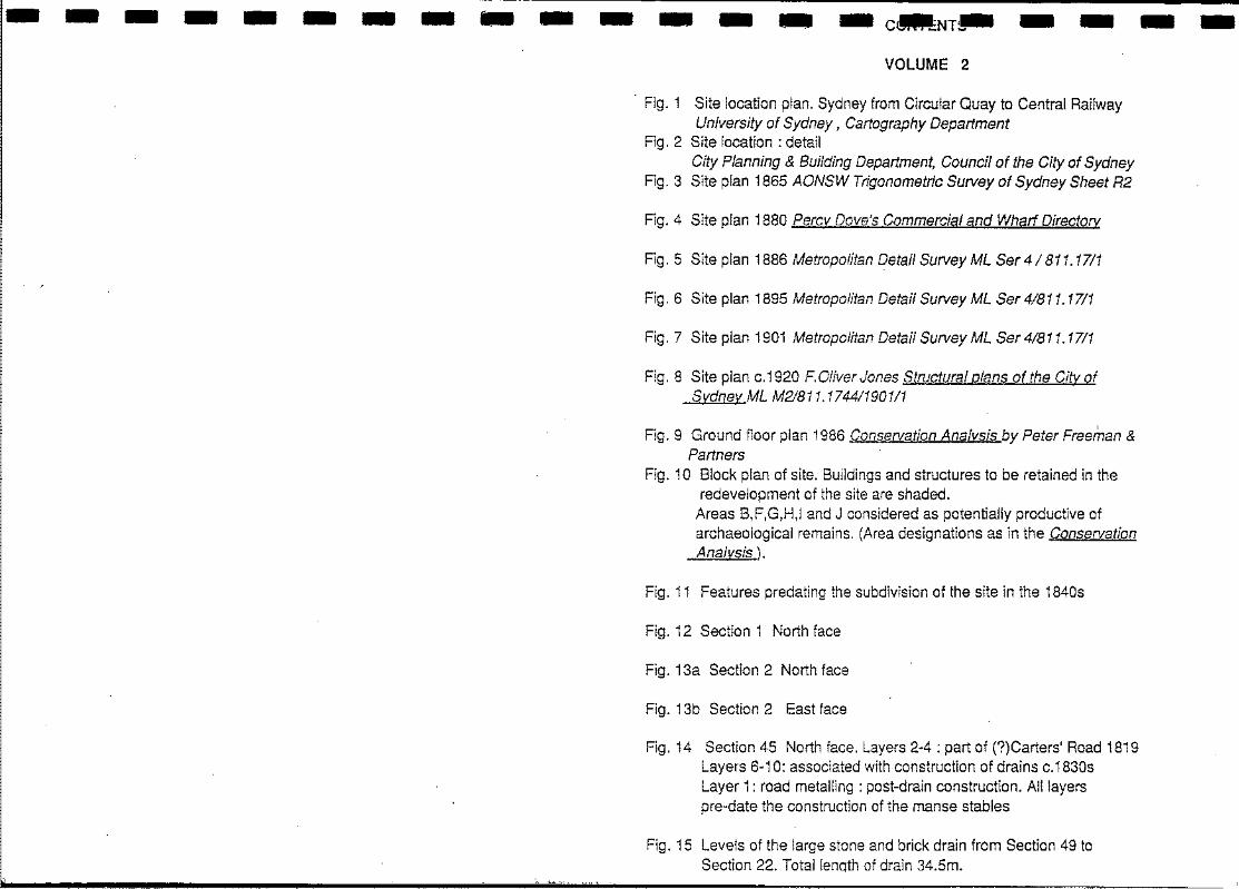
- - - - - - - - - - - - - - -C~NT~ - - - -
VOLUME 2
Fig. 1 Site location plan. Sydney from Circular Quay to Central Railway University of Sydney, Cartography Department
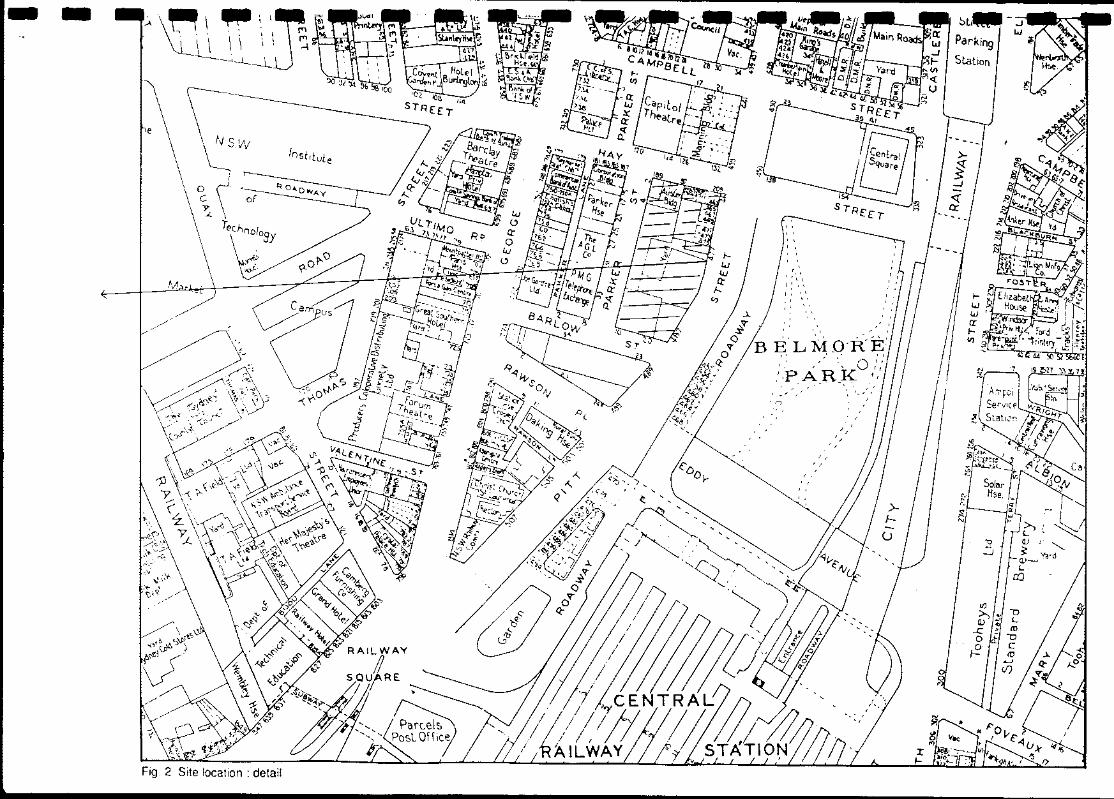
Fig. 2 Site location: detail City Planning & Building Department, Council of the City of Sydney
Fig. 3 Site plan 1865 AONSW Trigonometric Survey of Sydney Sheet R2
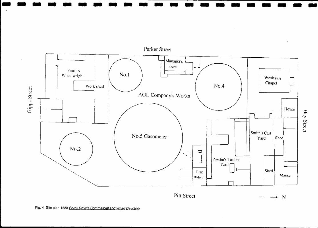
Fig. 4 Site plan 1880 Percy Dove's Commercial and Wharf Directory
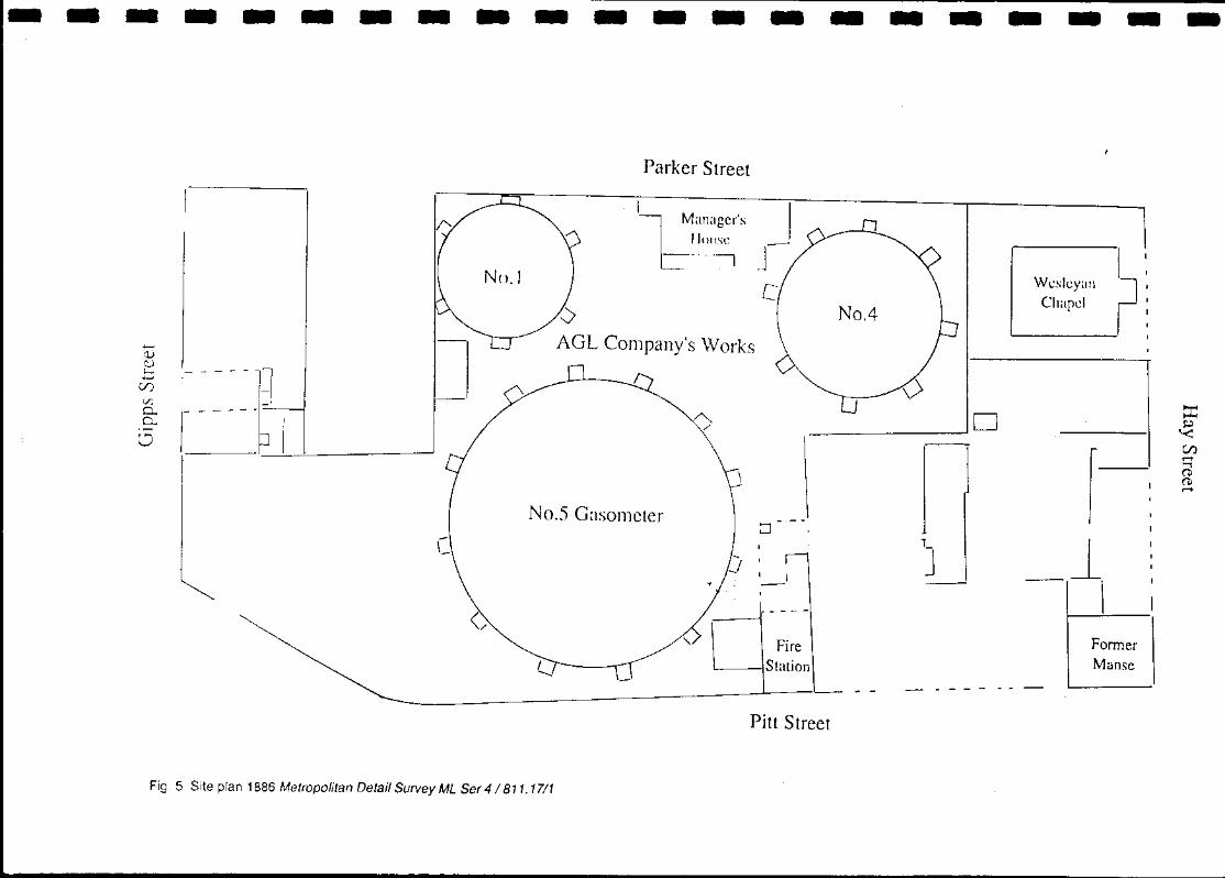
Fig. 5 Site plan 1886 Metropolitan qetail Survey ML Ser41 811.1711
Fig. 6 Site plan 1895 Metropolitan Detail Survey ML Ser4/811.1711
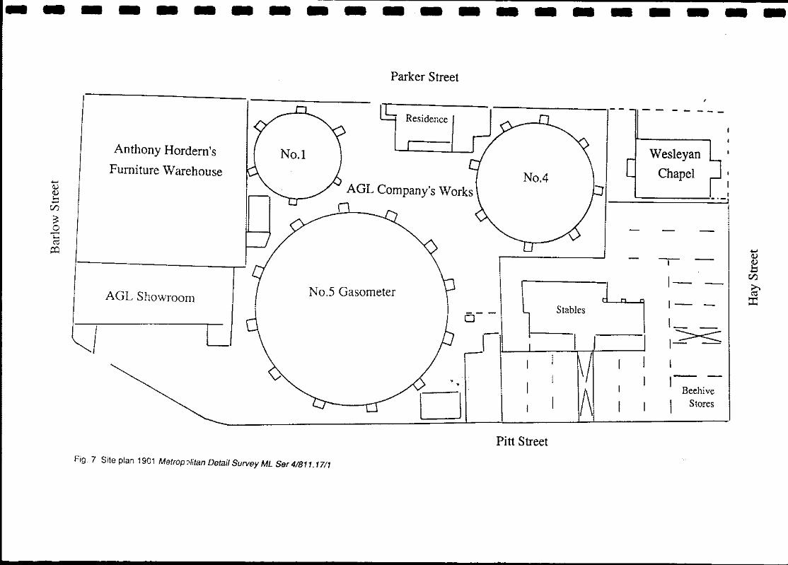
Fig. 7 Site plan 1901 Metropolitan Detail Survey ML Ser 41811.1711
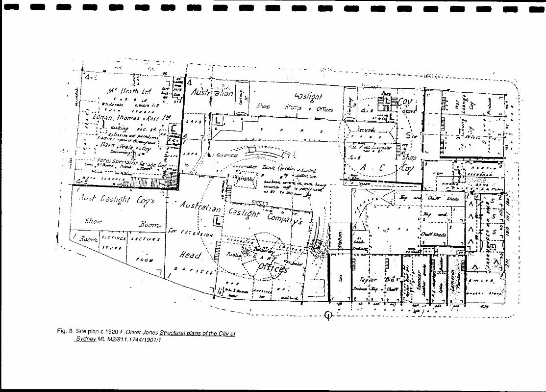
Fig. 8 Site plan c.1920 F. Oliver Jones Structural plans of the City of Sydney ML M2I811. 17441190111
I
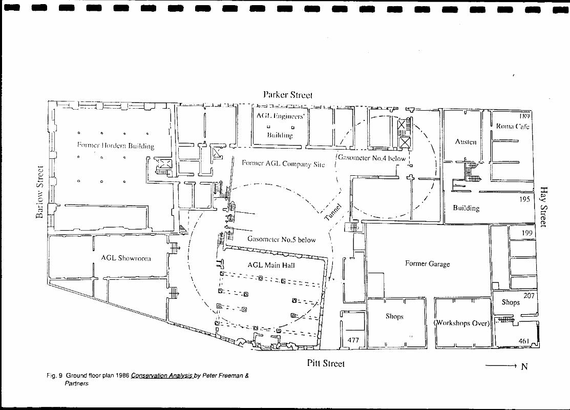
Fig. 9 Ground floor plan 1986 Conservation Analysis by Peter Freeman & Partners
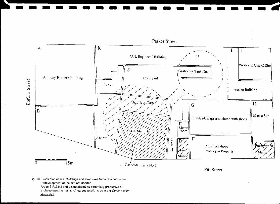
Fig. 10 Block plan of site. Buildings and structures to be retained in the redevelopment of the site are shaded.
Areas B,F,G,H,I and J considered as potentially productive of archaeological remains. (Area designations as in the Conservation Analysis ).
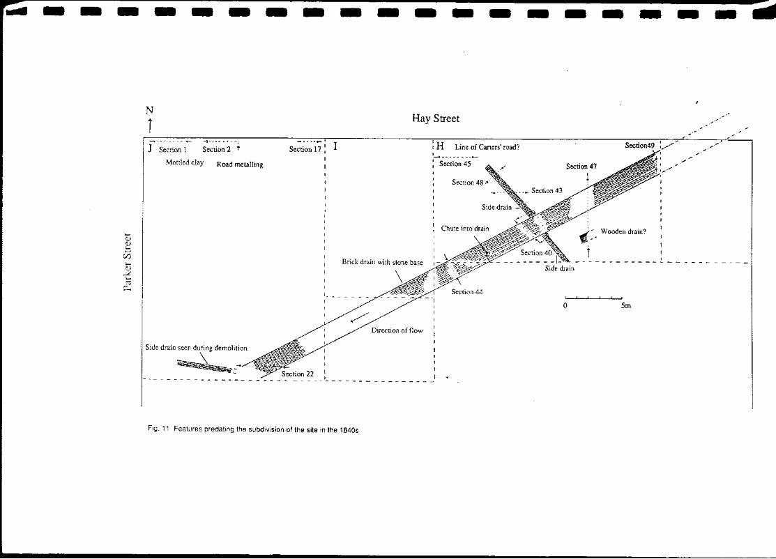
Fig. 11 Features predating the subdivision of the site in the 1840s
Fig. 12 Section 1 North face
Fig. 13a Section 2 North face
Fig. 13b Section 2 East face
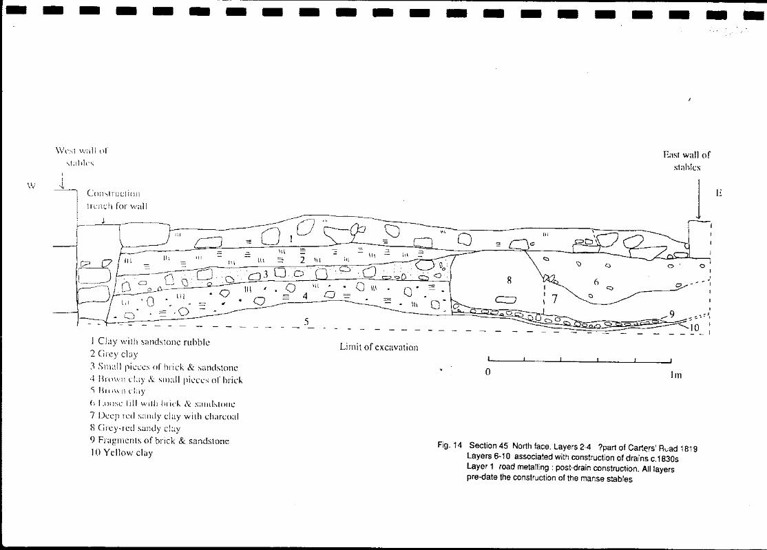
Fig. 14 Section 45 North face. Layers 2-4 : part of (?)Carters' Road 1819 Layers 6-10: associated with construction of drains c.1830s Layer 1 : road metalling : post-drain construction. All layers pre-date the construction of the manse stables
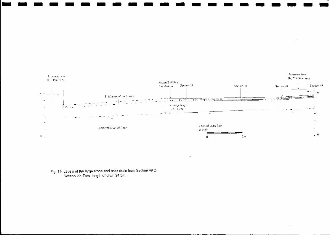
Fig. 15 Levels of the large stone and brick drain from Section 49 to Section 22. Totallenqth of drain 34.Sm.
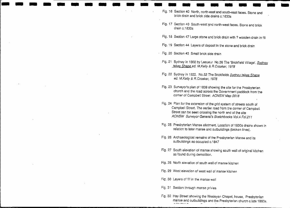
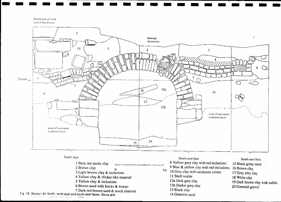
-------------------Fig. 16 Section 40 North, north-east and south-east faces. Stone and brick drain and brick side drains c.1830s
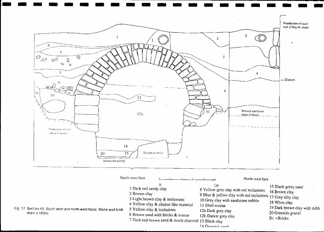
Fig. 17 Section 40 South-west ?-nd north-west faces. Stone and brick drain c.1830s
Fig. 18 Section 47 Large stone and brick drain with? wooden drain in fill
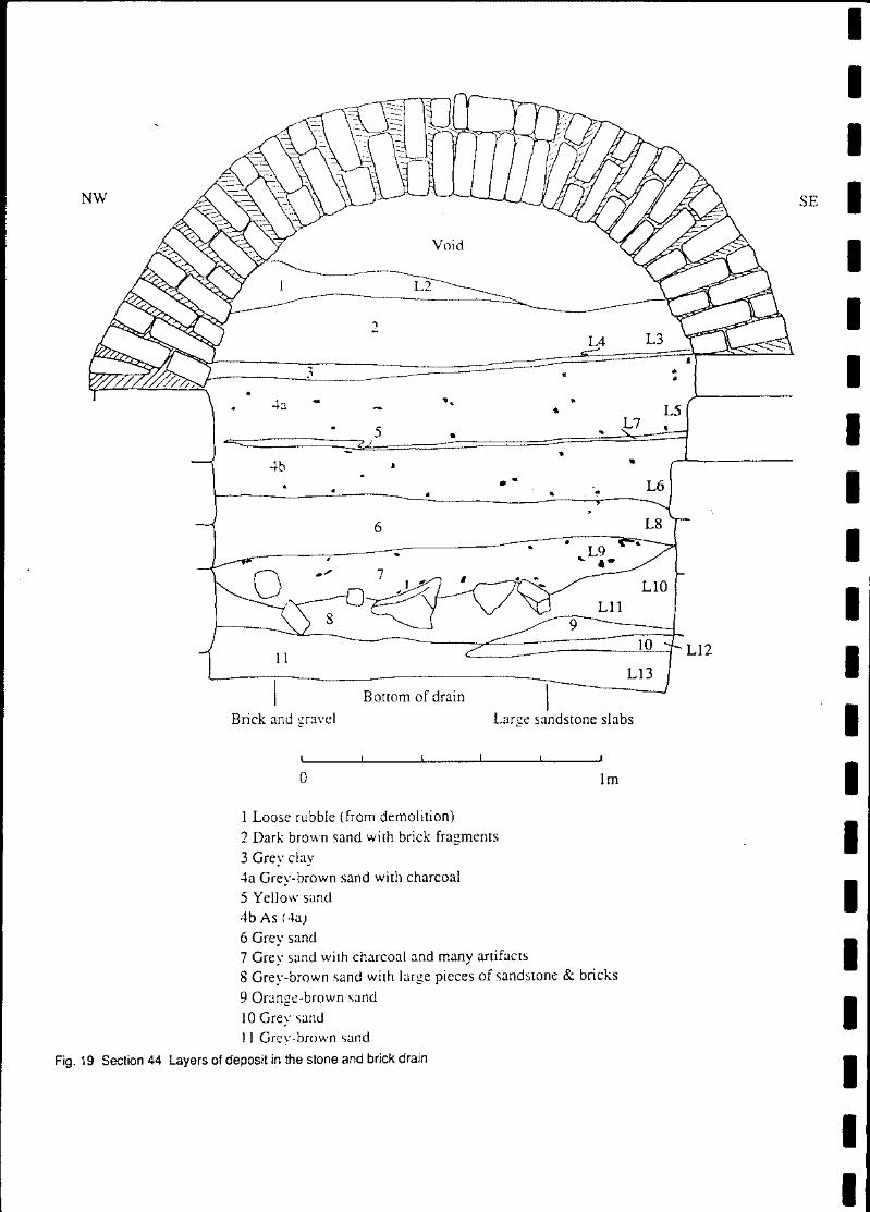
Fig. 19 Section 44 Layers of deposit in the stone and brick drain
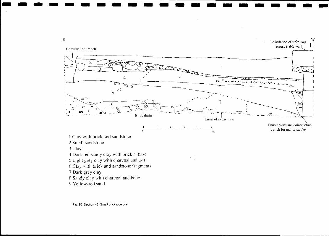
Fig. 20 Section 43 Small brick side drain
Fig. 21 Sydney in 1802 by Lesueur NO.38 The 'Brickfield Village'. Sydney takes Shape·ed. M.Kel/y & R.Croaker, 1978
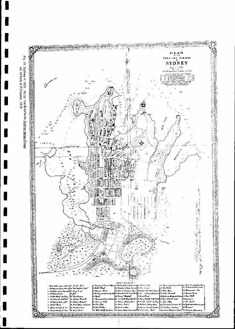
Fig. 22 Sydney in 1822. NO.52 The Brickfields Sydney takes Shape ed. M.Kelly & R.Croaker, 1978
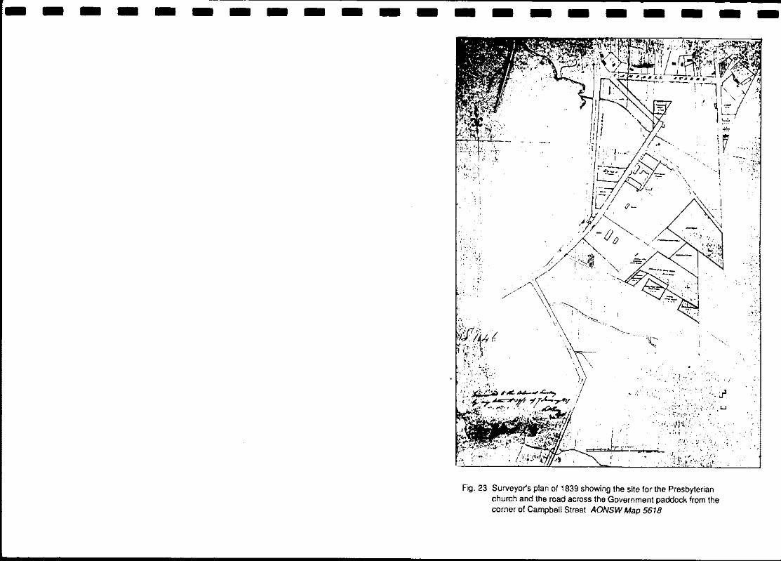
Fig. 23 Surveyor's plan of 1839 showing the site for the Presbyterian church and the road across the Government paddock from the corner of Campbell Street AONSW Map 5618
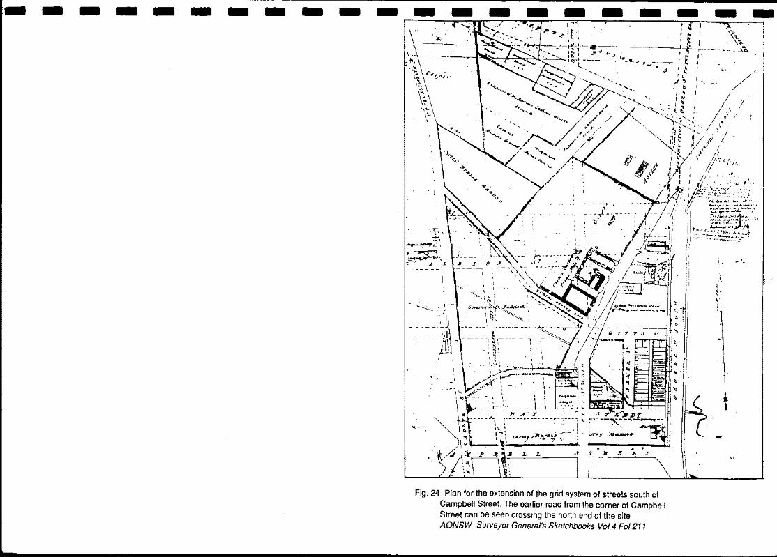
Fig. 24 Plan for the extension of the grid system of streets south of Campbell Street. The earlier road from the corner of Campbell Street can be seen crossing the north end of the site AONSW Surveyor General's Sketchbooks VolA Fol.211
Fig. 25 Presbyterian Manse allotment. Location of 1830s drains shown in relation to later manse and outbuildings (broken lines).
Fig. 26 Archaeological remains of the Presbyterian Manse and its outbuildings as occupied c.1847
Fig. 27 South elevation of manse showing south wall of original kitchen as found during demolition.
Fig. 28 North elevation of south wall of manse kitchen
Fig. 29 West elevation of west wall of manse kitchen
Fig. 30 Layers of fill in the manse well
Fig.31 Section through manse privies
Fig. 32 Hay Street ~howing the Wesleyan Chapel, house, Presbyterian manse and outbuildings and the Presbyterian church c.late 1860s.
A """ .. ,_, .. ' _ _ ~
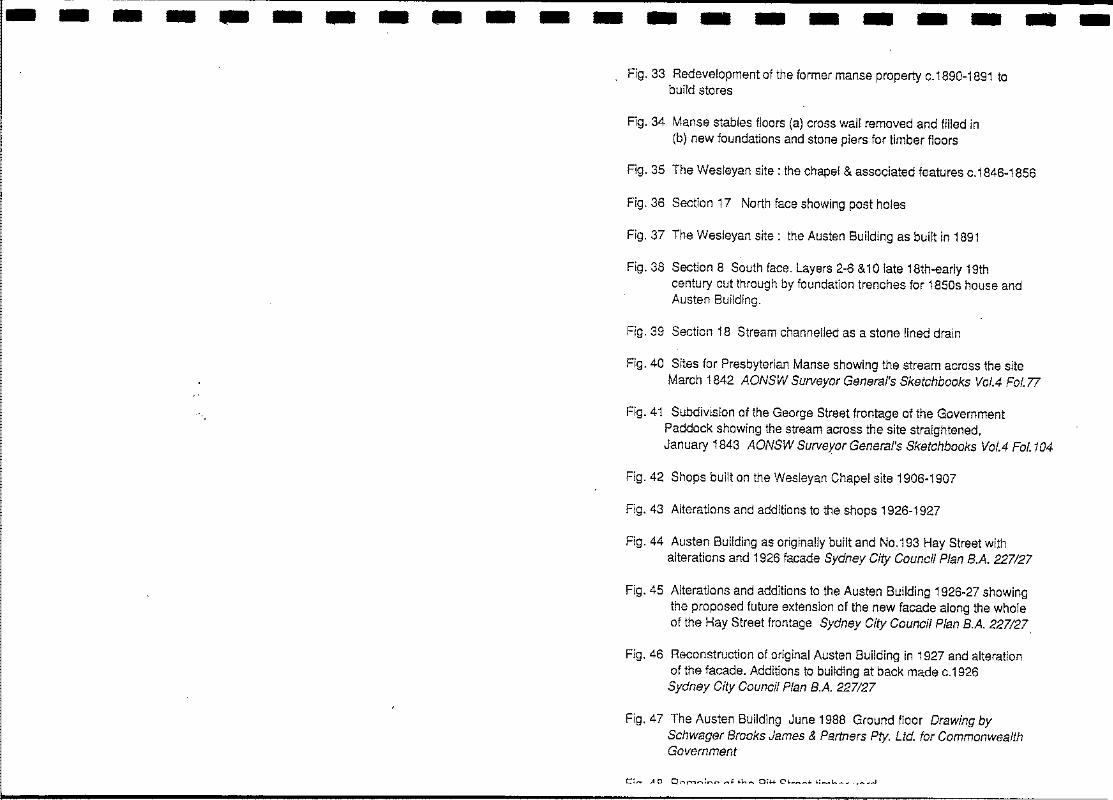
---------------------Fig. 33 Redevelopment of the former manse property c.1890-1891 to
build stores
Fig. 34 Manse stables floors (a) cross wall removed and filled in (b) new foundations and stone piers for timber floors
Fig. 35 The Wesleyan site: the chapel & associated features c.1846-1856
Fig. 36 Section 17 North face showing post holes
Fig. 37 The Wesleyan site: the Austen Building as built in 1891
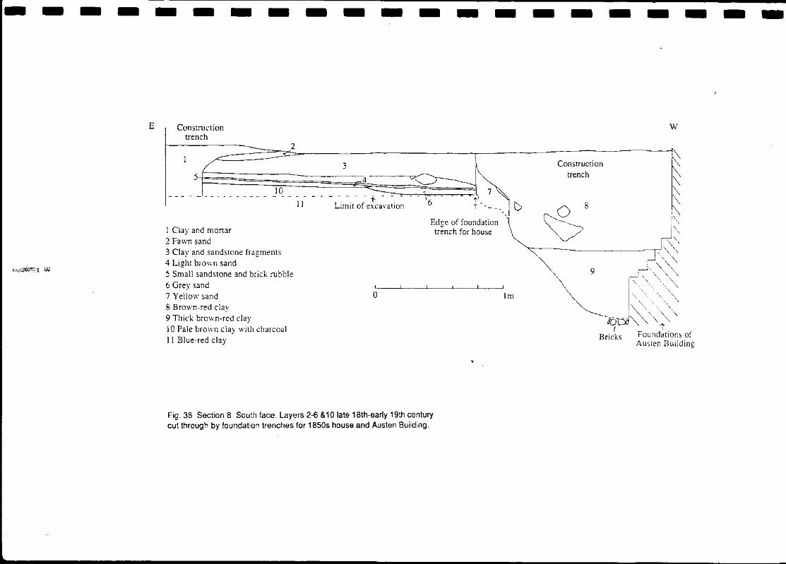
Fig. 38 Section 8 South face. Layers 2-6 &10 late 18th-early 19th century cut through by foundation trenches for 1850s house and Austen Building.
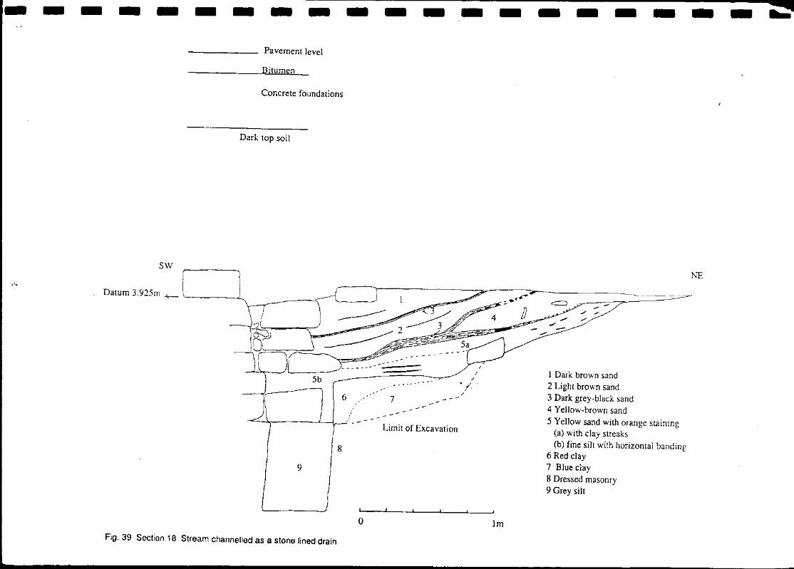
Fig. 39 Section 18 Stream channelled as a stone lined drain
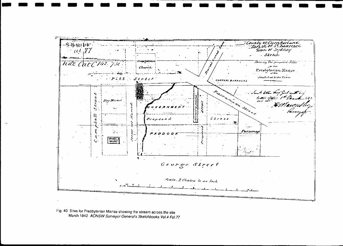
Fig. 40 Sites for Presbyterian Manse showing the stream across the site March 1842 AONSW Surveyor General's Sketchbooks Vol.4 Fol.77
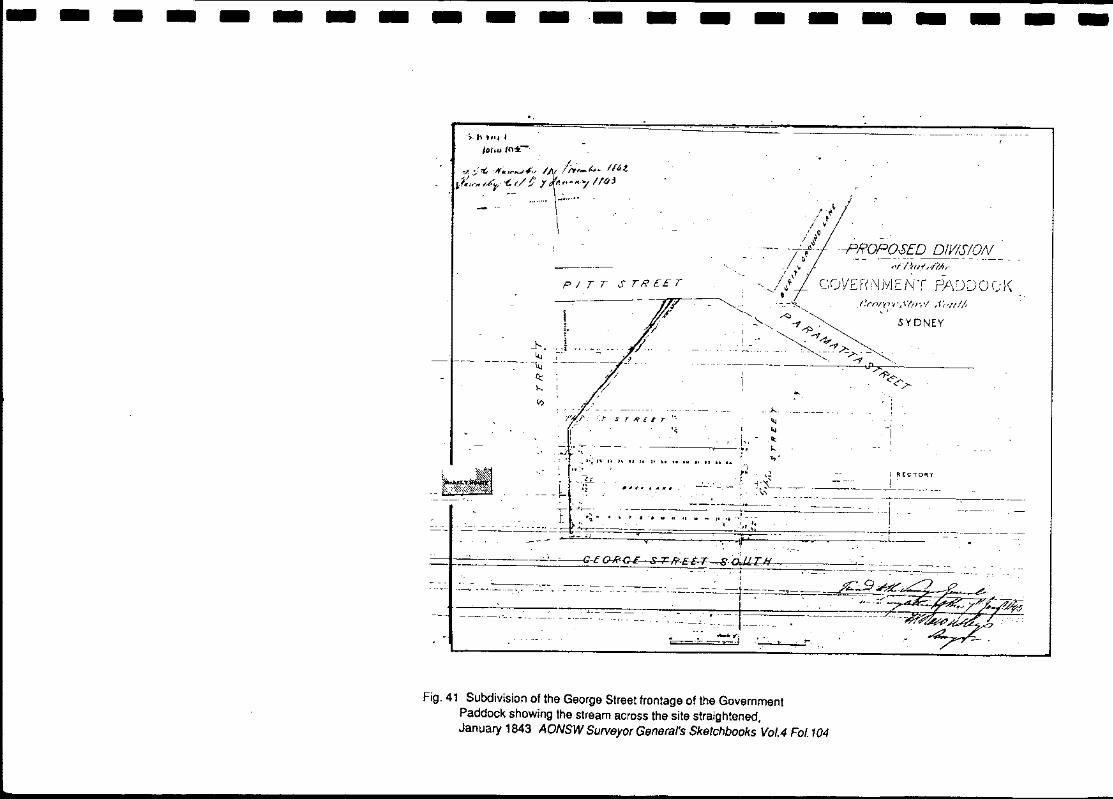
Fig. 41 Subdivision of the George Street frontage of the Government Paddock showing the stream across the site straightened, January 1843 AONSW Surveyor General's Sketchbooks Vol.4 Fol.104
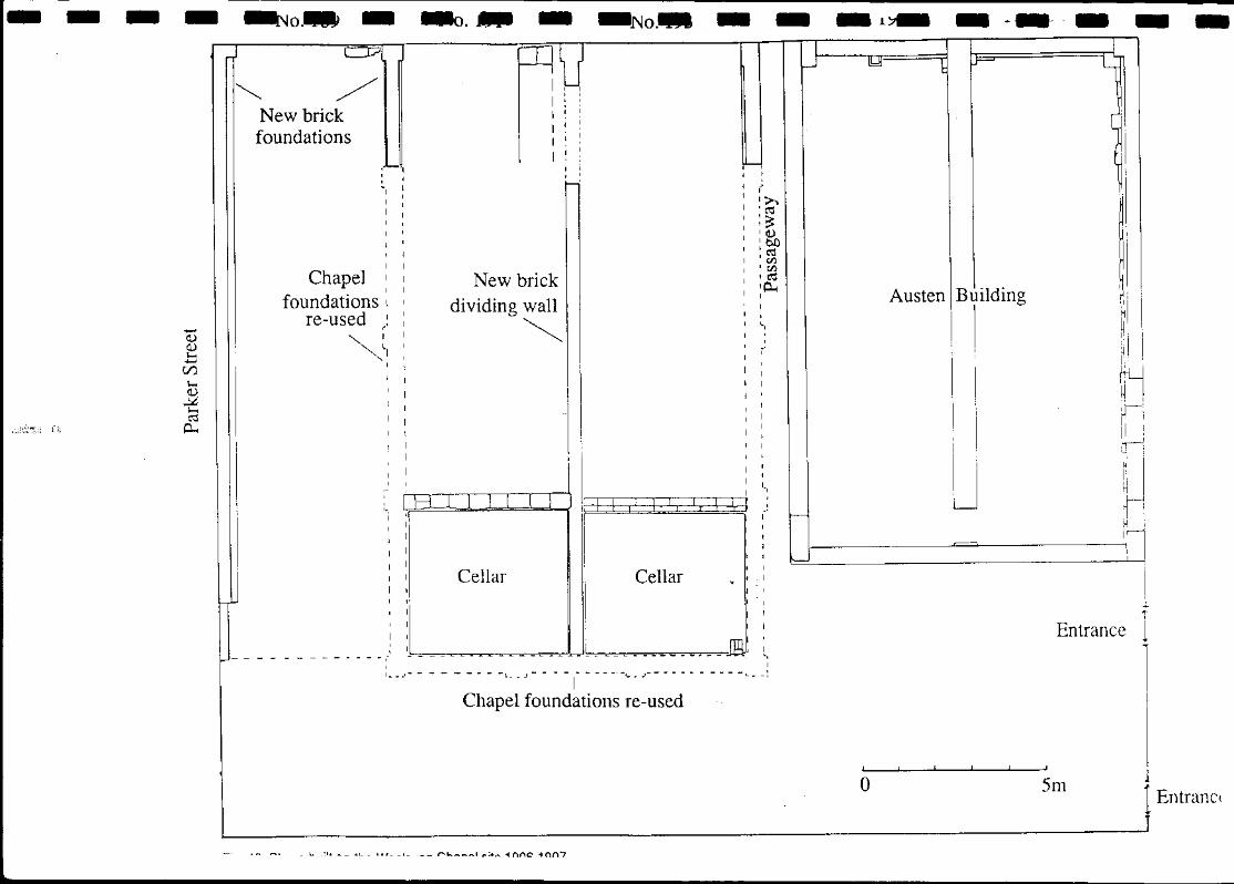
Fig. 42 Shops built on the Wesleyan Chapel site 1906-1907
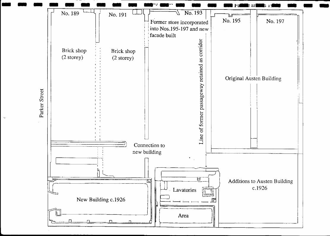
Fig. 43 Alterations and additions to the shops 1926-1927
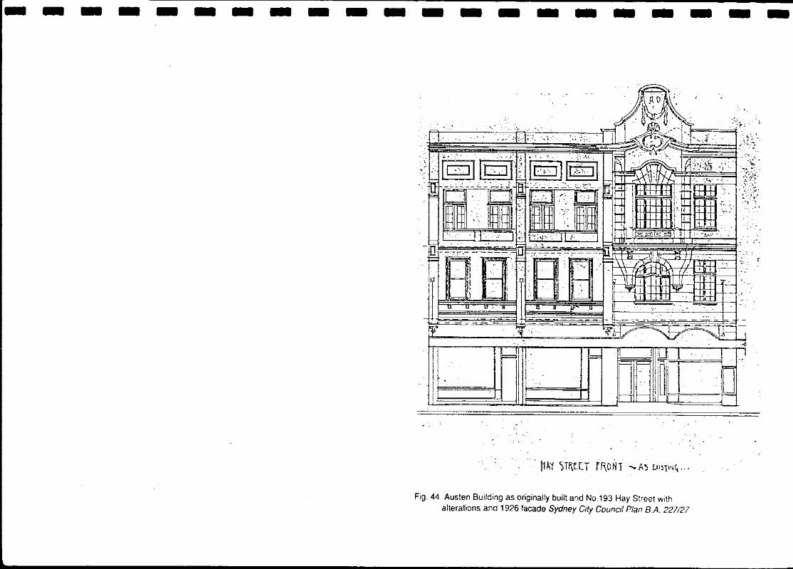
Fig. 44 Austen Building as originally built and No.193 Hay Street with alterations and 1926 facade Sydney City Council Plan B.A. 227127
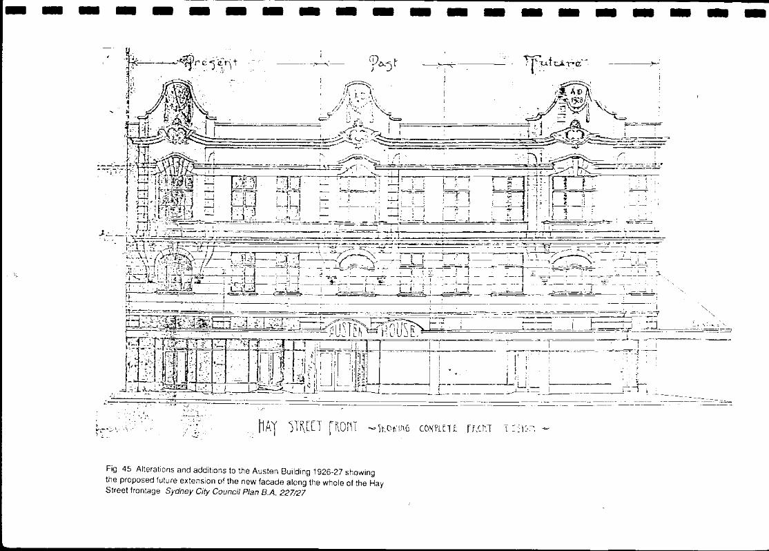
Fig. 45 Alterations and additions to the Austen Building 1926-27 showing the proposed future extension of the new facade along the whole of the Hay Street frontage Sydney City Council Plan B.A. 227127
Fig. 46 Reconstruction of original Austen Building in 1927 and alteration of the facade. Additions to building at back made c.1926 Sydney City Council Plan B.A. 227127
Fig. 47 The Austen Building June 1988 Ground floor Drawing by Schwager Brooks James & Partners Pty. Ltd. for Commonwealth Government
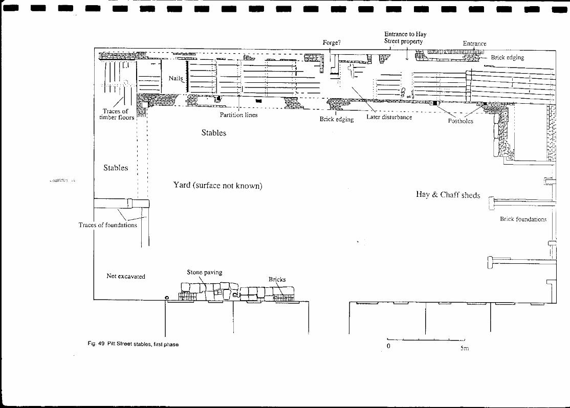
----- ---~-------- ---------.---~~~~--~~~~~~~~~~~~~~~~~~~~-~--------------. ---------------------Fig. 49 Pitt Street stables, first phase
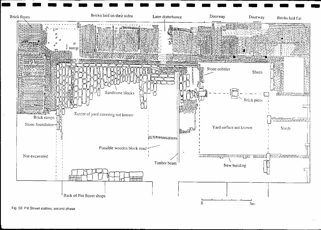
Fig. 50 Pitt Street stables, second phase
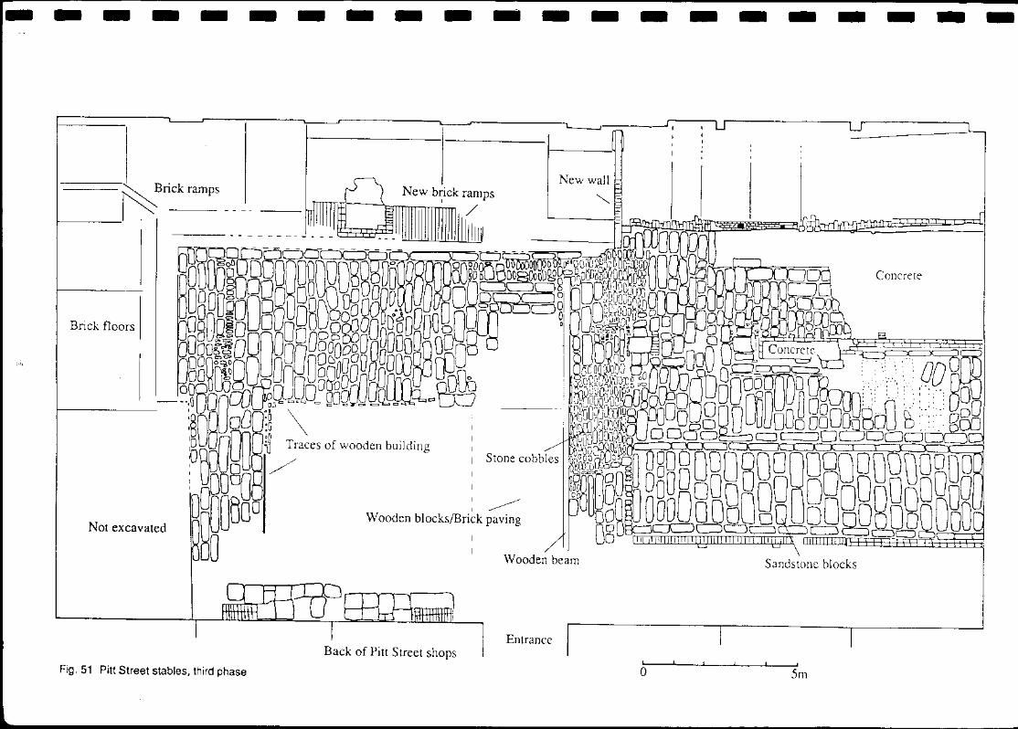
Fig. 51 Pitt.Street stables, third phase
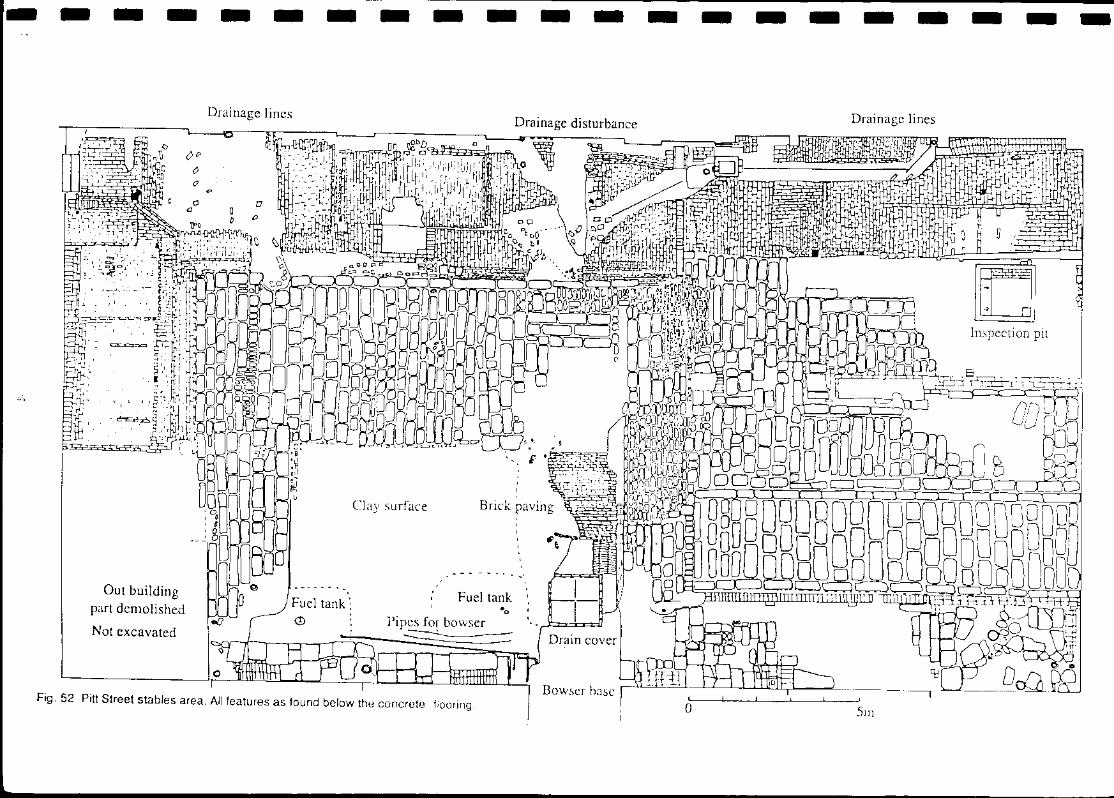
Fig. 52 Pitt Street stables area. All features as found below the concrete flooring
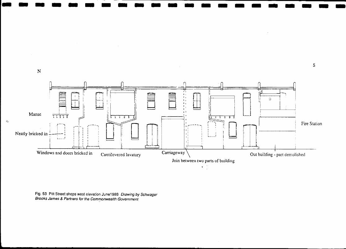
Fig. 53 Pitt Street shops west elevation June1988 Drawing by Schwager Brooks James & Partners for the Commonwealth Government
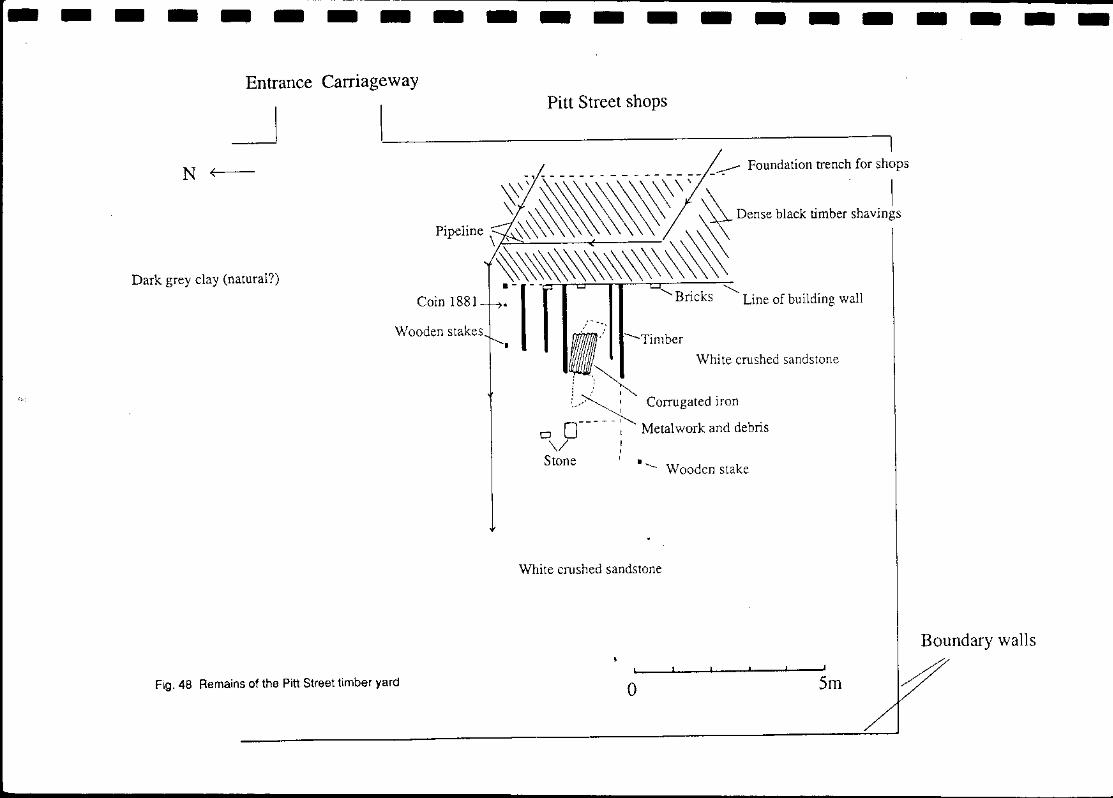
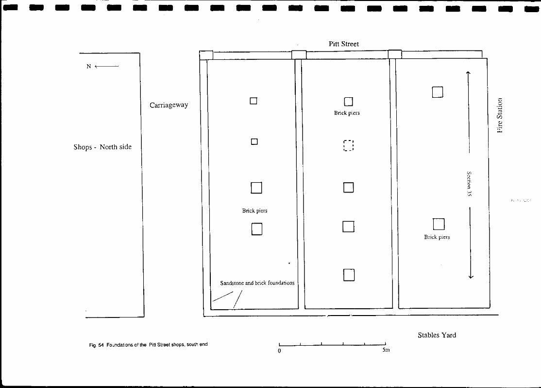
Fig. 54 Foundations of the Pitt Street shops, south end
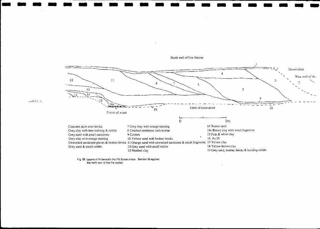
Fig. 55 Layers of fill beneath the Pitt Street shops: Section 35 against the north wall of the fire station
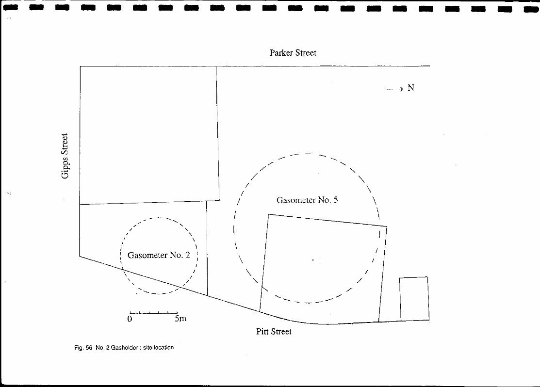
Fig. 56 Gasholder No. 2 : site location
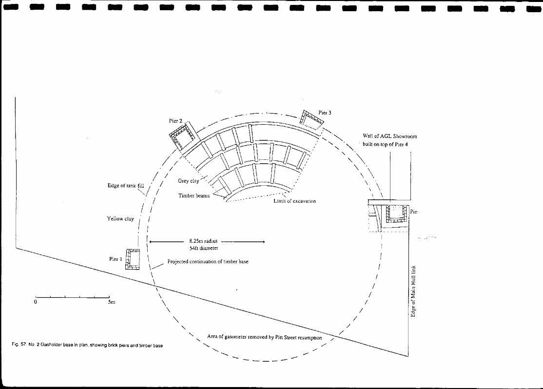
Fig. 57 Gasholder No. 2 : in plan, showing brick piers and timber base ,
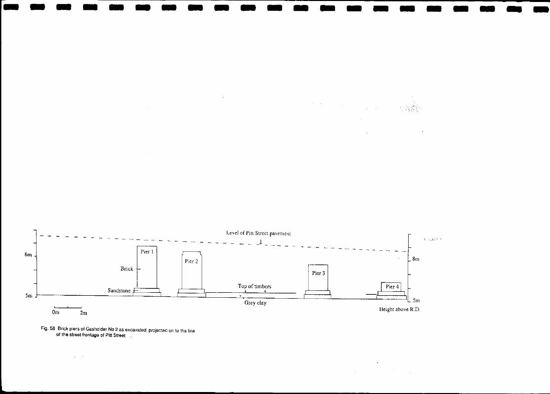
Fig. 58 Brick piers of Gasholder No. 2 as excavated, projected on to the line of the street frohtage of Pitt Street
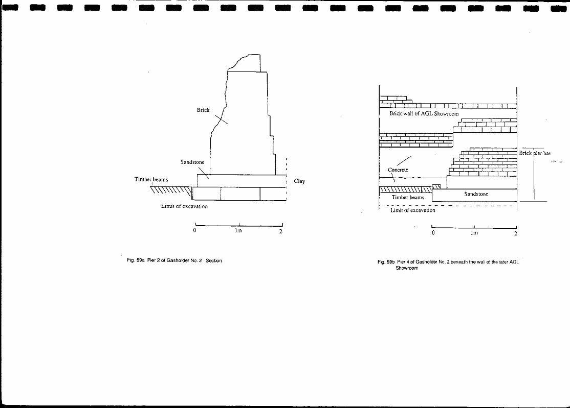
Fig. 59a Pier 2 of Gasholder No. 2 Section
Fig. 59b Pier 4 of Gasholder No. 2 beneath the wall of the later AGL Showroom
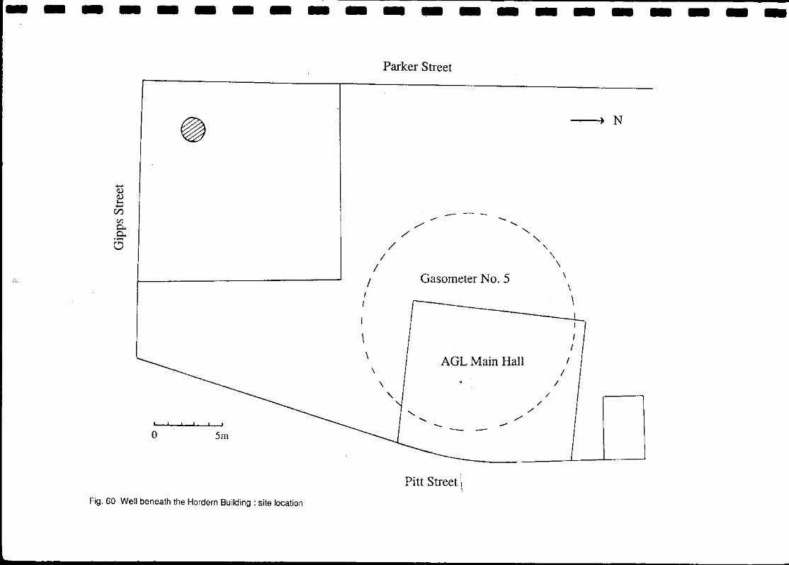
Fig. 60 Well beneath the Hordern Building: site location
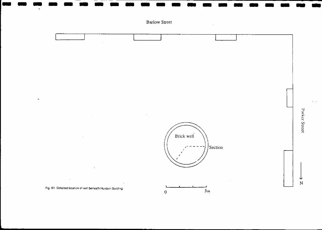
Fig. 61 Detailed location of well beneath Hordern Building
Fig. 62 Well beneath Hordern Building: section
Fig. 63 Well beneath Hordern Building: section and isometric view
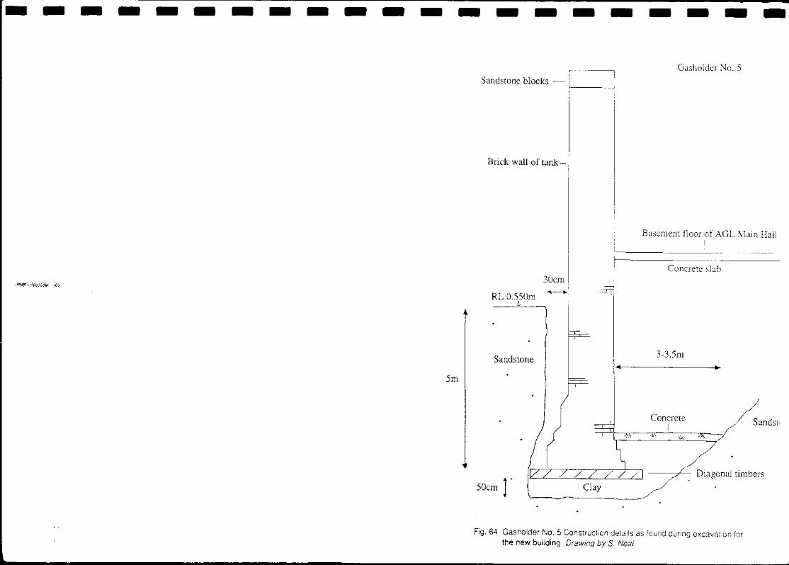
Fig. 64 Gasholder No. 5 : construction details as found during excavation for the new building. Sketch, not to scale. Drawing by S. Neal
--------------------.~
Fig 1 Site location plan. Sydney from Circular Quay to Central Railway University of Sydney, Cartography Department
- -Insbtute
Fig. 2
, , , ,
, ,
" , '" \ I' \ \ , ., J' \, I! \ \ , '
, , , , , ,
'\ ,...,
:'M ',:, O-R-E' E L _ '. : " 0" I' , If
,': A'Rk,', ,p, -- -, . " ' ~ ~ ~ , \ .... f
Parking
Station
--- "'-
..J tu
---------------------
CJ
2 -v: 0... C-
O
u Wheelwright and
farrier
-
AGL Company Gasometers
Fig. 3 Site plan 1865 AONSW Trigonometric Survey of Sydney Sheet R2
Parker Street
Manager's
HOllse
I I
.--_-, Cl
Pitt Street
Fire Station
Timber yard and sheds
Wl'skyan IJ ---,
Chapel ---l 1-
HOllse
::r: t,:)
'-< CI:l
Manse and @ (D ......
outbuildings
==i---"l
------") N
---------------------
L
Smith's Whct:l wright
No.2
No.I
Work shed
Parker Street
~ Manager's I
I' lint'"
AGL Company's Works
No.S Gasometer
CJ
rire '-----I slat ion
Piu Street
Fig. 4 Site plan 1880 Percy Doye's Commercial aad WbadDjrectol}:'
NoA
Austin's Timhcr
Yan'D, ___ 1
Wesleyan Chapel
Smith's Cart
, House
Yard Shed
Shed Manse
-----4~ N
---------------------Parker Street
I
~ManagCr's
Ilollse -_._, J--No.1
~
-----l~ l ,- - - - - -~!~-i -------'
AGL Company's Works
No.S Gasometer ::J
I -.. - - - -
"- ~ Fire Station
Pitt Street
Fig. 5 Site plan 1886 Metropolitan Detail Survey ML Ser 4/811.17/1
'-J
D
Wesleyall Chapel
I : l' ,:
'------ ,
r 1
\
Former Manse
----_ ... -
::c t;.)
"< en ...... ""1 ('t) ('t) ......
---------------------Parker Street
Residence
Anthony Hordern's
Furniture Warehouse o > AGL Company's Works
AGL Showroom No.S Gasometer
u 1_
Piu Street
Fig. 6 Site plan 1895 Metropolitan Detail Survey ML Ser 41811. 1711
451
NoA
r Wesleyan I Chapel
191
199 ~ __ ~ables ..L - - .!...--;------'
I I
I I I
201
I Beehiv:-Stores 439
- - - - - - - - - - -.- - - - - - - - - -
Anthony Hordern's
Furniture Warehouse
Parker Street
Residence
ACJL Company's Works
ACJL Showroom ~o.5 CJasometer
0--
I I ..
Pitt Street
Fig. 7 Site plan 1901 Metrop:>/itan Detail Survey ML Ser4/811.17/1
Stables
I
/ A
~
- - - --
Wesleyan
Chapel
~
1-1-
1-
-
1:><'
1--Beehive
Stores
..... <1)
~ Cl.)
~ ::r:
- - -
I I
\ ,
- - - - - -
Fig. 8 Site plan c.1920 F. Oliver Jones Structural plans of the City of Svdnev ML M2I811, 17441190111
- - - - - -
., -. -- - .. - - -~ : - ":':'~ -
I
- -
~. --!
• 'k-I"
-
i~' , .' ,.;
- - -'- - - - - - - - - .
- - -
.,-
- - - - - - - - - - - .- - - - - - - - - -
..... <l) <l) I-
C/)
;... ... C \: C\l ~
0 0 Cl
AGL Showroom
~J
Parker Street - - .. ~.J::c=l :1,-"'-'=r-F'-
1\( ;r, I ~Ilgilll:l'rs' ':'!=I11 - ---~t..f"l EQ.~
u o
11
I ~. _.-.- ~111!J "', Building Ir~ ,
'-=======::::::J C====.:==.! u::J__ _ F==r 0 ~ \
! Gasometer NoA below: Porlller AGL Company Sile
-'-"--...,
,.......
r"somctcr No.5 below
:fl AGL Main Hall 01:. -_- - _ .. _
\ I' ---.@---~ \" ... -. ~ : ::- ::. ::.
\ /5): -- :..._ 6J
\. @L- _ .. 6:. -- -: .. i "/1 - .. -@I /
,".'-. ~:.-:. ~ - :. -:.. .. - ..... , .-.--
--'0.0.::- 'Ii:il - .. ----- -:...--:
I ~
\ /
/
/ /
/.~j J Former Garage
~==~1==~'1==-=-=1~==~1
Shops
477 11 __ 11_-
Piu Street Fig. 9 Ground floor plan 1986 Conservation Analysis by Peter Freeman &
Partners
Ronla ('alC
~ I '-====~
= 195
Building
207 I1 Ii Shops
----+) N
- - --Parker Street
K
AGL Enginccrs' Building
Anthony Hordern Building Courtyard
B
•• o ISm Gasholder Tank No.5
Fig. 10 Block plan of site. Buildings and structures to be retained in the redevelopment of the site are shaded.
Areas B,F,G,H,I and J considered as potentially productive of archaeological remains. (Area designations as in the Conservation Analvsis ).
I
" /
/ " /
--
\ I I
I J
Wcslcyan Chapel Site
Austen Building
- - - - - - - - - - - - - - - - - - - -N
T Hay Street
_.~.~* ___ ._ ""M*~_ ~ ___ ; J Section 1 Section 2 t Section 17 I : H Line of Carters' road?
I --4 ________ +--
Mottled clay Road metalling I Section 45
~~_ Wooden drain?
T I -----------
o 5m
Direction of flow
Side drain seen during demolition
'@s \
- - - '- - - - - - - - - - - - - - - -
Fig. 11 Features predating the subdivision of the site in the 18405
~--------------------
w
Brick foundations
Bitumen . >;:: .
Concrete Crushed sandstone o 0 .=. .0'
Brown topsoil
Sandstone
Natural red and blue clay
Fig. 12 Section 1 North face
Pavement level ",', '.. :.'
Orange Sand Void
Yellow-brown sand
Sandstone blocks
/' Charcoal
.~
Orange clay Construction._,.-.....J I ..----- --__ --------------\ trench~_->---..
: Limitofmmtion ~ _. _. _. _. _ ._. _., 1 ______ L ____________ ~- .'.,. I 1 Crushed sandstone Construction trench for porch ... -:::"'-. --_____ -L-____ -'-____ _
' ............ I 2 Fine orange-brown sand I 3 Mottled orange clay 14 Brown sand 15 Grey clay
6 Brown sand with clay 7 Yellow small sandstone 8 Mottled clay with brown fIll 9 Mottled clay
o
-t· ... · ... ...... -.-Profile of construction trench for Ch~;~ :~ii . -. -. -. -. _. -. \ (projected on to this section)
lm
, i.
North wall of chapel
10 Brown clay Fig. 13b Section 2 East face
11 Light brown clay with smaH sandstone 12 Yellow sand 13 Mortar
-
W
- - - - - -
W,:st wall or "Llhlt-"
1 COllst ruct iOIl trench for wall
-·0
I Clay wilh sandstone rubble 2 Grey clay
:l Small pieces or hrick & sandstone .:I Hmwll clay 8: slllal! piL'CCS or hrick :"i Browll clay () J .oose fill witll hrick & salldstolle 7 Deep red sandy clay with charcoal 8 Grey-red sandy clay 9 Fragments of brick & sandstone ) 0 Yellow clay
- - - - -
4 o
5
Limit of excavation
- - - - - - - -
c::J
6 C:;)
<:)
0 C5
-
o
East wall of stahles
1
Cl " I
0 - - '-1
....... 9 -:: ~ -:,:.:.
"""-]0 I
- - - - I
]m
Fig.14 Section 45 North face. Layers 2-4 ?part of CartE;'Js' Rvad 1819 Layers 6-10 associated with construction of drains c.1830s Layer 1 road metalling : post-drain construction. All layers pre-date the construction of the manse stables
E
- - -
i l
J o j
- -
Pa,·ement level Ha,·/parker SI.
- - - - -
Thickness of brick arch
Projected level of floor
Fig. 15 Levels of the large stone and brick drain from Section 49 to Section 22. Total length of drain 34.5m.
- - - - - -
Austen Building foundations Section .... Section .. 0
1 Dark red sandy clay 2 Brown clay 0 3 Light brown clay & inclusions 4 Yellow clay & clinker-like material 5 Yellow clay & inclusions 6 Brown sand with bricks & mortar 7 Dark red-brown sand & much charcoal
Fig. 16 Section 40 North, north-east and south-east faces. Stone and .1 L • _I _'.J -.J
Nonh-east face 8 Yellow-grey clay with red inclusions 9 Blue & yellow day with red inclusions
Im 10 Grey clay with sandstone rubble 11 Shell mortar 12a Dark grey clay 12b Darker grey clay 13 Black clay 14 Greenish sand
South-east face
15 Black gritty sand 16 Brown clay 17 Grey silty clay 18 White clay 19 Dark brown clay with rubbl< 20 Greenish gravel
Worked sandstone 12b ______ <bl!se_of draLnL ____ _
14
20 15 Salldslolle hluck
Sandstone paving
South-west face North-west face
o I m 15 Black gritty sand 1 Dark red sandy clay 8 Yellow-grey clay with red inclusions 16 Brown clay 2 Brown clay 9 Blue & yellow clay with red inclusions 17 Grey silty clay
Fig. 17 Section 40 South-west and north-west faces. Stone and brick drain c.1830s
3 Light brown clay & inclusions 10 Grey clay with sandstone rubble 18 White clay 4 Yellow clay & clinker-like material 11 Shell mortar 19 Dark brown clay with rubb 5 Yellow clay & inclusions 12a Dark g ey clay
r 20 Greenish gravel 6 Brown sand with bricks & mortar 12b Darker grey clay
Br. =Bricks 7 Dark red-brown sand & much charcoal 13 Black clay
14 nrf"f"n; ~h ~"n~
- - - - - -- Hay Street frontage 3.23m N
3a
--- --
--'-- -
o Im
- -
3
--- . -.--
-
Fig. 18 Section 47 Large stone and brick drain with? wooden drain in fill
- - - -
Foundation of passage entry to Hay Street shops
1'-------""" ~. . ':;--.:
Limit of excavation (sewer line in concrete casing)
- -
1 Mottled grey-red clay with small sandstone pieces 2 Dark red sandy clay 3 Orange-brown loose fill with much charcoal 3a As (3) with some clay 4 As (3) with small pieces of brick 5 Broken bricks with patches of grey clay 6 Light brown clay with orange flecks 7 Dark brown-orange clay with sandstone 8 Pale grey-orange clay with brick fragments 8a As (8) with finer particles
- - - - -
s
14 - - - -
9 Dark grey clay with orange flecks and brick fragments 10 Grey-yellow clay 11 Wooden ?drain 12 Grey clay with charcoal and brick fragments 13 Orange clay with sandstone 14 Grey clay with brick fragments 15 Grey-blue clay with red streaks Br.= Brick
-
LIl 9
10 11
Ll3
Bottom of drain I Brick and gravel Large sandstone slabs
o
I Loose rubble (from demolition) 2 Dark brown sand with brick fragments 3 Grey clay 4a Grey-brown sand with charcoal 5 Yellow sand 4b As (-+a)
6 Grey sand 7 Grey sand with charcoal and many anifacts
lm
8 Grey-brown sand with large pieces of sandstone & bricks
1 Clay with brick and sandstone 2 Small sandstone 3 Clay
o
4 Dark red sandy clay with brick at base 5 Light grey clay with charcoal and ash 6 Clay with brick and sandstone fragments 7 Dark grey clay 8 Sandy clay with charcoal and bone 9 Yellow-red sand
Fig. 20 Section 43 Small brick side drain
"" -- ""
7
f - -<:::;z
Limit or excavation
1111
Foundation of sto're laid across stable wall
.........
w
Foundations and cOllstruction trench for manse stables
- - - - - - - -
"
-
TfT:·,; " l.
• ,<-
I· ..
0,
".
.'
- -
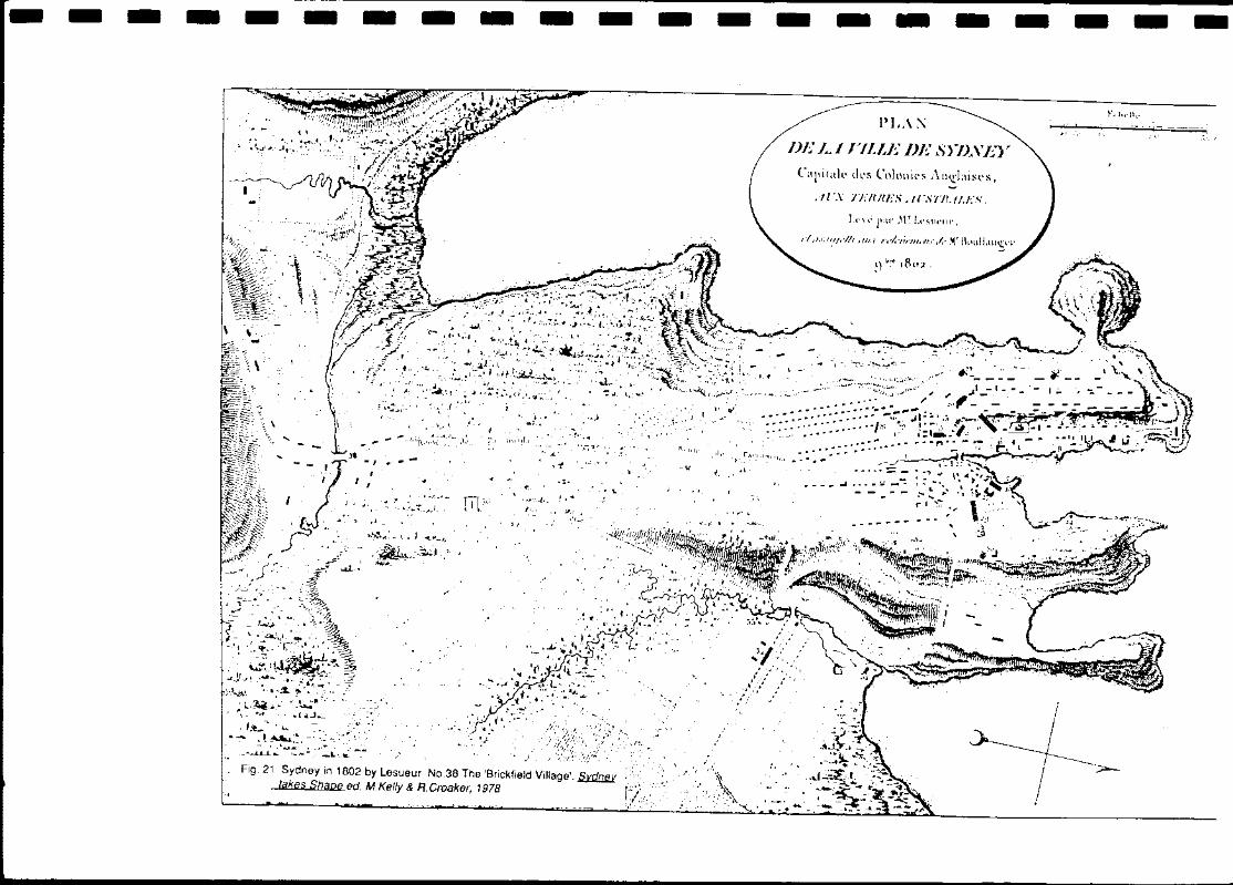
Fig. 21 Sydney in 1802 by Lesueur No.38 The 'Brickfield Vii/age'. ~ takes Sha,pfJ. ed. M. Keflr & R.Croaker. 1978
Fig. 23 Surveyor's plan of 1839 showing the site for the Presbyterian church and the road across the Government paddock from the corner of Campbell Street AONSW Map 5618
- -
- - - - - - - - - - - - - - - - -
Fig. 24 Plan for the extension of the grid system of streets south of Campbell Street. The earlier road from the corner of Campbell Street can be seen crossing the north end of the site AONSW Surveyor General's Sketchbooks Vo/.4 Fo/.211
Fig. 25 Presbyterian Manse allotment. Location of 1830s drains shown in relation to later manse and outbuildings (broken lines).
o 5rn
- -
- - - -
-- -I
1
1
.J
,
--------...1:
- - - - - - - - - - - -. - - - - - - - - -N
i Hay Street
- - ••• - L -.1 : ......... ~ Well ' . Not fully defined Base for steps '[' 1 •• 1 ~-··O ~,
\~\ Single door(?) i : or threshold I :. r~":
0 \ bo ~. ",
':'q'/I \ 00_"." J
Impressions oy / Stable and coachhouse ""7""" D-·'·-·~~;·.~ Construction pit stone piers 00 "'" .... . ,
0 Double doors (?) . , ' .. '
I 0 ~9
'/
~ r---l 1 ll---T-Probable position of walls I -- j of outbuildings
, Cellar(?) Ffl - _Entry Yard '----
to loft(?) ~ i Storeroom
r(J -: --'- -" ---, zrrnn .. c9 Privy q Not fully defined 0
/'".,
I '~ .. '
ill Kitchen Privy
.1 1 r
Doorway -Flat stone piers
Vm rn 'm Y X
o Srn
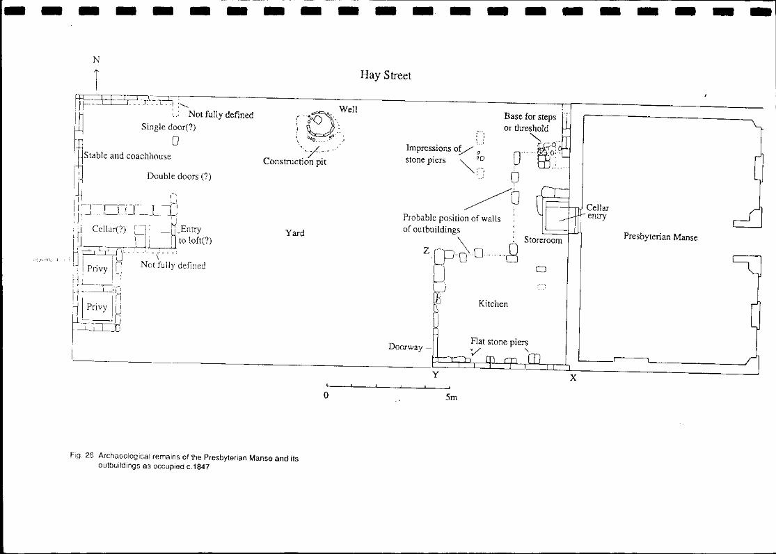
Fig. 26 Archaeological remains of the Presbyterian Manse and its outbuildings as occupied c.1847
I
Cellar I- entry ~
Presbyterian Manse
~J
[
1
- - - - - - - - - - - -. - - - - - - - - -
First floor
Ground Floor Street level
I.cvd or top or stonc picrs
o 3m Cellar floor
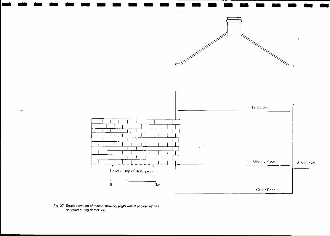
Fig. 27 South elevation of manse showing so.u!h wall of original kitchen as found during demolition. '-~
---------------------E
Back wall of manse
Keyed in
Later brick addition
I
" Stone piers /' x
o Im·
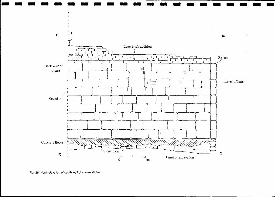
Fig. 28 North elevation of south wall of manse kitchen
w
- Level of lintel
J y Limit of excavation
----------------- - - --
Slate damp course
z Clay • Limit of excavation
N o lm
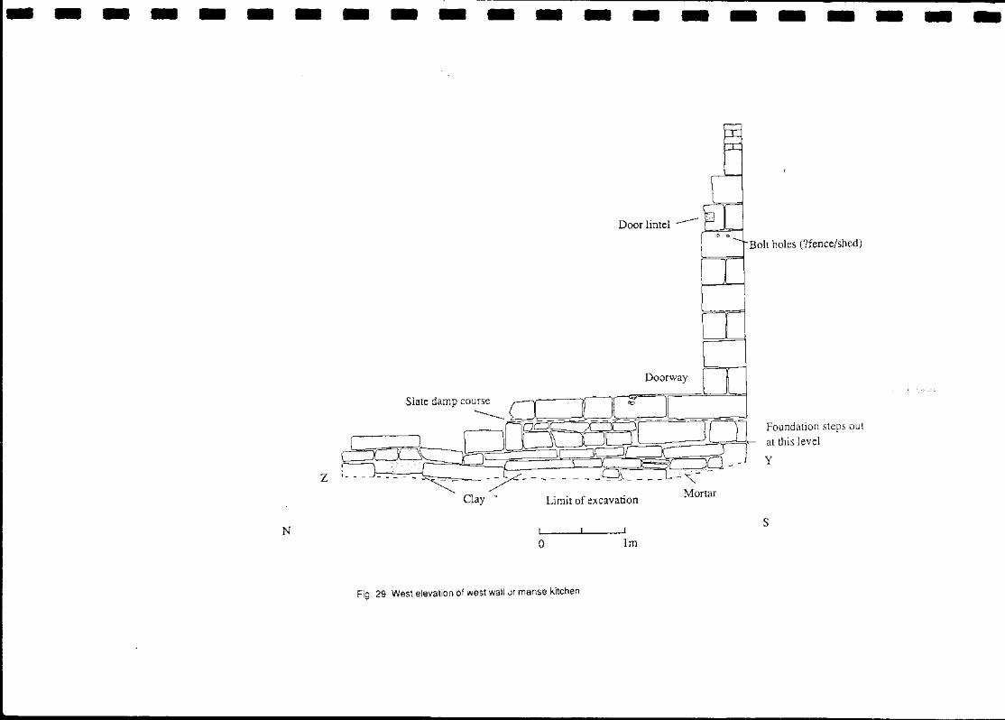
Fig. 29 West elevation of west wall.;)! manse kitchen
o 0
Doorway
Bolt holes (?fence/shed)
Foundation steps out at this level
y
S
Brick lining '-'f
Wet sieved to base -t
Water seepage
Ll
L2
2 L3
3 L4
4 L5 -'-'-'-'_._'-5 L6
6 L7
a aoCJJo [J 00000[1 7 L8
8
L9
LlD I
~L _.: -_-_ -.. ~ ~.-.~ .. ------~~_;I
H L12 LJ ,0 q:;::::::::r /.?:/~~/2 0 I \
Grey clay Timber beam Bricks
Fig. 30 Layers of fill in the manse well
r Layers 1 & 2 20th century
1 i
Layer 3 Late 19th century ..t.
r Layers 4-6 c.1860-1870
1 T
Layers 7-8 c.1850s (?)
1
Layers 9-12 Contemporary c. late 1850s
1m
I I 'I I 1 I I I: I I I I I I I I
I Loose rubble 1 2 Clay and soil with rubble and brick 3 Dark brown soil with charcoal
o
4 Darker brown soil 5 As (4) with sandstone and charcoal 6 Yellow mortar 7 As (3) with layer of bricks 8 Grey sand with orange staining
I I I I
- - - - - - - -
s
2
4
5
o
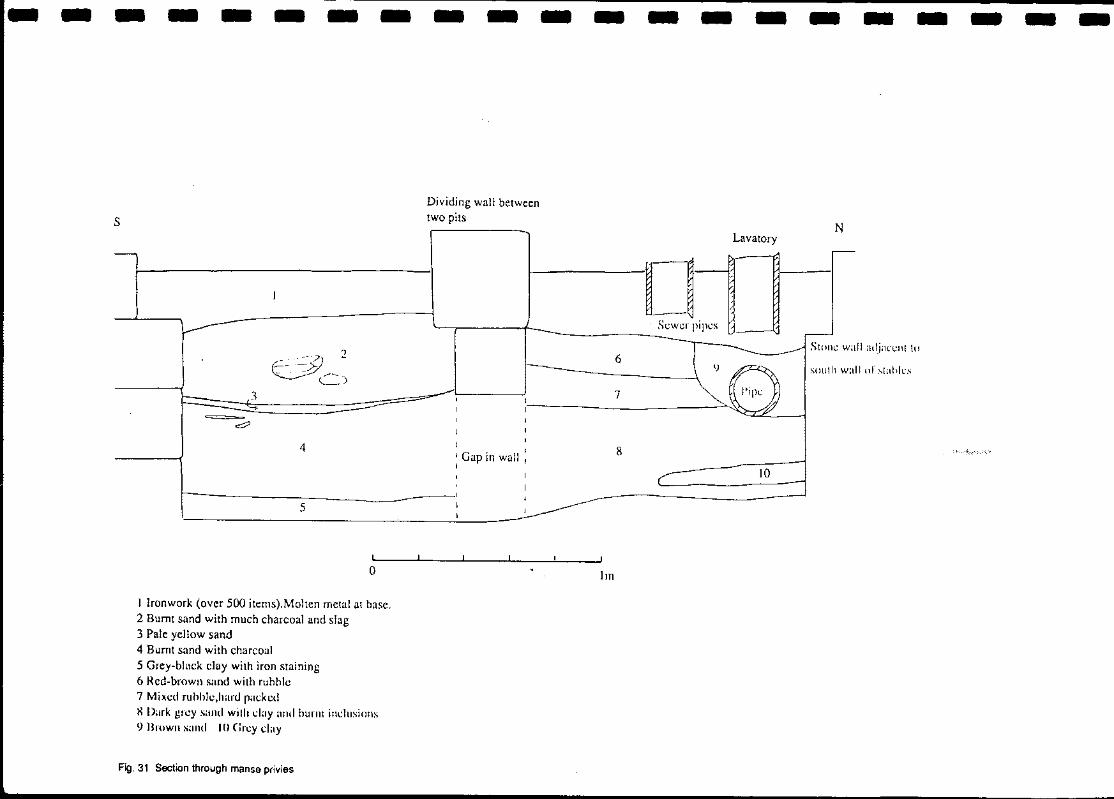
I Ironwork (over 500 items).Molten metal at base. 2 Burnt sand with much charcoal and slag 3 Pale yellow sand 4 Burnt sand with charcoal 5 Grey-bhlck clay with iron staining 6 Red-brown sand with ruhhle 7 Mixed ruhhle,hartl pilcked X Dnrk grey sand with cJilY and hurnt inclusions <) Brown sillld 10 Grcy clay
Fig.31 Section through manse privies
- -
Dividing wall between two pits
I
'Gap in wall : I
- - - - -
Lavatory
eJj-"l -----------------
6
7
8
10
Im
- - -
N
Slol1C wall adjacenl to
sOlllh wall or slahles
- - -
- - - - - - - - - - - - -
I "
Jtw 4\.r-f.~ le{ " '\ ~.
.~--I: I
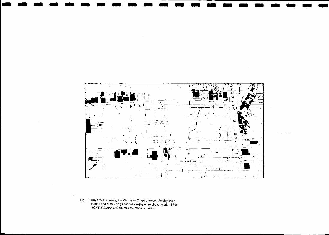
Fig. 32 Hay Street showing the Wesleyan Chapel, house, Presbyterian manse and outbuildings and the Presbyterian church c.late 1860s. AONSW Surveyor Generars Sketchbooks Vol.9
- - - - - - - -
- - - - -No. 195
Foundations of earlier stables
/
Overlies earlier foundations -.....
- -No. 197
- - - - -Hay Street
No. 199 Entrance passage
o
Sandstone footings
/
_' passage arch ---'
- - -No. 201
Sewer and stormwater drainage connections
~
Much disturbed for later sewer connections
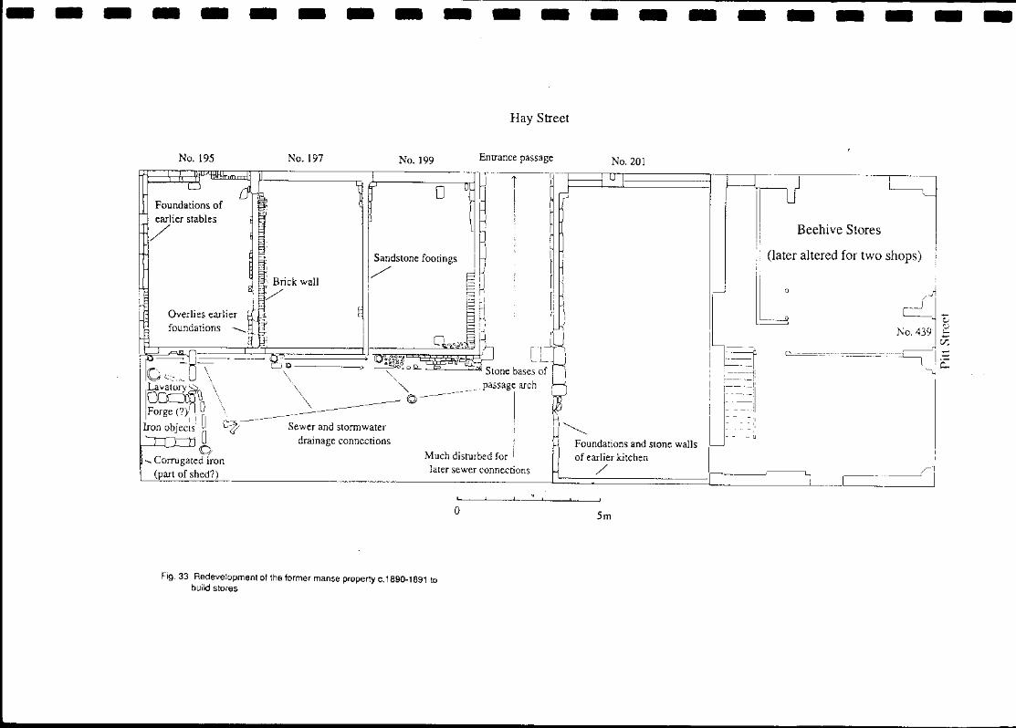
Fig,33 Redevelopment of the former manse property c.1690-1691 to build stores
o
Foundations and stone walls of earlier kitchen
/
5rn
- - - - - -
J Beehive Stores
(later altered for two shops)
o /
- - - - - -- - - - --
Original foundations
/
Stables Yard
Line of dividing wall of stables
I Privies
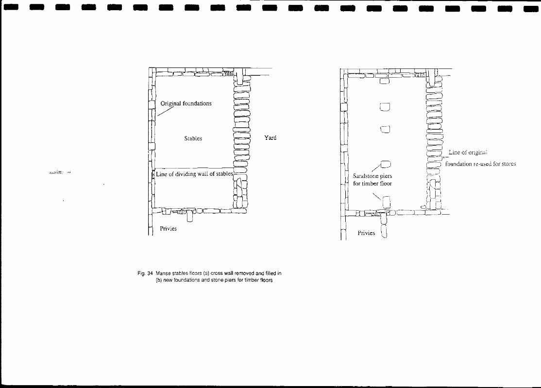
Fig. 34 Manse stables floors (a) cross wall removed and filled in (b) new foundations and stone piers for timber floors
- - -
o o
Sandstone piers for timber floor
- - - - - -
Line of
foundation re-used for stores
cJ
---------------------ph ph ph
"') [J i ,I Post holes _ .. _. i . - _. - ., Foundation ". C7 [J trench
~"'l::S:::±:::~:!:E~lE:::::::::::E~
Eaves drip : gully
Clay surfaced :-yard
/ Stone ch~nnelled ", // Shallow slope
c dram ·· .... :W/ ~.",// ····./·:i., " /
~ ':." ~ .'., ..... '.: .. ~ ~
o Stone piers
/ D D
Wesleyan Chapel
Fig. 35 The Wesleyan site: the chapel & associated features c.1846-1856 I
:J I I
I ,
I I I I
I
House
---_ ......... . ---- ..... - .....
---_ ..... _ .... ~ .... ---- .... - - - ...
Brick grain
o Srn
---------------------w Pavement level Bitumen
I Void ~ 1
1,...-_---_-----I
:1'.-. 'r~ l' - -FPostholc 1.11111\ of excavallon Wooden post
o 50cII1
1 Grey sand with clay and sandstone fragments 2 Pale grey clay 3 Grey sand 4 Red-brown sandy clay 5 Mottled clay 6 Brown fill
Fig. 36 Section 17 North face showing post holes
E,
-------------------Drain
~
Yard filled in and levelled
Drain filled in and levelled
1 I
, ! !
I
Hay Street
,.- D ! ! ! ?
Wesleyan Chapel
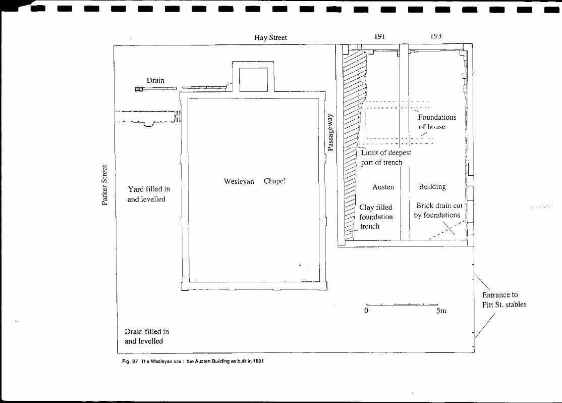
Fig. 37 The Wesleyan site: the Austen Building as built in 1891
Fig. 41 Subdivision of the George Street frontage of the Government Paddock showing the stream across the site straightened, January 1843 AONSW Surveyor Generars Sketchbooks Vol.4 Fol.104
Fig. 45 Alterations and additions to the Austen Building 1926-27 showing the proposed future extension of the new facade along the whole of the Hay Street frontage Sydney City Council Plan B.A. 227127
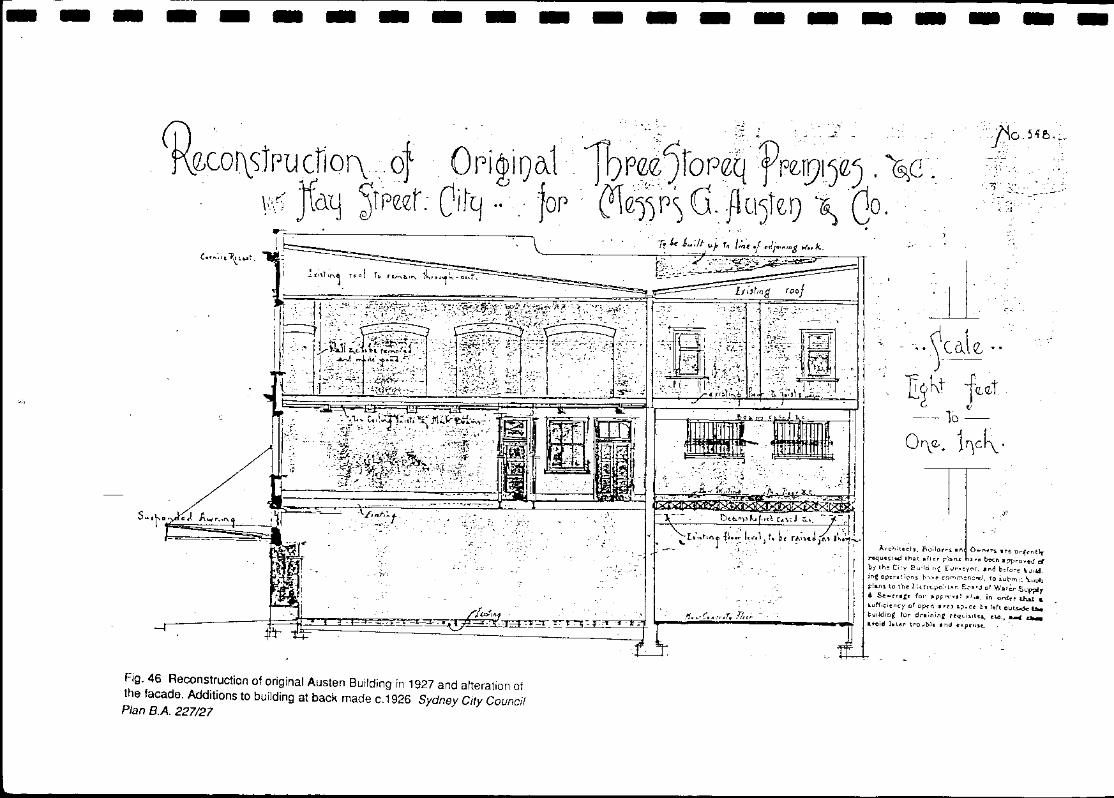
Fig. 46 Reconstruction of original Austen Building in 1927 and alteration of the facade. Additions to building at back made c.1926 Sydney City Council Plan B.A. 227/27
.:. I ... n ,~, .~' •• ~Cil.\ e, .••..
TI~~'J jQ.Q.t 10 -
O~Q,. 1'1c~.
Archite~ts. Eh.l;lOHS an O ..... ne1"t .re urfentlr requnttd lhet .fltf" pions ),,~ been .ppt"oved cl by th~ Ci:y Building £vI'veY('I-r •• "d b:ror-e t1uild. inC operations hv.",. eommencfld. to iocml: \.u::::h pla.ns to the '.iH''Vpo:ll1'lr. E"~~d of Wa'~S\"-m " SewrraJ:t fOl' Itprrcva' .1 .... in orde: .. that .. s.uf(ieienC'y of ofKn UC'.) 'p_ee b, left ou~ t::ha building tor dratnine r('qvi~lt'!lf e14., ~ a.. •• cid llt-l.cl" trolJbl •• nd ".penle.. "
- - - - - - - - - -I
I I I I I
RomaCafe
Austen Building
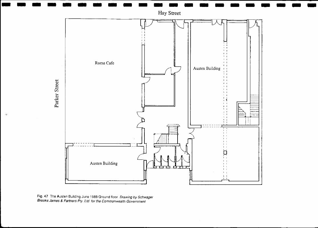
Fig. 47 The Austen Building June 1988 Ground floor Drawing by Schwager Brooks James & Partners Pty. Ltd. for the Commonwealth Government
o lm Concrete skim over bricks 7 Grey clay with orange staining 14 Brown sand Grey clay with iron staining & rubble 8 Crushed sandstone with mortar 14a Brown clay with wood fragments Grey sand with small sandstone 9 Cinders 15 Pink &. white clay Grey clay with orange staining 10 Yellow sand with broken bricks 16 As 15 Unworked sandstone pieces & broken bricks 11 Orange sand with unworked sandstone & metal fragments 17 Yellow clay Grey sand & small rubble 12 Grey sand with small rubble 18 Yellow-brown clay
Fig.61 Detailed location of well beneath Hordern Building
o 3m
---------------------( I I I
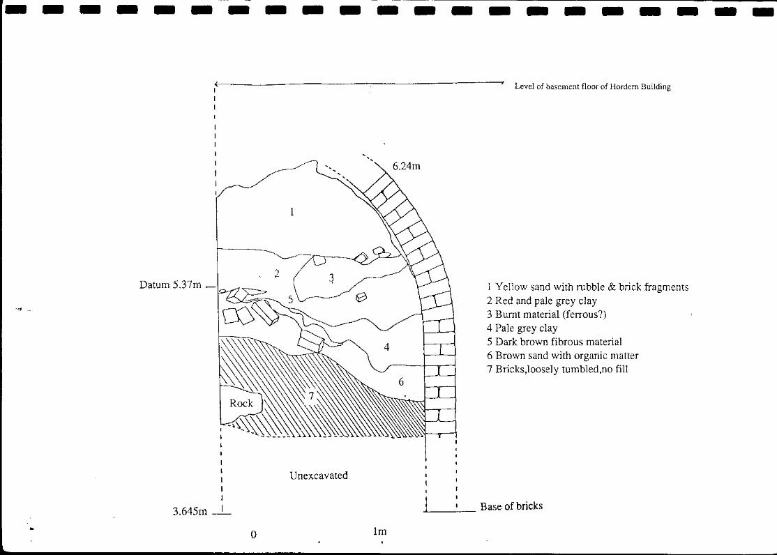
Datum 5.37m _
3.645m
Unexcavated
o Im
-'-----
Level of basement floor of Hordem Building
1 Yellow sand with rubble & brick fragments 2 Red and pale grey clay 3 Burnt material (ferrous?) 4 Pale grey clay 5 Dark brown fibrous material 6 Brown sand with organic matter 7 Bricks,loosely tumbled,no fill
Base of bricks
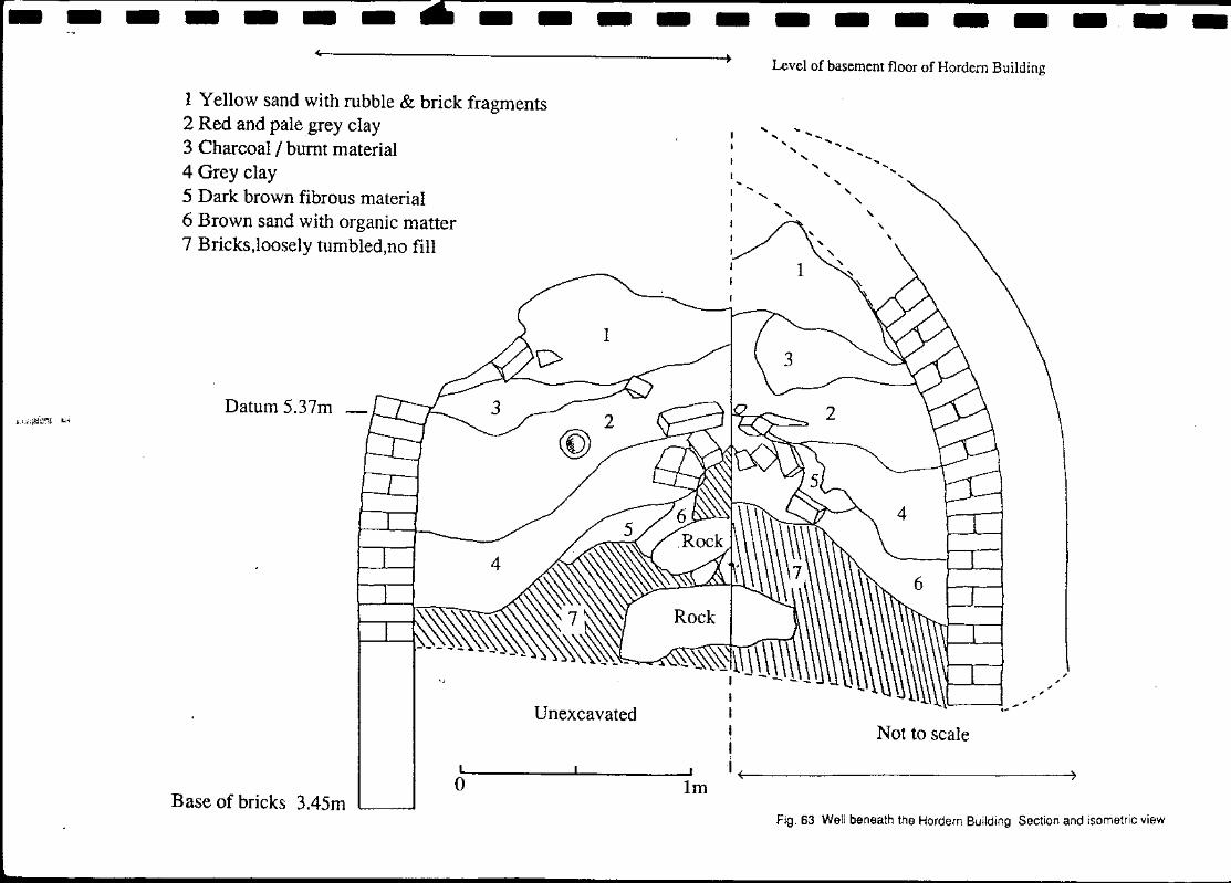
---- ___ 6 ____________ _
1 Yellow sand with rubble & brick fragments 2 Red and pale grey clay 3 Charcoal / burnt material 4 Grey clay 5 Dark brown fibrous material 6 Brown sand with organic matter 7 Bricks,loosely tumbled,no fill
Datum 5.37m
o Base of bricks 3.45m
Unexcavated
lm
I I I j ,
Level of basement floor of Hordern Building
Not to scale
, , ,
I ~( ______________ ~)
Fig. 63 Well beneath the Hordern Building Section and isometric view