59
www.environment-agency.gov.uk/cams Adur and Ouse Catchment Abstraction Management Strategy Final Strategy March 2005 Environment Agency
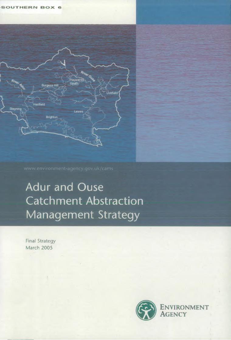
www.environment-agency.gov.uk/cams
Adur and Ouse Catchment Abstraction Management Strategy
Final Strategy March 2005
E n v iro n m e n t A gency
www.environment-agency.gov.uk/cams
The Environment Agency is the leading public body protecting and improving the environment in England and Wales.
It's our job to make sure that air, land and water are looked after by everyone in today's society, so that tomorrow's generations inherit a cleaner, healthier world.
Our work includes tackling flooding and pollution incidents, reducing industry's impacts on the environment, cleaning up rivers, coastal waters and contaminated land, and improving wildlife habitats.
Published by:Environment Agency Rio HouseWaterside Drive, Aztec West Almondsbury, Bristol BS32 4UD Tel: 01454 624400 Fax: 01454 624409
© Environment Agency March 2005
All rights reserved. This document may be reproduced with prior permission of the Environment Agency.
This report is printed using water based inks on Revive, a recycled paper combining at least 75% de-inked post consumer waste and 25% mill broke.
Front cover photograph by David Dennis, Environmental Images.
ENVIRONMENT AGENCY
130702
Contents
1 Introduction 1
2 Consultation on the Adur and Ouse CAMS • 2
3 The CAMS area 33.1. Hydrology and hydrogeology 33.2. Hydrometry 73.3. Abstractions and discharges 73.4. Conservation designations 103.5. Status of fisheries and ecology in the CAMS area 1 33.6. Water quality 143.7. Stakeholder concerns 153.8. Links with other plans 15
4 Resource assessment and resource availability status 174.1. Introduction <• 174.2. Resource assessment of river assessment points 184.3. Resource assessment of groundwater management units 214.4. Integration of the surface water and groundwater resource assessments 214.5. Water resource management units in the A&O CAMS 23
5 Existing strategies • 275.1. National Environment Agency strategies and initiatives 275.2. Southern Region water resources strategy 275.3. Water company water resources plans 285.4. Climate change 285.5. Opportunities for licence trading in the A&O CAMS area 295.6. The Water Act 2003 29
6 Licensing strategy 306.1. Introduction 306.2. Existing licensing policies relevant to the A&O CAMS 306.3. Sustainability appraisal 306.4. Licensing policy common to all WRMUs 316.5. Promoting water efficiency 326.6. Revocation of unused abstraction licences 336.7. Licensing strategy for the River Adur - WRMU 1 346.8. Licensing strategy for the River Ouse - WRMU 2 366.9. Licensing strategy for the Cockhaise Brook - WRMU 3 386.10. Licensing strategy for the Brighton Chalk - WRMU 4 406.11. Licensing strategy for areas not in a water resource management unit 41
7 Future developments in the A&O CAMS area 42
8 Summary of licensing policy and key actions 448.1. Existing licensing policy 448.2. A&O licensing strategy 448.3. Sustainability issues 448.4. Post CAMS appraisal 44
Appendix 1: References/Useful water efficiency contacts 46
Glossary 48
List of acronyms, abbreviations and units 52
Environment Agency The Adur and Ouse Catchment Abstraction Management Strategy
IntroductionThe CAMS Vision - A shared strategy for the sustainable management of water resources within a catchment.
The Environment Agency is committed to ensuring that water is managed in a sustainable way that benefits users and the environment both now and in the future. Catchment Abstraction Management Strategies (CAMS) set out how water resources are managed at a local level. They will make more information on water allocation and abstraction licensing practice publicly available and allow the balance between the needs of abstractors, other water users and the aquatic environment to be considered in consultation with the local community and interested parties.CAMS are also the mechanisms for managing time- limited licences by determining whether they should be renewed and, if so, on what terms.Managing Water Abstraction: The Catchment Abstraction Management Strategy Process is the national document that supports the development of CAMS at a local level. It sets out the national policy and the regulatory framework within which CAMS operate, describes the process of developing CAMS and provides information on the structure and content of CAMS documents. This document should be read in conjunction with Managing Water Abstraction.
The Adur and Ouse (A&O) CAMS sets out our plan for managing water abstraction in the River Adur and River Ouse catchments as well as the Brighton Chalk aquifer. This document summarises the availability of water resources and the sustainability of current abstraction. Our policies for managing surface and groundwater abstraction are described in detail. This includes actions to help maintain and where necessary restore a healthy balance between abstraction and the needs of the environment. The document also includes our proposed investigations to help improve our understanding of the interaction between abstraction, river flows and ecology.
The A&O CAMS is the second of three CAMS to be completed in Sussex Area of the Environment Agency. CAMS operate on a six-year cycle and the document will be reviewed in 2009 and an updated strategy will be published in 2011.A technical document (final version) for the A&O CAMS has been produced which provides detailed technical information on which the strategy has been based. If you wish to receive a copy of this document on CD-ROM, please contact:Tom Nichols - Technical Specialist (Water Resources),The Environment Agency,Sussex Area Office,Saxon House,Little High Street,Worthing,West Sussex,BN11 1DHTel: 08708 506506 Fax: 01903 215884Or by e-mail to:[email protected] copies of the A&O CAMS document and other information about CAMS in Sussex are also available from the same address.
Environment Agency The Adur and Ouse Catchment Abstraction Management Strategy 1
Consultation on the Adur and Ouse CAMSConsultation is an integral part of the CAMS process.It is important because it ensures that the CAMS are transparent and gives everyone the opportunity to get involved. For the Environment Agency to manage water resources in a catchment effectively and sustainably, it is important that as much information as possible is collated on water needs and uses. Comments and suggestions have been gathered during the development of this strategy through various activities. These were:• The wide circulation of an awareness raising leaflet• Setting up of a CAMS Stakeholder Croup• Presentations to the Sussex Area Environment
Group• Setting up of a multi-disciplinary CAMS project
team• Publication of a formal Consultation DocumentThe leaflet was distributed in July 2003. Its aim was to raise awareness of the development of the CAMS in the local area and it also invited anyone with an interest to send in written comments. We received 19 written responses providing information, views and suggestions for consideration during the early development of the CAMS.A stakeholder group was set up for the A&O CAMS. The role of the group was to represent the key interests in the catchment and to help identify issues of local significance, provide views on proposals and to consider the likely implications of different strategy options. The members of the A&O CAMS stakeholder group and the interests they represent were as follows:Mrs. Vivien Lyth
Dr. Tony Whitbread Mr. Trevor Passmore Mr. Paul Holmes
Horsham District Council Chairperson
Sussex Wildlife TrustAgricultureWater Companies (South East Water)
Mr. Tony Barnard
Mr. Paul Seeley later replaced by Mr. Mark PotterMs. Fenella Collins later replaced by Mr. Rupert AshbyMr. Peter Currell
Dr. Sam St. Pierre
FisheriesWater Companies (Southern Water)
Country Land & Business Association
Sussex Downs Conservation BoardSussex Ouse Conservation Society
English Nature were also kept fully informed of all aspects of the process but were unfortunately unable to accept membership of the Stakeholder Group.It was not possible to include representatives from all interested organisations on the Stakeholder Group. Contact was therefore established with a number of organisations inviting their input to the process. Representatives of these groups were sent minutes after each meeting. These included:• Inland Waterways Association (IWA)• NFU (South East Region)
There was also a formal consultation on our proposed licensing strategy through the A&O CAMS Consultation Document published in July 2004. We received a total of 25 responses, which were analysed and taken into account in developing the final strategy.We greatly value the ideas, suggestion, comments and opinions raised by respondents at all stages in developing this strategy.This document now sets out our final plan for managing water abstraction in the A&O CAMS area.
Environment Agency The Adur and Ouse Catchment Abstraction Management Strategy
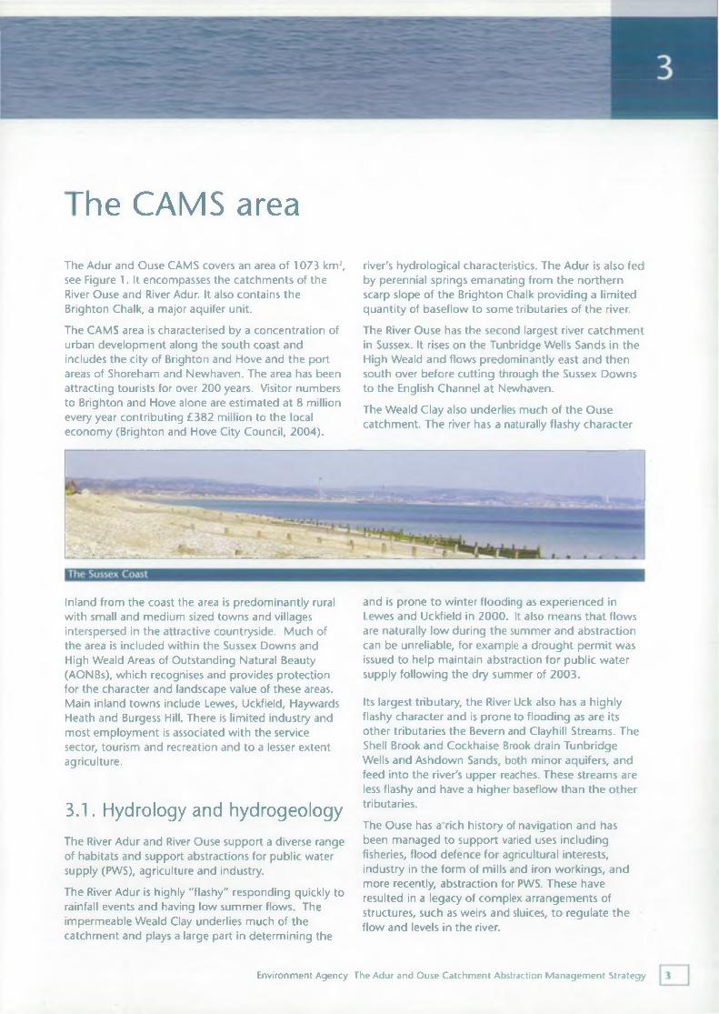
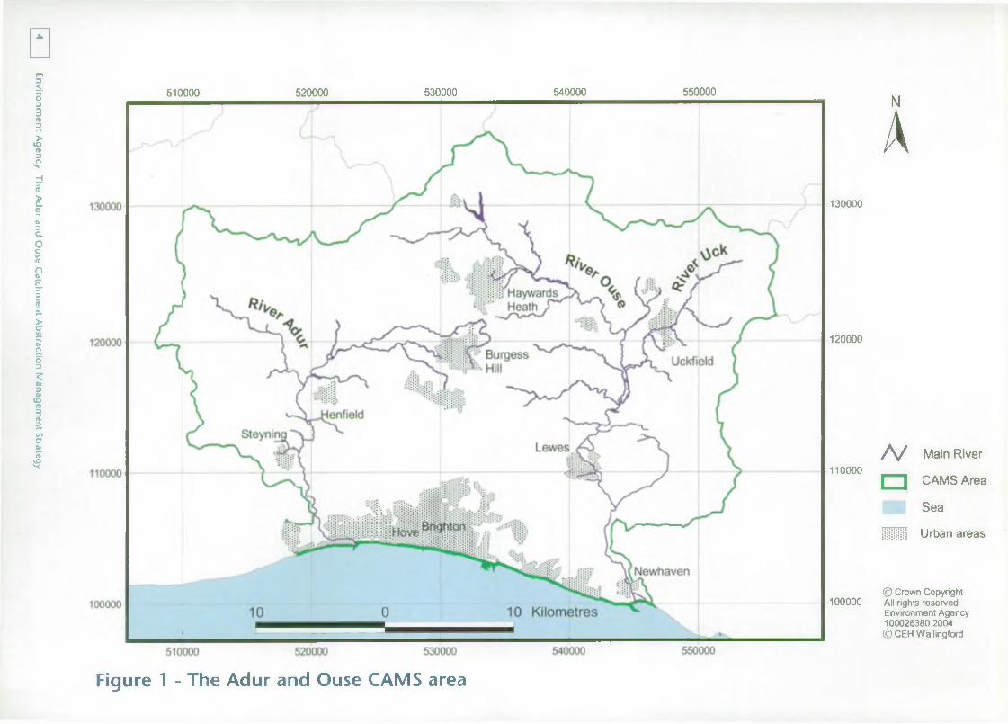
'he CAMS areaThe Adur and Ouse CAMS covers an area of 1073 km2, see Figure 1. It encompasses the catchments of the River Ouse and River Adur. It also contains the Brighton Chalk, a major aquifer unit.The CAMS area is characterised by a concentration of urban development along the south coast and includes the city of Brighton and Hove and the port areas of Shoreham and Newhaven. The area has been attracting tourists for over 200 years. Visitor numbers to Brighton and Hove alone are estimated at 8 million every year contributing £382 million to the local economy (Brighton and Hove City Council, 2004).
river's hydrological characteristics. The Adur is also fed by perennial springs emanating from the northern scarp slope of the Brighton Chalk providing a limited quantity of baseflow to some tributaries of the river.The River Ouse has the second largest river catchment in Sussex. It rises on the Tunbridge Wells Sands in the High Weald and flows predominantly east and then south over before cutting through the Sussex Downs to the English Channel at Newhaven.The Weald Clay also underlies much of the Ouse catchment. The river has a naturally flashy character
Inland from the coast the area is predominantly rural with small and medium sized towns and villages interspersed in the attractive countryside. Much of the area is included within the Sussex Downs and High Weald Areas of Outstanding Natural Beauty (AONBs), which recognises and provides protection for the character and landscape value of these areas. Main inland towns include Lewes, Uckfield, Haywards Heath and Burgess Hill. There is limited industry and most employment is associated with the service sector, tourism and recreation and to a lesser extent agriculture.
3.1. Hydrology and hydrogeologyThe River Adur and River Ouse support a diverse range of habitats and support abstractions for public water supply (PWS), agriculture and industry.The River Adur is highly "flashy" responding quickly to rainfall events and having low summer flows. The impermeable Weald Clay underlies much of the catchment and plays a large part in determining the
and is prone to winter flooding as experienced in Lewes and Uckfield in 2000. It also means that flows are naturally low during the summer and abstraction can be unreliable, for example a drought permit was issued to help maintain abstraction for public water supply following the dry summer of 2003.
Its largest tributary, the River Uck also has a highly flashy character and is prone to flooding as are its other tributaries the Bevern and Clayhill Streams. The Shell Brook and Cockhaise Brook drain Tunbridge Wells and Ashdown Sands, both minor aquifers, and feed into the river's upper reaches. These streams are less flashy and have a higher baseflow than the other tributaries.The Ouse has arich history of navigation and has been managed to support varied uses including fisheries, flood defence for agricultural interests, industry in the form of mills and iron workings, and more recently, abstraction for PWS. These have resulted in a legacy of complex arrangements of structures, such as weirs and sluices, to regulate the flow and levels in the river.
Environment Agency The Adur and Ouse Catchment Abstraction Management Strategy
Environment Agency
The Adur and
Ouse Catchm
ent Abstraction M
anagement Strategy
□510000 520000 530000 540000 550000 NA
130000
120000
110000N Main River
□ CAMS Area
■Sea
ill Urban areas
100000© Crown Copyright All rights reserved Environment Agency 100026380 2004 © CEH Wallingford
Figure 1 - The Adur and Ouse CAMS area
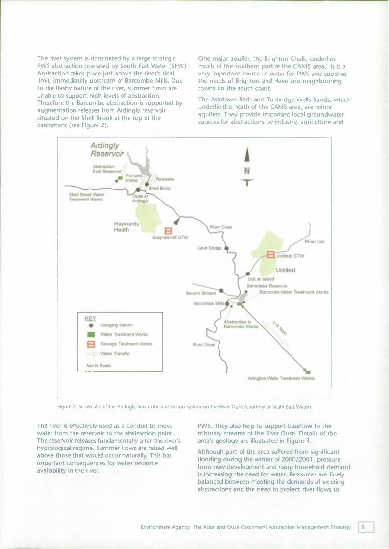
The river system is dominated by a large strategic PWS abstraction operated by South East Water (SEW). Abstraction takes place just above the river's tidal limit, immediately upstream of Barcombe Mills. Due to the flashy nature of the river, summer flows are unable to support high levels of abstraction.Therefore the Barcombe abstraction is supported by augmentation releases from Ardingly reservoir situated on the Shell Brook at the top of the catchment (see Figure 2).
The river is effectively used as a conduit to move water from the reservoir to the abstraction point. The reservoir releases fundamentally alter the river's hydrological regime. Summer flows are raised well above those that would occur naturally. This has important consequences for water resource availability in the river.
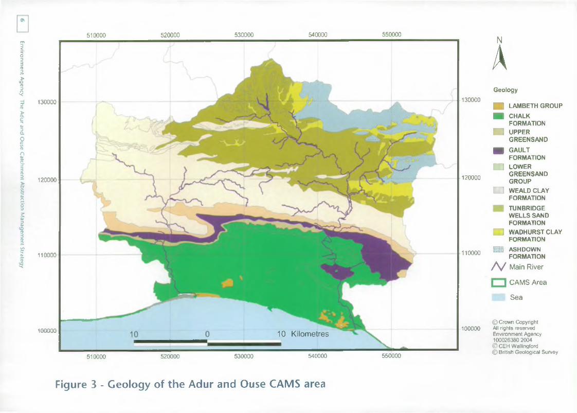
One major aquifer, the Brighton Chalk, underlies much of the southern part of the CAMS area. It is a very important source of water for PWS and supplies the needs of Brighton and Hove and neighbouring towns on the south coast.The Ashdown Beds and Tunbridge Wells Sands, which underlie the north of the CAMS area, are minor aquifers. They provide important local groundwater sources for abstractions by industry, agriculture and
PWS. They also help to support baseflow to the tributary streams of the River Ouse. Details of the area's geology are illustrated in Figure 3.Although part of the area suffered from significant flooding during the winter of 2000/2001, pressure from new development and rising household demand is increasing the need for water. Resources are finely balanced between meeting the demands of existing abstractions and the need to protect river flows to
Figure 2. Schematic of the Ardingly-Barcombe abstraction system on the River Ouse (courtesy of South East Water).
Environment Agency The Adur and Ouse Catchment Abstraction Management Strategy
Environment Agency
The Adur and
Ouse Catchm
ent Abstraction M
anagement Strategy
510000 520000 530000 540000 550000
130000 130000
120000 120000
110000 110000
510000 520000 530000 540000 550000
10 Kilometres100000 100000
NAGeology
■ 1 LAMBETH GROUP■ CHALK
FORMATION■ UPPER
GREENSANDn GAULT
FORMATIONH I LOWER
GREENSANDGROUP
□ WEALD CLAYFORMATIONTUNBRIDGEWELLS SANDFORMATION
■ i WADHURST CLAYFORMATION
■ ASHDOWNFORMATION
/ v Main River
| _ | CAMS Area
Sea
© Crown Copyright All rights reserved Environment Agency 100026380 2004 © CEH Wallingford © British Geological Survey
Figure 3 - Geology of the Adur and Ouse CAMS area
meet environmental and other in-stream requirements. This is illustrated by Southern Region Environment Agency policy generally presuming against further consumptive abstraction and from the Chalk aquifer and from rivers during the summer.
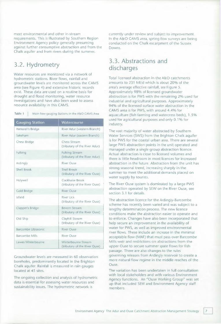
3.2. HydrometryWater resources are monitored via a network of hydrometric stations. River flows, rainfall and groundwater levels are monitored across the CAMS area (see Figure 4) and extensive historic records exist. These data are used on a routine basis for drought and flood monitoring, water resource investigations and have also been used to assess resource availability in this CAMS.
Table 1 | Main flow gauging Stations in the A&O CAMS Area
Gauging Station Watercourse
Groundwater levels are measured in 60 observation boreholes, predominantly located in the Brighton Chalk aquifer. Rainfall is measured in rain gauges located at 45 sites.The ongoing collection and analysis of hydrometric data is essential for assessing water resources and sustainability issues. The hydrometric network is
currently under review and subject to improvement.In the A&O CAMS area, spring flow surveys are being conducted on the Chalk escarpment of the Sussex Downs.
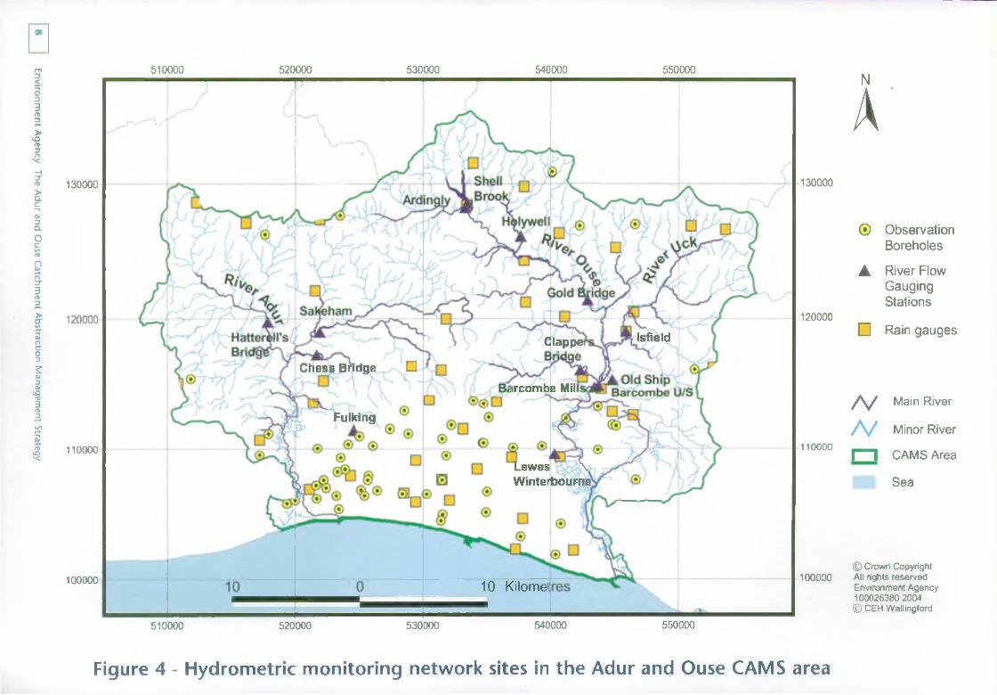
3.3. Abstractions and dischargesTotal licensed abstraction in the A&O catchments amounts to 231 Ml/d which is about 20% of the area's average effective rainfall, see Figure 5. Approximately 98% of licensed groundwater abstraction is for PWS with the remaining 2% used for industrial and agricultural purposes. Approximately 94% of the licensed surface water abstraction in the CAMS area is for PWS, with around 4.4% for aquaculture (fish farming and watercress beds), 1.5% used for agricultural purposes and only 0.1% for industry.
The vast majority of water abstracted by Southern Water Services (SWS) from the Brighton Chalk aquifer is for PWS for the coastal urban area. There are several large PWS abstraction points in the unit operated and managed under a single group abstraction licence. Actual abstraction is close to licensed volumes and there is little headroom in most licences for increased abstraction in the future. Abstraction from the unit has strong seasonal trend, increasing sharply in the summer to meet the additional demands placed on water supply by tourists.The River Ouse system is dominated by a large PWS abstraction operated by SEW on the River Ouse, see section 3.1 for details.The abstraction licence for the Ardingly-Barcombe scheme has recently been varied and was subject to a lengthy determination process. The new licence conditions make the abstraction easier to operate and to enforce. Changes have also been incorporated that help secure an improvement in the availability of water for PWS, as well as improved environmental river flows. These include an increase in the minimal acceptable flow (MAF) that must pass over Barcombe Mills weir and restrictions on abstractions from the upper Ouse to secure summer spate flows for fish passage. There are also changes to the rules governing releases from Ardingly reservoir to create a more natural flow regime in the middle reaches of the Ouse.The variation has been undertaken in full consultation with local stakeholders and with various Environment Agency functions. An "Ouse Working Group" was set up that included SEW and Environment Agency staff members.
Hatterell's Bridge River Adur (western Branch)
Sakeham River Adur (eastern Branch)
Chess Bridge Chess Stream(tributary of the River Adur)
Fulking Fulking Stream (tributary of the River Adur)
Ardingly River Ouse
Shell Brook Shell Brook(tributary of the River Ouse)
Holywell Cockhaise Brook (tributary of the River Ouse)
Cold Bridge River Ouse
Isfield River Uck(tributary of the River Ouse)
Clapper s Bridge Bevern Stream (tributary of the River Ouse)
Old Ship Clayhill Stream (tributary of the River Ouse)
Barcombe Ultrasonic River Ouse
Barcombe Mills River Ouse
Lewes Winterbourne Winterbourne Stream (tributary of the River Ouse)
Environment Agency The Adur and Ouse Catchment Abstraction Management Strategy
Environment Agency
The Adur and
Ouse Catchm
ent Abstraction M
anagement Strategy
NA® Observation
Boreholes
▲ River Flow Gauging Stations
□ Rain gauges
/ v Main River
A/ Minor River
m CAMS Area
Sea
© Crown Copyright All rights reserved Environment Agency 100026380 2004 © CEH Wallingford
IsfieldClappei
Chess Bridge □ircombe Mil
Fulking
Lewes \ Winterbourne
10 Kilomei
130000
120000
110000
100000
130000
120000
110000
100000
510000 520000 530000 540000 550000
Figure 4 - Hydrometric monitoring network sites in the Adur and Ouse CAMS area
510000 520000 530000 540000 550000
Environment Agency
The Adur and
Ouse Catchm
ent Abstraction M
anagement Strategy
510000 520000 530000 540000 550000
130000
120000
110000
100000
130000
110000
NASurface Water Abstraction Ml/d (licensed)
• <0.1 0 0.1-1O 1-5O 5-10
> 10
Groundwater 120000 Abstractions
Ml/d (licensed)• <0.1• 0.1 -1
• 1-5
O 5-10
o > 10
A/ Main River
□ CAMS Area
Sea
© Crown Copyright 100000 All rights reserved
Environment Agency 100026380 2004 © CEH Wallingford
510000 520000 530000 540000 550000
□ Figure 5 - Licensed abstraction in the Adur and Ouse CAMS area
3.4. Conservation designations
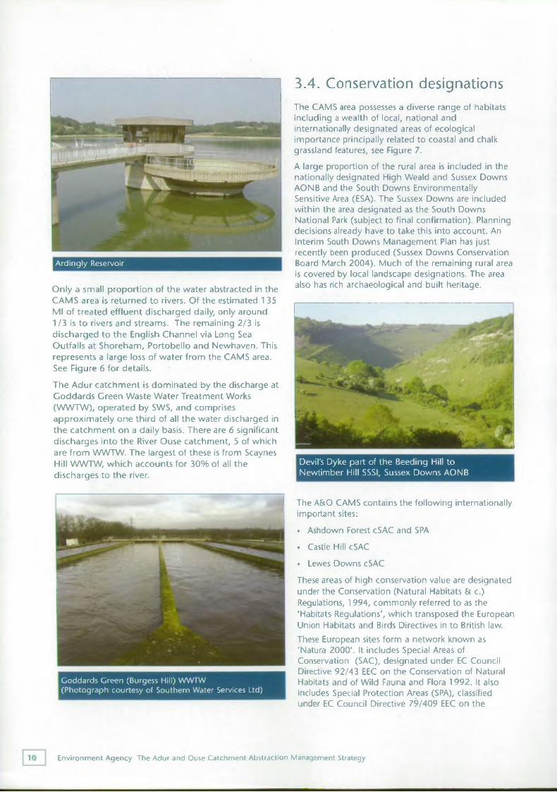
Ardingly Reservoir
Only a small proportion of the water abstracted in the CAMS area is returned to rivers. Of the estimated 1 35 Ml of treated effluent discharged daily, only around 1/3 is to rivers and streams. The remaining 2/3 is discharged to the English Channel via Long Sea Outfalls at Shoreham, Portobello and Newhaven. This represents a large loss of water from the CAMS area. See Figure 6 for details.The Adur catchment is dominated by the discharge at Goddards Green Waste Water Treatment Works (WWTW), operated by SWS, and comprises approximately one third of all the water discharged in the catchment on a daily basis. There are 6 significant discharges into the River Ouse catchment, 5 of which are from WWTW. The largest of these is from Scaynes Hill WWTW, which accounts for 30% of all the discharges to the river.
The CAMS area possesses a diverse range of habitats including a wealth of local, national and internationally designated areas of ecological importance principally related to coastal and chalk grassland features, see Figure 7.A large proportion of the rural area is included in the nationally designated High Weald and Sussex Downs AONB and the South Downs Environmentally Sensitive Area (ESA). The Sussex Downs are included within the area designated as the South Downs National Park (subject to final confirmation). Planning decisions already have to take this into account. An Interim South Downs Management Plan has just recently been produced (Sussex Downs Conservation Board March 2004). Much of the remaining rural area is covered by local landscape designations. The area also has rich archaeological and built heritage.
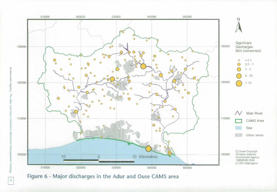
Devil's Dyke part of the Beeding Hill to Newtimber Hill SSSI, Sussex Downs AONB
The A&O CAMS contains the following internationally important sites:• Ashdown Forest cSAC and SPA . Castle Hill cSAC• Lewes Downs cSACThese areas of high conservation value are designated under the Conservation (Natural Habitats & c.) Regulations, 1994, commonly referred to as the 'Habitats Regulations', which transposed the European Union Habitats and Birds Directives in to British law.These European sites form a network known as 'Natura 2000'. It includes Special Areas of Conservation (SAC), designated under EC Council Directive 92/43 EEC on the Conservation of Natural Habitats and of Wild Fauna and Flora 1992. It also includes Special Protection Areas (SPA), classified under EC Council Directive 79/409 EEC on the
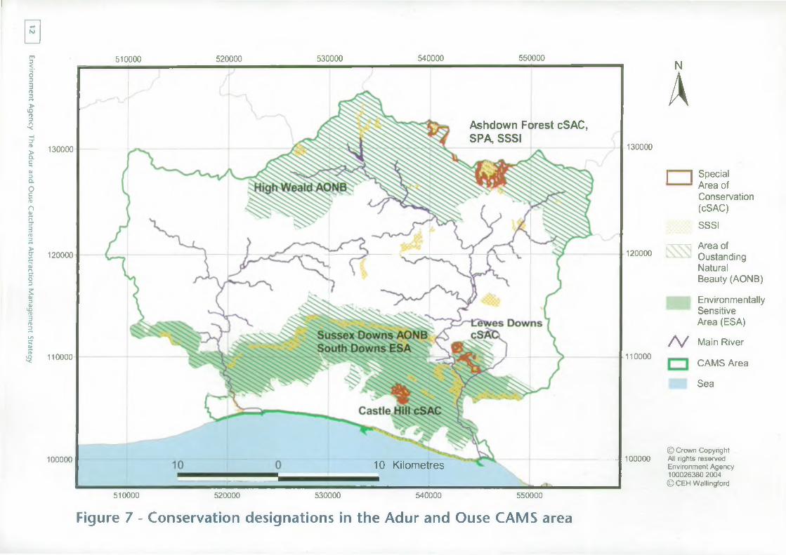
Goddards Green (Burgess Hill) W W TW (Photograph courtesy of Southern Water Services Ltd)
Environment Agency The Adur and Ouse Catchment Abstraction Management Strategy
Environment Agency
The Adur and
Ouse Catchm
ent Abstraction M
anagement Strategy
510000 520000 530000 540000 550000
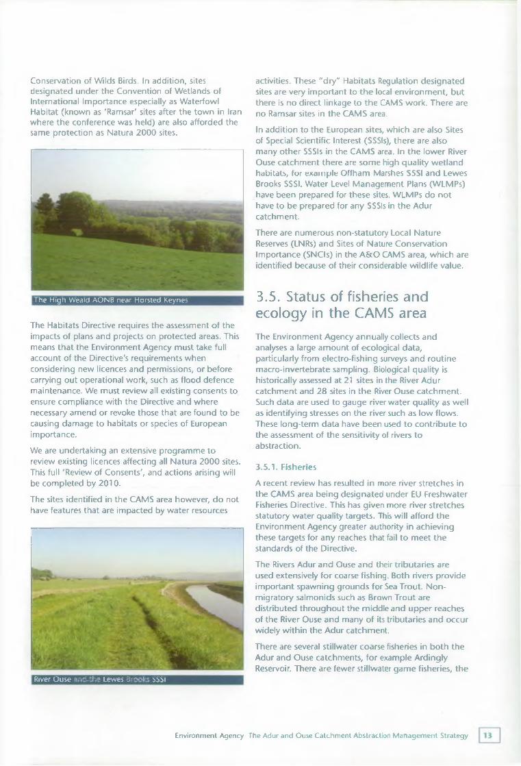
a Figure 6 - Major discharges in the Adur and Ouse CAMS area
N
*Significant Discharges Ml/d (consented)
o <0.1O 0.1-1
O 1-5Oo
5-10
> 10
/V Main River
□ CAMS Area
Sea
Ijj] Urban areas
© Crown Copyright All rights reserved Environment Agency 100026380 2004 © CEH Wallingford
Environment Agency
The Adur and
Ouse Catchm
ent Abstraction M
anagement Strategy
0
130000
120000
110000
100000
510000 520000 530000 540000 550000
130000
120000
110000
100000
510000 520000 530000 540000 550000
Ashdown Forest cSAC, SPA, SSSI
10 Kilometres
NA| | Special
Area of Conservation (cSAC)SSSI
Area ofOustandingNaturalBeauty (AONB)
Environmentally Sensitive Area (ESA)/V Main River
CAMS Area
Sea
© Crown Copyright All rights reserved Environment Agency 100026380 2004 © CEH Wallingford
Figure 7 - Conservation designations in the Adur and Ouse CAMS area
Conservation of Wilds Birds. In addition, sites designated under the Convention of Wetlands of International Importance especially as Waterfowl Habitat (known as 'Ramsar' sites after the town in Iran where the conference was held) are also afforded the same protection as Natura 2000 sites.
The High Weald AONB near Horsted Keynes
The Habitats Directive requires the assessment of the impacts of plans and projects on protected areas. This means that the Environment Agency must take full account of the Directive's requirements when considering new licences and permissions, or before carrying out operational work, such as flood defence maintenance. We must review all existing consents to ensure compliance with the Directive and where necessary amend or revoke those that are found to be causing damage to habitats or species of European importance.We are undertaking an extensive programme to review existing licences affecting all Natura 2000 sites. This full 'Review of Consents', and actions arising will be completed by 2010.The sites identified in the CAMS area however, do not have features that are impacted by water resources
River Ouse and the Lewes Brooks SSSI
activities. These “dry" Habitats Regulation designated sites are very important to the local environment, but there is no direct linkage to the CAMS work. There are no Ramsar sites in the CAMS area.In addition to the European sites, which are also Sites of Special Scientific Interest (SSSIs), there are also many other SSSIs in the CAMS area. In the lower River Ouse catchment there are some high quality wetland habitats, for example Offham Marshes SSSI and Lewes Brooks SSSI. Water Level Management Plans (WLMPs) have been prepared for these sites. WLMPs do not have to be prepared for any SSSIs in the Adur catchment.There are numerous non-statutory Local Nature Reserves (LNRs) and Sites of Nature Conservation Importance (SNCIs) in the A&O CAMS area, which are identified because of their considerable wildlife value.
3.5. Status of fisheries and ecology in the CAMS areaThe Environment Agency annually collects and analyses a large amount of ecological data, particularly from electro-fishing surveys and routine macro-invertebrate sampling. Biological quality is historically assessed at 21 sites in the River Adur catchment and 28 sites in the River Ouse catchment. Such data are used to gauge river water quality as well as identifying stresses on the river such as low flows. These long-term data have been used to contribute to the assessment of the sensitivity of rivers to abstraction.
3.5.1. FisheriesA recent review has resulted in more river stretches in the CAMS area being designated under EU Freshwater Fisheries Directive. This has given more river stretches statutory water quality targets. This will afford the Environment Agency greater authority in achieving these targets for any reaches that fail to meet the standards of the Directive.The Rivers Adur and Ouse and their tributaries are used extensively for coarse fishing. Both rivers provide important spawning grounds for Sea Trout. Non- migratory salmonids such as Brown Trout are distributed throughout the middle and upper reaches of the River Ouse and many of its tributaries and occur widely within the Adur catchment.There are several stillwater coarse fisheries in both the Adur and Ouse catchments, for example Ardingly Reservoir. There are fewer stillwater game fisheries, the
Environment Agency The Adur and Ouse Catchment Abstraction Management Strategy
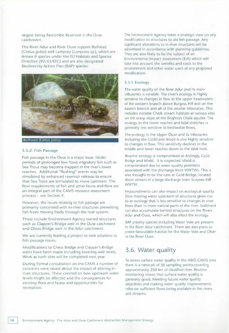
largest being Barcombe Reservoir in the Ouse catchment.The River Adur and River Ouse support Bullhead (Cottus gobio) and Lamprey (Lampreta sp.), which are Annex II species under the EU Habitats and Species Directive (92/43/EEC) and are also designated Biodiversity Action Plan (BAP) species.
Bullhead (Cottus gobio)
3.5.2. Fish PassageFish passage in the Ouse is a major issue. Under periods of prolonged low flows migratory fish such as Sea Trout may become trapped in the river's lower reaches. Additional "flushing" events may be simulated by enhanced reservoir releases to ensure that Sea Trout are stimulated to move upstream. The flow requirements of fish and other fauna and flora are an integral part of the CAMS resource assessment process - see Section 4.However, the issues relating to fish passage are primarily concerned with in-river structures preventing fish from moving freely through the river system.
These include Environment Agency owned structures such as Clapper's Bridge weir in the Ouse catchment and Chess Bridge weir in the Adur catchment.We are currently leading a project to seek solutions to fish passage issues.Modifications to Chess Bridge and Clapper's Bridge weirs have been made including lowering weir levels. Work at both sites will be completed next year.During formal consultation on the CAMS a number of concerns were raised about the impact of altering inriver structures. These centred on how upstream water levels might be affected and the consequences for existing flora and fauna and opportunities for recreation.
The Environment Agency takes a strategic view on any modification to structures to aid fish passage. Any significant alterations to in-river structures will be advertised in accordance with planning guidelines. They are also likely to be the subject of an Environmental Impact Assessment (EIA) which will take into account the benefits and costs to the environment and other water users of any proposed modification.
3.5.3. EcologyThe water quality of the River Adur and its main tributaries is variable. The river's ecology is highly sensitive to changes in flow in the upper headwaters of the western branch above Burgess Hill and on the eastern branch and all of the smaller tributaries. This includes notable Chalk stream habitats at various sites on the scarp slope of the Brighton Chalk aquifer. The ecology in the lower reaches and tidal stretches is generally less sensitive to freshwater flows.The ecology in the Upper Ouse and its tributaries including the Cockhaise Brook is also highly sensitive to changes in flow. This sensitivity declines in the middle and lower reaches down to the tidal limit.Riverine ecology is compromised at Ardingly, Gold Bridge and Isfield. It is suspected Isfield is compromised due to water quality problems associated with the discharge from WWTWs. This is also thought to be the case at Gold Bridge, located down stream of a large discharge from Scaynes Hill WWTW.Impoundments can also impact on ecological quality. Slow moving water upstream of structures gives rise to an ecology that is less sensitive to changes in river flows than in more natural parts of the river. Sediment can also accumulate behind structures on the Rivers Adur and Ouse, which will also affect the ecology.BAP priority species including Water Vole are present in the River Adur catchment. There are also plans to create favourable habitat for the Water Vole and Otter in the River Ouse.
3.6. Water qualityTo assess surface water quality in the A&O CAMS area there is a network of 50 sampling points covering approximately 250 km of classified river. Routine monitoring shows that surface water quality is generally good. Meeting future water quality objectives and making water quality improvements relies on sufficient flows being available in the rivers and streams.
Environment Agency The Adur and Ouse Catchment Abstraction Management Strategy
There are quality concerns associated with the large Goddards Green WWTW discharge to the Eastern branch of the River Adur, which would naturally have much lower summer flows downstream of this point. Upstream of the WWTW, urban drainage has been identified as the primary cause of poor water quality.The issue of groundwater quality protection is also important because the majority of PWS abstractions are taken from aquifers. Groundwater in the Chalk aquifer is naturally of very high quality, however increasing nitrate levels are of concern and are being closely monitored.The Environment Agency has a groundwater protection policy designed to afford the highest protection to the recharge areas around Chalk PWS sources. If PWS sources are affected by pollution, alternative sources have to be used either in the short or long term. Therefore groundwater quality can affect water resources. We will continue to apply the groundwater protection policy and to investigate where groundwater pollution is suspected. Successful campaigns have identified potentially polluting activities and advice has been targeted in these vulnerable areas.Additional information on water quality in the A&O CAMS area can be found at http://www.environment- agency.gov,uk/subjects/waterquality/.
3.7. Stakeholder concernsNumerous issues, concerns and suggestions were raised during the development of this plan about how water resources in the A&O CAMS area should be managed. Many of these were discussed in detail with the Stakeholder Group, who also made their own expert comments at each stage.We set out our proposed licensing strategy in the A&O CAMS Consultation Document published in July 2004.There was overall support for the strategy including encouraging the use of winter storage schemes and the need for further investigations to improve our understanding of environmental flow requirements and the impact of abstraction. However, a number of concerns also remained. These included:• The impact of abstraction on flows in streams fed
from the Brighton Chalk aquifer• The scope and robustness of the Resource
Assessment and Management (RAM) methodology and its applicability to groundwater resource assessment
• Time-limiting of abstraction licences and how this will affect existing licence holders
• Fish passage and the impact of modifying in-river structures
• A number of issues outside the immediate scope of CAMS were also raised. Most notably about water quality and included:
• The need for a monitoring programme for endocrine disrupters in the River Adur
• The impact that abstraction could have on summer river flows and the effect this would have on dilution of effluent
• The impact on water quality from the intermittent discharging of sewage in the tidal River Ouse
• The impact of nutrients in sewage effluent and the need for phosphate stripping at WWTWs in the Ouse catchment
• Storm sewage releases and their impact on river ecology, including nutrient loading and endocrine disrupters
• The size of the Goddards Green WWTW discharge at Burgess Hill compared to the size of the receiving watercourse
Many respondents felt that that there was a need to incorporate more information about water quality in this strategy and there is growing demand from stakeholders to produce a more integrated catchment management strategy.We have considered all relevant comments in developing our final strategy. Further information about fish passage and water quality are detailed in Sections 3.5.2 and 3.6 above. Opinions and concerns expressed about issues not dealt with by CAMS have been passed on to relevant Environment Agency teams and will be used to feed into other initiatives.
3.8. Links with other plansDeveloping links with other plans will ensure that other groups consider water resources issues. CAMS help both to implement and inform the Environment Agency's Southern Region and National Water Resources Strategies. CAMS also link to other plans such as:
Water Level Management Plans Catchment Flood Management Plans Water Quality Improvement Plans Fisheries Action Plans Biodiversity Action Plans
Environment Agency The Adur and Ouse Catchment Abstraction Management Strategy
Where possible links should be also encouraged with plans produced by external groups such as Regional and Local Development Plans, AONB Management Plans and Water Company Asset Plans.
3.8.1. The Water Framework Directive
The Water Framework Directive (WFD) represents the most substantial piece of water legislation from the European Commission to date. It requires all inland and coastal waters to reach at least "good ecological and good chemical status" by 2015 unless there are grounds for derogation. There is also a general "no deterioration" provision to prevent deterioration in status. The Environment Agency has been named as the Competent Authority for England and Wales and will be responsible for delivering the Directive's requirements.
An important feature of the Directive is the integration of water quality and water quantity issues for both surface and groundwater. This explicit linking of rivers and aquifers reinforces the holistic approach that will be taken to water management.
The Directive requires statutory strategic management plans known as River Basin Management Plans (RBM P's) to be produced for each of the nine River Basin Districts in England and Wales. RBMPs will be developed in consultation with the local community and will set out how the objectives for all water bodies within each river basin are to be achieved.
The integrated approach to catchment management envisaged for the WFD will consider a much wider spectrum of pressures and at a smaller scale than considered in CAMS. However, parts of the CAMS process will be used to help deliver the WFD. For example, the lessons learned from CAMS consultation will be important in helping the Environment Agency engage the public in the WFD process.
The first cycle of CAMS will be completed by 2008 and will feed into the first set of draft RBMPs to be published in the same year. A formal consultation on how the Environment Agency will approach River Basin Planning is underway at the time of publication of this document. It will look at how our existing water planning tools, including CAMS, can best be used to help deliver integrated river basin planning.The latest information about the WFD can be found at: www.environment-agency.gov.uk/wfd.
Environment Agency The Adur and Ouse Catchment Abstraction Management Strategy
Resource assessment and resource availability status4.1. IntroductionThis chapter summarises the results of the RAM framework used to assess the sustainability of abstraction in the CAMS area. For more detailed information please refer to the A&O CAMS Technical Document CD-ROM.To manage water resources effectively, we need to understand how much water is available and where it is located. This is achieved by undertaking an integrated resource assessment, covering both surface water and groundwater.Water is used for a number of different purposes, the principal categories being general agriculture, spray irrigation, industrial use, power generation and water supply. For each different use, the amount of water that is returned to the water environment varies. It may be close to the point of abstraction or many miles away or even to a different catchment altogether. Where this local water loss is high, the Environment Agency considers the abstraction to be
consumptive. This may restrict the availability of water for these purposes, unless a significant proportion of the water abstracted is returned to the water source close to the point of abstraction.To easily provide information on the availability of water resources within a catchment, that may be used for consumptive purposes, a classification system has been developed. This "resource availability status" indicates the relative balance between committed and available resources, showing whether abstraction licences are likely to be available and highlighting areas where abstraction needs to be reduced. This does not replace the need for the licence determination process, which is applied to individual licence applications. More information on the determination process is given in Annexe Two of Managing Water Abstraction.
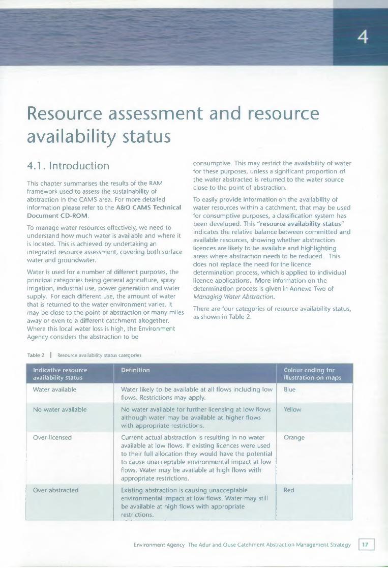
There are four categories of resource availability status, as shown in Table 2.
Table 2 | Resource availability status categories
Indicative resource availability status
Definition Colour coding for illustration on maps
Water available Water likely to be available at all flows including low flows. Restrictions may apply.
Blue
No water available No water available for further licensing at low flows although water may be available at higher flows with appropriate restrictions.
Yellow
Over-licensed Current actual abstraction is resulting in no water available at low flows. If existing licences were used to their full allocation they would have the potential to cause unacceptable environmental impact at low flows. Water may be available at high flows with appropriate restrictions.
Orange
Over-abstracted Existing abstraction is causing unacceptable environmental impact at low flows. Water may still be available at high flows with appropriate restrictions.
Red
Environment Agency The Adur and Ouse Catchment Abstraction Management Strategy
The RAM framework involves the development of an understanding of the water resources of the CAMS area and assessment of the surface water and groundwater resource. These results are integrated to define the final resource availability status of different units within the CAMS area.
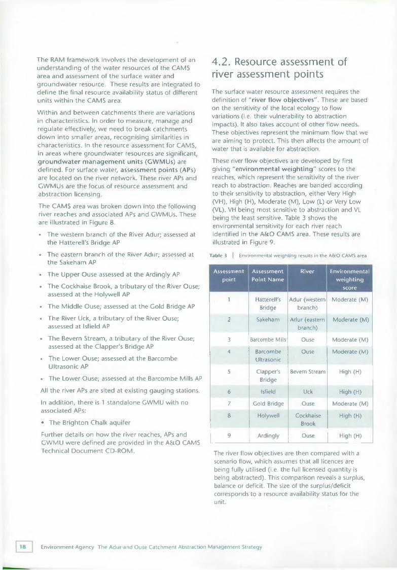
Within and between catchments there are variations in characteristics. In order to measure, manage and regulate effectively, we need to break catchments down into smaller areas, recognising similarities in characteristics. In the resource assessment for CAMS, in areas where groundwater resources are significant, groundwater management units (GWMUs) are defined. For surface water, assessment points (APs) are located on the river network. These river APs and CWMUs are the focus of resource assessment and abstraction licensing.The CAMS area was broken down into the following river reaches and associated APs and CWMUs. These are illustrated in Figure 8.• The western branch of the River Adur; assessed at
the Hatterell's Bridge AP• The eastern branch of the River Adur; assessed at
the Sakeham AP• The Upper Ouse assessed at the Ardingly AP
• The Cockhaise Brook, a tributary of the River Ouse; assessed at the Holywell AP
• The Middle Ouse; assessed at the Gold Bridge AP• The River Uck, a tributary of the River Ouse;
assessed at Isfield AP• The Bevern Stream, a tributary of the River Ouse;
assessed at the Clapper's Bridge AP• The Lower Ouse; assessed at the Barcombe
Ultrasonic AP• The Lower Ouse; assessed at the Barcombe Mills APAll the river APs are sited at existing gauging stations.In addition, there is 1 standalone GWMU with no associated APs:• The Brighton Chalk aquifer
Further details on how the river reaches, APs and GWMU were defined are provided in the A&O CAMS Technical Document CD-ROM.
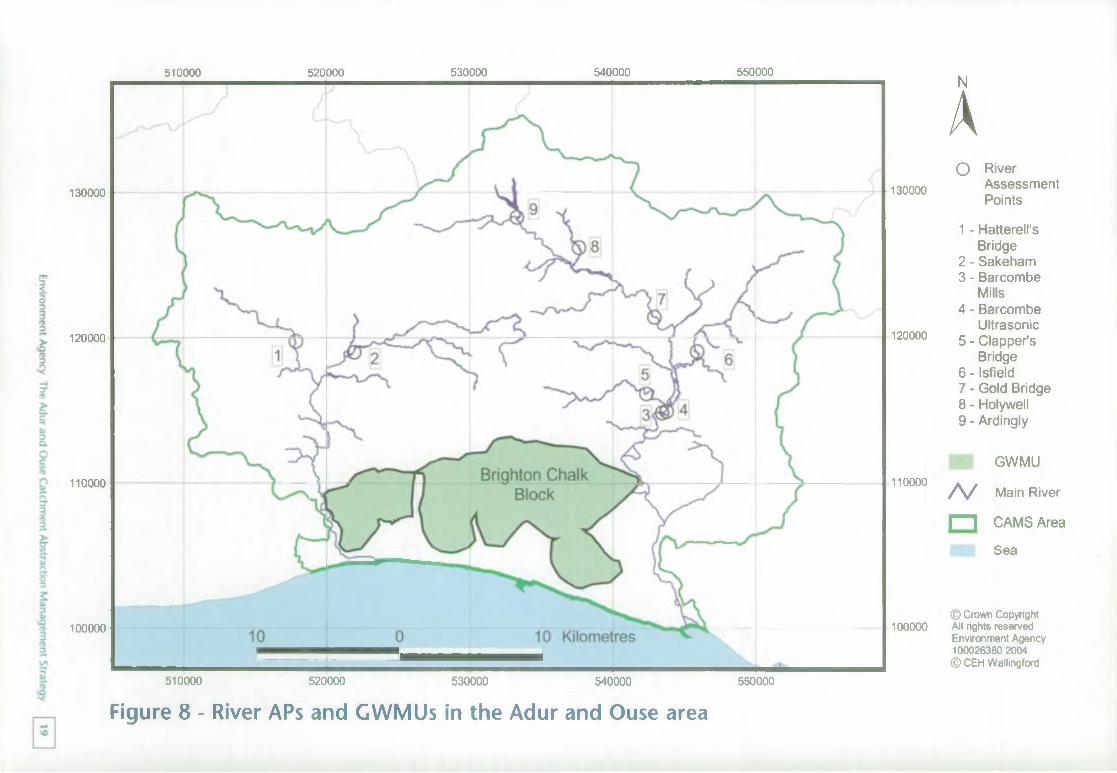
4.2. Resource assessment of river assessment pointsThe surface water resource assessment requires the definition of "river flow objectives". These are based on the sensitivity of the local ecology to flow variations (i.e. their vulnerability to abstraction impacts). It also takes account of other flow needs. These objectives represent the minimum flow that we are aiming to protect. This then affects the amount of water that is available for abstraction.These river flow objectives are developed by first giving "environmental weighting" scores to the reaches, which represent the sensitivity of the river reach to abstraction. Reaches are banded according to their sensitivity to abstraction, either Very High (VH), High (H), Moderate (M), Low (L) or Very Low (VL). VH being most sensitive to abstraction and VL being the least sensitive. Table 3 shows the environmental sensitivity for each river reach identified in the A&O CAMS area. These results are illustrated in Figure 9.
Table 3 | Environmental weighting results in the A&O CAMS area
Assessmentpoint
Assessment Point Name
River Environmentalweighting
score
1 Hatterell'sBridge
Adur (western branch)
Moderate (M )
2 Sakeham Adur (eastern branch)
Moderate (M )
3 Barcombe Mills Ouse Moderate (M)
4 BarcombeUltrasonic
Ouse Moderate (M)
5 Clapper'sBridge
Bevern Stream High (H)
6 Isfield Uck High (H)
7 Cold Bridge Ouse Moderate (M )
8 Holywell CockhaiseBrook
High (H)
9 Ardingly Ouse High (H)
The river flow objectives are then compared with a scenario flow, which assumes that all licences are being fully utilised (i.e. the full licensed quantity is being abstracted). This comparison reveals a surplus, balance or deficit. The size of the surplus/deficit corresponds to a resource availability status for the unit.
Environment Agency The Adur and Ouse Catchment Abstraction Management Strategy
130000
120000
110000
100000
510000 520000 530000 540000 550000
130000
120000
110000
100000
NA0 River
Assessment Points
1 - Hatterell'sBridge
2 - Sakeham3 - Barcombe
Mills4 - Barcombe
Ultrasonic5 - Clapper’s
Bridge6 - Isfield7 - Gold Bridge8 - Holywell9 - Ardingly
GWMU
A / Main River
n CAMS Area
Sea
© Crown Copyright All rights reserved Environment Agency 100026380 2004 © CEH Wallingford
510000 520000 530000 540000 550000
Figure 8 - River APs and CWMUs in the Adur and Ouse area
Environment Agency
The Adur and
Ouse Catchm
ent Abstraction M
anagement Strategy
0
130000
120000
110000
100000
510000 520000 530000 540000 550000 NA130000
Resource Availability Status
120000
A /
/ Vo
/V110000
WaterAvailable
No Water Available
OverLicensed
RiverAssessmentPointsMain River
CAMS Area
Sea
© Crown Copyright 100000 All rights reserved
Environment Agency 100026380 2004 © CEH Wallingford
510000 520000 530000 540000 550000
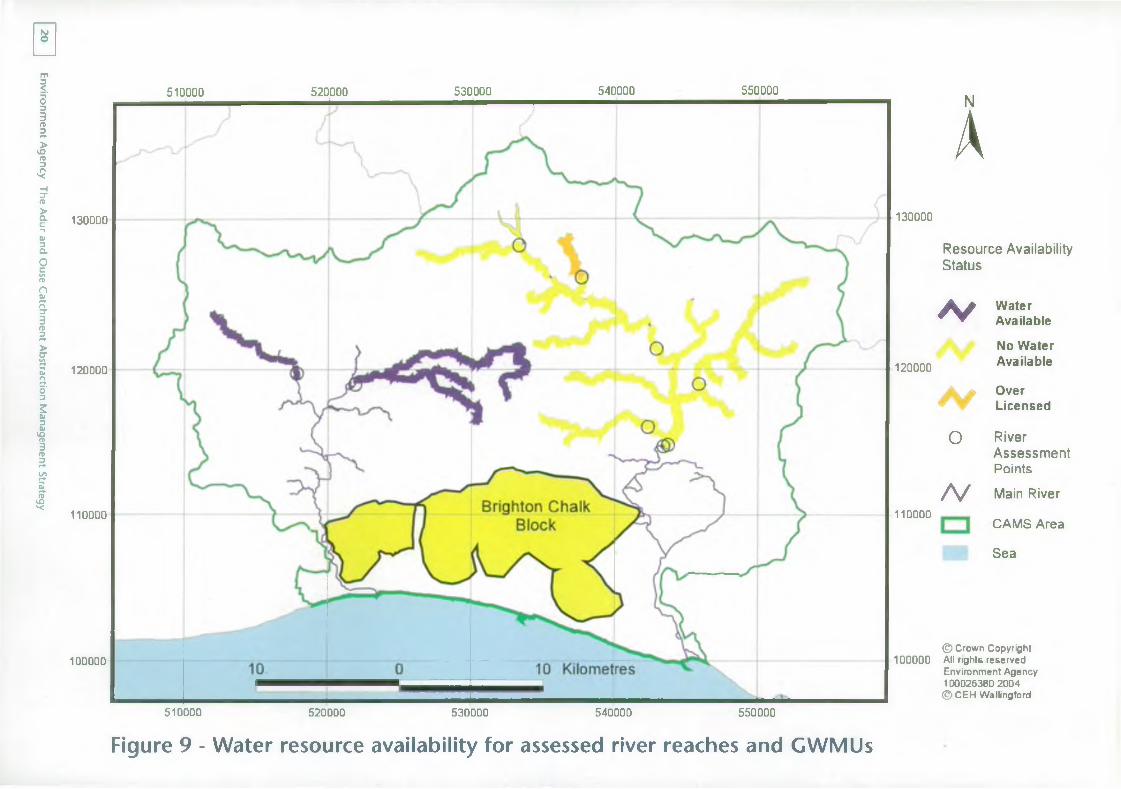
Figure 9 - Water resource availability for assessed river reaches and GWMUs
The surface water resource availability classification gives an indication of whether new licences will be available from the river or whether some recovery of resources is required. However, there are significant variations in flow throughout the year. A classification of "Over Licensed" or "Over Abstracted" generally indicates that no new licences will be granted. However, this applies only at times of low flow. During periods when flows are higher, there may be some water available for abstraction. The classification is therefore really a classification of resource availability at low flow.In order to ensure this flow variability is maintained abstraction licences are sometimes managed by the use of "hands-off flow" (HOF) conditions. These are conditions on licences that require abstraction to cease (or reduce) when the flow in the river falls below a specified level. Therefore, when river flows are above this HOF, abstraction can take place but when flows are below this, no abstraction (or reduced abstraction) can occur. Low flows will occur more frequently during the summer months.In order to maximise abstraction while maintaining the variability of flow (required for many aquatic species), a tiered system of HOFs is applied. Licences are generally granted with the lowest HOF possible on a first-come-first-served basis. As more licences are granted, the HOF must be increased to maintain sustainable flows in the river.For potential applicants for new abstraction licences, it is therefore important to know not only the likelihood of obtaining a licence, but also the reliability of a licence if granted with a HOF condition. Within the CAMS resource assessment, reliability is expressed as a percentage. This percentage indicates the minimum amount of time over the long term that the scenario flow exceeds the river flow objective, therefore allowing abstraction to take place.The resource assessments for both surface water and groundwater use a scenario, which assumes that all licences are being fully utilised; that is, the full- authorised volume is being abstracted. However, many licences are not used fully and therefore in reality the resource availability can be different. If the result of a resource assessment is "Over Licensed", data on actual abstraction are then used to establish whether the status is "Over Abstracted" (actual flows are lower than river flow objectives). "Over Abstracted" represents abstraction that is already unsustainable whereas "Over Licensed" represents the potential for damage should the full licensed amount be abstracted.
4.3. Resource assessment of groundwater management unitsFor the groundwater resource assessment, various tests are applied to each unit to determine the resource availability status. These tests include examining the balance between recharge to and abstraction from the unit, the impact of abstraction on summer outflows from the unit and an assessment of long-term trends including groundwater levels and water quality.
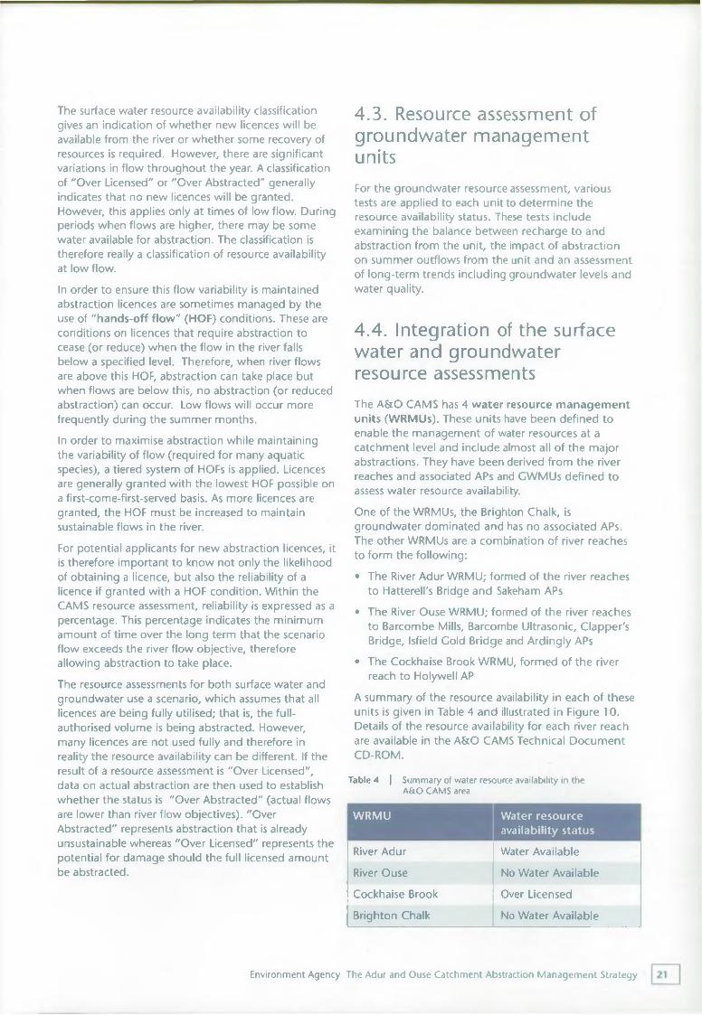
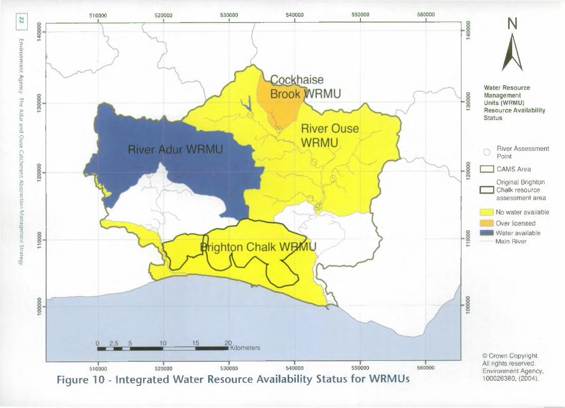
4.4. Integration of the surface water and groundwater resource assessmentsThe A&O CAMS has 4 water resource management units (WRMUs). These units have been defined to enable the management of water resources at a catchment level and include almost all of the major abstractions. They have been derived from the river reaches and associated APs and GWMUs defined to assess water resource availability.One of the WRMUs, the Brighton Chalk, is groundwater dominated and has no associated APs. The other WRMUs are a combination of river reaches to form the following:• The River Adur WRMU; formed of the river reaches
to Hatterell's Bridge and Sakeham APs• The River Ouse WRMU; formed of the river reaches
to Barcombe Mills, Barcombe Ultrasonic, Clapper's Bridge, Isfield Cold Bridge and Ardingly APs
• The Cockhaise Brook WRMU, formed of the river reach to Holywell AP
A summary of the resource availability in each of these units is given in Table 4 and illustrated in Figure 10. Details of the resource availability for each river reach are available in the A&O CAMS Technical Document CD-ROM.
Table 4 | Summary of water resource availability in the A&O CAMS area
WRMU Water resource availability status
River Adur
River Ouse Cockhaise Brook Brighton Chalk
Water Available No Water Available Over Licensed
No Water Available
Environment Agency The Adur and Ouse Catchment Abstraction Management Strategy
Environment Agency
The Adur and
Ouse Catchm
ent Abstraction M
anagement Strategy
510000 520000 i 530000 l 540000 L
550000 _L
560000 X
■ Kilometers
510000 520000 530000 540000 550000 560000
Figure 10 - Integrated Water Resource Availability Status for WRMUs
N
AWater Resource Management Units (WRMU) Resource Availability Status
River Assessment v Point
□ CAMS Area____Original BrightonI I Chalk resource
assessment area
No water available Over licensed
■ i Water available Main River
© Crown Copyright. All rights reserved. Environment Agency, 100026380, (2004).
4.5. Water resource management units in the A&O CAMS
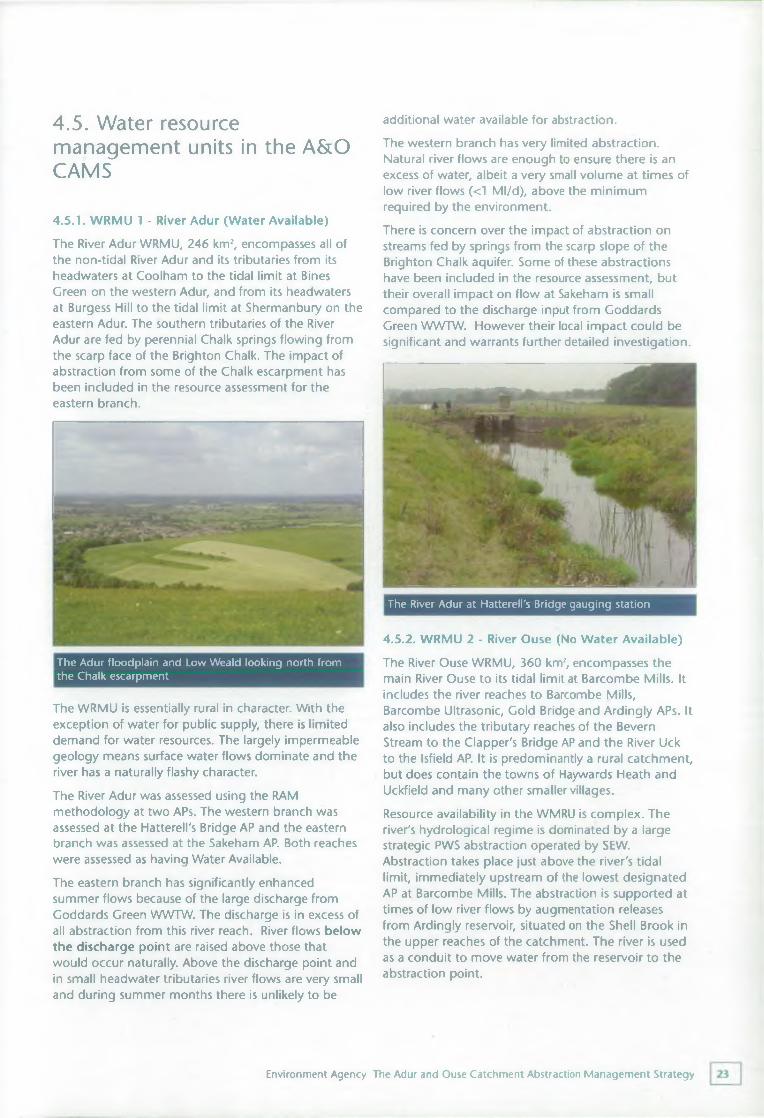
4.5.1. WRMU 1 - River Adur (Water Available)The River Adur WRMU, 246 km2, encompasses all of the non-tidal River Adur and its tributaries from its headwaters at Coolham to the tidal limit at Bines Green on the western Adur, and from its headwaters at Burgess Hill to the tidal limit at Shermanbury on the eastern Adur. The southern tributaries of the River Adur are fed by perennial Chalk springs flowing from the scarp face of the Brighton Chalk. The impact of abstraction from some of the Chalk escarpment has been included in the resource assessment for the eastern branch.
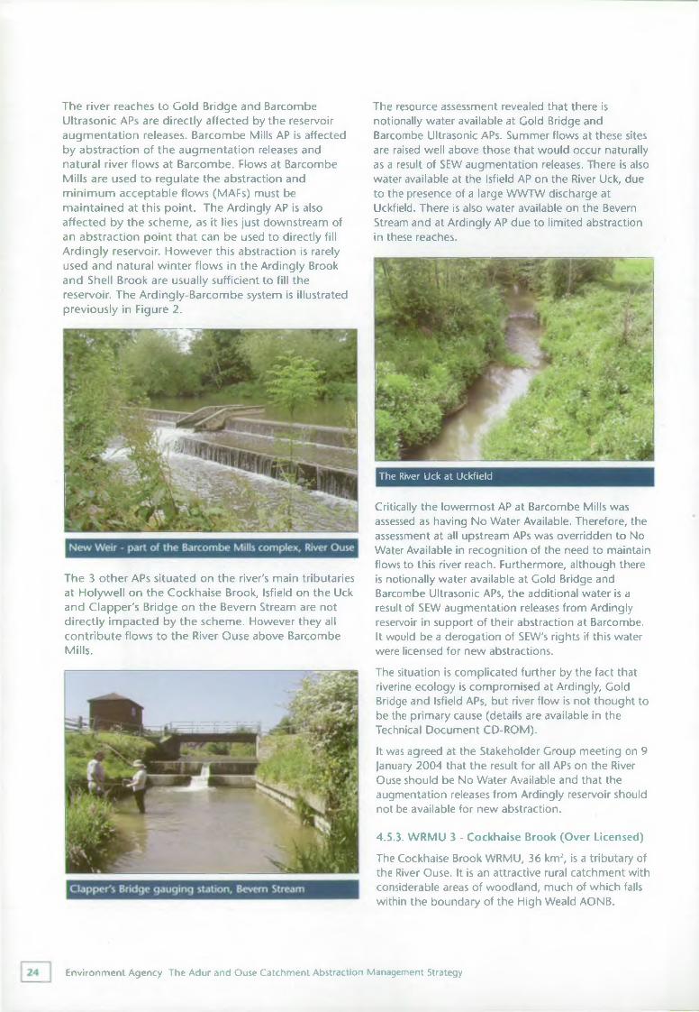
The WRMU is essentially rural in character. With the exception of water for public supply, there is limited demand for water resources. The largely impermeable geology means surface water flows dominate and the river has a naturally flashy character.The River Adur was assessed using the RAM methodology at two APs. The western branch was assessed at the Hatterell's Bridge AP and the eastern branch was assessed at the Sakeham AP. Both reaches were assessed as having Water Available.The eastern branch has significantly enhanced summer flows because of the large discharge from Goddards Green WWTW. The discharge is in excess of all abstraction from this river reach. River flows below the discharge point are raised above those that would occur naturally. Above the discharge point and in small headwater tributaries river flows are very small and during summer months there is unlikely to be
additional water available for abstraction.The western branch has very limited abstraction. Natural river flows are enough to ensure there is an excess of water, albeit a very small volume at times of low river flows (<1 Ml/d), above the minimum required by the environment.There is concern over the impact of abstraction on streams fed by springs from the scarp slope of the Brighton Chalk aquifer. Some of these abstractions have been included in the resource assessment, but their overall impact on flow at Sakeham is small compared to the discharge input from Goddards Green WWTW. However their local impact could be significant and warrants further detailed investigation.
The River Adur at Hatterell's Bridge gauging station
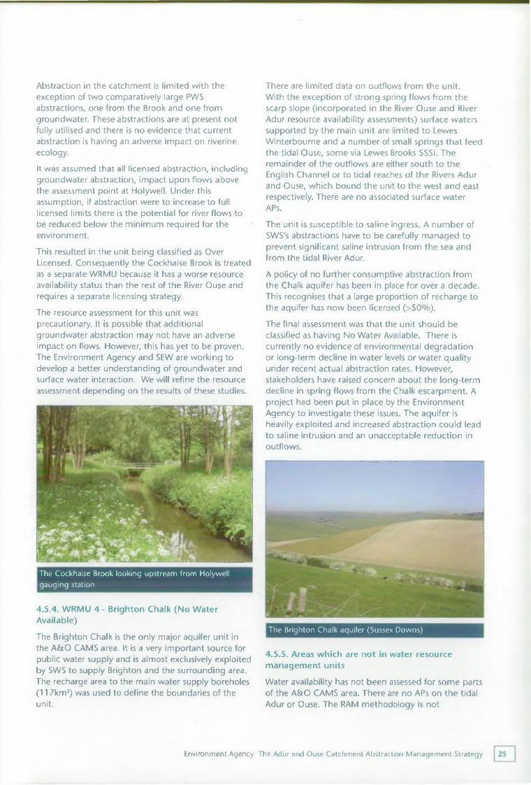
4.5.2. WRMU 2 - River Ouse (No Water Available)The River Ouse WRMU, 360 km2, encompasses the main River Ouse to its tidal limit at Barcombe Mills. It includes the river reaches to Barcombe Mills,Barcombe Ultrasonic, Gold Bridge and Ardingly APs. It also includes the tributary reaches of the Bevern Stream to the Clapper's Bridge AP and the River Uck to the Isfield AP. It is predominantly a rural catchment, but does contain the towns of Haywards Heath and Uckfield and many other smaller villages.Resource availability in the WMRU is complex. The river's hydrological regime is dominated by a large strategic PWS abstraction operated by SEW. Abstraction takes place just above the river's tidal limit, immediately upstream of the lowest designated AP at Barcombe Mills. The abstraction is supported at times of low river flows by augmentation releases from Ardingly reservoir, situated on the Shell Brook in the upper reaches of the catchment. The river is used as a conduit to move water from the reservoir to the abstraction point.
The Adur floodplain and Low Weald looking north from the Chalk escarpment
Environment Agency The Adur and Ouse Catchment Abstraction Management Strategy
The river reaches to Gold Bridge and Barcombe Ultrasonic APs are directly affected by the reservoir augmentation releases. Barcombe Mills AP is affected by abstraction of the augmentation releases and natural river flows at Barcombe. Flows at Barcombe Mills are used to regulate the abstraction and minimum acceptable flows (MAFs) must be maintained at this point. The Ardingly AP is also affected by the scheme, as it lies just downstream of an abstraction point that can be used to directly fill Ardingly reservoir. However this abstraction is rarely used and natural winter flows in the Ardingly Brook and Shell Brook are usually sufficient to fill the reservoir. The Ardingly-Barcombe system is illustrated previously in Figure 2.
The 3 other APs situated on the river's main tributaries at Holywell on the Cockhaise Brook, Isfield on the Uck and Clapper's Bridge on the Bevern Stream are not directly impacted by the scheme. However they all contribute flows to the River Ouse above Barcombe Mills.
The resource assessment revealed that there is notionally water available at Gold Bridge and Barcombe Ultrasonic APs. Summer flows at these sites are raised well above those that would occur naturally as a result of SEW augmentation releases. There is also water available at the Isfield AP on the River Uck, due to the presence of a large WWTW discharge at Uckfield. There is also water available on the Bevern Stream and at Ardingly AP due to limited abstraction in these reaches.
The River Uck at Uckfield
Critically the lowermost AP at Barcombe Mills was assessed as having No Water Available. Therefore, the assessment at all upstream APs was overridden to No Water Available in recognition of the need to maintain flows to this river reach. Furthermore, although there is notionally water available at Gold Bridge and Barcombe Ultrasonic APs, the additional water is a result of SEW augmentation releases from Ardingly reservoir in support of their abstraction at Barcombe.It would be a derogation of SEW's rights if this water were licensed for new abstractions.The situation is complicated further by the fact that riverine ecology is compromised at Ardingly, Gold Bridge and Isfield APs, but river flow is not thought to be the primary cause (details are available in the Technical Document CD-ROM).It was agreed at the Stakeholder Group meeting on 9 January 2004 that the result for all APs on the River Ouse should be No Water Available and that the augmentation releases from Ardingly reservoir should not be available for new abstraction.
4.5.3. WRMU 3 - Cockhaise Brook (Over Licensed)The Cockhaise Brook WRMU, 36 km2, is a tributary of the River Ouse. It is an attractive rural catchment with considerable areas of woodland, much of which falls within the boundary of the High Weald AONB.
Environment Agency The Adur and Ouse Catchment Abstraction Management Strategy
Abstraction in the catchment is limited with the exception of two comparatively large PWS abstractions, one from the Brook and one from groundwater. These abstractions are at present not fully utilised and there is no evidence that current abstraction is having an adverse impact on riverine ecology.It was assumed that all licensed abstraction, including groundwater abstraction, impact upon flows above the assessment point at Holywell. Under this assumption, if abstraction were to increase to full licensed limits there is the potential for river flows to be reduced below the minimum required for the environment.This resulted in the unit being classified as Over Licensed. Consequently the Cockhaise Brook is treated as a separate WRMU because it has a worse resource availability status than the rest of the River Ouse and requires a separate licensing strategy.The resource assessment for this unit was precautionary. It is possible that additional groundwater abstraction may not have an adverse impact on flows. However, this has yet to be proven. The Environment Agency and SEW are working to develop a better understanding of groundwater and surface water interaction. We will refine the resource assessment depending on the results of these studies.
The Cockhaise Brook looking upstream from Holywell gauging station
4.5.4. WRMU 4 - Brighton Chalk (No Water Available)
The Brighton Chalk is the only major aquifer unit in the A&O CAMS area. It is a very important source for public water supply and is almost exclusively exploited by SWS to supply Brighton and the surrounding area. The recharge area to the main water supply boreholes (11 7km2) was used to define the boundaries of the unit.
There are limited data on outflows from the unit.With the exception of strong spring flows from the scarp slope (incorporated in the River Ouse and River Adur resource availability assessments) surface waters supported by the main unit are limited to Lewes Winterbourne and a number of small springs that feed the tidal Ouse, some via Lewes Brooks SSSI. The remainder of the outflows are either south to the English Channel or to tidal reaches of the Rivers Adur and Ouse, which bound the unit to the west and east respectively. There are no associated surface water APs.The unit is susceptible to saline ingress. A number of SWS's abstractions have to be carefully managed to prevent significant saline intrusion from the sea and from the tidal River Adur.A policy of no further consumptive abstraction from the Chalk aquifer has been in place for over a decade. This recognises that a large proportion of recharge to the aquifer has now been licensed (>50%).The final assessment was that the unit should be classified as having No Water Available. There is currently no evidence of environmental degradation or long-term decline in water levels or water quality under recent actual abstraction rates. However, stakeholders have raised concern about the long-term decline in spring flows from the Chalk escarpment. A project had been put in place by the Environment Agency to investigate these issues. The aquifer is heavily exploited and increased abstraction could lead to saline intrusion and an unacceptable reduction in outflows.
The Brighton Chalk aquifer (Sussex Downs)
4.5.5. Areas which are not in water resource management unitsWater availability has not been assessed for some parts of the A&O CAMS area. There are no APs on the tidal Adur or Ouse. The RAM methodology is not
Environment Agency The Adur and Ouse Catchment Abstraction Management Strategy
applicable to these reaches. The low-lying coastal fringe to the south of the CAMS where the Brighton Chalk is overlain by younger Tertiary strata has also been excluded, as this does not form part of the recharge area to the main aquifer. The minor aquifers of the Ashdown Sands and Tunbridge Wells Sands have also not been assessed under RAM.
Even in areas that are within defined WRMUs, the resource assessments are limited to defined river reaches and exclude smaller tributaries. Abstraction from these small streams can have significant impact on the local environment and greater restrictions may need to be applied in these areas.In all areas not explicitly assessed under the RAM framework, applications for new or significantly varied abstraction licences will be subject to the normal licence determination process and assessed on a case- by-case basis.
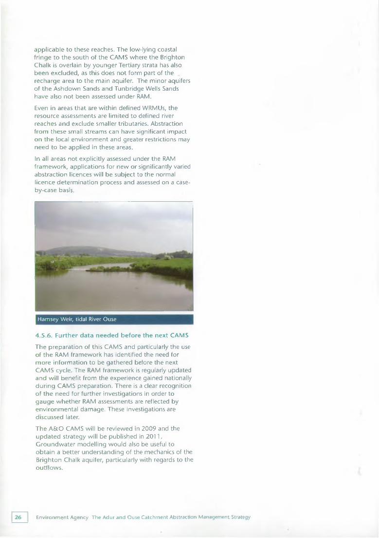
Hamsey Weir, tidal River Ouse
4.5.6. Further data needed before the next CAMSThe preparation of this CAMS and particularly the use of the RAM framework has identified the need for more information to be gathered before the next CAMS cycle. The RAM framework is regularly updated and will benefit from the experience gained nationally during CAMS preparation. There is a clear recognition of the need for further investigations in order to gauge whether RAM assessments are reflected by environmental damage. These investigations are discussed later.The A&O CAMS will be reviewed in 2009 and the updated strategy will be published in 2011. Groundwater modelling would also be useful to obtain a better understanding of the mechanics of the Brighton Chalk aquifer, particularly with regards to the outflows.
Environment Agency The Adur and Ouse Catchment Abstraction Management Strategy
Existing strategies5.1. National Environment Agency strategies and initiativesThere are national Environment Agency initiatives that have implications for this CAMS. Foremost amongst these are the National and Regional Water Resource Strategies, which were issued by the Environment Agency in March 2001.The Environment Agency has a duty to secure the proper use of water resources in England and Wales. The National Strategy defines the abstraction licensing framework at high level. It looks some 25 years ahead and considers the needs of public water supply, agriculture, commerce and industry, as well as the environment. The Regional Strategy and at a local level individual CAMS implement and feed back to the National Strategy.The periodic review of water company charges also has important implications for local water resources management. Water companies have to take large amounts of water from rivers and aquifers to provide enough to supply our everyday use. Whilst fulfilling this duty, the companies must also protect the environment, promote the efficient use of water and meet legal requirements. Water companies submit their business plans to Ofwat for consideration in price setting. These plans are known as Asset Management Plans (AMPs) and cover a five-year period.
We are now in the final stages of implementing AMP3 (2000-2005) which include actions identified in the Environment Agency's National Environment Programme (NEP). This was aimed at identifying environmental concerns caused by water company operations and to allow them to seek investment approval within the third periodic review to help overcome concerns on sustainability. Although no sites relating to abstraction impacts were identified in the A&O CAMS area, a number of improvements to SWS assets to raise water quality were included.In December 2004, Ofwat published its determination of the fourth Periodic Review of water company business plans, setting customer price limits for the
AMP4 period, 2005 to 2010. AMP4 includes actions identified in the Environment Agency's updated National Environment Programme. AMP4 also includes the implementation of water company schemes and investigations in the A&O CAMS area, to maintain and improve the public water supply - demand balance (see sections 5.2, 5.3 and 6.5 and 7).The Environment Agency also has a national Restoring Sustainable Abstraction programme (RSA). Sites which may be impacted by abstraction are listed on a catalogue and prioritised to allow further investigations and if necessary the identification of solutions. Some sites recognised in the A&O CAMS may be included on the RSA catalogue and require further investigation.
5.2. Southern Region water resources strategyIn March 2001 the Environment Agency published the document Water resources for the future - a strategy for Southern Region. This strategy identifies a preferred approach to meet the demand for water whilst protecting the environment in Sussex, Hampshire and Kent for the next 25 years. Assumptions were made about the potential development of new resources, the realistic potential for savings in forecast water use and the cut backs required to maintain or restore sustainable abstraction in some key areas. Key principles underlying the Regional Strategy include:• Promoting efficient water use by industry,
commerce, agriculture and in the home• Making the best use of available water resources
before developing new schemes
• Taking account of the potential impact of climate change
• Requiring water companies to explore the economic and environmental benefits of leakage control, metering and water efficiency measures, with all licence applications
Environment Agency The Adur and Ouse Catchment Abstraction Management Strategy
• Refusing new abstraction or impoundment licences to companies with poor leakage or water efficiency statistics and activity
• Encouraging water company bulk transfers, sharing of resources between areas of surplus and deficit and other increased integration, providing there are no adverse effects
• Future strategic resource developments should ideally be shared developments benefiting more than one Water Company.
As PWS is the major abstraction in the Southern Region, this is considered in detail, but the strategy also considers other water users such as agriculture and industry. Total abstraction by local water companies has declined over recent years as a result of leakage control and a reduction in demand from some of the larger water users. However in response to an increase in house building and changes in house occupancy rates the companies expect demand to start rising again.Demand Management measures such as metering and water efficiency measures may offset this rise in demand. In our March 2001 Regional Strategy we assume that a minimum of 60% of households will be metered by 2025, with an expectation that 75% to 80% should be achieved across Sussex. We also assume water efficiency saving will be achieved in domestic and commercial water use. Even so, to meet PWS demands over the next 25 years, resource supply enhancements will be necessary.
5.3. Water company water resources plansThe water companies, in conjunction with the Environment Agency, are required to produce water resource plans looking at supply and demand over the next 25 years. These plans are reviewed on an annual basis. They in turn underpin the existing regional water resources strategy and will feed into future strategies. As described above, the 'twin track' approach, which balances the need for new resources with demand management and water efficiency, is key.Water companies revised their water resources plans in draft and then final form in 2003/4 as a submission to the Environment Agency and as part of Ofwat's fourth Periodic Review of water company business plans. The Environment Agency's review of these plans is summarised in Maintaining water supply, published in July 2004 and individual letters were sent to each company. Companies are now expected to implement
their 'final' (2003/4) plans.
In relation to the Adur and Ouse catchments the plans include, by 2010:• Progressing toward year 2030 household metering
levels of over 80% in Southern Water supplied areas and 68% in South East Water supplied areas. By 2010 the metering levels should be over 40% and 39% respectively for the two companies
• SEW building a desalination plant at Newhaven• Full investigation by SEW of a potential new
reservoir on the Clayhill tributary to the River Ouse. The investigation will assess the feasibility of constructing the reservoir and whether it can be operational as required by 2016.
5.4. Climate changeClimate change is an important issue facing water resources management. The latest climate change scenarios from the UK Climate Impacts Programme suggest that temperatures will rise across England and Wales. By the 2050s, in southern England summers will become drier and winters will be wetter. This has important implications for water availability, as it will change groundwater and river regimes. For instance, rainfall is becoming both more seasonal and of increasing intensity, so this could lead to higher runoff and less water able to percolate into the aquifers which supply the bulk of PWS in this area.It is likely that direct abstractions will become less reliable in summer, which means that farmers and industries who rely on these will have to consider adapting in some way if they wish to maintain current levels of reliability - this will increase the importance of using water wisely. The impact on public water supply is less clear but recent modelling work suggests that the deployable output of some systems will be reduced.For more information on the Environment Agency's ongoing work on climate change, please refer to Appendix 1 of the Regional Water Resources Strategy. More details on climate change scenarios are available at www.ukcip.org.uk/scenarios.
Environment Agency The Adur and Ouse Catchment Abstraction Management Strategy
5.5. Opportunities for licence trading in the A&O CAMS areaOne of the objectives of the CAMS process is to facilitate water rights trading. The term water rights trading refers to the transferring of licensable water rights from one party to another, for benefit. It involves a voluntarily movement of a right to abstract water between abstractors, using the abstraction licensing process. More detailed information is available in Managing Water Abstraction.
A guidance leaflet (Water Rights Trading) was published and sent to Licence Holders towards the end of 2002 explaining the scope for water rights trading within current legislation. Consultation on more detailed proposals followed in 2003. After considering the responses to this consultation exercise, further information will be made available to update Licence Holders on the Environment Agency's conclusions for a detailed framework within which water rights trading will take place. This information and guidance will be timed to coincide with the expected implementation of the sections of the Water Act 2003 that are most relevant to trading. Further information on Water Rights Trading is available on our web-site (www.environment- agencv.gov.uk/subjects/waterres).
For more details on the Act and its implementation, see our web-site, www.environment-agnecy.gov.uk.The web-site will be updated to provide information as the Water Act is implemented.
5.6. The Water Act 2003Following the first major review of the abstraction licensing system since its inception in 1963, the Government set out, in 1999, a new framework for managing water resources. The CAMS process and the move to time limited licences are key elements of the new framework, which is completed by revisions to the statutory framework introduced by the Water Act 2003. The Act updates the Water Resources Act 1991 in several key areas:• Deregulation of small abstractions• New controls on previously exempt abstractions for
mine and quarry dewatering, trickle and other forms of irrigation, transfers into canals and internal drainage districts
• Stronger powers for water resources planning and management
• Changes to the legal status of abstraction licences
• More flexibility to the licensing regulations to improve thier efficiency and to encourage trading
• Stronger powers on water conservation
Environment Agency The Adur and Ouse Catchment Abstraction Management Strategy
Licensing strategy6.1. IntroductionThis section contains details of the abstraction licensing strategy for the A&O CAMS area. It provides details of whether licences are likely to be available and if so the conditions that are likely to be included to ensure the protection of low flows and flow variability. Where recovery of resources is required, the Environment Agency's preferred option(s) to achieve a more sustainable abstraction regime are also outlined.
6.2. Existing licensing policies relevant to the A&O CAMSIn general the aquifers and rivers of the region are heavily committed to abstraction. As this has been the case for many years, licensing policies have evolved which reflect the status of the catchments. Key policies operating across Southern Region to protect the environment when determining licences include:Use of the "precautionary principle" - Where there has been uncertainty over the impacts of a proposed abstraction, we have refused licences, or issued them with time limits, on the grounds of the "precautionary principle".Presumption against further consumptive summer abstraction - For most surface water catchments there is also a "presumption against" summer consumptive abstraction. This reflects the need to protect the lowest river flows. In some areas HOF conditions are also used to guarantee minimum flows. It is envisaged that updated HOFs generated by the RAM methodology will be used in the future to manage abstraction in order to protect low flows and flow variability.Major aquifer licensing policy - There has been a "presumption against" further consumptive abstraction from the Chalk and Lower Greensand aquifers throughout Southern Region. The groundwater drought of the late 1980's and early 1990's highlighted the vulnerability of these very important water sources. In response a groundwater management policy was introduced by the Environment Agency's predecessor organisation the
National Rivers Authority (NRA) in 1993. This embodied the general principle of prohibiting further consumptive abstraction from the region's major aquifers.Encouraging winter storage - Where possible, potential abstractors are encouraged to apply to take water in the winter and provide reservoir storage for subsequent re-use during summer months. This allows abstractors to use water for consumptive purposes during summer months when surface water resources are unavailable.Recovering resources - A key aspect of the Regional Water Resource Strategy is the need to recover unused licences or portions of licences to correct past over licensing. This will help secure protection of the water environment, simplify the resources balance and clarify the potential for new licences across all sectors of abstraction.
6.3. Sustainability appraisalA sustainability appraisal of options to manage abstraction was carried out for each of the 4 WRMUs in the A&O CAMS area. The process enables the Environment Agency to take account of costs and benefits in the production of CAMS. It allows the systematic consideration of the government's four objectives of sustainable development, relating to environment, economics, society and resource use. It uses a largely qualitative, proforma-based approach to consider what the resource availability status for each water resource management unit should or could be after each six-year cycle (Tier 1). This is undertaken for all WRMUs in all CAMS areas.The process also has a second phase (Tier 2), which allows the appraisal of options for managing water resources in order to meet the target resource availability status. This is usually undertaken for WRMUs where action is required to improve sustainability and includes, where necessary, the assessment of options to recover resources. More information on the sustainability appraisal process is provided in Managing Water Abstraction: The Catchment Abstraction Management Strategy Process.
Environment Agency The Adur and Ouse Catchment Abstraction Management Strategy
The completed forms can be seen in the accompanying Technical Document CD-ROM.
6.4. Licensing policy common to all WRMUsAll proposals for new abstraction licences or variations to existing authorisations will continue to be considered under the requirements of the Water Resources Act 1991, the Environment Act 1995 and Water Act 2003. Managing Water Abstraction summarises how the Environment Agency determines licence applications and also lists situations where a licence is not required.Licences that are non-consumptive or aimed at mitigating environmental impacts are likely to be issued irrespective of a WRMUs resource availability status. However local issues of derogation and/or environmental impact will always be assessed and may override other considerations. Anyone is entitled to apply for a licence even where the CAMS shows abstraction to be unsustainable. Applicants for new impoundments are dealt with on a case-by-case basis.In essence in all WRMUs, and particularly those which are Over Abstracted or Over Licensed, we will proactively seek to increase sustainability by reviewing existing licences in terms of three tests:• Need• Efficient Use• No damaging environmental impactAll three tests will to a greater or lesser extent be influenced by climate change. The three tests will also be applied when applications are made for renewal of time limited licences. There is a presumption that time-limited licences will be renewed.
6.4.1. Groundwater licencesMost large PWS licences in the CAMS area are groundwater abstraction from the Chalk. The Ashdown Beds and Tunbridge Wells Sands also provide small but important local sources of water. These abstractions do not have conditions that restrict their use in dry periods. Calculations to determine the water availability status of the Chalk aquifer in the CAMS area show the aquifer has No Water Available. Therefore there is little scope for new groundwater licences.• We will continue to presume against issuing further
consumptive abstraction licences from the ChalkThere is no policy for abstraction from other minor aquifers. Local investigation will be required to
determine potential environmental impacts and impacts on other abstractors.
6.4.2. Surface water licencesIn accordance with regional policy, in recent years there has been a presumption against issuing licences for consumptive abstraction from surface waters during summer months. Winter storage licences have been and will continue to be granted for direct river abstraction with appropriate flow or level conditions where water is available.This position is supported by recent analysis. A tiered system of HOF conditions has been calculated for APs in the River Adur and River Ouse WRMUs based on the RAM methodology. They provide a way to manage abstractions that help to protect low flows and flow variability.• We will use RAM generated HOFs, where
appropriate, to control new or significantly varied licences on main river reaches
Many existing surface water abstractions do not have any conditions restricting their use in periods of low flow. We will seek to incorporate existing licences into the RAM framework as and when these licences come up for renewal or are subject to a significant variation. This will include the option to impose HOF restrictions if the abstraction is shown to be causing an adverse impact to the environment.Spray irrigation, if not from a reservoir filled in winter, can represent a very significant demand on rivers when flows are low. Section 57 of the Water Resources Act 1991 gives the Environment Agency powers to impose a temporary restriction on spray irrigators if there has been an exceptional shortage of rain. We will continue to exercise these powers if required.
6.4.3. Time limiting of licencesSuccessful applications for new or significantly varied licences received after 1 st October 2001 are normally time-limited following Environment Agency policy.For the A&O CAMS area the normal renewal period is 12 years and the common end date for this CAMS is 2018. This renewal period will decrease depending on when any new licences are issued with respect to the common end date. Where significant capital investment is made, e.g. major water company developments, longer time periods will be considered. Time limited licences are likely to be renewed provided they satisfy the three tests described above.
Environment Agency The Adur and Ouse Catchment Abstraction Management Strategy
Licence holders will be notified of the need for licence renewal and will need to re-apply. If a licence is unlikely to be renewed, or it is likely to be significantly varied, then the licence holder will be given 6 years notice.Further details on time limits are available in Managing Water Abstraction: The Catchment Abstraction Management Strategy Process.
6.5. Promoting water efficiencyWater efficiency measures can reduce water demand allowing us all to make a difference. Please refer to the Appendix for more information on how you can save water, either at home or at work.
Throughout this CAMS area, we will seek to reduce water demand by promoting water efficiency. This will be achieved through methods, polices and principles set out in the National and Regional Water Resources Strategies. Water companies have a duty under the Water Industry Act 1991, amended by the Environment Act 1995, to promote the efficient use of water by their customers and ensure that their own use of water is efficient. They also have a new duty under the Water Act 2003 to 'further water conservation'; DEFRA are intending to produce guidance on the implications of this duty and details will appear on the Environment Agency's website in due course.
6.5.1. Water meteringMetering can reduce water consumption by between 2 % to 14% (with the average being 9%), depending upon the volumetric charge. The Environment Agency's Southern Region Water Resources Strategy assumes that in 2025 a water meter will be installed in a minimum of 75% - 80% of Sussex households. The current take up of meters is about 23% in areas supplied by SWS and 25% in areas supplied by SEW (based on figures for 2002/03 reported in water company June returns submitted to Ofwat, 2003). There is still a long way to go to get to the levels that the Environment Agency judges necessary to secure long term water supplies and help protect the environment. However, the required 2025 metering levels are achievable within the opportunities that water companies have to meter within current legislation. These opportunities are:• opting for a free meter• new homes
• houses with swimming pools• compulsory metering, if "water scarcity status" is
applied for by a water company and granted by the Secretary of State
6.5.2. Leakage
All water companies (SEW and SWS) operating in this CAMS area have reached their Ofwat leakage targets. The National and Regional Water Resources Strategy expects further economic leakage control progress to be made through the next 25 years.
6.5.3. Building design
Improved water efficiency should be a key component of all new housing developments, because on average only 3% of all household water consumption is actually for drinking. House builders can help reduce water consumption by installing water efficient domestic appliances, grey-water recycling schemes and rainwater systems.The Office of the Deputy Prime Minister (ODPM) has stated that all new buildings should be designed and equipped in such a way as to enable them to save up to 20% to 30% of per capita consumption. The Building Regulations are currently under review and it is intended to published a revised version in 2005 which will include measures to help achieve these water savings.Sustainable urban drainage systems (or SUDS) is the practice of controlling surface water runoff as close to its origin as possible before it is discharged to a watercourse or the ground. This involves moving away from traditional drainage systems to softer engineering solutions. The benefits are reduced flood risk, improved water quality and increased groundwater recharge. This water can also be collected and reused for non-potable purposes.
6.5.4. Water auditsAll businesses can use their water wisely. By investing a little time and money in implementing a simple water management plan, an organisation could reduce its water consumption by up to 80%, releasing money to be invested in other parts of the business and establishing 'green' credentials. Water audits allow the volume of water used during an average year to be calculated and suggest ways to reduce water use and therefore costs.
• changes of home ownership
• unattended sprinkler users
Environment Agency The Adur and Ouse Catchment Abstraction Management Strategy
6.6. Revocation of unused abstraction licencesUnder the Water Act 2003, the Environment Agency will not have to pay compensation if it revokes a licence that has not been used for 4 years. This section of the Act (Section 25/2) will commence on1 April 2004. However, under Section 25/4, which will also commence in April 2004, the new provision (4 years rather than 7 years) only applies to those licences where the period of non-use started after the commencement of that section (1 April 2004). For all other abstractions, where the period of non-use started before 1 April 2004, the 7 year rule will still apply.The revocation of licences will only take place after prior consultation with the licence holder and in some cases it might be more appropriate to reduce licence quantities.
Environment Agency The Adur and Ouse Catchment Abstraction Management Strategy
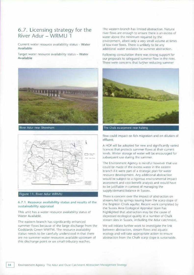
6.7. Licensing strategy for the River Adur - WRMU 1Current water resource availability status - Water Available
Target water resource availability status - Water Available
The western branch has limited abstraction. Natural river flows are enough to ensure there is an excess of water above the minimum required by the environment, albeit only a very small volume at times of low river flows. There is unlikely to be any additional water available for summer abstraction.
Following consultation there was strong support for our proposals to safeguard summer flow in the river. There were concerns that further reducing summer
River Adur near Shoreham The Chalk escarpment near Fulking
6.7.1. Resource availability status and results of the sustainability appraisal
This unit has a water resource availability status of Water Available.The eastern branch has significantly enhanced summer flows because of the large discharge from the Goddards Green WWTW. The resource availability status needs to be carefully understood in that there are no summer water resources available upstream of this discharge point or on small tributary reaches.
flow could impact on fish migration and on dilution of effluent.
A HOF will be adopted for new and significantly varied licences that protects summer flows at their current levels. Winter storage of water will be encouraged for subsequent use during the summer.The Environment Agency is mindful however that use could be made of the excess water in the eastern branch if it were part of a strategic plan for water resource development. Any additional abstraction would be subject to a rigorous environmental impact assessment and cost benefit analysis and would have to be justifiable in context of managing the supply/demand balance in Sussex.There is concern over the impact of abstraction on streams fed by springs issuing from the scarp slope of the Brighton Chalk aquifer. Recent work completed by the Sussex Area Ecological Appraisal team has highlighted that abstraction may be the cause of depressed ecological quality at a number of Chalk stream sites in Sussex, including the Adur catchment.We will initiate further work to investigate the link between abstraction, stream flows and aquatic ecology and will take appropriate action to ensure abstraction from the Chalk scarp slope is sustainable.
Figure 11. River Adur WRMU
AI I Rnw AdurI--------- I --ATffMU
/ \ / Mam R lw
Environment Agency The Adur and Ouse Catchment Abstraction Management Strategy
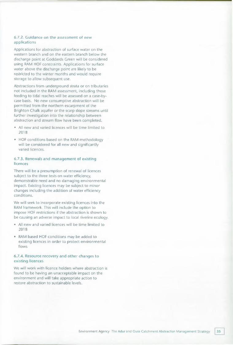
6.7.2. Guidance on the assessment of new applicationsApplications for abstraction of surface water on the western branch and on the eastern branch below the discharge point at Goddards Green will be considered using RAM HOF constraints. Applications for surface water above the discharge point are likely to be restricted to the winter months and would require storage to allow subsequent use.
Abstractions from underground strata or on tributaries not included in the RAM assessment, including those feeding to tidal reaches will be assessed on a case-by- case basis. No new consumptive abstraction will be permitted from the northern escarpment of the Brighton Chalk aquifer or the scarp slope streams until further investigation into the relationship between abstraction and stream flow have been completed.• All new and varied licences will be time limited to
2018• HOF conditions based on the RAM methodology
will be considered for all new and significantly varied licences.
6.7.3. Renewals and management of existing licencesThere will be a presumption of renewal of licences subject to the three tests on water efficiency, demonstrable need and no damaging environmental impact. Existing licences may be subject to minor changes including the addition of water efficiency conditions.We will seek to incorporate existing licences into the RAM framework. This will include the option to impose HOF restrictions if the abstraction is shown to be causing an adverse impact to local riverine ecology.• All new and varied licences will be time limited to
2018
• RAM based HOF conditions may be added to existing licences in order to protect environmental flows
6.7.4. Resource recovery and other changes to existing licencesWe will work with licence holders where abstraction is found to be having an unacceptable impact on the environment and will take appropriate action to restore abstraction to sustainable levels.
Environment Agency The Adur and Ouse Catchment Abstraction Management Strategy
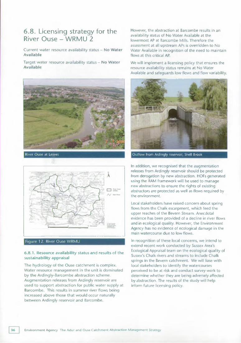
6.8. Licensing strategy for the River Ouse - WRMU 2Current water resource availability status - No Water Available
Target water resource availability status - No Water Available
However, the abstraction at Barcombe results in an availability status of No Water Available at the lowermost AP at Barcombe Mills. Therefore the assessment at all upstream APs is overridden to No Water Available in recognition of the need to maintain flows at this critical AP.
We will implement a licensing policy that ensures the resource availability status remains at No Water Available and safeguards low flows and flow variability.
River Ouse at Lewes Outflow from Ardingly reservoir, Shell Brook
Figure 12. River Ouse WRMU
6.8.1. Resource availability status and results of the sustainability appraisalThe hydrology of the Ouse catchment is complex. Water resource management in the unit is dominated by the Ardingly-Barcombe abstraction scheme. Augmentation releases from Ardingly reservoir are used to support abstraction for public water supply at Barcombe. This results in summer river flows being increased above those that would occur naturally between Ardingly reservoir and Barcombe.
In addition, we recognised that the augmentation releases from Ardingly reservoir should be protected from derogation by new abstraction. HOFs generated using the RAM framework will be used to manage new abstractions to ensure the rights of existing abstractors are protected as well as flows required by the environment.Local stakeholders have raised concern about spring flows from the Chalk escarpment, which feed the upper reaches of the Bevern Stream. Anecdotal evidence has been provided of a decline in river flows and in ecological quality. However, the Environment Agency has no evidence of ecological damage in the main watercourse due to low flows.In recognition of these local concerns, we intend to extend recent work conducted by Sussex Area's Ecological Appraisal team on the ecological quality of Sussex's Chalk rivers and streams to include Chalk springs in the Bevern catchment. We will liase with local stakeholders to identify the watercourses perceived to be at risk and conduct survey work to determine whether they are being adversely affected by abstraction. The results of the study will help inform future licensing policy.
Environment Agency The Adur and Ouse Catchment Abstraction Management Strategy
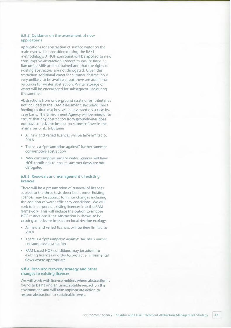
6.8.2. Guidance on the assessment of new applicationsApplications for abstraction of surface water on the main river will be considered using the RAM methodology. A HOF constraint will be applied to new consumptive abstraction licences to ensure flows at Barcombe Mills are maintained and that the rights of existing abstractors are not derogated. Given this restriction additional water for summer abstraction is very unlikely to be available, but there are additional resources for winter abstraction. Winter storage of water will be encouraged for subsequent use during the summer.Abstractions from underground strata or on tributaries not included in the RAM assessment, including those feeding to tidal reaches, will be assessed on a case-by- case basis. The Environment Agency will be mindful to ensure that any abstraction from groundwater does not have an adverse impact on summer flows in the main river or its tributaries.• All new and varied licences will be time limited to
2018• There is a "presumption against" further summer
consumptive abstraction• New consumptive surface water licences will have
HOF conditions to ensure summer flows are not derogated
6.8.3. Renewals and management of existing licencesThere will be a presumption of renewal of licences subject to the three tests described above. Existing licences may be subject to minor changes including the addition of water efficiency conditions. We will seek to incorporate existing licences into the RAM framework. This will include the option to impose HOF restrictions if the abstraction is shown to be causing an adverse impact on local riverine ecology.• All new and varied licences will be time limited to
2018• There is a "presumption against" further summer
consumptive abstraction• RAM based HOF conditions may be added to
existing licences in order to protect environmental flows where appropriate
6.8.4. Resource recovery strategy and other changes to existing licences
We will work with licence holders where abstraction is found to be having an unacceptable impact on the environment and will take appropriate action to restore abstraction to sustainable levels.
Environment Agency The Adur and Ouse Catchment Abstraction Management Strategy
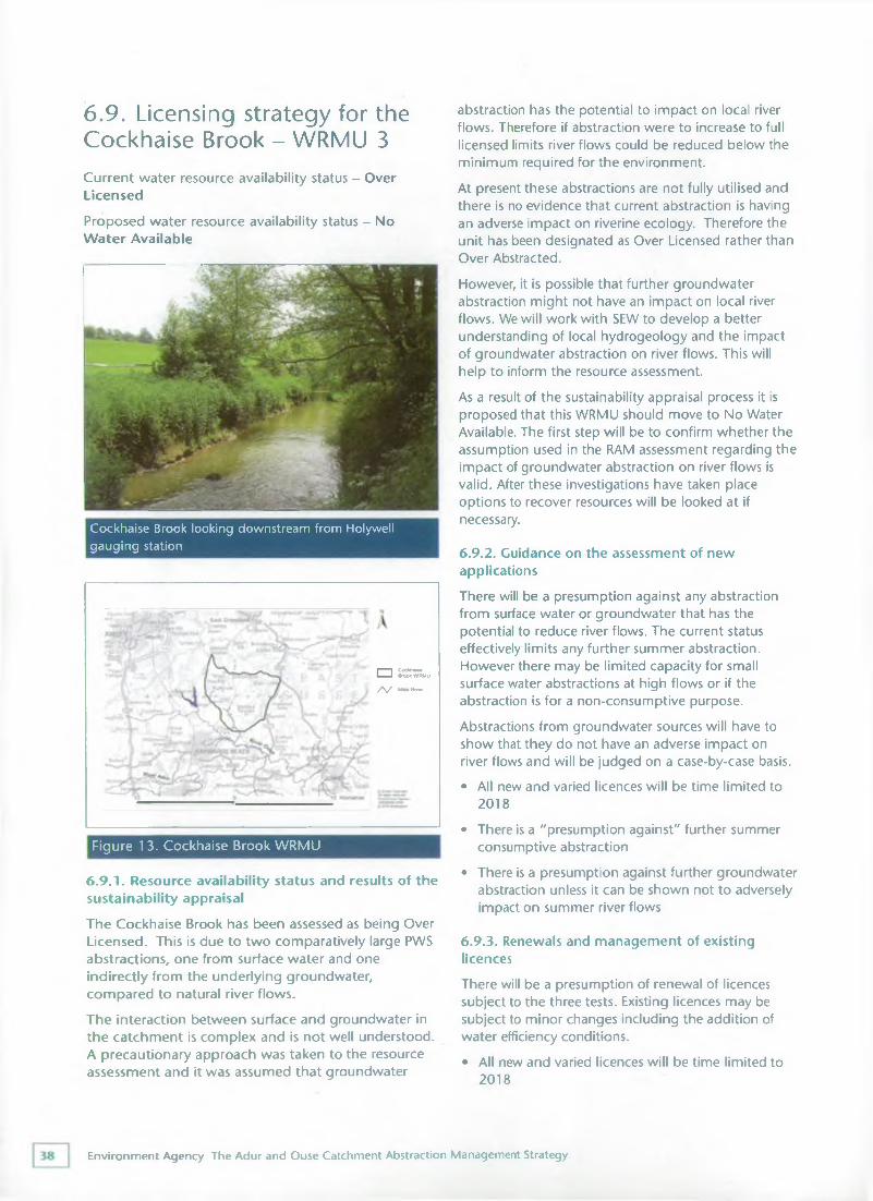
6.9. Licensing strategy for the Cockhaise Brook - WRMU 3Current water resource availability status - Over Licensed
Proposed water resource availability status - No Water Available
Cockhaise Brook looking downstream from Holywell gauging station
6.9.1. Resource availability status and results of the sustainability appraisalThe Cockhaise Brook has been assessed as being Over Licensed. This is due to two comparatively large PWS abstractions, one from surface water and one indirectly from the underlying groundwater, compared to natural river flows.The interaction between surface and groundwater in the catchment is complex and is not well understood. A precautionary approach was taken to the resource assessment and it was assumed that groundwater
abstraction has the potential to impact on local river flows. Therefore if abstraction were to increase to full licensed limits river flows could be reduced below the minimum required for the environment.At present these abstractions are not fully utilised and there is no evidence that current abstraction is having an adverse impact on riverine ecology. Therefore the unit has been designated as Over Licensed rather than Over Abstracted.However, it is possible that further groundwater abstraction might not have an impact on local river flows. We will work with SEW to develop a better understanding of local hydrogeology and the impact of groundwater abstraction on river flows. This will help to inform the resource assessment.As a result of the sustainability appraisal process it is proposed that this WRMU should move to No Water Available. The first step will be to confirm whether the assumption used in the RAM assessment regarding the impact of groundwater abstraction on river flows is valid. After these investigations have taken place options to recover resources will be looked at if necessary.
6.9.2. Guidance on the assessment of new applicationsThere will be a presumption against any abstraction from surface water or groundwater that has the potential to reduce river flows. The current status effectively limits any further summer abstraction. However there may be limited capacity for small surface water abstractions at high flows or if the abstraction is for a non-consumptive purpose.Abstractions from groundwater sources will have to show that they do not have an adverse impact on river flows and will be judged on a case-by-case basis.• All new and varied licences will be time limited to
2018• There is a "presumption against" further summer
consumptive abstraction• There is a presumption against further groundwater
abstraction unless it can be shown not to adversely impact on summer river flows
6.9.3. Renewals and management of existing licencesThere will be a presumption of renewal of licences subject to the three tests. Existing licences may be subject to minor changes including the addition of water efficiency conditions.• All new and varied licences will be time limited to
2018
Figure 1 3. Cockhaise Brook WRMU
□ Cocfchaise Brook WRMU
/ \ / Main R iw
Environment Agency The Adur and Ouse Catchment Abstraction Management Strategy
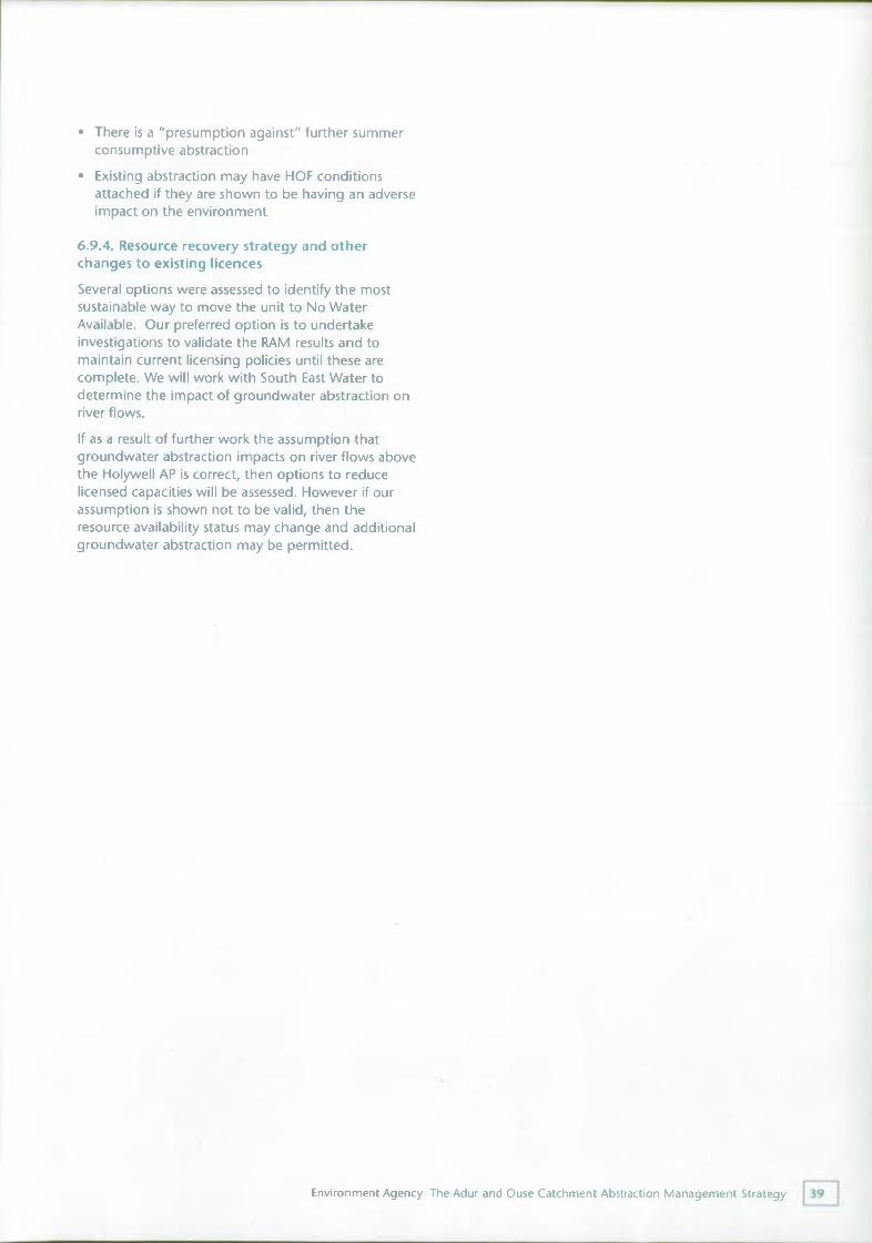
• There is a "presumption against" further summer consumptive abstraction
• Existing abstraction may have HOF conditions attached if they are shown to be having an adverse impact on the environment
6.9.4. Resource recovery strategy and other changes to existing licencesSeveral options were assessed to identify the most sustainable way to move the unit to No Water Available. Our preferred option is to undertake investigations to validate the RAM results and to maintain current licensing policies until these are complete. We will work with South East Water to determine the impact of groundwater abstraction on river flows.If as a result of further work the assumption that groundwater abstraction impacts on river flows above the Holywell AP is correct, then options to reduce licensed capacities will be assessed. However if our assumption is shown not to be valid, then the resource availability status may change and additional groundwater abstraction may be permitted.
Environment Agency The Adur and Ouse Catchment Abstraction Management Strategy
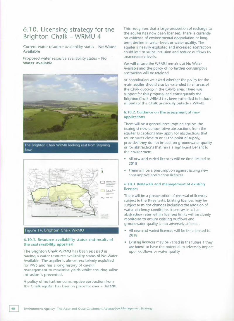
6.1 0. Licensing strategy for the Brighton Chalk - WRMU 4Current water resource availability status - No Water Available
Proposed water resource availability status - No Water Available
6.10.1. Resource availability status and results of the sustainability appraisalThe Brighton Chalk WRMU has been assessed as having a water resource availability status of No Water Available. The aquifer is almost exclusively exploited for PWS and has a long history of careful management to maximise yields whilst ensuring saline intrusion is prevented.A policy of no further consumptive abstraction from the Chalk aquifer has been in place for over a decade.
This recognises that a large proportion of recharge to the aquifer has now been licensed. There is currently no evidence of environmental degradation or longterm decline in water levels or water quality. The aquifer is heavily exploited and increased abstraction could lead to saline intrusion and reduce outflows to unacceptable levels.We will ensure the WRMU remains at No Water Available and the policy of no further consumptive abstraction will be retained.At consultation we asked whether the policy for the main aquifer should also be extended to all areas of the Chalk outcrop in the CAMS area. There was support for this proposal and consequently the Brighton Chalk WRMU has been extended to include all parts of the Chalk previously outside a WRMU.
6.10.2. Guidance on the assessment of new applicationsThere will be a general presumption against the issuing of new consumptive abstractions from the aquifer. Exceptions may apply for abstractions that return water close to or at the point of supply, provided they do not impact on groundwater quality, or for abstractions that have a significant benefit to the environment.• All new and varied licences will be time limited to
2018• There will be a presumption against issuing new
consumptive abstraction licences
6.10.3. Renewals and management of existing licencesThere will be a presumption of renewal of licences subject to the three tests. Existing licences may be subject to minor changes including the addition of water efficiency conditions. Increases in actual abstraction rates within licensed limits will be closely monitored to ensure existing outflows and groundwater quality is not adversely affected.• All new and varied licences will be time limited to
2018• Existing licences may be varied in the future if they
are found to have the potential to adversely impact upon outflows or water quality
Figure 14. Brighton Chalk WRMU
(------- 1 Bnghtor
PofccvAfM
~J Bnghton Chad
/ \ / Mam Rivo#
Environment Agency The Adur and Ouse Catchment Abstraction Management Strategy
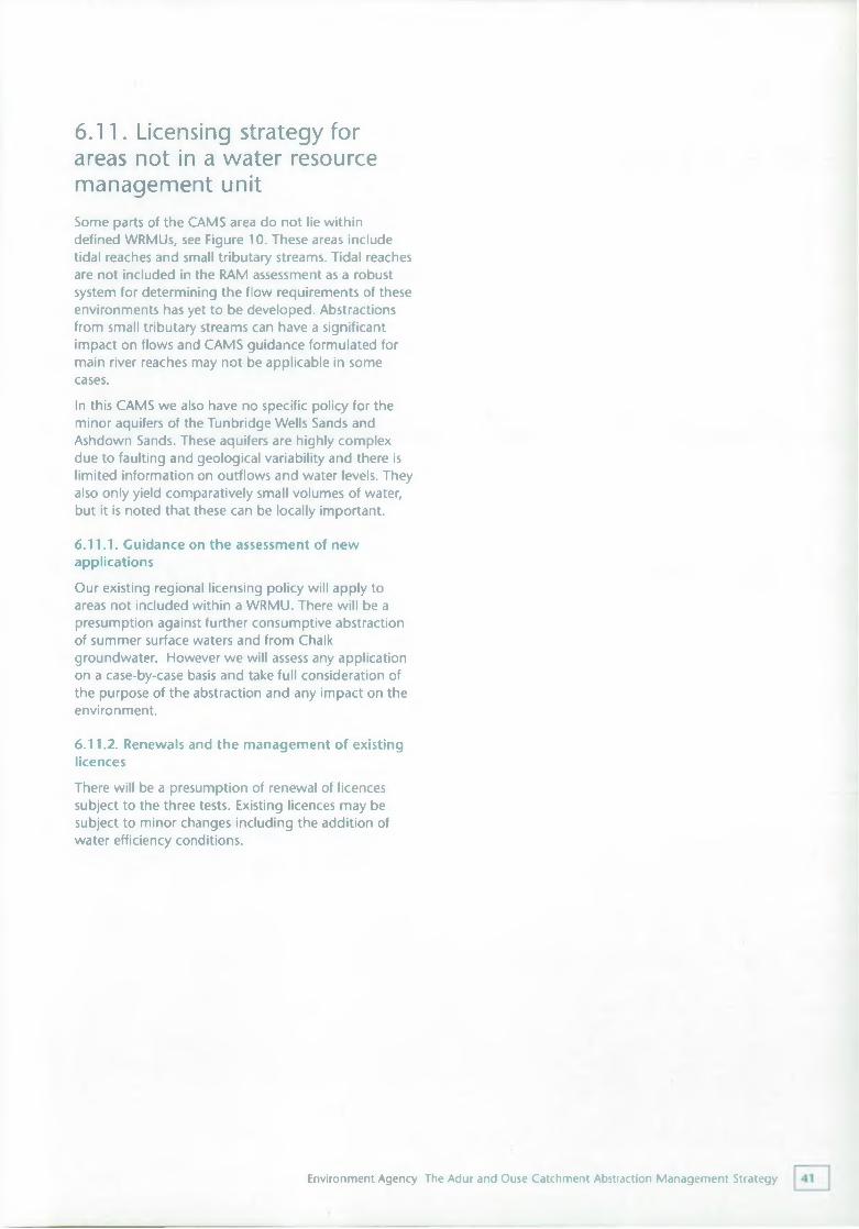
6.11. Licensing strategy for areas not in a water resource management unitSome parts of the CAMS area do not lie within defined WRMUs, see Figure 10. These areas include tidal reaches and small tributary streams. Tidal reaches are not included in the RAM assessment as a robust system for determining the flow requirements of these environments has yet to be developed. Abstractions from small tributary streams can have a significant impact on flows and CAMS guidance formulated for main river reaches may not be applicable in some cases.In this CAMS we also have no specific policy for the minor aquifers of the Tunbridge Wells Sands and Ashdown Sands. These aquifers are highly complex due to faulting and geological variability and there is limited information on outflows and water levels. They also only yield comparatively small volumes of water, but it is noted that these can be locally important.
6.11.1. Guidance on the assessment of new applicationsOur existing regional licensing policy will apply to areas not included within a WRMU. There will be a presumption against further consumptive abstraction of summer surface waters and from Chalk groundwater. However we will assess any application on a case-by-case basis and take full consideration of the purpose of the abstraction and any impact on the environment.
6.11.2. Renewals and the management of existing licencesThere will be a presumption of renewal of licences subject to the three tests. Existing licences may be subject to minor changes including the addition of water efficiency conditions.
Environment Agency The Adur and Ouse Catchment Abstraction Management Strategy
Future developments in the A&O CAMS areaThe South East of England is set to see significant development in coming years. Current Regional Planning Guidance for the South East (RPC9) advises on the proposed levels and pattern of development for the region. Although the CAMS area will not be impacted by the substantial planned new developments such as the Thames Gateway, areas including Brighton and neighbouring coastal areas, Haywards Heath and Burgess Hill are expected to expand.RPG9 is advisory, but under the 2004 Planning and Compulsory Purchase Act it will be replaced by a statutory Regional Spatial Strategy (RSS). The South East Plan is the name given to RSS that will be developed for this area. The purpose of the Plan will be to provide a spatial framework for local plans and will integrate regional and sub-regional priorities for housing, environmental protection and improvement, transport and economic development*.The draft South East Plan is being consulted upon now (March 2005). After consultation, a revised Plan will be produced and submitted to Government for approval later in 2005. The Government will then carry out further public consultation and hold a public examination of the proposals. It is expected that the final Plan will receive Government approval in 2006 and this will provide a statutory regional framework for development to 2026.The level of development that will take place in the region is being consulted upon as part of the Plan and builds on the current options developed following RPG9. These options are*:• 25,500 additional homes per annum - a lower
figure than the current planned rate• 28,000 additional homes per annum -
approximately the current planned rate• 32,000 additional homes per annum - higher than
the current planned rateIn addition two distribution options are:
• Continuation of Existing Policy - essentially a roll forward of the pattern of development established in existing regional planning guidance
• Sharper Focus - a variation which places more emphasis on a combination of areas requiring regeneration and areas with notable economic potential
(*Source: The South East Plan: Draft for Public Consultation, January 2005)
Although the exact details of where and how much development will take place have yet to be finalised, it is clear that new development will place increased demands on water resources. The ability of the South East to accommodate growth is reliant on, amongst other things, the sustainable provision of water. Domestic water consumption is also rising and this will place an additional pressure on existing supplies.The Environment Agency publication Water resources for the future - a strategy for Southern Region summarises how supply and demand will be managed in Southern Region over the next 25 years. Assumptions are made about the potential development of new resources, the realistic potential savings in forecast water use and the cut backs required to restore sustainability in certain areas. The strategy advocates a twin track approach to meet projected increases in demand and includes options for increasing supply and managing consumption of water.
The Environment Agency and the South East's Water Companies have worked closely together to refine water supply and demand forecasts in light of the possible scenarios for growth proposed for the South East. The outcome of this work is reflected in the latest Water Company plans. It has also helped to inform the draft South East Plan and ensure that increases in water consumption are met in a sustainable and environmentally acceptable way. In essence the Twin Tack approach will continue to be followed and a combination of demand management measures and
Environment Agency The Adur and Ouse Catchment Abstraction Management Strategy
strategic water resource development is required to meet increases in demand.In the A&O CAMS area Water Companies are investigating the following water resource schemes, although to different degrees:• Reservoirs - investigating and promoting future
reservoir development including in the A&O CAMS area at Clayhill (SEW)
• Bulk Supplies - continue to investigate the potential for shared resources and bulk supplies from one company to another to meet demand (SWS, SEW and Mid Kent Water)
• Effluent reuse - particularly the reuse of effluent currently discharged to coastal water
Beyond those already included in water company plans, water conservation options include:
• Further leakage control• Further Metering - including increasing use of the
change of occupier opportunity (SEW) to install a meter
• Retrofitting schemes - for example, wider implementation of dual flush toilet retrofit
• Water efficiency campaigns - both in household and commercial water company customers and with water abstractors (SWS and SEW)
and,• New build properties - ensuring that improvements
to the Building Regulations are implemented so that new build properties are as water-efficient as possible
More detailed options are discussed in Water resources for the future - a strategy for Southern Region, along with others such as rainwater harvesting and grey water recycling which are not selected in the proposed strategy, but could still be introduced.The latest information about the South East Plan is available at www.southeast-ra.gov.uk.
Environment Agency The Adur and Ouse Catchment Abstraction Management Strategy
Summary of licensing policy and key actions8.1. Existing licensing policyThere will be a presumption against further consumptive abstraction from the Chalk aquifer. Further abstraction from Ashdown Sands and Tunbridge Wells Sands aquifers will not be permitted unless no adverse environmental impact can be clearly demonstrated. Each application will be dealt with on a case-by-case basis.There will continue to be a presumption against further consumptive abstraction in summer months from surface waters.We will continue to adopt a precautionary approach to abstraction licensing and refuse applications where there is uncertainty over environmental impacts.
8.2. A&O licensing strategySection 6 of this document outlines our policy formanaging new and existing abstraction licences andincludes:• The RAM methodology will be adopted to manage
abstraction licences in the Rivers Adur, Ouse and Cockhaise Brook WRMUs
• HOF conditions will be imposed on new and existing abstraction licences to ensure low flows and flow variability are protected
• A Water Available resource status will be maintained for the River Adur WRMU in light of uncertainties over how reducing flows will impact on fish passage
• We will undertake an investigation into the validity of the RAM result in the Cockhaise Brook WRMU
• We will presume against any further consumptive abstraction from the Brighton Chalk WRMU
8.3. Sustainability issuesThere is concern about the impact of abstraction from the scarp slope of the Brighton Chalk aquifer on stream flows.
We will initiate further work to investigate the link between abstraction, stream flows and aquatic ecology and will take appropriate action to ensure abstraction from the Chalk scarp slope is sustainable.
Until this work is completed no further consumptive abstraction will be allowed from the northern escarpment of the Brighton Chalk aquifer or the scarp slope streams.
8.4. Post CAMS appraisalAn annual update will appear on the CAMS website highlighting our progress in implementing the strategy. The success of the A&O CAMS will be assessed using the following indicators:• The resource availability status of each WRMU
either remains unchanged or improves• Regular visits to licence holders to ensure that
licence conditions are met and comply with current legislation and to encourage water efficiency by abstractors
• Routine sampling programmes will continue to monitor the sensitivity of watercourses to abstraction in each WRMU. This will include monitoring fisheries, macrophytes and macroinvertebrates communities
• Progress in implementation or development of the Regional and National Water Resources Strategies
• Successful applications for new or significantly varied abstraction licences will be granted using RAM and appropriate HOF conditions will be imposed to protect low flows and flow variability
Environment Agency The Adur and Ouse Catchment Abstraction Management Strategy
The results of the proposed investigations will be feed into licensing policyCAMS will help contribute towards the development of River Basin Management PlansCAMS will help water bodies in the Adur and Ouse catchments achieve good ecological status or good ecological potential required by the Water Framework Directive
Environment Agency The Adur and Ouse Catchment Abstraction Management Strategy
Appendix
ReferencesBrighton and Hove City Council. 2004. A different kind of city - a unique destination - A strategic framework for tourism development for Brighton and Hove [online]. Available from: http://www.brighton- hove.gov.uk/downloads/tourism/Tourism_Strategy_20 04.pdf(Accessed March 2004)
South East England Regional Assembly. January 2005. The South East Plan, Draft for Public Consultation. http://www.southeast-ra.gov.uk/southeastplan/plan/cons_draft_jan05/executive_summary.pdf(Accessed 02/02/05)South East Water Pic. 2003. JUNE RETURN 2003 BOARD OVERVIEW.
http://www.ofwat.gov.uk/aptrix/ofwat/publis h. n sf / Attac h me n ts ByTitle/j rO 3_m se_ove rview. doc/$FILE/jrO 3_mse_overview.doc (Accessed 14/06/04)Southern Water Services Ltd. 2003. JUNE RETURN 2003 BOARD OVERVIEW.
http://www.ofwat.gov.uk/aptrix/ofwat/publis h.nsf/Content/jr03_srn_overview_tabled (Accessed 14/06/04)Sussex Downs Conservation Board (March 2004) Interim South Downs Management Plan.
Useful water efficiency contacts General/all sectorsEnvironment AgencyThe Environment Agency provides a range of free guidance on water efficiency, including best practice case studies for agriculture, business, industry, public sector and the domestic consumer. Consult www.environment-agency.gov.uk/savewater or telephone 01903 832275.
Water companiesFor local water efficiency advice, contact your water company. Consult www.southeastwater.co.uk or www.southernwater.co.ukWater regulations advisor service
WRAS provides advice on the Water Supply (Water Fittings) Regulations which prevents waste, misuse, undue consumption or contamination of wholesome water. Consult www.wras.co.uk or telephone 01495 248454.
Business/commercialEnvirowiseEnvirowise is a Government programme offering free, independent advice on practical ways for industrial and commercial small & medium sized enterprise to minimise waste and convert turnover into profit. Envirowise has a specific water section on their site called 'Waternet', which includes links to guidance published around the world and a benchmarking tool. Consult www.envirowise.gov.uk/waternet or telephone the Environment & Energy helpline: 0800 585 794.
Public sectorWatermark
Watermark is an initiative from OCG buying solution (part of the Office of Government Commerce in the Treasury) for public sector organisations. It has produced benchmarks for a wide range of public sector buildings, and offers access to a shared savings scheme for the installation of new, water efficient, devices. Consult www.watermark.gov.ukWater in the SchoolWater in the School is a website supported by a number of water companies aimed at National Curriculum Key Stage 2 and 3 pupils and their teachers. It provides a wealth of information for
Environment Agency The Adur and Ouse Catchment Abstraction Management Strategy
pupils on how to make savings. Consult www.waterintheschool.co.uk
HospitalsWater UKWater UK has collaborated with NHS Estates and Watermark to produce Water Efficient Hospitals, an information pack to help hospitals use water wisely and save money by cutting both water and energy bills. Consult www.water.org.uk/index.php?cat=3- 4701
Agriculture & HorticultureUK Irrigation Association (UKIA)The UKIA provides information on irrigation to its members and runs technical workshops. Consult www.ukia.orgDEFRA Rural Development Service (RDS)DEFRA's Rural Development Service provides grants for agricultural water resources management schemes under its Rural Enterprise Scheme. Consult www.defra.gov.uk/erdp/default.htm or telephone 0845 9335577.
Linking Environment & Farming (LEAF)LEAF promote and develop integrated farm management, this includes whole farm water savings. Consult www.leafuk.org or telephone: 0247 641 3 911.
Environment Agency The Adur and Ouse Catchment Abstraction Management Strategy
GlossaryAbstractionRemoval of water from a source of supply (surface water or groundwater).Abstraction licenceThe authorisation granted by the Environment Agency under section 38 of the Water Resources Act 1991 to permit water abstraction.Asset Management PlanAsset Management Plans are produced by the water companies for Ofwat and set out the investment programme for the water industry. These plans are drawn up through consultation with the Environment Agency and other bodies to cover a five year period and have to be agreed by DEFRA and Ofwat.AquiferA geological formation, group of formations or part of a formation that can store and transmit water in significant quantities.Area of Outstanding Natural BeautyAn area of land designated under the National Parks and Access to Countryside Act 1949 in order to conserve natural beauty.
Assessment pointCritical point on a river at which an assessment of available water resources is made.BaseflowThe component of river flow that is derived from groundwater rather than surface runoff.Biodiversity Action PlanEstablished at a National level in 1995 as part of the Government's commitment to conserving biodiversity made at the 'Earth Summit' held in Rio in 1992. The plan identified over 100 species and 14 habitats for targeted action for protection. This national plan has now been translated into local actions and the Sussex Biodiversity Action Plan (BAP) focuses on habitats and species listed in the plan found in the local area.
CatchmentThe area from which precipitation and groundwater will collect and contribute to the flow of a specific river.
Catchment Flood Management PlansHigh level plans developed by the Environment Agency at a catchment scale to facilitate the integrated management of flood risks to people and the developed and natural environment in a sustainable manner. These plans are being prepared across Sussex.ChalkA soft white fine-grained limestone which underlies much of the South Downs and forms a major aquifer.
Consumptive Abstraction/UseUse of water which results in a significant proportion of water abstracted not being returned either directly or indirectly to a source of supply e.g. spray irrigation.Demand managementThe implementation of policies or measures which sen/e to control or influence the consumption or waste of water.Deployable outputThe output of a commissioned source or group of sources or of bulk supply as constrained by:
• environment• licence, if applicable• pumping plant and/or well/aquifer properties
• raw water mains and/or aqueducts• transfer and/or output main
• treatment• water qualityfor specified conditions and demands.DerogationIn legal terms, the taking away of protected rights under the Water Resources Act (1991) due to the granting of a new licence.Discharge consentA statutory document issued by the Environment Agency, which defines the legal limits and conditions on the discharge of an effluent into controlled waters.
Environment Agency The Adur and Ouse Catchment Abstraction Management Strategy
DroughtA general term for prolonged periods of below- average rainfall resulting in low river flows and/or low recharge to groundwater, imposing significant strain on water resources and potentially the environment.EffluentLiquid waste from industrial, agricultural or sewage plants.Environmental flow requirementThe amount of water that is required to support the ecology of a river.Fisheries Action PlanA strategic plan for the local management and delivery of fisheries objectives and duties developed in partnership with local fisheries interests. The Western Rother Fisheries Action Plan is one of 5 pilot studies undertaken by the Environment Agency in response to The Salmon and Freshwater Fisheries Review published in March 2000.Gauging stationA site where the flow of a river is measured. GroundwaterWater that is contained in underground rocks (aquifers).Groundwater management unitAn area of aquifer delineated to allow the assessment of groundwater resources.Groundwater protection policyEnvironment Agency policy relating to groundwater recharge areas to control activities having the potential to pollute underground water.Habitats DirectiveThe European Directive on the Conservation of Natural Habitats and of Wild Flora and Fauna - known as the Habitats Directive - was adopted by the European Commission in 1992. The Directive is implemented in the UK by the Conservation (Natural Habitats & c.) Regulations 1994 - commonly known as the 'Habitats Regulations'.Hands-off flowA condition attached to an abstraction licence setting a river flow threshold below which abstraction must cease.HeadwatersThe uppermost reaches of a river system. HydrogeologyBranch of geology concerned with water within the Earth's crust.HydrologyThe study of water on and below the earth's surface.
HydrometryThe measurement of water on or below the earth's surface.Hydrometric networkA system of sites monitoring rainfall, river flow, groundwater levels, river and lake levels and some climatic parameters. The data is used extensively for water resources management and planning, water quality and ecological protection and improvement, flood defence, flood forecasting and flood warning.ImpoundmentA dam, weir or other work constructed in an inland water, whereby flows are obstructed or impeded or where water levels are raised above their natural position, and any works for diverting flows in an inland water associated with the construction of a dam, weir or other work.Lower GreensandA group of rock formations comprising mainly of sandstones, Siltstones, and sand, silt and clay deposits and include the Hythe Beds, Sandgate Beds and Folkestone Beds.Macro-invertebrateAn animal without a backbone which is retained in a 5mm sieve.Minimum acceptable flowThe minimum acceptable flow of an inland watercourse as defined in Section 21 of the Water Resources Act 1991.Natural flow regimeThe river flow pattern experienced prior to the influence of man, with no abstraction from or discharge to the catchment.Natura 2000The collective name given to the pan-European network of sites created under the Habitats Directive. This internationally important network includes Special Areas of Conservation (SAC) and Special Protection Areas (SPA).Non-consumptive abstractionAbstraction where the water is used is returned to a source close to or at the point of supply, e.g. hydropower generation, fish farming etc.National Environment ProgrammeThe Environment Agency's programme as approved by ministers setting out improvements to be made by water companies between 2000/01 and 2004/05 to help meet the needs of European Directives and UK legislation.OestrogensNatural and synthetic hormones found in sewage
Environment Agency The Adur and Ouse Catchment Abstraction Management Strategy
effluent. These chemicals are linked to the 'feminisation' of male fish.OutflowsA term used to describe the movement of water out (losses) from a defined area of an aquifer and includes spring flows, baseflow to surface waters and movement of underground water past a defined boundary.Ponded reach/stretchA section of a watercourse upstream of an impoundment or natural restriction characterised by reduced velocity of flow and raised water levels.Precautionary principleWhere significant environmental damage may occur, but knowledge on the matter is incomplete, decisions made should err on the side of caution.Public water supplyTerm used to describe the supply of water provided by a water undertaker.
RAM frameworkResource Assessment and Management Framework - a technical framework for resource assessment (for the definition and reporting of CAMS) and subsequent resource management (including abstraction licensing).
RamsarA site of international conservation importance classified at the 'Convention on Wetlands of International Importance' 1971, ratified by the UK Government in 1976.RechargeWater which percolates downward from the surface into groundwater.Restoring Sustainable AbstractionA programme set up in 1999 to catalogue river and wetland sites suspected of being affected by over abstraction and to establish a future strategy for investigations and implementation of solutions.Review of ConsentsThe procedure by which the Environment Agency as a competent authority will apply the Habitats Regulations to review all relevant existing consents, licences, permissions and activities which are likely to be having an effect on a designated European site.RevocationCancellation of licence and associated rights and benefits.River Basin Management PlanStrategic management documents required by the Water Framework Directive detailing how good
ecological status will be achieved for water bodies in each river catchment. They will be produced in consultation the local community for each River Basin District in England and Wales by December 2009.River reachUnit of a river between two Assessment Points, delineated for the purposes of abstraction licensing and resource management.Scarp slopeA steep sided slope often used locally in reference to the northern flank of the Chalk downland.
Site of Nature Conservation ImportanceSites designated by Local Authorities for planning purposes as locally important for conservation interests.Site of Special Scientific InterestA site given a statutory designation by English Nature or the Countryside Council for Wales because of its importance to nature conservation.
Special Area of ConservationInternationally important nature conservation site designated under the EU Habitats Directive (92/43/EEC).Special Protection AreaInternationally important nature conservation site designated under the EU Wild Birds Directive (79/409/EEC).Spray irrigationAbstracted water sprayed via a boom or rain gun etc. onto grassland, fruit, vegetables etc. Can have a high impact on water resources and is highly consumptive.SpringA surface water course that occurs where the water table intersects the ground surface.Surface waterThis is a general term used to describe all above ground water features such as rivers, streams, springs, ponds and lakes.Sustainable developmentDevelopment that meets the needs of the present without compromising the ability of future generations to meet their own needs. This involves meeting four objectives simultaneously:• social progress which recognises the needs of
everyone;• effective protection of the environment;• prudent use of natural resources;• maintenance of high and stable levels of economic
growth and employment.
Environment Agency The Adur and Ouse Catchment Abstraction Management Strategy
Tidal limitThe most upstream point within an estuary or river where water levels are subject to tidal variation.Time limited licenceAn abstraction licence with specified end date.Twin trackThe approach adopted by National and Regional Water Resources Strategies for the future management of water resources, balancing the need for efficient water use whilst bringing forward timely proposals for resource development where appropriate.Water Level Management PlansA written agreement between interested parties, providing the means by which the water level requirements for a range of activities in a particular area can be balanced and integrated.Water resource management unitAn area that has similar groundwater and or surface water characteristics defined for the local management of water resources.Water resources strategiesStrategy for Water Resource planning in England and Wales over the next 25 years to ensure sustainable use and sufficient water for all human uses with an improved water environment. The strategies predict demand using different social and economic scenarios.WetlandAn area of low lying land where the water table is at or near the surface for most of the time, leading to characteristic habitats.
Environment Agency The Adur and Ouse Catchment Abstraction Management Strategy
List of acronyms, abbreviations and unitsAM PAsset Management Plan AONBArea of Outstanding Natural Beauty A&OAdur and Ouse CAMS APAssessment Point BAPBio-diversity Action Plan CAMSCatchment Abstraction Management Strategy DEFRADepartment for Environment, Food and Rural Affairs EUEuropean Union G W M UGroundwater Management Unit HOFHands-off Flow
km2Square kilometres
mmetresMl/dMegalitres (million litres) per day NEPNational Environment Programme NRANational Rivers Authority OfwatOffice of Water Services PW SPublic Water Supply
RAMResource Assessment and Management RBMPRiver Basin Management Plan RSARestoring Sustainable Abstraction Programme SACSpecial Area of Conservation SNCISite of Nature Conservation Importance SPASpecial Protection Area SSSIA Site of Special Scientific Interest i.e. an area given a UK statutory designation because of its conservation valueSEWSouth East Water SWSSouthern Water Services UKCIPUnited Kingdom Climate Impacts Programme
WFDWater Framework Directive WLMPWater Level Management Plan WRMUWater Resource Management Unit WWTWWaste Water Treatment Works
Environment Agency The Adur and Ouse Catchment Abstraction Management Strategy
Notes
Environment Agency The Adur and Ouse Catchment Abstraction Management Strategy
C ONTACTS:ENVIRONMENT AGENCY HEAD OFFICE
Rio House, Waterside Drive, Aztec West, Almondsbury, Bristol BS32 4UD Tel: 08708 506 506
www.environment-agency.gov.ukwww.environment-agency.wales.gov.uk
EN V IRO N M EN T AGENCY REG IO NAL OFFICESANGLIAN Kingfisher House Goldhay Way Orton Goldhay Peterborough PE2 5ZR
MIDLANDS Sapphire East 550 Streetsbrook Road Solihull B91 1QT
NO RTH EAST Rivers House 21 Park Square South Leeds LS1 2QG
NORTH W EST PO Box 12Richard Fairclough House Knutsford Road Warrington WA4 1HG
SOUTHERN Guildbourne House Chatsworth Road WorthingWest Sussex BN 11 1LD
SOUTHW EST Manley House Kestrel Way Exeter EX2 7LQ
THAMESKings Meadow House Kings Meadow Road Reading RG1 8DQ
WALESCambria House 29 Newport Road Cardiff CF24 OTP
E N V I R O N M E N T A G E N C Y G E N E R A L E N Q U I R Y L I N E
08708 506506E N V I R O N M E N T A G E N C Y F L O O D L I N E
0845 988 1188E N V I R O N M E N T A G E N C Y E M E R G E N C Y H O T L I N E
0800 80 70 60En v ir o n m e n tAg e n c y
For further copies of this report or other reports published by the Environment Agency, contact general enquiries on 0845 9333111 or email us on [email protected]
E n v ir o n m e n t W aV A g e n c y


