Communities Directorate 20 October 2016 Adur Planning Committee Date: Time: Venue: Monday 31 October 2016 7:00pm Queen Elizabeth II Room, The Shoreham Centre, 2 Pond Road, Shoreham-by-Sea, BN43 5WU Committee Membership: Councillors Peter Metcalfe (Chairman), Carol Albury (Vice-Chair), Les Alden, George Barton, Ken Bishop, Stephen Chipp, Brian Coomber and Geoff Patmore. NOTE: Anyone wishing to speak at this meeting, on a planning application before the Committee, should register by telephone (01903 221006) or e-mail [email protected]before noon on Friday 28 October 2016. Agenda Part A 1. Declarations of Interest / Substitute Members Members and Officers must declare any disclosable pecuniary interests in relation to any business on the agenda. Declarations should also be made at any stage if such an interest becomes apparent during the meeting. If in doubt contact the Legal or Democratic Services representative for this meeting. Members and Officers may seek advice upon any relevant interest from the Monitoring Officer prior to the meeting. Any substitute members should declare their substitution. 1
Transcript
Communities Directorate 20 October 2016
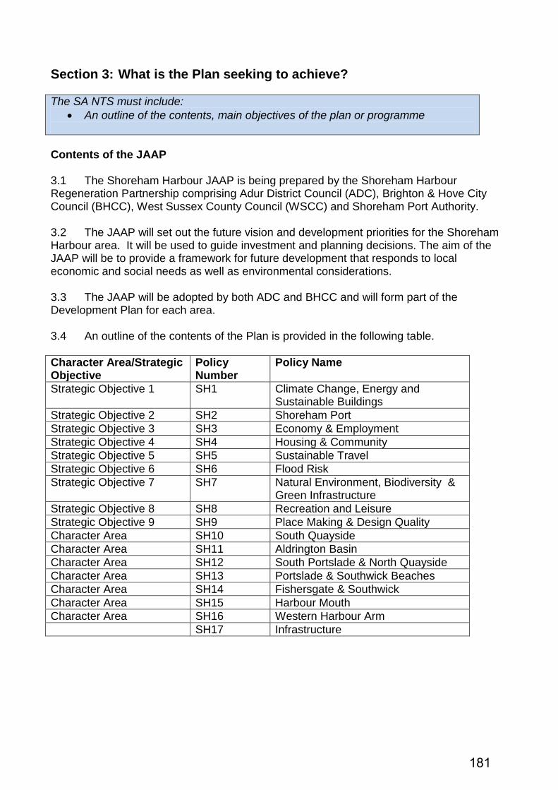
Adur Planning Committee
Date: Time: Venue:
Monday 31 October 2016 7:00pm Queen Elizabeth II Room, The Shoreham Centre, 2 Pond Road, Shoreham-by-Sea, BN43 5WU
Committee Membership: Councillors Peter Metcalfe (Chairman), Carol Albury (Vice-Chair), Les Alden, George Barton, Ken Bishop, Stephen Chipp, Brian Coomber and Geoff Patmore.
NOTE: Anyone wishing to speak at this meeting, on a planning application before the Committee, should register by telephone (01903 221006) or e-mail [email protected] before noon on Friday 28 October 2016.
Agenda Part A 1. Declarations of Interest / Substitute Members
Members and Officers must declare any disclosable pecuniary interests in relation to any business on the agenda. Declarations should also be made at any stage if such an interest becomes apparent during the meeting.
If in doubt contact the Legal or Democratic Services representative for this meeting.
Members and Officers may seek advice upon any relevant interest from the Monitoring Officer prior to the meeting. Any substitute members should declare their substitution.
2. Confirmation of Minutes To approve the minutes of the Planning Committee meeting held on 3 October 2016, which have been emailed to Members.
3. Items Raised Under Urgency Provisions To consider any items the Chairman of the meeting considers to be urgent.
4. Planning Applications To consider a report by the Director for the Economy, attached as Item 4.
5. Public Question Time To receive any questions from Members of the public in accordance with Council procedure Rule 11.2. (Note: Public Question Time will last for a maximum of 30 minutes)
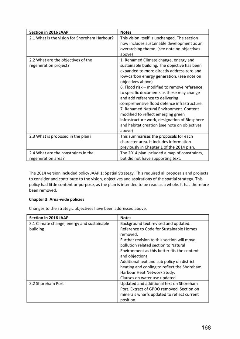
6. Draft Shoreham Harbour Joint Area Action Plan To consider a report by the Director for the Economy, attached as Item 6.
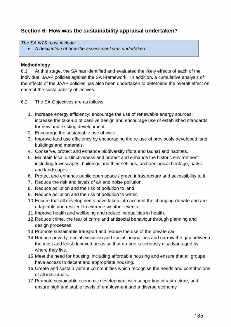
Part B - Not for publication - Exempt Information Reports None.
Recording of this meeting The Council will be voice recording the meeting, including public question time. The recording will be available on the Council’s website as soon as practicable after the meeting. The Council will not be recording any discussions in Part B of the agenda (where the press and public have been excluded).
For Democratic Services enquiries relating to this meeting please contact:
For Legal Services enquiries relating to this meeting please contact:
Duration of the Meeting: Four hours after the commencement of the meeting the Chairperson will adjourn the meeting to consider if it wishes to continue. A vote will be taken and a simple majority in favour will be necessary for the meeting to continue.
3
Planning Committee
31 October 2016
Agenda Item 4
Ward: ALL
Key Decision: Yes / No
Report by the Director for Economy
Planning Applications
1 Application Number: AWDM/1429/16 Recommendation – Refuse Site: Land South East of 5 Cecil Pashley Way, Shoreham (Brighton
City) Airport, Lancing, West Sussex Proposal: Erection of lattice telecom tower supporting 3no. antennae
and 2no. transmission dishes to a maximum height of 20m above ground level with associated ground level plant and surrounded by 2.4m high palisade fencing.
TREE PRESERVATION ORDER REPORTS
1 Application Number: AWTPO/0004/16 Recommendation – To be confirmed
Site: 14 Alandale Road, Sompting, West Sussex BN15 0JU Proposal: Confirmation of Adur Tree Preservation Order No 1 of 2016
4
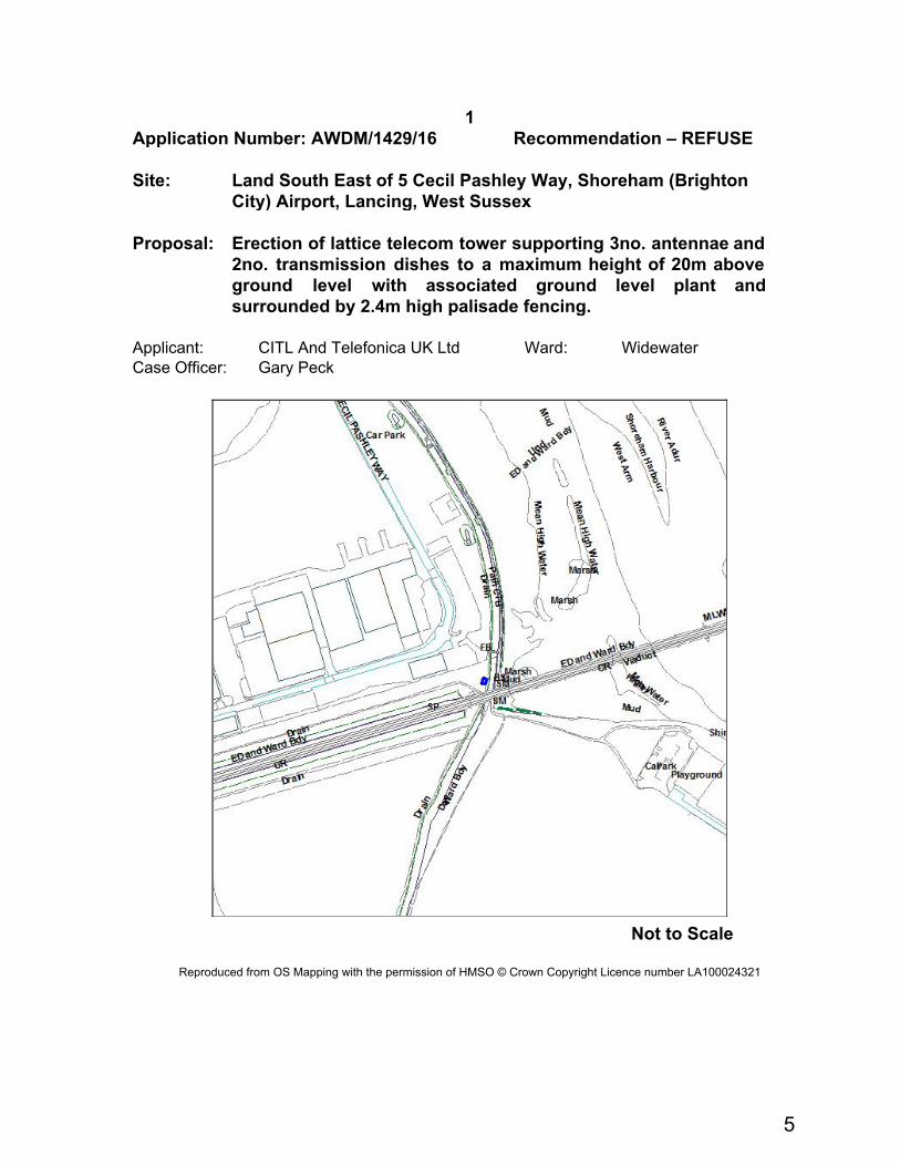
1 Application Number: AWDM/1429/16 Recommendation – REFUSE Site: Land South East of 5 Cecil Pashley Way, Shoreham (Brighton
City) Airport, Lancing, West Sussex Proposal: Erection of lattice telecom tower supporting 3no. antennae and
2no. transmission dishes to a maximum height of 20m above ground level with associated ground level plant and surrounded by 2.4m high palisade fencing.
Applicant: CITL And Telefonica UK Ltd Ward: Widewater Case Officer: Gary Peck
This application seeks full permission for the erection of a lattice telecommunications tower supporting 3 no. antennae and 2 no. transmission dishes to a maximum height of 20m above ground level, surrounded by 2.4m high palisade fencing. The application site is located to the north of the railway line and to the south of the bend in Cecil Pashley Way at the eastern end of the Shoreham Airport buildings. The River Adur is immediately to the east. A public footpath runs along the western side of the river and therefore between the river and application site (although at present the path has been rerouted to facilitate works to the railway bridge). The complex of buildings supporting largely aircraft related industries are to west with the airfield beyond. Just over 400 metres to the west is an existing telecommunications mast. A more open aspect to the east exists across the river. Relevant Planning History There is no planning history directly relevant to the site. Permission was originally granted for an existing 20 metre mast to the west on the southern side of Cecil Pashley and the airport buildings in 2003 with additional equipment being allowed a year later. Consultations Environmental Health raises no objection Representations
None received Relevant Planning Policies and Guidance Adopted Adur District Local Plan 1993-2006 (ADC 1996) (saved policies): AG1, AC1, AC4, AB29 Proposed Submission Adur Local Plan: Policies 15 and 38. National Planning Policy Framework (CLG 2012) Planning Practice Guidance (CLG 2014) Relevant Legislation The Committee should consider the planning application in accordance with: Section 70 of the Town and Country Planning Act 1990 (as amended) that provides the application may be granted either unconditionally or subject to relevant conditions,
6
or refused. Regard shall be given to relevant development plan policies, any relevant local finance considerations, and other material considerations Section 38(6) Planning and Compulsory Purchase Act 2004 that requires the decision to be made in accordance with the development plan unless material considerations indicate otherwise. Planning Assessment The key issue in the determination of the application is the impact of the proposal upon the visual character of the area. Saved policy AB29 of the Adur Local Plan, Telecommunications Development, states: The District Planning Authority will grant planning permission for, or approve the details of, telecommunications development where it can be demonstrated that:- (i) planning permission is required from the District Planning Authority; (ii) there is no reasonable possibility of sharing existing facilities; and (iii) in the case of radio masts there is no reasonable possibility of erecting antennas on an existing building or other structure. When considering proposals for telecommunications development, whether or not under permitted development rights, the District Planning Authority, whilst respecting operational requirements, will expect the apparatus to be sited, designed, and, where appropriate, landscaped, so as to minimise its visual impact on the environment in which it is located. Such masts will not be permitted where they would be visible in the wider landscape within the Area of Outstanding Natural Beauty except where special siting needs attributable to technical requirements, such as transmission range or line-of-sight, dictate otherwise. This approach has been followed in emerging policy 38 of the Proposed Submission Adur Local Plan: All opportunities for mast sharing, or the use of existing buildings or structures have been thoroughly assessed; and There are no satisfactory alternative sites available. Applications for telecommunications development (including for prior approval) should be accompanied by the necessary evidence to support development, including evidence which demonstrates that the proposal is the least environmentally harmful option, and includes a statement that self-certifies that the cumulative exposure will not exceed the guidelines of the International Commission on Non-Ionising Radiation Protection. All proposals for telecommunications development should ensure that siting and design of the equipment results in acceptable visual impact. Conditions or planning
7
obligations may be used to secure landscaping as well as restoration of the site once operation has ceased. It is a matter of fact that there is an existing telecommunications mast already exists in the locality and in line with the above policies, your officers, at the pre-application stage, requested clarification as to why the existing mast could not be shared or upgraded. The applicant responded that ‘for legal reasons’ the existing mast cannot be upgraded or shared. In support of the application, the applicant has included an appeal decision from a site in Newcastle, where an Inspector stated; ‘The Council argues that the failure to agree commercial terms represents insufficient justification for dismissing the alternative [site] and does not rule this out as a solution. I consider this to be somewhat unreasonable…given…the lack of objection on visual grounds to the proposed location…’ It can be seen from above, therefore, that to resist the application on the fact alone that the existing mast is not being shared would be unreasonable, if there are no objections to the alternative location proposed. However, your officers do have concerns about the location of the proposed structure. The effect of the existing mast is relatively limited primarily because it is centrally located within the complex of airport buildings (where the buildings are at their tallest) and benefits from some screening by existing tree planting to the west. Despite this, the top of the mast is visible from a wide area given the open nature of the surrounds. The application site is far less advantageous in being able to take account of existing buildings or tree screening. While views from the west may be limited by existing buildings to the eastern edge of the airport, and the railway bridge itself may act as a partial screen, the general character of the area is very open to the north, south and east. Longer distance views from the Adur Recreation Ground for example would see the mast as clearly visible and generally set against the backdrop of the Lancing College buildings in the distance. Similarly, from the Norfolk Bridge, while the existing mast is screened by buildings from this viewpoint, the proposed mast would be clearly visible. The mast would also be a prominent feature from across the river, including from the Ropetackle North site. In January 2016, the Assessment of landscape sensitivity report for the Adur Local Plan area stated: The views across the simple, expansive open landscape of the airport and the natural wetland habitats of the Adur corridor are highly vulnerable to change. The open, green expanse of Shoreham Airfield is prominent in the elevated views from the SDNP and in long east-west views across the Lancing/Shoreham Gap. This prominent open space is vulnerable to built development and/or infrastructure that would change its undeveloped, open, green character
8
Your officers therefore consider that irrespective of whether the existing mast can be shared or not, the proposed site would have unacceptable impact upon the visual character of the area. If additional network coverage is required in the vicinity of the airport area, then there would appear to be less visually obtrusive sites further to the west that would be better screened by existing buildings and, indeed, notwithstanding the Inspector’s comments above, it is considered to be a location where a mast share would be the least obtrusive option. It is therefore considered that a refusal of the application can be justified. Recommendation REFUSE for the following reason: The proposed mast by virtue of its height and siting would result in an unacceptably visual impact in area considered to be sensitive in landscape terms as identified in the Assessment of landscape sensitivity for the Adur Local Plan area. The proposal therefore fails to comply with saved policy AB29 of the Adur Local Plan 1996 and emerging policy 38 of the Proposed Submission Adur Local Plan (2016).
31 October 2016
9
10
TPO REPORT 1
Application Number: AWTPO/0004/16 Recommendation – Confirm Order Site: 14 Alandale Road, Sompting, West Sussex BN15 0JU Proposal:
Confirmation of Adur Tree Preservation Order Number 1 of 2016
Proposal, Site and Surroundings On the 17th August 2016 a provisional Tree Preservation Order was placed on one Pine tree in the rear garden of 14 Alandale Road Sompting. The order refers to one pine tree, which is one of few trees large mature trees in the area, which although not a prominent part of in the street scene, does make a
11
contribution to the character and visual amenities of Alandale Road and surrounding roads. Representations 1 letter of objection has been received from a neighbour to the east, at 15 Hillside Road. Their grounds for objecting to the proposed TPO are concerns of potential size and height of the tree, damage that may be caused to surrounding properties and possible failure of the tree. Relevant Planning Policies and Guidance Adur Local Plan 1996 – Policy AB23 National Planning Policy Framework Circular 04/07 ‘Tree Preservation Orders: A Guide to the Law and Good Practice’ (DETR 2000) Planning Assessment The tree is a reasonable specimen that meets the tests for new Tree Preservation Orders: the Adur and Worthing Council Tree Preservation Order – Survey and Decision Guide, as agreed by the Joint Planning Committee. The reason for protecting this tree is that is a feature of the area and it would be detrimental to the character and visual amenities of this part of north Sompting should the tree be removed or inappropriately pruned. The tree is a medium to large sized early mature growing at the far eastern end of the rear garden of 14 Alandale Road. The tree has a single stem that extends to 10 metres where it then forms a bushy slightly flattened top to the crown. The top of the crown does not have a central leader which will limit the overall height likely to be gained by the tree, making it unlikely to exceed more height that another 3 to 4 metres, and instead is more likely to increase in radial spread. As with any large tree there can be difficulty in growing some plants directly below the crown, although this can be alleviated by crown lifting over neighbouring gardens. Dead wood small branches and other debris can be dropped by any tree and this is a normal consequence of tree ownership. The removal of dead or dying wood does not require Local Authority approval, and can be carried out at any time. Other works such as reduction in radial spread, crown lifting and crown thinning would require planning permission but the existence of a Tree Preservation Order does not prevent approval of such of an application for appropriate works which often can help to alleviate the concerns expressed by the objector.
12
Recommendation That Adur Tree Preservation Order Number 1 of 2016 be confirmed as made.
31 October 2016 Local Government Act 1972 Background Papers: As referred to in individual application reports Contact Officers: Gary Peck Planning Services Manager (Development Management) Portland House 01903 221406 [email protected] Jeremy Sergeant Senior Tree and Landscape Officer Portland House 01273 263477 Senior Tree and Landscape Officer [email protected]
1.0 Council Priority 1.1 As referred to in individual application reports, the priorities being:-
- to protect front line services - to promote a clean, green and sustainable environment - to support and improve the local economy - to work in partnerships to promote health and wellbeing in our communities - to ensure value for money and low Council Tax
2.0 Specific Action Plans 2.1 As referred to in individual application reports. 3.0 Sustainability Issues 3.1 As referred to in individual application reports. 4.0 Equality Issues 4.1 As referred to in individual application reports. 5.0 Community Safety Issues (Section 17) 5.1 As referred to in individual application reports. 6.0 Human Rights Issues 6.1 Article 8 of the European Convention safeguards respect for family life and home,
whilst Article 1 of the First Protocol concerns non-interference with peaceful enjoyment of private property. Both rights are not absolute and interference may be permitted if the need to do so is proportionate, having regard to public interests. The interests of those affected by proposed developments and the relevant considerations which may justify interference with human rights have been considered in the planning assessments contained in individual application reports.
7.0 Reputation 7.1 Decisions are required to be made in accordance with the Town & Country Planning
Act 1990 and associated legislation and subordinate legislation taking into account Government policy and guidance (and see 6.1 above and 14.1 below).
8.0 Consultations 8.1 As referred to in individual application reports, comprising both statutory and
non-statutory consultees.
14
9.0 Risk Assessment 9.1 As referred to in individual application reports. 10.0 Health & Safety Issues 10.1 As referred to in individual application reports. 11.0 Procurement Strategy 11.1 Matter considered and no issues identified. 12.0 Partnership Working 12.1 Matter considered and no issues identified. 13.0 Legal 13.1 Powers and duties contained in the Town and Country Planning Act 1990 (as
amended) and associated legislation and statutory instruments. 14.0 Financial implications 14.1 Decisions made (or conditions imposed) which cannot be substantiated or which are
otherwise unreasonable having regard to valid planning considerations can result in an award of costs against the Council if the applicant is aggrieved and lodges an appeal. Decisions made which fail to take into account relevant planning considerations or which are partly based on irrelevant considerations can be subject to judicial review in the High Court with resultant costs implications.
15
16
Planning Committee
31 October 2016 Agenda Item No.6
Ward: St Mary’s, Southwick Green, Eastbrook, Marine
Draft Shoreham Harbour Joint Area Action Plan Report by the Director of Economy 1.0 Summary 1.1 This is a revised draft of the Shoreham Harbour Joint Area Action Plan (JAAP),
which is a 15 - 20 year plan to guide the regeneration of Shoreham Harbour. 1.2 The JAAP is a detailed plan which will sit alongside the Adur Local Plan and
Brighton & Hove City Plan to provide further detail on the Shoreham Harbour Regeneration Area. The JAAP forms part of the development plan for both Adur and Brighton & Hove.
1.3 The Committee is asked to note the progress made on the JAAP and provide
comment on the contents of the plan, prior to its approval for public consultation by the Executive Member for Regeneration. Following consultation, representations will be taken into account, and a proposed submission version of the plan will be prepared.
2.0 Background 2.1 The regeneration of Shoreham Harbour has long been an aspiration of Adur,
Brighton & Hove and West Sussex councils, and Shoreham Port Authority. The Councils consulted on the first draft of the JAAP in 2014. A total of 185 representations on the draft plan were received, and these have been taken into account in preparing the current draft of the document.
2.2 Since that time the policy context nationally and locally has changed. The Brighton
& Hove City Plan Part One has now been adopted, and the Adur Local Plan has recently been submitted to the Planning Inspectorate for examination in autumn 2016. These plans both include a policy for Shoreham Harbour Regeneration Area, which identifies it as a broad location for future strategic development. These
17
policies state that the detailed area wide policies and proposals for each of seven character areas will be set out in the JAAP.
2.3 Since 2014 the evidence base supporting the JAAP has been updated. This
includes further work on the Transport Study, and an update to the Transport Strategy.
2.4 A number of additional priorities have emerged, including the potential for a district
heat network, and green infrastructure improvements. These have been included in the revised document.
2.5 The document was circulated to officers of all the project partners earlier this year
and feedback has now been incorporated into the plan. A summary of the changes to the plan is included in the background papers.
2.6 Given the length of time since the last public consultation, and the large number of
amendments to the plan, it is proposed to conduct a further period of public consultation. Representations will be taken into account as the JAAP is further refined, and a proposed submission version of the plan is prepared in 2017.
3.0 Proposals 3.1 The area covered by the Shoreham Harbour JAAP stretches from the Adur Ferry
Bridge in the west to Hove Lagoon in the east. In addition to the operational areas of Shoreham Port, the regeneration area includes the Western Harbour Arm, Adur Homes estates south of the railway line at Southwick and Fishersgate, and industrial estates at Fishersgate and South Portslade.
3.2 The vision for the Shoreham Harbour Regeneration Area is:
By 2031, Shoreham Harbour Regeneration Area will be transformed into a vibrant,thriving, waterfront destination comprising a series of sustainable, mixed-use developments alongside a consolidated and enhanced Shoreham Port which will continue to play a vital role in the local economy. The redevelopment of key areas of the harbour will provide benefits for the local community and economy through increased investment, improved leisure opportunities, enhanced public realm and the delivery of critical infrastructure that will help respond positively to climate change.
3.3 The regeneration project and the JAAP have the following objectives:
18
● Objective 1 – Climate change, energy and sustainable building: To minimise carbon emissions, address the challenges of climate change and create a renewable energy hub
● Objective 2 – Shoreham Port: To support a growing, thriving port ● Objective 3 – Economy and employment: To stimulate the local economy and
provide new jobs ● Objective 4 – Housing and community: To provide new homes and contribute
to meeting housing need ● Objective 5 – Sustainable travel: To improve connections and promote
sustainable transport choices ● Objective 6 – Flood risk: To reduce the risk of flooding and adapt to climate
change ● Objective 7 – Natural environment, biodiversity and green infrastructure: To
conserve and protect the natural environment, enhance biodiversity and create a green infrastructure network
● Objective 8 – Recreation and leisure: To enhance and activate the harbour for leisure, recreation and tourism and encourage active, healthy lifestyles
● Objective 9 – Placemaking and design quality: To promote high design quality and improve townscape
3.4 Once the Shoreham Harbour JAAP is adopted, all planning applications within the
regeneration area will be assessed against the policies in the JAAP, as well as the National Planning Policy Framework, and either the Adur Local Plan or Brighton & Hove City Plan.
3.5 Attached to this report is the revised plan together with a summary of the key
changes to the Plan to assist the Committee’s consideration. In addition, a copy of the Shoreham Harbour Transport Strategy - Executive Summary and Sustainability Appraisal - Non Technical Summary are appended. The key proposals in the Shoreham Harbour JAAP are:
CA1 – South Quayside (Adur and Brighton & Hove)
3.5 South Quayside is mostly a port-operational area. Port facilities will be safeguarded
and improved. 3.6 The area also includes a wastewater treatment works, power stations and
renewable energy generation. These uses will be safeguarded. CA2 – Aldrington Basin (Brighton & Hove)
3.7 Aldrington Basin includes a mixture of port operations, employment space and
some residential areas. Port facilities will be safeguarded and improved.
19
3.8 The area includes proposed development at allocation SS1 – Aldrington Basin. Together, allocations SS1 and SS2 will deliver a minimum of 7,500m2 employment generating floorspace and 300 new homes.
CA3 – North Quayside and South Portslade (Brighton & Hove)
3.9 North Quayside is mostly a port-operational area. Port facilities will be safeguarded
and improved. 3.10 South Portslade is mostly an employment area. It includes proposed development
at allocation SS2 – South Portslade. Together allocations SS2 and SS1 will deliver a minimum of 7,500m2 employment generating floorspace and 300 new homes. CA4 – Portslade and Southwick Beaches (Adur and Brighton & Hove)
3.11 Access to Portslade and Southwick Beaches for pedestrians and cyclist will be
improved. Habitats and biodiversity will be created and protected. CA5 – Fishersgate and Southwick (Adur)
3.12 Fishersgate and Southwick include a mixture of port operations, employment space,
residential areas and green space. Port facilities will be safeguarded and improved. 3.13 The area includes proposed development at allocation SS3 – Southwick Waterfront.
This will deliver a minimum of 4,000m2 employment generating floorspace. 3.14 Lady Bee Marina will be expanded and improved. Green space will be improved
and connected to create wildlife corridors and linear open spaces. 3.15 Improvements to existing housing estates will be supported. This includes the
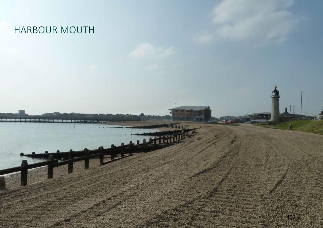
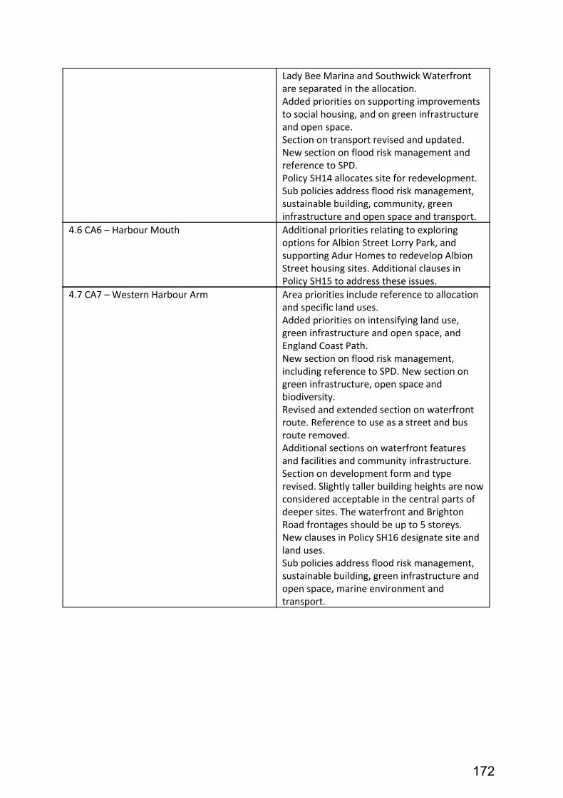
retrofit of energy efficiency measures. CA6 – Harbour Mouth (Adur)
3.16 Harbour Mouth includes port-operational areas, existing housing and employment
space, and Kingston Beach. Port operational areas will be safeguarded and improved.
3.17 The area includes the historic buildings of Kingston Buci lighthouse and Shoreham
Fort. These will be protected. CA7 – Western Harbour Arm (Adur)
3.18 Western Harbour Arm is primarily an employment area at the present time. The
relevant Policy SS4 – Western Harbour Arm Waterfront proposes a minimum of
20
1,100 new homes and 12,000 m 2 employment generating floorspace.
3.19 The policy refers to the requirement for new flood defences incorporating a new waterfront route to improve connections for pedestrians and cyclists between Shoreham-by-Sea town centre and Kingston Beach. Habitats and biodiversity would be created and protected.
3.20 The revised JAAP proposes a different approach regarding the form and height of
development considered appropriate along the Western Harbour Arm, compared to the previously adopted Development Brief, to reflect the desire for high quality flats rather than terraced housing. The increase in the District’s Objectively Assessed Housing Need (OAN) and viability concerns have influenced this change in approach.
4.0 Legal 4.1 Once adopted the JAAP will have statutory status as a local plan (as defined in The
Town and Country Planning (Local Planning) (England) Regulations 2012). Also referred to as a development plan document as defined in the Planning and Compulsory Purchase Act 2004. As such it will be given full weight in the determination of planning applications within the Shoreham Harbour Regeneration Area.
5.0 Financial implications 5.1 The main input from the Council is officer time, although this is externally funded.
Costs of producing the JAAP, including the public examination, will be met from funds awarded to the three authorities under the Government’s former Growth Point programme. Adur District Council is the accountable body for these funds.
6.0 Recommendation 6.1 It is recommended that the Committee note the progress made on the JAAP
and provide comment on the contents of the revised plan. These comments will then be passed to the Executive Member for Regeneration prior to seeking his approval to undertake a further period of public consultation. Following consultation, representations will be taken into account, and a proposed submission version of the plan will be prepared.
Local Government Act 1972 Background Papers:
● Draft Shoreham Harbour Joint Area Action Plan (2016)
21
● Summary of changes to the Shoreham Harbour JAAP ● Shoreham Harbour Transport Strategy - Executive Summary ● Sustainability Appraisal of the Shoreham Harbour Joint Area Action Plan - Non
Technical Summary. Contact Officer: Chris Jones Principal Planning Officer Shoreham Harbour Regeneration 01273 263243 [email protected]
22
Schedule of Other Matters 1.0 Council Priority 1.1 The Adur Local Plan will help to
● Support major regeneration projects to tackle deprivation ● Support businesses in creating jobs and regenerating neighbourhoods ● Seek to meet the housing needs of our communities ● Seek to safeguard Adur’s environmental assets ● Reduce red tape in planning, regulation and regeneration and increase the
opportunities for communities to be more involved in decisions ● Work with partners to reduce deprivation and inequalities
2.0 Specific Action Plans 2.1 Through specific policies, strategies and guidance in the Shoreham Harbour JAAP -
to improve the visual appearance of the regeneration area; to ensure the provision of sufficient housing and employment; to promote regeneration of the Shoreham Harbour Regeneration Area; to mitigate and adapt to climate change; to enhance the biodiversity of the area; and to promote the viability and sustainability of town and district centres
2.2 To encourage development project and delivery of new housing and employment
areas.
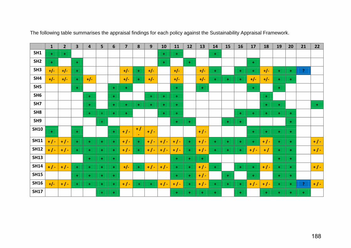
3.0 Sustainability Issues 3.1 It is a legal requirement that all local plans are subject to a sustainability appraisal
(SA). The SA for the JAAP has been carried out by Brighton & Hove City Council, and is included as a background paper.
4.0 Equality Issues 4.1 Equality issues have been considered as part of the SA for the Shoreham Harbour
JAAP. The JAAP aims to ensure that all groups have equal access to the spatial opportunities offered by the plan.
5.0 Community Safety Issues (Section 17) 5.1 Matter considered and no issues identified
23
6.0 Human Rights Issues 6.1 Matter considered and no issues identified 7.0 Reputation 7.1 The Shoreham Harbour JAAP has been prepared in accordance with Government
policy and legislation and is subject to extensive community involvement. The delivery of the strategy, policies and proposals in the plan will set a clear framework for development and the delivery of infrastructure in the regeneration area. The plan seeks to contribute to meeting the need for housing and employment floorspace in Adur and Brighton & Hove, and therefore should have a positive impact on the reputation of the Council.
8.0 Consultations 8.1 Public consultation was carried out in 2014 on the draft JAAP, and in 2012-3 on the
development briefs which have informed the plan. Consultation has been carried out in accordance with statutory requirements and the Statement of Community Involvement for each of the partner authorities. Representations received at each stage have been taken into account when developing the next iteration of the plan.
9.0 Risk Assessment 9.1 Although the Shoreham Harbour JAAP is not a statutory requirement, the council
and its partner authorities have committed to producing the JAAP through the Adur Local Plan and the Brighton & Hove City Plan Part One. Failure to do so could impact on a number of the Council’s priorities including economic and social regeneration as well as the delivery of new employment floorspace and homes (including affordable housing).
10.0 Health & Safety Issues 10.1 Matters considered and no issues identified. 11.0 Procurement Strategy 11.1 This report complies with the Procurement Strategy. 12.0 Partnership Working 12.1 The Shoreham Harbour JAAP has been prepared by the Shoreham Harbour
Regeneration Partnership. This is made up of Adur District Council, Brighton & Hove City Council, West Sussex County Council and Shoreham Port Authority.
24
1
SHOREHAM HARBOUR JOINT AREA ACTION PLAN DRAFT FOR APPROVAL OCTOBER 2016
4.8 Recreation and leisure .....................................................58
4.9 Place making and design quality ........................................62
5 Delivery and implementation .................................................134
27
2
28
3
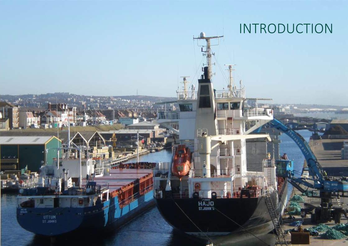
INTRODUCTION
29
4
1 Introduction
1.1 What is the Joint Area Action Plan (JAAP)?
The Shoreham Harbour Joint Area Action Plan (JAAP) is a strategy for the regeneration of Shoreham Harbour and surrounding areas. It includes proposals and policies for new housing and employment generating floorspace; and for upgraded flood defences, recreational and community facilities, and sustainable travel, environmental and green infrastructure improvements.
An area action plan is a type of local plan for an area of significant change. The JAAP sets a planning policy framework to guide development and investment decisions within the Shoreham Harbour Regeneration Area up to 2031.
The plan builds on and complements the emerging Adur Local Plan (2016) and the adopted Brighton & Hove City Plan Part One (2016). Planning applications within the regeneration area must comply with the strategy and policies in the JAAP, as well as the relevant local plan.
The plan contains:
a long-term vision, objectives and strategy for the Shoreham Harbour Regeneration Area
themed area-wide policies on:
climate change, energy and sustainable building
Shoreham Port
economy and employment
housing and community
sustainable travel
flood risk management
natural environment, biodiversity and green infrastructure
recreation and leisure
place making and design quality
proposals for seven character areas, including four allocations for new development
an outline of how the Shoreham Harbour Regeneration Project will be delivered, monitored and implemented.
1.2 Where is the Shoreham Harbour Regeneration Area?
Map 1 shows the location of Shoreham Harbour. It is between the coastal resorts of Brighton and Worthing, on the Sussex coast in southeast England. The harbour is around 55 miles from London and 30 miles south of Gatwick Airport.
Map 2 shows the boundary of the regeneration area. It stretches around 3 miles from the Adur Ferry Bridge in Shoreham-by-Sea through to Hove Lagoon. It is bounded to the north by the West Coastway railway line, and to the south by the River Adur and the English Channel. The A259 runs east-west through the regeneration area.
Shoreham Harbour straddles the local authority boundary between Adur district (within West Sussex) and the City of Brighton & Hove. The regeneration area includes parts of Shoreham-by-Sea, Kingston-by-Sea, Southwick, Fishersgate, Portslade-by-Sea and Hove.
30
5
Map 1 - Location of Shoreham Harbour
31
6
Map 2 - Shoreham Harbour Regeneration Area
32
7
1.3 Who prepared the plan?
The plan was prepared by the Shoreham Harbour Regeneration Partnership. This is made up of Adur District Council, Brighton & Hove City Council, West Sussex County Council and Shoreham Port Authority.
The partnership also works closely with a number of other organisations. These include the Environment Agency, the Homes and Communities Agency, Highways England, Natural England and Historic England.
The plan will be jointly adopted by Adur District Council, Brighton & Hove City Council and West Sussex County Council
1.4 Why was the plan prepared?
The regeneration of Shoreham Harbour and surrounding areas is a long-standing aspiration of all the project partners. In the past, a number of proposals were put forward, and some aspects of these were delivered.
This regeneration partnership produced this plan to identify realistic, deliverable and sustainable proposals for the regeneration area. It is part of a long-term strategy to revitalise the area. It will deliver new and affordable housing and modern employment floorspace on previously developed land.
The JAAP will help to generate investment and access funding for improved infrastructure, including sustainable transport and flood defence infrastructure. It will support the safeguarding of the important function of Shoreham Port, including the importing and handling of aggregates and minerals.
The plan will promote the port as a hub for renewable energy generation, contributing to national and local carbon reduction targets. The JAAP will also promote the creation and enhancement of green infrastructure links through the area.
1.5 How was the plan prepared?
There are four stages to preparing the JAAP. The process is at currently at stage 3:
Stage 1: Information gathering, baseline analysis and identifying issues (2008 – 2012)
Stage 2: Consideration of options, developing spatial framework, preparing development briefs for areas of change (2012 – 2014)
Stage 3: Consulting on the plan, updating evidence, exploring technical issues, addressing delivery issues (2014 – 2016)
Stage 4: Publication of the proposed submission JAAP, submission to the Secretary of State for independent examination, followed by formal adoption by the councils (2017 – 2018)
33
8
1.6 How was the community involved?
Working with local residents, businesses, community and local interest groups is an important part of the plan-making process. These individuals and groups have made a critical contribution to shaping the proposals and policies in the JAAP.
As well as formal periods of public consultation, there was ongoing engagement with communities throughout the plan-making process. There is a dedicated project website and regular newsletter updates.
The Consultation Statement provides full details of the engagement work to develop the plan. The consultation process complied with statutory regulations1 and the Statement of Community Involvement (SCI) of each of the partner councils2.
1 The Town and Country Planning (Local Planning) (England) Regulations 2012 2 Adur and Worthing Statement of Community Involvement (2012); Brighton & Hove Statement of Community Involvement (2015); West Sussex Statement of Community Involvement (2012)
1.7 What is the status of the JAAP?
The JAAP is a local plan3 for the Shoreham Harbour Regeneration Area. The JAAP is part of the development plan for both Adur and Brighton & Hove. The Adur Local Plan and Brighton & Hove City Plan Part One designate the regeneration area as a broad location for change.
The councils will assess all planning applications and investment decisions within the regeneration area against the strategy, proposals and policies in the JAAP, as well as the relevant local plan.
Sections 1.8 to 1.12 set out how the JAAP relates to other policies, plans and strategies.
Once adopted. the JAAP supersedes the following policy documents:
South Portslade Industrial Estate and Aldrington Basin Development Brief (2013)
Western Harbour Arm Development Brief (2013)
Shoreham Harbour Interim Planning Guidance (2011)
3 As defined in The Town and Country Planning (Local Planning) (England) Regulations 2012. Also referred to as a Development Plan Document as defined in the Planning and Compulsory Purchase Act 2004.
1.8 European policy
Relevant European legislation includes the Strategic Environmental Assessment (SEA) Directive (2001)4. This requires assessment of the plan against environmental objectives to ensure that it is sustainable.
The Sustainability Appraisal of the JAAP meets the requirements of the SEA Directive.
EU policies5 also require plan –makers to consider the impact that proposals may have on health and equality. This applies to these protected characteristics:
gender
race
disability
age
sexual orientation
religion or belief
The Sustainability Appraisal of the JAAP meets these requirements.
4 Directive 2001/42/EC transposed into UK legislation in The Environmental Assessment of Plans and Programmes Regulations 2004 5 Transposed into UK legislation in the Equality Act 2010
Birds Directive (2009)6 plan-makers must consider the potential effects of proposals on protected sites7 .
Both the Adur Local Plan and Brighton & Hove City Plan Part One were screened for Habitats Regulations Assessment (HRA). These reports concluded that a full HRA is not required as there are no significant impacts on protected European sites.
As the proposals in this plan are in line with the local plans, the partnership and Natural England have agreed that an HRA is not needed for the JAAP. The Habitats Regulations Statement sets this out in full.
6 Directive 92/43/EEC and Directive 2009/147/EC transposed into UK legislation in The Conservation of Habitats and Species Regulations 2010 7 Special Areas of Conservation (SAC), Special Protection Areas (SPA) and Ramsar sites.
1.9 National policy
NPPF and PPG
The JAAP was prepared in conformity with the National Planning Policy Framework (NPPF) and Planning Practice Guidance (PPG)8.
The NPPF applies a presumption in favour of sustainable development. It requires local planning authorities (LPA) to assess their housing and employment space needs, and to plan positively to meet those needs.
The NPPF promotes the role of ports. This includes the importance of safeguarding capacity for landing minerals and aggregates.
The NPPF also promotes the shift towards a green economy and encourages policies that promote district level renewable energy generation and green infrastructure as set out in this plan.
Where appropriate the JAAP highlights sections of the NPPF and PPG which support the policies in the plan.
8 National Planning Policy Framework (DCLG: 2012) and Planning Practice Guidance (DCLG: 2014)
Duty to cooperate
There is a legal duty for LPAs9 to engage with each other on cross boundary issues. Engagement must be active, constructive and ongoing to make local plans more effective.
The JAAP was prepared by a partnership of local authorities working together across the boundaries. The regeneration project is jointly governed by Adur, Brighton & Hove and West Sussex councils. Joint working arrangements are set out in a Memorandum of Understanding (MoU) between the project partners.
The Duty to Cooperate Statement sets out in more detail the cross boundary engagement in the preparation of this plan.
The National Policy Statement for Ports10 was produced by the Department for Transport under the Planning Act 200811. It provides the framework for decision making on proposals for new port development.
The statement highlights the changing role of ports in relation to energy supply and generation. This includes securing energy supplies, providing facilities to support offshore renewable sites and to house power stations fuelled by biomass.
The Overarching National Policy Statement for Energy (EN-1)12 outlines the increasing importance of renewables as part of the energy mix.
10 National policy statement for ports (DfT: 2012) 11 Planning Act 2008 s. 5(9) 12 National Policy Statements for Energy Infrastructure (DECC: 2011)
UK Marine Policy Statement
The Marine Policy Statement sets out the government’s vision for ‘clean, healthy, safe, productive and biologically diverse oceans and seas’13. It is the overarching framework for preparing marine plans across the UK. These will be used for decisions affecting the marine environment.
13 UK Marine Policy Statement (DEFRA: 2011)
1.10 Sub-regional policy
Greater Brighton City Deal
The Greater Brighton City Deal was awarded by government in 2014. The city region is made up of Adur, Brighton & Hove, Lewes, Mid Sussex and Worthing.
The councils work together to prioritise economic growth. Shoreham Harbour is identified as a growth centre which will focus on environmentally driven technologies.
Coast to Capital Strategic Economic Plan
The regeneration area is within the area of the Coast to Capital Local Enterprise Partnership (LEP). The LEP is responsible for £202 million Growth Deal funding. It has awarded £9.5 million for flood defence projects and transport access improvements in the Shoreham area.
The LEP produced the Strategic Economic Plan14 in 2014. It identifies Shoreham-by-Sea as one of its key strategic locations for growth. The plan recognises the flood risk and transport constraints in delivering growth.
14 Coast to Capital Strategic Economic Plan (Coast to Capital: 2014)
Coastal West Sussex and Greater Brighton Local Strategic Statement
The Coastal West Sussex and Greater Brighton Strategic Planning Board is made up of lead councillors from Adur, Arun, Brighton & Hove, Chichester, East Sussex, Horsham, Lewes, Mid Sussex, and West Sussex councils and the South Downs National Park Authority. Through the board the councils work together to identify and manage cross-boundary planning issues.
In 2016 the councils adopted an updated Local Strategic Statement (LSS)15. This statement sets the following strategic objectives:
1 Delivering sustainable economic growth
2 Meeting strategic housing needs
3 Investing in infrastructure
4 Managing environmental assets and natural resources
15 Coastal West Sussex and Greater Brighton Local Strategic Statement (CWS&GB Strategic Planning Board: 2016)
The LSS sets nine spatial priorities for the area. Spatial Priority 1 relates to Shoreham Harbour and Shoreham (Brighton City) Airport. For Shoreham Harbour this includes:
1 Improved road access to and from the A27 and A259 and to local transport infrastructure including public transport, walking and cycling.
2 Improved flood defences.
3 Consolidated port activities in the eastern harbour arm and safeguarding sufficient capacity at mineral wharves to ensure a steady and adequate supply of minerals to meet foreseeable future demands.
Biosphere Management Strategy
UNESCO16 designated the Brighton and Lewes Downs as a Biosphere Reserve in 2014. Biospheres are defined as “sites of excellence”:
‘to balance conservation and socioeconomic development between nature and people, and to explore and demonstrate innovative approaches as learning sites for sustainable development’.
16 United Nations Educational, Scientific and Cultural Organisation
The Biosphere Management Strategy17 has three objectives. These are:
1 Nature Conservation
2 Sustainable Socio-Economic Development
3 Knowledge, Learning and Awareness
Shoreham Harbour will deliver a high quality, exemplar, mixed-use sustainable development and improved environmental quality. This includes:
a comprehensive flood defence solution
development that reduces car ownership and promotes sustainable modes of transport
improved green infrastructure and access to open spaces
provision of enhanced public realm along the river frontage
policies in the emerging Adur Local Plan and Joint Area Action Plan that recognise the need to enhance green corridors and improve ecological connectivity.
The Marine Management Organisation is preparing the South Inshore Marine Plan. This covers the south coast and tidal rivers between Folkestone and the River Dart, Devon.
Marine plans and local plans overlap between high and low water marks. The South Inshore Marine Plan includes the coastline at Shoreham Beach, and Southwick and Portslade-by-Sea. It also include the Eastern and Western Arms of the River Adur.
The plan will manage the sustainable development of marine industries such as shipping, marine aggregates, fishing and windfarms, as well as the conservation and protection of marine habitats and species.
1.11 Local policy
Both the Adur Local Plan and the Brighton & Hove City Plan Part One identify the regeneration of the Shoreham Harbour area in their strategic objectives. Both plans also contain a policy that identifies the harbour as a ‘broad location’ for future strategic development.
This plan is consistent with the local plans for both Adur and Brighton & Hove. In case of any conflict between policies in these plans and the JAAP, the most recently adopted plan will have precedence18.
18 See Section 38(5) of the Planning and Compulsory Purchase Act 2004
Adur Local Plan
Adur District Council will submit the Adur Local Plan in autumn 2016. The plan provides a strategy for development in Adur19 up to 2031. Policy 2 (Spatial Strategy) states:
“Shoreham Harbour will be the focus of a significant level of development to facilitate regeneration of the Harbour and neighbouring communities, which will be delivered through an Area Action Plan to be prepared jointly between Adur District Council, Brighton & Hove City Council and West Sussex County Council.”
Policy 8 (Shoreham Harbour) sets out the policy and priorities for each character area and states that:
“The Council will facilitate the delivery of 1,100 new dwellings within the Shoreham Harbour Regeneration Area within Adur District during the plan period to 2031.”
Policy 4 (Planning for Economic Growth) allocates land for employment generating uses in Adur up to 2031, including 16,000m2 floorspace in the part of the Shoreham Harbour Regeneration Area within Adur.
19 The plan excludes the parts of the district within the South Downs National Park.
Brighton & Hove City Council adopted the Brighton & Hove City Plan Part One in March 2016. The plan provides the overall strategic and spatial vision for the future of Brighton & Hove20 up to 2030.
Strategic Objective 6 states:
“Through joint working with Adur District Council, West Sussex County Council and the Shoreham Port Authority, maximise the potential of Shoreham Harbour for the benefit of existing and future residents, businesses, port-users and visitors through a long term regeneration strategy.”
Policy DA8 (Shoreham Harbour) sets out the policy and priorities for each of the harbour character areas and states that the JAAP process will further explore and test the delivery of:
300 new residential units within Brighton & Hove
7,500m2 net additional employment floorspace
20 The plan excludes the parts of the city within the South Downs National Park.
Minerals and Waste Plans
Shoreham Port contains a number of minerals wharves and waste management facilities. West Sussex and Brighton & Hove councils are minerals and waste planning authorities for the regeneration area.
The West Sussex Minerals Local Plan (2003) safeguards a number of wharves at Shoreham Harbour, including some sites proposed for new mixed use development in this plan. The Draft West Sussex Joint Minerals Plan (2016) seeks to safeguard sufficient capacity to ensure a steady and adequate supply of minerals whilst supporting regeneration aspirations set out in this document.
Brighton & Hove City Council, East Sussex County Council and the South Downs National Park Authority adopted the Waste and Minerals Plan in 2013. The East Sussex, South Downs and Brighton & Hove Waste and Minerals Sites Plan was submitted in 2016. The plan safeguards wharf capacity at Shoreham Harbour.
Shoreham Beach Neighbourhood Plan
In 2014, Adur District Council approved the Shoreham Beach Neighbourhood Area and designated the Shoreham Beach Neighbourhood Forum. The forum is working with the community to produce a neighbourhood plan to address issues in the area. The neighbourhood plan area is contiguous with Marine ward. This overlaps with the regeneration area at Shoreham Fort, Shoreham Sailing Club and Silver Sands.
39
14
1.12 Shoreham Harbour policy
Shoreham Harbour Flood Risk Management Guide
The partnership, working closely with the Environment Agency, produced the Shoreham Harbour Flood Risk Management Guide Supplementary Planning Document (SPD)21. This sets out illustrative concepts for an upgraded flood defence network along the Western Harbour Arm, and a summary of the cost and requirements of developers in relation to mitigating flood risk. These documents will also be used to provide information for funding applications The SPD also provides guidance for flood mitigation at the other allocations.
Shoreham Harbour Green Infrastructure Strategy
The partnership is currently preparing a green infrastructure strategy. This sets out proposals for ecological enhancements throughout the regeneration area as well as the creation of a green corridor as part of an enhanced green infrastructure network.
21 Shoreham Harbour Flood Risk Management Guide (Adur District Council, Brighton & Hove City Council: 2015)
Shoreham Harbour Transport Strategy
The Shoreham Harbour Transport Strategy22 has been prepared to support delivery of the JAAP through a programme of transport infrastructure improvements, transport services and travel behaviour change initiatives. It is supported by a technical evidence base, which is set out in the Shoreham Harbour Transport Strategy Baseline Analysis document (2014).
Shoreham Port Masterplan
SPA produced the Shoreham Port Masterplan23. Although it is not a statutory planning policy document, the plan sets the port’s future development and must be taken into account when considering new developments in or near the port. Proposals include:
22 Shoreham Harbour Transport Strategy (West Sussex County Council: 2016) 23 Shoreham Port Masterplan (Shoreham Port Authority: 2010)
the port will be an integral part of the wider regeneration plans for the area
the Eastern Arm and Canal will be the focus for future commercial port operations
some non-port related uses in the Canal will be relocated to increase port capacity
The port will become an important location for renewable energy generation
port uses in the Western Harbour Arm will be relocated and land released for other developments
the number of marina berths will be increased
the port will work with councils to make amenity and environmental enhancements
the port will maintain its role as an important source of employment opportunities both direct and indirect
This plan includes many of the proposals identified in the masterplan where relevant to the regeneration project.
This section sets out the vision, themes, objectives and strategy for the regeneration of the Shoreham Harbour area up to 2031.
The vision is to maximise the potential of the area for the benefit of existing and new residents, businesses, port-users and visitors through a long-term regeneration strategy. This will be achieved through partnership working between local authorities and Shoreham Port Autority and with local landowners to facilitate the redevelopment of key sites.
The aim is to deliver a series of appropriately located, high quality, sustainable, mixed-use developments including new housing, employment floorspace, leisure opportunities, improved public space and associated infrastructure including flood defences and transport improvements.
Shoreham Harbour vision By 2031, Shoreham Harbour Regeneration Area will be transformed into a vibrant, thriving, waterfront destination comprising a series of sustainable, mixed-use developments alongside a consolidated and enhanced Shoreham Port which will continue to play a vital role in the local economy. The redevelopment of key areas of the harbour will provide benefits for the local community and economy through increased investment, improved leisure opportunities, enhanced public realm and the delivery of critical infrastructure that will help respond positively to climate change.
Sustainable development
Sustainable development “meets the needs of the present without compromising the ability of future generations to meet their own needs”24. The planning system contributes to achieving sustainable development25. The NPPF identifies three dimensions to sustainable development:
an economic role, contributing to building a strong, responsive and competitive economy
a social role, supporting strong vibrant and healthy communities
an environmental role, contributing and enhancing the natural, built and historic environment.
Sustainable development is an overarching theme for this plan, and the local plans for both Adur and Brighton & Hove.
24 Resolution 42/187 of the United Nations General Assembly 25 NPPF (2012) paragraph 6
42
17
2.2 What are the objectives of the regeneration project?
The partnership identified nine strategic objectives to deliver the vision for Shoreham Harbour. These are set out below:
Climate change, energy and sustainable building
Local plans are legally required to include policies to ensure that development and the use of land “contribute to the mitigation of, and adaptation to, climate change”26.
Planning helps to shape places to secure radical reductions in greenhouse gas emissions, minimise vulnerability and provide resilience to the impacts of climate change. It also supports the delivery of renewable and low carbon energy and associated infrastructure27.
Shoreham Port has EcoPort status from the European Sea Ports Organisation. The regeneration partnership aims to maximise the harbour area’s potential as a hub for renewable energy.
Objective 1 – Climate change, energy and sustainable building: To minimise carbon emissions, address the challenges of climate change and create a renewable energy hub To ensure all new developments use energy and water as efficiently as possible, use energy from renewable technologies, use sustainable materials, reduce waste, incorporate innovative approaches to open space, biodiversity, and green infrastructure, encourage uptake of low carbon modes of transport and support sustainable lifestyles in existing and new areas. To maximise opportunities to deliver sustainability objectives through large-scale zero and low-carbon energy technologies to serve the harbour and wider area; particularly those that take advantage of the harbour’s coastal location. Shoreham Port will be supported in becoming an important hub for renewable energy generation for the benefit of the sub-region as well as locally.
Shoreham Port
Shoreham Port is the largest commercial port between Southampton and Dover, and the closest Channel port to London.
The port plays an important economic role in the area. Around 1,700 people are employed in the port and a further 1,000 nearby. It is an important location for the import and export of aggregates, timber, steel, oil and cereals.
Shoreham Port Masterplan sets out SPA’s strategy for the growth and development of the port. The regeneration proposals in this plan provide an opportunity for consolidating, reconfiguring and enhancing the operations of Shoreham Port.
Objective 2 – Shoreham Port: To support a growing, thriving port
To facilitate the delivery of the adopted Port Masterplan, the provision of a modernised, consolidated and sustainable port and to promote the important role of the port in the local and wider economy.
43
18
Economy and employment
Local planning authorities must plan to meet the development needs of business and support economic growth28. The proposals in this plan will contribute to providing employment space in the local area.
For Adur, an Employment Land Review (2014) identified the following land requirements for the district29:
15,000 to 20,000m2 office and research and development floorspace (use classes B1a andB1b)
35,000 to 40,000m2 warehouse floorspace (use class B8)
For Brighton & Hove, the Employment Land Review (2012) identified the following requirements for the city30:
112,240m2 office floorspace (use classes B1a and B1b)
43,430 m2 industrial floorspace (use classes B1c, B2 and B8)
28 NPPF (2012) paragraph 20 29 Adur Local Plan area (excluding parts of the district in the South Downs National Park) 30 Brighton & Hove City Plan area (excluding parts of the city in the South Downs National Park)
Objective 3 – Economy and employment: To stimulate the local economy and provide new jobs
To provide new, high quality employment floorspace and improve the business environment to support the needs of local employers. To equip local communities with the training and skills required to access existing and future employment opportunities
Housing and community
Local planning authorities must plan to meet objectively assessed needs for new housing31 and identify deliverable sites or broad locations with potential for new housing. Local plans must also include policies to deliver community infrastructure and local facilities32.
Shoreham Harbour is identified as a broad location in both the Adur Local Plan and Brighton & Hove City Plan. The proposals in this plan will contribute to delivering housing in the local area.
Adur needs 6,825 homes up to 2032)33. This is 325 homes per year. The full objectively assessed housing need cannot be met and the Adur Local Plan aims to deliver 3,609 dwellings over the plan period.
Brighton & Hove needs 30,120 homes up to 203034. This is 1,506 homes per year. The full objectively assessed housing need cannot be met and the Brighton & Hove City Plan aims to deliver 13,200 dwellings over the plan period.
Objective 4 – Housing and community: To provide new homes and contribute to meeting housing need
To address shortfalls in local housing provision through delivering new homes of a range of sizes, tenures and types, including affordable and family homes as well as associated supporting community infrastructure.
33 Objectively Assessed Need for Housing: Adur District (GL Hearn: 2016) 34 Objectively Assessed Need for Housing: Brighton & Hove (GL Hearn: 2015)
44
19
Sustainable travel
Local plans should promote development at locations that minimise trip generation and encourages the use of sustainable modes of transport35. Transport policies can support reductions in greenhouse gas emissions, as well as contribute to wider sustainability and health objectives36
The Shoreham Harbour Transport Strategy includes a programme of transport infrastructure improvements, transport services and travel behaviour change initiatives.
Objective 5 – Sustainable travel: To improve connections and promote sustainable transport choices
To promote sustainable transport choices through ensuring that new developments are well served by high quality, integrated and interconnected networks, improved pedestrian, cycling and public transport routes and seeking to reduce demand for travel by private car in innovative ways.
35 Circular 02/2013 ‘The Strategic Road Network and the Delivery of Sustainable Development’ 36 NPPF (2012) paragraph 29
Flood risk
Local plans should direct development away from areas at high risk of flooding. This is determined through the Sequential Test, and if necessary, the Exception Test37.
Both Adur and Brighton & Hove councils have carried out sequential and exceptions tests for the regeneration area. These have found the wider sustainability benefits of development at Shoreham Harbour outweigh the flood risk38. Development must be safe, without increasing the flood risk elsewhere.
Objective 6 – Flood risk: To reduce the risk of flooding and adapt to climate change
To ensure that development avoids and reduces the risks from flooding and impacts on coastal processes and that risks are not increased elsewhere as a result. To ensure that appropriate and comprehensive flood infrastructure is delivered.
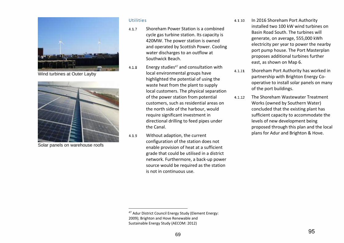
37 NPPF (2012) paragraph 100 38 Sequential and Exception Test for the Proposed Submission Adur Local Plan 2014 (Adur District Council: 2014); Brighton & Hove Sequential and Exception Tests for the Brighton & Hove City Plan Update (Brighton & Hove City Council: 2014)
Natural environment, biodiversity and green infrastructure
Local plans should contribute to and enhance the natural and local environment. Local plans should encourage the reuse of brownfield land. Local plans should include policies for the creation, protection, enhancement and management of networks of biodiversity and green infrastructure39.
Objective 7 – Natural environment, biodiversity and green infrastructure: To conserve and protect the natural environment, enhance biodiversity and create a green infrastructure network
To conserve and improve the area’s important environmental assets and wildlife habitats and to enhance the biodiversity of the area by creating new habitats. To minimise and mitigate impacts on the natural and local environment from soil, air, water or noise pollution.
To support the objectives of the Brighton & Lewes Downs Biosphere Management Strategy through the creation of green links within and beyond the harbour area, changes in the design and management of spaces to create a functioning green infrastructure network, including new green spaces and biodiverse green roofs and walls.
39 NPPF (2012) paragraphs 109; 114
45
20
Recreation and leisure
Local planning authorities should plan for recreational and leisure facilities and services to meet the needs of new development. Planning plays an important role in promoting healthy and active lifestyles. This includes the provision of open space, sports and recreation facilities40.
Local plans should also include policies to protect and enhance public rights of way and access41.
Objective 8 – Recreation and leisure: To enhance and activate the harbour for leisure, recreation and tourism and encourage active, healthy lifestyles.
To create places that promote healthy and enjoyable living by improving existing and providing new green infrastructure including open spaces and green links as well as leisure and recreation opportunities. To improve connections to and use of the waterfront, coast and beaches as attractive destinations for both locals and visitors.
Local plans should include policies that set out the quality of development expected in the area. New development should:
function well
establish a strong sense of place
optimise the potential of the site
respond to local character and history
create safe and accessible environments
be visually attractive42
Objective 9 – Placemaking and design quality: To promote high design quality and improve townscape
To promote developments of high design quality that maximise the waterfront setting, respect local character and form and enhance key gateways and public spaces.
To protect and enhance the area’s historic assets including the Scheduled Monument at Shoreham Fort, listed buildings and conservation areas.
42 NPPF (2012) paragraph 58
2.3 What is proposed in the plan?
This plan splits the regeneration area into seven character areas. These are shown in Map 3. The areas are:
CA1 South Quayside
CA2 Aldrington Basin
CA3 North Quayside and South Portslade
CA4 Portslade and Southwick Beaches
CA5 Fishersgate and Southwick
CA6 Harbour Mouth
CA7 Western Harbour Arm
Section 4 of this plan includes specific policies and proposals for each of these areas. This includes four allocations for new development. The allocations are:
SS1 Aldrington Basin
SS2 South Portslade
SS3 Southwick Waterfront
SS4 Western Harbour Arm Waterfront
46
21
Map 3 - Character areas
47
22
Map 4 illustrates the key proposals in the plan. These include:
CA1 – South Quayside
South Quayside is mostly a port-operational area. Port facilities will be safeguarded and improved.
The area also includes a waste water treatment works, power stations and renewable energy generation. These uses will be safeguarded.
CA2 – Aldrington Basin
Aldrington Basin includes a mixture of port operations, employment space and some residential areas. Port facilities will be safeguarded and improved.
The area includes proposed development at allocation SS1 – Aldrington Basin. Together, allocations SS1 and SS2 will deliver a minimum of 7,500m2 employment generating floorspace and 300 new homes.
CA3 – North Quayside and South Portslade
North Quayside is mostly a port-operational area. Port facilities will be safeguarded and improved.
South Portslade is mostly an employment area. It includes proposed development at allocation SS2 – South Portslade. Together allocations SS2 and SS1 will deliver a minimum of 7,500m2 employment generating floorspace and 300 new homes.
CA4 – Portslade and Southwick Beaches
Access to Portslade and Southwick Beaches for pedestrians and cyclist will be improved. Habitats and biodiversity will be created and protected.
CA5 – Fishersgate and Southwick
Fishersgate and Southwick include a mixture of port operations, employment space, residential areas and green space. Port facilities will be safeguarded and improved.
The area includes proposed development at allocation SS3 – Southwick Waterfront. This will deliver a minimum of 4,000m2 employment generating floorspace.
Lady Bee Marina will be expanded and improved. Green space will be improved and connected to create wildlife corridors and linear open spaces.
Improvements to existing housing estates will be supported. This includes the retrofit of energy efficiency measures.
CA6 – Harbour Mouth
Harbour Mouth includes port-operational areas, existing housing and employment space, and Kingston Beach. Port operational areas will be safeguarded and improved.
The area includes the historic buildings of Kingston Buci lighthouse and Shoreham Fort. These will be protected.
CA7 – Western Harbour Arm
Western Harbour Arm is mostly an employment area. It includes proposed development at allocation SS4 – Western Harbour Arm Waterfront. This will deliver a minimum of 1,100 new homes and 12,000m2 employment generating floorspace.
New flood defences will be built. A new waterfront route will improve connections for pedestrians and cyclists between Shoreham-by-Sea town centre and Kingston Beach. Habitats and biodiversity will be created and protected.
48
23
Map 4 - Regeneration proposals
49
24
Map 5 - Planning constraints
50
25
2.4 What are the constraints in the regeneration area?
Map 5 shows some of the main planning constraints in the regeneration area. Development and regeneration proposals need to consider these constraints.
Slipways and hards
There are several historic slipways and hards in the Western Harbour Arm area. Many of these are in a poor state of repair and are unusable for modern craft. However they are an important part of the heritage and character of Shoreham-by-Sea.
Historic buildings and conservation areas
The regeneration area includes part of the Shoreham-by-Sea Conservation Area and the Riverside section of the Southwick Conservation Area.
Shoreham Fort is a Scheduled Monument. There are three Grade II Listed Buildings:
Royal Sussex Yacht Club
Sussex Arms Public House
Kingston Buci Lighthouse
Nature reserves
The Adur Estuary Site of Special Scientific Interest (SSSI) is close to the regeneration area. The Western Harbour Arm, in particular, is within the impact risk zone for this site. Parts of the SSSI are also an RSPB nature reserve.
There are Sites of Nature Conservation Importance (SNCIs) at Shoreham Beach and Basin Road North. Shoreham Beach is also a Local Nature Reserve.
Open space
Kingston Beach is a Village Green. This safeguards the beach as a public space.
Other public open spaces include:
Fishersgate Recreation Ground
The Ham, a small recreation ground and skate park in the Western Harbour Arm area
The Garden, a pocket park at Coates Court, Southwick
The Sanctuary, a pocket park at Laylands Court, Fishersgate
The regeneration area is also close to Hove Lagoon and Vale Park.
Air quality
There are two Air Quality Management Areas (AQMAs) that are partly within the regeneration area. The Brighton & Hove and Portslade AQMA in the east. And the Shoreham AQMA in the west.
These AQMAs have been designated due to the high level of pollutants from road vehicle emissions. Each AQMA has an Air Quality Action Plan which sets out how this is managed.
Hazardous substances
There are three Health and Safety Executive (HSE) Consultation Zones in the regeneration area. These limit the types of development that are allowed close to sites where hazardous substances are handled. There is also a Development Proximity Zone at the Fishersgate site.
The South Quayside site is no longer active. Adur District Council is currently seeking to revoke the hazardous substances consent for this site
The Western Harbour Arm site will become inactive during the plan period. Adur District Council will seek to revoke the hazardous substances consent for this site at that time.
51
52
27
AREA-WIDE POLICIES
53
28
3 Area-wide policies 3.1 Climate change, energy and sustainable building
Objective 1 – Climate change, energy and sustainable building: To minimise carbon emissions, address the challenges of climate change and create a renewable energy hub
To ensure all new developments use energy and water as efficiently as possible, use energy from renewable technologies, use sustainable materials, reduce waste, incorporate innovative approaches to open space, biodiversity, and green infrastructure, encourage uptake of low carbon modes of transport and support sustainable lifestyles in existing and new areas.
To maximise opportunities to deliver sustainability objectives through large-scale zero and low-carbon energy technologies to serve the harbour and wider area; particularly those that take advantage of the harbour’s coastal location. Shoreham Port will be supported in becoming an important hub for renewable energy generation for the benefit of the sub-region as well as locally.
Section 19 (1A) of the Planning and Compulsory Purchase Act (2004) (as amended) legally requires local planning authorities to include in their plans “policies designed to secure that the development and use of land … contribute to the mitigation of, and adaptation to climate change”.
The National Planning Policy Framework (NPPF) states that:
“Planning plays a key role in helping to shape places to secure radical reductions in greenhouse gas emissions, minimising vulnerability and providing resilience to the impacts of climate change, and supporting the delivery of renewable and low carbon energy and associated infrastructure. This is central to the economic, social and environmental dimensions of sustainable development.”43
43 NPPF (2012) paragraph 93
In line with the carbon reduction targets in the Climate Change Act 2008, the National Planning Policy Framework (NPPF) states that local authorities should take a proactive approach to mitigating and adapting to climate change44.
The NPPF also states that local planning authorities should positively promote energy from renewable and low carbon sources and identify areas for renewable and low energy sources, and supporting infrastructure45.
Planning Practice Guidance (PPG) states that the inclusion of policies to contribute to the mitigation of, and adaptation to, climate change is a consideration when examining a plan for soundness46.
The harbour falls within the recently designated Brighton & Hove and Lewes UNESCO Biosphere area which promotes world class management of the environment. Shoreham Harbour is identified as a future hub for low carbon energy and decentralised energy generation.
The Coast to Capital Local Economic Partnership (LEP) and the Greater Brighton City Deal are promoting the potential for district heating networks and an eco-technology cluster at Shoreham Harbour. There is significant potential to leverage investment and resources for delivery in this area.
Sustainable building and design
The Submission Adur Local Plan (2016) includes a requirement for a Sustainability Statement to accompany development proposals within the parts of the regeneration area in Adur. Guidance is set out within Sustainability Statements Guidance Note: Shoreham Harbour.
Brighton & Hove City Plan Part One and the Sustainable Building Design Supplementary Planning Document require a Sustainability Checklist to accompany all proposals for residential new build and conversions in Brighton & Hove.
Creating an exemplar renewable energy hub
Shoreham Harbour Regeneration Partnership was awarded funding under the second wave of the government’s Eco-Towns programme in 2009 and a Capacity and Viability Study (2010) was commissioned to explore its potential to meet the programme criteria. A Shoreham Harbour and Adur District Energy Strategy (2009) and Brighton & Hove Renewable and Sustainable Energy Study (2012) have also been carried out which both highlighted the potential of the harbour to significantly contribute towards meeting the renewable energy needs of the sub-region.
Shoreham Port has European ‘Eco Port’ status and as a community trust Port is motivated to maximise its potential as a hub for renewable energy generation and waste heat distribution.
Building-related energy consumption is a significant contributor to greenhouse gas emissions. The hierarchy of demand reduction, efficient energy supply and renewable energy provision represents the most cost-effective means of reducing energy consumption and greenhouse gas emissions for new developments.
Passive design makes the best use of site orientation, building form, layout,
landscaping and materials to maximise natural light and heat, whilst avoiding overheating by providing passive cooling and ventilation.
Low and zero-carbon technologies include, but are not limited to the following:
Solar hot water
Air, ground or water source heat pumps
Biomass or biodiesel boiler, including woodchip, wood pellet or biodiesel
Biodiesel Combined Heat and Power (CHP)
Biomass CHP
Efficient gas boiler
Gas/Gas Micro CHP
Solar photovoltaic panels
Wind turbines
55
30
Potential for district heat network
As set out in Policy DA8 of the Brighton & Hove City Plan Part One, the city council is proactively encouraging opportunities that arise to incorporate waste heat or other heat sources into the heat networks for the city. The Brighton & Hove Energy Study (2013) identified the potential for district heating networks in and around Shoreham Harbour within a long list of priority areas.
New development that takes place within the long-list of priority areas will be encouraged to consider low and zero carbon decentralised energy possibilities and will be required to either connect where a suitable network is in place (or would be at the time of construction) or design systems to be compatible with a future connection to a network.
As part of the South Quayside Character Area proposals (within Section 4 of this document), there is potential to work with the existing Shoreham Power Station to deliver a district heating network to provide waste heat to local consumers.
The regeneration partnership has received funding from the Department of Energy and Climate Change (DECC) to undertake an energy masterplanning and feasibility exercise to develop this network which may end up being run by the local authorities or by an independent delivery body or an independent delivery body or Energy Service Company (ESCo).
Development should demonstrate that the heating and cooling systems have been selected in accordance with the following heating and cooling hierarchy
Connection to existing combined heat and power (CHP) distribution networks
Site wide renewable CHP
Site wide gas-fired CHP
Site wide renewable community heating/cooling
Site wide gas-fired community heating/cooling
Individual building renewable heating
Individual building heating, with the exception of electric heating
All CHP must be of a scale and operated to maximise the potential for carbon reduction. All buildings must adhere to the guidelines set out in Chapter 3 – Design – of the CIBSE Heat Networks Code of Practice for the UK.
Offshore and onshore wind power
An offshore wind generating turbine station (known as the Eon ‘Rampion’ wind farm) is under construction 13km off the Sussex coast to the south and east of Shoreham Harbour. The development will comprise up to 116 wind turbines with a gross capacity of up to 400MW. There will be potential supply chain benefits for Shoreham Harbour and the local economy.
Shoreham Port Authority has also installed two medium scale (100kw) on-shore wind turbines in the South Quayside area as an effective way of increasing renewable energy generation and reducing carbon emissions. The turbines will generate, on average, 555,000kWh electricity per year to power the nearby port Pump House.
Proposals for turbines are subject to environmental impact assessment via the planning application process.
56
31
Solar Photovoltaics
The expanse of warehouses roofs in the harbour area offer significant potential for solar PV power generation. Shoreham Port Authority has worked with Brighton Energy Cooperative to install a large number of solar panels on a number of these roofs. The project is funded by community investors buying shares in the cooperative.
There is also the potential for solar energy generation on the roofs of the Adur Homes estates at Southwick and Fishersgate. The regeneration partnership will support Adur Homes to explore these opportunities.
Sustainable use of water
Shoreham Harbour is supplied with water from the Brighton Chalk Aquifer. This is an important and heavily exploited resource. The Environment Agency has classified the location as falling within an area of ‘serious water stress’, where demand for water is high and resource availability is low.
New development at the harbour offers the opportunity to incorporate Sustainable Drainage Systems (SuDS). These can provide a range of sustainability benefits in addition to managing surface water, including enhancing biodiversity and reducing flood risk.
Water efficiency standards can help to deliver the objectives set out within both the Biosphere Management Strategy (2014-2019) and the South East River Basin Management Plan (2009). The basin plan contains an action that requires local authorities to seek the use of water efficiency standards that exceed the Building Regulations where there is local evidence to support this need.
57
32
SH1: Climate change, energy and sustainable building
1. A Sustainability Statement will be required to accompany all development proposals within Allocations SS3 and SS4 in Adur.
2. A completed Sustainability Checklist will be required to accompany all development proposals in the areas of the harbour within Brighton & Hove.
3. Development should achieve zero-carbon status (emitting no net annual carbon emissions from regulated and unregulated energy use), in particular within the four site allocations. This will include the use of passive design measures. Proposals must demonstrate good thermal performance and air tightness to prevent heat loss.
4. Developers should demonstrate how they can contribute towards Shoreham Port Authority’s objective of becoming a hub for renewable energy generation.
5. All new development will be expected to incorporate low and zero carbon decentralised energy opportunities.
SH1.1 – District heating and cooling
1. Development in areas identified in the
Shoreham Harbour Heat Network Study (2015), or subsequent update, will be expected to connect to district heating networks where they exist, or incorporate the necessary infrastructure for connection to future networks.
2. Where no heat network is in place, development must be connection ready. All buildings must adhere to the following technical specifications:
Buildings must use a centralised communal wet heating system rather than individual gas boilers or electric heating.
Buildings must allow adequate plant room space to allow for connection at a later date (the exact requirement to be agreed with the councils and their representatives).
The developer must identify and safeguard a pipe route to allow connection between the building and the highway or identified network route where available.
The developer must not in any other way compromise or prevent the potential connection.
SH1.2 – Sustainable use of water
1. All developments should seek to achieve
high standards of water efficiency and explore potential to implement measures to recycle, harvest and conserve water resources.
2. All new homes should achieve (as a minimum standard), internal water use of no more than 110 litres per head per day and all new commercial buildings should meet the BREEAM ‘excellent standard’.
3. Opportunities should be sought to link together development within the regeneration area with site-wide recycled water networks, taking advantage of the diversity of water sources and uses on-site. This process will be supported by the local authorities.
4. Where a recycled water network is delivered on-site, all buildings are required to connect (where it is feasible and viable to do so).
58
33
3.2 Shoreham Port
Objective 2 – Shoreham Port: To support a growing, thriving port
To facilitate the delivery of the adopted Port Masterplan, the provision of a modernised, consolidated and sustainable port and to promote the important role of the Port in the local and wider economy.
Shoreham Harbour contains the entirety of the working Trust Port of Shoreham. Since 1760 the Shoreham Port Authority has had responsibility for operating and managing Shoreham Port. The continued existence of a thriving and expanding commercial port is an integral part of the regeneration proposals
As a Statutory Harbour Authority, Shoreham Port Authority is responsible for the management of navigational safety within harbour limits between Hove Lagoon, the Old Toll Bridge on the River Adur and the outer Port limits. Shoreham Port Authority is also a Competent Harbour Authority within the provisions of the Pilotage Act 1987.
Shoreham Port Authority provides conservancy and a vessel information service for ships and craft using the port, including the maintenance of navigational channels, moorings, lights and the provision of hydrographic, tidal and other information. There are also a number of byelaws which govern operations and activities within the harbour limits.
The current level of use at Shoreham Port is 700 to 900 ship arrivals per year, which results in a trading throughput of approximately 1.8 to 2 million tonnes per year. The main commodities that are imported and exported at the Port are aggregates, timber, scrap metal, cereals, oil and increasingly steel. The Port Masterplan (2010) aims to provide the capacity for a 25% increase in trade by 2026.
The port is a significant local employer providing around 1,700 jobs. Employers range from large multinationals such as Cemex, national firms such as Travis Perkins through to a variety of small and medium sized firms including motorbike repairs and cheese suppliers. Delivery of the proposals identified in the Port Masterplan have the potential to create a further 500 local port-related jobs.
59
34
Land restrictions are an obstacle to growth within the port. It is therefore important to maximise the productivity of the existing port land. The JAAP aims to do this by focusing commercial port activity at the Eastern Arm and Canal, and by ensuring that vacant and underused sites are used to their full potential.
Non-port related industries currently located within the Eastern Arm at the Canal will be relocated, in order to expand the port’s capacity and secure future operations. In parallel, current port-related activities in the Western Harbour Arm will be relocated where and when possible through securing alternative sites within the harbour, enabling the land to be used for other developments.
Port Masterplan
Shoreham Port Authority’s strategy for growth is set out in the Port Masterplan (2010) and involves consolidating port-related uses within the Eastern Arm, Canal and South Quayside. The JAAP aims to promote the Port Masterplan’s objective of enhancing the Port’s role in the local community, particularly in terms of jobs and trade growth.
Eco-Port Status and Renewable Energy Hub
Shoreham Port Authority has an environmental policy and has ‘Eco-Port’ status, shared with other ports in Europe. The port uses a substantial amount of power which is needed for lighting on the terminals, operating the lock gates and water pumps which are used to keep the water at a constant level. Opportunities are being explored to reduce the reliance on traditional forms of energy by producing energy locally from renewable sources instead.
Adapting to Climate Change
In accordance with the National Ports Policy Statement (2012), new port infrastructure will typically be long-term investments which will need to remain in operation over many decades, in the face of a changing climate. Consequently, proposals for new development must consider the impacts of climate change when planning the location, design, build and operation of new port infrastructure.
Land Reclamation and Infilling
Previous development proposals for the harbour have included the reclamation of land out to sea on the south side of South Quayside, however the costs of implementation were considered to be prohibitive in the short to medium term. Whilst large scale land reclamation is not considered viable, it has been proposed on a limited scale within the canal, including at Britannia Wharf, as well as at Albion and Turberville Wharves, where it is hoped to increase the overall capacity and efficiency of the site.
Permitted Development Rights
Shoreham Port Authority has permitted development rights for certain types of development within the harbour meaning that planning permission from the local planning authority is not required. These rights are set out within the Shoreham Harbour Acts and also reflected within the General Permitted Development Order (GPDO) 2015; Part 17, Development By Statutory Undertakers, Class B (Dock, Pier, Harbours, Water transport, canal or inland navigation undertakings).
60
35
Minerals Wharfs
Minerals wharf capacity at Shoreham Harbour makes a significant contribution to meeting the needs for aggregate imports in to the sub-region. Most of the wharf capacity is contained within the Eastern Arm and Canal, but there are two wharves within the Western Harbour Arm (Free Wharf and Kingston Wharf also known as Railway Wharf East) that are currently safeguarded under Policy 40 of the West Sussex Minerals Local Plan (2003).
The NPPF provides protection to mineral wharves, stating that local planning authorities should safeguard existing, planned and potential wharfage for bulk transport of minerals, secondary materials and marine- dredged aggregates (paragraph 143).
Policy WMP 15 of the East Sussex, South Downs and Brighton & Hove Waste and Minerals Local Plan (2013) safeguards existing, planned and potential minerals wharf facilities and their consequential capacity for receiving and processing sea-borne imported aggregates at the Shoreham Port. The policy does allow for some redevelopment of wharves if overall capacity is maintained at the harbour. It is recognised that this capacity could be in the West Sussex portion of the harbour.
East Sussex County Council, the South Downs National Park Authority and Brighton & Hove City Council are currently updating their Local Aggregates Assessment which investigates the demand for and supply of aggregates in the minerals planning authorities’ area. Early indications are that the use of marine-won aggregates in the area is greater than previously thought. The implication is that maintaining sufficient wharf capacity at Shoreham Harbour will be important in order to maintain the supply of aggregates.
West Sussex County Council and the South Downs National Park Authority have also undertaken a Local Aggregate Assessment. This recognises the importance of wharf capacity at Shoreham Harbour for meeting both West Sussex’s needs and beyond.
The regeneration partnership is exploring how best to deliver the safeguarded sites policies at Shoreham Harbour to protect the overall wharfage capacity at the port whilst maintaining flexibility over which sites can contribute to meet aggregate needs.
There are several larger safeguarded sites within the heart of the port operational area that are actively used to discharge aggregates which offer unused capacity and therefore potential to mitigate the loss of wharves elsewhere in the port. In addition to this, in peak years the port is able to temporarily accommodate greater capacity in the port operational area on sites which are not currently safeguarded within the West Sussex Minerals Local Plan (2003).
In autumn 2013 work restarted on the preparation of a new West Sussex Joint Minerals Local Plan, to replace the 2003 Plan, with the commissioning of a Wharves and Railheads Study. The study, completed in November 2013, provided a range of scenarios. Further work, as set out in background paper April 2016, to support the Draft Joint Minerals Local Plan, set out the options considered and the preferred option. West Sussex County Council included relevant policies to safeguarded sites within the emerging Joint Minerals Local Plan.
61
36
The East Sussex, South Downs and Brighton & Hove Waste and Minerals Plan (2012) includes Policy WMP 15 which safeguards the overall mineral capacity in ports subject to no net loss of capacity rather than safeguarded individual sites. The plan states (paragraph 4.50) provision of equivalent capacity (tonnage) within either part of Shoreham Port maybe acceptable subject to future safeguarding by West Sussex County Council.
In accordance with the emerging minerals local plans and the NPPF any applications for alternative development proposals on safeguarded minerals wharves or adjacent sites will need to clearly demonstrate that there will be no net loss to capacity for the import of aggregates at the port as a result of the proposals.
In accordance with the NPPF Shoreham Port Authority will continue to work closely with local minerals planning authorities in preparing their annual Local Aggregate Assessment based on a rolling average of 10 years sales data, other relevant local information and an assessment of all supply options (including marine dredged, secondary and recycled sources).
West Sussex County Council has prepared a Statement of Common Ground (2016) between the project partners, and the neighbouring minerals planning authorities (East Sussex County Council and South Downs National Park Authority) to establish cooperation and collaboration between the parties in addressing strategic cross-boundary issues as they relate to planning for minerals infrastructure and their safeguarding at Shoreham Port. The Statement sets out matters of agreement and commitment to a future policy approach, reflecting the aspirations for regeneration at the harbour.
62
37
SH2: Shoreham Port
1. New development proposals within the port area will be assessed against the objectives of the Port Masterplan, which will be treated as a material consideration.
2. Parts of the harbour as identified within this plan will be safeguarded for port operational uses and will be the focus for commercial port activity. Non-port related activities will be resisted in those areas.
3. Acceptable uses will need to demonstrate the requirement for a port-side location or are ancillary to a use requiring a port-side location.
4. Sui generis uses appropriate to a port-side industrial location will also be acceptable provided they generate comparable levels of employment to B1-B2 classes.
5. New development within the harbour area should not conflict or unreasonably constrain the day to day operations and workings of the port and port-related uses.
6. Proposals in the vicinity of port operational areas should give careful consideration to health and safety implications in relation to access to the waterfront and to the security of moorings and storage areas. Security and safety implications should be considered at the outset and discussed with Shoreham Port Authority at an early opportunity.
7. Proposals for uses that support the port’s status as an ‘Eco port’ and hub for renewable energy generation will be encouraged.
8. New port infrastructure proposals should consider the impacts of climate change when planning the location, design, build and operation of new port infrastructure.
9. Proposals for the upgrade, intensification, and refurbishment of sites so they meet modern business standards and are more resource efficient will be supported.
10. There should be no net loss of employment floorspace in port operational areas as a result of new development proposals unless exceptional circumstances apply
63
38
3.3 Economy and employment
Objective 3 – Economy and employment: To stimulate the local economy and provide new jobs
To provide new, high quality employment floorspace and improve the business environment to support the needs of local employers. To equip local communities with the training and skills required to access existing and future employment opportunities.
The development of the harbour area is a long-term aspiration. In the short to medium term (5-10 years) it is essential to ensure that the initial phases of development do not compromise the operations of businesses on sites which are unlikely to come forward until later in the process. The regeneration partnership is committed to continuing a process of dialogue to ensure mutually appropriate development as and when sites come forward.
The JAAP proposals have been prepared in line with consideration of their impacts on the local economy. A preliminary Economic Impact Assessment (GL Hearn, 2013) has been undertaken which has indicated that the proposals could generate a significant net increase in employment and additional economic output. The proposals will also promote increased supply chain opportunities, with the new business base created by the proposals potentially supporting further indirect job creation in the local economy.
Whilst the proposals will result in overall losses of employment land footprint as land is redeveloped for other uses, the profile of the new employment space that is created and retained will support the objectives identified in the Brighton & Hove and Adur Employment Land Studies, particularly by:
Renewing older and poor quality industrial stock and delivering quality workshop and industrial space to meet the needs of key creative/digital industries as well as emerging high-tech manufacturing and environmental technologies sectors.
Expanding Adur’s under-developed office market through the provision of new office accommodation and thus supporting growth in higher value-added sectors.
Providing an opportunity to deliver small, affordable, start-up office space for which there is a continuing need in Brighton.
64
39
Proposals that incorporate initiatives and opportunities to secure apprenticeships, training and new job opportunities for the local area will be encouraged. As part of planning obligations associated with major development schemes developers may be required to contribute towards the provision of good quality employment and training opportunities during construction.
The regeneration partnership will continue to work with key stakeholders and local service providers to improve access and links to training and skills opportunities for local people. The Coast to Capital Local Enterprise Partnership (LEP) have produced a Skills Strategy (Skills for Growth, 2015) which identifies the need for improved employee skills across the LEP area. The Partnership will proactively engage with the LEP on this matter.
65
40
SH3: Economy and employment
1. The JAAP proposals support the delivery of a minimum of 16,000m2 of new employment generating floorspace in Adur and 7,500m2 in Brighton & Hove.
2. To prevent the loss of employment floorspace and associated jobs in the local area, the authorities will aid the relocation of existing occupiers displaced by new development within the regeneration area, district or sub-region depending upon individual requirements.
3. Prior to sites coming forward for redevelopment to alternative uses, planning permissions for continuation of current employment uses may be granted for temporary periods on a case-by-case basis.
4. New development will be required to contribute to the improvement of the local highways network and public realm to improve the street environment for local businesses.
5. Proposals should seek to incorporate or contribute towards enhancements to areas of public realm identified as being of poor quality.
SH3.1 – Retail uses
1. As part of mixed-use redevelopments, small-scale, ancillary retail uses are acceptable provided that such activity will assist in enlivening key frontages and supporting existing retailing areas. Proposals should be appropriate and complementary in relation to Shoreham-by-Sea town centre and the existing district centre designation on Boundary Road / Station Road.
2. New development for town centre uses (other than small-scale ancillary uses mentioned in i. above) outside of the defined town centre boundary (or Primary Shopping Area in the case of retail uses) will be assessed in accordance with the National Planning Policy Framework sequential and impact tests. An impact test will be required for any proposed retail development outside of the Primary Shopping Area with a net sales floorspace of 1,000m2 or more.
66
41
3.4 Housing and community
Objective 4 – Housing and community: To provide new homes and contribute to meeting housing need
To address shortfalls in local housing provision through delivering new homes of a range of sizes, tenures and types, including affordable and family homes as well as associated supporting community infrastructure.
Both Adur and Brighton & Hove are geographically constrained by the sea and by the South Downs National Park to the north. Most of the remaining green space is protected through environmental designations, to prevent coalescence of settlements and for its recreation and amenity value. As a result, there is a limited supply of sites where new homes can be built and therefore development mainly consists of building on previously developed (brownfield) sites and small scale infill sites. Despite this, the demand for new homes continues to grow creating a challenge for local authorities in identifying new sites.
Housing needs assessments for both Adur and Brighton & Hove have identified a shortfall in housing provision in relation to need, in particular affordable and family sized homes. Supporting the delivery of new housing areas is central to the vision of transforming the harbour into an attractive waterfront community. The JAAP will support the regeneration of a number of brownfield sites which have been identified as suitable for residential development, balanced with the protection of key employment sites in other parts of the harbour.
Social and community infrastructure
To ensure the regeneration of Shoreham Harbour promotes healthy, sustainable communities, it is important that appropriate and sufficient social and community infrastructure is provided in accessible locations to serve all parts of the community. An increase in population in the area will place pressure on existing facilities and create the need for new infrastructure provision.
The plan aims to contribute towards reducing the inequalities experienced by different groups within the community and the Partnership recognises the special needs of younger people, older people, disabled people, lesbian, gay, bisexual and trans people and black and minority ethnic people, gypsies and travellers, refugees and asylum seekers and people of different religions and beliefs. The needs of these groups will be taken in to account in providing and improving community facilities and services.
67
42
To create a community that is a healthy, cohesive and promotes active lifestyles for all members of the community, developments will be encouraged to works towards ‘Lifetime Neighbourhood’ principles. Lifetime Neighbourhoods aim to achieve the following outcomes:
An environment that is accessible and inclusive, aesthetically pleasing and safe (in terms of both traffic and crime)
A community that offers plenty of services, facilities and open space
A strong social and civic fabric, including volunteering and informal networks
A culture of consultation and user empowerment amongst decision makers
A strong local identity and sense of place
Brighton & Hove has recently committed to becoming an ‘Age-Friendly’ City (World Health Organisation) which encourages active ageing by optimizing opportunities for health, participation and security in order to enhance quality of life as people age. Developments are encouraged to ensure that the features of Age-Friendly Cities are embedded within the design and layout of new proposals from the outset.
Social infrastructure refers to emergency services, schools and colleges, health facilities, community spaces and cultural venues in the area.
Specific items of supporting infrastructure that will need to be delivered for Shoreham Harbour are set out within the Infrastructure Delivery Plans (IDPs) that accompany the Adur Local Plan and Brighton & Hove City Plan Part One.
These are live documents that are continuously updated and identify the range of different stakeholders that are responsible for delivery as well as associated costs, funding sources, priorities and progress.
Specific requirements relating to delivery of the Western Harbour Arm proposals are set out under 4.7 – Western Harbour Arm.
The Brighton & Hove IDP sets out specific requirements to support the proposed increase in residential population at South Portslade Industrial Estate and Aldrington Basin. In particular planning obligations towards education and health/medical services will be sought from new developments coming forward.
The Proposed Submission Adur Local Plan (2016) includes Policy 34: Planning for Sustainable Communities that resists the loss of existing community facilities. Also refer to SH17: Planning obligations towards infrastructure delivery in this plan.
68
43
SH4: Housing and community
1. Sites identified for residential-led redevelopment should contribute a minimum of 1,400 new homes across the harbour by 2031, comprising 1,100 within Adur and 300 within Brighton & Hove.
2. Developers will be required to ensure that proposals deliver a mixed and balanced community through providing a mix of dwelling types, sizes and tenures in accordance with identified local needs including suitable family accommodation. A mix of apartments and terraced town houses would be appropriate across all tenures.
3. New residential development will be expected to make provision for a mix of affordable housing, including social rented, affordable rented and intermediate housing in accordance with local plan policies.
4. Developers are encouraged to work towards the principles of Lifetime Neighbourhoods and incorporate Age-Friendly Cities features.
SH4.1 – Co-location of residential and employment generating uses
1. Residential development in close proximity to existing or proposed employment activities and port uses must be carefully designed and incorporate appropriate mitigation measures to prevent future conflicts arising and maintain the continued operation of business uses.
2. Innovative solutions to mitigation will be encouraged to ensure that residential-led development proposals are capable of existing with neighbouring uses, as well as the long-term development scenario envisaged in the JAAP.
69
44
3.5 Sustainable travel
Objective 5 – Sustainable travel: To improve connections and promote sustainable transport choices
To promote sustainable transport choices through ensuring that new developments are well served by high quality, integrated and interconnected networks, improved pedestrian, cycling and public transport routes and seeking to reduce demand for travel by private car in innovative ways.
Transport improvements will be required to support the JAAP proposals and reduce the impact of existing and future traffic congestion and related air quality and noise impacts, in particular the impacts on the two Air Quality Management Areas (AQMAs). Measures that reduce reliance on the private car and improve sustainable transport choices will be promoted.
The Shoreham Harbour Transport Strategy was developed alongside the JAAP to support regeneration and development at Shoreham Harbour. The Transport Strategy contains a package of integrated transport measures that will guide the provision of transport infrastructure for the next 15 years.
The strategy takes a balanced view of transport provision in the regeneration area focusing on improvements to the existing road network and measures to encourage the use of sustainable modes of transport. Five key outcomes are identified in the Transport Strategy:
OC1 Reduced levels of congestion
OC2 Strengthened sustainable transport mode share
OC3 Improved connectivity
OC4 A safe and attractive environment
OC5 Adequate parking provision and controls
The coastal settlement pattern of the regeneration area is linear with most of the key roads connected by the A259 which runs east to west through the Shoreham Harbour area. The A259 carries secondary and local traffic from Littlehampton and Worthing to Brighton and Hove.
The A27 provides the strategic inland route taking much of the through traffic; however there is a significant volume of local traffic along the A259 including heavy goods vehicles.
70
45
Access to the main operational port area is via two main entrances off the A259 which are not well connected to the A27. The advisory lorry route to Shoreham Harbour from the A27 is via the A293. As a result heavy goods vehicles often pass through either residential areas (via the advisory routes) or the town centres of Shoreham-by-Sea and Portslade.
Vehicular access to Shoreham Beach to the south of the harbour is restricted to a single entry point from the A259 (Brighton Road).
At peak periods journey times for vehicles on the A259 are slow, for example Shoreham High Street. As a gateway to the regeneration area the A259 will be required to facilitate development traffic and provide access to local services, and reducing congestion on this key route is therefore essential to the regeneration proposals.
The Adur Local Plan & Shoreham Harbour Transport Study (2013) and addendums (2014; 2016) assessed the impact of proposed housing and employment development at Shoreham Harbour on the highway network. It proposes a package of mitigation measures which will reduce the impact of development and encourage a shift in travel patterns to sustainable modes of transport. This package consists of sustainable transport measures, behaviour change initiatives and junction capacity improvements.
Examples of behaviour change initiatives include travel plans, car sharing schemes, encouraging shared car ownership, and cycle training. This study is part of the evidence base for the Shoreham Harbour Transport Strategy and development proposals will be expected to contribute towards the package of measures identified.
Public transport accessibility to the harbour is generally good with four local railway stations on the West Coastway line serving most of the population within a 20 minute walk.
Despite good accessibility, the railway line acts is a physical barrier to north – south movements for other road users. Capacity constraints on the Brighton Main Line and West Coastway have been identified by Network Rail as significant challenges facing this part of the rail network.
There are frequent buses along the A259. However, north-south movements are limited due to the road layout and severance created by the A259 and roads running under the railway line. In addition, there is scope to improve public perception of the bus network.
Shoreham Harbour is well served by pedestrian infrastructure; however the environment for pedestrians is considered to be poor and unattractive in places, and may not encourage short walking trips. In places the network is narrow, in poor condition, close to road traffic or poorly lit. The railway line and A259 both act as barriers to pedestrian movements causing severance.
71
46
Two key pedestrian routes connect across the harbour - the Adur Ferry Bridge from Shoreham-by-Sea town centre to Shoreham Beach and the harbour lock gates to Southwick Beach. Whilst both are well used, up until recently neither of these has offered a high quality pedestrian environment. The Adur Ferry Bridge now provides a much improved pedestrian and cycle connection between Shoreham Beach and Shoreham-by-Sea town centre and railway station.
To the east, the Brighton & Hove seafront provides a heavily used promenade for pedestrians and cyclists and a series of recreational activities. This ends abruptly at Hove Lagoon immediately to the east of Shoreham Harbour.
Southwick Beach and Carats Cafe act to some extent as destinations that help draw people to walk along the eastern part of the harbour and across the lock gates from Southwick. There is a significant opportunity to improve the quality of this experience. There are also opportunities to create visitor destinations around Shoreham Fort on Shoreham Beach and the lighthouse on Kingston Beach.
Parking
Guidance produced by West Sussex County Council states that car parking provision for residential development should: take account of the expected levels of car ownership; ensure high quality of design; make efficient use of land. The guidance outlines that expected levels of car ownership and demand should be determined taking account of the type, size and tenure of the proposed development.
Brighton & Hove standards currently outline maximum levels of parking, however it is anticipated that new guidance will put a priority on minimising off-street car parking provision in accessible locations.
Due to the constrained nature of strategic development sites at Shoreham Harbour, innovative approaches to parking will be required. The Transport Strategy identifies a localised approach to car parking provision such as using appropriate parking controls and the use of car clubs
72
47
SH5: Sustainable travel
1. New development in the regeneration area must demonstrate how it intends to reduce the need to travel by car and should help to deliver sustainable transport improvements as identified in the Shoreham Harbour Transport Strategy.
2. Development will be required to contribute towards implementation of the area-wide Travel Behaviour Change and Travel Choice Programme set out in the Shoreham Harbour Transport Strategy.
3. The layout and streetscape of the strategic allocations should be designed to give pedestrians and cyclists priority over vehicular traffic wherever possible.
4. Developments will be required to contribute towards the delivery of transport infrastructure which reduces congestion and increases the use of sustainable transport modes. Specific measures are identified in the Transport Strategy including junction capacity improvements, improvements to bus and rail infrastructure and better cycling and pedestrian routes and facilities.
5. Improvements should focus on the following priority corridors and seek to minimise the impact of traffic, including HGV’s, on surrounding communities:
A259
A283
A293
6. To improve the connectivity of the regeneration area, development proposals must provide or contribute towards the delivery of a comprehensive and well integrated transport network with strong linkages to town / district centres, the harbour waterfront / coastline, the South Downs, access routes and surrounding neighbourhoods. Specific network improvements for these supporting links are identified in the Transport Strategy.
7. Proposals that incorporate facilities and/ or initiatives to promote the use of the river as a means of transport, such as provision of pontoons and additional moorings will be encouraged.
8. Improvements must be consistent with recommendations in the Shoreham Harbour Streetscape Guide and Shoreham Harbour Transport Strategy.
SH5.1 – Parking
1. Car parking provision will be considered as part of the overall package of measures that impact on the need to travel resulting from the development. Proposals should include adequate levels of car parking for residential development or measures to promote lower levels of car ownership.
2. For commercial development, car parking provision should be in line with local authority maximum standards.
3. The amount of surface and on-street car parking should be minimised wherever possible and innovative solutions to the provision of car and cycle parking are encouraged as informed by the Transport Strategy. Measures could include the creation of new car clubs or the extension of existing car clubs, by providing additional vehicles in appropriate locations and access to membership, to cover the regeneration area.
4. All new development proposals will be required to provide adequate, appropriate and secure cycle storage facilities.
73
48
3.6 Flood risk
Objective 6 – Flood risk: To reduce the risk of flooding and adapt to climate change
To ensure that development avoids and reduces the risks from flooding and impacts on coastal processes and that risks are not increased elsewhere as a result. To ensure that appropriate and comprehensive flood infrastructure is delivered.
Parts of the regeneration area are at a high risk of flooding due to the proximity to the coastline and the River Adur, exacerbated by the low lying topography of some sites. This is especially true for the Western Harbour Arm, parts of Aldrington Basin, Southwick and Portslade beaches as well as the port operational area.
Tidal flooding presents the most significant risk to the area. The Adur & Worthing and Brighton & Hove Strategic Flood Risk Assessments identify a number of sites located within Tidal Flood Zones 2, 3a, 3b and Non-functional Flood Zone 3b. This latter category recognises that some sites have the same risk of tidal flooding as Flood Zone 3b but do not have a significant storage or conveyance potential which materially impacts flood risk elsewhere. In addition to this tidal flood risk, some areas are also affected by fluvial and surface water flooding.
Working closely with the Environment Agency, the partnership has prepared a Flood Risk Management Guide SPD which sets out the types of flood risk present in the harbour area, the vision for a comprehensive flood defence network along the Western Harbour Arm and the requirements of developers in relation to mitigating flood risk in the regeneration area. This guide has been adopted by both Adur and Brighton & Hove councils. A key consideration of the SPD is the impact that climate change will have on rising sea levels, storm frequency and storm magnitude.
Brighton & Hove City Council, in partnership with Adur District Council and the Environment Agency have produced the Brighton Marina to River Adur Coastal Strategy Study. This document examines how the stretch of coastline between Brighton Marina and the River Adur (up to the Canal lock gates in Southwick) will change over the next 100 years. This includes identifying erosion and flood mitigation measures that need to be delivered over this period.
74
49
Proposed flood defence improvements identified in this strategy would enhance the standard of protection for allocated sites identified in this plan, such as Southwick Waterfront and Aldrington Basin. The proposals identified in the strategy are therefore fully supported by the Partnership. A similar strategy, The Rivers Arun to Adur Flood and Erosion Management Strategy (2010) has already been adopted by DEFRA. This strategy includes a large part of the River Adur taking in the Western Harbour Arm.
The NPPF highlights the need to direct development away from areas at highest risk of flooding (thereby avoiding the risk in the first instance), but where development is necessary, ensuring it will be safe without increasing the risk of flooding elsewhere.
Refer to policies in Part 3 of this plan which identify the site-specific flood defence and mitigation measures required within the character areas. Development in the Western Harbour Arm in particular will be required to deliver significant flood risk mitigation infrastructure.
75
50
SH6: Flood risk
1. Development proposals in the regeneration area must comply with the recommendations of the Shoreham Harbour Flood Risk Management Technical Guide (2015).
2. Where development creates new or alters flood flow routes, the site specific Flood Risk Assessment must assess the potential flood hazard posed by them to ensure that flood risk is not increased elsewhere.
3. Proposals should demonstrate how the risks of surface water run-off and water pollution have been reduced including through the introduction of Sustainable Drainage Systems (SuDS) and water capture/recycling technology. SuDS must also be applied to hard landscaping (including paving and road carriageways).
4. New developments must incorporate open space, appropriate planting, green roofs and/or green walls (suitable for coastal growing conditions) to reduce levels of surface water run-off and consequent risk of flooding.
5. Proposals which seek to provide basement parking in tidal/fluvial flood zones will only be acceptable where adequate mitigation and emergency planning are included as part of the planning application.
6. Proposals must include an emergency strategy to ensure the safety of residents at times of flooding.
76
51
3.7 Natural environment, biodiversity and green infrastructure
Objective 7 – Natural environment, biodiversity and green infrastructure: To conserve and protect the natural environment, enhance biodiversity and create a green infrastructure network
To conserve and improve the area’s important environmental assets and wildlife habitats and to enhance the biodiversity of the area by creating new habitats. To minimise and mitigate impacts on the natural and local environment from soil, air, water or noise pollution.
To support the objectives of the Brighton & Lewes Downs Biosphere Management Strategy through the creation of green links within and beyond the harbour area, changes in the design and management of spaces to create a functioning green infrastructure network, including new green spaces and biodiverse green roofs and walls.
The regeneration area falls within the Brighton & Hove and Lewes Biosphere (UNESCO). As such the JAAP aims to contribute towards meeting its three objectives of:
Nature conservation
Sustainable socio-economic development
Knowledge, learning and awareness
New development within the harbour is expected to be outstanding from an environmental perspective and all opportunities to promote biodiversity need to be considered. It is possible to significantly reduce negative impacts of development on the ecology of an area through mitigation measures. Any potential wildlife habitats that will be lost or negatively impacted as a result of development will need to be compensated for and enhanced wherever possible.
The Shoreham Harbour Ecology and Green Infrastructure Study (2015) identifies the potential impacts of development proposed within this plan. It also updates previous ecological surveys and proposes green infrastructure improvements.
Designated sites and biodiversity
In accordance with the NPPF and with Biodiversity 2020: A Strategy for England’s Wildlife and Ecosystem Services, it is essential that any development in the harbour takes into account the sensitivities of the local environment and protects and enhances it wherever possible.
Located just outside the regeneration boundary to the west, is the Adur Estuary, a Site of Special Scientific Interest (SSSI) of particular ecological significance for its inter-tidal mudflats. It also contains one of the few saltmarsh habitats in West Sussex.
The Adur Estuary is an important habitat for a range of species, including estuarine plants and wading birds (particularly redshank, dunlin and ringed plover). The ringed plover population regularly exceeds 1% of the total British population, making the SSSI of national importance for this species.
77
52
The entire regeneration area is within the Impact Risk Zone (IRZ) for the Adur Estuary SSSI. An IRZ provides an initial assessment of potential risks to an SSSI posed by development proposals. Allocation SS4: Western Harbour Arm Waterfront is most likely to impact the SSSI. Consultation with Natural England is expected for these sites.
The eastern end of Shoreham Beach Site of Nature Conservation Importance (SNCI) falls within Character Area 6: Harbour Mouth. A large part of the SNCI is also designated as a Local Nature Reserve (LNR) whose boundary is adjacent to the regeneration area. The site’s main interest is coastal vegetated shingle, an internationally rare and threatened habitat. It also provides a high tide roosting area for wading birds that have fed on the mudflats within the Adur Estuary.
Basin Road South SNCI is located at the eastern end of the regeneration area, adjacent to Allocation SS1: Aldrington Basin. This site is also designated for coastal vegetated shingle. The Shoreham Harbour Vegetated Shingle Assessment (2015) found that the site is predominantly made up of imported material and has undergone periods of disturbance.
The Basin Road South SNCI is 1.1ha in size. The assessment found the extent of vegetated shingle to be 0.43ha (39%) concentrated along the northern and southern fringes. The status of this site will be reviewed through the Brighton & Hove City Plan Part Two. The partnership is working to identify opportunities for coastal vegetated shingle habitat creation at Portslade and Southwick Beaches.
The Shoreham Harbour area as a whole is of regional importance for passage bird species and is of county importance for wintering birds as a result of the sheltered nature of the site. The area is also of local importance for breeding birds. It will be important to consider the impacts of increased recreational activities as a result of new development at the harbour on these sensitive areas.
A Reptile Survey (2009) has indicated the presence of an exceptional population of common lizards and a good population of slow worms on the North Canal Bank on the harbour’s Eastern Arm, south of the A259. A Great Crested Newt Pond Survey (2009) concluded that due to a general lack of ponds and standing water bodies within the area, there is a negligible risk of impacts on this protected species as a result of the proposals.
Green infrastructure and wildlife corridors
There are a number of strategically important green corridors in and around the harbour area including the nationally important routes of the South Downs Way and the Monarchs Way long distance footpath. As highlighted in both the recent Adur District Council and Brighton & Hove City Council open space strategies; the beaches, foreshore and wider seafront area act as a blue/green corridor supporting a broad diversity of species. Other local links include:
National Cycle Route 2 along the coast links Shoreham with Worthing to the west and Brighton to the east. Between Shoreham-by-Sea town centre and the Canal lock gates at Southwick this route is diverted inland to avoid the busy A259. It is anticipated that the proposed pedestrian/cycle route along the waterfront at the Western Harbour Arm, and a designated A259 cycle route could create a more direct route.
78
53
By 2020, Natural England expects to deliver the England Coast Path, a new National Trail around England’s entire coast. The Partnership is working with Natural England to progress this project. It is anticipated that the new and improved routes at the Western Harbour Arm, Canal lock gates and Portslade and Southwick Beaches will ultimately form part of this route.
Regional cycle route 79 (12) following the Adur River valley connects Horsham to the south coast at Shoreham.
Within Brighton & Hove, there are three north-south corridors providing important wildlife links and some public access between the harbour and the South Downs:
Southwick Hill down to Fishersgate– public access throughout although very narrow in parts of the urban area
Foredown Hill to Vale Park in South Portslade – series of green spaces with intermittent public access
Benfield Valley linking the downs to Old Shoreham Road with consistent public access
The Shoreham Harbour Ecology and Green Infrastructure Study (2015) makes a number of proposals to enhance the green infrastructure and biodiversity of the harbour and surrounding areas. These include:
The preparation of a green infrastructure strategy for the regeneration area and links to surrounding areas.
A259 green corridor. The study identifies fourteen green spaces located along the A259. These act as a series of ‘stepping stones’ for wildlife. These sites include designated spaces such as Kingston Beach village green, but also the embankments between the A259 and the port, and the grassed amenity spaces around the Adur Homes estates at Southwick and Fishersgate. The Partnership is working with Adur Homes, Action Eastbrook and local communities to deliver improvements to these sites. Specific proposals are included within each character area policy in Section 4 of this plan. Further detail will be included in the Shoreham Harbour Green Infrastructure Strategy.
Portslade and Southwick Beaches green corridor. The Shoreham Harbour Vegetated Shingle Assessment identified significant potential for coastal vegetated shingle habitat creation along these beaches. Habitat creation could be delivered as part of improvements to coastal defences and through the delivery of the England Coast Path and improved cycle route along the beaches.
Linear intertidal habitat creation. The study identifies opportunities to deliver habitats as part of new flood defences along the waterfront. This includes timber baulking and ‘vertical beaches’ attached to sheet piling.
Green roofs and walls. These could compensate for the loss of open mosaic habitats at ground level on vacant or unused sites. These should be appropriately planted for the coastal location, including vegetated shingle.
79
54
New development at the harbour should act as a catalyst to enhance green corridors and linkages, particularly where higher density developments result in limited opportunities to provide open space on site.
The national cycle network provides a valuable basis from which to extend greenways in this location to better connect Shoreham to urban areas such as Hove, Lancing and Worthing. Proposals for improving this route are set out within the Shoreham Harbour Transport Strategy.
Other recommendations from green infrastructure assessments in relation to biodiversity include:
Enhance and create new open spaces and habitats at locations such as Shoreham Fort and Shoreham (Kingston Buci) Lighthouse with improved access linkages for visitors.
Consider and improve wildlife corridors wherever a new green corridor is developed or enhanced as part of the new development.
The role of parks, allotments, school playing fields, private residential gardens and cemeteries in providing valuable green corridors and wildlife habitats should be recognised in this area.
Protect the species rich grasslands beside the harbour and integrated grassland into new areas of waterfront open space where possible
Building designs should incorporate green roofs and areas of planting wherever possible.
Existing open spaces and parks would benefit from more wildlife planting and a varied mowing regime.
Water quality
The overall groundwater quality of the Brighton Chalk Aquifer is currently classified as “poor” and the chemical status is classified as “good (deteriorating)”. The overall water quality of the Adur Estuary is classified as “moderate” and chemical quality is “good”.
The Water Framework Directive requires all bodies of water (including surface water, coastal waters and groundwater) to achieve “good” status by 2015 and the quality of all water resources needs to be protected.
The Environment Agency monitors the quality of bathing water at Southwick Beach. Since 2009 water at this location has achieved “higher” status. This means that bathing water meets the criteria for the stricter guideline
standards of the revised Bathing Water Directive.
Air Quality
Road vehicles are the greatest contributing factor to poor air quality in Adur and Brighton & Hove, with vehicles emitting a variety of pollutants including carbon monoxide, nitrogen oxides, volatile organic compounds and particulate matters.
There are two Air Quality Management Areas (AQMAs) that lie partly within the regeneration area. Brighton AQMA includes Kingsway / Wellington Road (A259) Church Road (A293), Boundary Road / Station Road (B2194) and parts of South Portslade to the south of North Street.
Shoreham AQMA runs along Shoreham High Street (A259) from Norfolk Bridge to Surry Street. Nearby, there is also an AQMA in Southwick on the A270 between Kingston Lane and Southview Close.
Air Quality Action Plans (AQAPs) will continue to play a key role in helping to manage issues of localised air pollution.
80
55
Noise
Noise can be a significant issue in built-up urban areas, and can act as both a disturbance and a threat to human health. DEFRA has undertaken a comprehensive noise mapping study, the results of which indicate that there are parts of the regeneration area where road traffic noise exceeds World Health Organisation guidelines.
The main generator of background noise in the Regeneration area is road traffic. The A259, A293 and B2194 have high levels of noise pollution related to traffic movements with noise levels decreasing with distance from these roads.
Rail-related noise is also an issue in some parts of the regeneration area with levels decreasing with distance from the railway line. Some of the industrial and port-related land uses in the regeneration area also generate high levels of noise.
Contamination
The nature of current and historic industrial activities at Shoreham Harbour raises significant potential for contamination to be present, which could adversely impact site users, buildings and the environment, including surface and groundwater quality. Pollution to controlled waters may result in contravention of objectives set out within the Water Framework Directive (WFD).
Former land uses have included Portslade Gas Works, oil storage, and coal and timber yards. Current uses also include coal and timber yards, as well as a power station, aggregate sorting and storage sites, garages, oil and petrol storage areas, a waste water treatment facility and other waste uses. Consequently, significant risks of pollutant linkages have been found in the area.
It will be important for development proposals to undertake the necessary risk assessments in line with best practice approaches and Code of practice (BS 10175, 2011), the British Standard for Investigation of potentially contaminated sites.
Waste and recycling
In keeping with the objectives of the Biosphere Management Strategy (2014-2019). It is important that the JAAP supports the shift towards sustainable management of waste and seeks to ensure waste is fully considered during design, construction, post-construction and demolition phases of new development.
Brighton & Hove City Council, East Sussex County Council and the South Downs National Park Authority, have adopted a Waste and Minerals Plan (2013) that provides planning policies to guide the management of waste and production of minerals over the plan period to 2026.
West Sussex County Council and the South Downs National Park Authority have adopted a West Sussex Waste Local Plan (2014). The Waste Local Plan covers the period to 2031 and provides a basis for making consistent land-use decisions for waste management facilities.
81
56
SH7: Natural environment
1. The Partnership will prepare a green infrastructure strategy for the regeneration area and its surroundings.
2. The partnership will work with stakeholders, developers, landowners and communities to deliver an improved green infrastructure network including:
A259 green corridor improving and connecting improvement sites alongside the road, including embankments and grassed amenity space
Portslade and Southwick Beaches including coastal vegetate shingle habitat creation
Intertidal habitat creation, including baulking and vertical beaches as part of flood defence works.
Green walls and roofs, and appropriate street planting.
3. The partnership will promote and require the creation and enhancement of open space and green infrastructure in accordance with the emerging Shoreham Harbour Green Infrastructure Strategy and Brighton and Lewes Downs Biosphere objectives.
4. All development must ensure no net loss, and seek to provide a net gain to biodiversity, in particular to Habitats of
Principal Importance (formerly known as BAP habitats). The indirect impacts of development, such as recreational disturbance, on designated nature conservation sites and other significant habitats must be considered. Appropriate mitigation must be identified, along with the means for its delivery and maintenance.
5. The Shoreham Harbour Streetscape Guide (2012) states that all vegetation must be salt tolerant and suitable for a coastal environment. Trees must be securely staked, hardy and able to withstand strong winds
6. Development proposals will be required to include schemes to conserve, protect and enhance existing biodiversity and to create appropriate habitats, taking into account appropriate, coastal protected sites and species. Measures to enhance biodiversity include, but are not limited to:
Incorporating green walls and roofs and appropriate planting schemes for the location, using locally native species wherever possible.
Providing bird-nesting and bat-roosting boxes.
Providing areas of vegetated shingle.
Using SuDS to create wetland habitat features, which help store and clean surface water.
Creating, restoring or enhancing off-site habitats, in particular through contributions to management and monitoring plans for, local conservation sites such as Shoreham Beach and Widewater Lagoon Local Nature Reserves.
82
57
SH7.1 – Water quality
1. Development must protect groundwater quality and to ensure only clean surface water is discharged into the River Adur.
2. All development will be expected to incorporate appropriate Sustainable Drainage Systems (SuDS) and demonstrate how surface water run-off will be minimised. Development should seek to provide ecological enhancements through the use of SuDS.
3. All development must consider implications upon the sewerage network and ensure that capacity is adequate. New development must connect to the sewerage system at the nearest point of adequate capacity. Where this is not the case, appropriate contributions will be required to upgrade the network.
SH7.2 – Air quality
1. Air quality impacts should be considered at an early stage in the design process to ensure that creating new exposure to poor air quality is avoided.
2. Development within or adjacent to an Air Quality Management Area (AQMA), or that is likely to have an impact on an AQMA, will be required to provide a contribution towards implementing Air Quality Action Plan objectives, such as sustainable transport improvements.
3. Proposals will be required to demonstrate that appropriate mitigation measures are introduced to ensure that new and existing residents are not exposed to poor air quality.
SH7.3 – Noise
4. Development proposals should adhere to the following basic principles of noise control - Noise sources should be separated from sensitive receptors. Then noise should be controlled at source. Finally, the sensitive receptor should be protected.
5. Particular consideration will be required in relation to noise generated by transport and arising from adjacent industrial, trade and business premises, construction sites, activities in the street and on-going port and marine-related activities.
SH7.4 – Contamination
1. Applications for development within a 10 metre radius of potentially contaminated sites will be required to submit a risk assessment.
2. Assessment of contamination should not be limited to site boundaries as contamination can migrate beyond the proposed site development through soil, water and air.
SH7.5 – Waste and Recycling
1. All development proposals will be required to incorporate facilities that enable and encourage high rates of recycling and re-use of waste and materials.
2. All new development will be required to demonstrate that waste is minimised both during the construction phase and the lifetime of the building.
3. Development proposals shall be accompanied by a Site Waste Management Plan
83
58
3.8 Recreation and leisure
Objective 8 – Recreation and leisure: To enhance and activate the harbour for leisure, recreation and tourism and encourage active, healthy lifestyles.
To create places that promote healthy and enjoyable living by improving existing and providing new green infrastructure including open spaces and green links as well as leisure and recreation opportunities. To improve connections to and use of the waterfront, coast and beaches as attractive destinations for both locals and visitors.
Beaches and water sports
The public beaches play a significant role in the provision of amenity space in the harbour for residents and visitors. They provide recreational and leisure opportunities as well as providing landscape, environmental and biodiversity benefits.
Some of the beaches, such as Southwick Beach, Shoreham Beach and, to a lesser extent, Kingston Beach are well used for traditional seaside activities (walking, swimming, sunbathing and fishing). In addition, Southwick Beach is well used by surfers when conditions are right, whilst the Shoreham Beach area is well used by windsurfers and kite surfers. Paddle boarding is becoming an increasingly popular sport for coastal areas. Currently, facilities for these users do not exist, other than car parking facilities.
The harbour is also home to Shoreham Rowing Club located next to the Lifeboat Station on Kingston Beach. The Partnership is currently working with the Rowing Club to supports its redevelopment to provide a new, expanded, modern facility.
Sailing and facilities for boat-users
The harbour is home to a number of sailing facilities including:
Lady Bee Marina (Southwick Waterfront)
Riverside Yard (Southwick Waterfront)
Sussex Yacht Club (Western Harbour Arm / Southwick Waterfront)
Shoreham Sailing Club (Harbour Mouth)
Shoreham Rowing Club (Harbour Mouth)
All five areas have a strong leisure and recreation function with the first three providing berthing opportunities for larger vessels. These three currently have capacity for around 120 pontoon berths although access is a constraint to further pontoon capacity. Shoreham Port Authority is seeking to increase berthing capacity at Lady Bee Marina.
Whilst there is good provision of uses in and around the regeneration area, access is constrained in some places, and some facilities are in poor condition in need of replacement, improvement or re-provision.
84
59
Slipways and Hards
There are a number of historic slipways and hards in the Shoreham area. These were formerly used to launch and land boats onto and from the water. However most of these are now unable to function effectively for various reasons such as having been in-filled, being too steep, being dilapidated or being inaccessible and lacking sufficient parking and turning areas for trailers.
West Sussex County Council, working in partnership with Adur District Council and the Shoreham Slipways Group, are working towards providing new and improved public slipways for the Shoreham area. These new facilities will help support the local economy through enabling visting anglers, divers and day boat users to access the harbour. The enhanced access to the water will help to restore Shoreham’s maritime heritage.
A key planning consideration for locating a new public slipway is the need for sufficient appropriately laid out parking and turning areas for vehicles and trailers to manoeuvre.
Pedestrian Routes
Strategic routes for rural walkers are concentrated in the South Downs and stop at the outskirts of built up areas. Currently these do not connect well into the town centres and to the sea. Walking routes in the urban areas of the regeneration area are not well designed and signage is poor. footbridge has significantly improved the quality of the pedestrian environment in that area.
The pedestrian network running east to west along the majority of the regeneration area north of the coast / waterfront is limited to the path that runs along the A259 and as such currently offers a very poor experience for cyclists and pedestrians.
Cycle Paths
The Sustrans national cycle route (No. 2) runs through the harbour from Hove Lagoon, along the southern section of the canal (the South Quayside area) across the canal locks, then runs inland to re-emerge in Shoreham-by-Sea. It then crosses over Adur Ferry Bridge and continues on to the seafront to the west. This route links Brighton in the east and Worthing in the west and is part of a long distance cycle route from Dover to Penzance.
The section from Hove Lagoon to Brighton in the east and Shoreham Beach to Worthing in the West is almost entirely ‘traffic-free’ with dedicated cycle paths. The section in between that runs through the harbour area is classified as ‘on-road’, with no dedicated cycle facilities. This route is well used by cyclists for leisure and recreation. It is also a popular commuting route for cyclists, although a high number of commuters use the A259 from the lock gates in Southwick as this is the quickest and most direct course.
85
60
In addition, the harbour area has good cycling links to the South Downs in the north. The ‘Downs Link’ Bridleway that runs along the river Adur from Ropetackle to the South Downs is a key cycling and pedestrian link which connects Shoreham with the South Downs and which continues up to the North Downs in Surrey. However, signage to this route from the town centre is poor. Other routes to the South Downs from the regeneration area are also poorly signposted.
Open Space
Provision of new and enhanced areas of open space will be essential to creating a pleasant harbourside environment. Multi-functional open spaces provide a range of health benefits and and can create pleasant new spaces for people to sit, relax and interact helping to build a sense of community and identity for the harbour.
The NPPF requires that planning policies should be based on robust, up-to-date assessments of local needs for open space, sports and recreation facilities and opportunities for new provision.
The Adur District Open Spaces Study was updated in 2014 which has provided open space provision standards for the district.
For Brighton & Hove, open space standards are set out within the Open Space Update Study (2011).
86
61
SH8: Recreation and leisure
1. Development proposals will be required to provide high quality public open space / green infrastructure on site. The type and quantity of open space will be determined by the scale and type of development, the identified needs of the area and local standards.
2. Brighton & Hove City Council and Adur District Council will work with developers to explore the role, function and more detailed design of green spaces as they come forward. These areas could help to meet local need for a range of open spaces including parks and gardens, amenity green space, provision for children and young people, outdoor sports facilities, allotments and community gardens.
3. Improved linkages to existing open space assets and green corridors will be encouraged.
4. In accordance with local plan policies, the loss of existing open space will be resisted unless it has become surplus to requirements or would be replaced with equivalent or improved provision in a suitable location. In the case of any loss of open space, mitigation measures include, but are not limited to:
Better access to remaining open space.
Provision of an alternative site.
Significant enhancements to remaining open space including features to improve open access to the waterfront.
5. Major waterfront development schemes, are expected to incorporate features that improve open access to the waterfront. These may include facilities for boat users, additional moorings, floating pontoons/docks, slipways and inlets. Early consultation with Shoreham Port Authority and statutory bodies such as the Environment Agency and Marine Management Organisation is advised.
6. Development schemes that result in the loss of an existing slipway or hard and that fail to incorporate a new useable slipway (with sufficient parking/turning space) on-site may be expected to contribute towards re-provision of the facility off-site.
7. Where a new/improved slipways or hards are provided or reinstated it will be necessary to consult with the relevant highway authority to ensure appropriate public highway status is recorded including rights of motor vehicle use.
8. Where additional moorings are provided consideration must be given to the management of additional waste and sewage arising. Appropriate services, such as toilets, should be provided where appropriate.
87
62
3.9 Place making and design quality
Objective 9 – Place making and design quality: To promote high design quality and improve townscape
To promote developments of high design quality that maximise the waterfront setting, respect local character and form and enhance key gateways and public spaces.
To protect and enhance the area’s historic assets including the Scheduled Monument at Shoreham Fort, listed buildings and conservation areas.
High quality urban design is an integral element of successful developments. Good design encompasses architectural design, form, height, scale, siting, layout, density, orientation, materials, parking and open space. New developments should be well-designed and integrated into the landscape and townscape, and should contribute positively to the harbour’s character and distinctiveness. Existing poor-quality design should not set a precedent.
Improvements to the public realm (streets and public spaces) provide an opportunity to enhance the quality, character and distinctiveness of the harbour. Good use of ‘natural surveillance’, natural and artificial light and careful siting of buildings and street furniture can improve the layout of an area, reduce perceived and actual crime and opportunities for anti-social behaviour, and make an area more pleasant to use.
Lighting is an important element of design quality; whilst necessary for safety reasons it can also add character and highlight elements of architectural quality. However, it is also important to ensure that light shines on its ‘target’ and does not waste energy or contribute to ‘sky glow’.
Shoreham Harbour benefits from a number of historic assets which are proposed to be protected and enhanced to contribute towards maintaining the cultural history of the area and visual interest within the landscape and local views. The harbour area includes:
Parts of the Shoreham-by-Sea Conservation Area
The Riverside section of the Southwick Conservation Area.
Three Grade II Listed Buildings
Royal Sussex Yacht Club
Sussex Arms Public House
Kingston Buci Lighthouse)
Shoreham Fort (Scheduled Monument).
88
63
SH9: Place making and Design Quality
1. Schemes should be designed to reflect the character of the marine environment and should be sensitive to views of the waterfront, surrounding landscape and historic features.
2. Waterfront development schemes are encouraged to incorporate features that improve public access, views and experience of the marine environment. This may be externally in the form of landscaped viewing areas and/or internally as an integral part of building design.
3. Major development proposals may be subject to design review process at the pre-application and application stages in order to ensure the highest quality of design.
4. Development proposals should improve the quality, accessibility, security and legibility of public streets and spaces. The public realm elements of the development proposals must be designed in accordance with the Shoreham Harbour Streetscape Guide (2012).
5. Where appropriate contribution will be sought for the provision of public art, in accordance with the scale of development proposed.
6. All development proposals will be expected to embrace principles of good urban design with reference to the following characteristics:
High standards of architectural design and detailing.
Suitable scale and massing in relation to housing type and local context, including townscape character and historic environment.
Appropriate internal and external space standards in accordance with each authority’s policy requirements.
Buildings should provide strong enclosure to public spaces and streets, and should maintain a clear distinction between public, semi-private and private space.
High standards of private amenity space for all residential development, including private balconies, terraces, gardens and shared courtyards as appropriate.
Careful consideration of the the impact of new development on access to daylight and sunlight for both existing and new residents.
7. The Partnership will work with its partners and other stakeholders to conserve and enhance the harbour’s historic assets.
89
90
65
CHARACTER AREA PROPOSALS
91
66
SOUTH QUAYSIDE
92
67
Map 6 – CA1 - South Quayside
93
68
4 Character area proposals
4.1 CA1 - South Quayside
Area priorities
To support Shoreham Port Authority in improving operational efficiency, developing new trade and exploring opportunities for sustainable energy generation, in line with the adopted Port Masterplan.
To accommodate the relocation of existing port operators from elsewhere within the port.
To accommodate the future capacity requirements for Shoreham Wastewater Treatment Works.
To improve Basin Road South as a popular recreational route for walking and cycling, providing access to the beaches.
With the exception of the existing and planned power stations, and the wastewater treatment works, non-port operations will not be permitted in this area.
About the area
CA1 - South Quayside is the main operational area of Shoreham Port. It is a long, narrow area between Basin Road South and the waterfront. The area stretches from the mouth of the harbour along the southern side of the Eastern Arm of the River Adur, and the Canal as far as the eastern ship turning head.
The full length of South Quayside is 2,370 metres. Within the Canal, there are 11 berths totalling 1,575 metres in length. In the Eastern Arm of the River Adur, the Outer Layby terminal extends further with two berths of 257 metres. There is a significant concentration of port trades and quayside activity.
In the quayside area, cargo handling and ship unloading are carried out using mobile cranes and lift trucks. Plant installations used by operators include a major aggregates grading and handling plant, a ready-mix concrete plant and gantry cranes at a steel stockyard.
Visiting fishing trawlers and other vessels often moor up alongside the power station. There are a number of security gate entry points to the port area, and the area north of Basin Road South is a secure area with no public access.
The regeneration strategy for the harbour is dependent on consolidating port-related activities within the Eastern Arm and Canal. South Quayside will be safeguarded for port operational uses. As well as improving operating efficiencies for the port, it will enable waterfront land to be redeveloped for alternative uses along the Western Harbour Arm.
South Quayside is sufficiently removed from residential areas that it can accommodate activities and uses that otherwise might harm residential amenity through noise and disturbance. Major facilities likely to remain for the timespan of the plan period include Shoreham Power Station and Shoreham Wastewater Treatment Works.
94
69
Wind turbines at Outer Layby
Solar panels on warehouse roofs
Utilities
Shoreham Power Station is a combined cycle gas turbine station. Its capacity is 420MW. The power station is owned and operated by Scottish Power. Cooling water discharges to an outflow at Southwick Beach.
Energy studies47 and consultation with local environmental groups have highlighted the potential of using the waste heat from the plant to supply local customers. The physical separation of the power station from potential customers, such as residential areas on the north side of the harbour, would require significant investment in directional drilling to feed pipes under the Canal.
Without adaption, the current configuration of the station does not enable provision of heat at a sufficient grade that could be utilised in a district network. Furthermore, a back-up power source would be required as the station is not in continuous use.
47 Adur District Council Energy Study (Element Energy: 2009); Brighton and Hove Renewable and Sustainable Energy Study (AECOM: 2012)
In 2016 Shoreham Port Authority installed two 100 kW wind turbines on Basin Road South. The turbines will generate, on average, 555,000 kWh electricity per year to power the nearby port pump house. The Port Masterplan proposes additional turbines further east, as shown on Map 6.
Shoreham Port Authority has worked in partnership with Brighton Energy Co-operative to install solar panels on many of the port buildings.
The Shoreham Wastewater Treatment Works (owned by Southern Water) concluded that the existing plant has sufficient capacity to accommodate the levels of new development being proposed through this plan and the local plans for Adur and Brighton & Hove.
95
70
Transport and connections
Heavy goods vehicles serving the port, as well as the public, access this area via the main port entrance at the junction of Wharf Road and Kingsway (A259). Basin Road South runs the length of the southern side of the port along the seafront to Carat’s Café and the adjacent public car park.
To the western end of the quayside and forming the crossing over to the north side of the harbour, the area around the lock gates is a key functional part of the port. Shoreham Port Authority has reclaimed a small area of land here by the pump house to accommodate a new engineering base.
As outlined in Character Area 4, the lock gate crossing is a public right of way and part of the National Cycle Route (NCN2). Running parallel with the cycle route along Basin Road South is the Monarch’s Way which is part of a long distance national walking trail. The route is popular with locals and cyclists and has the potential to be made more of a focal point with better signage, interpretation and way-finding.
Proposed improvements to both Southwick Waterfront and to the beach areas are likely to increase public usage of this area and it will be important to maintain appropriate buffers between the operational port areas and public spaces.
96
71
SH10: South Quayside
1. South Quayside is safeguarded for future commercial port activity and for the relocation of existing port operators from elsewhere in the harbour. With the exception of the existing and proposed power stations, and waste water treatment plant, non-port operations are not permitted in this area.
2. South Quayside will be promoted as a hub for renewable energy generation, including appropriately located solar and wind generation.
3. Wastewater treatment infrastructure will be safeguarded to serve future population changes.
4. The partnership will seek improvements to the lock gate crossing for the benefit of pedestrians and cyclists. These must not detract from its primary port operational function.
5. The partnership will seek Improvements to Basin Road South, National Cycle Route (NCN2) and Monarch’s Way public right of way including signage, interpretation, boundaries, surfacing, way finding and access to the beaches.
97
72
ALDRINGTON BASIN
98
73
Map 7 - CA2 - Aldrington Basin
99
74
4.2 CA2 – Aldrington Basin
Area priorities
To designate a strategic employment/mixed-use area (Allocation SS1 – Aldrington Basin).
To accommodate a mix of new and improved port operational facilities as well as compatible non-port employment generating floorspace (use classes B1, B2 and B8).
To accommodate appropriately located mixed-use development (use classes A1, A2, A3, B1 and C3).
To secure improvements to legibility, permeability and connectivity through high quality building design, townscape and public realm; respecting and complementing the character of surrounding areas.
To maximise intensification and redevelopment opportunities of existing lower grade, vacant and under-used spaces.
To ensure that all development takes into account the findings and recommendations of current Strategic Flood Risk Assessment and the Shoreham Harbour Flood Risk Management Guide SPD (2015).
To ensure that new development proposals take account of noise and air quality impacts and that improvements are sought wherever possible.
To enhance biodiversity by creating and improving habitats and improved green infrastructure links, including a green corridor along the A259.
To support the delivery of the England Coast Path through the Aldrington Basin area.
About the area
CA2 – Aldrington Basin forms the eastern gateway to the harbour with the main port entrance at the junction of Wharf Road and Kingsway (A259). The basin is situated immediately adjacent to Hove Lagoon. It marks the end of the Hove seafront promenade and a transition to the industrial character of Shoreham Harbour.
The northern part of the area is formed of a steep slope from Basin Road North, up to Kingsway (A259). Overlooking the basin, to the north of Kingsway, is the West Hove residential area comprised of mostly two storey housing built in the 1920s and 1930s.
Since the mid-1800s, Aldrington Basin has been predominantly occupied by industrial and port-related uses. Over time, a number of physical interventions such as land reclamation, the addition of landing stages and wharves and the arrival of the Western Esplanade residential dwellings at the beginning of the twentieth century, have shaped its current character.
This area contains a mixture of employment uses ranging from offices,
100
75
retail outlets, a restaurant and pub at Kingsway level through to light industrial, storage and marine-related uses down in the basin itself. Some of the sites are owned and leased by Shoreham Port Authority including Hove Enterprise Centre, Brighton & Newhaven Fish Sales, and Quayside offices. The remaining sites are in private ownership.
The steep slope down to the basin from Kingsway means the location is able to accommodate land uses and activities that may otherwise harm residential amenity due to noise, smell, dust or other disturbance. Maritime House and Hove Enterprise Centre contribute towards meeting the local demand for affordable, flexible workshop and office space and have high occupation rates.
A key consideration for development in the basin is that the eastern end of the Canal acts as the main turning head for ships. The shape of the current turning area means there is no opportunity for infilling any of the basin to increase waterfront space. Remodelling of this area may be a long term opportunity. This would require significant investment.
Harbour entrance at Wharf Road
View east towards Western Esplanade
View west from Aldrington Basin
Transport and connections
Refer to the Shoreham Harbour Transport Strategy for details of the package of measures proposed to support the development of this allocation.
Improve Junctions
Although the access route from the A259 in to the basin works relatively well, it creates a tight turning circle for commercial vehicles. The transport strategy includes junction improvements to each of the main accesses in to the port from the highway, including:
Wellington Road (A259) – Church Road (A293) – Basin Road North
Shoreham Port Authority intends to upgrade and extend the route on the north side of the canal from the existing mini-roundabout linking to an improved Wellington Road (A259)-Church Road (A293) junction. This is to make the route more suitable for HGV traffic and to lead port-traffic more directly on to the advisory route.
101
76
Improve Basin Road South cycle route and Monarch’s Way
Basin Road South runs parallel to South Quayside provides vehicular access to the main operational port areas. It also forms part of the National Cycle Network (NCN2) which runs along Wharf Road and Basin Road South before crossing the lock gates. NCN2 will eventually connect many of the urban areas along the south coast. Despite the poor condition of this route for cycling and walking, the poor quality of the public facilities and generally dated appearance, it remains a popular route and the beaches are frequented by local families, swimmers, surfers and artists particularly during the summer months.
The road is also a public right of way which forms the end of the historic Monarch’s Way route, a long distance footpath (990km) that approximates the escape route taken by King Charles II in 1651 after being defeated in the Battle of Worcester. There is considerable potential to improve the quality of this route through a comprehensive landscaping upgrade and interpretive signage.
Improve connections with Hove Lagoon and Hove seafront
Hove seafront promenade ends at Hove Lagoon. This area is very popular for walking, cycling and general recreation and there are a range of water-sports offered at Hove Lagoon. The Hove Deep Sea Anglers Club is adjacent.
Beyond this point is a row of secluded 1920s residential properties on Western Esplanade overlooking private beaches. This, combined with the industrial character of the harbour, acts as a barrier for wayfinding between Hove Lagoon and seafront and Portslade and Southwick beaches to the west.
The transport strategy includes proposals to improve the cycling and walking routes through this area. Where sites and groups of sites come forward, opportunities to create direct public or semi-public access to the waterfront should be explored.
New signage, and improved visual and physical access from Aldrington Basin to Hove Lagoon would help to soften the boundaries of the basin and could be achieved through relatively minor interventions in formal landscape and site layout of Hove Lagoon. This connection could be achieved through the development of pathways and crossings to achieve direct, safe access.
Natural England will deliver the England Coast Path, a new National Trail around the coast of England. Although the final route has not yet been decided, it is expected that this will pass through CA2 – Aldrington Basin between Portslade Beach and Hove seafront promenade.
102
77
Environment
Kingsway (A259), Wharf Road and Basin Road North fall within the Brighton & Hove Air Quality Management Area (AQMA) designated in 2013.
The area is crossed by several underground water mains and sewers (the latter conveying wastewater to the nearby waste water treatment works). This infrastructure needs to be protected and new development needs to ensure its operation remains unaffected.
Flood risk management
Due to its elevated position, sites along the A259 Kingsway are not at a significant risk of flooding. For sites between the A259 Kingsway and the coast, there is a risk of tidal flooding. The Brighton & Hove Strategic Flood Risk Assessment (JBA: 2012) identifies most of the Aldrington Basin area as Flood Zone 2 and 3a with some small areas of Flood Zone 3b for tidal flooding. The estimated maximum flood depth for this area for the 1:200 year tidal event is 0.50m, with some areas estimated to flood to a depth of just 0.20m.
The risk associated with this form of flooding increases significantly when sea level rise associated with climate change is factored in. In this scenario, maximum estimated flood depths increase to about 1.4m with increased flood velocities. Development in this location will need to take this flood risk constraint into consideration.
Developers should include SuDS and building level resistant and resilience measures as part of proposals, ensuring development is safe for its intended lifetime. the approach set out in the following publications (or subsequent replacement documents):
The embankments sloping up from Wharf Road and Basin Road North to Kingsway (A259) form part of the proposed green corridor through the regeneration area. The partnership will promote green infrastructure improvements in these areas through the emerging Shoreham Harbour Green Infrastructure Strategy. Development in this area will be expected to take these aspirations into consideration.
The Wharf Road embankment, adjacent to Hove Lagoon, is a prominent location at the main eastern gateway to the harbour. The partnership will seek landscape and ecological improvements such as planting of native hedgerows, plug planting of suitable species and the enhancement of the existing butterfly bank. Appropriate public art will also be encouraged
The Basin Road North embankment extends east from the Boundary Road/Station Road junction. The partnership will seek improvements such as planting of native hedgerows and plug planting of suitable species
Wharf Road embankment and Hove
Lagoon from Kingsway
Basin Road North embankment
Development opportunities
The release of sites for redevelopment in and around the basin requires careful management given the close proximity of port operations and residential areas at Western Esplanade and to the north of Kingsway.
The partnership will work with businesses and service providers to identify their needs and overcome barriers to growth in order to improve the basin as a modern thriving local business cluster. As shown on Map 8, key proposals for this area include the following:
104
79
Strategic employment area
Employment generating uses (use classes B1, B2 and B8) will remain the predominant land use within Aldrington Basin. The partnership will work with land owners to promote the redevelopment of sites to deliver better quality, modern accommodation. Key opportunity sites are as follows:
Site A (see Map 7) is bounded by Basin Road North and Basin Road South, opposite Hove Lagoon:
Opportunities to develop the under-used plots to the north of Newhaven & Brighton Fish Sales for modern fit- for-purpose employment space will be encouraged.
The redevelopment of other plots in the immediate vicinity will also be promoted where modern, high quality new employment floorspace can be delivered.
Sites B, C and D (see Map 7) are on the southern side of Basin Road North:
Ferry Wharf (site B) could be developed to provide modern, employment floorspace suitable for compatible uses such as environmental technologies.
The Shoreham Port Authority-owned Hove Enterprise Centre (site C) is a successful operation supplying flexible workspace and will be safeguarded in its current use throughout the plan period.
The other plots south of Basin Road North (site D) may also be appropriate for redevelopment for modern, good quality employment space. These will be safeguarded for employment and port related uses.
Mixed-use development
New mixed-use development is promoted on plots between Basin Road North and Kingsway (site E on Map 8). Proposals must demonstrate that they are compatible with existing employment uses at the basin level.
Plots between The Gather Inn to the east and Ocean Sports Board Riders to the west could be redeveloped for a mix of uses with employment floorspace (use class B1) on lower storeys fronting Basin Road North and mixed-employment (use classes A1, A2, A3 and B1) fronting Kingsway and residential apartments (use class C3) on upper storeys.
105
80
Development form and typology
The following principles for development form are proposed:
For new employment floorspace at the basin level, flexible employment uses are proposed arranged as two to three storey buildings on under-used plots.
Mixed employment and residential uses with a dual frontage onto Kingsway (residential/mixed commercial activities of up to four storeys above Kingsway) and Basin Road North (employment uses).
Buildings in the basin itself should be simple and flexible with a contemporary appearance and character in keeping with the aesthetic of the harbour.
New buildings should be of a modern design which complements the existing historic character.
106
81
SH11: Aldrington Basin
1. Aldrington Basin is designated as a strategic employment/mixed use area – (Allocation SS1 – Aldrington Basin).
2. The partnership will work with developers and stakeholders to deliver approximately 300 new dwellings and 7,500m2 of new employment floorspace (in combination with SS2: South Portslade). The partnership will support the redevelopment of sites to deliver high quality, modern employment floorspace and appropriately located residential dwellings.
3. At the basin level, plots bounded by Basin Road North, Basin Road South and the Canal (sites A, B, C and D on Map 8) will be safeguarded for port-related and compatible employment uses (classes B1, B2 and B8).
a. Building heights of two to three storeys are generally considered acceptable at the basin level. If taller buildings are proposed, care needs to be taken to consider sunlight impacts on other sites.
4. Plots between Basin Road North and Kingsway (site E on Map 8) will be released for mixed-use redevelopment (B1 and B2 at Basin Road North level, A2 and B1 at Kingsway level, and C3 on upper storeys).
a. Building heights of up to four storeys above Kingsway and six storeys above Basin Road North are considered acceptable subject to high quality design and being suitably orientated to accommodate generous views between new buildings. Development shall not exceed the height of the nearby Vega apartment building and care needs to be taken to consider sunlight impacts on other sites.
b. Development should maintain a sense of openness and promote views through to the harbour wherever possible. The scale of development should provide a positive impact on the street environment along Kingsway.
c. Development should be appropriately set back from Kingsway, providing a more domestic scale and attractive character along the A259 and contribute towards improving the street scene and image of the harbour, including appropriate landscaping and signage.
d. Residential development will need to demonstrate compatibility with employment uses at the basin level below in order to prevent future conflicts arising.
5. Where appropriate, proposals will be expected to enhance townscape around key linkages and junctions, in particular Kingsway (A259) – Wharf Road junction and Wharf Road – Basin Road North – Basin Road South junction.
107
82
SH11.1: Flood Risk Management
1. Development proposals must accord with the principles and approach to flood risk management set out in the Shoreham Harbour Flood Risk Management SPD (2012).
2. Proposals must protect against a breach scenario through the application of an appropriate finished floor level of 5.77m AOD for residential development
3. For non-residential development, proposals must be designed to be safe for the proposed lifetime of the development, assumed to be at least a 60 year period from the date of receiving planning permission, unless otherwise agreed with the Local Planning Authority.
4. Appropriate SuDS must be included as part of development proposals. Applications should follow the approach set out in the Strategic Flood Risk Assessment48.
5. Pollution control measures will be required to deal with surface water run-off where this is discharging straight into the Canal. This is especially relevant where waterside vehicular access is promoted.
1. Development will be required to maximise opportunities to support the city’s sustainability and One Planet City objectives.
2. Development will be expected to incorporate low and zero carbon decentralised energy generation.
3. Development will be expected to consider heat networks and to either connect, where a suitable system is in place (or would be at the time of construction) or design systems so they are compatible with future connection to a network.
SH11.3: Green infrastructure and open space
1. The partnership will promote and require the creation and enhancement of open space and green infrastructure in accordance with the emerging Shoreham Harbour Green Infrastructure Strategy and Brighton and Lewes Downs Biosphere objectives.
2. The partnership will support ecological and landscaping improvements (including public art) to embankments between Kingsway (A259) and Wharf Road/Basin Road North as part of the green corridor alongside the A259.
3. Development will be required to integrate new green infrastructure, including biodiverse green roof (bio-solar where appropriate), green walls and suitable planting, and to contribute to enhancements to the green corridor.
4. Where open space requirements cannot be met on site, development will be required to contribute towards existing open spaces, such as Hove Lagoon, Portslade Beach, Wish Park and/or Vale Park.
108
83
SH11.4: Transport
1. The partnership will work with developers and stakeholders to deliver the package of transport measures for Aldrington Basin as set out in the Shoreham Harbour Transport Strategy. Critical measures include:
Improvements to the following junctions:
o Wellington Road (A259) – Church Road (A293) – Basin Road North
o Kingsway/Wellington Road (A259) – Boundary Road/Station Road (B2194) – Basin Road North
Upgrade and extension of Basin Road North
The following cycling infrastructure improvements:
o Improvements to the cycling facilities along the A259
o Improvements to NCN2 to create a safe and continuous route along Wharf Road and Basin Road South
Improvements to pedestrian and cycle crossing points.
Improvements to bus stops
2. Development will be required to
contribute to, or deliver, improvements set out in the Shoreham Harbour Transport Strategy.
3. The partnership will work with Natural England to support the delivery of the England Coast path through the Aldrington Basin area.
109
84
NORTH QUAYSIDE AND SOUTH PORTSLADE
110
85
Map 8 - North Quayside and South Portslade
111
86
4.3 CA3 – North Quayside and South Portslade
Area Priorities
To designate a strategic employment/mixed-use area (Allocation SS2 – South Portslade).
To accommodate a mix of new and improved employment generating floorspace (classes B1, B2 and B8).
To accommodate appropriately located mixed use development (B1 and C3).
To revise the boundary of South Portslade Industrial Estate and safeguard for employment generating uses.
To safeguard and develop North Quayside as a new and improved port operational area accommodating new and relocated port uses with limited land reclamation and a new access road (within the port boundary) in line with the Port Masterplan.
To secure improvements to legibility, permeability and connectivity through high quality building design, townscape and public realm; respecting and complementing the character of surrounding areas.
To maximise intensification and
redevelopment opportunities of existing lower grade, vacant and under-used spaces.
To improve connections and townscape around key linkages including Boundary Road/Station Road (B2194) district retailing centre, Church Road (A293) and along Wellington Road (A259).
To ensure that all development takes in to account the findings and recommendations of the current Strategic Flood Risk Assessment and Flood Risk Management Guide SPD (2015)
To ensure that new development proposals take account of noise and air quality impacts and that improvements are sought wherever possible.
To enhance biodiversity by creating and improving habitats and improved green infrastructure links, including a green corridor along the A259.
About the area
The North Quayside area of the port and South Portslade are home to a diverse mix of mostly industrial premises nestled within a residential neighbourhood. Land uses on the south-side of the A259 are predominantly port-related, industrial and aggregate uses including the safeguarded Britannia Wharf.
South Portslade Industrial Estate is defined predominantly by employment generating uses. This includes car garages, offices and product fabrication.
To the north and west of the industrial estate, the area is abutted by residential properties, in some cases on the same street (such as Church Road (A293) and St. Peter’s Road).
To the east is the district retailing centre of Boundary Road/Station Road (B2194), leading to Portslade Station.
There are several community uses such as the City Coast Church and Community Centre, St Peter’s School and the Brighton & Hove City Council-owned Belgrave Day Centre.
112
87
Transport and connections
Refer to the Shoreham Harbour Transport Strategy for details of the package of measures proposed to support the development of this allocation.
The southern edge of the industrial estate is defined by the stark environment of Wellington Road (A259). Although benefitting from views to the sea over the working harbour, the A259 suffers from weak frontages and buildings backing on to its northern side, poor quality public realm and a lack of frontage to the south. The townscape environment, particularly along Wellington Road is run down and unsightly which has a detrimental impact on the perception of this part of the harbour.
The industrial estate’s internal road network is not well connected to its surroundings and is bound to the north and west by rows of terraced housing. There are two main north-south access roads, Boundary Road/Station Road (B2194) and Trafalgar Road/Church Road (A293). These are well used by HGVs and link the harbour to the A270 and A27.
Improving key junctions
The Wellington Road (A259) – Church Road (A293) junction is particularly impacted by air quality issues, relating in particular to heavy goods vehicles. This limits the types of uses that are suitable to be situated in close proximity.
There is currently a narrow one-way port access road (Basin Road North) on to Wellington Road (A259) at the junction with Boundary Road/Station Road (B2194). Shoreham Port Authority intends to upgrade and extend this road to the junction with Church Road (A293) to form a more accessible route through the operational port.
These routes are key gateways into the harbour area and the Transport Strategy promotes improvements to both the Wellington Road (A259) – Church Road (A293) – Basin Road North junction as well as the Wellington Road/Kingsway (A259) – Boundary Road/Station Road (B2194) – Basin Road North junction.
Improving connections and streetscape
Opportunities exist to enhance the permeability of South Portslade Industrial Estate in order to repair and reconnect sites to adjacent neighbourhoods and key routes. Improvements to cycle routes and pedestrian crossings as well as improved connections with stations are proposed.
During the plan period, opportunities may exist to create new and improved north-south connections. Beyond the plan period, further opportunities may exist to unlock and extend routes (pedestrian or vehicular) such as Ellen Street and West Street.
Linkages to existing recreation and open space assets such as Hove Lagoon, Vale Park, Wish Park and Portslade and Southwick Beaches will also be promoted.
113
88
Flood risk management
South Portslade is situated outside of the area that is at risk of tidal and fluvial flooding. However the Brighton & Hove Strategic Flood Risk Assessment (SFRA, 2012) identifies some parts of the area as being at risk of surface water flooding in both the 1 in 30 and 1 in 200 year events. This is particularly the case around the junction of Church Road and Wellington Road as this is a localised area of lower lying land.
Surface water flooding can result in pollution to water and development in this location will need to take this flood risk constraint into consideration. Sustainable drainage systems have been identified for areas to the north of the allocation. These improvements will benefit development in this location. Developments should therefore contribute towards improvements to limit the surface water flooding. Refer to the Urban Sustainable Drainage System Feasibility Study (2015, Brighton & Hove City Council) for further details.
Refer to the Shoreham Harbour Flood Risk Management Guide SPD for full details of requirements in relation to protection from flooding.
Green infrastructure
The grassed frontages on the northern side of Wellington Road (A259) and the steep embankment between Wellington Road (A259) and Basin Road North form part of the proposed green corridor through the regeneration area. The partnership will promote green infrastructure improvements in these areas through the emerging Shoreham Harbour Green Infrastructure Strategy. Development in this area will be expected to take these aspirations into consideration.
The grassed frontages to Wellington Road (A259) have the potential to provide multifunctional amenity space for adjacent development sites. The partnership will seek landscape and ecological improvements such as the creation of wildflower meadows, plug planting of suitable species, planting of native hedgerows.
Adjacent development should incorporate green walls and roofs. The sites also have potential for sustainable drainage (SuDS) features such as raingardens or swales. Appropriate public art will also be encouraged
The Basin Road North embankment could be improved to provide a more attractive southern edge to Wellington Road (A259).
Vale Park is situated just outside the regeneration area. The partnership will seek improvements to enhance the ecology and amenity of this public open space.
The Shoreham Harbour Green Infrastructure Strategy will set out full details of requirements in relation to green infrastructure and biodiversity.
Wellington Road frontage
Vale Park
114
89
Development opportunities
North Quayside will remain safeguarded for port-related operational uses as part of the consolidation of port activities.
Much of South Portslade Industrial Estate will be safeguarded for employment generating uses. This safeguarding will be extended to include sites to the west of Church Road (A293). A number of sites will be released from safeguarding to accommodate mixed use development including both employment generating and residential floorspace. Key proposals are shown in further detail on Map 9.
Although Brighton & Hove City Council owns some of the land within the estate, the majority of sites within the estate are privately owned. This may provide the opportunity for the partnership to coordinate a comprehensive redevelopment approach. Key planning considerations for the renewal of this area include impact on employment floorspace supply, impact on existing businesses and the compatibility of introducing new residential uses within the existing employment uses to the north and port operational uses to the south.
Managed release of sites for mixed-use redevelopment opportunities
Due to the proximity of a concentration of well-established predominantly industrial uses, the release of sites within the estate for redevelopment requires careful management. The core of the industrial estate will remain safeguarded for employment uses and extended to include sites to the west of Church Road (A293)
A limited number of carefully selected plots around the periphery are promoted for redevelopment. These sites have been selected either where they are vacant and redundant from their existing use, where their location makes them peripheral to the employment area core or where redevelopment would provide wider regeneration benefits. Locations where redevelopment opportunities are promoted are as follows:
Sites A and B (see Map 8) are bounded by Camden Street, North Street and Wellington Road (A259):
With the exception of the existing shops and amenities on North Street and Boundary Road / Station Road, much of this block could be comprehensively redeveloped for a mixed use scheme, in particular focussing on improving the frontage visible from the A259.
The former Belgrave Day Centre (within site A on Map 9) could be redeveloped to accommodate residential development (class C3).
The remainder of site A is suitable for mixed use redevelopment comprising employment uses (classes B1 and B2) on lower storeys and residential (class C3) on upper storeys
Regency House (site B on Map 8) remains suitable for employment uses (classes B1 or B2) compatible with the adjacent residential use. If redeveloped the site could accommodate a mix of uses including employment (class B1) on lower storeys and residential uses (class C3) on upper storeys.
115
90
Sites C and D (see Map 8) are bounded by Middle Street, North Street, Camden Street and Wellington Road (sites C and D on Map 9):
It is recommended that site C is subject to comprehensive redevelopment proposals. Residential uses (class C3) may be introduced on upper storeys along the southern frontage overlooking the harbour, set back from Wellington Road (A259). Associated class D uses may also be appropriate on this site.
The lower storeys of site C and all of site D could provide new, high quality, fit for purpose employment space (classes B1 or B2), capable of being compatible with the adjacent residential; creating a buffer with the industrial uses to the north.
Sites E and F (see Map 8) are located either side of the south end of Church Road (A293), bounded by Middle Street to the north and Wellington Road to the south:
Due to the close proximity to the busy Church Road/Wellington Road junction at the entrance to the port and the close proximity to industrial port operational uses, it is recommended that sites E and F are considered to be longer term (10-15 yrs.) redevelopment opportunities for modern employment space (classes B1, B2 or B8). Public sector intervention may be required to assist in bringing forward these sites comprehensively due to the mix of land ownerships.
As part of a comprehensive redevelopment, the north side of site F may be appropriate for residential uses (C3) in keeping with the character of St Peter’s Road. Development on this site must consider the adjacent primary school and nearby residential dwellings.
The existing Kwik-Fit store (site G on Map 9) on Boundary Road/Station Road could be redeveloped to provide an active frontage as well as providing residential and new employment uses. The redeveloped site could comprise a two to three storey building with active commercial and retail uses at ground floor and residential dwellings above with amenity space to the rear.
The depth of the site would allow the creation of a small number of mews / terraced houses off the main street.
116
91
Residential uses
New residential developments will provide much needed new homes and help contribute to the creation of a softer edge to the fringes of the port operational and employment areas. They will also help to deliver public realm and infrastructure improvements through contributions arising from planning obligations.
At South Portslade, a mix of apartments, terraced town houses and mews housing would be appropriate, with the majority of residential dwellings likely to be arranged as flatted accommodation, for example apartments arranged to complete urban blocks or forming new perimeter blocks. A number of sites in South Portslade are proposed as apartment blocks of varying heights overlooking Wellington Road and the port to the south.
Mews housing, where site dimensions and depth allow, opportunities exist (such as part of a redeveloped Clarendon Place) to create a two to three storey mews housing typology alongside apartments.
Redefining the core employment area boundary
A redefined core employment area for the South Portslade Industrial Estate is proposed. The original boundary was based on the Employment Area designation in the adopted Brighton & Hove Local Plan (2005). The area is extended to include sites to the west of Church Road (A293).
North Street remains the core spine of the employment area fronted by modern employment floorspace. Opportunities will be sought by the partnership to support and promote the provision of modern employment floorspace and improve the business environment within the redefined core employment area.
Supporting community assets
There are several valued community assets within the area including City Coast Church and Community Centre, St Peters Primary School. New developments in the area should take into account the proximity to these activities, seek to enhance the quality of their environment wherever possible and mitigate potential impacts.
117
92
SH12: South Portslade and North Quayside
1. North Quayside is safeguarded for future commercial port operations and related activities.
2. South Portslade is designated as a strategic employment/mixed use area (Allocation SS2 – South Portslade).
3. The partnership will work with developers and stakeholders to deliver approximately 300 new dwellings and 7,500m2 new employment floorspace (in combination with SS1: Aldrington Basin). The partnership will support the redevelopment of sites to deliver high quality, modern employment floorspace and appropriately located residential dwellings.
4. Site A is released for mixed-use redevelopment. The Belgrave Day Centre and adjacent equipment store are suitable for residential development (class C3). The remainder of site A is suitable for mixed-use development - employment (class B1) on the lower storeys, and residential (class C3) on upper storeys.
a. Building heights of four to six storeys are generally considered acceptable. If taller buildings are proposed, care needs to be taken to consider sunlight impacts on other sites.
b. Proposals for development at the far eastern boundary of the site need to be mindful of impacting access to daylight on the rear of adjacent properties on Station Road. Building heights of three to four storeys are generally considered acceptable.
c. Buildings fronting Wellington Road must be set back beyond the proposed green corridor.
5. Site B is released for mixed-use development – employment (class B1) on lower storeys, and residential (class C3) on upper storeys.
a. Building heights of four to six storeys are generally considered acceptable. If taller buildings are proposed, care needs to be taken to consider sunlight impacts on other sites.
6. Site C is released for mixed-use development – employment (class B1) on lower storeys, and residential (class C3) on upper storeys. Associated D class uses may also be appropriate provided they are demonstrated to be compatible with residential and employment uses in the vicinity.
a. Building heights of four to six storeys are generally considered acceptable.
b. Buildings fronting Wellington Road must be set back beyond the proposed green corridor.
118
93
7. Site D is safeguarded for employment uses (B1, B2 and B8). Employment uses must be compatible with adjacent residential development.
a. Building heights of four to six storeys are generally considered acceptable.
b. Buildings fronting Wellington Road must be set back beyond the proposed green corridor.
8. Site E is safeguarded for employment uses (B1, B2 and B8). Employment uses must be compatible with adjacent residential development.
a. Building heights of four to six storeys are generally considered acceptable.
b. New buildings should be set back from Wellington Road to extend the proposed green corridor.
9. The majority of site F is safeguarded for employment uses (B1, B2 and B8). Employment uses must be compatible with adjacent residential development.
a. Building heights of four to six storeys are generally considered acceptable.
b. New buildings should be set back from Wellington Road to extend the proposed green corridor.
c. As part of a comprehensive redevelopment, residential (class C3) development is acceptable on the frontage to St Peter’s Road, opposite existing residential uses Development will be limited to two-three storeys, unless a sufficient setback from the pavement is incorporated.
10. Site G is identified for mixed use redevelopment with employment uses (classes A1, A2, A3 and B1) fronting Station Road and residential (class C3) on upper storeys.
a. Building heights of up to three storeys are generally considered acceptable
11. Comprehensive redevelopment may offer potential for greater building heights, subject to consultations through the planning application process, detailed design considerations and meeting the policies of Taller Building Guidance (SPG15) and the emerging Urban Design Framework.
12. Development should respect and connect with surrounding areas. Where appropriate proposals will be expected to enhance townscape around key linkages and junctions, in particular Boundary Road/Station Road (B2193) – Wellington Road (A259) junction and Church Road (A293) – Wellington Road (A259) junction.
119
94
SH12.1 – Flood Risk Management
1. Development proposals must accord with the principles and approach to flood risk management set out in the Shoreham Harbour Flood Risk Management SPD (2012).
2. Appropriate SuDS must be included as part of development proposals. Applications should follow the approach set out in the Strategic Flood Risk Assessment.
SH12.2 – Sustainable building
1. Development will be required to maximise opportunities to support the city’s sustainability and One Planet City objectives.
2. Development will be expected to incorporate low and zero carbon decentralised energy generation.
3. Development will be expected to consider heat networks and to either connect, where a suitable system is in place (or would be at the time of construction) or design systems so they are compatible with future connection to a network.
SH12.3 – Green infrastructure and open space
1. The partnership will promote and require the creation and enhancement of open space and green infrastructure in accordance with the emerging Shoreham Harbour Green Infrastructure Strategy and Brighton and Lewes Downs Biosphere objectives.
2. The partnership will support ecological and landscaping improvements to the Wellington Road frontage as part of the green corridor alongside the A259.
3. Development will be required to integrate new green infrastructure, including biodiverse green roof (bio-solar where appropriate), green walls and suitable planting, and to contribute to enhancements to the green corridor.
4. New developments fronting Wellington Road should be setback beyond the proposed green corridor. Given the proximity to both the road and port operational uses this will prevent a canyoning effect and ensure that residents are protected from noise and air quality impacts.
5. High quality, multi-functional public open space will need to be provided where appropriate in accordance with City Plan standards and guidance and the Shoreham Harbour Green Infrastructure Strategy.
6. Where open space requirements cannot be met on site, development will be required to contribute towards the creation of the proposed green corridor along the A259, and/or existing open spaces, such as Vale Park, Hove Lagoon and/or Portslade Beach.
SH12.4 – Transport
1. The partnership will work with developers and stakeholders to deliver the package of transport measures for North Quayside and South Portslade as set out in the Shoreham Harbour Transport Strategy. Critical measures include:
Improvements to the following junctions:
o Wellington Road (A259) – Church Road (A293) – Basin Road North
o Kingsway/Wellington Road (A259) – Boundary Road/Station Road (B2194) – Basin Road North
Improvements to the cycling facilities along the A259Improvements to pedestrian and cycle crossing points.
Improvements to bus stops
2. Development will be required to contribute to, or deliver, improvements set out in the Shoreham Harbour Transport Strategy.
120
121
96
PORTSLADE AND SOUTHWICK BEACHES
122
97
Map 9 - Portslade and Southwick Beaches
123
98
4.4 CA4 – Portslade and Southwick Beaches
Area priorities
To seek improvements to the quality, access, appearance and maintenance of the public right of way, beach promenade, public areas and beach environment
To support the delivery of the England Coast Path along the beaches
To protect and enhance important habitats and species, such as coastal vegetated shingle as part of a green corridor along the beaches
About the area
Basin Road South runs parallel to South Quayside and provides vehicular access to the main operational port areas. It forms part of the national cycle network (NCN2) which runs along Wharf Road and Basin Road South before crossing the lock gates. NCN2 will eventually connect many of the urban areas along the south coast. Basin Road South also forms part of Monarch’s Way walking trail which runs along the road to Hove Lagoon before continuing along the seafront promenade.
The England Coast Path currently being developed by Natural England is likely to follow this route. The partnership will work with Natural England to secure improvements to the route through this area.
There is considerable potential to improve the quality of this route through a comprehensive landscaping upgrade, whilst maintaining the security of the adjacent port operational areas.
At the eastern end of Portslade beach is Basin Road South SNCI; designated for coastal vegetated shingle. This site is part of the operational port and remains in active use. Vegetated shingle covers less than half of the site and is not considered to be an outstanding example of its type. However it is the largest example of this habitat within Brighton & Hove.
There are further areas of coastal vegetated shingle spread out along the coastal frontage. These are relatively isolated from each other. There is therefore potential to connect these habitats to create a continuous corridor as part of an enhanced green infrastructure network. There is potential for raising public awareness through better demarcating of habitats and interpretive signage.
Despite the industrial feel of this route, it remains popular and the beaches are frequented by local families, swimmers, surfers and artists, particularly during the summer months. There is also a café and public car park. The Adur District Council-owned beach huts adjacent to the café have recently been refurbished (2010) and remain oversubscribed. There may be an opportunity to increase the number of beach huts.
124
99
Policy SH13: Portslade & Southwick Beaches
1. The beach areas and adjacent public spaces will be safeguarded for the protection of coastal processes, marine habitats and the enjoyment of local communities and visitors.
2. The partnership will promote the enhancement and creation of vegetated shingle habitats to create a continuous corridor along the beaches. Compensatory habitat creation and safeguarding will be required for any loss or disturbance to existing habitats.
3. The partnership will promote improvements to the seafront café and immediately surrounding area.
4. The partnership will promote opportunities to improve the quality of the National Cycle Route No. 2 and Public Right Of Way corridor in accordance with the Transport Strategy.
5. The partnership will work with Natural England to support the delivery of the England Coast path through the Portslade and Southwick Beaches area.
6. The partnership will promote opportunities to improve the quality of public access areas connected to the beaches including:
Work with local community to identify suitable locations for incorporation of public art.
Explore potential for increasing beach huts and converting some to artist’s studios.
Explore opportunities for environmental improvements to the car park entrance and boundaries including landscaping, fencing, signage, lighting and an enhanced entrance.
125
100
FISHERSGATE AND SOUTHWICK
126
101 127
102
4.5 CA5 – Fishersgate and Southwick
Area priorities
To designate a strategic employment area (Allocation SS3 – Southwick Waterfront).
To support the comprehensive redevelopment of Southwick Waterfront to accommodate a mix of new and improved employment generating uses (use classes B1, B2 and B8 and ancillary A1, A2 and A3).
To safeguard and develop port operational areas to accommodate new and relocated port uses with limited land reclamation and a new access road (within the port boundary) in line with the Port Masterplan.
To support the comprehensive reconfiguration of Lady Bee Marina.
To address deprivation through
partnership working with Adur Homes, Action Eastbrook Partnership and local service providers.
To improve sustainable transport links with surrounding communities
To support improvements to local housing estates and community facilities, including enhancing Fishersgate recreation ground.
To enhance biodiversity by creating and improving habitats and improved green infrastructure links, including landscape enhancements to social housing estates.
To support the delivery of the England Coast Path through the Southwick Waterfront area.
About the area
The Fishersgate and Southwick Waterfront area comprises a mix of residential, community, open space, recreational, port and employment uses. Within the residential community there are pockets of deprivation which is the focus for the work of the Action Eastbrook Partnership.
The area extends from the district boundary to the lock gates over the Canal.
The eastern end of this character area comprises the Fishersgate neighbourhood, between the railway line to the north and the busy A259 to the south. There is a footbridge over the railway line at Fishersgate station. The residential areas located here are in very close proximity to the industrial activities of the port including the fuel storage facility as well as a nearby industrial estate and electricity substation.
128
103
There are a number of community assets including two community centres, a recreation ground with children’s play area, Shoreham Academy’s Gateway Centre, and a children and family centre. Fishersgate has been identified as a focus area requiring better facilities for youth services. Currently there is no dedicated youth centre close by, although there are a number of community facilities which could offer or do offer a youth service provision.
The area is a densely populated urban area with a high proportion of flats. The housing is predominantly terraced with some semi-detached houses and two Adur Homes-owned estates with multi-storey flatted developments reaching up to six storeys high. The surrounding public landscaped space is fairly sparse but serves as a green buffer between housing and the road.
The Mill Road Industrial Estate, located to the east of the Fishersgate area, comprises a mix of retail units, manufacturing warehouses, office space and storage (including self-storage) warehouses. In the west of this character area is the Grange Industrial Estate which comprises a mix of retail units, manufacturing units, printing companies and distributing warehouses. The Grange Industrial Estate is well-used with low vacancy rates.
Southwick Waterfront, adjacent to the lock gates, has been identified as an allocation for new employment floorspace. The lock gates carry the National Cycle Route (NCN2) across the harbour and are an important pedestrian route to South Quayside and Southwick Beach. Many of the buildings and public realm in this area is of poor quality. However it is adjacent to the popular Lady Bee Marina and Southwick Riverside Conservation Area, which includes the Grade II listed Sussex Yacht Club boat store.
Lock gate and Southwick Waterfront
Lady Bee Marina and Southwick Riverside Conservation Area
129
104
Transport and connections
Refer to the Shoreham Harbour Transport Strategy for details of the package of measures proposed to support the development of allocation SS3 and the wider character area.
Southwick town centre is located north of the railway line, outside the regeneration area. There are two access points linking the centre of Southwick with the Southwick Waterfront area. Pedestrian and cycle connections linking Fishersgate with surrounding areas are poor. The A259 and adjacent footways are the main route east / west.
The transport strategy proposes a range of measures for this area including junction improvements to the A259/Lady Bee Marina junction; A259 bus priority measures; improvements to the NCN2 cycle route across the lock gates; an A259 cycle facility linking and improved cycle and pedestrian crossing points and public realm.
Natural England will deliver the England Coast Path, a new National Trail around the coast of England. Although the final route has not yet been decided, it is expected that this will pass through CA5 – Fishersgate and Southwick, crossing over the lock gates.
Flood risk management
Most of Fishersgate and Southwick is situated outside of the area at risk of tidal and fluvial flooding for present day flood risk. The estimated flood depth for this site during a 1 in 200-year tidal flood event has been shown to be relatively low (up to 0.4m). The 2115 prediction factoring in climate change however indicates that flood depths could increase to between 1m and 1.6m and much of the site becomes at risk of flooding
Parts of the waterfront fall within Tidal Flood Zones 2 and 3. The estimated maximum flood depth for this area for the 1:200 year tidal event is 0.40m.
The risk associated with this form of flooding increases significantly when sea level rise associated with climate change is factored in. In this scenario, maximum estimated flood depths increase to about 1.4m with increased flood velocities. Development in this location will need to take this flood risk constraint into consideration.
The Brighton Marina to River Adur Strategy identifies improvements to flood defence infrastructure in this locality. Improvements will help protect areas identified for development and because no residential development is identified for this allocation, it is considered appropriate that building level resilient and resistant measures will be sufficient.
Surface water flooding is also a risk to the site can result in pollution to water and development in this location will need to take this flood risk constraint into consideration.
Developers should include SuDS and building level resistant and resilience measures as part of proposals, ensuring development is safe for its intended lifetime. the approach set out in the following publications (or subsequent replacement documents):
East of Lady Bee Marina the North Canal Bank slopes steeply from the canal up to the A259. This undeveloped grassland provides an important green infrastructure role as a linear wildlife corridor, and is an important habitat for common lizards and slow worms.
The partnership will support Shoreham Port Authority to manage and enhance this area. Potential interventions include landscape and ecological improvements such as planting of native hedgerows, plug planting of suitable species and improved sustainable transport links.
To the north of Fishersgate Terrace/Albion Street (A259) the social housing estates are set amongst areas of grassed space. These spaces have significant enhancement potential to provide both amenity space to residents and ecological benefits. Two pocket parks have already been created at Coates Court, Southwick and Laylands Court, Fishersgate. The partnership will continue to work with Adur Homes and Action Eastbrook Partnership to improve these areas
The grassed areas around the housing estates, the North Canal Bank and Fishersgate Recreation Ground form key elements of the proposed green corridor through the regeneration area.
The Shoreham Harbour Green Infrastructure Strategy will set out detailed proposals for these areas.
North Canal Bank
Fishersgate Recreation Ground
Frontage to housing estate
131
106
Development opportunities
For the foreseeable future the waterfront area adjacent to Fishersgate will remain safeguarded for port-operational uses. As port uses change over time it will be important to take account of the effect on nearby residential areas.
Allocation SS3 – Southwick Waterfront
Southwick Waterfront has been identified for a minimum of 4,000m2 new employment floorspace and provision of small scale business units (classes B1 and B2). Residential development is not appropriate due to the proximity of port operations.
A public right of way, and part of the national cycle route (NCN2) run through the area, crossing over the lock gates. Public realm in this area is poor. This could be improved as part of new development and the delivery of the England Coast Path.
Lady Bee Marina and Riverside Conservation Area
Lady Bee Marina currently contains an eclectic assortment of interesting buildings, many dating from the 19th and early 20th centuries. The marina has a quaint, maritime charm and includes a chandlery and pub/restaurant. It has 120 pontoons for private boats and is a popular spot for anglers and dog walkers.
Parts of Lady Bee Marina fall within the Riverside Conservation Area including the Grade II listed Royal Sussex Yacht Club. The Riverside Conservation Area also includes several residential dwellings, a pub and the former Southwick Town Hall now used for offices.
The Port Masterplan describes this location as lacking design quality and integrity with spatial constraints causing car parking to be marginalised and squeezed into any available space. It identifies the area as having significant potential for enhancement to improve the leisure offer within the port.
There is a flat area of green space to the east of the marina, accessed on foot via a narrow path or steps down the steep retaining north canal bank from the A259. This is commonly used for dog walking and angling however suffers from littering. The Port Masterplan identifies this area as having potential for improvements including a canal-side walkway, a new service road, car park, dry boat store and new base for local youth groups. This location could act as a buffer between the more industrialised North Quayside area and a new revitalised marina.
132
107
Policy SH14: Fishersgate and Southwick SH14.1 – Flood Risk Management
1. Southwick Waterfront is designated as a strategic employment area (Allocation SS3 – Southwick Waterfront).
2. The partnership will work with, developers and stakeholders to deliver approximately 4,000m2 new employment floorspace. The partnership will support the redevelopment of sites to deliver high quality, modern employment floorspace.
3. The partnership will work with developers and stakeholders to deliver the reconfiguration of Lady Bee Marina. This will include:
Improved marina facilities, expanded berthing capacity and waterside leisure provision, including a new slipway, utilising canal edge water space to the east
Complimentary waterside facilities and attractions, such as an expanded chandlery, café/bar and public conveniences
Possible location for a youth sailing centre.
4. Port operational areas, including the dry dock, are safeguarded for future commercial port operations and related activities.
5. Ongoing protection will be provided for the functioning of the dry dock ensuring that land uses in the immediate vicinity do not compromise its ongoing efficient use.
6. Development should respect and connect with surrounding areas. Where appropriate proposals will be expected to enhance townscape around key linkages and junctions, in particular pedestrian and cycle routes from Southwick station and Southwick Green across the lock gates to the beaches, and an improved alignment of the Nautilus House access road serving SS3 and the dry dock.
1. Development proposals must accord with the principles and approach to flood risk management set out in the Shoreham Harbour Flood Risk Management SPD (2012).
2. Non-residential development, proposals must be designed to be safe for the proposed lifetime of the development, assumed to be at least a 60 year period from the date of receiving planning permission, unless otherwise agreed with the Local Planning Authority.
3. Appropriate SuDS must be included as part of development proposals. Applications should follow the approach set out in the Strategic Flood Risk Assessment1.
4. Pollution control measures will be required to deal with surface water run-off where this is discharging straight into the Canal. This is especially relevant where waterside vehicular access is promoted.
1. Development will be expected to incorporate low and zero carbon decentralised energy generation.
2. Development will be expected to consider heat networks and to either connect, where a suitable system is in place (or would be at the time of construction) or design systems so they are compatible with future connection to a network.
SH14.3 – Community
1. The partnership will support Adur Homes, Action Eastbrook Partnership and local service providers to deliver improvements and harness benefits arising for harbour-side communities. Emerging priorities include:
Enhancing Fishersgate Recreation ground
Supporting and enhancing local community facilities
Supporting improvements to housing estates
Promote opportunities to support communities in improving green infrastructure to provide amenity to residents and enhance biodiversity
SH14.4 – Green infrastructure and open space
1. The partnership will promote and require the creation and enhancement of open space and green infrastructure in accordance with the emerging Shoreham Harbour Green Infrastructure Strategy and Brighton and Lewes Downs Biosphere objectives.
2. The partnership will support ecological and landscaping improvements to the frontage of housing estates to Fishersgate Terrace/Albion Street (A259), Fishersgate Recreation Ground and the North Canal Bank as part of the green corridor along the A259.
3. Development will be required to integrate new green infrastructure, including biodiverse green roof (bio-solar where appropriate), green walls and suitable planting, and to contribute to enhancements to the green corridor.
134
109
SH14.5 – Transport
1. The partnership will work with developers and stakeholders to deliver the package of transport measures for Fishersgate & Southwick as set out in the Shoreham Harbour Transport Strategy. Critical measures include:
Improvements to the following junctions:
o Albion Street (A259)-Riverside junction serving Lady Bee Marina
o Improvements to the Albion Street (A259) junction serving Southwick Waterfront
Improvements to cycling facilities along the A259
Improvement to the pedestrian and cycle route across the lock gates.
Improved pedestrian and cycle crossing points
Bus stop improvements
2. Development will be required to contribute to, or deliver, improvements set out in the Shoreham Harbour Transport Strategy.
3. The partnership will support the delivery of the Southwick Waterfront access road, with limited canal infill where required, to create space for an access road and waterside footway / cycle path
4. The partnership will work with Natural England to support the delivery of the England Coast path through the Southwick area.
135
110
HARBOUR MOUTH
136
111
Map 10 - Harbour Mouth
137
112
4.6 Harbour Mouth
Area priorities
To support the conservation of Shoreham Fort.
To enhance connections between Shoreham town centre, Shoreham Beach and Shoreham Fort through environmental and landscaping improvements.
To support the redevelopment of Shoreham Rowing Club and enhance the public realm environment of Kingston Beach.
To explore options for the future use of the Albion Street lorry park.
To support Adur Homes in exploring options for redevelopment of housing sites.
About the area
CA6 – Harbour Mouth is split across either side of the River Adur at the mouth of the river. This is the entrance to the harbour. The southern section is also within the area covered by the emerging Shoreham Beach Neighbourhood Plan.
On Shoreham Beach is the remains of Shoreham Fort, a Scheduled Monument. The fort was completed in 1857 and is one of the celebrated south coastal defences built under the Victorian Prime Minister Lord Palmerston. It is of national historical importance and was a vital part of the south coast defence system.
A local charity, the Friends of Shoreham Fort supported by Shoreham Port Authority, have taken responsibility for conserving the fort. This area is a popular destination for walkers. It is well used by anglers and home to the National Coastwatch Institute look-out tower.
In recent years there have been various plans for the fort including local interest for incorporating an educational facility and improving the public toilet block. The Environment Agency plan to improve the layout, surfacing and public realm of the car park area at the Fort through the Shoreham Adur Tidal Walls
scheme. The fort will benefit from this improvement. In addition, an upgrade including improved signage, benches, and potentially a café/visitor centre facility would further improve the area.
To the west of the fort is the settlement of Shoreham Beach, a distinct residential community almost entirely surrounded by water, connected to the town centre by Norfolk Bridge and the Adur Ferry Bridge. The beach area has a fascinating history. It was originally empty scrub created by a shingle bank that developed over centuries through longshore drift.
The beach itself is designated as a Local Nature Reserve (LNR) and Site of Nature Conservation Importance (SNCI) due to its rare and beautiful flowering vegetated shingle that has adapted over time to the harsh conditions.
On the riverside of Shoreham Beach is Silver Sands, a small sandy beach between Sussex Wharf and Soldier’s Point, which sees the flowering of wild Geranium and Childing Pink, a nationally rare and protected plant species.
138
113
Directly opposite the harbour mouth is Kingston Beach, designated with Village Green status to safeguard it as a public space. The beach is home to Shoreham Rowing Club as well as the new RNLI lifeboat building, a maritime themed, low carbon building of significant architectural merit.
Kingston Beach is also home to the Grade II listed Kingston Buci Lighthouse, a distinctive local landmark. There is a wealth of local history that could be better interpreted in this location through imaginative signage. There is significant potential to improve the landscaping and street furniture to make it more accessible and appealing as a local amenity area.
Directly opposite Kingston Beach is a row of terraced housing, including several Adur Homes-owned properties.
To the east of these properties on the south-side of the A259 is the port operational area; whilst on the north-side of the A259 are a number of dwellings, Albion Street Lorry Park, and a range of light industrial and employment generating uses.
Development opportunities
The existing port operational area will be retained for port use. There are significant opportunities to improve the amenity value of Shoreham Fort and Kingston Beach for the benefit of local residents and visitors.
The Albion Street lorry park is no longer required in this area. The partnership is exploring alternative uses for the site, including relocation of businesses from elsewhere in the regeneration area.
Adur Homes is exploring opportunities to redevelop a number of older properties on the northern side of Albion Street. The partnership will support the redevelopment of these sites.
The proposed waterfront route along the Western Harbour Arm will end at Kingston Beach. The partnership is exploring options to integrate this route with the village green and connect to the proposed A259 cycle route.
Shoreham Fort and Shoreham Beach
Kingston Buci Lighthouse and Shoreham Lifeboat Station
139
114
SH15: Harbour Mouth
1. The existing port operational areas will be safeguarded for future commercial port activity.
2. The partnership will work with the community and stakeholders to support the conservation of Shoreham Fort and enhancement of the surrounding area including:
Explore potential to provide visitor centre / café.
Improved car parking configuration and delineation of bays, including disabled parking.
Explore potential to improve public toilet block.
Improve sense of arrival and entrance on to site, ensuring disabled access as well as improved access between the car park and Shoreham Beach
Upgrade of street furniture such as benches, signage, bins and lighting
Improved way-finding connections to new footbridge
3. The partnership will ensure that the Shoreham Beach Local Nature Reserve is protected. In particular the most sensitive sections of the beach in terms of ground nesting birds and vegetated shingle.
4. The partnership will work with the community and stakeholders to improve Kingston Beach including:
Redevelopment of Shoreham Rowing Club
Upgrade of public open space areas in accordance with the Shoreham Harbour Streetscene Guidance and Shoreham Harbour Green Infrastructure Strategy
Improve delineation/ formalisation of parking area
Promote opportunities for interpretation of marine environment and biodiversity
5. The partnership will promote appropriate streetscape planting along Albion Street and Brighton Road (A259) to extend the green corridor.
6. The partnership will support Adur Homes to maximise the use of its housing sites, including potential redevelopment.
7. The partnership will explore options for the alternative uses for Albion Street lorry park.
8. The partnership will explore options to deliver the eastern entry to the proposed Western Harbour Arm waterfront route.
140
115 141
116
WESTERN HARBOUR ARM
142
117
Map 11 - Western Harbour Arm
143
118
4.7 Western Harbour Arm
Area priorities
To designate a strategic mixed-use area (Allocation SS4 – Western Harbour Arm Waterfront).
To facilitate the comprehensive development of the Western Harbour Arm Waterfront to become an exemplar sustainable mixed-use area (classes B1 and C3)
To improve legibility, permeability and connectivity through high quality building design, townscape and public realm, ensuring to respect and complement the character of surrounding areas.
To maximise intensification and redevelopment opportunities of existing lower grade, vacant and under-used spaces.
To facilitate the strategic relocation of industrial uses to elsewhere in the harbour or local area to free up waterfront opportunity sites.
To improve access arrangements to create better linkages with Shoreham town centre and surrounding areas.
To improve connections around key
linkages including Shoreham High Street/Norfolk Bridge (A259) – Old Shoreham Road (A283), Brighton Road (A259) – New Road – Surry Street, and Brighton Road (A259) – Ham Road.
To deliver a comprehensive flood defence solution integrated with a publicly accessible waterfront route including pedestrian / cycle way and facilities for boat users.
To ensure that new development proposals mitigate noise and air quality impacts.
To enhance the area’s natural biodiversity by incorporating multi-functional green space, creating and improving habitats and improved green infrastructure links
To support the delivery of the England Coast Path through the Western Harbour Arm area.
About the area
CA7 – Western Harbour Arm is on the northern bank of the River Adur between the Harbour Mouth and the historic centre of Shoreham-by-Sea. The area is highly constrained by Brighton Road (A259) and the railway. The Western Harbour Arm is the principal approach to Shoreham-by-Sea from the east. To the north of the railway line, the area is abutted by residential neighbourhoods and a large industrial estate.
Shoreham-by-Sea town centre, a few minutes’ walk to the west has a peaceful, coastal charm consisting of predominantly two storey terraced cottages on streets leading off from the primary shopping area. There are open views across the River Adur to the south as well as river glimpses between buildings where remnant slipways and hards remain. There is a marked contrast moving east out of the town and along Brighton Road (A259) where there are only limited views of the waterfront and public access to it.
144
119
Along the Western Harbour Arm there are a range of different employment uses. The waterfront sites are predominantly large industrial and open storage premises including fuel storage, plastics manufacturing, aggregates handling and metal recycling. The majority of the sites are privately owned.
Closer to Shoreham-by-Sea town centre is The Ham, an open space which includes a popular skate park. There is a car show room and some office and workshop units such as the Riverside Business Centre, Ham Business Centre,
On the northern side of the A259 are mainly ‘big box’ retail warehouses, a supermarket and the local municipal waste facility.
A number of the premises along Brighton Road (A259) are coming to the end of their useful life and are no longer ideally suited for modern business needs either requiring significant investment on-site or relocation to a better facility elsewhere.
The river wall and flood defence infrastructure is in need of upgrade and repair and some of the land stands vacant and underused.
Transport and connections
The Brighton Road (A259) road frontage is harsh and unattractive due to the industrial uses that prevent views across the water. The road is a very popular route with cyclists despite the lack of a formal cycle lane, poor surfacing and heavy use by heavy goods vehicles.
There are a number of historic public slipways and hards along the arm in varying states of repair. Most of these slipways are owned and managed by West Sussex County Council as the highway authority up to the high water mark; by the relevant site owner between high and low water mark and by Shoreham Port Authority below the low water mark.
Some of the slipways and hards are now only used by light recreational craft yet contribute to the historic character of the town. Many of them are now unusable for modern craft and lack sufficient parking and turning space.
Adur and West Sussex councils are exploring ways to improve the management of Shoreham’s public slipways and hards, and identifying alternative locations for new slipways.
Natural England will deliver the England Coast Path, a new National Trail around the coast of England. Although the final route has not yet been decided, it is expected that this will pass through CA7 – Western Harbour Arm between Kingston Beach and Adur Ferry Bridge.
145
120
Environmental considerations
The Western Harbour Arm is subject to a number of environmental constraints which need to be taken into account when planning for the area. These include:
Proximity to the Adur Estuary, a Site of Special Scientific Interest (SSSI).
Proximity to Shoreham Beach, a Local Nature Reserve (LNR) and Site of Nature Conservation Importance (SNCI).
Shoreham-by-Sea Air Quality Management Area (AQMA) that covers the town centre and the western part of the Western Harbour Arm.
A municipal waste site.
A metal recycling facility. It is proposed that this be relocated
A Health and Safety Executive (HSE) Consultation Zone which determines the distance for different types of development from a ‘major hazard’ based on the current gas storage use. It is proposed that this be relocated.
The presence of contaminated land.
The presence of underground water mains and sewers. This infrastructure needs to be protected and new development needs to ensure its operation remains unaffected.
Historic Assets
The Western Harbour Arm benefits from a number of historic assets and falls partly within the Shoreham-by-Sea Conservation Area described as ‘riverfront which is characterised by clustered development around a riverside setting, yacht club and boats on the river’.
The wider town centre conservation area includes 47 listed buildings; including the Grade I listed St Mary de Haura Church. The church is clearly visible from Shoreham Beach, the South Downs and much of the wider area and it will be important for any new development at the harbour to respect views of the church and its setting.
Also visible from the Western Harbour Arm are the Kingston Buci Lighthouse (Grade II listed) and Shoreham Fort, a Scheduled Monument.
There is a wealth of local maritime history that could be better interpreted in this location and there is significant potential to improve the landscaping and setting of the river. This will make the area more attractive and accessible.
146
121
Flood risk management
The Western Harbour Arm is adjacent to the lower reaches of the River Adur where it flows into the English Channel. Given this low lying location, there are a number of potential sources of flooding which will be a key consideration in planning for the future of this area.
Sites along the Western Harbour Arm are vulnerable to surface water, fluvial, and most significantly tidal flooding meaning that any new residential development would need to be lifted up above likely flood levels. Development will need to be protected through flood defence provision and will need to be safe for the intended building lifetime taking into account climate change and sea level rise.
The Adur and Worthing Councils’ Strategic Flood Risk Assessment (SFRA) identifies a number of sites in this area as Tidal Flood Zone 2, 3a and Non-functional Flood Zone 3b. This latter category recognises that some sites have the same risk of flooding as Flood Zone 3a but do not have a significant storage or conveyance potential which materially impacts flood risk elsewhere. Some sites also fall within Fluvial Flood Zones 2, 3a and 3b.
The partnership has worked closely with the Environment Agency to develop a comprehensive vision for an upgraded flood defence network to protect a redeveloped Western Harbour Arm. The Shoreham Harbour Flood Risk Management Guide SPD (2015) and Technical Annex details about the recommended approach for this stretch.
Comprehensive land raising and/or flood defence provision will be essential to protect existing and future residents and businesses as well as the A259. This approach, which focuses on flood defence provision from the Adur Ferry Bridge to Kingston Beach will ensure the complete closure of the flood cell and continuation of the line of new defences currently being provided via the Shoreham Adur Tidal Walls Scheme - an Environment Agency funded flood defence scheme which ends at the Adur Ferry Bridge.
It is essential that the new flood defence network is integrated with a high quality public realm environment that promotes a positive inter-relationship with the river. Flood defences can often physically divide one area from another therefore an important ambition for the Western Harbour Arm is to promote permeability through the entire site.
Developers should include SuDS and building level resistant and resilience measures as part of proposals, ensuring development is safe for its intended lifetime. the approach set out in the following publications (or subsequent replacement documents):
The Western Harbour Arm is dominated by industrial land-uses and generally has a low diversity of terrestrial habitats.
The River Adur to the south includes areas of coastal saltmarsh and intertidal mudflat. These habitats form part of the wider network of intertidal habitats in the River Adur Estuary; however these are of limited extent and quality.
The Western Harbour Arm is adjacent to the Adur Estuary SSSI and falls within its Impact Risk Zone. Consultation with Natural England will be required in order to avoid harmful impacts on the SSI. Environmental Impact Assessment may also be required.
The creation of a new species rich native hedgerow along the southern boundary of The Ham would provide wildlife value but also act as a buffer to noise and pollution from Brighton Road (A259).
The Western Harbour Arm Waterfront is the largest of the allocations in this plan. As such it has significant potential to provide green infrastructure enhancements and a net gain in biodiversity.
SuDS should be incorporated into design proposals as an integrated system during masterplanning of individual sites. This could include rain water harvesting, green walls and roofs, rain gardens, vegetated swales and porous surface materials.
Appropriate planting alongside Brighton Road could extend the proposed green corridor from Kingston Beach as far as The Ham and Shoreham town centre.
The proposed waterfront route for pedestrians and cyclists and onsite amenity open space also present significant opportunities for green infrastructure enhancement. Appropriate planting could include areas of vegetated shingle along the route, and on connections through to Brighton Road.
Any loss of intertidal habitat as a result of new development or associated flood defence improvements will need to be compensated elsewhere. There are also opportunities for habitat creation along the new flood defences. Timber baulking attached to flood defences could increase the biodiversity of the river edge.
Buildings should be designed to accommodate green walls (or planting) and green roofs (preferably bio-solar). These could compensate for any loss of habitats at ground level, as well as provide additional areas of vegetated shingle.
New residential development will generate the need for new open space provision. Some of this will be required on site. However, improvements to existing open spaces will be considered where appropriate.
The Shoreham Harbour Green Infrastructure Strategy will set out full details of requirements in relation to green infrastructure and biodiversity.
148
123
Development opportunities
Many of the business occupiers currently situated on the waterfront do not specifically need a portside location and are not dependent on access to the harbour for their operations.
The existing businesses provide a significant amount of employment floorspace and jobs. A key consideration for this area is the importance of working with the harbour businesses to retain them either in the port itself or within the local area in suitable, modern accommodation.
Shoreham Port Authority remains responsible for ensuring the river remains navigable and is periodically dredged to a level suitable for existing uses. There is now only one active berth occupied by Kendall Brothers. At Fisherman’s Wharf there is a fishing quay with La Poisonnerie fresh fish outlet owned by Monteum Ltd.
It is proposed that existing port-related uses in the Western Harbour Arm are relocated within the commercial port area in the Eastern Arm of the River Adur or the Canal. Marine-related uses that contribute to the character of the harbour could potentially remain
There is currently development pressure for change along this strip as land owners seek to maximise the value of their land recognising that the location has long been earmarked for redevelopment as a new waterside community. The first phases of development in this area are likely to be at the western end near Shoreham-by-Sea town centre, and eastern end near Kingston Beach.
The Port Masterplan states that:
“To maximise the development opportunities of both these areas there could be merit in the relocation of non-port uses some of which are currently on SPA land (leasehold). The land at the eastern end could provide a site of 2.4 hectares (SPA own 1.6 hectares) if the land is assembled together. The site could be an attractive mixed use waterfront site adjacent to the new RNLI station and Kingston Beach to the east.”
Residential development
Allocation SS4 - Western Harbour Arm Waterfront is a prime waterfront site that could offer a vibrant mix of new uses. Development of a minimum of 1,100 new residential dwellings (class C3) will be instrumental in delivering the sustainable transformation, enabling the creation of an attractive new setting and creating a greater sense of vibrancy along the waterfront.
Sites to the north of Brighton Road (A259) are outside the strategic allocation. These sites are not considered likely to come forward within the plan period. This does not preclude appropriate mixed use development on these sites if opportunities arise within the plan period. This would support a comprehensive approach taking in both sides of the road.
149
124
Employment-generating floorspace
Adur District Council will require the inclusion of new employment generating floorspace as part of mixed use schemes. This should be predominantly high quality office space (use class B1a). Proposals will be encouraged to provide a range of commercial spaces in smaller format units.
Through the Greater Brighton City Deal, the wider Shoreham Harbour area is being promoted as a hub for environmental technology and digital media technology-related businesses. Major development proposals will be expected to incorporate floorspace designed to be suitable for such uses where appropriate.
Employment floorspace should be of modern, high quality design with an emphasis on providing studio style or office-based flexible workspace that could accommodate a comparatively higher number of jobs per unit of floorspace than the former industrial uses.
Smaller scale (preferably marine-related) leisure facilities will also be supported. These activities will play a major role in adding diversity and interest to the waterfront, and helping to generate footfall.
The partnership will continue to liaise with landowners and businesses to understand their ambitions and ensure that the process of land use change is managed sensitively. For example, it is understood that some operators are already considering alternative sites outside of the Western Harbour Arm for relocation purposes. However, other businesses have no immediate desire to relocate, and as such may not come forward for redevelopment until the latter part of the plan period. This plan seeks to maintain sufficient flexibility to enable a phased redevelopment approach.
The release of sites for redevelopment to alternative uses along the Western Harbour Arm is a long term process which requires careful management and will rely on working in collaboration with landowners and businesses. There is a strong commitment from the partnership to ensure any release of sites is backed up by a Delivery Strategy which minimises impact on business operations and retains local firms and jobs in the area.
Ancillary retail uses
Shops, cafes and restaurants that are ancillary to new mixed-use developments have an important role to play in realising the vision for regeneration of the Western Harbour Arm. Although residential dwellings and employment generating floorspace will be the primary land use, ancillary retail development will help to bring life to the waterfront and strengthen the overall offer of Shoreham-by-Sea complementing the town centre.
150
125
New waterfront route and open spaces
New developments will be expected to incorporate areas of public open space which will help to increase the accessibility and visibility of the waterfront, attract visitors to spend time in the area, provide new space for community activities and events and enhance the local environment.
As set out in the Shoreham Harbour Transport Strategy, development of a new, publicly accessible waterfront route for pedestrians and cyclists is proposed. The route would increase access to the waterfront by opening up previously restricted vistas and connecting Shoreham town centre and Adur Ferry Bridge with Kingston Beach and beyond framed by the attractive harbour setting.
The waterfront route will provide the new residential and commercial properties in the Western Harbour Arm with an attractive outlook over the harbour. The route must be well lit with appropriate signage and landscaping.
To accommodate the route, development must be set back from the waterfront. A setback is likely to be required for the purpose of flood risk management.
The waterfront route will not be complete when the England Coast Path is created through the area. This means that the trail will initially have to follow a different route. It is proposed that once the waterfront route is in place, it is adopted as part of the coast path.
Waterfront features and facilities
Despite popular demand, the harbour is currently lacking in good quality, modern waterfront facilities for boat-users and for local residents and visitors to enjoy. It is proposed to increase the number of berths in the harbour for both visitors and new residents through the incorporation of new publicly accessible quays or floating docks/pontoons linked to new developments and open spaces. This will significantly improve the facilities on offer for the boating community and attract visitors in to the area supporting the local economy. All new features would be subject to the appropriate environmental approvals processes with the relevant statutory bodies.
151
126
Improved connections and streetscape
As shown in Map 11, a series of new north-south connections from the waterfront route to Brighton Road (A259) are proposed. The exact form and function of these will depend on a number of factors. In some cases, these links may be pedestrian or cyclist only, whilst others will enable site access or direct connections to the waterfront.
The incremental introduction of mixed use development to the south of the road will be a trigger for the gradual enhancement of the A259 corridor to ensure that conditions for pedestrians and cyclists are improved.
There is considerable scope for highways interventions such as public realm and streetscape improvements and improved crossing facilities. Landscaping treatments will also be important for creating setbacks between new developments and the A259 corridor to prevent noise and air quality impacts.
Social and Community Infrastructure
Contributions towards improving local community facilities, or in some instances, provision of new facilities, will be required to support the increased population resulting from development of the Western Harbour Arm. Full details are contained within the Infrastructure Delivery Plan (IDP) that accompanies the Adur Local Plan (2016). Refer also to Policy SH16 in Section 5. Social and community infrastructure requirements include:
Childcare / Early Years Provision
Additional childcare places will be required through financial contributions for expanding local provision delivered by private, voluntary and independent childcare providers.
Health and Medical Services
Health infrastructure providers have identified the need to replace the existing Shoreham Health Centre in Pond Road. The present 1960s building is of a poor quality and expensive to maintain being unsuitable for modern healthcare deliver. New development on the Western Harbour Arm will be expected to contribute towards improvements.
Education
The project partners are working together to address the need for suitable education provision in the Shoreham area, arising from growth. Existing primary schools are nearing capacity with planned improvements, and opportunities for further expansion are limited. Work is being undertaken to ensure any feasible opportunities to increase capacity at existing schools in the area can be brought forward during the plan period or if other sites can be identified. If not, innovative solutions to address need will be considered by all authorities.
Library Provision
The library offer will need to be improved or expanded to facilitate the development at the Western Harbour Arm. Infrastructure providers are considering the potential for a new library facility at Pond Road in Shoreham as part of a comprehensive redevelopment of the site including the provision of new healthcare facilities.
152
127
Facilities for Young People and Teenagers
Mixed-use developments will be expected to incorporate features and facilities that attract young families such as play areas and leisure uses. There may be opportunities to improve the existing skate park as part of new developments in the vicinity.
Emergency Services
Contributions towards emergency services, including the police and the fire and rescue services will be required as a result of development at the Western Harbour Arm. Sussex Police has identified the need for improved accommodation and equipment in the Shoreham area. The West Sussex Fire and Rescue Service has identified the potential need for new or improved facilities.
Development form and typology
It is important to avoid a single development form being repeated across the whole allocation. Buildings should be oriented to maximise views across the river. However, the exact form is partly dependent on the depth of the site and the mix of uses. The following potential typologies are recommended:
It is proposed that deeper sites are arranged as horseshoes of flatted development. Employment floorspace on lower storeys will provide a frontage to Brighton Road (A259). The residential layout will maximise views across the river.
It is proposed that narrower sites are arranged as pairs of north-south blocks. Employment floorspace will be provided on lower storeys. This will also maximise views across the river.
Mixed employment space should be incorporated into development across allocation SS4 – Western Harbour Arm Waterfront. Sites should be designed in an urban format with parking at lower levels and trading areas above.
The site at the eastern end of the Western Harbour Arm Waterfront has the dual function of forming a strong edge to Kingston Beach, helping to define the space, and to mark the gateway to the Western Harbour Arm. A key consideration here is the potential navigational impact of residential development. Discussions will be required with Shoreham Port Authority at an early point in the design process to ensure navigational issues are addressed.
153
128
In general, buildings should be developed up to 5 storeys on the Brighton Road (A259) and River Adur frontages. This will ensure an intimate scale of development to the waterfront route and the street environment. Schemes offering a variation of height and scale are encouraged.
Significantly taller buildings could create issues, such as traffic congestion, infrastructure provision and creation of a microclimate through trapping of air pollutants. There may be scope to consider slightly taller buildings in the centre of deeper sites provided that it can be demonstrated that these issues have been addressed, and the proposal is of exceptional design quality.
The findings from the Objectively Assessed Need for Housing: Adur District study undertaken in 2015 identifies a limited demand for dwellings with four or more bedrooms. The focus of provision of market housing in Adur should be on two and three bedroom housing both for younger households and older households wishing to downsize. The provision of smaller dwellings should be focussed in and around town centres and Shoreham Harbour.
For Shoreham Harbour specifically, there is an opportunity to provide a mix of properties, including one, two and three bed homes as part of a higher density development. The majority of dwellings delivered at Shoreham Harbour will be flatted development. Some sites may be able to accommodate up to ten per cent of dwellings as terraced housing. Across SS4 – Western Harbour Arm Waterfront as a whole the following mix of dwelling sizes is considered suitable:
90% flatted development:
25% 1 bed
40% 2 bed
35% 3 bed
10% terraced housing (split between 2, 3 and 4 beds)
154
129
SH16: Western Harbour Arm
1. Western Harbour Arm Waterfront is designated as a strategic mixed use area (Allocation SS4 – Western Harbour Arm Waterfront).
2. The partnership will work with developers and stakeholders to secure a comprehensive redevelopment of the Western Harbour Arm Waterfront. This will deliver a minimum of 1,100 new homes (class C3) and 12,000m2 new employment generating floorspace (predominately class B1a) on the southern side of Brighton Road (A259) within the plan period. Smaller scale retail outlets, food and drink, and marine-related leisure facilities are also encouraged.
3. Development proposals for sites to the south of Brighton Road (A259) should not unduly prejudice the potential future development of sites to the north of Brighton Road (A259) and vice versa.
4. New developments should incorporate active uses along the waterfront. This may include the provision of parks, squares, play areas and active frontages such as cafes, shops and workspace.
5. New development should achieve residential densities of a minimum of 95 dwellings per hectare consisting of predominantly flatted development. A mix of dwelling sizes should be delivered.
6. Building heights of up to five storeys are generally considered acceptable on the Brighton Road and River Adur frontages.
7. Proposals for individual taller buildings above a threshold of five storeys will be required to demonstrate an appropriate response and high quality design in relation to the following elements:
Scale and height
Architectural detailing
Materials
Public realm and open space
Public transport accessibility
Views into and out of the area, including assessment of glimpse views, local views and long views in relation to the waterfront, local landmarks, the South Downs National Park, conservation areas, and historic assets
Microclimate impacts including wind, daylight and sunlight effects, air pollution and urban heat island effects.
8. Development should respect and connect with surrounding areas, in particular protecting and enhancing the views from Shoreham Beach, protecting views of St Mary de Haura Church and better connecting with Shoreham town centre’s historic core.
9. Where appropriate, proposals will be expected to enhance townscape around key linkages and junctions, in particular Shoreham High Street/Norfolk Bridge (A259) – Old Shoreham Road (A283), Brighton Road (A259) – New Road – Surry Street, and Brighton Road (A259) – Ham Road.
10. A setback from the waterfront is safeguarded to enable the delivery of a waterfront pedestrian and cycle route between Shoreham-by-Sea town centre and Kingston Beach. Developments should be sufficiently set back from the riverside (at least 8m from harbour wall to building) to incorporate the new waterfront route.
11. Developments should be set back as far as possible from the A259 corridor to prevent a canyoning effect and to ensure that residents are protected from noise and air quality impacts.
155
130
SH16.1 – Flood Risk Management
1. Development proposals must accord with the principles and approach to flood risk management set out in the Shoreham Harbour Flood Risk Management SPD (2012).
2. Where undefended land levels are below the 1 in 200 year tidal flood event for 2115, land raising and/or flood defences should be provided to the following heights:
5.25m AOD for hard defences;
5.40m AOD for soft defences.
3. For sites where existing defences / land levels do not meet the heights outlined above, developers will be required to deliver flood defences or land raising to this height to meet the required standard of protection.
4. Proposals must protect against a breach scenario through the application of an appropriate finished floor level of 5.77m AOD for residential development.
5. For non-residential development, proposals must be designed to be safe for the proposed lifetime of the development, assumed to be at least a 60 year period from the date of receiving planning permission, unless otherwise agreed with the Local Planning Authority.
6. Appropriate SuDS must be included as part of development proposals. Applications should follow the approach set out in the Strategic Flood Risk Assessment.
7. Pollution control measures will be required to deal with surface water run-off where this is discharging straight into the Canal. This is especially relevant where waterside vehicular access is promoted.
8. Developments should be set back from the riverside by at least 8m from wharf wall to building for flood defence maintenance requirements.
9. Where proposals seek to retain existing wharf walls as part of the flood defence infrastructure, an extensive structural survey will be required to ensure the development will be safe for its lifetime.
10. Where pontoons and mooring opportunities are provided as part of delivery of new flood defences, the following requirements apply.
Pontoons should be designed to be freestanding structures.
Where boats are to be moored directly on to piling, a structural survey is required to consider whether defences could take the loading over their expected lifetime.
11. Maintenance arrangements for flood defences should be agreed with the Environment Agency and the local authorities prior to construction.
12. Where sheet piling is being proposed, a piling risk assessment must be carried out to demonstrate that any proposed piling will not result in contamination of groundwater or migration of contamination off-site.
13. Displacement piling methods are generally preferred on contaminated sites as they produce no spoil so that contamination is not exported to the surface.
156
131
SH16.2 – Sustainable building
1. Development will be required to maximise opportunities to support the local authorities’ sustainability objectives.
2. Development will be expected to incorporate low and zero carbon decentralised energy generation.
3. Development will be expected to consider heat networks and to either connect, where a suitable system is in place (or would be at the time of construction) or design systems so they are compatible with future connection to a network.
SH16.3 – Green Infrastructure and open space
1. The partnership will promote and require the creation and enhancement of open space and green infrastructure in accordance with the Shoreham Harbour Green Infrastructure Strategy and Lewes and Brighton Downs Biosphere objectives.
2. The partnership will support ecological and landscaping improvements along the waterfront route and alongside Brighton Road (A259) to extend the green corridor.
3. Development will be required to integrate new green infrastructure including biodiverse green roof (bio-solar where appropriate) green walls and suitable planting, and to contribute to enhancements to the green corridor.
4. The new waterfront route must
incorporate SUDS features, such as permeable surfacing and incorporating suitable trees and vegetation.
5. High quality, multi-functional public open space will need to be provided where appropriate in accordance with Adur Local Plan standards and guidance and the Shoreham Harbour Green Infrastructure Strategy.
6. Where open space requirements cannot be met on site, development will be expected to contribute towards the creation of the proposed green corridor along the A259, and/or existing open spaces, such as The Ham and Kingston Beach.
157
132
SH16.4 – Marine environment
1. Major waterfront development schemes will be expected to actively respond to the marine/estuarine environment in terms of their design and layout and incorporate features that improve open access to the waterfront and facilities for boat users such as additional moorings, floating pontoons/docks and slipways. Access to existing public hards must remain.
2. Where appropriate, development will be required to incorporate ecological enhancements to the marine/estuarine riverine environment in order to promote biodiversity, where possible and appropriate to do so.
3. Management agreements should be included as part of the planning application for sites of compensatory habitat to ensure the long term integrity for wildlife benefit.
SH16.5 – Transport
1. The partnership will work with developers and stakeholders to deliver the package of transport measures for the Western Harbour Arm as set out in the Shoreham Harbour Transport Strategy. Critical measures include:
New waterfront route for pedestrians and cyclists between Shoreham Town Centre and Kingston Beach
Improvements to the following junctions:
o Brighton Road/Norfolk Bridge (A259) – Old Shoreham Road (A283)
o Brighton Road (A259)/Surry Street
o Brighton Road (A259)/South Street (A2025)
Improvements to the cycling facilities along the A259Improved pedestrian and cycle crossing points
Bus stop improvements
2. Development will be required to contribute to, or deliver, improvements set out in the Shoreham Harbour Transport Strategy.
3. The partnership will work with Natural England to support the delivery of the England Coast path
158
133
DELIVERY AND IMPLEMENTATION
159
134
5 Delivery and implementation
The following section sets out how the proposals in this plan will be delivered on the ground and how progress will be monitored over time. The plans will need to remain flexible and adjustable as opportunities emerge over time.
The regeneration plans are being driven by the Shoreham Harbour Regeneration Partnership. Members of the Partnership signed up to a renewed joint commitment to deliver renewal plans for the harbour via a Memorandum of Understanding signed in 2011. Partnership work is organised around an agreed governance structure that sets out day to day project management and operating protocols.
Progress on project work is overseen by a Project Board of senior officers and key stakeholders that meets every quarter. In turn the Project Board reports back to a Leaders’ Board comprising the leaders of each council and the Chief Executive of the Shoreham Port Authority. Key decisions are taken through the relevant committees of each authority.
Since 2009, significant technical work has been undertaken by the local authorities to determine the appropriate scale and land use mix to plan for at the harbour. Given the changes in the wider economy and government approach during the recent period, it is critical that the plans are not held back by reliance on a large injection of upfront public funding which may be difficult to access.
The current plans aim to provide a pragmatic balance between the aspirations and ambitions for a new waterfront community and the commercial realities of bringing forward complex, brownfield sites under current market conditions.
The role of the partnership is to provide a dedicated resource to work with developers and investors to facilitate bringing forward packages of catalyst sites and local area improvement projects.
Recent work has been focussed on gaining a better understanding of the barriers and costs that have contributed to the large viability gaps that have stalled previous iterations of harbour plans. This has highlighted potential solutions and alternative approaches to reduce costs, delays and risks that are now being taken forward by the partnership.
Examples of current areas of partnership work to support delivery include:
Technical studies to identify infrastructure costs and delivery mechanisms including flood defence, transport and social infrastructure.
Supporting business relocation plans including identifying alternative sites in the local area that better meet business requirements.
Communications activities to maintain a positive two-way dialogue with land owners, developers and stakeholders and promote joint working for mutual benefit.
Proactively seeking ways to reduce viability gaps and unlock stalled sites.
Close working and ongoing dialogue with local charities and community
160
135
groups with an active interest in the harbour area.
Close working and engagement with key government agencies including Environment Agency, Highways England, Natural England and the Marine Management Organisation.
Delivery objectives and dependencies
The objectives for plan delivery are as follows:
To ensure that the JAAP proposals and policies are realistic, viable and deliverable within the plan period (to 2031).
To maintain appropriate governance structures and adequate resources to ensure responsibility for implementation.
To commit to partnership working to identify delivery solutions and to source external funding where required.
To maximise investor confidence and reduce risk for developers, partners and stakeholders.
The successful delivery of the JAAP is dependent on a number of factors including:
Delivery of the strategic allocation proposals
Funding and timely delivery of infrastructure, including flood defences, highway works and social infrastructure.
Ability to resource working with local community groups and managing the local area improvement projects.
The members of the partnership and key stakeholders continuing to provide on-going commitment to Shoreham Harbour as a strategic development priority.
Delivering site allocation proposals
Bringing forward the major development opportunities will require the formation of land owner and developer partnerships. Some of the key sites are owned by members of the Partnership, particularly the Port Authority which will enable greater control over the nature of proposals coming forward.
Landowner and stakeholder partnerships and potentially joint venture companies will carry forward proposals on the basis of development agreements, within the framework set out by the JAAP, and other supplementary site briefs.
Land assembly and anticipated release of development sites through the proactive work of the regeneration partnership will help to kick start progress during the first five years. It is not intended to utilise compulsory purchase powers (‘CPO’) in implementing site allocations in multiple ownership and/or occupation, as the JAAP places an onus on developers to negotiate any land acquisition with support from the Partnership. However, an approach that takes a CPO route to deliver a scheme may be required if negotiation proves unsuccessful. This will be carried out in accordance with Circular 06/2004.
161
136
Infrastructure requirements
Development at Shoreham Harbour will generate the need for additional and improved infrastructure to support the needs of an increased population. Essential infrastructure covers a range of items including social infrastructure (e.g. health facilities, libraries, educational; establishments etc.); physical infrastructure (e.g. highways, flood defences, utility provision etc.) and green infrastructure (e.g. allotments, natural open spaces etc.).
Infrastructure Delivery Plans (IDPs) have been drafted for Adur and Brighton & Hove. These are live documents that set out the infrastructure priorities associated with the implementation of the Adur Local Plan and Brighton & Hove City Plan and include requirements for Shoreham Harbour. The IDPs clarify which organisation/s are responsible for delivering the infrastructure, how it will be funded and when it is required.
Private sector funding through planning obligations linked to individual development proposals will be an important mechanism for securing delivery of infrastructure.
The authorities are currently exploring the use of the Community Infrastructure Levy (CIL). Work is on-going to identify which types of developments are applicable for CIL as well as suitable rates and how this might impact on the use of traditional contribution mechanisms such as Section 106 Agreements.
Local plan policies and Supplementary Planning Guidance set out the approach to planning obligations that will be applied which can be summarised as follows:
On-site obligations required as part of the development including access roads and junctions for development and local public open space.
Community infrastructure standard charges including towards public realm improvements, highways improvements and community facilities that may be required or impacted as a result of the development.
Strategic infrastructure standard charge covering major capacity enhancing projects including transport network and flood alleviation.
For strategic level infrastructure technical work has been carried out to scope out the critical priorities and costs for the harbour. For example, a Flood Risk Management Technical Guide has now been adopted as supplementary planning guidance. This sets out the parameters for provision of harbour-side flood defences. A Shoreham Harbour Transport Strategy has prepared by WSCC which establishes the priority transport works that are required to support the proposals. Both of these documents will be used as part of planning negotiations to provide greater clarity to developers over contributions.
162
137
The following items of infrastructure are typically likely to be requirements for major developments within the allocated sites:
Contributions to public transport and highway network improvements
Upgraded flood defences integrated with public waterfront walking / cycle route (where appropriate – particularly Western Harbour Arm Waterfront sites)
Contributions to social infrastructure
Remediation of contaminated areas
On-site renewable energy systems / low carbon technologies
Securing funding
The work of the Partnership is currently supported by a limited amount of public funding that was awarded by central government prior to 2010. This funding is used to support staff resources, undertake technical studies and provide match funding for future funding bids.
The main current sources of funding include:
Growth Points Programme funding
Eco-town funding
Homes and Communities Agency contributions
Environment Agency contributions
Local authority and Shoreham Port Authority contributions
This plan will offer greater certainty for stakeholders to be able to work together to target sources of external funding. Potential sources being currently being explored include:
City Deal
Coastal Communities Fund
Coast to Capital Local Economic Partnership (LEP) – Single Growth Pot
Sustainable Transport Fund
Heritage Lottery Funding
EU funding
Monitoring of progress
The progress of the JAAP will be measured at regular intervals over time against the indicators set out within the Sustainability Appraisal that accompanies this document. As the JAAP evolves, the monitoring framework will be established working in partnership with relevant stakeholders. Final monitoring arrangements will be confirmed in the Sustainability Statement to be produced after the JAAP is adopted.
The local authorities undertake ongoing monitoring of their Local Development Frameworks of which this JAAP is a part. Progress on the delivery of the key opportunity development sites will be contained with the Authority Monitoring Report (AMR) for each respective council.
163
138
SH17: Infrastructure Requirements
1. Developers will be required to provide or contribute to the provision of infrastructure made necessary by the development.
2. Infrastructure must be provided at the appropriate time, prior to any part of the development becoming operational or being occupied. Infrastructure needs are identified in each local authority’s Infrastructure Delivery Plan (IDP).
3. In accordance with each local authority’s planning contributions guidance, infrastructure contributions will be sought via Section 106 Planning Obligations where they meet the statutory tests, and potentially through a future Community Infrastructure Levy
164
Summary of changes to the JAAP document
Introduction
The councils last consulted on the Draft JAAP in 2014. Since that time the policy context and evidence base has changed, and a number of additional priorities have emerged. Several different officers have worked on individual sections of the document. A version of the JAAP was circulated to officers of the project partners in January 2016. This brought together these changes. Feedback from officers has been incorporated into the document in its current form. The summary below presents the main changes to the document from the 2014 draft to present. A more detailed account of changes will be available for the purposes of sustainability appraisal of the plan.
General notes
Format of document:
The 2014 document was divided into four chapters. These were:
1. Introduction and context 2. Harbour vision and character area proposals 3. Harbour-wide policies 4. Delivery and implementation
The current document is divided into five chapters:
1. Introduction 2. Spatial strategy 3. Area-wide policies 4. Character area proposals 5. Delivery and implementation
This format separates the spatial strategy from the character area proposals. This allows a much clearer summary of what is actually proposed in the plan. The spatial strategy section sets out the vision for the regeneration area, the objectives of the project and a short description of the main proposals in each character area. It also includes the constraints on development. This was included in Section 1 of the 2014 document. Placing the area-wide policies ahead of the character area policies creates a more logical order to the plan and will allow for reduction of repetition later on if necessary.
Objectives:
Both documents include nine objectives. Two of these have changed significantly.
In the 2014 document, objective 1: Sustainable Development addressed the environmental sustainability of new development, including renewable energy. This is not consistent with the definition of sustainable development in the National Planning Policy Framework. Sustainable development has environmental, economic and social dimensions. It has therefore been included as an overarching theme for the entire plan. Objective 1 has been renamed: Climate change, energy and sustainable building. This better reflects the content of policies under this objective and is in line with terminology in the relevant local plans.
In the 2014 document, objective 7: Nature Conservation sought to conserve the protected sites (SSSI, SNCIs) in the area. However this did not adequately address the non-protected sites. Since 2014 further ecology and biodiversity studies have identified potential for a green infrastructure
165
network throughout the harbour area, and the partnership has committed to preparing a green infrastructure strategy. The objective has therefore been renamed: Natural environment, biodiversity and green infrastructure.
Policy numbering:
Following consultation in 2014, new policies were added to the document. Some of these were very short, and this led to a large number of policies overall. In the January 2016 version these were combined to create single policies for each character area, and for each objective. This meant that some of the policies were overly long. In the current version there is a main policy heading for each character area and objective. There are also a number of sub-policy headings. For example, section 3.3 is on economy and employment. The main policy heading is:
● SH3: Economy and employment – this sets out the overall amounts of employment generating floorspace and the general approach. This is supplemented by the following sub-policy:
o SH3.1 – Retail uses – this specifically addresses the provision of retail in the regeneration area.
Similarly, section 4.2 is on character area 2 – Aldrington Basin. The main policy is:
● SH11: Aldrington Basin – this includes the allocation of sites, appropriate land uses and general principles of development. The sub policies deal with the specific topics relevant to this area:
o SH11.1 – Flood risk management o SH11.2 – Sustainable building o SH11.3 – Green infrastructure and open space o SH11.4 – Transport
Changes by chapter
Chapter 1 – Introduction:
This section has changed the most. The current version is intended to be clearer, presented more logically and to avoid unnecessary repetition with later sections of the plan. The language has also been modified where possible to provide a more readable account for those unfamiliar with planning terminology. The table below summarises the revised content.
Section in 2016 JAAP Notes 1.1 What is the Joint Area Action Plan (JAAP) This expands on paragraph 1.1.1 of the 2014
document. It gives a clearer description of what the JAAP is and how it will be used.
1.2 Where is the Shoreham Harbour Regeneration Area
In the 2014 document, description of the location was spread across several sections. This section includes both the location in the regional context, and a more detailed description of local context. This includes some of the information included in the 2014 section 1.9 – About the area – drivers for change.
1.3 Who prepared the plan? This section puts the role of the partnership up front, and explains the joint adoption of the plan. In the 2014 document this
166
information was spread across several sections.
1.4 Why was the plan prepared These sections have been adapted from 1.5 Why is the Joint Area Action Plan being prepared? The current version updates this information, and separates the reasons for the plan, from the process involved.
1.5 How was the plan prepared?
1.6 How was the community involved? The 2014 document included information specific to that consultation period. This version sets out the general approach to consultation and will remain relevant throughout the plan making process.
1.7 What is the status of the JAAP? The 2014 version did not make sufficiently clear that the JAAP is a local plan (or development plan document) in its own right.
1.8 European policy These sections have been updated and revised with current relevant legislation and policy. In particular, the Brighton & Hove City Plan has now been adopted, and the Adur Local Plan is nearing submission. Additional detail has been included on the Shoreham Port Masterplan. The Flood Risk Management Guide has now been adopted by Adur and Brighton & Hove councils. The Shoreham Beach Neighbourhood Plan and the emerging Shoreham Harbour Green Infrastructure Strategy have been added. European legislation is currently included as this remains in force, although this will be modified at a later date if required.
1.9 National policy 1.10 Sub-regional policy 1.11 Local policy 1.12 Shoreham Harbour policy
1.13 Which policies does this plan replace A local plan is legally required to directly state which policies and plans it replaces.
The summary of JAAP proposals has been removed as this is now included in Chapter 2. The character area map has also been moved.
There is no equivalent to 2014 section 1.9: About the area – drivers for change. Much of this information was repeated in descriptions of the individual character areas. The map of environmental constraints was not accompanied by supporting text. This has now been moved to Chapter 2.
Chapter 2 – Spatial strategy:
This new chapter is intended to provide a clearer and more succinct summary of what is actually included in the plan. It expands on 2014 sections 2.1 and 2.2, and includes a summary of proposals in relation to each objective and character area.
167
Section in 2016 JAAP Notes 2.1 What is the vision for Shoreham Harbour? This vision itself is unchanged. The section
now includes sustainable development as an overarching theme. (see note on objectives above)
2.2 What are the objectives of the regeneration project?
1. Renamed Climate change, energy and sustainable building. The objective has been expanded to more directly address zero and low-carbon energy generation. (see note on objectives above) 6. Flood risk – modified to remove reference to specific documents as these may change and add reference to delivering comprehensive flood defence infrastructure. 7. Renamed Natural Environment. Content modified to reflect emerging green infrastructure work, designation of Biosphere and habitat creation (see note on objectives above)
2.3 What is proposed in the plan? This summarises the proposals for each character area. It includes information previously in Chapter 1 of the 2014 plan.
2.4 What are the constraints in the regeneration area?
The 2014 plan included a map of constraints, but did not have supporting text.
The 2014 version included policy JAAP 1: Spatial Strategy. This required all proposals and projects to consider and contribute to the vision, objectives and aspirations of the spatial strategy. This policy had little content or purpose, as the plan is intended to be read as a whole. It has therefore been removed.
Chapter 3: Area-wide policies
Changes to the strategic objectives have been addressed above.
Section in 2016 JAAP Notes 3.1 Climate change, energy and sustainable building
Background text revised and updated. Reference to Code for Sustainable Homes removed. Further revision to this section will move pollution related section to Natural Environment as this better fits the content and objections. Additional text and sub policy on district heating and cooling to reflect the Shoreham Harbour Heat Network Study. Clauses on water use updated.
3.2 Shoreham Port Updated and additional text on Shoreham Port. Extract of GPDO removed. Section on minerals wharfs updated to reflect current position.
168
3.3 Economy and employment Added reference to start up units and LEP skills strategy. Employment floorspace figures revised
3.4 Housing and community Section on social and community infrastructure requirements for Western Harbour Arm moved to Character Area 7. Number of dwellings amended to reflect City Plan.
3.5 Sustainable travel Transport section revised and updated to reflect Transport Strategy.
3.6 Flood risk Flood risk management section revised, updated and expanded. Added reference to Flood Risk SPD and proposed solutions for each strategic site
3.7 Natural environment, biodiversity and green infrastructure
Section revised, updated and extended. New paragraph relating to Biosphere New paragraph on compensatory habitat and biodiversity improvements and proposed GI strategy New section on designated sites and habitats New section on green infrastructure and wildlife corridors. Reference added to NCN2, England Coastal Path and north-south links to the regeneration area Policy renumbered Added clause on preparation of GI strategy Added clauses on GI network priorities and open space
3.8 Recreation and leisure Minor amendments. Approach to offsite open space provision set out.
3.9 Place making and design quality Minor amendments.
Chapter 4: Character Area Proposals
Each character area section follows a similar format. This sets out the area priorities, and includes a description of the area. After this specific subsections address the relevant topics for that area. These include:
● Utilities ● Transport and connections ● Environmental considerations ● Historic assets ● Flood risk management ● Green infrastructure ● Development opportunities ● Social and community infrastructure
Maps of the character area proposals have not yet been updated. However, this will take place before the consultation on the revised JAAP.
169
170
Section in 2016 JAAP Notes 4.1 CA1 – South Quayside Revised section on utilities includes Edgeley
Green Power Station, wind turbines and potential for district heating. Policy SH10: South Quayside includes additional clauses on promoting the area as a hub for renewable energy and promoting the delivery of the Shoreham Harbour Heat Network.
4.2 CA2 – Aldrington Basin Additional area priority on biodiversity and green infrastructure. A new section on green infrastructure proposals added. Additional paragraphs on flood risk management. Added reference to Flood Risk SPD. Policy SH11 allocates sites for redevelopment and includes specific use classes. The number of dwellings is reduced from 400 to 300 (with CA3) in accordance with City Plan. Sub policies address sustainable building, green infrastructure and open space and transport.
4.3 CA3 – North Quayside and South Portslade Additional area priorities on intensifying land use, biodiversity and green infrastructure. Added reference to safeguarding port/employment uses. Transport and flood risk sections revised and updated. Added reference to Flood Risk SPD. Policy SH12 allocates sites for redevelopment and includes specific use classes. The number of dwellings is reduced from 400 to 300 (with CA2) in accordance with City Plan. Sub policies address flood risk management sustainable building, green infrastructure and open space and transport. Allocation of specific sites has been adjusted to remove unsuitable residential sites, and to include alternative sits suitable for residential development.
4.4 CA4 – Portslade and Southwick Beaches Additional priority on supporting England Coast Path. Reference to SNCI changed to refer to vegetated shingle corridor along beaches. Policy SH13 includes new clauses relating to England Coast Path, habitat creation and compensatory habitat.
4.5 CA5 – Fishersgate and Southwick This character area has been renamed to avoid confusion with the Southwick Waterfront allocation, and as it includes the Southwick council housing estates, which are not on the waterfront.
171
Lady Bee Marina and Southwick Waterfront are separated in the allocation. Added priorities on supporting improvements to social housing, and on green infrastructure and open space. Section on transport revised and updated. New section on flood risk management and reference to SPD. Policy SH14 allocates site for redevelopment. Sub policies address flood risk management, sustainable building, community, green infrastructure and open space and transport.
4.6 CA6 – Harbour Mouth Additional priorities relating to exploring options for Albion Street Lorry Park, and supporting Adur Homes to redevelop Albion Street housing sites. Additional clauses in Policy SH15 to address these issues.
4.7 CA7 – Western Harbour Arm Area priorities include reference to allocation and specific land uses. Added priorities on intensifying land use, green infrastructure and open space, and England Coast Path. New section on flood risk management, including reference to SPD. New section on green infrastructure, open space and biodiversity. Revised and extended section on waterfront route. Reference to use as a street and bus route removed. Additional sections on waterfront features and facilities and community infrastructure. Section on development form and type revised. Slightly taller building heights are now considered acceptable in the central parts of deeper sites. The waterfront and Brighton Road frontages should be up to 5 storeys. New clauses in Policy SH16 designate site and land uses. Sub policies address flood risk management, sustainable building, green infrastructure and open space, marine environment and transport.
172
Chapter 5: Delivery and implementation
This section has been updated to reflect the current position. Further update will be required as the project develops and nears submission.
Further outstanding revisions
Evidence base:
The partnership is continuing to update the evidence base to support the plan. Current work includes:
● A Whole plan viability study ● Update to the Transport Strategy to reflect the latest study and revised development
contributions ● Tall buildings and townscape assessment for the Western Harbour Arm – including the
Adur Civic Centre site.
Maps:
The maps have not yet been updated to reflect the current policies. This work will be carried out before the consultation.
173
174
Shoreham Harbour Joint Area Action Plan Transport Strategy – Executive Summary
The Shoreham Harbour Transport Strategy (2016-2031) has been developed by West Sussex County Council (WSCC) on behalf of the Shoreham Harbour Regeneration Partnership , alongside the Shoreham Harbour Joint Area Action Plan (JAAP).
1
The JAAP is a long-term 15 year strategic vision for a comprehensive regeneration scheme in Shoreham Harbour that focusses on four development areas of Aldrington Basin, South Portslade, Southwick Waterfront and Western Harbour Arm. This will deliver 1,400 new homes, 23,500m² of new employment space, a consolidated port, with improved flood defences, transport infrastructure, public spaces and community and leisure facilities.
The aim of the Transport Strategy is to support the JAAP by identifying a programme of transport infrastructure improvements, services and travel behaviour initiatives; to minimise the impact of the new development on the existing transport network and communities, while connecting the Harbour with its surroundings. It is underpinned by a comprehensive technical evidence base, so that the package of improvements is proportionate and can support the delivery of the planned regeneration to 2031.
An analysis of the existing transport network to identify the key issues along with evidence from transport studies enabled the Transport Strategy to be developed. This analysis can be found in the accompanying Shoreham Harbour Transport Strategy Baseline Analysis document (2014). The supporting evidence identified several future challenges and opportunities for Shoreham Harbour:
● While there is expected to be less than a 3% increase in the number of vehicle journeys across the area by 2031, sections of A27, A259, A283 and A293 are expected to see increases in congestion and journey times unless mitigation measures are provided.
● Levels of traffic in Shoreham and Portslade town centres contribute to congestion and an unwelcoming environment.
● A package of sustainable transport improvements and behaviour change measures will be integral to ensuring that the cumulative impact of development is not severe.
● Improvements to key junctions will also be required to ensure the highway network can support the predicted increase in vehicle journeys.
● Improvements to port access arrangements and the internal road network will be
required to facilitate port consolidation.
The Transport Strategy seeks to achieve five desired outcomes, which complement the strategic objectives and area priorities within the JAAP. They are:
1 The Partnership consists of Adur District Council, Brighton & Hove City Council, West Sussex County Council and Shoreham Port Authority.
175
OC1. Reduced levels of congestion
OC2. Strengthened sustainable transport mode share
OC3. Improved connectivity
OC4. A safe and attractive environment
OC5. Adequate parking provision and controls
Using the evidence and outcomes, a list of interventions was identified, tested and refined against selected criteria, to identify the most suitable and relevant items for the Transport Strategy. The final package of interventions is considered to be proportionate to the scale of development proposed in the JAAP and the impacts have been technically assessed using the Shoreham Harbour Transport Model.
On the basis of the technical assessment, it has been concluded that the package of local transport infrastructure improvements and sustainable transport measures is likely to provide sufficient mitigation so that any residual cumulative impacts of the proposed development at Shoreham Harbour would not be severe.
The Transport Strategy is presented using interconnected themes that target one or more of the desired outcomes or a specific location or site. The themes are:
1. An Area Wide Travel Behaviour Change and Travel Choice Programme
2. Priority Corridors
3. Access to Port Activities
4. Accessing the Waterfront 5. A High Quality Public Transport Network
6. Expanding and Improving the Cycling and Pedestrian Networks 7. Enhancing Interchange with and Access to the Railway
8. Providing a Better and Enhanced Public Realm
9. Appropriate Car and Cycle Parking
10. Managing and Maintaining the Local Highway Network
An implementation programme has been developed to deliver the Transport Strategy. A level of priority has been assigned for each intervention; there is also an estimated cost and associated funding mechanism. Other details such as lead-in time, responsible partner(s) and dependencies have also been included.
The progress of the Transport Strategy will be monitored through the Monitoring Framework, consisting of a range of travel and accessibility indicators.
176
Shoreham Harbour Joint Area Action Plan
Sustainability Appraisal
Non-Technical Summary
September 2016
Produced by Brighton & Hove City Council for the Shoreham Harbour Regeneration Partnership
177
Contents Section 1 Purpose of this report
3
Section 2 Consultation
4
Section 3 What is the Plan seeking to achieve?
5
Section 4 What is the sustainability context?
6
Section 5 What is the sustainability baseline?
7
Section 6 How was the sustainability appraisal undertaken?
9
Section 7 What are the appraisal findings at this current stage?
11
Section 8 What has plan-making involved up to this point?
14
Section 9 Proposals for Monitoring
16
178
Section 1: Purpose of this report 1.1 This report is the non-technical summary of the combined Sustainability Appraisal
and Strategic Environmental Assessment of the draft Shoreham Harbour Joint Area Action
Plan (September 2016 version). The JAAP and full SA report are available from www.adur-
worthing.gov.uk/shoreham-harbour-regeneration
1.2 The requirement for a Non-technical summary is set out in part 10 of Schedule 2 of
the Regulations1 and must include a summary of the following information:
a. An outline of the contents and main objectives of the Plan
b. The relevant aspects of the current state of the environment and likely
evolution without implementation of the Plan
c. The environmental characteristics of areas likely to be significantly affected
d. Any existing environmental problems including those relating to areas of
particular importance
e. The environmental protection objectives which are relevant to the Plan
f. The likely significant effects on the environment
g. The measures envisaged to prevent, reduce and offset significant effects
h. An outline of why the alternatives were selected and a description of how the
assessment was undertaken
i. A description of the measures to monitor implementation of the Plan
1.3 The purpose of the SA/SEA is to ensure that the environmental, economic and social
objectives are considered during the preparation of the plan. It assesses the effects of the
policies in the plan against these objectives.
1.4 An SA/SEA has been carried out and published at the following stages:
• Scoping Report (Update) (December 2012)
• SA – Development Briefs (January/July 2013)
• SA – Draft JAAP (February 2014)
1.5 In addition there have been two further stages of SA/SEA that have not been
published; one carried out by consultants URS in 2015 as part of an independent review,
and the second on a version of the draft JAAP in March 2016 that was circulated for internal
comments only. This interim Sustainability Appraisal work has fed into this Sustainability
Appraisal, September 2016.
1 The Environmental Assessment of Plans and Programmes Regulations 2004
The SA NTS must include: • An outline of the contents, main objectives of the plan or programme
Contents of the JAAP 3.1 The Shoreham Harbour JAAP is being prepared by the Shoreham Harbour Regeneration Partnership comprising Adur District Council (ADC), Brighton & Hove City Council (BHCC), West Sussex County Council (WSCC) and Shoreham Port Authority. 3.2 The JAAP will set out the future vision and development priorities for the Shoreham Harbour area. It will be used to guide investment and planning decisions. The aim of the JAAP will be to provide a framework for future development that responds to local economic and social needs as well as environmental considerations. 3.3 The JAAP will be adopted by both ADC and BHCC and will form part of the Development Plan for each area. 3.4 An outline of the contents of the Plan is provided in the following table.
Character Area/Strategic Objective
Policy Number
Policy Name
Strategic Objective 1 SH1 Climate Change, Energy and Sustainable Buildings
Strategic Objective 2 SH2 Shoreham Port
Strategic Objective 3 SH3 Economy & Employment
Strategic Objective 4 SH4 Housing & Community
Strategic Objective 5 SH5 Sustainable Travel
Strategic Objective 6 SH6 Flood Risk
Strategic Objective 7 SH7 Natural Environment, Biodiversity & Green Infrastructure
Strategic Objective 8 SH8 Recreation and Leisure
Strategic Objective 9 SH9 Place Making & Design Quality
Character Area SH10 South Quayside
Character Area SH11 Aldrington Basin
Character Area SH12 South Portslade & North Quayside
Character Area SH13 Portslade & Southwick Beaches
Character Area SH14 Fishersgate & Southwick
Character Area SH15 Harbour Mouth
Character Area SH16 Western Harbour Arm
SH17 Infrastructure
181
Section 4: What is the sustainability context? The SA NTS must include:
• The environmental protection objectives which are relevant to the plan Relevant objectives 4.1 Plans, programme and policies of relevance to the JAAP have been reviewed and
must be taken into account during the preparation of the JAAP. This includes European
legislation as well as national legislation including the NPPF, regional policy and local
strategies. Strategies produced for both Adur District and Brighton & Hove must be taken
into consideration by the JAAP. Key messages and objectives that the JAAP must support
include:
• Protection and enhancement of biodiversity and ecological networks
• Avoidance of flood risk
• Movement of waste up the waste hierarchy
• Protection and enhancement of water quality and quantity
• Promotion of energy efficiency and renewable energy
• Improvement in air quality
• Management of environmental noise
• Minimise travel and improve access to sustainable forms of transport
• Protection of soils and prevention of soil pollution
• Delivery of a wide choice of quality homes
• Ensure ongoing sustainable economic growth
• Promote social inclusion and reduce inequalities
• Improve health and reduce health inequalities
182
Section 5: What is the sustainability baseline? The SA NTS must include:
• The relevant aspects of the current state of the environment • The environmental characteristics of areas likely to be effected • Any existing environmental problems, particular those relating to an area of
importance such as areas designated pursuant to Directives 79/409/EED and 92/43/EEC.
• The likely evolution within implementation of the Plan
The relevant aspects of the current state of the environment and the environmental characteristics of areas likely to be effected 5.1 The SA scoping report and analysis of baseline data identified the following sustainability challenges and issues for the Shoreham Harbour area:
5.2 Environmental
• Climate change will result in sea level rise and more frequent and extreme weather events including flooding and droughts. Of these, flooding in particular puts a significant amount of the regeneration area at risk, particularly on the western side of Shoreham Harbour.
• In terms of ‘water’, there is high water stress (i.e. limited water supply and high demand) and both the groundwater resource and the River Adur estuary are currently failing to achieve good overall status as defined by the Water Framework Directive.
• Traffic congestion is an issue, and also has air quality implications. There are designated AQMAs, and there is poor air quality associated with the A259. Noise and dust are also issues locally.
• Sensitive habitats are present within the regeneration area and nearby, which are under pressure including as a result of climate change. There is a need to contribute to identified strategic green infrastructure opportunities.
• There is a distinctive historic and built heritage that must be preserved and enhanced. More generally, much of the built environment and public realm is in need of enhancement.
• Opportunities exist around the remediation of contaminated brownfield sites.
5.3 Socio-economic
• There are specific needs in terms of employment floorspace, but there is a lack of demand for employment floorspace in parts of the JAAP area. Adur is not perceived as an office location.
• High levels of congestion on the A259 hinder economic growth, as does low skill levels.
• Various issues indicate some degree of relative deprivation / social exclusion associated with the regeneration area and nearby communities.
183
• There are identified deficiencies in terms of access to services, community infrastructure, housing and education / skills training.
• There is a high degree of housing need, and a shortage of affordable housing provision.
• There is an ageing population with increasing demands on health and social care. Climate change will impact on the elderly. The working age population has remained fairly static over the last 20 years in Adur, compared to a steady increase in Brighton & Hove.
Any existing environmental problems, particular those relating to an area of importance
5.4 There are no Special Areas of Conservation (SAC) or Special Protected Areas (SPA) within the JAAP boundary. The approximate distances to SACs or SPAs within 20 miles of a central point within the JAAP boundary are shown on the following table. Consideration of impacts on SACs and SPAs has been through the Habitats Regulations Screening Assessments undertaken for the Adur Local Plan and Brighton & Hove City Plan.
Castle Hill SAC 8 miles
Lewes Downs SAC 12 miles
Arun Valley SAC/SPA 14 miles
The Mens SAC 18 miles
Duncton to Bignor Escarpment SAC 18 miles
The likely evolution within implementation of the Plan 5.5 The no plan scenario is considered to result in the following:
• limited piecemeal development that does not contribute towards a comprehensive regeneration scheme
• lower levels of housing and employment coming forward
• limited opportunities to increase land use efficiency
• lack of sustainable transport infrastructure
• no improvements to flood defences
• no improvements to existing community resources
• worsening of air quality, noise issues and congestion
• no improvement to streetscape, public realm and general appearance of the area
184
Section 6: How was the sustainability appraisal undertaken? The SA NTS must include:
• A description of how the assessment was undertaken
Methodology
6.1 At this stage, the SA has identified and evaluated the likely effects of each of the
individual JAAP policies against the SA Framework. In addition, a cumulative analysis of
the effects of the JAAP policies has also been undertaken to determine the overall effect on
each of the sustainability objectives.
6.2 The SA Objectives are as follows:
1. Increase energy efficiency; encourage the use of renewable energy sources;
increase the take-up of passive design and encourage use of established standards
for new and existing development.
2. Encourage the sustainable use of water.
3. Improve land use efficiency by encouraging the re-use of previously developed land,
buildings and materials.
4. Conserve, protect and enhance biodiversity (flora and fauna) and habitats.
5. Maintain local distinctiveness and protect and enhance the historic environment
including townscapes, buildings and their settings, archaeological heritage, parks
and landscapes.
6. Protect and enhance public open space / green infrastructure and accessibility to it.
7. Reduce the risk and levels of air and noise pollution.
8. Reduce pollution and the risk of pollution to land.
9. Reduce pollution and the risk of pollution to water.
10. Ensure that all developments have taken into account the changing climate and are
adaptable and resilient to extreme weather events.
11. Improve health and wellbeing and reduce inequalities in health.
12. Reduce crime, the fear of crime and antisocial behaviour through planning and
design processes.
13. Promote sustainable transport and reduce the use of the private car
14. Reduce poverty, social exclusion and social inequalities and narrow the gap between
the most and least deprived areas so that no-one is seriously disadvantaged by
where they live.
15. Meet the need for housing, including affordable housing and ensure that all groups
have access to decent and appropriate housing.
16. Create and sustain vibrant communities which recognise the needs and contributions
of all individuals.
17. Promote sustainable economic development with supporting infrastructure, and
ensure high and stable levels of employment and a diverse economy
185
18. Avoid, reduce and manage the risk from all sources of flooding to and from the
development and to minimise coastal erosion where possible.
19. Improve the range, quality and accessibility of services and facilities and to improve
integrated transport links with them.
20. Create places and spaces and buildings that work well, wear well and look good.
21. Raise educational achievement and skills levels to enable people to remain in work,
and to access good quality jobs.
22. Reduce waste generation and increase material efficiency and reuse of discarded
material by supporting and encouraging development, businesses and initiatives that
promote these and other sustainability issues.
6.3 The following key was used throughout the appraisals:
+ Positive impacts / consistent with sustainability objective
+/- Mixed impacts / potential for conflict with sustainability objective
- Negative impacts / conflict with sustainability objective
? Uncertain impacts / dependent on implementation
No impact / issues addressed by other policies in the plan
186
Section 7: What are the appraisal findings at this current stage? The SA NTS must include:
• The likely significant effects on the environment. • The measures envisaged to prevent, reduce and offset adverse effects
Likely Effects
7.1 The appraisal identified the following effects:
7.2 Positive Impacts
• Provision of energy infrastructure and district heating network
• Measures to reduce water consumption
• Delivery of SUDS to minimise risk of water pollution
• Remediation of contaminated land
• Improved land use efficiency
• Safeguarding of sites of biodiversity value
• Increase in green infrastructure including creation of green corridor
• Enhancement of historic assets
• Improved access to existing open space
• Delivery of new open space
• Measures to promote sustainable travel
• Improvements in flood defence
• Delivery of the wider determinants of health, including increased opportunities for active lifestyles
• Opportunities to reduce deprivation
• Delivery of types of housing
• Delivery of employment opportunities
• Improved and increased access to a range of services and facilities
• Improved streetscapes and public realm
7.3 Adverse Impacts
• Increased energy consumption
• Increased water consumption
• Pollution of water
• Loss of intertidal habitats
• Risk of flooding in certain locations
• Worsening of air quality
• Increased congestion
• Increased waste generation
187
The following table summarises the appraisal findings for each policy against the Sustainability Appraisal Framework.
7.4 The following measures are anticipated to mitigate against adverse impacts.
All measures are identified within JAAP policies.
7.4.1 Potential for increased energy consumption:
• Requirement for energy efficient infrastructure
• Support for and connection to future district heating network
• BREEAM standards
• Passive design 7.4.2 Increased water consumption:
• Measures to recycle, harvest and conserve water resources
• Dwellings to achieve 110l/p/day
• BREEAM standards 7.4.3 Pollution of water:
• Pollution prevention techniques
• SUDS to reduce surface water run-off 7.4.4 Loss of intertidal habitats:
• Ecological enhancements
• Avoidance, mitigation and compensation
• Creation of intertidal habitats
• Creation, restoration or enhancement of off-site habitats 7.4.5 Risk of flooding in certain locations:
• SUDS to reduce surface water run-off
• Provision of open space and green infrastructure
• Finished floor levels for residential development
• Non-residential development to be safe for the lifetime of development
• Land-raising in certain locations and set-backs 7.4.6 Worsening of air quality:
• Sustainable transport improvements
• Measures implemented to reduce exposure to air pollutants 7.4.7 Increased congestion:
• Implementation of travel behaviour change programme
• Pedestrian and cycle priority across strategic sites
• Transport infrastructure improvements such as junction improvements, bus and rail improvements and improvements to cycle and pedestrian routes
• Delivery of new waterfront route
• Improved connectivity throughout the area
• Minimisation of surface and on-street parking
• Provision of cycle storage
189
7.4.8 Increased waste generation:
• Facilities to encourage high rates of recycling
• Waste to be minimised during construction
• Site Waste Management Plans
190
Section 8: What has plan-making involved up to this point?
The SA NTS must include: • An outline of the reasons for selecting the alternatives dealt with
8.1 Consideration of alternatives
At this late stage of plan-making, the SA has carried out an appraisal of policies,
rather than appraisal of alternatives. Alternatives have been considered at earlier
stages of plan-making as outlined below.
8.2 2006-2009: Work driven by SEEDA and the South East Plan
The South East Plan included a target for delivery of 10,000 homes and 8,000 jobs
in the harbour area. SA work undertaken at this time assessed the following:
• 10,000 homes and 7,750 jobs with a new link road to the A259
• 10,000 homes and 7,750 jobs without a new link road
• 7,750 homes and 6,000 jobs with a new link road to the A259
• 10,000 homes and 6,000 jobs without a new link road
8.3 A second phase of SA was carried out that assessed options relating to the
following issues:
• Transport
• Economy
• Housing
• Open space and outdoor recreation
• Port development
• Retail
• Community Facilities
• Waste and Energy (Sustainable Living)
8.4 2010-2012: Progress following changes to government
Capacity and viability work undertaken during this time helped to shape the
quantums that were anticipated to be delivered to around 2,000 homes and 3,000
jobs.
8.5 2012-2013: Development Briefs and Emerging Proposals Report Development Briefs for the Western Harbour Arm, Aldrington Basin and South Portslade Industrial Estate were developed. This included consideration of the following options:
191
8.5.1 Western Harbour Arm:
• Option 1 suggested a courtyard structure with improved access to the waterfront and employment uses at ground floor level. This approach retained the existing Brighton Road (A259) on its current alignment.
• Option 2 proposed a more radical approach, realigning the A259 to run along the waterfront.
8.5.2 South Portslade Industrial Estate:
• Option 1 proposed the comprehensive redevelopment of the area as a residential neighbourhood.
• Option 2 proposed a more incremental approach leading to a mixed use scenario.
8.5.3 Aldrington Basin:
• Option 1 proposed a mixture of commercial uses alongside existing employment and port uses.
• Option 2 proposed the introduction of residential uses to certain sites.
8.5.4 The Emerging Proposals report outlined a direction of change for each of the
“areas of change” as follows:
8.5.6 Western Harbour Arm: Given the complex land-ownerships and the likelihood of development coming forward at different times, the realignment of the A259 was ruled out as an option. The Emerging Proposals Report envisaged an additional route along the waterfront which would improve access to developments. 8.5.7 South Portslade: The need to retain employment space ruled out ‘comprehensive redevelopment’ as an option. Instead it was suggested that a limited number of specific sites should be released from employment use. 8.5.8 Aldrington Basin: The need to retain port-operational and other employment uses ruled out the wider introduction of residential development, i.e. this is not a reasonable option. The report suggested a limited amount of residential development fronting Kingsway and a mixture of commercial uses on specific sites.
8.6 2013-2016: Draft JAAP The work on the Development Briefs and the Emerging Proposals report helped to inform the policies within the JAAP. The JAAP was also informed by policies contained within the Adur Local Plan and the Brighton & Hove City Plan, both of which have been subject to separate SA process.
192
Section 9: Proposals for Monitoring
The SA NTS must include: • A description of measures envisaged concerning monitoring
9.1 The indicators to be used to measure progress and impacts of the JAAP will be finalised in the SA/SEA post adoption statement. At this stage, monitoring indicators are still being defined. It is likely that monitoring indicators will be defined to align with the Strategic Objectives of the JAAP. The following table presents some of the monitoring indicators that are being considered at this stage. Objective Indicator
1. Climate Change, Energy and Sustainable buildings
• % of proposals accompanied by a Sustainability Statement/Checklist
• Number and % of homes achieving zero-carbon status
• Energy efficiency rating of new developments
• No. and % of new developments incorporating low/zero carbon technologies
• No. & % of new developments incorporating passive design measures
• No. and type of schemes to improve energy efficiency of existing building stock
• No. and type of renewable energy developments/installations within the plan area
• Amount of energy generated from renewable sources within the plan area
• Number and type of district heating/power networks within the plan area
• Number and % of developments within JAAP area achieving each CSH level
• Number and % of developments achieving each BREEAM level
• Water efficiency rating of new developments
• Number and % of homes achieving water-neutrality
• No. and % of new developments incorporating measures to recycle, harvest and conserve water.
• No. and % of new developments incorporating Sustainable Drainage Systems (SuDS)
• Quality of groundwater, water bodies and bathing water.
• Number of pollution incidents affecting groundwater, water bodies or bathing water.
• Air quality at monitoring locations
• Mitigation measures delivered as part of development proposals
• Noise complaints relating to new development in the plan area.
• Road/industry related noise levels.
• Contaminated land remediated
• Development incorporating recycling facilities.
2. Shoreham Port • Port-related operations relocated to the eastern arm/canal
• New port-related development in the eastern arm/canal
• Port-related operations remaining outside the eastern arm/canal