31


Advantages of Using Combined Bathymetry and Side Scan Data in Survey Processing
T.M. Hiller, L.N. BrissonEdgeTech, West WareHam MA, USA

EdgeTech 6205 Combined Bathymetric and Side Scan Sonar

– Coverage of up to 10 x water depth.– IHO Special Order compliant coverage over 9x water depth– Over 200⁰ Swath Coverage– Co-registered Dual Frequency Side Scan Imagery– High Resolution– Superior Data Quality & Integrity
EdgeTech’s Next Generation MPES Bathymetric Technology
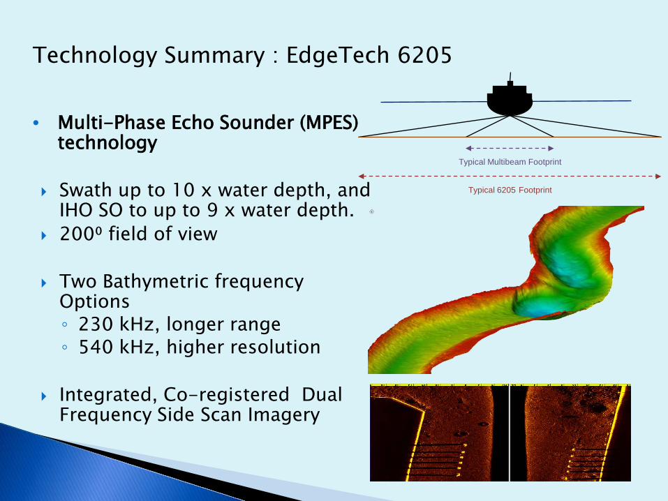
Technology Summary : EdgeTech 6205
• Multi-Phase Echo Sounder (MPES) technology
Swath up to 10 x water depth, and IHO SO to up to 9 x water depth.
200⁰ field of view
Two Bathymetric frequency Options◦ 230 kHz, longer range◦ 540 kHz, higher resolution
Integrated, Co-registered Dual Frequency Side Scan Imagery
Typical Multibeam Footprint
Typical 6205 Footprint

• Swath bathymetry systems utilize two differing technologies to achieve bathymetry measurements across a “swath” of the sea floor:
Beam Forming (MBES) Interferometric Sonars
MPES combines MBES and Interferometry to improve nadir performance and multipath rejection, while maintaining a wide swath

6205 Swath Bathymetry and Side Scan System– Port and Starboard transducers: 10 bathy receive staves per side– Chirp pulses for higher accuracy and extended range– Full nadir coverage– Improved Multipath and Wake Suppression– Total field of view is over 200 degrees – Integrated dual frequency side scan
EdgeTech’s Next Generation MPES Bathymetric Technology
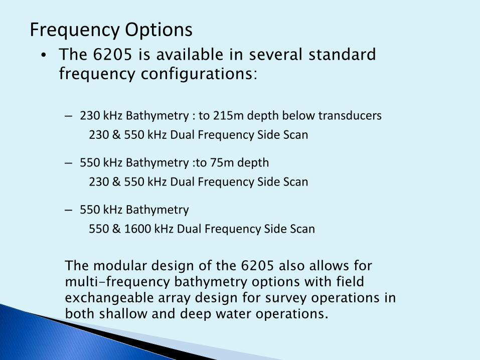
Frequency Options• The 6205 is available in several standard
frequency configurations:
– 230 kHz Bathymetry : to 215m depth below transducers230 & 550 kHz Dual Frequency Side Scan
– 550 kHz Bathymetry :to 75m depth230 & 550 kHz Dual Frequency Side Scan
– 550 kHz Bathymetry550 & 1600 kHz Dual Frequency Side Scan
The modular design of the 6205 also allows for multi-frequency bathymetry options with field exchangeable array design for survey operations in both shallow and deep water operations.
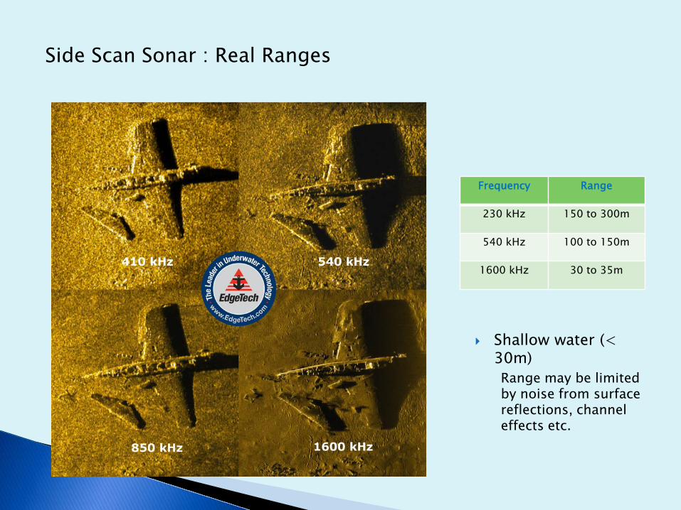
Side Scan Sonar : Real Ranges
Frequency Range
230 kHz 150 to 300m
540 kHz 100 to 150m
1600 kHz 30 to 35m
Shallow water (< 30m)Range may be limited by noise from surface reflections, channel effects etc.

Three types of data available- Bathymetry- Backscatter- Sidescan (Dual Frequency)

Aim◦ Show the overall system performance
Wide Swath and coverage at Nadir◦ Use IHO S44 5th Ed. Special Order as a
standard
Methodology◦ Create a Reference Surface
Multiple lines, in various directions, over the same area◦ Run a test line and compare to that
Reference Surface
Results◦ Demonstrates Wide Swath Coverage◦ Demonstrates Compliance at Nadir

Reference Surface◦ St. John’s River, Jacksonville, FL, USA◦ Approximate Water Depth = 10 m◦ The reference surface was acquired using
200% coverage with a boustrophedoniclattice pattern, consisting of 16 N-S lines and 16 E-W lines, and only logging the highest quality data, or 90 deg swath.
Support Sensors◦ Applanix POS MV◦ Trimble HPD450 Radio
Real-time kinematic (RTK)
Average surface looks clean and noise free.
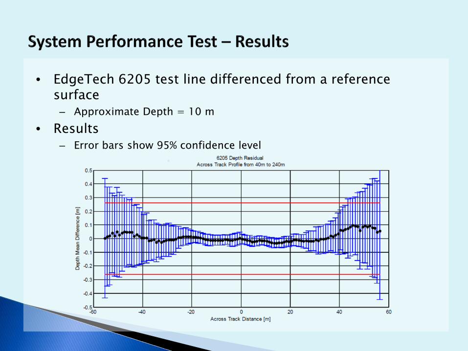
• EdgeTech 6205 test line differenced from a reference surface
– Approximate Depth = 10 m• Results
– Error bars show 95% confidence level
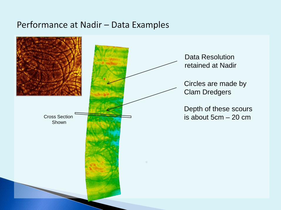
Data Resolution retained at Nadir
Circles are made by Clam Dredgers
Depth of these scours is about 5cm – 20 cmCross Section
Shown
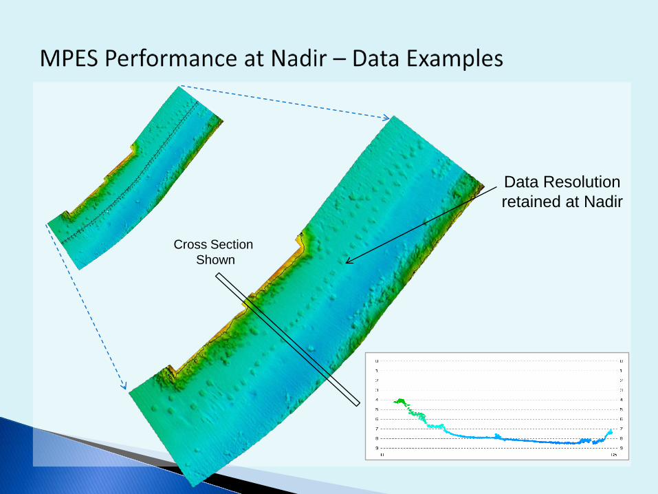
Data Resolution retained at Nadir
Cross Section Shown

Wide Swath Data: New River, bank-to-bank

Advantages of Co-Registered Bathymetry & Side Scan
- Improved understanding of data during survey- Significantly aids data processing and filtering - Enhances object detection- Improved feature definition and interpretation- Improves interpretation of shoal features- Improved interpretation of complex areas- Complementary information for identifying bottom type

Spikes
Fish
FishShadows
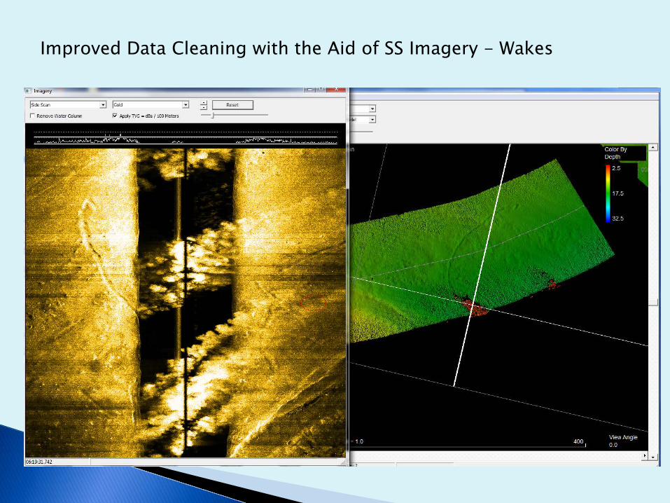
Improved Data Cleaning with the Aid of SS Imagery - Wakes
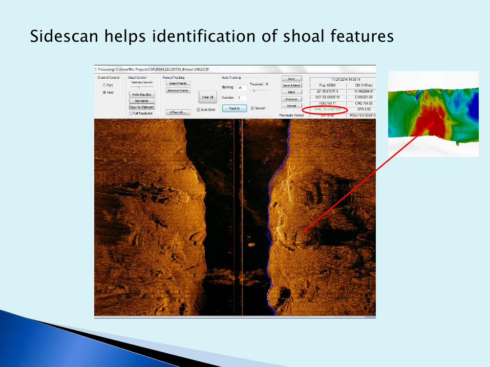
Sidescan helps identification of shoal features
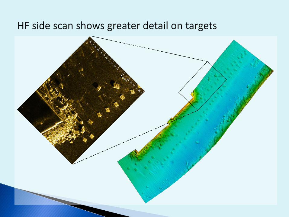

Additional information for Object Detection and Identification
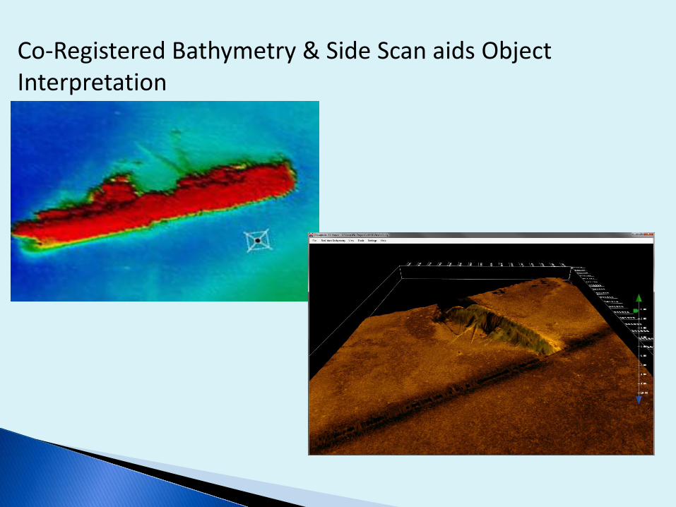
Co-Registered Bathymetry & Side Scan aids Object Interpretation
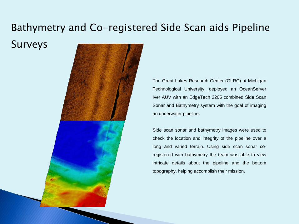
Bathymetry and Co-registered Side Scan aids Pipeline Surveys
The Great Lakes Research Center (GLRC) at Michigan
Technological University, deployed an OceanServer
Iver AUV with an EdgeTech 2205 combined Side Scan
Sonar and Bathymetry system with the goal of imaging
an underwater pipeline.
Side scan sonar and bathymetry images were used to
check the location and integrity of the pipeline over a
long and varied terrain. Using side scan sonar co-
registered with bathymetry the team was able to view
intricate details about the pipeline and the bottom
topography, helping accomplish their mission.

Co-Registered Bathymetry & Side Scan improves interpretationof of debris field


Improved interpretation of complex areas:550kHz Bathymetry and Side Scan of Dock Entrance

Data Interpretation with the Aid of SS Imagery – Bottom features

100m
Data Interpretation with the Aid of SS Imagery – Bottom Types
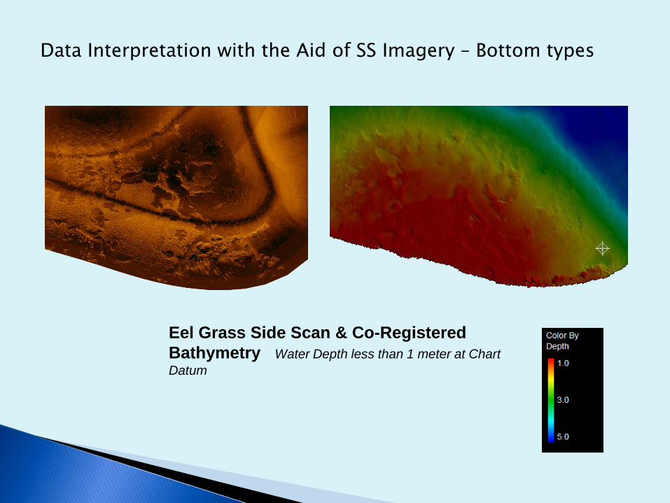
Eel Grass Side Scan & Co-Registered Bathymetry Water Depth less than 1 meter at Chart Datum
Data Interpretation with the Aid of SS Imagery – Bottom types
Advantages of Using Combined Bathymetry and Side Scan Data in Survey Processing
T.M. Hiller, L.N. BrissonEdgeTech, West WareHam MA, USA


