DALLAS COUNTY CONSULT ANT ENGINEERING SERVICES CONTRACT AECOM TECHNICAL SERVICES, INC. WORK ORDER NO.5- AMENDMENT NO. 1 This Agreement is entered into this 20th day of December , 20 16 , to amend the Consultant Engineering Services Contract between Dallas County (the "County") and AECOM Teclmical Services, Inc. (hereinafter refetTed to as "Consultant"). Whereas, pursuant to Dallas County Commissioners Court Order 2012-0721, dated April 24, 2012, and SOQ 2011-053-5501 dated August 23,2011 Dallas County awarded a professional services contract to AECOM Technical Services; and Whereas, pursuant to Dallas County Commissioners Comi Orders No. 2013-0283, No. 2013- 1792 and No. 2014-1499 dated February 12 , 2013, October 29, 2013, and October 28,2014 respectively, the Consultant Engineering Services Contract was amended to extend the contract; and Whereas, pursuant to Dallas County Commissioners Comi Order 2012-1364, dated August 21 , 2012, Dallas County awarded Work Order No. 1 to AECOM Teclmical Services, Inc. for an amount not to exceed $431,000.00 to provide engineering services for the Southem Dallas County Infrastructure Assessment (SOCIA) Study Project MCIP No. 501 02; and Whereas, pursuant to Dallas County Commissioners Court Order 2014-0712, dated May 20, 2014, Dallas County awarded Work Order No. 2 to AECOM Technical Services, Inc. for an amount not to exceed $890,062.00 to provide engineering services for the Pleasant Run Improvements Project MCIP No. 31402; and Whereas, on September 4, 2014, Dallas County awarded Work Order No. 2- Amendment No.1 to AECOM Teclmical Services, Inc. for an amount not to exceed $16,350.00 to provide additional engineering services for the Pleasant Run Improvements Project MCIP No. 31402 from Lancaster Hutchins Road to Millers FetTy Road specifically Subsurface Utility Engineering for gas transmission lines; and Whereas, on January 6, 2015, Dallas County approved Work Order No. 2-Amendment No. 2 to AECOM Teclmical Services, Inc. to amend the original survey proposal reducing the overall cost of Work Order No.2 by ($2,712.50) for the Pleasant Run Improvements Project MCIP No. 31402; and Whereas, pursuant to Dallas County Commissioners Comi Order 2015-0209, dated February 10, 2015, Dallas County awarded Work Order No. 3 to AECOM Technical Services, Inc. for an amount not to exceed $197,318.00 to prepare final waterline plans, including bidding and construction phase services for the Pleasant Run Improvements Project MCIP No. 31402; and AECOM Technical Services. Inc. Page I of4 Amend me111 I to Work Order No.5- Pleasant Run Road MCIP 31403 (Paving & Drainage)
Transcript
DALLAS COUNTY CONSULT ANT ENGINEERING SERVICES CONTRACT
AECOM TECHNICAL SERVICES, INC.
WORK ORDER NO.5- AMENDMENT NO. 1
This Agreement is entered into this 20th day of December , 20 16, to amend the Consultant Engineering Services Contract between Dallas County (the "County") and AECOM Teclmical Services, Inc. (hereinafter refetTed to as "Consultant").
Whereas, pursuant to Dallas County Commissioners Court Order 2012-0721 , dated April 24, 2012, and SOQ 2011-053-5501 dated August 23,2011 Dallas County awarded a professional services contract to AECOM Technical Services; and
Whereas, pursuant to Dallas County Commissioners Comi Orders No. 2013-0283 , No. 2013-1792 and No. 2014-1499 dated February 12, 2013, October 29, 2013, and October 28,2014 respectively, the Consultant Engineering Services Contract was amended to extend the contract; and
Whereas, pursuant to Dallas County Commissioners Comi Order 2012-1364, dated August 21 , 2012, Dallas County awarded Work Order No. 1 to AECOM Teclmical Services, Inc. for an amount not to exceed $431 ,000.00 to provide engineering services for the Southem Dallas County Infrastructure Assessment (SOCIA) Study Project MCIP No. 501 02 ; and
Whereas, pursuant to Dallas County Commissioners Court Order 2014-0712, dated May 20, 2014, Dallas County awarded Work Order No. 2 to AECOM Technical Services, Inc. for an amount not to exceed $890,062.00 to provide engineering services for the Pleasant Run Improvements Project MCIP No. 31402; and
Whereas, on September 4, 2014, Dallas County awarded Work Order No. 2- Amendment No.1 to AECOM Teclmical Services, Inc. for an amount not to exceed $16,350.00 to provide additional engineering services for the Pleasant Run Improvements Project MCIP No. 31402 from Lancaster Hutchins Road to Millers FetTy Road specifically Subsurface Utility Engineering for gas transmission lines; and
Whereas, on January 6, 2015, Dallas County approved Work Order No. 2-Amendment No. 2 to AECOM Teclmical Services, Inc. to amend the original survey proposal reducing the overall cost of Work Order No.2 by ($2,712.50) for the Pleasant Run Improvements Project MCIP No. 31402; and
Whereas, pursuant to Dallas County Commissioners Comi Order 2015-0209, dated February 10, 2015, Dallas County awarded Work Order No. 3 to AECOM Technical Services, Inc. for an amount not to exceed $197,318.00 to prepare final waterline plans, including bidding and construction phase services for the Pleasant Run Improvements Project MCIP No. 31402; and
AECOM Technical Services. Inc. Page I of4 Amendme111 I to Work Order No.5- Pleasant Run Road MCIP 31403 (Paving & Drainage)
Whereas, pursuant to Dallas County Commissioners Court Order 2015-0589, dated April 21, 2015, Dallas County awarded Work Order No. 4 to AECOM Technical Services, Inc. for an amount not to exceed $673,800.00 to prepare final pump station plans, including bidding and construction phase services for the Pleasant Run Improvements Project MCIP No. 31402; and
Whereas , pursuant to Dallas County Commissioners Comi Order 20 15-0563, dated April 14, 2015, Dallas County awarded Work Order No. 5 to AECOM Technical Services, Inc. for an amount not to exceed $ 1,110,2 17.00 to prepare final roadway, drainage, and sewer line plans, including bidding and construction phase services for the Pleasant Run Improvements Project MCIP No. 31403; and
Now therefore, this Amendment No. 1 to Work Order No.5 is made by and entered into by the County and Consultant for the mutual consideration stated herein.
I. Purpose
County and Consultant both muhtally agree to amend said Contract in accordance with the tenns of the existing Agreement, except as modified below. The purpose of this Amendment is to amend the Consultant Agreement to prepare final sewer line study and plans, including environmental services and ROW documents, along Cottonwood Creek from Pleasant Run Road to the Dallas County Detention Center on The Pleasant Run Road Project, MCIP 31403 as well as provide for the compensation accordingly.
II. Amended Provisions
A. Article IV. "Work Order(s)", of the Consultant Agreement shall be amended to add the Scope of Work as detailed in Attaclunents ' 'A" attached hereto and incorporated herein.
B. Ariicle V. "Compensation" of the Consultant Agreement shall be amended to add Attachment "B" attached hereto and incorporated herein.
a. The fee to be paid to the Consultant under this Amendment for all of the scope of services shall not exceed One Hundred Twenty Thousand Five Hundred Sixty Dollars and no cents ($120,560.00), provided however, that modifications to the scope of services, or other conditions defined in the Attaclunents "A, B C, and D" may necessitate a change of fee and futiher provided that any additional fee is approved by the Commissioners Court in accordance with the tenns of this Amendment and the Consultant Engineering Services Contract.
b. The revised amount for Work Order No.5 by thi s amendment is One Million Two Hundred Thiriy Thousand Seven Hundred Seventy Seven Dollars and no cents ($1 ,230, 777 .00).
c. The Consultant shall provide reporis and invoices with attached documentation, as required by Dallas County. Each repmi and invoice shall identify engineering services perfonned according to the scope of services.
d. This Work Order will be paid from MCIP Fund 196, Project 31403.
C, Attaclunent "C" is the Survey and Attaclunent "D" is the Enviromnental attached hereto and incorporated herein.
AECOM Technical Services. Inc. Page 2 o.f4 Amendment I to Work Order No.5- Pleasant Run Road MCIP 3/403 (Paving & Drainage)
III. Effect of Work Order
This Amendment shall not change or waive any contractual provisions, clauses or conditions of the original Contract, unless otherwise provided for herein.
IN "VITNESS WHEREOF, THE COUNTY OF DALLAS has caused this Contract to be signed by its County Judge, duly authorized to execute the same in its behalf by Court Order No._~6-1548 approved by the Commissioners Comi on ~ 2D , 2016, and signing by and through its duly authorized representative, thereby binding the parties hereto, their successors, assigns and representatives for the faithful and full performance of the terms and provisions of this Contract.
By: ~~~~---------------
Title: A S20G(ct ~ e v.'' e rresr' e-~ I? 1\ t
County of Dallas
Approved as to Form*: Susan Hawk District Attomey
BJ/i~Y~ Assistant District Attomey
*By law, the Disuict Attomey"s Office may only advise or approve contracts or legal documents on behalf of its clients. It may not advise or approve a contract or legal document on behalf o f other pa1ties. Our review of this document was conducted solely from the legal perspect ive of our c lient. Our approval of this document was offered solely for the benefi t of our client. Other panies should not rely on this approval, and should seek review and approval by their own respect ive anomey(s).
AECOM Teclrnical Services. Inc. Page 3 o/4 Amendment/ 10 Work Order No.5 - Pleasant Run Road MCIP 3 1403 (Pa ving & Drainage)
A:' COM
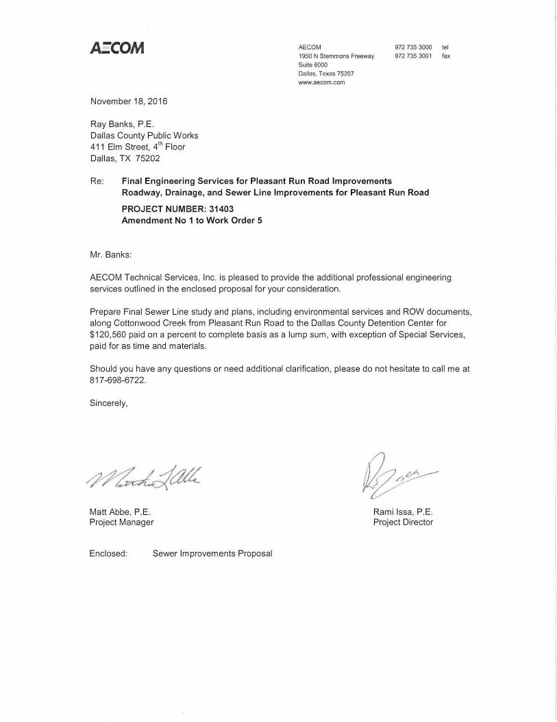
November 18, 2016
Ray Banks, P.E. Dallas County Public Works 411 Elm Street, 41
h Floor Dallas, TX 75202
AECOM
1950 N Stemmons Freeway Suite 6000
Dallas. Texas 75207
www.aecom.com
972 735 3000 tel
972 735 3001 fax
Re: Final Engineering Services for Pleasant Run Road Improvements Roadway, Drainage, and Sewer Line Improvements for Pleasant Run Road
PROJECT NUMBER: 31403 Amendment No 1 to Work Order 5
Mr. Banks:
AECOM Technical Services, Inc. is pleased to provide the additional professional engineering services outlined in the enclosed proposal for your consideration.
Prepare Final Sewer Line study and plans, including environmental services and ROW documents, along Cottonwood Creek from Pleasant Run Road to the Dallas County Detention Center for $120,560 paid on a percent to complete basis as a lump sum, with exception of Special Services , paid for as time and materials.
Should you have any questions or need additional clarification, please do not hesitate to call me at 817-698-6722.
Sincerely,
Matt Abbe, P.E. Project Manager
Enclosed: Sewer Improvements Proposal
Rami lssa, P.E. Project Director
ATTACHMENT A
SCOPE OF WORK
FOR
PLEASANT RUN ROAD IMPROVEMENTS ENGINEERING SERVICES
PROJECT NUMBER: 31403
SEWER LINE FINAL DESIGN, BID, AND CONSTRUCTION ADMINISTRATION SERVICES
BACKGROUND
AECOM was authorized on May 131h 2014 to perform preliminary engineering services for
improvements to Pleasant Run Road from Lancaster-Hutchins Road to Millers Ferry Road, approximately a three-mile stretch. The project includes a Preliminary Engineering Report (PER) and the preparation of 30% roadway, drainage, water and sewer plans. Dallas County requested that additional services be included as an amendment to the contract to advance the design of the roadway, drainage and sewer line plans from previously contracted 30% level to final design, so that this portion of the project can be constructed by a selected contractor. Work Order #5 (W0#5) was prepared to finalize the roadway and sewer plans. During preliminary design phase for a segment of the Wilmer sewer line for W0#5, it was noted that the preferred route during the study phase could not be constructed due to ROW issues. Thus, an alternate alignment is required for the sewer line. The effort to realign the sewer line will be covered by this project design proposal and provides a study and design services for the Wilmer sewer line. Services for this project design proposal will generally include:
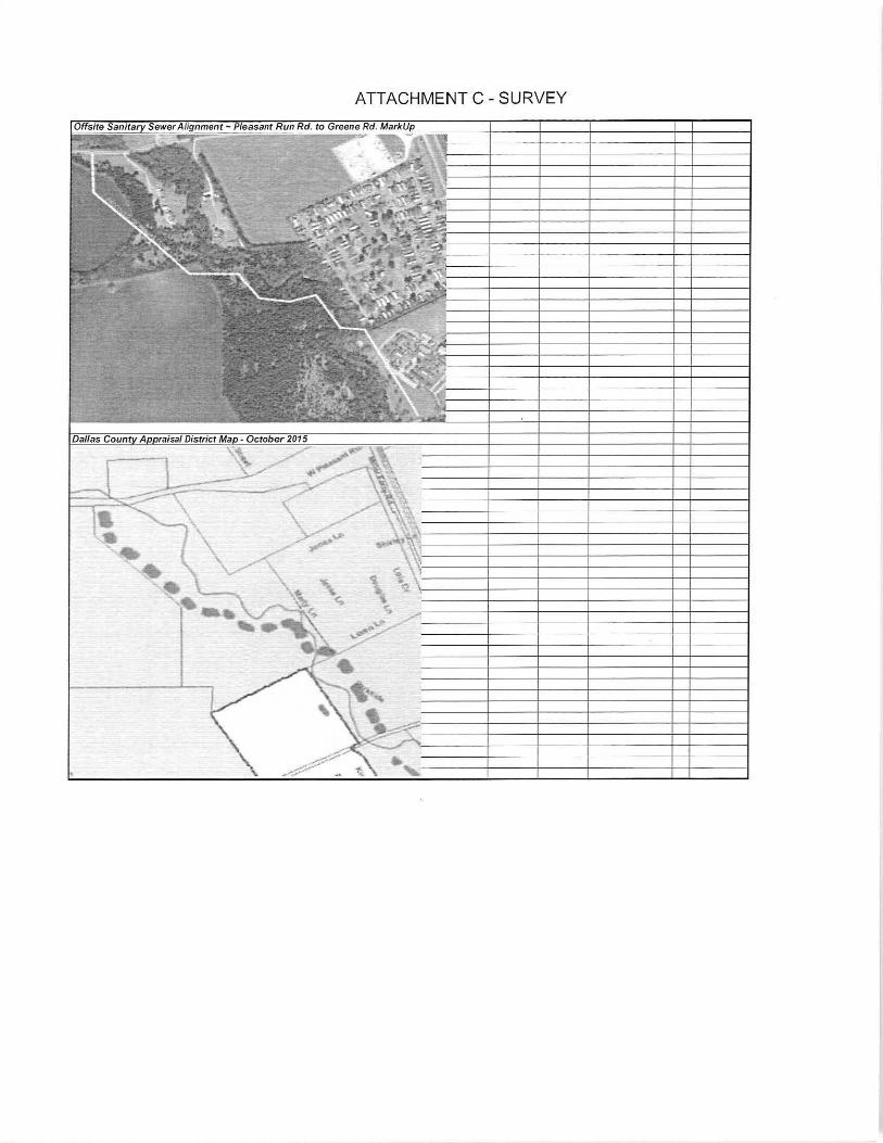
• Sanitary Sewer Alignment Study- AECOM reviewed different options to re-align the sewer line along Cottonwood Creek. The review accounted for the profile of the sewer based on 2-ft contour mapping from the NCTOG. A review of sewer depths, ROW, and aerial crossing locations allowed for one defined option. The selected option was agreed upon in meetings and will be taken to Final Design.
• Sanitary Sewer Line Final Design -Bidding documents for 4,200 LF of new sewer line to serve Wilmer along Cottonwood Creek, as presented in meetings and depicted in the Final PER, wh ich was developed through the Sewer Alignment Study. It should be noted that W0#5 Contract included the design of 2,400 LF of sewer along Cottonwood Creek. Thus, the 2,400 LF will not be included in this scope. This scope provides for the difference between the two proposals, which is 1,800 LF, and the design of two aerial crossings.
The following document is a detailed scope of work for the services. Compensation for these services will be based on prim e contract, paid on a percent to complete basis as a lump sum base contract, with the exception of Special Services, paid as Time and Materials.
Dallas County Pleasant Run Road Improvements Sanitary Sewer Improvements Modification
Page 1 November 18, 2016
DESIGN STANDARDS
Design and preparation of construction drawings and technical specifications required for the project will be in accordance with the following standards:
• TxDOT Design Standards • Texas Commission on Environmental Quality Requirements • Lancaster Design Standards • North Central Texas Council of Governments (NCTCOG) Specifications (41
h Ed.) • EPA and FEMA Regulations
DESIGN PLANS
Design plans will be prepared for the Sanitary Sewer line sheets to progress the package submitted in the PER to Final Design. The plans will consist of:
Sanitary Sewer Improvements
Plan and Profile sheets will be prepared for the proposed sanitary sewer lines provided in the Final PER along Cottonwood Creek. Sheets will include: recommended pipe size, manholes, related appurtenances, and pertinent information needed to construct the project. Legal description (Lot Nos., Block Nos., and Addition Names) along with property ownership shall be provided on the plan view. The design will require survey, preparation of ROW documents, easements, a geotechnical report, and two aerial crossings, which will need structural design . .
Standards and Special Detail Sheets
Standard and special detail sheets for the project will be provided. These may include connection details between various parts of the project, TxDOT roadway details, tunneling details, boring and jacking details, details unique to the construction of the project, trench less details, and special service lateral reconnections. Standard details will be provided, when possible.
DETAILED SCOPE OF WORK:
I. Project Administration and Project Delivery
A. Project Administration
1. Additional Site Visits - Include two site visits during study and design phase.
B. Quality Assurance/Quality Control
1. Conduct internal review and make necessary corrections to all deliverables prior to submitting to Dallas County for review.
2. Incorporate Dallas County comments on 90% submittals. Dallas County shall gather comments from all stakeholders and distribute to AECOM in written format. If there are confl icting comments among stakeholders, then Dallas County shall provide direction to AECOM to resolve conflicting comments . Dallas County desires shall prevail.
II. Design Support Services
A. Survey -
1. Proposed Survey
a.) Design Topographic Survey along the proposed alignment
Dallas County Pleasant Run Road Improvements Sanitary Sewer Improvements Modification
Page 2 November 18, 2016
i.) Obtain topographical surveys information for 1-foot contours for proposed sewer line from existing manhole in II.A.1.a.i., and along Cottonwood Creek (approximately 4,200 LF with a 30 to 50-foot wide corridor). NOTE: Scope of work will be covered under W0#2.
ii.) Establish base line control points and provide vertical and horizontal control sheets (per Dallas County standards) . NOTE: Scope of work will be covered under W0#2.
iii.) Locate and tie existing above ground utility appurtenances, structures, pavements, curbs, fences, natural features, trees 6-inches caliber and above and other improvements. NOTE: Scope of work will be covered under W0#2.
iv.) Locate existing underground utilities based on available record drawings, and determine the horizontal and vertical al ignment of existing storm sewers and sanitary sewer lines within the limits of the proposed pipeline alignment. NOTE: Scope of work will be covered under W0#2.
b.) Boundary/Property Line survey
i.) Identify existing property owners along the proposed alignment
ii.) Locate and tie existing Right-of-Way and easements along the proposed alignment
c.) Provide digital survey file for ROW, topographic, and boundary surveys
d.) Prepare right of way or easement dedication exhibits for parcels (up to 6 total). Includes 3 permanent and 3 construction easements.
B. Geotechnical Investigation - Sewer Alignment
1 . Provide 3 bores at 25 ft depth along pipeline and 5 bores at each aerial crossing (2 total aerial crossings) at 40ft depths. NOTE: Scope of work will be covered under W0#2 and is not part of this proposal.
2. Geotechnical report with findings. NOTE: Scope of work will be covered under W0#2 and is not part of this proposal.
C. Environmental Investigation (Refer to Attachment 0 for detailed scope)
1. Provide an environmental study of the sewer line alignment to confirm that the project is not significantly impacting the natural environment.
2. Environmental report with findings.
Ill. Sewer Line Final Design
Sewer Alignment study phase - The study reviewed different alignments along Cottonwood Dallas County Pleasant Run Road Improvements Sanitary Sewer Improvements Modification
Page 3 November 18, 2016
Creek, including multiple site visits. Conceptual exhibits were prepared showing both plan and profile of the different sewer alignments. The profile views helped to view the depth of cover and allow the design team and Dallas County to hone in on a preferred design. The preferred design was provided in the Final PER.
Based on the approved recommendations presented in the Final PER prepared for the original project scope, final bidding documents will be prepared for construction. The final design wi ll be performed for the sanitary sewer lines along the Pleasant Run corridor as depicted in the PER and along Cottonwood Creek.
The final design will include approximately 4 ,200 LF of sewer line along Cottonwood Creek. A total of 16 additional sheets are estimated including structural details, assuming a 1"=40' scale for 11 "X1 7" plan and profile sheets. Sanitary Sewer sheets will consist of plan and profile sheets and details.
Structural Design Details and Erosion Control Sheets wil l also be included in the design package for the two aerial crossings. These items were not included in the previous work order #5.
Submit electronic drawings (PDF and Microstation V8i), reference files, cut sheets, and Geopak files.
A. 90% Design Submittal
1. Develop 90% drawings;
2. Develop 90% specifications for one (1) project; as provided by the approved list of specifications in II I.A. ;
3. Prepare 90% Erosion Control Plans;
4. Prepare a 90% AACE Class 1 OPCC;
5. Submit 90% design submittal to Dallas County (Submit 12 half-size sets and 5 spec books);
B. Final Design Submittal:
1. Develop final drawings;
2. Develop final specifications for one (1) project; as provided by the approved list of specifications in Ill .A ;
3. Prepare a final AACE Class 1 OPCC;
4. Submit final submittal to Dallas County (Submit 6 full-size and 6 half-size sets and 5 spec books).
IV. Bidding and Advertisement Services
A. Scope is included in Work Order #5.
V. Construction Phase Services
A. Scope is included in Work Order #5.
VI. Special Services- General Construction Services (For aerial crossings only)
A. RFI's- It is assumed that no more than five (5) Requests for Information (RFI 's) will be addressed will be addressed by Engineer during construction phase. Any additional RFI's will be deemed out of scope.
B. Shop Drawing Review- AECOM shall assist the County with shop drawing review. It is
Dallas County Pleasant Run Road Improvements Sanitary Sewer Improvements Modification
Page 4 November 18, 2016
anticipated that there will be 5 required reviews for the aerial crossings and erosion protection.
C. On-site Observation- AECOM anticipates 3 total site visits for the sewer line contract.
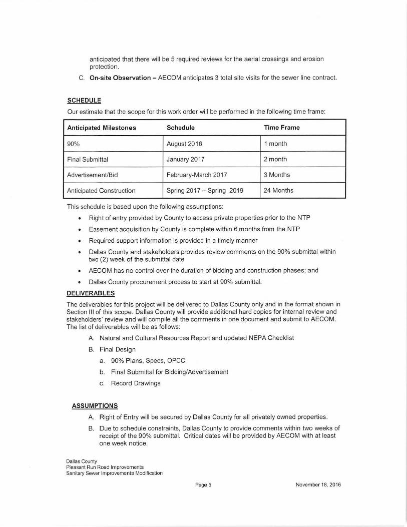
SCHEDULE
Our estimate that the scope for this work order wi ll be performed in the following time frame:
Anticipated Milestones Schedule Time Frame
90% August2016 1 month
Final Submittal January 2017 2 month
Advertisement/Bid February-March 2017 3 Months
Anticipated Construction Spring 2017- Spring 2019 24 Months
This schedule is based upon the following assumptions:
• Right of entry provided by County to access private properties prior to the NTP
• Easement acquisition by County is complete within 6 months from the NTP
• Required support information is provided in a timely manner
• Dallas County and stakeholders provides review comments on the 90% submittal within two (2) week of the submittal date
• AECOM has no control over the duration of bidding and construction phases; and
• Dallas County procurement process to start at 90% submittal.
DELIVERABLES
The deliverables for this project will be delivered to Dallas County only and in the format shown in Section Ill of this scope. Dallas County will provide additional hard copies for internal review and stakeholders' review and will compile all the comments in one document and submit to AECOM . The list of deliverables will be as follows:
A. Natural and Cultural Resources Report and updated NEPA Checklist
B. Final Design
a. 90% Plans, Specs. OPCC
b. Final Submittal for Bidding/Advertisement
c. Record Drawings
ASSUMPTIONS
A. Right of Entry will be secured by Dallas County for all privately owned properties.
B. Due to schedule constraints, Dallas County to provide comments within two weeks of receipt of the 90% submittal. Critical dates will be provided by AECOM with at least one week notice.
Dallas County Pleasant Run Road Improvements Sanitary Sewer Improvements Modification
Page 5 November 18, 2016
C. This scope does not include any Pre-Construction Notification application or any environmental permits.
D. Dallas County will provide full time inspector during construction . AECOM has no responsibilities with regard to construction means and methods.
E. Dallas County will provide appraisal services and title search for easement/ROW acquisition.
F. Timely input and feedback from the County and other stakeholders, such as Wilmer and Lancaster, wi ll be performed through the County.
G. The Engineer's OPCC will be Class 1 and 2 as defined by The Association for the Advancement of Cost Engineering (AACE).
H. The Engineer's OPCC provided with this scope will be for reference only and based on recent average unit prices for comparable projects and TxDOT twelve month moving unit prices. Preliminary quantities were calculated without having final engineering design plans; thus, does not make any representations or warranties with respect to the information included therein. The estimated costs are based upon currently available information and, thus, the estimate may change based upon unknown facts or circumstances that could occur after the issuance of this document.
I. In providing its services hereunder, AECOM shall not be responsible for identification, handling, containment, abatement, or in any other respect, for any asbestos or hazardous material if such is present in connection with the project. In the event that the County becomes aware of the presence of asbestos or hazardous material at the jobsite, the County shall be responsible for complying with all applicable federal and state rules and regulations, and shall immediate notify AECOM, who shall then be entitled to cease any of its services that may be affected by such presence, without any liability to AECOM therefrom.
J. In the performance of its professional services, AECOM will use that degree of care and skill ordinarily exercised under similar conditions in similar localities and no other warranties, express or implies are made or intended in any of AECOM's proposal, contracts or reports.
K. Roadway Design will be based on latest AASHTO Design Criteria. Storm Drain and Sewer Line Design will be based on City of Lancaster General Design Manual (Version April 2001 ) and City of Lancaster Standard Details (Version December 1999). Storm Drain computations wi ll be prepared by using the TxDOT Winstorm computation program . TxDOT and NCTCOG Specifications will be used for installation.
L. It should be noted that construction could be delayed due to unknown issues, such as weather, and such issues are beyond the Engineers control. Such delays will be a basis for additional compensation.
M. The Contractor must deliver complete set of plans mark ups for AECOM to be able to complete the record drawing task.
N. This scope does not include any work required for Permits or Authorizations.
0 . The County agrees that in accordance with generally accepted construction practices, the Construction Contractor will be required to assume sole and complete responsibility for job site conditions during the course of construction of the Project, including safety of all persons and property, and that this requirement shall be made to apply continuously and not be limited to normal working hours. Engineer shall not have control over or charge of, and shall not be responsible for, construction means,
Dallas County Pleasant Run Road Improvements Sanitary Sewer Improvements Modification
Page 6 November 18, 2016
methods, techniques, sequences, or procedures, as these are solely the responsibility of the Construction Contractor.
EXCLUSIONS
The scope does not include the following services. However, they can be added to the scope for additional compensation:
• Obtaining right of entry to privately owned properties is not included in this scope.
• Aerial Survey for the project corridor.
• Subsurface Utility Engineering (SUE).
• Appraisal services for ROW acquisition.
• Permitting preparation and associated fees.
• Any grant research and application preparation.
• Traffic signal-warrant studies; or traffic counts.
• Permits, training, fees, cost for flaggers, etc. for entry into the railroad right of way.
• Services related to City of Lancaster Tree Mitigation.
• Storm Water Pollution Prevention Plan (SWPPP). Temporary erosion control sheets are provided, but the actual SWPPP shall be prepared by the contractor.
• Construction Inspection or monitoring of any kind.
• Weekly construction meetings with engineer are not anticipated. Only the numbers of meetings specified in the scope are anticipated.
• Construction materials testing .
• Trench protection safety.
• Public Meetings, hearings, or exhibit preparation for meetings.
• Signals, illumination, and associated conduit are not included.
• Landscaping/hardscaping services are not included.
• TDLR TAS submittals are not included.
• LOMRICLOMR for Cottonwood Creek, or any other tributary.
• Certification at the end of the construction phase
ENCLOSED
Attachment B: Detailed Fee
Attachment C: Scope of Services for Survey/ROW field notes
Attachment D: Environmental
Dallas County Pleasant Run Road Improvements Sanitary Sewer Improvements Modification
Page 7 November 18, 2016
.:.::· ...
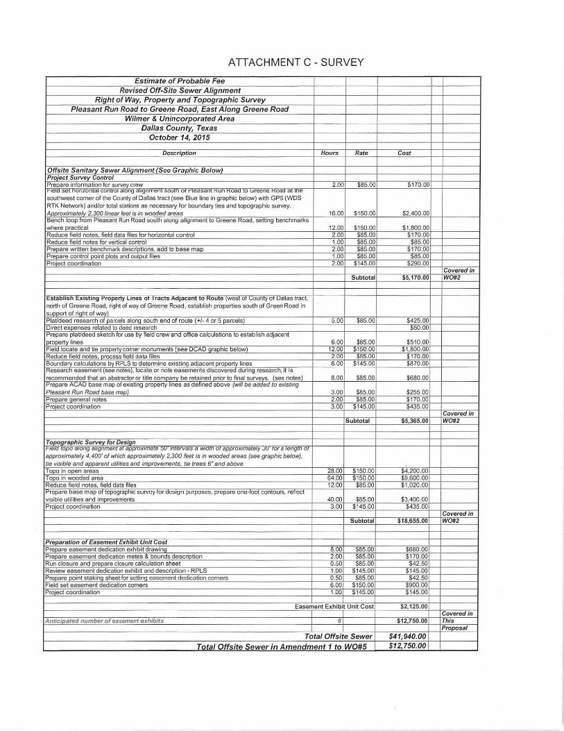
ATTACHMENT C- SURVEY
Estimate of Probable Fee
Rev ised Off-Site Sewer Alignment
Right of Way, Property and Topographic Survey
Pleasant Run Road t o Greene Road, East Alo ng Green e Road
Wilmer & Unincorpo rated Area
Dallas County, T exas
October 14, 2015
Description Hours Rate Cost
Offsite Sanitary Sewer Alignment (See Graphic Below) Pro ·ect Survey Control Prepare information for survey crew 2.00 $85.00 $170.00
1eou se onzon a con ro a eng augnmen souuo o easan un " oau o ~.>reene oau a1 uoe southwest corner of the County of Dallas tract (see Blue line in graphic below) with GPS (WDS RTK Network) and/or total stations as necessary for boundary ties and topographic survey. Approximately 2.300 linear feet is in wooded areas 16.00 $150.00 $2.400.00 ·Bench loop from Pleasant Run Road south a long a lignment to Greene Road, setting benchmarks where practical 12.00 $150.00 $1,800.00 Reduce field notes, field data files for horizontal control 2.00 $85.00 $170.00 Reduce field notes for vertical control 1.00 $85.00 $85.00 Prepare written benchmark descriptions, add to base map 2.00 $85.00 $170.00 Prepare control point plots and output files 1.00 585.00 $85.00 Project coordination 2.00 $145.00 $290.00
Covered in Subto tal $5,170.00 W0#2
1 t:staooosn t:XIS ong o-ropeny unes o racts ADJacent o r<oute (West o ~.-oun~-o · uauas rae , north of Greene Road, right of way of Greene Road, establish properties south of Green Road in support of riQht of way) PlaVdeed research of parcels along south end of route(+/- 4 or 5 parcels) 5.00 $85.00 $425.00 Direct expenses related to deed research $50.00 Prepare plaVdeed sketch for use by field crew and office calculations to establish adjacent
I property lines 6.00 $85.00 $510 .00 Field locate and tie property corner monuments (see DCAD graphic below) 12.00 $150 .00 $1,800.00 Reduce field notes, process field data files 2.00 $85.00 $170.00 Boundary calculations by RPLS to determine existing adjacent property lines 6.00 $145.00 $870.00 'Kesearcn easement (See notes), 1ocate or note easements discoverea aunng researcn, 1t IS
recommended that an abstractor or title company be retained prior to final surveys. (see notes) 8.00 $85.00 $680.00 1-'repare AL;AU case map 01 ex1sting property lines as definea a cove (Will oe aaaea to exrstmg Pleasant Run Road base map) 3.00 $85.00 $255.00 Prepare general notes 2.00 $85.00 $170.00 Pro·ect coordination 3.00 $145.00 $435.00
Covered in Subtotal $5,365.00 W0#2
Topographic Survey for Design 1e1a capo a1ong angnmenc ac approx1mace ::,u· mcerva1s a w1acn or approx1macew .Ju· ror a rengcn or
approximately 4,400' of which approximately 2,300 feet is in wooded areas (see graphic below), tie visible and apparent utilities and improvements, tie trees 6" and above Tope in open areas 28.00 $150.00 $4,200.00 Tope in wooded area 64.00 $150.00 $9,600.00 Reduce field notes. field data files 12.00 $85.00 $1,020.00
1 Prepare base map of topographic survey for design purposes, prepare one-toot contours, re11ec t visible utilities and improvements 40.00 $85.00 $3,400.00 Pro·ect coordination 3.00 $145.00 $435.00
Covered in Subtotal $18,655.00 W0#2
Preparation of Easement Exhibit Unit Cost Prepare easement dedication exhibit drawing 8.00 585.00 $680.00 Prepare easement dedication metes & bounds description 2.00 $85.00 $170.00 Run closure and prepare closure calculation sheet 0.50 585.00 $42.50 Review easement dedication exhibit and description- RPLS 1.00 $145.00 $145.00 Prepare point staking sheet for setting easement dedication comers 0.50 $85.00 $42.50 Field set easement dedication comers 6.00 $150.00 $900.00 Project coordination 1.00 $145.00 $145.00
Easement Exhibit Unit Cost $2,125.00 Covered in
Anticipated number o f easement exhibits 6 $12,750.00 This Proposal
Total Offsite Sewer $4 1,940.00 Tota l Offs ite S e w e r in Amendment 1 to W0 #5 $12,750.00
ATTACHMENT C- SURVEY
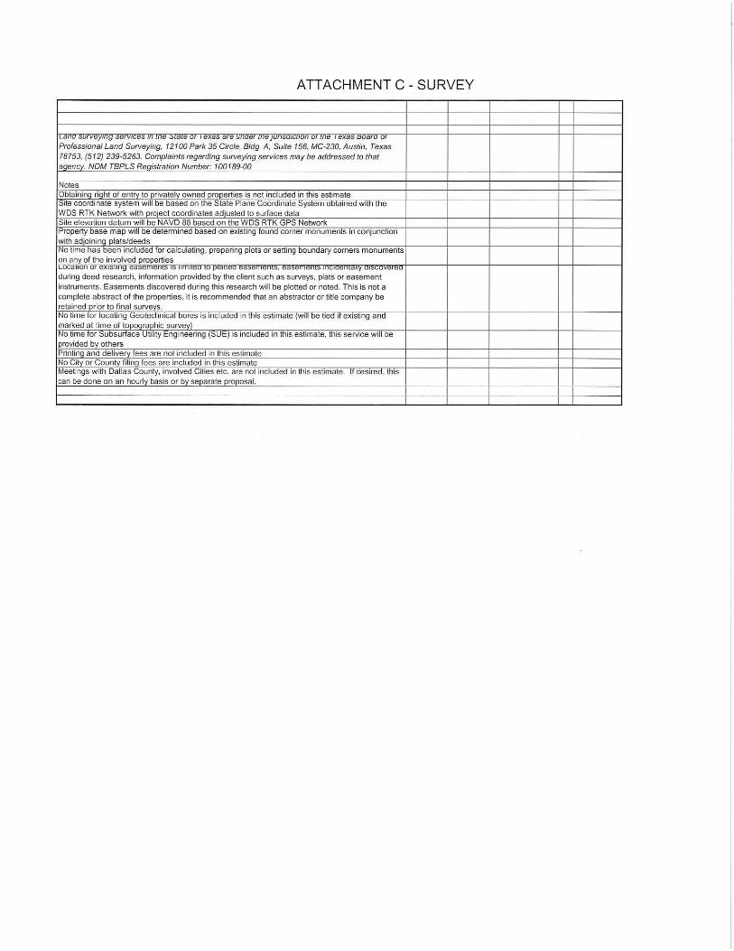
1 Lana surveyrng servrces m me .::.rare or 'exas are unaer me JUnsarcuon o, me ex as ooaro o Professional Land Surveying, 12100 Park 35 Circle. Bldg. A. Suite 156, MC-230, Austin, Texas 78753, (512) 239-5263. Complaints regarding surveying services may be addressed to that aqencv. NOM TBPLS Reqistration Number: 100189-00
Notes Obtainina riaht of entrv to privately owned properties is not included in this estimate I Site coordinate system will be based on the State Plane Coordinate ::;ystem obtained with the WDS RTK Network with project coordinates adjusted to surface data Site elevation datum will be NAVD 88 based on the WDS RTK GPS Network
!Property base map will be determined based on existing found comer monuments in conjunction with adjoininq plats/deeds No time has been included for calculating, preparing plots or setting boundary corners monuments on any of the involved properties ILOCaUOn 01 eXIS!II1g t:d>t: ll lt:lll> I> lll llllt:U lU fJidUt:U "d>.,ll l.,lll>, III~IU.,IIldlly ui>LUV"'"U during deed research, information provided by the client such as surveys, plats or easement instruments. Easements discovered during this research will be plotted or noted. This is not a complete abstract of the properties, it is recommended that an abstractor or title company be retained prior to final surveys. No time for locating Geotechnical bores is included in this estimate (will be tied if existing and marked at time of topOQraphic survey) I No time for Subsurface Utility Engineering (SUE) is included in this estimate, tnis service will oe provided by others Printinq and deliverv fees are not included in this estimate No City or County fil ina fees are included in this estimate Meetings with Dallas County, involved Cities etc. are not included in this estimate. It desired, this can be done on an hourly basis or by separate proposal.
ATTACHMENT C - SURVEY
ATTACHMENT D - ENVIRONMENTAL
October 14, 2015
AECOM Matthew Abbe Project Engineer, South Region 1200 Summit Avenue, Suite 102 Fort Worth, TX 76102 (817) 698-6700 [email protected]
Benchmark • Environment al Consultants 'T
Re: Proposal to Conduct Natural and Cultural Resources Assessments and Complete Portions of the NCTCOG Checklist for the Dallas County Road/Pipeline Project Proposed Alignment 3
Dear Matthew,
Please see the attached proposals to conduct Natural and Cultural Resource Assessments required to complete portions of the NCTCOG Checklist for the Dallas County Road/Pipeline Project Proposed Alignment 3. Based on Benchmark's calculations, the proposed Alignment 1 is no more than 4,500 feet long.
A summary of the costs and a timeline are included below.
Natural Resources Once NTP is received, Benchmark can begin the desktop review immediately and begin fieldwork within 5 business days. The draft report and checklist will be submitted 15 business days after NTP. Additional time (up to 60 days) should be allowed for responses from government agencies. The estimated cost for these services is a lump sum price of $7,110.
Cultural Resources Once NTP is received, Benchmark can begin the desktop review immediately and begin fieldwork within 15 business days. This 15-day period is required for the permit from the Texas Historical Commission prior to beginning the survey. The preliminary findings will be included in the draft report and checklist discussed above. Additional time (up to 60 days) should be allowed for responses from government agencies. The estimated cost for these services is a lump sum price of $4,000.
Please let me know if you have any questions.
Sincerely,
-- /
Eddie Koch Coord inator of Natural & Cultural Resources
The objective of the natural resources assessment is to identify environmental resources in order to complete the NCTCOG RTR checklist. As such, the following services are to be included as part of this scope.
SCOPE OF SERVICES:
I. Water of the U.S./ Wet land Survey (Stream Cross ings)
• • • •
•
A waters of the U.S./wetlands survey will be conducted along the project corridor. If waters of the U.S. and/or wetlands are located along the ROW, they will be delineated in accordance with the 1987 Corps of Engineers Wetlands Delineation Manual and the appropriate regional supplement. In addition, information regarding the location and size of stream crossings and whether any permits are needed wi ll be provided.
The U.S. Corps of Engineers (USACE) regulates "Waters of the U.S.", wetlands and special aquatic sites under Section 404 of the Clean Water Act (CWA) and Section 10 of the Rivers and Harbors Act. The USACE and the Environmental Protection Agency (EPA) define wetlands as "those areas that are inundated or saturated by surface or groundwater at a frequency and duration sufficient to support, and that under normal circumstances do support, a prevalence of vegetation typically adapted for life in saturated soil conditions. Wetlands typically include swamps, marshes, bogs, and other similar areas".
Prior to conducting the environm ental field activities, we will perform a desktop review of the project area by reviewing the following sources:
U.S. Geological Survey (USGS) 7.5-minute topographic quadrangle maps; U.S. Fish and Wild life Service (USFWS) National Wetlands Inventory (NWI) Maps; Aerial photographs (current and historical); U.S. Department of Agriculture (USDA), Natural Resources Conservation Service (NRCS) County Soil Surveys; and Federal Emergency Management Agency (FEMA) Flood Hazard Maps .
The desktop review will assist in the planning and execution of the field surveys and will expedite the field survey process.
Surveys will be performed by tra ined biologist using common wetland survey tools such as shovels and soil augers, the Munsell Soil Color Chart, Wetland Data Forms, plant indicator lists, and visual observation for plant identification. The survey will implement the three parameter approach, assessing vegetation, soils, and hydrology for wetland conditions, as set forth in the 1987 Corps of Engineers Wetlands Delineation Manual and the regional supplement to determine the boundaries of potential wetlands within the survey area.
Iden tified wetland boundaries will be surveyed using Global Positioning System (GPS) technologies. Stream crossings will be identified by number, name (if applicable), stream flow, ordinary high water mark (OHWM) distance in feet, and comments regarding dominant vegetation and streambed communities. Ponds will be characterized by number, description and crossing length in feet.
A-1
ATTACHMENT D- ENVIRONMENTAL
A summary of survey findings will be provided in electronic format. Additionally, photographic documentation of each water and/or wetland feature and representative vegetation will be provided in a Photographic Exhibit and electronic shapefiles of the collected features wi ll be presented on maps created in ArcGIS. Copies of the Wetland Data Forms will also be included with the Report. The data will include the following:
• A summary table of the qualitative data; including, • Type of water feature, • Type of vegetation cover, • Description of aquatic life, • Coward in Classification of water feature, • Significant nexus, and • Whether the feature meets a definition of a water of the United States.
• A summary table of quantitative data (e.g . length and/or area) within the survey area for each water and/or wetland feature.
II. Threatened and Endangered (T&E) Species Habitat Assessment During the waters of the U.S./wetlands survey, a field assessment for potential habitat for any T&E species wi ll be conducted and observations/recommendations regarding birds protected by the Migratory Bird Treaty Act (MBTA) will be recorded.
• U.S. Geological Survey (USGS) 7.5-minute topographic quadrangle maps; • Aerial photographs (current and historical); • U.S. Department of Agriculture (USDA), Natural Resources Conservation Service (NRCS) County
Soil Surveys; • County Lists of T&E available through the State and/or Federal Agencies; • Other relevant information as appropriate.
A paragraph summary of the habitat survey to be included in the waters of the U.S./wetlands delineation report will be prepared. In addition, we will provide a summary table of T&E/rare species along with suitable habitat descriptions, and suitable habitat presence or absence determinations within the project area for each species. Recommendations regarding MTBA birds will also be included.
Ill. Right-of-Way Information (for RTR Checklist) Complete the existing land use section of checklist. AECOM will be responsible for providing utility information and information about any structures to be displaced.
IV. Threatened and Endangered Species; Migratory Bird Treaty Act; Farmland; Wetlands; Waters of the U.S.; Water Quality; Floodplains; Vegetation; Air Quality Regulated Materials (for RTR Checklist)
The information gathered in Sections I and II above will be used to complete these sections. Desktop resources and information provided by AECOM will be utilized to complete these sections.
A-2
ATTACHMENT 0- ENVIRONMENTAL
• Threatened and Endangered Species- includes site visit (Section II), coordination with TPWD, results of coordination, and completion of Checklist Items 28 and 29.
• Migratory Bird Treaty Act - includes f ield survey for nests located along the ROW and completion of Checklist Items 30, 31 , and 32.
• Farmland- includes assessment of soils using the USDA soil maps and completion of Checklist Item 33.
• Wetlands/Waters of the U.S. - includes site visit (Task 1 ), and completion of Checklist Item 34. If a PCN is required, a separate price is provided. This proposal assumes that an Individual Permit (IP) is not needed.
• Water Quality - includes assessment of permitting type needed and completion of Checklist Items 35 through 39. This does not include preparation of a SW3P or MS4 permit.
• Floodplains- includes answering Checklist Item 40 (work in Trinity River Regulatory Zone). AECOM will need to provide information regarding any floodplain impacts/construction plans. Coordination with local floodplain administrator is not included.
• Vegetation- includes assessment of natural vegetation (Section II) and answering Checklist Item 42. Does not include tree survey of ROW.
• Air Quality - includes completion of Checklist Items 43 through 45. Does not include information for construction plans.
• Regulated Materials - includes completion of Checklist Items 46 through 49. Phase I Environmental Site Assessments (ESAs) will be completed for the project; however, the pricing for the Phase I ESAs is provided in a separate proposal.
• Special Permits- Benchmark will advise on whether any special permits are needed for Checklist Item 50.
A-3
ATTACHMENT D- ENVIRONMENTAL
Attachment A-2
Cultural Resources Assessment
The objective of the cultural resources assessment is to identify and/or delineate, determine, and characterize potential archaeological sites within the proposed project corridor and the proposed area of potential effects (APE). The proposed APE for the project is not assumed to exceed 150-ft.
SCOPE OF SERVICES:
Archaeological Survey A linear pedestrian survey with associated shovel testing of the proposed APE of the project that will be impacted by the construction activities will be performed. These investigations will follow the prescribed guidelines as set forth by the Council of Texas Archeologists (CTA) and approved by the Texas Historical Commission (THC) for linear projects. Shovel tests wil l be excavated judgmentally at jurisdictional water crossings along the APE to explore for subsurface cultural deposits. The survey will be conducted by a Project Archeologist traversing the area along systematic transect intervals spaced 15 meters apart. Any archeological sites recorded during the course of the survey will be delineated by excavating shovel tests in the four cardinal directions until two consecutive negative tests are reached.
Prior to conducting fieldwork, background research on the area will be conducted including reviewing the following resources:
• The Texas Historical Commissions Archeological Site Atlas • The National Register of Historic Places Online Database
While in the fie ld, detailed notes and photographs will be taken of the general area of the project and selected shovel test units, and all archaeological sites and local ities identified. Since the location of the project is on ancient landforms, the potential for deeply buried archaeological resources is low; therefore, no backhoe trenching is recommended for this project.
Official State of Texas Archaeological Site Forms will be completed for all archaeological sites identified, and general assessments made as to the National Register of Historic Places eligibility of these resources. The proposed project APE may cross several drainages, and could have several previously unrecorded historic and prehistoric sites located along the APE. There are no previously recorded sites within a 1-mile radius of the proposed APE. It is assumed that no more than one archeological site will be encountered, since the survey crosses at least one drainage.
Once the survey is completed and all f indings are analyzed, a report summarizing the findings and recommendations will be submitted to the client for review. The reports will only need to be submitted and reviewed by the THC if any archeological sites are encountered. With concurrence, the f inal reports will be submitted to the client.
A-4
<b't~-;. ''• ~ ~--
~ ... ~ i~ ~ !!: •..
~ ... ~
..,.
..
''• "•
n; .,, .q. ~
- - Ahgnment 1 B o Proposed Manholes
--Alignment 3 CJ Pleasant Run Parcels
•-• Existing Sewer - - · Cononwood Creek
- Proposed Sewer
- Afignment l
-Attgnment2
~?
"'
t ATIACHMENT 0 ·ENVIRONMENTAL 0 250 500 1,000
Feet
~
PBC
DEPARTMENT OF PUBLIC WORKS COUNTY OF DALLAS
DALLAS, TEXAS
Pleasant Run Road -Project No. 31403 (Lancaster Hutchins Road to Millers Ferry Road)
Amendment No. 1 to Work Order No.5
ATTACHMENT E"
ORIGINAL CONTRACT AMOUNT ......... ............ ..... .... ....... ..... ... .... ... . $ 1,110,217.00 NET EFFECT OF PREVIOUS AMENDMENTS .................................. $ __ ----..::0=.0=0 REVISED CONTRACT AMOUNT BY ABOVE AMENDMENT ....... $ 1,110,217.00 NET EFFECT OF THIS AMENDMENT ............................................. $ 120,560.00 REVISED CONTRACT AMOUNT BY THIS CHANGE ORDER ....... $ 1,230,777.00
EFFECT OF AMENDMENT: The sum of One Hundred Twentv Thousand Five Hundred Sixtv Dollars and 00/100 ($120,560.00) shall be added to the previous contract price.
Distribution of Funds for this Amendment:
$120,560.00 Dallas County (100%) (RTR Funds)
TOTAL: $120,560.00
AECOAI/ Technical Services. Inc. Page 4 of4 Amendment I to Work Order No.5- Pleasant Run Road MCIP 31403 (Paving & Drainage)