AGENDA PUBLIC WORKS/SAFETY COMMITTEE CITY HALL BOARD ROOM Tuesday April 14, 2015 5:30 P.M. Core Value for the month is: “Open and Sensitive to Citizen's Concerns” Please turn off all Cell Phones and like devices prior to the start of the meeting. 1. CALL TO ORDER AND ROLL CALL 2. APPROVAL OF MINUTES: March 10, 2015 3. NEW BUSINESS: a) Ann Circle Sidewalk Presentation/Adam Miles b) Calhoun Ave and Zerbe St Pedestrian Facilities Project/Hank Woolard c) OCSO Monthly Report d) SIGNAL FOUR ANALYTICS etiquette training/Joe Bodi e) Discussion and a motion - to form some type of sub-committee - to work on a tracking system to assist in the communication and follow up between committee(s) and the Destin City Council/Steve Menchel. f) Guide signage for Immanuel Anglican church off US Hwy 98/Steve Menchel. g) Marler St at US Hwy 98/Steve Menchel 4. OLD BUSINESS: h) Update and status on crosswalk(s) for James Lee Park and parking lot - some lights still not working/Steve Menchel. i) Update and status on Hwy 98 Big Kahunas roadway - pothole and bump is still an issue/Steve Menchel. j) Update and status of the Street Sign installation/replacement project on Hwy 98 mast arm intersections/Steve Menchel. k) Update and status of PW/PS committee having access to SIGNAL FOUR ANALYTICS computer system/Steve Menchel l) Update and status of Street Light inventory/Steve Menchel 5. DISCUSSION: a) Bicycle Sub-Committee Report b) Committee Member Steve Menchel c) Committee Member Scott Jacobs d) Committee Member Andrea Ansley e) Committee Member Sam Perman f) Committee Member Philip Jata g) Committee Member Guy Tadlock
Transcript
AGENDA PUBLIC WORKS/SAFETY COMMITTEE
CITY HALL BOARD ROOM Tuesday April 14, 2015
5:30 P.M.
Core Value for the month is: “Open and Sensitive to Citizen's Concerns” Please turn off all Cell Phones and like devices prior to the start of the meeting.
1. CALL TO ORDER AND ROLL CALL 2. APPROVAL OF MINUTES: March 10, 2015 3. NEW BUSINESS:
a) Ann Circle Sidewalk Presentation/Adam Miles b) Calhoun Ave and Zerbe St Pedestrian Facilities Project/Hank Woolard c) OCSO Monthly Report d) SIGNAL FOUR ANALYTICS etiquette training/Joe Bodi e) Discussion and a motion - to form some type of sub-committee - to work on a
tracking system to assist in the communication and follow up between committee(s) and the Destin City Council/Steve Menchel.
f) Guide signage for Immanuel Anglican church off US Hwy 98/Steve Menchel. g) Marler St at US Hwy 98/Steve Menchel
4. OLD BUSINESS:
h) Update and status on crosswalk(s) for James Lee Park and parking lot - some lights still not working/Steve Menchel.
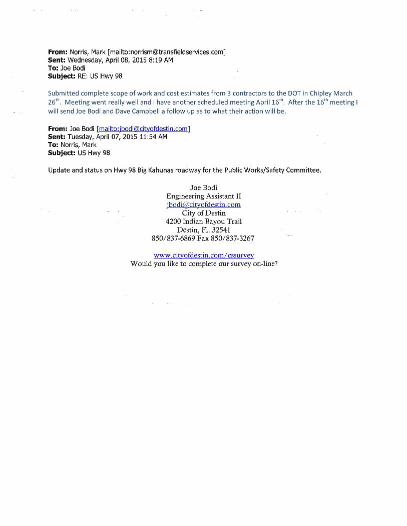
i) Update and status on Hwy 98 Big Kahunas roadway - pothole and bump is still an issue/Steve Menchel.
j) Update and status of the Street Sign installation/replacement project on Hwy 98 mast arm intersections/Steve Menchel.
k) Update and status of PW/PS committee having access to SIGNAL FOUR ANALYTICS computer system/Steve Menchel
l) Update and status of Street Light inventory/Steve Menchel
5. DISCUSSION: a) Bicycle Sub-Committee Report b) Committee Member Steve Menchel
c) Committee Member Scott Jacobs
d) Committee Member Andrea Ansley
e) Committee Member Sam Perman
f) Committee Member Philip Jata
g) Committee Member Guy Tadlock
h) Committee Member Nancy Weidenhamer
i) Public Services Monthly Project Status Report
6. ADJOURNMENT: If a person decides to appeal any decision made by the City Council, committee, board, panel, or agency with respect to
any matter considered at such meeting or hearing, he or she will need a record of the proceedings, and that, for such purpose, he or she will may need to ensure that a record of the verbatim record of the proceedings is made, which record includes the testimony and evidence upon the appeal is to be based.
"Persons with disabilities who require assistance to participate in this meeting are requested to notify the Public
Services Office 850/837-4242 at least 48 hours in advance".
MINUTES OF THE PUBLIC WORKS/SAFETY COMMITTEE MEETING
TUESDAY, MARCH 10,2015 5:30PM DESTIN CITY HALL BOARDROOM
1. CALL TO ORDER:
Chairman Nancy Weidenhamer called the Public Works/Safety Committee to order on Tuesday, March 10, 2015, at 5:30p.m.
ROLLCALL: Members Present Nancy Weidenhamer Steve Menchel Phil Jata Guy Tadlock Scott Jacobs
Members Absent Andrea Ansley Sam Perman
Staff Kim Montgomery, Deputy City Clerk Joe Bodi, Engineering Assistant
2. APPROVAL OF MINUTES: February 10, 2015
On a motion by Committee member Menchel, seconded by committee member Jata; the members voted unanimously to approve the February 10, 2015 minutes as written.
3. NEW BUSINESS:
• Okaloosa County Sheriff's Department Presentation- Ted Pecot
Capt. Pecot showed the member the computer program called Signal Four Analytics they 've been using and how easy it is now to pin down different incidents in the City. He explained that Committee member Menchel had asked him about bicycle involved crashes in the City and showed with the program how he can drill locate a certain one or others and their locations over the past year as well as the details that were provided in the report by the deputy on the scene. He then provided a short overview of how it works in regards to tracking other crashes that include traffic, pedestrian, and motorcycle crashes as well.
Committee member Menchel asked how the reports get populated into the program. Capt. Pecot explained that the information is first entered in the computer in the deputy' s cruiser at the scene; the shift personnel then reviews the information for accuracy before sending it off to the State. Committee member Tadlock asked if the information is available on a website. Capt. Pecot responded that it ' s only available to government entities but doesn't think it would be a problem for this committee to access the information. The Engineering Assistant stated that he is in the process of signing up for the information adding that he has to send a letter on City letterhead for the request and once he gets all approved, he provide them with the information on how to access the information. He continued that they would have training on how to use the program and pointed out that their access to the program is something that they will have to keep secure.
Capt. Pecot then explained to the members the duties from his office that he has in the Destin Commons noting that their offices and furniture are all donated by Destin Commons for their use in what is called the Eastern District.
1
unctions
~==r::=:-:flw~ ~Mil l'bwallr a., ii to 1M Wilkin County lJnl.. II hili I clltalwd .,, __ ........ : -JTiit-niJIIitl*'lqllld. {Diillnlddld 3to conlnct fY 2115,
.,..::·:rdoilotlf~ destination. The East District As such record breaking ng -calls for service in the
ihlefi.eo\felr$ from east of the Brooks Bridge on ,_fijtr[t(ftltt~ 111ra11tnn County line, north to Duke Field,
Nor1'1111111est Florida Regional Airport. and all southern
In addition the Mid-Bay Bridge Connector By-pass opened in 2014- adding 10 miles of additional roadway to patrol. The largest permanentpopulation serviced in the East District is Destin which stands at 13,697 and swells to over 60,000 during the 100 days of summer and spring break. Bluewater Bay/Seminole area is close behind with a population of 12,730. The total. population of the East District stands at46,930
He spoke of the Festive Market Place along the Harbor and explained that their calls have skyrocketed for that area since the inception of allowing people to carry drinks outside the establishments in this area.
2
Committee member Tadlock stated that he feels the line should not be up to the sidewalk on 98 to allow open containers; adding that he has witnessed people pulling their coolers across the highway from the Marler Parking Lot and already have a beer opened. He stated that he would like to see the line moved back down closer to the harbor and away from the highway.
CaJIIs for Seirvice A!lcohol EstabUshrments 2009 Through 2013
With Spring Break being in full swing; Walton County has again taken the brunt of the visitors trashing the beaches. However, they have 35 deputies and he only has 4 to police the beaches. He spoke of volunteers he can call on when needed, if they are able to help out, and suggested that the best hope for more funding to hire additional deputies is for the citizens to attend the Okaloosa County Commission meetings and demand for additional funding to hire more deputies.
3
Underage Possession of Alcohol
Arrests for underage possessio n of a lco ho l d uring Spring Break 2009-552, 20:10- 566, 2on-342 , 20:12- 543, 2013-337, 2014-393
Committee member Tadlock asked if they have seen a change in underage drinking. Capt. Pecot stated that he thinks it's still about the same.
Committee member Jacobs spoke of how Destin was showcased on a Housewives of Atlanta and how disturbing it was in regards to how they allowed the teenaged children to act on the show which is a big influence with all the teenagers that watch the show.
Capt. Pecot spoke of how Crab Island has become too commercialized and out-of-hand. The need to take control of vendors as well as corridors so that emergency water vehicles can get faster access to people in need of life saving; explaining that at least once a year someone ends up with a broken neck from · · into the shallow water.
In the past year Destin ranked #8 on boating related crashes in the State although Destin has been ranked #4 in the past. He explained that Destin has 17 sworn officers and that Panama City Beach with a comparable population with permanent and tourist populations have 58 officers adding that although he feels Destin doesn't need that many, we do need more.
Capt. Pecot invited the members to ride on a Friday or Saturday patrol unit to get an eye opening experience on what takes place after 9 p.m. He added that guns and drugs are getting more and more prevalent in the City. Committee member Tadlock asked him if the Courts System backs them up. Capt. Pecot stated that they are so overwhelmed and the jails are so full that they really can't; adding that a nonviolent criminals are put back on the streets a lot quicker.
There was a discussion regarding stolen cars and Capt. Pecot pointed out that 70% of stolen cars are not locked. The discussion changed to the recent rash of vehicles being broken into and items being stolen. Committee member Tadlock spoke of the Hide it & Lock it campaign. The Chairman suggested
5
to Committee member Tadlock that he should champion the campaign and contact the local TDD and Beach TV to help get the word out to the tourists.
Service population 11,814
* Very similar tourist population Number of Officers 51
Equals 4. 7 officers per 1000 residents Law Enforcement budget $6,977,079.00
Committee member Menchel stated that he is an advocate for bed tax funds being redirected more towards the City because Destin has the highest capacity of tourists in the County and should get their fair share of the bed tax to help pay for additional support needed from the Sheriffs Department. He then asked Capt. Pecot what they can do to champion the department. Capt. Pecot responded that continuing to back the bed tax realignment so that is can help them get more deputies on staff. As well as continuing to keep the address numbering up-to-date for both homes and commercial businesses is a tremendous help to both the departments as well as the citizen so that they can get to the address as quickly as possible in emergency situations.
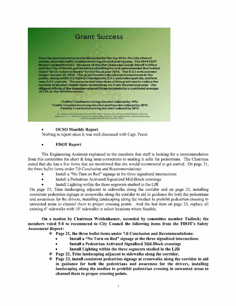
He then praised the assistance that the department received from the Grants and Projects Manger helping them obtain grants in the last few years and spoke of the statistics.
6
"Traffic Crashes Involving Alcoholr~ced by 11-9%! •Traffic Crashes involving Alcohol and ~n:Ju lies reduced by 3()%;!
•Fatality CFashedinvofving Alcohol..-edu<Ed by 50%!
d ..:: .:d-~ ,:.:.::..:::r ~::::0...-.2'1~ 3.1~:=. =~- ':"r ~::._.-
• OCSO Monthly Report Nothing to report since it was well discussed with Capt. Pecot.
• FDOT Report
The Engineering Assistant explained to the members that staff is looking for a recommendation from this committee for short & long term corrections to making it safer for pedestrians. The Chairman stated that she has a few items that are mentioned that she would recommend to get started. On page 21 , the three bullet items under 7.0 Conclusion and Recommendations:
• Install a "No Turn on Red" signage at the three signalized intersections • Install a Pedestrian Activated Signalized Mid-Block crossings • Install Lighting within the three segments studied in the LJR
On page 22, Trim landscaping adjacent to sidewalks along the corridor and on page 23 , installing consistent pedestrian signage at crosswalks along the corridor to aid in guidance for both the pedestrians and awareness for the drivers, installing landscaping along the median to prohibit pedestrian crossing in unwanted areas to channel them to proper crossing points. And the last item on page 23, replace all existing 6' sidewalks with 10' sidewalks in select locations where feasible .
On a motion by Chairman Weidenhamer, seconded by committee member Tadlock; the members voted 5-0 to recommend to City Council the following items from the FDOT's Safety Assessment Report:
•!• Page 21, the three bullet items under 7.0 Conclusion and Recommendations: • Install a "No Turn on Red" signage at the three signalized intersections • Install a Pedestrian Activated Signalized Mid-Block crossings • Install Lighting within the three segments studied in the LJR
•!• Page 22, Trim landscaping adjacent to sidewalks along the corridor, •!• Page 23, install consistent pedestrian signage at crosswalks along the corridor to aid
in guidance for both the pedestrians and awareness for the drivers, installing landscaping along the median to prohibit pedestrian crossing in unwanted areas to channel them to proper crossing points.
7
•:• Replace all existing 6' sidewalks with 10' sidewalks in select locations where feasible.
4. OLD BUSINESS:
• Bicycle Subcommittee
Nothing to report
~ COMMITTEE MEMBER COMMENTS
• Committee member Menchel
Asked the Engineering Assistant if the Gulf Power street light inventory has been finalized. The Engineering Assistant stated that it ' s a very comprehensive undertaking and they still have a lot of work to do .
• Committee member Tadlock
Asked about the status of the Restore Act funds and added that the City should consider a recommendation to use some of those funds for a street light project as well as using some towards the Marler Street crosswalk/traffic control device.
Committee member Jata asked who is responsible for lighting on Highway 98. The Engineering Assistant suggested that they all come to the FDOT presentation to City Council and make their suggestions that they feel should be on the need list.
• Chairman Weidenhamer
The Chairman reminded the Engineering Assistant that he needs to get the road restriping and resurfacing report for 2015 to Lockwood Wernet so they can schedule their pipe repairs with the City's repatrs.
5. PUBLIC SERVICES REPORT:
No discussion.
6. ADJOURN:
Having no further business at this time, the meeting adjourned at 7:25p.m.
Adopted and approved this ______ day of _______ 2015 .
Nancy Weidenhamer, Chairman Kim Montgomery, Deputy City Clerk
8
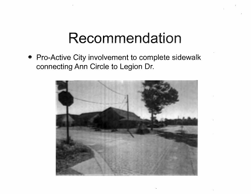
Sidewalk Completion
Corner of Legion Dr. and Ann Cir. Submitted by: Capt Adam Miles
Sidewalk Completion • Pedestrian Safety
• Area Beautification
• Recommendation Legion Dr and Ann Cir
Legion Dr & Ann Cir Deslin, f"l32541
••••
Uist"U'I
' -~') '''· Buek ~~!irl P111'1!
Pedestrian Safety • No sidewalks connecting Ann Circle to Legion Dr.
• Witnessed 8-12 pedestrians/bicycles transit per hour during daylight I 6-8 per hour dusk-evening
• Dimly lit- high pedestrian traffic coupled with high vehicle traffic on Legion Dr.
Area Beautification • Completing Sidewalk will better define the corner
• Completion ONLY requires 60-70' of sidewalk per side
• Owner (Mr. Miles) of 704 Legion Dr (corner lot) will landscape inside of sidewalk to beautify corner I raise Destin sight appeal
• Reduction in trash on lawns pedestrians currently travel through
• Reduction in parking on lawns due to defined sidewalk
Recommendation • Pro-Active City involvement to complete sidewalk
connecting Ann Circle to Legion Dr.
Continuing Services Contractor
Project Location
Date
Length (ft)
Width (ft)
Depth (4in)
LxW =SF
LxWxD = CF
CF div 27 = CY
SF div9 = SY
Total Pounds
Total Tons
DEMOLITION
Clear & Grub
Debris Hauling
Tree Trimming
PAVING
Asphalt Patch, 2"
Prime Coat
Tack Coat
8" Graded Aggregate Base, delivered and compacted on grade
4" Graded Aggregate Base, delivered and compacted on grade
Stabilized Subbase 12"
Stabilized Subbase 6"
Removal of Asphalt up to 4M thick
Asphalt cut with abrasive blade
TRAFFIC
Traffic Control (MOT) cost
Guardrail Aluminum Pipe (FOOT Index 870)
Guardrail (FOOT Index)
CONCRETE
Concrete Driveway 6" thick-fiber reinforced
Concrete Sidewalk 4" thick, installed
Concrete Ribbon Curb, 12" wide X 8" deep
Concrete Type 'D' Curb
Concrete Type 'E' Curb & Gutter
Concrete Type 'F' Curb & Gutter
Concrete Modified 18" Type 'F' Curb & Gutter
Removal of Concrete up to 6"
Removal of Concrete over 6"
Ann Circle
200
4
0.33
800
264.00
9.78
88.89
23466.667
11.733333
QTY
5
10
QTY
QTY
QTY
800
UNIT
HR
CY
HR
UNIT
SY
SY
SY
SY
SY
SY
SY
SY
LF
UNIT
DAY
LF
LF
UNIT
SY
SF
LF
LF
LF
LF
LF
SY
SY
COST
$75.00
$8.15
$35.00
TOTAL:
COST
$15.00
$1.00
$1.00
$16.50
$10.00
$4.00
$3.25
$9.00
$1.50
TOTAL
$375.00
$81.50
$0.00
$456.50
TOTAL
$0.00
$0.00
$0.00
$0.00
$0.00
$0.00
$0.00
$0.00
$0.00
TOTAL: $0.00
COST TOTAL
$250.00 $0.00
$75.15 $0.00
$75.15 $0.00
TOTAL: $0.00
COST TOTAL
$44.15 $0.00
$4.00 $3.200.00
$8.50 $0.00
$9.50 $0.00
$9.50 $0.00
$12.25 $0.00
$15.15 $0.00
$9.15 $0.00
$12.15 $0.00
Concrete cut with abrasive blade
FDOT specification handrail
DRAINAGE QTY
Manhole Adjust
Concrete Headwall or Drainage Structure
18" RCP installed
24" RCP installed
15K ADS Culvert Pipe installed
18" ADS Culvert Pipe installed
Inlet Adjustments
Mitered end section SMALL 6" to 12"
Mitered end section MEDIUM 15" to 18"
Mitered end section Adjustment
Concrete flume 4" thick
Inlet Apron
Grout
Concrete Collar
Swale installation
Item
UTILITIES
Valve Box Adjust
Irrigation heads
Irrigation Piping
Item
Item
Item
Item
SOD & EROSION CONTROL QTY
Bermuda Sod 94
St. Augustine Sod
Centipede Sod
Hay Bales
Silt Fence
EARTHWORK QTY
Fill Dirt
Excavation
Final Qradinq
Dewatering/Well Points
Compaction
LF
LF
UNIT
EA
CY
LF
LF
LF
LF
HR
EA
EA
EA
SY
SY
EA
EA
SF
EA
EA
EA
LF
EA
EA
EA
EA
UNIT
SY
SY
SY
EA
LF
UNIT
CY
CY
SY
HR
HR
$1.50
$75.15
TOTAL:
COST
$150.00
$3.15
$35.00
$45.00
$30.00
$35.00
$49.15
$75.15
$175.00
$57.15
$40.50
$40.50
$50.00
$50.00
$10.00
$0.00
$0.00
$3,200.00
TOTAL
$0.00
$0.00
$0.00
$0.00
$0.00
$0.00
$0.00
$0.00
$0.00
$0.00
$0.00
$0.00
$0.00
$0.00
$0.00
$0.00
TOTAL: $0.00
$225.00 $0.00
$2.00 $0.00
$1.00 $0.00
$0.00
$0.00
$0.00
$0.00
TOTAL: $0.00
COST
$4.05
$4.05
$4.05
$6.15
$1.50
TOTAL:
COST
$8.50
$8.50
$2.00
$110.00
$25.00
TOTAL
$380.70
$0.00
$0.00
$0.00
$0.00
$380.70
TOTAL
$0.00
$0.00
$0.00
$0.00
$0.00
.TOTAL: $0.00
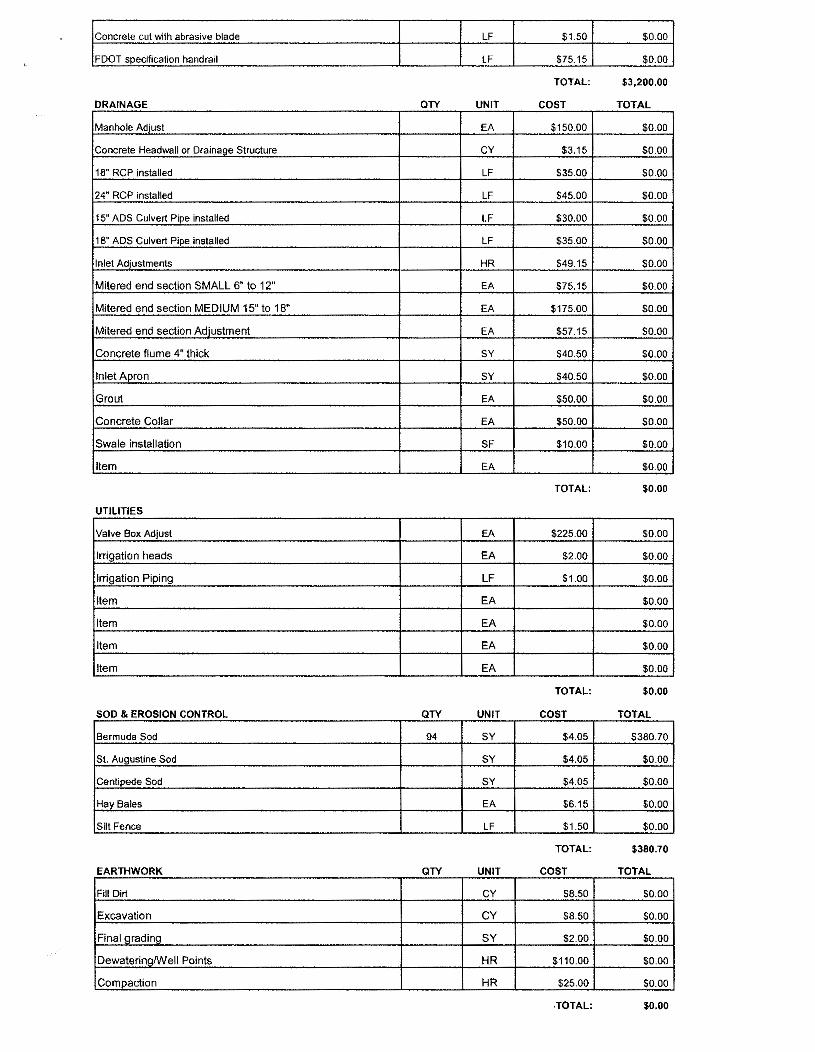
GRAND TOTAL $4,037.20 I
) I
Office of the City Manager 4200 Indian Bayou Trail I Destin , FL 32541 I Phone: 850-837-4242 I Fax: 850-650-9250 I V>'WW.cityofdestin.com
March 6, 2015
Jenny Cook- TPO Staff Brian Youpatoff - Transportation Planner West Florida Regional Planning Council 4081 E Olive Road- Suite A- Pensacola, FL 32514
Re: Transportation Alternatives Program- City of Destin Funding Application
Dear Ms. Cook & Mr. Youpatoff:
The City of Destin respectfully submits the attached Transportation Alternatives Program (TAP) funding application for the Calhoun A venue and Zerbe Street Pedestrian Facilities Project for the TPO's consideration.
The Project is important in furthering the City's commitment to providing a safe, attractive, and efficient pedestrian facilities network for its residents and visitors. City Council support for the project is reflected in the attached Resolution 15-03.
Please contact Planner, Hank Woollard if you have any questions regarding this submittal. Hank can be reached at 850-337-3121 or via email at [email protected].
The City appreciates the opportunity to be considered for funding under the TAP program.
Sincerely,
-i1 ~ Gregory A. Kisela City Manager
Enc. TAP Application Package
Copy to:
Community Development Director, Ken Gallander, AICP Public Services Director, David Campbell, P.E. Development Manager, Steve Schmidt FDOT TAP File
RESOLUTION 15-03
A RESOLUTION OF THE CITY COUNCIL OF THE CITY OF DESTIN TO SUPPORT CONSTRUCTION OF THE CALHOUN A VENUE PEDESTRIAN FACILITIES IMPROVEMENTS WITH TRANSPORTATION ALTERNATIVE PROGRAM FUNDING.
WHEREAS, walking and bicycling help meet the goals of Chapter 339.1 75 Florida Statutes - Metropolitan Planning Organization - to serve the mobility needs of people while minimizing transportation related fuel consumption and air pollution; and
WHEREAS, the Center for Disease Control (CDC) encourages people to walk for fitness, transportation and fun; and
WHEREAS, MAP-21, the Moving Ahead for Progress in the 21 51 Century Act (P.l> 112-141), was signed into law by President Obama on July 6, 2012, to address growing concerns about air quality, open space, and traffic congestion. The Transportation Alternative Program (TAP) strengthens the cultural, aesthetic, and environmental aspects of the Nation· s intermodal transportation system: and
WHEREAS, this support is consistent with the Okaloosa/Walton Transportation Planning Organization (TPO), FOOT, CDC, and MAP-21 policies supporting alternative means of transportation; and
WHEREAS, the City of Destin established the first multi-modal transportation district in the State of Florida and has continued to successfully implement it over the past decade;
NOW, THEREFORE BE IT RESOLVED by the City Council of the City of Destin that the City hereby affirms its support for the construction of the Calhoun Avenue Pedestrian Facilities Improvements.
ATTEST:
ADOPTED TIDS 2ND DAY OF MARCH 2015 BY:
o1 I P nder, Mayor
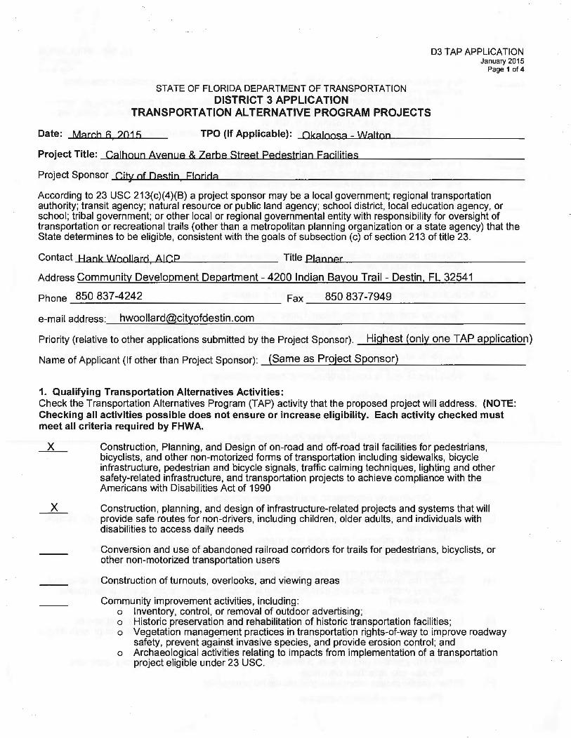
STATE OF FLORIDA DEPARTMENT OF TRANSPORTATION DISTRICT 3 APPLICATION
Project Title: Calhoun Avenue & Zerbe Street Pedestrian Facilities
Project Sponsor City of Destin Florida
According to 23 USC 213(c)(4)(8) a project sponsor may be a local government; regional transportation authority; transit agency; natural resource or public land agency; school district, local education agency, or school; tribal government; or other local or regional governmental entity with responsibility for oversight of transportation or recreational trails (other than a metropolitan planning organization or a state agency) that the State determines to be eligible, consistent with the goals of subsection (c) of section 213 of title 23.
Contact Hank Woollard AICP ; Title Planner
Address Community Development Department- 4200 Indian Bayou Trail - Destin, FL 32541
Priority (relative to other applications submitted by the Project Sponsor). Highest (only one TAP application)
Name of Applicant (If other than Project Sponsor): (Same as Project Sponsor)
1. Qualifying Transportation Alternatives Activities: Check the Transportation Alternatives Program (TAP) activity that the proposed project will address. (NOTE: Checking all activities possible does not ensure or increase eligibility. Each activity checked must meet all criteria required by FHWA.
X
X
Construction, Planning, and Design of on-road and off-road trail facilities for pedestrians, bicyclists, and other non-motorized forms of transportation including sidewalks, bicycle infrastructure, pedestrian and bicycle signals, traffic calming techniques, lighting and other safety-related infrastructure, and transportation projects to achieve compliance with the Americans with Disabilities Act of 1990
Construction, planning, and design of infrastructure-related projects and systems that will provide safe routes for non-drivers, including children, older adults, and individuals with disabilities to access daily needs
Conversion and use of abandoned railroad corridors for trails for pedestrians, bicyclists, or other non-motorized transportation users
Construction of turnouts, overlooks, and viewing areas
Community improvement activities, including: o Inventory, control, or removal of outdoor advertising; o Historic preservation and rehabilitation of historic transportation facilities; o Vegetation management practices in transportation rights-of-way to improve roadway
safety, prevent against invasive species, and provide erosion control; and o Archaeological activities relating to impacts from implementation of a transportation
project eligible under 23 USC.
03 TAP APPLICATION January 2015
Page 2 of4
Any environmental mitigation activity, including pollution prevention and pollution abatement activities and mitigation to:
o Address storm water management, control, and water pollution prevention or abatement related to highway construction or due to highway runoff including activities described in 23 USC 133(b)(11), 328(a) and 329; or
o Reduce vehicle-caused wildlife mortality or to restore and maintain connectivity among terrestrial or aquatic habitats.
The Recreational Trails Program under 23 USC 206 - Contact Alexandra Weiss at Department Of Environmental Protection, Office of Greenways and Trails (850) 245-2052, toll-free at 1-877-822-5208, or email [email protected]
Safe Routes to School Projects- A separate application (FOOT Form # 500-000-30) must be submitted. This form may be accessed at: http://www2.dot.state.fl.us/proceduraldocuments/forms/ByNumber.asp?index=5 Contact Alicia Brininger at (850) 330-1550 for further information.
Planning, designing, or constructing boulevards and other roadways largely in the right-of-way of former Interstate System routes or other divided highways.
2. Project Description: Use additional sheets as necessary to respond to the following:
(a) Provide a clear and concise detailed description of the Transportation Alternatives project. For sidewalks and multi-use paths, include the preferred width and construction material, (i.e. concrete or asphalt surface). If the project is located parallel to a roadway include which side of roadway is proposed for the construction, and note any unique or special features that may be necessary which have been identified (such as boardwalks, bridges, drainage, guardrail, etc.).
Please see attached narrative. (b) What type of work is being proposed? (Check all that apply)
(c)
(d)
(e)
(f)
(g)
(h)
X
X
X
X
X
Planning Activities
Project Development and Environmental Studies
Engineering and Final Plans Preparation Work
Right of Way Acquisition
Construction
Construction Engineering and Inspection Activities
Where is the project located (and what is the project length and termini, if appropriate)? Include location map.
Please see attached narrative and maps. Summarize any special characteristics of project. Provide typical section drawings for appropriate projects.
Please see attached narrative and drawinos. . . . . . Descnbe the project's existing nght otway ownersn1ps. This descnpt1on shall1dent1fy when the right of way was acquired and how ownership is documented (i.e. plats, deeds, prescriptions, certified surveys).
D Please see attac_tledhntarrative. . .t. . 1
d. t d t h' f d escnbe any proposeu ng otway acqu1s1 1on, 1nc u mg expec e rna c 1ng un source, limitations on fund use or availability, and who will acquire and retain ownership of proposed right of way.
Please see attached narrative. Describe any related project work phases that are already complete or currently underway.
Please see attached narrative. Other specific project information that should be considered.
Please see attached narrative.
03 TAP APPLICATION January 2015
Page 3 of4
3. Project Implementation Information: Please refer to attached project narrative.
Attach documentation as exhibits to this application.
4.
(a) Describe the proposed method of performing (i.e. contract or in-house) and administering (i.e. local or state) each work phase of the project. If it is proposed that the project be administered by a governmental entity other than the Department of Transportation, the agency must be certified to administer Federal Aid projects in accordance with the department's Local Agency Program M~nua/ (Topic No. 525-010-300).
(b) Describe any public (and private, if applicable) support of the proposed project. (Examples include: written endorsement, formal declaration, resolution, financial donations or other appropriate means).
(c) Describe the proposed ownership and maintenance responsibilities for the project when it is completed.
(d) Describe source of matching funds and any restrictions on availability.
(e) Other specific implementation information that should be considered.
Project Cost: Please refer to Exhibit "E" Construction Cost Estimate
If a more detailed breakdown of cost estimates is being provided , a sample cost estimates sheet is provided for your use. Sample Construction Cost Estimate
For latest cost information go to: http://www.dot.state.fl.us/specificationsoffice/Estimates/HistoricaiCostlnformation/HistoricaiCost.shtm
What is the total estimated cost of the work requested to be funded as a transportation alternative project through this application?
Planning Activities. $ ______ _
Project Development and Environmental Studies. $ ______ _
Engineering and Final Plans Preparation Work. $. ______ _
Right of Way Acquisition. $ ______ _
Construction. $ ______ _
Construction Engineering and Inspection Activities. $ ______ _
Other. (Describe) $ ______ _
TOTAL: $ _____ _
How will the project be funded?
FOOT Transportation Alternative Funds $ ____ + Local $ ____ =Total $. ____ _
FOOT Transportation Alternative Funds ____ % + Local ____ % = 100%
03 TAP APPLICATION January 2015
Page 4 of4
CERTIFICATION OF PROJECT SPONSOR
I hereby certify that the proposed project herein described is supported by the Destin City Council (Project Sponsor)
and that said entity will: (1) provide any required funding match; (2) enter into a maintenance agreement with the Florida Department of Transportation; (3) comply with the Federal Uniform Relocation Assistance and Acquisition Policies Act for any Right of Way actions required for the project, and (4) comply with the NEPA process prior to construction, which may require involvement with the State Historic Preservation Officer (SHPO), and other State and/or Federal agencies, prior to construction, and (5) support other actions necessary to fully implement the proposed project. I further certify that the estimated costs included herein are reasonable and agree to follow through on the project once programmed in the Florida Department of Transportation's Work Program. I fully understand that significant increases in these costs could cause the project to be removed from the Florida Department of Transportation work program.
If project is not located along a state roadway: Is sponsor or applicant willing to administer project using the Department's Local Agency Program (check one) Yes___x_ No __
Status of sponsor/administrator's LAP certification: Currently certified x Not certified __ _ Applied for certification & pending review__ Planning to apply for certification __
Other (explain)--------------------------------
Is resolution included with application? Yes_____K_ No __ A copy of the adopted resolution showing sponsor's (board or council) approval and support of project should be included with this application.
"Mel" Ponder Name (please type or print)
Mayor - City of Destin Title
March 6, 2015
Date
* This should be executed by person who has signatory authority for sponsor and is authorized to obligate services and funds for that entity (generally chairman of the board or council).
City of Destin 2015 TAP Application Narrative
Calhoun Avenue and Zerbe Street Pedestrian Facilities
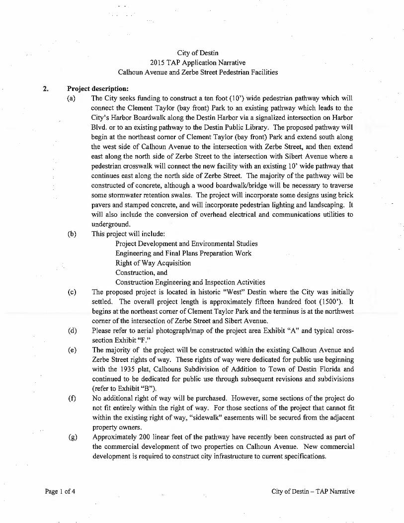
2. Project description: (a) The City seeks funding to construct a ten foot (10') wide pedestrian pathway which will
connect the Clement Taylor (bay front) Park to an existing pathway which leads to the City's Harbor Boardwalk along the Destin Harbor via a signalized intersection on Harbor Blvd. or to an existing pathway to the Destin Public Library. The proposed pathway will begin at the northeast comer of Clement Taylor (bay front) Park and extend south along the west side of Calhoun A venue to the intersection with Zerbe Street, and then extend east along the north side of Zerbe Street to the intersection with Sibert A venue where a pedestrian crosswalk will connect the new facility with an existing 10' wide pathway that continues east along the north side of Zerbe Street. The majority of the pathway will be constructed of concrete, although a wood boardwalk/bridge will be necessary to traverse some stormwater retention swales. The project will incorporate some designs using brick pavers and stamped concrete, and will incorporate pedestrian lighting and landscaping. It will also include the conversion of overhead electrical and communications utilities to underground.
(b) This project will include: Project Development and Environmental Studies Engineering and Final Plans Preparation Work Right of Way Acquisition Construction, and Construction Engineering and Inspection Activities
(c) The proposed project is located in historic "West" Destin where the City was initially settled. The overall project length is approximately fifteen hundred foot (1500'). It begins at the northeast comer of Clement Taylor Park and the terminus is at the northwest comer of the intersection of Zerbe Street and Sibert A venue.
(d) Please refer to aerial photograph/map of the project area Exhibit "A" and typical crosssection Exhibit "F."
(e) The majority of the project will be constructed within the existing Calhoun Avenue and Zerbe Street rights of way. These rights of way were dedicated for public use beginning with the 1935 plat, Calhouns Subdivision of Addition to Town of Destin Florida and continued to be dedicated for public use through subsequent revisions and subdivisions (refer to Exhibit "B").
(f) No additional right of way will be purchased. However, some sections ofthe project do not fit entirely within the right of way. For those sections of the project that cannot fit within the existing right of way, "sidewalk" easements will be secured from the adjacent property owners.
(g) Approximately 200 linear feet of the pathway have recently been constructed as part of the commercial development of two properties on Calhoun Avenue. New commercial development is required to construct city infrastructure to current specifications.
Page 1 of4 City of Destin - TAP Narrative
(h) The Calhoun Avenue Pathway is planned to connect to the northern extension of Destin's Harbor Boardwalk at some point north of the Marler Bridge. Until it becomes possible to make that connection, it is very important that pedestrian traffic be guided to the signalized pedestrian crossing at Stahlman Avenue and Harbor Blvd. (aka. U.S. Hwy. 98) where they can safely cross Harbor Blvd. This project will accomplish that essential pedestrian safety objective.
3. Project implementation Information:
(a) The scope of work will consist ofsix(6) tasks: (1) Surveying and testing
Page 2 of4
(2) Engineering Design (3) Permitting ( 4) Construction Administration ( 5) Construction ( 6) Inspection
The City will solicit proposals from Engineering firms and select one firm to provide surveying and testing, engineering design, permitting, construction administration, and inspection services for each task.
• Surveying and Testing - The survey shall be of sufficient detail to establish accurate elevations and location of all existing features in the project area, including roads, sidewalks, utilities, stormwater structures, property lines, easements, houses, trees and other features relevant to the project. The testing will consist of a geotechnical investigation and analysis of the existing soil conditions ..
• Engineering Design - The engineering design will be based on the City of Destin adopted specifications for the pedestrian pathways in the Harbor District (refer to Exhibit "C"). The engineer shall provide construction plans and specifications in sufficient detail to construct the proposed improvements. The engineer will coordinate with the City, Gulf Power Company and the other utility companies for the relocation of overhead utilities.
• Permitting- The project will be submitted to the FDOT, City of Destin Community Development Department and the City of Destin Public Services Department for review and approval.
• Construction Administration - The engineering firm will provide the construction administration and inspection services for the project. Construction administration will include bidding, shop drawing review, issuing addenda, review and approval of pay requests, review and approval of change orders, and as-built drawing and certifications. The City has a staff of engineers and inspectors qualified to provide project management, to monitor the construction process and to work with the FDOT grant administrator. City will coordinate with the utility companies to relocate all overhead utilities prior to construction of the pathway improvements.
City of Destin-TAP Narrative
• Construction - The Contractor will be selected using a competitive selection process established in City Ordinance 244 and Florida Statutes Chapter 287. The City will select the most qualified, responsible, responsive bidder to construct the project in accordance with the engineered plans and specifications as well as the local, state and
federal permit requirements.
• Inspections - The engineering firm will provide daily construction inspection
sufficient to ensure the construction is in accordance with the plans and specifications. Weekly projects meetings will be held at Destin City Hall with the engineer, contractor, utility companies and City staff.
(b) The proposed project incorporates elements of three priority projects in the City of Destin, 2009 Pathways Master Plan which was incorporated into the City's Land Development Code by Ordinance after considerable public participation before the Local Planning Agency and Public Works and Public Safety Committee (refer to Exhibit "G").
(c) The project will be owned by the City of Destin and will be maintained by the City of
Destin Public Services Department.
(d) Locally collected gasoline tax funds will be used for the project match.
(e) Destin is the first city in Florida to have a State approved and designated multimodal transportation district. This project will further the goals of the multimodal transportation
initiative by providing additional pedestrian infrastructure. The project was adopted in the City's FY 2015 Budget and Capital Improvements Plan by the City Council (refer to
exhibit "D").
4. Project Cost:
Please refer to the enclosed project cost estimate (refer to Exhibit "E").
Project funding:
FDOT Transportation Alternative Funds $928,706.30 Local $300,000 =Total $1,228,706.30
FDOT Transportation Alternative Funds 76% Local24% = 100%
Page 3 of4 City of Destin- TAP Narrative
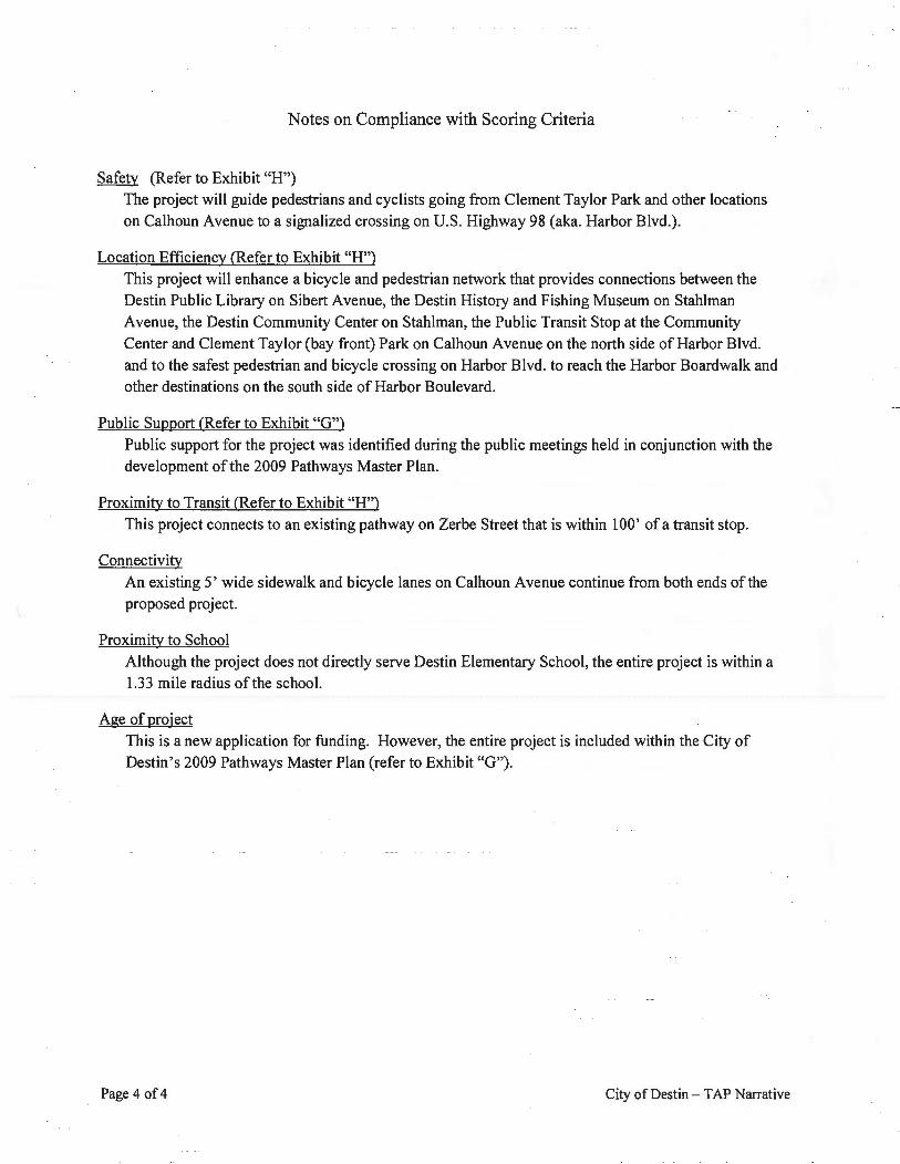
Notes on Compliance with Scoring Criteria
Safety (Refer to Exhibit "H")
The project will guide pedestrians and cyclists going from Clement Taylor Park and other locations on Calhoun Avenue to a signalized crossing on U.S. Highway 98 (aka. Harbor Blvd.).
Location Efficiency (Refer to Exhibit "H")
This project will enhance a bicycle and pedestrian network that provides connections between the Destin Public Library on Sibert A venue, the Destin History and Fishing Museum on Stahlman Avenue, the Destin Community Center on Stahlman, the Public Transit Stop at the Community
Center and Clement Taylor (bay front) Park on Calhoun Avenue on the north side of Harbor Blvd. and to the safest pedestrian and bicycle crossing on Harbor Blvd. to reach the Harbor Boardwalk and other destinations on the south side of Harbor Boulevard.
Public Support (Refer to Exhibit "G")
Public support for the project was identified during the public meetings held in conjunction with the development of the 2009 Pathways Master Plan.
Proximity to Transit (Refer to Exhibit "H") This project connects to an existing pathway on Zerbe Street that is within 1 00' of a transit stop.
Connectivity An existing 5' wide sidewalk and bicycle lanes on Calhoun A venue continue from both ends of the proposed project.
Proximity to School Although the project does not directly serve Destin Elementary School, the entire project is within a 1.33 mile radius ofthe school.
Age of project
This is a new application for funding. However, the entire project is included within the City of Destin's 2009 Pathways Master Plan (refer to Exhibit "G").
Page 4 of4 City of Destin - TAP Narrative
EXHIBIT
A
N
A 0 230 460 920
I ~--~
' ' h
I.
~
" ·<r
SECOND REV I SION OF
CALHOUNS SUBDIVISION OF ADDITION TO T OWN OF
DESTIN FLORIDA OKALOO SA COUNTY
"" a
EXHIBIT
~ e
OTAT~ OF' f'i.ORJOI" Cot)NTY or OKALoos;.)
&i\t"e f?e u6~rtlJf:r P.•r4tH1o!.'u ~F~~J Tl{kr Colfuwn, kna~n lo mel• be &'-lc inaiVtc'uo/ cldcribed
I c. I Harbor CRA District Streetscape - Hardscape Standards
Streetscape hardscape design on Harbor Boulevard and Calhoun A venue within the Destin Harbor CRA area shall generally be as shown on the sheet prepared by Tetra Tech, Inc. titled "Sidewalk & Pedestrian Lighting Hardscape Concepts" and further specified as follows:
• Concrete sidewalk: 6-inch thick sidewalk in accordance with FDOT Index No. 310 with a foundation in accordance with FDOT Standard Specification 522-4. Tooled or stamped in a wood deck pattern with 12-inch wide "boards" and 12-inch external banding. A stamped pattern of truncated domes shall be used to delineate ADA accessible access in concrete sidewalk areas on comers of cross streets.
• Pavers: Decoloc Omnidirectional concrete pavers, Destin Fire color blend; 4x8 concrete pavers, Color Mix 32; or a combination of the two, banded with 4x8 concrete paver "soldier rows" Silver Shell color blend, or equal. Bremen ADA specialty pavers in Silver Shell color blend may be used to delineate ADA accessible access in paver areas on comers of cross streets. (see www.destinpaverslandscaping.com)
• Light Fixtures: Sternberg 2500 Lincoln Series pole with double banner arm, HSCPM twin arm bracket, and CRS22 Harborside fixtures, or equal.
Streetscape hardscape design on other streets within the Destin Harbor CRA area shall be standard concrete sidewalk as otherwise specified in the Land Development Code, with an additional change to the above specified light fixtures as follows:
• Light Fixtures: Use the Gulf Power outdoor lighting program to install the Holophane single or double Euro Style Destin Fixture on Stresscrete fluted concrete poles, or equal privately available poles and fixtures consistent with the Euro Style Destin Fixture on fluted concrete poles specifications.
CAPITAL IMPROVEMENT PROJECT REQUEST PEDESTRIAN FACILITIES PLAN
Calhoun Avenue from Clement Taylor Park to US98
TR618
Purpose and Justification: The purpose of this series of capital improvement projects is to construct and/ or complete a city-wide network of pedestrian and bicycle facilities enabling users to go from one end of the City to the other in a safe and convenient manner. A total of 44 individual improvements are proposed to complete the network. The prioritized list of improvements including sidewalks, bicycle paths, and multi-use trails was adopted by Ordinance 10-01-LC on l\Iarch 15, 2010. The current Calhoun Avenue from Clement Taylor Park to US 98 is one of the projects identified in the Pathways Master Plan. The project incorporates the following: construction of a 10' wide pathway from the west side of Calhoun Avenue beginning at Clement Taylor Park and continuing southward along the west side of Calhoun Avenue to the north side of US Highway 98 as well as extending east on Zerbe to connect with the public parking lot. This new sidewalk is envisioned to eventually link with the proposed Boardwalk Under the Bridge and will feature lighting, landscaping, and street furniture.
Status: Comprehensive Plan Policy: 2-1.3.1 Is this a Multi-Year Project: No If yes, what was/ is the Project's initiation Date:
Overview
FY16 FY17 FY18 FY19
Operations & Maintenance (0 & M) impact(s): Upon complet10n, these unprovements will generate an additional maintenance requirements for landscaping, street furniture and street cleaning. An additional manpower impact estimated to be 100 hours per year for routine maintenance.
Total Funding Requirement(s): $491,575
Expenditures to Date Land Acquisition Conceptual Design Engineering & Permitting Construction ~300,000
Equipment & Furnishings Landscaping & Site Amenities
TOTAL ~300,000
Funding Source(s) General Revenues Gas Tax ~300,000
Bond (Tax Increment)
EXHIBIT
D
Lease Pedestrian Facilities Concept: Sidewalks, Multiuse Trails, Bike Paths
Grant (list sources and amounts) TOTAL $300,000
VII - 6
CALHOUN STREET PEDESTRIAN PATHWAY OPINION OF CONSTRUCTION COSTS
The LDC designates the mm1mum required multi-use trail width as ten feet of unobstructed through zone. This provides the minimum width for two-way pedestrian and non-motorized traffic movements. Figure F, below, graphically depicts multi-use trail design requirements for roadways.
FIGURE F. TYPICAL MULTI-USE TRAIL DESIGN
CITY OF DESTIN • PATHWAYS MASTER PLAN, 2009 UPDATE -
EXHIBIT
IG
PREPARED FOR
THE CITY OF DESTIN
PREPARED BY
RENAISSANCE PLANNING GROUP
SEPTEMBER, 2009
TABLE D. DISTRICT-WIDE ACCESSIBILITY AND CONNECTIVITY
A Master Pathways Plan public workshop was held during a general meeting of the Local Planning Agency (LPA) on May 7, 2009. The intent of the workshop was to obtain a better understanding of the community's broad interests regarding pedestrian and bicycle mobility. The event was advertised to the general public and attendance and participation at the workshop was voluntary. The following groups were represented in attendance:
• LPA members
• Public Works/Public Safety Committee members
• City staff
• General public
The workshop included breakout sessions with the participants. The breakout sessions gave participants the opportunity to discuss the current pathways network and to address opportunities and constraints in the system. In addition, participants expressed public desires by marking-up City pathways maps with comments and suggested recommendations for improvements. Prior to adjournment, a representative from each the breakout session groups provided a summary to the attendees of their group's conversation and the various issues discussed. Many workshop attendees also took an opportunity to provide public comment to LPA members.
_l).! _____ fi).~~-~-~_$.MRY.~X-----------------------------------------------------------------------------------------------------------------------------The workshop included distribution of a pathways questionnaire for attendees to complete and return to facilitators prior to the close of the event. The questionnaire responses gave facilitators an additional tool to assist the City in understanding the various issues and opportunities for improving walking and biking conditions in Destin. Questionnaire responses were tallied and analyzed as one means of assisting to determine desired improvements to pathway facilities.
The questionnaires included five questions. Eighteen participants completed the questionnaires. A copy of the workshop questionnaire form and responses is included as Exhibit B in the Appendix to this Plan.
CITY OF DESTIN • PATHWAYS MASTER PLAN, 2009 UPDATE -
EXHIBITS QUESTIONNAIRE
Pathways Master Plan Update
Community Workshop
May 7, 2009
Questionnaire Objective: We are seeking the Community's broad interests regarding pedestJria.n and bicycle mobility to help
update the !lty's Pathways Master Plan. This questionnaire is one tool to assist the City in
understJant!ling tile various issues and opportunities for improving walking and biking conditions In
Destin. We'd greatly appreciate your help by completing this survey,
1. How do you utilize the existing pedestrian and bicycle network throughout the City, such as
sidewalks, trails, and bicycle paths? (Circle all that apply)
Jogging/Running Walking Bicycling
Commuting to Work/School Recreation/Exercise Personal Errands
2. From the list of destinations, consider which ones are most important to you for bicycling
and/or walking accessibility. Rank the importance of each destination: either low, medium or
high.
Destination Destination
L M H Harbor Walk L M H Clement Taylor Park
L M H Destin Elementary L M H Dalton Threadgill Park
L M H Destin Middle School L M H Mattie Kelly Park
L M H Destin Library L M H Joe's Bayou Rec. Area
L M H Destin City Hall L M H Harbor View Park
L M H Destin Post Office L M H Main Street Park
L M H M organ Sports Complex L M H Keii-Aire Park
L M H Henderson Beach State Park L M H June White Decker Park
L M H James Lee County Park L M H Shirah Street Beach Access
L M H Scenic Hwy 98 (west) Beach Access L M H Gulf Shore Beach Access
L M H Scenic Hwy 98 (east) Beach Access L M H The Shores Shopping Center
L M H Downtown Destin Shopping Center L M H Shoreline Village Mall
L M H Paradise Key Shopping Center L M H Destin Commons
L M H Wai-Mart
City of Destin Page 1 o/2
QUESTIONNAIRE
3. When bicycling or walking, what types of destinations do you frequently travel to? If you
don't currently bike or walk, but would consider doing so, what are some destinations you
would consider?
Response:
4. In your opinion, what are some of the constraints and limitations, if any, to utilizing the
existing pedestrian and bicycle network in the City of Destin?
Response:
5. Are there opportunities for improving accessibility and mobility to the bicycle and pedestrian
network in the City? Please share some of your ideas with us.
Response:
City of Destin Page2 of2
Responses to Questionnaire
1. How do you utilize the existing pedestrian and bicycle network throughout the City, such as sidewalks, trails, and bicycle paths? (circle all that apply)
Table: Mode Utilized Question #1 Responses
Mode Utilized Number of times circled
Jogging/Running 7
Walking 13
Bicycling 14 Community to Work/School 2
Recreation/Exercise 9
Personal Errands 7
Eighteen questionnaires were completed.
2. From the list of destinations, consider which ones are most important to you for bicycling and/or walking accessibility. Rank the importance of each destination: either low, medium or high.
Table: Important Destinations Question #2 Responses and Scores*
Rank Destination SCORE*
Low Medium High
Destin Commons 2 1 12 40 Scenic Hwy 98 (East) Beach Access 2 1 11 37 Destin Post Office 2 6 7 35 Downtown Destin Shopping Center 1 5 8 35 Scenic Hwy 98 (West) Beach Access 3 1 10 35 Wai-Mart 3 4 8 35 Shirah Street Beach Access 2 1 10 34 Gulf Shore Beach Access 2 0 10 32 Harbor Walk 2 0 10 32 Henderson Beach 1 2 9 32 Main Street Park 2 3 8 32 Morgan Sports Complex 2 3 8 32 Harbor View Park 2 1 9 31 Joe's Bayou Rec. Area 2 4 7 31 June White Decket Park 3 0 9 30 Destin City Hall 6 4 5 29 The Shores Shopping Center 3 4 6 29 Mattie Kelly Park 3 2 7 28 Paradise Key Shopping Center 2 4 6 28 Destin Elementary 4 2 6 26 James Lee County Park 2 0 8 26 Clement Taylor Park 4 1 6 24 Destin Library 4 4 4 24 Shoreline Village Mall 4 4 4 24 Destin Middle School 6 1 5 23 Dalton Threadgill Park 5 5 2 21 Keii-Aire Park 5 5 2 21
*Scores are weighted as follows: Low= 1, Medium = 2, High= 3 Rankings of "High" were also given to destination write-ins including: Dolphin Beach Access, Barracuda Beach Access, Big Kahunas (2), 98 Palms Shopping Center, Norriego Point, and Commons Drive. Eighteen questionnaires were completed.
3. When bicycling or walking, what types of destinations do you frequently travel to? If you don't currently bike or walk, but would consider doing so, what are some destinations you would consider?
1) shopping, entertainment, mail, restaurants, drug store, beach and exercise 2) destinations are not so important to us; we really like to ride through Destin as a part
of or local bike rides sponsored by the Emerald Coast cyclists, the main group that sponsors rides
3) road biking is not so much a destination issue but safe conditions for riding through areas
4) bike for leisure purposes vary (too many to use) 5) Destin Commons, Harbor, 30-A, Grand Blvd, Wai-Mart, Publix, Fresh Market 6) beach, Harbor, Destin Commons 7) my serious considerations would be (some I do now) Wai-Mart, City Hall, Publix,
Henderson Beach, Post Office, Winn Dixie, Target 8) Destin Elementary, Benning Drive, Gulf Shore Drive, Scenic HWY 98, Harbor walk 9) restaurants in Crystal Beach area 1 0) beach access points/parks; recreation parks (ball fields); shopping, government
center 11) post office, shopping office, Harbor walk 12) Destin health and fitness 13) Harbor walk, The Shores Shopping Center 14) schools, shopping, beach access
4. In your opinion, what are some of the constraints and limitations, if any, to utilizing the existing pedestrian and bicycle network in the City of Destin?
1) having to ride on sidewalks is not a good idea 2) traffic and safety, HWY 98 is a river with no bridges or usable sidewalk 3) safety, safety, safety; we would really like to have a good bike path that keeps us
away from HWY 98 and the busy streets in Destin 4) the biggest problem for road bikes is safe designated lanes for through biking 5) lack of connecting paths 6) no sidewalk or bike path between Publix, Commons Drive and Kelly Plantation; lack
of completed bike paths/sidewalks (HWY 98- Sandestints 30-A 7) we must find a way to treat commons drive as a city road (it is in the county); it is the
most important east west route in our city for bicycles pedestrians 8) constraints and limitations are that our subdivision "Indian Bayou" is "locked in and
isolated" from reaching to commons extension and airport road; we need to make this a reality
9) improving sidewalks and/or adding more sidewalks throughout Destin ex: HWY 98, Harbor walk area
1 0) sidewalks too narrow to walk side by side with 2 people
11) too many gaps in the overall bike system; not enough bike racks at the top destinations
12) traffic, county road in between city land wet lands 13) definitely noted better connectivity to provide cross town travel 14) not safe enough, nothing is interconnected 15) crossing streets to access (HWY 98) - need crosswalks; damaged
5. Are there opportunities for improving accessibility and mobility to the bicycle and pedestrian network in the City? Please share some of your ideas with us.
1) bike lanes on Main Street and Destin Commons and Bench Drive; sidewalks are "sidewalks" and not for bikes; HWY 98 is impossible for bikers; I have nearly hit bikers riding the sidewalk near Golden Corral and McDonalds
2) build separated trails away from roadways; provide public bike parking with water/ shower; provide safer crosswalk and HWY 98
3) of course, designated bike lanes on perimeter road ways 4) require as a park development orders bike/paths wider paths on scenic 98 for high
traffic use and separate pedestrians and bikes on high Destin areas 5) require sidewalks/bike paths as part of new development orders; needs to be more
sidewalks and bike paths linking HWY 98 to Scenic 98 and beaches 6) we must find a way to treat commons drive as a city road (it is in the county); it is the
most important east west route in our city for bicycles pedestrians 7) definitely, yes, and it should be the first priority from the point of a- utility, b
environmental issues c- health and safety reasons 8) the highest priority for recreation would be the Harbor Area, Scenic HWY 98, most of
which are planned 9) finish incomplete sidewalks systems; provide a bike/pedestrian access through
Henderson Beach State Park from Scenic HWY 98 east and west 1 0) more funding needs to be programmed for the year to year improvements program 11) need bicycle paths across Commons Drive (County road) 12) use power path for future 13) better and safer accessibility
ORDINANCE 10-0l~LC
A.~ ORDINANCE OF THE CITY OF DESTIN, FLORIDA, RELATING TO TRANSPORTATION; PROVIDING FOR AUTHORITY; PROVIDING .FOR FINDINGS OF FACT; PROVIDING FOR AMENDMENT OF LAJ\ll DEVELOPMENT CODE SECTION 8.07.01. PURPOSE Al'CD INTENT (OF APPROVED TRANSPORTA TlON PLANS); PROVIDING FOR CREATION OF LAND DEVELOPMENT CODE SECTION 8.07.02. PATHWAYS MASTER PLAN; PROVIDING FOR INCORPORATION lNTO THE LAND DEVELOP~NT CODE; PROVIDING FOR CONFLICTING PROVISIONS; PROVIOI~G FOR SEVERABILITY; AND PROVIDING FOR AN EFFECTIVE DATE.
NOW THEREFORE BE IT ORDAINED BY THE ClTY COUNCIL OF THE CITY OF DFJSTJN, FLORIDA, AS FOLLOWS:
SECTION I. Al)THORITY. The authority for enactment bfthis Ordinance is Article I, Section l.OI(b) of the City Charter, Section 166.021, Florida Statutes and Chapter 163, Part II, Florida Statutes.
SECTION 2. FINDINGS OF FACT.
WHEREAS, the City Council found the Pathway.~ Ma.~ler Plan - 2009 Upcfate, prepared for the City of Destin by Renaissance Planning Group and dated September, 2009, !o he coliSistent With Gomprehensive Plan; 20 I 0 and adopted said Plan at its regular meeting held on October 5, 2009;
WHEREAS, ~1e City Council has deemed it necessary to U!fiend the existing land development code to implement the recently adopted Pathways Master Plan- 2009 Update;
WHEREASz the City Council has determined that this ordinance is in the best interests of$~ City and its citizens;
WHEREAS~ a ptlblic hearing has been ·conducted after due public notice by the Destin Local Ph~nning Agency and its recommendations reported l<! the City Councilj and
WHEREAS, a public heating ha:; bech conducted by the City Council after due publh; notice.
NOTE: Language irt secUons 3 th1•ough 4 of this ordinance thbl is &IJ'Itek EMBttgh is ltmguaHe proposed to he defeMI, ullderlined langu,age i·'l /angliage proposed to be added, /cmguage that is IWI
stPuek lh·vmgh CJI' underlined is not to be cllll11$ed, and"' * ~' repr~ents sections of!h~ Lt111d Developmem Code thai httve been skipped and remain ttm:hcmged.
SECTION 3. AMENDMENT OF LAND DEVELOPMENT CODE SECTlON S.Oi.Ol. PURPOSE AND INTENT (OF APPROVED TRANSPORTATION PLANS). Section 8.07.01. Purpose and Intent of the Land Development Code is hereby amended as follows:
8.07.01. Pllrpose r.md Intent, AIJ proposed developments which require capital improvements to transportation infrastructure shall be considered for development order approval on the basis thal each shall be required to provide S!lfe and convenient on-site ve}JicuJar and pedestrian lraftic tlow, lnborinten~ive transportation facilities (e.g. installation of signage$ rQad striping, installation of sidewalks and/or bicycle lanes, etc ... ) and sufficient vehicular and bic1cle (if applicab!ei parkihg to accommQdate the needs ofthe development.
A. Roadway, bicycle, pedestri&n and transit improvements scheduled in the transportation improveme11t ~rogram (Tfl>) most recently approved by the Okaloosa-Walton Transportation Plamiing Organization (TPO) may be considered positively in the approval of development ordet·s.
B. Tronsp6rtotiotl improvell)ents scheduled in the TIP program which require purt or complete funding by local government shall be inclUded in the local government's capital improvement program (CIP} before approval of deveiopment orders cah be rendered.
C. It shalt b~ incttmbent upon the local government to prioritize loc~d ropdway, bicycle, pedestrian ond trans!{ improvements \Vith the TPO to maintain ncceptl!ble mulrin)odal LOS standards wid1in the City.
D. Developments shall be responsible for constructing the segments of planned Side\.valk. bicycle path ahd./or multi-use pathway facilities as required by the Land Deyelopment Code. Sidewalk, bicycle path and multi-use pathway facilities are identified in rhis Section as well as the City's Pathways Master Plan. Comprehensive Plan. and Impact Fee Stydv.
SECTION 4. CREATION OF LAND DEYELOPMEN1 CODE SECTIO.N ti.07.0l. PATHWAYS MASTER PL!'\N. Section 8.07.02. Patllway.v Maslel' Plan of the Land Development Code is hereby created as follows: ·
8.07.02. Pathwa}'s lvfasler Plan. Tbe Pathways Master Plan - 2009 Un(iqte (Plan). prepared for the Citv of Destin by Renaissance Planning Group, September. 2009. identifies and prioritize~ those projects needed to complete the City of DeStin Multi-modal Transportation network ,as well as to achieve and maintain acceptable myltl~modal LOS standatds. lt provides a clear vision and stmtegy for the Citv to continue with the implementation or a §}jstem of pathways that wjl! further enhance the quality of life in Destin by providing a non-vehicular alremative to automobile travel. 'fhe Plan is to be used as an implementation tool for the City and DevelQ~rs to i'mplement multi-modal transportation p.rOjects throughout the City. The project priorities identified in the Plan and rel1ecled jn tgbles 8-7 A through 8-7C may be revised at the discretion Qfthe City Council to address future needs. conditions. and resources regardless or the score that any particular project received.
Tables 8-7A, 8-78 & 8-7C list prioritized future pathway facility improvements that will:
• Improve the overall function and utilizption of the pathways network; • Provide the greatest return on jnyestment: • Enhance pedestrian safetyj • Respotld to the consensual desires of residents. where possible: • Strengthen non-vehicular transpoftation connections to important destinations: and • Result in unproved multi modal LOS throughout. the City.
Mtrr-3 GulfShor!: Multi·l!:!i< tmil along ~be '~~l ~~~S gf ~Yif Sb!:!~ Ddv~ fG!m fuc ~Qyth ~ige of lQ .lW Drive US Hjgbw!!,Y 2R tg nnpmxim£tte!v S!!!:!d[!iJ2ec CQ~S Q[j~,
~ M!.!lii·!.!~ !mil conl!~~tinl!. gJ!Uim:m\ DISID~ · IID s:l!ii~line Rllbli~ ~S!li!:DI ll:2m - ~ms;m. the: south Sid( of Jndhm Tmil, wu!hwiiJ'd to Indian Bqyou f>siuh , !Q .!.2:fi [Ddi~.m 'frail
BL-9 H!E!}~~D §iE":l;~ lllii!O:i lii!2DQ H niJjculnr tlCCCiii drive from Comm2o~ Qciv!< lg us lQ 19-23 n~n~b&Q!!d I Jighwn\' 98, at lh!< iol~:~;.:tioo Qf H&ngtrs~n [l~cl) Bll!l~.
~ ~s Highway 98 Si~!<wi!Jt :l!I9D& !b& llSlllb :iia~: Q~ US Bl!ibW!v ..98 frQm !l!c W~l ~i!l~< of K!:lb' 2. W2 ~ll!!l!il!i2!!Driv_c to 1he WeSt si&!~ Q[ Mid ~\· Bridg_e Roa'd [SR 293),
PABL£8-ZC: bE.V.EL THREE 1!RIORJT¥ PMNNED Ilv!PROYEME.WS
PLANNED IMJ>ROYJ;MENlJ! LOONI' l0N I BESORWT I(JX esJOR!TY R.:WKJNG
~··QQJ& 'RD6[!WA V J&J:A:. ~ 22Im
~ UjckoQ' StreeL Sjdc:walk along the south side or Hickon• S!reet from lbe wesL side Stllhlman 1 32-34 Avenu!< to !he ~nuth sid" nflbu Lake StrcetJSibcrt Av~aJU~ intcrsecliou,
SECTION 5: ADOPTION OF NEW LAND DEVELOPI\'IENT CODE MAPS. As an amendment to Land Development Code Article 8 Transporlatipn) the Destin City Council hereby adopts the newly created maps as follows. These maps shall be located at the end of Section 8.07.02. Pathways Ma:ster Plan for reference purposes and the newly created maps are titled as follows:
Z.t. Destin CommoM 25. Scenic Hwy II Buch Accna Points
21. J•mn LH County Perk
SECTION 6. INCO)l.PORATIO~ INTO THE LAND DEVELOPMENT CODE. This ordinance shall be incorporajed into the City of Destin's Land Development Code and any section or parapaph number or letter and any heading rnay be changed or modified as necessary to effectuate the foregoing.
SECTIO~ 7. CONFLICTlNG PROVISIONS. Special Acts of the Florida Legislature applicable to the incorporated area of the City of Destin, Cit}· Ordinances and City Resolutions1 or parts, thereof, in conflict with the provisions of this ordinance are hereby superseded by this ordinance to the extent of such conflict.
SECTION" 8. SEVERABILITY, Each separat~ provision of this ordinance is deemed independent of all other provisions herein so that ifal,ly portion or provision of this ordinance is declared invalid, all other provisions tllereofshall remain valid and enforceable.
SECifiON 9. EFFECTIVE DATE. This ordinance shall become effective upon its adoption by the City Council !llld signature by the Mayor.
ADOPTED TFOS 15th DAY OF MARCH .2010
ATl'EST:
Rey Bailey, City Olerk
First Reading: ---""'M=a=rc=h,_l=·-=2=0 .... 1 0,._ Second Reading: March 15.2010
Page9 of9
N
A
DESTIN CHART FEBRUARY 2015
Total Calls for Service 2767
Day Shift 1389
Night Shift 1378
Priority 1 Calls 872
calls under 5 minutes 808
calls under 6 minutes 17
calls over 6 minutes 47
Property Crimes 35
Burglary 18
Larceny-Theft 8
Motor Vehicle Theft 2
Arson 0
Criminal Mischief 7
Violent Crime 0
Murder 0
Forcible Rape 0
Robbery 0
Aggravated Assault 0
Traffic Violations-stops 628
Arrest-traffic 21
Citation-traffic 125
Warning-traffic 468
DUI--traffic 14
Traffic Crash 60
Traffic crash w/injuries 8
Traffic crash w/o injuries 52
City Ord. Violations
600 400 200
0
Total Calls for Service = 2767
Property Crimes
Traffic Stop Data
Total Priority One Calls= 872
• calls under 5 minutes • calls under 6 minutes
• calls over 6 minutes
Violent Crime
1
0.5 /
n fl n _0
0 v~ ~ ~ ~/
rz,'- -::,..,e· ,~ o··· ,~ cJ> ~Q, ~Q,
~'I> ~v ~o' (§> <.,'I>
100
so 0
~ 9<>¢0
"'
Traffic Crashes
Traffic crash w/injuries
52
Traffic crash
w/o injuries
Prepared by Kathy Wilson, Crime Analyst, March 12, 2015
NEW BUSINESS -ITEM 3D
Discussion and a motion - to form some type of sub-committee -to work on a tracking system (for lack of a better term) to assist in the communication and follow up between committee(s) and the Destin City Council. The current method of City Council members reading the minutes (approved) is neither an efficient method nor a timely method to an information flow.
Current Committee/Council Communication system - City staff provides written draft minutes to City Council for review upon completion of the written minutes. Final minutes are provided are not provided to City Council after the committee approves the draft minutes (per prior Council request). The Committee members may contact their Council member at any time.
Taking the relationship between the committee and their city council counterparts, there is no tracking mechanism by city staff, in place for individual motions between City Council and the Committees.
NEW BUSINESS -ITEM 3D
Discussion and a motion- to fonn some type of sub-committee- to work on a tracking system (for lack of a better term) to assist in the communication and follow up between committee(s) and the Destin City Council. The current method of City Council members reading the minutes (approved) is neither an efficient method nor a timely method to an information flow.
Current Committee/Council Communication system- City staff provides written draft minutes to City
Council for review upon completion of the written minutes. Final minutes are provided are not provided to City Council after the committee approves the draft minutes (per prior Council request). The Committee members may contact their Council member at any time.
Taking the relationship between the committee and their city council counterparts, there is no tracking mechanism by city staff, in place for individual motions between City Council and the Cm11111ittees.
(4) Destinations Not Eligible for Signing on Non-Limited Access Facilities. Except as
provided in Rules 14-85.004 or 14-51.021, F.A.C., destination guide signing shall not be
provided for the following destinations shown in Table 5.
Table 5- Destinations Not Eligible for Signing on Non-Limited Access Facilities Businesses Television/radio station, theaters, motels/hotels/inns, travel trailer parks, industrial parks and plants, office parks, shopping districts, strip malls; mixed-use developments (retail, restaurant, office, residential in any combination). Cemeteries Local, state, public, private. Community Facilities Civic groups (Kiwanis, Lions, Rotary, etc.), churches, subdivision, mixed use facilities, business districts. Government State, local and regional political offices or boundaries. Schools K through 9. Medical Infirmaries, out-patient or residential treatment centers; county, fraternal or non-Veterans nursing homes, retirement facilities, specialized short or long term treatment or rehabilitation facilities, ambulatory surgical center, specialty hospitals or clinics. Recreation/Conservation Water and soil conservation district boundaries, water sheds, habitat or natural resource protection zones, recreation centers (community centers, swimming pools, baseball/softball fields, tennis courts, etc.), training centers, country clubs, private golf courses, tree nurseries/arboretums (including those sponsored by government services). Rulemaking Authority 316.0745, FS. Law Implemented 316.0745, FS. History-New 3-27-05, Amended ll-24-ll.
Chapter 14-51, Florida Administrative Code Effective Date: November 24, 2011
CHAPTER 14-51
FLORIDA'S HIGHWAY GUIDE SIGN PROGRAM
PART I GENERAL 14-51.010 Purpose 14-51.011 Definitions 14-51.012 Trailblazers 14-51.013 Sign Evaluation Process 14-51.014 General Criteria
PART II GUIDE SIGNS ON LIM IED ACCESS FACILITIES 14-51.020 Supplemental Guide Signs 14-51.021 General Service Signs
PART Ill GUIDE SIGNS ON NON-LIMITED ACCESS FACILITIES 14-51.030 Destination Guide Signs 14-51.031 General Services Signs
PART IV PLACE NAME SIGNS ON NON-LIMITED ACCESS FACILITIES 14-51.040 Exclusions 14-51.041 Criteria for Unincorporated Areas 14-51.042 Sign Characteristics 14-51.043 Customized Place Name Signs
PART V COMMUNITY WAYFINDING GUIDE SIGNS 14-51.051 Standards 14-51.052 Design 14-51.053 Pedestrian Wayfinding Signs 14-51.054 Informational Guide Signs
PART VI TOURIST-ORIENTED DIRECTIONAL SIGNS {TODS} 14-51.061 Program Implementation 14-51.062 General Criteria 14-51.063 location and Placement 14-51.064 Trailblazers 14-51.065 Design
1
Chapter 14-51, Florida Administrative Code Effective Date: November 24, 2011
14-51.010 Purpose
PART I GENERAL
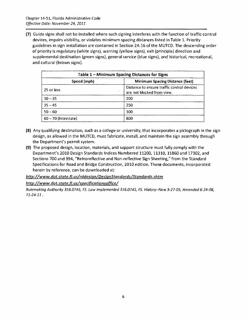
(1) This rule chapter provides for a system of guide signing that will perform the following functions:
(a) Inform and guide motorists to the needed signed facilities and motorist services.
(b) Improve traffic flow at interchanges or intersections near destinations that generate a large volume of traffic.
(c) Establish criteria for the erection of guide signs and general service signs.
(2) This rule chapter applies the requirements for guide signs, excluding principle destination signs, general service signs, community wayfinding guide signs, and tourist-oriented directional signs as stated in the applicable sections of the Manual on Uniform Traffic Control Devices, incorporated herein by reference under Rule 14-15.010, F.A.C.
14-51.011 Definitions As used in this rule chapter, the following words and phrases shall have the following meanings:
(1) "Applicant" means the person or entity seeking authorization for a sign under this rule chapter.
(2) "Community Wayfinding Guide Sign" means a directional guide sign that is part of a coordinated and continuous system of signs directing tourists and other road users to key civic, cultural, visitor, and recreational attractions, within a city or a local urbanized area.
(3) "Community Wayfinding Guide Sign System Plan" means the system boundaries, installation location, sign panel design, engineering, sign assembly specifications, and adopted criteria submitted to the Department for approval.
(4) "Department" means the Florida Department of Transportation.
(5) "Enhancement Marker" means a sign or portion of a sign where shape, color, or pictograph is used as a visual identifier for a community wayfinding guide sign.
(6) "FHWA" means the Federal Highway Administration.
(7) "Guide Sign" means a sign that shows route designations, destinations, directions, distances, services, points of interest, or other geographical, recreational, or cultural information.
(8) "Limited Access Facility" means as defined in Section 334.03, F.S.
(9) "local Government" means the county or city having jurisdiction in the subject area, including the area involving the state highway system.
(10) "Manual on Uniform Traffic Control Devices (MUTCD)" means the federal publication-used to establish the uniformity of traffic control devices, such as sign placement, color of sign backgrounds and letters, and sign messages.
(11) "Non-Limited Access Facility" means an arterial or collector road as defined in Sections 334.03, F.S.
(12) "Non-traffic Control Sign" means an authorized highway sign that does not have any traffic control purpose, is not intended for use by road users in general, and is not considered to be a traffic control device, such as highway service signs and the associated sponsorship.
(13) "Official Traffic Control Devices" means as defined in Section 316.003, F.S.
2
Chapter 14-51, Florida Administrative Code Effective Date: November 24, 2011
{14) "Pari-mutuel Facility" means a racetrack, fronton, or other facility used by a permit holder of the Florida Department of Business and Professional Regulation for the conduct of pari-mutuel wagering as defined in Section 550.002, F.S. These facilities may include card rooms only when authorized by Section 849.086, F.S.
{15) "Permit System" and "Permitted" means as defined in Rule 14-20.010, F.A.C.
{16) "Pictograph" means a pictorial representation used to identify a governmental jurisdiction, an area of jurisdiction, a governmental agency, a military base or branch of service, a governmentalapproved university or college, a toll payment system, or a government-approved institution.
{17) "Place Name Sign" means a sign identifying the geographic boundary of a municipality or county, lying on or along a road on the state highway system.
{18) "Recreational Attractions" means facilities located within 15 miles of the limited access facility that provide easy access for motorists, ample all-weather parking areas, and several recreational activities such as picnicking, camping, hiking, swimming, fishing or boating. Examples include public recreational facilities, state forest recreation areas, and wildlife refuges.
{19) "Rural Interchange" means a grade separated intersection between streets or roadways outside the limits of any urban or urbanized area, as defined in Section 334.03, F.S. Where either the immediate right of way of a limited access facility or the right of way of an intersecting roadway is within the boundary of an urban or urbanized area, the interchange or intersection shall be considered urban.
{20} "Sign" means any traffic control device intended to communicate specific information to road users through a word or symbol legend. They do not include traffic control signals, pavement markings, delineators, or channelization devices.
(21) "Supplemental Guide Sign" means a sign placed or erected to provide information regarding destinations, other than the principle destinations displayed on the exit directional sign, accessible from the interchange.
(22) "Tourist Attraction" means facilities that principally provide recreation, amusement, or leisure activities to the general public, with the majority of its visitors traveling over 100 miles to visit the facility, and with the major portion of their income from these non-resident visitors.
{23) "Tourist-Oriented Directional Signs" or "TODS" means guide sign assemblies with individual panels displaying the identity and directional information for a business, service, or activity facilities.
(24} "Trailblazers" means signs erected at strategic locations in conjunction with the signing of a destination, tourist attraction, or general service facility.
{25) "Unincorporated Area" means all lands outside of the boundaries of municipalities within a county boundary.
14-51.012 Trailblazers (1) Trailblazers shall be used for destinations which are five miles or more from the interchange or
intersection and a motorist could drive through highly developed areas, "Y" intersections, or multiple strip developments to reach the destination.
(2) A countdown distance system to national and state park sites shall be based upon specific site/area conditions, and installed by the park agency through the Department's permit system.
3
Chapter 14-51, Florida Administrative Code
Effective Date: November 24, 2011
{3) Local governments shall have all trailblazers in place on their road system prior to installing the corresponding destination .sign on the state highway system.
{4) Trailblazers shall provide the distance and/or direction to the nearest or most convenient point of access.
{5) Trailblazers shall match the color scheme or symbol of its corresponding sign on the state highway system.
Rulemaking Authority 316.0745, 334.044{2}, F.S. Law Implemented 316.0745, F.S. History New 3-27-05, Amended 11-24-11.
14-51.013 Sign Evaluation Process
(1) Sign requests must originate from state agencies, city or county resolution, official representatives of schools or universities, or representatives of tourist attractions or businesses.
(2) Upon receiving a written request, the Department will determine whether:
(a) The written request concerns an eligible destination or motorist service.
{b) The trip generation meets or exceeds the minimum criteria.
(c) There are seasonal considerations.
{d) Significant rapid growth is projected.
(e) The intersection or interchange approach may accommodate additional destination legend without exceeding the mandatory space limitations for either existing sign panels, or an additional sign structure. If a request for destination guide signing is received, but the intersection or interchange has the maximum number of destinations, then the request will be denied.
(f) The addition of the sign will benefit the safety of the motoring public.
{3) Written requests shall provide data to support the trip generation of the proposed destination. It shall also provide data to support the function of the facility (e.g., tourist attraction) to determine which set of criteria from Table 1, Criteria for Signing Destinations on Limited Access Facilities, and Table 4, Criteria for Signing Destinations on Non-Limited Access Facilities, will apply. If additional support data is needed, the Department will require an engineering study to validate the request.
{4) If the written request complies with these criteria, the District Traffic Operations Engineer shall review the sign location for space availability.
(5) Supplemental guide sign destinations are subject to a four-year review cycle to verify that the trip generation characteristics are consistent with Department signing criteria. The review will confirm that mid-way through the life of the sign panel (approximately seven to eight years) an opportunity will exist to make sign changes. The Department will not replace a signed destination with a new destination, regardless of annual trips, as long as the signed destination remains in operation.
{6) The following shall be considered when developing a guide sign system:
(a) Highest preference will be given to destinations that attract a larger number of trips from distances greater than 100 miles.
{b) The likelihood that the destination will continue to generate a high number of trips or if there are seasonal characteristics.
(c) Local government recommendations.
(d) The cooperation of local government and the tourism industry with the development of a regional signing plan.
4
Chapter 14-51, Florida Administrative Code Effective Date: November 24, 2011
(e) When concurrence can be reached by all affected parties, changes to the Department's supplemental guide sign system may be approved through the permit system.
(7) Table 2, Criteria for Signing Destinations on Limited Access Facilities, and Table 4 mandatory criteria for guide signs installed under this rule chapter. The criteria will assist the District Traffic Operations Engineer in determining which destination will be signed for on limited and non-limited access facilities.
(8) Destinations signed prior to the effective date of this rule chapter shall not be subject to the requirements of this rule chapter.
(9) Signs may be approved by the Department for research and evaluation based on studies provided by the applicant. These studies shall include, at a minimum, trip generation, origin and destination studies i.e., entrance and exit locations, specific route, U-turns, and last minute lane changes to determine the safety impact. All studies shall be signed and sealed by a professional engineer registered in Florida. If the Department determines that it would be appropriate to allow the temporary installation to become permanent, the rule will be revised accordingly.
Rule making Authority 316.0745, FS. Law Implemented 316.0745, FS. History-New 3-27-05, Amended 11-24-11.
14-51.014 General Criteria (1) Guide signs for other than recreational, historical, or cultural facilities, shall be white on green in
color. Guide signs for recreational, historical, or cultural facilities shall be white on brown in color. For existing white on green destination guide signs a combination sign consisting of white on green and white on brown shall be used with the colors separated by a common white border.
(2) Signing for a destination with a limited period of operation shall be displayed only during those periods of operation, and only if the destination meets the trips generated annually criteria referenced in Table 2 or Table 4. If occasional off-season usage exceeds 25 percent of the trips generated annually for most of the year, the signs may be displayed permanently.
(3) Traffic control signs for major short term events, e.g., golf and tennis tournaments, boat and auto shows, that will attract a significant number of non-residents, shall be evaluated based on the criteria established in Rule 14-51.013, F.A.C.
(a) Static or portable changeable message signs (PCMS) shall be erected no more than three days before, nor remain more than three days after, the signed event. Sign costs, such as design, installation, maintenance, and removal shall be paid by the applicant.
(b) Both static and PCMS signing will be installed through the Department's permit system. PCMS devices, and approved messages displayed on them shall be devoid of advertisements. PCMS devices shall be approved by the Department for use on the state highway system.
(c) All applicable Department clear recovery zone requirements shall be met and short-term event signing cannot interfere with visibility/effectiveness of existing traffic control devices.
(4) In no case shall information relating to destinations, motorist services, and multi-modal facilities be displayed on a supplemental guide sign until trailblazer directional guide signing has been installed.
(5) When there are more qualified destinations than can be signed, the local government recommendation as to the facilities to be signed will be considered. If the local government has no preference, the destinations that create the greatest traffic demand shall be signed, subject to standards specified in the following sections.
(6) No guide signs for destinations shall be erected prior to approval by the District Traffic Operations Engineer.
5
Chapter 14-51, Florida Administrative Code Effective Date: November 24, 2011
(7} Guide signs shall not be installed where such signing interferes with the function of traffic control devices, impairs visibility, or violates minimum spacing distances listed in Table 1. Priority guidelines in sign installation are contained in Section 2A.16 of the MUTCD. The descending order of priority is regulatory (white signs}, warning (yellow signs), exit (principle) direction and supplemental destination (green signs), general service (blue signs}, and historical, recreational, and cultural (brown signs}.
Table 1- Minimum Spacing Distances for Signs
Speed (mph) Minimum Spacing Distance (feet)
25 or less Distance to ensure traffic control devices are not blocked from view.
30-35 200
35-45 250
50-60 300
60-70 (Interstate) 800
(8} Any qualifying destination, such as a college or university, that incorporates a pictograph in the sign design, as allowed in the MUTCD, must fabricate, install, and maintain the sign assembly through the Department's permit system.
(9} The proposed design, location, materials, and support structure must fully comply with the Department's 2010 Design Standards Indices Numbered 11200, 11310, 11860 and 17302, and Sections 700 and 994, "Retroreflective and Non-reflective Sign Sheeting," from the Standard Specifications for Road and Bridge Construction, 2010 edition. These documents, incorporated herein by reference, can be downloaded at:
Chapter 14-51, Florida Administrative Code Effective Date: November 24, 2011
PART II GUIDE SIGNS ON LIMITED ACCESS FACILITIES
14-51.020 Supplemental Guide Signs
(1) General. The criteria referenced for destinations listed in Table 2 are used to determine which
supplemental destinations will be signed for on limited access facilities
Table 2- Criteria for Signing Destinations on Limited Access Facilities
Type of Destination Criteria Guidelines
Major Metro Urban Rural Areas' Areas
2 Areas 3
State and National Parks and State Forest Miles from 15 15 15 Recreational Areas Interchange
Private Colleges and Universities Number of Trips 550,000' 550,000' 300,000'
Generated Annually' 1,200,000' 750,000' 450,000'
Miles from 15 15 15
Interchange
Military Bases Number of Trips 5,000,000 4,000,000 3,000,000 Generated Annually'
Miles from 10 10 10
Interchange
Miles from 10 10 10 Veteran's Administration (VA) Hospitals Interchange
Arenas, Auditoriums, Amphitheaters, Civic Number of Trips 200,000 165,000 135,000 Centers, Convention Halls, Stadiums, Major Generated Tourist Attractions (Fairgrounds, Annuallyd
Amusement Parks, Zoos, etc.) Miles from 5 5 5 Interchange'
Historical, Cultural, or Recreational Number ofT rips 100,000 100,000 100,000 Attractions, Historic Districts Generated
Annually" 1 Over 50,000 population. 2 5,000 to 49,999 population. 3 Under 5,000 population. 4The distance may be increased~ mile for each 10 percent over the minimum requirement listed to a maximum of 2
times the maximum distance listed.
'Annual Trips= Number of Enrolled Students (who physically attend classes on campus) x 1.5 (college or university without dormitories, each student equals 1.5 trips) x Number of semesters per year x Number of weeks per semester x 5 days per week. Figures based on AASHTO'S 2001 Selection of Supplemental Guide Signs for Traffic Generators.
'Annual Tr1ps =Number of Enrolled Students (who physically attend classes on campus) x 2.0 (college or university with dormitories, each student equals 2 trips) x Number of semesters per year x Number of weeks per semester x 5 days per week. Figures based on AASHTO'S 2001 Selection of Supplemental Guide Signs for Traffic Generators.
'·One employee or military personnel equals 0.9 trips. Figures based on AASHTO'S 2001 Selection of Supplemental Guide Signs for Traffic Generators.
d. Trip: a sing!€ or one-direction vehicle movement either to or away from the traffic generator.
7
Chapter 14-51, Florida Administrative Code Effective Date: November 24, 2011
(2) Standards (a) Not more than one supplemental guide sign shall be erected at each interchange approach.
The supplemental guide sign shall contain no more than two destinations with no more than three lines of legend, excluding exit numbers or exit directions.
{b) If two supplemental guide sign panels are required at any interchange approach only one destination shall be displayed on each panel. Not more than two destinations shall be signed at any one interchange approach.
(c) Each destination shall be signed only once in each direction.
{d) Supplemental guide signs shall be located in advance of the interchange that is the most practical route to the facility. Local government recommendations on the most practical route will be considered.
(e) Countdown trailblazers shall not be erected on the mainline portion of limited access facilities.
{f) Except as otherwise specified in Rule 14-85.004, F.A.C., and other areas of this section, the name of the operating agency, community group, or enterprise shall not appear in the legend of any supplemental guide sign, or attached to it.
(g) Supplemental guide signs shall not be installed in advance of freeway-to-freeway interchanges. Interchanges between freeways are major decision points; therefore, sign messages shall only contain the route shield, cardinal direction, and name of the next control city on that route.
(h) Supplemental guide signs shall be installed in advance of freeway-to-spur interchanges if the spur serves a local community.
{3) Guidelines
(a) Cultural, historical, and recreational attractions or historical districts shall meet the trip generation criteria in Table 2 and the following specific criteria in order to be eligible for evaluation for signing:
1. The cultural, historical, and recreational attractions or historical district shall be identified by name on the current Official Florida Transportation Map. Identification on local city maps does not qualify for interstate signing.
2. Cultural and historical attractions or historical districts must be on the National Register of Historic Places, meet trip generation, be located within 15 miles of the limited access facility, provide easy access for motorists, and ample all-weather (surface treated) parking to be eligible for signing. These attractions or districts can be publicly or privately owned, but shall be operated on a non-profit basis and open to the general public year-round for sign eligibility. Examples include forts, battlegrounds, plantations, archeological or geological sites, art galleries, and museums.
3. Any conversion of attendance to trip generation figures will be evaluated by the Department, based on general engineering practice.
4. Recreational attractions shall be operated on a non-profit basis and meet ADA accessibility standards for public access.
{b) The criteria referenced in Table 2 shall be used to determine which destination to sign for on new interchanges, or to determine which destination to add to an existing supplemental guide sign, with an existing destination.
(c) For the purpose of geographic identification, only state lines, county lines, and municipal limits, as well as significant geographic features shown on the Official Florida Transportation Map,
8
Chapter 14-51, Florida Administrative Code Effective Date: November 24, 2011
such as waterways, will be signed on limited access facilities. The limited access facility must traverse the corporate limits of a municipality for geographic identification guide signing limits in both directions. No custom place name signs or auxiliary panels will be permitted other than approved 48" x 48" pictographs representing the locality and having sufficient legibility and visual acuity on a standard white on green sign design. With the addition of the pictograph, the local government must provide an approved sign panel.
(d) Airports shall be eligible for signing on limited access facilities when they are served regularly by scheduled airlines with interstate passenger service. The standard airport symbol shall also be used with the airport name.
(e) Deep water public cargo and passenger ports (Port Authority locations) shall be eligible for signing.
(f) Rail terminals shall be eligible for signing on limited access facilities when they are intercity rail (Amtrak, Commuters, etc.). They must provide regularly scheduled passenger service and have parking spaces available to accommodate patrons.
(g) Certified Florida Farm Wineries shall be eligible for signing pursuant to Section 599.004, F.S. The Florida Farm Winery logo panel with supplemental name panel shall be installed based on space availability. There is a fee associated with this signing.
(h) Signing for "regional malls" or "regional shopping centers" (Malls) shall be eligible for signing through the Department's permit system: only if the facility is located within 5 miles of the qualifying interchange and occupies 1,000,000 square feet or more of active retail sales area (excluding any parking, business, residential or hotel space, landscape area, or shipping, receive, warehousing, or stock areas). Malls with open-air promenades comprised of individual buildings, located together in a themed environment that meet the square feet requirement and are in a climate-controlled active retail area may be considered. To be eligible for signing as a Mall, all property included as square footage shall be managed by a single leasing agent and storefronts shall be on the same or contiguous properties. Outparcels are not included. If the District Traffic Operations Engineer determines that safety or operational problems can be attributed to unclear directions to the Mall, then a request shall be processed based on the criteria established in Rule 14-51.013, F.A.C. If the minimum qualifying criteria is not met, the applicant shall submit a traffic engineering study performed by a licensed Florida professional engineer, addressing each of the qualifying criteria which include:
1. Research and evaluation of the need for any Mall directional signs on the roadway(s) leading to the Mall from the interchange.
2. The safety and operational issues affecting both site and non-site destined traffic.
3. Whether existing or proposed on-site Mall signage is visible and provides sufficient advance notice to motorists traveling on the limited access facility to recognize the Mall destination and safely enter the exit ramp at the interchange.
(i) State-funded community college main campuses, vocational/technical center campuses, and university main campus are eligible for signing. Satellite campuses are eligible, only if the curriculum allows students to obtain an Associate of Arts (AA) degree or higher at the campus site.
1. If the campus requests a name change within four years of sign installation, the campus shall be responsible to contract for all supplemental guide sign panel replacements, at their own expense.
9
Chapter 14-51, Florida Administrative Code Effective Date: November 24, 2011
2. The campus shall provide an inventory of all existing supplemental guide sign sizes and locations, including the local road system.
3. The Department will provide an approved standard sign design for the supplemental guide signs on the state highway system. The Department will install the supplemental guide signs on the state highway system, unless a pictograph is requested in the design. All supplemental guide signs with pictographs shall be installed through the Department's permit system.
(j) Private colleges and universities, whether for-profit or non-profit, where student travel, to attend regularly scheduled classes at that campus meet the minimum trip generation criteria in Table 2 are eligible for signing through the permit system where space is available. Other private universities with existing signs will be allowed to retain their signs, so long as they remain active.
(k) Schools licensed by the Department of Education's Commission for Independent Education are not eligible for signing to any site, unless student travel to that site meets the trip generation criteria referenced in Table 2.
(I) Signing for multi-modal transportation facilities is considered supplemental guide signing, except for those that qualify as a general service. Multi-modal facilities are stations that link various modes of transportation: airports (air carrier and general aviation), seaports (passenger and cargo), commuter rail terminals, freight and intercity rail terminals, intercity buses, parking lots, garages, and Park and Ride. A signing plan for multi-modal facilities must be submitted.
(m) Veteran's Hospitals designated as the regional treatment centers for veterans are eligible for signing on limited access facilities. VA community service and community based outpatient clinics, centers, benefits offices, and national veterans cemeteries are not eligible to be signed on limited access facilities.
(n) Medical facilities/research centers that have regional, statewide, or national significance, provide in-patient and out-patient services by advance appointment, perform specialized surgery or treatment of human diseases are eligible for signing on limited access facilities.
(o) If a destination qualifies for supplemental guide signing, but is participating in the logo program in the attraction category it shall not be eligible for supplemental guide signing. If a signed destination is approved for a business logo in the attraction category, then it will be removed from the supplemental guide sign.
(p) Major metropolitan area airports and major seaport passenger facilities are considered prime destinations and are eligible for signing.
(q) General aviation will not be eligible for signing.
(r) "DOWNTOWN" signs must meet the following criteria in order to be eligible for signing:
1. "DOWNTOWN" signs will only be considered for the largest core municipality of an urban area with a population of 50,000 or more.
2. The limited access facility must traverse the incorporated limits of the municipality under consideration and have multiple exits for each direction of travel.
3. The urban guide signing concept, as specified in Section 2E.06 of the MUTCD, shall be in effect.
4. A distinct central business district must exist. Strip development business centers and mixed-use urban development, or re-development areas, shall not qualify as "downtown"
10
Chapter 14-51, Florida Administrative Code Effective Date: November 24, 2011
or be eligible for signing.
5. Only one such sign shall be permitted for each direction of travel. The sign shall be erected in advance of the most direct route to the downtown core.
(4) Destinations Not Eligible for Signing
(a) Except as provided in Rule 14-85.004, F.A.C., the following destinations, shown in Table 3, shall
not be eligible for signing.
Table 3- Destinations Not Eligible for Signing on limited Access Facilities
Businesses Chamber of Commerce, television/radio station, live performance or movie theaters, motels/hotels/inns, travel trailer parks, industrial parks and plants, commerce centers, shopping or outlet centers, auto malls, auctions, flea markets, mixed-use developments or re-developments (retail, and/or office, and/or residential, and/or other commercial facilities regardless of combined trip generation).
Cemeteries Local, state, federal, sovereign nation, public, private.
Community Facilities Libraries, churches, subdivisions, mixed use facilities, community and general aviation airports, recreational facilities or parks.
Governmental Research/experimental campuses even when associated with a state college or university; state, regional, district, local offices even where trip generation is associated with public meetings, hearings or permit applications, Government centers, courthouses, driver license centers, jails, correctional facilities, prisons, civil defense facilities, maintenance facilities, power plants, gaming facilities not operated under Florida pari-mutuel licensing.
Schools K through 12, seminaries, post-graduate educational facilities.
Historical Homes/buildings/sites/landmarks publicly or privately owned, heritage trails.
Medical All classes of hospitals, and other licensed facilities except as specified in Rules 14-51.021 and 14-51.020, F.A.C., mental health facilities, research facilities, sanitariums, rehabilitation/infirmaries/treatment centers, non hospital Veteran's facilities, county/fraternal/nursing homes, retirement facilities, humane facilities including animal emergency services, (not qualified under General Services).
Military Sites/detachments, armories, arsenals.
Recreation/Conservation Country clubs/golf courses/resorts, fish hatcheries, game farms, tree nurseries/arboretums, points of interest, camps (scout, church, 4-H, youth, YMCA/YWCA) nature trails, conservation or protection areas, conservation developments, watersheds, trail heads and crossings.
14-51.021 General Service Signs (1) General Criteria
(a) General service signing is used when the general services provided are infrequent and not within sight of the interchange.
(b) Requests for general service signing (except Logo signing) shall be directed to the District Traffic
11
Chapter 14-51, Florida Administrative Code Effective Date: November 24, 2011
Operations Engineer.
(c) General service signing is considered supplemental to overall signing.
(d) General service signs, including signing for state agency buildings, have a white legend on blue background, excluding multi-modal facilities.
(e) The name or pictograph representing the operating agency, community, group, individual, or enterprise shall not appear on the general service sign, except for state agency buildings and other facilities meeting the criteria established in this rule chapter. If a pictograph is used, it shall be installed through the Department's permit system.
(f) Symbol signs for hospital, airport, Amtrak, Greyhound, cruise-based seaports, commuter rail, and multi-modal terminals can be used in urban or rural areas, when the criteria established in Rule 14-51.013, F.A.C., are met.
(g) In no case shall general service signing be erected that would function primarily as advertisements for businesses.
(h) In no case shall information relating to general services be displayed until trailblazer signing has been installed to direct motorists from the exit to the service
(2) Standards
(a) Except as otherwise specified in Rule 14-85.004, F.A.C., where logo signs are utilized, general service signs shall not be used. General service signing off the Department's right of way shall not be provided when those services are conveniently located off an interchange.
(b) Except as otherwise specified in Rule 14-85.004, F.A.C., only symbol signs will be used to advise of the availability of gas, food, lodging, camping, hospital, and telephone on rural limited access facilities
(c) When three or fewer general services are available at a given interchange, and it is unlikely that more than three general services will be provided in the near future, the symbol signs denoting these general services will be attached to the advance guide sign. At locations where the "NEXT EXIT 00 MILES" panel is attached to the advance guide sign, the symbol signs will be attached to the exit direction sign. If four or more general services are available at an interchange, or are anticipated in the near future, a supplemental roadside sign denoting the available general services and reading "NEXT RIGHT" or the interchange exit number shall be installed.
(3) Guidelines. Each general service sign has its own set of criteria that must be met in order for signing to be provided on limited access facilities.
(a) Gas
1. The service station facility shall be located within 1 mile of the exit ramp terminal;
2. Is open for continuous service a minimum of 16 hours, 7 days a week;
3. Provides vehicle services including fuel and oil;
4. Provides public rest rooms; and
S. Has a telephone available for public use.
(b) Food
1. The restaurant facility is located within 1 mile of the exit ramp terminal;
2. Serves a complete meal and is open for continuous service a minimum of 14 hours, 7 days a week;
3. Provides public rest rooms;
12
Chapter 14-51, Florida Administrative Code Effective Date: November 24, 2011
4. Has a telephone available for public use; and
5. Is licensed by the Florida Department of Business Regulation, Division of Hotels and Restaurants, and the local County Health Department.
(c) Lodging
1. The lodging facility is located within 1 mile of the exit ramp terminal;
2. Is equipped with 20 or more units for rent;
3. Has a telephone available for public use; and
4. Is licensed by the Florida Department of Business Regulations, Division of Hotels and Restaurants, and the local County Health Department.
(d) Camping
1. The camping facility is located within 5 miles of the exit ramp terminal;
2. Is equipped with a minimum of 25 rental camp sites (RV and tent not just one or the other);
3. Is equipped with indoor sanitary toilet and bathing facilities;
4. Has a telephone available for public use; and
5. Is licensed by the local County Health Department.
(e) Hospital Emergency Room Service
1. General service signs for hospital emergency room services will be erected in rural and urban areas in advance of an interchange; and
2. The purpose of the hospital sign is to provide direction to motorists in need of immediate medical services. Hospital general service signs shall be erected in advance of the interchange which provides the most practical route to that facility when the hospital facility has an emergency room open 24 hours, 7 days a week.
3. Where more than one hospital meeting the criteria is available from any one interchange, only the hospital located closest to the exit point shall be signed or trailblazed.
4. The hospital facility shall not be located more than 10 miles from the exit ramp terminal; and
5. In the event a hospital meets the criteria, but another hospital is closer by continuing along the limited access facility to another exit, the first hospital will not be signed.
(f) Tourist Information Centers
1. Tourist information centers shall be signed as a general service with the word legend "INFO" and
2. Signs for tourist information centers will be erected when the center is located on a direct route from the limited access facility and not more than 1 mile from the exit ramp; and
3. Tourist information center signs will be erected when:
a. The general service signing requests are received from local government; and
b. The destination provides continuous, professionally staffed service for a minimum of 8 hours, 7 days a week; and
c. The destination, located within 1 mile of the interchange, is operated exclusively by a non-profit organization, or is approved by local government to operate as a tourist information center.
4. If the tourist information center is operated on a seasonal basis, the general service signs
13
Chapter 14-51, Florida Administrative Code Effective Date: November 24, 2011
shall be removed during the off season.
5. All trailblazers on the non-limited access facility shall be installed by the local government agency through the Department's permit system.
(g) Telephone. Symbol signs will be erected when:
1. The telephone is a public telephone available for use 24 hours, 7 days a week; and
2. The telephone is located within the immediate interchange area, not more than 1/2 mile from the interstate or exit ramp, and the immediate interchange is located in an isolated rural area; and
3. The interchange does not have gas, food, lodging, or camping (located within 1 mile of the interchange) identified.
(h) Pari-mutuels associated with jai-alai, horse tracks, or dog tracks shall display word legend JAIA'LAI, HORSE TRACK, or DOG TRACK. The state standard symbol shall not be displayed on limited access facilities. The registered name of a qualifying pari-mutuel facility shall only be displayed with documentation that a distinction is necessary for safe navigation and travel confirmation for its patrons.
(i) Park and Ride areas shall qualify for general service on limited access facilities when they are governmentally owned and operated as part of a car pool, van pool, or other public transportation program. The facility shall have parking spaces available for patron use.
Chapter 14-51, Florida Administrative Code Effective Date: November 24, 2011
PART Ill GUIDE SIGNS ON NON-LIMITED ACCESS FACILITIES
14-51.030 Destination Guide Signs (1) General
(a) The criteria referenced for destinations listed in Table 4 are used to determine which destinations will be signed for on non-limited access facilities.
(b) For pari-mutuel facilities that offer gaming, trip generation that may be attributed to the draw of the gaming activity alone are not eligible to qualify that facility for destination guide signing on the basis of trip generation.
(2) Standards
(a) Not more than six eligible destinations, including cities, shall be signed at any intersection approach. Exception for community wayfinding guide sign systems and TODS guide signing are found in Rule Chapter 14-51, Part V and Part VI, F.A.C. These eligible destinations shall not be indicated on more than two separate signs, with no more than three lines of legend on each sign.
(b) If there are four destinations to be signed at a given intersection, all four destinations should be included on one sign, unless lateral restrictions limit sign panel square footage.
(c) Destination guide signs shall be located in advance of the intersecting roadway that is the most direct or desirable route to the facility. Local government recommendations on the most desirable route will be considered because the most direct route may have roadway safety features that are less desirable than the longer route.
(3) Guidelines
(a) Any state or national park, or state forest; open to the public and offering multiple recreational activities with ADA access and accommodations, including restrooms and paved handicapped parking, shall be eligible. Countdown trailblazers permitted in rural areas for route confirmation. Sign panels, installation, and maintenance shall be provided by the park or forest destination. Advance signs shall not be located more than 10 miles from the park entrance.
(b) "DOWNTOWN" signs shall meet the following criteria in order to be considered for destination guide signing.
1. "DOWNTOWN" signs will be considered for municipalities with a population of 5,000 or more.
2. The non-limited access facility route shall traverse the municipal limits.
3. A distinct central business district must exist. Strip development, business centers, mixeduse development, or re-development shall not be considered as "downtown" or as a qualifying destination for guide signing unless it was historically identified as the udowntown 11
•
4. Only one such sign will be permitted for each direction of travel to provide the most practical route to the central business district.
(c) The criteria referenced in Table 4 shall be used to determine which destination to add to an existing destination guide sign.
(d) Hospitals are eligible for destination guide signing when the hospital does not have access from the state highway system, and is not located more than three miles from the intersection to be signed (other than trailblazers from a limited access facility).
15
Chapter 14-51, Florida Administrative Code Effective Date: November 24, 2011
Table 4- Criteria for Signing Destinations on Non-limited Access Facilities
Type of Destination Criteria Guidelines
Major Metro Urban Areas'
Rural Areas 3
Areas 1
State Colleges and Universities Nearest intersection to the state highway system.
Private Colleges and Number of Trips 550,000'' 55o,ooo'' 300,000'' Universities Generated Annually' 1,200,000'' 750,000bd 450,000bd
Private Vocational/Technical Number of Trips' 675,000'
55o,ooo' 300,000' Schools Generated Annually
Military Bases Number of Trips' 5,000,000' 4,000,000' 3,000,000' Generated Annually'
Arenas, Auditoriums, Number of Trips' 37,500 trips plus 3,750 per mile of distance from Amphitheaters, Civic Centers, Generated Annually intersection
State and National Parks, and Nearest intersection to the state highway system.
State Forest Recreational Areas
Youth Camps (YMCA, Scouts, Signing only in rural areas, with facilities for a minimum of 50 persons on etc.) an overnight basis and in operation for at least 6 months of the year.
Mental Health and Medical Minimum of 500 beds in urban and suburban areas. Nearest state highway Facilities system Exit. Bed minimum can be lowered for hospitals with access off the
state highway system serving isolated, rural county populations.
Downtown There must be a clear central core commonly considered the downtown area that is located on an intersecting road a maximum of 3 miles off the state road. This excludes requests for signing new development or re· development zones as "downtown" that were not historically the "downtown" prior to new construction or rehabilitation.
Drivers License Nearest intersection only.
State Agency Buildings Number of Trips' 260,000 100,000 1,500 Generated Annually
1 Over 50,000 population (Section 334.03, F.S.).
'5,000 to 49,999 population (Section 334.03, F.S.). 3 Under 5,000 population.
Trip: a single or one-direction vehicle movement either to or away from the traffic generator.
'Annual Trips= Number of Enrolled Students (who physically attend classes on campus) x 1.5 (college or university without dormitories, each student equals 1.5 trips) x Number of semesters per year x Number of weeks per semester x 5 days per week. Figures based on AASHTO'S 2001 Selection of Supplemental Guide Signs for Traffic Generators.
'Annual Trips= Number of Enrolled Students (who physically attend classes on campus) x 2.0 (college or university with dormitories, each student equals 2 trips) x Number of semesters per year x Number of weeks per semester x S days per week. Figures based on AASHTO'S 2001 Selection of Supplemental Guide Signs for Traffic Generators.
'One employee or military personnel equals 0.9 trips. Figures based on MSHTO'S 2001 Selection of Supplemental Guide Signs for Traffic Generators. 0 Trip: a single or one-direction vehicle movement either to or away from the traffic generator.
16
Chapter 14-51, Florida Administrative Code Effective Date: November 24, 2011
(e) Unincorporated areas shall meet the criteria as shown in Rule 14-51.041, F.A.C., in order to qualify for signing. Counties may develop a program to sign the boundaries of unincorporated communities with historic or cultural interest that are not on the Official Florida Transportation Map, through the Department's permit system. Standard white-on-green geographic identification signs may be placed within the Department's right-of-way. All custom place name signs for unincorporated communities must be located outside the right-of-way.
(f) Recreational, historical, or cultural attractions funded by federal, state, or local governments are eligible for destination guide signing. Such attractions shall meet the following specific criteria in order to be eligible for signing:
1. Historical attractions shall be listed in the National Register of Historic Places and be open to the general public year round.
2. Cultural attractions shall be open to the general public year round.
3. Signs shall be limited to the nearest intersection to the state highway system.
4. Recreational attractions shall be operated on a non-profit basis and include multiple activities such as picnicking, camping, hiking, swimming, fishing, or boating.
5. All recreational, historical, or cultural attractions shall have multiple activities, rest rooms, ADA access and paved handicapped parking facilities.
(g) Signs shall be installed to identify designated, developed parking areas for state or local recreational trails only. To be eligible for destination guide signing, the recreational trail must be ADA accessible and the parking ADA compliant. These signs are for traffic control purposes only, and are not intended for advertisement.
(h) Rail Terminals shall be eligible for destination guide signing when the following criteria are met:
1. Intercity rail (Amtrak, commuters, etc.) shall provide regularly scheduled passenger service and have parking spaces for patron use.
2. Intra-urban rail shall provide regularly scheduled service, and have parking spaces for patron use.
(i) Destination guide signing for a non-charter interstate bus service shall only include the standard general service signing for a Greyhound bus station and/or bus stop. The purpose of the standard Greyhound symbol sign is to assist motorists who are trying to locate a bus station which is inside a building, or a published, scheduled stop that is not serviced by any ticket agent at that remote stop.
(j) Seaports, deep water public cargo, or passenger ports (for Port Authority locations) are eligible for destination guide signing on non-limited access facilities.
(k) Airports are eligible for signing when the following criteria are met:
1. Air carrier airports are those which are served regularly by scheduled airlines. The airport symbol shall also be used with the airport name.
2. General aviation (open to public use) destination guide signs are allowed in each direction along the state highway system in advance of an intersecting roadway that provides direct access to the airport property. Signing shall be limited to an intersection within five miles of the airport. The facility may be named on an auxiliary panel with the general service airport sign. The directional arrow panel is mandatory. The airport general service sign should be pointed such that the tip of the airplane is pointed in the same direction of the arrow panel.
(I) Certified Florida Farm Wineries shall be eligible for destination guide signing pursuant to
17
Chapter 14-51, Florida Administrative Code Effective Date: November 24, 2011
Section 599.004, F.S. The Florida Farm Winery logo with supplemental name panel shall be installed at the nearest state highway intersection based on space availability for certified wineries. There is a fee associated with this signing.
(m) Regional malls or regional shopping centers (1,000,000 square feet or more) shall be eligible for destination guide signing through the permit system when safety or operational problems can be attributed to unclear directions and when the criteria established in Rule 14-51.013, F.A.C., are met. Safety and operational problems, where signing will improve corridor safety or relieve congestion and affects both site destined and other traffic, shall be documented by a Professional Engineer registered in the State of Florida.
(n) Colleges and Universities
1. State-funded community college, vocational/technical center, or university main campuses are eligible to request destination guide signing. Satellite campuses are eligible if the curriculum allows students to obtain an associate of arts (AA) degree, or higher, attending classes at that campus (no travel to another campus or web-based courses to complete coursework in standard schedule). Name changes on existing destination guide signs made within four years of existing sign panel installation will be allowed at the expense of the college or university. The board shall be responsible to contract with a private vendor for the sign replacement panel, or overlay at their own expense. The Department will install and maintain the updated panel. The Department will provide an approved sign design that can be accommodated on the existing structure. Modifications, such as abbreviations to the desired legend text may be necessary. If a pictograph is used, the sign shall be installed and maintained through the Department's permit system.
2. Private and all for-profit colleges and universities that meet the trip generation referenced in Table 4 are eligible for signing through the Department's permit system, if they meet the criteria outlined in Rule 14-51.013, F.A.C. Private universities with existing signs will be retained so long as they remain active. Private and for-profit universities shall only be eligible for destination guide signing to distinct college campuses, when the core baccalaureate degree requirement courses are available in traditional classroom settings at that site and meet the trip generation criteria.
3. Schools licensed by the Department of Education's Commission for Independent Education are not eligible for signing to any site unless they meet the trip generation criteria referenced in Table 4.
(o) Signing for multi-modal transportation facilities is considered destination guide signing, except for those that qualify as a general service.
1. Multi-modal facilities are airports (air carrier and general aviation), seaports (passenger and cargo), rail terminals, intercity bus, parking lots, garages, and Park and Ride.
2. A destination guide signing plan for multi-modal facilities shall be submitted.
(p) Veterans' Hospitals designated as the regional treatment center or State Veterans' nursing homes are eligible for destination guide signing on non-limited access facilities.
(q) Medical facilities/research providing by advance appointment, specialized surgery or treatment of human diseases, providing both in-patient and out-patient services, are eligible for destination guide signing on non-limited access facilities.
(r) Requests for destination guide signing by local government agencies shall be approved through the Department's permit system. The Department shall allow local governments to fabricate
18
Chapter 14-51, Florida Administrative Code Effective Date: November 24, 2011
and install the following destination guide signs pursuant to Department standards and direction. The following facilities are eligible for destination guide signing when they do not have direct state road access. The signs shall be erected at the intersection nearest the facility and shall not interfere with official traffic control devices:
1. Post Offices, including small businesses that are under contract with the United States Postal Service (USPS) are eligible for destination guide signing, when requested by local government and signed through the Department's permit system. In order to qualify for signing they shall have a contract with the USPS and provide a confirmation letter from the USPS along with their written request for signing. The destination guide signs shall be green background with white lettering and have the appropriate directional arrow;
2. Libraries;
3. Recycling Drop-Off Centers;
4. Courthouses;
5. Publicly-owned Vocational/Technical Schools that meet criteria established in Table 4;
6. Parks;
7. High Schools;
8. Constitutional Officials, such as Tax Collectors;
9. Chamber of Commerce; Tourist information;
10. Animal Shelters;
11. City/Town Halls;
12. Landfills; Transfer Stations;
13. Bus and Rail Stations;
14. National Veterans Cemeteries;
15. Veterans Community Treatment Centers;
16. Multi-use developments/redevelopment areas, such as Town Centers, when it is demonstrated that the majority of traffic is generated by tourism;
17. Temporary signing for access to polling stations;
18. Tourist Oriented Directional Signing Systems in qualifying counties;
19. Place name signs for unincorporated communities;
20. Community Wayfinding Guide Sign Systems;
21. Custom Place name signs;
22. Public parking, parking lots and garages shall be eligible for destination guide signing if they are open to the public, with non-reserved parking spaces available daily, and not more than one mile from the intersection. The green and white "P" parking symbol sign shall be used without the name of the parking facility;
23. Destination guide signing for an intercity bus service shall consist of the standard single post local bus stop signs. Permit applications are not required, but all signs must be installed outside the clear zone and may not interfere with priority traffic control devices;
24. City historical areas or districts that are officially declared by either city or county resolution.
19
Chapter 14-51, Florida Administrative Code Effective Date: November 24, 2011
(4) Destinations Not Eligible for Signing on Non-limited Access Facilities. Except as provided in Rules 14-85.004 or 14-51.021, F.A.C., destination guide signing shall not be provided for the following
destinations shown in Table 5.
Table 5- Destinations Not Eligible for Signing on Non-limited Access Facilities
Businesses Television/radio station, theaters, motels/hotels/inns, travel trailer parks, industrial parks and plants, office parks, shopping districts, strip malls; mixed-use developments (retail, restaurant, office, residential in any combination).
Cemeteries Local, state, public, private.
Community Facilities Civic groups (Kiwanis, Lions, Rotary, etc.), churches, subdivision, mixed use facilities, business districts.
Government State, local and regional political offices or boundaries.
Schools K through 9.
Medical Infirmaries, out-patient or residential treatment centers; county, fraternal or non-Veterans nursing homes, retirement facilities, specialized short or long term treatment or rehabilitation facilities, ambulatory surgical center, specialty hospitals or clinics.
Recreation/Conservation Water and soil conservation district boundaries, water sheds, habitat or natural resource protection zones, recreation centers (community centers,
swimming pools, baseball/softball fields, tennis courts, etc.), training centers, country clubs, private golf courses, tree nurseries/arboretums (including those sponsored by government services).
(a) General service signing is used when the general services provided are infrequent, and not within sight of the intersection.
(b) Requests for General Service Signing (except Logo signing) shall be directed to the District
Traffic Operations Engineer.
(c) Signing for general services is considered supplemental to overall signing.
(d) General service signs, including signing for state agency buildings, such as DRIVERS LICENSE, shall have a white legend on blue background; multi-modal and pari-mutuel general service signs are white-on-green, and recreational attractions are white-on-brown.
(e) The name of the operating agency, community, group, individual, or enterprise shall not appear on the general service sign, except for state agency buildings and facilities meeting the criteria established in this section.
(f) Symbol signs for hospital, airport, Amtrak, Greyhound, cruise-based seaports, and commuter rail are authorized by the District Traffic Operations Engineer in urban or rural areas based on
20
Chapter 14-51, Florida Administrative Code Effective Date: November 24, 2011
criteria established in Rule 14-51.013, F.A.C.
(g) In no case shall general service signing be erected that would function primarily as an advertisement for a business.
(h) General service signing shall not be displayed until trailblazers have been installed to direct motorists from the intersection to the service.
(i) Not more than one general service sign with a directional arrow for a particular service shall be displayed, in each direction, in advance of the intersection facility. General service signs shall only be located in advance of the intersecting road which is the best and most direct route to the facility.
(j) General signs on non-limited access facilities shall not be installed within competitive range of participating Logo sign program enterprises offering similar services.
{2) Standards
(a) Police, sheriff, and highway patrol stations that are staffed and open 24 hours are eligible for general service signing. Guidance to a closed facility, even one with a "hotline" contact telephone, may increase danger or increase response time in an emergency.
(b) Hospitals are eligible for general service signing when the hospital emergency room is located not more than five miles from an intersection (other than trailblazing from a limited access facility).
(c) When requested, general service signs for a hospital shall be erected on the state highway system in advance of the intersection which provides the most practical route to that facility when the hospital has an emergency room open 24 hours, 7 days a week. When more than one hospital meeting the criteria is available from any one intersection, only the hospital located closest to the exit point shall be signed or trailblazed.
(d) Tourist information centers are eligible for general service signing when the center is located less than one mile from the state highway system. Tourist information center signs qualify for signing on the state highway system when:
1. The signing request and permit application is received from local government; and
2. The center gives continuous service at least 8 hours, ?days a week; and
3. The center is operated exclusively by a non-profit organization and is approved and receives funding by the local government to operate as a tourist information center.
4. If the tourist information center is operated on a seasonal basis, the signs shall be removed during the off season. If the tourist information center sign is approved under the criteria referenced above, it shall be installed under the Department's permit system by local government.
(e) Boat ramp and camping facilities open to the general public and free of charge are eligible for general service signing in advance of intersecting roads in rural areas with direct access to the facility provided the entrance is less than one mile from the state highway system and is open year round. If the facility is associated with a local park or recreation system, it shall be signed by the sponsoring agency through the Department's permit system.
(f) Signing will be provided to state agency buildings with auditorium facilities where public meetings are hosted or generate significant daily traffic from large numbers of the general public's vehicular access. The sign panels will be supplied by the applicant and installed by Department Maintenance where space allows on the state highway system. The applicant shall
21
Chapter 14-51, Florida Administrative Code Effective Date: November 24, 2011
supply replacement panels when necessary. The sign shall be installed adjacent to the building on the state highway system. If the building is located more than one mile from the state highway, then the sign shall be placed at the nearest intersection, and trailblazers to the destination will be supplied by the applicant. Signing will be provided to those state agency buildings where the need for directional information is based on emergency situations, such as emergency evacuation shelters, permits, and/or a state gas facility, is necessary. All other state agency buildings shall meet the following criteria:
1. The number of non-employee trips generated by the building shall meet the criteria established in Table 4.
2. Meeting space for a minimum of 30 people.
(g) Pari-mutuels associated with jai-alai, horse tracks, or dog tracks are eligible for general service symbol signing on non-limited access facilities. The state standard symbol will be displayed on the non-limited access facility. The registered name of a qualifying pari-mutuel can be included if it is trailblazing from a limited access facility supplemental guide signing that displays the name. If the Department installs the word message general service panel on the limited access facility, the local government may choose to display the official operating name of the parimutuel at the nearest state road intersection as an auxiliary to the standard general service sign, as an assembly, through the Department's permit system.
Chapter 14-51, Florida Administrative Code Effective Date: November 24, 2011
PART IV PLACE NAME SIGNS ON NON-liMITED ACCESS FACILITIES
14-51.040 Exclusions
(1) Place name signs other than for geographic features and boundaries of counties, municipalities, or unincorporated areas found on the Official Florida Transportation Map shall not be erected on nonlimited access facilities.
(2) Place name signs for other governmental or quasi-governmental boundaries including, but not limited to, water management districts, school districts, voting districts, commissioner districts, and fire districts, shall not be erected on the state highway system.
(3) Place name signs shall not be installed for urban subdivisions unless they appear on the full size Official Florida Transportation Map (not on the urban area enlargements).
(4) "Exiting" or "Leaving" added to a place name signs shall not be permitted.
(5) Overhead signs/structures shall not be permitted.
(6) Place name sign requests originated by organizations or persons other than the local government shall not be considered.
14-51.041 Criteria for Unincorporated Areas (1) If an unincorporated area appears on the Official Florida Transportation Map, place name signing
shall be provided on non-limited access facilities by the Department upon request by the county.
(2) Place name signs for sovereign lands or an unincorporated area not appearing on the current Official Florida Transportation Map will be eligible for signing through the Department's permit system upon written request of the county. Such requests must demonstrate the following:
(a) A clearly identifiable localized development in the area.
(b) The community must lie on or along the state highway system.
(c) A community, for the purpose of place name signing, must have an identifiable boundary. The boundary and area name may not be coincidental to platted or unplatted subdivisions. The community must be demonstrated to have historical or cultural significance, not recreational significance. The community must not be associated with a specific developer, specific development theme, corporate business or investment, or entities such as a private golf course or resorts.
(d) The county must demonstrate that the unincorporated community has significant historical, cultural, or educational value, that the county has an investment in preserving.
(e) The county has installed or agreed to install place name signs on its roads traversing the area.
14-51.042 Sign Characteristics (1) Place name signs shall have a white legend on a green rectangular background.
(2) Place name signs shall be retro-reflectorized and shall conform to the MUTCD standards and specifications for guide signs and general information signs.
(3) Place name sign information shall be limited to the name of the place, except for a pictograph representing a special award.
(4) Only one place name sign shall be permitted in each approach direction. The signs shall be located
23
Chapter 14-51, Florida Administrative Code Effective Date: November 24, 2011
at, or in proximity to, the geographical boundary of the county, municipality, or unincorporated area.
14-51.043 Customized Place Name Signs (1) No place name signs within limited access facilities will be permitted for custom treatment, other
than the addition of a pictograph to the standard white-on-green sign.
(2) On limited access rights-of-way, no customized treatment may be constructed to stand individually, or as an assembly, such that it resembles a place name sign, nor shall a place name be included as part of any landscape structure or design within limited access rights of way.
(3) Customized treatment of county, municipal, sovereign lands, and unincorporated area place name signs shall be considered only on non-limited access facilities.
(4} The preferred location of all customized place name signs is off the state highway system right of way, where increased lateral clearance can be used. In such instances, the property owner's permission is required. Custom place name signs may be permitted by the county for sovereign lands and unincorporated areas that are identified on the Official Florida Transportation Map, only where they will be located outside non-limited access facilities right of way. Place name signs located off the state highway system right of way shall conform to Section 479.16 F.S.
(5} The Department will not assume responsibility for vegetation management.
(G) The custom place name sign and structure or other treatment shall be located at or in absolute proximity to, the geographical boundary of the county, municipality, sovereign nation or unincorporated area in the approach direction only.
(7) The proposed installation shall not interfere in any manner with other traffic control devices in the area.
(8} Existing standard geographic boundary guide signs, and/or nonofficial signs or structures, at or near the location shall be removed.
(9} All custom place name signs installed under these provisions are traffic control devices and shall be made of retroreflective material or be lighted. Supporting structures shall be designed, constructed, and installed to meet the Department's clear zone and safety criteria including breakaway features, when located within the state right of way or located where there is limited lateral clearance from the travel lanes. The design shall be signed and sealed by a Professional Engineer registered in the State of Florida.
(10} Sign size and lettering shall be appropriate for driver readability without decreasing speed.
(11) Sign information shall be limited to the name of the county, municipality, sovereign nation, or eligible unincorporated area, a pictograph, the words "Welcome To," and where applicable, a regional designation or phrase approved by local resolution. The "regional designation or phrase" is the only opportunity to chose and indicate an association with any one community designation or initiative program, including national and local grant, planning, or development. Highway signing is intended for traffic control only.
(12) The sign and structure shall be completely devoid of any commercial advertising, sponsorship, or the name of any political candidate, and be of such design and color as to be in good taste and aesthetically pleasing.
(13} In urban areas, the primary location for custom place name signs shall be along the roadside behind curb and gutter sections. Medians will only be considered if all other approach, right
24
Chapter 14-51, Florida Administrative Code Effective Date: November 24, 2011
roadside locations, either on or off state highway rights of way, are not physically possible. Median spaces shall not be used to accommodate design size or aesthetic preference.
(14} Installations in any median shall meet the Department's appropriate clear zone and safety criteria. Signs shall not be installed in both the median and roadside at a given location.
(15) Displays shall be fixed. Flashing lights, colored lights, or changeable messages shall not be used. However, customized treatment, including interior or exterior illumination, is allowable. In the absence of lighting, all sign face components shall be retroreflective.
(16) Upon approval of a customized place name sign request, the Department and the local government shall execute an agreement providing for the local government to install and maintain the customized sign/sign supports and all landscaping and shrubbery associated with the installation, as well as to defray the cost of any electrical energy necessary for operation of the sign display. The agreement shall clearly indicate that the Department reserves the right to have the installation modified or removed from the state highway right of way.
(17} Unincorporated areas that are not on the Official Florida Transportation Map are not eligible for custom place name signs.
14-51.051 Standards (1) This rule chapter provides statewide criteria for community wayfinding guide signs to be installed
on the state highway system.
(2) All regulatory, warning, and general service signs within the community wayfinding guide system plan shall conform to the MUTCD. Community wayfinding guide signs shall not be installed where adequate spacing cannot be provided between the community wayfinding guide sign and higher priority signs. Community wayfinding guide signs shall not be installed in a position where they could obscure the road users' view of other traffic.
(3) Local governments shall develop and approve through local resolution the criteria for the destinations shown on the community wayfinding guide sign system plan. Local governments may use the criteria established in Rule 14-51.030, F.A.C. The intent is to provide guidance and navigation information to local cultural, historical, recreational, and tourist activities. No destination may be displayed for the purpose of advertising.
(4) Communities eligible for community wayfinding guide signs must be on the Official Florida Transportation Map. Community wayfinding guide signs not appearing on the Official Florida Transportation Map are eligible to participate with written acceptance of full responsibility by the local government. Such requests shall follow the process outlined in subsection 14-51.041(2), F.A.C.
(5) Existing community wayfinding guide signs that were installed on the state highway system prior to this rule becoming effective shall be allowed to remain or be replaced until a new community wayfinding guide sign system is approved by the local government and designed and installed in accordance with this rule chapter.
(6) Community wayfinding guide signs shall be limited to non-limited access facilities. Community wayfinding guide signs shall not be allowed within the right of way of limited access facilities, including ramps and frontage roads.
(7) Community wayfinding guide signs shall be designed, installed, and maintained in accordance with the standards referenced in subsections 14-51.014(7) and (8), F.A.C.
(8) The planning, design, installation, and maintenance of all community wayfinding guide signs and their assemblies are the responsibility of the local government, including those on the state highway system.
(9) Community wayfinding guide signs shall not be used to provide direction to primary destinations or to highway routes or streets. Destination or other guide signs shall be used for this purpose, as described in Section 2D of the MUTCD, and shall have priority over any community wayfinding guide sign.
(10) Community wayfinding guide signs shall not be mounted overhead.
(11) The local government shall submit their community wayfinding guide sign system plan to the appropriate District Traffic Operations Office to initiate the Department's permit system.
Rule making Authority 316.0745, FS. Law Implemented 316.0745, FS. History-New 5-8-06, Amended 11-24-11.
14-51.052 Design (1) Red, yellow, orange, purple, or the fluorescent versions thereof, fluorescent yellow-green, or
fluorescent pink shall not be used as background colors for community wayfinding guide signs, in order to minimize confusion with critical, higher-priority regulatory, warning, construction, or
26
Chapter 14-51, Florida Administrative Code Effective Dote: November 24, 2011
incident management sign color meanings readily understood by road users.
(2) Background colors, other than those stated in subsection (1). shall be allowed on community wayfinding guide signs.
{3) A minimum contrast value of legend color to background color of 70 percent is required for community wayfinding guide signs (ADA minimum contrast value).
{4) Enhancement markers may be used, at the option of the applicant, as a means of visually identifying the sign as a part of an overall system of community wayfinding guide signs. The size and shapes of identification enhancement markers shall be smaller than the community wayfinding
guide signs themselves. Identification enhancement markers shall not be designed to have an appearance that could be mistaken by road users as being a traffic control device.
{5) The area of an identification enhancement marker shall not exceed 1/5 the area of the community wayfinding guide sign with which it is mounted in the same sign assembly.
{6) A pictograph designed appropriately for use on traffic control devices may be incorporated into the overall design of a community wayfinding guide sign. If a pictograph is used, its height shall not exceed two times the height of the upper-case letters of the principal legend on the sign.
{7) Except for pictographs, symbols that are not approved in the MUTCD for use on guide signs shall not be used on community wayfinding guide signs.
{8) There shall be a maximum of four destinations shown on each community wayfinding guide sign.
{9) All lettering used on community wayfinding guide signs on the state highway system shall be highway gothic fonts or other FHWA approved fonts. A lettering style other than the Standard Alphabets provided in the Standard Highway Signs and Markings book may be used on community wayfinding guide signs if an engineering study submitted by the local government and approved by the Department determines that the legibility and recognition values for the chosen lettering style meet or exceed the values for the Standard Alphabets for the same legend height and stroke width.
{10) The minimum specific ratio of letter height to legibility distance shall comply with provisions of Section 2A.14 of the MUTCD. The size lettering used for destination and directional legends on community wayfinding guide signs shall comply with the provisions of minimum letter heights as provided within Section 2D.06 of the MUTCD.
(11) The lettering for destinations on community wayfinding guide signs shall be a combination of lower-case letters with initial upper-case letters. All other word messages on community wayfinding guide signs shall be in all upper-case letters.
(12) Except for signs that are intended to be viewed only by pedestrians, bicyclists stopped out of the flow of traffic, or occupants of parked vehicles, Internet and e-mail addresses, including domain names and uniform resource locators (URL), shall not be displayed on any community wayfinding guide sign or sign assembly.
{13) The arrow location and priority order of destinations shall follow the provisions described in Section 2D.08 and Section 2D.34 of the MUTCD. The positioning of arrows relative to the destinations shown shall be in accordance with Section 2D.34 of the MUTCD.
{14) Community wayfinding guide and pedestrian wayfinding signs and their supporting structures shall be designed, constructed, and installed to meet the Department's clear zone and safety criteria, including breakaway features. The design shall be signed and sealed by a Professional Engineer registered in the State of Florida.
{15) All messages, borders, legends, and backgrounds of community wayfinding guide signs and any
27
Chapter 14-51, Florida Administrative Code Effective Date: November 24, 2011
enhancement markers shall be retroreflective and in accordance with Section 994 {Retroreflective and Nonreflective Sign Sheeting) of the Standard Specifications for Road and Bridge Construction 2010, referenced in subsection 14-51.014{9), F.A.C.
Rule making Authority 316.0745, FS. Law Implemented 316.0745, FS. History-New 5-8-06, Amended 11-24-11.
14-51.053 Pedestrian Wayfinding Signs (1) Pedestrian wayfinding signs that are designed as a part of a community wayfinding guide sign
system plan are intended to provide direction to pedestrians or other users of a sidewalk or other roadside area and should be located to minimize their conspicuity to vehicular traffic. If used, such signs should be located as far as practical from the street, such as at the far edge of the sidewalk. Where locating such signs farther from the roadway is not practical, the pedestrian wayfinding signs shall have their conspicuity to vehicular traffic minimized by employing one or a combination of the following methods:
{a) Locating signs away from intersections where high-priority traffic control devices are present.
{b) Facing the pedestrian message toward the sidewalk and away from the street.
(c) Cantilevering the sign over the sidewalk if the pedestrian wayfinding sign is mounted at a height consistent with vehicular traffic signs, removing the pedestrian wayfinding signs from the line of sight in a sequence of vehicular signs.
(2) To minimize their conspicuity to vehicular traffic during nighttime conditions, pedestrian wayfinding signs shall not be retroreflective.
Rule making Authority 316.0745, FS. Law Implemented 316.0745, FS. History-New 11-24-11.
14-51.054 Informational Guide Signs (1) At the boundaries of the geographical area within which community wayfinding guide signing is
used, an informational guide sign may be posted to inform road users about the presence of community wayfinding guide signs and to identify the meanings of the various color codes or pictographs that are being used.
(2) This informational guide signs shall have a white legend and border on a green background and shall have a design similar to that illustrated in Section 20.03 of the MUTCD and shall be consistent with the basic design principles for guide signs. These informational guide signs shall not be installed on limited access facilities.
(3) The color coding or a pictograph of the identification enhancement markers of the community wayfinding guide signing system shall be included on the informational guide sign posted at the boundary of the community wayfinding guide signing area. The color coding or pictographs shall apply to a specific identifiable neighborhood or geographical subarea within the overall area covered by the community wayfinding guide sign. Color coding or pictographs shall not be used to distinguish between different types of destinations that are within the same designated neighborhood or subarea. The color coding shall be accomplished by the use of different colored squares or rectangular panels on the face of the informational guide sign, each positioned to the left of the neighborhood or named geographic area to which the color-coding panel applies. The height of the colored square or rectangular panels shall not exceed two times the height of the upper-case letters of the principal legend of the sign.
28
Chapter 14-51, Florida Administrative Code Effective Date: November 24, 2011
(4} The different colored square or rectangular panels may include either a black or a white (whichever provides the better contrast with the color of the panel) letter, numeral, or other appropriate designation to identify the destination.
(5} Color-coded community wayfinding guide signs may be used with or without the boundary informational guide sign displaying corresponding color-coding panels described in this subsection.
Rulemaking Authority 316.0745, FS. Law Implemented 316.0745, FS. History-New 11-24-11.
29
Chapter 14-51, Florida Administrative Code Effective Date: November 24, 2011
PART VI TOURIST-ORIENTED DIRECTIONAL SIGNS (TODS)
14-51.061 Program Implementation (1) Part VI of this rule chapter provides eligible local governments with the criteria for Tourist-Oriented
Directional Signs (TODS) and guidance for the installation of TODS on non-limited access facilities on the state highway system in accordance with the MUTCD.
(2) Prior to the installation of a TODS the Department must approve, by permit, the design, location, and placement based on the criteria established in this rule chapter.
(3) Prior to requesting a permit to install TODS on the state highway system, a local government shall have established, by ordinance, criteria for TODS program eligibility including participant qualifications and location regulations.
14-51.062 General Criteria (1) Development of a TODS program is limited to rural counties meeting the Rural Economic
Development Initiative (REDI) criteria as referenced in Section 288.0656, F.S.
(2) To qualify as a TODS destination, the tourist-oriented businesses, services, or activities shall meet the following minimum conditions:
(a) The major portion (51%) of income or visitors during the normal business season shall be from tourists not residing within 20 miles of the destination. A business shall not qualify if admission or access is based on a membership fee or other means of exclusive admission, or where minors are excluded.
(b) All state and local building and occupational permits, licensing, and registrations shall be current and in good standing.
14-51.063 Location and Placement (1) TODS may be installed on the state highway system only after permitted by the Department.
(a) TODS shall not be permitted by the Department if they interfere with the effectiveness of other traffic control devices.
(b) TODS shall only be permitted at the nearest intersection providing the most direct practical route to the eligible facility. An additional sign may be approved at the closest state road intersection with a roadway on the Strategic lntermodal System (SIS) when the nearest state road intersection is not on an SIS facility.
(c) Each destination is limited to one sign panel in each direction of travel on the state highway system.
(d) The maximum distance from the business to where a TODS may be placed on the state highway system shall be 25 miles.
(e) If a facility with state road frontage is more than 10 miles from the nearest state highway system intersection suitable for TODS installation, the jurisdiction with TODS authority may apply for a permit to sign for this facility with a "ONE MILE" advanced TODS sign. This is the only instance an advanced sign may be permitted on the state highway system.
30
Chapter 14-51, Florida Administrative Code Effective Date: November 24, 2011
(2) TODS shall be limited to placement on rural conventional roads, as stated in the MUTCD. TODS shall not be placed within the right of way of limited access facilities. TODS shall not be located in the right of way of a limited access facility interchange regardless of jurisdiction or local road classification.
(3) The location of other official traffic control devices shall take precedence over the Location of TODS. TODS shall have standard spacing with other traffic control devices shown in Table 1.
(4) The Department will remove without notice, and with no obligation to relocate the sign or compensate for its removal, any TODS on the state highway system for highway safety or operational purposes or activities including construction, reconstruction, or maintenance.
Rule making Authority 479.262, FS. Law Implemented 479.262, FS. History-New 6-24-08, Amended 11-24-11.
14-51.064 Trailblazers (1) In accordance with Rule 14-51.012, F.A.C., trailblazers shall be required if a motorist must navigate
one or more turns to get from a local road intersection to the destination. All trailblazers required for guidance to a destination shall be in place on the local road system prior to installation of the TODS on the state highway system.
(2) TODS and trailblazers, on either the state or local road system, shall not be permitted within the boundaries of a community wayfinding guide sign system plan. Removal of TODS within the boundaries of a proposed community wayfinding guide sign system plan is a mandatory condition of community wayfinding guide sign permit approval.
Rule making Authority 479.262, FS. Law Implemented 479.262, FS. History-New 6-24-08, Amended 11-24-11.
14-51.065 Design (1) The planning, design, installation, and maintenance of TODS and their supporting structures are
the responsibility of the local government and must conform to the criteria in subsection 14-51.014(8), F.A.C., Design Standard Index 17354 and the applicable sections of the MUTCD.
(2) If different supporting structures are proposed for use on the state highway system, they shall be designed, constructed, and installed to meet the Department's clear zone and safety criteria, including breakaway features. The design shall be signed and sealed by a Professional Engineer registered in the State of Florida.
(3) TODS assemblies shall have a maximum of five panels on two posts. TODS assemblies that are designed for a single post shall have a maximum of two panels. Sign panels shall be rectangular in shape and have white lettering on a blue background. The optional top panel may have the text "TOURIST ACTIVITIES" and a pictograph that identifies the TODS program jurisdiction. The other four panels are reserved for qualifying destinations. The panel legend is limited to one destination identification, a pictograph or in its place a cultural, recreational, or general service symbol, the directional arrow, and destination distance. There is a maximum of two lines of legend per destination panel.
(4) General service, recreational, and cultural interest symbols may not be added as individual auxiliary sign panels to the TODS assembly, but may be contained in the individual panel with the business identification text, in the place of a pictograph. No other type of sign or legend may be added to a TODS assembly.
(5) After proper notice to the local government, the Department will remove any non-conforming panel.
31
Chapter 14-51, Florida Administrative Code Effective Date: November 24, 2011
(6} If a destination qualifies for a business logo under Rule Chapter 14-85, F.A.C., it shall not be displayed on an existing TODS, even where it cannot be accommodated by the LOGO sign program. TODS may not be used to trailblaze for LOGO participants.
14-51.021 General Service Signs. ( 1) General Criteria. (a) General service signing is used when the general services provided are infrequent and not within sight of the i'nterchange. (b) Requests for general service signing (except Logo signing) shall be directed to the District Traffic Operations Engineer. (c) General service signing is considered supplemental to overall signing. (d) General service signs, including signing for state agency buildings, have a white legend on blue background, excluding
multi-modal facilities. (e) The name or pictograph representing the operating agency, community, group, individual, or enterprise shall not appear on
the general service sign, except for state agency buildings and other facilities meeting the criteria established in this rule chapter. If a pictograph is used, it shall be installed through the Department's permit system.
(f) Symbol signs for hospital, airport, Amtrak, Greyhound, cruise-based seaports, commuter rail, and multi-modal terminals can be used in urban or rural areas, when the criteria established in Rule 14-51.013, F.A.C., are met.
(g) In no case shall general service signing be erected that would function primarily as advertisements for businesses. (h) In no case shall information relating to general services be displayed until trailblazer signing has been installed to direct
motorists from the exit to the service. (2) Standards. (a) Except as otherwise specified in Rule 14-85.004, F.A.C., where logo signs are utilized, general service signs shall not be
used. General service signing off the Department's right of way shall not be provided when those services are conveniently located off an interchange.
(b) Except as otherwise specified in Rule 14-85.004, F.A.C., only symbol signs will be used to advise of the availability of gas, food, lodging, camping, hospital, and telephone on rural limited access facilities.
(c) When three or fewer general services are available at a given interchange, and it is unlikely that more than three general services will be provided in the near future, the symbol signs denoting these general services will be attached to the advance guide sign. At locations where the "NEXT EXIT 00 MILES"' panel is attached to the advance guide sign, the symbol signs will be attached to the exit direction sign. If four or more general services are available at an interchange, or are anticipated in the near future, a supplemental roadside sign denoting the available general services and reading "NEXT RIGHT' or the interchange exit number shall be installed.
(3) Guidelines. Each general service sign has its own set of criteria that must be met in order for signing to be provided on limited access facilities.
(a) Gas. 1. The service station facility shall be located within 1 mile of the exit ramp terminal; 2. Is open for continuous service a minimum of 16 hours, 7 days a week; 3. Provides vehicle services including fuel and oil; 4. Provides public rest rooms; and 5. Has a telephone available for public use. (b) Food. 1. The restaurant facility is located within 1 mile of the exit ramp terminal; 2. Serves a complete meal and is open for continuous service a minimum of 14 hours, 7 days a week; 3. Provides public rest rooms; 4. Ha"' a telephone available for public use; and 5. Is licensed by the Florida Department of Business Regulation, Division of Hotels and Restaurants, and the local County
Health Department. (c) Lodging. 1. The lodging facility is located within 1 mile of the exit ramp tenninal; 2. Is equipped with 20 or more units for rent; 3. Has a telephone available for public use; and 4. Is licensed by the Florida Department of Business Regulations, Division of Hotels and Restaurants, and the local County
Health Department. (d) Camping.
1. The camping facility is located within 5 miles of the exit ramp terminal; 2. Is equipped with a minimum of 25 rental camp sites (RV and tent not just one or the other);
3. Is equipped with indoor sanitary toilet and bathing facilities; 4. Has a telephone available for public use; and
5. Is licensed by the local County Health Department.
(e) Hospital Emergency Room Service: 1. General service signs for hospital emergency room services will be erected in rural and urban areas in advance of an
interchange; and
2. The purpose of the hospital sign is to provide direction to motorists in need of immediate medical services. Hospital general service signs shall be erected in advance of the interchange which provides the most practical route to that facility when the hospital
facility has an emergency room open 24 hours) 7 days a week.
3. Where more than one hospital meeting the criteria is available from any one interchange, only the hospital located closest to the exit point shall be signed or trailblazed.
4. The hospital facility shall not be located more than 10 miles from the exit ramp terminal; and 5. In the event a hospital meets the criteria, but another hospital is closer by continuing along the limited access facility to
another exit, the first hospital will not be signed. (f) Tourist Information Centers;
1. Tourist information centers shall be signed as a general service with the word legend "INFO"; and
2. Signs for tourist information centers will be erected when the center is located on a direct route from the limited access facility and not more than 1 mile from the exit ramp; and
3. Tourist information center signs will be erected when: a. The general service signing requests are received from local government; and
b. The destination provides continuous, professionally staffed service for a minimum of 8 hours, 7 days a week; and
c. The destination, located within 1 mile of the interchange, is operated exclusively by a non-profit organization, or is approved by local government to operate as a tourist information center.
4. If the tourist information center is operated on a seasonal basis, the general service signs shall be removed during the off season.
5. All trailblazers on the non-limited access facility shall be installed by the local government agency through the Department's permit system.
(g) Telephone. Symbol signs will be erected when: l. The telephone is a public telephone available for use 24 hours, 7 days a week; and 2. The telephone is located within the immediate interchange area, not more than 1/2 mile from the interstate or exit ramp, and
the immediate interchange is located in an isolated rural area; and
3. The interchange does not have gas, food, lodging, or camping (located within 1 mile of the interchange) identified. (h) Pari-mutuels associated withjai-alai, horse tracks, or dog tracks shall display word legend JAI-A'LAI, HORSE TRACK, or
DOG TRACK. The state standard symbol shall not be displayed on limited access facilities. The registered name of a qualifying pari-mutuel facility shall only be displayed with documentation that a distinction is necessary for safe navigation and travel confirmation for its patrons.
(i) Park and Ride areas shall qualify for general service on limited access facilities when they are governmentally owned and
operated as part of a car pool, van pool, or other public transportation program. The facility shall have parking spaces available for patron use.
Responsibilities of Program Administrator and Department Qualification of Interchanges Logo Structures Display Panel Configuration Business Logos and Dual Business Logos Installation, Maintenance and Removal of Logo Structures and business Logos Qualification of Businesses Pennits Priority of Applications Permit Renewal Denial, Revocation, Suspension, or Cancellation of Permit
All terms in this rule chapter shall have the same meanings as defined in Section 479.261, F.S. Additionally, the following terms are defined:
(1) "Business" means a commercial establishment providing gas, food, lodging or camping services, attractions, and other services located at a single site qualified interchange, as authorized by the Manual on Uniform Traffic Control Devices, incorporated
herein by reference in Rule 14-15.010, F.A.C. (2) "Business Logo" means a sign mounted on the display panel of a logo structure showing the name, symbol, trademark, or
combination thereof for a business within a category of motorist services available at an interchange. (3) '"Category" means the motorist services of gas, food, lodging, camping, attraction, and other services, as authorized under
the Manual on Unifonn Traffic Control Devices. (4) ""Combination Logo Structure" means a logo structure designed to display a combination of business logos in no more than
three categories. (5) "Crossroad" means a road intersecting the interstate highway to which access is provided by means of an interchange.
(6) "Department" means the Florida Department of Transportation. (7) "Display Panel" means the facing or surface of a logo structure to which business logos are affixed.
(8) "Double Exit Interchange" means an interchange configuration where, for a given direction of travel on the mainline, two exit ramps provide access to the crossroad, one for each direction of travel on the crossroad.
(9) "Dual Business Logo" means a logo displaying two businesses located under the same roof. (1 0) "'Exit Ramp" means the traffic lane or lanes at an interchange on an interstate highway leading from the mainline to the
crossroad.
( 11) "Full Size Logo Structure" means a mainline or ramp logo structure capable of displaying six business logos. (12) ""Half Size Logo Structure" means a mainline or ramp logo structure capable of displaying three business logo signs. (13) "Logo Structure" means the support columns and display panel upon which separate business logos may be displayed.
(14) ""Logo Trailblazer Signs'' means signage in addition to mainline and ramp logo structures necessary to provide additional direction to otherwise qualifYing businesses that are not located on, or visible from, the crossroad. Logo trailblazer signs shall consist of a business logo identical to a ramp business logo, a directional arrow, and supports.
(15) "Mainline" means the traffic lanes on the Interstate Highway System intended for through travel. (16) ""Mainline Business Logo Structure" means those logo structures located along the mainline.
( 17) "Pennit" means written authorization for the display of a business logo. (18) "Permittee" means legal company/owner name to which a permit is issued. (19) "Prepared Food" means hot or deli style food prepared on site. (20) "Program Administrator" means the contractor hired by the Department to provide services relating to the logo sign
program. (21) "Project Manager" means the Department employee with oversight responsibility for the program. (22) "Qualified Interchange" means an interchange that meets the requirements of Rule 14-85.015, F.A.C. (23) "Ramp Logo Structure" means those logo structures located along an exit ramp. (24) "Rural Area" means all areas outside an urban area. (25) "Sign Configuration" means the aJTangement of the logo categories on a display panel. (26) "Single Exit Interchange" means an interchange configuration where, for a given direction of travel on the mainline, one
exit ramp provides access to the crossroad for both directions of travel on the crossroad. (27) "Traffic Control Device" means all signs, signals, markings, and devices placed on, over, or adjacent to a street or highway
by authority of a public body or official having jurisdiction to regulate, wam, or guide motorists, as defined by the Manual on Unifonn Traffic Control Devices.
(28) "Urban Area" means as defined in Section 334.03(32), F.S. (29) "Wait List" means a compilation of businesses, by individual category, which have applied to participate in the logo
program at a particular interchange at which there is currently no space available. Wait lists are maintained by interchange, category and application date.
14-85.014 Responsibilities of Program Administrator and Department. (1) The Department is responsible for establishing the logo sign program pursuant to Section 479.261, F.S. (2) The Program Administrator is responsible for administering all provisions of this rule chapter, including the receipt of
applications and renewals and the issuance of Department-approved notices.
14-85.015 Qualification of Interchanges. (1) Interchanges on the Interstate Highway System are qualified for the logo sign program when spacing requirements allow at
least one logo structure on the mainline and one conesponding ramp logo structure) in addition to all necessary traffic control devices for each direction of travel on the mainline.
(2) An interchange on the Interstate Highway System is qualified only when the interchange configuration allows a motorist to exit and reenter the Interstate Highway System and continue in the same direction of travel.
(3) Interchanges are no longer qualified when either the spacing requirement or the configuration requirement cannot be met as a result of Department action. Either the Department or the Program Administrator shall relocate or remove logo structures.
14-85.017 Logo Structures. (1) The number oflogo structures along an approach to an interchange and the corresponding ramp structures shall be limited to
a maximum of four each. (2) No more than six business logos shall be allowed on any logo structure. (3) No category shall appear on more than two mainline and two ramp logo structures in each direction at an interchange. (4) Arrangement of business logos on the display panel shall be based on the most efficient use of the display panel and not on
the priority of the wait list or length of time a business has been participating in the program. (5) At interchanges where sufficient spacing exists for mainline and corresponding ramp logo structures, preference shall be
given in the successive order of gas, food, lodging, camping, attractions, and other permissible categories. (6) At interchanges where sufficient spacing does not exist, the display panel configuration shall be based on that which
maximizes participation in the logo sign program.
(7) Combination logo structures and ramp logo structures shall be used when spacing for separate structures is unavailable to accommodate all business categories for which applications have been submitted.
(8) A maximum of two dual business logos shall be displayed on any one logo structure. (9) The display panel of mainline logo structures shall be: (a) 15 feet wide by I 0 feet high for a full size mainline logo structure; (b) 15 feet wide by 6 feet high for a half size mainline logo structure; (c) 15 feet wide by either 8 or 12 feet high for a combination mainline logo stmcture. (10) The display panel of ramp logo structures shall be: (a) 8 feet wide by 7 feet high for a full size ramp logo structure; (b) 8 feet wide by 4 feet high for a half size ramp logo structure; (c) 8 feet wide by 8 feet high for a combination ramp logo structure.
Rulemaking Authority 334.044(2). 479.261 (?) FS. Law Implemented 479.26/ (2), 479.261 (7) FS. Hist01:v-·New I 2-I 5-09.
14-85.018 Display Panel Configuration. (1) If spacing is unavailable on a logo structure for categories with pending applications for the interchange, display panels shall
be configured to best accommodate as many categories as practicable, with consideration given to the priorities listed in subsection 14-85.017(5), F.A.C.
(2) When a business logo is removed, the next qualified business, in the same category, on the waiting list will be displayed on the display panel subject to subsection 14-85.017(4), F.A.C.
14-85.019 Business Logos and Dual Business Logos. (1) Mainline business logos and mainline dual business logos shall be constructed of metal and shall be 48 inches wide and 36
inches high. Letters shall be at least 10 inches high, whether capital or lowercase. However, when only a symbol or trademark is used on the business logo, any legend on the symbol or trademark shall be proportional to the size customarily used on the symbol or trademark.
(2) Ramp business logos and ramp dual business logos shall be constructed of metal and shall be 24 inches wide and 18 inches high. Letters shall be at least 6 inches high, whether capital or lowercase. However, when only the symbol or trademark is used, any legend on it shall be proportional to the size customarily used on the symbol or trademark.
(3) Dual business logos may only be displayed where space is not available for the display of separate business logos. (4) All supplemental messages shall be displayed within the business logo. Supplemental messages may include DIESEL, 24
HOURS, CLOSED AND THE DAY OF THE WEEK, ALTERNATE FUELS, RV, and the handicapped symbol.
14·85.020 Installation, Maintenance and Removal of Logo Structures and Business Logos. (I) Except as provided, all logo structures and business logos shall be installed and maintained in accordance with the Manual
on Unifonn Traffic Control Devices. (2) The Program Administrator shall remove, replace, or cover any business logo that no longer meets Department standards. (3) The Program Administrator will make all removed business logos available to the permittee for 15 calendar days from
removal. Any business logos not picked up during that time will become the property of the Program Administrator.
14-85.021 Qualification of Businesses. (1) To qualify for participation in any category, a business must be open and operating and meet all of the following conditions: (a) Hold all necessary licenses and permits to provide the services required to qualify for the category being displayed. (b) Comply with laws concerning the provision of public accommodations without regard to race, religion, color, age, sex, or
national origin, and allow admission to the general public. A business shall not qualify if admission or access is based on a membership fee or other means of exclusive admission, or where minors are excluded.
(c) Provide on-site, modern sanitary facilities and a telephone for use by rnot01ists. (d) Be within a category set forth in subsection 14-85.013(4), F.A.C., and meet the requirements applicable to that category,
including distance from the qualifying interchange. The distance will be measured along the crossroad from the point where the crossroad intersects with the centerline of the interstate highway median to the nearest entrance to the premises of the business.
(e) Be located on or visible from the crossroad so that a motorist can immediately discern the type of service provided. However, a business which meets all other qualifications but is not located on or visible from the crossroad will be permitted to display a business logo subject to all of the following conditions:
1. The business demonstrates that additional signs are in place, which are adequate to direct the motOJist to its location. Such signs shall be maintained at all times while the business logo is displayed.
2 The business shall provide the Program Administrator with the logo trailblazer signs at its own cost. Written approval must be obtained from the entity having authority for sign placement prior to installation of the logo trailblazer sign. Logo trailblazer signs shall be maintained by the Program Administrator.
3. Space is available to display the business logo on an existing logo structure. (2) A business qualified in a category of gas, food or lodging only, which is located between three and six miles from the
interchange will be granted a permit for a business logo if fewer than six permits have been issued for businesses within three miles of the interchange for that category. A permit for a business logo issued for a business located between three and six miles of the interchange will not be renewed at the next billing date if space is needed to accommodate a business or businesses located within three miles of the interchange that have been qualified for pennits. If more than one business is located between three and six miles of the interchange, the logo of the business furthest from the interchange shall be the first to be removed.
(3) A business shall qualify to display a business logo in one direction only, for that specific interchange, if any of the following conditions are met:
(a) The business is located at an interchange that serves one direction only. (b) The business is located at an interchange serving both directions, but the business can only serve motorists traveling in one
direction because of the interchange configuration. (c) The business is located at an interchange serving both directions, but the business can only be signed in one direction
because of sign spacing. (d) The business is using supplemental signing in one direction but supplemental signing in the other direction is not available. (4) RV Friendly. (a) Businesses meeting the following requirements shall be granted a permit to display the RV friendly symbol on their business
logo: 1. Roadway access and egress shall have a hard surface, be free of potholes, and be at least 12 feet wide with a minimum swing
radius of 50 feet to enter and exit the facility. 2. Roadway access, egress, and parking facilities must be free of any electrical wires, tree branches, and other obstructions up to
14 feet above the surface. 3. Facilities requiring short-term parking, such as restaurants or tourist attractions, are required to have 2 or more parking spaces
that are at least 12 feet wide and 65 feet long with a swing radius of 50 feet to enter and exit the spaces. 4. Fueling facilities with canopies are required to have at least a 14-foot clearance, and those selling diesel fuel are required to
have pumps with non-commercial nozzles. 5. Fueling facilities must allow for pull-through with a swing radius of 50 feet. 6. Campgrounds shall have two or more spaces at least 18 feet wide and 45 feet long. 7. Businesses shall post directional signing on their sites, as needed, to RV friendly parking spaces and other on site RV friendly
services. 8. If a left turn into the business is precluded by a median or some other design feature of the crossroad, and aU -tum will be
required to access the RV friendly site, an engineering study provided by the applicant is required to demonstrate that a lawful Utum can be made by RVs within !,000 feet of the business.
(b) RV friendly symbol design and placement. I. The design of the RV friendly symbol is a 12-inch diameter yellow circle with a 1/2-inch approved non-reflective black
border. The yellow background sheeting will be AASHTO Type III Sign Sheeting (High Intensity). The black upper case letters "RV" are inside the circle and are 8 inches in height and will be approved non-reflective black.
2. The RV friendly symbol shall be located in the lower right-hand comer of the business logo. 3. The RV friendly symbol shall only be displayed on mainline logo structures. (c) RV friendly participation. 1. Businesses interested in providing this service should contact the Program Administrator. 2. Businesses in all categories may apply to use the RV friendly symbol on their business logos at any time. 3. The Program Administrator will inspect the business to assure compliance with the RV friendly qualifying criteria. 4. If a business subsequently fails to satisfy the RV friendly criteria, the RV friendly symbol shall be removed by the Program
Administrator. 5. Upon application, the business will be charged a one-time fee of $100.00 for each RV friendly symbol displayed. (5) Gas. To qualify for a business logo in the gas category, an existing business must meet all of the following conditions: (a). Operate year round at least 16 hours per day, 360 days a year. However, a business that meets all other qualifications but
maintains operating hours other than 16 hours per day will be permitted to display a business logo in the gas category if it meets all of the following conditions:
1. Space is available to display the business logo in the gas category on an existing logo structure. 2. At least one other gas business logo is displayed at the same interchange for a business operating year round at least 16 hours
per day, at least 360 days a year. 3. The gas business operating less than 16 hours per day shall operate at least 12 continuous hours per day at least 360 days a
year. (b) Provide on-site vehicle services including: fuel, oil, water, and tire inflation. (c) Provide drinking water. (d) Be located within six miles of the interchange. (6) Accessibility. Any full or self service gas business interested in providing gas pumping service to motorists with disabilities
during the hours the business is open, may display the International Symbol of Accessibility for the Handicapped (Symbol D9-5 Manual on Uniform Traffic Control Devices) on its business logo. The symbol shall be a minimum of 6 inches wide by 6 inches high and a maximum of 8 inches wide by 8 inches high for the mainline business logo. These dimensions shall be reduced by one half for corresponding ramp business logos. The symbol shall be located in the upper left hand corner of the business logo in a manner in which it touches both the business logo and the display panel and is positioned in such a way as to cause minimal interference with the artwork. Permitted gas category businesses may apply to use this symbol on their business logos at any time. A new participant may elect to participate when the first permit fee payment is submitted.
(a) Gas category businesses interested in providing gas pumping services to motorists with disabilities should contact the Program Administrator. In order to participate, a gas business shall meet all of the following conditions:
1. An attendant shall be on duty to pump gas for motorists with disabilities, without additional charge and; 2. At least one gas pump is plainly identified with the International Symbol of Accessibility for the Handicapped with an
explanation of the method by which the driver can notify an attendant of the need for assistance without exiting the vehicle. (b) Following the approval of the initial application, the Program Administrator will install the symbol on the mainline and
ramp logo signs. (7) Food. To qualify for a business logo in the food category, an existing business must meet all of the following conditions: (a) Be licensed in accordance with Chapter 500 or 509, F.S., and serve prepared food. (b) Be located within six miles of the interchange. (c) Not require a cover charge for admittance. (d) Maintain continuous operating hours from at least 7:00a.m. to 10:00 p.m., at least 360 days a year. A business which meets
aJI other qualifications, but maintains operating hours other than 7:00a.m. to 10:00 p.m., will be permitted to display a business logo in the food category so long as it meets all of the following conditions:
1. Space is available to display the business logo on an existing logo structure. 2. At least one business logo in the food category is displayed at the same interchange, with continuous operating hours from at
least 7:00a.m. to 10:00 p.m. 3. The business shall operate for at least six consecutive hours between 6:00a.m. and midnight, at least 360 days a year. (e) If a food business is qualified, except for the fact that the business is only open six days a week, that business will be
allowed to participate as a fully qualified business. The business shall identify the day it is closed on the business logo, e.g., Closed
Sunday. The legend must be located in the lower one third of the business logo and the letters must be at least 6 inches high. The color of the letters must be in contrast to the color of the background.
(8) Lodging. To qualify to display a business logo in the lodging category, an existing business must meet both of the following conditions:
(a) Be licensed in accordance with Chapter 509, F.S. (b) Be located within six miles of the interchange. (9) Camping. To qualify for a business logo in the camping category, an existing business shall hold a permit under the
provisions of Chapter 513, F.S., and must be located within fifteen miles of the interchange. (10) Attraction. To qualify for a business logo in the attraction category, an existing business must meet all of the following
conditions: (a) Be open at least 5 days a week for 52 weeks a year.
(b) Have, as its principal focus, family-oriented entertainment or cultural, educational, recreational, scientific, or historical activities.
(c) Be publicly recognized as a bona fide tourist destination. A bona fide tourist destination shall have, and keep current, all legally required permits and licenses, and comply with all Jaws concerning the provision of public accommodations pursuant to subsection 14-85.021(1), F.A.C.
(d) Advertise to the general public. (e) Provide adequate parking. (f) Not be advertised or displayed on any existing traffic control device, such as a supplemental guide sign or an overhead sign
in the direction being signed by the logo sign program. (g) Be located within fifteen miles of the interchange. (11) Other permissible Services, as authorized by the Federal Highway Administration and in compliance with the Manual on
Unifonn Traffic Control Devices, shall be permitted.
14-85.022 Permits. (1) Permit Period. All permits shall expire annually on December 31. However, initial permits approved after September 30,
will expire December 31 of the year following approval. (2) Permit Fees.
(a) The following charts show the groupings for both AADT and population. Annual fees for participation in the Logo Sign Program are computed based upon the Annual Average Daily Traffic (AADT) at each interchange, the population of the area surrounding the interchange, market conditions, and the costs of the program. The following charts show the groupings for both AADT and population:
AADT Grouping
> <~ Group
0 30,000 0
30,000 75,000 I
75,000 175,000 2
175,000 3
Population Grouping
>~ < Group
0 5,000 I
5,000 2
The following chart shows the weighted values assigned to each factor:
Fee Formula Factors
AADT 230
Population 400
Cost 1000
The fee for each interchange is computed as follows: (AADT Group x AADT Factor)+ (Population Group x Population Factor)+ Cost Factor Under no circumstances shall calculated fee exceed $3500.00 for an interchange in an urban area, or $2500.00 for an interchange outside an urban area. EXAMPLE: For an interchange with an AADT of60,000 and a population of75,000, the fee is computed as follows:
AADT Group~ I Population Group ~ 2
(I X 230) + (2 X 400) + 1000 ~ $2,030
The fees calculated above are for a mainline logo sign and ramp logo signs in both directions of the interstate. At interchanges where the configuration only allows access to the business in a single direction, one mainline logo sign and one ramp logo sign will be provided and the fee will be one-half(l/2) that computed for both directions.
(b) An annual permit fee of $1,300.00 is established for all interchanges located within the boundaries of rural communities designated as within a Rural Area of Critical Economic Concern (RACEC) as defined by Section 288.0656(2)(d) and (e), F,S, The list of rural communities and areas designated as RACEC is published by the Governor's Office of Tourism, Trade and Economic Development. The RACEC status will be that which is in effect at the time the invoice for either the initial or renewal billing for participation in the Logo Sign Program is generated. If a RACEC designation is secured subsequent to the generation of the invoice, no refund, credit, or pro rata distribution of funds received by the Department for that year will be made to the permittee.
(c) Payment of permit fees shall be by U.S. currency, postal money order, bank draft, cashier's check, personal check, or business check. If a personal or business check is not honored for any reason by the bank on which it is drawn, the application for which the fee was submitted will be denied. If an individual or company issues two or more checks to the Department or Program Administrator that are not honored, no further personal or business checks will be accepted from that individual or company, regardless of whether restitution has been made on previous checks.
(d) For calendar year 20 I 0, the annual permit fees shall be reduced to conform to the formula shown above. Each business that has paid a 2010 annual permit fee in excess of the reduced annual fee amount shall be issued a credit for the excess amount. Such credits shall apply to the permitted location only and shall be applied against future permit renewals. No refunds shall be provided. Businesses which cancelled or did not renew participation for 2010, and for which space is available on the display panel, shall be provided a notice allowing thirty (30) days to reinstate participation in the program. Reinstatement shall be granted upon receipt of payment of an amount equal to 75% of the annual permit fee amount as computed from the above formula.
(e) For any business located within a threatened area as identified in a Proclamation or Executive Order declaring a State of Emergency pursuant to Section 252.36(2), F.S., the annual permit fee shall be reduced to $83.33 per month ($1 ,000 per year) during existence of the state of emergency. For businesses which are signed in a single direction, the fee shall be reduced to $41.67 per month ($500 per year). If the Proclamation or Executive Order is issued after fees have been paid for the year, the business will be issued a credit for any excess amount paid. Such credits shall apply to the permitted location only and shall be applied against future permit renewals. No refunds shall be provided. If the State of Emergency is terminated after payment is received for the annual permit fees, the business shall be billed for any difference between the fee paid and the prorated annual permit fee and shall have thirty (30) days to pay such additional amount.
(f) The permit fee will be prorated with 1112 of the permit fee charged for each month or portion thereof remaining in the calendar year after the date of approval of an application. The fee for an application approved after September 30 will also include the fees for the next calendar year.
(3) A full service or self service gas business providing gas pumping service to motorists with disabilities and wishing to display the International Symbol of Accessibility for the Handicapped (Symbol D9-5 Manual on Uniform Traffic Control Devices) on its business logo, the business will be charged a one-time additional fee of$100 per display panel, payable in advance.
(4) When a participating business wishes to change a business logo, there will be a $100 change-out fee for each business logo, payable in advance.
(5) Initial Pennit Application. A business applying to display a business logo must submit a completed Logo Sign Permit Application on Form 575-070-34, Rev. 12/09, incorporated by reference, to the Program Administrator. A Logo Sign Pennit Application may be obtained at http://www.dot.state.fl.us/tightofway/Documents.shtm.
(6) Completed applications will be acted upon within 30 days of receipt. Written notice of the decision will be furnished to the applicant.
(7) Permit fees must be received by the Program Administrator within30 days of the notification of permit approval. (8) After notification of approval, the applicant shall be responsible for providing the Program Administrator with all required
business logo signage. (9) The business logo will generally be affixed to the display panel within 30 days of receipt of the business logo or the permit
fee, whichever is later. (10) When space is not available on a logo structure for a qualified business, the bus.iness will be placed on a waiting list in each
individual category in the order in which the application was received. When space becomes available, notice will be provided to the business with the highest priority, providing the business 30 days within which to submit an application in accordance with this section.
14-85.023 Priority of Applications. (1) For gas, food, and lodging categories only, applications received for businesses within three miles of an interchange shall
have priority over businesses that are within three to six miles of that interchange. (2) Active permit holders retain priority over other applications, except when retaining priority would conflict with subsection
14-85.021(1), F.A.C. (3) Initial permit applications will be assigned priority based upon the date and time of receipt by the Program Administrator.
The application received earliest will be given the highest priority subject to subsections 14-85.021(1) and (2), F.A.C. Processing will be in order of assigned priority. A business that fails to submit an application within 30 days of notice that space has become available shall be deemed to have withdrawn its application. The business shall resubmit the application in order to be assigned priority. Priority shall be based upon the date and time of receipt of the resubmitted application.
(4) Acceptance of an application and assignment of processing priority does not constitute approval of the application. Approval or denial of applications will be granted after processing is complete.
14-85.024 Permit Renewal. (1) Each year a dated renewal billing shall be sent to current permittees specifying the permit fee amount, due date, Interstate
and interchange location, number of panels, and name on the business logo. (2) Permit renewal payments must be received by the Program Administrator no later than 5:00 p.m. on December 1 of each
year. In any year in which the average annual fee increases by more than 20% and upon request by the permittee, the Department shall extend the due date for (thirty) 30 days.
(3) In any year in which the average annual fee increases by more than 20% and upon request by the permittee, the Department shall accept payments on an installment basis. Installments shall be paid in accordance with the following provisions:
(a) No more than four (4) quarterly installments of equal amount shall be authorized. (b) The first installment payment shall be paid no later than 5:00p.m. on the due date established in accordance with subsection
(2). (c) Payment for each subsequent quarter shall be paid at least thirty (30) days prior to the beginning of that quarter.
(d) Failure to submit each quarterly payment by the required date will result in the revocation of the permit pursuant to subsection 14-85.025(2), F.A.C.
(4) It is the responsibility of the permit holder to keep the Program Administrator informed of all address, ownership, contact, billing changes, as well as any other changes occurring after the last renewal period, which may impact the permittee's notification of their participation eligibility
14-85.025 Denial, Revocation, Suspension, or Cancellation of Permit. ( 1) Denial. An application for a permit will be denied if the business does not meet the eligibility requirements outlined in this
rule or if permit fees are not timely received. (2) Revocation. A business's permit to participate in the logo sign program shall be revoked if:
(a) The business no longer meets the eligibility requirements as outlined in this rule chapter, has not been granted a suspension pursuant to subsection (3), or the Program Administrator has not received the permit fees by 5:00p.m. on December 1, unless the Department has extended the payment due date pursuant to subsections 14-85.024(2) and (3), F.A.C.
(b) Prior to revoking a permit, the Program Administrator shall issue by certified mail a Notice of Intent to Revoke for Noncompliance. This notice shall state the noncompliance found and provide the following:
I. The permittee shall have 30 calendar days from receipt of the Notice of Intent to Revoke to correct the noncompliance and present evidence to the Program Administrator of such correction or to file a request for an administrative proceeding.
2. If corrective action is not accomplished within the 30~day period, and a hearing request is not filed, the revocation becomes the final agency action of the Department.
3. The business logo shall be removed from the logo structure(s) after the revocation is final or after the entry of a Final Order pursuant to Chapter 120, F.S.
(3) Suspension. A permit will be suspended when the business notifies the Program Administrator that it is temporarily unable to provide the services required.
(a) The maximum period of suspension shall be 90 days, except in cases of national disaster or when substantial physical changes, such as retrofitting of fuel tanks, must be made to the business. An additional 90 days will be granted by the Program Administrator upon receipt of complete construction or engineering specifications for the physical changes and a construction schedule supporting the need for additional time.
(b) The permit must remain in force, including payment of all fees, during the period of suspension. (c) The Program Administrator shall cover or remove the business logo until the business is again able to provtde services. (d) If the circumstances requiring suspension of the permit are not resolved within that time, the Program Administrator shall
revoke the permit. (4) Notice. In cases of denial or revocation, the Program Administrator shall provide written notice to the applicant or permittee
by certified mail. The notice shall contain a statement of the reason for the action and an explanation of the permittee's rights under Chapter 120, F.S.
(5) Cancellation. If a business decides to no longer participate in the logo sign program, the business must provide the Program Administrator a written notice of its decision not to participate. Upon receipt of the notice, the Program Administrator will cancel the business' pennit and remove the business' business logo.
This is my third letter to the editor regarding the dangers involved in pedestrians attempting to cross the street in Destin.
The city has provided a wonderful public parking place located right in town. However, getting across the street to the restaurants is a life-threatening situation.
Stand at the corner of Marler and U.S. Highway 98 after 6 p.m. and wait and wait and wait for a break. Then run for your life across the street!
Because of the distance between traffic lights, motorists maintain a certain speed to stay with the flow, as the lights are synchronized.
Good for the drivers, bad for the pedestrians.
What will it take to get crosswalk caution/stop lights in Destin for this season?
- SUSAN HORNER Fort Walton Beach
From: Norris, Mark [mailto:[email protected]] Sent: Wednesday, April 08, 2015 8:19AM To: Joe Bodi Subject: RE: US Hwy 98
Submitted complete scope of work and cost estimates from 3 contractors to the DOT in Chipley March 26th. Meeting went really well and I have another scheduled meeting April 16th. After the 16th meeting I will send Joe Bodi and Dave Campbell a follow up as to what their action will be.
From: Joe Bodi [mailto:[email protected]] Sent: Tuesday, April 07, 2015 11:54 AM To: Norris, Mark Subject: US Hwy 98
Update and status on Hwy 98 Big Kahunas roadway for the Public Works/Safety Committee.
This is a partial list of projects the Public Services Dept. is currently working on:
1. The City Hall Annex water damage project is progressing nicely. The contractor completed their interior work allowing City staff to begin the drywall, texturing and painting. This will occur next week. We expect the project to be complete by the next Council meeting in mid-April.
2. City staff spent time with the contractor on the Primrose project at the Destin Museum this week. Staff secured the band around the pilings in preparation for the roof rafters. The volunteer contractor has coordinated the electrical work and run the conduit for the modifications. The goal is to have the Primrose ready for dedication on Founder' s day in May.
3. The electrical motor for the harbor pump has been pulled for repair and is currently at the contractor's shop. We expect the motor to be reinstalled in about 2 weeks.
4. Staff started our quarterly drainage inspections at the large structures located on Gulf Shore Dr, Mountain Dr, intersection of Benning Drive and Highway 98, Fisherman's Wharf, intersection of Calhoun Avenue and Highway 98, Coleman Lake and Fort Benning Rest Camp this week. So far, Gulf Shore Drive required cleaning and approximately 1 Cubic Yard of trash and debris was removed. The remaining locations will be cleaned as needed.
5. "Did you Know"- The City and Waste Management provides free bulk pickup for large items such as mattresses and couches you often see on the side of the road. We routinely remove these type items where people have dumped them. This practice is illegal and can result in significant fines. Ironically, the people doing this have already paid for the removal of these items from their homes as part of their Waste Management bill. If you see this occurring, please contact the Sheriff or inform the party that they can call862-7141 and Waste Management will pick it up from their residence free of charge. It will save them a lot of work. Help keep our City clean.
6. Kelly Street- The curbing & paving was completed this week. Temporary striping consisting of the stop bars and gore striping at the 5 way intersection is complete. The thermoplastic (permanent) striping will follow in about a week. Drainage piping and storm structure installation is complete. There are a couple of small areas of sidewalk that remain to be installed. Grading the swales irrigation repairs, sodding and signage and cleanup are the main items remaining.
7. The second phase of the Indian Bayou stormwater project crossing the golf course is complete. The third and final phase of the Indian Bayou stormwater project crossing the golf course is scheduled after this fall as not to interfere with golfers.
8. Primrose shelter- The Primrose is scheduled to be moved in the week of the 14th and the post office building moved on the week of the 20th. Construction of the wooden viewing platform will follow. Thanks to the Destin Forward for their donation to help make this possible.
9. Public Services processed approximately 5 stormwater related permits/inspections/citizen concerns and 4 ROW permits this week.
10. Request For Bid -Destin Community Center HV AC Replacement and a Request for Proposals for Design Services Drainage for the NFWF Improvements are going to the Bid Committee April 14th and then let to bid.