AGENDA SECTION 86 DEVELOPMENT ASSESSMENT COMMITTEE MEETING Wednesday 19 September, 2018 Council Chambers 15 Stead Street, Ballan 4.30pm MEMBERS Cr. Paul Tatchell (Mayor) Councillor – Central Moorabool Ward Cr. John Keogh (Deputy Mayor) Councillor – East Moorabool Ward Cr. Jarrod Bingham Councillor – East Moorabool Ward Cr. Tonia Dudzik Councillor – East Moorabool Ward Cr. David Edwards Councillor – East Moorabool Ward OFFICERS Mr. Satwinder Sandhu General Manager Growth & Development Mr. Rob Fillisch Manager Statutory Planning and Community Safety Ms. Bronwyn Southee Coordinator Statutory Planning Mr. Ewen Nevett Manager Engineering Services Mrs. Jacquie Younger Minute Taker Item Title Responsibility Page No. Action 1. Welcome, Present and Apologies Chair Noting 2 Recording of Meeting Chair Noting 3. Meeting Minutes Chair Noting 3.1 Confirmation of previous minutes 15 August, 2018. Resolution 4. Conflict of Interest Chair Noting 5. Growth & Development Reports S. Sandhu Discussion 5.1 Planning Permit Application PA2018077 – Use of land for the keeping of animals at Camp Road, Bullarto South M. Lovell Page 3 Resolution 5.2 Planning Permit Application PA2017220 – Two (2) lot subdivision (boundary realignment) and creation of a carriageway easement over Lot 9 on LP129303D in favour of proposed Lot 1 on PS811639Y at 145 Old Melbourne Road, Ballan. V. Mack Page 16 Resolution 1
Transcript
AGENDA SECTION 86 DEVELOPMENT ASSESSMENT
COMMITTEE MEETING
Wednesday 19 September, 2018 Council Chambers
15 Stead Street, Ballan 4.30pm
MEMBERS
Cr. Paul Tatchell (Mayor) Councillor – Central Moorabool Ward
Cr. John Keogh (Deputy Mayor) Councillor – East Moorabool Ward
Cr. Jarrod Bingham Councillor – East Moorabool Ward
Cr. Tonia Dudzik Councillor – East Moorabool Ward
Cr. David Edwards Councillor – East Moorabool Ward
OFFICERS
Mr. Satwinder Sandhu General Manager Growth & Development
Mr. Rob Fillisch Manager Statutory Planning and Community Safety
3.1 Confirmation of previous minutes 15 August, 2018. Resolution
4. Conflict of Interest Chair Noting
5. Growth & Development Reports S. Sandhu Discussion
5.1 Planning Permit Application PA2018077 – Use of land for the keeping of animals at Camp Road, Bullarto South
M. Lovell Page 3 Resolution
5.2 Planning Permit Application PA2017220 – Two (2) lot subdivision (boundary realignment) and creation of a carriageway easement over Lot 9 on LP129303D in favour of proposed Lot 1 on PS811639Y at 145 Old Melbourne Road, Ballan.
V. Mack Page 16 Resolution
1
5.3 Planning Permit Application PA2017264 – Development and Use of a Dwelling and Removal of Native Vegetation at Cowans Drive, Dales Creek.
T. Tonkin Page 32 Resolution
6. Update on Trends, Issues and Other Matters S. Sandhu Discussion
7. Update of VCAT Decisions Chair Resolution
8. Date of Next Meeting Chair Noting
8.1 Wednesday 17 October, 2018 5.00pm North Wing Room 2 & 3 Darley Civic and Community Hub, 182 Halletts Way, Darley
9. Meeting Close Chair Noting
2
GROWTH & DEVELOPMENT REPORTS Item 5.1 Planning Permit Application PA2018 077 – Use of land for the keeping of animals at Camp Road, Bullarto South
Application Summary:
Permit No: PA2018 077
Lodgement Date: 15 March, 2018
Planning Officer: Mark Lovell
Address of the land: Lot 10 on Title Plan 085359L Camp Road, Bullarto South.
Proposal:
Use of the land for the keeping of animals.
Lot size:
6.1 hectares.
Why is a permit required Clause 35.06-1 – Rural Conservation Zone - Use of land.
Why is this application being presented to Council?
Three (3) objections received.
Public Consultation:
Was the application advertised? Notices on site: Notice in Moorabool Newspaper: Number of Objections: Consultation meeting:
Yes. Yes. No. Three (3). None for this application. The previous planning application for a dwelling had a consultation meeting which raised the issue of animals on site without planning permission. The same objectors to the dwelling proposal for the dwelling have objected to this application, therefore as the submissions clearly indicated that an outcome could not be resolved through mediation a consultation meeting has not been offered nor undertaken.
Victorian Charter of Human Rights and Responsibilities Act 2006
In developing this report to Council, the officer considered whether the subject matter raised any human rights issues. In particular, whether the scope of any human right established by the Victorian Charter of Human Rights and Responsibilities is in any way limited restricted or interfered with by the recommendations contained in the report. It is considered that the subject matter does not raise any human rights issues.
Officer's Declaration of Conflict of Interests
Under section 80C of the Local Government Act 1989 (as amended), officers providing advice to Council must disclose any interests, including the type of interest. Manager – Robert Fillisch In providing this advice to Council as the Manager, I have no interests to disclose in this report. Author – Mark Lovell In providing this advice to Council as the Author, I have no interests to disclose in this report.
Executive Summary:
Application Referred? Yes. Council’s Infrastructure, Council’s Environmental Planning, Council’s Community Safety departments and Western Water.
Any issues raised in referral responses? Western Water objected to the application as a Section 55 authority.
Preliminary Concerns? Nil.
Any discussions with applicant regarding concerns
No.
Any changes made to the application since being lodged?
No.
Brief history The site has had a number of animals on site for the last two years without planning approval. The applicant was advised during their dwelling planning permit application to apply for planning permission. The application has been deferred at two previous Development Assessment Committee (DAC) meetings to enable the applicant and a referral authority, Western Water sufficient time to negotiate an outcome.
4
Previous applications for the site? 2005-418 was issued on 12 December, 2006 authorising the use and development of land for purpose of mineral, stone or soil extraction (removal of clay) and conversion of a mining site into a dam. PA2016-279. A Notice of Decision was issued on 16 March 2018 for the Development and Use of a Dwelling and Ancillary Outbuilding, native vegetation removal and earthworks. An objector has been lodged against this decision with VCAT. A hearing is scheduled for 3 October, 2018.
General summary The proposal involves a small number of different animals that are not used for farming purposes or as pets. The animals that are kept have been rescued or abandoned. The following animals are proposed to be kept on site as part of this proposal:
One (1) pony;
Two (2) donkeys;
Two (2) alpacas;
Two (2) sheep;
Three (3) goats;
Two (2) turkeys;
Five (5) geese;
Nine (9) ducks;
16 chickens;
Three (3) rabbits;
Four (4) dogs; and
17 guinea pigs. The site shows an alpacas enclosure, goat enclosure, donkey/horse enclosure, sheep enclosure and fowl enclosure. The proposed use is considered acceptable in relation to the zone and overlay provisions that apply to the site. A Section 55 referral authority, Western Water has objected to this application and on this basis the application cannot be supported.
Summary Recommendation:
That, having considered all relevant matters as required by the Planning and Environment Act 1987, Council issue a Refuse to Grant a Planning Permit for the use of land for keeping of animals for the land at Lot 10 on Title Plan 085359L otherwise known as Camp Road, Bullarto South.
5
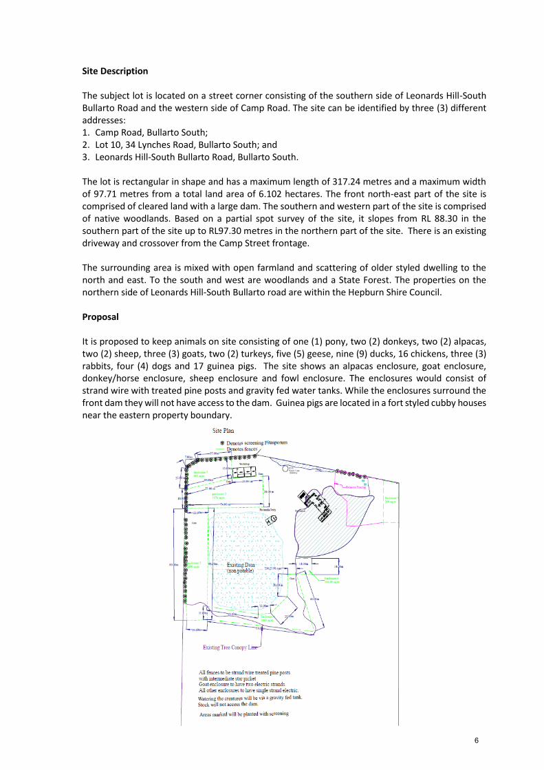
Site Description The subject lot is located on a street corner consisting of the southern side of Leonards Hill-South Bullarto Road and the western side of Camp Road. The site can be identified by three (3) different addresses: 1. Camp Road, Bullarto South; 2. Lot 10, 34 Lynches Road, Bullarto South; and 3. Leonards Hill-South Bullarto Road, Bullarto South. The lot is rectangular in shape and has a maximum length of 317.24 metres and a maximum width of 97.71 metres from a total land area of 6.102 hectares. The front north-east part of the site is comprised of cleared land with a large dam. The southern and western part of the site is comprised of native woodlands. Based on a partial spot survey of the site, it slopes from RL 88.30 in the southern part of the site up to RL97.30 metres in the northern part of the site. There is an existing driveway and crossover from the Camp Street frontage. The surrounding area is mixed with open farmland and scattering of older styled dwelling to the north and east. To the south and west are woodlands and a State Forest. The properties on the northern side of Leonards Hill-South Bullarto road are within the Hepburn Shire Council. Proposal It is proposed to keep animals on site consisting of one (1) pony, two (2) donkeys, two (2) alpacas, two (2) sheep, three (3) goats, two (2) turkeys, five (5) geese, nine (9) ducks, 16 chickens, three (3) rabbits, four (4) dogs and 17 guinea pigs. The site shows an alpacas enclosure, goat enclosure, donkey/horse enclosure, sheep enclosure and fowl enclosure. The enclosures would consist of strand wire with treated pine posts and gravity fed water tanks. While the enclosures surround the front dam they will not have access to the dam. Guinea pigs are located in a fort styled cubby houses near the eastern property boundary.
6
Background of Current Proposal As part of planning permit PA2016-278, it was brought to Council’s attention that there were a number of animals on site without planning permission. The applicant was advised to apply for planning permission and this was submitted however, as it was considered that some of the animals could be approved as part of the residential use i.e. chickens, rabbits and dogs the keeping of animals application was not progressed until the dwelling had been decided. The dwelling application was issued with a Notice of Decision to Grant a Permit on 16 March, 2018 as a result of S86 Development Assessment Committee of Council meeting held on 21 February, 2018. However, has since been appealed through VCAT. The current application PA2018-077 was presented to a S86 Development Assessment Committee of Council on 18 July, 2018. It was determined to defer the item as an objection had been received from a referral authority, Western Water and the applicant did not have the opportunity to have discussions with this authority. The application was then presented at the next available S86 Development Assessment Committee of Council on 15 August, 2018. The applicant was still in negotiations with Western Water and requested further time to resolve Western Waters concerns. It was determined to defer the item again to allow the negotiations to be finalised. The applicant provided Western Water with a revised enclosure plan, revised planning report and a report from Phillips Agribusiness which advised the grazing land available is limited to 14 DSE (Dry Sheep Equivalent). As this application is retrospective with animals still residing on site, there is an element of urgency to determine the application. As Councillors have now resolved to defer this item on two previous occasions, it is considered that the applicant has had sufficient time to resolve an outcome with Western Water and that Council should be in a position to make a decision. Public Notice The application was notified to adjoining and surrounding landowners by mail and placing a large sign on site for period of fourteen days, a total of three (3) objections were received. Summary of Objections The objections received are detailed below with officer’s comments accompanying them:
Objection Any relevant requirements
Does not comply with purpose of the Rural Conservation Zone/Prohibited use in a Rural Conservation Zone.
Clause 35.06
Officer’s response – Please refer to the Officer Discussion section of the report where the land use for this proposal is explored and determined. As the use is not determined to be ‘intensive animal husbandry’ which is a Section 3, prohibited land use in the Rural Conservation Zone and the application can be considered under the zoning of the land. The proposal does not undermine the objectives or the biodiversity of the area with large section of land still devoted to native woodlands unaffected by the proposed use. The Rural Conservation Zone does allow for animal type uses that don’t impact the conservation value of the site, it is considered that the subject proposal can be managed in a way that does not cause detriment to the conservation aspects of this land.
7
Objection Any relevant requirements
Animal effluent
Officer’s response – The site can be managed and animal effluent will not be excessive that could affect the health and wellbeing of the animals. As specified in the response above, conditions will require that waste is managed and removed from the site.
Officer’s response – The environment will not be adversely affected by having animals on the land as evident by their current occupation over the past two years. There is no proof of environmental damage caused by the animals.
The land is located within a Special Water Catchment Area, does not comply with the State Planning Policy Framework, does not comply with the Local Planning Policy Framework, does not comply with the decision guidelines contained within the Rural Conservation Zone, has not considered stocking rates with capabilities of the land to sustain grazing/overstocking on water quality, prohibited land use.
Section 55 of the Planning & Environment Act
Officer’s response – Under Section 55, a permit can not be granted when a determining referral authority objects.
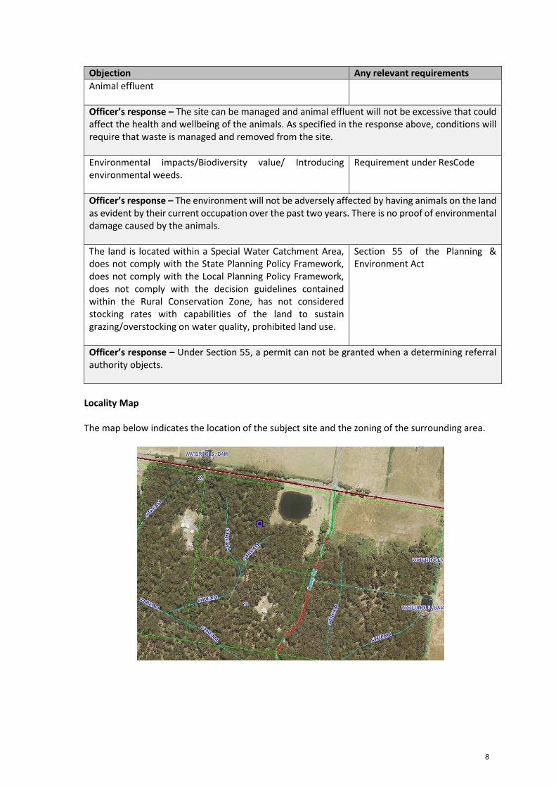
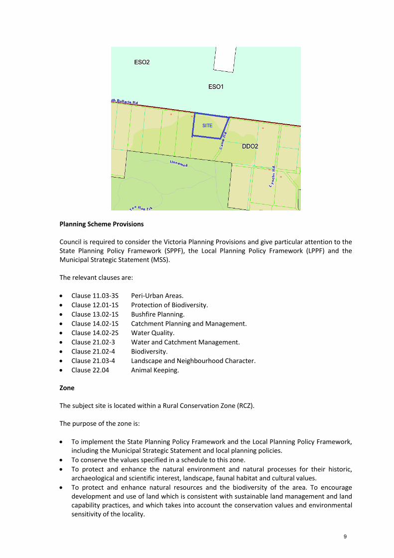
Locality Map The map below indicates the location of the subject site and the zoning of the surrounding area.
8
Planning Scheme Provisions Council is required to consider the Victoria Planning Provisions and give particular attention to the State Planning Policy Framework (SPPF), the Local Planning Policy Framework (LPPF) and the Municipal Strategic Statement (MSS). The relevant clauses are:
Clause 11.03-3S Peri-Urban Areas.
Clause 12.01-1S Protection of Biodiversity.
Clause 13.02-1S Bushfire Planning.
Clause 14.02-1S Catchment Planning and Management.
Clause 14.02-2S Water Quality.
Clause 21.02-3 Water and Catchment Management.
Clause 21.02-4 Biodiversity.
Clause 21.03-4 Landscape and Neighbourhood Character.
Clause 22.04 Animal Keeping. Zone The subject site is located within a Rural Conservation Zone (RCZ).
The purpose of the zone is:
To implement the State Planning Policy Framework and the Local Planning Policy Framework, including the Municipal Strategic Statement and local planning policies.
To conserve the values specified in a schedule to this zone.
To protect and enhance the natural environment and natural processes for their historic, archaeological and scientific interest, landscape, faunal habitat and cultural values.
To protect and enhance natural resources and the biodiversity of the area. To encourage development and use of land which is consistent with sustainable land management and land capability practices, and which takes into account the conservation values and environmental sensitivity of the locality.
9
To provide for agricultural use consistent with the conservation of environmental and landscape values of the area.
To conserve and enhance the cultural significance and character of open rural and scenic non-urban landscapes.
For uses described as the keeping of animals not clearly defined under Clause 74, is a Section 2, permit required use under Clause 35.06-1, Decision guidelines are listed under Clause 35.06-6. Overlays Bushfire Management Overlay The subject is covered by a Bushfire Management Overlay (BMO). The purpose of this Overlay is:
To implement the State Planning Policy Framework and the Local Planning Policy Framework, including the Municipal Strategic Statement and local planning policies.
To ensure that the development of land prioritises the protection of human life and strengthens community resilience to bushfire.
To identify areas where the bushfire hazard warrants bushfire protection measures to be implemented.
To ensure development is only permitted where the risk to life and property from bushfire can be reduced to an acceptable level.
The use does not require approval under this overlay. Design & Development Overlay Schedule 2 The subject site is located in Design & Development Overlay Schedule 2 (DD02).
The purpose of Schedule 2 is:
To enhance visual amenity in rural, township and vegetated areas of the Moorabool Shire.
To encourage the use of external cladding, such as non-reflective materials for building construction.
To discourage the use of materials, such as reflective cladding for building construction, which could have a detrimental effect on amenity.
There are no building works that requires planning approval under this clause. Any future building works associated with the keeping of animals would require separate planning permission. Relevant Policies No relevant policies.
10
Discussion Use of the Land The Planning Scheme contains a number of land use definitions with regard to the keeping of animals as follows: 1. Animal boarding - Land used to board domestic pets, such as boarding kennels and a cattery. 2. Animal husbandry - Land used to keep, breed, board, or train animals, including birds. 3. Animal keeping - Land used to:
a) breed or board domestic pets; or b) keep, breed, or board racing dogs
4. Extensive animal husbandry - Land used to keep or breed farm animals, including birds, at an
intensity where the animals' main food source is obtained by grazing, browsing, or foraging on plants grown on the land. It includes: a) a) emergency and supplementary feeding; and b) b) the incidental penning and housing of animals, including birds, for brooding, weaning,
dipping, or other husbandry purposes 5. Intensive animal husbandry - Land used to keep or breed farm animals, including birds, by
importing most food from outside the enclosures. It does not include: a) a) an abattoir or sale yard; b) b) emergency and supplementary feeding if incidental to the use of land for extensive
animal husbandry; or c) c) the penning and housing of animals, including birds, for brooding, weaning, dipping or
other husbandry purposes if incidental to the use of land for extensive animal husbandry. There are also number of VCAT decisions where the debate has centered around interpretation of these definitions. The Marantelli decision [VCAT 270 (2014)] looked at applying common sense approach to how the land is used in excluding some uses such as intensive or extensive animal husbandry. The member noted ‘first I agree with Council that a common sense interpretation of the term ‘farm animal’ points to these animals being kept for the purpose of making a profit. Contrast this with many situations where animals are (in small numbers) kept either overtly or otherwise generally in the nature of pets e.g. pet dogs and cats or a handful of chooks/guinea pigs/sheep/goats.’ The subject proposal was assessed against the land use definitions as specified above and also compared against the previous VCAT decisions that have been made similar to this proposal. What is clear is whilst some of the animals are hooved and could be used for farming and commercial purposes, this is not the intent of the landowner/applicant. It has been raised in objections that the proposed use is Intensive Animal Husbandry. This definition falls predominantly down to ‘extent’ of the application and normally applies to the likes of chicken broilers and large scale commercial animal farming uses with the intent of ‘producing’ food/wool or the likes from the animals for commercial gain.
11
Due to the Intensive Animal Husbandry land use being too general and capturing smaller uses, the Department Environment, Land, Water and Planning has developed a Draft Policy – Sustainable Animal Industries which as part of the Smart Planning reform process intends on providing new land use definitions which help to clarify this issue further. What is clear in this draft policy which has been a document of due consideration since 2017, is that the animal use definitions have been strengthened to clearly define farm animals for production and other uses which are not for production purposes. Whilst this documentation has yet to be formalised, its definitions relating to animal uses should be considered in relation to this application. Please note that Animal Husbandry would no longer include Intensive Animal Husbandry, this definition would be deleted and replaced with the following: Animal husbandry Land used to keep, breed, board, or train animals, including birds:
Animal keeping;
Animal production;
Animal training;
Apiculture; and
Horse stables. Animal production Land used to keep or breed poultry or mammals, other than rodents, for the production of eggs, fibre, meat, milk or other animal products:
Broiler farm;
Grazing animal;
Production;
Intensive animal;
Production;
Pig farm;
Poultry farm; and
Poultry hatchery. What this all comes down to is that the keeping of one (1) pony, two (2) donkeys, two (2) alpacas, two (2) sheep, three (3) goats, two (2) turkeys, five (5) geese, nine (9) ducks, 16 chickens, three (3) rabbits, four (4) dogs and 17 guinea pigs by nature does not make the use ‘Intensive Animal Husbandry’ because the animals are not being used for commercial purposes. Due to the small number of animals, feed being brought to the site does not trigger the ‘Intensive’ this is no different to people buying dog food or chicken feed for domestic purposes. The land use can be best described as the keeping of animals which does not fall into a specified definition category. The use for the land in this current application is managing abandoned animals and is not for profit. There is a small number of different animals that are not used for farm production. The use is confined to a small percentage of the total site area surrounding the front dam and in a cleared section of land. The proposed animal enclosures are located in the cleared section of the site as can be seen in the site plan there are specific fenced off sections for different species of animals. The use has operated for approximately two (2) years and there is evidence from two (2)separate site inspections that the use is not of an extent that would adversely affect the amenity of adjacent or nearby properties.
12
It is considered that the use could be managed by having maintained enclosures for different animals and ensuring they are sufficiently cared for including food and water. Permit conditions could protect the surrounding area by controlling amenity impacts by ensuring feed is correctly stored away from vermin, animal waste is collected from the paddocks (to limit the risk of nutrient impact on the catchment), and no tree removal is undertaken for this application. The proposal could be improved by including additional fenced off areas in the existing cleared area to allow resting and rehabilitation of proposed enclosures. This area is in a rural setting and it cannot be expected that it will be an animal free environment. The zoning of the land expects there will be human habitation, animals in small numbers coexisting with predominately a natural environment whilst acknowledging that residential development of individual lots does result in the removal of small sections of the natural environment. The Rural Conservation Zone envisages residential activity in a rural setting. This use of keeping animals does not require additional land clearing and therefore can utilise the existing cleared and open areas, that are not set aside for future residential use which is subject to a decision to be determined on review at VCAT. Using other parts of cleared land for the keeping of animals effectively maximises the use of the land. The site still contains a large section of native trees that is not affected by the keeping of the animals and thereby maintaining the biodiversity of this area. The applicant is not operating a farm business that is suited to land in the Farming Zone. The proposed use of keeping animals is consistent with the purpose of the Rural Conservation Zone that is to conserve the values specified in the schedule to this zone that includes to protect land of environmental significance. Catchment Authority Proclaimed Water Catchment Areas are covered by the planning scheme under the Environmental Significance Overlay Schedule 1 (ES01). The environmental objectives of this overlay are:
To protect the quality and quantity of water produced within proclaimed water catchments.
To provide for appropriate development of land within proclaimed water catchments. The subject land is not covered by an Environmental Significance Overlay Schedule 1 which instead covers all of the northern side of South Bullarto Road, immediately north of the subject land. Western Water requested referral of the application and subsequently objected to the application. They advised the land is covered by a Special Water Supply Catchment Area (previously called a Proclaimed Water Catchment Area) under the Catchment and Land Protection Act 1994. Under Clause 66.02-5, a special water supply catchment area requires referral to the relevant water board or water supply authority who are a Section 55 determining authority. Under Section 55(4) of the Planning & Environment Act, Western Water are determining referral authority. With the Western Water objection, Council must refuse the application and under Section 65(2) of the Planning & Environment Act must specify the grounds are those of the determining referral authority. Had Western Water not objected, the application would have received officers support on planning grounds with appropriate conditions.
13
General Provisions Clause 65 – Decision Guidelines have been considered by officers in evaluating this application.
The matters set out in Section 60 of the Act.
The State Planning Policy Framework and the Local Planning Policy Framework, including the Municipal Strategic Statement and local planning policies.
The purpose of the zone, overlay or other provision.
Any matter required to be considered in the zone, overlay or other provision.
The orderly planning of the area.
The effect on the amenity of the area.
Clause 66 - Stipulates all the relevant referral authorities to which the application must be referred. Referrals The following referrals were made pursuant to s.55 of the Planning and Environment Act 1987 and Council departments were provided with an opportunity to make comment on the proposed development plan.
Authority Response
Infrastructure Community Safety Environmental Planning Western Water
Consent with three conditions Consent Consent provided no tree removal. Objection
Financial Implications There are no financial implications in recommending refusal of this use application. Risk and Occupational Health and Safety Issues The recommendation of refusal to this use application does not implicate any risk or OH & S issues to Council. Communications Strategy Notice was undertaken for the application, in accordance with s.52 of the Planning and Environment Act 1987, and further correspondence is required to all interested parties to the application as a result of a decision in this matter. All submitters and the applicant were invited to attend this meeting and invited to address Council if desired. Options Council has the following options it could consider:
Issue a refusal in accordance with the S55 authorities reasons for refusal which have been implemented in the recommendation of this report;
Should Council wish to consider additional refusal grounds, Councilors need to explore reasons based on the proposal not complying with the Moorabool Planning Scheme; or
As this is a S55 refusal Council does not have the power to approve this application.
14
Conclusion The proposed use is for the keeping of animals that are not to be used for farm production or in large commercial numbers. The animals are separated by enclosures with their own water source. The proposed use does not involve the removal of native trees. The use could be managed with the current absence of a dwelling on the land and it does not affect the local biodiversity as it is confined to cleared areas of the site located adjacent to the northern and eastern property boundaries. The proposed Animal Keeping use is consistent with the purpose and the objectives of the Rural Conservation Zone.
However, a Section 55 referral authority, Western Water has objected to the application. The applicant has been given the opportunity to undertake further discussions with Western Water but has not been able to achieve a withdrawal of objection. With an objection from Western Water as a Section 55 determining referral authority, the application must be refused in accordance with all of Western Water’s grounds.
Recommendation That, having considered all matters as prescribed by the Planning and Environment Act, Council Refuse to Grant a Permit for the use of land for the keeping of animals for the land at Lot 10 on Title Plan 085359L otherwise known as Camp Road, Bullarto South, subject to the following grounds: 1. Western Water as a Section 55 determining referral authority have objected to the application
with the following grounds: a) The land is located within a Special Water Supply Catchment Area listed in Schedule 4 of
the Catchment and Land Protection Act (Pykes Creek Reservoir and Werribee River Water Supply Catchment) which provided water to a domestic supply. Pursuant to Clause 66.02-5 of the Moorabool Planning Scheme Western Water is a Determining Water Authority.
b) The proposal does not provide acceptable outcomes in regards to the State Planning Policy Framework.
c) The proposal does not provide acceptable outcomes in regards to the Local Planning Policy Framework.
d) The proposal is not in accordance with the purpose or the decision guidelines contained within the Rural Conservation Zone.
e) The application has failed to taken into account stocking rates with the capabilities of the land to sustain grazing and the potential impact of overstocking on water quality.
f) The proposed use of the land falls within the definition of Intensive Animal Husbandry which is prohibited within the Rural Conservation Zone.
Note: All animals will be required to be removed from the land in accordance with timelines set by the Responsible Authority.
Report Authorisation: Authorised by: Name: Satwinder Sandhu Title: General Manager Growth and Development Date: 28 August, 2018
15
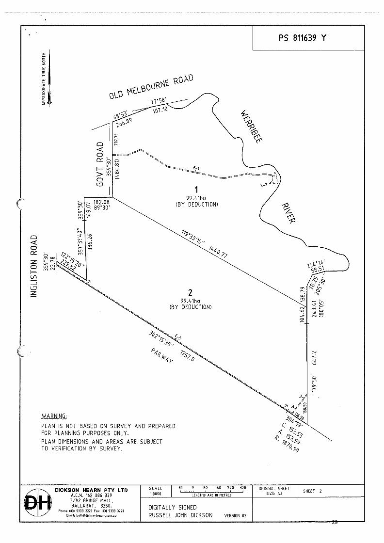
Item 5.2 Planning Permit Application 2017220 – Two lot subdivision (boundary realignment) and creation of a carriageway easement over Lot 9 on LP129303D in favour of proposed Lot 1 on PS811639Y at 145 Old Melbourne Road, Ballan.
Application Summary:
Permit No: PA2017220
Lodgment Date:
18 October 2017
Planning Officer:
Victoria Mack
Address of the land:
145 Old Melbourne Road, Ballan Lot 10 on PS 129303 and Lots 1 and 2 on TP 103768X (formerly pt Portion 15 and 16, Section 4 Parish of Gorong) and Lot 9 on LP129303D.
Proposal:
Two lot subdivision (boundary realignment) and creation of a carriageway easement over Lot 9 on LP129303D in favour of proposed Lot 1 on PS811639Y.
Lot size:
198.82ha – total area of the three lots.
Why is a permit required?
Farming Zone - Subdivision Road Zone Category 1 - Subdivision Environmental Significance Overlay – Subdivision Clause 52.29 - Subdivision
Public Consultation
Was the application advertised?
Yes
Notices on site:
No, site not suitable.
Notice in Moorabool Newspaper:
No
Number of Objections:
Three (3). However one (1) has been formally withdrawn.
Consultation Meeting:
Held on 13 August, 2018 with all objectors attending.
Policy Implications
Strategy Objective 2:
Minimising Environmental Impact
Context 3A: Land Use Planning
Victorian Charter of Human Rights and Responsibilities Act 2006
In developing this report to Council, the officer considered whether the subject matter raised any human rights issues. In particular, whether the scope of any human right established by the Victorian Charter of Human Rights and Responsibilities is in any way limited restricted or interfered with by the recommendations contained in the report. It is considered that the subject matter does not raise any human rights issues.
16
Officer’s Declaration of Conflict of Interests
Under section 80C of the Local Government Act 1989 (as amended), officers providing advice to Council must disclose any interests, including the type of interest. Manager – Robert Fillisch In providing this advice to Council as the Manager, I have no interests to disclose in this report. Author – Victoria Mack In providing this advice to Council as the Author, I have no interests to disclose in this report.
Executive Summary
Application Referred?
Yes Western Water, Southern Rural Water, Melbourne Water, Central Highlands Water, VicRoads and Council’s Infrastructure Department.
Any issues raised in referral responses?
No.
Preliminary concerns?
No legal access to the proposed Lot 1.
Any discussions with applicant regarding concerns?
The applicant advised that access to the proposed lot 1 could be secured via an existing carriageway easement on a separate lot (Lot 9 on LP129303D) which is in the same ownership as the subject land. Consent has been provided by the owners that the proposed Lot 1 would be a benefiting lot to the carriageway easement. The title to Lot 9 would be required to be adjusted accordingly.
Any changes made to the application since being lodged?
Provision of the title to Lot 9 on LP129303D showing the carriageway easement.
Brief history
The land is vacant and is used for grazing. The land currently comprises three titles. The two (2) owners (tenants in common) have applied to re-subdivide the three (3) lots into two (2) lots of equal size to rationalise the property ownership and allow the two (2) owners to gain an equal share of the land.
Previous applications for the site?
Nil.
General Summary The application is for a two (2) lot subdivision (boundary realignment) and creation of a carriageway easement over Lot 9 on LP129303D in favour of proposed Lot 1 on PS811639Y. The site currently consists of three (3) lots with a total area of 198.82ha. The two (2) new lots to be created would be of equal size and would be 99.41ha each.
17
Generally the application is a relatively straightforward boundary realignment in the Farming Zone which would create little impact on the surrounding land uses. However, the application was advertised and three (3) objectors raised concerns about different aspects of the proposal. Much of the concern related to access to the proposed Lot 2. Concern was expressed that a driveway could be constructed from lot 2 via the unused government road at the rear of their Ingliston Road properties to take advantage of the existing carriageway easement to the north. However, the application has not requested that the proposed Lot 2 has access to the carriageway easement and permit conditions could be used to ensure that the carriageway easement is only used to benefit the proposed Lot 1. The application was referred to five (5) statutory referral authorities and Council’s Infrastructure Department was provided opportunity to comment. All consented to the application and only two (2) authorities required conditions. It is recommended that the application is supported.
Summary Recommendation
That, having considered all relevant matters as required by the Planning and Environment Act 1987, Council issues a Notice of Decision to Grant a Planning permit for a Two lot subdivision (boundary realignment) and creation of a carriageway easement over Lot 9 on LP129303D in favour of proposed Lot 1 on PS811639Y on land known as 145 Old Melbourne Road, Ballan, and otherwise known as Lot 10 on PS 129303 and Lots 1 and 2 on TP 103768X (formerly pt Portion 15 and 16, Section 4 parish of Gorong).
Site Description The site comprises three (3) lots with a total area of 198.82ha. The majority of the site is open undulating grazing land with little native vegetation other than a few scattered trees. There are no improvements on the site other than farming related infrastructure. The Werribee River abuts much of the east side boundary of the subject land and the Ballarat-Melbourne rail corridor abuts the south side boundary of the land. The Western Highway abuts a portion of the north side boundary and on the west side boundary (in part) there are eight (8) small 2ha lots most of which contain dwellings.
18
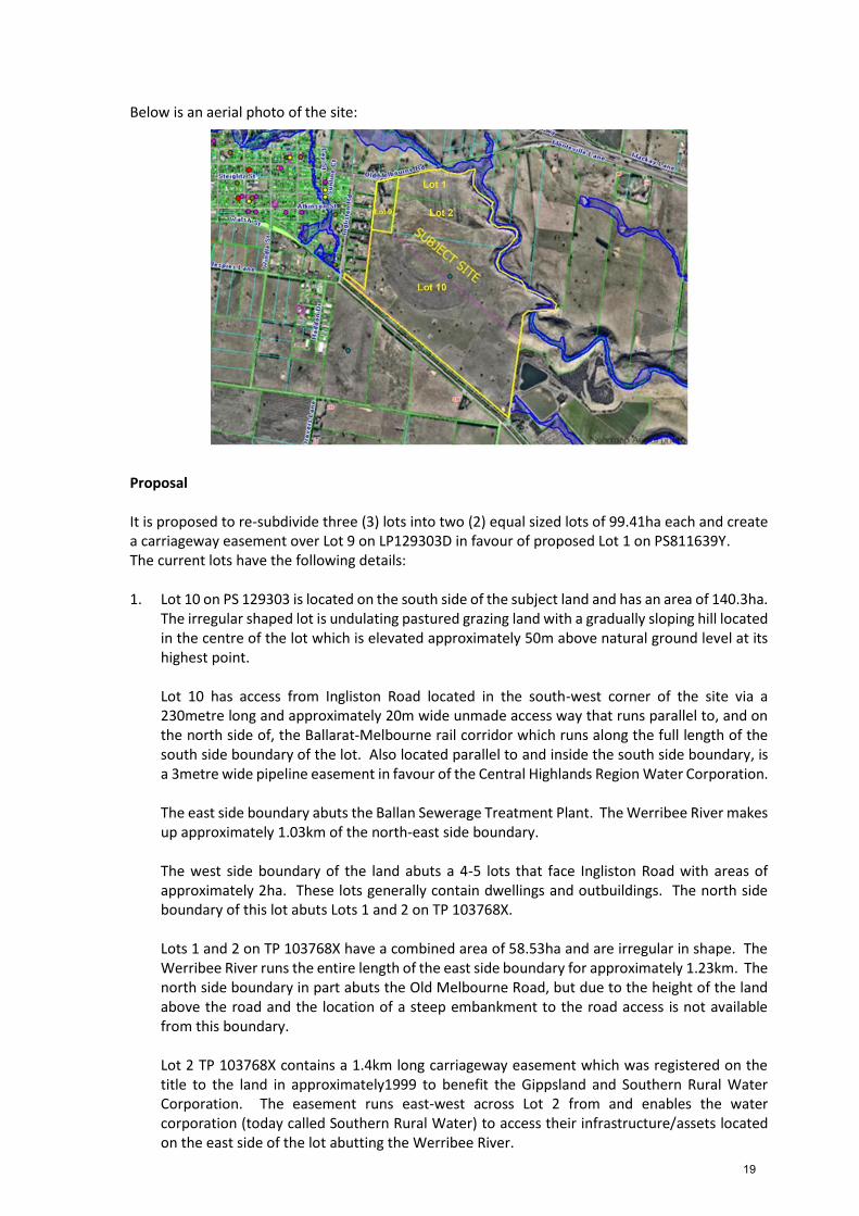
Below is an aerial photo of the site:
Proposal
It is proposed to re-subdivide three (3) lots into two (2) equal sized lots of 99.41ha each and create a carriageway easement over Lot 9 on LP129303D in favour of proposed Lot 1 on PS811639Y. The current lots have the following details: 1. Lot 10 on PS 129303 is located on the south side of the subject land and has an area of 140.3ha.
The irregular shaped lot is undulating pastured grazing land with a gradually sloping hill located in the centre of the lot which is elevated approximately 50m above natural ground level at its highest point. Lot 10 has access from Ingliston Road located in the south-west corner of the site via a 230metre long and approximately 20m wide unmade access way that runs parallel to, and on the north side of, the Ballarat-Melbourne rail corridor which runs along the full length of the south side boundary of the lot. Also located parallel to and inside the south side boundary, is a 3metre wide pipeline easement in favour of the Central Highlands Region Water Corporation. The east side boundary abuts the Ballan Sewerage Treatment Plant. The Werribee River makes up approximately 1.03km of the north-east side boundary. The west side boundary of the land abuts a 4-5 lots that face Ingliston Road with areas of approximately 2ha. These lots generally contain dwellings and outbuildings. The north side boundary of this lot abuts Lots 1 and 2 on TP 103768X. Lots 1 and 2 on TP 103768X have a combined area of 58.53ha and are irregular in shape. The Werribee River runs the entire length of the east side boundary for approximately 1.23km. The north side boundary in part abuts the Old Melbourne Road, but due to the height of the land above the road and the location of a steep embankment to the road access is not available from this boundary.
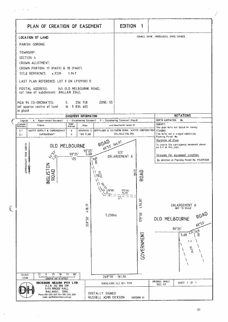
Lot 2 TP 103768X contains a 1.4km long carriageway easement which was registered on the title to the land in approximately1999 to benefit the Gippsland and Southern Rural Water Corporation. The easement runs east-west across Lot 2 from and enables the water corporation (today called Southern Rural Water) to access their infrastructure/assets located on the east side of the lot abutting the Werribee River.
19
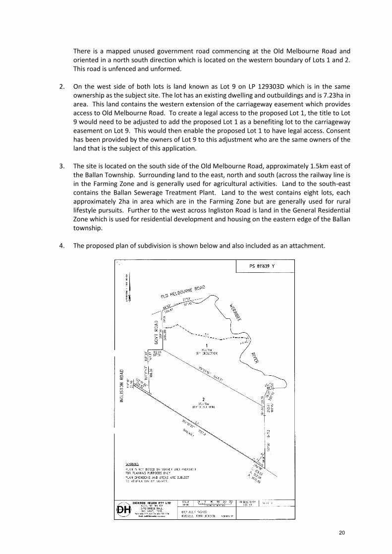
There is a mapped unused government road commencing at the Old Melbourne Road and oriented in a north south direction which is located on the western boundary of Lots 1 and 2. This road is unfenced and unformed.
2. On the west side of both lots is land known as Lot 9 on LP 129303D which is in the same
ownership as the subject site. The lot has an existing dwelling and outbuildings and is 7.23ha in area. This land contains the western extension of the carriageway easement which provides access to Old Melbourne Road. To create a legal access to the proposed Lot 1, the title to Lot 9 would need to be adjusted to add the proposed Lot 1 as a benefiting lot to the carriageway easement on Lot 9. This would then enable the proposed Lot 1 to have legal access. Consent has been provided by the owners of Lot 9 to this adjustment who are the same owners of the land that is the subject of this application.
3. The site is located on the south side of the Old Melbourne Road, approximately 1.5km east of the Ballan Township. Surrounding land to the east, north and south (across the railway line is in the Farming Zone and is generally used for agricultural activities. Land to the south-east contains the Ballan Sewerage Treatment Plant. Land to the west contains eight lots, each approximately 2ha in area which are in the Farming Zone but are generally used for rural lifestyle pursuits. Further to the west across Ingliston Road is land in the General Residential Zone which is used for residential development and housing on the eastern edge of the Ballan township.
4. The proposed plan of subdivision is shown below and also included as an attachment.
20
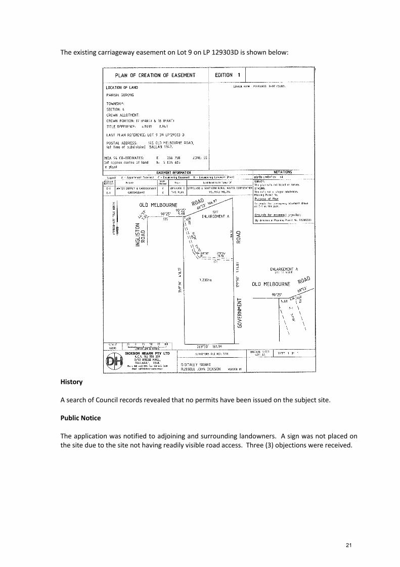
The existing carriageway easement on Lot 9 on LP 129303D is shown below:
History A search of Council records revealed that no permits have been issued on the subject site. Public Notice The application was notified to adjoining and surrounding landowners. A sign was not placed on the site due to the site not having readily visible road access. Three (3) objections were received.
21
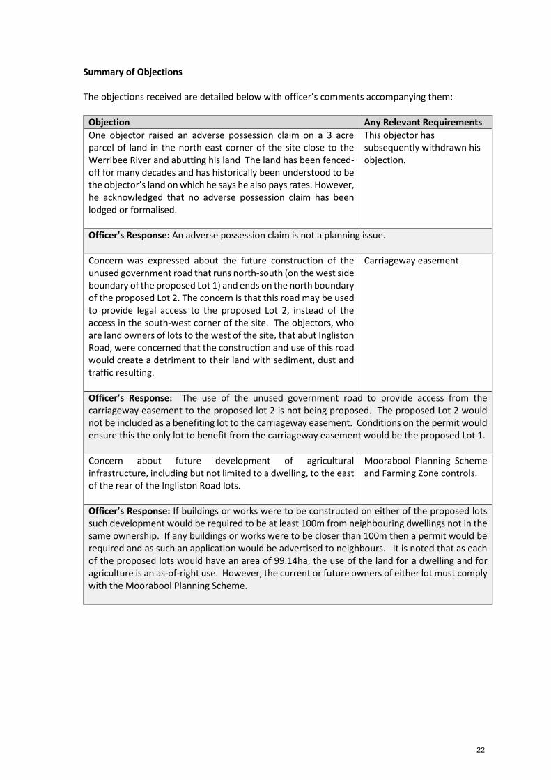
Summary of Objections The objections received are detailed below with officer’s comments accompanying them:
Objection Any Relevant Requirements
One objector raised an adverse possession claim on a 3 acre parcel of land in the north east corner of the site close to the Werribee River and abutting his land The land has been fenced-off for many decades and has historically been understood to be the objector’s land on which he says he also pays rates. However, he acknowledged that no adverse possession claim has been lodged or formalised.
This objector has subsequently withdrawn his objection.
Officer’s Response: An adverse possession claim is not a planning issue.
Concern was expressed about the future construction of the unused government road that runs north-south (on the west side boundary of the proposed Lot 1) and ends on the north boundary of the proposed Lot 2. The concern is that this road may be used to provide legal access to the proposed Lot 2, instead of the access in the south-west corner of the site. The objectors, who are land owners of lots to the west of the site, that abut Ingliston Road, were concerned that the construction and use of this road would create a detriment to their land with sediment, dust and traffic resulting.
Carriageway easement.
Officer’s Response: The use of the unused government road to provide access from the carriageway easement to the proposed lot 2 is not being proposed. The proposed Lot 2 would not be included as a benefiting lot to the carriageway easement. Conditions on the permit would ensure this the only lot to benefit from the carriageway easement would be the proposed Lot 1.
Concern about future development of agricultural infrastructure, including but not limited to a dwelling, to the east of the rear of the Ingliston Road lots.
Moorabool Planning Scheme and Farming Zone controls.
Officer’s Response: If buildings or works were to be constructed on either of the proposed lots such development would be required to be at least 100m from neighbouring dwellings not in the same ownership. If any buildings or works were to be closer than 100m then a permit would be required and as such an application would be advertised to neighbours. It is noted that as each of the proposed lots would have an area of 99.14ha, the use of the land for a dwelling and for agriculture is an as-of-right use. However, the current or future owners of either lot must comply with the Moorabool Planning Scheme.
22
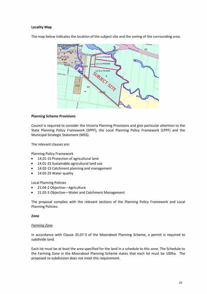
Locality Map The map below indicates the location of the subject site and the zoning of the surrounding area.
Planning Scheme Provisions Council is required to consider the Victoria Planning Provisions and give particular attention to the State Planning Policy Framework (SPPF), the Local Planning Policy Framework (LPPF) and the Municipal Strategic Statement (MSS). The relevant clauses are: Planning Policy Framework
14.01-1S Protection of agricultural land
14.01-2S Sustainable agricultural land use
14.02-1S Catchment planning and management
14.02-2S Water quality
Local Planning Policies
21.04-2 Objective—Agriculture
21.02-3 Objective—Water and Catchment Management The proposal complies with the relevant sections of the Planning Policy Framework and Local Planning Policies. Zone Farming Zone In accordance with Clause 35.07-3 of the Moorabool Planning Scheme, a permit is required to subdivide land. Each lot must be at least the area specified for the land in a schedule to this zone. The Schedule to the Farming Zone in the Moorabool Planning Scheme states that each lot must be 100ha. The proposed re-subdivision does not meet this requirement.
23
However, Clause 35.07-3 also states that permit may be granted to create smaller lots if the following applies:
The subdivision is the re-subdivision of existing lots and the number of lots is not increased. In this application the re-subdivision reduces the number of lots from three to two and in this instance an application can be made to re-subdivide the land.
The purpose of the Farming Zone is to: Implement the Municipal Planning Strategy and the Planning Policy Framework. Provide for the use of land for agriculture. Encourage the retention of productive agricultural land. Ensure that non-agricultural uses, including dwellings, do not adversely affect the use of land
for agriculture. Encourage the retention of employment and population to support rural communities. Encourage use and development of land based on comprehensive and sustainable land
management practices and infrastructure provision. Provide for the use and development of land for the specific purposes identified in a schedule
to this zone. Road Zone Category 1 In accordance with Clause 36.04-2 of the Moorabool Planning Scheme, a permit is required to subdivide land. Overlays Environmental Significance Overlay (ESO) In accordance with Clause 42.01-2 pf the Moorabool Planning Scheme, a permit is required to subdivide land. This does not apply if a schedule to this overlay specifically states that a permit is not required. Environmental Significance Overlay – Schedule 1 – Proclaimed Water Catchment Areas Schedule 1 to the ESO does not exempt an application to re-subdivide land from requiring a permit. Environmental Significance Overlay – Schedule 2 – Waterway Protection Schedule 2 to the ESO only requires a permit where an application includes buildings or works. A permit is not required to re-subdivide land. Environmental Significance Overlay – Schedule 5 - Ballan Sewage Treatment Plant Buffer Area Schedule 5 to the ESO only requires a permit where an application includes buildings or works. A permit is not required to re-subdivide land. Design and Development Overlay – Schedule 2 – Visual Amenity and Building Design In accordance with Clause 43.02 of the Moorabool Planning Scheme a permit in not required to re-subdivide land.
24
Relevant Policies There are no Council policies that apply to an application to re-subdivide Farming Zoned land where the total area is 198.82ha and the number of lots would be reduced from three (3) lots to two (2) lots. Particular Provisions Clause 52.29 Land Adjacent to A Road Zone, Category 1 In accordance with Clause 52.29-2 a permit is requirement to:
Subdivide land adjacent to a road in a Road Zone, Category 1. Discussion The proposal is a relatively straightforward application to re-subdivide vacant agricultural land by reducing the number of lots from three lots to two equal sized lots of 99.41ha each. The realignment of the boundaries is also relatively straightforward and would not detrimentally impact on waterways or neighbouring landowners. However, two (2) objector neighbours were concerned about what could happen if this subdivision was approved. They were concerned that current, or future, owners may construct building or works right behind their lots where their rear boundaries abut the proposed lot 2. It must be noted that this application does not propose future development and must be assessed on what is being requested which is re-subdivision of the lots, not what might happen in the future. It is considered that the application does not create a circumstance that would allow something to occur that was not already permitted with the existing arrangement of lots. Following the consultation meeting with the objectors who live on Ingliston Road, they advised that they would withdraw their objections if a 100m buffer behind their properties was made a condition of the permit where agricultural infrastructure could not be constructed. The applicant was asked to comment on this requirement and advised that the landowners would not agree to such a restriction. They asked that the application was determined at a Council meeting. However, it is considered that due to the location of five (5) 2ha lots with dwellings facing Ingliston Road that abut the western boundary of the proposed Lot 2, that a 100m a buffer should be required to be registered on the title to this lot, shown as a restriction on the plan, where agricultural infrastructure cannot be constructed. It is recommended that this is made a condition of the permit. General Provisions Clause 65 – Decision Guidelines have been considered by officers in evaluating this application. Clause 66 – Stipulates all the relevant referral authorities to which the application must be referred.
25
Referrals
Authority Response
Western Water Central Highlands Water Southern Rural Water Melbourne Water VicRoads
Consent without conditions Consent with 2 conditions Consent without conditions Consent without conditions Consent without conditions
Infrastructure
Consent
Financial Implications The recommendation of approval of this application would not represent any financial implications to Council. Risk and Occupational Health and Safety Issues The recommendation of approval of this application does not have any risk or OH&S implications for Council. Communications Strategy Notice was undertaken for the application, in accordance with s.52 of the Planning and Environment Act 1987, and further correspondence is required to all interested parties to the application as a result of a decision in this matter. A consultation meeting was held. Options An alternative option would be for Council to refuse the application, subject to grounds. Refusing the application may result in the applicant lodging an application for review of Council’s decision with VCAT. Conclusion The proposal is to re-subdivide 198.82ha of land comprising three (3) lots into two (2) lots. Each lot would be 99.41ha in area. The land is vacant except for normal infrastructure associated with farming.
Two (2) of the objections received related to a concern that an access road may be constructed in the future, using the existing unused government road, that would provide alternative access to the proposed Lot 2. However, such access has not been proposed in this application and permit conditions would ensure that the use of the existing carriageway easement for access would only apply to the proposed Lot 1 and not the proposed Lot 2. The objectors were also concerned that future agricultural infrastructure or residential development on either of the proposed lots, but specifically the proposed Lot 2, would create a detriment to the existing residences located on the western boundary of this lot. This concern it is not relevant to this application to realign boundaries to create two (2) equal sized lots in the Farming Zone, each of 99.41ha. Future development of either lot would be required to meet all the requirements of the planning scheme at that time.
26
However, on balance to ensure that the amenity of the Ingliston Road lots is protected, it is considered that a 100m buffer should be required to be registered on the title to this lot, shown as a restriction on the plan, where agricultural infrastructure cannot be constructed.
Overall, the proposal is considered to be consistent with relevant Planning Policy Framework and Local Planning Policy in relation to the re-subdivision of land and it is recommended that the application is supported. Recommendation That, having considered all matters as prescribed by the Planning and Environment Act, it is recommended that Council issues a Notice of Decision to Grant a Planning Permit for a two (2) lot subdivision (boundary realignment) and creation of a carriageway easement over Lot 9 on LP129303D in favour of proposed Lot 1 on PS811639Y on land known as 145 Old Melbourne Road, Ballan, and otherwise known as Lot 10 on PS 129303 and Lots 1 and 2 on TP 103768X (formerly pt Portion 15 and 16, Section 4 Parish of Gorong) subject to the following conditions: Endorsed Plans: 1. Before certification of the plan of subdivision, amended plans to the satisfaction of the
Responsible Authority must be submitted to and approved by the Responsible Authority. When approved, the plans will be endorsed and will then form part of the permit. The plans must be drawn to scale with dimensions and three (3) copies must be provided. The plans must be generally in accordance with the plans submitted with the application or some other specified plans but modified to show: a) A 100m wide buffer from the boundaries of lots abutting Ingliston Road on the proposed
Lot 2, shown as a restriction on the plan, where agricultural infrastructure cannot be constructed.
Unless otherwise approved in writing by the Responsible Authority, the subdivision must be undertaken in accordance with the endorsed plans to the satisfaction of the Responsible Authority prior to the commencement of the use.
Operational:
2. Before Statement of Compliance is issued for the subdivision, the title to Lot 9 on LP 1293030D must be altered to include the proposed Lot 1 only of the subdivision as a benefiting lot to the carriageway easement located on that lot.
Central Highlands Water:
3. Any plan lodged for certification will be referred to the Central Highlands Region Water Corporation pursuant to Section 8(1)(a) of the Subdivision Act.
4. The owner will provide easements to the satisfaction of the Central Highlands Region Water Corporation, which will include easements for pipelines or ancillary purposes in favour of the Central Highlands Region Water Corporation, over all existing and proposed sewerage facilities within the proposal.
27
Permit Expiry: 5. This permit will expire if the plan of subdivision is not certified within two (2) years of the date
of issue of the permit. Council may extend the periods referred to if a request is made in writing before the permit expires or in accordance with the timeframes as specified in Section 69 of the Planning and Environment Act 1987. Statement of Compliance must be achieved and certified plans registered at Titles office within five (5) years from the date of certification.
Report Authorisation: Authorised by: Name: Satwinder Sandhu Title: General Manager Growth and Development Date: 28 August, 2018
28
29
30
31
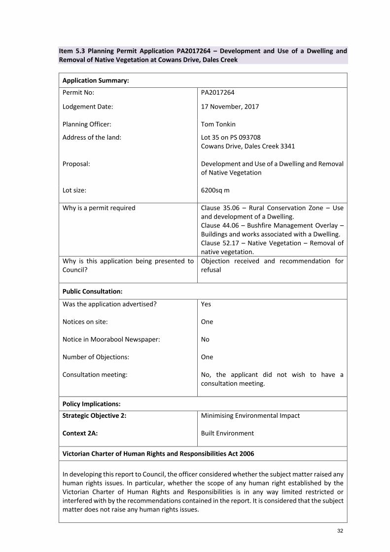
Item 5.3 Planning Permit Application PA2017264 – Development and Use of a Dwelling and Removal of Native Vegetation at Cowans Drive, Dales Creek
Application Summary:
Permit No: PA2017264
Lodgement Date: 17 November, 2017
Planning Officer: Tom Tonkin
Address of the land: Lot 35 on PS 093708 Cowans Drive, Dales Creek 3341
Proposal: Development and Use of a Dwelling and Removal of Native Vegetation
Lot size: 6200sq m
Why is a permit required Clause 35.06 – Rural Conservation Zone – Use and development of a Dwelling. Clause 44.06 – Bushfire Management Overlay – Buildings and works associated with a Dwelling. Clause 52.17 – Native Vegetation – Removal of native vegetation.
Why is this application being presented to Council?
Objection received and recommendation for refusal
Public Consultation:
Was the application advertised? Notices on site: Notice in Moorabool Newspaper: Number of Objections: Consultation meeting:
Yes One No One No, the applicant did not wish to have a consultation meeting.
Victorian Charter of Human Rights and Responsibilities Act 2006
In developing this report to Council, the officer considered whether the subject matter raised any human rights issues. In particular, whether the scope of any human right established by the Victorian Charter of Human Rights and Responsibilities is in any way limited restricted or interfered with by the recommendations contained in the report. It is considered that the subject matter does not raise any human rights issues.
32
Officer's Declaration of Conflict of Interests
Under section 80C of the Local Government Act 1989 (as amended), officers providing advice to Council must disclose any interests, including the type of interest. Manager – Robert Fillisch In providing this advice to Council as the Manager, I have no interests to disclose in this report. Author – Tom Tonkin In providing this advice to Council as the Author, I have no interests to disclose in this report.
Executive Summary:
Application Referred? Yes. Infrastructure, Environmental Health, Environmental Planning, the relevant water boards for the Special Water Supply Catchment and the CFA.
Any issues raised in referral responses? Yes. Western Water initially objected to the application on several grounds.
Preliminary Concerns? Yes. The original plans were in breach of the covenant which requires a minimum 18.28m front setback.
Any discussions with applicant regarding concerns
The Council officer wrote to the applicant about the abovementioned concern.
Any changes made to the application since being lodged?
Yes, the proposed dwelling site was amended to comply with the covenant.
VCAT history? Not for the current application.
Previous applications for the site? Yes, PA2006-273 for Development and Use of a Dwelling and Removal of Native Vegetation was refused by Council on 1 August 2007. Council’s grounds of refusal were that the site was incapable of accommodating a septic tank in accordance with the Septic Tank Code of Practice 2003. Western Water and Southern Rural Water also provided grounds of refusal. The applicant appealed the decision at VCAT but later withdrew that appeal before the matter was heard.
33
General Summary It is proposed to use and develop the site for a dwelling and remove 0.302ha of native vegetation. The site is in a Special Water Supply Catchment and is unsewered, and the proposal makes provision for the treatment of wastewater to Western Water and Southern Rural Water’s satisfaction, subject to conditions. An objection to the application relates to wastewater treatment and the proposed dwelling’s street setback. Overall, the proposal is inconsistent with State and local planning policy and the Bushfire Management Overlay relevant to the protection of human life and property from bushfire. The subject site’s location in Dales Creek and its topography and vegetation cover severely limit its capability to support a dwelling which could withstand a bushfire. The risk-based assessment identifies that a dwelling on the site must achieve a Flame Zone BAL rating, significantly affecting its ability to withstand a bushfire. The proposal’s risk to loss of human life and property in a bushfire event is unacceptable and should not be supported.
Summary Recommendation:
That, having considered all relevant matters as required by the Planning and Environment Act 1987, Council issue a Refusal to Grant a Planning Permit for this application in accordance with Section 61 of the Planning and Environment Act 1987, on the grounds included at the end of this report.
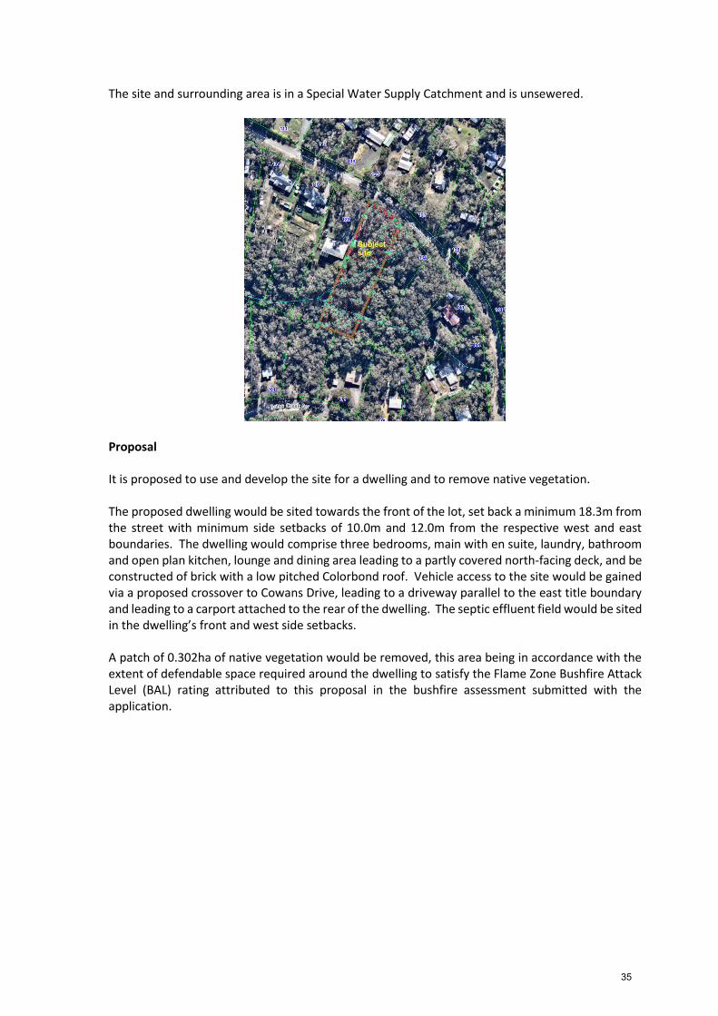
Site Description The site is identified as Lot 35 on PS 093708 and known as Cowans Drive, Dales Creek, and is roughly rectangular shape with an area of 6200sq m. The site is on the south side of the street approximately 300m northwest of the Dales Creek Avenue intersection. The site is vacant and heavily vegetated with native trees, falls generally to the south and is trisected by tributaries of Dales Creek which flow to the southwest of the site. The site and surrounding land is in the Rural Conservation Zone and comprises mostly lots of 4000-6500sq m size, many developed with single dwellings in a bushland setting. The area has a mostly hilly topography, with land falling generally to the west. Other than adjoining lots to the east and southwest, all other adjoining lots are developed with dwellings.
34
The site and surrounding area is in a Special Water Supply Catchment and is unsewered.
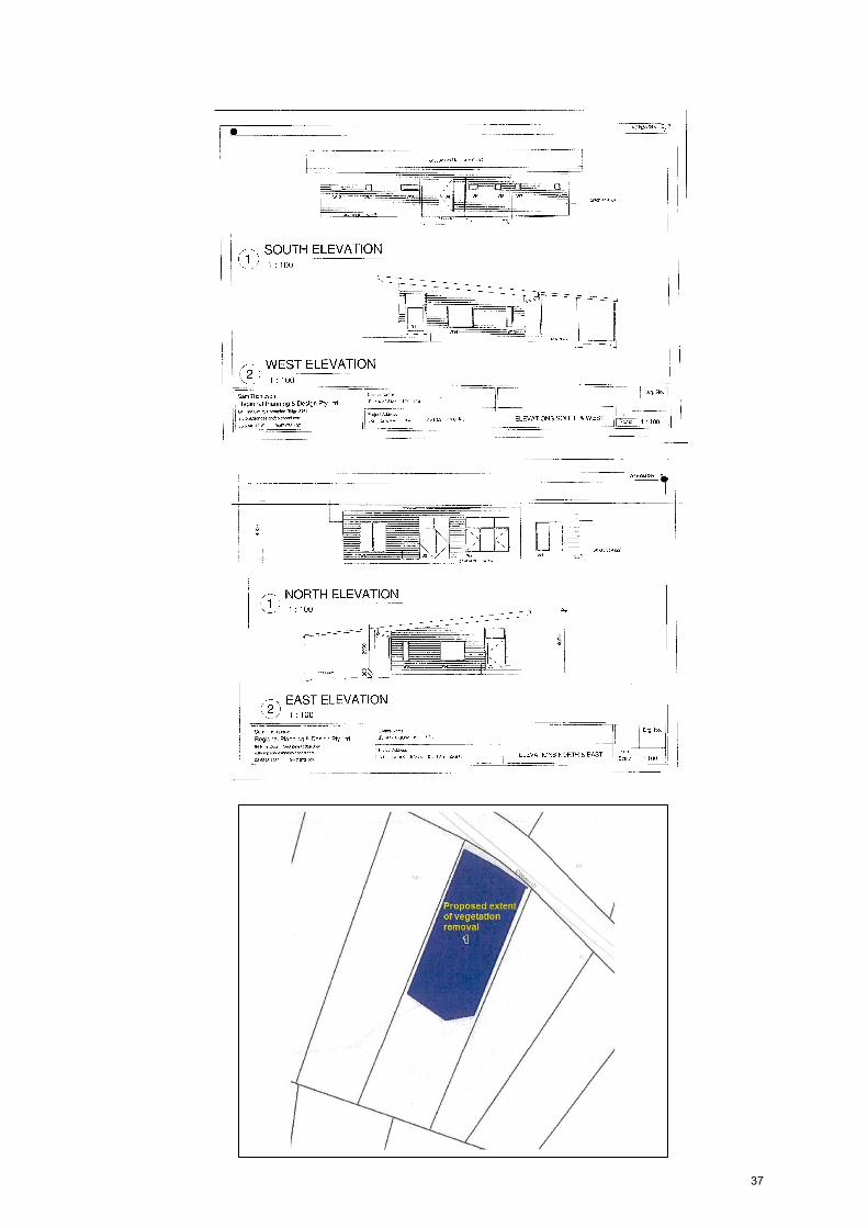
Proposal It is proposed to use and develop the site for a dwelling and to remove native vegetation. The proposed dwelling would be sited towards the front of the lot, set back a minimum 18.3m from the street with minimum side setbacks of 10.0m and 12.0m from the respective west and east boundaries. The dwelling would comprise three bedrooms, main with en suite, laundry, bathroom and open plan kitchen, lounge and dining area leading to a partly covered north-facing deck, and be constructed of brick with a low pitched Colorbond roof. Vehicle access to the site would be gained via a proposed crossover to Cowans Drive, leading to a driveway parallel to the east title boundary and leading to a carport attached to the rear of the dwelling. The septic effluent field would be sited in the dwelling’s front and west side setbacks. A patch of 0.302ha of native vegetation would be removed, this area being in accordance with the extent of defendable space required around the dwelling to satisfy the Flame Zone Bushfire Attack Level (BAL) rating attributed to this proposal in the bushfire assessment submitted with the application.
35
The proposed site plan, dwelling floor plans and elevations are provided below.
36
37
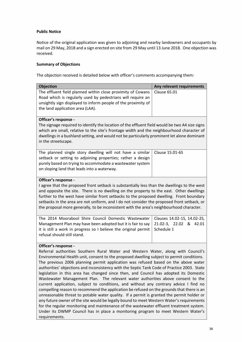
Public Notice Notice of the original application was given to adjoining and nearby landowners and occupants by mail on 29 May, 2018 and a sign erected on site from 29 May until 13 June 2018. One objection was received. Summary of Objections The objection received is detailed below with officer’s comments accompanying them:
Objection Any relevant requirements
The effluent field planned within close proximity of Cowans Road which is regularly used by pedestrians will require an unsightly sign displayed to inform people of the proximity of the land application area (LAA).
Clause 65.01
Officer’s response - The signage required to identify the location of the effluent field would be two A4 size signs which are small, relative to the site’s frontage width and the neighbourhood character of dwellings in a bushland setting, and would not be particularly prominent let alone dominant in the streetscape.
The planned single story dwelling will not have a similar setback or setting to adjoining properties; rather a design purely based on trying to accommodate a wastewater system on sloping land that leads into a waterway.
Clause 15.01-6S
Officer’s response - I agree that the proposed front setback is substantially less than the dwellings to the west and opposite the site. There is no dwelling on the property to the east. Other dwellings further to the west have similar front setbacks to the proposed dwelling. Front boundary setbacks in the area are not uniform, and I do not consider the proposed front setback, or the proposal more generally, to be inconsistent with the area’s neighbourhood character.
The 2014 Moorabool Shire Council Domestic Wastewater Management Plan may have been adopted but it is fair to say it is still a work in progress so I believe the original permit refusal should still stand.
Officer’s response - Referral authorities Southern Rural Water and Western Water, along with Council’s Environmental Health unit, consent to the proposed dwelling subject to permit conditions. The previous 2006 planning permit application was refused based on the above water authorities’ objections and inconsistency with the Septic Tank Code of Practice 2003. State legislation in this area has changed since then, and Council has adopted its Domestic Wastewater Management Plan. The relevant water authorities above consent to the current application, subject to conditions, and without any contrary advice I find no compelling reason to recommend the application be refused on the grounds that there is an unreasonable threat to potable water quality. If a permit is granted the permit holder or any future owner of the site would be legally bound to meet Western Water’s requirements for the regular monitoring and maintenance of the wastewater effluent treatment system. Under its DWMP Council has in place a monitoring program to meet Western Water’s requirements.
38
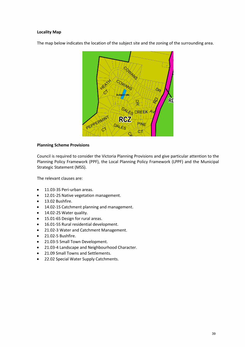
Locality Map The map below indicates the location of the subject site and the zoning of the surrounding area.
Planning Scheme Provisions Council is required to consider the Victoria Planning Provisions and give particular attention to the Planning Policy Framework (PPF), the Local Planning Policy Framework (LPPF) and the Municipal Strategic Statement (MSS). The relevant clauses are:
11.03-3S Peri-urban areas.
12.01-2S Native vegetation management.
13.02 Bushfire.
14.02-1S Catchment planning and management.
14.02-2S Water quality.
15.01-6S Design for rural areas.
16.01-5S Rural residential development.
21.02-3 Water and Catchment Management.
21.02-5 Bushfire.
21.03-5 Small Town Development.
21.03-4 Landscape and Neighbourhood Character.
21.09 Small Towns and Settlements.
22.02 Special Water Supply Catchments.
39
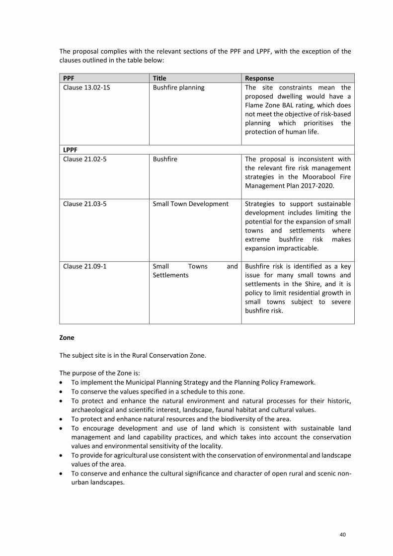
The proposal complies with the relevant sections of the PPF and LPPF, with the exception of the clauses outlined in the table below:
PPF Title Response
Clause 13.02-1S Bushfire planning
The site constraints mean the proposed dwelling would have a Flame Zone BAL rating, which does not meet the objective of risk-based planning which prioritises the protection of human life.
LPPF
Clause 21.02-5 Bushfire The proposal is inconsistent with the relevant fire risk management strategies in the Moorabool Fire Management Plan 2017-2020.
Clause 21.03-5 Small Town Development Strategies to support sustainable development includes limiting the potential for the expansion of small towns and settlements where extreme bushfire risk makes expansion impracticable.
Clause 21.09-1 Small Towns and Settlements
Bushfire risk is identified as a key issue for many small towns and settlements in the Shire, and it is policy to limit residential growth in small towns subject to severe bushfire risk.
Zone The subject site is in the Rural Conservation Zone. The purpose of the Zone is:
To implement the Municipal Planning Strategy and the Planning Policy Framework.
To conserve the values specified in a schedule to this zone.
To protect and enhance the natural environment and natural processes for their historic, archaeological and scientific interest, landscape, faunal habitat and cultural values.
To protect and enhance natural resources and the biodiversity of the area.
To encourage development and use of land which is consistent with sustainable land management and land capability practices, and which takes into account the conservation values and environmental sensitivity of the locality.
To provide for agricultural use consistent with the conservation of environmental and landscape values of the area.
To conserve and enhance the cultural significance and character of open rural and scenic non-urban landscapes.
40
Under Clause 35.06-1 a dwelling is a Section 2 use requiring a permit, and must be the only dwelling on the lot and must meet the requirements of Clause 35.08-2 for access, treatment of wastewater, and potable water and power supplies. Under Clause 35.06-5 a permit is required to construct buildings and works associated with a Section 2 use, within 20.0m of a road, 100m of a dwelling in separate ownership and 100m of a waterway. Overall, the proposed use and development does not protect or enhance the biodiversity of the area, or properly satisfy the Planning Policy Framework with regard to minimizing the loss of human life and property in a bushfire event, and the loss of native vegetation associated with creating defendable space for a dwelling. Overlays The site is affected by the Design and Development Overlay – Schedule 2 – Visual amenity and building design. Under Clause 43.02-2, a permit is required to construct buildings and works. Schedule 2 provides an exemption from this requirement if the external walls and roof are clad with non-reflective materials. In this instance a permit is not required but if a permit were to issue it is recommended that a condition be imposed to ensure no reflective materials are used.
The design objectives for Schedule 2 are:
To enhance visual amenity in rural, township and vegetated areas of the Moorabool Shire.
To encourage the use of external cladding, such as non-reflective materials for building construction.
To discourage the use of materials, such as reflective cladding for building construction, which could have a detrimental effect on amenity.
The property is affected by the Bushfire Management Overlay. Under Clause 44.06-1, a permit is required to construct buildings and works associated with a dwelling. There are no relevant exemptions under the Overlay.
The purpose of the Bushfire Management Overlays is:
To implement the State Planning Policy Framework and the Local Planning Policy Framework, including the Municipal Strategic Statement and local planning policies.
To ensure that the development of land prioritises the protection of human life and strengthens community resilience to bushfire.
To identify areas where the bushfire hazard warrants bushfire protection measures to be implemented.
To ensure development is only permitted where the risk to life and property from bushfire can be reduced to an acceptable level.
The proposal does not meet the purpose of the overlay, as discussed below. Relevant Policies There are no relevant policies additional to those incorporated in the Moorabool Planning Scheme.
41
Particular Provisions Clause 52.17 Native Vegetation The proposed removal of 0.302ha of native vegetation from the site meets the ‘Basic assessment pathway’, not being in an area mapped as an endangered Ecological Vegetation Class, and the proposed vegetation removal not having a significant impact on any habitat for a rare or threatened species. Clause 53.02 Bushfire Planning Clause 53.02-4 applies to an application to construct a single dwelling in the Rural Conservation Zone. The subject site presents an unacceptable risk to human life and property in the event of bushfire, as discussed below. Discussion Overall, the proposal is considered to be inconsistent with relevant State and local planning policy, the Rural Conservation Zone, Bushfire Management Overlay and Clauses 52.17 and 53.02 of the Moorabool Planning Scheme. This is specifically in relation to the risk-based assessment of the proposal relating to the bushfire hazard for the site and wider area. The proposed use and development of a dwelling is generally consistent with surrounding use and development for residential purposes. The proposed single storey brick dwelling is relatively modest in size and would generally fit with surrounding development. Non-reflective exterior cladding is proposed and a recommended permit condition would reinforce this. Although a substantial area of vegetation would require removal to facilitate the development approximately 50% of the site would remain vegetated in support of the bush character of the area, and there would be no adverse impacts on any identified conservation values, or impact on any agricultural activities.
The site is in a Special Water Supply Catchment and is unsewered. A Land Capability Assessment was submitted in support of a wastewater treatment system and the application was referred to Council’s Environmental Health Officer and to the relevant water boards Western Water and Southern Rural Water, all of whom consent subject to conditions.
The site is affected by a Bushfire Management Overlay and accordingly a Bushfire Management Statement was submitted which recommended construction to BAL Flame Zone for the dwelling and defendable space extending to both side boundaries and the front boundary. Access would be obtained via the proposed crossover and access way with a turning area for vehicles to manoeuvre in a three point turn to exit forwards. A 10,000L water tank on the southeast side of the dwelling would be for firefighting purposes.
An area of 0.302ha of native vegetation would be removed to facilitate the development and provision of defendable space. The native vegetation is not in an area mapped as an endangered Ecological Vegetation Class and would not have a significant impact on any habitat for rare or threatened species. It is proposed to offset the removal in accordance with the relevant planning scheme provisions. The key issue for consideration regarding this proposal is the risk that the proposal presents to loss of human life and property.
42
The purpose of the Bushfire Management Overlay is:
To implement the Municipal Planning Strategy and the Planning Policy Framework.
To ensure that the development of land prioritises the protection of human life and strengthens community resilience to bushfire.
To identify areas where the bushfire hazard warrants bushfire protection measures to be implemented.
To ensure development is only permitted where the risk to life and property from bushfire can be reduced to an acceptable level.
The Bushfire Management Statement (BMS) submitted with the application identifies that the proposed development would require a Flame Zone BAL rating, the most extreme rating that can be applied to building design and construction. It is noted that the designation of a Flame Zone BAL to dwellings in the Shire, including Dales Creek, is rare, with no other known examples where development has been subject to planning approval. The Flame Zone BAL rating applies to this property given the extensive forested areas in all directions, with the site being vulnerable to long runs of fire from the southwest, likely to cause ember attack which is the main cause of house loss in a fire. The fire risk is further exacerbated by the steep (10-15 degrees) slope on the rear southeast portion of the site. Whilst the BMS states that a dwelling may be constructed to achieve the BAL rating, the proposed dwelling is of a generic design with no distinguishing features to reflect the construction requirements for a Flame Zone BAL. It is considered highly likely that construction costs to achieve a Flame Zone BAL would be substantial compared to a conventional dwelling design, and in a bushfire event the proposed dwelling would be at extreme risk of destruction. Furthermore, Dales Creek’s isolated location in a heavily forested area with limited escape routes exacerbates the risk to loss of life in a bushfire event. It is therefore not considered that the proposal satisfies the purpose of the Bushfire Management Overlay. In relation to the proposed native vegetation removal, whilst the site does not support significant biodiversity, the loss of vegetation to enable defendable space for a dwelling that would still result in a BAL Flame Zone rating and be at extreme risk of destruction in a bushfire does not support proper and orderly planning in relation to protection of native vegetation. General Provisions Clause 65 – Decision Guidelines have been considered by officers in evaluating this application. Clause 66 - stipulates all the relevant referral authorities to which the application must be referred. Referrals The following referrals were made pursuant to s.55 of the Planning and Environment Act 1987 and internal Council departments were provided with an opportunity to make comment on the proposal.
Authority Response
Western Water Southern Rural Water Country Fire Authority
Consent with conditions Consent with conditions Consent with conditions
Infrastructure Environmental Health Environmental Planning
Consent with conditions Consent with conditions Consent with conditions
43
Further to the CFA response, the Council officer discussed the application with the CFA to inform the officer’s recommendation for this application. Financial Implications The recommendation of refusal of this development would not have any financial implications for Council. Risk and Occupational Health and Safety Issues The recommendation of refusal of this development does not have any risk or OH & S implications for Council. Communications Strategy Notice was undertaken for the application, in accordance with s.52 of the Planning and Environment Act 1987, and further correspondence is required to all interested parties to the application as a result of a decision in this matter. The applicant and objector were invited to attend this meeting and address Council if desired. Options
Issue a refusal to grant a permit in accordance with the recommendation of this report;
Issue a Notice of Decision with conditions to be determined. Conclusion Overall, the proposal is inconsistent with the Moorabool Planning Scheme, in particular State and local planning policy and the Bushfire Management Overlay relevant to the protection of human life and property from bushfire. The subject site’s location in Dales Creek and its topography and vegetation cover severely limit its capability to support a dwelling which could withstand a bushfire. The risk-based assessment identifies that a dwelling on the site must achieve a Flame Zone BAL rating, significantly affecting its ability to withstand a bushfire. The proposal’s risk to loss of human life and property in a bushfire event is unacceptable and should not be supported. Recommendation That, having considered all matters as prescribed by the Planning and Environment Act, Council issues a Refusal to Grant Planning Permit PA2017264 for Development and Use of a Dwelling and Removal of Native Vegetation at Lot 35 on PS 093708, Cowans Drive, Dales Creek 3341, on the following grounds: 1. The proposal does not meet the objective or relevant strategies of Clause 13.02 of the
Moorabool Planning Scheme. 2. The proposal does not meet the objectives of Clause13.02-1S (Bushfire), Clause 21.02-5
(Bushfire), Clause 21.03-5 (Small Town Development) or relevant strategies in Clause 21.09-1 (Small Towns and Settlements) of the Moorabool Planning Scheme.
3. The proposal does not meet the purpose of Clause 35.06 (Rural Conservation Zone) of the
Moorabool Planning Scheme.
44
4. The proposal does not meet the purpose of Clause 44.06 (Bushfire Management Overlay) in the Moorabool Planning Scheme.
Report Authorisation: Authorised by: Name: Satwinder Sandhu Title: General Manager Growth and Development Date: 28 August, 2018