All-sky satellite radiance assimilation using NOAA operational HWRF and a regional Hybrid Ensemble-Variational Data Assimilation system Man Zhang 1 , Milija Zupanski 1 , Min-Jeong Kim 1,2 , John Knaff 3 , Karina Apodaca 1 1 CIRA/CSU, Fort Collins, CO 2 JCSDA, NOAA/NESDIS/STAR, Camp Springs, MD 3 NESDIS/STAR-RAMMB, CIRA/CSU, Fort Collins, CO 2012 Warn-on-Forecast and High Impact Weather Workshop, Norman, Oklahoma, Feb 8-9, 2012 ACKNOWLEDGEMENTS: JCSDA Program Grant No. NA10NES4400012, and NCEP/EMC HFIP project
Transcript
All-sky satellite radiance assimilation using NOAA operational HWRF and a regional Hybrid Ensemble-Variational Data
Assimilation system
Man Zhang1, Milija Zupanski1, Min-Jeong Kim1,2, John Knaff3, Karina Apodaca1
1CIRA/CSU, Fort Collins, CO 2JCSDA, NOAA/NESDIS/STAR, Camp Springs, MD 3NESDIS/STAR-RAMMB, CIRA/CSU, Fort Collins, CO
2012 Warn-on-Forecast and High Impact Weather Workshop, Norman, Oklahoma, Feb 8-9, 2012
ACKNOWLEDGEMENTS: JCSDA Program Grant No. NA10NES4400012, and NCEP/EMC HFIP project !
Outline
1. Motivation
2. A regional HVEDAS components
3. Direct assimilation of all-sky AMSU-A radiance in TC inner core
! Background
! Operational clear-sky radiance (CSR) approach
! Key elements of the all-sky radiance (ASR) approach
! Hurricane Danielle (2010)
4. Towards assimilating GOES-R measurements
5. Summary and future plan
1. Motivation
! Over the past two decade, TC intensity and inner-core convective structure forecasts remain a challenge for most operational NWP models.
! Evaluate the impact of all-sky satellite observations assimilation in TC inner-core area analysis and forecast.
! Use a prototype hybrid variational-ensemble data assimilation system (HVEDAS) developed at CIRA/CSU to have an early assessment of the future operational HVEDAS.
! Prepare for merging current satellite observations with the future GOES-R measurements (Advanced Baseline Imager and Geostationary Lightning Mapper).
2. A regional HVEDAS components
" Hybrid DA algorithm - Maximum Likelihood Ensemble Filter (MLEF: Zupanski, 2005;Zupanski et al., 2008)
• A hybrid DA method seeking nonlinear solution; • It employs an iterative minimization of a cost function, similar to variational methods; • An important advantage of iterative solution method is in application with nonlinear observation operators;
" NWP model - The ATMOS portion of NOAA operational HWRF (with the NMM core) • HWRF outer domain has a grid spacing of 27 km; • the inner domain of about 6°!6° has a grid spacing of 9 km and moves along with the storm
" Observation forward operators - Gridpoint Statistical Interpolation (GSI) • Exclude GSI B.E.s, the adjoint model, and minimization
Quality Control Methods for AMSU-A Radiance (Operational clear-sky DA in GSI )
1. Cloud/precipitation detection procedures
2. AMSU-A radiance over ocean surface
3. Topography effect: reduce QC bounds over higher topography (Zsfc>2 km)
4. Transmittance at the top of the model less than 1
- inflating observation error
5. Sensitivity to surface temperature/emissivity
- inflating observation error
6. Background innovation check
!
"Tbich#ich
> 3
!
"ich : inflating observation error
Key elements of the ASR approach in MLEF-HWRF
1. Extending the analysis control variables for clouds - i.e. total cloud condensate in HWRF
2. Inclusion of cloud information in first guess - A prognostic cloud scheme, see Hou et al.2002
3. Selection of all-sky AMSU-A radiance data and quality control - no prior cloud/precipitation detection is used
- selectively ‘correcting’ bias on certain channels (i.e. ch8 in our case)
The ASR approach provides a weaker observational constraint on cloud analysis compared to operational CSR setting.!
Hou et al. 2002, NCEP OFFICE NOTE 441.
123+451367'89:6938:;'63:821:63'
HURRICANE DANIELLE !(21-30 August 2010)!
''''''71''()%.)'<%)*'
''''''71''*,<'<%)*'
JY!)@'/!@0,:-;!
DA span period: 1200 UTC 24 ~1800 UTC 26 Aug 2010
(0-9 cycle)
Experimental design
" MLEF-HWRF cycling systemH!
- produce 9-km analysis in HWRF inner domain every 6-hr; - Control variables include the following 6 components: wind components (U, V); specific humidity (Q); temperature (T); hydrostatic pressure depth (PD); total cloud condensate (CWM)
" ENSEMBLE SIZE :)!ZW!202+0,)!
" Other Tuning measures! - Error covariance localization (Yang et al.2009)
- Vortex initialization at cycle0
Yang et al. 2009, QJRMS,135,251-262
1. CSR: clear-sky AMSU-A radiance assimilation • Mimics the operationally clear-sky radiance framework; • Except for
2. ASR: as in CSR, but with new features: • Including cloud/rain computation in first guess; • No prior cloud/precipitation detection; • No bias correction scheme was applied on Channel 8
3.CTL: pure MLEF-HWRF cycling run w/o observation assimilated
Experiments
• All experiments extend from 1200 UTC 24 Aug to 1800 UTC 26 Aug 2010 (1-9 cycles)
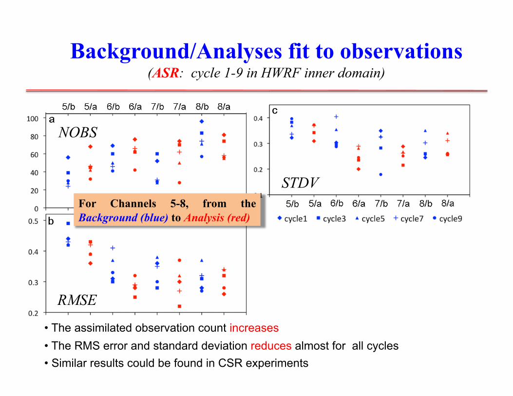
Background/Analyses fit to observations (ASR: cycle 1-9 in HWRF inner domain)
For Channels 5-8, from the Background (blue) to Analysis (red)
• The assimilated observation count increases • The RMS error and standard deviation reduces almost for all cycles • Similar results could be found in CSR experiments
NOBS
RMSE
STDV
Min MSLP (hPa)
Track
Verification with NHC best track data
! CTL: produced a stronger storm with less than 10 hPa of min MSLP error due to the use of vortex initialization at cycle0
! CSR & ASR: After 1-day warm-up period, AMSU-A radiance assimilation in TC inner core consistently reduces errors in TC intensity, but not in position.
! ASR: catch up with the observed TC intensity quickly after cycle 5!
cycle index
[$CF!
[$CF!
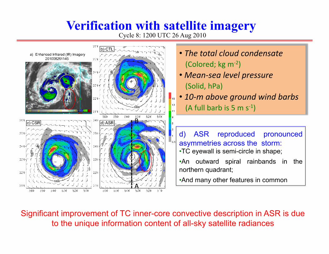
Verification with satellite imagery Cycle 8: 1200 UTC 26 Aug 2010
d) ASR reproduced pronounced asymmetries across the storm: • TC eyewall is semi-circle in shape; • An outward spiral rainbands in the northern quadrant; • And many other features in common
Background: Two new instruments will be on the GOES-R satellite: the Advanced Baseline Imager (ABI) and the Geostationary Lightning Mapper (GLM)
" All-sky satellite radiance assimilation capability has been implemented in MLEF-HWRF.
" A pilot study by Zupanski et al. (2011) successfully assimilated synthetic GOES-R ABI radiances in cloudy scenes in a severe weather case study through combining MLEF with WRF-ARW.
" Assimilation of GOES-R proxy data in MLEF-HWRF is underway.
o SEVIRI - Onboard: MSG - Spectral Channels: 12 - Sampling Frequency: 15 min - Spatial resolution: 3km@nadir
o An observation forward operator for MSG SEVIRI has been developed at CIRA. (Grasso et al. 2008)
Zupanski et al. 2011,IJRS, 32, 9637-9659 Grasso et al. 2008. IJRS, 29, 4373-4384
" Summary!! First application to Danielle case shows encouraging results. The ASR approach is indeed beneficial for TC inner-core analyses and
forecasts with respect to the improvement of QPF and severe wind warning if the storm is about to landfall.
! The hybrid system is applicable to operational HWRF ensemble data assimilation, and promising for the future operational HVEDAS.