Amman, 2014 ARABIC VERSION Hanadi Taher, Samia Khouri, Rashia Wir The Qusayr 'Amra Management Plan was developed by a joint Department of Antiquities - World Monuments Fund team, and printed with support from World Monuments Fund, thanks to the contributions of the Robert W. Wilson Challenge to Conserve Our Heritage and the Selz Foundation. The Qusayr ‘Amra Conservation Project is a collaboration between the Department of Antiquities of Jordan, World Monuments Fund and the Istituto Superiore per la Conservazione ed il Restauro.
Transcript
1
Chapter 1 - The site
Amman, 2014
ARABIC VERSION Hanadi Taher, Samia Khouri, Rashia Wir
The Qusayr 'Amra Management Plan was developed by a joint Department of Antiquities - World Monuments Fund team, and printed with support from World Monuments Fund, thanks to the contributions of the Robert W. Wilson Challenge to Conserve Our Heritage and the Selz Foundation.
The Qusayr ‘Amra Conservation Project is a collaboration between the Department of Antiquities of Jordan, World Monuments Fund and the Istituto Superiore per la Conservazione ed il Restauro.
2
Section i – Site deScription and documentation
All photos by Gaetano Palumbo, except otherwise indicated.
3
Chapter 1 - The site
FOREWORD
The Hashemite Kingdom of Jordan is endowed with an exceptional variety of archaeological sites, spanning the entire history of human presence in the region. Many of these sites have an Outstanding Universal Value, as recognized by the inscription of four of them in the UNESCO World Heritage List. One of these is Qusayr ‘Amra, the first in fact –together with Petra- to be inscribed in the World Heritage List as early as 1985.
Many years have passed since that inscription, and the site has received from the Ministry of Tourism and Antiquities and the Department of Antiquities the attention and protection it deserves. Although regulations for such protection are in place, as well as facilities and personnel to ensure their implementation, a comprehensive Site Management Plan for further enhancement of these regulations did not exist.
This document fills a gap in the Ministry’s and Department of Antiquities commitment to fulfill the requirements of the World Heritage Convention. Site boundaries were defined in 2013 and with the presentation of this Site Management Plan, the Jordanian Government complies with the World Heritage Committee’s invitation to provide these essential documents.
This Site Management Plan is now an operational tool in the hands of the Ministry and of the Department of Antiquities. Its implementation and follow-up will ensure the preservation to future generations of the Outstanding Universal Values of this unique site.
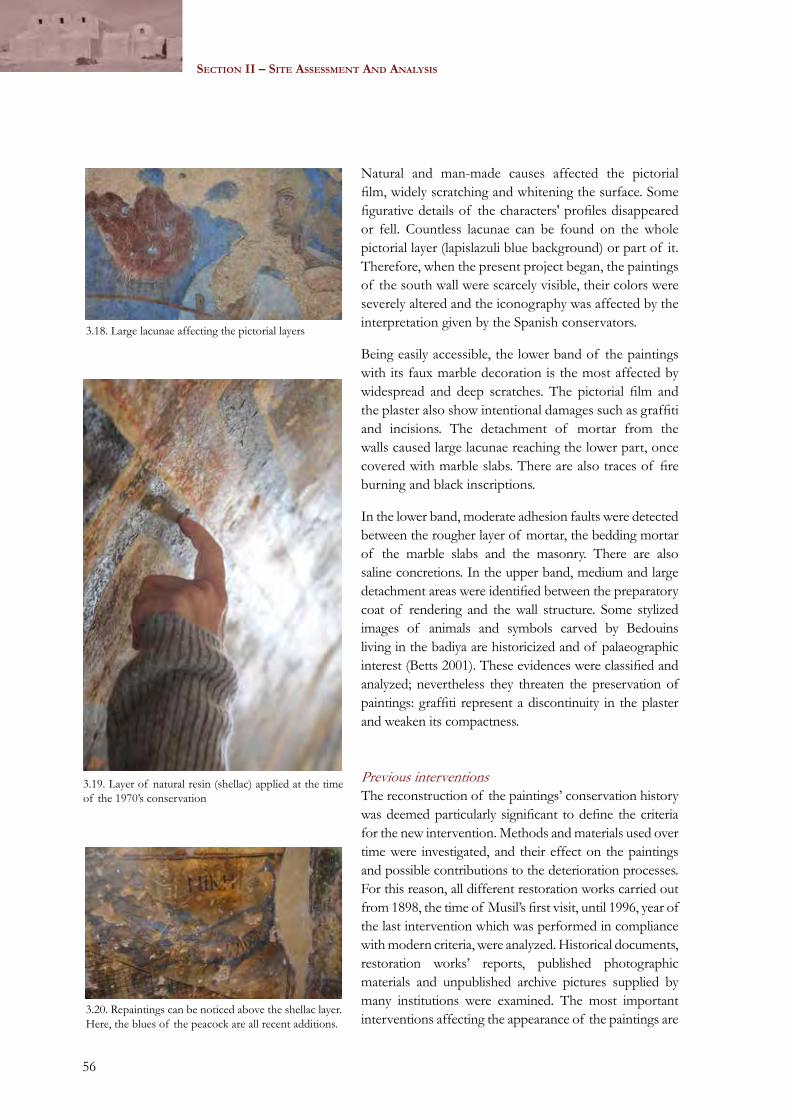
H.E. Nidal KatamineMinister of Tourism and Antiquities
4
Section i – Site deScription and documentation
5
Chapter 1 - The site
INTRODUCTION
It is with great pleasure that I am introducing the first comprehensive Site Management Plan for Qusayr ‘Amra World Heritage Site.
For many years the site lacked the tools required to make its inscription in the World Heritage List more effective. With the official adoption of this Site Management Plan, the Department of Antiquities is now able to improve on its protection and conservation approach, and to schedule conservation and monitoring actions more efficiently.
Qusayr ‘Amra is a unique site that requires particular attention if we want to protect its Outstanding Universal Values. Many visitors from all over the world come to the site, and they deserve to be welcomed and provided with an indelible educational experience. The work of our team addressed all these issues and we intend to implement measures to correct the present situation over the course of the next years.
An important component of the site management planning process was the consultation with and involvement of the local community, in order to explore with them opportunities for economic and cultural development. The entire process, from data collection to assessments, and from the definition of policies to the identification of specific implementing actions, was an experience that the Department of Antiquities intends to replicate at other important sites requiring the support of a comprehensive Site Management Plan.
As every operational tool, this document is not the final word on the management of the site. We will monitor the implementation of the actions recommended by the Plan and we will provide corrective measures if issues arise in the course of action. A complete revision of the Site Management Plan will follow after one year of trial implementation, in order to respond to upcoming challenges, or to reinforce those actions that prove positive for the conservation and presentation of the site. Only by a continuous site management implementation, monitoring and response we can be sure that our duty and responsibility to preserve the Outstanding Universal Values of the site will be fulfilled.
H.E. Munther JamhawiDirector GeneralDepartment of Antiquities of the Hashemite Kingdom of Jordan
6
Section i – Site deScription and documentation
7
Chapter 1 - The site
TABLE OF CONTENTS
ABBREVIATIONS ..............................................................................................................................................11ACKNOWLEDGMENTS ..................................................................................................................................13EXECUTIVE SUMMARY..................................................................................................................................15SECTION I – SITE DESCRIPTION AND DOCUMENTATION.....................................................23CHAPTER 1 – THE SITE..................................................................................................................................25
1.1. Location and boundaries.........................................................................................................................251.2. Archaeological and historical contexts...............................................................................................271.3. History of interventions..........................................................................................................................28
1.3.1. Discoveries and early campaigns.......................................................................................................281.3.2. Conservation projects.........................................................................................................................29
1.4. Qusayr ‘Amra: a World Heritage Site..................................................................................................30CHAPTER 2 – DOCUMENTATION.............................................................................................................31
2.1. Architecture and construction materials............................................................................................312.2. The mural paintings.................................................................................................................................322.3. The archaeological setting.....................................................................................................................362.4. Site plans and surveys..............................................................................................................................372.5. Photographic documentation................................................................................................................38
SECTION II – SITE ASSESSMENT AND ANALYSIS...........................................................................39CHAPTER 3 – Physical conditions...................................................................................................................413.1. Condition assessment.....................................................................................................................................41
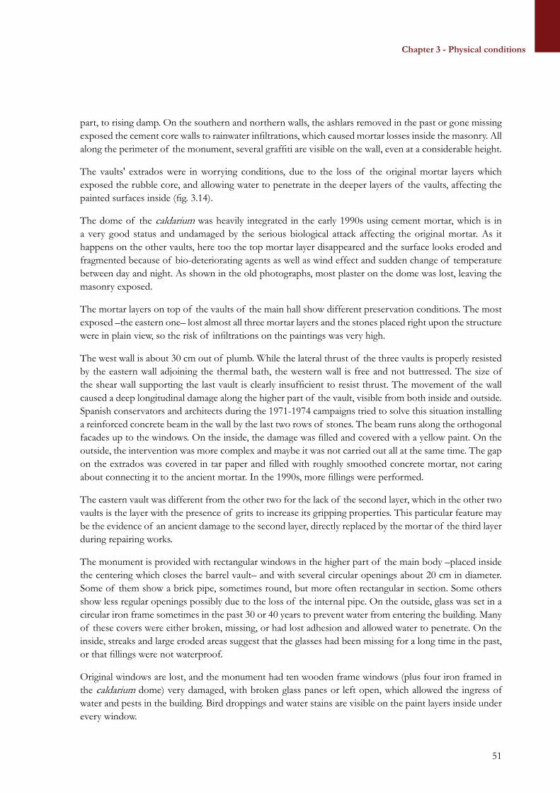
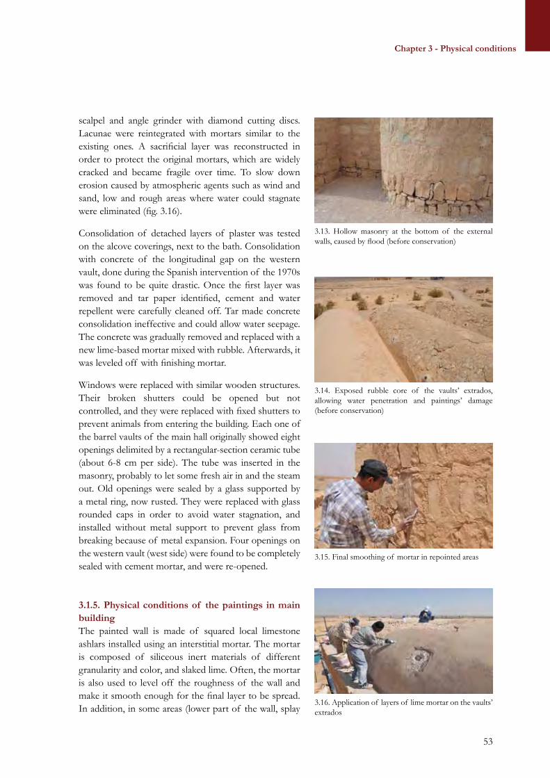
3.1.1 Infrastructures......................................................................................................................................413.1.2. Facilities and services..........................................................................................................................433.1.3. Regional and local development contexts.......................................................................................463.1.4. Physical conditions of the main building and architectural structures.......................................493.1.5. Physical conditions of paintings in main building.........................................................................53
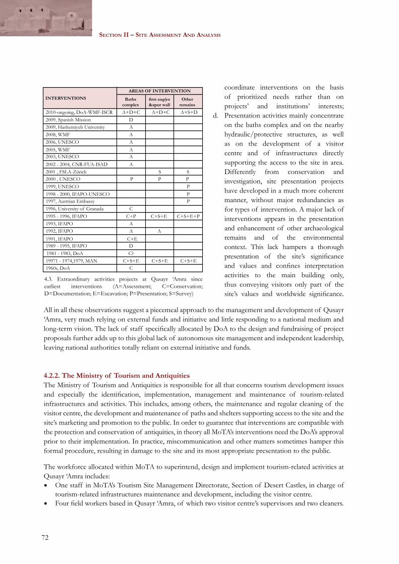
CHAPTER 4 – THE MANAGEMENT CONTEXT..............................................................................................634.1. Legal status and protection....................................................................................................................63
4.1.1. National protection.............................................................................................................................634.1.2. International designation....................................................................................................................67
4.2. Competent authorities..............................................................................................................................694.2.1. The Department of Antiquities........................................................................................................694.2.2. The Ministry of Tourism and Antiquities........................................................................................72
4.3. Key stakeholders.......................................................................................................................................734.4. Financial resources...................................................................................................................................754.5. Visitors’ numbers, profile and impact................................................................................................76
8
Section i – Site deScription and documentation
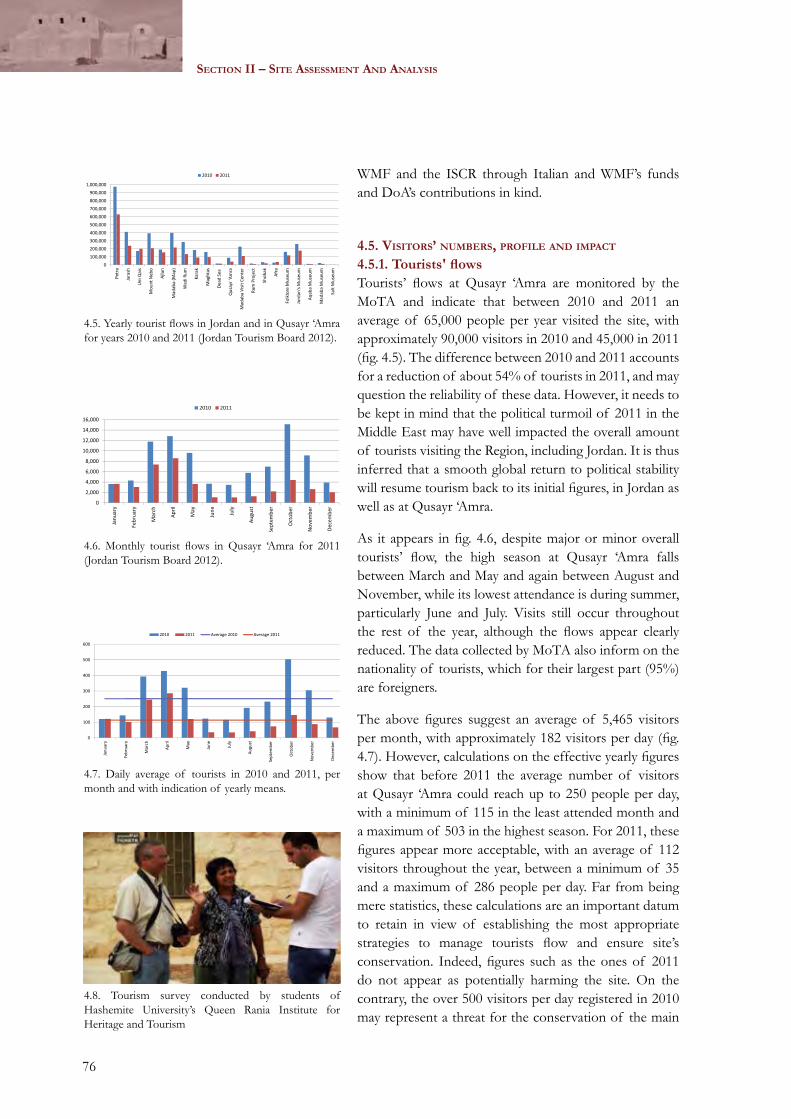
4.5.1. Tourists' flows........................................................................................................................................764.5.2. Tourist and visit profiles.....................................................................................................................774.5.3. Tourism impact and management....................................................................................................78
CHAPTER 5 – SITE SIGNIFICANCE AND VALUES........................................................................................795.1. Cultural significance....................................................................................................................................................80
5.1.1. Historical value.........................................................................................................................................................805.1.2. Archaeological value..............................................................................................................................................815.1.3. Artistic and aesthetic values.................................................................................................................................815.1.4. Architectural value..................................................................................................................................................825.1.5. Natural value.............................................................................................................................................................825.1.6. Scientific value..........................................................................................................................................................835.1.7. Social and symbolic values...................................................................................................................................835.1.8. Outstanding Universal Value, authenticity and integrity.........................................................................83
5.2. Other site values and assets.....................................................................................................................................865.2.1. Tourism and economic development..............................................................................................................865.2.2. Educational assets...................................................................................................................................................86
CHAPTER 6 – SUMMARY OF CONDITIONS, RISKS AND KEY ISSUES.........................................896.1. Legal and institutional framework........................................................................................................................896.2. Conservation and documentation.........................................................................................................................906.3. Maintenance and monitoring..................................................................................................................................916.4. Visitation and interpretation...................................................................................................................................926.5. Research and excavations.........................................................................................................................................936.6. Facilities, services and infrastructures...............................................................................................................946.7. Public awareness, education and community participation.................................................................956.8. Investments and funding..........................................................................................................................................95
SECTION III – SITE MANAGEMENT PLANNING........................................................................................99CHAPTER 7 – VISION, AIMS AND POLICIES...................................................................................................101
7.1. Vision..................................................................................................................................................................................1017.2. Aims and policies........................................................................................................................................................101
7.2.1. Appropriate use.....................................................................................................................................................1017.2.2. Legal and institutional framework.................................................................................................................1027.2.3. Conservation and documentation..................................................................................................................1037.2.4. Maintenance and monitoring............................................................................................................................1057.2.5. Visitation and interpretation.............................................................................................................................1067.2.6. Research and excavations...................................................................................................................................1077.2.7. Facilities, services and infrastructures...........................................................................................................1077.2.8. Public awareness, education and community participation.................................................................1087.2.9. Investments, marketing and funding.............................................................................................................109
CHAPTER 8 – STRATEGIES AND ACTIONS......................................................................................................1118.1. Appropriate use.............................................................................................................................................................111
8.1.1. Guidelines and implementation......................................................................................................................1118.2. Legal and institutional framework.....................................................................................................................111
9
Chapter 1 - The site
8.2.1. Definition and enforcement of legal provisions and boundaries..............................................1118.2.2. Definition of responsibilities concerning the site........................................................................1118.2.3. Configuration of the management system and of legal obligations ........................................1118.2.4. Capacity building and training........................................................................................................112
8.3. Conservation and documentation.......................................................................................................................1138.3.1. Planning.....................................................................................................................................................................1138.3.2. Coordination and supervision..........................................................................................................................1138.3.3. Conservation guidelines and immediate threat control.........................................................................1138.3.4. Establishment of the Qusayr ‘Amra Documentation Centre ...........................................................114
8.4. Maintenance and monitoring................................................................................................................................1148.4.1. Planning and coordination ................................................................................................................................1148.4.2. Guidelines, protocols and urgent actions....................................................................................................1148.4.3. Visitors monitoring .............................................................................................................................................115
8.5. Visitation and interpretation.................................................................................................................................1158.5.1. Site promotion.......................................................................................................................................................1158.5.2. Planning ...................................................................................................................................................................1158.5.3. Implementing actions ........................................................................................................................................115
8.6. Research and excavation.........................................................................................................................................1168.6.1. Planning and coordination.................................................................................................................................1168.6.2. Excavation, documentation, research .........................................................................................................116
8.7. Facilities, services and infrastructures.............................................................................................................1178.7.1. Planning and coordination ...............................................................................................................................1178.7.2. Hospitality and facilities improvement.........................................................................................................117
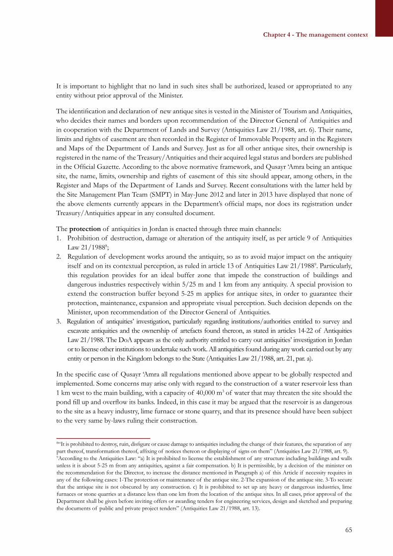
8.8. Public awareness, education and community participation...............................................................1188.8.1. Planning and coordination.................................................................................................................................1188.8.2. Community involvement ..................................................................................................................................118
8.9. Investments, marketing and funding................................................................................................................1188.9.1. Planning..............................................................................................................................................1188.9.2. Fundraising, cooperation, and national/international projects..................................................1188.9.3. Support for private and community-based initiatives ..........................................................................118
CHAPTER 9 – PLAN IMPLEMENTATION...........................................................................................................1199.1. Mechanisms and responsibilities........................................................................................................................119
9.1.1. Plan approval and implementation mechanism........................................................................................1199.1.2. Ministry of Tourism and Antiquities.............................................................................................................1199.1.3. Department of Antiquities................................................................................................................................120
9.2. Action Program ............................................................................................................................................................1219.3. Plan monitoring and periodic review...............................................................................................................122
ACOR American Centre of Oriental ResearchAPAAME Aerial Photographic Archive for Archaeology in the Middle EastASAM Academic Society of Alois MusilASL Above Sea LevelCBRL Council for British Research in the LevantCCTV Closed-Circuit TelevisionDAI Deutsches Archäologisches InstitutDLS Department of Lands and SurveyDoA Department of AntiquitiesEDS Energy-Dispersive X-ray Spectroscopy GC-MS Gas Chromatography/Mass SpectrometryFTIR Fourier Transform Infrared spectroscopyFUA Florence University of the ArtsGIS Geographic Information SystemGPS Global Positioning SystemICOMOS International Council of Monuments and SitesIFAPO Institut Français d’Archéologie du Proche-OrientIfpo Institut Français du Proche-OrientISCR Istituto Superiore per la Conservazione e il RestauroJD Jordanian DinarsJITOA Jordan Inbound Tour Operators AssociationJTB Jordan Tourism Board JTGA Jordan Tour Guides Association MAN Museo Arqueológico Nacional de MadridMEGA Middle Eastern Geodatabase for AntiquitiesMoTA Ministry of Tourism and AntiquitiesMTS Medium Term StrategyNGO Non-Governmental OrganizationNRA Natural Resources AuthorityOUV Outstanding Universal ValueQADoC Qusayr ‘Amra Documentation CentreRBG Royal Botanic GardenRSCN Royal Society for the Conservation of NatureSAP Site Annual PlanSEM Scanning Electron MicroscopeSLSA Fondation Suisse-Liechtenstein pour les Recherches Archéologiques à l´Étranger SM Site ManagerSMD Site Management DirectorateSMP Site Management PlanSMPT Site Management Plan Team
12
Section i – Site deScription and documentation
SMU Site Management UnitSOUV Statement of Outstanding Universal ValueTSMD Tourism Site Management DirectorateUNESCO United National Educational, Scientific and Cultural OrganizationUTM Universal Transverse MercatorWHC World Heritage CommitteeWMF World Monuments FundWHS World Heritage SiteWHSS World Heritage Sites Section
13
Chapter 1 - The site
ACKNOWLEDGMENTS
The Qusayr ‘Amra Management Plan was developed as part of the Qusayr ‘Amra Conservation Project, jointly designed and implemented by the Department of Antiquities of Jordan, the World Monuments Fund and the Istituto Superiore per la Conservazione ed il Restauro.
Our thanks go to Mr. Fares Hmoud (previous Interim Director General at DoA) and to Dr. Munther Jamhawi (DoA Director General) for their support and advice throughout the project.
The local communities and the Municipalities of Muwaqqar and Azraq, represented by their respective mayors and by numerous NGOs, met with the team in a number of occasions, sharing their views on the future of the site.
The Royal Society for the Conservation of Nature and the Royal Botanic Garden provided information on the natural environment of the site.
Mr. Hakim Al-Sabealah hosted one of the stakeholder meetings in his tent at the entrance of the site and shared his concerns and vision for tourist-related activities.
The professors and students of the Hashemite University’s Queen Rania Institute for Tourism and Heritage collaborated on the tourism surveys at the site and in a pilot activity for the design of new exhibits in the visitor center. We would like to thank in particular Prof. Zeidan Kafafi, Prof. Firas Alawneh, and Prof. Arwa Badran for their support, as well as the numerous students who participated in the tourism survey project.
We would also like to thank the numerous institutional stakeholders that have participated in general as well as one-on-one meetings, providing information and sharing views on conservation and development strategies to implement on site. A more detailed list of these fundamental stakeholders is provided in chapter 4 of this Site Management Plan.
Finally, our thanks go to Giovanna De Palma (ISCR), and Lisa Ackerman (WMF), for reading and commenting on the final draft of this document.
14
Section i – Site deScription and documentation
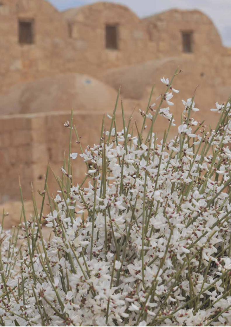
Qusayr ‘Amra in springtime
15
Chapter 1 - The site
EXECUTIVE SUMMARY
IntroductIon and methodology
The Qusayr ‘Amra Site Management Plan establishes the policies and strategies for the implementation of conservation, presentation, and management actions conceived to preserve its Outstanding Universal Value (OUV).
Qusayr ‘Amra World Heritage Site (WHS) was inscribed in the World Heritage List in 1985. It consists of a bath house with associated hydraulic features as well as a number of ancillary structures spread over a 2 km2 area in Wadi al-Butum, 85 km east of Amman along the Amman-Azraq highway. The site belongs mainly to the latter part of the Umayyad period, and it has been dated on the basis of archaeological and epigraphic data to a period comprised between 720 and 740 AD. There are however archaeological remains belonging to earlier periods (mainly Paleolithic) and evidence of use of the building in later periods, such as the Ayyubid-Mamluk period, as well as use until recent times by local Bedouins.
The site was inscribed in the World Heritage List for the presence of the most complete cycle of mural paintings in existence for the Umayyad period. The themes recall leisure activities such as hunting, dancing, and music playing, but there are also scenes that are still open to interpretation such as the presence of six kings paying their respect to the Prince, of a woman on the edge of a pool observed by a crowd of onlookers, and of at least one prophet (Jonah) whose story is narrated both in the Bible and the Qur’an. The dome in the caldarium is internally decorated with a representation of the night sky, the earliest such representation on a non-flat surface.
A conservation project conducted by the Department of Antiquities (DoA), World Monuments Fund (WMF), and the Istituto Superiore per la Conservazione e il Restauro (ISCR) is revealing the unexpected presence of brilliant colors and details under layers of later additions of chemical products and repaintings. The project has also addressed the conservation of the heavily eroded extrados of the vaults and of the wall bases, has conducted archaeological surveys in the site’s area, revealing the presence of prehistoric remains as well as those contemporary with the known Umayyad structures, and is addressing various other activities related to the management, presentation and development of the site. The present document is a component of this project.
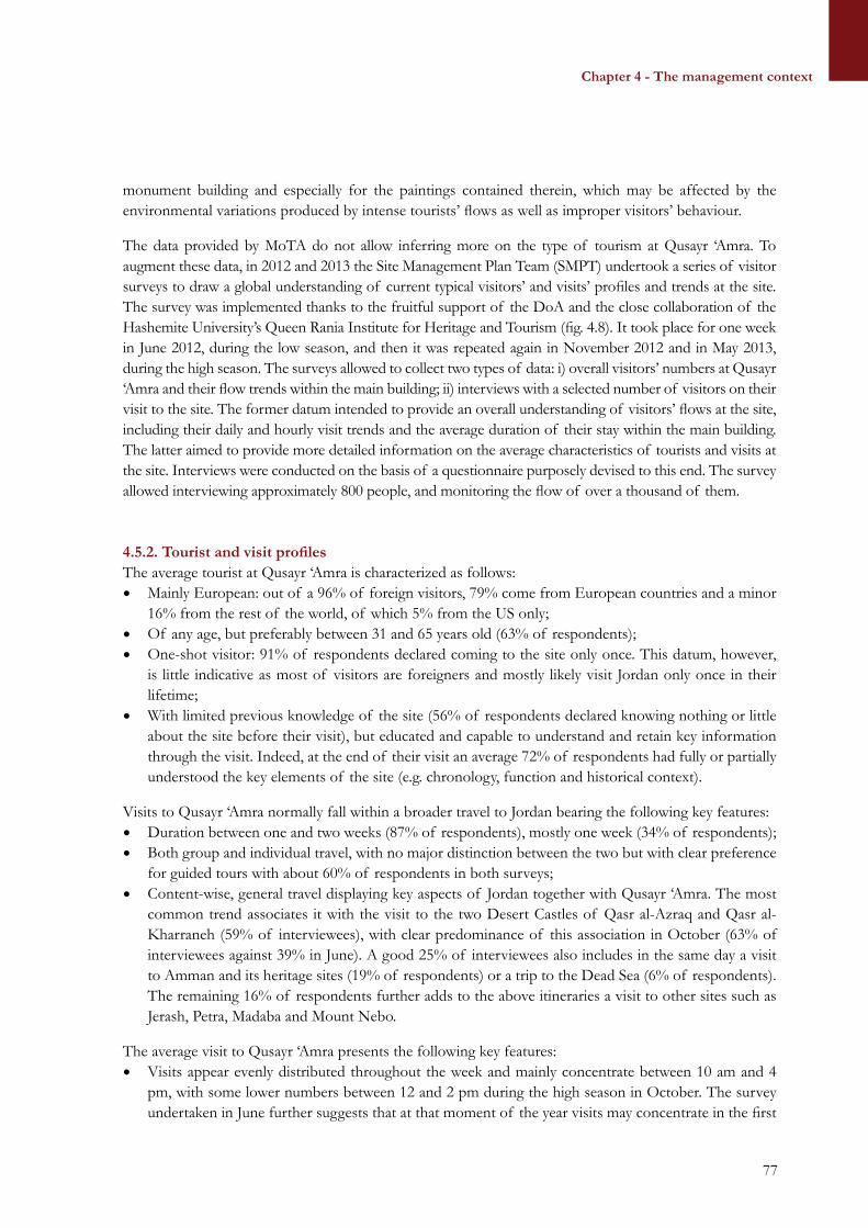
A first phase of documentation was conducted in order to gathering published and unpublished information on the site from archives around the world. This phase was followed by on-site research and assessments and by the organization of several stakeholders meetings and tourism surveys, which altogether provided information on the state of conservation of the site, on possible threats to its integrity and authenticity, on management and tourism issues and opportunities, and which allowed identifying the causes of the observed risks.
These assessments were followed by actions towards the improved conservation and management of the site. These actions included conservation and research activities and metric surveys to establish the actual legal boundaries of the site. They also ensured thorough implementation of a management planning process that identified a number of core values besides the established OUV, and which elaborated policies for each of the identified main topics concerning conservation and development at the site (see below). The policies were then further elaborated in a number of strategies and actions presented in a 5-year action plan and articulated by priority of intervention.
16
Section i – Site deScription and documentation
SIte valueS
The values of Qusayr ‘Amra have been identified through in-depth technical analyses as well as through broad consultations with stakeholders. Accordingly, a core set of values shapes the significance of the site through the following components:• Historic value: stemming from the contextualization of the site in its historical time, at the very core of
Arab expansion and during the apogee of the Umayyad caliphate;• Archaeological value: deriving from the richness in archaeological structures and sites in the area
surrounding Qusayr ‘Amra, spanning over tens of thousands of years and providing information on different modalities of human settlement in the badiya through time;
• Artistic/aesthetic value: linked to the presence of one of the most extensive cycle of paintings of early Islamic art, with the unique testimony they provide in understanding the origins of this art as well as its cultural, iconographic and technical references;
• Architectural value: deriving from the building style, techniques and materials as well as from the advanced water channelling system allowing the existence of a bath complex and, seemingly, of gardens and/or agricultural cultivations in the steppe;
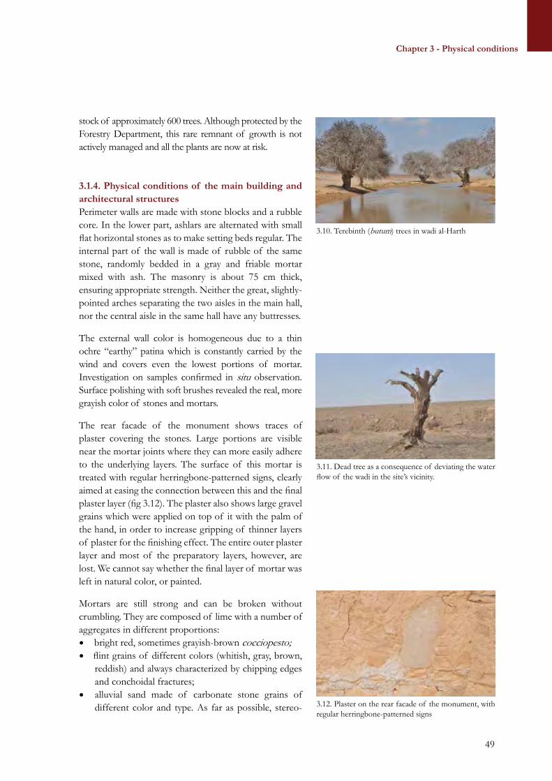
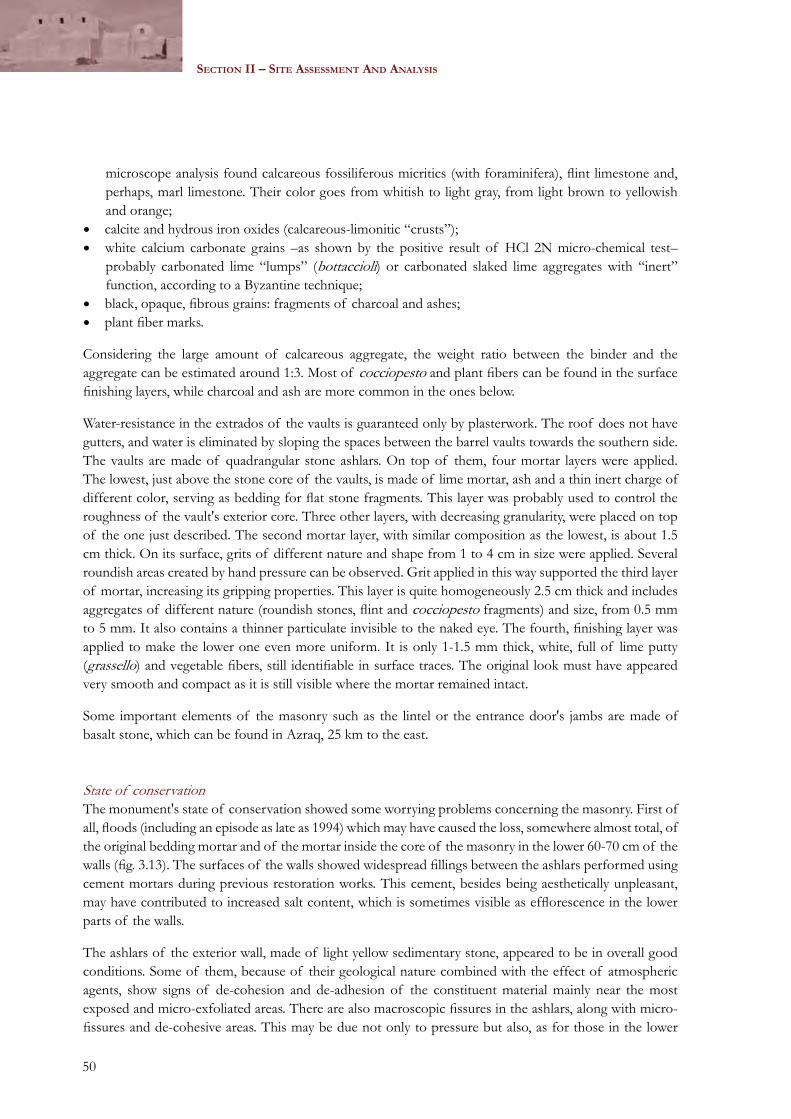
• Natural value: linked to the existence of Wadi al-Butum and of its peculiar ecosystem, which presumably was one of the key reasons why Qusayr ‘Amra was built there;
• Scientific value: deriving from the enormous potential of archaeological discoveries in the area, which may sensibly impact the global understanding of Desert Castles’ structure and function as well as of Umayyad territorial strategies and control;
• Social and symbolic values: stemming from the role held by Qusayr ‘Amra for local communities and in the symbolic frames of reference of the Bedouin tribes who have occupied the land for centuries.
A further group of values, or also opportunities, includes all such elements deriving from the many potential or effective uses of the site and producing secondary repercussions on stakeholders and the local community. This group seemingly includes:• Tourism and economic values and assets: deriving from people’s interest in the site, expressed through
their visit to it and triggering the development of associated income-generating activities such as tickets sale, bookshop, cafeteria, tourists guide, sale of souvenirs etc.
• Educational assets: linked to the informative potential that the site retains over the general public of any age and to the possibility of transferring these information through a variety of educational and communication policies and strategies.
These core values are further reinforced and enhanced by the international recognition of the site’s OUV, its authenticity and integrity, which have gained Qusayr ‘Amra the nomination as a WHS in 1985. The OUV of Qusayr ‘Amra is linked to its exceptional paintings, which have no parallel during the Umayyad period and which also provide an unprecedented corpus of images to investigate and understand early Islamic art, its iconography, style and cultural/artistic references. Qusayr ‘Amra’s OUV is also associated to the exceptional state of conservation of its architectural ensemble, a concept only introduced in the retrospective Statement of OUV of 2010 and that includes the other features surrounding the site and its environmental context. The authenticity of Qusayr ‘Amra is linked to the existence and state of conservation of its remains, particularly the building with its decorative features but also the other structures recovered in the surrounding area. Some remarks need being made in this regard, particularly in the light of the new discoveries at the site. These discoveries suggest that the paintings at Qusayr ‘Amra are a challenging blend of authentic background layer topped by modern modifications, which in some cases have sensibly altered
executIve Summary
17
Chapter 1 - The site
the original iconography. The restitution of the original Umayyad paintings through active removal of all subsequent layers thus appears as a most necessary and compelling intervention if the authenticity of attributes such as form and design is to be preserved.
The integrity of the site focuses on the physical conditions of the main monument building and on the deterioration processes harming its conservation on the long term. Accordingly, the baths and reception hall with their frescos remain intact, although threatened by a variety of factors such as erosion, flooding, moisture penetration, dirt, graffiti and birds/insects’ deposits. Other threats come from development works and encroachment from a variety of activities: the appropriate management of development interventions at the site is a vital factor to the preservation of Qusayr ‘Amra’s integrity. The provision of adequate core and buffer boundaries, the set up and enforcement of appropriate modalities to manage development works in the area, and finally the mandatory execution of archaeological/environmental impact assessments and of emergency archaeology are all key possible measures to mitigate the alteration of the area’s integrity.
Summary of threatS
The conservation, management and presentation of Qusayr ‘Amra presents issues of various relevance, whose long-term persistence may have an impact on the preservation of the site. The analysis of these emerging issues and their root causes justify their merging in few thematic groups:• Legal and institutional framework;• Conservation and documentation;• Maintenance and monitoring;• Visitation and interpretation;• Research and excavations;• Facilities, services and infrastructures;• Public awareness, education and community participation;• Investments, marketing and funding.
Key issues within the “legal and institutional framework” concern the existing legal provisions for site protection and management and their implementation. They also include site management responsibilities and tasks, and their distribution among concerned staff and authorities, namely the Ministry of Tourism and Antiquities (MoTA) and the Department of Antiquities (DoA). Within the “conservation and documentation”, key issues particularly pertain the vision and strategy to conserve the site, as well as the modalities for site conservation and the documentation of interventions and its easy accessibility.
Maintenance and monitoring are particularly relevant to the durable preservation of the site values. In this regard, key emerging issues concern the strategy and modalities for monitoring and maintenance, as well as the staff in charge for monitoring and maintenance and their responsibilities. Presentation and interpretation is another important domain at the site, and it is currently particularly concerned by the lack of a vision and strategy for site visitation and interpretation, including actions and tools to convey the values of the site. It also pertains to the management of visitors’ impact on the conservation of the site, as well as the coordination among bodies responsible for the design and development of site visitation and interpretation. Within the domain of research and excavation, a key emerging issue is the definition of the strategy and modalities for future investigation and researches, with the view to complete and integrate the quantity of studies and campaigns that to date have characterized the main monument building and its immediate surrounding structures.
executIve Summary
18
Section i – Site deScription and documentation
Facilities, services and infrastructures are of fundamental importance to allow a pleasant and appreciated visit to the site, and are thus a tool for appropriate communication of the site values. This group of issues concerns the facilities, services and infrastructures available at Qusayr ‘Amra, including those for tourism-related purposes. Key evidences, in this regard, include the lack of shaded and sitting areas along the paths leading from the site’s entrance to the main monument building, as well as the underuse of space in the visitor centre, against a substantial lack of adequate spaces for cultural exhibitions and tourist services. They also include the lack of proper disabled-friendly accesses and infrastructures and of adequate hospitality services, such as a souvenir shop and a bookshop with thematic publications and maps available on site, increasingly required by tourists.
Public awareness, education and community participation are relevant in so far as they engage the local community and the public in a durable engagement for the preservation of the site. Key emerging issues, in this regard, concern the public knowledge on the cultural and natural significance of the site, as well as public awareness on heritage preservation and appropriate behaviours. They also include the definition of modalities and means to enhance public engagement and youth education. Finally, the thematic group on investments, marketing and fundraising is of key importance to ensure the site continuous availability of funds for projects implementation. In this regard, key emerging issues include the entity of national investments to improve Qusayr ‘Amra’s conservation and tourist appeal, and private investments in tourism-related activities.
vISIon, aImS and polIcIeS
The assessment of values and the understanding of threats at the site allowed the definition of a vision statement and of policies addressing long term conservation, presentation, and community engagement at Qusayr ‘Amra. Below is the vision statement forming the basis of policies and strategies definition.
Qusayr ‘Amra World Heritage Site is an exceptional site that illustrates the transition from the Late Antique to the early Islamic era and which displays the most extensive cycle of figurative paintings of Umayyad times. These elements bear an outstanding universal value to the whole humankind, as it is recognized by Qusayr ‘Amra’s inscription in the UNESCO World Heritage List. The long-term, sustainable conservation and presentation of the site’s values, of its authenticity and integrity are a fundamental commitment of Jordan towards its people and the whole humankind. These values shall be further enhanced through continuous research and investigations by the national and international scientific community. Sustainable conservation and site development will be reinforced through education and income-generating activities, to ensure that strong socio-cultural ties link Qusayr ‘Amra to the local community and to its visitors. These various aspects will be addressed through the collaborative efforts of the Jordanian authorities and its international partners, in the framework of this comprehensive Site Management Plan.
Policies were formulated to achieve the following aims (by thematic group):Appropriate use: Qusayr ‘Amra is an exceptional World Heritage Site conserving
among the most unique examples of early Islamic culture and figurative art. As such, the use of the site will ensure that it remains authentic to its original configuration and setting, including the preservation of its natural ecosystem.
Legal and institutional framework: The legal and institutional framework will be conducive to the conservation and presentation of the site’s values, authenticity and integrity and will ensure the enforcement of protection
executIve Summary
19
Chapter 1 - The site
by-laws, the strategic and coordinated management of the site and its field-based monitoring and supervision.
Conservation and documentation: Qusayr ‘Amra will be conserved in its setting, form and material, respecting its authenticity and integrity, in order to maintain the Outstanding Universal Value (OUV) of the entire site, including the annex buildings and its physical and environmental contexts. Site conservation will particularly endeavor counteracting man-made and natural threats and will ensure the long-term sustainability and minimum impact of interventions, as per highest international standards. Accurate, periodic and accessible documentation will ensure transparency of interventions and their continuous revision in the light of new technical discoveries and acquisitions.
Maintenance and monitoring: Regular site monitoring and maintenance will ensure that the values of the site, its authenticity and its integrity remain intact and are properly conveyed to the local, tourist and scientific communities. Tourism flows will also be closely monitored to reduce their impact on the site.
Visitation and interpretation: Qusayr ‘Amra will be interpreted, presented and marketed to foster the thorough understanding of its cultural and natural values as expressed by the SMP. Communication and tourism strategies will be designed to meet tourists’ needs and expectations, and will endeavor to minimize visitation’s impact on site conservation. The MoTA and the DoA will concertedly collaborate to ensure highest interpretation and visitation standards through the synergy of their specific expertise and competences.
Research and excavation: Research in Qusayr ‘Amra will be promoted in order to reinforce and further enhance the OUV of the entire site. Renewed debate will be fostered on the historic and artistic context of the paintings, and further excavations will be programmed on the overall archaeological context to allow its interpretation and the relationship with other Umayyad sites in the Jordanian badiya. Investigations will be undertaken as per the highest international standards and will ensure that their outcomes are accessible to the international community and the larger public. Accurate, periodic and accessible documentation of excavations will ensure transparency of interventions and their continuous revision in the light of new technical discoveries and acquisitions. Provisions will be made to ensure that recovered artifacts are accurately recorded, declared and returned to the local authorities upon completion of researches.
Facilities, services and infrastructures: Qusayr ‘Amra World Heritage Site is a unique site that deserves services and facilities appropriate to its fame. The visitor centre will
executIve Summary
20
Section i – Site deScription and documentation
be upgraded, services will be improved, and exhibits redesigned in order to bring these services to par with international standards. Site development will not conflict with site conservation, and it will be subordinated to the preservation and enhancement of the site’s values, authenticity and integrity.
Public awareness, education and community participation:
Qusayr ‘Amra will represent an expression of Jordanian identity and culture, and its legacy will be recognized and protected by locals and nationals as part of a common heritage. Awareness will be spread among adults and the youth on its values and assets, and heritage-friendly behaviours will be channelled here to educate a whole new generation of Jordanians to the conservation and respect for their past and their environment.
Investments, marketing and funding: Qusayr ‘Amra will be allocated an annual budget for its regular maintenance and for site development, including tourism enhancement. Extra-budgetary funds will be ensured through ad-hoc fundraising activities to promote site conservation, investigation and presentation. Community-based activities aiming at tourism development in Qusayr ‘Amra and in the surrounding badiya will be supported to enhance heritage-driven development in the area and to reinforce community participation into site conservation and presentation.
StrategIc axeS and actIonS
Policies will be implemented through the adoption of specific strategies and actions, which have been classified in terms of priority (High, Medium, Low) and timeframe (1-2 years, 3-5 years, more than5 years). Each action is described in chapter 8 and summarized in the implementation plan in chapter 9. Generally speaking, the most urgent actions concern the development of an appropriate management structure and of specific guidelines for actions concerning the maintenance, monitoring, tourism management, sustainable use, and presentation of the site.
Within the “legal and institutional framework” policy framework, site management needs being structured so as to ensure a clear and progressive distinction of management actions at the implementation, coordination and strategic level. The strategic direction is proposed by a Joint Committee of technical experts, composed of staff from of the MoTA and the DoA. The directions are expressed through a Medium Term Strategy (MTS), expressing the vision and proposed interventions over a medium term time span of five years, and through a Site Annual Plan (SAP), defining the short term implementation actions and available budget on a yearly basis. The MTS and the SAP are prepared by the Joint Committee of technical experts and are submitted to the Director General of the DoA for validation and approval. They are then forwarded to the Minister of Tourism and Antiquities for endorsement, which ensures their legally binding value for implementation.
The Site Management Directorate (SMD) of the DoA is in charge for coordination of the effective implementation of the MTS and SAP in their general structure and guidelines. The Site Management Unit (SMU) is the field-based warrant of actions implementation, as defined in the SAP. The SMU is led by a
executIve Summary
21
Chapter 1 - The site
Site Manager (SM), who is permanently based on site and who is responsible for daily maintenance and monitoring of the site, for staff and guards supervision, and for the implementation and overseeing of specific conservation, presentation and management projects. The SMU reports to the SMD through its regional Directorate in Zarqa. Other urgent actions within the “legal and institutional framework” concern the definition of duties and responsibilities and of coordination mechanisms between MoTA and DoA and with other governmental institutions. They also include the capacity building of site staff.
“Conservation and documentation” actions include both the adoption of measures to address environmental conservation and the development of specific guidelines to ensure appropriate intervention in case of an emergency. Specific threats to address are the presence of birds and the continuing problem of graffiti. Finally, the establishment of a documentation centre is strongly recommended. “Maintenance and monitoring” requires not only the development of guidelines and protocols for their effective undertaking, but also the regular use of specific forms that will help the site manager to address conservation issues, along with the establishment of regular monitoring and maintenance cycles. “Visitation and interpretation” actions include a reconsideration of the present displays and a development of new narratives based on the recent discoveries at the site.
“Research and excavation” is concerned with the development of a global research strategy and agenda, of specific and project documents to address the investigation and preservation of the ancillary structures at the site, the development of a site GIS, and the strict monitoring of excavation projects within the boundaries of the site. “Facilities, services and infrastructures” include the improvement of present structures, such as parking area and lavatories, as well as improvement of access for the disabled, while avoiding any intervention that may modify the present setting. “Public awareness, education and community participation” actions include the organization of community days and regular contacts with local NGOs in order to develop opportunities for public engagement. Finally, ”investments, marketing and funding” includes planning for the financing of projects, fundraising initiatives, as well as support for private business initiatives, especially those implemented by the local community.
This Site Management Plan (SMP) should ideally be reviewed and updated every five years, under coordination of the SMD. A first evaluation will be undertaken after one year from the approval and endorsement of the plan, and modifications will be applied as per relevant emerging needs. This review will include the implementation of new condition assessments, the evaluation of the impacts of projects and actions conducted on site and assessment of possible impacts on the site’s OUV, the drafting of recommendations for possible corrective actions, the organization of stakeholder meetings to discuss draft recommendations, and submission to the joint MoTA-DoA Committee for adoption.
executIve Summary
22
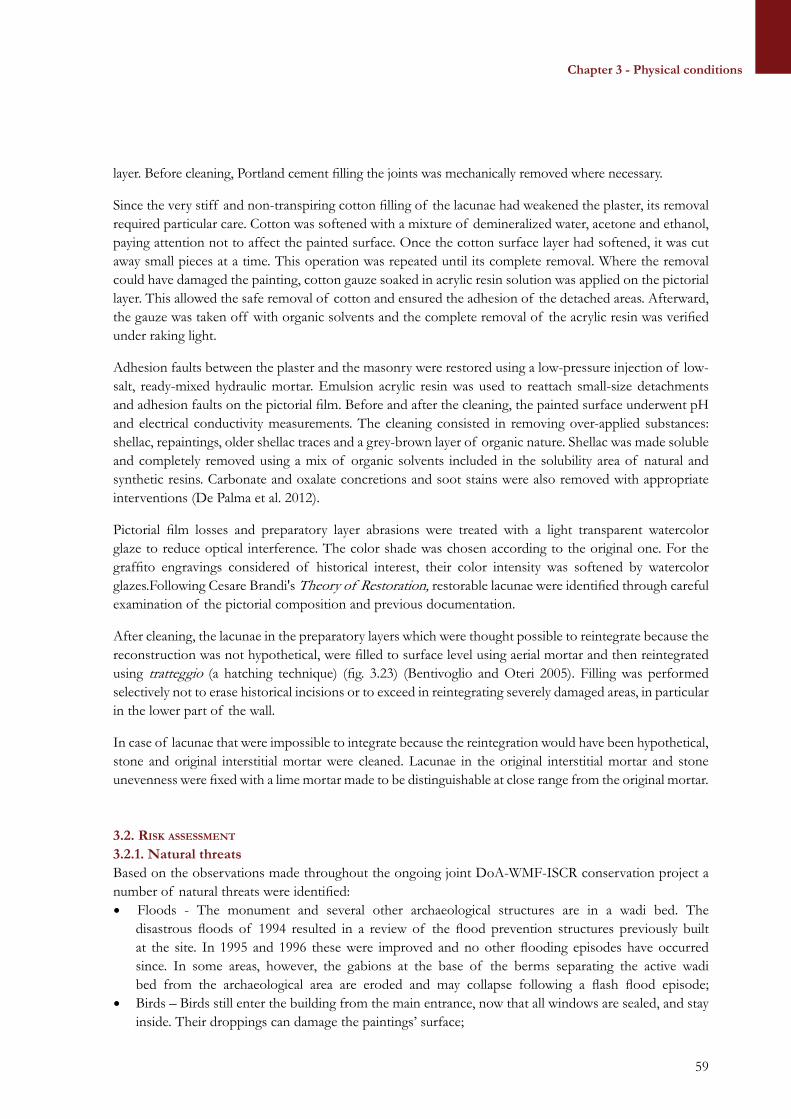
Section i – Site deScription and documentation
23
Chapter 1 - The site
SECTION ISITE DESCRIPTION AND DOCUMENTATION
Chapter 1 – The siteChapter 2 – Documentation
24
Section i – Site deScription and documentation
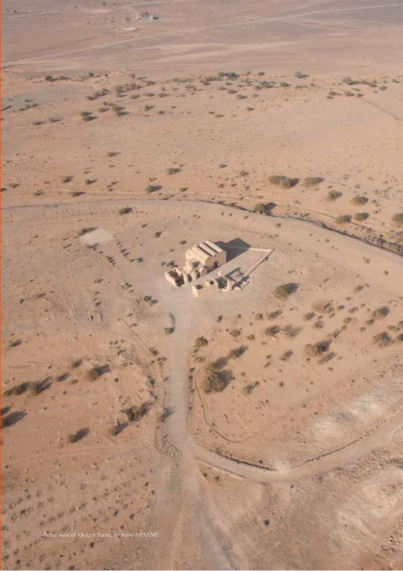
Aerial view of Qusayr ‘Amra, courtesy APAAME
25
Chapter 1 - The site
CHAPTER 1 – THE SITE
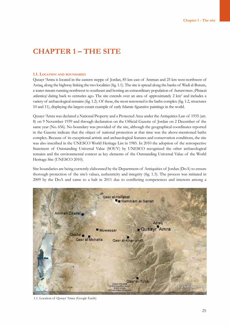
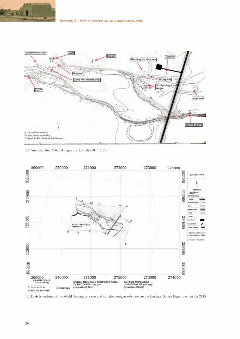
1.1. locatIon and boundarIeS Qusayr ‘Amra is located in the eastern steppe of Jordan, 85 km east of Amman and 25 km west-northwest of Azraq, along the highway linking the two localities (fig. 1.1). The site is spread along the banks of Wadi al-Butum, a water stream running northwest to southeast and hosting an extraordinary population of butum trees (Pistacia atlantica) dating back to centuries ago. The site extends over an area of approximately 2 km2 and includes a variety of archaeological remains (fig. 1.2). Of these, the most renowned is the baths complex (fig. 1.2, structures 10 and 11), displaying the largest extant example of early Islamic figurative paintings in the world.
Qusayr ‘Amra was declared a National Property and a Protected Area under the Antiquities Law of 1935 (art. 8) on 9 November 1939 and through declaration on the Official Gazette of Jordan on 2 December of the same year (No. 656). No boundary was provided of the site, although the geographical coordinates reported in the Gazette indicate that the object of national protection at that time was the above-mentioned baths complex. Because of its exceptional artistic and archaeological features and conservation conditions, the site was also inscribed in the UNESCO World Heritage List in 1985. In 2010 the adoption of the retrospective Statement of Outstanding Universal Value (SOUV) by UNESCO recognized the other archaeological remains and the environmental context as key elements of the Outstanding Universal Value of the World Heritage Site (UNESCO 2010).
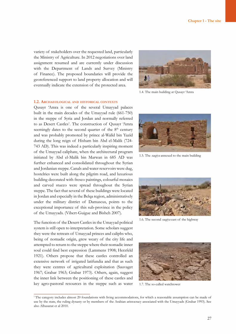
Site boundaries are being currently elaborated by the Department of Antiquities of Jordan (DoA) to ensure thorough protection of the site’s values, authenticity and integrity (fig. 1.3). The process was initiated in 2009 by the DoA and came to a halt in 2011 due to conflicting competences and interests among a
1.1. Location of Qusayr ‘Amra (Google Earth)
26
Section i – Site deScription and documentation
1.2. Site map after Vibert-Guigue and Bisheh 2007 (pl. 2b)
1.3. Draft boundaries of the World Heritage property and its buffer zone, as submitted to the Land and Survey Department in July 2013
27
Chapter 1 - The site
1.4. The main building at Qusayr ‘Amra
1.5. The saqiya annexed to the main building
1.6. The second saqiya east of the highway
1.7. The so-called watchtower
1 The category includes almost 20 foundations with living accommodations, for which a reasonable assumption can be made of use by the state, the ruling dynasty or by members of the Arabian aristocracy associated with the Umayyads (Grabar 1993). See also Alhasanat et al 2010.
variety of stakeholders over the requested land, particularly the Ministry of Agriculture. In 2012 negotiations over land assignment resumed and are currently under discussion with the Department of Lands and Survey (Ministry of Finance). The proposed boundaries will provide the georeferenced support to land property allocation and will eventually indicate the extension of the protected area.
1.2. archaeologIcal and hIStorIcal contextS Qusayr ‘Amra is one of the several Umayyad palaces built in the main decades of the Umayyad rule (661-750) in the steppe of Syria and Jordan and normally referred to as Desert Castles1. The construction of Qusayr ‘Amra seemingly dates to the second quarter of the 8th century and was probably promoted by prince al-Walîd bin Yazîd during the long reign of Hisham bin Abd el-Malik (724-743 AD). This was indeed a particularly inspiring moment of the Umayyad caliphate, when the architectural program initiated by Abd el-Malik bin Marwan in 685 AD was further enhanced and consolidated throughout the Syrian and Jordanian steppe. Canals and water reservoirs were dug, hostelries were built along the pilgrim road, and luxurious building decorated with fresco paintings, colourful mosaics and carved stucco were spread throughout the Syrian steppe. The fact that several of these buildings were located in Jordan and especially in the Belqa region, administratively under the military district of Damascus, points to the exceptional importance of this sub-province in the policy of the Umayyads. (Vibert-Guigue and Bisheh 2007).
The function of the Desert Castles in the Umayyad political system is still open to interpretation. Some scholars suggest they were the retreats of Umayyad princes and caliphs who, being of nomadic origin, grew weary of the city life and attempted to return to the steppe where their nomadic inner soul could find best expression (Lammens 1908; Herzfeld 1921). Others propose that these castles controlled an extensive network of irrigated latifundia and that as such they were centres of agricultural exploitation (Sauvaget 1967; Grabar 1963; Grabar 1973). Others, again, suggest the inner link between the positioning of these castles and key agro-pastoral resources in the steppe such as water
28
Section i – Site deScription and documentation
springs and transhumance routes, and infer that these castles were set up with the purpose of geopolitical control (Almagro 1995; King 1985; Alhasanat et al. 2010). All these hypotheses seem reasonable and may well represent the different factors of a more complex reality, where Desert Castles could have also played a strategic role in diplomatic exchanges between the Umayyads and the chiefs of local Arab tribes, their key supporters and allied in this part of the Umayyad domain.
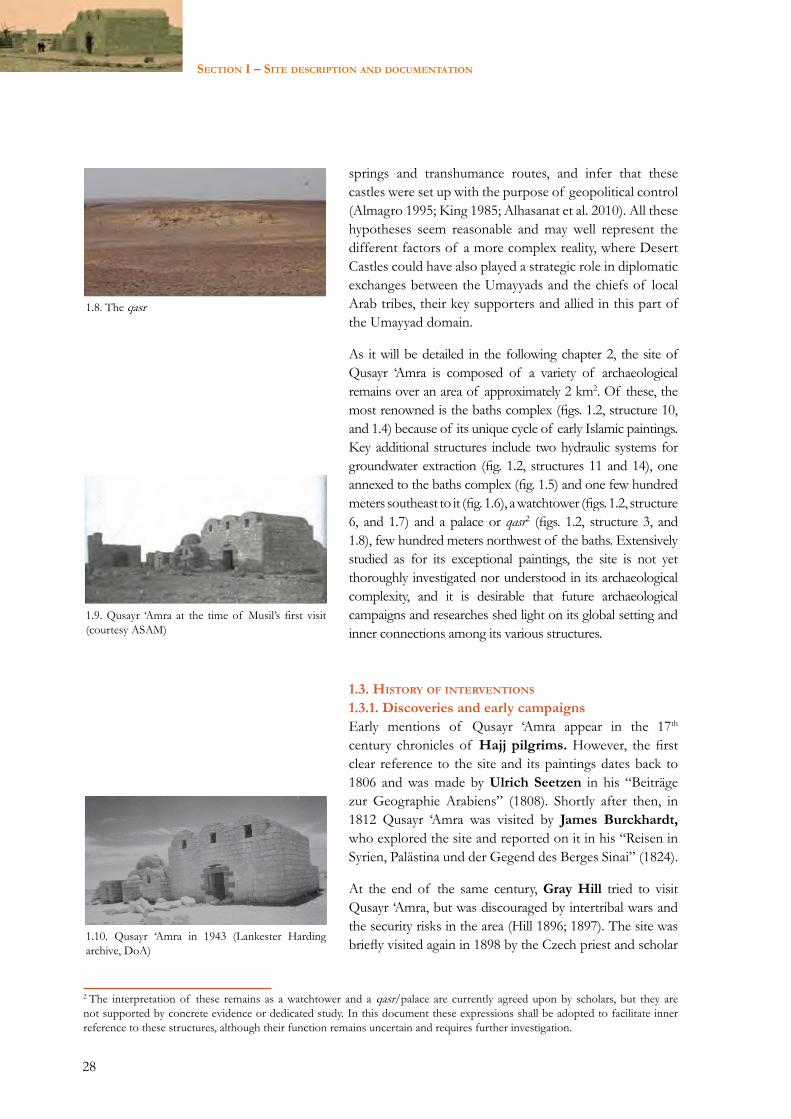
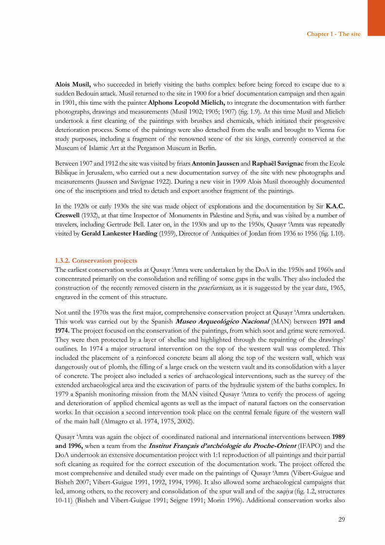
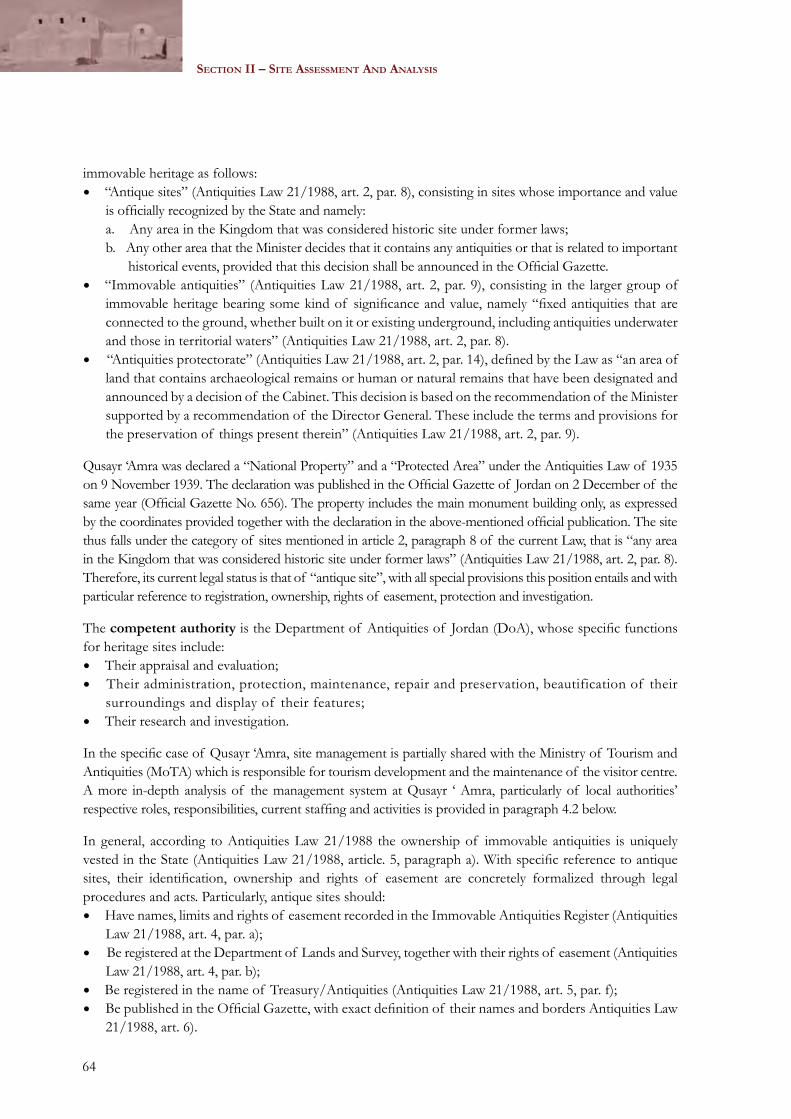
As it will be detailed in the following chapter 2, the site of Qusayr ‘Amra is composed of a variety of archaeological remains over an area of approximately 2 km2. Of these, the most renowned is the baths complex (figs. 1.2, structure 10, and 1.4) because of its unique cycle of early Islamic paintings. Key additional structures include two hydraulic systems for groundwater extraction (fig. 1.2, structures 11 and 14), one annexed to the baths complex (fig. 1.5) and one few hundred meters southeast to it (fig. 1.6), a watchtower (figs. 1.2, structure 6, and 1.7) and a palace or qasr2 (figs. 1.2, structure 3, and 1.8), few hundred meters northwest of the baths. Extensively studied as for its exceptional paintings, the site is not yet thoroughly investigated nor understood in its archaeological complexity, and it is desirable that future archaeological campaigns and researches shed light on its global setting and inner connections among its various structures.
1.3. hIStory of InterventIonS 1.3.1. Discoveries and early campaignsEarly mentions of Qusayr ‘Amra appear in the 17th century chronicles of Hajj pilgrims. However, the first clear reference to the site and its paintings dates back to 1806 and was made by Ulrich Seetzen in his “Beiträge zur Geographie Arabiens” (1808). Shortly after then, in 1812 Qusayr ‘Amra was visited by James Burckhardt, who explored the site and reported on it in his “Reisen in Syrien, Palästina und der Gegend des Berges Sinai” (1824).
At the end of the same century, Gray Hill tried to visit Qusayr ‘Amra, but was discouraged by intertribal wars and the security risks in the area (Hill 1896; 1897). The site was briefly visited again in 1898 by the Czech priest and scholar
1.8. The qasr
1.9. Qusayr ‘Amra at the time of Musil’s first visit (courtesy ASAM)
1.10. Qusayr ‘Amra in 1943 (Lankester Harding archive, DoA)
2 The interpretation of these remains as a watchtower and a qasr/palace are currently agreed upon by scholars, but they are not supported by concrete evidence or dedicated study. In this document these expressions shall be adopted to facilitate inner reference to these structures, although their function remains uncertain and requires further investigation.
29
Chapter 1 - The site
Alois Musil, who succeeded in briefly visiting the baths complex before being forced to escape due to a sudden Bedouin attack. Musil returned to the site in 1900 for a brief documentation campaign and then again in 1901, this time with the painter Alphons Leopold Mielich, to integrate the documentation with further photographs, drawings and measurements (Musil 1902; 1905; 1907) (fig. 1.9). At this time Musil and Mielich undertook a first cleaning of the paintings with brushes and chemicals, which initiated their progressive deterioration process. Some of the paintings were also detached from the walls and brought to Vienna for study purposes, including a fragment of the renowned scene of the six kings, currently conserved at the Museum of Islamic Art at the Pergamon Museum in Berlin.
Between 1907 and 1912 the site was visited by friars Antonin Jaussen and Raphaël Savignac from the Ecole Biblique in Jerusalem, who carried out a new documentation survey of the site with new photographs and measurements (Jaussen and Savignac 1922). During a new visit in 1909 Alois Musil thoroughly documented one of the inscriptions and tried to detach and export another fragment of the paintings.
In the 1920s or early 1930s the site was made object of explorations and the documentation by Sir K.A.C. Creswell (1932), at that time Inspector of Monuments in Palestine and Syria, and was visited by a number of travelers, including Gertrude Bell. Later on, in the 1930s and up to the 1950s, Qusayr ‘Amra was repeatedly visited by Gerald Lankester Harding (1959), Director of Antiquities of Jordan from 1936 to 1956 (fig. 1.10).
1.3.2. Conservation projectsThe earliest conservation works at Qusayr ‘Amra were undertaken by the DoA in the 1950s and 1960s and concentrated primarily on the consolidation and refilling of some gaps in the walls. They also included the construction of the recently removed cistern in the praefurnium, as it is suggested by the year date, 1965, engraved in the cement of this structure.
Not until the 1970s was the first major, comprehensive conservation project at Qusayr ‘Amra undertaken. This work was carried out by the Spanish Museo Arqueológico Nacional (MAN) between 1971 and 1974. The project focused on the conservation of the paintings, from which soot and grime were removed. They were then protected by a layer of shellac and highlighted through the repainting of the drawings’ outlines. In 1974 a major structural intervention on the top of the western wall was completed. This included the placement of a reinforced concrete beam all along the top of the western wall, which was dangerously out of plomb, the filling of a large crack on the western vault and its consolidation with a layer of concrete. The project also included a series of archaeological interventions, such as the survey of the extended archaeological area and the excavation of parts of the hydraulic system of the baths complex. In 1979 a Spanish monitoring mission from the MAN visited Qusayr ‘Amra to verify the process of ageing and deterioration of applied chemical agents as well as the impact of natural factors on the conservation works. In that occasion a second intervention took place on the central female figure of the western wall of the main hall (Almagro et al. 1974, 1975, 2002).
Qusayr ‘Amra was again the object of coordinated national and international interventions between 1989 and 1996, when a team from the Institut Français d’archéologie du Proche-Orient (IFAPO) and the DoA undertook an extensive documentation project with 1:1 reproduction of all paintings and their partial soft cleaning as required for the correct execution of the documentation work. The project offered the most comprehensive and detailed study ever made on the paintings of Qusayr ‘Amra (Vibert-Guigue and Bisheh 2007; Vibert-Guigue 1991, 1992, 1994, 1996). It also allowed some archaeological campaigns that led, among others, to the recovery and consolidation of the spur wall and of the saqiya (fig. 1.2, structures 10-11) (Bisheh and Vibert-Guigue 1991; Seigne 1991; Morin 1996). Additional conservation works also
30
Section i – Site deScription and documentation
included the new paving of the main hall, which was designed according to the casts left by the original stone slabs in the ground (Bisheh et al 1997).
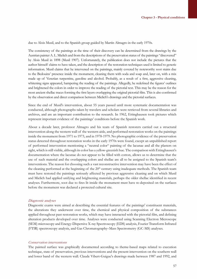
In 1996 a new Spanish mission from the University of Granada intervened on the paintings, particularly those of the so-called “throne room”, to counteract the fast deterioration pace of the fixative (shellac) used by the Spanish Museo Arquéologico Nacional in the 1970s (Medina Florez 1997; Medina Florez and Garcia Bueno 2002). At the same time and until 1999, the site went through a set of coordinated actions by the IFAPO, the French Embassy, UNESCO and the DoA. These actions targeted site presentation and enhanced accessibility and included the design and construction of the new visitor centre, which was inaugurated in 1999 (Morin and Vibert-Guigue 2000).
Since 2010 the site is undergoing a thorough conservation project targeting simultaneously the main building and its decorative features, but also including the management planning of the site and its community-based preservation and enhancement. The project is a joint collaboration between World Monuments Fund (WMF), the Italian Istituto Superiore per la Conservazione ed il Restauro (ISCR) and the DoA. To date, the project has allowed the structural consolidation and restoration of the main building and the restoration of the western aisle (fig. 2.1, room IA), which particularly unveiled unprecedented features and elements of the paintings. Stakeholders consultations have been conducted throughout the project for the sustainable planning of the site, and the present Site Management Plan has been developed as part of this project to ensure long-term and sustainable conservation of Qusayr ‘Amra.
1.4. QuSayr ‘amra: a World herItage SIte
In 1985 Qusayr ‘Amra was inscribed as a World Heritage Site, acknowledging the exceptional testimony it bears to the Umayyad civilization (UNESCO 1985). The ICOMOS evaluation stressed the uniqueness of the figurative painting decoration on the walls and vaults of the main hall and baths, with historical, mythological and imaginary scenes and themes (ICOMOS 1984). These elements were later reaffirmed through the SOUV, retrospectively approved by the UNESCO World Heritage Committee (WHC) in 2010. Accordingly, Qusayr ‘Amra was inscribed in the World Heritage List since it meets criteria i, iii and iv, and namely because:• Its paintings “constitute a unique achievement in the Umayyad period” (UNESCO 2010, p. 11) and
represent “a masterpiece of human creative genius” as per criterion i) of UNESCO’s Operational Guidelines to the World Heritage Convention (2011);
• With its exceptional paintings and iconography, it bears “a unique or at least exceptional testimony to a cultural tradition or to a civilization which is living or which has disappeared” as per criterion iii) of the Operational Guidelines (2011);
• Being the best conserved of the Umayyad palaces and castles in Jordan and Syria, it provides “an outstanding example of a type of building, architectural or technological ensemble or landscape which illustrates (a) significant stage(s) in human history” as per criterion iv) of the Operational Guidelines (2011).
Still today the site embeds these values and represents one of the key references for early Islamic art in the region. In 2010 the retrospective SOUV adopted by the World Heritage Committee (WHC) reiterated the reasons for inscribing the site in the World Heritage List according to criteria i, iii, and iv, adding a statement of authenticity and of significance, and expanding the values of the site to include its archaeological and environmental contexts.
31
Chapter 2 - Documentation
CHAPTER 2 – DOCUMENTATION
2.1. archItecture and conStructIon materIalS
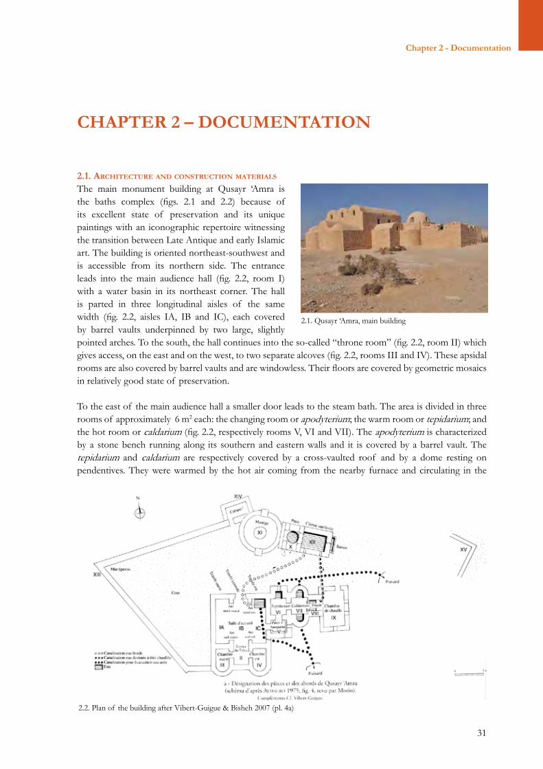
The main monument building at Qusayr ‘Amra is the baths complex (figs. 2.1 and 2.2) because of its excellent state of preservation and its unique paintings with an iconographic repertoire witnessing the transition between Late Antique and early Islamic art. The building is oriented northeast-southwest and is accessible from its northern side. The entrance leads into the main audience hall (fig. 2.2, room I) with a water basin in its northeast corner. The hall is parted in three longitudinal aisles of the same width (fig. 2.2, aisles IA, IB and IC), each covered by barrel vaults underpinned by two large, slightlypointed arches. To the south, the hall continues into the so-called “throne room” (fig. 2.2, room II) which gives access, on the east and on the west, to two separate alcoves (fig. 2.2, rooms III and IV). These apsidal rooms are also covered by barrel vaults and are windowless. Their floors are covered by geometric mosaics in relatively good state of preservation.
To the east of the main audience hall a smaller door leads to the steam bath. The area is divided in three rooms of approximately 6 m2 each: the changing room or apodyterium; the warm room or tepidarium; and the hot room or caldarium (fig. 2.2, respectively rooms V, VI and VII). The apodyterium is characterized by a stone bench running along its southern and eastern walls and it is covered by a barrel vault. The tepidarium and caldarium are respectively covered by a cross-vaulted roof and by a dome resting on pendentives. They were warmed by the hot air coming from the nearby furnace and circulating in the
2.1. Qusayr ‘Amra, main building
2.2. Plan of the building after Vibert-Guigue & Bisheh 2007 (pl. 4a)
Chapter 2 - Documentation
32
Section i – Site deScription and documentation
hypocaust and through terracotta pipes placed under the walls’ marble covers, now lost. Hot and warm water pools were also available in these two rooms. The suspensurae are lost, while the floor of the hypocaust is characterized by flat stones with lime mortar bedding. In the centre of the room the pilae were made of basalt pillars, while the pillars attached to the sides of the two rooms were made of flat bricks set in lime mortar.
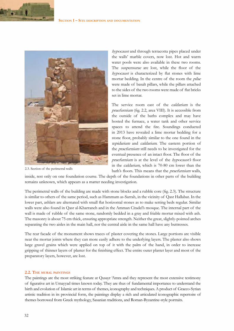
The service room east of the caldarium is the praefurnium (fig. 2.2, area VIII). It is accessible from the outside of the baths complex and may have hosted the furnace, a water tank and other service spaces to attend the fire. Soundings conducted in 2013 have revealed a lime mortar bedding for a stone floor, probably similar to the one found in the tepidarium and caldarium. The eastern portion of the praefurnium still needs to be investigated for the eventual presence of an intact floor. The floor of the praefurnium is at the level of the hypocaust’s floor in the caldarium, which is 70-80 cm lower than the bath’s floors. This means that the praefurnium walls,
inside, rest only on one foundation course. The depth of the foundations in other parts of the building remains unknown, which appears as a matter needing investigation.
The perimetral walls of the building are made with stone blocks and a rubble core (fig. 2.3). The structure is similar to others of the same period, such as Hammam as-Sarrah, in the vicinity of Qasr Hallabat. In the lower part, ashlars are alternated with small flat horizontal stones as to make setting beds regular. Similar walls were also found in Qasr al-Kharraneh and in the Amman Citadel’s mosque. The internal part of the wall is made of rubble of the same stone, randomly bedded in a gray and friable mortar mixed with ash. The masonry is about 75 cm thick, ensuring appropriate strength. Neither the great, slightly-pointed arches separating the two aisles in the main hall, nor the central aisle in the same hall have any buttresses.
The rear facade of the monument shows traces of plaster covering the stones. Large portions are visible near the mortar joints where they can more easily adhere to the underlying layers. The plaster also shows large gravel grains which were applied on top of it with the palm of the hand, in order to increase gripping of thinner layers of plaster for the finishing effect. The entire outer plaster layer and most of the preparatory layers, however, are lost.
2.2. the mural paIntIngS
The paintings are the most striking feature at Qusayr ‘Amra and they represent the most extensive testimony of figurative art in Umayyad times known today. They are thus of fundamental importance to understand the birth and evolution of Islamic art in terms of themes, iconography and techniques. A product of Graeco-Syrian artistic tradition in its provincial form, the paintings display a rich and articulated iconographic repertoire of themes borrowed from Greek mythology, Sasanian traditions, and Roman-Byzantine-style portraits.
2.3. Section of the perimetral walls
33
Chapter 2 - Documentation
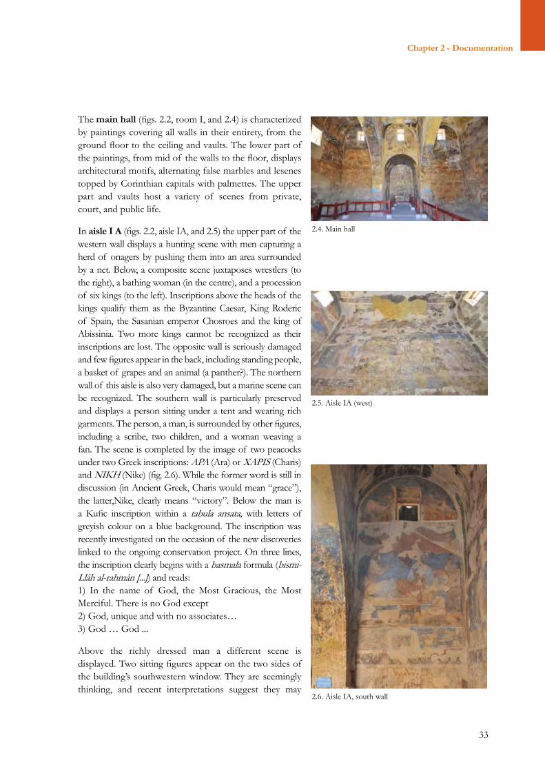
The main hall (figs. 2.2, room I, and 2.4) is characterized by paintings covering all walls in their entirety, from the ground floor to the ceiling and vaults. The lower part of the paintings, from mid of the walls to the floor, displays architectural motifs, alternating false marbles and lesenes topped by Corinthian capitals with palmettes. The upper part and vaults host a variety of scenes from private, court, and public life.
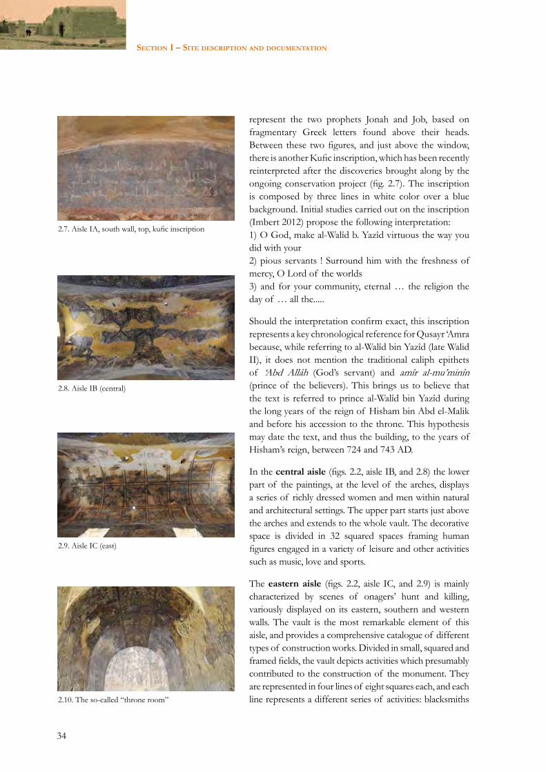
In aisle I A (figs. 2.2, aisle IA, and 2.5) the upper part of the western wall displays a hunting scene with men capturing a herd of onagers by pushing them into an area surrounded by a net. Below, a composite scene juxtaposes wrestlers (to the right), a bathing woman (in the centre), and a procession of six kings (to the left). Inscriptions above the heads of the kings qualify them as the Byzantine Caesar, King Roderic of Spain, the Sasanian emperor Chosroes and the king of Abissinia. Two more kings cannot be recognized as their inscriptions are lost. The opposite wall is seriously damaged and few figures appear in the back, including standing people, a basket of grapes and an animal (a panther?). The northern wall of this aisle is also very damaged, but a marine scene can be recognized. The southern wall is particularly preserved and displays a person sitting under a tent and wearing rich garments. The person, a man, is surrounded by other figures, including a scribe, two children, and a woman weaving a fan. The scene is completed by the image of two peacocks under two Greek inscriptions: APA (Ara) or XAPIS (Charis) and NIKH (Nike) (fig. 2.6). While the former word is still in discussion (in Ancient Greek, Charis would mean “grace”), the latter,Nike, clearly means “victory”. Below the man is a Kufic inscription within a tabula ansata, with letters of greyish colour on a blue background. The inscription was recently investigated on the occasion of the new discoveries linked to the ongoing conservation project. On three lines, the inscription clearly begins with a basmala formula (bismi-Llâh al-rahmân [...]) and reads: 1) In the name of God, the Most Gracious, the Most Merciful. There is no God except2) God, unique and with no associates…3) God … God ...
Above the richly dressed man a different scene is displayed. Two sitting figures appear on the two sides of the building’s southwestern window. They are seemingly thinking, and recent interpretations suggest they may
2.4. Main hall
2.5. Aisle IA (west)
2.6. Aisle IA, south wall
34
Section i – Site deScription and documentation
represent the two prophets Jonah and Job, based on fragmentary Greek letters found above their heads. Between these two figures, and just above the window, there is another Kufic inscription, which has been recently reinterpreted after the discoveries brought along by the ongoing conservation project (fig. 2.7). The inscription is composed by three lines in white color over a blue background. Initial studies carried out on the inscription (Imbert 2012) propose the following interpretation: 1) O God, make al-Walîd b. Yazîd virtuous the way you did with your2) pious servants ! Surround him with the freshness of mercy, O Lord of the worlds3) and for your community, eternal … the religion the day of … all the.....
Should the interpretation confirm exact, this inscription represents a key chronological reference for Qusayr ‘Amra because, while referring to al-Walîd bin Yazîd (late Walid II), it does not mention the traditional caliph epithets of ‘Abd Allâh (God’s servant) and amîr al-mu’minîn (prince of the believers). This brings us to believe that the text is referred to prince al-Walîd bin Yazîd during the long years of the reign of Hisham bin Abd el-Malik and before his accession to the throne. This hypothesis may date the text, and thus the building, to the years of Hisham’s reign, between 724 and 743 AD.
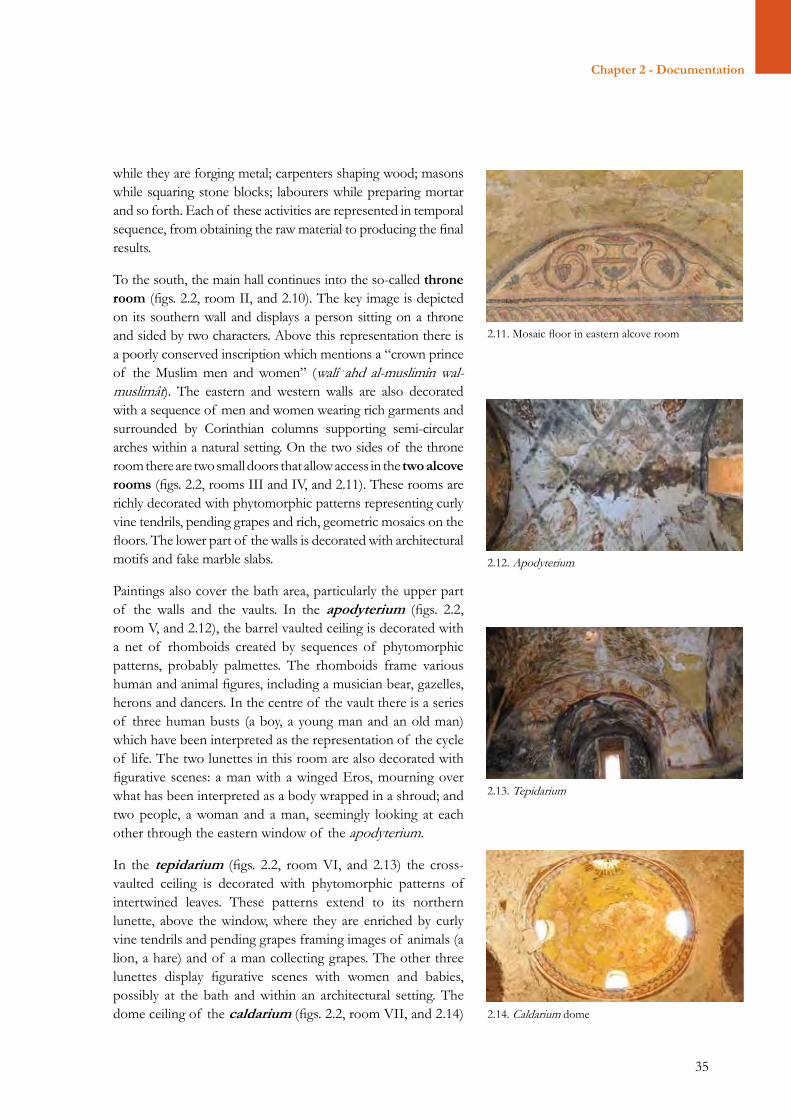
In the central aisle (figs. 2.2, aisle IB, and 2.8) the lower part of the paintings, at the level of the arches, displays a series of richly dressed women and men within natural and architectural settings. The upper part starts just above the arches and extends to the whole vault. The decorative space is divided in 32 squared spaces framing human figures engaged in a variety of leisure and other activities such as music, love and sports.
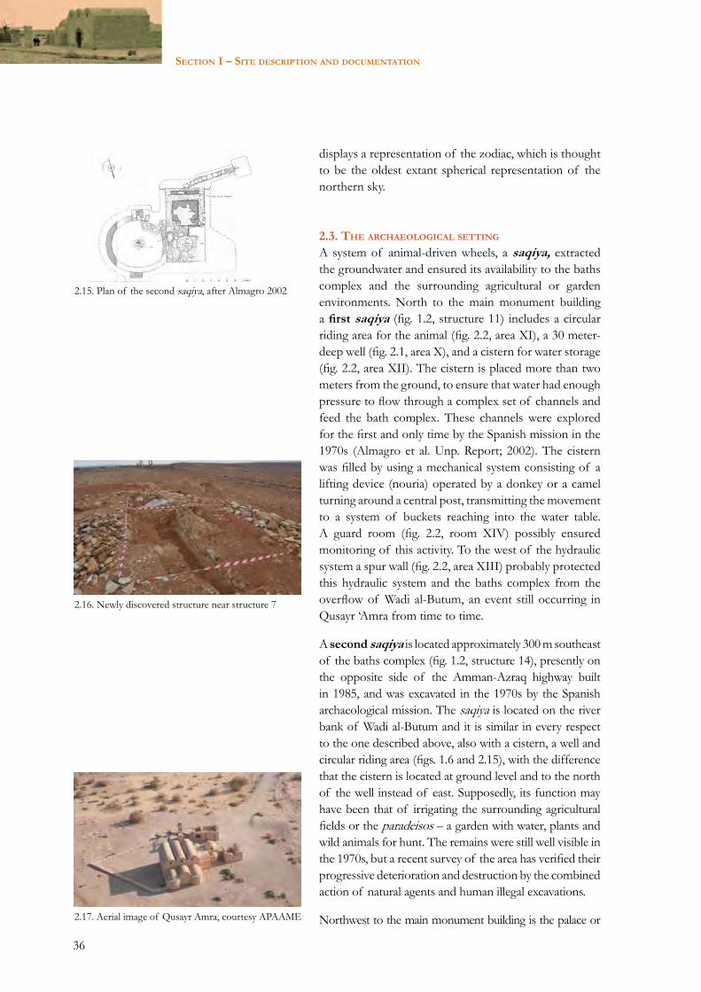
The eastern aisle (figs. 2.2, aisle IC, and 2.9) is mainly characterized by scenes of onagers’ hunt and killing, variously displayed on its eastern, southern and western walls. The vault is the most remarkable element of this aisle, and provides a comprehensive catalogue of different types of construction works. Divided in small, squared and framed fields, the vault depicts activities which presumably contributed to the construction of the monument. They are represented in four lines of eight squares each, and each line represents a different series of activities: blacksmiths
2.8. Aisle IB (central)
2.9. Aisle IC (east)
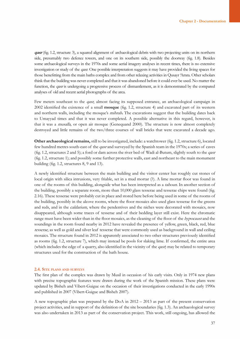
2.10. The so-called “throne room”
2.7. Aisle IA, south wall, top, kufic inscription
35
Chapter 2 - Documentation
while they are forging metal; carpenters shaping wood; masons while squaring stone blocks; labourers while preparing mortar and so forth. Each of these activities are represented in temporal sequence, from obtaining the raw material to producing the final results.
To the south, the main hall continues into the so-called throne room (figs. 2.2, room II, and 2.10). The key image is depicted on its southern wall and displays a person sitting on a throne and sided by two characters. Above this representation there is a poorly conserved inscription which mentions a “crown prince of the Muslim men and women” (walî (ahd al-muslimîn wal-muslimât). The eastern and western walls are also decorated with a sequence of men and women wearing rich garments and surrounded by Corinthian columns supporting semi-circular arches within a natural setting. On the two sides of the throne room there are two small doors that allow access in the two alcove rooms (figs. 2.2, rooms III and IV, and 2.11). These rooms are richly decorated with phytomorphic patterns representing curly vine tendrils, pending grapes and rich, geometric mosaics on the floors. The lower part of the walls is decorated with architectural motifs and fake marble slabs.
Paintings also cover the bath area, particularly the upper part of the walls and the vaults. In the apodyterium (figs. 2.2, room V, and 2.12), the barrel vaulted ceiling is decorated with a net of rhomboids created by sequences of phytomorphic patterns, probably palmettes. The rhomboids frame various human and animal figures, including a musician bear, gazelles, herons and dancers. In the centre of the vault there is a series of three human busts (a boy, a young man and an old man) which have been interpreted as the representation of the cycle of life. The two lunettes in this room are also decorated with figurative scenes: a man with a winged Eros, mourning over what has been interpreted as a body wrapped in a shroud; and two people, a woman and a man, seemingly looking at each other through the eastern window of the apodyterium.
In the tepidarium (figs. 2.2, room VI, and 2.13) the cross-vaulted ceiling is decorated with phytomorphic patterns of intertwined leaves. These patterns extend to its northern lunette, above the window, where they are enriched by curly vine tendrils and pending grapes framing images of animals (a lion, a hare) and of a man collecting grapes. The other three lunettes display figurative scenes with women and babies, possibly at the bath and within an architectural setting. The dome ceiling of the caldarium (figs. 2.2, room VII, and 2.14)
2.11. Mosaic floor in eastern alcove room
2.12. Apodyterium
2.13. Tepidarium
2.14. Caldarium dome
36
Section i – Site deScription and documentation
displays a representation of the zodiac, which is thought to be the oldest extant spherical representation of the northern sky.
2.3. the archaeologIcal SettIng A system of animal-driven wheels, a saqiya, extracted the groundwater and ensured its availability to the baths complex and the surrounding agricultural or garden environments. North to the main monument building a first saqiya (fig. 1.2, structure 11) includes a circular riding area for the animal (fig. 2.2, area XI), a 30 meter-deep well (fig. 2.1, area X), and a cistern for water storage (fig. 2.2, area XII). The cistern is placed more than two meters from the ground, to ensure that water had enough pressure to flow through a complex set of channels and feed the bath complex. These channels were explored for the first and only time by the Spanish mission in the 1970s (Almagro et al. Unp. Report; 2002). The cistern was filled by using a mechanical system consisting of a lifting device (nouria) operated by a donkey or a camel turning around a central post, transmitting the movement to a system of buckets reaching into the water table. A guard room (fig. 2.2, room XIV) possibly ensured monitoring of this activity. To the west of the hydraulic system a spur wall (fig. 2.2, area XIII) probably protected this hydraulic system and the baths complex from the overflow of Wadi al-Butum, an event still occurring in Qusayr ‘Amra from time to time.
A second saqiya is located approximately 300 m southeast of the baths complex (fig. 1.2, structure 14), presently on the opposite side of the Amman-Azraq highway built in 1985, and was excavated in the 1970s by the Spanish archaeological mission. The saqiya is located on the river bank of Wadi al-Butum and it is similar in every respect to the one described above, also with a cistern, a well and circular riding area (figs. 1.6 and 2.15), with the difference that the cistern is located at ground level and to the north of the well instead of east. Supposedly, its function may have been that of irrigating the surrounding agricultural fields or the paradeisos – a garden with water, plants and wild animals for hunt. The remains were still well visible in the 1970s, but a recent survey of the area has verified their progressive deterioration and destruction by the combined action of natural agents and human illegal excavations.
Northwest to the main monument building is the palace or
2.15. Plan of the second saqiya, after Almagro 2002
2.16. Newly discovered structure near structure 7
2.17. Aerial image of Qusayr Amra, courtesy APAAME
37
Chapter 2 - Documentation
qasr (fig. 1.2, structure 3), a squared alignment of archaeological debris with two projecting units on its northern side, presumably two defence towers, and one on its southern side, possibly the doorway (fig. 1.8). Besides some archaeological surveys in the 1970s and some aerial imagery analyses in recent times, there is no extensive investigation or study of the qasr. One possible interpretation suggests it may have provided the living spaces for those benefitting from the main baths complex and from other relaxing activities in Qusayr ‘Amra. Other scholars think that the building was never completed and that it was abandoned before it could ever be used. No matter the function, the qasr is undergoing a progressive process of dismantlement, as it is demonstrated by the compared analyses of old and recent aerial photographs of the area.
Few meters southeast to the qasr, almost facing its supposed entrance, an archaeological campaign in 2002 identified the existence of a small mosque (fig. 1.2, structure 4) and excavated part of its western and northern walls, including the mosque’s mihrab. The excavations suggest that the building dates back to Umayyad times and that it was never completed. A possible alternative in this regard, however, is that it was a musalla, or open air mosque (Genequand 2000). The structure is now almost completely destroyed and little remains of the two/three courses of wall bricks that were excavated a decade ago.
Other archaeological remains, still to be investigated, include: a watchtower (fig. 1.2, structure 6), located few hundred metres south-east of the qasr and surveyed by the Spanish team in the 1970s; a series of caves (fig. 1.2, structures 2 and 5); a ford or dam across the river bed of Wadi al-Butum, slightly south to the qasr (fig. 1.2, structure 1); and possibly some further protective walls, east and northeast to the main monument building (fig. 1.2, structures 8, 9 and 13).
A newly identified structure between the main building and the visitor center has roughly cut stones of local origin with silica intrusions, very friable, set in a mud mortar (?). A lime mortar floor was found in one of the rooms of this building, alongside what has been interpreted as a taboun. In another section of the building, possibly a separate room, more than 10,000 glass tesserae and tesserae chips were found (fig. 2.16). These tesserae were probably cut in place and stored here before being used in some of the rooms of the building, possibly in the alcove rooms, where the floor mosaics also used glass tesserae for the greens and reds, and in the caldarium, where the pendentives and the niches were decorated with mosaics, now disappeared, although some traces of tesserae and of their bedding layer still exist. Here the chromatic range must have been wider than in the floor mosaics, as the cleaning of the floor of the hypocaust and the soundings in the room found nearby in 2012 have revealed the presence of yellow, green, black, red, blue tesserae, as well as gold and silver leaf tesserae that were commonly used as background in wall and ceiling mosaics. The structure found in 2012 is apparently associated to two other structures previously identified as rooms (fig. 1.2, structure 7), which may instead be pools for slaking lime. If confirmed, the entire area (which includes the edge of a quarry, also identified in the vicinity of the qasr) may be related to temporary structures used for the construction of the bath house.
2.4. SIte planS and SurveyS
The first plan of the complex was drawn by Musil in occasion of his early visits. Only in 1974 new plans with precise topographic features were drawn during the work of the Spanish mission. These plans were updated by Bisheh and Vibert-Guigue on the occasion of their investigations conducted in the early 1990s and published in 2007 (Vibert-Guigue and Bisheh 2007). A new topographic plan was prepared by the DoA in 2012 – 2013 as part of the present conservation project activities, and in support of the definition of the site boundaries (fig. 1.3). An archaeological survey was also undertaken in 2013 as part of the conservation project. This work, still ongoing, has allowed the
38
Section i – Site deScription and documentation
identification of a number of prehistoric sites (Lower, Middle, and Upper Paleolithic, Epipaleolithic, and possibly Neolithic and Chalcolithic), witnessing the importance of Wadi al-Butum for hunting practices since the early prehistory.
2.5. photographIc documentatIon
The photographic documentation on Qusayr ‘Amra illustrates the evolution of the site and its surrounding context since early discovery through the present day. These images also chronicle the various conservation interventions. Archival documentation on Qusayr ‘Amra is distributed in a variety of public and private institutions in Jordan and abroad. While this is not unusual for many sites throughout the world, it is indicative of the challenges in investigating the history and changes at the site.
As a component of the joint concervation project currently implemented by the Department of Antiquities of Jordan (DoA), the World Monuments Fund (WMF) and the Istituto Superiore per la Conservazione e il Restauro (ISCR), a collection of historic photographs was identified by WMF and the DoA. Copies of key images were secured for enhanced documentation of the site, and they were placed at the DoA. This activity engaged a number of institutions holding photographic collections and other archival materials on Qusayr ‘Amra, including: the Academic Society of Alois Musil (ASAM) in Prague, the Grabar archive at the University of Michigan, the Gertrude Bell archive in Newcastle, the Creswell archive at the Ashmolean Museum in Oxford, the Lankester-Harding archive at the DoA, the Jaussen and Savignac archive at the Ecole Biblique in Jerusalem, the Horsfield archive at University College London, the Laboratory of Archaeology at the University of Granada in Spain, the Rockefeller Museum in Jerusalem, and the Aerial Photographic Archive for Archaeology in the Middle East (APAAME) at the University of Western Australia.
The existing documentation spans from the early discoveries of the site in the 19th century to recent conservation works in the 21st century, and includes photos by:• Alois Musil, dating between 1898 and 1901;• Antonin Jaussen and Raphael Savignac, dating between 1911 and 1914;• Gertrude Bell, dating to 1914;• George Horsfield, dating between 1926 and 1936;• Sir Keppel Archibald Cameron Creswell, dating to 1930s;• John Whiting, dating to 1937;• Gerald Lankester Harding, dating between 1930 and 1943;• Oleg Grabar and Fred Anderegg, approximately dating to 1962;• the Aerial Photography Archive for Archaeology in the Middle East (APAAME) of the University of Western Australia, dating between 1997 and 2002 (fig. 2.17).
These materials will be used to create a physical and virtual repository at the DoA, with the ultimate purpose to facilitate national and international research and conservation works at Qusayr ‘Amra and in the surrounding areas.
39
Chapter 3 - Physical conditions
SECTION IISITE ASSESSMENT AND ANALYSIS
Chapter 3 – Physical conditionsChapter 4 – The management contextChapter 5 – Site significance and valuesChapter 6 – Summary of conditions, risks and key issues
40
Section ii – Site ASSeSSment And AnAlySiS
Northern side of main structure
41
Chapter 3 - Physical conditions
CHAPTER 3 – PHYSICAL CONDITIONS
3.1. condItIon aSSeSSment This section describes the conditions of the site as found during the documentation work conducted for this Site Management Plan (SMP). As for the assessment of the conservation conditions, it includes also a description of the site conditions found in 2010, at the time of the first investigations undertaken to prepare for the currently ongoing project jointly implemented by the Department of Antiquities of Jordan (DoA), the World Monuments Fund (WMF) and the Italian Istituto Superiore per la Conservazione e il Restauro (ISCR).
3.1.1. InfrastructuresService roads and highwayThe site is located along the highway joining Amman to Azraq, which was built in 1985 at the time of the inscription of the site in the World Heritage List. The road drives across the archaeological area (fig. 1.2) and separates its eastern features (saqiya and big eastern U-shaped wall) from the whole rest of its western remains (main monument building and adjacent structures, qasr, watchtower etc.). Because it is built on a typical earthen road embankment aimed at levelling the ground altitudes, it impacts on the overall perception of the archaeological site and influences its perceived authenticity3. The highway has a negative impact on the site’s integrity too due to the noise and pollution it produces and as it is also highlighted in the retrospective Statement of Outstanding Universal Value (SOUV). According to the Ministry of Public Works and Housing no plan is foreseen in the coming biennium 2012-2014 to modify the highway in this specific stretch. The enlargement of the road is however envisaged in the medium/long term, and this will require accurate heritage risk and impact assessment by the DoA.
Additional infrastructures include two dirt roads allowing access to the open steppe plain. The first one departs from the highway 100 m north of the entrance to the site, and drives towards west. This track follows a long earthen berm approximately a meter high, consisting of earth, stone and gravel scraped from the nearby surface with a bulldozer. This berm is more than 2 km long and was apparently made ten years ago, probably by the Forestry Department to mark the edge of the Wadi al-Butum protection area, but it has caused considerable damage, scarring the surface of the steppe within the archaeological area (fig. 3.1). The dirt track splits at the watchtowerand its main track leads to the south, towards the qasr, Wadi al-Butum and the water basin recently built by the Ministry of Agriculture. The other track continues to the steppe and the illegal quarries, as well as to the dam in Wadi al-Harth.
The second dirt road departs from the highway approximately 500 m south of the entrance to the site and drives again towards west. The road leads to a farm located 400 south of the site’s southern fence, whose construction must be dated between 1985 and 2000 as per available information.
3As road embankments are often constructed using material obtained from a cutting, it would be important to assess whether this also applies to the case of Qusayr ‘Amra and, if so, where the cutting was done and whether this may have altered the stratigraphic sequence at the site. If this is not the case, it would be important to ascertain the origin of the materials used for the embankment, as this would allow discerning local from non-local earth and debris. In both cases the embankment has seriously hampered the possibility to join eastern and western stratigraphies in one unique archaeological profile, thus influencing the possibility to interpret the interconnections between the two parts of the site.
42
Section ii – Site ASSeSSment And AnAlySiS
Further along in the direction of Amman, a paved road 2.5 km long leads to an area to the south of Wadi al-Butum, which includes a large paved area and a paved road encircling an area of approximately 800x700 m, with a number of perpendicular roads further dividing this area. This area was built for a meeting of King Abdallah II with the Beni Sakher tribe in 2003 and has not been used since. At the northeastern corner of this area there is a small fenced area with a small house used by the Ministry of Agriculture.
Water, sewerage and electricityWater supply at Qusayr ‘Amra is provided by water tank cars periodically coming from Amman. Basic needs are further fulfilled by a set of water reservoirs located above the bathrooms’ building and hidden by a wall. A septic tank buried under the bathrooms ensures adequate disposal of wastewaters, particularly those deriving from the bathrooms at the visitor centre. Electricity is also available at the visitor centre, which reaches the place via a diversion from the main electric line accessible on the main road.
A deep well from which water is pumped into tanks to provide water for sheep and goats herds was built on the eastern side of the road to Azraq by the Ministry of Agriculture, 300 m north of the access road to Qusayr ‘Amra.
The main electric line on high pylons is located approximately 500 m east of the highway, while a second electric line was recently buried underground on the eastern side of the highway embankment.
Flood risk management infrastructures During the rainy season Qusayr ‘Amra is occasionally subject to floods due to heavy torrential rains that are not immediately absorbed by the ground. The most recent occurred in 1994, when in some parts of Wadi al-Butum the water level reached up to 60-70 cm height. In that occasion, the geomorphology of the area channelled the strongest water stream through the Wadi’s southern branch, thus diverting its harsh impact from the main monument building. However, this did not prevent the site from being flooded. The southern branch of Wadi-al Butum normally flows below the Amman-Azraq highway through a series of cement pipes which in that occasion were
3.1. Dirt track and berm within the archaeological area, possibly built by the Ministry of Agriculture.
3.2. Water basin and dyke 500 m west of Qusayr ‘Amra
3.3. Parking area
3.4. Visitor centre
43
Chapter 3 - Physical conditions
obstructed by large quantities of debris brought along by the heavy water stream. Water thus remained blocked west of the highway, in an artificial basin delineated by: the highway embankment to the east, a levee to the north/north-west, and the southern branch of the Wadi to the south. The monument building and its adjacent structures contained therein were flooded, with water and mud attaining up to 60-70 cm inside and outside the building.
Following this event, between 1995 and 1996 the DoA, the Institut français d'archéologie du Proche-Orient (IFAPO) and UNESCO jointly carried out the following set of flood risk reduction interventions:• Cleaning of the Wadi’s bed, to favour the water flow towards east and beyond the highway;• Modelling of surfaces and heights, again to foster water flow in its natural direction, to the east of the
site and highway;• Construction of a dyke with stoned gabions and earth to close the northern branch of Wadi al-Butum
and thus divert floods in the future.
More recently the Ministry of Water and Irrigation also intervened in the area to address the problem of floods and provide a water reserve. In that occasion, a water reservoir of 40,000 m3 and its adjacent earthen dyke were built approximately 500 m west of the main monument building, at the junction between the northern and southern branches of Wadi al-Butum (fig. 3.2). No further floods since 1994 have affected the area, which could have been the case in 2013 due to a high seasonal rainfall in winter.
3.1.2. Facilities and servicesAccess and parking The site is located along the highway joining Amman to Azraq and leading to Iraq and Saudi Arabia and its presence is indicated by a series of road panels. Consistently with general practices in the country, the panels for Qusayr ‘Amra are brown with white text and stand along the road in proximity of the site along both lanes, directions Amman-Azraq and Azraq-Amman.
A paved road of about 150 m opens on the western lane of the above-mentioned highway and leads to the site’s parking lot of about 1,600 m3, whose renovation is contextual to the construction of the visitor centre in the late 1990s. The parking area is unmarked and cars and buses usually park side by side in front of the wall limiting to the east the front of the visitor center, or in front of the fence running along the southern edge of the parking area. In busy days, it may be dangerous to walk between buses and cars to reach the entrance to the site, as foot paths do not exist (fig.3.3).
Visitor centre The new visitor centre was established in the late 1990s through a joint project of DoA, IFAPO and the French Embassy and it was inaugurated in 1999. It was constructed not far from the previous visitor facilities (a guards’ room and the toilets) and it is composed of four buildings joined together through an open, shaded walking area. The construction is fully made of stone, so as to blend easily in the overall steppe landscape, and includes (fig. 3.4):• Guards’ room, for sheltering the security personnel. The building is further sub-divided in two rooms
and one hosts a ticket counter. No ticket service is currently in force at Qusayr ‘Amra, thus the public function of this specific space remains unexploited;
• Toilets with running water service ensured by water tanks placed on rooftop and hidden by a wall. Toilets are cleaned and maintained on a regular basis and they appear as the most appropriate toilets
44
Section ii – Site ASSeSSment And AnAlySiS
along the whole itinerary of the Desert Castles (Qasr al-Kharraneh-Qusayr ‘Amra, Qasr al-Azraq and Qasr Hallabat);
• Exhibition room, opening on the shaded walking space and consisting in one room fully dedicated to the explanation of Qusayr ‘Amra and its context. The room was designed and arranged in 1999 and contains 13 informative boards hanging in a line all over its four walls. They address four key topics, one per wall: i) the discovery of Qusayr ‘Amra; ii) the description of archaeological area with all key remains; iii) the presentation and description of the mural paintings and their iconography; iv) the chronohistory of the Umayyads. The exhibition is integrated by a scale model of the site, which provides a useful global understanding of the area and of the interconnection between the various archaeological structures. A showcase is also available and displays some of the artefacts recovered at Qusayr ‘Amra during archaeological campaigns. Three smaller showcases facilitate children’s understanding of the site through educational materials.
• A room used by the guards at night and a small electric room also used for storage.
The visitor center is in relatively good conditions, although the woodwork of the window fixtures and of the shaded areas has not been maintained for some time and needs to be repainted and in some cases replaced. Toilets are regularly cleaned but should be updated with seated toilets, since the Turkish toilets are uncomfortable for the average tourist.
Paths and shelters The visit and global understanding of Qusayr ‘Amra much relies on the strategic planning and development of its visiting infrastructures, which in this case account for:• Paths, to reach the key features of the site;• Shelters, to protect visitors from the heavy sun and heat.
A first path leads from the site’s entrance to the visitor center and it has broken paving stones that need to be replaced, especially at the beginning of the path. Along this path, the posts and chain that channel visitors towards the visitor center are broken and should be replaced.
A winding path joins the visitor centre to the main monument building and adjacent structures, and its itinerary follows the longest trajectory between these two points. The path was recently rearranged by the MoTA and is marked by stone alignements4 along its borders and by a series of iron stakes holding a rope, in a navy style (fig. 3.5). Many stakes have been kicked out of place, and in several spots the rope is laying on the ground, giving the impression that the site is not being maintained.
In 2012 the path’s natural surface was covered with black tuff stones which were aesthetically unpleasant and difficult to walk on. DoA was able to have this intervention reversed by MoTA. The path crosses a wooden pavilion that allows visitors appreciating the global view of the site and its contextual environment whilst resting in the shade. A board has been placed here, providing explanation on the surrounding landscape with its natural and man-made features. The board needs to be replaced as it is discoloured and broken. The pavilion itself has never been maintained: the woodwork needs replacement, as well as the broken stones facing the four pillars supporting the woodwork of the small structure.
4 The stones used to mark the path appear very similar to those of the qasr, approximately 600 m west/northwest to the main monument building. Although it has not been demonstrated, it seems that the company who realized the path used the qasr as a stone procurement area, thus further damaging this unexplored site. Should this prove correct, more control will be needed in the future to prevent this from happening again and to ensure that such type of interventions is sanctioned as per legal provisions.
45
Chapter 3 - Physical conditions
Closer to the site, a sign installed about ten years ago is now illegible and should be replaced or eliminated (fig. 3.6). The path ends here, approximately 20 m before the building. Tourists and visitors are free to circulate around the site.
The path is probably long, and it has been observed that often tourists follow it when going to the main monument building, but cut through the site when they leave. No other path exists nowadays at the site to join the building with other archaeological structures located in the surrounding area, at few hundred meters from it. This plays a substantial role on visitors’ perception of the extension and complexity of the site, and needs to be targeted through a strategic accessibility plan capable to communicate all key cultural and natural features of this World Heritage Site.
Site protection infrastructuresThe reconstructed saqiya was in dangerous conditions in 2012 as its woodwork had deteriorated to breaking point. Emergency work to avoid its collapse was conducted in 2012, but the entire system should be maintained and possibly replaced with new wooden elements. A wooden handrail is placed at the edge of the saqiya’s well, but it should be maintained and given protective oils regularly to avoid cracking and splitting.
Inside, a wooden barrier running along the walls of the main hall is designed to avoid contact with the mural paintings, but at the same time it encourages people to climb it. From there, they can reach the paintings and write or scratch graffiti. The two alcove rooms have their entrances blocked by this barrier, but as the graffiti in these rooms show, this is not a deterrent for visitors to jump over it and access the rooms. As part of the present project, the barrier system will be redesigned.
The apodyterium does not have barriers inside, while thetepidarium and caldarium rooms have a wooden platformabove the pilae and barriers in the same style as in the main hall.
Hospitality services A Bedouin tent is installed in the parking lot at the entrance to the site and is managed by a member of the
3.6. Illegible signage on site
3.5. Path leading to the main structure
3.7. Beduin tent at entrance of site, managed by a member of the Beni Sakher tribe.
46
Section ii – Site ASSeSSment And AnAlySiS
tribe of Beni Sakher, the main tribe of this region (fig. 3.7). The tent has been installed upon permission issued by the MoTA and provides a basic cafeteria service with tea, coffee and water, together with a small selection of souvenirs.
3.1.3. Regional and local development contextsQusayr ‘Amra is located in the Governorate of Zarqa and, at a smaller scale, within the Municipality of Azraq. No development plan or strategy seemingly exists nowadays at either level. Rather, development works are apparently undertaken on a short-term basis, depending on emerging needs. Some short-term projects and other activities currently exist in and around Qusayr ‘Amra, which bear an impact on the site and which are thus relevant mentioning in this paragraph:• A water harvesting project in the catchment area
of Wadi al-Harth, currently implemented by the Ministry of Water and Irrigation in collaboration with the Ministry of Agriculture (fig. 3.8);
• Quarrying activities, apparently carried out with no legal endorsement but hardly monitored and halted and thus seriously affecting the area (fig. 3.9);
• Socio-economic development activities, carried out by local entrepreneurs upon approval of competent authorities;
• The development of infrastructures, particularly the broadening of the highway by the Ministry of Public Works and Housing;
• Preservation of the ecosystem in response to its increasing deterioration due to uncoordinated actions.
The water harvesting projectThe water harvesting project is implemented by the Ministry of Water and Irrigation in collaboration with the Ministry of Agriculture to ensure groundwater recharge and the development of a rangeland area for livestock farming. With specific reference to the area around Qusayr ‘Amra and Wadi al-Butum, the water catchment area includes one major dam, three check-dams and three water reservoirs.
The major dam is located on Wadi al-Harth, upstream to Wadi al-Butum and about 3 km from Qusayr ‘Amra, with UTM coordinates E2693 and N35243 (fig. 3.8). The dam collects water from a catchment area of 250 km2 with average precipitation of 122 mm/year and an overall potential of 1,500,000 m3 of water per year5. The dam is 4 m deep and has a capacity of 1,000,000 m3, thus leaving a minimum of 500,000 m3 of water to the territory. The dam was built in 2011 by the Ministry of Water and Irrigation upon request and funding by the Ministry of Agriculture, which plans to install a rangeland area near the dam for grazing animals.
The check-dams are small entities which, according to officers from the Ministry of Water and Irrigation, do not have a major impact on the surrounding environment in general and on the area of Wadi al-Butum
3.8. Wadi al-Harth dam
5 The calculation is made as follows: area in km2 * mm/year * 0.05 run-off coefficient.
3.9. Illegal quarrying and construction material dumping in the vicinity of the site
47
Chapter 3 - Physical conditions
and Qusayr ‘Amra in particular. These dams are about 2 m deep and are located in the following areas:• At UTM E2640 and N35230,• At UTM E2665 and N35230.They serve a catchment area of approximately 190 km2 with 122 mm/year average precipitation and about 1,160,000 m3 water runoff per year.
The water reservoirs are located as follows:• One upstream of the dam on Wadi al-Harth, with capacity of approximately 50,000 m3;• One on Shi’ban al-Butum, with capacity of 50,000 m3;• One, of new construction, at UTM E2625 and N35225, with capacity of 50,000 m3.
As it appears clearly from all this information, this water harvesting system is absorbing an enormous amount (65%) of the average local water capacity, in an area with scarce human presence and with reduced opportunities to exploit this extra water reserve. The impact of this system becomes crucial in years such as 2012, when effective rainfall fell below the average level, thus aggravating water scarcity. What’s more, increased drought in an area with about 30% evaporation rate entails excessive soil salination, a harsh and hardly reversible threat to the ecosystem. This means that a micro-environment such as Wadi al-Butum will soon start disappearing, with tremendous impact on the local ecosystem, national biodiversity and, last but not least, on the Qusayr ‘Amra World Heritage Site itself, whose original construction was conceived exactly because of the existence of Wadi al-Butum nearby and the resources it offered for such settlement. Solutions may thus need to be envisaged in order to avoid this a natural catastrophe to happen, such as the removal of some dams or the development of alternative water collection systems. In this regard, a hint may be coming from ancient agricultural practices, with the creation of terraces to slow down water flow and ensure increased water absorption in the ground. These actions, however, will need careful discussion, planning and impact assessment, to avoid further negative impact on the territory.
Quarrying activitiesIllegal quarrying seemingly occurs around Qusayr ‘Amra with some frequency, as proved by the frequent explosions reported by the conservators during the conservation campaigns. The impact of illegal quarrying on the site is two-folded: on the one hand, explosions and stone extraction destroy the peculiar environmental setting of the Jordanian badiya, a steppeland of clayey soils covered by a thin layer of chert (hammada). On the other, the seismic movements6 associated to the use of explosives may bear an impact on the stability of the main building and thus foster, on the medium to long term, the opening of new cracks in the walls.
According to the Natural Resources Authority (NRA) of the Ministry of Energy and Natural Resources, no quarrying activity has recently been approved in the area around Qusayr ‘Amra, which makes any reported extraction illegal (fig. 3.9). Azraq-based inspectors from the NRA patrol the area, also in close collaboration with Royal Society for the Conservation of Nature (RSCN), and report to the Police. The intervention by the Civil Defence is reportedly immediate, within one hour from reporting. According to the consulted stakeholders, illegal extractors are very fast, and they succeed completing their work before the arrival of the competent authorities.
6 In this regard, seismic monitoring by the National Resource Authority (NRA) may be recommendable in the area so as to have concrete understanding of the situation and to plan conservative measures accordingly.
48
Section ii – Site ASSeSSment And AnAlySiS
Socio-economic developmentQusayr ‘Amra and the surrounding badiya have an enormous potential for the development of attractive, sustainable tourism and other related economic activities. The participation and involvement of local communities in this regard is of fundamental importance towards the long-term sustainability of the site. This type of action needs to be concerted and agreed upon both by competent authorities, particularly the DoA and the MoTA who need to provide backstopping and legal authorization to these activities, and by the local community, who needs to launch and implement new, entrepreneurial projects for the development of the area. At present these two stakeholders, institutional and local, face some communication challenges, as it emerged from stakeholders’ consultations. The manager of the Bedouin tent providing hospitality services in Qusayr ‘Amra reports that several requests were made to the MoTA and the DoA in order to broaden these services and set up a small tourist camp with tents. Discussions are currently ongoing with the competent authorities to find a solution for the promotion of tourism development on site and in the surrounding area.
Highway and roads developmentThe most recent road dates back to 1985, when the highway was constructed few hundred metres from Qusayr ‘Amra. No new road is currently planned in Qusayr ‘Amra, as reported by the Ministry of Public Works and Housing in Spring 2012. A possible foreseen development could entail the enlargement of the current highway, but no action in this regard is planned for the coming two years 2012-2014. According to the Ministry, by procedural default all planned works are normally communicated to the competent authorities, including the MoTA and the DoA, for their inputs on relevant issues. Despite current legal provisions, reportedly the Ministry of Public Works and Housing is not aware of the national database of Antiquities (MEGA Jordan), nor does preventive archaeological/cultural impact assessment play a role in the design and construction of national infrastructures.
Preservation of the ecosystemThe specific and extraordinary ecosystem of Wadi al-Butum is the environmental justification as for why Qusayr ‘Amra was built there and it was recognized by the SOUV as an integral component of the site (fig. 3.10). Its preservation is thus of fundamental relevance for guaranteeing the authenticity and integrity of this World Heritage Site. However, the combination of recent development activities at and around the site (e.g. water harvesting, infrastructures development and illegal quarrying) seriously threatens this ecosystem. Particularly, the above-mentioned water harvesting project is drying up the soil of Wadi al-Butum and thus leading the butum trees (Pistacia atlantica) to death (fig. 3.11). No solution is on the horizon to this key issue. On the one hand, the Rangeland Department (Ministry of Agriculture), among the key supporters of the project, claims that water harvesting has minimal support on the ecosystem. On the contrary, the Forestry Department and the RSCN firmly reject the sustainability of these activities because they will lead to the desertification of Wadi al-Butum and to a major change in the overall ecosystem balance.
An environmental analysis of Wadi al-Butum was conducted between 2004 and 2009 by the Royal Botanic Garden (RBG), a Jordanian NGO (Addison et al. 2003). This analysis allowed the identification of plant and animal species living in the area, as well as the threats to the integrity of the biodiversity of the area. These threats were identified in: the installation of barriers and dams along the Wadi, which stop the natural flow of the water; the numerous illegal quarries which not only scar the steppe surface but also stop the flow of rainwater towards the wadi bed; the presence of parasites on the butum trees, which, combined with the other factors already mentioned, are effectively stopping the growth of new butum trees and putting at risk the existing
49
Chapter 3 - Physical conditions
stock of approximately 600 trees. Although protected by the Forestry Department, this rare remnant of growth is not actively managed and all the plants are now at risk.
3.1.4. Physical conditions of the main building and architectural structuresPerimeter walls are made with stone blocks and a rubble core. In the lower part, ashlars are alternated with small flat horizontal stones as to make setting beds regular. The internal part of the wall is made of rubble of the same stone, randomly bedded in a gray and friable mortar mixed with ash. The masonry is about 75 cm thick, ensuring appropriate strength. Neither the great, slightly-pointed arches separating the two aisles in the main hall, nor the central aisle in the same hall have any buttresses.
The external wall color is homogeneous due to a thin ochre “earthy” patina which is constantly carried by the wind and covers even the lowest portions of mortar. Investigation on samples confirmed in situ observation. Surface polishing with soft brushes revealed the real, more grayish color of stones and mortars.
The rear facade of the monument shows traces of plaster covering the stones. Large portions are visible near the mortar joints where they can more easily adhere to the underlying layers. The surface of this mortar is treated with regular herringbone-patterned signs, clearly aimed at easing the connection between this and the final plaster layer (fig 3.12). The plaster also shows large gravel grains which were applied on top of it with the palm of the hand, in order to increase gripping of thinner layers of plaster for the finishing effect. The entire outer plaster layer and most of the preparatory layers, however, are lost. We cannot say whether the final layer of mortar was left in natural color, or painted.
Mortars are still strong and can be broken without crumbling. They are composed of lime with a number of aggregates in different proportions:• bright red, sometimes grayish-brown cocciopesto; • flint grains of different colors (whitish, gray, brown,
reddish) and always characterized by chipping edges and conchoidal fractures;
• alluvial sand made of carbonate stone grains of different color and type. As far as possible, stereo-
3.10. Terebinth (butum) trees in wadi al-Harth
3.11. Dead tree as a consequence of deviating the water flow of the wadi in the site’s vicinity.
3.12. Plaster on the rear facade of the monument, with regular herringbone-patterned signs
50
Section ii – Site ASSeSSment And AnAlySiS
microscope analysis found calcareous fossiliferous micritics (with foraminifera), flint limestone and, perhaps, marl limestone. Their color goes from whitish to light gray, from light brown to yellowish and orange;
• calcite and hydrous iron oxides (calcareous-limonitic “crusts”); • white calcium carbonate grains –as shown by the positive result of HCl 2N micro-chemical test–
probably carbonated lime “lumps” (bottaccioli) or carbonated slaked lime aggregates with “inert” function, according to a Byzantine technique;
• black, opaque, fibrous grains: fragments of charcoal and ashes; • plant fiber marks.
Considering the large amount of calcareous aggregate, the weight ratio between the binder and the aggregate can be estimated around 1:3. Most of cocciopesto and plant fibers can be found in the surface finishing layers, while charcoal and ash are more common in the ones below.
Water-resistance in the extrados of the vaults is guaranteed only by plasterwork. The roof does not have gutters, and water is eliminated by sloping the spaces between the barrel vaults towards the southern side. The vaults are made of quadrangular stone ashlars. On top of them, four mortar layers were applied. The lowest, just above the stone core of the vaults, is made of lime mortar, ash and a thin inert charge of different color, serving as bedding for flat stone fragments. This layer was probably used to control the roughness of the vault's exterior core. Three other layers, with decreasing granularity, were placed on top of the one just described. The second mortar layer, with similar composition as the lowest, is about 1.5 cm thick. On its surface, grits of different nature and shape from 1 to 4 cm in size were applied. Several roundish areas created by hand pressure can be observed. Grit applied in this way supported the third layer of mortar, increasing its gripping properties. This layer is quite homogeneously 2.5 cm thick and includes aggregates of different nature (roundish stones, flint and cocciopesto fragments) and size, from 0.5 mm to 5 mm. It also contains a thinner particulate invisible to the naked eye. The fourth, finishing layer was applied to make the lower one even more uniform. It is only 1-1.5 mm thick, white, full of lime putty (grassello) and vegetable fibers, still identifiable in surface traces. The original look must have appeared very smooth and compact as it is still visible where the mortar remained intact.
Some important elements of the masonry such as the lintel or the entrance door's jambs are made of basalt stone, which can be found in Azraq, 25 km to the east.
State of conservationThe monument's state of conservation showed some worrying problems concerning the masonry. First of all, floods (including an episode as late as 1994) which may have caused the loss, somewhere almost total, of the original bedding mortar and of the mortar inside the core of the masonry in the lower 60-70 cm of the walls (fig. 3.13). The surfaces of the walls showed widespread fillings between the ashlars performed using cement mortars during previous restoration works. This cement, besides being aesthetically unpleasant, may have contributed to increased salt content, which is sometimes visible as efflorescence in the lower parts of the walls.
The ashlars of the exterior wall, made of light yellow sedimentary stone, appeared to be in overall good conditions. Some of them, because of their geological nature combined with the effect of atmospheric agents, show signs of de-cohesion and de-adhesion of the constituent material mainly near the most exposed and micro-exfoliated areas. There are also macroscopic fissures in the ashlars, along with micro-fissures and de-cohesive areas. This may be due not only to pressure but also, as for those in the lower
51
Chapter 3 - Physical conditions
part, to rising damp. On the southern and northern walls, the ashlars removed in the past or gone missing exposed the cement core walls to rainwater infiltrations, which caused mortar losses inside the masonry. All along the perimeter of the monument, several graffiti are visible on the wall, even at a considerable height.
The vaults' extrados were in worrying conditions, due to the loss of the original mortar layers which exposed the rubble core, and allowing water to penetrate in the deeper layers of the vaults, affecting the painted surfaces inside (fig. 3.14).
The dome of the caldarium was heavily integrated in the early 1990s using cement mortar, which is in a very good status and undamaged by the serious biological attack affecting the original mortar. As it happens on the other vaults, here too the top mortar layer disappeared and the surface looks eroded and fragmented because of bio-deteriorating agents as well as wind effect and sudden change of temperature between day and night. As shown in the old photographs, most plaster on the dome was lost, leaving the masonry exposed.
The mortar layers on top of the vaults of the main hall show different preservation conditions. The most exposed –the eastern one– lost almost all three mortar layers and the stones placed right upon the structure were in plain view, so the risk of infiltrations on the paintings was very high.
The west wall is about 30 cm out of plumb. While the lateral thrust of the three vaults is properly resisted by the eastern wall adjoining the thermal bath, the western wall is free and not buttressed. The size of the shear wall supporting the last vault is clearly insufficient to resist thrust. The movement of the wall caused a deep longitudinal damage along the higher part of the vault, visible from both inside and outside. Spanish conservators and architects during the 1971-1974 campaigns tried to solve this situation installing a reinforced concrete beam in the wall by the last two rows of stones. The beam runs along the orthogonal facades up to the windows. On the inside, the damage was filled and covered with a yellow paint. On the outside, the intervention was more complex and maybe it was not carried out all at the same time. The gap on the extrados was covered in tar paper and filled with roughly smoothed concrete mortar, not caring about connecting it to the ancient mortar. In the 1990s, more fillings were performed.
The eastern vault was different from the other two for the lack of the second layer, which in the other two vaults is the layer with the presence of grits to increase its gripping properties. This particular feature may be the evidence of an ancient damage to the second layer, directly replaced by the mortar of the third layer during repairing works.
The monument is provided with rectangular windows in the higher part of the main body –placed inside the centering which closes the barrel vault– and with several circular openings about 20 cm in diameter. Some of them show a brick pipe, sometimes round, but more often rectangular in section. Some others show less regular openings possibly due to the loss of the internal pipe. On the outside, glass was set in a circular iron frame sometimes in the past 30 or 40 years to prevent water from entering the building. Many of these covers were either broken, missing, or had lost adhesion and allowed water to penetrate. On the inside, streaks and large eroded areas suggest that the glasses had been missing for a long time in the past, or that fillings were not waterproof.
Original windows are lost, and the monument had ten wooden frame windows (plus four iron framed in the caldarium dome) very damaged, with broken glass panes or left open, which allowed the ingress of water and pests in the building. Bird droppings and water stains are visible on the paint layers inside under every window.
52
Section ii – Site ASSeSSment And AnAlySiS
Conservation interventionsBefore intervention started in 2011 within the DoA-WMF-ISCR project, chemical and physical analyses were carried out in order to verify the composition of the mortar and the aggregates, as well as the granularity curve. The observation of the exterior walls allowed detecting the presence of homogeneous mortars. It was immediately clear, and then confirmed by the analyses, that the whole building is covered by the clay dust typical of this part of the country. The “real” color of the mortar is white-grayish as often happens to lime putty (grassello) mortars. The use of ashes and coal as an additive or inert material makes this color more intense.
Biological deterioration on covering mortars was also analyzed in order to identify the most effective biocide. Surfaces were freed from sandy particulate through mild polishing; the areas affected by bio-deteriorating attacks were treated with Preventol R80 3% in deionized water applied in three phases with 7-day time-exposure between one treatment and next.
Cement mortars were eliminated where present and repointing was made with mortars complying as much as possible with existing ones, and aggregates follow the same criteria. All mortars used were composed of slaked lime putty matured for more than six months. DoA experts turned quicklime into slaked lime in barrels next to the work yard. The first stage of the intervention implied the choice of aggregates and of mortar color. White sand, yellow sand, wadi sand and cocciopesto were used. A warmer tone was preferred to the original grayish color of mortars, since it was closer to the clayey layer carried by the wind and covering the whole building. Cocciopesto-based hydraulic mortars were used for deep consolidation. Granularity analysis on ancient mortars allowed working out compatible mortars.
The first interventions on the exterior of the monument were conducted on the lower sections of the walls, affected by the loss of the bedding and core mortar. Lacunae were filled with stone chips up to 60-70 cm from the ground level. The filling was divided in two distinct operations: the former aimed at re-establishing the building's compliance with static safety requirements, the latter at protecting the surfaces from future deterioration.
The progression of the intervention on the outside perimeter of the building followed a number of phases:1. Removal of Portland cement used in previous restoration works and of the stones used to fill the
lacunae. 2. Cleaning of the surfaces from dust and earthy deposits using paintbrushes and medium-hard-bristled
brushes.3. Where necessary, the surface was made rough using a mortar made of inert and hydraulic charges of
different granularity (binder: charge ratio = 1:3, grassello, sand, grit and cocciopesto) and stones of different sizes soaked in water to fill the gaps in the core wall. This allowed restoring cohesion within the masonry.
4. Missing ashlars were replaced by natural stones found nearby, with the intent to restore an organic and complete view of the surfaces without the interference of missing parts. In order to underline the presence of non-original ashlars, the perimeter filling was done slightly under the surface level.
5. In the same way, the finishing mortar used for the gaps between ashlars (binder: charge ratio = 1:3, grassello, sand, grit, volcanic sand) was applied slightly under the surface level to make the conservation intervention identifiable.
The final smoothing of the surfaces was aimed at easing rainwater flowing to the ground (fig. 3.15).
On the barrel vaults cement layers from previous restorations were mechanically removed with hammer,
53
Chapter 3 - Physical conditions
scalpel and angle grinder with diamond cutting discs. Lacunae were reintegrated with mortars similar to the existing ones. A sacrificial layer was reconstructed in order to protect the original mortars, which are widely cracked and became fragile over time. To slow down erosion caused by atmospheric agents such as wind and sand, low and rough areas where water could stagnate were eliminated (fig. 3.16).
Consolidation of detached layers of plaster was tested on the alcove coverings, next to the bath. Consolidation with concrete of the longitudinal gap on the western vault, done during the Spanish intervention of the 1970s was found to be quite drastic. Once the first layer was removed and tar paper identified, cement and water repellent were carefully cleaned off. Tar made concrete consolidation ineffective and could allow water seepage. The concrete was gradually removed and replaced with a new lime-based mortar mixed with rubble. Afterwards, it was leveled off with finishing mortar.
Windows were replaced with similar wooden structures. Their broken shutters could be opened but not controlled, and they were replaced with fixed shutters to prevent animals from entering the building. Each one of the barrel vaults of the main hall originally showed eight openings delimited by a rectangular-section ceramic tube (about 6-8 cm per side). The tube was inserted in the masonry, probably to let some fresh air in and the steam out. Old openings were sealed by a glass supported by a metal ring, now rusted. They were replaced with glass rounded caps in order to avoid water stagnation, and installed without metal support to prevent glass from breaking because of metal expansion. Four openings on the western vault (west side) were found to be completely sealed with cement mortar, and were re-opened.
3.1.5. Physical conditions of the paintings in main buildingThe painted wall is made of squared local limestone ashlars installed using an interstitial mortar. The mortar is composed of siliceous inert materials of different granularity and color, and slaked lime. Often, the mortar is also used to level off the roughness of the wall and make it smooth enough for the final layer to be spread. In addition, in some areas (lower part of the wall, splay
3.13. Hollow masonry at the bottom of the external walls, caused by flood (before conservation)
3.14. Exposed rubble core of the vaults’ extrados, allowing water penetration and paintings’ damage (before conservation)
3.15. Final smoothing of mortar in repointed areas
3.16. Application of layers of lime mortar on the vaults’ extrados
54
Section ii – Site ASSeSSment And AnAlySiS
of the window) grit of different granularity and color were scattered on fresh mortar in order to prevent it from shrinking when drying as well as to improve gripping for the final layer.
At the bottom of the wall, 4 cm thick fragments of bedding mortar from the skirting marble slabs can be observed. Marble slabs covered the whole aisle at a height of 50 cm and a few fragments have remained in the throne room. Slab slots are still visible on the floor. The plaster, without further preparatory layers, was applied right on the stone and it is mainly composed of plant fibers, slaked lime and an organic protein binder. About one centimeter thick, it shows an intense white color and quite a smooth surface although some unevenness can be detected.
Raking light inspection has revealed succeeding plaster spreading phases (pontate) from up to bottom (fig. 3.17). The upper “pontata” is divided in two “giornate”, (a spreading of plaster corresponding in general to a day of work) the left one overlapping the right one. In some localized areas, mortar was probably added in order to correct unevenness. Signs of a presumably hurried and sometimes non-homogeneous work are visible on smooth surfaces close to rougher and irregular areas. Plaster smoothing seems more accurate in the lower part, intentionally simulating marble. No traces of direct or indirect incisions were found. The preparatory drawing, which outlines figures and major decorations, is orange-red colored. Another element of the pictorial technique is represented by the preparatory drawing performed right on the rendering, which can be glimpsed in the lacunae of the painted layer. Wide traces of red and yellow colors can be noticed near the lateral figures’ garments and should be assigned to this preparatory phase.
The sequence of pictorial levels appears to be complex. A first drawing of the figurative scheme may have been traced when the preparatory layer was still drying. This could have allowed cohesion between pigments and plaster. Blue backgrounds especially can be assigned to this phase.
This first level was followed by a series of pictorial layers performed using binder. In this phase, characters' complexion and probably hair, now missing, as well as other pictorial details were completed. In the southern wall of the western aisle, white circles and highlights on the folds of the main character's garment; the furnishing, the peacocks' plumage, and the Kufic Arabic inscription at the top of the lunette belong to this phase. In particular, the tabula ansata shows two different spreading phases of blue paint. For the first one, fresco technique was used. Whereas the second, thicker application was performed on dry walls where the binder have caused cracking (cretto). On this surface, ochre letters were outlined in red and lined up by a blue horizontal line painted in relief on their upper edges.
The double spreading of blue paint is also noticeable on the main character's foot and shows a micro-cretto on the first layer applied directly on plaster. The palette that was chosen reveals a large use of precious pigments such as lapis lazuli, which was spread on the background even if it was to be covered by more layers of paint. According to the analysis of pigments, elements such as lead and arsenic (white lead and orpiment), natrojarosite, calcium hydroxide (bianco Sangiovanni), ochre, lapis lazuli, minium and cinnabar are part of a complex and variegated palette of natural and synthetic pigments, some of which may have been hard or very expensive to obtain.
State of conservation The constant use of the area as a shelter by local tribes and its remote location caused the loss of large portions of plaster. This was due to incisions and graffiti, affecting not only the lower part of the walls but also the upper area –in some points severely damaged– and mainly delicate details such as the characters' faces (fig. 3.18).
55
Chapter 3 - Physical conditions
Since the rediscovery of the monument in the late 19th century, surface cleaning efforts –even though not always appropriately performed– allowed a better visibility on the one hand, and accelerated the deterioration of constituent materials on the other. A large portion of the pictorial film applied on dry plaster (secco technique) was lost also because of aggressive cleaning methods, which totally depleted the binders and damaged the plaster on most exposed areas. As a consequence, surfaces appear to be more opaque than they probably were, and widely incomplete. Lead-based pigments underwent major alterations, turning from white to dark grey tones. Some of the substances used to perform aggressive cleaning in the past, may have favored the alteration and change of some original pigments. Furthermore, dust and birds caused deterioration, as testified by traces of carbonate and oxalate concretions caused by water percolation polluted by animal dejections identified below the windows. These concretions are combined with large soot residues and yellow substances.
In the middle 1970s, the monument was subject to an extensive restoration intervention aimed at preserving the masonry and plaster and, at the same time, at reintegrating the paintings. At that time, the detachment of the western wall from the southern one was filled with rubble and cement mortar. Detachments of the preparatory layer from the masonry (de-adhesion) were secured with vinyl resin. The edges of the widest lacunae or the lacunae themselves were sealed with cotton soaked in that same resin without performing any other filling, and they were covered with a yellowish tempera which, in some points, was applied on exposed stone walls and also onto parts of the original pictorial layer.
After partial cleaning, the paintings throughout the building (with very few exceptions) were covered with a layer of natural resin (shellac) (fig. 3.19). The polishing substance, more suitable to be used on furniture than to protect mural paintings, must have been applied in order to modify the refractive index of fading colors, made irreversibly opaque by previous interventions. At the time when it was applied, the shellac was more transparent but throughout the last 40 years it acquired a strong amber color, worsened by several layers of atmospheric fine particles due, among others, to tourism-related causes. In addition, the shellac layer now shows signs of contraction and is causing the lifting of the pictorial layer underneath. This shellac layer has extensive repaintings (fig. 3.20) in non water-soluble color overflowing in some of the lacunae. Traces of an additional, older brown shellac layer, a residue of previous interventions, were also found. These repaintings, identified for the first time by C. Vibert-Guigue (Vibert-Guigue and Bisheh 2007) in his study of the monument, substantially alter the iconography of the monument, as revealed by the recent project’s cleaning efforts.
Large traces of coal residuals and coherent particles (silico aluminates) found in saline concretions of different nature, which were never removed, prevented the correct reading of some original details of the composition. Therefore, the objective of reintegration by the Spanish team was to outline with dark colors the characters and other figurative elements still visible. Some parts of the drapery, zoomorphic elements (peacocks) and geometric /decorative patterns (squaring, tent) were repainted more freely. 3.17. Raking light photo of South wall, West
aisle, showing the plaster’s spreading phases
56
Section ii – Site ASSeSSment And AnAlySiS
Natural and man-made causes affected the pictorial film, widely scratching and whitening the surface. Some figurative details of the characters' profiles disappeared or fell. Countless lacunae can be found on the whole pictorial layer (lapislazuli blue background) or part of it. Therefore, when the present project began, the paintings of the south wall were scarcely visible, their colors were severely altered and the iconography was affected by the interpretation given by the Spanish conservators.
Being easily accessible, the lower band of the paintings with its faux marble decoration is the most affected by widespread and deep scratches. The pictorial film and the plaster also show intentional damages such as graffiti and incisions. The detachment of mortar from the walls caused large lacunae reaching the lower part, once covered with marble slabs. There are also traces of fire burning and black inscriptions.
In the lower band, moderate adhesion faults were detected between the rougher layer of mortar, the bedding mortar of the marble slabs and the masonry. There are also saline concretions. In the upper band, medium and large detachment areas were identified between the preparatory coat of rendering and the wall structure. Some stylized images of animals and symbols carved by Bedouins living in the badiya are historicized and of palaeographic interest (Betts 2001). These evidences were classified and analyzed; nevertheless they threaten the preservation of paintings: graffiti represent a discontinuity in the plaster and weaken its compactness.
Previous interventionsThe reconstruction of the paintings’ conservation history was deemed particularly significant to define the criteria for the new intervention. Methods and materials used over time were investigated, and their effect on the paintings and possible contributions to the deterioration processes. For this reason, all different restoration works carried out from 1898, the time of Musil’s first visit, until 1996, year of the last intervention which was performed in compliance with modern criteria, were analyzed. Historical documents, restoration works’ reports, published photographic materials and unpublished archive pictures supplied by many institutions were examined. The most important interventions affecting the appearance of the paintings are
3.19. Layer of natural resin (shellac) applied at the time of the 1970’s conservation
3.18. Large lacunae affecting the pictorial layers
3.20. Repaintings can be noticed above the shellac layer. Here, the blues of the peacock are all recent additions.
57
Chapter 3 - Physical conditions
due to Alois Musil, and to the Spanish group guided by Martìn Almagro in the early 1970s.
The consistency of the paintings at the time of their discovery can be determined from the drawings by the Austrian painter A. L. Mielich and from the descriptions of the preservation status of the paintings “discovered” by Alois Musil in 1898 (Musil 1907). Unfortunately, the publication does not include the pictures that the author himself claims to have taken, and the description of the restoration techniques used is limited to generic information. Musil claims that he intervened on the paintings, mainly covered by noteworthy soot stains due to the Bedouins’ presence inside the monument, cleaning them with soda and soap and, later on, with a mix made up of Venetian turpentine, gasoline and alcohol. Probably, as a result of a first, aggressive cleaning, whitening signs appeared, hampering the reading of the paintings. Allegedly, he redefined the figures’ outlines and brightened the colors in order to improve the reading of the pictorial text. This may be the reason for the most ancient shellac traces forming the first layers overlapping the original pictorial film. This is also confirmed by the observation and direct comparison between Mielich's drawings and the pictorial surfaces.
Since the end of Musil's intervention, about 55 years passed until more systematic documentation was conducted, although photographs taken by travelers and scholars were retrieved from several libraries and archives, and are an important contribution to the research. In 1962, Ettinghausen took pictures which represent important evidence of the paintings’ conditions before the Spanish work.
About a decade later, professor Almagro and his team of Spanish restorers carried out a structural intervention along the western wall of the western aisle, and performed restoration works on the paintings inside the monument from 1971 to 1973, and in 1978-1979. No photographic evidence of the preservation status detected throughout restoration works in the early 1970s were found, except an unpublished report of performed intervention mentioning a “neutral color“ painting of the lacunae and all the plasters on sight, which is still visible, although its color has a yellow-greenish hue. The comparison with Ettinghausen's documentation where the lacunae do not appear to be filled with cotton, allows us to determine that the use of such material and the overlapping colors and shellac are all to be assigned to the Spanish team's interventions. The reason for choosing such a vast reconstructive intervention may have been the effect of the cleaning performed at the beginning of the 20th century using inadequate methods. The Spanish team must have restored the paintings seriously affected by previous aggressive cleaning and on which Musil and Mielich had applied unifying and brightening materials, perhaps the older shellac identified in recent analyses. Furthermore, soot due to fires lit inside the monument must have re-deposited on the surfaces before the monument was declared a protected cultural site.
Diagnostic analysesDiagnostic exams were aimed at describing the essential features of the paintings' constituent materials, the alterations they underwent over time, the chemical and physical composition of the substances applied throughout past restoration works, which may have interacted with the pictorial film, and defining alteration products developed over time. Analyses were conducted using Scanning Electron Microscope (SEM) microscopy and Energy-Dispersive X-ray Spectroscopy (EDS) analysis, Fourier Transform Infrared (FTIR) spectroscopy analysis, and Gas Chromatography–Mass Spectrometry (GC-MS) analyses.
Conservation interventionsThe painted surface was graphically documented according to theme-based maps related to execution technique, state of preservation, previous interventions and the present intervention on the southern wall and lower band of the western wall. Claude Vibert-Guigue's drawings made between 1987 and 1992, and
58
Section ii – Site ASSeSSment And AnAlySiS
published in Vibert-Guigue and Bisheh 2007, were used as a graphic base. Their high quality, accuracy and wealth of details allowed to compare the preservation conditions of the surfaces in the years 1987-1992 and their current status. High resolution photographs supplemented Vibert-Guigue’s drawings.
Before, during and after the restoration intervention, an accurate photographic report of the surface conditions, different phases of the intervention and training activity throughout this whole period was conducted. Ultraviolet (UV) and infrared (IR) photography was also conducted, with interesting results showing details poorly visible or no visible at all to the naked eye.
A thermographic survey of the entire complex was conducted in February 2011, in order to visualize thermal discontinuities in the walls of the building. The survey allowed the visualization of the composition of the walls hidden beneath the paint layers, and the identification of areas which may indicate the presence of voids or of possible water infiltration (fig. 3.21). A new topographic survey, mapping the entire complex, and laser scan of the main building, was conducted for the purpose of producing a highly accurate 3D model of the site to be used in future phases of the conservation project, as well as for presentation and education purposes (fig. 3.22). The topographic survey was also used to produce a detailed plan of the archaeological area for the purpose of defining the legal boundaries of the site.
Environmental monitoring is being carried out since 2010, following the installation of sensors throughout the building, in order to measure variations in temperature and relative humidity in the structure. These measurements are particularly useful now, after the installation of new windows and covers that have effectively “sealed” the building. Comparing data with the measurements taken for a year before the installation of the new windows will help understanding the effect of this intervention on the stability of the environment inside the building.
The cleaning operations are complex and articulated in various phases, in particular because of the presence of the shellac layer, since the substance becomes irreversible with ageing and its removal required progressive treatments and particular care, in order to respect the original pictorial
3.21. Thermography of south wall of west aisle. The entire monument was mapped with this technique.
3.22. 3D model of Qusayr ‘Amra, derived from a laser scan survey conducted by DoA in 2013.
59
Chapter 3 - Physical conditions
layer. Before cleaning, Portland cement filling the joints was mechanically removed where necessary.
Since the very stiff and non-transpiring cotton filling of the lacunae had weakened the plaster, its removal required particular care. Cotton was softened with a mixture of demineralized water, acetone and ethanol, paying attention not to affect the painted surface. Once the cotton surface layer had softened, it was cut away small pieces at a time. This operation was repeated until its complete removal. Where the removal could have damaged the painting, cotton gauze soaked in acrylic resin solution was applied on the pictorial layer. This allowed the safe removal of cotton and ensured the adhesion of the detached areas. Afterward, the gauze was taken off with organic solvents and the complete removal of the acrylic resin was verified under raking light.
Adhesion faults between the plaster and the masonry were restored using a low-pressure injection of low-salt, ready-mixed hydraulic mortar. Emulsion acrylic resin was used to reattach small-size detachments and adhesion faults on the pictorial film. Before and after the cleaning, the painted surface underwent pH and electrical conductivity measurements. The cleaning consisted in removing over-applied substances: shellac, repaintings, older shellac traces and a grey-brown layer of organic nature. Shellac was made soluble and completely removed using a mix of organic solvents included in the solubility area of natural and synthetic resins. Carbonate and oxalate concretions and soot stains were also removed with appropriate interventions (De Palma et al. 2012).
Pictorial film losses and preparatory layer abrasions were treated with a light transparent watercolor glaze to reduce optical interference. The color shade was chosen according to the original one. For the graffito engravings considered of historical interest, their color intensity was softened by watercolor glazes.Following Cesare Brandi's Theory of Restoration, restorable lacunae were identified through careful examination of the pictorial composition and previous documentation.
After cleaning, the lacunae in the preparatory layers which were thought possible to reintegrate because the reconstruction was not hypothetical, were filled to surface level using aerial mortar and then reintegrated using tratteggio (a hatching technique) (fig. 3.23) (Bentivoglio and Oteri 2005). Filling was performed selectively not to erase historical incisions or to exceed in reintegrating severely damaged areas, in particular in the lower part of the wall.
In case of lacunae that were impossible to integrate because the reintegration would have been hypothetical, stone and original interstitial mortar were cleaned. Lacunae in the original interstitial mortar and stone unevenness were fixed with a lime mortar made to be distinguishable at close range from the original mortar.
3.2. rISk aSSeSSment
3.2.1. Natural threatsBased on the observations made throughout the ongoing joint DoA-WMF-ISCR conservation project a number of natural threats were identified:• Floods - The monument and several other archaeological structures are in a wadi bed. The
disastrous floods of 1994 resulted in a review of the flood prevention structures previously built at the site. In 1995 and 1996 these were improved and no other flooding episodes have occurred since. In some areas, however, the gabions at the base of the berms separating the active wadi bed from the archaeological area are eroded and may collapse following a flash flood episode;
• Birds – Birds still enter the building from the main entrance, now that all windows are sealed, and stay inside. Their droppings can damage the paintings’ surface;
60
Section ii – Site ASSeSSment And AnAlySiS
• Other pests – Sealing the roof holes and other openings has drastically reduced the number of insects and other small animals entering the building. Flies cause nuisance to visitors but they do not seem to affect the painted surface. Burrowing animals cause damage to unexcavated structures and future management of the area will have to take this into consideration;
• Dust – Again, sealing of the many openings has also reduced the amount of dust, which however still enters the building from the only wide entrance available, especially during windy days. Dusts deposits in fine layers on surfaces and obscures details. With time, it may create a harder layer, difficult to remove;
• Erosion – Sealing of spaces between the ashlars of the monument outside has reduced this risk, which however remains high in other monuments of the site (the qasr, the watchtower, the “service” building and the second saqiya), which remain unexcavated and unconsolidated;
• Salt efflorescences – This phenomenon is observed in some rooms (the alcoves for example) and may be due to the use of cement in old repairs;
• Raising moisture – This phenomenon was observed where water stagnates, for example on the outside of the western wall of the monument, but also in the western alcove.
3.2.2. Man-made threats
• Vandalism and graffiti – This is one of the most serious risks to the integrity of the site. Graffiti writing is still frequent on site and the presence of guards does not seem to be sufficient to curb it (fig. 3.24). Vandalism is also quite frequent in the form of illegal excavations, especially in remote parts of the site. This plan proposes a number of measures that could be taken to at least reduce its impact;
• Lack of maintenance – This is seen in the state of conservation of the visitor center, of the path, and other structures;
• Highway – Passing only 100 m east of the site, the heavy truck traffic of the highway provokes vibrations that may weaken the main monument’s structure and cause structural problems;
• Previous interventions – In past conservation efforts, Portland cement was used to repair wall cracks and lacunae. Although present conservation efforts are concentrating on its removal, salts may have migrated into the walls where it was applied. On the paintings, the applications of shellac and of successive repaintings have affected the pictorial layers. Efforts are concentrating on their removal, but this is a slow process that will hopefully be achieved in the course of the present conservation project;
• Dams and check dams – The water harvesting projects of the Ministry of Agriculture and of Water and Irrigation in the area are a threat to the integrity and authenticity of the landscape setting of the site because of the modifications they produce in the biodiversity of the area. They are also a threat to the site itself, because of the increased risk of flash-flooding in case of dam’s collapse or overflow;
• Illegal quarrying – As already mentioned, illegal quarrying is a forbidden yet practiced activity which
3.23. Tratteggio applied on new lime mortar filling small lacunae (visible in center of image)
3.24. Graffiti are one of the most serious problems affecting the integrity of the site
61
Chapter 3 - Physical conditions
destroys the natural landscape and produces seismic vibrations potentially hampering the structural conservation of the main building;
• Unplanned interventions – There are traces, also recent, of several failed “improvement” projects conducted by contractors to the MoTA without proper supervision. This has resulted in a failed attempt to plant the area of the site with trees about ten years ago, which however has left scars and foreign material (tufa pebbles) on the surface of the site, and in the construction of a visitor path which has partially damaged unexcavated parts of the archaeology of the site, namely the service building and the ancient quarry, both partly bulldozed, and the ruined qasr, which was used as a quarry to procure cut stones to use in the delimitation of the visitors path.
62
Section ii – Site ASSeSSment And AnAlySiS
South wall of western aisle, after conservation
63
Chapter 4 - The management context
CHAPTER 4 – THE MANAGEMENT CONTEXT
4.1. legal StatuS and protectIon
4.1.1. National protectionHistorically, the legal framework for antiquities in Jordan includes the following laws: • First Antiquities Law under the British Mandate for both Palestine and Jordan, 1925;• First Jordanian Antiquities Law of 1935, renewed in 1947;• Antiquities Law No. 33 of 1953; • Antiquities Law No. 26 of 1968;• Antiquities Law No. 12 of 1976, incorporating stop to trading, exporting and importing of antiquities
and amended in 1988 (amendment No. 14);• Antiquities Law No. 21 of 1988, amended in 2002 (amendment No. 23), 2004 (amendment No. 23)
and 2008 (amendment No. 55);• Regulations for Archaeological Excavations and Surveys in Jordan of 1994, in accordance with provisions
of the Antiquities Law No. 21 of 1988;• Law No. 5 of 2005 on the Protection of Architectural and Urban Heritage, ruling the protection and management of cultural heritage dating after year AD 1750;• Regulations for Archaeological Excavations and Surveys in Jordan of 2013, issued pursuant
to the provisions of the Jordanian Antiquities Law No. 21 of 1988.
The current legal framework in Jordan applies the Antiquities Law 21/1988 and following amendments of 2004 and 2008. The structure of the Law can be summarized as follows:• Definitions (articles 1-2);• Competent authorities’ roles and responsibilities (article 3);• Property of antiquities (articles 4-8);• Antique sites’ protection, excavation and discoveries (articles 9-22);• Movable antiquities’ trading, import and export (articles 23-25);• Sanctions and penalties (articles 26-30);• National museum (articles 31-32);• Other issues (articles 32-36).
With specific reference to the case of Qusayr ‘Amra, the following articles appear of fundamental importance in ruling its ownership, management, investigation, development and other interventions at the site: i) article 2: definition and legal status; ii) article 3: competent authority; iii) articles 4-6: property of antiquities and sites; iv) articles 9 and 13-22: protection, excavation and discoveries.
A first aspect of utmost relevance concerns the legal definition and status of Qusayr ‘Amra. Within the broad and general group of “antiquities7”, the Antiquities Law 21/1988 classifies the sub-group of
7According to the Antiquities Law “antiquities” are: “a) Any object, whether movable or immovable, which has been constructed, shaped, inscribed, erected, excavated, or otherwise produced or modified by humankind, earlier than the year AD 1750, including caves, sculpture, coins, pottery, manuscripts and all sorts of artefact that indicate the rise and development of sciences, arts, manufacturing, religions and traditions relating to previous cultures, or any part added thereto, reconstructed or restored at a later date; b) Any Object, movable or immovable, as defined in the previous subsection referring to a date subsequent to the year AD 1750, which the minister may declare to be antique by order of the Official Gazette; c) Human, plant and animal remains going back to a date earlier than AD 600” (Antiquities Law 21/1988, art. 2, par. 7).
64
Section ii – Site ASSeSSment And AnAlySiS
immovable heritage as follows:• “Antique sites” (Antiquities Law 21/1988, art. 2, par. 8), consisting in sites whose importance and value
is officially recognized by the State and namely: a. Any area in the Kingdom that was considered historic site under former laws; b. Any other area that the Minister decides that it contains any antiquities or that is related to important
historical events, provided that this decision shall be announced in the Official Gazette.• “Immovable antiquities” (Antiquities Law 21/1988, art. 2, par. 9), consisting in the larger group of
immovable heritage bearing some kind of significance and value, namely “fixed antiquities that are connected to the ground, whether built on it or existing underground, including antiquities underwater and those in territorial waters” (Antiquities Law 21/1988, art. 2, par. 8).
• “Antiquities protectorate” (Antiquities Law 21/1988, art. 2, par. 14), defined by the Law as “an area of land that contains archaeological remains or human or natural remains that have been designated and announced by a decision of the Cabinet. This decision is based on the recommendation of the Minister supported by a recommendation of the Director General. These include the terms and provisions for the preservation of things present therein” (Antiquities Law 21/1988, art. 2, par. 9).
Qusayr ‘Amra was declared a “National Property” and a “Protected Area” under the Antiquities Law of 1935 on 9 November 1939. The declaration was published in the Official Gazette of Jordan on 2 December of the same year (Official Gazette No. 656). The property includes the main monument building only, as expressed by the coordinates provided together with the declaration in the above-mentioned official publication. The site thus falls under the category of sites mentioned in article 2, paragraph 8 of the current Law, that is “any area in the Kingdom that was considered historic site under former laws” (Antiquities Law 21/1988, art. 2, par. 8). Therefore, its current legal status is that of “antique site”, with all special provisions this position entails and with particular reference to registration, ownership, rights of easement, protection and investigation.
The competent authority is the Department of Antiquities of Jordan (DoA), whose specific functions for heritage sites include:• Their appraisal and evaluation;• Their administration, protection, maintenance, repair and preservation, beautification of their
surroundings and display of their features;• Their research and investigation.
In the specific case of Qusayr ‘Amra, site management is partially shared with the Ministry of Tourism and Antiquities (MoTA) which is responsible for tourism development and the maintenance of the visitor centre. A more in-depth analysis of the management system at Qusayr ‘ Amra, particularly of local authorities’ respective roles, responsibilities, current staffing and activities is provided in paragraph 4.2 below.
In general, according to Antiquities Law 21/1988 the ownership of immovable antiquities is uniquely vested in the State (Antiquities Law 21/1988, article. 5, paragraph a). With specific reference to antique sites, their identification, ownership and rights of easement are concretely formalized through legal procedures and acts. Particularly, antique sites should:• Have names, limits and rights of easement recorded in the Immovable Antiquities Register (Antiquities
Law 21/1988, art. 4, par. a);• Be registered at the Department of Lands and Survey, together with their rights of easement (Antiquities
Law 21/1988, art. 4, par. b);• Be registered in the name of Treasury/Antiquities (Antiquities Law 21/1988, art. 5, par. f);• Be published in the Official Gazette, with exact definition of their names and borders Antiquities Law
21/1988, art. 6).
65
Chapter 4 - The management context
8“It is prohibited to destroy, ruin, disfigure or cause damage to antiquities including the change of their features, the separation of any part thereof, transformation thereof, affixing of notices thereon or displaying of signs on them” (Antiquities Law 21/1988, art. 9).9According to the Antiquities Law: “a) It is prohibited to license the establishment of any structure including buildings and walls unless it is about 5-25 m from any antiquities, against a fair compensation. b) It is permissible, by a decision of the minister on the recommendation for the Director, to increase the distance mentioned in Paragraph a) of this Article if necessity requires in any of the following cases: 1-The protection or maintenance of the antique site. 2-The expansion of the antique site. 3-To secure that the antique site is not obscured by any construction. c) It is prohibited to set up any heavy or dangerous industries, lime furnaces or stone quarries at a distance less than one km from the location of the antique sites. In all cases, prior approval of the Department shall be given before inviting offers or awarding tenders for engineering services, design and sketched and preparing the documents of public and private project tenders” (Antiquities Law 21/1988, art. 13).
It is important to highlight that no land in such sites shall be authorized, leased or appropriated to any entity without prior approval of the Minister.
The identification and declaration of new antique sites is vested in the Minister of Tourism and Antiquities, who decides their names and borders upon recommendation of the Director General of Antiquities and in cooperation with the Department of Lands and Survey (Antiquities Law 21/1988, art. 6). Their name, limits and rights of easement are then recorded in the Register of Immovable Property and in the Registers and Maps of the Department of Lands and Survey. Just as for all other antique sites, their ownership is registered in the name of the Treasury/Antiquities and their acquired legal status and borders are published in the Official Gazette. According to the above normative framework, and Qusayr ‘Amra being an antique site, the name, limits, ownership and rights of easement of this site should appear, among others, in the Register and Maps of the Department of Lands and Survey. Recent consultations with the latter held by the Site Management Plan Team (SMPT) in May-June 2012 and later in 2013 have displayed that none of the above elements currently appears in the Department’s official maps, nor does its registration under Treasury/Antiquities appear in any consulted document.
The protection of antiquities in Jordan is enacted through three main channels:1. Prohibition of destruction, damage or alteration of the antiquity itself, as per article 9 of Antiquities
Law 21/19888;2. Regulation of development works around the antiquity, so as to avoid major impact on the antiquity
itself and on its contextual perception, as ruled in article 13 of Antiquities Law 21/19889. Particularly, this regulation provides for an ideal buffer zone that impede the construction of buildings and dangerous industries respectively within 5/25 m and 1 km from any antiquity. A special provision to extend the construction buffer beyond 5-25 m applies for antique sites, in order to guarantee their protection, maintenance, expansion and appropriate visual perception. Such decision depends on the Minister, upon recommendation of the Director General of Antiquities.
3. Regulation of antiquities’ investigation, particularly regarding institutions/authorities entitled to survey and excavate antiquities and the ownership of artefacts found thereon, as stated in articles 14-22 of Antiquities Law 21/1988. The DoA appears as the only authority entitled to carry out antiquities’ investigation in Jordan or to license other institutions to undertake such work. All antiquities found during any work carried out by any entity or person in the Kingdom belongs to the State (Antiquities Law 21/1988, art. 21, par. a).
In the specific case of Qusayr ‘Amra all regulations mentioned above appear to be globally respected and implemented. Some concerns may arise only with regard to the construction of a water reservoir less than 1 km west to the main building, with a capacity of 40,000 m3 of water that may threaten the site should the pond fill up and overflow its banks. Indeed, in this case it may be argued that the reservoir is as dangerous to the site as a heavy industry, lime furnace or stone quarry, and that its presence should have been subject to the very same by-laws ruling their construction.
66
Section ii – Site ASSeSSment And AnAlySiS
Since the archaeological remains are widely distributed over an area of approximately 1.5 km2 around the main building10, an extension of the protected area is currently being processed to encompass all archaeological features there. In this regard, some concerns arise on the effective implementation of Antiquities Law 21/1988, particularly: 1. The destruction and illegal excavation of antiquities
recorded through previous explorations and currently used as illegal sources for stone and construction materials or searched and dug in hunt for treasures and gold. The most striking, concrete examples of this problem are: a. The qasr, located about 600 m northwest of
the main building and repeatedly used as an open air quarry for stone and building material (fig. 4.1). Indeed, when it was first recorded on a map by the Spanish archaeological and conservation mission in the 1970s this structure appeared clearly as a squared building of modest dimensions built around a central courtyard, with two major watchtowers on its northern side and a projecting main entrance on the southern side.
Nothing remains of all this today, and the whole qasr lays in piles of rubble that can hardly allow recognizing its original shape;
b. The mosque, located few metres southeast of the qasr. Its existence was noticed and recorded by Genequand (2002) during his survey in 2001. At that time, the eastern and southern walls of this mosque, together with its mihrab, were still visible and suggested it could be interpreted as an open-air mosque (musalla) of the 2nd decade of the 8th century (Genequand 2002). Today, pillages and illegal excavations, probably in search of gold or other treasures, have made it impossible to distinguish this structure from other scattered remains, thus depriving archaeologists of an important piece of information to better interpret this controversial area (fig. 4.2);
c. The saqiya located 350 m southeast to the main building. This saqiya was excavated during the Spanish archaeological and conservation mission in the 1970s, and full documentation is available witnessing its excellent state of conservation in those times. Nowadays, the remains are indistinguishably piled in scattered rubble possibly produced by illegal excavations and extraction of construction materials, and it is very difficult to distinguish the original structure (fig. 1.6).
2. The implementation of legal and illegal development works in the archaeological area of 1.5 km2
surrounding the main monument building, and particularly:a. The construction of a water reservoir within the concerned area, carried out in partial violation of the
construction limitations referred to in article 13 of Antiquities Law 21/1988. Indeed, not only the water reservoir represents a flood threat to the main building, but its construction also occurred in an area of high archaeological potential whose excavation should have not been allowed without DoA’s prior approval and archaeological assistance during works’ execution (fig. 3.2);
b. The construction of a solar water pumping station at 400 m from the site, susceptible to contravene
10 The area extent is roughly calculated based on the archaeological distribution maps drawn following various archaeological surveys at the site.
4.1. The qasr is continuously looted and used as a source for building material
4.2. The mosque identified by Genequand in 2001 cannot be seen any longer
67
Chapter 4 - The management context
11 The selection criteria are reported on the Operational Guidelines to the World Heritage Convention and include: criterion i, to represent a masterpiece of human creative genius; criterion iii, to bear a unique or at least exceptional testimony to a cultural tradition or to a civilization which is living or which has disappeared; criterion iv, to be an outstanding example of a type of building, architectural or technological ensemble or landscape which illustrates a significant stage in human history (UNESCO 2011).
article 9 of Antiquities Law 21/1988 as it may disfigure the steppe setting that justifies initial planning and setting of the whole complex;
c. Illegal quarrying activities in the area surrounding the site, which contravene to article 9 of Antiquities Law 21/1988 since they pose a direct threat to the stability and conservation of the main building and because they disfigure the original environmental setting that justifies the site’s initial design and construction. Depending on their location, illegal quarrying activities are also in contravention of article 13, paragraph c of the same Law (fig. 3.9);
d. The road having been built in 1985, that is well before Antiquities Law 21/1988 was approved, its construction did not violate any of the current rules and regulations. Still, the road cuts the site in two and separates its western structures (main building and saqiya, qasr, watchtower etc.) from its eastern expansion and possible boundaries (second saqiya and u-shaped wall). Any future infrastructural development in the area will thus have to take this into consideration when planning possible widening of driving lanes and similar additions.
4.1.2. International designationTogether with Petra, Qusayr ‘Amra is one of the first two Jordanian sites having been inscribed in the World Heritage List. The 1985 Nomination Dossier and the ICOMOS’s evaluation that endorsed Jordan’s nomination of Qusayr ‘Amra as a World Heritage Site (WHS) highlighted the importance of Qusayr ‘Amra for its remarkable architectural structure and bath complex. Most importantly, however, ICOMOS’ evaluation stressed the uniqueness of the figurative painting decoration on the walls and vaults of the reception hall and of the baths, with historical, mythological and imaginary scenes and themes. As already mentioned in chapter 1, and as it will be seen more in detail in chapter 5 below, the combination of these factors provided ground for Qusayr ‘Amra’s inscription in the World Heritage List on the basis of criteria i, iii and iv11.
In 2005 the revised Operational Guidelines to the World Heritage Convention introduced the Statement of Outstanding Universal Value (SOUV), which represents the basis for the future protection and management of a WHS. The Statement is drawn upon information contained in the State Party’s World Heritage Nomination and includes a summary of the World Heritage Committee's (WHC) determination that the property has an Outstanding Universal Value (OUV). At its 34th Session in 2010 the WHC retrospectively adopted the SOUV for Qusayr ‘Amra, which includes:a. A brief synthesis of the site’s historical context and background;b. The justification for site’s inscription;c. The Statements of Authenticity and of Integrity for the site, respectively measuring the authenticity
and wholeness of the cultural heritage and its attributes;d. The protection and management requirements, including adequate long-term legislative, regulatory,
institutional protection and management and delineated boundaries to ensure the site’s safeguarding.
As we shall see in detail in chapter 5, Qusayr ‘Amra’s OUV is embedded in the uniqueness of its cycle of paintings and in the state of conservation of the architectural ensemble. In this regard, and since 2010, the value of the site is also expressed by the archaeological complexity of the area, with a variety of other archaeological structures around the main building, and by the natural context of the site, an “oasis” in the steppe of eastern Jordan. The
68
Section ii – Site ASSeSSment And AnAlySiS
integrity of the site is currently well preserved since the most significant elements of the property remain intact (UNESCO 2010), despite a variety of natural and man-made threats. The SOUV also highlights the authenticity of Qusayr ‘Amra, which is conveyed by the main monument building, wall paintings and remnant mosaic floors, as well as by the archaeological and natural contexts (UNESCO 2010).
These elements, officially presented in the SOUV, provide national and international stakeholders and parties with the most authoritative reference and framework for Qusayr ‘Amra’s protection and management. Site management is thus to be performed to ensure sustainable conservation of the site’s values, authenticity and integrity as expressed in the above document. Based on the SOUV, the protection and management of Qusayr ‘Amra are ensured by:a. Its legal status as a "National Property" and a "Protected area" under the Antiquities Law of 1935
and under Antiquities Law 12/1976, as incorporated and enforced through current Antiquities Law 21/1988;
b. Site management, reportedly implemented by the MoTA through the DoA’s Regional Office in Zarqa;c. Site boundaries and fencing, and the attempt, by the DoA, to establish an expanded protection zone
around the property for up to approximately 2,000 dunum (200 ha).
The recent evolution of the Operational Guidelines to the World Heritage Convention requested the Jordanian authorities to adapt to new conservation and management requirements. This particularly includes: i) the development of a Site Management Plan (SMP), and ii) the delineation of boundaries that ensure the full expression of the site’s Outstanding Universal Values (OUV), integrity and authenticity of Qusayr ‘Amra and that guarantee its effective protection. The present document responds to the former requisite and was developed within the broader joint conservation project between the DoA, WMF and the ISCR for the improved conservation and management of Qusayr ‘Amra.
With reference to the delineation of clear boundaries for the site, in 2009 the WHC officially requested the Hashemite Kingdom of Jordan to provide clear boundaries’ definition for the nominated property. After an archaeological survey of the area and consequent report, in 2009 the DoA regional Directorate in Zarqa sent a letter to the Department of Lands and Survey requesting the allocation of land for the protection of Qusayr ‘Amra and the other Desert Castles. After reviewing the extent of the area, in January 2009 both institutions countersigned the proposal to allocate the DoA 6,289 dunum (628.9 ha) of land at Qusayr ‘Amra, incorporating the main monument building and adjacent archaeological structures. The request was reiterated through a letter sent by the DoA to the Department of Lands and Survey on 6 April 2011, confirming the requested area extent of 6,289 dunum. The land requested by DoA is khazina, meaning that it belongs to the Treasury. In 2010 the SOUV adopted by the WHC reported that the “Department of Antiquities is currently in discussion with the authorized departments regarding land cadastre surveying for the establishment of an expanded protection zone around the property for up to approximately 2,000 dunum (200 ha)” (UNESCO 2010, p. 12)
In March 2011, the DoA sent a letter to the UNESCO Office in Amman including a map (without the indication of clear coordinates) showing two border outlines: one indicating the current property of the DoA, and the second displaying the new boundaries as per request made to the Department of Lands and Survey. In reality, however, at the current understanding of facts neither of these boundaries exist, although a fence surrounds the main monumental area. Indeed, the fence was set up by a DoA-IFAPO project in 1995 without reference to any official boundary, while the new boundaries are those requested to the Department of Lands and Survey, but not yet assigned by it. In May 2012, as part of the preparation of Qusayr ‘Amra’s Site Management Plan, it was decided that the definition of new site’s boundaries and buffer zones would be of priority importance. Investigations were thus conducted regarding progresses made in land allocation. It was discovered that the
69
Chapter 4 - The management context
request made by DoA in 2009 and reiterated in 2011 was never followed up by the Department of Lands and Survey, since two other conflicting requests exist for parts of the requested land. Indeed, two Departments of the Ministry of Agriculture, the Forestry and the Rangeland Departments, have advanced similar requests to the Department of Lands and Survey. The definition of the WHS’s boundaries should be independent from land ownership issues. These boundaries are being defined by the DoA in coordination with the MoTA so that the core archaeological and environmental zone can be adequately protected.
To date, no major points have been raised by the WHC with regard to the conservation and management of Qusayr ‘Amra and its compliance with the Operational Guidelines. In 1997 and again in 1998 the WHC positively responded to the design and planning of a visitor centre at the site, which was built in the late 1990s (1998-1999). In 2003 the WHC sent a mission of Italian experts to Qusayr ‘Amra to evaluate a project concerning the building of a wastewater treatment plant in the al-Azraq area. Apart from the other negative effects, the experts pointed out the unsustainable location of the water plant and recommended a new appropriate evaluation of the project to avoid risks of compromising the specific cultural landscape of the Azraq region and its assets.
In 2006 a new group of international experts visited the site on behalf of the WHC in combination with the Reactive Monitoring Mission to Umm ar-Rasas. The visit was organized by the DoA to update available information concerning the management and state of conservation of the site and its mural paintings. In their final report, the experts highlighted the lack of major threats at the site and appreciated the positive impact achieved through the presence of the visitor centre on the site’s presentation and its ability to improve tourist flow through the site. The report stressed the increasing damage to the paintings, deriving from natural and man-made threats, including structural deterioration of the building and decay of chemical agents from conservation campaigns in the 1970s. It also stressed the lack of adequate human resources for ordinary maintenance works and to protect the site from vandalism.
4.2. competent authorItIeS
The administration and management of Qusayr ‘Amra is divided by fields of competence between two main authorities: • The Department of Antiquities12 (DoA), in charge of all activities related to the conservation,
administration, protection, maintenance, repair and preservation, beautification and display of the site and of its surroundings as per Antiquities Law 21/1988 (art. 3), and
• The Ministry of Tourism and Antiquities (MoTA), in charge of all that concerns tourism development issues and particularly the identification, implementation, management and maintenance of tourism-related infrastructures and activities, as per Tourism Law 20/1988.
4.2.1. The Department of AntiquitiesThe DoA is responsible for all activities related to the conservation, “administration, protection, maintenance, repair and preservation, beautification […] and display […]” of the site and of its surroundings (Antiquities Law 21/1988, art. 3). This includes first of all the main monument building with its paintings and mosaics and with its adjacent structures, the saqiya and the spur wall on its west side. This also includes the other archaeological remains as detailed in chapter 2 above, particularly: the qasr located 600 meters northwest to the main building, an open-air mosque south of it, some caves, a watchtower, a second saqiya southeast to the
12 The Department of Antiquities is considered one of the independent departments in Jordan. It has its own budget that is managed by a Director General, who is undersecretary and directly linked to the Minister of Tourism and Antiquities.
70
Section ii – Site ASSeSSment And AnAlySiS
main building and a variety of other remains and walls scattered in the area and still open for investigation.
Within the field of competences of the DoA, the administration and management of Qusayr ‘Amra may be schematized as follows:• Ordinary activities, including monitoring and maintenance of the site as well as the ticket service,
administered by the DoA’s regional Directorate in Zarqa13;• Extraordinary activities, including extra-budgetary conservation and rehabilitation projects, administered
by DoA’s Central Office in Amman through its Directorates as per projects’ field of action and requirements.
Despite ad-hoc official coordination actions, no structured mechanism appears to exist between ordinary and extraordinary activities and respective implementation teams, and their integration is mostly left to individual interactions and working relationships. At present time, team working in the DoA is excellent, but the establishment of a structured line of communication may help avoiding a potential lack of coordination in the future.
Ordinary activities include regular monitoring of the site and of its surroundings as well as periodic maintenance works. It also includes the ticket service, which is currently merged with that of other two Desert Castles, Qasr al-Kharraneh and Qasr al-Azraq. Ordinary activities are administered by DoA’s regional Directorate in Zarqa through:• Two archaeologists, of which: one in charge of monitoring and coordinating conservation and
maintenance works at all Desert Castles; a second one, introduced in June 2012, in charge of coordinating conservation and maintenance works at Qusayr ‘Amra and at Qasr al-Kharrane. The apparent lack of clear tasks/responsibilities distinction between these two staffs suggests the possible overlapping and scarce coordination of interventions at Qusayr ‘Amra and Qasr al-Kharrane;
• Seven field workers based in Qusayr ‘Amra, of which: three ticket vendors14, two ticket observers and two guards with shifts of one week each.
With specific reference to field workers at Qusayr ‘Amra, recent consultations with local stakeholders and visitors allowed to identify the following points of attention:• The ticket vendor is frequently absent;• No ticket is sold in Qusayr ‘Amra, nor ticket control is ensured at the entrance to verify whether tickets
were already purchased at the two co-ticketed sites of Kharraneh and Azraq;• Not always do guards provide thorough guarding service, as it is proven by an increasing amount of
graffiti and other vandalism episodes and as it is also witnessed by the experience of visitors who, when arriving at the site early in the morning, are given the key of the main building so as to open it themselves;
• Guards workload appears excessive, since it entails two monthly shifts of one week each, 24 hours per day (day and night);
• Guards perceive that their role/function does not appear clearly to visitors, which has an impact on their authority to limit acts of vandalism. They hint that the adoption of symbols of authority, such as a badge or a uniform, may better convey this message;
• Guards stay at the visitor center at night, but do not undertake patrolling of the site and there are no alarms to wake them up in case of forced entrance.
13 The DoA’s regional Directorate in Zarqa is responsible for an area of approximately 100 x 150 km, including all the Desert Castles.14 The ticket to Qusayr ‘Amra also includes the visit to the two other desert castles of Qasr al-Kharraneh and Qasr al-Azraq. Recent changes in legislation assign 20% of ticket revenues to maintenance and conservation of archaeological sites, but the funds are pooled together and DoA will decide the amount to be assigned to each site.
71
Chapter 4 - The management context
According to some staff from MoTA and DoA, an element of these professional deficiencies stems from the current system of field workers’ recruitment. In some cases it is suggested that increased salary and training could enhance the motivation and professional engagement of staff.
Except from the periodic monitoring of the site and its surroundings, which are carried out more or less on a regular basis, ordinary activities do not seem to follow a pre-ordered strategic plan but rather appear to occur as a response to emerging needs. Particularly, maintenance works intervene when necessary and are planned and executed upon request of DoA’s field officer by DoA’s workers or by external companies. Because of the above-mentioned lack of an overall plan on the site’s maintenance, much of its undertaking and technical assessments are left to the initiative and capacities of field officers. This type of approach leaves an enormous responsibility to single individuals, to their respective competences and also to their understanding and knowledge of the site and of its strengths and weaknesses, thus hampering an integrated, long-term and strategic approach to conservation.
Extraordinary activities are administered and coordinated by the DoA’s Central Office in Amman through its Directorates as per projects’ field of action and requirements. They include extra-budgetary conservation and rehabilitation projects and are administered in collaboration with other national and international institutions. As it appears from the chronohistory of interventions reported in the table below (fig. 4.3), extraordinary projects are normally carried out by international institutions and they are often relying on external funds and needs assessments. Despite the fundamental interest and value of most of these projects, their implementation appears based on external opportinuties and needs, rather than according to a national, holistic site development strategy based on its priorities. In this regard, a comprehensive analysis of the sequence of interventions allows drawing the following observations:a. Interventions at the site can be grouped by clusters of intensive collaboration between the Jordanian
authorities and the following international institutions: i) Spanish Museo Arqueologico Nacional in the 1970s; ii) Institut français d'archéologie du Proche-Orient (IFAPO) in the 1990s; iii) WMF and ISCR from 2008 onwards. On top of these, we should add a series of conservation assessments carried out in the 1990s and then in 2000, generally on very similar conservation aspects and issues. Far from bearing any negative value, this type of approach embeds the risk of intervening on the site without clear vision of the priorities but rather on the basis of emerging opportunities, despite their final relevance for the global site conservation;
b. Interventions at the site mostly focus on the baths complex and on the nearby hydraulic and protective systems (first saqiya and spur wall), which indeed are the key components of this WHS. Nevertheless, as it is also mentioned in the Nomination File and ICOMOS evaluation, the significance and value of Qusayr ‘Amra also include the surrounding landscape, with its archaeological as well as environmental context. A clear, holistic strategy prioritizing among key needs for intervention may allow distributing local and foreign projects across all key site features, rather than repeatedly focusing on the same structures and issues. Interventions on the baths complex include many conservation assessments, carried out at different stages but at short intervals by different companies/institutions/organizations. Particularly, such number of assessments concentrates from years 2000s onwards. Their reports all lead to analogous conclusions, thus suggesting that this redundancy did not bring any added value in terms of conservation strategies;
c. In the area of approximately 1.5 km2 surrounding the core monumental complex and containing a variety of other archaeological remains, extraordinary interventions mainly consist in archaeological surveys carried out in the 1970s, in the 1990s and again in 2001. No other types of actions seem having been undertaken instead, such as conservation assessments, documentation of the remains or concrete conservation works. A clear vision and strategic planning for the site’s conservation and development would allow to
72
Section ii – Site ASSeSSment And AnAlySiS
coordinate interventions on the basis of prioritized needs rather than on projects’ and institutions’ interests;
d. Presentation activities mainly concentrate on the baths complex and on the nearby hydraulic/protective structures, as well as on the development of a visitor centre and of infrastructures directly supporting the access to the site in area. Differently from conservation and investigation, site presentation projects have developed in a much more coherent manner, without major redundancies as for types of intervention. A major lack of interventions appears in the presentation and enhancement of other archaeological remains and of the environmental context. This lack hampers a thorough presentation of the site’s significance and values and confines interpretation activities to the main building only, thus conveying visitors only part of the site’s values and worldwide significance.
All in all these observations suggest a piecemeal approach to the management and development of Qusayr ‘Amra, very much relying on external funds and initiative and little responding to a national medium and long-term vision. The lack of staff specifically allocated by DoA to the design and fundraising of project proposals further adds up to this global lack of autonomous site management and independent leadership, leaving national authorities totally reliant on external initiative and funds.
4.2.2. The Ministry of Tourism and AntiquitiesThe Ministry of Tourism and Antiquities is responsible for all that concerns tourism development issues and especially the identification, implementation, management and maintenance of tourism-related infrastructures and activities. This includes, among others, the maintenance and regular cleaning of the visitor centre, the development and maintenance of paths and shelters supporting access to the site and the site’s marketing and promotion to the public. In order to guarantee that interventions are compatible with the protection and conservation of antiquities, in theory all MoTA’s interventions need the DoA’s approval prior to their implementation. In practice, miscommunication and other matters sometimes hamper this formal procedure, resulting in damage to the site and its most appropriate presentation to the public.
The workforce allocated within MoTA to superintend, design and implement tourism-related activities at Qusayr ‘Amra includes:• One staff in MoTA’s Tourism Site Management Directorate, Section of Desert Castles, in charge of
tourism-related infrastructures maintenance and development, including the visitor centre. • Four field workers based in Qusayr ‘Amra, of which two visitor centre’s supervisors and two cleaners.
INTERVENTIONS
AREAS OF INTERVENTION
Bathscomplex
Otherremains
2010-ongoing, DoA-WMF-ISCR2009, Spanish Mission2009, Hashemiyeh University2008, WMF2006, UNESCO
4.3. Extraordinary activities projects at Qusayr ‘Amra since earliest interventions (A=Assessment; C=Conservation; D=Documentation; E=Excavation; P=Presentation; S=Survey)
73
Chapter 4 - The management context
With specific reference to field workers, dissatisfaction is being expressed by MoTA’s staff over the quality and effectiveness of their work. Similarly to what explained above for DoA’s field workers, these professional shortcomings may be linked to recruitment modalities and to the professional terms and conditions of these positions. In some cases it has been pointed out that increased salary and training could enhance the motivation and professional engagement of this staff.
Tourism-related activities at Qusayr ‘Amra may be divided between ordinary and extraordinary. Ordinary activities include the regular maintenance of tourism-related infrastructures, namely the visitor centre. Extraordinary activities are carried out on an ad-hoc basis and address the development of specific services and infrastructures. Among these, the most recent ones include the feasibility study for a night lighting system in the core monumental area and the creation of paths and shelters between the visitor centre and the main building. As it appears from the chronohistory of interventions, presentation and tourism-related activities seem to be distributed between MoTA and DoA without major distinction as for respective fields of action and competence. Accordingly, the visitor centre was developed by the international community in collaboration with the DoA, but it is currently managed and maintained by the MoTA. Site access infrastructures have been planned and designed by the MoTA and only later have they been subject to DoA’s technical approval. This lack of clear division of tasks and responsibilities between the two authorities hampers a coherent and harmonious development of the site, multiplying interventions and funds in a fragmented approach to site management and presentation. A clear example of this haphazard approach was, in early 2012, the installation of a layer of black gravel on the path leading to the site, executed by a contractorupon MoTA’s request The gravel was not only aesthetically unpleasant, but also uncomfortable to walk on, to the point that the path could no longer be used by tourists. Following the DoA’s protests the gravel was finally removed, but all this resulted in expenditures that could have been allocated to other, more urgent projects.
4.3. key StakeholderS
Qusayr ‘Amra’s stakeholders were identified in consultation with the MoTA and DoA, and based on the analysis of all national and international public and private institutions who can have an impact on the site or be impacted by it. These include:• National institutional actors, including all Jordanian Authorities variously involved in the management
and development of the site and its surrounding areas. These include:- Civil Defence (Ministry of Interior);- Department of Antiquities (Ministry of Tourism and Antiquities);- Department of Lands and Survey (Ministry of Finance);- Forestry Department (Ministry of Agriculture);- Hashemite University, Queen Rania Institute for Heritage and Tourism;- Jordan Museum;- Jordan Tourism Board (Ministry of Tourism and Antiquities);- Ministry of Environment;- Ministry of Interior/Domestic Affairs;- Ministry of Public Works and Housing;- Ministry of Tourism and Antiquities;- Ministry of Water and Irrigation;- Municipality of Azraq;- Municipality of Muwaqqar;- National Electric Power Company;- National Commission for UNESCO;- Natural Resources Authority (Ministry of Energy and Natural Resources);
74
Section ii – Site ASSeSSment And AnAlySiS
- Office of Bedouin Affairs;- Rangeland Department (Ministry of Agriculture);- Royal Court;- Tourism Police;- University of Jordan and other universities.
• Private sector and civil society in Jordan, namely the non/semi-governmental organizations that are variously involved in the conservation and management of the site and its surroundings. Qusayr ‘Amra being located in the desertic steppe, it was difficult to identify a concrete interlocutor for the civil society since nobody lives near the site and in its immediate surroundings. It was thus decided to consult the Bedouin tribe that is held responsible for the area. Globally, the stakeholders under this category include:- Handicrafts associations and producers in Azraq;- Jordan Inbound Tour Operators Association (JITOA);- Jordan National Gallery of Fine Arts;- Jordan Tour Guides Association (JTGA);- Royal Society for the Conservation of Nature (RSCN);- Royal Botanic Garden (RBG);- Students and archaeologists;- Teachers and schoolchildren;- Tribe of Beni Sakher.
• International actors, namely the international organizations and institutions variously involved in the conservation, management and presentation of the site at various stages, or conducting projects at other Umayyad sites:- American Center of Oriental Research (ACOR);- Berlin Technical University and Pergamon Museum;- Centre for British Research in the Levant (CBRL);- Centre National de la Recherche Scientifique (CNRS) and Institut français du Proche-Orient (Ifpo);- Deutsches Archäologisches Institut;- Istituto Superiore per la Conservazione e il Restauro (ISCR);- Spanish Archaeological Mission;- UNESCO Office in Jordan;- World Monuments Fund (WMF).
Stakeholder consultations were held between Spring 2012 and Autumn 2013 on a bilateral and plenary basis, depending on the level of impact of the above-mentioned stakeholders on the conservation and management of Qusayr ‘Amra (fig. 4.4). Both bilateral and plenary meetings pursued the following objectives:• To share information and raise awareness on Qusayr ‘Amra as a cultural and World Heritage Site and
the national and international provisions for the site’s conservation and management;• To discuss about and identify perceived site values and assets;• To gather information on current and prospective development projects on site as well as in its
surrounding;• To foster debate and consensus on most appropriate means to ensure compliance with national and
international conservation and management provisions within the local and regional development context;
• To identify the most appropriate strategies to combine
75
Chapter 4 - The management context
the local development needs with the preservation of the site, its authenticity, integrity and values.
Bilateral meetings were principally held with primary stakeholders, particularly national governmental bodies directly engaged in current or prospective development projects at the site or in its immediate surroundings, such as the Rangeland Department (Ministry of Agriculture), the Directorate of Mines and Quarries (Natural Resources Authority) and the Department of Lands and Survey (Ministry of Finance). Three stakeholder workshops were organized in April and June 2012 and in March 2013 as a means to engage secondary stakeholders15 into fruitful exchanges and debate on Qusayr ‘Amra, its values, conservation and the development of its surrounding territory. They involved representatives of national institutions, private companies and civil society, as well as members of the international community from the academic and intergovernmental sectors.
One important component of these consultations was the bilateral and plenary discussion with representatives of the concerned local community and particularly the Beni Sakher, one of the key Bedouin tribes in Jordan since as far as the 18th century whose land also includes Qusayr ‘Amra. Very extended by territory and number of members, the Beni Sakher are further divided into clans among which is the clan of Khreisheh, based around Qusayr ‘Amra. Because of their intimate connection to the land, a key community activity to date has been the encounter of local representatives of the tribe, in order to explore with them their memory and traditions of the site, analyze tribe identity components in association with it, assess their current interest in site conservation, and raise awareness on the value of Qusayr ‘Amra and the importance of its legacy. These activities are constantly ongoing and intend to prepare the ground for long-term community-based conservation of the site, which is the only effective key to its sustainability.
4.4. fInancIal reSourceS
Coherently with the management structure delineated in the paragraphs above, the national financial resources allocated to Qusayr ‘Amra pertain16: • To the DoA, for all ordinary and extraordinary activities under its responsibility;• To the MoTA, for all projects and tourism-related actions and interventions.
The DoA does not allocate a specific budget for annual expenses at the site. Rather, operating costs and other necessary expenses are paid under the global DoA’s budget on an ad hoc basis. The annual budget for ordinary activities is estimated around 3,000 JD, divided between 600 JD per year (50 JD per month) for cleaning expenses and 2,400 JD per year (200 JD per month) for electricity costs. On top of this, other occasional expenditures may occur in connection with specific projects or activities, as it is the case in 2012 of approximately 20,000 JD allocated by MoTA for the development of paths to access the main monument building and for general maintenance of the bathrooms at the visitor centre.
A consistent share of financial resources at Qusayr ‘Amra comes from extra-budgetary international funds, as it is the case of the current conservation and management project jointly implemented by the DoA, the
4.4. Stakeholders meeting
15 Secondary stakeholders are the ‘intermediaries’, that is, persons or organizations who are indirectly affected by an organization's actions.16 This calculation does not include personnel costs, which are sustained by DoA’s Central Office.
76
Section ii – Site ASSeSSment And AnAlySiS
WMF and the ISCR through Italian and WMF’s funds and DoA’s contributions in kind.
4.5. vISItorS’ numberS, profIle and Impact
4.5.1. Tourists' flowsTourists’ flows at Qusayr ‘Amra are monitored by the MoTA and indicate that between 2010 and 2011 an average of 65,000 people per year visited the site, with approximately 90,000 visitors in 2010 and 45,000 in 2011 (fig. 4.5). The difference between 2010 and 2011 accounts for a reduction of about 54% of tourists in 2011, and may question the reliability of these data. However, it needs to be kept in mind that the political turmoil of 2011 in the Middle East may have well impacted the overall amount of tourists visiting the Region, including Jordan. It is thus inferred that a smooth global return to political stability will resume tourism back to its initial figures, in Jordan as well as at Qusayr ‘Amra.
As it appears in fig. 4.6, despite major or minor overall tourists’ flow, the high season at Qusayr ‘Amra falls between March and May and again between August and November, while its lowest attendance is during summer, particularly June and July. Visits still occur throughout the rest of the year, although the flows appear clearly reduced. The data collected by MoTA also inform on the nationality of tourists, which for their largest part (95%) are foreigners.
The above figures suggest an average of 5,465 visitors per month, with approximately 182 visitors per day (fig. 4.7). However, calculations on the effective yearly figures show that before 2011 the average number of visitors at Qusayr ‘Amra could reach up to 250 people per day, with a minimum of 115 in the least attended month and a maximum of 503 in the highest season. For 2011, these figures appear more acceptable, with an average of 112 visitors throughout the year, between a minimum of 35 and a maximum of 286 people per day. Far from being mere statistics, these calculations are an important datum to retain in view of establishing the most appropriate strategies to manage tourists flow and ensure site’s conservation. Indeed, figures such as the ones of 2011 do not appear as potentially harming the site. On the contrary, the over 500 visitors per day registered in 2010 may represent a threat for the conservation of the main
0
100,000
200,000
300,000
400,000
500,000
600,000
700,000
800,000
900,000
1,000,000
Petr
a
Jara
sh
Um
Qai
s
Mou
nt N
ebo
Ajlu
n
Mad
aba
(Map
)
Wad
i Rum
Kara
k
Mag
htas
Dea
d Se
a
Qus
ayr '
Amra
Mad
aba
Visit
Cen
ter
Rum
Pro
ject
Shob
ak
Afra
Folk
lore
Mus
eum
Jord
an's
Mus
eum
Aqab
a M
useu
m
Mad
aba
Mus
eum
Salt
Mus
eum
2010 2011
4.5. Yearly tourist flows in Jordan and in Qusayr ‘Amra for years 2010 and 2011 (Jordan Tourism Board 2012).
4.6. Monthly tourist flows in Qusayr ‘Amra for 2011 (Jordan Tourism Board 2012).
4.7. Daily average of tourists in 2010 and 2011, per month and with indication of yearly means.
4.8. Tourism survey conducted by students of Hashemite University’s Queen Rania Institute for Heritage and Tourism
77
Chapter 4 - The management context
monument building and especially for the paintings contained therein, which may be affected by the environmental variations produced by intense tourists’ flows as well as improper visitors’ behaviour.
The data provided by MoTA do not allow inferring more on the type of tourism at Qusayr ‘Amra. To augment these data, in 2012 and 2013 the Site Management Plan Team (SMPT) undertook a series of visitor surveys to draw a global understanding of current typical visitors’ and visits’ profiles and trends at the site. The survey was implemented thanks to the fruitful support of the DoA and the close collaboration of the Hashemite University’s Queen Rania Institute for Heritage and Tourism (fig. 4.8). It took place for one week in June 2012, during the low season, and then it was repeated again in November 2012 and in May 2013, during the high season. The surveys allowed to collect two types of data: i) overall visitors’ numbers at Qusayr ‘Amra and their flow trends within the main building; ii) interviews with a selected number of visitors on their visit to the site. The former datum intended to provide an overall understanding of visitors’ flows at the site, including their daily and hourly visit trends and the average duration of their stay within the main building. The latter aimed to provide more detailed information on the average characteristics of tourists and visits at the site. Interviews were conducted on the basis of a questionnaire purposely devised to this end. The survey allowed interviewing approximately 800 people, and monitoring the flow of over a thousand of them.
4.5.2. Tourist and visit profilesThe average tourist at Qusayr ‘Amra is characterized as follows:• Mainly European: out of a 96% of foreign visitors, 79% come from European countries and a minor
16% from the rest of the world, of which 5% from the US only;• Of any age, but preferably between 31 and 65 years old (63% of respondents);• One-shot visitor: 91% of respondents declared coming to the site only once. This datum, however,
is little indicative as most of visitors are foreigners and mostly likely visit Jordan only once in their lifetime;
• With limited previous knowledge of the site (56% of respondents declared knowing nothing or little about the site before their visit), but educated and capable to understand and retain key information through the visit. Indeed, at the end of their visit an average 72% of respondents had fully or partially understood the key elements of the site (e.g. chronology, function and historical context).
Visits to Qusayr ‘Amra normally fall within a broader travel to Jordan bearing the following key features:• Duration between one and two weeks (87% of respondents), mostly one week (34% of respondents);• Both group and individual travel, with no major distinction between the two but with clear preference
for guided tours with about 60% of respondents in both surveys;• Content-wise, general travel displaying key aspects of Jordan together with Qusayr ‘Amra. The most
common trend associates it with the visit to the two Desert Castles of Qasr al-Azraq and Qasr al-Kharraneh (59% of interviewees), with clear predominance of this association in October (63% of interviewees against 39% in June). A good 25% of interviewees also includes in the same day a visit to Amman and its heritage sites (19% of respondents) or a trip to the Dead Sea (6% of respondents). The remaining 16% of respondents further adds to the above itineraries a visit to other sites such as Jerash, Petra, Madaba and Mount Nebo.
The average visit to Qusayr ‘Amra presents the following key features:• Visits appear evenly distributed throughout the week and mainly concentrate between 10 am and 4
pm, with some lower numbers between 12 and 2 pm during the high season in October. The survey undertaken in June further suggests that at that moment of the year visits may concentrate in the first
78
Section ii – Site ASSeSSment And AnAlySiS
half of the week (Sunday to Tuesday) between 10 am and 1 pm, with 60% of the overall amount of weekly visitors concentrating in this very slot of time;
• The duration of stay spans between a minimum of five minutes to a maximum of one hour with general trend between 10 and 20 minutes (65% of respondents).
In general, interviewees appear satisfied with the visit to Qusayr ‘Amra, since most of them (96%) would recommend its visit to their friends. The visit normally includes all key elements of the main monument building and its adjacent structures, and the area is globally perceived as peaceful and comfortable, despite the fact that most respondents share their visit inside the building with other tourists.
Most interviewees (85%) like the facilities available on the site, against a minor 5% who do not. The visitor centre encounters large appreciation, with an average 48% of positive evaluations on its explanations, graphics and content. The access paths are also well appreciated, with 66% of interviewees judging them good and 17% fair. The evaluation of restrooms is less favourable, with only 31% of positive remarks and several requests for improvement. Poor evaluation also for the ticket services, not visited by 55% of interviewees in June 2012 and apparently not even functioning despite the existence at the site of staff purposely recruited to this end. Finally, respondents suggest that the following additional facilities and services be provided at the site:• Information sources (e.g. brochure, site map, guide books, small video, photographs, boards etc.)
available at the site (36% of respondents),sitting areas, possibly in the shadow (20%), • A bookshop (17%), • A cafeteria at the site (19%), and • More/different exhibits (2%).Other suggestions also include the presence of a lighting system inside the castle and the availability of local guides at the site.
4.5.3. Tourism impact and managementBased on the information made available by key stakeholders and partners, particularly the MoTA, it appears that no global strategy or plan for tourism development and visitors’ management exists for Qusayr ‘Amra. Except from piecemeal interventions on specific aspects of the site (e.g. visiting paths), no comprehensive vision for the site’s enhancement is currently under discussion, nor are related implementation strategies and development plans. Visitors’ flow do not appear as a major concern to competent authorities, and this aspect is not being assessed neither. Still, the site is being marketed around the world by the Jordan Tourism Board (JTB) as a component of the itinerary to Jordan’s Desert Castles. The lack of vision and strategy versus a constant marketing of the site may, on the long term, impact on the conservation of the site, since an increased visitors’ flow may not be balanced by adequate flow management strategies and mechanisms. As it has already emerged through the visitor survey, one potential risk may already be emerging during the low season in summer, with the concentration of 80% of tourists in the early part of the week, between 10 am and 1 pm. If tourists flows remain moderate, as it is the case in 2011, this datum does not appear excessively alarming for the conservation of the site. On the contrary, should tourists’ flows resume as in 2010, the site would have to face flows of up to 3,500 people per week, of which 2,800 concentrated in the first three days, with peaks of up to 935 persons per day during the high season. If this scenario proves true, the lack of appropriate tourism management measures and strategies will lead to the rapid decay of the site, and to a major cultural loss for Jordan and the whole humankind.
79
Chapter 5 - Site significance and values
CHAPTER 5 – SITE SIGNIFICANCE AND VALUES
The values17 of Qusayr ‘Amra have been identified through in-depth technical analyses as well as through broad consultations with stakeholders. Accordingly, a core set of values shapes the significance of the site through the following components:• Historical value: stemming from the contextualization of the site in its historical time, at the very
core of Arab expansion and during the apogee of the Umayyad caliphate;• Archaeological value: deriving from the richness in archaeological structures and sites in the area
surrounding Qusayr ‘Amra, spanning over tens of thousands of years and providing information on different modalities of human settlement in the badiya through time;
• Artistic/aesthetic value: linked to the presence of one of the most extensive cycle of paintings of early Islamic art, with the unique testimony they provide in understanding the origins of this art as well as its cultural, iconographic and technical references;
• Architectural value: deriving from the building style, techniques and materials as well as from the advanced water channelling system allowing the existence of a bath complex and, seemingly, of gardens and/or agricultural cultivations in the steppe;
• Natural value: linked to the existence of Wadi al-Butum and of its peculiar ecosystem, which presumably was one of the key reasons why Qusayr ‘Amra was built there;
• Scientific value: deriving from the enormous potential of archaeological discoveries in the area, which may sensibly impact the global understanding of Desert Castles’ structure and function as well as of Umayyad territorial strategies and control;
• Social and symbolic values: stemming from the role held by Qusayr ‘Amra for local communities and in the symbolic frames of reference of the Bedouin tribes who have occupied the land for centuries.
These core values are further reinforced and enhanced by the international recognition of the site’s Outstanding Universal Value (OUV), its authenticity and integrity, which have gained Qusayr ‘Amra the nomination as a WHS in 1985.
A further group of values, or also opportunities, includes all such elements deriving from the many potential or effective uses of the site and producing secondary repercussions on stakeholders and the local community. This group seemingly includes:• Tourism and economic values and assets: deriving from people’s interest in the site, expressed
through their visit to it and triggering the development of associated income-generating activities such as tickets sale, bookshop, cafeteria, tourists guide, sale of souvenirs etc.
• Educational assets: linked to the informative potential that the site retains over the general public of any age and to the possibility of transferring these information through a variety of educational and communication policies and strategies.
Values being the drivers of conservation, their detailed presentation is reported in the paragraphs below, with the view to allow a thorough understanding of the site’s significance and opportunities and to lay the bases for the development of clear conservation and management guidelines.17 The values of a site are the characteristics that motivate its labelling as “heritage” and that justify and lead its conservation. These include, among others, the values connoting the cultural significance of a site, such as historical, artistic and archaeological values. As it is widely accepted, the notion of site values extends to other aspects that are rather associated to the relation and impact that the site engages with and produces on the territory. These notably include the economic, tourism-related and educational values, and allow a certain range of site-derived socio-economic and development opportunities for the variety of stakeholders.
80
Section ii – Site ASSeSSment And AnAlySiS
5.1. cultural SIgnIfIcance
5.1.1. Historical value Built by prince al-Walîd bin Yazîd presumably during Hisham’s caliphate (724-743) Qusayr ‘Amra is, together with Qasr Hisham and its mosaics, “the best preserved of the decorated Umayyad palaces and castles in Jordan and Syria” (UNESCO 2010, p. 12) As an expression of the Umayyad culture and power during the last decades of their reign, the historical value of Qusayr ‘Amra thus entails a variety of aspects, which in some cases configure themselves as independent values.
A first key element is the role seemingly played by Qusayr ‘Amra in the geopolitical control of the Jordanian badiya, as part of a broader network of Desert Castles. Recent territorial studies demonstrate that these structures were strategically built at line-of-sight distance one from the other and their positioning was normally located at perennial water sources along key routes of transhumance. Besides allowing hunting and cultivation (Lammens 1908; Herzfeld 1921; Sauvaget 1967; Grabar 1963; Grabar 1973), their strategic positioning clearly allowed extended control over primary supply and exchange chains in the region (Almagro 1995; King 1985; Alhasanat et al. 2010), as it is well displayed at Qusayr ‘Amra, bent over the course of the Wadi al-Butum and at a very short distance from Azraq and Qasr al-Kharraneh. As a leisure palace, imbued with arts and pleasure, Qusayr ‘Amra also provided Umayyads with an excellent venue for strategic, diplomatic exchanges with the chiefs of local Arab tribes (mainly from the Quda’ah confederacy) who were their key supporters and allied in this part of their territory (Vibert-Guigue and Bisheh 2007). Another aspect of the historical value of Qusayr ‘Amra is the information it provides on the culture of the time, as a by-product of a unique blend between Late Antique regional taste, iconography and imagery with Arab ideology, costumes and social dimensions. As one of the few extant cycles of paintings of early Islamic times, the imagery, iconography and techniques conserved in Qusayr ‘Amra shed new light on the history of Islamic art in its seamless transition between pre-Islamic visual references and sources and its later, mature expressions. The testimony of secular creativity and art, far from religious-bound aniconism, Qusayr ‘Amra shows the coexistence of elements such as Late Antique Syrian figural representations, Sasanian elements and traditions, Greek inscriptions and mythological imagery and the Christian art of the eastern Roman Empire, and proves their fundamental contribution to the very growth and development of later Islamic art and taste.
Again in connection with its paintings, the historical value of Qusayr ‘Amra is also linked to the information they provide on the interests and pleasures of the ruling class during the Umayyad caliphate, including dance, music, hunting, bathing and women (fig. 5.1). These elements appear particularly important in connection with the controversial figure of al-Walid bin Yazid or Walid II, who appears as having built this palace while he was heir to Hisham (724-743). A vilified member of the Umayyad dynasty, Walid II is considered as a caricature of impiety and licentiousness because of his alleged indifference to religion, cruelty and revengefulness and due to his passion for love, women and wine – all seemingly underpinned in the imagery selection at Qusayr ‘Amra (Judd 2008). Walid II was a controversial figure, who, partly because his own behavior, partly because he was victim of a smear campaign after the defeat of the Umayyads, is known more for his excesses than for the positive role he played in the consolidation of Islam in the territories controlled by the Umayyads. Some of his bad reputation may be derived from a conflict within the Royal Court, as Caliph Hisham bin Abdulmalik, his uncle and predecessor, tried to replace him as Crown Prince with his son Maslama bin Hisham, under the pretext that he was unfit to govern, and that he had many weaknesses (Lash 2012). Recent studies, however, suggest that the leadership role of Walid II may have been more complex and influential, placed at the crossroad between the culmination of the Umayyad conception of religious authority and the beginning of later Abbasid political theory (Judd 2008). In this sense, the historical value of Qusayr ‘Amra also entails the contribution that the site and its figurative cycles can give to a clearer interpretation of this debated character of the Umayyad caliphate, especially since recent conservation interventions on the paintings are starting to