The content of this publication is the sole responsibility of the author and can in no way be taken to reflect the views of the European Union. An analysis of the stakeholders and drivers of deforestation and forest degradation in the South Nguru landscape By Emmanuel Lyimo December, 2014
Transcript
The content of this publication is the sole responsibility of the author and can in no way be taken to reflect the views of the European Union.
An analysis of the stakeholders and drivers of deforestation and forest degradation
in the South Nguru landscape
By
Emmanuel Lyimo
December, 2014
i
Acknowledgements This survey would have not been possible without the financial support from the EU under
the Adding Value to the Arc: Forests and Livelihoods in the South Nguru Mountains” (AVA). I
appreciate the assistance given by TFCG Senior Technical Advisor Nike Doggart for her
critical technical inputs provided at different stages of this survey. I am grateful to AVA
Project Manager Mr. Hassan Chikira and Enterprises Development Officer Mr. Masinde
Hamisi for their contribution. I am also grateful to Mimi Stith for her assistance in editing the
report.
I am greatly indebted to all the respondents in all villages whose contribution was of great
value. Without their responses, this work could have never materialized. Many thanks also
go to field asisstance Vedatus Manyama, Fatuma Rashid, Boniface Laiton for their inputs
during the data collection and data entry who worked tirelessly, day and night, very stringed
environments, to make sure that everything goes well. Great thanks are also extended to
Gerald Alphonce who drove the team all over the areas. Again thank you all those who have
enabled us to do this work successfully.
Last but not least, I would like to thanks all Village Natural Resources Committee members
and Village Council who participated in the meetings during the survey for sacrificing their
time.
Suggestion citation Lyimo, E. 2014. An analysis of the stakeholders and drivers of deforestation and forest
degradation in the South Nguru landscape. TFCG Technical paper 45. TFCG, DSM, TZ. 1-59.
ii
Table of Contents Acknowledgements ............................................................................................................ i Table of Contents ...............................................................................................................ii List of Table ....................................................................................................................... iii Maps ................................................................................................................................. iv List of abbreviations ........................................................................................................... v
1.1 About the project ‘Adding Value to the Arc: Forests and Livelihoods in the South Nguru Mountains” (AVA) .............................................................................................................. 1 1.2 Objectives .................................................................................................................... 1
1.2.1 Overall objective ................................................................................................... 1 1.2.2 Specific objectives ................................................................................................ 1
2.0 LITERATURE REVIEW .................................................................................................. 1
3.0 STUDY METHODOLOGY ............................................................................................... 2
3.1 Study area ................................................................................................................... 2 3.2 Data collection and analysis ........................................................................................ 3
4.0 RESULTS AND DISCUSSION ........................................................................................ 5
4.1: Stakeholder analysis ................................................................................................... 5 4.1.1 Small scale farmers............................................................................................... 5 4.1.2 Large scale farmers .............................................................................................. 7 4.1.3 Firewood collectors ............................................................................................... 7 4.1.3 Loggers and timber traders ................................................................................... 8 4.1.5 Charcoal makers ................................................................................................... 9 4.1.4 Pole cutters ......................................................................................................... 10 4.1.5 Livestock keepers ............................................................................................... 11 4.1.6 Pastoralists ......................................................................................................... 11 4.1.7 Miners ................................................................................................................. 12 4.1.8 Beekeepers ......................................................................................................... 13 4.1.8 Hunters ............................................................................................................... 13 4.1.9 Sambu Allanbackia stuhlmanii nuts collectors ..................................................... 14 4.1.10 Medicinal plants/Traditional healer .................................................................... 14 4.1.11 Black pepper collectors ..................................................................................... 14 4.1.12 Village Natural Resource Committee (VNRC) ................................................... 15 4.1.13 Village Council (VC) .......................................................................................... 15 4.1.14 Ward Executive officers .................................................................................... 16 4.1.15 Extension service .............................................................................................. 16 4.1.16 Ward Councillors ............................................................................................... 16 4.1.17 Traders in wildlife .............................................................................................. 16 4.1.18 Tanzania Forest Services (TFS) ........................................................................ 17 4.1.19 Small scale carpenters ...................................................................................... 17 4.1.20 Teak plantation and teak growers ..................................................................... 17 4.1.22 JUVIHIMTU ....................................................................................................... 18 4.1.23 Women in the landscape ................................................................................... 18 4.1.24 Institutions ......................................................................................................... 19
4.2 Drivers of deforestation and forest degradation ......................................................... 21 4.2.1 Agriculture ........................................................................................................... 21 4.2.2 Bushfire............................................................................................................... 21 4.2.3 Logging ............................................................................................................... 21 4.2.4 Charcoal making ................................................................................................. 22
iii
4.3 Land tenure ............................................................................................................... 22
5.0 CONCLUSION AND RECOMMENDATION .................................................................. 23
Annex 1 Village Profile..................................................................................................... 26 Annex 2 Questions asked during the joint meetings with the Village Councils and VNRCs ........................................................................................................................................ 58 Annex 3 Questions asked during Focus Group Discussions with multiple stakeholders in each village ..................................................................................................................... 59 Annex 4 Combined population of the project villages ....................................................... 60
List of Table Table 1: Number of Stakeholders per village who participated in the survey ......................... 4 Table 2: List of stakeholders identified in the study area ....................................................... 5 Table 3: Type of crops cultivated in the landscape ................................................................ 6 Table 4: Crop production in the landscape ............................................................................ 6 Table 5: Places where firewood collected ............................................................................. 7 Table 6: Prefered species for timber in the landscape ........................................................... 8 Table 7: Most prefered species for traditional healer ........................................................... 14 Table 8: Institutions available in the South Nguru Landscape ............................................. 19 Table 9: Incidents of bushfires in the landscape .................................................................. 21 Table 10: The forest which is most used by communities .................................................... 27 Table 11: Drivers of deforestation and degradation identified in the villages ....................... 27 Table 12: The condition of the forest to compare with 10 years ........................................... 28 Table 13 : Crop production per acre .................................................................................... 31 Table 14: The forest which is most used by communities .................................................... 34 Table 15: Drivers of deforestation and degradation identified in the Masimba village .......... 34 Table 16: The condition of the forest to compare with 10 years ........................................... 34 Table 17: Crop production at Masimba Village .................................................................... 35 Table 18: Drivers of deforestation and degradation identified at Bwage village ................... 38 Table 19: The forest which is most used by communities .................................................... 38 Table 20: The condition of the forest to compare with 10 years at Bwage village ................ 39 Table 21: Crop production at Bwage Village ....................................................................... 40 Table 22: The forest which is most used by communities at Mvomero village ..................... 43 Table 23: Drivers of deforestation and degradation identified at Mvomero village ............... 44 Table 24: The condition of the forest to compare with 10 years at Mvomero village ............ 44 Table 25: Crop production at the Mvomero village .............................................................. 45 Table 26: Most of forest used by communities at Pemba Village ......................................... 48 Table 27: Drivers of deforestation and degradation identified in the villages ....................... 48 Table 28: Condition of the forest comparing with the past 10 years..................................... 48 .Table 29: Crop yield per acre per crop at Pemba village .................................................... 49 Table 30: Institutions available at Kanga village .................................................................. 51 Table 31: Crop yield per acre at the Kanga village .............................................................. 52 Table 32: Most forest used by communities at Kanga village .............................................. 54 Table 33: Drivers of deforestation and degradation identified in the villages ....................... 54 Table 34: The condition of the forest to compare with 10 years ........................................... 54 Table 35: Crop production per acre at Ndole village ............................................................ 55 Table 36: Most used forest at Ndole village ......................................................................... 57 Table 37: Drivers of deforestation and degradation identified at Ndole villages ................... 57 Table 38: The condition of the forest to compare with 10 years ........................................... 57
iv
Table 39: Questions during the joint meetings with the VC and VNRC ................................ 58
Maps Map 1: Location of the study villages .................................................................................... 3
v
List of abbreviations AVA Adding Value to the Arc: Forests and Livelihoods in the South Nguru
Mountains CBFM Community Based Forest Management CBT Community Based Trainer COP Conference Of the Parties EU European Union ER Expected Result FAO Food and Agriculture Organization of the United Nations FBD Forestry and Beekeeping Division FGD Focus Group Discussion FR Forest Reserve FFS Farmer Field School iWASH Integrated Water Sanitation and Hygiene JFM Joint Forest Management JUVIHIMTU Jumuiya ya Vikundi vya Hisa Mvomero na Turiani MEC Monitoring Evaluation and Communication MJUMITA Mtandao wa Jamii wa Usimamizi wa Msitu Tanzania MSEC Mtibwa Sugar Estate Company LTD MVDC Mvomero District Council
NDTL Novella Development Tanzania LTD NR Nature Reserve PEMA Participatory Environmental Management Programme REDD Reducing Emissions from Deforestation and Forest Degradation TAHA Tanzania Horticultural Association TFCG Tanzania Forest Conservation Group TFS Tanzania Forest Services Agency TZS Tanzania Shillings URT United Republic of Tanzania UNFCCC United Nations Framework Convention on Climate Change VEO Village executive officer VC Village Council VLUP Village Land Use Plan VFR Village Forest Reserve VNRC Village Natural Resources Committee VSLA WEO
Village Savings and Loans Association Ward Executive Officer
WMA Wildlife Management Area
1.0 INTRODUCTION
1.1 About the project Adding Value to the Arc: Forests and Livelihoods in the South Nguru Mountains” (AVA) The Tanzania Forest Conservation Group (TFCG) in partnership with the Community Forestry Network of Tanzania commonly known by its Swahili acronym, MJUMITA (Mtandao wa Jamii wa Usimamizi Misitu Tanzania), Mvomero District Council (MVDC) and the Tanzania Forest Services Agency (TFS) has been awarded a grant from the European Union (EU) to implement a project known as “Adding Value to the Arc: Forests and Livelihoods in the South Nguru Mountains” (AVA). The primary objective of the project is to alleviate poverty and improve economic resilience among marginalized rural, natural resource-dependent communities living in Mvomero District in Tanzania. The project aims to achieve its goal by supporting more sustainable, forest management through Community Based Forest Management (CBFM) and Joint Forest Management (JFM). This study describes an analysis of stakeholders and deforestation drivers in the South Nguru landscape.
1.2 Objectives
1.2.1 Overall objective The overall objective of this study is to collect and analyse the data necessary to assist marginalized rural, natural resource-dependent communities living in Mvomero District in Tanzania. With a focus on sustainable, forest management through Community Based Forest Management (CBFM) and Joint Forest Management (JFM), the project aims to alleviate poverty and improve economic resilience across a diverse group of stakeholders.
1.2.2 Specific objectives i. To identify stakeholders in the South Nguru Landscape. ii. To identify and describe the drivers of deforestation and forest degradation in the
South Nguru Landscape.
2.0 LITERATURE REVIEW
2.1 Stakeholder analysis A stakeholder analysis is “a process of systematically gathering and analysing qualitative information to determine whose interests should be taken into account when developing or implementing a policy or program or project” (Schmeer, 1999). In the context of the AVA project, different stakeholders within a community may have different interests in the same resource. For instance women may value a certain tree species for the firewood and fruit that it provides the household, whilst men may see the same tree as a potential cash-earner for themselves from the sale of poles or timber. Raben et al., (2006) carried out a similar study in the South Nguru Landscape. This study demonstrated that different stakeholder groups were conducting illegal activities within the forest reserves such us grazing and cultivation of crops such as cardamom, cocoa, coffee, plantains and yams. It was also noted that grazing of livestock was the cause of conflict between farmers and pastoralists. There were also groups of people involved in the collection of firewood, Allanblackia stuhlmannii nuts and seedlings, and wild black pepper. Very few people were involved in honey production, hunting and collection of use of ropes made from climbers and bark fibers collected from the forest reserves.
2.2 Deforestation and forest degradation UNFCCC (2001) defines deforestation as “the conversion of forest to another land use or the long-term reduction in tree canopy cover to below a minimum 10% threshold” The term specifically excludes areas where the trees have been removed as a result of harvesting or logging, and where the forest is expected to regenerate naturally or with the aid of silvicultural measures (FAO, 2001).
2
According to ITTO (2002) forest degradation refers to the reduction of the capacity of a forest to produce goods and services. A degraded forest delivers a reduced supply of goods and services from a given site and maintains only limited biological diversity. It has lost the structure, function, species composition and/or productivity normally associated with the natural forest type expected at that site. When there are human-induced emissions from forests caused by a decrease in canopy cover that does not qualify as deforestation, it is termed as degradation (GOFC-GOLD, 2008). Forest degradation and deforestation are among the factors contributing to global climate change. According to the AVA analysis of deforestation in the South Nguru landscape, approximately 475 ha of forest was cleared between October 2010 to January 2014 inside the boundary of the Mkingu Nature Reserve and about 40 ha was cleared inside the boundary of Kanga Forest Reserve. These forest losses are equivalent to an annual deforestation rate of 0.81% and 0.17% for Mkingu Nature Reserve and Kanga Forest Reserve respectively.
3.0 STUDY METHODOLOGY
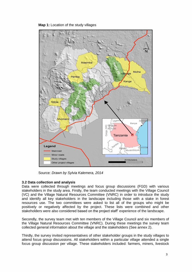
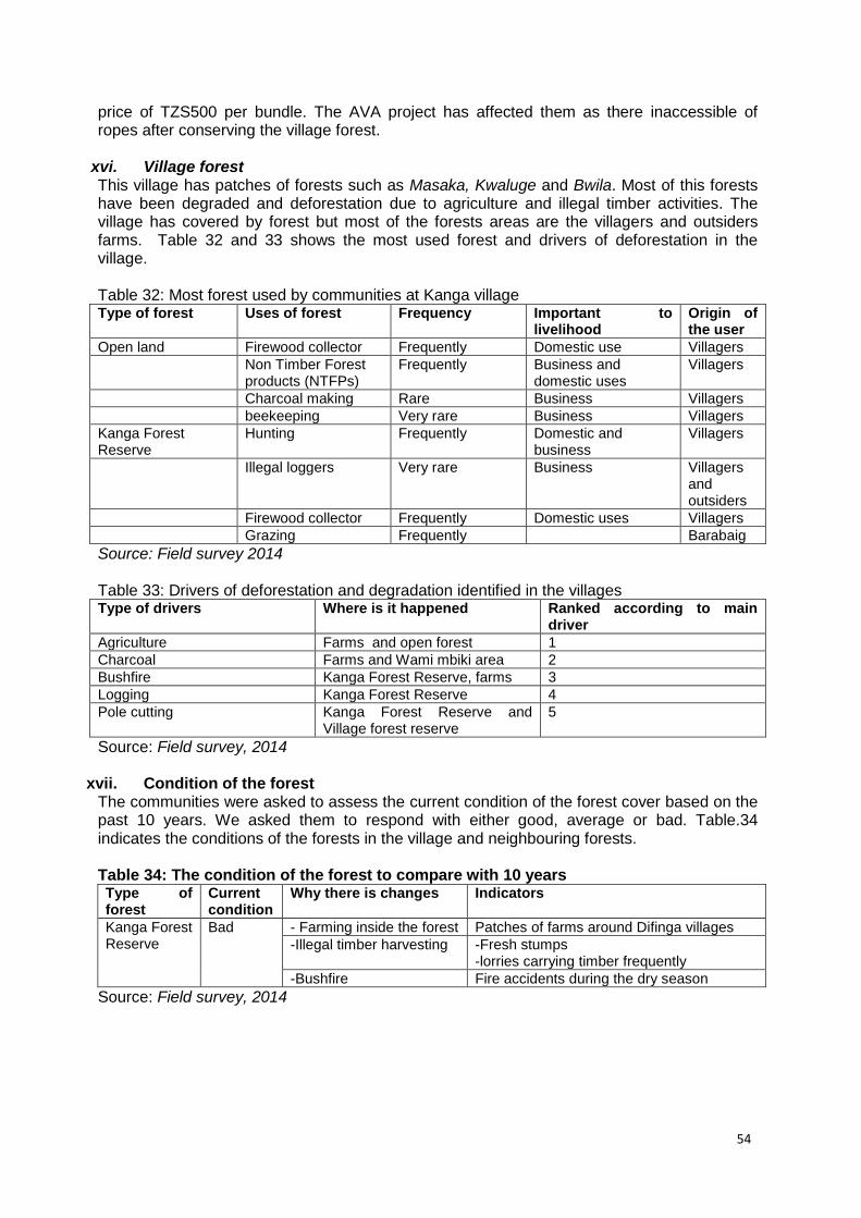
3.1 Study area The South Nguru Mountain landscape is located between 5˚ 50’ S to 6˚ 10’S and 37˚ 25’E 37˚ 47’E. The area is located in Morogoro Region, Mvomero District and includes Hembeti, Maskati, Mtibwa, Diongoya,Sungaji, Pemba, Kinda Kanga, Mhonda, Kibati and Mvomero wards. There are two main forest reserves within the landscape which are Kanga Forest Reserve and Mkingu Nature Reserve. There are also patches of forest and woodland on village land. The project villages come from 9 wards (Hembeti, Maskati, Diongoya, Sungaji, Pemba, Kinda, Kanga, Mhonda and Mvomero) has a combined population of approximately 101,581 people with a population growth rate of 2.6% (URT, 2013) See Annex 4. In terms of ethnic composition, focus group discussions found that the South Nguru Landscape is inhabited mainly by Nguu and Kaguru who consider themselves as the original inhabitants of the area. The Zigua, Maasai, Luguru, Chagga, Pare, Barabaig, Bena, Sukuma, Kinga, Hehe, Ngoni, and Nyakyusa are immigrants to the area. This study was carried out in seven villages of Pemba, Kanga, Maskati and Mvomero wards in Mvomero district. In three of these seven villages (Kanga, Mziha and Bwage) the AVA project had already introduced some of the planned interventions (awareness raising, Village Land Use Plan (VLUP) & CBFM processes and REDD) at the time of conducting this study. In the other four villages (Masimba, Ndole, Pemba and Mvomero) no interventions had been implemented at the time of conducting this survey. The villages were selected with a view to include villages in different parts of the landscape including highland villages such as Maskati, Ndole and Pemba and lowland villages including Masimba, Mziha, Kanga and Bwage.
3
Map 1: Location of the study villages
Source: Drawn by Sylvia Kalemera, 2014
3.2 Data collection and analysis Data were collected through meetings and focus group discussions (FGD) with various stakeholders in the study area. Firstly, the team conducted meetings with the Village Council (VC) and the Village Natural Resources Committee (VNRC) in order to introduce the study and identify all key stakeholders in the landscape including those with a stake in forest resources use. The two committees were asked to list all of the groups who might be positively or negatively affected by the project. These lists were combined and other stakeholders were also considered based on the project staff’ experience of the landscape. Secondly, the survey team met with ten members of the Village Council and six members of the Village Natural Resources Committee (VNRC). During these meetings the survey team collected general information about the village and the stakeholders (See annex 2). Thirdly, the survey invited representatives of other stakeholder groups in the study villages to attend focus group discussions. All stakeholders within a particular village attended a single focus group discussion per village. These stakeholders included: farmers, miners, livestock
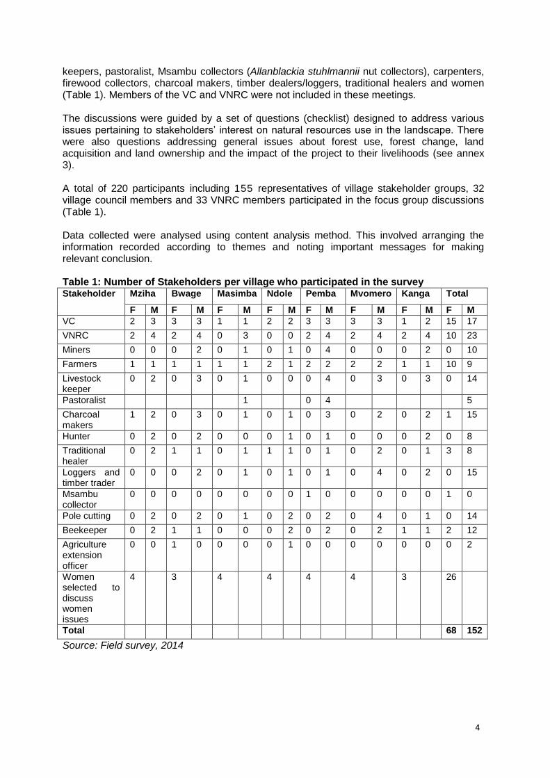
4
keepers, pastoralist, Msambu collectors (Allanblackia stuhlmannii nut collectors), carpenters, firewood collectors, charcoal makers, timber dealers/loggers, traditional healers and women (Table 1). Members of the VC and VNRC were not included in these meetings. The discussions were guided by a set of questions (checklist) designed to address various issues pertaining to stakeholders’ interest on natural resources use in the landscape. There were also questions addressing general issues about forest use, forest change, land acquisition and land ownership and the impact of the project to their livelihoods (see annex 3). A total of 220 participants including 155 representatives of village stakeholder groups, 32 village council members and 33 VNRC members participated in the focus group discussions (Table 1). Data collected were analysed using content analysis method. This involved arranging the information recorded according to themes and noting important messages for making relevant conclusion. Table 1: Number of Stakeholders per village who participated in the survey Stakeholder Mziha Bwage Masimba Ndole Pemba Mvomero Kanga Total
F M F M F M F M F M F M F M F M
VC 2 3 3 3 1 1 2 2 3 3 3 3 1 2 15 17
VNRC 2 4 2 4 0 3 0 0 2 4 2 4 2 4 10 23
Miners 0 0 0 2 0 1 0 1 0 4 0 0 0 2 0 10
Farmers 1 1 1 1 1 1 2 1 2 2 2 2 1 1 10 9
Livestock keeper
0 2 0 3 0 1 0 0 0 4 0 3 0 3 0 14
Pastoralist 1 0 4 5
Charcoal makers
1 2 0 3 0 1 0 1 0 3 0 2 0 2 1 15
Hunter 0 2 0 2 0 0 0 1 0 1 0 0 0 2 0 8
Traditional healer
0 2 1 1 0 1 1 1 0 1 0 2 0 1 3 8
Loggers and timber trader
0 0 0 2 0 1 0 1 0 1 0 4 0 2 0 15
Msambu collector
0 0 0 0 0 0 0 0 1 0 0 0 0 0 1 0
Pole cutting 0 2 0 2 0 1 0 2 0 2 0 4 0 1 0 14
Beekeeper 0 2 1 1 0 0 0 2 0 2 0 2 1 1 2 12
Agriculture extension officer
0 0 1 0 0 0 0 1 0 0 0 0 0 0 0 2
Women selected to discuss women issues
4 3 4 4 4 4 3 26
Total 68 152
Source: Field survey, 2014
5
4.0 RESULTS AND DISCUSSION
4.1: Stakeholder analysis The survey identified various stakeholders in the study area (Table 2). This list of stakeholders was ranked in accordance with their importance in the landscape through pairwise ranking. All of these stakeholder groups were mentioned by the VC and VNRC members. However, there were other stakeholders who were not listed by members of the VC and VNRC. These were Teak growers (growing more than two acres), bird catchers, Mtibwa SUGAR Estate Company Ltd, Mtibwa police station, private land owners (own farm land but do not reside in the landscape), Ward Executive Officers, Ward councillors and Village executive officers. Table 2: List of stakeholders identified in the study area
Rank List of stakeholder Bwage Kanga Mziha Pemba Masimba Mvomero Ndole
1 Small scale farmers 2 Firewood collector 3 loggers and timber
traders
4 Charcoal makers 5 TFS 8 Pole cutter 7 Pastoralist 8 Livestock keepers 9 Miners 10 Carpenter 11 Migrant pastoralists x x x 12 Local Beekeepers 13 Hunters 14 Large scale farmers
>50 acres x x X
15 Traditional Healer 16 Carpenter 17 Fishers x x X 18 Allanblackia
stuhmanii nuts collectors)
x x x x x X
19 Teak growers x x x 20 Mtibwa Estate
company LTD.
VNRC
Source: Field survey, 2014 Note: √ indicates presence of the identified stakeholder. X Note mentioned in the village.
4.1.1 Small scale farmers Small scale farmers are the most prevalent stakeholder group in the landscape (Table 2). According to the discussions with members of the VC and VNRC, every household in the surveyed villages was involved in farming activities. Farmers were involved in the cultivation of both food and cash crops. The preferred food crops were maize, cassava, rice, banana, yam, beans and cowpeas while cash crops included sunflower, sesame, sugar cane and rice (Table 3). Three farming systems were reported to exist in the study area. These are inter-cropping, mono-cropping and agro forestry. Inter-cropping involves mixing of more than one seasonal crop in one plot (maize, beans and cowpeas are mixed together in one plot). Mono-cropping involves cultivation of one type of crop in one plot (sugarcane, rice and sesame).
6
Agro forestry involves mixing trees with crops in one plot. Either farmers planting trees amongst other crops or planting trees along their plot boundaries. It was noted that in the South Nguru Mountains there are two agricultural seasons. The first season is the short rainy season (vuli) which extends from September to December. The second season is the long rainy season which extends from February to May (masika). Of these seasons, the famers prefer to cultivate during the long rains as they are assured of harvesting. While in the short rains they are not assured of harvesting. It was also noted in the landscape that there are some farmers who practice a type of shifting cultivation where they stay in the same area for two to three years and then shift to another farm. This case has been reported in Mziha, Ndole, Masimba and Pemba villages. Table 3: Type of crops cultivated in the landscape Village Main crops cultivated listed according to their more cultivated at the village
Bwage Maize, Sesame, Rice, Sunflower, Cowpeas, Kunde and Vegetables
Kanga Maize, Rice, Sugarcane, Sesame, Sunflower and Cowpeas
Mziha Maize, Cowpeas, Beans, Sunflower, Sesame, Groundnuts, and Rice
Ndole Maize, Beans, Cowpeas and Sesame
Pemba Maize, Cassava, Banana, and Beans Yam
Mvomero Maize, Rice, Sunflower, Cowpeas, Beans and Millet
Masimba Maize, Sunflower and Groundnuts
Source: Field survey, 2014
The survey noted that the average maize production, which was the main crop in the landscape, was 8.3 sacks per acre (one sack weighs 100 kg) (Table 4). This was considered to be low production for farmers who use local seeds. During various discussions the agriculture extension officers claimed that “Farmers who follow recommended maize farming practices can harvest 8 to 15 sacks per acre using local seeds while farmers who use improved varieties of maize (Tan seeds and Seedco) can harvest 16 to 30 sacks per acre. Tan seeds can produce 16 to 28 sacks per acre and seedco can produce 25 to 30 per acre”. Together with low maize production, other challenges were farmers land use conflict with pastoralists. The results showed that out of the 7 villages that were surveyed, farmers from 4 villages reported land use conflict between farmers and pastoralists. This conflict arises during the dry season (July to December every year) where the pastures available for animal grazing start to decline in Kilindi, Kiteto, and Handeni districts. Pastoralists then move into the South Nguru Landscape to graze on crop residues in farmers’ fields. Participants in the focus group discussions stated that some farmers, after harvesting their crops, rent out their farms to the pastoralists for a period of two months for grazing their cattle. A farmer who rents out his / her farm to a pastoralist can earn TZS 5,000 per acre per two months. Table 4: Crop production in the landscape Production per acre
Crop Unit Bwage village
Kanga village
Mziha village
Pemba village
Masimba village
Mvomero village
Ndole village
Mean
Maize Sacks1 5 8 8 7 9 8 13 8.3
Rice Sacks 5 10 13 11 9.8
Sesame Sacks 5 3 3 2 3.3
Sugarcane Tons 40 50 45
Beans Sacks 2 5 2 5 3 3.4
Kunde/cowpeas Sacks 2 4 6 5 1 3.6
Tomato Package of 60 to 70kg
120 100 110
Sunflower Sacks 7 3 7 6 7 6
Groundnuts sacks 6 2 4
1Sack = 100 kg Source: Field survey, 2014
7
4.1.2 Large scale farmers Within the AVA project area there are large scale farmers who own more 50 acres. These farmers are found in the lowland villages (Bwage, Kanga, Mziha, Mvomeo and Masimba) however most of them are not staying in the villages. The main crops that they cultivate are sugarcane, maize, sesame and paddy. However, some of these large farmers own large woodlots in the landscape which are not yet developed. The discussions with VC and other stakeholders revealed that local based dwellers complained that they don’t have adequate land for cultivation which leads them to open farms at the forest reserve land such as Kanga Forest Reserve and Wami Mbiki WMA. 4.1.3 Firewood collectors During focus group discussions, participants stated that firewood collectors were collecting firewood from their farms, village forest reserves and sometimes in Kanga Forest reserve and Mkingu Nature Reserve (Table 5). However, entering Mkingu Nature Reserve and Kanga Forest Reserve was restricted. Collection of firewood in these reserves was only allowed with permission but communities were not willing to obey the laws. Various group participants contended that dead branches of trees and shrubs were most preferred for collection because they were easy to carry. Table 5: Places where firewood collected Village Where do they collect firewood Any restrictions
Bwage Village Forest Reserve, Kanga Forest Reserve and their farms
Restriction in Kanga forest reserve, VFR allowed under conditions, free in the farms
Kanga Kanga Forest Reserve and their farms Not allowed in the reserve
Mziha VFRs, farms and sometimes in Kanga forest reserve
Permission required in VFRs, restriction in Kanga Forest Reserve
Masimba Farms and open areas No restriction
Pemba Mkingu NR, unreserved forest and farms Restriction in Mkingu
Mvomero Farms and unreserved forests No restriction
Ndole Open area/unreserved forest land and farms
No restriction
Source: Field survey, 2014 It was also noted that men, women and youth were involved in firewood collection. Men and youth do the collection mostly for business purposes while women collected firewood for domestic uses. The most preferred tree species for firewood was Combretrum molle (Mlama), Brachylaena hutchinsii (Mhugwe), Brachystegia microphylla (Msami) and Brachystegia spp (Mrwati). The average price of a 20 kg bundle of firewood is TZS 2,000. A study by Raben (2006) found that firewood collection is the activity within the Mkingu Forest Reserve in which most local inhabitants have had a stake. The study further noted that women collect firewood mostly for cooking. Male youths, often poor with few alternative income-generating activities, derive an income from the sale of collected firewood. The focus group discussions in all of the surveyed villages revealed that firewood availability is not a problem in the lowland villages (Mziha, Kanga, Bwage and Masimba) but in highland villages, this seemed to be a problem (Ndole). There were villages in which ten years ago firewood was not sold but nowadays people are selling firewood. During the focus group discussion, it was stated by Mama Rashid from Ndole that. “Hali tunakoelekea ni mbaya sana, watu wananunua kuni na kuweka kwenye bajeti zao, hapa kwetu Ndole hali si mbaya sana lakini nenda vijiji kama Semwali, Maskati na Dibago watu wananunua kuni hadi shilingi 2000 hadi 3000 kwa fungu la kupikia chakula mara tatu tu. Je baada ya miaka mingine kumi tutafika wapi” meaning that the coming years the situation will be worse. The villagers were
8
not bought firewood over past ten years but now people buy firewood. This was noted in Ndole village but the situation at Ndole is not as bad as in Semwali, Maskati and Dibago where they buy a single bundle of firewood for TZS 2000 to TZS 3000 which can be used only three times. This is an indicator that the firewood has been decreasing in the highland villages.
4.1.3 Loggers and timber traders There were four groups of people involved in the logging and timber trade in the landscape as listed by respondents during focus group discussions. The groups were loggers who were staying within as well as outside the village and labourers who help to carry pieces of timber from the forest to station where the vehicle or motorcycle (Plate 1) can pick this up (carrying one piece for TZS 1000). Other groups were traders who may come from the village or may be outsiders and the last group were transporters (Plate 3). The focus group discussions estimated that 80% of the traders were people from outside of the villages and 20% were the small scale traders who sell timber to local people for construction. The survey also noted that the traders, particularly those coming from outside of the project area, were the main actors in the timber trade. They provided the chainsaw and advance payment to the loggers (Paid them TZS 2,000 per piece) to prepare timber for them. Those who carry the timber from the forest to the loading area were paid an average of TZS 1,500 per piece of timber. Various participants asserted that the major markets for timber were Madizini, Morogoro, Dar es Salaam and Arusha. In the surveyed villages, an average of 1,000 pieces of timber per village was thought to be traded per month. This makes 7,000 pieces of timber per month in the studied villages. The price of timber per piece depends on the type of species but most timber of the size 2x4 inches were sold at TZS 4,000 per piece and for 2x6 inches was sold at TZS 6,000 per piece. The most preferred species for timber are indicated in table 6.
Table 6: Prefered species for timber in the landscape Local name Scientific name
Mninga Pterocarpus angolensis
Mninga maji Pterocarpus tinctorius
Mkangazi Khaya anthotheca
Mvule Mellisia excels
Mpilipili Schinus molle
Mseni Brachystegia spp
Mng’ongo Ekebergia capensis
Msufi pori Ceiba pentanda
Mhembeti Sterculia spp
Mfimbo Belschmedia kweo
Source: Field survey, 2014 The conflict between Village Natural Resources Committee (VNRC) members and timber dealers was also reported. These conflicts arise as timber dealers enter into the forest reserves to harvest timber without permission. The VNRC and village council also complained that some loggers come from the district with permit without consult them in the villages. Furthermore, VNRC complained that in some cases village leaders were providing permit to small scale loggers in the village land without consulting them.
9
Plate 1: Model of transport of logs and timber (motorcycle). A man stands near a motorcycle which is loaded with a log ready to be transported.
Source: Lyimo, E. 2014
Plate 2: Logs waiting to be loaded in the track at Difinga village Source: Nlelwa R, 2014
4.1.5 Charcoal makers Charcoal making and trading was observed in the visited villages. Various discussions indicated that this activity is carried out as the main economic activity for some as well as being a subsidiary activity for others. The villages that considered charcoal making as an economic activity were Mziha, Ndole, Difinga, Msolokelo and to a lesser extent in Bwage
10
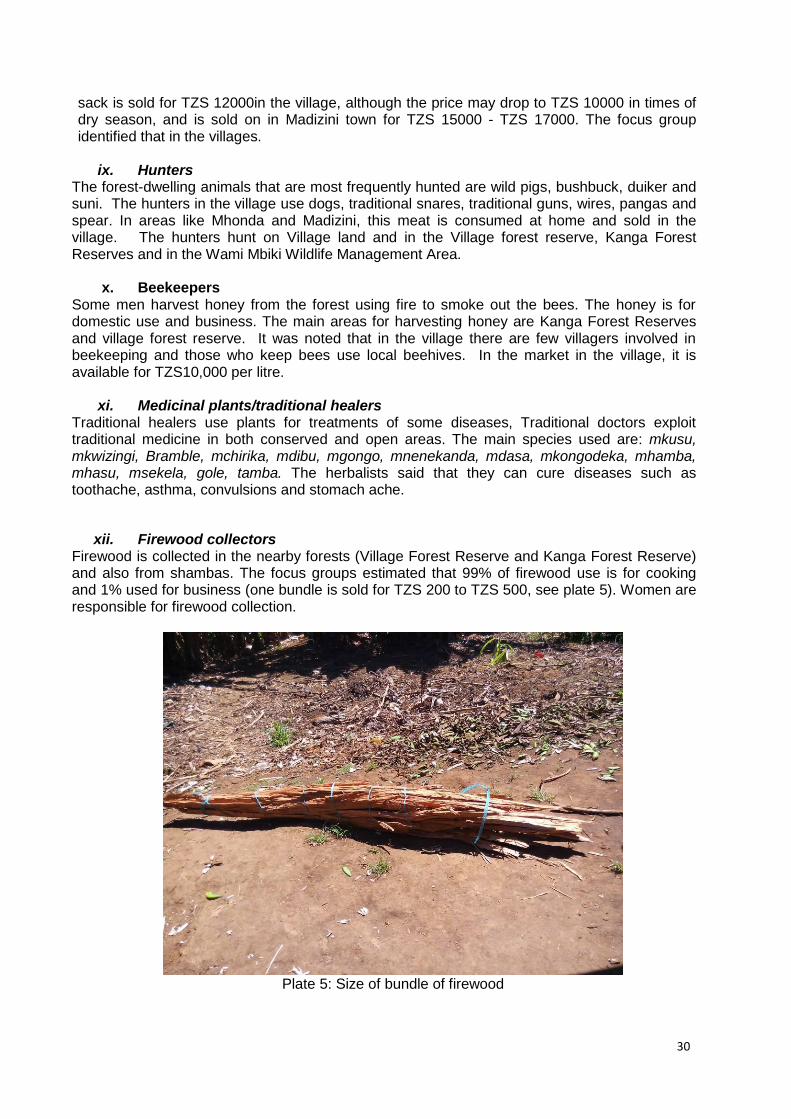
(although the survey didn’t visit Difinga and Msolokelo, neighbouring villages reported that people from these villages practiced charcoal making as an economic activity). This was also noted and observed by enumerators when they were on the way to Masimba village. In Masimba, Kanga and Mvomero villages charcoal production was conducted as a subsidiary economic activity. The focus group revealed that many people were involved in charcoal making when clearing new farms as they use the cleared logs to make charcoal. Others were involved in charcoal making by clearing forest in public land. Two types of charcoal makers were noted; first, those who lived within the study villages and others who live outside of the landscape. The activity was carried out by both men and women. The survey noted that the preferred tree species for charcoal making in the study area were Brachystegia spp (Msemi), Brachystegia spiciformis (Miombo), Pteleopsis myritifolia (Mngoji), Brachylaena hutchinsii (Mhugwe) and Combretrum molle (Mlama). These were preferred due to their high calorific values compared to other trees. In every study village there were a few members of the community involved in this activity. Most of the study villages do not use charcoal for cooking. They mainly use firewood instead. Charcoal is mainly sold to nearby towns and villages close to the town such as Mvomero and Madizini Townships. The rest is transported to Morogoro town and to the city of Dar es Salaam. It was also noted that some of the businessmen were not paying a levy to the respective village government as per the regulations. The price was estimated at TZS 10,000 – TZS 12,000 per bag at gate price (within the village) and TZS 15,000 – TZS 17,000 per bag at Madizini and Mvomero Township. Ndole village for example have been receiving several businessmen from Morogoro and Dar es Salaam with permission from Mvomero District for charcoal making in their village land.
4.1.4 Pole cutters Pole cutting is another activity carried out in the landscape. In three of the visited villages (Mziha, Kanga and Bwage) people cut poles in Village forest reserves, and Kanga Forest Reserve. In Pemba, pole cutters access open areas, farms and Mkingu nature reserve. Ndole and Msimba access only open areas and farms for pole cutting. Others were also cutting poles from their own farms and open areas. Villagers in Ndole, Masimba, Pemba and Mvomero villages asserted that there are no laws concerning pole cutting in the village land, therefore anybody can collect poles anywhere without permission. Poles were mainly for domestic purposes such as for construction and for hand hoes. However, in villages such as Pemba, Mziha and Ndole there were villagers selling poles. Poles were mainly sold inside the village and in Madizini Township at TZS 1,000 to TZS 5,000 per bundle and TZS 500 for a hand hoe. A similar situation was reported by Raben et al., (2006) who reported that communities in the South Nguru Landscape were cutting poles from the forests and open areas for the purpose of house construction and hand hoe handles. The preferred tree species for poles included Brachystegia spiciformis (Miyombo), Bequaertisdendion natalense (Mduru), Accacia spp (Mgunga), Pterocarpus angolensis (Mninga), Spirostachys africana (Msalaka), Acaccia nigrescens (Mkambala), Markhamia obtusifolia (Mtandawala), Milletia lasiantha (Mhafe), Brachylaena hutchisis (Mhugwe) and Pentas purrurea (Magugu). The villagers strongly complained that nowadays it take much longer times to collect poles compared with the past 10 years. In the past years, villagers from Kanga, Bwage and Mziha reported that they were collecting poles from the land close to their house but nowadays it takes more than an additional 1 to 3 hours. However, in Ndole and Masimba villages, villagers reported that there were still plenty of poles around the village land.
11
4.1.5 Livestock keepers Within the AVA project area there are farmers who keep livestock such as cattle, goat and poultry. It was estimated that 99% of the households keep poultry (local chicken). However, women and sometimes children are the ones who are responsible for taking care. The discussions also noted that people use free range systems where the chicken are left to freely search the farms and house yard for food. Most people keep poultry as alternative source of income, particular when they get an urgent need of money. Poultry is also used for domestic uses such as food for the household and prestige food for visitors. The price of chicken in the landscape range from TZS7000 up to TZS10000 per chicken in the village while at Madizini range from TZS10000 to TZS 15000. Furthermore, it was noted that the livestock keepers in this landscape keep cattle, ranging from one to ten heads. Most of them keep dairy cattle in zero grazing system. It was observed that the livestock keepers can get 5 to 10 litre of milk per day. One litre of milk is sold forTZS1000. The discussions also noted that the livestock are very important for daily livelihoods income. In addition to that, some farmers in Kanga and Bwage villages, use manure from cattle to their farms and home gardens. It was observed in the landscape, goats and sheep are kept as coping strategies/social economic securities. Mama Masawe from Kanga village states that “Mbuzi ndio mkombozi wetu tunapopata dharura” meaning that goat and sheep are the big help in solving emergence problems. The price of one goat in the village is sold from TZS40000 to TZS60000 depend on the size and this price increases during the holidays, particularly Christmas and Ramadan.
4.1.6 Pastoralists In the landscape there are two types of pastoralists: immigrant pastoralists and permanent resident pastoralists. Immigrant pastoralists who are immigrating to the village during the dry seasons (July to December) search for pasture. Based on the focus group discussion with Village councils it was noted the pastoralist who are migrating to the villages are Barabaig, Maasai, Mbulu and Sukuma who mostly come from Kilindi, Handeni and Kiteto with the average herd size of 500 to 2000 per herder. According to the discussions, most of these group were not recognized by village government. On the other hand, permanent resident pastoralists who have been living and grazing their herds on the landscape for a long period, are recognized by and are part of leadership at village and ward level. Pastoralist from Masimba, Bwage and Ndole said that, in the village there was no specific area for grazing hence sometimes they were tempted to graze their cattle in the village forest reserve and government forest reserves. Similar findings were also reported by Raben et al., (2006) who demonstrated that the Maasai pastoralists were using grazing areas within the South Nguru landscape. They normally graze all over the landscape, at the forest boundary and sometimes within the forest reserves. Their grazing patterns were sometimes conflicting with the interests of the local farmers. This was evident in Bwage which had a good number of pastoralists, but their land use plans did not specify areas for grazing (MVDC, 2013). Despite, the fact that pastoralists were discouraged in the visited villages, they play an important role in the community. Their livestock provide meat and milk to the people in the landscape. The pastoralists participated in the development project such as construction of school, dispensaries and other social facilities.
12
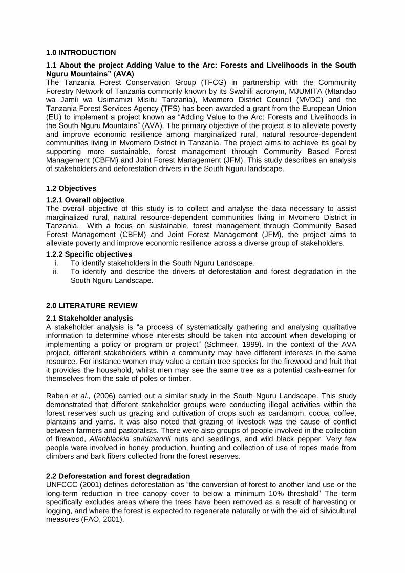
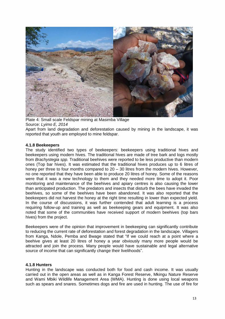
4.1.7 Miners The focus group discussions revealed that gold mining was carried out in all villages in the landscape (Plate 3). Another mineral that is being mined in the landscape is feldspar which is extracted in Masimba, Pemba and Msolokelo villages (Plate 4). The mining activities were reported to contribute to deforestation and destruction of riverbanks due to cutting down of trees. People were cutting down and up-rooting trees in the process of mining as they believed that gold stays under the trees. The villagers revealed that a market for gold is available within the project villages and outside the landscape. A gram of gold was sold between TZS 80,000 and TZS 100,000.
Plate 3: Small scale gold mining at Bwage Village Source: Lyimo E, 2014
13
Plate 4: Small scale Feldspar mining at Masimba Village Source: Lyimo E, 2014 Apart from land degradation and deforestation caused by mining in the landscape, it was reported that youth are employed to mine feldspar.
4.1.8 Beekeepers The study identified two types of beekeepers: beekeepers using traditional hives and beekeepers using modern hives. The traditional hives are made of tree bark and logs mostly from Brachystegia spp. Traditional beehives were reported to be less productive than modern ones (Top bar hives). It was estimated that the traditional hives produces up to 6 litres of honey per three to four months compared to 20 – 30 litres from the modern hives. However, no one reported that they have been able to produce 20 litres of honey. Some of the reasons were that it was a new technology to them and they needed more time to adopt it. Poor monitoring and maintenance of the beehives and apiary centres is also causing the lower than anticipated production. The predators and insects that disturb the bees have invaded the beehives, so some of the beehives have been abandoned. It was also reported that the beekeepers did not harvest the honey at the right time resulting in lower than expected yield. In the course of discussions, it was further contended that adult learning is a process requiring follow-up and training as well as beekeeping gears and equipment. It was also noted that some of the communities have received support of modern beehives (top bars hives) from the project. Beekeepers were of the opinion that improvement in beekeeping can significantly contribute to reducing the current rate of deforestation and forest degradation in the landscape. Villagers from Kanga, Ndole, Pemba and Bwage stated that “If we could reach at a point where a beehive gives at least 20 litres of honey a year obviously many more people would be attracted and join the process. Many people would have sustainable and legal alternative source of income that can significantly change their livelihoods”.
4.1.8 Hunters Hunting in the landscape was conducted both for food and cash income. It was usually carried out in the open areas as well as in Kanga Forest Reserve, Mkingu Nature Reserve and Wami Mbiki Wildlife Management Area (WMA). Hunting is done using local weapons such as spears and snares. Sometimes dogs and fire are used in hunting. The use of fire for
14
hunting has contributed to deforestation and forest degradation in the South Nguru Landscape. The meat obtained from hunting is usually consumed at home and surplus is sold for TZS 1,000 to TZS 4,000 per piece. The animals hunted were mainly Bushbuck, Suni, Bush pig, and Sykes monkey. A study by Raben (2006) et al. also reported the same situation. The survey revealed that hunters were the sources of bushfire as they use fire during hunting to increase vision, ease mobility and when chasing animals in a certain direction. However, the hunters reported that animals have become more scarce over the last 10 years. Nowadays hunters have to go further into the forest to find animals such as suni and bushbuck. For example, it was reported in Bwage, Kanga and Mziha Villages in 10 years ago these animals were available in people’s farms. These villages are close to the Wami-Mbiki WMA. Member of the focus group from Mziha state that “Zamani watu wengi walikuwa na wanyama kama chui, watu walikuwa wanakula nyama za porini takribani kila wiki lakini sasa hazipatikani tena mbuga ya wamimbiki imekwisha kabisa” meaning that ‘in the past many people were injured by animals like leopard and people ate bush meat almost every week but now it is not available and wildlife in Wami-Mbiki WMA are completely finished’.
4.1.9 Sambu Allanbackia stuhlmanii nuts collectors Allanbackia stuhlmanii is an important tree species found in the landscape. Both women and men in the landscape are involved in the collection of Allanblackia stuhlmanii nuts. Collection is mostly collected in Mkingu Nature Reserve where it is more abundant than in other forests in the area. However, it was reported that the Allanblackia stuhlmanii nuts over the ten past years were collected in people’s farm but nowadays people have to go further inside the reserve to collect nuts. The main buyer of the Allanblackia stuhlmanii nuts was Novella Development Tanzania LTD (NDTL) in Morogoro. One kg of the nuts was sold between 300TZS and 500TZS. NDTL later process the nuts and sell the (same processed oil) to Unilever Company to make various finished products including margarine.
4.1.10 Medicinal plants/Traditional healer During the focus group discussions, it was revealed that there were traditional healers in the South Nguru Landscape particularly in the surveyed villages. The discussion confirmed that the traditional healers were using traditional medicine mainly obtained from the forests particularly village land forests, Kanga Forest Reserve and Mkingu Natuure Reserve. The tree species that are most preferred for traditional medicine to heal various diseases are shown in table 7.
4.1.11 Black pepper collectors Black pepper is another important tree species (Pipe nigrum) found in the landscape. It was a perennial vine and climber that requires supporting trees or pole to grow in height. Men in the landscape are involved in the collection of black pepper. Collection is mostly collected in Mkingu Nature Reserve and Kanga Forest Reserve where it is more abundant than in other forests in the area. It was stated that black pepper is one of the most spice used during the Ramadan month. Table 7: Most preferred species for traditional healer Scientific name Local name Disease
4.1.12 Village Natural Resource Committee (VNRC) In the landscape there is VNRC who responsible in managing the village forest reserve on behalf of other villagers. It was reported that out of 7 villages surveyed 6 villages (Ndole, Mvomero, Pemba, Kanga, Bwage and Mziha) had VNRC while 1 Village (Masimba) has no VNRC. It was noted that there some villages (Kanga, Bwage and Mziha) has active VNRC, these were currently elected under the AVA project. The other villages (Ndole, Mvomero and Pemba) which were dormant were selected during PEMA project. The members were dormant due to corruption among of the members, lack of communication between VC and VNRC, lack of communication between VC and TFS or Mkingu NR. The other reasons outlined were lack of funds and working gear such as boots, raincoats and weapons during the patrol. Also the VNRC blamed timber and charcoal dealers for coming to the district with a permit but without communicating with the village.
4.1.13 Village Council (VC) All seven villages have a government structure which is composed of the following three committees: Planning and Finance; Education and Social Welfare; Defence and Security. This organisational set-up is centrally determined by the Local Government Authority system. There are also several small committees for the implementation of public, village government activities and projects such as the construction of schools, health facilities and the village natural resources committee.
It was realized that in the landscape village government administration is like other villages in the country. In terms of internal set up, each village is governed by the village government under a chairperson (Mwenyekiti wa kijiji) while the sub village is led by sub village chairperson (Mwenyekiti wa kitongoji). Moreover, the village has a government representative who is an village secretary or Village Executive Officer (VEO-mtendaji wa kijiji) who is the salaried civil servants. He/she is the organizer of all meetings, security and are major actors at the village level. It was reported in the discussions that in the villages where the VEO is weak, the development of that village performs poorly. Hence the strength of VEO lead to good governance in the village and made more villagers participate in the development activities. It was noted during the discussions in the village where there was a strong VEO the level of participation was high and organization of meetings and groups discussion were excellent. On the other hand, poor governance skills were observed in all study villages. This has led to poor fulfilment of their roles and responsibilities of committees, Village councils and the villagers. For example, few members were attending the VC meetings; the Village Assembly meetings were supposed to be held at least 4 times a year but it is not always the case in
16
Bwage, Mziha, Pemba, Mvomero and Kanga. This indicates the need for training on good governance in order to have strong and committed leadership in natural resources management in the landscape. Never will they be able to stop deforestation and forest degradation without improvement in good governance. The capacity of the communities to govern needs to be nurtured.
4.1.14 Ward Executive officers Ward executive officer (WEO (Mtendaji wa kata)) who is salaried civil servant to whom all village Executive Officers report is a key person in all matters pertaining to the development and welfare of the villages. She/he is under the direct supervision of the District Executive Director (DED) and is also an important link for all matters from the District Commissioner and for all extension services originating from the different departments at the district level. It was observed in the landscape that WEO have significant influence on the development and management of this landscape. Many cases related to the forest management were reported to the WEO in different wards in the landscape. Although the WEO has influence many stakeholders asserted during the focus group that WEOs are not able to follow up and act on the village level. This is link to poor performance of VEO at village level.
4.1.15 Extension service In many surveyed villages in the landscape, there are agr icultural f ie ld extension officers posted to the village levels. In some of the villages that were visited the team was able to invite the agriculture extension officers (who are either stationed at the village or ward headquarters) to the focus group discussions. The community members and key stakeholders who were involved in the discussions blamed the agricultural field exstention officer for their lack of adequate extension services such as frequent farm visits and absence of farm field school or demonstration plots. It was reported that the district agriculture officers come once in a while and sometimes do not visit some villages for a couple of years. This could be attributed to lack of manpower at the district or financial resources.
4.1.16 Ward Councillors Ward Councillors are political leaders elected by villagers at the ward level. They can be selected from any political party but, once elected, should represent everyone fairly and balance local concerns. These are important stakeholders in the project area due to the high levels of influence they have with the communities. The main task of this stakeholder is to facilitate the communities to initiate projects, support the projects and help to implement development projects at the ward level. The community acknowledged councillors’ activity levels varied from place to place according to the interests, political motivations and the skills of the individual councillors. It was noted that in those project villages where the councillors are close to community, the communities are more likely to engage actively in the AVA project. Similarly, it was also observed that in those villages where the AVA project made an intervention with the involvement of ward councillors, there was more cooperation at village level. During the community-level discussions, it was noted that villagers would refer to ward councillors’ support for the project as a basis for the communities’ involvement. Also some villagers have reported cases of illegal activities to the councillors.
4.1.17 Traders in wildlife Based on the focus group discussions in seven villages, none of the villages reported the presence of wildlife trading. However, it was stated that over the past 10 years there have been traders of wildlife such as chameleons and birds. Nowadays, this trade does not exist particularly in Ndole, Kanga, Masimba, Pemba, Mvomero, Bwage and Mziha villages. Members of the focus group from Pemba and Ndole reported that there were people trapping birds at Ubiri and Maskati. The village chair from Ubiri and Maskati said that most bird
17
trappers come from Arusha and use local communities to collect the birds from the Mkingu Forest Reserve. Based on the Maskati village chair, the bird trappers visited the villages secretly. The numbers of bird trappers were not many compared to the past years. This results do not differ much with the study carried by Raben et al., (2006) which revealed that a single case of commercial bird trapping (Kulukulu bird) was identified at Ubiri village.
4.1.18 Tanzania Forest Services (TFS) The main interest of the TFS as a stakeholder is sustainable management of the nation’s forests. The TFS is seen by the other stakeholders as having a high capacity to influence the outcome of the management of the landscape, since they have the overall mandate and control over the management of the nation’s forests and forest resources. Of all stakeholders, the TFS is perceived to have the highest capacity to facilitate CBFM and JFM in the South Nguru Landscape. TFS is represented by the TFS manager at Mvomero District and the Mkingu Nature Reserve conservator and 2 fields based technical officers at both Kanga Forest Reserve and Mkingu Nature Reserve.
4.1.19 Small scale carpenters Their main interest is regular supply of wood for their work. They rely mostly on Kanga forest reserve, Mkingu Nature Reserve and patches of forest found in the village land. The small scale carpenters use chain-saws to obtain lumber since they experience difficulties in obtaining supplies from loggers. The small-scale carpenters are generally not organized. During the focus group discussions they complained that they were not involved in the management of Mkingu and Kanga Forest Reserves although they depend on the resources. “They do not invite us to the workshops during the planning but rely on us by asking questions during the interviews” said one carpenter from Bwage focus group discussion. This implies that even small groups should be considered in the project implementation so that they can make the project more sustainable even after phasing out.
4.1.20 Teak plantation and teak growers Teak is a commonly planted commercial tree species in the lowlands of the South Nguru landscape. The TFS-owned Mtibwa Teak Plantation is the largest teak plantation. Mtibwa teak plantation plays an important role by distributing seedlings and seeds to small teak growers. It also provides employment (planting of seedlings and guards) to the communities surrounding the plantations. Teak is also grown by small scale teak growers where the farmers either in woodlots or as scattered trees in their farms. According to discussions, noted that teak is considered as a multiple purpose tree for agro forestry in many plots of the landscape. In Kanga, Mziha and Bwage, it is reported that farmers are increasingly planting teak as an investment for the future. Out of the teak growers in the small plantations people have planted teak in their gardens to supply their own requirements of wood as saving accounts for their children and to use in special cases of need. It was also observed that more and more in the lowland villages, teak is planted with the view of providing a supply of industrial wood. 4.1.21 Mtibwa Sugar Estate Ltd (MSE) Mtibwa Sugar Estate Ltd is located in Turiani Division, 102 km north of Morogoro town. It is situated at an altitude of 350m above sea level at the Eastern foothills of the South Nguru Mountains. Sugarcane growing and the production of sugar and related products are the main activities of Mtibwa Sugar Estates Ltd.. Cane is supplied from the company’s own fields and a small portion from small out growers in surrounding villages. Part of the sugar produced is exported to the EU under the Sugar Protocol while the remaining is sold locally (http://www.superdoll-tz.com/Mtibwa-Sugar.html).
18
In the discussion, it was stated that before 2011 the communities adjacent to Mtibwa estate were solely depend on Mtibwa Company for their livelihoods. The community used to secure employment like casual labour and permanent employees, out growers who produce the sugarcane in their own farms and supply to the company, and other jobs such as mama lishe, shops, tractor owners, and vehicle company owners. However, recently things have changed as the company failed to purchase sugarcane from out growers, let go off redundant workers and ceased to play employees on time. This situation, it was said, has led to many out growers abandoning their sugarcane farms and engaging in farming other crops like maize and paddy. The redundant employees opened new farms in the forest reserve and others engaged in causal labour, especially the charcoal business and logging.
4.1.22 JUVIHIMTU JUVIHIMTU is an apex of Village Savings and Loan Association/groups (VSLAs) from Mvomero and Turiani division. It is registered as Community Based Organization with registration number MG/MVDC/CBO/00023. However, the apex has been extended up to Wami Dakawa ward and some villages from Kilosa district. That makes a total of 486 VSLA/groups from Turiani, Mvomero, Wami Dakawa and some villages of Kilosa district. The aim of this organization is to reduce poverty through formation of Village Savings and loans Associations which lead to increase the access of low income farmers to access loan easily for investment in the other economic activities. Based on the discussions with stakeholders in the landscape, it was noted that TFCG
(through AVA project) has been collaborating JUVIHIMTU hand in hand to support the VSLA
members by strengthening the existing VSLA, formation of new VSL groups and training
more Community Based Trainers (CBT).
Villagers acknowledged that JUVIHIMTU has a good aim but the following problems were
noted: lack of reliable sources of funds, lack of facilities and technical knowledge.
4.1.23 Women in the landscape In the landscape women perform the bulk of household work. During the focus group discussions, women mentioned that although a husband and wife sometimes participated in the same work like going to the farm but when they return back from farm, men have to rest while women participate in other activities like preparation of food for her family, collection of water, firewood and other small activities at home. The women in Mas imba village stated that “Utaona tumetoka shamba wote lakini mwanaume anapumzika na kusikiliza radio”. Meaning that you can see us all coming back from the fields but the men just rest and listen to the radio. In addition women’s rights to property are determined by the lines of gender and subordination within the household and the community in the specific customs and cultures. In landscape communities and of course in some other ethnic group like Maasai and Barabaig it was reported that traditionally women are not allowed to own property like cows and farms and in those households, property is owned exclusively by the husband. But among other ethnic groups in the landscape like Nguu, Zigua and other tribes, women are allowed to own a farm, cows and other properties. At times, women may have equal opportunities in terms of education and participation in the development activities. But it was noted that in some villages, husbands did not allow their wives to participate in the village committees such as the village natural resources committees because the men felt jealous and did not want their wife to go on patrols in the forest with other men.
19
Gender is an important factor. The daily division of labour by gender and participation of women in the development activities at each stage is an area to be further investigated.
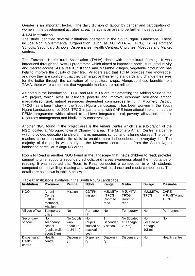
4.1.24 Institutions The study identified several institutions operating in the South Nguru Landscape. These include Non Governmental Organization (such as MJUMITA & TFCG, TAHA) Primary Schools, Secondary Schools, Dispensaries, Health Centres, Churches, Mosques and Market centres. The Tanzania Horticultural Association (TAHA) deals with horticultural farming. It was introduced through the iWASH programme which aimed at improving horticultural productivity and market access. As a result in Kanga and Masimba villages, vegetable production has help to improve the quality of their life. Villagers said that TOHA provides free knowledge, and now they are confident that they can improve their living standards and change their lives for the better through the cultivation of horticultural crops. Alongside these benefits from TAHA, there were complaints that vegetable markets are not reliable. As noted in the introduction, TFCG and MJUMITA are implementing the Adding Value to the Arc project, which aims to alleviate poverty and improve economic resilience among marginalized rural, natural resources dependent communities living in Mvomero District. TFCG has a long history in the South Nguru Landscape. It has been working in the South Nguru Landscape since 2003. TFCG in partnership with CARE international implemented the PEMA programme which aimed to achieve integrated rural poverty alleviation, natural resources management and biodiversity conservation. Another NGO found in the project area is the Amani Centre which is a sub-branch of the NGO located at Morogoro town at Chamwino area. The Mvomero Amani Centre is a centre which provides education to children, farm, nurseries school and tailoring classes. The centre teaches children essential life skills to enable more independence in everyday life. The majority of the pupils who study at the Mvomero centre come from the South Nguru landscape particular Mkingu NR areas. Room to Read is another NGO found in the landscape that: helps children to read; provides support to girls; supports secondary schools; and raises awareness about the importance of reading. It was reported that Room to Read conducted a competition in which students competed on storytelling, reading and writing as well as dance and music competitions. The details are as shown in table 6 bellow. Table 8: Institutions available in the South Nguru Landscape Institution Mvomero Pemba Ndole Kanga Mziha Bwage Masimba
NGO Amani Centre, ERICK memorial, Mission
Mission CDTFN, mission
MJUMITA, TFCG, Room to read
MJUMITA, TFCG, Room to read
MJUMITA, TFCG,
CARE, MJUMITA and TFCG
Village office Temporary office
No Permanent
No Temporary No Permanent
Secondary school
No secondary school (pupils walk about 2km)
No (pupils walk about 15 to 24 km)
No (pupils studied at maskati sec)
1 Secondary school
No (located at Kanaga 20Km)
No (located at Kanaga 10Km)
No
Dispensary/Health centre
Health centre
Dispensary
Dispensary
Dispensary
Dispensary No Health centre
20
Primary court
located at the village
No No No No No No
Primary school
Three primary school
1 primary school
1 primary school
1 primary school
2 primary school
1 primary school
1 primary school
Police Police station
No police No police No police Police station
No police station
No police station
Teak growers
No teak growers
No teak growers
No teak growers
Teak growers
Teak growers
Teak growers
No teak growers
(tibwa sugar estate company
No No No No No No No
Ward councillors
Yes Yes Yes Yes Yes Yes Yes
Ward executive officer
Yes Yes Yes Yes Yes Yes Yes
Village executive officer
Yes Yes Yes Yes Yes Yes Yes
JUVIHIMTU Yes Yes Yes Yes Yes Yes Yes
Mtibwa Teak plantation
No No No No No No No
Churches Yes Yes Yes Yes Yes Yes Yes
Mosque Yes Yes Yes Yes Yes Yes Yes
Absentees Private land owners
Yes No No Yes Yes Yes No
Source: Field survey, 2014
21
4.2 Drivers of deforestation and forest degradation
4.2.1 Agriculture In all of the villages that were visited agriculture was cited as being the dominant driver of deforestation and forest degradation in the area. This is mainly due to the shifting cultivation system that is practised in the area. Farmers prefer to clear forest to secure new agricultural land. Also there are some people who own large areas of land covered with woodland, which they are gradually clearing result in deforestation. During the focus group discussions villagers claimed that “unaweza kuona maeneo mengi yana misitu mikukubwa lakini maeneo hayo ni mashamba ya matajiri ambao wanakaa nje ya hapa kijijini. Kwahiyo watakapo kuamua kufungua mashamba maeneo yote yatakuwa mashamba” meaning that you can see forest everywhere in the villages but those forests belong to individuals. Hence when they decided to clear their land these forests will change to farms. This statement was also supported by villagers from Bwage and Mziha who said that during the preparation of the village land use plan the villagers failed to set aside large areas for the village forests because every patch of forest belongs to somebody. Furthermore, it was revealed that, agricultural expansion in the landscape has been influenced by population growth and low production of the Mtibwa Sugar Company. There has been an increase in the number of people looking for new areas to farm. Labourers who used to work in the sugarcane plantation are no longer hired by the company so they have decided to clear forests to open up new farms.
4.2.2 Bushfire Bush fire was also mentioned as an important factor that leads to deforestation and forest degradation. Focus group discussions revealed that villagers had experienced fire incidents in the village land forests, Kanga Forest Reserve and Mkingu Nature Reserve. Fire incidents were reported as being frequent by villagers in all seven villages. As mentioned above there is a relationship between bushfire and pastoralists, farmers and hunters. The groups stated that pastoralists believe that burning of grass encourages the regeneration of fresh grass and reduces the tsetse flies which affect their animals. Farmers prepare their farms by burning the grass and other vegetation growing on their fields. The fires then spread to the forest and burn the trees. Hunters use fire to flush out animals and to improve visibility and mobility during the hunting. The charcoal maker uses fire in their kilns, if this is not well managed it can burn adjacent forests. Table 9 below shows average records of bushfires incidents per village in the landscape. Table 9: Incidents of bushfires in the landscape Villages Incidence of fire Effects /spread
Bwage August to September (4-6 incidents) Spread up to kanga forest reserve and village forest reserve
Kanga July to October (> 5 incidents) From farmers to Kanga forest reserve
Mziha August to September (4-6 incidents) Spread up to kanga forest reserve and village forest reserve
Masimba July to December (> 4 incidents) Farming and grazing areas
Pemba September to December From village to Mkingu Nature reserve
Mvomero July to October Mkingu Nature Reserve
Ndole August to September Open land
Source: Field survey 2014
4.2.3 Logging Logging was ranked as the third most significant driver of deforestation and forest degradation in the landscape, after agriculture and bush fires. The villagers confirmed that there was an increase in illegal timber harvesting. The major indicators if this was the
22
number of vehicles transporting timber per day; the number of people involved in timber activities; and, the number of fresh stumps identified by VNRC members during the patrols.
4.2.4 Charcoal making The villagers perceived that charcoal making is likely to increase in the near future especially when most of the people with bigger farm sizes will start investing in their farms since this activity would require cutting of trees. Villagers were also of the opinion that charcoal making was contributing to deforestation and forest degradation. They suggested a provisional control mechanism in charcoal making. However, the villagers were not worried about village forest reserve since the management plans and bylaws govern the management of the reserves.
4.3 Land tenure According to the Land Act, land and its resources are held under the fundamental title of the president, but officially all land ownership can take two forms, granted right of occupancy and/or customary (or deemed) right of occupancy. Granted right of occupancy refers to rights issued by the authority whereas customary right of occupancy is decided through Customary Law. Land tenure in the landscape is based on both right of occupancy for the Mtibwa Estate Company Ltd and Government Forest Reserves (Mkingu NR and Kanga Forest Reserve) and individuals are occupying the land through customary land rights.
A large amount of the land in the landscape is village land which falls under the authority of the Village Assembly. This includes forested areas on village land and open areas. Decisions associated with land use must get approval of Village Assembly. According to the group discussions we observed that some members have lived in the area for a long time and acquired land through allocation by their parents (inheritance) and marriage. Others acquired it as a result of villagisation programme during which land was given by the government. Others were bought from the villagers. So people in the landscape acquired land by a variety of ways including through the legal system of village government and national development policies. It was noted that, although village government has authority over land, in practice, land belongs to an individual family which has power over re-allocation and even in determining which areas can be given to any Tanzanian. Based on this survey most of villagers acquired land through inheritance and, secondarily, through buying.
23
5.0 CONCLUSION AND RECOMMENDATIONS
5.1 Conclusion There are many different stakeholders in the South Nguru landscape, most of whom are villagers and engaged in small scale farming, timber harvesting, charcoal making, teak growers, hunting firewood and nuts collector, grazing. The others are the institutions such as Mtibwa teak plantation, Mtibwa Estate Company Ltd, Village Councils and Ward Executive Officers. The group discussions stated that deforestation and forest degradation is more increase in this landscape due to various reasons: low production of Mtibwa Estate Company Ltd which has forced many people to depend on agriculture for a living and many of them use this as reason for having to go to the forests to make charcoal, timber and mining. The larger scale farmers who own woodlots in the villages clear for agriculture. Pastoralist who brings more cattle in the forest and sometimes light a fire causes dying of hundred of trees. Also the charcoal maker and timber loggers contribute a lot in the forest degradation. It was observed a serious case in the landscape where the land users (Pastoralists and farmers) conflict each other. This conflict has been noted in almost villages around the South Nguru particularly in the lowland villages. The VNRCs are concerned about the state of the forests but they lack support from district office and TFS. The VNRC stated that whenever they report information to the government or need assistance from the government to arrest timber or charcoal dealers, there were no positive results from TFS. This situation has discouraged the committees to perform their work as outlined. The survey also concluded that there is poor governance at the levels of the Tanzania Forest Services, Mvomero District Council, ward office, Village Council, Village Natural Resource Committee and villagers themselves in management of natural resources in general. Each should have a link to each other but it has been noted that each one stand as distinct pillar in the management of natural resources in the landscape. Final the survey concluded that the communities surrounding the reserves (Kanga Forest Reserve, Mkingu Nature Reserve and Wami Mbiki Wildlife Management Area) are still farming, timbering and grazing in the reserves.
5.2 Recommendation As many stakeholders engaged in small farming and depending for their livelihoods, it is recommended that AVA project to formulate suitable education awareness programme on type of farming practices which are required in the project areas. Farmer field school (FFS) specific to particular villages should be introduced. It was also observed that there has been an increase of deforestation and degradation due to various factors. Survey recommends that the villages which still have patches of forest should introduce the CBFM concepts with sustainable timber and charcoal harvesting. It was noted in various areas in the landscape people are engaged in timber and charcoal but not sustainably. Also the AVA project should make sure that communities understand clearly the implication of PFM to their real life. The AVA project should routinely introduce public awareness raising campaigns to increase recognition of the values of the forests in the South Nguru Landscape as well as the existing strategies to sustain their conservation and implication of PFM to the communities.
24
Land use planning should be conducted to identify areas for cultivation, grazing and areas for forests conservation. The survey recommends that during the planning process it is important to include all stakeholders identified in the survey. It is important to keep in mind special cases like pastoralists who bring their cattle into the village on a seasonal basis should be included in the process. If they are not included and decision are made without them, conflict are likely to continue. Introducing capacity building programmes for government, especially the TFS, MVDC, Village Government Leaders and VNRC members, is very important and will contribute towards improving knowledge and skills in leadership as well as good forest governance. As the aim of the project is to reduce poverty through improving the livelihoods and forests, it was noted that farmers are collecting black pepper from the forests for the business. The survey recommends that project liaise with farmers in Amani Nature Reserves to introduce black pepper in the project villages. The survey also recommends that more research should be done in the following areas:
Scientific research on deforestation and forest degradation in the village forests to calculate an accurate and up-to-date rate of deforestation in these forests.
The inclusion of gender into the study program, namely through interventions toward the daily division of labour by gender and the participation of women in development activities.
More research should be carried to understand the causes and root of land use conflict between farmers and pastoralists in the landscape.
Possible market for Msambu nuts and market chain should be explored and carried out.
25
6.0 LIST OF REFERENCES
1. FAO. (1995). State of worlds’ forests. Food and Agriculture Organazation (FAO) of the United nation, Rome.
2. GOFC-GOLD. (2008). Reducing green gas emissions from deforestation and degradation in developing countries; a sourcebook of methods and procedures for monitoring, measuring and reporting. GOFC-GOLD Report version COP13-2. Natural Resources Canada, Alberta.
3. ITTO. (2001). Guideline for restoration management and rehabilitation of degraded and secondary tropical forests. ITTO Policy Development siries no.13.
4. Raben, K., DIIS., Nyingi, J.,Loserian, D.,Akelo, Z and kidoido, M. (2006). Identifying local stakeholders in the forest landscape; Understanding the use of ecological goods Kasyaha-Kitomi landscape, Uganda. Nguru South Nguru Landscape, Tanzania.
5. Schemeer, K. (1999)- Guideline for conducting a stakeholder analysis.. Bethesda, MD: Partnerships for health Reform, Abt Associates Inc.
6. URT. (2013). 2012 Population and housing census, population distribution by administrative areas. National bureau of statistics, ministry of finance and office of chief government statistics presidents office, finance, economy and development planning, Dar es Salaam Tanzania.
7. Nlelwa, R. (2014). Photo taken at Difinga Village. Mvomero.
8. www.tzdpg.or.tz/Forestry-Tanzania_DPG_Main_Field.accessed on line December 2014
9. www.superdoll-tz.com/Mtibwa-Sugar accessed on line April, 2015
Annex 1 Village Profile Mziha Village profile Background Mziha is a traditional village established in 1974 and registered in 1976 under the registration number MG/KIJ/286. The village has a population 4515 (2046 female and 2469 male) and 1122 household. There are eight official sub villages (Kambini, Kibatula, Komkomba, Kwangoje, Njeula, Bwageselewa, Kwafiluka and Kwabeku). The village is located 40 km from Madizini centre and 140 km from Mvomero district headquarters. The original inhabitants of the village were Zigua. Other groups have migrated into the area in search of land for agriculture and grazing areas and have settled in the village. There are now about 16 tribes (Wanguu, Wakaguru, Wazigua, Wahehe, Wabena, Wanyiramba, Wanyaturu, Wapare, Chagga, Waarusha, Masai, Barabaig, Wambulu, Waha, Gogo and Sukuma). Each tribe still uses their own language but most communicate with each other in Swahili and Zigua. More than 85% of the people in the village are Muslims and the rest are Christians.
The main economic activities are agriculture, small business and livestock keeping. The main cash crops are sesame, rise, sunflower, beans, groundnuts, sugarcane and cowpeas. The main food crops are maize, rise and cassava.
The village has two primary schools, one located at Kwamkonje and the other located at Kambini sub villages. The Kambini primary school has 10 teachers and 11 classrooms. There is no secondary school in the village. Most of the students study at Kanga secondary school which is located at Kanga village about 20km from Mziha village.
There are 19 shallow wells where 345 households depend on them, also there are other sources of water such as the streams: Mziha, Haluna, Lukigula, Kwenyombe, Kwesunga, Kwahungo, Sunguli, Lumpehompeho, Lusonge, Lukwemzi, Mkomangila,Tomoro, Sesezi. The other shallow wells are Shuleni, Difuko, Kwa Mkokolo- Komkomba, Kwa Msigala- Komkomba, Mkuyuni, Komkomba Mwembeni, Kwa Kululu, Tomoro, Kivesa, Kwekamba, Msesezi, Kwasambena, Komwandu, Kwa Mhagalo, kwa Kivome, Kwa Bakari Ally, Kwa Dungu, Kwa Beku, Kwa Manya, Malimeza, Kwa Malinda, Mlavajuni, Kwa Francis, Kwa Morris, Kwa Mbato, Digongo, Kwa Salehe, Selewa, Kwa Afidhi, Kwa Abdalah Masanja, Kwa Salehe, kwa Philip na Kwa Makundo. Also there are dams such as Maguruluko, Mpolo, Mwemkulo, Kilankindu, Mbuguni, Kweng’unga and Bwalubwalu. i. Forest
For many years the village had abundant natural forests. Forest patches remaining in the forest include: Komkomba, Msalaka, Kwechala, Kwedifuko, Bonge hill, Kibambali, Kilakindu, Mito mingi, Mdege, Fiswe and Ghalimwa. Some of the species available in the forest include: Mtomondo, mnyomsi, mgunga, mkongowe, mulwati, msisimizi, mninga, mvule, mlama, mhembeti, mkomba, mnyenye, mkangazi, mpilipili, mtugutu, mkuyu, msaleka, mkambala, msamba, mgude, msasa, mfimbo, mfungwe, mbughu, mlawanda, mpingo, mbwewe, mhuga, mkomanguku, msiga, mumbu, kilemelatembo and mvilu. The interviewed people felt that the condition of their forests are worse than in the past 10 years due mostly to population increase as a result of immigration from different areas in Tanzania. People are migrating from Tanga, Arusha, Kilimanjaro and Morogoro Town to farm in the village. The village leaders allocated them forested land to clear for their farms.
27
Villagers explained that because of the forest degradation, they now getting less rain than in the past 10 years.
ii. Forest benefits The team asked people from Mziha village about forest conservation. They mentioned a range of benefits from forests including good rains, prevention of soil erosion, good weather, honey, charcoal, poles, timber, logs, medicines and the ability to market their carbon but they were not sure. The hunters added that wild animals will increase and they will manage to get more bush meat. We asked them if the village will manage to reduce deforestation and forest degradation. The VNRC members said that it will be possible if the owners of farms will be willing to leave their farm to be a forest otherwise after ten to twenty years the village will not remain with forests. The mama in the focus group revealed that every farm or forest you see in the village is owned by individuals i.e. the village has already allocated almost all of the village land to outsiders and pastoralists. Table 10 and 11 describes the most forest used and forest condition in the village. During the group discussions, we asked members if the villagers comply with their village land use plan. They said that some resources such as water sources, ritual forests and public services are used in accordance with the plan. However some people are cultivating and conducting illegal activities such as the harvesting of timber and charcoal burning in the forests. However, the villagers said that if the AVA project will continue to support them, particularly in demarcating the land by putting up signs, they will reduce illegal activities in the forest and people will obey the village land use plan. We asked also, who will be affected by implementing the AVA project particularly conserving forest for purpose of getting money from selling carbon credits. People said Maasai and Barabaig (pastoralist) will be negatively affected by protecting the forest because they will not be allowed to graze in the forest. In addition, AVA brought the concept of land use plan so every area in the village has been planned so this group will not have enough space to graze their cattle. Another group are those harvesting forest products without permission (charcoal burners, timber sawyers). Table 10: The forest which is most used by communities Type of forest Uses of forest Frequency Importance to
livelihood Origin of the user
Village Forest reserve
Firewood collector Not frequently Domestic use villagers
Non Timber Forest products (NTFPs)
Frequently Business and domestic uses
villagers
Charcoal making Rare Business Villagers
Kanga Forest Reserve
Hunting Frequently Domestic and business
Villagers
Illegal loggers Very rare Business Villagers and outsiders
Grazing Frequently Barabaig
Unreserved Forest/uncultivated farms
Grazing Frequently Outsider and few villagers
Firewood collector Frequently Domestic use villagers
Charcoal making Frequentlty Business and domestic use
Villagers and outsider
Timber harvesting Frequently Business and domestic uses
Outsider and villagers
Source: Field survey 2014 Table 11: Drivers of deforestation and degradation identified in the villages
28
Type of drivers Where is it happened Ranked according to main driver
Agriculture Village Forest Reserve, Farms, Wami Mbiki area and open forest
1
Charcoal Village forest reserve, Farms and wamimbiki area
2
Bushfire Kanga Forest Reserve, farms and Village Forest Reserve
3
Pole cutting Kanga Forest Reserve and Village forest reserve
4
Source: Field survey 2014 Condition of the forest in the village The communities were asked to assess the current condition of the forest cover based on the past 10 years. We asked them to respond with either good, average or bad. Table 12 indicates the conditions of the forests in the village and neighbouring forests. Table 12: The condition of the forest to compare with 10 years Type of forest Condition in
currently Why there is changes
Indicators
Kanga Forest Reserve Bad -farming inside the forest
Patches of farms around Difinga villages
-illegal timber harvesting
-Fresh stumps -lories carrying timber frequently
-Bushfire Fire accidence during the dry seasons
Village Forest reserves Only recently established so still bad
Business as usual
Patches of farms around Difinga villages
-Fresh stumps -lories carrying timber frequently
Fire accidence during the dry seasons
Wami Mbiki WMA Bad -farming in the forest -illegal timber harvesting -bushfire
-patches of farms -number of wild animal decreased
Source: Field survey 2014
iii. Land ownership Village leaders told us that, someone who needs land must request land from the village government. The village government then discusses the request before giving it to them. Also there are some people who acquire land by purchasing it or by being given it by relatives and other friends, by inheriting, or by renting it. Following these responses from the village leaders, we asked the discussion groups how people acquire land in the village. They stated that the procedures are clear but a few people who have money lobby the village leaders and get the land without the villagers’ permission. Sometimes you can find people get more than 50 acres of land from the village office which is not allowed. During the focus group it was said “Hawa watu wanatumia pesa zao kuwarubini viongozi na kupata ardhi zaidi ya ekari 50 kwa mtu mmoja kama sheria inavyosema,” which means that those people bought land in the village bribe the village leaders to sell more than 50 acres as recommended in the land act. It was also noted that, it is difficult to get a piece of
29
land because there are large areas occupied by Maasai and as well as wealthy people who primarily reside in Madizini, Morogoro and sometimes Dar es Salaam.
iv. Land use conflicts Land use conflicts frequently happen in this village due to the tendency of pastoralists to graze on agricultural land. The pastoralists are from Manyara region. Conflicts usually break out in August and September. These conflicts are solved by informing the police to negotiate between pastoralists and farmers.
v. Timber In the past there were many timber trees in the forests and farms, including Milicia excelsa, Mahogany (cedar), Tectona grandis, kapok tree, Albizia tree, Mninga maji, mnyenye, mkomba, mhembeti, mfimbo and mseni. Nowadays these species have disappeared through overharvesting, and only a few species are now used for timber including mfimbo, mhembeti and msemi. A small number of villagers engage in timber harvesting in the village and most of them come from Madizini and from Morogoro town. These people, based on village assessments, mainly farm, but when they need extra income they turn to timber harvesting. If people in the village need timber for house building or furniture, they will buy it from the timber harvesters, for TZS 4000 to TZS 6000 per piece. The places where the timber is harvested from for use in the village are Kanga forest and from the Village forest reserve. The market for the timber includes carpenters in the village and in neighbouring village like Bwage and Madizini town. We asked the timber dealers what will be the advantages and disadvantage for the presence of AVA project. They responded that the illegal timber harvesting areas will be converted to the reserves which lead to limit to access of timber and they will end with no money.
vi. Pole collectors Poles are harvested in the village forest and in Kanga Forest Reserve. There are only a few people engaged in poles business in the village. Most of villagers who want to build their house cut poles by themselves. Those who can’t cut the trees buy from a few men engaged, the price is TZS1500 per bundles of pole and for hand hoe TZS 500.
vii. Pepper collection There are about 4 people in the village who collect wild pepper from the forest. One of the collectors said that he used to collect this product from Kanga Forest Reserve and from the village forest located at Kwebeku and Kwafiruka. He stated that restrictions on access forest products like wild pepper from the village forest reserves and from Kanga Forest Reserve will affect their livelihoods.
viii. Charcoal makers Charcoal is mostly made when shambas are cleared for cultivation. The felled trees are made into charcoal. However, there are those who make charcoal for a living, or at least boost their income through charcoal production. Both men and women make charcoal but it is more frequently made by men. We asked charcoal burners whether every farmer knows how to make charcoal and they said that not everyone in the village knows how to make charcoal. Charcoal can also be for domestic use, although most people use firewood for cooking in their homes.
It was reported that the preferred species for making charcoal are msemi, mtondolo and Miyombo, of these msemi is the best. Charcoal can be made anywhere in the forest where these species are found but in recent years the trees needed for charcoal production have become increasingly distant, so that nowadays it is necessary to walk 1 to 2 hours to even begin to make charcoal. One person can make 20 sacks of charcoal in one week. This charcoal is sold to traders from Madizini who come to the village by bicycle and motorcycle to buy it. One
30
sack is sold for TZS 12000in the village, although the price may drop to TZS 10000 in times of dry season, and is sold on in Madizini town for TZS 15000 - TZS 17000. The focus group identified that in the villages.
ix. Hunters
The forest-dwelling animals that are most frequently hunted are wild pigs, bushbuck, duiker and suni. The hunters in the village use dogs, traditional snares, traditional guns, wires, pangas and spear. In areas like Mhonda and Madizini, this meat is consumed at home and sold in the village. The hunters hunt on Village land and in the Village forest reserve, Kanga Forest Reserves and in the Wami Mbiki Wildlife Management Area.
x. Beekeepers
Some men harvest honey from the forest using fire to smoke out the bees. The honey is for domestic use and business. The main areas for harvesting honey are Kanga Forest Reserves and village forest reserve. It was noted that in the village there are few villagers involved in beekeeping and those who keep bees use local beehives. In the market in the village, it is available for TZS10,000 per litre.
xi. Medicinal plants/traditional healers
Traditional healers use plants for treatments of some diseases, Traditional doctors exploit traditional medicine in both conserved and open areas. The main species used are: mkusu, mkwizingi, Bramble, mchirika, mdibu, mgongo, mnenekanda, mdasa, mkongodeka, mhamba, mhasu, msekela, gole, tamba. The herbalists said that they can cure diseases such as toothache, asthma, convulsions and stomach ache.
xii. Firewood collectors Firewood is collected in the nearby forests (Village Forest Reserve and Kanga Forest Reserve) and also from shambas. The focus groups estimated that 99% of firewood use is for cooking and 1% used for business (one bundle is sold for TZS 200 to TZS 500, see plate 5). Women are responsible for firewood collection.
Plate 5: Size of bundle of firewood
31
xiii. Livestock keeping The village has three types of livestock keepers (pastoralists living in the villages, seasonal pastoralists who migrate temporarily to the village for seasonal pastures; and livestock keepers keeping less than 10 cattle living in the village permanent). Pastoralists now dominate in Kwebeku and Kwafiruka sub-villages but farmers do not accept them as normal villagers like themselves. The pastoralists (Maasai and Barabaig) who are searching for pastures and migrate to the village in July after harvesting and in October they leave the village.
xiv. Fishing
Villagers fish in the river and in dams available in the village. The species of fish available at the village are tilapia and catfish (Kambale)
xv. Agriculture
Farms are located all over the villages. Food crops include maize, beans, cassava, and rice. Cash crops include sesame, rice, sunflower, beans and maize. People stated that the best cash crops are maize and sesame. The village has an agricultural extension officer but for the time being she is at school. The crop production per acre is shown on the Table 10. It was observed in the village that some farmers practice shifting cultivations. The farmers used to stay at the farms for the period of 2 to 3 years and then leave the farms for regeneration. After three years the farmers would come back to the area again for farming. It was noted that there are two agricultural seasons. The first season is the short rainy season (vuli) which extends from September to December. The second season is the long rainy season(masika) which extends from February to May. Of these seasons the famers prefer to cultivate during the long rains as they are assured of harvesting.
Table 13 : Crop production per acre Na. Type of crops Production per acreage (sack of 120 kg)
1 Beans 2
2 Rice 13
3 Sesame 3
4 Groundnuts 6
5 Sunflower 7
6 Cow peas 6
7 Maize 8
Source: Field survey 2014
xvi. Outsiders who come to the village The nomadic pastoralist Maasai and Barabaig come from Manyara, Arusha, Handeni, Bagamoyo, Kilindi and Kilosa with herds of cattle to graze on the village land and in Kanga Forest reserve. In addition, traders come from Madizini Town on bicycles and motorcycles to buy charcoal, sunflowers and maize. Others participate in the weekly market (mnada wa ng’ombe) and other come to harvest timber.
xvii. Projects/NGOs in the area There are three NGOs working in the village: Room to Read, TFCG and MJUMITA. And one community based organization (CBO): JUVIHIMTU
xviii. Groups
32
There are 24 VSLA group in the village, consisting of 487 members (231 men and 256 women) from all sub villages which were established by CARE International in 2010.
xix. VNRC There is a Village Natural Resources Committee, consisting of members selected from the village government. The committee was revived by TFCG and MJUMITA through the AVA project and told us that all members are new members and mostly are active. This committee provides harvesting licenses for the few people who apply to harvest timber in the village. The committee has some idea of its roles and responsibilities and has been trained on how prepare their work plan, conducting patrol and their roles and responsibilities. The other members are the members of HIMAYAKA which is MJUMITA local network.
33
Masimba Village Profile Background Masimba village is a traditional village established in 1975. It is located about 60km from Madizini centre and 160 km from Mvomero district headquarter. The village has a population 3387 of which 1573 are females, 1378 males and 436 children. There are about 748 households. The village is comprised of six official sub villages that are Masimba, Manyinga, Kizota, Sagasa, Kongo and Kwambugo. The original inhabitants of the village were Nguu tribe, however due to immigration, other people who were searching for land for agriculture and grazing areas had settled in the village. There are now about 7 tribes in the village, which are Nguu, Kaguru, Waarusha, Maasai, Barabaig and Gogo living in the village. Each tribe still uses their own language but most communicate with each other in Swahili language. Three quarters (75%) of the villagers are Muslims while the rest (25%) constitute the Christians and people who identify as neither Christian nor Muslim. The main economic activities carried out in the village include agriculture, livestock keeping and small business. The main cash and food crops grown are maize, beans, sunflower and groundnut. The village has one primary school and dispensary which are located at the village centre. The dispensary has 2 staff (clinical officer and nurse), 12 rooms and 1 staff house. The most prevalent complaints in the village are malaria, followed by pneumonia, skin and eye problems, coughs, worms and HIV. With regards to water, the village has two pumped wells which are located at Sagasa and Masimba sub villages. These are the only sources of water on which the whole population depend. Women are of the opinion that access to water is the biggest problem in the village which is a time consuming task. Sometimes, they are forced to travel about 14km to Pemba village to access water. The mostly affected are people are women and girls who spend about two to three hours a day to get a bucket water.
i. Forest
The village has abundant natural forests which include: Kipogoro, Kwemnyese, Makuyu, Sagasa, Mkwanzu, Vigenge and kwafimbo. Among tree species available in the forests include: Msame, Mtomondo, Mkungugu Mlama, Myombo. Mnyomsi, Mgunga, Mkongowe, Mulwati, Msisimizi, Mninga, Mvule, Mhembeti, Mkomba, Mnyenye, Mkangazi and Mpilipili, Various discussions with villagers indicate that the condition of their forests is worse than in the past 10 years mostly due to population increase as a result of immigration from different areas in Tanzania. As such there has been increase in encroachment (Table 14). ii. Forest benefits
The team asked people from Masimba village about forest benefits. They mentioned a range of benefits from forests including collections of NTFPs (medicinal, mushroom, and vegetables), availability of rains through out of the year, prevention of soil erosion, good weather, honey, charcoal, poles, timber, logs and grazing. The hunters added that wild animals will increase and they will manage to get more bush meat. We asked them if the village will manage to reduce deforestation and forest degradation. The VC stated that the villagers are willing to participate in the conservation and have already requested themselves TFCG to implement the AVA project in the village. During the group discussions, we asked the members if the villagers comply with their village land use plan. They said that the village has no land use plan but they comply with their
34
traditional believes for management of the village resources such water sources, ritual areas and forest conservation. However, the villagers said that if the AVA project will accept their request of Masimba to be part of the project, they hope that they will reduce illegal activities in the forest and people will benefit more from the forest resources (Table 15). We asked also, who will be affected by implementing AVA project particularly conserving forest for purpose of getting money from selling carbon credits. People said the charcoal makers and illegal timber harvesters will be affected because they will lose income. Table 14: The forest which is most used by communities Type of forest Uses of forest Frequency Important to
livelihood Origin of the user
Open land (unreserved forest)
Firewood collector Frequently Domestic use villagers
Non Timber Forest products (NTFPs)
Frequently Business and domestic uses
villagers
Charcoal making Frequently Business Villagers
Hunting Frequently Domestic and business
Villagers
Illegal loggers Very rare Business Villagers and outsiders
Grazing Frequently Villager
Source: Field survey, 2014. Main drivers of deforestation and forest degradation identified in the village Table 15 below shows the main drivers of deforestation available in the village. Table 15: Drivers of deforestation and degradation identified in the Masimba village Type of drivers Where is it happened Ranked according the main driver
Agriculture Unreserved forest 1
Charcoal Unreserved forest 2
Bushfire Unreserved forest 3
Pole cutting Unreserved forest 4
Logging Unreserved forest 5
Source: Field survey, 2014 Condition of forest covers in the village The communities were asked to assess the current condition of the forest cover based on the past 10 years. We asked them to give credits good, average or bad. Table 16 indicates the conditions of the forests in the village and neighbouring forests. Table 16: The condition of the forest to compare with 10 years Type of forest Condition in currently Why there is changes Indicators
Open forest (patches of forest in the village)
Bad -Farming inside the forest
Patches of farms around Difinga villages
-Illegal timber harvesting
-Fresh stumps -lories carrying timber frequently
-Bushfire Fire accidence during the dry seasons
Source: Field survey 2014 iii. Land ownership Village leaders told us that someone who needs land must request land from the village government. The village government then discusses the request before giving it to them. Also
35
there are some people who acquire land by purchasing it or by being given it by relatives and other friends, by inheriting, or by renting it. Following these responses from the village leaders, we asked the discussion groups how people acquire land in the village. They stated that the procedures are clear: the villager should submit the request to the village council and will be discussed and then will be approved by village assembly. This procedure applies to both villager and non-villager. Also there is another system where people can buy a piece of land from another villager but should report to the village office for documentation and witness. iv. Land use conflicts Not much land conflict exists in this village although sometimes it does happen. However, it is not critical like in other villages in the landscape. It was stated that pastoralists and farmers are living together and collaborate in the development project. v. Agriculture
Agriculture is the mainstay of the people in the village. Crops cultivated are both for food and cash crops. Food crops include maize, sunflower, beans, groundnuts and cassava. Cash crops include: maize, sunflower and beans. The village has no agriculture extension officer but depend on the ward agriculture extension officer. It was noted that there are two agricultural seasons. The first season is the short rainy season (vuli) which extends from September to December. The second season is the long rainy season (masika) which extends from February to May. Of these seasons the famers prefer to cultivate during the long rains as they are assured of harvesting. While in the short rains they are not assured of harvesting. The crop production per acre is shown in Table 17. In Masimba, it was reported that few people are practicing shifting cultivation. Those who reported practicing shifting cultivation often stayed in the same field for almost three years and then shifted to another area. Table 17: Crop production at Masimba Village SN Crops Crop yield per acre ( Sack of 100kg)
1 Maize 9sacks
2 beans 2 sacks
3 Sunflower 6 sacks
4 Groundnuts 2 sacks
Source: Field survey, 2014 vi. Livestock keepers The village has two types of livestock keepers (pastoralists who keep cattle and livestock keepers who keeping poultry). The main tribes who practise pastoralism in the village are the Maasai, Mbulu, and Barabaig. Poultry are mainly kept by Nguu and Zigua tribes. The pastoralists grazes in the wider landscape, in the forest boundary and sometimes within the forest reserves. vii. Beekeepers The village has a few numbers of beekeepers and the honey obtained is for domestic use. Men are the main actors in harvesting honey and they use fire to smoke out the bees. The VC members stated that the area is potential for beekeeping and people are interested with beekeeping.
viii. Hunters The forest-dwelling animals that are most frequently hunted are suni antelope (suni), funo, dondolo and cane rats (ndezi). The hunters in the village use dogs, traditional snares,
36
traditional guns, wires, pangas and spears. They consume the meat at home and sometimes sell to the other villagers. The hunter complained that nowadays there are few wild animals compared to the past. He stated that hunters have to go deeper into the forest to find animals to hunt. ix. Miners There are two sites for mining extractions in the village located at Sagasa and Kongo sub villages. The main mineral available is feldspar. The owners are coming from outside the village. The local communities participated in mining activities as labourers. The owners of the mining sites had contributed to the village development through construction of mosque, wells. They also pay land rent of TZS 1,500,000 per 6 months. x. Charcoal makers
Charcoal is mostly made when farms (shambas) are cleared for cultivation. The felled trees are made into charcoal. Some villagers make charcoal as their main activity to raise income for their living. Both men and women make charcoal but it is more frequently made by men. We asked charcoal burners whether every farmer knows how to make charcoal and they said that not everyone in the village knows how to make charcoal. Charcoal can also be for domestic use, although most people use firewood for cooking in their homes. It was reported that the preferred species for making charcoal are Msame, Mkungugu, Mlama and Myombo. Focus group discussion indicated that bags of charcoal weignted between 40 – 60kg are sold to traders from Madizini who come to the village by bicycle and motorcycle to buy it. One sack is sold for TZS 10,000 in the village and is sold on at Madizini town for TZS 15,000 - TZS 17,000. xi. Rope collectors Ropes are harvested in the village patches forests. There are only few people engaged in rope business in the village. Most of the villagers who want to build their house cut ropes by themselves. The prices of ropes depending on the negotiations between the rope collectors and buyers and varies according to the types of species. The preferred species for ropes are climbers such as Matolwe, Vikoko, Mlwati, Msani and Usisi. It was noted that ropes are used mainly for house construction, but women also uses for tie up their bundles of firewood. xii. Firewood collectors Firewood is collected in the nearby patches of forests and also from farms. The focus groups estimated that 100% of firewood is used for cooking.
xiii. Projects/NGOs in the area There are no projects or NGOs in the village apart from the TFCG and MJUMITA through AVA project
37
Bwage Village profile Background
Bwage village is the new village established in 2000 with registration number MG/VC/196. It is located about 30 km from Madizini centre and 130 km from Mvomero district headquarters. The village has a population 929 of which 406 are females and 523 males. There are 324 households. The village is made up of four official sub villages that are Kigugu, Kichangani, Apendae and Mkuyuni) and has an area of 1085ha. The original inhabitants of the village were Zigua tribe. Other tribes (Maasai, Barabaig, Sukuma and Chagga) have migrated into the area in search of land for agriculture and grazing areas and have settled in the village.
The main economic activities in the village are agriculture, livestock keeping and small business such as kiosks, shops and buyer of crops. There are other groups employed by government includes teachers, extension officer and Village Executive Officer (VEO). The village has 1 primary school located between Kichangani and Makuyu sub villages. The school has 10 teachers with 627 pupils (317 boys and 320 girls). There is no dispensary in the village and people get a health service at Kanga village. There are 3 rivers where 324 households depend on as a source of water also there are other sources of water such as the stream flowing from mountains to the Wami and Mbiki river.
i. Forest For many years the village had abundant natural forests. However, the forest resource keeps on decreasing year after year. The forest patches remaining in the village is called Mlima wa Simba meaning lion mountain forest. This forest was given its name due to its population of lions which sometimes threatened villagers and their livestock. However, due to deforestation, the lions have disappeared. The interviewed people felt that the condition of their forests are worse than in the past 10 years mainly due to population increase as a result of immigration from different areas in Tanzania. People are migrating from Tanga, Arusha, Kilimanjaro and Morogoro Town to farm in the village. The village leaders allocated them forested land and they cleared it for new farms. Villagers explained that in the past 10 years the village had been receiving less rains as a result of forest degradation.
ii. Forest benefits The team asked people from Bwage village about forest conservation. They mentioned a range of benefits from forests including good rains, prevention of soil erosion, good weather, honey, charcoal, poles, timber, logs, medicines and the ability to market their carbon but they were not sure. The hunters added that wild animals will increase and they will manage to get more bush meat. We asked them if the village will manage to reduce deforestation and forest degradation. The VNRC members said that it will be possible if the owners of farms would be willing to leave their farm to be a forest otherwise after ten to twenty years the village will not remain with forests. It was also noted that every farm or forest you see in the village is owned by individuals i.e. the village has already allocated almost all of the village land to outsiders.
38
During the group discussions, we asked the members if the villagers comply with their village land use plan. They said that some resources such as water sources, ritual forests and public services are used in accordance with the plan. However some people are grazing, cultivating and doing illegal activities such as harvesting of timber and charcoal burning in the forests. However, the villagers said that if the AVA project will continue to support them particularly in the issues of demarcating the land by putting up signs, they will reduce illegal activities in the forest and people will obey the village land use plan. The table 18 below shows the drivers of deforestation identified in the village. We also asked who will be affected by implementing the AVA project, particularly conserving forest for purpose of getting money from selling carbon credits. People said Maasai and Barabaig pastoralists will be negatively affected by protecting the forest because they will not be allowed to graze in the forest. The main tree species available in the village forest are Mseni, Mhagata, Mpalatanyani, Myombo, Mninga na Mkenge. The tree species more available in the forest are Mseni, Mtogo, Mpilipili, Myombo Mninga and Mlama. Also there are some animal species like Kima, Pelele, tohe, Ngiri, nyani, funo, mbega, samba, Chui, pelele, nguruwe, bukumlima and digidigi. Bird species found in the forest are bundi Cholowa, Hondohondo, Kware Njiwa, Kweleakwelea, Kwembe and also snake such as Ngole, Mafasa, Chatu, Sawaka and Koboko. Table 18: Drivers of deforestation and degradation identified at Bwage village Type of drivers Where is it happened Ranked according to main
driver
Agriculture Village Forest Reserve, Farms, WMA and open forest
1
Charcoal Farms and WMA area 2
Bushfire Kanga Forest Reserve, farms and Village Forest Reserve
3
Pole cutting Kanga Forest Reserve and Village forest reserve
5
Logging Kanga and Village forest reserve 4
Source: Field survey, 2014 Table 19: The forest which is most used by communities Type of forest Uses of forest Frequently Important to
livelihood Origin of the user
Village Forest reserve Firewood collector Not frequently Domestic use Villagers
Non Timber Forest products (NTFPs)
Frequently Business and domestic uses
Villagers
Charcoal making Rare Business Villagers
Mining Frequently Business Villagers and outsider
Kanga Forest Reserve Hunting Frequently Domestic and business
Villagers
Illegal loggers Very rare Business Villagers and outsiders
Grazing Frequently Outsiders-Barabaig
Open Forest/uncultivated farms
Grazing Frequently Outsider and few villagers
Firewood collector Frequently Domestic use villagers
Charcoal making Frequently Business and Villagers
39
Type of forest Uses of forest Frequently Important to livelihood
Origin of the user
domestic use and outsider
Timber harvesting Frequently Business and domestic uses
Outsider and villagers
Source: Field survey, 2014 Condition of the forest in the village The communities were asked to assess the condition of the forest cover based on the past 10 years. We asked them to classify them as good, average or bad. Table 20 indicates the conditions of the forests in the village and neighbouring forests. Table 20: The condition of the forest to compare with 10 years at Bwage village Type of forest Current condition Why there is changes Indicators
Kanga Forest Reserve Bad -Farming inside the forest
Patches of farms around Difinga villages
-Illegal timber harvesting
-Fresh stumps -lories carrying timber frequently
-Bushfire Fire accidence during the dry seasons
Village Forest reserves Bad Business as usual Patches of farms around Difinga villages
-Fresh stumps -lories carrying timber frequently
Fire accidence during the dry seasons
Source: Field survey, 2014 iii. Land ownership
Village leaders told us that, someone who needs land must request land from the village government. The village government then discusses the request before giving it to them. Also there are some people who acquire land by purchasing it or by being given it by relatives and other friends, inheriting , or renting. Following these responses from the village leaders, we asked the discussion groups how people acquire land in the village. They stated that the procedures are clear: the villager should submit the request to the village council and will be discussed and then will be approved by village assembly. This procedure applies to both villager and non-villager. Also there is another system where people can buy a piece of land from other villager but should report to the village office for documentation and witness. iv. Land use conflicts
Land use conflicts frequently happen in the village due to the tendency of pastoralists to graze on agricultural land. The pastoralists are from Manyara and Tanga region who immigrated to the village during dry seasons. Conflicts usually break out in August and September. These conflicts are solved by informing the police to negotiate between pastoralists and farmers.
v. Agriculture Agriculture is the mainstay of the people in the village. Crops cultivated are both for food and cash crops. Food crops and cash crops shown in the Table 21. The village has an agricultural extension officer. It was noted that there are two agricultural seasons. The first
40
season is the short rainy season (vuli) which extends from September to December. The second season is the long rainy season which extends from February to May (masika). Of these, seasons the famers prefer to cultivate during the long rains as they are assured of harvesting. While in the short rains they are not assured of harvesting. The crop production per acre on Table 21. In Bwage village, it was noted that there is no shifting cultivation but instead people used to stay in the same area and make a rotation of crops. The village has not enough land to enable farmers to practice shifting cultivation. Table 21: Crop production at Bwage Village S/N Crop type Production per acre
1 Rice 5 sacks
2 Sesame 3sacks
3 Sunflower 7 sacks
4 Cow peas 4sacks
4 Maize 5 Sacks
5 Sugar cane 40 tan
6 Tomato 120 basket
7 Black pepper 25sacks
8 Strong pepper 25 sacks
9 Nyanya chungu 25sacks
10 Cabbage 3 sacks
Source: Field survey 2014 Note: 1Bag =120kg, basket cup =60 to 70kg xx. Charcoal makers Charcoal is mostly made when farms are cleared for cultivation. The felled trees are made into charcoal. However, there are those who make charcoal for a living, or at least boost their income through charcoal production. Both men and women make charcoal but it is more frequently made by men. We asked charcoal burners whether every farmer knows how to make charcoal and they said that not everyone in the village knows how to make charcoal. Charcoal can also be for domestic use, although most people use firewood for cooking in their homes. It was reported that the preferred species for making charcoal are Msemi, Mtondolo and Miyombo. Charcoal can be made anywhere in the forest where these species are found but in recent years the trees needed for charcoal production have become increasingly distant, so that nowadays it is necessary to walk 1 to 2 hours to even begin to make charcoal. One person can make 20 to 30 sacks of charcoal in 1 month. This charcoal is sold to traders from Madizini who come to the village by bicycle and motorcycle to buy it. One sack is sold for TZS 12000 in the village, although the price may drop to TZS 10000 in times of dry season, and is sold on in Madizini town for TZS 15000 - TZS 17000. The focus group identified that in the villages. xxi. Fishing Fishing activities are carried out in river Mkomamgira which is within the village. Both men and women are engaged in the fishing activities. They use-nets and chemicals for catching fish in the rivers. The species of fish available in the village are tilapia and catfish (Kambale.)
xxii. Timber In the past there were many timber trees in the forests and farms, including Milicia excelsa, Mahogany (cedar), Tectona grandis, kapok tree, Albizia tree, Mninga maji, Mnyenye, Mkomba, Mhembeti, Mfimbo and Mseni. Nowadays these species have disappeared through overharvesting, and only few species are now used for timber including Mfimbo, Mhembeti
41
and Msemi. A small number of villagers engage in timber harvesting in the village .Most of them come from Madizini town and Morogoro municipality. These villagers who harvest timber are also engaged in farming, they harvest timber for generating extra income. If villagers need timber for house construction or furniture, they buy from the timber harvesters, for TZS 4,000 to TZS 6,000 per piece. The places where the timber is harvested for use in the village are Kanga forest and from the Village Forest Reserve. The market for the timber includes carpenters in the village and in neighbouring village like Kanga and Madizini town. vi. Bee keepers
There are two groups in the village who are engaged in bee keeping: local bee keepers who use a local beehives and other group who use modern beehives. The main areas for hanging hives are the village forest reserve and patches of the forest in the village. Also there are some men harvest honeys from the forest by using fire to smoke out the bees. The honey is for domestic use and business. The market is available in the village at a price of TZS 10,000 per litre. vii. Medicinal plants/traditional healers Traditional healers use plants for treatments of some diseases, Traditional doctors exploit traditional medicine in both conserved and open areas. The main species used are: Mkongodeka, Mkusu, , Bramble, Mchirika, Mdibu, Mgongo, Mnenekanda, Mdasa, Mhamba, Mkwizingi The herbalists said that they can cure diseases such as toothache, asthma, convulsions and stomach ache, heart diseases, headache and legs. viii. Livestock keeping The villages has three types of livestock keepers (Pastoralists living in the villages, seasonal pastoralists who migrate temporarily to the village for seasonal pastures, and non-pastoralist livestock keepers who keep chickens and a few goats and cattle (less than 5). The pastoralists normally graze in the Kanga Forest Reserve, Village Forest Reserve and in the farms after the harvest. The pastoralists who immigrate to the village are Maasai and Barabaig who searching pastures and always immigrate to the village on August and they leave the village on early of December. It was noted that the villagers do not recognize the presences of Maasai and Barabaig, they always conflict each other due to fighting for the area for farming and grazing. It was also stated by pastoralists that there is no area allocated for grazing and other infrastructure such as livestock path and trough. This led the pastoralists to use the normal roads and farms during the grazing. ix. Fire
Fire contributes to deforestation. Villagers during farm preparation use fire and those with farms are near the forest fire spread to the forest. The hunters and illegal loggers also use fire during their activities hence cause fire in the forest. Furthermore, there are people who harvest honey traditionally using fire to chase bees once they fail to control fire burn the forest.
x. Firewood collectors Firewood is collected in the nearby forests (Village forest reserve and Kanga Forest reserve) as well as from shambas. The focus groups estimated that 99% of firewood use is for cooking and 1% used for business (one bundle is sold for TZS 500 to TZS 1000). xi. Pole collectors
Poles are harvested from the village land forest and in Kanga Forest Reserve. There are few people engaged in poles business in the village. Most of villagers who want to build their house cut poles by themselves. Those who can’t cut the trees buy from a few men engaged, the price is TZS1000 per bundles of pole and for hand hoe TZS 500.
42
xii. Projects/NGOs in the area There are two NGOs working in the village: TFCG and MJUMITA. Which is dealing with conservation and livelihoods activities such as beekeeping and VSLA There is also one community based organization (CBO) called UVIHIMTU which supporting the VSLA.
xiii. VNRC There is a Village Natural Resources Committee, consisting of members selected from the village government. The committee was revived by TFCG and MJUMITA through the AVA project. This committee among other duties receive application for timber harvesting, assessing and provides harvesting licenses for those who qualify based on their management plan. The committee has trained on how prepare their work plan and conducting patrol.. Some of the members of VNRC are also members of HIMAYAKA which is a MJUMITA local network.
43
Mvomero Village profile Background Mvomero village is a traditional village established in 1974 with registration number MG/KIJ/286. It has a population 9208 of which 4808 females and 4400 males. The village has 2248 households. The original inhabitants of village were Nguu. The other groups immigrated into the area in search of land for agriculture and grazing areas and have settled in the village. Now there are tribes such as Kaguru, Waarusha, Maasai, Chagga, Pare and Gogo. Each tribe still uses their own language but most communicate with each other through Swahili language. More than half of villagers (65%) of the people in the village are Muslims and the rest (35%) are Christians. The main economic activities are agriculture, livestock keeping, informal small scale mining and small business. The main cash crops grown are sesame, sunflower, horticultural (tomatoes, cabbage, spinach) and beans and food crops are maize, rice, millet, cassava in small scale and cowpeas. The main institutions present in the village are primary court, police station, health centre, 2 primary schools. In average pupils walk about 0.5km to 5km. The village has an area for market and has already started to construct the market. The village also has temporary building for village office; we were told that the village has a plan to build a permanent office. There are also NGO available at the village which is Amani centre which deal with technical education, children care and health issues. There is one health centre in the village. The most frequent diseases reported at the health centre are malaria, pneumonia, skin, eye problems, coughs, worms and HIV. Regarding water sources, the villagers depend on the wells constructed by KUWAIT support. It was also noted that other villagers depends on the rivers and streams.
i. Forest For many years the village had abundant of forests. It was also noted that there are abundant of forest in the villages but are not under control. People are free to harvest timber, charcoal but not sustainably. The focus group discussions estimated that 70% of the forests area will be disappear if the rates of harvesting timber will continuous as current. Table 22 and 23 indicates forest which communities use more and drivers of deforestation respectively. There is a Village Natural Resources Committee, but the committee is not active. Table 22: The forest which is most used by communities at Mvomero village Type of forest Uses of forest Frequently Important to
livelihood Origin of the user
Mkingu Nature Reserve
Hunting Frequently Domestic and business
Villagers
Illegal loggers Very rare Business Villagers and outsiders
Grazing Frequently Outsiders-Barabaig
Open land Forest/uncultivated farms
Grazing Frequently Outsider and few villagers
Firewood collector Frequently Domestic use villagers
Charcoal making Frequently Business and domestic use
Villagers and outsider
44
Timber harvesting Frequently Business and domestic uses
Outsider and villagers
Source: Field survey 2014 Drivers of deforestation and degradation identified in the villages Table 23: Drivers of deforestation and degradation identified at Mvomero village Type of drivers Where is it happened Ranked according to main
driver
Agriculture Village Forest Reserve, Farms and open forest
1
Charcoal Farms and unprotected areas 2
Bushfire Mkingu NR, farms and 3
Pole cutting Farms 5
Logging Farms 4
Firewood collecting Every where 5
Source: Field survey, 2014 Condition of the forest The communities were asked to assess the current condition of the forest cover based on the past 10 years. We asked them to give the credits either is good, average or bad. Table 24 indicate the conditions of the forests in the village and neighbouring forests. Table 24: The condition of the forest to compare with 10 years at Mvomero village Type of forest Condition in
currently Why there is changes Indicators
Mkingu NR Bad -farming inside the forest
Patches of farms
-illegal timber harvesting
-Fresh stumps -lories carrying timber frequently
-Bushfire Fire accidence during the dry seasons
open land Bad Business as usual Patches of farms
-Fresh stumps -lories carrying timber frequently
Fire accidence during the dry seasons
Source: Field survey, 2014 ii. Landownership
The village has no village land use plan, and majority of the villagers own land locally. Villagers were getting land through buying from individuals, inherent from their parents and few of them clear land from woodland and other gets from village government. The outsiders are buying land from villagers or village government. iii. Land uses conflict There is high land uses conflict between farmers and Maasai pastoralist. This problem rose frequently particularly in the farming seasons. The main causes of this conflict depends on both sides. Sometimes it started by pastoralists when they allow cattle to enter the farms and sometimes by farmers when farming at the grazing or animal routes.
45
According to village leaders, there is special committee which deal with pastoralist and farmers conflict resolution. If the committee failed to resolve the conflicts the committees send the case to the ward committees and later to the police. iv. Agriculture Farms are located all over the village. Both food and cash crops are cultivated. The food crops include: maize, rice, millet, cassava in small scale and cowpeas. Cash crops include: sesame, sunflower, horticultural (tomatoes, cabbage, spinach) and beans. The main crops and crop production is shown on the table 25. Table 25: Crop production at the Mvomero village S/N Crop type Production per acre
1 Maize 8 bags
2 Rice 11 bags
3 Sunflower 7 bags
4 Cow peas 5 bags
5 Millet 2 bags
6 Tomato 100 basket cup
7 Beans 5 bags
Source: Field survey, 2014
v. Medicinal plants/Traditional healers Traditional healers use plants to treat some diseases in the village. The traditional doctors extract traditional medicine in both conserved and open areas. The main species used are: Mchilika, Mtundwi and Mkwizingi. The traditional healers stated that they will be affected by AVA project because when the AVA comes into operation in the village they will not be allowed to access the forest freely like now. However, they have a positive attitude with AVA project particularly on the issue of REDD and harvesting plan as promised with AVA staff during the launching of the project at village level. vi. Livestock keepers The livestock keepers immigrate to the village from the neighbour villages such as Makuyu, Kibaoni and Dibamba. The main livestock brought to the village are cattle, goat and sheep. The livestock keeper always causes conflict with farmers in September to December during harvesting period. The conflict arises when pastoralists enter their livestock to the farms which have not yet harvested. vii. Timber dealers The village has a lot of people engaged in illegal timber harvest and most of them come from Morogoro municipality and Dumila. The village leaders state that the timber harvesters preferred to harvest in the open land without any permission from village or other authority like TFS. The most species preferred by timber dealers are Mninga, Mpilipili, Mkangazi, Mvule and Mkomba. The price of timber differs from species to species, but most of them range from TZS6000 to TZS8000 per pierce.
viii. Miners There are not many people engaged in mining activities in the village. It was noted that those who engaged in mining are doing it as subsidiary activity. It was stated that gold is the main type of mining available in the Mvomero village. The miners preferred to mine in Mkingu Nature Reserve. The villagers revealed that a market for gold is available within the village and outside the village. A gram of gold was sold between TZS 80000 and TZS 100000. Poles collectors The poles are harvested in the open land. There are few people engaged in poles business in the village. Most of poles harvested are used for house construction. The price of one pole
46
ranged from TZS 2000 to TZS 5000. The species preferred for poles are Magungu and Miyombo.
47
Pemba Village profile Background Pemba is the traditional village established in 1976. The village is located 74 km from Madizini centre and 174km from Mvomero district headquarter.It has a population 8160 of which 4400 female and 3760 male and the household number is 3215. The village has here nine official sub villages that are Nyakonge, Ndeme A, Ndeme B, Dukani, Mzambarauni, Muheza, Kinyambugo, Kwemkomboe and Mgalai. The village has two tribes that are Nguu and Maasai, however Nguu is dominant over the area while Maasai occupy only the Nyakonge sub village. Mode of communication is through Swahili, Nguu and Maasai. 75% of the people in the village are Christians and the rest (25) are Muslims. The main economic activities are agriculture and livestock keeping, the main food and cash crops are maize, banana cassava, banana, beans and yam. The village has 1 primary school. The school has 5 teachers. There is no secondary school in the village most of students study at Kibati and Unguru village which is about 24.1Km from the village. The village has one dispensary with one clinical official and one nurse. The village has opportunity to access clean water from the main source of Mkungaji River throughout the year; The River is near to the village so the villagers walk about 5 minutes for the closest houses and for a distance houses walk about 5-10 minutes to the river. The village is also connected with piped water almost all sub villages. The village has ability to access Television Stations like ITV, STAR TV and CHANNEL TEN and Radio Stations like Radio Free, Clouds, Capital, Uhuru, Abood and TBC1. Regardless of the access of TVs and Radios, the village suffers due to no network for mobile phone communication. The village is not easily accessible due to poor road condition especially during the rainy season. There is no public transport villagers use mainly motorbike and bicycles.
i. Land ownership Land tenure in the village area is based on occupying the land through customary land rights. Rights to hold land are mainly vested in the in the head of the household who passes it on to their children. The large part of the land in the village land which falls under the authority of the Village Assembly. This includes open land areas on village land. Decisions related to land use must pass through the Village Assembly.
There are various modes of land acquisition in the village. Villagers acquired land through the legal system of village government and national development policies. It was noted that, although the village government has authority over land, in practice land belongs to an individual lineage which has power over re-allocation and even in determining which areas can be given to anybody.
ii. Land use conflict
Land use conflicts frequently happen in this village due to the tendency of pastoralists to graze on agriculture land. Also there is boundary conflict between the Pemba village and Gonja village. It was stated that this conflict has been existing over the past three years and so far no resolution has been taken by district to resolve the conflict. iii. Forest The village borders the Mkingu Nature Reserve and has patches of forest in the village land. During the interview, people felt that the current condition of their forests is worse than in the past 10 years due mostly to increase of human activities in the village. It was observed also
48
high rate of timber harvesting in the forests. Table 26 and 27 indicates most forest used and driver of deforestation in the village respectively. Table 26: Most of forest used by communities at Pemba Village
Type of forest Uses of forest Frequency Important to livelihood
Origin of the user
Mkingu Nature Reserve
Hunting Very rare Domestic and business
Villagers
Illegal loggers Very rare Business Villagers and outsiders
Mining Frequently Business Villagers and outsiders
Grazing Very rare Villagers
Open land Forest/uncultivated farms
Grazing Frequently Outsider and few villagers
Firewood collector Frequently Domestic use villagers
Timber harvesting Frequently Business and domestic uses
Outsider and villagers
Beekeeping Very rare Business Villagers
Source: Field survey 2014 Table 27: Drivers of deforestation and degradation identified in the villages
Type of drivers Where is it happened Ranked according the main driver
Agriculture Unprotected Forest Farms and open forest
1
Bushfire Mkingu Nature Reserve, farms and open area
2
Pole cutting Mkingu and open land 3
Logging Open land 4
Source: Field survey 2014 Condition of the forest The communities were asked to assess the condition of the forest cover based on the past 10 years. We asked them to answer either good, average or bad. Table. 28 indicates the conditions of the forests in the village and neighbouring forests. Table 28: Condition of the forest comparing with the past 10 years Type of forest Current
condition Why there is changes Indicators
Mkingu Nature reserve
Bad -farming inside the forest
Patches of farms around Difinga villages
-illegal timber harvesting
-Fresh stumps -lories carrying timber frequently
-Bushfire Fire accidence during the dry seasons
Source: Field survey 2014 iv. Agriculture Farms are scattered throughout the villages. Food and cash crops include maize, beans, cassava, and rice. Cash crops include: maize, cassava, banana, beans and yam. People stated that the best cash crops are maize and beans. The village has an agricultural extension officer. The crop production per acre is shown on the Table 29.
49
It was noted that there are two agricultural seasons. The first season is the short rainy season (vuli) which extends from September to December. The second season is the long rainy season (masika) which extends from February to May. Of these seasons the famers prefer to cultivate during the long rains as they are assured of harvesting. It was reported that there are farmers practicing shifting cultivation in the village. Some are cultivating on the village land and then shifting to Mkingu Nature Reserve. Farmers usually stay on the same farm for two years and then shift to another farm. .Table 29: Crop yield per acre per crop at Pemba village
SN Crops Crop production per acre (sack of 100kg)
1 Maize 7
2 Cassava 10
3 Beans 5
4 Yams No data
Source: Field survey, 2014 v. Charcoal makers
Charcoal is not a main activity in the village. Most of the charcoal makers produce charcoal when preparing their farms for cultivation and few making as income activities. The most preferred species for charcoal are Msemi, Myombo, Mlama, Kihangal and Bontha. Charcoal making is carried out in open land and farms. The price is TZS10, 000 per sack. vi. Livestock keepers In the village there was both pastoralists and livestock keepers. There was no migrant livestock in the village. vii. Miners There are two types of mine available in the village which include gold and feldspar. The feldspar is available at the village land while Gold is available at Mkingu Nature Reserve.
viii. Beekeepers Beekeeping activities are practised in the village. There are beekeepers who use traditional methods and hanging hives at the open forest in the village. The price of the honey harvested in the village range from TZS6000 to TZS10000 per litre. ix. Msambu collector Allanbackia stuhlmanii is an important tree species in the village. Both women and men in the in the village are involved in the collection of Allanblackia stuhlmanii nuts. Collection is mostly done in Mkingu Nature Reserve where it is more abundant than in other forests in the area. However, it was reported that over the ten past years the Allanblackia stuhlmanii nuts were colleted in people’s farm but nowdays people have to go further inside the reserve to collect nuts.
The main buyer of the Allanblackia stuhlmanii nuts was Novella Development Tanzania LTD (NDTL) in Morogoro. 1 kg of the nuts was sold between TZS 300 and TZS 500. NDTL later process the nuts and sell the (same processed oil) to Unilever Company to make various finished products including margarine. x. Timber/loggers dealers
There is few number of timber harvesters in the village. Most of buyers come from outside of the village. The price of timber varies from TZS 4000 to 5000 per piece.
50
xi. Medicinal plants/Traditional healer The traditional healers use plants to treat some diseases, traditional doctors exploit traditional medicine in both conserved and open areas. The main species used are Mkusu, Mchilika, Mngora and Mkwizingi. xii. Hunters The forest dwelling animals that are frequently hunted in the village are bushbuck and reedbuck. The hunters in the village use dogs and traditional snares. The hunters hunt in the open areas and conserved land.
xiii. Pole collectors Poles are harvested in open areas, in the village land forest and in Mkingu Forest Reserve. There are a few people engaged in poles business in the village. Most of villagers who want to build their house cut poles by themselves. The species preferred for poles are Mhafe, Mnyohoyo, Sunagana, Kihare, Mtumbatu, Msaraka and Mhamila duma.Those who can’t cut the trees buy from a few men engaged, the price is TZS1000 per bundles of pole and for hand hoe TZS 500.
xiv. Firewood collectors Firewood is collected in the nearby forests (open areas and Mkingu Nature Reserve) and also from farm. The focus groups estimated that all (100%) households use firewood use is for cooking.
51
Kanga Village profile Background Kanga is the traditional village established in 1972. The village is located is located 85 Km from the District headquarters. The village has a population 2805 of which 1354 females and 1451 males) and it has 564 households. There village is comprised of five official sub villages which are Chalongwe, Sechambo, Lusonge, Lukindu and Kisauke. The original inhabitant of the village is Zigua tribe. Other tribes include Chagga, Pare, Maasai, Barabaig, Hehe and Sukuma that immigrated into the area in search of land for agriculture and grazing. Each tribe still uses their own language, however in most cases they communicate with each other in Swahili. With regards to religion, the village has both Christians and Muslims. The main economic activity in this village is agriculture, livestock keeping and small business. There are rivers and streams within the village of which most household depend on them as a source of water. It was noted that water is the big problem in the village despite the presence of these sources. Village has good road network which is passing through village from Morogoro to Handeni District. There are about 5 Radio station (TBC, ATV, Radio Imani, TOP Radio, CRO2 radio) heard in the village. Also there are two TV stations TBC1 and ITV. In the village there are three NGOs working so far which are MJUMITA, TFCG and Room to Read. Of these NGOs, TFCG and MJUMITA have recently started working in the village but TFCG has a long history of working in village since PEMA programme. Furthermore, the Room to Read was working in the village since 2012 with the aim of motivating the children particular girls to have tendencies of reading and writing. Room to read had also constructed two class rooms and one library at Kanga primary school. The other institution operating in the village indicated are as shown in table 30. Table 30: Institutions available at Kanga village Institution No of institution Remark
Primary school 1 Has 9 teachers, has enough class rooms and desks
Secondary school 1 Has 18 teachers
Dispensary 1
Village office 0 No village office, most of times uses one of the class room at the primary school
Churches 3 KKKT, Roman Catholic and Assemblies of God
Mosque 3
VSLA Village Saving and Loan Associations
JUVIHIMTU Is an apex organizing the members of VSLA at the district level
Source Field survey 2014
i. Land ownership Land tenure in the village area is mainly based on occupying the land through customary land rights. Rights to hold land are mainly vested in the in the head of the household who pass it on to their children. Family farms are normally organised around a cluster of houses erected by family members. Much of the land in the village land which falls under the authority of the Village Assembly. This includes open land areas on village land. Decisions related to land use must pass through the Village Assembly.
People have acquired land through various modes based on the legal system of village government and national development policies. It was noted that although village government
52
has authority over land, in practice, land belongs to an individual lineage which has power over re-allocation and even in determining which areas can be given to anybody. ii. Land use conflict
There are conflicts between farmers and pastoralist particularly Barabaig who brought their livestock to village during the dry seasons. Also there are some conflict between the land owners and village council due to the farmers who were given land by the village but they failed to cultivate it so the village government decided to allocate the farm to another owner. iii. Agriculture The village has two types of farmers; small scale farmers of which most of them are villagers and big scale farmers of which most of them are the outsiders who are based in Madizini, Morogoro and Dar es Salaam. The main crops cultivated by the village are maize, rice, sugarcane, sesame, sunflower cows and vegetables include cabbage, tomato, spinach, black pepper and pepper. The small scale farmers own land between 5 and 10 acres while the big scale farmers own land between 50 and 200 acres (Table 31). It was noted that there are two agricultural seasons. The first season is the short rainy season (vuli) which extends from September to December. The second season is the long rainy season (masika) which extends from February to May. Of these seasons the famers prefer to cultivate during the long rains as they are assured of harvesting. There is no shifting cultivation at Kanga village because there is not enough land to practice that kind of agriculture system. Table 31: Crop yield per acre at the Kanga village SN Crop Production per acre (sack of 100kg)
1 Maize 8
2 Rice 10
3 Sugarcane 50tons
4 Sesame 3
5 Sunflower 3
6 Cowpeas 4
Source: Field survey 2014 iv. Firewood collectors Most of the firewood is used for domestic purposes. There are few people who deal with firewood business and many of them sell firewood to the Mtibwa sugar company at Madizini Township with a price of TZS 34,000 per ton. The prise within the village is TZS3000per bundle. The post preferred species for firewood are Mseni, Miombo, Mikurunge, Mgunga and Mngoji. v. Miners
In the village, there are some miners who are mining within the village forest reserves and at Bwage village. The type mineral available is gold, but in small quantity. vi. Pole and wattle collector Most of the trees used for poles are Mdulu, Mgunga, Mlemeta, Mninga, Msalaka, Mkambala while wattle they use Mtandawala, Mtitu and Mhafe. They are collecting poles and wattles from village forest reserves and open areas, they are mostly sell them within the village for the price of TZS 1000 and TZS3000 per bundle for pole and wattle respectively. vii. Timber dealers Timbers are harvesed from Kanga forest reserve and open areas. The preferred types of trees are Mninga, Mninga Maji, Mkomba, Mkangazi, Mvule, mpilipili, mseni. Mng’ongo, Msufi
53
pori and Mhembeti, At the Kanga Forest Reserve, they are harvesting timber illegally, but in open areas like in farms, one has to get permission from the village as he/she is clearing the area for farm preparation. They are selling timber within and outside the village with the price of TZS 3000 – 4000 per piece of timber. The AVA project has affected them as there is inaccessible of timber as there are frequent forest patrols.
viii. Livestock keepers The village has two types of livestock keepers (pastoralists and livestock keepers who keeping poultry). The main tribe practises pastoralists in the village are Maasai, Mbulu, and Barabaig. Poultry and few numbers of cattle and goat are kept by other tribes like Zigua and Chagga. The pastoralists grazes in the wider landscape, in the forest boundary and sometimes within the forest reserves. ix. Hunters The forest-dwelling animals that are most frequently hunted are wild pigs, bushbuck, duiker and suni. The hunters in the village use dogs, traditional snares, traditional guns, wires, pangas and spear. They consume the meat at home and sell it in the village, and in areas like Mhonda and Madizini. The hunters hunt on village land and in the Village Forest Reserve, Kanga Forest Reserves and in the Wami Mbiki Wildlife Management Area. . x. Charcoal makers
Charcoal is made when farmers prepare their farms for cultivation. The species most often used for charcoal making are Miombo, Miseni and Mngoji. In the village, there are those making charcoal for living, or at least boost their income through production. This charcoal is solid to traders from Madizini and Morogoro who come to the village by vehicle or motorcycle to buy it. One sack sold for TZS 12000 in the village. xi. Medicinal plants/Traditional healer The traditional healers use plants for treatments of some diseases and traditional doctors exploit traditional medicine in both conserved and open areas. The main species used mtongatonga, mkusu, mgoto, mkwazu, mkingu, mkwamba, mtomokwe and mguluka they cure diseases like stomachache, back pains, hernia and convulsion. xii. Hunters The forest dwelling animals that are frequently hunted in the village are bushbuck and reedbuck. The hunters in the village use dogs and traditional snares. The hunters hunt in the open areas and conserved land.
xiii. Pole collectors Poles are harvested in the village forest and in Kanga Forest Reserve and open areas. There are only a few people engaged in poles business in the village. Most of villagers who want to build their house cut poles by themselves. The species preferred for poles are mhafe, Mnyohoyo, Sunagana, Kihare, Mtumbatu, Msaraka and Mhamila duma.Those who can’t cut the trees buy from a few men engaged, the price is TZS1000 per bundles of pole and for hand hoe TZS 500.
xiv. Firewood collectors Firewood is collected in the nearby forests (open areas and Kanga Forest Reserve) and also from farm. The focus groups estimated that 99% of firewood use is for cooking and the rest for business.
xv. Rope harvester In the village, there are people who collect ropes for building houses. They are mostly using miyombo trees and they are getting ropes from open areas and selling it within the village at
54
price of TZS500 per bundle. The AVA project has affected them as there inaccessible of ropes after conserving the village forest.
xvi. Village forest This village has patches of forests such as Masaka, Kwaluge and Bwila. Most of this forests have been degraded and deforestation due to agriculture and illegal timber activities. The village has covered by forest but most of the forests areas are the villagers and outsiders farms. Table 32 and 33 shows the most used forest and drivers of deforestation in the village. Table 32: Most forest used by communities at Kanga village Type of forest Uses of forest Frequency Important to
livelihood Origin of the user
Open land Firewood collector Frequently Domestic use Villagers
Non Timber Forest products (NTFPs)
Frequently Business and domestic uses
Villagers
Charcoal making Rare Business Villagers
beekeeping Very rare Business Villagers
Kanga Forest Reserve
Hunting Frequently Domestic and business
Villagers
Illegal loggers Very rare Business Villagers and outsiders
Source: Field survey 2014 Table 33: Drivers of deforestation and degradation identified in the villages Type of drivers Where is it happened Ranked according to main
driver
Agriculture Farms and open forest 1
Charcoal Farms and Wami mbiki area 2
Bushfire Kanga Forest Reserve, farms 3
Logging Kanga Forest Reserve 4
Pole cutting Kanga Forest Reserve and Village forest reserve
5
Source: Field survey, 2014
xvii. Condition of the forest The communities were asked to assess the current condition of the forest cover based on the past 10 years. We asked them to respond with either good, average or bad. Table.34 indicates the conditions of the forests in the village and neighbouring forests. Table 34: The condition of the forest to compare with 10 years Type of forest
Current condition
Why there is changes Indicators
Kanga Forest Reserve
Bad - Farming inside the forest Patches of farms around Difinga villages
Ndole Village profile Background Ndole is a traditional village established in 1976. It is located 110 km from district headquarters. The village has a population 1693 (884 male and 809 female) and 392 households. There three official sub villages (Mheza, Manyata and Kitope). The original inhabitants of the village are from the Nguu tribe. Swahili and Nguu language are used to communicate. The majority of villagers are Muslims and followed by Christians. The main economic activities are agriculture, livestock keeping, and informal small scale mining and small business. The main food and cash crops are sesame, sunflower, maize, cowpeas and beans. The main institutions present in the village are primary school, market, dispensary, Village office and CDTFN deal with education to the children and child care. There is no secondary school at the village but pupils study at Maskati secondary school which is located about 22km from the village. The water sources available in the village are rivers and bore holes located in each sub villages and also there water system called Mseleleko. The walking distances for many households to get water for domestic uses is about 400m to 1 km. The mobile network is not reliable, there are some places you can be connected with Airtel, Tigo and Vodacom but large area no networks. Out of mobile there are radio like Abood, Radio TBC, Tumaini, Ukweli and radio. TV such as Abood, Azam, ITV, TBC1 and Star TV are available by using decoder.
i. Land ownership Land tenure in the village area is based upon occupying the land through customary land rights. Rights to hold land are mainly vested in the head of the household who passes it on to their children. Much of the land in the village land which falls under the authority of the Village Assembly. This includes open land areas on village land. Decisions related to land use must pass through the Village Assembly.
People have acquired land by a variety of ways based on the legal system of village, government and national development policies. It was noted that although village government has authority over land, in practice land belongs to an individual lineage which has power over re-allocation and even in determining which areas can be given to somebody. ii. Agriculture
Farming is the main livelihood activity for people living in the village. The size of farms ranges from 2-5 acres. Types of crops include maize sesame, cashew nuts and beans. There is a market within the village (See table 35). Shifting agriculture has been reported in the village where the farmers stay in the same area for approximately 2 to 3 years and then shift to farm another area. The village still has enough areas for agriculture and open areas. Table 35: Crop production per acre at Ndole village SN Crops Production per acre (sack of
100kg)
1 Maize 13 sacks
2 Beans 3 sacks
3 Cowpeas 1sacks
4 Sesame 2sacks
56
Source: Field survey 2014
iii. Livestock keepers In the village there are livestock keepers who are permanently resident in the village and there are pastoralists who migrate temporarily to the village. Types of livestock in the village include: chickens, cows, goats and sheep. Permanent livestock keepers own 5-50 livestock and, migratory livestock keepers, own up to 100-250 livestock. These migrant livestock keeper enters the village often, in September to December. iv. Hunters The forest-dwelling animals that are most frequently hunted are suni and rabbit. The hunters in open area use dogs, traditional snares, traditional guns, wires, pangas and spear. They consume the meat at home and sell it in the village. v. Medicinal plants/Traditional healer In the village there are traditional healer who use trees for local medicine. The preferred species of tree are Mkwizingi, Mvilu, Mhumba, Mkilika and Mkunju, which are used to cure diseases like hernia, back pain, headache. They collect medicine from open areas at Manyata, Ngudulu, Mheza and Kitope. There are no rules that they follow in medicine collection. Traditional healers will be affected by AVA project as they will not allowed to collect medicine illegally in areas those will be demarcated as village forest reserves.
vi. Timber harvester There are people in the village who harvest timber for different uses like house building and furniture making. The most preferred species are Msani, Muhembeti, Mkangazi and Mkingu. They sell these timbers within the village for house building and carpenters. They are harvesting timber at open area. There are no rules that limit them in timber harvesting as there is conserved no conserved forest.
vii. Firewood collectors
Most of the villages use firewood for their daily cooking and others sell firewood to the food vendors with the price of TZS1000 - TZS2000 per bundle. They are collecting firewood at open areas. There are no regulations concern firewood collections as there are no conserved village forests.
viii. Charcoal maker There are many people engaged in the charcoal making in the village. The charcoal makers made charcoal in the forest in open areas. Most of the charcoal makers produce charcoal for sale. It was noted during the discussions that numbers of lories come every week to collect charcoal. There are other charcoal makers who come to the village with a permit from district for making charcoal at the village land particularly in the open areas. One sack of charcoal is sold for TZS80000 to TZS11000 in the village. ix. Miners There are miners who mine at the village at Madendega which is an open area. They mine gold and they sell these minerals within the village to buyers who are coming from nearby village particularly Matale village. There are no any rules they following concerning mining as they are just mining at the open areas. x. Bee keepers;
There are individuals who are practicing bee keeping at the village, They keep their bee hives on open areas at Manyata, Kitope and Mheza. When harvesting honey they sell it within the village with the Price of TZS 2,000 per little and TZS40000 per plastic.
57
xi. Pole harvesters Poles are harvested in the open area. There are few people engaged in the pole cutting. Most of the villagers who want to build their house cut poles by themselves. xii. Forest used in Ndole village Table 36: Most used forest at Ndole village Type of forest Uses of forest Frequency Important to
livelihood Origin of the user
open area Firewood collector Frequently Domestic use villagers
Non Timber Forest products (NTFPs)
Frequently Business and domestic uses
villagers
Charcoal making Rare Business Villagers
Hunting Frequently Domestic and business
Villagers
Illegal loggers Frequently Business Villagers and outsiders
Grazing Frequently Villagers and outsider
Mining Frequently Business Villagers and outsider
Source: Field survey, 2014 Table 37: Drivers of deforestation and degradation identified at Ndole villages Type of drivers Where is it happened Ranked according to main
driver
Agriculture Open land 2
Charcoal Farms and open land 3
Bushfire Farms and open land 1
Pole cutting Farms and open land 4
Logging Farms and open land 5
Source: Field survey 2014
xiii. Condition of the forest The communities were asked to assess the current condition of the forest cover based on the past 10 years. We asked them to respond with either good, average or bad. Table 38 indicates the conditions of the forests in the village and neighbouring forests. Table 38: The condition of the forest to compare with 10 years Type of forest Current condition Why there is changes Indicators
Open areas Bad -Farming inside the forest
Patches of farms around Difinga villages
-Illegal timber harvesting
-Fresh stumps -lories carrying timber frequently
-Bushfire Fire accidence during the dry seasons
58
Annex 2 Questions asked during the joint meetings with the Village Councils and VNRCs Table 39: Questions during the joint meetings with the VC and VNRC
Basic information of the villages Year that the village was registered or formed
Administrative ward
No. and names of sub villages
Distance from District HQ (km) Area of the village if known Demographics: Tot al
Male
Female
Children
No. of HH
No of eligible to attend VA
Most common tribes (Ethnic group)
Language spoken
Religion present (Indicate dominant)
Main economic activities
Institutions available in the village Primary school
Dispensary
Market
Village office
NGOs
Church
Mosque Land use conflict (group, type of conflict, frequency of occurrence
Mechanism of solving land use conflict
Stakeholder Analysis
59
1. List one stakeholder per card
2. Group the stakeholders which are looking the same
3. Ranking the stakeholders according to their importance at the village
Annex 3 Questions asked during Focus Group Discussions with multiple stakeholders in each village Some questions related to use forests 1. How is the forest currently used in your village? 2. How frequently does s/he use the forest? 3. Which forest is most used by the community or outsiders? 4. How important are forest products to your livelihood? 5. Have you observed an increase in deforestation recently? 6. What are the main causes of deforestation that you have observed? 7. Who is doing this? 8. How can the project stop deforestation? 9. What other kinds of people use the forest products? 10. Where do they come from? 11. How frequently do they visit village? 12. Does any member of group trade any forest product? Which product? Where do they
get market? 13. Does any member of the group cleared forest in the 10 years if so was primary or
secondary forest? 14. What does she plant in the areas that were cleared? 15. Does anyone in the group anticipate other threats to the forest in the future?
Some questions about agriculture in the village 1. Farming seasons 2. Main crops cultivated in the villages 3. Where does s/he sell her / his agricultural products? 4. Which crops are sold? To whom? 5. Does s/he receive any support such as technical advice from extension workers for his /
her activities? 6. Has s/he planted any trees? If so, which species? For what purpose? 7. Do farmers practice shifting agriculture 8. Length of time farm used 9. How long to return to the fallow land
Question related to deforestation and forest degradation 1. What are the main drivers of deforestation and forest degradation in your village? 2. What are the main role of each stakeholder in reducing deforestation and forest
degradation?
Questions about land tenure 1. Land ownership 2. Reasons for abandoned land? 3. How do villagers get land at the village? 1. Does anybody from outside the village can buy land at your village? If so how many
hectares allowed owning?
60
2. Do you have anybody who has a land in the village but does not live in the village? 3. Does the village have enough area for VFRS or most of the forest area are owned by
private or individual?
Land use conflict analysis 1. Does the village have any land use conflict? 2. What are the main causes the land conflict? Who is doing this and why? 3. How frequency does land conflict occur in your village? 4. Has you observation does the conflict increase recently? 5. How does the village solve the land use conflict 6. What other approach has been used by villages to solve the problem? 7. Does the conflict occur within the villagers or others (specify where do they come
from) 8. How frequently the none villagers who caused the land use conflict visit the villages
and which period Fire
4. Does s/he use fire to clear his / her land or for other purposes apart from cooking? 5. Has s/he observed forest fires? 6. Are forest fires increasing in frequency or intensity? 7. Who starts fires in forests? Why? When?
Health
1. Do s/he have access to a clinic? 2. Does the clinic meet her needs? 3. What are the main health problems in the village?
Water
1. Where does s/he get water from? 2. Is there enough water through the year? 3. Is the water clean?
Annex 4 Combined population of the project villages WARD NO. VILLAGE TOTAL MALE FEMALE
1 Makuyu 4246 2035 2211
2 Matale 2479 1238 1241
MVOMERO 3 Mvomero 9208 4400 4808
4 Makate - - -
5 Hembeti 4374 2123 2251
HEMBETI 6 Mkindo 7036 3427 3609
7 Dihombo 2800 1365 1435
8 Msufini 1598 792 803
9 Kisimagulu 1610 788 822
10 Mndela 934 487 447
11 Maskati 1870 888 982
MASKATI 12 Dibago 2540 1259 1281
13 Semwali 2084 1051 1033
14 *Kinda 2973 1444 1529
61
15 Masimba 2504 1266 1238
PEMBA 16 Msolokelo 2262 1142 1120
17 Pemba 4035 2016 2019
18 Gonja 1325 683 642
19 Kigugu 2822 1392 1430
SUNGAJI 20 Mbogo 3446 1697 1749
21 Komtonga 2335 1166 1169
22 Mlaguzi 1100 560 540
23 Kwelikwiji 3384 1717 1667
MHONDA 24 Mhonda 4317 2141 2176
25 Mafuta 1648 833 815
26 Ubiri 1586 799 787
27 Digoma 2706 1342 1364
DIONGOYA 28 Digalama 1832 965 867
29 Kwadoli 1512 805 707
30 Mziha 7275 3766 3509
31 Bwage 1475 741 734
KANGA 32 Difinga 2722 1434 1288
33 Kanga 2957 1538 1419
34 Dihinda 6587 3303 3286
Total 101581 50603 50978
* Kinda population in 2012 was including Makate as a sub village