An Archaeological Post-Excavation Assessment Report The Loop, Manston, Thanet, Kent May 2008 SWAT. Archaeology Swale and Thames Archaeological Survey Company School Farm Oast, Graveney Road Faversham, Kent ME13 8UP Tel: 01795 532548 or 07885 700 112 The Loop/PEX asses May 2008 4/18/09 11:01 AM Page 1
Transcript
An Archaeological Post-Excavation Assessment Report
The Loop, Manston, Thanet, KentMay 2008
SWAT. ArchaeologySwale and Thames Archaeological Survey Company
School Farm Oast, Graveney RoadFaversham, Kent
ME13 8UPTel: 01795 532548 or 07885 700 112
The Loop/PEX asses May 2008 4/18/09 11:01 AM Page 1
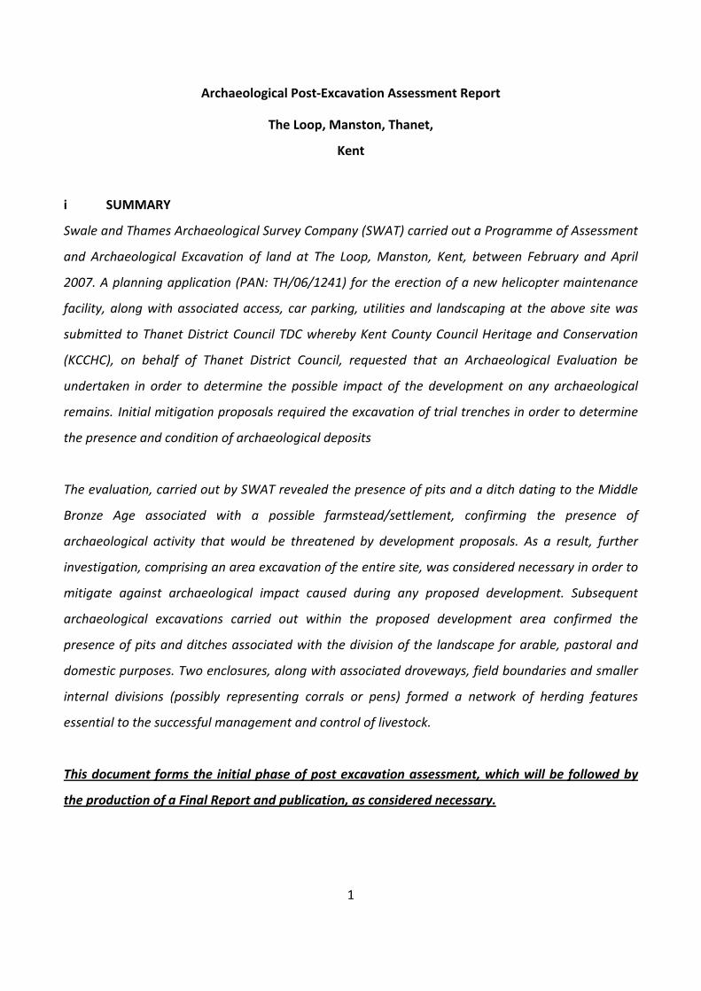
Archaeological Post-Excavation Assessment Report
The Loop, Manston, Thanet, Kent
Planning Application Number: TH/06/1241
Submitted to;
Duncan & Graham Partnership
Adam Single (Archaeological Officer) Heritage & Conservation Group
Kent County Council
Planning Department Thanet District Council
Swale & Thames Archaeological Survey Company School Farm Oast Graveney Road
Moody, G. A. (2004) Land Adjacent to Preston Park Caravan Site, Spratling Street, Manston, Kent.
Unpublished Trust for Thanet Archaeology evaluation report.
Murton, J. B., Bateman, M. D., Baker, C. A. and Whiteman, C. A. (2003) The Devensian Periglacial
Record on Thanet, Kent, UK. Permafrost and Periglacial Processes 14: 217‐246
Osborne‐White, H. J. (1928) Memoir of the Geological Survey: explanation of Sheets 274 and 290.
65‐67
Perkins, D. R. J. and Chadwick Hawks, S. (1984) The Monkton gas pipeline: phases I and II (Monkton
Parish) 1982. Archaeologia Cantiana CI; 83‐114
Perkins, D. R. J. (1985) The Monkton gas pipeline: phases III and IV, 1983‐4. Archaeologia Cantiana
CII; 43‐69
35
Perkins, D. R. J. and Gibson, A. (1990) A Beaker Burial from Manston. Archaeologia Cantiana CVIII,
11‐27
Perkins, D. R. J., Boast, E., Wilson, T. and Macpherson‐Grant, N. (1998) Kent International Business
Park, Manston: Excavations and evaluations 1994‐1997, Report 1. Archaeologia Cantiana CXVIII,
217‐255
Preece, R. C. and Bridgland, D. R. (eds.) (1998) Late Quaternary Environmental Change in North‐
west Europe.
Pryor, F.M.M. (1974) Excavation at Fengate, Peterborough, England: the First Report Toronto: Royal Ontario Mus Archaeol Monogr 3
Pryor, F.M.M.(1978) Excavation at Fengate, Peterborough, England: the Second Report Toronto: Royal Ontario Mus Archaeol Monogr 5
Pryor, F.M.M.(1980) Excavation at Fengate, Peterborough, England: the Third Report Toronto and Leicester: Northants Archaeol Soc Archaeol Monogr 1/Royal Ontario Museum Archaeol Monogr, 6
Pryor, F.M.M.(1984) Excavation at Fengate, Peterborough, England: the Fourth Report Toronto and Leicester: Northants Archaeol Soc Archaeol Monogr 2/Royal Ontario Mus Archaeol Monogr, 7
Pryor, F.M.M., (1996 )Sheep, stockyards and field systems: Bronze Age livestock populations in the Fenlands of eastern England, Antiquity, 70, 313‐24
Pryor, F.M.M., (1997a) Archaeological evaluation at Murdens former depot, Fengate, Peterborough, Cambridgeshire, Fenland Archaeological Trust Rep 97/1, Peterborough
36
Pryor, F.M.M., (1997b) Peterborough East: a guide to curation in an area of outstanding archaeological importance, Fenland Archaeol Trust, Peterborough
Pryor, F.M.M., (1998) Farmers in prehistoric Britain, Stroud: Tempus Books
Shephard‐Thorn, E. R. ‘Pegwell Bay’ in Shephard‐Thorn, E. R. and Wymer, J. J. (eds.) (1977)
Guidebook for excursion A5: South‐East England and the Thames Valley. INQUA X Congress, Geo
Abstracts, Norwich.
Stuckey, E. A G.I.S. (forthcoming) Survey of the Island of Thanet.
Weir, A. H., Catt, J. A. and Madgett, P. A. (1971) ‘Postglacial soil formation in the Loess of Pegwell
Bay, Kent, (England)’, Geoderma 5: Amsterdam, 131‐135.
37
Appendix 1 – Context Register
Cont No
Type Interpretation Description Fill of Filled by
Group Section No
Plan No Artefact dating
ASSIGNED DATE
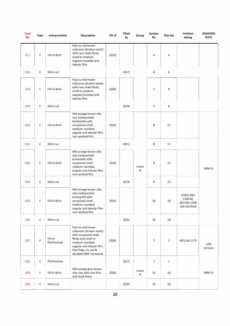
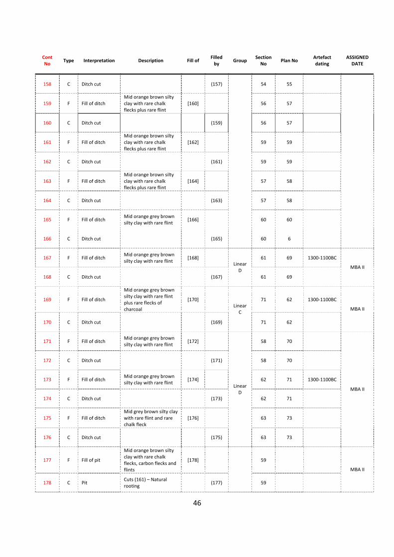
001 L Topsoil
002 L Subsoil Reworked, marled brickearth
003 L Med/Post Med horizon
Isolated area of Grey/brown compact silty clay
004 L Colluvium
Colluvial drift and windblown deposit comprising relatively coarse‐grained Thanet Bed sands of the Tertiary mixed with very fine‐grained Loess of the Quaternary
005 L Brickearth Mid red brown silty clay
006 L Chalk
007 F Fill of ditch Pale mid brown silty clay with rare tabular flint
[008] 26 23 1300‐1100BC
008 C Ditch cut (007)
Linear C
26 23
MBA II
009 F Fill of ditch
Pale to mid brown colluvium (broken earth) with rare chalk flecks, small to medium angular/rounded and tabular flint.
[010] 2 9 Modern pipe
010 C Ditch cut (009)
Modern
2 9
Modern
011 F Fill of cable trench
[012] 1 9
012 C Cable trench (011)
Modern
1 9
013 F Fill of ditch
Mid orange grey brown silty clay with rare chalk flecks and rare angular gravel
[014] 6 4 13th century
014 C Ditch cut (013) 6 4
015 F Fill of ditch Brickearth covering prehistoric horizon
[016] 5 6
016 C Ditch cut (015)
Linear A
5 6
MBA III
38
Cont No
Type Interpretation Description Fill of Filled by
Group Section No
Plan No Artefact dating
ASSIGNED DATE
017 F Fill of ditch
Pale to mid brown colluvium (broken earth) with rare chalk flecks, small to medium angular/rounded and tabular flint.
[018] 4 6
018 C Ditch cut (017) 4 6
019 F Fill of ditch
Pale to mid brown colluvium (broken earth) with rare chalk flecks, small to medium angular/rounded and tabular flint.
[020] 3 8
020 C Ditch cut (019)
3 8
021 F Fill of ditch
Mid orange brown silty clay (redeposited brickearth) with occasional small ‐ medium rounded, angular and tabular flint, rare worked flint
[022] 8 17
022 C Ditch cut (021) 8 17
023 F Fill of ditch
Mid orange brown silty clay (redeposited brickearth) with occasional small ‐ medium rounded, angular and tabular flint, rare worked flint
[024] 9 23
024 C Ditch cut (023) 9 23
025 F Fill of ditch
Mid orange brown silty clay (redeposited brickearth) with occasional small ‐ medium rounded, angular and tabular flint, rare worked flint
[026] 10 18
1500/1300‐1100 BC
AD1150‐1200 100‐50/25AD
026 C Ditch cut (025)
Linear B
10 18
MBA III
027 F Fill of Pit/Posthole
Pale to mid brown colluvium (broken earth) with occasional chalk flecks and small to medium rounded, angular and tabular flint. Flint flake, Fe nail & abraded CBM recovered
[028] 7 1 AD1150‐1175
028 C Pit/Posthole (027) 7 1
12th Century
029 F Fill of ditch Mid orange grey brown silty clay with rare flint and chalk flecks
[030] 15 10
030 C Ditch cut (029)
Linear A
15 10
MBA III
39
Cont No
Type Interpretation Description Fill of Filled by
Group Section No
Plan No Artefact dating
ASSIGNED DATE
031 F Fill of ditch Mid orange grey brown silty clay, rare flint and rare chalk flecks
[032] 22 11
032 C Ditch cut (031) 22 11
033 F Fill of ditch Same as (029) [034] 16 12
034 C Ditch cut (033) 16 12
035 F Fill of ditch Mid grey orange brown, silty clay with occasional flints of varying sizes
[036] 17 13
036 C Ditch cut (035) 17 13
037 F Fill of ditch Mid orange grey brown, silty clay with rare chalk flecks and flint
[038] 23 20
038 C Ditch cut Mid orange grey brown, silty clay with rare chalk flecks and flint
(037)
23 20
039 F Fill of ditch Mid orange brown silty clay with occasional flint plus rare chalk flecks
[040] 40 28
040 C Ditch cut (039)
Linear D
40 28
MBA II
041 F Fill of ditch
Mid orange grey brown silty clay with rare chalk flecks and rare angular gravel
[042] 12 5
042 C Ditch cut (041) 12 5
043 F Fill of ditch
Mid orange grey brown silty clay with rare chalk flecks and rare angular gravel
[044] 13 3
044 C Ditch cut (043) 13 3
045 F Fill of ditch
Mid orange grey brown silty clay with rare chalk flecks and rare angular gravel
[046] 14 2
046 C Ditch cut (045) 14 2
047 F Fill of ditch Mid orange brown silty clay rare flint
[048] 11 & 19
14
048 C Ditch cut (047) 11 & 19
14
049 F Fill of ditch Mid grey orange brown silty clay with rare flint
[050] 20 19
050 C Ditch cut (049)
Linear A
20 19
MBA III
40
Cont No
Type Interpretation Description Fill of Filled by
Group Section No
Plan No Artefact dating
ASSIGNED DATE
051 F Fill of ditch
Mid dark orange brown silty clay with occasional chalk fragments plus tabular flint
[052] 41 19
052 C Ditch cut (051) 41 19
053 F Fill of ditch
Pale mid brown silty clay with rare angular, rounded and tabular flint. Pot base (071), worked flint
Mid orange grey brown silty clay with rare chalk flecks and rare angular gravel
[058] 6
058 C Recut [016] (057) 6
059 F Fill of Recut
Mid orange grey brown silty clay with rare chalk flecks and rare angular gravel
[060] 6
060 C Recut [018] (059) 6
061 F Fill of Recut
Mid orange grey brown silty clay with rare chalk flecks and rare angular gravel
[062] 8
062 C Recut [020] (061) 8
063 F Fill of Recut Indistinguishable from (035)
[064] 17 13
064 C Recut [036] (063) 17 13
065 F Fill of Recut
Mid orange grey brown silty clay with rare chalk flecks and rare angular gravel
[066] 18 15
066 C Recut [056] (065)
Linear A
18 15
MBA III
067 F Fill of ditch Mid orange brown silty clay with rare flint
[068] 35 21 & 32
068 C Ditch cut (067) 35 21 & 32
069 C Ditch cut (070) (071)
Linear C
25
MBA II
41
Cont No
Type Interpretation Description Fill of Filled by
Group Section No
Plan No Artefact dating
ASSIGNED DATE
070 F Fill
Pale mid brown silty clay with rare angular, rounded and tabular flint. Pot base (071), worked flint
[069] (071) 25 1300‐1100BC
071 F Vessel within fill [069] 25 1300‐1100BC
072 F Fill of ditch
Pale to mid brown silty clay with rare rounded, angular and tabular flint, chalk flecks and flint flecks
(071) 24 22 1300‐1100BC
073 C Ditch cut (072)
24 22
074 F Ditch cut Mid‐dark grey brown silty clay with rare chalk flecks and flint
[073] 23 20
075 C Recut by [038] (074)
Linear A
23 20
MBA III
076 F Fill of ditch Pale mid brown silty clay with occasional flint
[077] 27 24 & 30 1300‐1100BC
077 C Ditch cut (076)
Linear D
27 24 & 30
MBA II
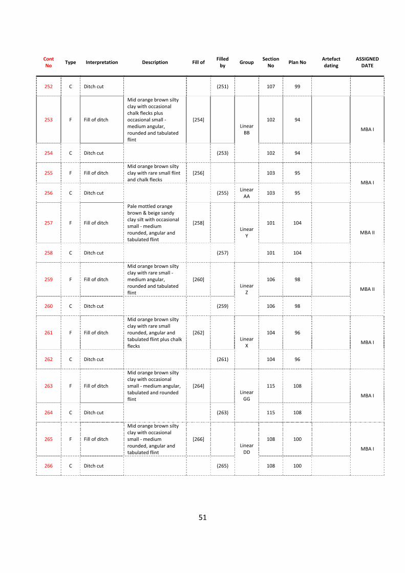
078 F Fill of post hole
Mid orange grey brown silty clay with rare small pebbles (<0.01m) plus rare chalk flecks
[079] 34 33 1300‐1100BC
079 C Posthole Truncates Linear K 34 33
MBA II
080 x x NOT USED x x X x x x x
081 F Fill of ditch
Pale to mid brown silty clay with occasional tabulated flint and flecks of charcoal
[082] 31 25
082 C Ditch cut (081) 31 25
083 F Fill of ditch
Pale mid brown silty clay with occasional flint, charcoal flecks and shell. Moderate natural chalk inclusions
[084] 29 26
084 C Ditch cut (083)
Linear F
29 26
MBA III
085 C Ditch cut [086] 30 27
086 F Fill of ditch Same as (072) (085)
Linear C
30 27
MBA II
42
Cont No
Type Interpretation Description Fill of Filled by
Group Section No
Plan No Artefact dating
ASSIGNED DATE
087 F Fill of ditch
Mid dark grey brown silty clay with rare flint plus rare charcoal fragments
[088] 38 34 1300‐1100BC
088 C Ditch cut (087) 38 34
089 F Fill of ditch
Mid dark grey brown silty clay with rare flints plus rare charcoal fragments
[090] 37 35
090 C Ditch cut (089)
Linear G
37 35
MBA III
091 F Fill of ditch [092] 43 37
092 C Ditch cut
Natural feature
(091)
Linear H
43 37
No date
093 F Fill of ditch
Mid orange brown silty clay with occasional chalk fragments plus occasional flint
[094] 33 29
094 C Ditch cut (093)
Linear D
33 29
MBA II
095 F Fill of ditch
Mid orange grey brown silty clay with occasional flint and occasional chalk flecks
[096] 32 38
096 C Ditch cut (095)
Linear I
32 38
MBA II
097 F Fill of ditch
Dark grey brown silty clay with occasional flint (Tabular, angular and rounded), rare charcoal fragments, pottery, animal bone and burnt flint
[098] 39 36 1300‐1100BC
098 C Ditch cut (097)
Linear J
39 36
MBA II
099 F Fill of pit
Dark brown silty clay with tabular and angulated flint plus considerable burnt matter including charcoal, one worked flint and small pieces of pottery
[100] 28 39
100 C Pit (099)
28 39
MBA III
101 F Fill of ditch Mid orange brown silty clay with occasional flints
[102] 36 48 1300‐1100BC
102 C Ditch cut (101)
Linear L
36 48
MBA II
43
Cont No
Type Interpretation Description Fill of Filled by
Group Section No
Plan No Artefact dating
ASSIGNED DATE
103 F Fill of ditch
Mid dark orange brown silty clay with occasional chalk fragments plus tabular flint
[104] 42 44
104 C Ditch cut (103)
42 44
105 F Fill of ditch
Mid orange brown silty clay with occasional tabulated flint and chalk flecks
[106] 44 40 & 43
106 C Ditch cut (105) 44 40 & 43
107 F Fill of ditch
Mid orange brown silty clay with very occasional tabulated flint plus occasional chalk flecks
[108] 45 41
108 C Ditch cut (107)
Linear K
45 41
MBA III
109 F Fill of ditch Mid grey brown silty clay with occasional tabulated flints
[110] 46 42 1300‐1100BC
110 C Ditch cut (109)
Linear D
46 42
MBA II
111 F Fill of ditch
Mid orange brown silty clay with moderate occasional flint and occasional chalk flecks truncated by linear K
[112] 47 43 1300‐1100BC
112 C Ditch cut (111)
Linear C
47 43
MBA II
113 F Fill of ditch
Mid orange brown silty clay with occasional tabulated flint and charcoal
[114] 48 45
114 C Ditch cut (113)
Linear L
48 45
MBA III
115 F Fill of pit
Mottled orange brown silty clay and light white yellow sandy silt with rare flint
[116] 64 49
116 C Pit complex (115) 64 49
117 F Fill of pit Mid orange brown silty clay with rare flint and chalk flecks
[118] 64 49
118 C Pit complex (117) 64 49
119 F Fill of pit Mid orange brown silty clay with rare tabulated flint and charcoal flecks
[120] 64 49
120 C Pit complex (119) 64 49
121 F Fill of pit
Mottled yellow and orange brown silty clay with frequent inclusions of chalk
[122]
Pit comple
x
64 & 65
49
MBA II
44
Cont No
Type Interpretation Description Fill of Filled by
Group Section No
Plan No Artefact dating
ASSIGNED DATE
122 C Pit complex (121) 64 & 65
49
123 F Fill of pit
Slumped natural deposit – mid orange brown silty clay with rare flint inclusions
[127] 64 49
124 F Fill of pit
Mottled yellow and orange brown silty clay with moderate inclusions of chalk
[127] 64 49
125 F Fill of pit
Mid grey brown fine silty clay with rare flint and friable fragments of fired clay (pottery)
[127] 64 49 1500/1300‐1100BC
126 F Fill of pit Pale yellow chalky paste, rare fragments of tabulated flint
[127] 64 49
127 C Pit complex
(115) (123) (124) (125) (126)
64 49
128 F Fill of Posthole
Mid orange brown silty clay with occasional tabulated flints and charcoal flecks
[129] 52 39
129 C Posthole (cuts (099))
(128)
52 39
130 F Fill of Pit
Mid orange brown silty clay with occasional fragments of tabulated flint
[118] 65 No Date
131
132
133
134 F Pit Redeposited (slumped) natural silty clay brickearth
[122] 64 &65
135 F Fill of ditch
Mid orange brown silty clay with occasional tabulated flint and rounded pebbles plus occasional fragments of charcoal and chalk
[136] 49 46
136 C Ditch cut (135) 49 46
137 F Fill of ditch
Mid orange brown silty clay with occasional tabulated flint and rounded pebbles plus occasional fragments of charcoal and chalk
[138] 50 47
138 C Ditch cut (137)
Linear L
50 47
MBA III
45
Cont No
Type Interpretation Description Fill of Filled by
Group Section No
Plan No Artefact dating
ASSIGNED DATE
139 F Fill of Pit
Mid yellow orange brown silty clay, occasional chalk and charcoal fragments
[140] 66 90
140 C Pit (139)
66 90
MBA II
141 F Fill of natural hollow
Mid orange brown silty clay with moderate tabulated flint
[142] 51
142 C Natural hollow (141)
51
No date
143 F Fill of natural hollow
Light grey brown sandy silt with occasional tabulated flint and charcoal flecks
[144] 67 & 68
50 1300‐1100BC
144 C Natural hollow (143) 67 & 68
50
145 F Fill of Pit
Dark grey brown sandy silt with occasional charcoal flecks – Same as (147)
[146] 68 50 1300‐1100BC
146 C Pit (145) 68 50
147 F Fill of Pit
Dark grey brown sandy silt with occasional charcoal flecks – Same as (145)
[146]
68 50 1300‐1100BC
MBA II
148 x x NOT USED x x x x x x x
149 F Fill of pit Same as (431) [150] 69 51 & 52 2000‐1700BC
150 C Elongated Pit Same as [432] (149)
Linear M
69 51 & 52
EBA
151 F Fill of ditch [152] 70 51 & 53 AD1475‐1500
152 C Ditch cut (151)
LinearTT
70 51 & 53
MBA I
153 F Fill of ditch Mid orange brown silty clay with rare chalk flecks plus rare flint
[154] 55 56
154 C Ditch cut (153) 55 56
155 F Fill of ditch Mid orange brown silty clay with rare chalk flecks plus rare flint
[156] 53 54
156 C Ditch cut (155) 53 54
157 F Fill of ditch Mid orange brown silty clay with rare chalk flecks plus rare flint
[158]
Linear E
54 55
MBA II
46
Cont No
Type Interpretation Description Fill of Filled by
Group Section No
Plan No Artefact dating
ASSIGNED DATE
158 C Ditch cut (157) 54 55
159 F Fill of ditch Mid orange brown silty clay with rare chalk flecks plus rare flint
[160] 56 57
160 C Ditch cut (159) 56 57
161 F Fill of ditch Mid orange brown silty clay with rare chalk flecks plus rare flint
[162] 59 59
162 C Ditch cut (161) 59 59
163 F Fill of ditch Mid orange brown silty clay with rare chalk flecks plus rare flint
[164] 57 58
164 C Ditch cut (163) 57 58
165 F Fill of ditch Mid orange grey brown silty clay with rare flint
[166] 60 60
166 C Ditch cut (165)
60 6
167 F Fill of ditch Mid orange grey brown silty clay with rare flint
[168] 61 69 1300‐1100BC
168 C Ditch cut (167)
Linear D
61 69
MBA II
169 F Fill of ditch
Mid orange grey brown silty clay with rare flint plus rare flecks of charcoal
[170] 71 62 1300‐1100BC
170 C Ditch cut (169)
Linear C
71 62
MBA II
171 F Fill of ditch Mid orange grey brown silty clay with rare flint
[172] 58 70
172 C Ditch cut (171) 58 70
173 F Fill of ditch Mid orange grey brown silty clay with rare flint
[174] 62 71 1300‐1100BC
174 C Ditch cut (173) 62 71
175 F Fill of ditch Mid grey brown silty clay with rare flint and rare chalk fleck
[176] 63 73
176 C Ditch cut (175)
Linear D
63 73
MBA II
177 F Fill of pit
Mid orange brown silty clay with rare chalk flecks, carbon flecks and flints
[178] 59
178 C Pit Cuts (161) – Natural rooting
(177)
59
MBA II
47
Cont No
Type Interpretation Description Fill of Filled by
Group Section No
Plan No Artefact dating
ASSIGNED DATE
179 F Fill of ditch Mid grey orange brown silty clay with rare flint
[180] 73 63
180 C Ditch cut (179) 73 63
181 F Fill of ditch Mid grey orange brown silty clay with rare flint
[182] 74 64
182 C Ditch cut (181) 74 64
183 F Fill of ditch
Mid grey brown silty clay with occasional flint, rare chalk flecks, 3 sherds of pot and several possible worked flints
[184] 72 66 1300‐1100BC
184 C Ditch cut (183) 72 66
185 F Upper Fill
Dark grey with frequent grey black burnt material; silty clay, rare flint, occasional charcoal and rare burnt flint
[180] 73
186 F Upper Fill Same as (185) [182]
Linear C
74
MBA II
187 F Fill of ditch Mid grey brown silty clay with rare flint
[188] 76
188 C Ditch cut (187) 76
189 F Fill of ditch Mid grey brown clay with rare flint (Not on survey)
[190] 75 67, 74 &
91
190 C Ditch cut Not on survey (189)
Linear TT
75 67, 74 &
91
191 F Fill of ditch Mid grey orange brown silty clay with occasional flint
[192] 77 65 & 102 1300‐1100BC
192 C Ditch cut (191)
Linear C
77 65 & 102
MBA II
193 F Fill of ditch Mid grey orange brown silty clay with occasional flint
[194] 78 & 79
72
194 C Ditch cut (193)
Linear D
78 & 79
72
MBA II
195 F Fill of ditch Mid grey brown silty clay with rare flint
[196] 79 72
196 C Ditch cut (195)
Linear TT
79 72
197 F Fill of ditch Mid orange brown silty clay with rare flint
[198] 91 76 & 102
198 C Ditch cut (197)
Linear M
91 76 & 102
MBA II
48
Cont No
Type Interpretation Description Fill of Filled by
Group Section No
Plan No Artefact dating
ASSIGNED DATE
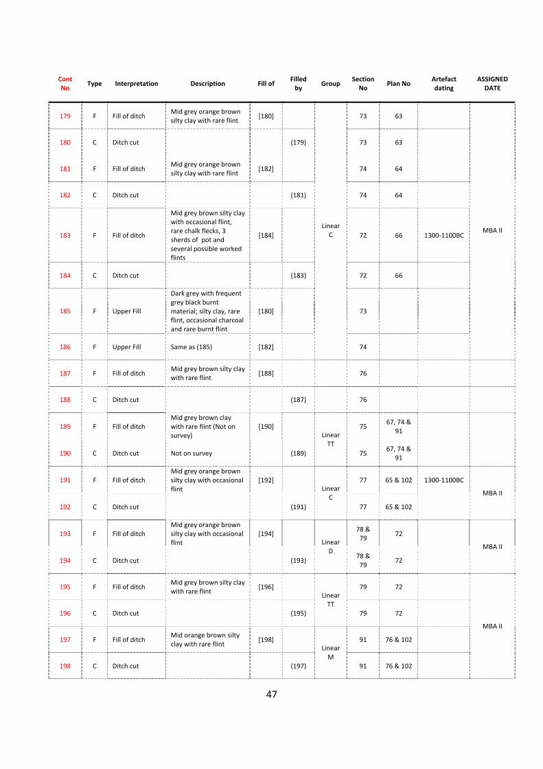
199 F Fill of ditch Mid orange brown silty clay with rare chalk flecks plus rare flint
[200] 80 61
200 C Ditch cut (199)
Linear E
80 61
MBA II
201 F Fill of ditch Mid orange brown silty clay with rare flint
[202] 83 78
202 C Ditch cut (201) 83 78
203 F Fill of ditch Mid orange brown silty clay with rare flint
[204] 82 77
204 C Ditch cut (203)
Linear N
82 77
MBA I
205 F Fill of ditch Mid orange brown silty clay with rare flint
[206] 81 68
206 C Ditch cut (205)
Linear U
81 68
MBA II
207 F Fill of ditch Mid orange brown silty clay with rare flint and chalk
[208] 88 79
208 C Ditch cut (207)
Linear OO
88 79
MBA II
209 F Fill of ditch Mid orange brown sandy silty clay with rare flint
[210] 87 80
210 C Ditch cut (209)
Linear SS
87 80
MBA II
211 F Fill of ditch Mid orange brown silty clay with rare chalk flecks plus rare flint
[212] 80 61
212 C Ditch cut (211)
Linear UU
80 61
MBA II
213 F Fill of ditch Mid orange brown silty clay with rare flint
[214] 86 86
214 C Ditch cut (213)
Linear P
86 86
MBA II
215 F Fill of ditch Mid orange brown silty clay with rare flint and chalk
[216] 89 88
216 C Ditch cut (215)
Linear Q
89 88
MBA II
217 F Fill of Pit
Mid grey orange brown silty clay with occasional flint, rare chalk fragments. Deep short 'sausage shaped' ditch
[218] 85 85 1300‐1100BC
218 C Elongated Pit (217)
85 85
MBA II
219 F Fill of ditch Mid orange brown silty clay with rare flint
[220] Linear O
84 84 MBA II
49
Cont No
Type Interpretation Description Fill of Filled by
Group Section No
Plan No Artefact dating
ASSIGNED DATE
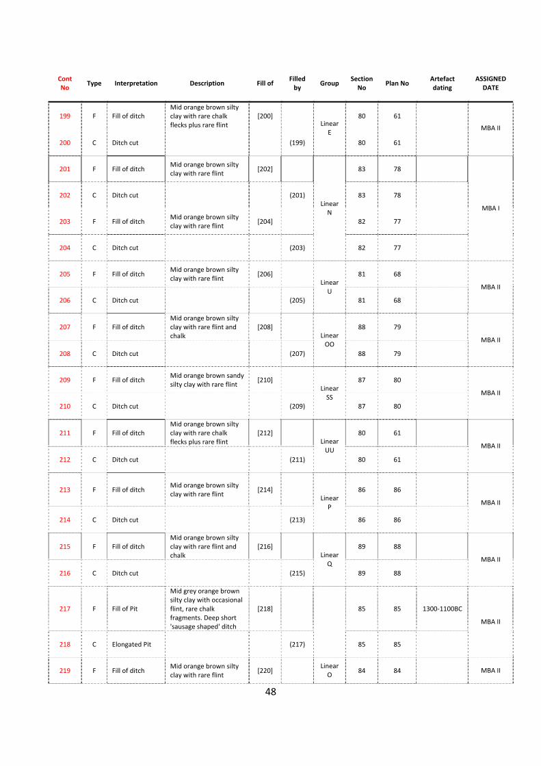
220 C Ditch cut (219)
84 84
221 F Fill of ditch
Mid orange brown silty clay with rare small ‐ medium angular, rounded and tabulated flint
[222] 100 87
222 C Ditch cut (221)
Linear Q
100 87
MBA II
223 F Fill of ditch
Mid orange brown silty clay with carbon lens, occasional small to large angular and tabulated flint
[224] 92 89 1300‐1100BC
224 C Ditch cut (223)
Linear P
92 89
MBA II
225 F Fill of ditch Mid orange brown silty clay with rare flint
[226] 90 75
226 C Ditch cut (225)
Linear U
90 75
MBA II
227 F Fill of ditch
Abundant mussel shell with occasional oyster shell (80%) in a mid orange brown silty clay with rare flint tools, occasional small ‐ medium angular, tabulated and rounded flint plus rare carbon flecks and one pot sherd
[228] 93 81 & 102 1300‐1100BC
228 C Ditch cut (227)
Linear C
93 81 & 102
MBA II
229 F Upper Fill
Light orange brown silty clay with occasional small ‐ medium angular, tabulated flint plus rare chalk
[231] 95
230 F Lower Fill Light orange brown with pale beige mottled silty clay. Inclusions as (229)
[231] 95 144
231 C Ditch cut (229) (230)
Linear I
95 144
MBA II
232 F Fill of ditch
Mid orange brown clay with occasional small ‐ medium angular and tabular flint plus rare chalk flecks. Same as (203)
[233] 97 141
233 C Ditch cut (232)
Linear N
97 141
MBA I
234
235
50
Cont No
Type Interpretation Description Fill of Filled by
Group Section No
Plan No Artefact dating
ASSIGNED DATE
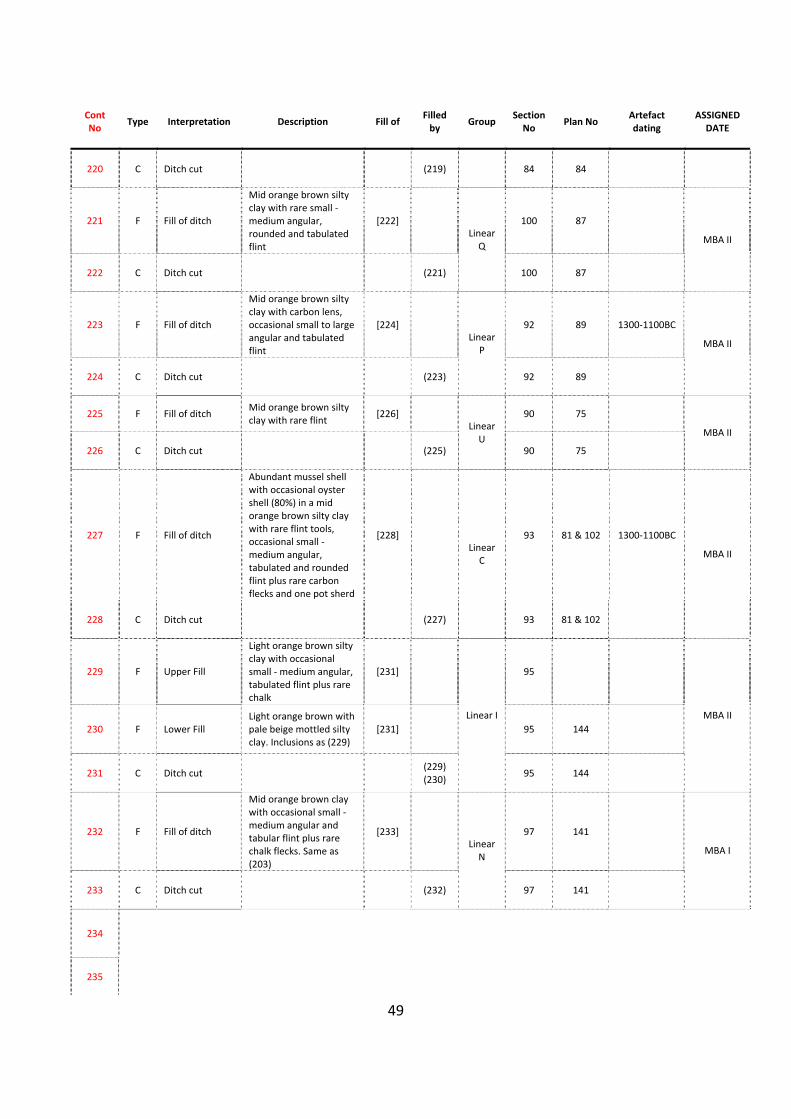
236 F Fill of ditch
Below shell fill (227). Mid orange brown sandy silty clay with occasional small ‐ medium angular, tabulated and rounded flint plus rare carbon
[228] Linear C
93 81 MBA II
237 F Fill of ditch
Mid orange brown silty clay with occasional small ‐ medium rounded, angular and tabulated flint plus rare chalk flecks
[238] 96 93
238 C Ditch cut (237)
Linear M
96 93
MBA I
239 F Fill of ditch
Mid orange brown silty clay with rare small ‐ medium angular, rounded and tabulated flint
[240] 98 83
240 C Ditch cut (239)
Linear V
98 83
MBA II
241 F Fill of ditch
Mid orange brown silty clay with rare with small angular, rounded and tabulated flint plus rare chalk flecks
[242] 99 82
242 C Ditch cut (241)
Linear R
99 82
MBA I
243 F Fill of ditch
Slightly red orange brown silty clay compacted with occasional chalky flecks
[244] 142 136
244 C Ditch cut (243) 142 136
245 F Fill of ditch
Slightly red orange brown silty clay compacted with occasional chalky flecks
[246] 143 137
246 C Ditch cut (245) 143 137
247 F Fill of pit Dark grey brown silty clay, with rare chalk flecks
[248] 150 138
248 C Pit (247)
Linear S
150
MBA I
249 F Fill of ditch
Mid orange brown silty clay with rare small ‐ medium angular, rounded and tabulated flint
[250] 105 97
250 C Ditch cut (249) 105 97
251 F Fill of ditch
Mid orange brown silty clay with small ‐ medium angular, rounded and tabulated flint
[252]
Linear CC
107 99
MBA I
51
Cont No
Type Interpretation Description Fill of Filled by
Group Section No
Plan No Artefact dating
ASSIGNED DATE
252 C Ditch cut (251)
107 99
253 F Fill of ditch
Mid orange brown silty clay with occasional chalk flecks plus occasional small ‐ medium angular, rounded and tabulated flint
[254] 102 94
254 C Ditch cut (253)
Linear BB
102 94
MBA I
255 F Fill of ditch Mid orange brown silty clay with rare small flint and chalk flecks
[256] 103 95
256 C Ditch cut (255) Linear AA
103 95
MBA I
257 F Fill of ditch
Pale mottled orange brown & beige sandy clay silt with occasional small ‐ medium rounded, angular and tabulated flint
[258] 101 104
258 C Ditch cut (257)
Linear Y
101 104
MBA II
259 F Fill of ditch
Mid orange brown silty clay with rare small ‐ medium angular, rounded and tabulated flint
[260] 106 98
260 C Ditch cut (259)
Linear Z
106 98
MBA II
261 F Fill of ditch
Mid orange brown silty clay with rare small rounded, angular and tabulated flint plus chalk flecks
[262] 104 96
262 C Ditch cut (261)
Linear X
104 96
MBA I
263 F Fill of ditch
Mid orange brown silty clay with occasional small ‐ medium angular, tabulated and rounded flint
[264] 115 108
264 C Ditch cut (263)
Linear GG
115 108
MBA I
265 F Fill of ditch
Mid orange brown silty clay with occasional small ‐ medium rounded, angular and tabulated flint
[266] 108 100
266 C Ditch cut (265)
Linear DD
108 100
MBA I
52
Cont No
Type Interpretation Description Fill of Filled by
Group Section No
Plan No Artefact dating
ASSIGNED DATE
267 F Fill of ditch
Mid orange brown silty clay with occasional small ‐ medium angular, rounded and tabulated flint plus rare chalk flecks
[268] 114 109
268 C Ditch cut (267) 114 109
269 F Fill of ditch
Mid orange brown silty clay with occasional small ‐ medium angular, rounded and tabulated flint plus rare chalk flecks
[270] 113 111 & 143
270 C Ditch cut (269)
Linear FF
113 111 & 143
MBA I
271 F Fill of ditch
Mid orange brown silty clay with rare small ‐ medium angular, rounded and tabulated flint plus occasional chalk flecks (near base)
[272] 112 110
272 C Ditch cut (271)
Linear EE
112 110
MBA I
273 F Fill of ditch Firm mid orange brown clay silt with occasional chalk flecks
[274] 131 105
274 C Ditch cut (273)
Linear Y
131 105
MBA II
275 F Fill of Pit
Very firm red brown clay (occasional silt) with occasional rounded pebbles
[276] 131 105
276 C Pit cut (275)
131 105
277 F Fill of pit
Light grey brown slightly clayey silt with very rare chalk flecks. Unclear but feint suggestion that this overlies (279) ‐ suggesting later date
[278] 136 129
278 C Pit (277)
136 129
MBA II
279 F Fill of Pit
Mid orange brown silty clay compacted with occasional tabulated flint and chalk flecks
[280] 136 & 145
129 1300‐1100BC
280 C Pit (279)
136 & 145
129
MBA II
281 F Fill of ditch
Mid red brown silty clay compacted with occasional tabulated flint
[282] 145 129
282 C Ditch cut (281)
Linear W
145 129
MBA I
53
Cont No
Type Interpretation Description Fill of Filled by
Group Section No
Plan No Artefact dating
ASSIGNED DATE
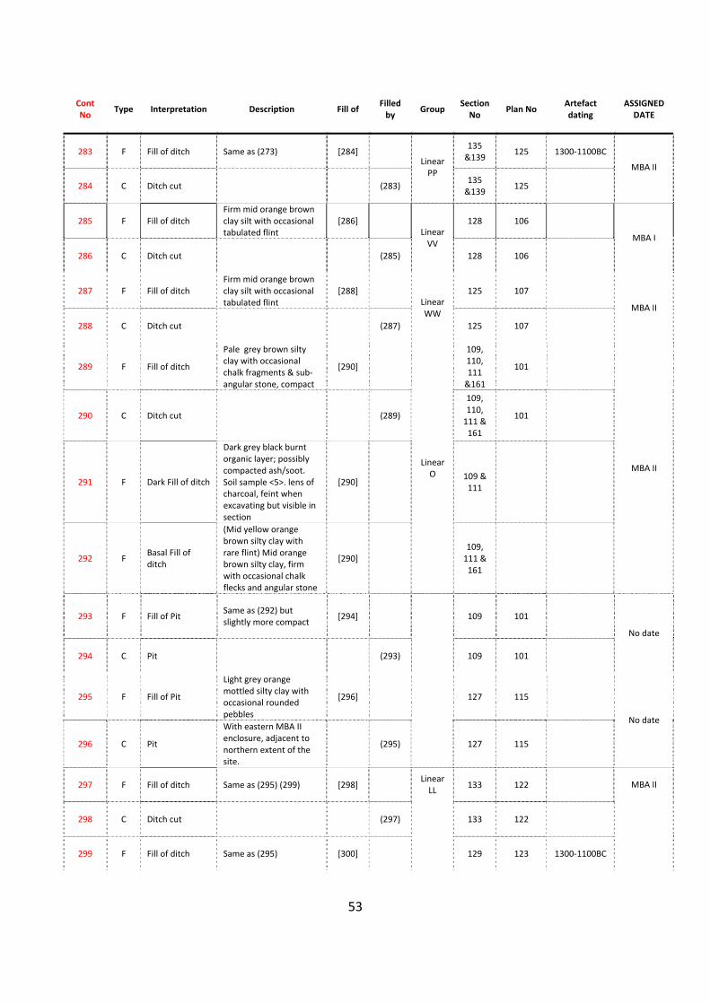
283 F Fill of ditch Same as (273) [284] 135 &139
125 1300‐1100BC
284 C Ditch cut (283)
Linear PP
135 &139
125
MBA II
285 F Fill of ditch Firm mid orange brown clay silt with occasional tabulated flint
[286] 128 106
286 C Ditch cut (285)
Linear VV
128 106
MBA I
287 F Fill of ditch Firm mid orange brown clay silt with occasional tabulated flint
[288] 125 107
288 C Ditch cut (287)
Linear WW
125 107
MBA II
289 F Fill of ditch
Pale grey brown silty clay with occasional chalk fragments & sub‐angular stone, compact
[290]
109, 110, 111 &161
101
290 C Ditch cut (289)
109, 110, 111 & 161
101
291 F Dark Fill of ditch
Dark grey black burnt organic layer; possibly compacted ash/soot. Soil sample <5>. lens of charcoal, feint when excavating but visible in section
[290] 109 & 111
292 F Basal Fill of ditch
(Mid yellow orange brown silty clay with rare flint) Mid orange brown silty clay, firm with occasional chalk flecks and angular stone
[290]
Linear O
109, 111 & 161
MBA II
293 F Fill of Pit Same as (292) but slightly more compact
[294] 109 101
294 C Pit (293)
109 101
No date
295 F Fill of Pit
Light grey orange mottled silty clay with occasional rounded pebbles
[296] 127 115
296 C Pit
With eastern MBA II enclosure, adjacent to northern extent of the site.
(295)
127 115
No date
297 F Fill of ditch Same as (295) (299) [298] 133 122
298 C Ditch cut (297) 133 122
299 F Fill of ditch Same as (295) [300]
Linear LL
129 123 1300‐1100BC
MBA II
54
Cont No
Type Interpretation Description Fill of Filled by
Group Section No
Plan No Artefact dating
ASSIGNED DATE
300 C Ditch cut (299)
129 123
301 F Fill of ditch
Firm mid orange brown silty clay with moderate chalk flecks and rare rounded stone
[302] 140
302 C Ditch cut (301)
Linear DD
140
MBA II
303 F Fill of ditch Mid orange brown silty clay with rare flint
[304] 117 118
304 C Ditch cut (303)
Linear SS
117 118
MBA II
305 F Fill of ditch Mid yellow grey brown silty clay with rare flint
[306] 118 119
306 C Ditch cut (305)
Linear NN
118 119
MBA II
307 F Fill of Pit Same as (303). Mid orange brown silty clay with rare flint
[308] 116 118
308 C Pit (307)
116 118
309 F Fill of ditch Light ‐Mid yellow orange grey clay silt with rare flint
[310] 120 116
310 C Ditch cut (309)
Linear QQ
120 116
MBA II
311 F Fill of ditch Mid orange brown silty clay with rare flint
[312] 123 117
312 C Ditch cut (311)
Linear RR
123 117
MBA II
313 F Fill of ditch Mid orange brown silty clay with rare flint
[314] 122 114
314 C Ditch cut (313)
Linear SS
122 114
MBA II
315 F Fill of ditch
Mid orange brown silty clay with rare flint, rare small pebbles and rare chalk flecks. Also contains several animal bones (probably same animal)
[316] 122 114
316 C Ditch cut (315) 122 114
317 F Fill of ditch Mid orange brown silty clay with rare flint
[318] 121 113
318 C Ditch cut (317)
Linear T
121 113
319 F Fill of ditch Mid orange brown silty clay with rare flint
[320] Linear SS
121 113 MBA II
55
Cont No
Type Interpretation Description Fill of Filled by
Group Section No
Plan No Artefact dating
ASSIGNED DATE
320 C Ditch cut (319)
121 113
321 F Fill of ditch
Mid grey orange brown silty clay with occasional chalk fragments (<0.03m diameter) plus rare flint
[322] 119
322 C Ditch cut (321)
Linear T
119
MBA II
323 F Fill of pit Same as (237) [324] 138 127
324 C Pit (323)
138 127
No date
325 F Fill of natural rooting
Same as (273) [326] 137 126
326 C Natural rooting (325)
137 126
No date
327 F Fill of ditch
Mid orange brown silty clay with occasional oyster shell, rare flint plus two pieces of pot
[328] 124 120 1300‐1100BC
328 C Ditch cut (327)
Linear T
124 120
MBA II
329 F Fill of ditch Mid orange brown silty clay with rare flint
[330] 124 120
330 C Ditch cut (329)
Linear SS
124 120
MBA II
331 F Fill of ditch Same as (281) [332] 149 121 & 139
332 C Ditch cut (331)
Linear X
149 121 & 139
MBA II
333 F Fill of ditch
Firm slightly red mid brown silty clay with occasional chalk flecks and moderate tabulated flint and rounded stone
[334] 132 124 1300‐1100BC
334 C Ditch cut (333)
Linear P
132 124
MBA II
335 F Fill of ditch Same as (289) Mid orange brown silty clay with rare flint
[336] 157 & 167
103
336 C Ditch cut (335)
Linear UU
157 & 167
103 MBA II
337 F Fill of pit
Mid orange brown silty clay with occasional rounded stones and tabulated flint plus moderate chalk flecks, relatively firm
[338] 157 & 167
103
338 C Pit Same as [294] (337)
Pit
157 & 167
103
MBA II
56
Cont No
Type Interpretation Description Fill of Filled by
Group Section No
Plan No Artefact dating
ASSIGNED DATE
339 F Fill of Pit
Dark red brown clay with rare flint and rare chalk flecks. {NB. (339) possible clay lining of pit ‐ continues up pit sides}
[338]
157 & 167
103
340 F Fill of pit
Relatively firm slightly brown orange silty clay with occasional chalk flecks and rounded stone
[341] 126 128
341 C Pit cut Cutting [346] (340)
126 128
342 F Fill of Pit
Mid grey brown silty clay with moderate chalk and occasional tabulated flint
[343] 130 131
343 C Pit (342)
130 131
No date
344
345 F Fill of ditch Firm orange brown clay silt with occasional chalk flecks and tabulated flint
(346) 126 128
346 C Ditch cut [341]
Linear V
126 128
MBA II
347 F Fill of ditch Same as (273) [348] 134 130 1300‐1100BC
348 C Ditch cut Same as (283). No clear distinction or break
(347)
Linear Y
134 130
MBA II
349 F Fill of ditch
Mid orange brown silty clay with occasional oyster shell, rare flint plus two pieces of pot
[350] 135 1300‐1100BC
350 C Ditch cut (349)
Linear T
135
MBA II
351 F Fill of ditch Same as (305) [352] 147 125 & 132
352 C Ditch cut (351)
Linear NN
147 125 & 132
MBA II
353 F Fill of ditch Same as (303) [354] 148 132
354 C Ditch cut (353)
Linear SS
148 132
355 F Fill of ditch
Mid grey brown loose silty clay with moderate chalk lumps and flecks of occasional tabulated flint
[356] 146 140
356 C Ditch cut (355)
Linear JJ
146 140
MBA II
57
Cont No
Type Interpretation Description Fill of Filled by
Group Section No
Plan No Artefact dating
ASSIGNED DATE
357 F Fill of Pit
Mid grey brown loose silty clay with moderate chalk lumps and flecks of occasional tabulated flint
[358] 154 134
358 C Pit (357)
154 134
No date
359 F Fill of ditch Same as (355) (357) [360] 153 & 154
134
360 C Ditch cut (359)
Linear JJ
153 & 154
134
MBA II
361 F Fill of ditch Mid red brown silty clay with occasional tabulated flint
[362] 151 133
362 C Ditch cut (361)
Linear MM
151 133
MBA II
363 F Fill of ditch
Mid orange brown silty clay with occasional oyster shell, rare flint plus two pieces of pot
[364] 151 133
364 C Ditch cut (363)
Linear T
151 133
365 F Fill of ditch Shell [362] 151 133
366 F Fill of ditch Shell [364] 151 133
MBA II
367 F Fill of natural Mid orange brown silty clay with occasional chalk flecks
[367] 152 133
368 C Natural Tree bole (368)
152 135
No date
369 F Fill of ditch Same as (355) [370] 141 142 1300‐1100BC
370 C Ditch cut (369) 141 142
371 F Fill of ditch Same as (355) [372] 155 145
372 C Ditch cut (371)
Linear JJ
155 145
MBA II
373 F Natural
Dark red brown clay with moderate large rounded flint plus occasional chalk flecks ‐ Natural
[374] 158 147
374 C Natural (373)
158 147
No date
375 F Fill of ditch Mid orange brown silty clay with rare chalk flecks
[376] 158 147
376 C Ditch cut (375)
Linear N
158 147
MBA II
58
Cont No
Type Interpretation Description Fill of Filled by
Group Section No
Plan No Artefact dating
ASSIGNED DATE
377 F Fil of ditch Same as (355) [378] 156 & 160
146 & 149
378 C Ditch cut (377)
Linear JJ
156 & 160
146 & 149
MBA II
379 F Fill of pit
Pale orange brown silty clay with rare charcoal flecks and chalk flecks plus occasional rounded stone
[380] 159 148
380 C Elongated pit (379)
159 148
381 F Fill of ditch Mid orange brown silty clay with occasional tabulated flint
[382] 166 153
382 C Ditch cut (381)
Linear R
166 153
MBA II
383 F Fill of Slot 1
Mid orange brown silty clay. Firm with occasional chalk and rounded stone (contains fragments of bone)
[384] 162 150
384 C Slot 1 (383) 162 150
385 F Fill of Slot 2 Same as (383) [386] 163 151
386 C Slot 2 (385) 163 151
387 F Fill of Slot 4 Same as (383) [388] 164 152
388 C Slot 4 (387) 164 152
389 F Fill of Slot 3 Mid orange brown silty clay with occasional rounded stones
[390] 165 153
390 C Slot 3 (389)
Linear KK
165 153
MBA II
391 F Fill of ditch Same as (381) [392] 167 154
392 C Ditch cut (391)
Linear R
167 154
MBA II
393 F Fill of Pit
Dark grey brown silty clay with frequent charcoal and occasional chalk and stone ‐ C20th ceramic
[394] 168 155
394 C Pit (394)
168 155
No date
395 F Fill of Pit
Mid grey brown silty clay with occasional chalk fragments and rounded stone
[396] 169 156 No date
59
Cont No
Type Interpretation Description Fill of Filled by
Group Section No
Plan No Artefact dating
ASSIGNED DATE
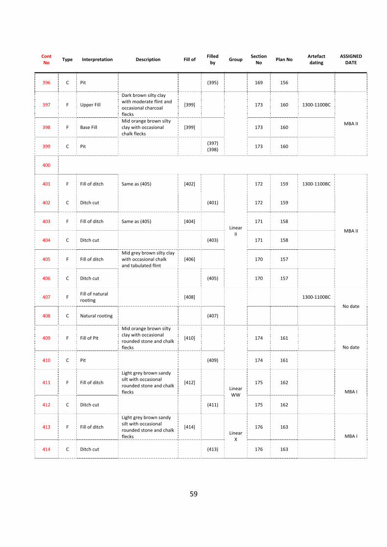
396 C Pit (395)
169 156
397 F Upper Fill
Dark brown silty clay with moderate flint and occasional charcoal flecks
[399] 173 160 1300‐1100BC
398 F Base Fill Mid orange brown silty clay with occasional chalk flecks
[399] 173 160
399 C Pit (397) (398)
173 160
MBA II
400
401 F Fill of ditch Same as (405) [402] 172 159 1300‐1100BC
402 C Ditch cut (401) 172 159
403 F Fill of ditch Same as (405) [404] 171 158
404 C Ditch cut (403) 171 158
405 F Fill of ditch Mid grey brown silty clay with occasional chalk and tabulated flint
[406] 170 157
406 C Ditch cut (405)
Linear II
170 157
MBA II
407 F Fill of natural rooting
[408] 1300‐1100BC
408 C Natural rooting (407)
No date
409 F Fill of Pit
Mid orange brown silty clay with occasional rounded stone and chalk flecks
[410] 174 161
410 C Pit (409)
174 161
No date
411 F Fill of ditch
Light grey brown sandy silt with occasional rounded stone and chalk flecks
[412] 175 162
412 C Ditch cut (411)
Linear WW
175 162
MBA I
413 F Fill of ditch
Light grey brown sandy silt with occasional rounded stone and chalk flecks
[414] 176 163
414 C Ditch cut (413)
Linear X
176 163
MBA I
60
Cont No
Type Interpretation Description Fill of Filled by
Group Section No
Plan No Artefact dating
ASSIGNED DATE
415 F Fill of ditch
Mid orange brown silty clay with moderate chalk flecks and occasional rounded stone plus tabulated flint
[416] 177 164
416 C Ditch cut (415)
Linear CC
177 164
MBA I
417 F Fill of ditch [418] 178 165
418 C Ditch cut (417)
Linear Z
178 165
MBA I
419 F Fill of post pit
Compact dark grey brown slightly silty clay with frequent chalk and moderate flint/fill
[422] 179 166
420 C x
Assigned to represent interface between post packing and fill of post pit.
(419) 179 166
421 F Fill of post pit
Dark grey brown silty clay with occasional chalk fragments and rounded stone ‐ post packing
[420] 179 166
422 C Post pit (421) 179 166
423 F Fill of post hole
Very dark brown silty clay with rare chalk and occasional rounded stone ‐ Fill of decomposed post hole?
[422] 179 166
424 C Post hole (423)
179 166
No date
425 F Fill of ditch
Mid orange brown silty clay with rare small ‐ medium angular, rounded and tabulated flint plus occasional chalk flecks (near base)
[426] x x
426 C Ditch cut (425)
Linear EE
x x
MBA I
427 F Fill of ditch
Light orange brown silty clay with occasional small ‐ medium angular, tabulated flint plus rare chalk
[428] 180 167 1300‐1100BC
428 C Ditch cut (427) 180 167
429 F Fill of ditch
Light orange brown silty clay with occasional small ‐ medium angular, tabulated flint plus rare chalk
[430] 181 168
430 C Ditch cut (429)
Linear I
181 168
MBA II
61
Cont No
Type Interpretation Description Fill of Filled by
Group Section No
Plan No Artefact dating
ASSIGNED DATE
431 F Pit fill
Firm slightly red mid brown silty clay with occasional chalk flecks and moderate tabulated flint and rounded stone
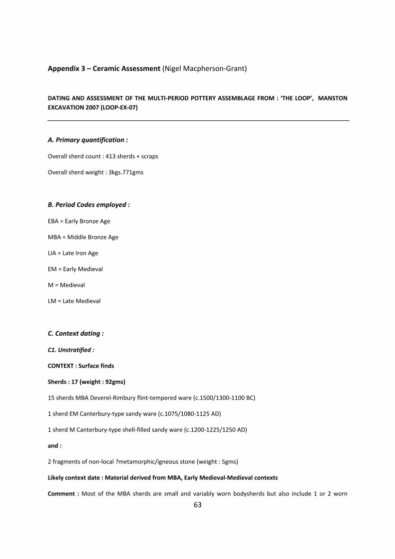
DATING AND ASSESSMENT OF THE MULTI‐PERIOD POTTERY ASSEMBLAGE FROM : ‘THE LOOP’, MANSTON EXCAVATION 2007 (LOOP‐EX‐07)
A. Primary quantification :
Overall sherd count : 413 sherds + scraps
Overall sherd weight : 3kgs.771gms
B. Period Codes employed :
EBA = Early Bronze Age
MBA = Middle Bronze Age
LIA = Late Iron Age
EM = Early Medieval
M = Medieval
LM = Late Medieval
C. Context dating :
C1. Unstratified :
CONTEXT : Surface finds
Sherds : 17 (weight : 92gms)
15 sherds MBA Deverel‐Rimbury flint‐tempered ware (c.1500/1300‐1100 BC)
1 sherd EM Canterbury‐type sandy ware (c.1075/1080‐1125 AD)
1 sherd M Canterbury‐type shell‐filled sandy ware (c.1200‐1225/1250 AD)
and :
2 fragments of non‐local ?metamorphic/igneous stone (weight : 5gms)
Likely context date : Material derived from MBA, Early Medieval‐Medieval contexts
Comment : Most of the MBA sherds are small and variably worn bodysherds but also include 1 or 2 worn
64
formal elements. The Early Medieval sherd is fairly large and unworn apart from some heavy edge‐wear suggesting partial exposure in a long term static environment. The single medieval sherd is fairly heavily worn and could come from manure scatters.
CONTEXT : Surface of colluvium Context 4
Sherds : 6 (weight : 20gms)
4 sherds ? MBA Deverel‐Rimbury flint‐tempered ware (c.1600‐1100 BC)
1 sherd EM Canterbury‐type sandy ware (c.1075/1100‐1175 AD)
1 sherd M/LM Canterbury Tyler Hill sandy ware (c.1350‐1400/1450 AD)
Likely context date : Medieval and later ?
Comment : The MBA sherds are small and extremely weathered – into roundish balls. The Early Medieval sherd is fairly worn, the Late Medieval sherd basically unworn.
C2. Ditches and Pits :
CONTEXT : Linear A Context 15
Sherd : 1 (weight : 1gm)
1 sherd LIA ‘Belgic’‐style grog‐tempered ware (c.100‐50/25 BC)
Likely context date : If not intrusive or residual, early‐mid C1 BC
Comment : The sherd is small and fairly worn, but not heavily – and is unlikely to have travelled too far from its original use‐zone or been frequently disturbed, once lost.
CONTEXT : Linear A Context 33
Sherds : 2 (weight : 1gm)
1 sherd LP flint‐tempered ware (c.1500‐1100/50 BC)
and :
1 scrap daub (weight ; >1gm)
Likely context date : If not residual, may be MBA
Comment : The flint‐tempered sherd is a worn scrap and seriously residual, either in an MBA or later, context
CONTEXT : Linear A Context 41
65
Sherds : Minute scraps and dust (weight : >1gm)
Indeterminate pottery or daub
Likely context date : Probably prehistoric
Comment : Basically undatable – except by contextual association (or other artefact types)
CONTEXT : Linear A Context 43
Sherd : 1 (weight : 2gms)
1 sherd M Canterbury Tyler Hill sandy ware (c.1200/‐1225/1250 AD)
Likely context date : If not intrusive – mid‐late C13 AD or later
Comment : Small bodysherd, fairly worn ‐ perhaps as a bi‐product of agricultural activity. It may be intrusive into a prehistoric context or residual in a later one
CONTEXT : Linear A Context 49
1 fragment natural iron (weight : 3gms)
CONTEXT : Linear B Context 25
Sherds : 3 (weight : 5gms)
1 sherd probable MBA Deverel‐Rimbury flint‐tempered ware (c.1500/1300‐1100 BC)
1 sherd probable LIA ‘Belgic’‐style grog‐tempered ware (c.100‐50/25 BC)
1 sherd EM North Kent shell‐tempered ware with little/no sand (c.1150‐1200/1225 AD)
Likely context date : c.1150‐1200 AD or intrusive into an MBA feature
Comment : The probable MBA sherd is small and heavily abraded. The probable ‘Belgic’ sherd is seriously reduced and abraded. The fabric type suggests an early handmade vessel. Its degree of abrasion is due to reduction through broadly contemporary LIA manure scatters or as a bi‐product of Early Medieval and later agricultural activity. The EM sherd is small and fairly fresh.
CONTEXT : Linear C Context 7 – ditch terminal
Sherds : 3 (weight : 103gms)
3 sherds MBA Deverel‐Rimbury flint‐tempered ware (c.1500/1300‐1100 BC; 2 same vessel)
Likely context date : c.1300‐1100 BC
66
Comment : 1 coarseware bucket‐type coarseware jar and 1 fineware bowl/jar represented. The latter are from the same fineware bowl/jar, one sherd with heavy unifacial wear. The coarseware jar is large and heavily worn overall with some burring of the sherd’s edges.
CONTEXT : Linear C Context 70
Sherds : 5 (weight : 18gms)
5 sherds MBA Deverel‐Rimbury flint‐tempered ware (c.1500/1300‐1100 BC)
Likely context date : c.1300‐1100 BC
Comment : 3‐5 coarseware vessels represented by small‐fairly small, fairly fresh, but sometimes fragmentary, sherds
CONTEXT : Linear C Context 72
Sherds : 3 (weight : 15gms)
3 sherds MBA Deverel‐Rimbury flint‐tempered ware (c.1500/1300‐1100 BC)
Comment : 3 coarsewares represented by small fairly fresh sherds.
CONTEXT : Linear C Context 111 – junction of W and Linear K
Sherds : 12 (weight : 104gms)
11 sherds MBA Deverel‐Rimbury flint‐tempered ware (c.1500/1300‐1100 BC)
1 sherd probable LIA ‘Belgic’‐style grog‐tempered ware
and :
1 rounded scrap duab (weight : 1gm)
Likely context date : c.1300‐1100 BC
Comment : 9‐10 vessels represented including 3 fineware bowls ‐ 1 with traces of a dot‐and‐ring stamp; the remainder are coarsewares. Sherds are small‐medium‐sized and practically all the sherds are worn – some with very heavy unifacial or even bifacial wear. Wear patterns depend on individual post‐loss sherd histories – but some should indicate long term exposure and weathering in a relatively static environment. The ‘Belgic’‐style sherd is small and heavily abraded and, like the sherd from Linear B Context 25, is probably an early handmade product and received its abrasion via a similar choice of mechanisms.
67
CONTEXT : Linear C Context 191/192
Sherds : 3 (weight : 15gm)
3 sherds MBA Deverel‐Rimbury flint‐tempered ware (c.1500/1300‐1100 BC)
Likely context date : c.1300‐1100 BC
Comment : 1 fineware and 2 coarsewares represented by 2 small and 1 medium‐sized sherd. All are worn but the larger sherd has heavy overall wear and burring of sherd edges – indicating fairly frequent disturbance and exposure.
CONTEXT : Linear C Context 227
Sherd : 1 (weight : 3gms)
1 sherd MBA Deverel‐Rimbury flint‐tempered ware (c.1500/1300‐1100 BC)
Likely context date : c.1300‐1100 BC
Comment : Coarseware jar sherd, small and worn.
CONTEXT : Linear D Context 76/77
Sherds : 3 (weight : 68gms)
3 sherds MBA Deverel‐Rimbury flint‐tempered ware (c.1500/1300‐1100 BC)
Likely context date : c.1300‐1100 BC
Comment : 1 fineware and 2 coarsewares (including 1 bucket/barrel‐type jar) represented by 2 small worn scraps and 1 medium‐sized fairly fresh sherd
CONTEXT : Linear D Context 109
Sherd : 1 (weight : 11gms)
1 sherd MBA Deverel‐Rimbury flint‐tempered ware (c.1500/1300‐1100 BC)
Likely context date : c.1300‐1100 BC
Comment : 1 sub‐fineware jar represented by a medium‐sized sherd with fairly heavy unifacial wear.
CONTEXT : Linear D Context 167/168
68
Sherds : 5 (weight : 46gm)
5 sherds MBA Deverel‐Rimbury flint‐tempered ware (c.1500/1300‐1100 BC; 2 same vessel)
Likely context date : c.1300‐1100 BC
Comment : 1 fineware bowl and 3 coarseware bucket/barrel‐type jars represented by mostly medium‐sized sherds. Mixed wear‐patterns – 2‐3 sherds with heavy/fairly heavy unifacial wear.
CONTEXT : Linear D Context 173/174
Sherds : 3 (weight : 10gms)
3 sherds MBA Deverel‐Rimbury flint‐tempered ware (c.1500/1300‐1100 BC; 2 same vessel)
Likely context date : c.1300‐1100 BC
Comment : 1 fineware vessel and 1 coarseware bucket/barrel‐type jar represented by small‐medium sized worn sherds
CONTEXT : Linear D Context 183
Sherds : 6 (weight : 24gm)
6 sherds MBA Deverel‐Rimbury flint‐tempered ware (c.1500/1300‐1100 BC; 2 conjoining)
Likely context date : c.1300‐1100 BC
Comment : 2 sub‐fineware jars and 1‐2 coarseware jars represented by small, mostly medium‐sized sherds with heavy bifacial or unifacial (a base sherd) wear.
CONTEXT : Linear I ‐ Surface
Sherds : 2 (weight : 29gms)
2 sherds MBA Deverel‐Rimbury flint‐tempered ware (c.1500/1300‐1100 BC)
Likely context date : c.1300‐1100 BC – but possibly intrusive
Comment : 1 moderate‐sized coarseware barrel/bucket jar sherd, 1 fairly large fineware globular jar rim sherd. The latter has heavy unifacial wear internally – indicating long term exposure in static ground conditions – the former has part‐unifacial wear. The fineware rim has a hole bored through, after firing, just above the incipient, off‐set, shoulder typical of this type of vessel.
CONTEXT : Linear II Context 401/402
Sherds : 8 (weight : 22gms)
69
7 sherds MBA Deverel‐Rimbury flint‐tempered ware (c.1500/1300‐1100 BC; same vessel)
1 sherd MBA flint‐tempered pottery or fired clay slab
Likely context date : c.1300‐1100 BC
Comment : One coarseware jar represented by one medium‐sized sherds and conjoining scraps; all fairly worn. One heavily worn fairly small thick‐bodied sherd may be from a vessel or from a pottery slab.
CONTEXT : Linear J Context 97/98
Sherd : 1 (weight : 10gms)
1 sherd MBA Deverel‐Rimbury flint‐tempered ware (c.1500/1300‐1100 BC)
Likely context date : c.1300‐1100 BC
Comment : Coarseware jar sherd, medium‐sized, fairly fresh.
CONTEXT : Linear JJ Context 369/370
Sherds : 26 (weight : 699gm)
26 sherds MBA Deverel‐Rimbury flint‐tempered ware (c.1500/1300‐1100 BC; some same vessels, 2 with conjoining sherds)
and : 1 fragment daub (weight : 1gm) – rounded, worn
Likely context date : c.1300‐1100 BC
Comment : Four‐five vessels represented, including one large rim from a large coarseware barrel‐type storage jar with two horizontal rows finger‐tip decoration in neck hollow, a base (with conjoining sherds) from the same/similar type of vessel. All sherds from coarseware jars except one fineware jar base – again with conjoining sherds. Large‐small sherds, all fairly fresh and from a undisturbed contemporary context.
CONTEXT : Linear K Context 107/108
1 small, 2 scraps daub (weight : 3gms)
Likely context date : Possibly MBA
Comment : Daub is worn
CONTEXT : Linear LL Context 299
Sherds : 2 (weight : 11gms)
70
2 sherds MBA Deverel‐Rimbury flint‐tempered ware (c.1500/1300‐1100 BC)
Likely context date : c.1300‐1100 BC
Comment : Two coarseware jars represented. Both small unworn sherds and should be from an undisturbed contemporary context
CONTEXT : Linear P Context 213 – ditch terminal
Sherd : 1 (weight : >1gm)
1 sherd EP or LIA ‘Belgic’‐style grog‐tempered ware (c.2000‐1500/1100 or 100‐50 BC)
Likely context date : Context is MBA – sherd probably residual
Comment : The sherd is small and fairly heavily worn. Even though an early LIA ‘Belgic’ date is just a possibility – the grog is really too coarse and angular and the fabric too ill‐prepared for a ‘Belgic’ product – so an Early Prehistoric date is preferred. Again, Beaker fabrics are mostly well‐prepared whereas there is a recognisable devolution in manufacturing quality during the later phases of the EBA, amongst Urn fabrics particularly. This latter type is, initially, preferred – and the sherd could be a c.1700‐1500 BC product residual in its current context.
CONTEXT : Linear P Context 223
Sherds : 127 (weight : 1073gm)
127 sherds MBA Deverel‐Rimbury flint‐tempered ware (c.1500/1300‐1100 BC; some same vessels, some conjoins)
Likely context date : c.1300‐1100 BC
Comment : Between 7‐10 identifiable bucket/barrel‐type and smaller coarseware jars, possibly more, represented by some large, mostly medium and a few small sherds with mixed‐wear patterns : heavily worn bifacially, unifacially and some basically unworn. Despite condition, the quantity of sherds indicates recovery from an undisturbed (post‐settlement abandonment) contemporary context.
CONTEXT : Linear P Context 333/334
Sherds : 24 (weight : 209gms)
12 sherds MBA Deverel‐Rimbury flint‐and‐grog tempered ware (c.1500/1300‐1100 BC; same vessel)
12 sherds MBA Deverel‐Rimbury flint‐tempered ware (c.1500/1300‐1100 BC; some same vessels)
Likely context date : c.1300‐1100 BC
Comment : Two‐three coarseware jars and one fineware represented. The flint‐and‐grogged sherds are mostly fairly fresh, though some are weather‐split and one has fairly heavy surface abrasion. Apart from the fineware
71
sherds, all others are mostly heavily worn with some weather‐split – indicating long term exposure and weathering.
CONTEXT : Linear P – Additional slot
Sherds : 29 (weight : 387gm)
1 sherd ? EBA or LIA ‘Belgic’‐style grog‐tempered sandy ware (c.2000‐1500 or 100‐50 BC)
4 sherds MBA Deverel‐Rimbury flint‐and‐grog tempered ware (c.1500/1300‐1100 BC; same vessel)
24 sherds MBA Deverel‐Rimbury flint‐tempered ware (c.1500/1300‐1100 BC; some same vessel)
Likely context date : c.1300‐1100 BC
Comment : The grogged sherd is difficult. It is from a worn base sherd with a flaring curving lower‐body wall. In a grogged fabric this would be atypical of MBA styles, but typical of Food Vessel type jars of the EBA. It could also occur on a fineware ‘Belgic‐style vessel. However, the fairly fine and profuse grog content and even wall thickness is more typical of the regular competent potting of the ‘Belgic’ period. This vessel is handmade and so a date before c.50 BC is likely.
For the MBA material, one flint‐and‐grogged coarseware bucket/barrel jar represented by one large, several smaller, fairly worn sherds and 3‐4 vessels represented in purely flint‐tempered ware, including 19 sherds from the same decorated fineware bowl – with some unifacial wear and some virtually unworn sherds. The wear pattern on these sherds is interesting – it occurs only on the exterior and implies, even though many of the sherds do not join, that all of them arrived in place the same way). Remaining coarseware sherds are fresh or fairly worn. Despite it coming from the same linear, the flint‐and‐grogged sherds need not be from the same vessel as in Context 333/334.
CONTEXT : Linear PP Context 283 – ditch terminal
Sherd : 1 (weight : >1gm)
1 sherd MBA Deverel‐Rimbury flint‐tempered ware (c.1500/1300‐1100 BC)
Likely context date : c.1300‐1100 BC
Comment : Small, fairly worn coarseware scrap
CONTEXT : Linear T Context 349/350
Sherd : 1 (weight : 10gms)
1 sherd MBA Deverel‐Rimbury flint‐tempered ware (c.1500/1300‐1100 BC)
Likely context date : c.1300‐1100 BC
Comment : Coarseware jar sherd, medium‐sized with some fairly heavy unifacial wear.
72
CONTEXT : Pit V Context 217/218
Sherds : 6 (weight : 20gms)
1 sherd EBA Beaker fine silty ware with sparse grog and flint temper (c.2300/2000‐1700 BC)
5 sherds MBA Deverel‐Rimbury flint‐tempered ware (c.1500/1300‐1100 BC; same vessel)
Likely context date : c.1300‐1100 BC
Comment : The Beaker sherd is small and abraded, from a thin‐walled vessel with traces of comb‐impressed decoration. The 5 MBA sherds are small, fragmentary, but fresh and from a coarseware barrel/bucket‐type jar decorated with a single row of finger‐tip impressions on shoulder.
5 sherds MBA Deverel‐Rimbury flint‐tempered ware (c.1500/1300‐1100 BC; 2 conjoining)
and :
1 worn lump daub (weight : 6gms)
Likely context date : c.1300‐1100 BC
Comment : 2‐3 coarseware vessels represented, including 2 bucket/barrel‐type jars. Mostly small sherds, all worn except for those from the same vessel.
6 sherds MBA Deverel‐Rimbury flint‐tempered ware (c.1500/1300‐1100 BC; 2 conjoining)
Likely context date : c.1300‐1100 BC
Comment : 1‐2 fineware bowls and 2 coarsewares represented by small only fairly worn sherds. 1 bowl sherd has a single horizontal incised line (probably as part of a band of decoration).
CONTEXT : Pit Complex 144/146/147 ‐ Context 147
Sherds : 6 (weight : 13gms)
6 sherds MBA Deverel‐Rimbury flint‐tempered ware (c.1500/1300‐1100 BC)
Likely context date : c.1300‐1100 BC
73
Comment : All coarseware sherds, 1‐2 vessels represented, heavily worn and fragmentary
CONTEXT : 407/408 ‐ Pit
Sherds : 2 (weight : 9gms)
2 sherds MBA Deverel‐Rimbury flint‐tempered ware (c.1500/1300‐1100 BC)
Likely context date : c.1300‐1100 BC
Comment : 1 sub‐fineware sherd and 1 coarseware sherd, the first fairly small and bifacially worn, the other heavily worn and rounded
CONTEXT : 78 ‐ Posthole
Sherd : 1 (weight : 10gms)
1 sherd LM Canterbury‐type fine earthenware (c.1475/1500‐1525 AD)
And :
1 worn scrap C16 AD brick (weight : >1gm)
1 fragment natural flint ‐ DISCARDED
Likely context date : If not intrusive ‐ c.1500‐1525 AD
Comment : The LM sherd is a handle fragment from a large cistern‐type jar; it is fairly heavily worn – and could be intrusive from an early Post‐Medieval context/horizon.
C3. Individual contexts :
CONTEXT : 13 – Surface clean
Sherd : 1 (weight : 2gms)
1 sherd EM Canterbury‐type sandy ware (c.1075‐1150/1175 AD)
Likely context date : If not intrusive – C13 AD or later
Comment : Sherd is small and fairly heavily abraded, possibly receiving its degree of wear as a bi‐product of agricultural activity. It may be intrusive into a prehistoric context, or residual in a later one.
CONTEXT : 27
Sherds : 3 (weight : 17gms)
74
1 sherd EM North Kent shell‐filled ware with little/no sand (c.1125/1150‐1175 AD)
1 sherd ? EM N.French/Flanders fine grey sandy ware (c.1150‐1175/1200 AD; CHECK)
1 sherd Canterbury Tyler Hill sandy ware (c.1225‐1250/1275 AD)
and :
2 fragments fired clay tile/slab (weight : 30gms) ‐ ?prehistoric or Early Medieval
Likely context date : ? 1150‐1175 AD – with intrusive later elements
Comment : The context has been tentatively dated on the basis of sherd size and wear patterns. The Early Medieval shell‐filled pan/dish rim sherd is fresh and moderate‐sized and really too large and fresh to arrive via manuring scatters. Two fragments of fine‐grained fired clay slab/?kitchen furniture are similarly moderate‐sized and fairly fresh ‐ and may be contemporary. Conversely, the medieval sherd is a highly worn scrap and should have arrived into context via manuring or ploughing. Similarly the two small fairly worn Post‐Medieval tile fragments.
CONTEXT : 53
1 scrap daub (weight : 1gm)
Likely context date : ? MBA
Comment : Fragment is not seriously worn and should be from an undisturbed contemporary context.
CONTEXT : 71
Sherds : 30 + scraps (weight : 291gms)
30 sherds + scraps MBA Deverel‐Rimbury flint‐tempered ware (c.1500/1300‐1100 BC; same vessel)
Likely context date : c.1300‐1100 BC
Comment : Base sherds from a coarseware jar – all sherds fairly fresh but most highly fragmented.
CONTEXT : 87/88
Sherds : 2 (weight : 34gms)
2 sherds MBA Deverel‐Rimbury flint‐tempered ware (c.1500/1300‐1100 BC)
and :
75
1 lump ironstone (weight : 79gms)
Likely context date : c.1300‐1100 BC
Comment : 2 coarsewares represented by one large virtually unworn sherd and one small scrap. Sherd size and condition should indicate material from an undisturbed contemporary context.
1 worked flint flake (weight : >1gm) ‐ unpatinated
1 fragment burnt flint (weight : 1gm)
Likely context date : ? MBA
CONTEXT : 101/102
Sherds : 8 (weight : 47gms)
8 sherds MBA Deverel‐Rimbury flint‐tempered ware (c.1500/1300‐1100 BC)
Likely context date : c.1300‐1100 BC
Comment : 4‐5 coarseware vessels represented, including 1 fairly fresh barrel‐type storage jar rim sherd. Most other sherds are small worn scraps; one fairly small sherd is very heavily abraded.
CONTEXT : 125
Sherd : 1 (weight : 4gms)
1 sherd MBA Deverel‐Rimbury flint‐tempered ware (c.1500/1300‐1100 BC)
Likely context date : If not residual in a later context, c.1300‐1100 BC
Comment : Coarseware jar sherd, small and worn overall
CONTEXT : 149/150
Sherds : 2 (weight : 2gms)
2 sherds EBA Beaker grog and sparse flint‐tempered ware (c.2300/2000‐1700 BC; conjoining)
Likely context date : c.2000‐1700 BC – or residual/intrusive into an MBA feature
Comment : Small slightly worn sherds from a comb‐zoned Beaker, ? with horizontal impressed decoration. The
76
condition of the sherd suggests it comes from a contemporary EBA context or, has been disturbed only a short distance from the same.
CONTEXT : 151/152
Sherds : 2 (weight : 13gms)
1 sherd EBA Beaker grog‐and‐sparse flint‐tempered ware (c.2300/2000‐1700 BC)
1 sherd LM Canterbury Tyler Hill sandy ware (c.1475‐1500/1525 AD)
Likely context date : 1475‐1500 AD ‐ or residual/intrusive in an MBA feature
Comment : Single slightly worn small sherd from a comb‐decorated Beaker. The sherd is residual but its condition suggests it derives from a disturbed EBA context or one only a short distance from Context 151/152. The Late Medieval sherd is fairly large, totally unworn and should be from an undisturbed contemporary context.
CONTEXT : 169/170
Sherd : 1 (weight : 3gms)
1 sherd MBA Deverel‐Rimbury flint‐tempered ware (c.1500/1300‐1100BC)
and :
1 worn scrap daub (weight : 1gm)
Likely context date : c.1300‐1100 BC
Comment : Single coarseware bodysherd, fairly fresh and probably from an undisturbed contemporary context.
CONTEXT : 247/248
Sherds : 2 (weight : 3gms)
1 sherd EBA Beaker grog‐tempered ware with sparse flint (c.2300/2000‐1700 BC)
1 sherd MIA‐LIA flint‐tempered ware (c.300/150‐50 BC)
Likely context date : Suspect EBA or MBA
Comment : Both sherds are small. The Beaker sherd is fairly worn but not heavily, the later MIA‐LIA type rim is heavily abraded. Either this is an EBA context and the LP sherd is intrusive, or the Beaker sherd is residual in an MBA context ‐ and the later sherd again intrusive. The LP sherd is from a probable S‐profiled jar with thickened curving and inverted rim, it could be MIA but an LIA date is preferred (until greater site/locale evidence for the MIA is forthcoming). This would place its likely date between c.150‐50 BC.
77
CONTEXT : 279 ‐ surface
Sherds : 2 (weight : 4gms)
1 sherd ? EBA Beaker or Romanised grogged sandy ware (c.2300/2000‐1700 BC or c.75‐125 AD)
Comment : These two sherds are very worn and, since they are from the context’s surface may be machined into place. If not, their severely abraded condition inhibits certain dating. The ?EBA sherd is too abraded to be reliably used at all – the alternatives given are reasonable but will not be used in this assessment. The ? EBA Food vessel sherd is a distinct possibility, partly because of the obvious, and earlier, Beaker presence, partly because of the probable EBA Urn‐type sherd from Context 427 but also though the fabric could be LIA, its outer surface appears to carry the worn traces of deep, possibly decorative, moulding – not a characteristic of the latter period but certainly among EBA Food Vessels and some urns. However, in view of the sherd’s condition, this potential requires confirmation
CONTEXT : 279
Sherds : 4 (weight : 22gms)
4 sherds MBA Deverel‐Rimbury flint‐tempered ware (c.1500/1300‐1100 BC)
and :
1 lump daub (weight : 5gms)
Likely context date : c.1300‐1100 BC
Comment : 1 fineware, 1 sub‐fineware and 2 coarsewares represented. The fineware sherd is fairly heavily abraded, the sub‐fineware sherd moderate‐sized and fairly fresh; one coarseware bodysherd has fairly heavy unifacial wear.
CONTEXT : 327
Sherd : 1 (weight : 4gms)
1 sherd MBA Deverel‐Rimbury flint‐tempered ware (c.1500/1300‐1100 BC)
Likely context date : c.1300‐1100 BC
Comment : Unworn sub‐fineware jar sherd – should be from an undisturbed contemporary context
CONTEXT : 347
78
Sherds : 2 (weight : 3gm)
1 sherd probable EBA Beaker fine silty ware with sparse grog and flint temper (c.2300/2000‐1700 BC)
1 sherd MBA Deverel‐Rimbury flint‐and‐grog tempered ware (c.1500/1300‐1100 BC)
Likely context date : c.1300‐1100 BC
Comment : The possible Beaker sherd is small, thin‐walled and abraded – and superficially very similar in size, condition and appearance to the definite Beaker sherd from Context 217/218; the likelihood that this sherd is genuinely EBA is strong. By comparison, the MBA sherd , though small, is fresh and unabraded and should be from an undisturbed contemporary context.
CONTEXT : 397
Sherds : 3 (weight : 10gms)
3 sherds MBA Deverel‐Rimbury flint‐tempered ware (c.1500/1300‐1100 BC; same vessel)
Likely context date : c.1300‐1100 BC
Comment : 3 small, fragmentary but fairly fresh coarseware sherds.
CONTEXT : 427
Sherds : 26 (weight : 234gms)
1 sherd probable EBA Urn‐type grog‐tempered ware with sparse flint temper (c.2000/1700‐1500 BC)
24 sherds MBA Deverel‐Rimbury flint‐tempered ware (c.1500/1300‐1100 BC)
1 sherd ? MBA or EIA‐LIA flint‐and grog‐tempered ware (c.1500‐1100 or 500‐50 BC
Likely context date : c.1300‐1100 BC
Comment : It is possible that the ? EBA Urn sherd is an intrusive LIA ‘Belgic’‐style sherd. However the fabric is less compact than most ‘Belgic’‐type grogged products, and one or two of the grog inclusions are atypically big. Underfired rather friable fabrics, containing poorly sorted grog, appears to be a relative regional norm for EBA Urn fabrics – and visually and texturally different from well‐sorted compact ‘Belgic’ fabrics. In addition the two‐tone firing, pale buff externally, dark grey‐black internally, is atypical of ‘Belgic’ material, does occur among some later EBA assemblages – and is basically a lower‐grade follow‐on from the more highly oxidised firing trends associated with earlier Beaker fabrics.
Most of the MBA flint‐tempered sherds are small and, apart from 2‐3 fairly large and intact base sherds, are split and fragmentary, but only moderately worn. They appear to all be from the same thick‐based coarseware barrel/bucket jar – and should represent material recovered from an undisturbed contemporary context. The single flint‐and‐grogged sherd may be MBA – but it is much more worn than the associated MBA material. It could be residual – and as such may be useful as a settlement‐longevity indicator. Alternatively, it is later, EIA‐LIA, and intrusive. ‐ its thick body wall and relatively fine fairly sparse flint temper could indicate an earlier IA date.
79
D. Assessment :
This modest‐sized multi‐period assemblage consists of mostly small‐large sherds with mixed wear‐patterns, highly abraded and reduced, unifacial weathering indicating exposure in undisturbed ground/contexts for relatively long periods of time (ie. unsealed rubbish deposits), and little worn or fresh unworn sherds. Most of the small quantity of Earlier Prehistoric material consists of highly abraded and small sherds, although 2 contexts (Contexts 149/150 and 151/152) produced unworn small sherds. For the Later Prehistoric MBA phase undisturbed discard deposits contemporary with the life of the settlement are represented by both fresh and weathered vari‐sized sherd assemblages from Ditch Linears C, D, II, JJ, K, L, LL, P, PP, T and Y, Pit V and Pit Complex 144/146/147 and Contexts 71, 87/88, 101/102, 169/170, 279, 327, 347, 397,427. For later periods – most of the small quantity of material recovered is small and worn but includes larger fresh/slightly worn sherds from Linear B and Contexts 27, 151/152. Overall, the recovered sherds provide the following period frequencies and implications :
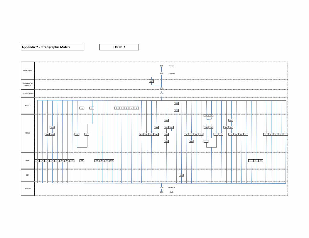
Four main phases of activity are represented ceramically :
Earlier Prehistoric – Early Bronze Age (c.2000‐1700 BC) :
Definitely represented by fairly fresh small decorated Beaker sherds from Contexts 149/150 and 151/152, almost certainly by small worn sherds (1 with traces of decoration) from Contexts 217/218 and 247/248. In addition there are small worn sherds in grog‐tempered fabrics which do not look Late Iron Age and may be from EBA Beaker or Urn. These are from Linear P and Contexts 279, 347 and 427. Of these a thick‐walled rather coarsely grogged and under‐fired sherd from Context 427 may represent a Collared Urn.
The condition of the two definite Beaker sherds suggests derivation from undisturbed contemporary EBA contexts – or they have been shifted only a short distance from their original loss points. The remainder of the probable or potential EBA sherds are sufficiently reduced in size to indicate a considerable degree of post‐loss movement in, probably, agriculturally disturbed soils. The only exception to this may be the possible Urn sherd from Context 427 which, again, suggests only a limited degree of post‐loss movement.
The condition of the 2 decorated Beaker sherds (representing 2 separate vessels) suggests that they derive from original on‐site EBA activity. If the excavation also produced a fairly high quantity of EBA‐type flintwork, then this may be a genuine likelihood. If not, then the condition of these sherds suggests either a limited degree of on‐site activity, the evidence of which has been removed by agricultural/occupational disturbance during the MBA or, since the site is on a long sloping gradient, be derived from disturbed EBA contexts up‐slope but adjacent to the excavated area. The condition of the other smaller possible Beaker sherds is more compatible with the latter suggestion. The low quantity of genuine, and possible, EBA sherds suggests they are derived from plough‐reduced settlement‐fringe activity or from ring‐ditch (barrow) burials – and the single possible worn EBA Urn sherd tends to support the latter possibility.
Later Prehistoric – Middle Bronze Age (c.1500‐1100 BC) :
Both in terms of features and ceramics, this is the dominant period element recorded. All the linear ditches (though there is some uncertainty about Linears A, B‐K) – excluding any modern features ‐ are of this general date. The excavation recorded a relatively complex sequence of re‐cut and modified field‐boundary and possible enclosure ditches. Without a close examination of ditch‐intersect sections, it is impossible to be
81
entirely certain about the correct sequence of ditches, and any sub‐phases of ditch renewal associated with them. However, and simplistically at this stage, there appear to be three main phases represented by differing ditch alignments :
1. An ENE‐WSW alignment represented by Linears N, AA and X, BB, CC, WW, W, S with the small field‐boundary Linears VI, R and DD, FF, GG at right‐angles to it. It is virtually certain that the thin ditches belonging to this alignment come first. Whether any other linears were contemporary with this phase is uncertain (ie. ? Linear L).
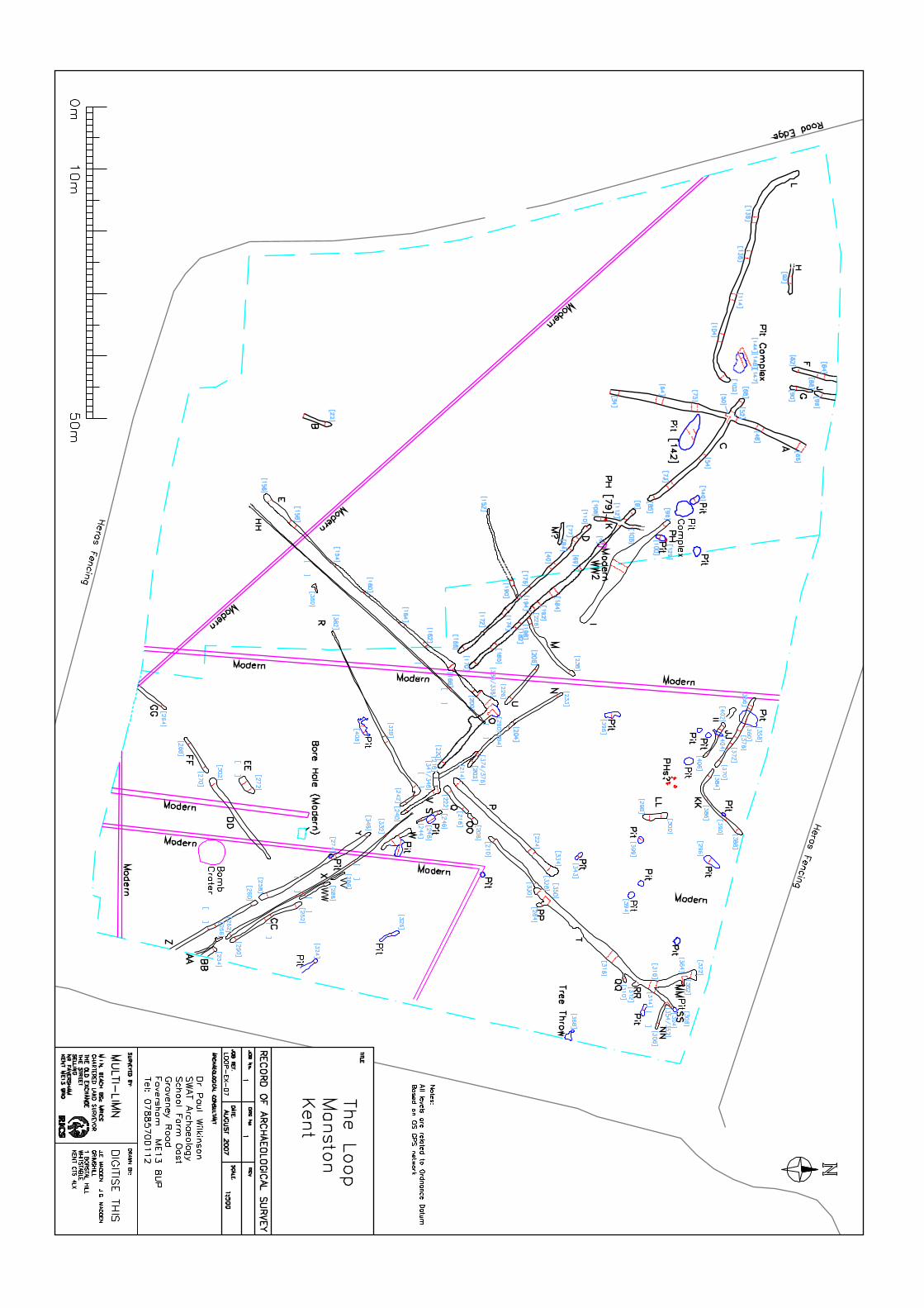
2. Partially based on the former alignment (Linears Z and Y), a fairly major re‐organisation generated a more substantial axial NW‐SE alignment represented by Linears Z, Y, O, D and C and including a right‐angled off‐set at the junction of Linears E and O. This probable second phase included a similar set of more substantial NE‐SW aligned ditches, Linears E, HH and G,P,OO and T, cut at right‐angles to the main axial line. At some time during this general phase Linear C was cut to join Linear L in the north‐west corner of the site. However, there is an interpretative complication here, partly represented by :
3 ‐ a NNE‐SSW alignment including Linears F, G, J and B, K.
Of these Linear K coincidentally butt‐ends with Linear D (obviously part of the main probable second‐phase NW‐SE axial alignment) and the parallel Linears F and G, J have an indirect, but probably non‐coincidental relationship, with the eastern end of Linear L These two separate instances of ditch terminal conjunctions are on either side of a potential gap, that appears to have been sealed by extending Linear C over to Linear L. Also, Linear K is on the same alignment as Linear B. If a line was drawn between both, coincidentally, the western terminal of the primary phase linear, VI, stops just short of it. Equally coincidentally, Linears B and K are broadly parallel with Linear A – which goes through the potential gap in the main NW‐SE axial alignment. The curvilinear nature of Linear A, coupled with its apparent twin Linears K, suggests a droveway. However, the site plan appears to shows ‘droveway’ ditches A and K post‐dating Linear C. Though this could imply that they are considerable later than the MBA settlement (the ceramic evidence for both ‘droveway’ ditches is ambiguous) ‐ the above set of coincidences does strongly imply that the ‘droveway’ was integral with part, at least, of the settlement’s history. Irrespective, the extension of Linear C across this ‘gap’, and its conjunction with the potential droveway, is significant. Either the settlement was initially established on either side of a known trackway (possibly pre‐dating the settlement’s establishment), and was subsequently partially formalised with the addition of ditch‐and‐hedge boundaries – or ‐ that there was indeed a pre‐settlement trackway, which was closed for a period by a linear, but then subsequently re‐utilised and formalised.
In addition to the above, a further set of right‐angular linears, II, JJ and KK, lie close to the north‐eastern site‐boundary. Whatever their original function, they are seen as being ‘within’ and close to the main occupation area itself, principally because they are among clusters of pits and post‐holes. Also partly because, close to them, Linear T appears to have a number of short drainage gullies leading into it ‐ suggesting inconvenient water run‐off problems close to the main living area ‐ and partly because most of the other pits recorded are concentrated along the north‐eastern ‘inner’ side of the main NW‐SE axial ditch alignment.
For the pottery ‐ relatively large sherd‐assemblages (between 10‐150 sherds each) were recovered from Linears C, JJ, P, Pit complex 144/146/147 and Contexts 71, 427 – all belonging to the MBA Deverel‐Rimbury ceramic tradition. Comparatively, the overall pottery assemblage is not large but contains useful diagnostic formal and decorated elements from Linears C, I, II, JJ and P and Contexts 101/102, 145/146 and 217/218 – including several new additions to the regional typological database. The latter include sherds from a large‐diameter fineware bowl or globular jar with a horizontal band of decoration consisting of incised chevrons above a broad zone of incised grooves or combing (from Linear P) – and a large rim sherd from a large barrel‐type coarseware storage jar decorated with two horizontal rows of finger‐tip impressions in the neck hollow
82
(from Linear JJ, 369/370). One small insignificant‐looking bodysherd from Linear C Context 111 ‐ from a fineware bowl originally decorated with a horizontal band of dot‐and‐ring impressions – is a key dating element. In addition, there are several rim sherds from fineware globular jars with off‐set shoulders which are also important elements in dating the site.
The largest sherd assemblages are from Linears JJ and P, and Pit Complex 144/146/147. The latter pit sequence is just within the eastern curve of Linear L, Linear P is within the long NE‐SW ?settlement enclosure ditch represented by Linears G, OO and T. Both of these locations are on the inside of the main NW‐SE axial ditch alignment, that basically encloses the assumed settlement’s main occupation zone, on its north‐east side. These two assemblages, particularly that from Linear P, mostly consist of medium‐sized, highly worn, sherds – suggesting rubbish dumped in ditches around the edge of the settlement. As indicated above Linear JJ is among a cluster of pits and ditches indicating concentrations of activity – and here, the large virtually unworn sherds from it, suggest breakage and convenient disposal in ditches adjacent to the main occupation area.
Significance of the feature evidence :
As of 2001, regional, Kent‐area, find‐spots of Middle Bronze Age Deverel‐Rimbury pottery numbered only 71. This is comparatively low compared with the following periods ‐ 113 for the Late Bronze/Early Iron Age transition, 140 for the Early‐Mid Iron Age and 411 for the ‘Belgic’ phase of the Late Iron Age. These numbers will have increased since 2001 ‐ but the likely ratios not at all. This difference is partly due to subsequent increases in population – but also, to some extent, to the mostly more lightweight character of MBA farmsteads – simple ditched‐and‐hedged, or lightly palisaded, enclosures set within large tracts of similarly enclosed farmland – compared with the later generally more substantial farm and settlement enclosures of the earlier first millennium BC. Whilst MBA farmsteads may have been relatively substantial in their own day, the enclosure format employed frequently consisted of thin irregularly dug, frequently interrupted, ditches ‐ which have not only had to survive the increasing agricultural use of the land during the following three millennia, but also the ravages of modern deep ploughing. This frequently results in only ephemeral ditch traces which may be missed altogether due to the frequently limited scope of evaluation archaeology or, if found, may have insufficient ceramic content to adequately define their date.
In Thanet, out of an overall recorded period total of between 15‐20 sites, only 8 are settlement sites. Of these, only one, at South Dumpton Downs, produced a complete paddock‐style enclosure and traces of associated field‐boundary ditches. All the others are represented by tantalising fragments of enclosure or, more frequently, field‐boundary ditches. Within Kent as a whole, the only other comparable published area‐excavation of an MBA field and enclosure system is from Coldharbour Road, Gravesend. Both the latter and present site‐plans are superficially similar, in terms of frequently re‐cut and interrupted thin linear ditches and therefore typical of other examples across south‐eastern England. However, Gravesend is at the other end of the county and whilst it, and the Loop site, may be broadly typical of other examples of MBA ranch‐style farmsteads across southern England – Thanet was confirmably within the sphere of continental influence throughout the Bronze Age – and intra‐period similarities found elsewhere cannot always be taken for granted. For instance, it has become very clear from the excavations at Highstead, Chislet (on the other side of the Wantsum seaway from Thanet) ‐ which produced a number of datable and undatable enclosures of broadly first millennium or earlier BC date – that however economic the temptation, it is academically unwise to attempt to date enclosures solely via the study of aerial photographs (Champion 2007, ???). A greater degree of intra‐period consistency, at least for defining typical enclosure/settlement plans, is still urgently needed. The relatively extensive nature of the present site, with its firm feature evidence for relatively long‐term occupation, is therefore a welcome and useful addition to the regional MBA settlement‐plan database.
Significance of the ceramic evidence :
83
A recent re‐appraisal of the dating of English Bronze Age cultures (Needham ???) places the Middle Bronze Age Deverel‐Rimbury tradition’s broad‐band dating between c.1700‐1000 or 900 BC ‐ but its main floruit between c.1600‐1100 BC – and, superficially, the latter can be applied to the present assemblage. However, a recent review of the dating of Thanet’s Bronze Age metalwork hoards placed that contained within the Birchington bowl to between c.1300‐1100 BC. This simple globular bowl is decorated with a broad mid‐girth band of incised/combed horizontal lines framed by single rows of dot‐and‐ring stamping. Sherds from other, or almost certainly, similarly decorated fineware bowls occur from a number of mostly unpublished Thanet MBA sites : Netherhale Farm, Margate Football Club, Manston Road, Westwood Cross –and now the Loop. The present sherd is worn and scrappy but there is no doubting the decoration – it usefully links this site with all the others and provides an initial, though purely typological (the bronze palstaves from the Birchington bowl), date of c.1300‐1100 BC for the Loop assemblage. Usefully, within this frame of association, the large decorated barrel jar from Linear JJ has two fairly close stylistic parallels with similar jars from Netherhale Farm (Macpherson‐Grant 1992, 62).
The decoration of this jar can be further paralleled amongst others from an MBA cremation cemetery at Kimpton, Hampshire. All of these are associated with its Phase C and have associated, but difficult, C‐14 dating (though one, at 1420‐1130 BC, is within the typological date‐range given above). Kimpton Phase C precedes Kimpton Phases D and F. These phases produced a series of plain and decorated biconical or sub‐biconical globular‐style urns (or fineware jars in daily life) typically provided with slight off‐set or incipient shoulders. These vessels are associated with C‐14 dates of 1590‐1250 and 1710‐1250 BC. In addition, a shoulder sherd from a vessel of this type was recovered from the recent 2003 Bon Secours site at Ramsgate, and indirectly associated with a C‐14 date of 1510‐1320 BC. Rim sherds from vessels of this type were recovered from Loop contexts Linear I and Linear JJ Context 369/370. A rim sherd from another similar vessel, together with 2 further general parallels for the decorated barrel jar rim, came from the Monkton Area 7 ring‐ditch cremation cemetery. This site had no associated C‐14 dating, but another nearby ring‐ditch cremation cemetery, Monkton Area 3, produced two‐thirds of a Cornish Trevisker Ware barrel jar, from the primary silt of the ring‐ditch. This vessel has been C‐14 dated to 1530‐1310 BC (94% probability). Trevisker Ware pottery is made using clays that contain gabbroic inclusions, a type of volcanic rock found in the Lizard Peninsula. The jar’s presence at Monkton inevitably implies long‐distance sea‐borne trade. It has to be more than coincidence that another Middle Bronze Age site within the same island of Thanet, the Loop, should produce samples of serpentine rock from the same peninsula. Whatever the reason for this rock’s presence in the Loop settlement, it unavoidably strengthens the likelihood of regular long‐distance seaway trading contacts between these two regions.
There are further inter‐assemblage inter‐regional parallels that can be quoted for the pottery – and a further 2‐3 Carbon‐14 dates. These, together with the sites and typological and scientific dating mentioned above, can be constructively applied to the present assemblage. This will be useful, because despite the relative uniformity of the Deverel‐Rimbury culture across southern England, and accepting the inevitability of inter‐regional and even intra‐settlement manufacturing variations, there are subtle formal and manufacturing differences amongst regional material that are likely to equate with differences in chronological position. To some degree these differences may be reflected in the available Kentish C‐14 dates for the period, but this is not at all certain. This is a condition that needs to be remedied. As a result, though the Loop assemblage itself is not large, the string of associations that can be tied into it will, with further analysis, help consolidate the relative chronological placement of Kentish assemblages recovered to date. In addition, the direct links to Cornwall, and all their associated implications, are not only of academic value but are the stuff of stories and pre‐historical accuracy.
Early Historic – Late (pre‐Roman) Iron Age (c.150‐25 BC) :
84
One small and worn, but definite, MIA/LIA‐style flint‐tempered rim sherd was recovered from Context 247/248. Another, possible, Iron Age‐type bodysherd was recovered from Linear A Context 33. Late Iron Age ‘Belgic’‐style grog‐tempered sherds were recovered from Linears A‐C and P. These latter sherds are highly worn and small ‐ and it is possible some may be of MBA date – however their grog content appears more typical of earlier ‘Belgic’ first century BC products. The low quantities of both ware types suggests either settlement‐fringe activity or arrival on‐site via agricultural manuring, at some time between c.150‐25 BC. However, once established, LIA farmsteads (as opposed to major settlement types) generally remain occupied through until the first or second centuries AD before terminating and shifting location as a result of changing land‐use policies. Since there is a notable virtual absence of later ‘Belgic’ or Roman pottery from this excavation, it is possible that this part of the landscape was maintained at pasture, fallow‐land or woodland level throughout the later first century BC and the whole of the Roman period at least, with some or all of the sherds arriving on‐site during later agricultural activity.
Later Historic – Early‐Late Medieval (c.1075‐1525 AD) :
A total of 10 sherds represent this period, 5 of which are of Early Medieval eleventh‐twelfth century AD date. Some of these, and most of the later, Medieval or Late Medieval, sherds are small and abraded. However, 2 Early Medieval sherds (from Contexts 25 (Linear B) and 27) and one Late Medieval sherd (Context 151/152) are fairly large and virtually unworn. Whilst their condition could imply on‐site activity during these periods, their recovery points are all, almost certainly, of MBA Deverel‐Rimbury date – and they are therefore intrusive. Irrespective, their size and condition does imply discard from a hamlet/manor/farm only a short distance away.
E. Recommendations :
1. The definite and probable Beaker and EBA Urn sherds require further identification and provision of a report. They have been sent to Dr.Alex Gibson of Bradford University
2. The two decorated Beaker sherds need illustration – their drawing for publication will take 1 day.
3. The Middle Bronze Age pottery needs to be thoroughly examined for fabric type and wear‐patterns to help determine the correct sequence of ditches and their phasing. This, together with assessor/excavator liaison, will take >3 days.
4. The overall MBA pottery element is small and mostly consists of bodysherds with relatively few diagnostic or new items demanding illustration and publication. As a result these can be most economically dealt with via conventional publication – rather than slim line published statements based on a detailed Available Archive report. To achieve this :
5. Six elements require pre‐drawing glued restoration. This will take 1 day
6. Nine elements (mostly bases) require pencil drawing only for Archive purposes. This will take > 1 day
7. Thirteen elements require drawing for publication – including 5 plain, 4 simple‐decorated and 4 complex‐decorated, sherds. This will take >3 days
8. Four elements require illustration alongside abstractions of previously published pottery figures for direct visual comparative purposes. The process of abstraction, re‐drawing or modification will take > 2 days
9. Preparation of publication report pottery artwork figures will take > 1 day
10. Comparative research, preparation of pottery fabric‐type frequency and inter‐assemblage comparative
85
dating tables, writing of final pottery report > 7 days
NB : Strictly speaking regional research requirements need as many C‐14 dates as can be acquired. However, in view of the number of existing C‐14 dates and typological cross‐references that can be applied to this site and finds assemblage – it is recommended that no C‐14 dating is asked for, unless the key pottery elements from Linear JJ Context 369/370 and Linear P – Additional slot were self‐evidently associated with contemporary deposits of fresh animal bone.
Analyst: N.Macpherson‐Grant (11.11.2007)
86
Appendix 4 – Lithic Assessment (Barry Bishop)
DATING AND ASSESSMENT OF THE LITHIC ASSEMBLAGE FROM : ‘THE LOOP’, MANSTON EXCAVATION 2007 (LOOP‐EX‐07)
Proposals for Assessment
The struck lithic material from Manston Loop comprises a medium sized assemblage of approximately 400 pieces recovered from a wide variety of individual contexts. The site is in an area of considerable archaeological interest, not least that relating to the prehistoric periods. Analysis of the lithic material has the potential to significantly contribute to the stated specific aims of the archaeological work undertaken at Manston Loop. In particular, they will contribute to an understanding of the character, function, significance and date of any lithic‐based activities, including the spatial organisation of such activities, as well as to questions relating to matters such as ceremonial or ritual behaviour.
Preliminary examination of the material indicates it is multi‐period. It was noted that there was a high proportion of blades and debitage originating from a blade‐based reduction strategy, indicating the presence of Mesolithic or Early Neolithic industries. The presence of an unfinished leaf‐shaped arrowhead confirms activity at the site during the latter period. Other contexts contained material originating from a more opportunistic, flake‐based, reduction strategy, which would be more typical of Bronze Age or possibly even Iron Age industries.
It is therefore desirable that the assemblage be examined in greater detail in order for its archaeological potential to be assessed.
It is therefore proposed that:
- The assemblage is catalogued and classified by individual context according to a basic technological
and typological scheme
- A general overview of the material should be presented, including the chronological periods
represented and a brief description of the characteristics of each industry
- A brief consideration of contextual associations should be made, including the spatial distribution of
the material, the degree of residuality and a description of key selected sub‐assemblages
- The archaeological significance of the material should be highlighted, including a statement of its
potential to contribute to the further understanding of the nature and chronology of the activities
identified during the project
- A recommendation detailing any further work required should be included
Analyst: Barry Bishop (November 2007)
87
Appendix 5 – Figures
(001) Topsoil
(002) Ploughsoil
028
(003)
(004)
129
A K B F G J L
100
UU O
127 MM
278 144 130 120 234 238 PP TT
248 280 D C 408 140 280 146 118 II JJ KK 178 P OO SS RR NN QQ I U Y Q LL