AN ENGINEERING GEOLOGICAL INVESTIGATION FOR A PROPOSED NEW CEMETERY AT STORMS RIVER PREPARED BY: PREPARED FOR: SETPLAN SETTLEMENT PLANNING SERVICES CONSULTING TOWN PLANNERS P.O. BOX 2446 NORTH END 6056 JANUARY 2008 Tel: 041 373 8871 • Fax: 041373 6549 • Cell: 082 499 3140 • PO Box 27996 GREENACRES 6057
Storms River Cemetery: Engineering Geological Investigation
Geological and Environmental Services • PO Box 27996 GREENACRES 6057 • Tel: 041 373 8871 • Cell: 082 499 3140
ii
Appendices
Appendix 1: Figures
Appendix 2: Trial Pit Profiles
Appendix 3: Laboratory Soil Results
Storms River Cemetery: Engineering Geological Investigation
Geological and Environmental Services • PO Box 27996 GREENACRES 6057 • Tel: 041 373 8871 • Cell: 082 499 3140
1
1 Introduction
1.1 Background
A new cemetery site is required for the Storms River community in the south-western part of the Eastern
Cape Province. The existing cemeteries in the area are unsuitable for cemetery purposes due to shallow
bedrock conditions and perched water tables / flooding after wet periods. The remaining functional
cemetery sites are also too small, located long distances away from the town and rapidly reaching full
capacity.
Six proposed cemetery candidate sites were selected by Setplan Settlement Planning Services in
conjunction with the local Storms River community. Open pieces of land that appeared suitable from both
an accessibility and vegetation area point of view were selected as potentially suitable sites and subjected
to a more detailed engineering geological investigation. These candidate sites were also ranked by the
Storms River community according to certain social criteria.
The ranking of the candidate sites during this initial social and town planning site selection process is as
follows:
Candidate Site 1: Rugby Field (most preferred)
Candidate Site 2: Adjacent Rugby Field
Candidate Site 3: Keurboom Forest
Candidate Site 4: National Road Site
Candidate Site 5: Plantation Site
Candidate site 6: Existing Goena cemetery (least preferred)
The engineering geological investigation was commissioned to determine which of the above candidate
sites is the most suitable for cemetery site establishment based on the prevailing geological conditions.
Cognisance was also taken of the recommended cemetery site selection criteria, public pedestrian and
vehicular accessibility, and various Department of Water Affairs and Forestry (DWAF) constraints
(perched water table activity and proximity to drainage channels.
Storms River Cemetery: Engineering Geological Investigation
Geological and Environmental Services • PO Box 27996 GREENACRES 6057 • Tel: 041 373 8871 • Cell: 082 499 3140
2
The findings of the engineering geological investigation form the basis of the environmental investigation,
which has been completed. Environmental authorisation is required from the Department of Economic
Affairs Environment and Tourism (DEAET) in terms of current environmental legislation to rezone the
candidate site for cemetery usage.
Verbal instruction to undertake the engineering geological investigation was received from Mr Brendan
Hindes of Setplan on Tuesday 1 November 2005. The field investigation was carried out on Wednesday
16 November 2005.
1.2 Location
The Storms River village is located about 5 km west of the Paul Sauer Bridge (Storms River Bridge /
Tsitsikamma Total village tourist stop). The existing small cemetery at Goena (candidate site 6) visited
during the field investigation is located adjacent to an electricity sub-station about 10 km south of the
Storms River village.
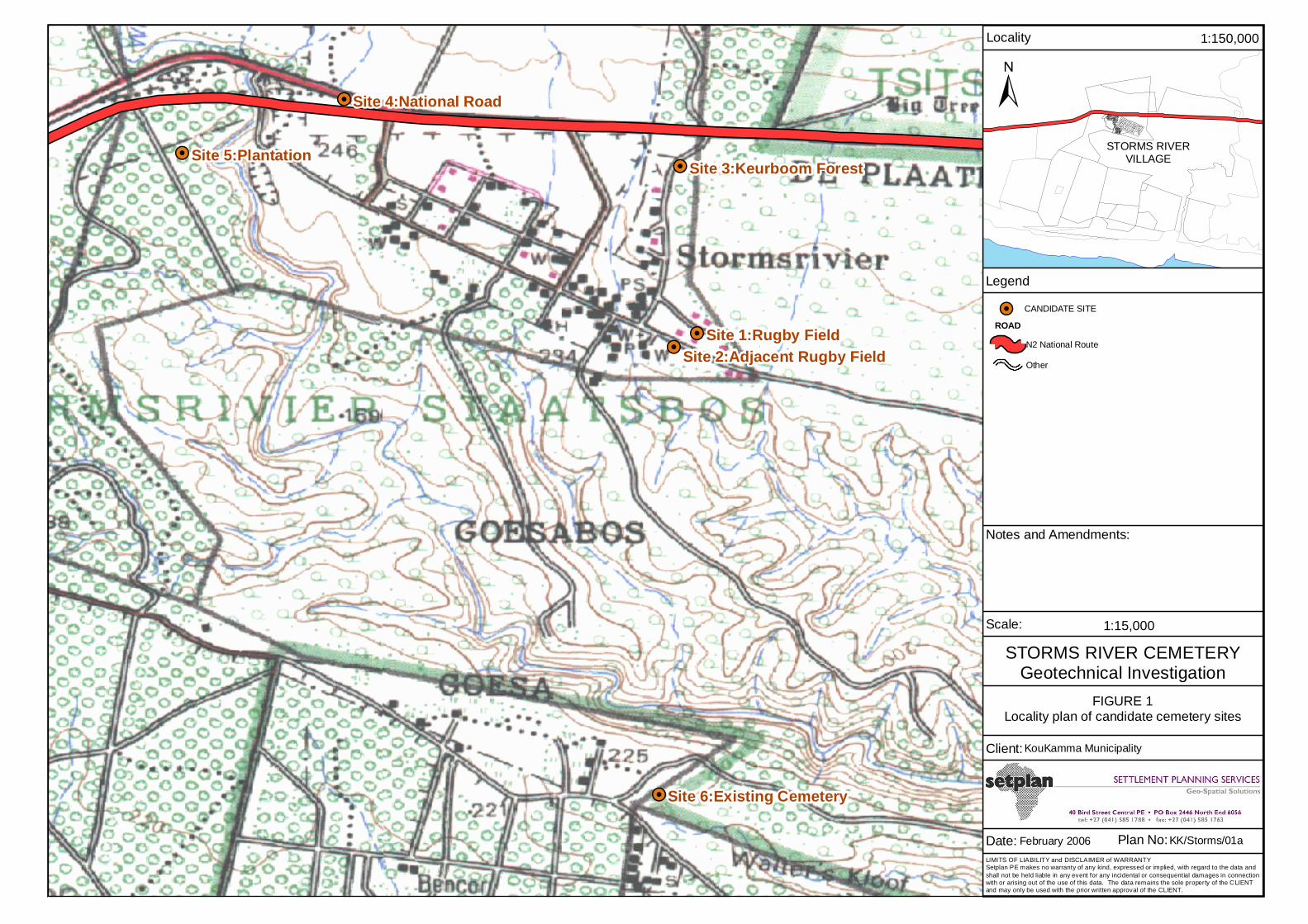
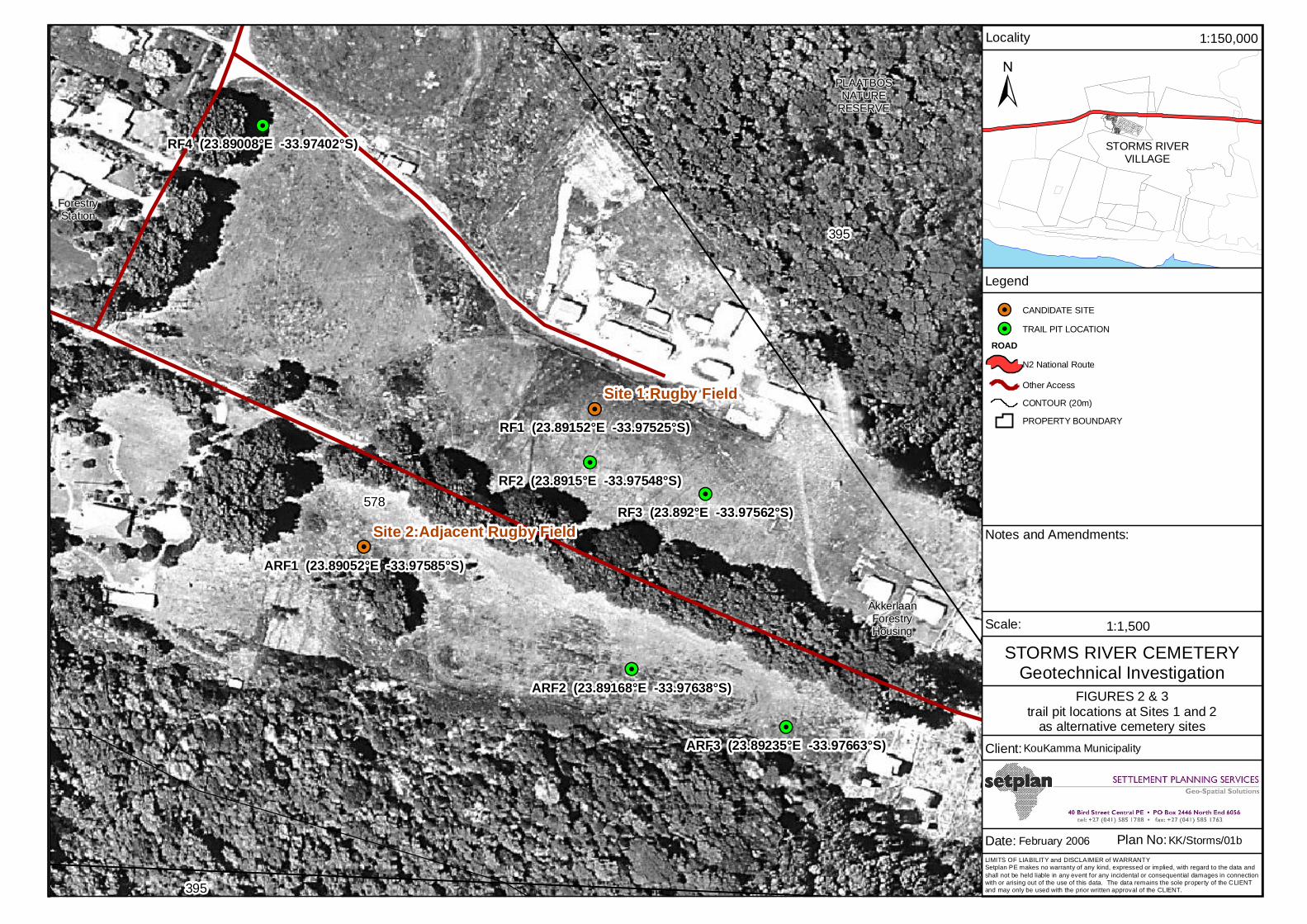
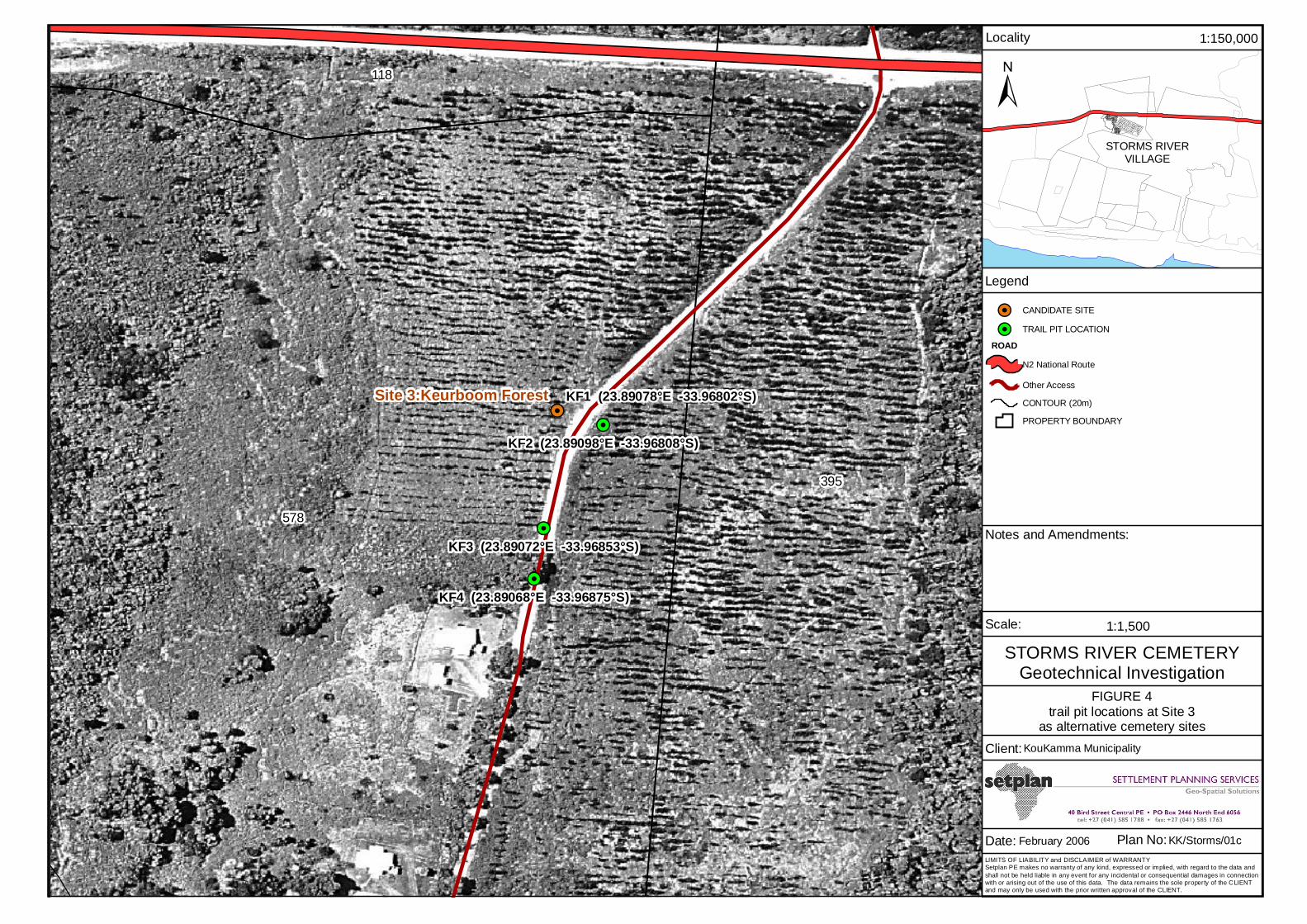
The remaining five candidate sites investigated during the field work are located in close proximity to the
village town centre, with the two rugby field sites (candidate sites 1 and 2) located on the eastern outskirts,
the Keurboom forest site on the north-eastern outskirts (between the town infrastructure and the N2
highway), the national road site to the north of the N2 highway and the plantation site to the west of
Storms River, west of the perennial Witteklip River (Appendix 1, Figure 1).
Each of the five candidate sites represents greenfield properties that have been deemed large enough from
a town planning perspective. The candidate sites under investigation were selected by the planners and
local authorities with input from the local community. The local community have ranked the candidate
sites based on social criteria as outlined previously.
Storms River Cemetery: Engineering Geological Investigation
Geological and Environmental Services • PO Box 27996 GREENACRES 6057 • Tel: 041 373 8871 • Cell: 082 499 3140
3
2 Site Description
2.1 Topography, Drainage and Geomorphology
The study area is situated on a regional, flattened marine terrace which slopes very gently towards the
south (seawards). Fluvial incision into the terrace (due to an ancient drop in sea-level), has resulted in a
series of steep-sided river valleys in this area. The Witteklip River to the west of the Storms River village
is located in one of these steep-sided gorges. A less prominent ephemeral drainage channel also occurs to
the west of the preferred cemetery site and flows southwards through the central parts of the Storms River
village. None of the candidate sites assessed during this investigation occur within drainage channel or
obvious wetland environments.
Candidate Site 1 (rugby field)
This candidate site is located to the east of the Storms River village on flat ground with no significant fall.
Surface run-off at this site would be problematic and drainage infrastructure would be required to prevent
pounding of surface water in depressions after wet periods. This site occurs at a height of about 240
metres above mean sea-level.
Candidate Site 2 (adjacent rugby field)
This candidate site is located to the east of the Storms River village on flat ground with a very gentle
southerly-sloping gradient. An ephemeral drainage channel flows towards the south-east about 150
metres south of the area investigated. This site occurs at a height of about 220 metres above mean sea-
level.
Candidate Site 3 (keurboom forest)
This is the preferred candidate site according to the local community and is located to the north-east of the
Storms River village on flat ground with a very gentle southerly-sloping gradient. An ephemeral drainage
channel flows towards the south about 100 metres west of the area investigated. This site occurs at a
height of about 250 metres above mean sea-level.
Storms River Cemetery: Engineering Geological Investigation
Geological and Environmental Services • PO Box 27996 GREENACRES 6057 • Tel: 041 373 8871 • Cell: 082 499 3140
4
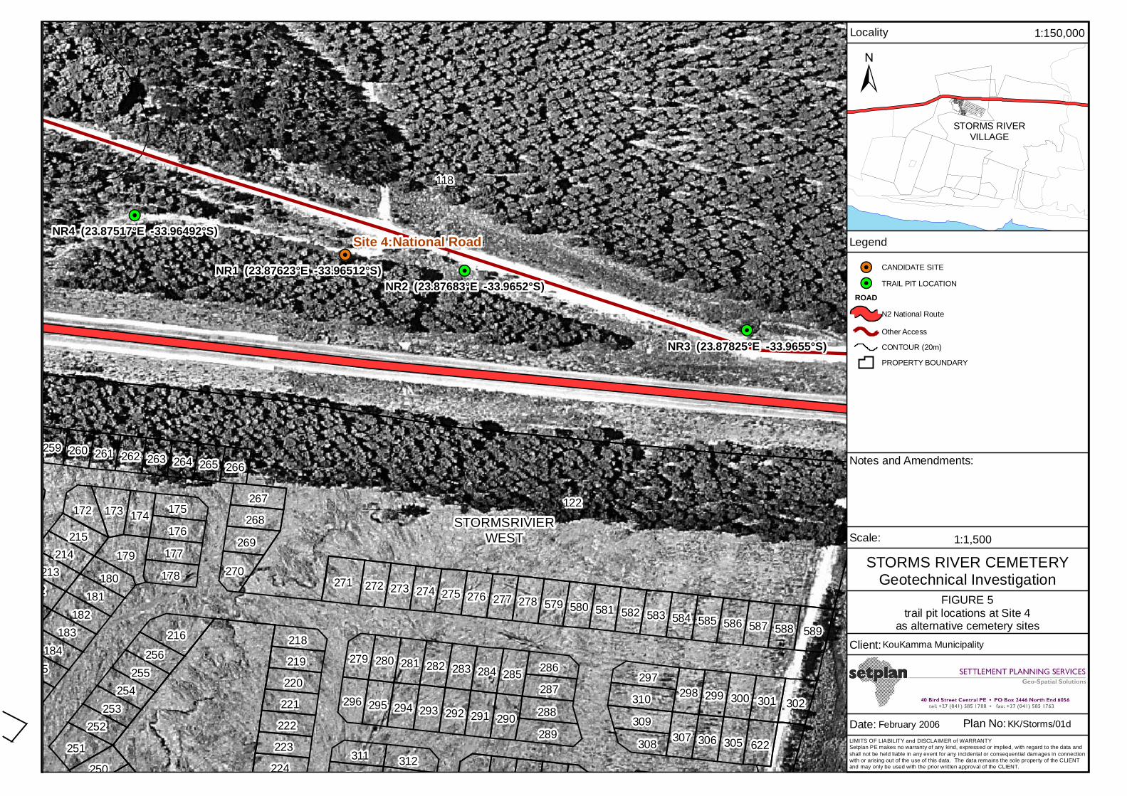
Candidate Site 4 (national road)
This candidate site is located to the north-west of the Storms River village, north of the N2 highway. It is
situated on gentle to moderately sloping ground with gradients to the north and north-west. The site is
bound by the N2 highway to the south and the R102 roadway to the north. An ephemeral, northerly
sloping drainage channel occurs to the north and north-west of this candidate site. This site occurs at a
height of about 250 metres above mean sea-level.
Candidate Site 5 (plantation)
This candidate site is located to the west of the Storms River village on gently sloping ground with a
north-easterly-sloping gradient. An ephemeral drainage channel flows towards the south-east about 100
metres east of the area investigated. This site occurs at a height of about 215 metres above mean sea-
level.
Candidate Site 6 (existing Goena cemetery)
This candidate site is located to south of the Storms River village on gently sloping ground with a
southerly-sloping gradient. An ephemeral drainage channel flows towards the east about 50 metres south
of the area investigated. This site occurs at a height of about 245 metres above mean sea-level.
2.2 Climate
According to the South African Weather Bureau (WB40, 1988) moderate coastal climatic conditions
prevail in the Storms River area. Rainfall varies between 950 mm and 1200 mm per annum falling
throughout the year. Summer (January) temperatures vary from an average maximum of about 24 °C to an
average minimum of about 15 °C, whilst winter (July) maximums and minimums are about 18 °C and 8
°C respectively.
Winter months are generally dominated by south-westerly and westerly winds associated with passing low
pressure (cold front) systems. During the summer months, high pressure systems result in easterly and
south-easterly dominated wind storms. These high pressure systems also frequently bring mid-afternoon
thunderstorms to the interior region.
Storms River Cemetery: Engineering Geological Investigation
Geological and Environmental Services • PO Box 27996 GREENACRES 6057 • Tel: 041 373 8871 • Cell: 082 499 3140
5
Weinert’s climatic N number is approximately 1 implying that chemical weathering dominates over
mechanical weathering. This has an influence on weathering rates down to competent bedrock in the
Tsitsikamma region.
2.3 Vegetation
The candidate sites under investigation all occur on land where some sort of transformation has taken
place and where pristine natural vegetation conditions no longer occur. The candidate sites near the rugby
field complex are underlain by short grass, whilst the preferred site is dominated by mature Keurboom
trees where an original pine plantation used to occur. Candidate site 4 is blanketed by tall Fynbos and
thicket species (including alien vegetation infestation) and the plantation site occurs in cleared plantation
lands. The existing candidate site occurs in a clearing adjacent to an existing plantation.
Storms River Cemetery: Engineering Geological Investigation
Geological and Environmental Services • PO Box 27996 GREENACRES 6057 • Tel: 041 373 8871 • Cell: 082 499 3140
6
3 Investigation Procedure
3.1 Desk Study Investigation
The investigation commenced with a desk study of all available information sources, including previous
engineering geological investigations conducted in the Storms River area. This study gave an indication
of the general environmental conditions, geology and soil profile to be expected. Potential engineering
geological problems and cemetery constraints could also be identified.
3.2 Field Investigation
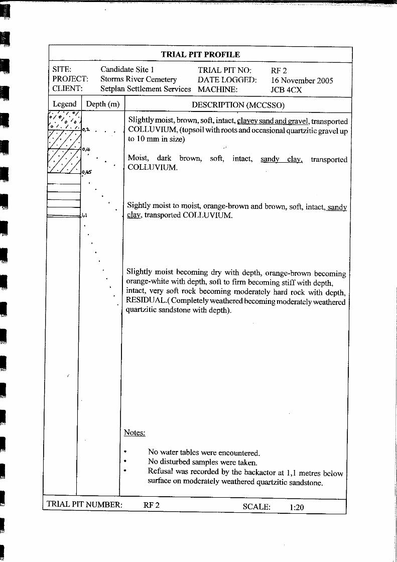
Field work took place on Wednesday 16 November 2005 when fifteen (15) trial pits were excavated
within some of the proposed candidate sites. Four (4) trial pits were opened at candidate site 1 (rugby
field), three (3) at candidate site 2 (adjacent rugby field), four (4) at the preferred site, candidate site 3
(Keurboom forest) and four (4) trial pits at the national road site (candidate site 4). All of the trial pits
were opened using a JCB 3CX backactor made available by SANParks.
Trial pits were not opened at candidate site 5 (plantation) and candidate site 6 (existing cemetery) as these
sites were deemed unsuitable for the establishment of a new cemetery by the local community, based on
planning and social reasons.
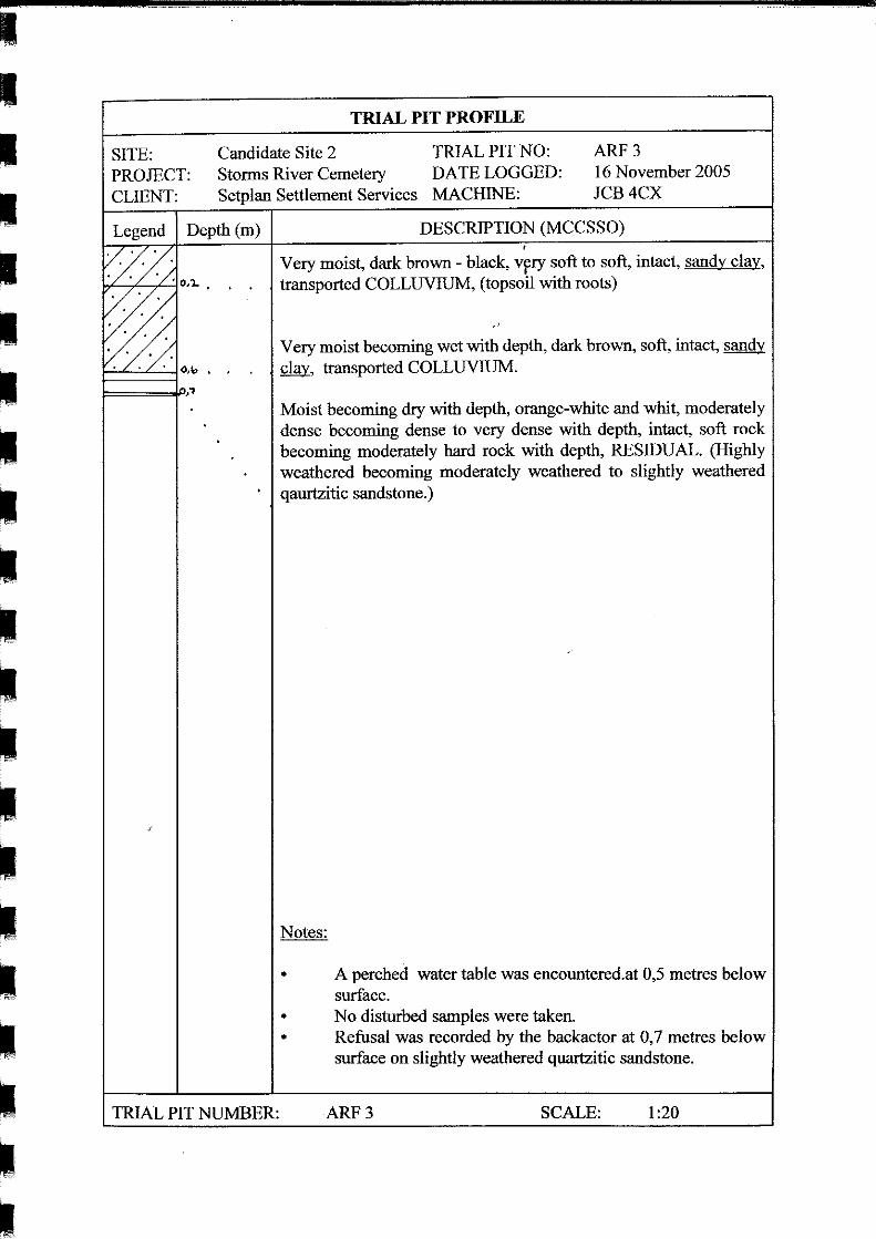
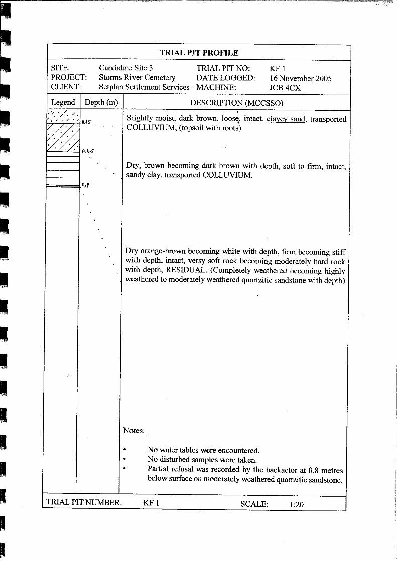
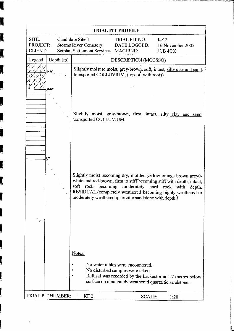
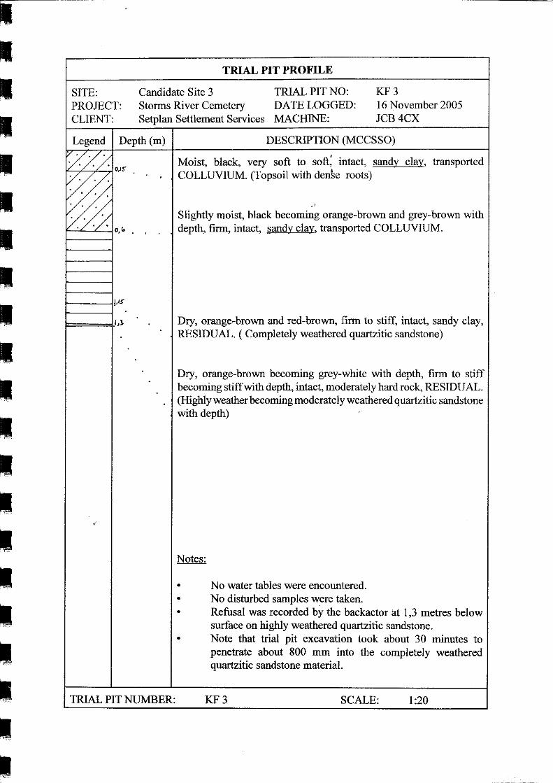
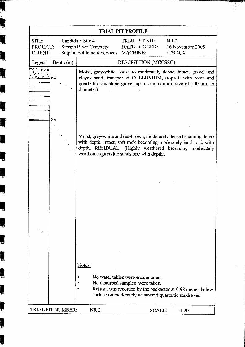
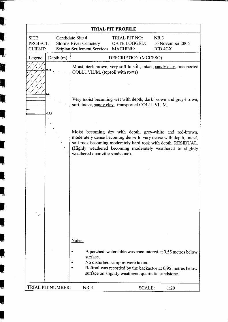
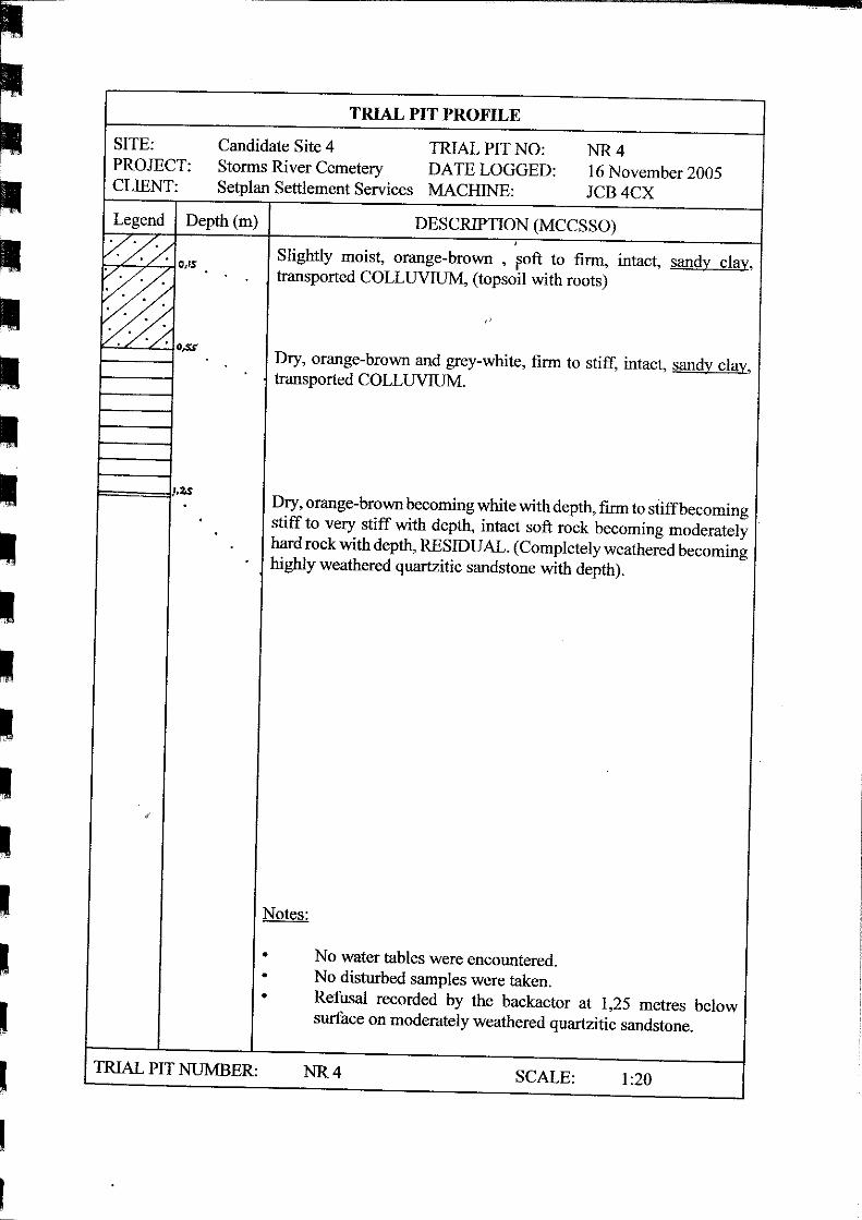
The trial pit profiles are included in Appendix 2 of this engineering geological report, whilst the trial pit
positions at the various candidate sites are indicated on the plans included in Appendix 1.
3.3 Laboratory and Soil Testing
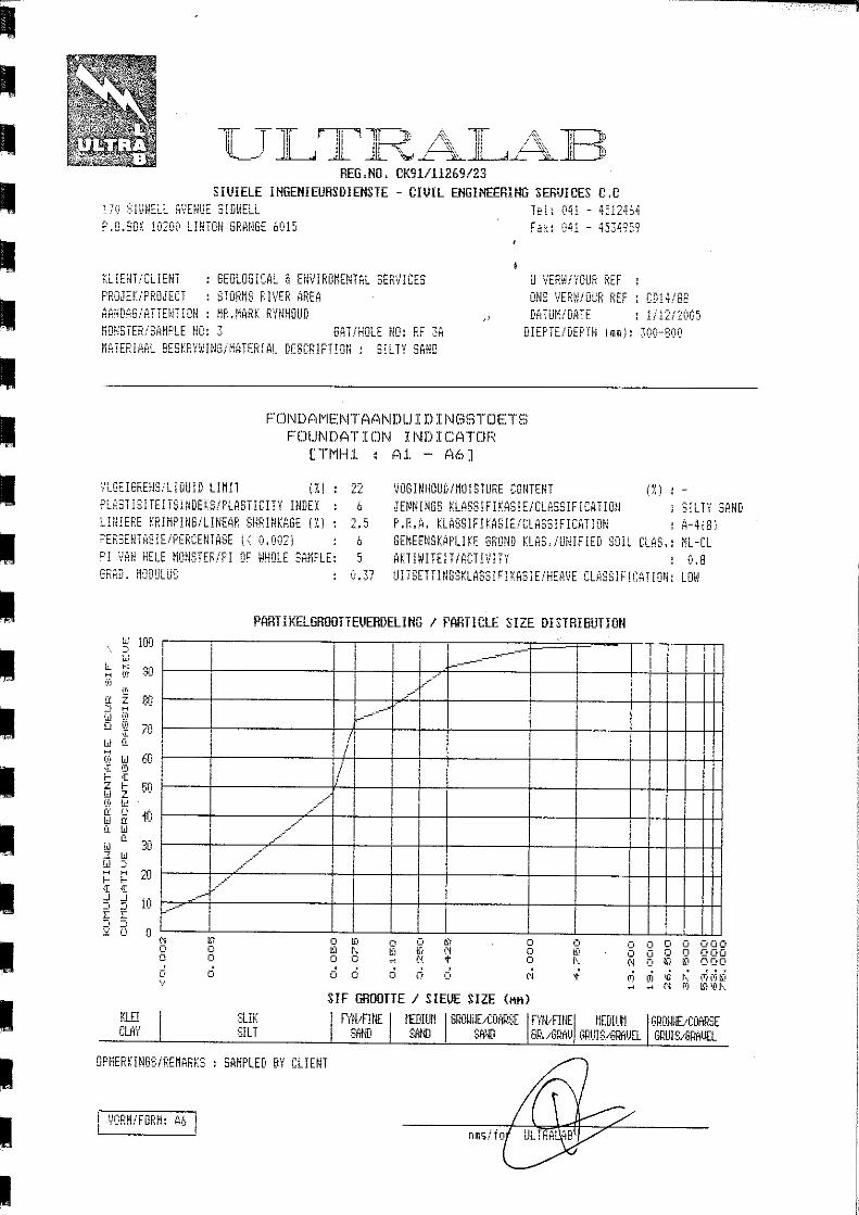
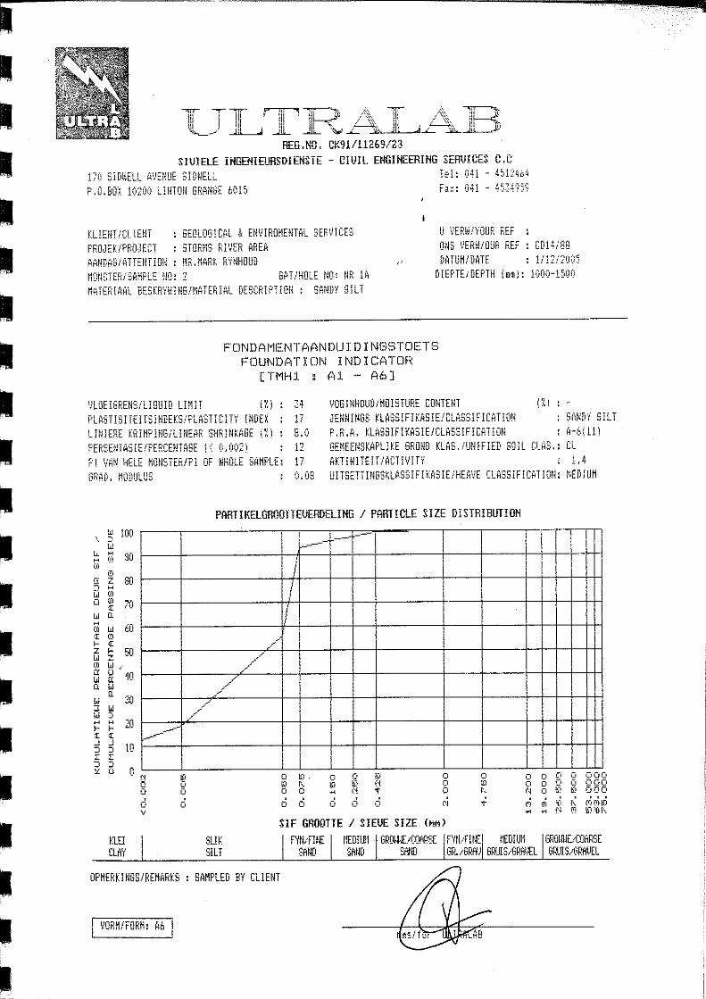
Three (3) disturbed soil samples were taken from the trial pits for laboratory testing and subjected to
Foundation Indicator testing as per TMH1 test methods A1 to A5. One sample was collected from
candidate site 1 (rugby field), one from the preferred candidate site 3 (Keurboom forest) and one from the
fourth candidate site (national road). Only sites that appeared to be potentially suitable for cemetery
establishment were tested during field work, hence no disturbed samples were taken from trial pits opened
in candidate site 2 (adjacent rugby field) during the field investigation.
Storms River Cemetery: Engineering Geological Investigation
Geological and Environmental Services • PO Box 27996 GREENACRES 6057 • Tel: 041 373 8871 • Cell: 082 499 3140
7
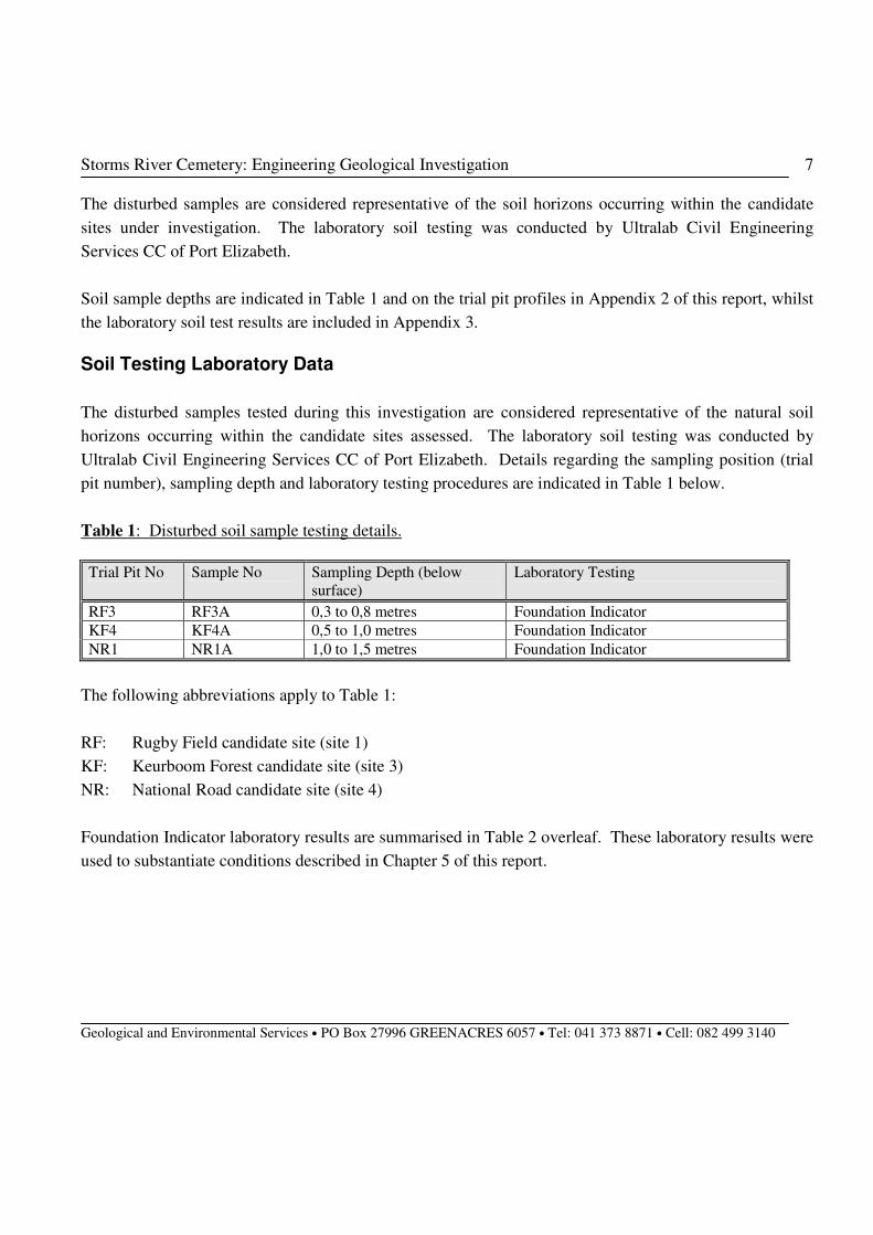
The disturbed samples are considered representative of the soil horizons occurring within the candidate
sites under investigation. The laboratory soil testing was conducted by Ultralab Civil Engineering
Services CC of Port Elizabeth.
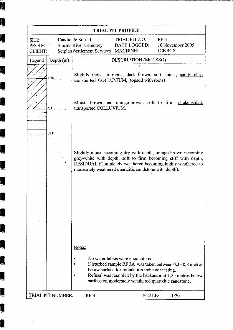
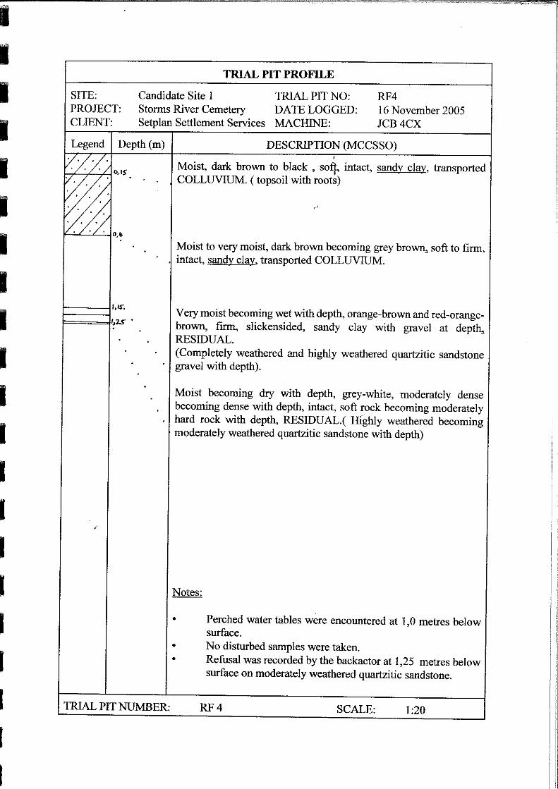
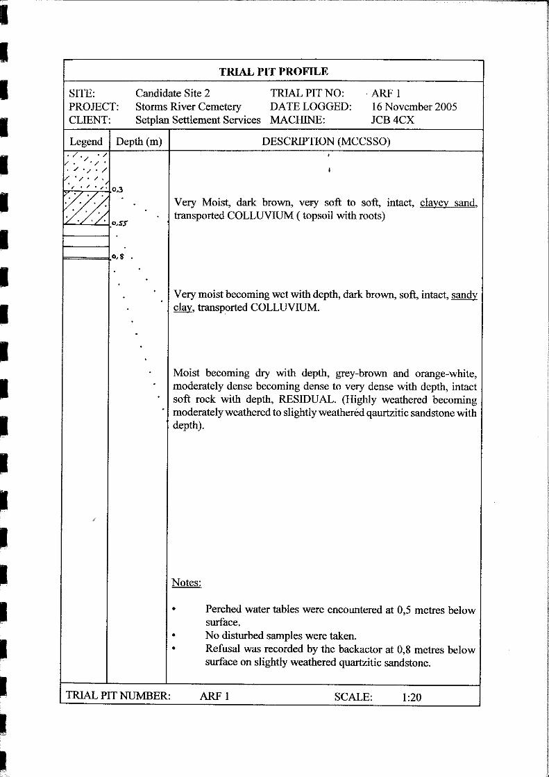
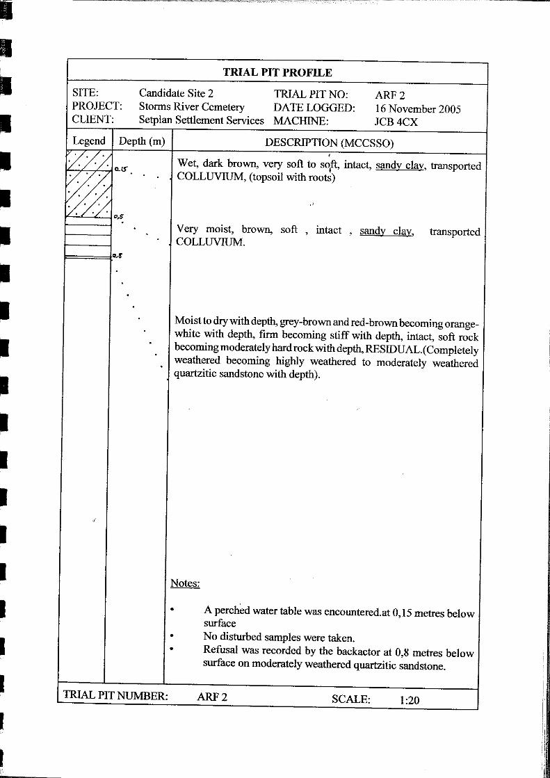
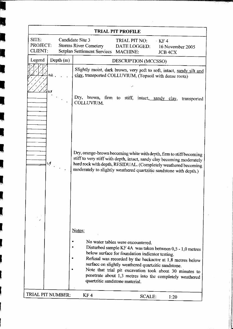
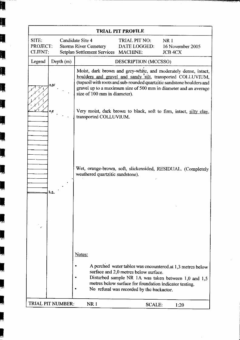
Soil sample depths are indicated in Table 1 and on the trial pit profiles in Appendix 2 of this report, whilst
the laboratory soil test results are included in Appendix 3.
Soil Testing Laboratory Data
The disturbed samples tested during this investigation are considered representative of the natural soil
horizons occurring within the candidate sites assessed. The laboratory soil testing was conducted by
Ultralab Civil Engineering Services CC of Port Elizabeth. Details regarding the sampling position (trial
pit number), sampling depth and laboratory testing procedures are indicated in Table 1 below.
Table 1: Disturbed soil sample testing details.
Trial Pit No Sample No Sampling Depth (below
surface)
Laboratory Testing
RF3 RF3A 0,3 to 0,8 metres Foundation Indicator
KF4 KF4A 0,5 to 1,0 metres Foundation Indicator
NR1 NR1A 1,0 to 1,5 metres Foundation Indicator
The following abbreviations apply to Table 1:
RF: Rugby Field candidate site (site 1)
KF: Keurboom Forest candidate site (site 3)
NR: National Road candidate site (site 4)
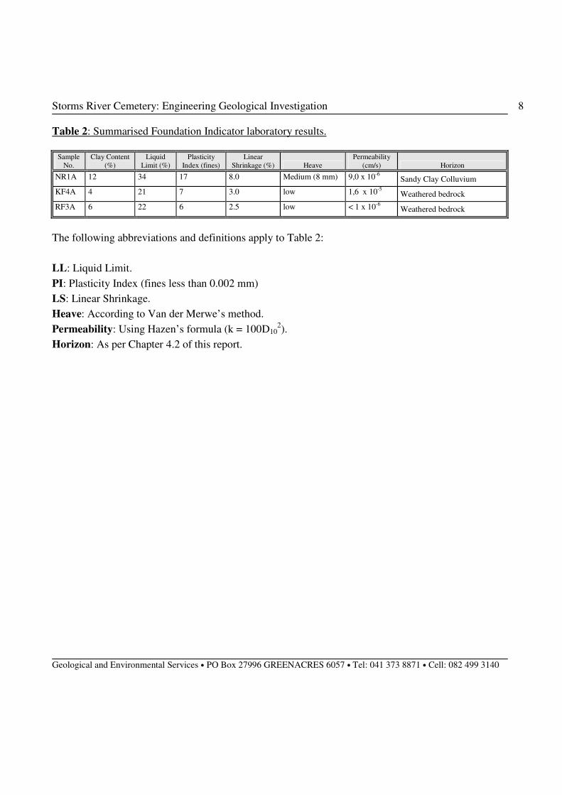
Foundation Indicator laboratory results are summarised in Table 2 overleaf. These laboratory results were
used to substantiate conditions described in Chapter 5 of this report.
Storms River Cemetery: Engineering Geological Investigation
Geological and Environmental Services • PO Box 27996 GREENACRES 6057 • Tel: 041 373 8871 • Cell: 082 499 3140
8
Table 2: Summarised Foundation Indicator laboratory results.
Sample
No.
Clay Content
(%)
Liquid
Limit (%)
Plasticity
Index (fines)
Linear
Shrinkage (%) Heave
Permeability
(cm/s) Horizon
NR1A 12 34 17 8.0 Medium (8 mm) 9,0 x 10⁻⁶ Sandy Clay Colluvium
KF4A 4 21 7 3.0 low 1,6 x 10⁻⁵ Weathered bedrock
RF3A 6 22 6 2.5 low < 1 x 10⁻⁶ Weathered bedrock
The following abbreviations and definitions apply to Table 2:
LL: Liquid Limit.
PI: Plasticity Index (fines less than 0.002 mm)
LS: Linear Shrinkage.
Heave: According to Van der Merwe’s method.
Permeability: Using Hazen’s formula (k = 100D102).
Horizon: As per Chapter 4.2 of this report.
Storms River Cemetery: Engineering Geological Investigation
Geological and Environmental Services • PO Box 27996 GREENACRES 6057 • Tel: 041 373 8871 • Cell: 082 499 3140
9
4 Geological Environment
According to the 1:250 000 Geological Map (3322 OUDTSHOORN) published by the Geological Survey
of South Africa, the study area may be underlain by either the Kouga Formation or the Baviaanskloof
Formation (or both - Kouga Formation to the north and Baviaanskloof Formation to the south). Both of
these formations represent quartzitic sandstone bedrock and are both overturned in the Storms River area.
4.1 Geological Formation
Kouga Formation
The Kouga Formation is an Eastern Cape equivalent of the Skurweberg Formation in the Western Cape.
The Kouga Formation also forms part of the Nardouw Subgroup, Table Mountain Group of the Cape
Supergroup. This formation generally comprises thickly-bedded, medium to coarse grained, white-
weathering quartzitic sandstone, which is usually about 200 to 400 metres thick.
Data collected during the field investigation suggests that quartzitic sandstone occurs at shallow to
moderate depth throughout all of the candidate sites assessed.
Baviaanskloof Formation
The Baviaanskloof Formation (also of the Nardouw Subgroup, Table Mountain Group of the Cape
Supergroup) generally comprises fine-grained structureless sandstone and sub-ordinate black shale. This
formation attains thicknesses of between about 180 and 200 metres and conformably overlays the above-
mentioned Kouga Formation.
Data collected during the field investigation suggests that quartzitic sandstone occurs at shallow to
moderate depth throughout all of the candidate sites assessed.
Storms River Cemetery: Engineering Geological Investigation
Geological and Environmental Services • PO Box 27996 GREENACRES 6057 • Tel: 041 373 8871 • Cell: 082 499 3140
10
4.2 Groundwater
Perched water tables were encountered in trial pits opened at candidate site 1 (rugby field), candidate site
2 (adjacent rugby field) and candidate site 4 (national road) during the field investigation. Considering the
geological conditions (weathered clay over shallow bedrock) in the Storms River area, the gentle
topography and very high rainfall the presence of perched water tables is virtually guaranteed throughout
the region and would probably occur in all six candidate sites assessed during this investigation.
From a hydrological perspective, therefore, the candidate site that is best placed would be the preferred
site as perfect hydrological conditions for cemetery establishment in the Storms River area is unlikely to
occur. Hydrological constraints to be aware of when planning a cemetery in the region include distances
from surface drainage channels and adequate depths down to competent bedrock (associated perched
water tables).
Storms River Cemetery: Engineering Geological Investigation
Geological and Environmental Services • PO Box 27996 GREENACRES 6057 • Tel: 041 373 8871 • Cell: 082 499 3140
11
4 Engineering Geological Evaluation
The engineering geological evaluation is based on the results of the desk study, observations and
interpretations made on site, the laboratory results (see Appendix 3) and previous investigations conducted
in the region. A broad overview of the geotechnical constraints that are predicted to occur within the
study area based on the findings during this investigation are as follows:
5.1 Expansive Soil
The clayey colluviums encountered at candidate site 4 (sample NR1A) proved medium expansive with a
heave value of about 8 mm. The laboratory results suggest that expansive clay may be a factor in the area.
No evidence of expansive clayey conditions were noted in the preferred candidate site 3 (keurboom forest)
but the occurrence of such expansive clayey material cannot be ignored. Field evidence such as thick
clayey material, slickensiding and dessication cracks frequently suggest expansive conditions. If such
heave indicators are noted during site clearing and construction then cemetery infrastructure should be
designed with expansive clay in mind.
5.2 Dispersive Soil
Clay is an assemblage of microscopic platelets, which are held together by various forces. A high
percentage of sodium cations in the clay cause the platelets to be loosely bound. Should water with a low
concentration of dissolved salts (such as rainwater) find an initial micro-channel in such a soil mass, the
loosely held platelets will disperse and be carried away resulting in soil erosion and piping.
No significant erosion problems are predicted at the preferred cemetery site, however, as the prevailing
grades are too low to encourage significant surface water flow or seepage, required to facilitate erosion
scour. Disturbed footprints should, nevertheless, be covered with natural vegetation as soon as possible to
limit exposure of the sub-soil environment to the atmosphere.
Storms River Cemetery: Engineering Geological Investigation
Geological and Environmental Services • PO Box 27996 GREENACRES 6057 • Tel: 041 373 8871 • Cell: 082 499 3140
12
5.3 Potentially Collapsible Soil
A soil with a collapsible fabric is defined as a soil that can withstand relatively large imposed stresses with
small settlements at low in situ soil moisture content, but which will exhibit a decrease in volume and
associated settlement with no increase in the applied stress if wetting up occurs. The change in volume is
associated with a change in the soil fabric (collapse of grain structure) and is applied to an additional
settlement, which occurs due to the wetting up of partially saturated subsoil, which has a collapsible
fabric.
According to the laboratory results none of the samples tested proved collapsible. This was confirmed by
comparing the sample grading curves with Knight (1961) and Errera’s (1977) grading envelopes for
collapse potential. This is not, therefore, considered a significant constraint and precautions to counter
heave will reduce any effect of collapse potential across the site.
5.4 Compressible Horizons
In a dry state the topsoil is slightly compressible, whereas the colluvium and weathered bedrock would
become compressible under saturated conditions. Soil saturation and compressibility would also be
exacerbated by the flat grades across the site.
Storms River Cemetery: Engineering Geological Investigation
Geological and Environmental Services • PO Box 27996 GREENACRES 6057 • Tel: 041 373 8871 • Cell: 082 499 3140
13
6 Cemetery Site Selection Procedures
6.1 Background
Cemeteries have a fairly severe pollution potential, especially if sited incorrectly. Leachate produced in a
cemetery is of a pathogenic nature and can pollute surface water features and ground water if located too
close. The bacteriological, virological and parasitic organisms in this leachate have been shown to travel
far greater distances within the soil and ground water than previously thought and that the lifespan of
some organisms (especially viruses) within the ground water is sufficiently long to pose contamination
problems hundreds of metres away under certain conditions. Ground water is a vital resource in the
Eastern Cape Province and adequate measures should, therefore, be taken to prevent such additional
pollution.
To counter the pollution potential of a cemetery site, which is of at least equal magnitude as that posed by
a conventional waste disposal site a set of ten criteria has been applied to this site to establish its
suitability for cemetery purposes. These criteria, if adhered to should ensure the correct siting of any
cemetery. The selected site at Storms River should also comply with the recommended criteria as set out
below. Performance of this site in relation to the criteria is discussed in Chapter 7 of this engineering
geological report.
6.2 Site Selection Criteria
The cemetery site selection criteria are not only designed to counter pollution problems but also take
cognisance of other constraints such as slope, shallow bedrock and soil stability. The ten criteria are
mentioned below with a brief description of each.
Χ Soil Excavatibility: A minimum excavatable depth of 1,8 metres is preferred for cemetery
purposes, although depths exceeding 2 metres would be more desirable.
Χ Soil Permeability: Soil permeabilities should preferably fall between the following limits: 1 X 10-
7 cm per second and 1 X 10
-4 cm per second. Too high permeabilities would allow rapid leachate spread
and too low permeabilities would inhibit the decomposition process.
Storms River Cemetery: Engineering Geological Investigation
Geological and Environmental Services • PO Box 27996 GREENACRES 6057 • Tel: 041 373 8871 • Cell: 082 499 3140
14
Χ Position in Respect of Domestic Water Sources: Minimum safe distances between a cemetery
and domestic water source such as a borehole or storage dam would be between 100 and 450 metres in the
Storms River area depending on the prevailing soil permeabilities.
Χ Position in Respect of Drainage Features: Minimum safe distances between a cemetery and
drainage feature, would be between 50 and 150 metres, once again depending on the prevailing soil
permeabilities.
Χ Site Drainage: Good site drainage is required to firstly prevent soil erosion and secondly to
prevent ponding, marshy conditions, unnecessary water ingress and cemetery degradation.
Χ Site Topography: A gradient of between 2° and 6° is considered ideal for cemetery purposes.
This slope range will ensure adequate drainage, minimise erosion and promote human and mechanical
mobility on site.
Χ Basal Buffer Zone: A basal buffer zone refers to the soil succession between the base of the
deepest grave and the water table. The buffer zone is essentially a barrier between the source of pollution
and the valuable water resource. A buffer zone of at least 2,5 metres is preferred.
Χ Grave Stability: Competence of the grave verge is important for a number of reasons, the most
prominent being that a few days usually elapses between excavation and use, hence the need for a few
days of “stand up” time.
Χ Soil Workability: This refers to the ease at which the soil can be manipulated in and out of the
graves.
Χ Cemetery Size: A minimum sized cemetery to justify the costs of investigation and
implementation is recommended. The 2,9 hectare site should be suitable for the Storms River community
for at least 15 years (assume burial rates of about 10 burials per month).
Storms River Cemetery: Engineering Geological Investigation
Geological and Environmental Services • PO Box 27996 GREENACRES 6057 • Tel: 041 373 8871 • Cell: 082 499 3140
15
7 Evaluation Of The Study Area Using The Selection Criteria
Evaluation of the study area in terms of the ten cemetery site selection criteria reveals that candidate site 3
(keurboom forest) to the north/ north-east of the Storms River village is generally the most suitable for
cemetery purposes. A few minor constraints do, however, occur at this site that is common to the region.
7.1 Soil Excavatability
Trial pit depths revealed during the field investigation proved highly variable in all candidate sites
subjected to trial pit excavation. Trial pit depths ranged from 1,1 to 1,5 at candidate site 1 (rugby field),
0,7 to 0,8 metres at candidate site 2 (adjacent rugby field), 0,8 and 1,8 metres at candidate site 3
(keurboom forest) and 0,9 and 2,2 metres below surface at candidate site 4 (national road). Minimum
excavatable depths of 1,8 metres are preferred for cemetery purposes, which was only attained at
candidate site 3 (preferred site) and candidate site 4. The other sites are deemed unsuitable for cemetery
site establishment based on soil excavatability requirements.
7.2 Soil Permeability
Soil permeabilities are marginal with regards the recommended limits. The permeability tests revealed
permeability rates (determined using Hazen’s formula) of between < 1,0 X 10⁻⁶
(impervious) and 1,6 X
10-5 (semi-pervious to impervious) cm per second (see Table 2).
On site permeabilities generally appear to fall outside the upper permeability limit (10-4
cm per second)
and the site is, therefore, considered marginally acceptable in terms of the recommended soil permeability
range. The preferred site reveals permeability values closest to the preferred values of the candidate sites
assessed during this investigation.
Storms River Cemetery: Engineering Geological Investigation
Geological and Environmental Services • PO Box 27996 GREENACRES 6057 • Tel: 041 373 8871 • Cell: 082 499 3140
16
7.3 Position In Respect Of Domestic Water Sources
The minimum safe distance between this cemetery and a domestic water source would be about 100 to
150 metres (based on a number of factors, including soil permeability, climate and soil moisture
conditions). As far as could be ascertained the nearest domestic water source is well outside this distance.
The underlying quartzitic sandstone is a good aquifer, but is isolated from the surface by impervious
clayey material (colluviums and completely weathered bedrock).
A row of indigenous trees should, nevertheless, be planted around the cemetery. Apart from the aesthetic
qualities, trees also tend to absorb large quantities of polluted water from the soil. Exotic tree species
should be avoided as far as possible in this regard.
7.4 Position In Respect Of Drainage Features
The minimum safe distance between the cemetery boundary (preferred candidate site) and the surrounding
drainage feature to the west, should be about 50 metres. This safe distance is derived from available
literature and based on the prevailing conditions in the area.
This minimum safe distance implies that the entire study area may not be suitable for cemetery purposes.
The cemeteries western boundary would have to move to ensure a minimum distance of 50 metres from
the neighbouring drainage channel is attained. This area may, however, be suitable for alternative land
uses such as parking facilities or other cemetery related infrastructure that does not involve burial.
Storms River Cemetery: Engineering Geological Investigation
Geological and Environmental Services • PO Box 27996 GREENACRES 6057 • Tel: 041 373 8871 • Cell: 082 499 3140
17
7.5 Site Drainage
Site drainage appears to be moderately problematic for the establishment of a cemetery at the site.
This is one of the inevitable flaws with cemetery sites in Storms River area as the region is
characterised by flat and gentle grades in response to the marine terrace origins of the land surface.
An effective on site drainage system should, therefore, be constructed across the study area. This
system could include a soil berm around the upper northern and north-eastern section of the preferred
cemetery site, which would prevent excess sheet-wash from entering the site. In addition, artificially
sloping drainage ditches should be located along access roads and paths, thus collecting run-off from
the high-lying areas and rapidly channelling it away from the site towards the south and south-west.
Grass cover and trees would also improve site drainage.
7.6 Site Topography
Site topography ties in with site drainage. Gentle slopes with a southerly to south-westerly sloping
gradient of less than 1° occur across the preferred site. These gradients not are regarded as ideal for
the establishment of cemetery sites, but there are very few alternative sites in the Storms River area.
The marginal slopes in the study area are regarded as an acceptable trade-off for the establishment of a
cemetery site, as this criteria is not considered a fatal flaw. Surface drainage conditions can also be
improved by using certain engineering options.
As far as possible, burial should always commence in the lower lying areas and proceed towards the
higher lying land. This is done so that grave diggers are not exposed to polluted soil and seepage from
higher lying graves. Graves should also be orientated parallel to the contours as far as possible. T his
will reduce leachate seepage velocities. The issue of grave orientation is, however, not always flexible
as certain communities insist on a specific grave orientation from a religious and cultural point of
view.
7.7 Basal Buffer Zone
A marginal adequate basal buffer zone occurs in parts of the study area. The basal buffer zone
generally consists of sandy clay colluviums and weathered bedrock. Ground water is generally not
associated with this transported horizon, which forms an impervious buffer between the grave site and
the residual mudstone and sandstone aquifer at depth.
The impervious nature of these clayey material renders a thinner basal buffer zone acceptable for a
cemetery site in this region. Basal buffer zones are also not considered a fatal flaw and should
adequate burial depth be achieved at a cemetery site the depth to competent bedrock is not an overly
significant constraint.
Storms River Cemetery: Engineering Geological Investigation
Geological and Environmental Services • PO Box 27996 GREENACRES 6057 • Tel: 041 373 8871 • Cell: 082 499 3140
18
7.8 Grave Stability
Soil consistencies are generally in the soft to firm and occasionally stiff range for the colluvium and
weathered bedrock. This facilitates ideal grave stability conditions, although hand excavation may
prove slightly difficult during dry periods.
8.9 Soil Workability
Soil workability is generally satisfactory although the more clayey material may be less workable after
prolonged dry periods. This is, however, only a minor constraint and should not detract from overall
site suitability for cemetery purposes.
7.10 Cemetery Size
The preferred cemetery site covers a surface area of about 2,92 ha (29 200 m2). It has been assumed
that a 20 metre buffer will be established along the western boundary due to the proximity of the
ephemeral drainage channel and a further 25% of the property is lost to accommodate vegetation
clumps in the layout plan. This suggests that about 18 000 m2 will be available for burial purposes at
the cemetery once established.
Planning records suggest that the Storms River community buries about 4 to 5 persons per month (data
obtained from SA Police Services records). For planning purposes it has been assumed that a
maximum of 10 burials will take place at Storms River per month.
This implies about 1 200 graves over a 10-year period, which will cover a surface area of about 9 290
m2
under a conventional cemetery layout. Increased burials of between about 1 500 and 2 000 graves
over a 15 year period will occupy a footprint of about 15 400 m2.
The preferred site, therefore, has sufficient surface area to conservatively meet the requirements of the
Storms River community for 15 years, which is deemed adequate for planning purposes.
Storms River Cemetery: Engineering Geological Investigation
Geological and Environmental Services • PO Box 27996 GREENACRES 6057 • Tel: 041 373 8871 • Cell: 082 499 3140
19
8 Project Overview
The Storms River village does not have access to a suitable cemetery that meets the standard cemetery
selection criteria and the existing cemetery at Goena is deemed unacceptable by the community for
social reasons. Numerous candidate cemetery sites were selected by the local authorities, planners and
the local community for assessment as potentially suitable cemetery sites. These candidate sites have
been subjected to an environmental investigation and engineering geological assessment to confirm
suitability for cemetery purposes.
The engineering geological investigation showed that the regional marine terrace in the Tsitsikamma
region is characterised by flat grades, shallow bedrock, a surficial weathered clayey horizon and
perched water tables. These ground conditions are problematic for the establishment of a cemetery,
which implies that not all of the cemetery selection criteria can be strictly applied to sites under
investigation in this region.
Cemetery site selction constraints common to the region include shallow depth of soil to bedrock,
impervious soil permeabilities, proximity to drainage channels, site drainage and basal buffer zones.
constraints identified at this site include dispersive soil, collapse potential, compressible soil with
These constraints are surmountable but may result in additional costs to manage the constraints such as
poor surface drainage and create buffer zoned from drainage features.
Based on the findings of this engineering geological report, the candidate site that proved to be the
most suitable as it complied with more of the cemetery site selection criteria then any of the other sites
assessed. This site also proved ot be the preferred site by the local community. Candidate sites 5
(plantation) and 6 (existing cemetery) were not assessed during the geological investigation as they
were eliminated from the process by the local community based on social constraints (distance from
Storms River, cemetery size and suitability for burials).
Storms River Cemetery: Engineering Geological Investigation
Geological and Environmental Services • PO Box 27996 GREENACRES 6057 • Tel: 041 373 8871 • Cell: 082 499 3140
20
9 Report Provisions
This investigation is aimed at providing the project engineers with an indication of the suitability of the
candidate site for cemetery establishment purposes. The preferred candidate site should also be
assessed based on the compliance with the preferred cemetery site selection criteria.
Fortunately the engineering geological investigation found that the site that is preferred by the local
community also proves to be the most suitable in terms of the standard cemetery site selection criteria.
This preferred cemetery site is also deemed acceptable by the local authorities, including the
SANParks and DWAF (landowners).
It is, therefore, recommended that should a cemetery be established in the Storms River area that
candidate site 3 (Keurboom forest) be used and that the other candidate sites assessed during this
investigation be ignored.
Storms River Cemetery: Engineering Geological Investigation
Geological and Environmental Services • PO Box 27996 GREENACRES 6057 • Tel: 041 373 8871 • Cell: 082 499 3140
21
10 References
• Brink A. B. A. (1981). Engineering Geology of Southern Africa, Vol. 2. Building Publications,
Pretoria.
• Brink A. B. A. (1983). Engineering Geology of Southern Africa, Vol. 3. Building Publications,
Pretoria.
• Brink A. B. A. (1985). Engineering Geology of Southern Africa, Vol. 4. Building Publications,
Pretoria.
• Brink A. B. A., Partridge T. C. & Williams A. A. B. (1980). Soil Survey for Engineering,
Caledon Press - Oxford.
• Frankipile South Africa (Pty) Ltd. (1995). A guide to practical Geotechnical Engineering in
South Africa.
• Jennings J. E., Brink A. B. A., Williams A. A. B. (1973). Revised Guide to Soil Profiling for
Civil Engineering Purposes in South Africa. Trans. SAICE. Vol. 15, No.1, Jan. 1973.
• Johnson, M. R. and le Roux, F. G. 1994. The Geology of the Grahamstown Area.
Explanation booklet for Council for Geoscience sheet 3326 (1:250 000 scale). Government
Printer, Pretoria.
• Knight, K. (1961). The collapse structure of sand sub-soils on wetting. PhD thesis, Department
of Civil Engineering, University of the Witwatersrand, South Africa.
• Lewis, C. A. 1996. The Geomorphology of the Eastern Cape. Grocott & Sherry Publishers.
• Rahn, P. H. (1996). Engineering Geology, an Environmental Approach. Prentice Hall P T R, pp
657.
• Van Der Merwe, D. H. (1964). The prediction of heave from the plasticity index and
percentage clay fraction of soils. Transactions of the South African Institute of Civil Engineers,
Volume 6, No 6, pp103 to 107.
• Weather Bureau (1998). Climate of South Africa - Climate statistics: 1961 to 1990 (WB42).
Government Printer, Pretoria.
• Weinert H. H. (1980). The Natural Road Construction Materials of Southern Africa.
Academica, Cape Town.
APPENDIX 1
STORMS RIVER CEMETERY
GEOTECH INVESTIGATION
Figures
STORMS RIVERVILLAGE
Locality 1:150,000
LIMITS OF LIABILITY and DISCLAIMER of WARRANTYSetplan PE makes no warranty of any kind, expressed or implied, with regard to the data andshall not be held liable in any event for any incidental or consequential damages in connectionwith or arising out of the use of this data. The data remains the sole property of the CLIENTand may only be used with the prior written approval of the CLIENT.
Date: Plan No:February 2006 KK/Storms/01a
Client:KouKamma Municipality
FIGURE 1Locality plan of candidate cemetery sites
STORMS RIVER CEMETERYGeotechnical Investigation
Scale:
Notes and Amendments:
1:15,000
PLAATBOSNATURE
RESERVE
AkkerlaanForestryHousing
ForestryStation
!H!H
!H
!H
!H
!H
Site 5:Plantation
Site 1:Rugby Field
Site 4:National Road
Site 3:Keurboom Forest
Site 6:Existing Cemetery
Site 2:Adjacent Rugby Field
±
Legend
!H CANDIDATE SITE
ROAD
N2 National Route
Other
STORMS RIVERVILLAGE
Locality 1:150,000
LIMITS OF LIABILITY and DISCLAIMER of WARRANTYSetplan PE makes no warranty of any kind, expressed or implied, with regard to the data andshall not be held liable in any event for any incidental or consequential damages in connectionwith or arising out of the use of this data. The data remains the sole property of the CLIENTand may only be used with the prior written approval of the CLIENT.
Date: Plan No:February 2006 KK/Storms/01b
Client:KouKamma Municipality
FIGURES 2 & 3trail pit locations at Sites 1 and 2
as alternative cemetery sites
STORMS RIVER CEMETERYGeotechnical Investigation
Scale:
Notes and Amendments:
!H
!H
!H
!H
!H
!H
!H
!H
!H
PLAATBOSNATURE
RESERVE
AkkerlaanForestryHousing
ForestryStation
395
395
578RF3 (23.892°E -33.97562°S)
RF2 (23.8915°E -33.97548°S)
RF4 (23.89008°E -33.97402°S)
RF1 (23.89152°E -33.97525°S)
ARF3 (23.89235°E -33.97663°S)
ARF2 (23.89168°E -33.97638°S)
ARF1 (23.89052°E -33.97585°S)
Site 1:Rugby Field
Site 2:Adjacent Rugby Field
1:1,500
±
!H CANDIDATE SITE
!H TRAIL PIT LOCATION
ROAD
N2 National Route
Other Access
CONTOUR (20m)
PROPERTY BOUNDARY
Legend
STORMS RIVERVILLAGE
Locality 1:150,000
LIMITS OF LIABILITY and DISCLAIMER of WARRANTYSetplan PE makes no warranty of any kind, expressed or implied, with regard to the data andshall not be held liable in any event for any incidental or consequential damages in connectionwith or arising out of the use of this data. The data remains the sole property of the CLIENTand may only be used with the prior written approval of the CLIENT.
LIMITS OF LIABILITY and DISCLAIMER of WARRANTYSetplan PE makes no warranty of any kind, expressed or implied, with regard to the data andshall not be held liable in any event for any incidental or consequential damages in connectionwith or arising out of the use of this data. The data remains the sole property of the CLIENTand may only be used with the prior written approval of the CLIENT.