Page 1
Page 1
An Improved Vertical Datum: a New Zealand Case Study Graeme Blick
Chief Geodesist
National Geodetic Office
With acknowledgement to the NZ Vertical Datum Improvement team:
Matt Amos | Land Information New Zealand
Rachelle Winefield | Land Information New Zealand
Jack McCubbine | Land Information New Zealand
Euan Smith | Victoria University of Wellington
Fabio Caratori Tontini | GNS Science
Page 2
Page 2
• Introduction
• Traditional LevellinG Based datums
• New Zealand Vertical Datum 2009
• Vertical Datum IMPROVEMENT PROJECT – NZVD 2016
• NATIONAL AIRBORNE GRAVITY SURVEY
• Summary
Page 3
Page 3
Introduction
• Vertical datum provides common reference surface
– Essential for integration of geospatial data
• Geoid enables ellipsoidal height transformations
– Geometric to gravimetric
– Ellipsoidal - orthometric
Page 4
Page 4
TRADITIONAL LEVELLING BASED DATUMS
Page 5
Page 5
Levelling-based datums
• 13 levelling based datums
• Each connected to a tide separate tide gague based on “MSL“
• Not nationally consistent
• No national geoid
– Need local transformations
Geoid
Mean Sea
Level
Datum A
Datum C
Datum B
Equipotential Surface
(Geoid)
Mean Sea
Level
Instantaneous
Sea Level
Sea Surface
Topography
Datum A
Datum C
Datum B
Tidal Effect
Page 6
Page 6
Terrain
Geoid
Ellipsoid
Hh
N
• Gravimetric geoid using gravity
observations to model geoid
• Independent of leveling
Page 7
Page 7
NEW ZEALAND VERTICAL DATUM 2009
Page 8
Page 8
New Zealand Quasigeoid 2009
• Gravimetric quasigeoid computed from:
– EGM2008
Page 9
Page 9
New Zealand Quasigeoid 2009
• Gravimetric quasigeoid computed from:
– EGM2008
– Land and sea gravity data
Page 10
Page 10
New Zealand Quasigeoid 2009
• Gravimetric quasigeoid computed from:
– EGM2008
– Land and sea gravity data
– DNSC08 altimetry
Page 11
Page 11
New Zealand Quasigeoid 2009
• Gravimetric quasigeoid computed from:
– EGM2008
– Land and sea gravity data
– DNSC08 altimetry
– Digital elevation model
Page 12
Page 12
New Zealand Quasigeoid 2009
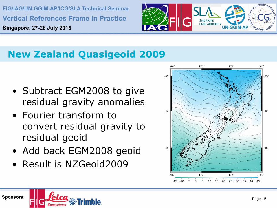
• Subtract EGM2008 to give residual gravity anomalies
Page 13
Page 13
New Zealand Quasigeoid 2009
• Subtract EGM2008 to give residual gravity anomalies
• Fourier transform to convert residual gravity to residual geoid
Page 14
Page 14
New Zealand Quasigeoid 2009
• Subtract EGM2008 to give residual gravity anomalies
• Fourier transform to convert residual gravity to residual geoid
• Add back EGM2008 geoid
Page 15
Page 15
New Zealand Quasigeoid 2009
• Subtract EGM2008 to give residual gravity anomalies
• Fourier transform to convert residual gravity to residual geoid
• Add back EGM2008 geoid
• Result is NZGeoid2009
Page 16
Page 16
New Zealand Quasigeoid 2009
• Computation area:
160º E – 170º W, 25º S – 60º S
• ~40m range over NZ
• Provided on 1’ x 1’ grid
~1.9 km over NZ
• NZGeoid2009 value linearly interpolated from grid
• Geoid changes smaller than 2 km will not be represented
Page 17
Page 17
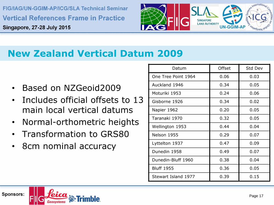
New Zealand Vertical Datum 2009
• Based on NZGeoid2009
• Includes official offsets to 13 main local vertical datums
• Normal-orthometric heights
• Transformation to GRS80
• 8cm nominal accuracy
Datum Offset Std Dev
One Tree Point 1964 0.06 0.03
Auckland 1946 0.34 0.05
Moturiki 1953 0.24 0.06
Gisborne 1926 0.34 0.02
Napier 1962 0.20 0.05
Taranaki 1970 0.32 0.05
Wellington 1953 0.44 0.04
Nelson 1955 0.29 0.07
Lyttelton 1937 0.47 0.09
Dunedin 1958 0.49 0.07
Dunedin-Bluff 1960 0.38 0.04
Bluff 1955 0.36 0.05
Stewart Island 1977 0.39 0.15
Page 18
Page 18
Vertical Datum IMPROVEMENT PROJECT – NZVD 2016
Page 19
Page 19
NZVD2009 limitations
• Irregular gravity coverage
• Computed from existing gravity data
• Gravity not collected for geoid determination
Page 20
Page 20
NZVD2009 limitations
• Sparse GNSS-levelling data
• Extensive precise levelling coverage
Page 21
Page 21
NZVD2009 limitations
• Simplistic offset modelling
• Other options available
• Multiple datums confusing
Point Inclined
Plane
Polynomial
Surface
Page 22
Page 22
Is this a problem?
• Confusion still exists with multiple datums
• Datum accuracy insufficient
• Timely disaster response difficult
• Heights becoming more important
Page 23
Page 23
Disaster recovery
• Heights are important after
disaster events
• Expectation that height
system exists to aid recovery
• Quick re-establishment of
height system necessary
• Not efficient with levelling
based datum
Page 24
Page 24
3D cadastre
• Heighted boundaries
– Variety of datums used
– Often inconsistent with other services
• Geoid not accurate enough
Page 25
Page 25
3D cadastre
• Heighted boundaries
– Variety of datums used
– Often inconsistent with other services
• Geoid not accurate enough
• Future cadastre may need greater height consistency
– All rights shown together
– All measurements 3D
Page 26
Page 26
User Requirements Accuracies
Recreational GNSS
Topographic Mapping
Hydrographic Charting
GIS Community
Cadastral Surveyors
Local Government
Scientific Monitoring
Page 27
Page 27
An improved vertical datum
• Better accuracy
• Better links to existing datums
• Better services to access datum
Page 28
Page 28
Better accuracy
• Updated national geoid
• 3cm in developed areas
• National airborne gravity coverage
• New global models and computation techniques
Page 29
Page 29
Better links to existing datums
• Present approach simplistic
• Accuracy improved by GNSS-levelling
• Alternative modelling approaches
Page 30
Page 30
Better services to access datum
Page 31
Page 31
NATIONAL AIRBORNE GRAVITY SURVEY
Page 32
Page 32
Airborne Gravity Collection
2014
• Gravity Flights completed
2015
• LVD offset improvement
• Geoid computation
• Transformation tools
2016
• New vertical datum
Collaboration with: Victoria University of Wellington GNS Science
Page 33
Page 33
Gravity collection
• Piper Chieftain
– 6 hour endurance
– 130 knots
• L&R Air-Sea Gravimeter
– 2 mGal repeatability
Page 34
Page 34
Collection challenges
• Wind, rain, fog
• Aircraft mechanicals
• Limited daylight
• Average of 3 flight days per
week
Page 35
Page 35
Flight lines
• 50,000 line km
– 120 flight lines at 10k spacing
– 20 tie lines at 150k spacing
– 2 calibration lines
• 4 base airports
• Two campaigns
– August – October 2013
– February – June 2014
• 75 flights
• 425 flying hours
O
O
O
O
Page 36
Page 36
Flight Tasks
• Aligned to topography
• Flying height 3,500 – 13,500 feet
Page 37
Page 37
Free Air Anomaly – EGM2008
Page 38
Page 38
Free Air Anomaly – Airborne Data
Page 39
Page 39
Data Combination
Combined aitborne and terrestrial gravity
observations (mGal) using least squares collocation
Page 40
Page 40
Data Combination
Difference between combined airborne/terrestrial
data and EGM2008 (mGal)
Highlights the fine scale structure of the NZ
gravity field and that the main areas of difference
are in the mountainous parts of the South Island
Page 42
Page 42
Summary
• Airborne gravity campaign
is now complete
• Should deliver 3 cm geoid
• Improvements to LVD
offsets also underway
• Updated NZ vertical datum
expected in 2016
Page 43
Page 43
QUESTIONS