An overview of the lithostratigraphical framework for the Quaternary and Neogene deposits of Great Britain (onshore) Geology, Geotechnics and Palaeontology, Development of Capability Programme Research Report RR/04/04
Transcript
An overview of thelithostratigraphical frameworkfor the Quaternary and Neogenedeposits of Great Britain(onshore)
Geology, Geotechnics and Palaeontology, Development ofCapability Programme
Research Report RR/04/04
Bookmarks
The main elements of the tableof contents are bookmarkedenabling direct links to befollowed to the principalsection headings and sub-headings, figures, platesand tables irrespective ofwhich part of the documentthe user is viewing.
HOW TO NAVIGATE THIS DOCUMENT
In addition, the report contains links:
from the principal section and subsection headings backto the contents page,
from each reference to a figure, plate or table directly tothe corresponding figure, plate or table,
from each figure, plate or table caption to the first placethat figure, plate or table is mentioned in the text and
from each page number back to the contents page.
RETURN TO CONTENTS PAGE
BRITISH GEOLOGICAL SURVEY
RESEARCH REPORT RR/04/04
An overview of the lithostratigraphicalframework for the Quaternary andNeogene deposits of Great Britain(onshore)
Authors
Andrew A McMillan, Richard J O Hamblin and Jon W Merritt
Contributors
Clive A Auton and Adrian J Humpage
Keyworth, Nottingham British Geological Survey 2005
The National Grid and otherOrdnance Survey data are usedwith the permission of theController of Her Majesty’sStationery Office.Licence No: 100017897/2005.
Kirkhill Interglacial Site[NK 011 528], near Strichen,Aberdeenshire; showinginterbedded tills, fossil soils (whitehorizon), sand and gravel andsolifluction deposits of theCaledonia and Albion Glacigenicgroups.
Bibliographical reference
MCMILLAN, A A, HAMBLIN, R J O,and MERRITT, J W. 2005.An overview of the lithostrati-graphical framework for theQuaternary and Neogene depositsof Great Britain (Onshore).British Geological Survey ResearchReport RR/04/04 38pp.
ISBN 0 85272 516 7
Copyright in materials derivedfrom the British GeologicalSurvey’s work is owned by theNatural Environment ResearchCouncil (NERC) and/or theauthority that commissioned thework. You may not copy or adaptthis publication without firstobtaining permission. Contact theBGS Intellectual Property RightsSection, British Geological Survey,Keyworth, e-mail [email protected] may quote extracts of areasonable length without priorpermission, provided a fullacknowledgement is given of thesource of the extract.
Maps and diagrams in this book usetopography based on OrdnanceSurvey mapping.
The full range of Survey publications is available from the BGSSales Desks at Nottingham, Edinburgh and London; see contactdetails below or shop online at www.geologyshop.com
The London Information Office also maintains a referencecollection of BGS publications including maps for consultation.
The Survey publishes an annual catalogue of its maps and otherpublications; this catalogue is available from any of the BGSSales Desks.
The British Geological Survey carries out the geological surveyof Great Britain and Northern Ireland (the latter is an agencyservice for the government of Northern Ireland), and of thesurrounding continental shelf, as well as its basic researchprojects. It also undertakes programmes of British technical aidin geology in developing countries as arranged by theDepartment for International Development and other agencies.
The British Geological Survey is a component body of the NaturalEnvironment Research Council.
London Information Office at the Natural History Museum(Earth Galleries), Exhibition Road, South Kensington, LondonSW7 2DE� 020–7589 4090 Fax 020–7584 8270� 020–7942 5344/45 e-mail: [email protected]
Forde House, Park Five Business Centre, Harrier Way,Sowton, Exeter, Devon EX2 7HU� 01392–445271 Fax 01392–445371
This report results from a study by the British GeologicalSurvey (BGS) to rationalise the Quaternary lithostratigraphy ofGreat Britain (England, Scotland and Wales). The reportproposes a new lithostratigraphical framework which utilisesthe full hierarchy of the stratigraphical code, that is supergroup,group, subgroup and formation (together with smaller units)for the correlation of the onshore Quaternary and Neogenedeposits of Great Britain. It presents an overview of theproposed framework. Formations (the principal mapping units)will be described in greater detail in the forthcoming full
framework report (in preparation). The objective of bothreports is to provide a regional lithostratigraphical scheme forGreat Britain to aid future Quaternary mapping and correlation(onshore and offshore), and to propose a stratigraphical schemecapable of use in a wide variety of applications.
David A FalveyExecutive DirectorBritish Geological Survey
iii
Foreword
iv
This report is the result of much discussion and livelydebate both within the BGS and with external researchersregarding the application of lithostratigraphical principlesto Quaternary deposits. Following a workshop held at theBritish Geological Survey (BGS), Keyworth in February1998, two framework committees (SFCs) were establishedby Dr Peter Allen (at that time, Assistant Director, BGS) toconsider stratigraphy to the north and to the south of themain Late Devensian ice sheet limit. The SFCs werechaired by Dr Richard Hamblin (South) and Mr AndrewMcMillan (North). Draft reports prepared by thecommittees aimed at a common goal of establishing auseable lithostratigraphy for Great Britain (onshore). Theexercise also highlighted differences of approach to theapplication of lithostratigraphy to the Quaternary anddifferences across Great Britain in the nature of thedeposits, and both depositional and post-depositionalenvironments. Concurrently the Geological Society SpecialReport No. 23 entitled A revised correlation of Quaternarydeposits in the British Isles was published in 1999. Thatreport described over 1400 units at formation, member andbed level and considered the criteria for defining largerbodies of Quaternary deposits.
To inform the framework committees an Open ProgressMeeting on Quaternary lithostratigraphy was held at BGS,
Keyworth in February 2001. Subsequently, during theautumn of 2002, the original participants of the twocommittees were brought together under the BGSSuperficial Deposits Advisory Group (SDAG) as a result ofthe recommendations of the Programme DevelopmentGroup for Onshore Surveys (Walton and Lee, 2001). TheSDAG, led by Andrew McMillan, was part of the BGSGeology, Geotechnics and Palaeontology Programme, underthe direction of Dr J H Powell. The authors of the presentoverview report acknowledge the work of the SDAGmembers together with others in BGS who have offeredconstructive advice. The counsel of external contributors isalso acknowledged especially that of Professor Jim Rose(Royal Holloway, University of London) who participated inSDAG committee meetings and Dr Phil Gibbard (Universityof Cambridge) who provided helpful advice following the2001 Open Progress meeting.
In compiling this report, the authors readilyacknowledge the assistance of several BGS colleagues.They thank members of the BGS Stratigraphy Committeefor contructive comment, and J H Powell and S J Boothwho reviewed an earlier draft. They also extend thanks tothree external reviewers acting for the Geological SocietyStratigraphy Commission, namely Dr P L Gibbard,Dr W Westerhoff and Prof D Q Bowen.
Acknowledgements
Foreword iii
Acknowledgements iv
Summary vi
1 Introduction 11.1 Purpose 11.2 General considerations 1
1.3 Chronostratigraphy and oxygen isotope stratigraphy 7
2 Principles and definitions 202.1 The lithostratigraphical code and its application
to the Quaternary deposits of Great Britain 202.1.1 Naming of lithostratigraphical units 202.1.2 Supergroup 202.1.3 Group 202.1.4 Subgroup 212.1.5 Formation 212.1.6 Member 262.1.7 Bed 26
2.2 Application of the BGS Rock ClassificationScheme 272.2.1 Lithogenetic unit 27
3.2.1 Crag Group 283.2.2 Dunwich Group 283.2.3 Residual Deposits Group 293.2.4 British Coastal Deposits Group 293.2.5 Britannia Catchments Group 293.2.6 Albion Glacigenic Group 293.2.7 Caledonia Glacigenic Group 30
Appendix 1 Geochronology 34
References 35
FIGURES
1 Relationship of the proposed lithostratigraphical groups 72 Distribution of glacigenic groups and subgroups and
marine deposits of the Crag Group (approximate coursesof the pre-Anglian river systems also shown) 8
3 Distribution of catchment subgroups of the BritanniaCatchments Group 9
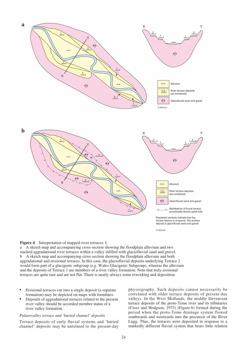
4 Interpretation of mapped river terraces: I 245 Interpretation of mapped river terraces: II 256 Sketch map of the distribution of terrace deposits of the
proto-River Teme 26
7 The British Coastal Deposits Group: relationships offormations and lithogenetic units in the GreatYarmouth district 29
8 Schematic cross-section of formations of theAlbion Glacigenic Group, Lowestoft district of EastAnglia 30
9 Schematic cross-sections across the Clyde Valley,west-central Scotland, showing the stratigraphicalrelationships between formations and members and theassignment of groups and subgroups 31
10 Model showing examples of the relationships offormations, subgroups and groups of the GreatBritain Superficial Deposits Supergroup in north-eastScotland 32
11 Schematic cross-section across the Highland Boundaryand Strathmore, north-east Scotland, showing thestratigraphical relationships between formations andinformal lithogenic units and the assignment of groupsand subgroups 33
12 Preservation potential and complexity of glacigenicsequences associated with a glaciation (after Andrews,1979; Lowe and Walker, 1997) 33
TABLES
1 Summary of the Quaternary and late Neogenelithostratigraphical framework for Great Britainwith relationship of groups to Quaternary stages andsuggested correlation with marine isotope stages 2
2 Examples of formations of the Crag Group, DunwichGroup and Residual Deposits Group 3
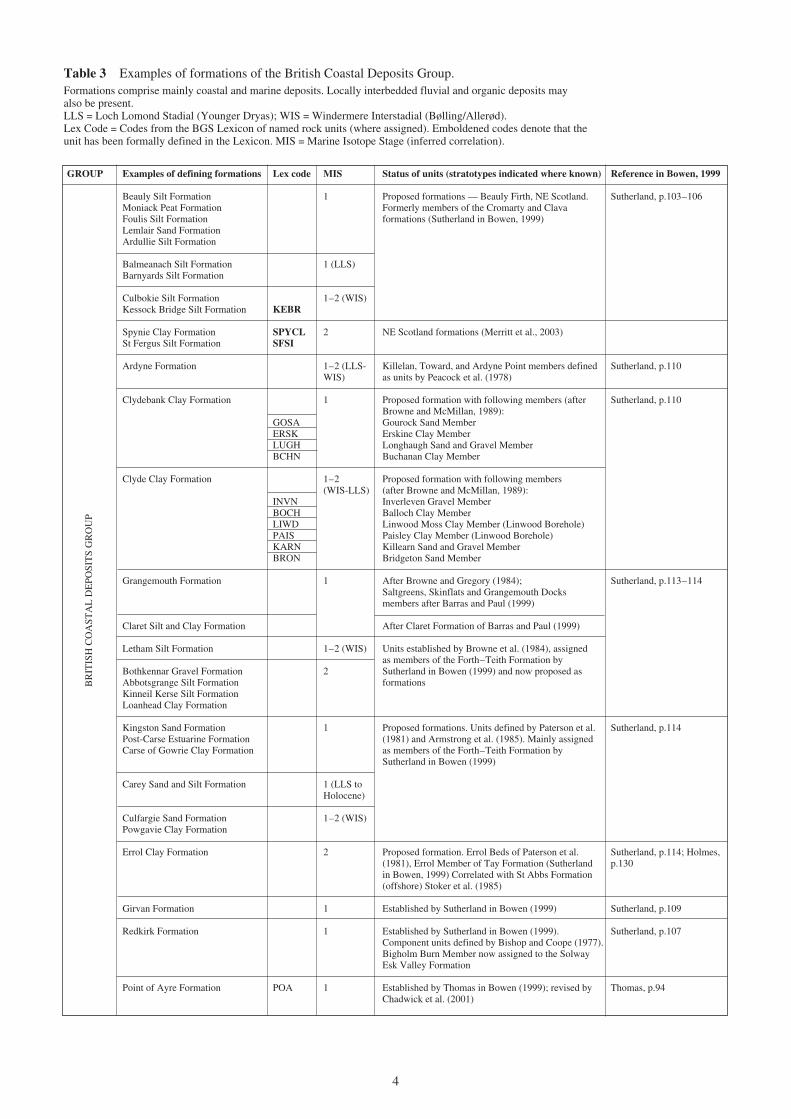
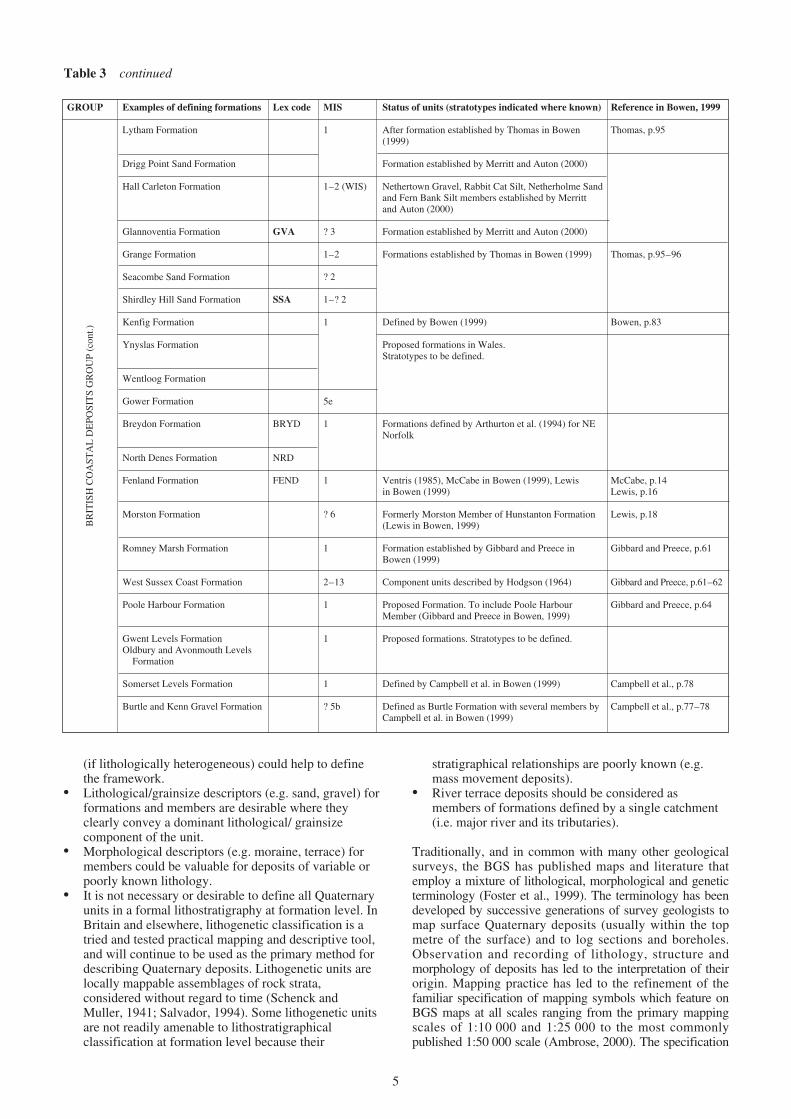
3 Examples of formations of the British Coastal DepositsGroup 4
4 Subgroups and examples of formations of the BritanniaCatchments Group 11
5a Examples of formations of the Albion GlacigenicGroup south of the Devensian ice-sheet limit 15
5b Examples of subgroups and formations of the AlbionGlacigenic Group north of the Devensian ice-sheetlimit 16
6 Examples of subgroups and formations of theCaledonia Glacigenic Group 17
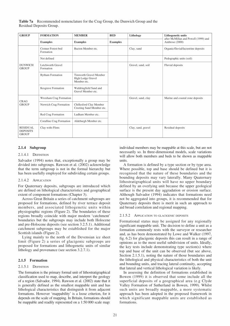
7a Recommended nomenclature for the Crag Group,the Dunwich Group and the Residual DepositsGroup 21
7b Recommended nomenclature for units of the BritanniaCatchments Group and the British Coastal DepositsGroup 22
7c Recommended nomenclature for glacigenic units of theAlbion Glacigenic Group and the Caledonia GlacigenicGroup 23
Contents
v
This report presents an overview of the proposed BGSlithostratigraphical framework for the onshore Quaternarydeposits of Great Britain (England, Scotland and Wales).The objective of the report is to provide a practicalframework to aid future Quaternary correlation, mappingand research, and a stratigraphical scheme capable of usein a wide variety of applications. A full lithostratigraphicalframework report describing the scheme in greater detail isin preparation (McMillan and Hamblin, in prep).
A framework that utilises the full hierarchy of thestratigraphical code (supergroup, group, subgroup,formation and smaller units) is proposed. Although theframework is built around the formation, the primary unitfor mapping and correlation, it is recommended that someclasses of lithogenetically-defined deposits are notaccorded formational status. However, at group level thescheme embraces all Quaternary deposits, thus enabling acoded lithostratigraphical superscript to be applied to everyQuaternary map symbol defined in the BGS specificationsfor the preparation of 1:10 000 scale geological maps(Ambrose, 2000). The map specifications are based uponthe lithogenetic classification of Quaternary deposits, as
outlined in BGS Rock Classification Scheme (RCS) forartificial and natural superficial deposits (McMillan andPowell, 1999). In parts of Great Britain lithostratigraphicalmapping at formation level can only be regarded as a long-term objective. Products such as lithostratigraphical maps,cross-sections and three-dimensional models may thereforebe regarded as an evolving layer in the geological model ofGreat Britain.
The unified lithostratigraphical framework for onshoreQuaternary deposits is designed to be of use for regionalmapping and correlation and may also be of relevance forregional hydrogeological and geotechnical applications.For example the lithostratigraphical classification can beused to enhance geological and hydrogeological domainsmaps and models depicting landform–sedimentassociations (McMillan et al., 2000).
The current report is based upon a review of publishedliterature (including BGS geological maps and reports),and expert local knowledge. Extensive reference is madeto the Geological Society of London Special ReportNo. 23–A revised correlation of Quaternary deposits inthe British Isles (Bowen, 1999).
vi
Summary
1.1 PURPOSE
The purpose of this report is to set out a lithostratigraphicalframework for onshore Quaternary deposits of GreatBritain (England, Scotland and Wales). Some Neogenedeposits are also considered with the framework. Theframework has been constructed using establishedprinciples of stratigraphy that involve firstly, thedescription and interpretation (lithostratigraphy) ofQuaternary units, correlation by all possible means andfinally classification. There should be a clear distinctionbetween factual description based upon observation andinference such as inferred correlation withchronostratigraphical scales defined by climatic fluctuationor with the oxygen isotope stratigraphical scale derivedfrom ocean sediments.
The framework is based upon a review of the extensiveBritish literature (including BGS geological maps) andthe Geological Society of London Special ReportNo. 23–A revised correlation of Quaternary deposits inthe British Isles, edited by Bowen (1999), a revision ofMitchell et al. (1973). As discussed below, for practicalreasons emphasis is placed on the application of the fullhierarchy of lithostratigraphical codes which may haveapplication for regional mapping, classification andcorrelation.
The report demonstrates how the lithostratigraphicalcodes have been interpreted and applied to Quaternarydeposits (Chapter 2) and presents an overview of the newlithostratigraphical framework and units at supergroup,group, subgroup and formation levels (Chapters 2 and 3,Tables 1–6). Groups and subgroups are wholly or partiallydefined by formations, which form the primary mappingunit, and by lithogenetic units. Inferred correlation withmarine isotope stages is presented in Tables 1–6.Recommended nomenclature for Quaternary units isshown in Table 7.
The more detailed, lithostratigraphical framework report(McMillan and Hamblin, in prep), will describe formationsand members region by region throughout Great Britain. Incompiling both reports the authors resolved that, thelithostratigraphical framework should aim to:
• conform as far as possible with internationalstratigraphical principles for lithostratigraphicalclassification as provided by the International Unionof Geosciences (IUGS) (Hedberg, 1976; Salvador,1994). Regional application of these guides is offeredby the North American Commission on StratigraphicalNomenclature (NACSN, 1983) and the guidance ofWhittaker et al. (1991) and Rawson, et al. (2002)
• serve as a basis for geological mapping andcorrelation
• assist the user (both the Quaternary specialist andnon-specialist) of geological data including BGS mapsmemoirs and sheet explanations, and
• provide a basis ultimately for a Quaternarylithostratigraphical map of Great Britain and three-dimensional modelling.
1.2 GENERAL CONSIDERATIONS
As Powell (1998) has stated, ‘In science and engineering,classification is essential if written and oralcommunications are to be precise and unambiguous.’ Foronshore Quaternary strata the application of a strictlithostratigraphical classification presents uniquedifficulties. A wide range of processes has operated duringthe Quaternary (the last 1.81 Ma, as internationallydefined*; see also Lourens et al., 1996; Ehlers andGibbard, 2003) (Table 1). Deposits are discontinuous,variable in thickness and commonly poorly exposed. Theregional significance of unconformities and discontinuitiesseen in sections or boreholes may be poorly understood.The fragmentary nature of the record, the ill-defined fieldrelationships and the poorly fossiliferous nature of manydeposits, with little organic or other dateable material,make the construction of a lithostratigraphical framework asizeable task.
Where lithostratigraphy has been applied to BritishQuaternary deposits it has usually been to define locally well-exposed sequences in natural sections, excavations andboreholes, where stratigraphical relationships can be observed.National or regional correlation may not be possible. This isreflected in the stratigraphical schemes published by Bowen(1999) in which formations may be restricted to districts wherecorrelation is secure. Tentative correlation may then be madewith differently named units of adjoining areas. Many of thelower level units, particularly at member and bed level,referred to in Bowen (1999) have been defined at one or morewell-exposed sections or from boreholes. Such units, asBowen (1999) confirms, ‘are not amenable to systematic andwidespread mapping away from their stratotypes’.Nevertheless these units are important for correlation and forinferences about climate and palaeoenvironment.
To address the need to regionally correlate larger bodies ofQuaternary deposits, the BGS Superficial Deposits AdvisoryGroup (a Stratigraphical Framework Committee) has beenpreparing a new lithostratigraphical framework for theonshore Quaternary deposits of Great Britain. The currentoverview report and a more detailed Quaternarylithostratigraphical framework report (McMillan andHamblin, in prep.) take into account conclusions from twoworkshops on stratigraphical classification and nomenclatureof British Quaternary deposits held at the BGS, Keyworth,Nottingham in February 1998 and February 2001. McMillanand Hamblin (2000) published initial ideas on theframework. An early version of the current framework waspresented at the TNO International Workshop on IntegratedLand-Sea Lithostratigraphic Correlation in Utrecht, TheNetherlands (April 2003) (McMillan, 2005).
1 Introduction
1
* The BGS Timescale currently adopts the internationally accepted 1.81 millionyears (Ma) (after Gradstein and Ogg, 1996). Many Quaternary scientists support theproposal to redefine the base of the Quaternary as the current GSSP of the GelasianStage at about 2.6 Ma (for discussion see Pillans, 2004; Gibbard et al., 2005). Thisage, which more accurately represents the onset of northern hemisphere glaciations,is coincident with the Gauss/Matuyama palaeomagnetic Epoch boundary and iscorrelated with the peak of Marine Isotope Stage 103.
British NW European MISQuaternary QuaternaryStage (Onshore) Stage(Gordon and Sutherland, (Gibbard et al., 1991; Glacigenic Non-glacigenic1993; Mitchell et al., Funnell, 1996; Lister, deposits deposits1973; West, 1961, 1980; 1998, 2000; Zagwijn,Zalasiewicz et al., 1991) 1992)
HOLOCENE 1–211.5 ka
Loch LomondStadial (YoungerDryas)
WindermereInterstadial
LATE (Bølling/Allerød) WEICHSELIAN
DimlingtonStadial 3
4
5a–5d
IPSWICHIAN EEMIAN 5e0.126 Ma
‘WOLSTONIAN’ SAALIAN 6–10
HOXNIAN HOLSTEINIAN 11
ANGLIAN ELSTERIAN 12MIDDLE
CROMERIAN CROMERIAN 13–21COMPLEX
0.78 Ma
BEESTONIAN BAVELIAN 22–64
MENAPIAN
EARLY WAALIAN
EBURONIAN
PASTONIAN TIGLIAN C5–61.806 Ma
PRE-PASTONIAN TIGLIAN C4c 65–95
BAVENTIAN
ANTIAN/ TIGLIAN C1–4bBRAMERTONIAN
GELASIANTHURNIAN TIGLIAN B
LUDHAMIAN TIGLIAN A
PRE-LUDHAMIAN PRAETIGLIAN 96–100
2.588 Ma REUVERIAN C 103
PLE
IST
OC
EN
E
DE
VE
NSI
AN
GR
EA
T B
RIT
AIN
SU
PER
FIC
IAL
DE
POSI
TS
SUPE
RG
RO
UP
SUPE
RG
RO
UP
AL
BIO
NG
LA
CIG
EN
ICG
RO
UP
CA
LE
DO
NIA
GL
AC
IGE
NIC
GR
OU
P
RE
SID
UA
L D
EPO
SIT
S G
RO
UP
DU
NW
ICH
GR
OU
P
CR
AG
GR
OU
P
BR
ITA
NN
IA C
AT
CH
ME
NT
S G
RO
UP
BR
ITIS
H C
OA
STA
L D
EPO
SIT
S G
RO
UP
PLIO
CE
NE
SER
IES
SUB
SER
IES
Table 1 Summary of the Quaternary and late Neogene lithostratigraphical framework for Great Britainwith relationship of groups to Quaternary stages and suggested correlation with marine isotope stages.Notes. Climatostratigraphical stages for Great Britain and north-west Europe are based on inferences from biostratigraphical(pollen) and lithological evidence for ‘temperate’ and ‘cold’ events. Ages: bases of series and subseries are taken from thePhanerozoic time scale of Gradstein and Ogg (1996). The early/middle Pleistocene boundary is correlated with the Bruhnes —Matuyama magnetic reversal, correlated with Marine Isotope Stage 19. The base of the Pleistocene Series is defined at the baseof the marine claystones conformably overlying the marker bed sapropel layer ‘e’ in the Vrica section, Calabria, Italy (Aguirreand Passini, 1985). Suggested correlation with marine isotope stages for Early to Middle Pleistocene is after Zagwijn (1992) andFunnell (1996), based on the stages of Shackleton et al. (1990).Abbreviations: ka = 1000 calibrated radiocarbon years; Ma = 106 years; MIS = Marine Isotope Stage (inferred correlation).The Crag Group is defined by marine formations.The Dunwich Group is defined by fluvial formations within pre-Anglian palaeocatchments.The Residual Deposits Group includes Clay-with-Flints.The British Coastal Deposits Group is defined by coastal, estuarine and marine formations.The Britannia Catchments Group is divided into subgroups defined by fluvial formations within major drainage systems(includes peat, head, cover sand, loess and mass movement deposits).The Caledonia Glacigenic Group, lying mainly to the north of the Devensian limit, is divided into subgroups defined by tillformations with associated glacigenic units. Some glaciofluvial units extend south of the Devensian limit.The Albion Glacigenic Group, preserved mainly to the south of the Devensian limit, is divided into formations; to the north, thegroup is divided into subgroups defined by till formations with associated glacigenic units.
2
GROUPS
The BGS workshops addressed a number of questionsfundamental to the establishment of a workablelithostratigraphical framework which takes as its premiseits ability to be applied to geological mapping. Principalconclusions from the workshops and subsequent discussionincluded the following:
• The formation is the fundamental mapping unit (Hedberg,1976; North American Commission on StratigraphicNomenclature — NACSN, 1983; Whittaker et al., 1991;Salvador, 1994; Bowen, 1999; Rawson et al., 2002).
• Members and beds may also be mappable units atappropriate scales.
• Grouping of formations is desirable, particularly to aidregional mapping (Salvador, 1994) and interpretationby non-geologists.
• Groups and subgroups may or may not be composedentirely of named formations (NACSN, 1983) but theestablishment of groups without constituent formationsshould be avoided (Salvador, 1994).
• Lithogenetic descriptors for high-level units (super-groups, groups and subgroups) and for formations
GROUP Examples of defining formations Lex code MIS Status of units (stratotypes indicated where known) Reference in Bowen, 1999
Letchworth Gravels Formation LTH 13–? Defined by Smith and Rose (1997)
Cromer Forest-bed Formation CRF 17–? Freshwater members of the Cromer Forest-bed Lewis, p.15Formation of Lewis in Bowen (1999)
pedogenic units (Valley Farm Lewis in Bowen (1999) Lewis, p.22Soil) above Kesgrave Formationand Bytham Formation
Bytham Formation BYTH 13–? Proposed formation. Members include: Lewis, p.19Timworth Gravel, Knettishall Gravel, Ingham FarmGravel, Seven Hills Gravel, High Lodge Gravel,Lakenheath Gravel, Fodderstone Gravel and Shouldham Thorpe Gravel members. Bytham Sandsand Gravels defined by Rose (1994) and Bateman andRose (1994). Includes the Ingham Sand and Gravel(Clarke and Auton, 1982; Lewis, 1993; Lewis inBowen, 1999). Also includes the ShouldhamFormation of Lewis in Bowen (1999)
Kesgrave Formation KES ? 61–13 Proposed formation. Includes Lower St Osyth, Lewis, p.22Wivenhoe, Ardleigh and Waldringfield members, of Allen, p.24the Colchester Formation (Kesgrave Group) of Gibbard, p.57Whiteman and Rose (1992)
Beaconsfield*, Satwell*, Westland Green*, Gibbard, p.47–49:Waterman’s Lodge† and Stoke Row* members of the (*Middle ThamesSudbury Formation (Kesgrave Group) of Whiteman Formation.and Rose (1992) †Northern Drift Formation)
GCGR Pre-12 Gerrards Cross Gravel Formation and Westmill Gravel Gibbard, p.47–49Formation of Ellison et al. (2004). Members of Middle
WLGR Thames Formation of Gibbard in Bowen, 1999)
Stanmore Gravel Formation STGR ? Pre- ‘High-level’ gravels formerly referred to ‘Pebble Gibbard, p.4822 Gravel’ (Gibbard in Bowen, 1999; Ellison et al., 2004)
Wroxham Crag Formation WRCG ? 17– Established by Hamblin (2001), Rose et al. (2001) and Lewis, p.15? 67 Moorlock et al. (2002). The Sidestrand Member of the
Norwich Crag Formation (Lewis in Bowen, 1999), andthe marine Paston and Mundesley members of theCromer Forest-bed Formation (Lewis in Bowen, 1999)are included.
Norwich Crag Formation NCG ? 68– Established by Funnell and West (1977). Four Lewis, p.22? 81 members (Mathers and Zalesiewicz, 1988; Lewis in
Bowen, 1999); the Chillesford Clay, Chillesford Sand,College Farm Clay and Creeting Sand
Red Crag Formation RCG ? 82– Established by Funnell and West (1977). Zalasiewicz Lewis, p.22et al. (1988) defined two members in Suffolk: Gibbard, p.53Sizewell and Thorpeness members. The Ludham Member of Norfolk (Lewis in Bowen, 1999) and theNetley Heath Member of the Blackwater–Loddenvalleys (Gibbard in Bowen, 1999) also defined
Coralline Crag Formation CCG Defined by Balson et al. (1993) with three members:Aldeburgh, Sudbourne and Ramsholt members
Clay-with-Flints CWF Defined by Pepper (1973), Catt (1986) and Ellisonet al. (2004).
Buchan Gravels Formation BUG Merritt et al. (2003)
DUNWICHGROUP
Table 2 Examples of formations of the Crag Group, Dunwich Group and Residual Deposits Group.Lex Code = Codes from the BGS Lexicon of named rock units (where assigned). Emboldened codes denotethat the unit has been formally defined in the Lexicon. MIS = Marine Isotope Stage (inferred correlation).
CRAGGROUP
RESIDUALDEPOSITS
GROUP
3
GROUP Examples of defining formations Lex code MIS Status of units (stratotypes indicated where known) Reference in Bowen, 1999
Beauly Silt Formation 1 Proposed formations — Beauly Firth, NE Scotland. Sutherland, p.103–106Moniack Peat Formation Formerly members of the Cromarty and ClavaFoulis Silt Formation formations (Sutherland in Bowen, 1999)Lemlair Sand FormationArdullie Silt Formation
Spynie Clay Formation SPYCL 2 NE Scotland formations (Merritt et al., 2003)St Fergus Silt Formation SFSI
Ardyne Formation 1–2 (LLS- Killelan, Toward, and Ardyne Point members defined Sutherland, p.110WIS) as units by Peacock et al. (1978)
Clydebank Clay Formation 1 Proposed formation with following members (after Sutherland, p.110Browne and McMillan, 1989):
GOSA Gourock Sand MemberERSK Erskine Clay MemberLUGH Longhaugh Sand and Gravel MemberBCHN Buchanan Clay Member
Clyde Clay Formation 1–2 Proposed formation with following members(WIS-LLS) (after Browne and McMillan, 1989):
INVN Inverleven Gravel MemberBOCH Balloch Clay MemberLIWD Linwood Moss Clay Member (Linwood Borehole)PAIS Paisley Clay Member (Linwood Borehole)KARN Killearn Sand and Gravel MemberBRON Bridgeton Sand Member
Grangemouth Formation 1 After Browne and Gregory (1984); Sutherland, p.113–114Saltgreens, Skinflats and Grangemouth Docksmembers after Barras and Paul (1999)
Claret Silt and Clay Formation After Claret Formation of Barras and Paul (1999)
Letham Silt Formation 1–2 (WIS) Units established by Browne et al. (1984), assignedas members of the Forth–Teith Formation by
Bothkennar Gravel Formation 2 Sutherland in Bowen (1999) and now proposed asAbbotsgrange Silt Formation formationsKinneil Kerse Silt FormationLoanhead Clay Formation
Kingston Sand Formation 1 Proposed formations. Units defined by Paterson et al. Sutherland, p.114Post-Carse Estuarine Formation (1981) and Armstrong et al. (1985). Mainly assignedCarse of Gowrie Clay Formation as members of the Forth–Teith Formation by
Errol Clay Formation 2 Proposed formation. Errol Beds of Paterson et al. Sutherland, p.114; Holmes,(1981), Errol Member of Tay Formation (Sutherland p.130in Bowen, 1999) Correlated with St Abbs Formation(offshore) Stoker et al. (1985)
Girvan Formation 1 Established by Sutherland in Bowen (1999) Sutherland, p.109
Redkirk Formation 1 Established by Sutherland in Bowen (1999). Sutherland, p.107Component units defined by Bishop and Coope (1977).Bigholm Burn Member now assigned to the SolwayEsk Valley Formation
Point of Ayre Formation POA 1 Established by Thomas in Bowen (1999); revised by Thomas, p.94Chadwick et al. (2001)
BR
ITIS
H C
OA
STA
L D
EPO
SIT
S G
RO
UP
Table 3 Examples of formations of the British Coastal Deposits Group.Formations comprise mainly coastal and marine deposits. Locally interbedded fluvial and organic deposits mayalso be present.LLS = Loch Lomond Stadial (Younger Dryas); WIS = Windermere Interstadial (Bølling/Allerød).Lex Code = Codes from the BGS Lexicon of named rock units (where assigned). Emboldened codes denote that theunit has been formally defined in the Lexicon. MIS = Marine Isotope Stage (inferred correlation).
4
(if lithologically heterogeneous) could help to definethe framework.
• Lithological/grainsize descriptors (e.g. sand, gravel) forformations and members are desirable where theyclearly convey a dominant lithological/ grainsizecomponent of the unit.
• Morphological descriptors (e.g. moraine, terrace) formembers could be valuable for deposits of variable orpoorly known lithology.
• It is not necessary or desirable to define all Quaternaryunits in a formal lithostratigraphy at formation level. InBritain and elsewhere, lithogenetic classification is atried and tested practical mapping and descriptive tool,and will continue to be used as the primary method fordescribing Quaternary deposits. Lithogenetic units arelocally mappable assemblages of rock strata,considered without regard to time (Schenck andMuller, 1941; Salvador, 1994). Some lithogenetic unitsare not readily amenable to lithostratigraphicalclassification at formation level because their
stratigraphical relationships are poorly known (e.g.mass movement deposits).
• River terrace deposits should be considered asmembers of formations defined by a single catchment(i.e. major river and its tributaries).
Traditionally, and in common with many other geologicalsurveys, the BGS has published maps and literature thatemploy a mixture of lithological, morphological and geneticterminology (Foster et al., 1999). The terminology has beendeveloped by successive generations of survey geologists tomap surface Quaternary deposits (usually within the topmetre of the surface) and to log sections and boreholes.Observation and recording of lithology, structure andmorphology of deposits has led to the interpretation of theirorigin. Mapping practice has led to the refinement of thefamiliar specification of mapping symbols which feature onBGS maps at all scales ranging from the primary mappingscales of 1:10 000 and 1:25 000 to the most commonlypublished 1:50 000 scale (Ambrose, 2000). The specification
GROUP Examples of defining formations Lex code MIS Status of units (stratotypes indicated where known) Reference in Bowen, 1999
Lytham Formation 1 After formation established by Thomas in Bowen Thomas, p.95(1999)
Drigg Point Sand Formation Formation established by Merritt and Auton (2000)
Hall Carleton Formation 1–2 (WIS) Nethertown Gravel, Rabbit Cat Silt, Netherholme Sandand Fern Bank Silt members established by Merrittand Auton (2000)
Glannoventia Formation GVA ? 3 Formation established by Merritt and Auton (2000)
Grange Formation 1–2 Formations established by Thomas in Bowen (1999) Thomas, p.95–96
Seacombe Sand Formation ? 2
Shirdley Hill Sand Formation SSA 1–? 2
Kenfig Formation 1 Defined by Bowen (1999) Bowen, p.83
Ynyslas Formation Proposed formations in Wales.Stratotypes to be defined.
Wentloog Formation
Gower Formation 5e
Breydon Formation BRYD 1 Formations defined by Arthurton et al. (1994) for NENorfolk
North Denes Formation NRD
Fenland Formation FEND 1 Ventris (1985), McCabe in Bowen (1999), Lewis McCabe, p.14in Bowen (1999) Lewis, p.16
Morston Formation ? 6 Formerly Morston Member of Hunstanton Formation Lewis, p.18(Lewis in Bowen, 1999)
Romney Marsh Formation 1 Formation established by Gibbard and Preece in Gibbard and Preece, p.61Bowen (1999)
West Sussex Coast Formation 2–13 Component units described by Hodgson (1964) Gibbard and Preece, p.61–62
Poole Harbour Formation 1 Proposed Formation. To include Poole Harbour Gibbard and Preece, p.64Member (Gibbard and Preece in Bowen, 1999)
Gwent Levels Formation 1 Proposed formations. Stratotypes to be defined.Oldbury and Avonmouth Levels
Formation
Somerset Levels Formation 1 Defined by Campbell et al. in Bowen (1999) Campbell et al., p.78
Burtle and Kenn Gravel Formation ? 5b Defined as Burtle Formation with several members by Campbell et al., p.77–78Campbell et al. in Bowen (1999)
BR
ITIS
H C
OA
STA
L D
EPO
SIT
S G
RO
UP
(con
t.)
Table 3 continued
5
corresponds to the hierarchical Rock Classification Schemefor Natural and Artificial Superficial Deposits (McMillanand Powell, 1999). The BGS classification now forms thebasis of, and the dictionary for, digital products such as thedigitised and attributed 1:50 000 scale geological mapcoverage of Great Britain (DigMapGB-50) which requiresthe data to be structured for sensible retrieval of information(McMillan, 2002). Such objectives are common to manygeological surveys and similar lithogenetic schemes havebeen established in many European countries (e.g. in France,Lebret et al., 1993).
In attempting to define a broad framework based uponinternational and national stratigraphical guidance (NorthAmerican Commission on Stratigraphical Nomenclature,1983; Whittaker et al., 1991; Salvador, 1994; Rawson et al,2002; see also Chapter 2) the BGS Superficial DepositsAdvisory Group identified a number of factors which, ifnot unique to British and continental north EuropeanQuaternary deposits, are unusual in other parts of thestratigraphical column.
• Onshore Quaternary deposits vary greatly in bothlateral and vertical extent. Although sequences canattain thicknesses of 200 m or more, commonlycomponent lithostratigraphical formations may be onlya few metres thick.
• By their nature many Quaternary units (e.g. till sheets)are strictly allostratigraphical, i.e. defined andidentified on the basis of bounding discontinuities.However allostratigraphy has not been popularlyapplied in Britain (Rawson et al., 2002).
• Many Quaternary lithostratigraphical units, beingsurficial deposits, will have no overlying strata (orbounding surface). However, the associated landformmay show characteristic features that can aid thedefinition of a unit.
• The distribution of some mass movement and fluvialdeposits can be related to the present day physiographybut caution should be applied when assigninglithostratigraphical classification to units which areunrelated to modern catchments (see Section 1.2.2 below).
• The lithology of many Quaternary deposits isdetermined by the medium of transport, the medium ofdeposition and by provenance. Inferred genesis andprovenance may aid lithostratigraphical classificationof heterogeneous superficial deposits but always thereshould be a clear distinction made between inferenceand description. Provenance may not be directly relatedto the present-day surface distribution of bedrock (levelof erosion).
• Weathering characteristics and soil development playan important role in Quaternary stratigraphy.
• Some Quaternary deposits may be the result of modern,active processes, e.g. storm beach which may beremoved in a very short period of time.
Differentiation of Quaternary lithostratigraphical units byorigin is to be avoided (Salvador, 1994) but it has longbeen recognised that such units can be classified in thisway. For example, in establishing the Pleistocenestratigraphical framework of Illinois, Willman and Frye(1970) noted that their formations, defined by lithology,could also be differentiated by origin into five generaltypes. They commented that ‘Although these are geneticgroupings, their different origins impart distinctivecompositions, grain size and structure and the formationsare differentiated on lithology and not on origin.’ These
authors did not define groups but noted that groupingscould be made as the need arises.
This recognition of the link between origin and lithologyhas guided the development of the proposed framework forGreat Britain. Thus whilst formations are defined on thebasis of distinctive lithology, they may be grouped on bothlithological criteria and principal sedimentary environment(e.g. glacial, fluvial, marine). For example, the newlyproposed facies association scheme of the integrated landand sea stratigraphical model of the Netherlands and theDutch sector of the North Sea (Laban et al., 2003) assignsformations to broad facies associations (glacigenic, marineand fluviatile). As Salvador (1994) notes, ‘the degree ofchange in lithology required to justify the establishment ofdistinct formations (or other lithostratigraphic units) is notamenable to strict and uniform rules. It may vary with thecomplexity of the geology of a region and the detailneeded to portray satisfactorily its rock framework and towork out its geologic history’. Pragmatic decisions requireto be taken about the grouping of formations. For exampleinterbedded marine and fluvial sediments of coastalembayments or fenland may appropriately be groupedtogether. Additionally, it is evident that the distribution ofQuaternary formations can be linked not only to theprocesses by which they formed or were modified, but alsoto geographical setting (see Sections 1.2.1 and 1.2.2below). This too has influenced the establishment of theproposed groups and subgroups (Figures 1–3, Table 1; seeChapters 2 and 3).
1.2.1 Glacigenic deposits
The extent and behaviour of ice sheets during theQuaternary directly influenced the distribution of a rangeof glacigenic deposits including diamictons andglaciofluvial deposits. Thus, in Britain the limits of themost extensive (Anglian) ice-sheet and the latest(Devensian) ice-sheet (Figure 2) play an important part indefining distribution. Early glacigenic deposits of theAnglian ice-sheet are present mainly to the south of theDevensian ice-sheet limit (Bowen, 1973; Bowen et al.,2002 and references therein) and north of a lineapproximately east–west from the River Thames to theBristol Channel (Figure 2). Inferred Anglian deposits alsooccur, locally, farther north and may be present in thesubsurface below deposits of the Devensian ice-sheet. Pre-Devensian deposits may exhibit complex weatheringprofiles (indicative of a range of climatic conditions) thatmay aid stratigraphical correlation. Devensian glacigenicdeposits are present mainly to the north of the Devensianice-sheet limit (Figure 2). Some Devensian glacigenicdeposits (e.g. glaciofluvial terrace deposits) may extendsouth of the limit.
1.2.2 Fluvial deposits
A river catchment is a physiographic entity, not alithostratigraphic division. It is the deposits of the catchmentthat determine what classification is valid. However, thelinking of broad catchment geology to present-day drainagesystems will have advantages for a wide range ofenvironmental users. In Scotland, for example, the ScottishEnvironment Protection Agency has proposed thedevelopment of the first River Basin Management Plan witha supporting network of up to eight River Basin Districtcatchment areas (SEPA, 2004). These areas will be definedby surface water catchments and it may prove valuable toestablish a catchment lithostratigraphical framework, albeit
6
informal (e.g. using a subgroup nomenclature, seeSections 2.1.4 and 3.2.5.1), to aid the characterisation ofcatchment deposits. Similarly, in other parts of GreatBritain, catchment subgroups could provide thelithostratigraphical framework for the 126 EnvironmentAgency Catchment Abstraction Management areas (seewww.environment-agency.gov.uk).
Allowing for glacio-isostatic and relative sea levelchanges, in practice, within each river system, lateDevensian to Holocene river terrace and alluvial depositslying to the north of the Devensian ice-sheet limit(Figure 3), can be related to that system. At, and to thesouth of, this ice-sheet limit, the distribution, elevation andcorrelation of river terrace deposits is more complicated.River terrace deposits, such as those of the River Thamesand its precursors, extend back to pre-Anglian time andhave been subject to variations in base level over time(reflecting relative sea level and isostatic changes). Earlyrivers changed course during and between glaciations anddeposits of palaeovalleys are common. Thereforelithostratigraphical correlation between formations ofdifferent river catchments, both modern and ancient, needsto be applied with caution. The application oflithostratigraphical classification to river terrace deposits isdiscussed further in Chapters 2 and 3.
1.3 CHRONOSTRATIGRAPHY AND OXYGENISOTOPE STRATIGRAPHY
Chronostratigraphy is the element of stratigraphy that dealswith the time relations and ages of rock bodies (Salvador,1994). The purpose of chronostratigraphical classificationis to organise systematically the rocks into named units(systems, series and stages) that correspond to intervals ofgeological time (geochronological units including periods,epochs and ages). Some methods for dating anddetermining the time sequence of Quaternary deposits aredescribed in Appendix 1. The Quaternary is the latestsystem of the Cenozoic Era and embraces two series, thePleistocene and the Holocene — the last 11.5 ka (calendaryears) (Gradstein and Ogg, 1996) (Table 1).
The concept of time plays little part in establishing oridentifying lithostratigraphical units and their boundaries.Lithological character is generally influenced more stronglyby the conditions of formation than by the time of origin.Thus caution should be applied when linking ages tolithostratigraphical boundaries. However, for many depositswhere no correlatable stratigraphical relationships areevident, dating techniques (e.g. 14C or terrestrial cosmogenicnuclide dating — Appendix 1) may provide ages allowingthe deposits to be placed within the framework.
The British Quaternary has traditionally been dividedinto climatostratigraphical temperate ‘interglacial’ andlonger cold ‘glacial’ stages inferred primarily from thevegetational pollen record (Mitchell et al. 1973; Rose,1989; Gordon and Sutherland, 1993). However thevegetational response during temperate stages wasinfluenced by variation in altitude and latititude and thepollen biozone boundaries are diachronous.
Although there is continuing debate about theapplication of a climate-driven chronostratigraphy andnomenclature (for discussion see Rose, 1989; Mitchell etal., 1973; Bowen, 1999) reference is made in this report tothe British onshore climatostratigraphical stages. Theseare broadly correlated with the proposed higher statuslithostratigraphical units (e.g. groups) (Table 1). Variationin depositional environment resulting in changes in grosslithological characteristics and lithofacies may be effectedby climate change. With the exception of the‘Wolstonian’, the British stages are defined from typesections in East Anglia (Mitchell et al., 1973) (Table 1). Itshould be noted that there is, as yet, no formal proposal toreplace the stage term ‘Wolstonian’ (Mitchell et al., 1973;Gibbard and Turner, 1988; Rose, 1988; Bowen, 1999),although the proposed framework adopts thelithostratigraphical Wolston Glacigenic Formation whichmay correlate with the Lowestoft Formation of EastAnglia (Anglian/Elsterian) (see Sumbler, p. 37 in Bowen,1999).
With the exception of some long sequences known fromLake Baikal, Columbia, Greece and Italy, the Quaternaryonshore record is incomplete. Thus, in addition tocorrelation with the British and north-west European stages,
7
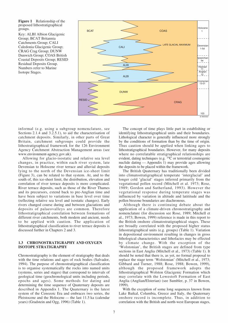
BCAT
CALI
ALBI
ALBI
COAS
DUNW
CRAGRESID
LATE GLACIAL MAXIMUM
Ipswichian
Hoxnian
Anglian
Holocene1
Devensian1-5d
5e
11
12
Cromerian13-21
103ID 98000567
Figure 1 Relationship of theproposed lithostratigraphicalgroups.
GLACIGENIC SUBGROUPSOF THE CALEDONIAGLACIGENIC GROUP
AlstonCentre
CheviotHills
Moffat HillsCentre
Galloway HillsCentre
Shap Divide
Rannoch MoorCentre
Cairngorm-Gaick Centre
WesternIsles
North-westHighlands
Banffshire Coast& Caithness
East Grampian
Logie -Buchan
Nor
th-w
est
Hig
hlan
ds D
ivid
e
Borders
Manx
Groups of the Great BritainSuperficial Deposits Supergroup
Note: Deposits of the Albion Glacigenic Group are present mainly to the south of the Devensian ice-sheet limit, but also occur locally farther north where they are placed in a parallel set of subgroups to those shown e.g. Mearns (Albion) Glacigenic Subgroup
CaledoniaGlacigenic
Group
AlbionGlacigenic
Group
CragGroup
Shetland
Inverness
Western Isles
Northwest Highlands
Banffshire Coast and Caithness
East Grampian
Logie-Buchan
Central Grampian
Mearns
Midland Valley
Borders
Southern Uplands
Irish Sea Coast
Central Cumbria
Manx
Southern limit of late Devensian glaciationand Caledonia Glacigenic Group
Southern limit of Anglian glaciationand Albion Glacigenic Group
Western limit of Crag Group
ID 98000568
Figure 2 Distribution ofglacigenic groups and subgroupsand marine deposits of the CragGroup (approximate courses of thepre-Anglian river systems alsoshown).Note that the geographicalboundaries are approximate and arebased on mapping formations oftill. They will be refined asknowledge of the distribution ofdefining formations is improved.
9
4
56
7 8
9
10
11
14
1516
17
1
2
3
13
20
19
21
18 2223
24
12
Southern limit of lateDevensian glaciation
Southern limit ofAnglian glaciation
Southern limit of lateDevensian glaciation
Southern limit ofAnglian glaciation
Additional subgroups for Shetland Isles,Orkney, Outer and Inner Hebrides and Arran may be established
ID 98000569
Figure 3 Distribution ofcatchment subgroups of theBritannia Catchments Group.Numbers refer to the catchmentsubgroups listed in Table 4. Notethat the geographical boundaries areapproximate and will be refined asknowledge of the distribution ofdefining formations is improved.
inferred land–sea correlations are also tentatively proposedusing the marine oxygen isotope stratigraphic scale derivedfrom ocean sediments (Gordon and Sutherland, 1993;Bowen, 1999). The oxygen isotope stratigraphicalframework (strictly not a chronostratigraphical scale) wasdeveloped from the analysis of calcareous microfossilspreserved in deep ocean floor marine sediments. In thisreport reference is made to the marine isotope stages fromthe record of cores V28–238 and Ocean Deep DrillingProject 667 (Shackleton and Opdyke, 1973; Shackleton etal., 1990; Bowen, 1999) (Table 1).
Marine isotope stages (� 18O stages which are designatedin a numerical scheme) provide a universal means ofsubdividing the Quaternary (Emiliani, 1954; Shackleton andOpdyke, 1973). The changing microfaunal assemblagespreserve a record of fluctuating oceanic water temperatureand the relative proportions of the two common isotopes ofoxygen contained in the skeletons provide an indirect recordof global ice volume and global sea level (Imbrie et al.,1984; Mix et al., 1995; Clark and Mix, 2002). During glacialperiods water is lost from the oceans to form ice sheets andthe oceans become relatively enriched in water containingthe heavy isotope of oxygen (18O). The changing 18O
content of ocean water can be used as an index of ice sheetgrowth and decay although it should be noted that a numberof variables (e.g. fluctuating ocean bottom temperaturesduring the Pleistocene, local hydrological effects) mean thatthe index cannot be directly related to ice volume as oncethought by Shackleton and Opdyke (1973).
The correlation of � 18O stages to informal climaticevents (e.g. interglacials) should be undertaken with cautionif used in isolation. The numerical scheme provides inexact‘high’ and ‘low’ ice volume reference points. The durationof an interglacial, as defined by evidence from onshoreQuaternary sequences, may be subject to continuedrevision. However, evenly numbered � 18O stages generallyrefer to cold ‘events’ and odd numbers to warm ‘events’within each global glacial — interglacial cycle. Some � 18Ostages are subdivided: for example, Stage 5 is subdividedinto 5a–5e (or 5.1 to 5.5, see Imbrie et al., 1984). Of thesesubdivisions 5a, 5c and 5e represent low ice volume eventsand may be equated with interstadials and interglacials.Stage 5e is generally accepted to represent a full interglacialand the equivalent of the Ipswichian (Eemian)climatostratigraphical stage and Stage 11 to the Hoxnian(Holsteinian) (Table 1).
10
GROUP SUBGROUP Examples of defining Lex MIS Status of units (stratotypes Reference in Bowen,formations code indicated where known) 1999
3. Tay Catchments Strathtay Formation 1 Proposed formations. StratotypesSubgroup South Esk Formation to be defined.
Strathearn Formation
4. Forth Catchments Lothian Tyne Valley 1 Proposed formations. StratotypesSubgroup Formation to be defined.
Carron Valley FormationAlmond Valley FormationForth Valley Formation
Clyde Valley Formation 1 Proposed formation will include fluvial Sutherland, p.110members (after Browne and McMillan,1989) of the Clyde Valley Formationof Sutherland in Bowen (1999) including:Law Sand and Gravel Member (LawBorehole)Lochwinnoch Clay Member(Lochwinnoch Borehole)
Strathendrick Formation 1 Proposed formation will include fluvial Sutherland, p.111–1125. Clyde Catchments members of the Clyde Valley FormationSubgroup of Sutherland in Bowen (1999). Includes
Endrick Sand Member (Mains ofKilmaronock Borehole) (Browne andMcMillan, 1989)
Strathkelvin Formation KELV 1 Stratotype to be defined.
Leven Valley Formation 1 Proposed formations. Stratotypes to beAyr Valley Formation defined.Irvine Valley Formation
Kilmaronock Silt Formation KILK 1 Lacustrine unit defined by Browne and Sutherland, p.111McMillan, (1989) (Mains of KilmaronockBorehole)
Clippens Peat Formation* CLPT 1 Defined from Linwood Borehole Sutherland, p.111–112(Browne and McMillan, 1989)
6. Tweed Catchments Tweed Valley Formation 1 Proposed formation. Stratotypes to beSubgroup defined.
Cree Valley Formation 1 Proposed formations. Stratotypes to beFleet Valley Formation defined.Kirkcudbright Dee Valley
FormationNithsdale FormationAnnandale Formation
7. Solway Catchments Solway Esk Valley SESKV 1 Proposed formation will include Sutherland, p.107Subgroup Formation Bigholm Burn Member (Bowen, 1999)
Eden Valley Formation 1 Proposed formations. Stratotypes to beWampool Valley defined.
FormationWaver Valley FormationEllen Valley FormationSolway Derwent Valley
Formation
BR
ITA
NN
IA C
AT
CH
ME
NT
S G
RO
UP
Table 4 Subgroups and examples of formations of the Britannia Catchments Group (see also Figure 3).The catchment subgroups are defined principally by formations of fluvial deposits. The Britannia Catchments Groupalso embraces lithogenetic units including mass movement deposits (e.g. head, talus), organic deposits (e.g. peat),mountain regolith and cover sand. Where appropriate some of these units have been raised to formation status: examplesare denoted thus *.Lex Code = Codes from the BGS Lexicon of named rock units (where assigned). Emboldened codes denote that the unithas been formally defined in the Lexicon. MIS = Marine Isotope Stage (inferred correlation).
11
12
GROUP SUBGROUP Examples of defining Lex MIS Status of units (stratotypes Reference in Bowen, formations code indicated where known) 1999
8. Northumbria Coquet Valley Formation 1 Proposed formations.Catchments Tyne Valley Formation Stratotypes to be defined.Subgroup Wear Valley Formation
Tees Valley FormationEsk Valley FormationTeeside Formation
9. Isle of Man Sulby Glen Formation SUGL 1 Formations established by Thomas Thomas, p.94Catchments in Bowen (1999) and revised bySubgroup Curragh Formation* CAGH 1 Chadwick et al. (2001)
Ehen Alluvial Formation 1 Formation established by Merrittand Auton (2000)
Esk Alluvial Formation 1 Proposed formation. Stratotypesto be defined.
10. Cumbria- Lune Valley Formation 1 Formations are proposed for Thomas, p.95Lancashire Ribble Valley Formation fluvial deposits of the SwettenhamCatchments Formation and Lytham formationsSubgroup of Thomas in Bowen (1999)
Blelham Peat Formation* 1 Blelham Formation of Thomas in Thomas, p.96Bowen (1999) and adopted byMerritt and Auton (2000)
Mersey Valley Formation 1 Formation is proposed for fluvial Thomas, p.95deposits of the SwettenhamFormation and Lytham formations
11. Cheshire–North Wales of Thomas in Bowen (1999)Catchments Subgroup
Weaver Valley Formation 1 Proposed formationsDee Valley FormationConway Valley FormationClwyd Valley Formation
Swale Valley Formation 1 Proposed formations.Ure Valley Formation Stratotypes to be defined.Nidd Valley Formation
12. Yorkshire Catchments Aire Valley FormationSubgroup Hull Valley Formation
Humber FormationYorkshire Ouse ValleyFormation Derwent Valley FormationWharfe Valley Formation
Ringingslow Formation* 1 Thomas in Bowen (1999) Thomas, p.97–98
Trent Valley Formation 1–8 Members after Brandon in Bowen (1999) Brandon, p.41
Proto-Trent Valley Members after Brandon in Bowen (1999) Brandon, p.42Formation
13. Trent Catchments Devon Valley Formation Members after Brandon and Sumbler Brandon and Sumbler, Subgroup in Bowen (1999) p.42
Bain Valley Formation Members after Brandon and Sumbler Brandon and Sumbler,in Bowen (1999) p.14–15
Trent Derwent Valley Members after Derwent Valley Brandon, p.39Formation Formation of Brandon in Bowen (1999)
Soar Valley Formation Members after Maddy in Bowen (1999) Maddy, p.39
Severn Valley Formation SEVN 1–11 Members after Maddy and Sumbler in Maddy and Sumbler,Bowen (1999) p.34–36
14. Severn and Avon Avon Valley Formation AVON Members after Maddy in Bowen (1999) Maddy, p.37–38
Bristol Avon Valley Members defined within the Avon Maddy, Keen andFormation Valley Formation of Maddy, Keen and Sumbler, p.37–38
Sumbler in Bowen (1999)
BR
ITA
NN
IA C
AT
CH
ME
NT
S G
RO
UP
(con
tinu
ed)
Table 4 continued
GROUP SUBGROUP Examples of defining Lex MIS Status of units (stratotypes Reference in Bowen, formations code indicated where known) 1999
14. continued Teme Palaeovalley 2–?11 Proposed formation with Little Hereford, Brandon, p.29–31Formation Bank Farm and Shakenhurst members.
See also fluvial Bodenham Member ofHerefordshire Formation, BullinghamMember of Wye Valley formation andMarden Member of Lugg Valley Formation (Brandon in Bowen, 1999)
Chelford Sands Formation* 3–6 Congleton Sand of Evans et al. (1968); Worsley, p.34described by Worsley (1991)
Dovey Formation 1 Possible formations for consideration Bowen, p.79–9015. West Wales Afon Formation (Tywi after Bowen, 1999, but restricted (Wales)Catchments Subgroup Teifi Valley Formation to deposits of the Tywi valley). Tregaron
Tywy Valley Formation and Ystog formations after Bowen (1999)Neath Valley FormationTregaron FormationYstog Formation
Nar Valley Formation NARC 1–?9 Marham, Pentney, Wormegay and Nar Lewis, p.18members after Ventris (1985) and Lewisin Bowen (1999)
Lark Valley Formation 1–? Lackford, Cavenham, Kentford, Lewis, p.21Fornham, Eriswell and Sicklesmoremembers after Lewis in Bowen (1999)
Cam Valley Formation 1–? Barnwell Station, Sidgwick Avenue, Lewis, p.21–22Barnwell Abbey, Barrington Village,
16. Ouse–Nene Histon Road, Huntingdon Road, LittleCatchments Subgroup Wilbraham, Bordeaux Pit and North Hall
members after Lewis in Bowen (1999)
Nene Valley Formation 1–?
Ouse Valley Formation
Slea Valley Formation
Welland Valley Formation
Witham Valley Formation
Waveney Valley Formation 1–11 Terrace deposits described by Moorlock Wymer, p.24,17. Yare Catchments et al. (2000a). Shotford, Wortwell and Lewis, p.25Subgroup Broome members after Lewis in Bowen
(1999). Hoxne Formation (Wymer inBowen, 1999) assigned member status
Yare Valley Formation YV Defined by Moorlock et al. (2000a)
18. Somerset Catchments Parrett Formation Defined with several members by Campbell et al., p.78Subgroup Campbell et al. in Bowen (1999)
Thames Valley Formation TV 1–12 Proposed formation. River terrace Gibbard, p.49–51deposit members and ‘brickearth’(loessic) deposits after Ellison et al.(2004) (members of the Maidenheadand Lower Thames formations ofGibbard, in Bowen, 1999)
Kennet Valley Formation 1–8 Members after Kennett (sic) Valley Collins, p.51–52Formation (Collins in Bowen, 1999)
19. Thames Catchments Blackwater–Lodden Valley BL2 to 1–8 Possible members after Blackwater– Gibbard, p.53Subgroup Formation BL4 Lodden Valley Formation (Gibbard in
Bowen, 1999)
Colne Valley Formation CVD Possible members after Colne Formation Gibbard, p.53(Gibbard in Bowen, 1999)
Mole-Wey Valley Formation MO1 to 1–9 Possible members after Mole-Wey Gibbard, p.54MO2 Formation (Gibbard in Bowen, 1999)
Wandle Valley Formation 1–8 Possible members after Wandle Gibbard, p54Formation (Gibbard in Bowen, 1999)
Lea Valley Formation 1–11 Possible members after Lea Formation Gibbard, p.54–56(Gibbard in Bowen, 1999)
BR
ITA
NN
IA C
AT
CH
ME
NT
S G
RO
UP
(con
tinu
ed)
Table 4 continued
13
14
GROUP SUBGROUP Examples of defining Lex MIS Status of units (stratotypes Reference in Bowen, formations code indicated where known) 1999
Darent-Cray Valley 1–11 Possible members after Darent Formation Gibbard, p.56Formation (Gibbard in Bowen, 1999)
Medway Valley Formation ME1 to 1–9 Possible members after Medway Valley Bridgland, p.56–57ME4 Formation (Bridgland in Bowen, 1999)
20. Suffolk Catchments Currently lithogenetic unitsSubgroup
21. Cornubian Catchments Currently lithogeneticSubgroup units
Hamble Formation Proposed formation. Three aggradationsabove alluvium
Itchen Formation Proposed formation. Up to sevenaggradations above alluvium
Test Formation Proposed formation. Up to eleven22. Solent Catchments aggradations above alluviumSubgroup
Hampshire Avon Formation Proposed formation. Up to eleven Gibbard and Preece,aggradations above alluvium. Includes p.63the Ringwood Formation (formerly‘Older River Gravel Formation’) andsome members of the New ForestFormation of Gibbard and Preece inBowen (1999)
Dorset Stour Formation Defined by Allen and Gibbard (1994). Gibbard and Preece,See Sway Member of New Forest p.63Formation of Gibbard and Preece inBowen (1999)
Frome–Piddle Formation Defined by Allen and Gibbard (1994). Gibbard and Preece,Members described by Gibbard and p.64Preece in Bowen (1999)
Cuckmere Formation 1 Proposed formation. Two aggradations Gibbard and Preece,above alluvium. Cuckmere Member of p.62the Sussex Valleys Formation of Gibbardand Preece in Bowen (1999)
Sussex Ouse Formation Proposed formation. Four aggradations23. Sussex Catchments above alluvium. Lower Ouse MemberSubgroup of the Sussex Valleys Formation of
Gibbard and Preece in Bowen (1999)
Arun Formation AR1 to Proposed formation. Seven aggradationsAR7 above alluvium. Arun Member of the
Sussex Valleys Formations of Gibbardand Preece in Bowen (1999)
Adur Formation AD1 to Proposed formation. Three aggradationsAD3 above alluvium
Sussex Rother Formation RS1 to Proposed formation. Five aggradationsRS5 above alluvium
Kentish Rother Formation 1 Proposed formation. Stratotypes to bedefined.
Pegwell Formation 2–3 Formation established by Gibbard and Gibbard and Preece,24. South Kent Preece in Bowen (1999) p.61Catchments Subgroup
Kent Ouse Formation OK and Terrace depositsOK1 toOK2
Kentish Stour Formation 3–10 Possible members after Gibbard and Gibbard and Preece,Preece in Bowen (1999) p.59
BR
ITA
NN
IA C
AT
CH
ME
NT
S G
RO
UP
(con
tinu
ed)
Table 4 continued
15
GROUP Examples of defining Lex MIS Status of units (stratotypes indicated Reference in Bowen, 1999formations code where known)
Briton’s Lane Formation BRLA ?6 Lee et al. (2004)
Oakwood Formation Worsley in Bowen (1999) Worsley, p.32–34
Ridgacre Formation Maddy in Bowen (1999) Maddy, p.34–36
Trysull Silt Formation 9 Member of Seisdon Formation Worsley, p.32
Sheringham Cliffs SMCL ?10 Lee et al. (2004)Formation
Wolston Formation WOLS 10–12 Sumbler in Bowen (1999) includes the Sumbler, p.37following members:
Lowestoft Formation LOFT 12 Modified from Lewis in Bowen (1999) Lewis, p.19–20
Happisburgh Formation HPTI ?16 Member of North Sea Drift Formation Lewis, p.15–16after Lunkka (1994) (Lewis in Bowen,1999) and Lee et al. (2004).
ALBIONGLACIGENIC
GROUP(Beyond the
main Devensianice-sheet limit)
Table 5a Examples of formations of the Albion Glacigenic Group south of the Devensian ice-sheet limit.Lex Code = Codes from the BGS Lexicon of named rock units (where assigned). Emboldened codes denote that the unithas been formally defined in the Lexicon. MIS = Marine Isotope Stage (inferred correlation).
16
GROUP SUBGROUP Examples of Lex MIS Status of units (stratotypes Referencedefining formations code indicated where known) in Bowen, 1999
Shetland (Albion) South Wick Till Formation ?12 Described by Mykura and Phemister Sutherland p.106–107Glacigenic Subgroup (1976) and Hall et al. (1993a, b); member
of the Shetland Formation (Sutherland inBowen, 1999)
Western Isles (Albion) No formations currentlyGlacigenic Subgroup identified
Banffshire Coast and Camp Fauld Till Formation ?6 Merritt et al. (2003); Red Burn Member Sutherland p.102Caithness (Albion) Red Burn Till Formation of Teindland Formation (Sutherland inGlacigenic Subgroup Bowen, 1999)
Rottenhill Till Formation ?6 Auton et al. (2000) and Merritt et al. Sutherland p.100–102Bellscamphie Till BLTI (2003); Rottenhill Till Member ofFormation Kirkhill Formation (Sutherland inBirnie Gravel Formation BEGR Bowen, 1999); see also Bellscamphie
Formation (Sutherland in Bowen, 1999)East Grampian (Albion)Glacigenic Subgroup Pitscow Sand and Gravel 8 Merritt et al. (2003); member of Sutherland, p.99
Wales (Albion) Glacigenic No formations currentlySubgroup identified
Table 5b Examples of formations and subgroups of the Albion Glacigenic Group northof the Devensian ice-sheet limit.Lex Code = Codes from the BGS Lexicon of named rock units (where assigned). Emboldened codes denote that the unithas been formally defined in the Lexicon. MIS = Marine Isotope Stage (inferred correlation).
AL
BIO
N G
LA
CIG
EN
IC G
RO
UP
17
GROUP SUBGROUP Examples of Lex MIS Status of units (stratotypes Referencedefining formations code indicated where known) in Bowen, 1999
Shetland Glacigenic Burrier Wick Till Formation ?2–4 Described by Mykura and Phemister Sutherland, p.107Subgroup Sandness Till Formation (1976) and by Hall (1993a, b); members
of the Shetland Formation (Sutherlandin Bowen, 1999)
Western Isles Glacigenic Port Beag Till Formation 2–4 Described by von Weymarn and Edwards Sutherland, p.106Subgroup (1973); member of the Lewis Formation
(Sutherland in Bowen, 1999)
Alturlie Gravel Formation* ALGR 2 Formations of Auton (2003), FletcherArdersier Silts Formation* ARDS et al. (1996), Merritt et al. (2003)Reisgill Burn Till Formation† REDR
Banffshire Coast and Essie Till Formation * Moray FirthCaithness Glacigenic Kirk Burn Silt Formation§ KBSI † Caithness and SutherlandSubgroup Blackhills Sand and Gravel BLSG § Keith and Banffshire
East Grampian Glacigenic Lochton Sand and Gravel LOSG 2 Formations of Merritt et al. (2003) Sutherland, p.101Subgroup Formation
Glen Dye Silts Formation GDSIBanchory Till Formation BATICrovie Till Formation CRTIByth Till Formation
Mearns Glacigenic Drumlithie Sand and Gravel DSG 2 Formations of Merritt et al. (2003); Sutherland, p.114Subgroup Formation• members of the Mill of Forest Formation
Ury Silts Formation• USI (Sutherland in Bowen, 1999)Mill of Forest Till Formation• MFT • Aberdeen–Stonehaven
Logie-Buchan Glacigenic Ugie Clay Formation UGCL 2 Formations of Merritt et al. (2003); Sutherland, p.102Subgroup Kippet Hills Sand and Gravel KHG members of the Bellscamphie Formation
Formation (Sutherland in Bowen, 1999)Hatton Till Formation HATT
Central Grampian Ardverikie Till Formation ARDT 2 Formations of Merritt (1999)Glacigenic Subgroup Ceardaich Sand and Gravel
Formation CEARLinn of Pattack Silt LPSIFormationPattack Till Formation PATT
Finglack Till Formation* FINT 2 Merritt et al. (1995) and Fletcher et al. Sutherland, p.103Kincurdy Silts Formation KSI (1996); Finglack member of Clava
Formation (Sutherland in Bowen, 1999)* Moray Firth
Inverness GlacigenicSubgroup
Red Craig Gravels RCGR 4 Fletcher et al. (1996) Sutherland, p.103Formation Cromarty Firth
Allt Gravel Formation 5a–d Member of Allt Odhar Formation Sutherland, p.105(Sutherland in Bowen, 1999)
Dunbeath Till Formation† DUTI 4 † Caithness and Sutherland (Auton, 2003)
Drumbeg Sand and Gravel DRBG 1 Formations of Browne and McMillan Sutherland, p.111Formation (LLS) (1989) (members of Clyde Valley
Formation of Sutherland in Bowen, 1999)
Gartocharn Till Formation GATI
Broomhouse Sand and BHSE 2 Formation (after Browne and McMillan Sutherland, p.109Gravel Formation (1989) (member of Clyde Valley
Formation of Sutherland in Bowen, 1999)including:
Midland Valley Glacigenic RSSA Ross Sand MemberSubgroup
BILL Bellshill Clay Member
Wilderness Till Formation WITI Formation (after Browne and McMillan(1989) (member of Clyde ValleyFormation of Sutherland in Bowen, 1999)including:
Table 6 Examples of subgroups and formations of the Caledonia Glacigenic Groupmainly north of the Devensian ice sheet limit.Lex Code = Codes from the BGS Lexicon of named rock units (where assigned). Emboldened codes denote that the unithas been formally defined in the Lexicon. MIS = Marine Isotope Stage (inferred correlation).
CA
LD
EO
NIA
GL
AC
IGE
NIC
GR
OU
P
18
GROUP SUBGROUP Examples of Lex MIS Status of units (stratotypes Referencedefining formations code indicated where known) in Bowen, 1999
CADR Cadder Sand Member
BRLL Broomhill Clay Member
Baillieston Till Formation BNTI Pre-2 Formation (after Browne and McMillan(1989) (member of Clyde ValleyFormation of Sutherland in Bowen, 1999)
Langholm Till Formation LHTI 2 Proposed formations for Dumfries andGalloway (McMillan et al., in prep.)
Kirkbean Sand and Gravel KNSouthern Uplands FormationGlacigenic Subgroup
Dalswinton Moraine DSMOFormation
Mouldy Hills Gravel MOHIFormation
Borders Glacigenic Greenlaw Gravel Formation 2 Proposed formationsSubgroup Kale Water Till Formation
North Sea Coast Holderness Formation HOLD 2 Described by Catt and Penny (1966); McCabe and Bowen,Glacigenic Subgroup includes Sewerby and Skipsea and other p.13
members, and Dimlington Bed (McCabeand Bowen in Bowen, 1999)
Gretna Till Formation GRET 2 Proposed formations for Dumfries andGalloway (McMillan et al., in prep.)
Kilblane Sand and Gravel KBSGFormation
Cullivait Silt Formation CUS
Kerr Moraine Formation KEMO
Plumpe Sand and Gravel PLSGFormation
Baronwood Sand and Gravel 2 Proposed glacigenic formations in NorthFormation Cumbria.
Greystoke Till Formation
Great Easby Clay Formation
Gillcambon Till Formation
Gosforth Glacigenic 2 Glacigenic formations in West CumbriaFormation established by Merritt and Auton (2000)
Jurby Formation JURBY 2 Isle of Man glacigenic formations. Thomas, p.94Thomas in Bowen (1999) and Chadwick
Orrisdale Formation ORRIS et al. (2001)
Shellag Formation SHLAG
Morecambe Bay Formation 2 Glacigenic formation in Lancashire Thomas, p.95–96Kirkham Formation correlated with the Stockport Glacigenic
Formation (Thomas in Bowen, 1999)
Lleyn Till Formation 2 Proposed till formation (NW Wales). Bowen, p.84 and 89Other till and glaciofluvial formations tobe considered (e.g. members of St AsaphFormation of Bowen, 1999 afterMcKenny-Hughes, 1887)
Stockport Glacigenic 2 Defined by Worsley (1991). Maddy, p.34Formation Maddy in Bowen (1999)
Four Ashes Sand and Gravel FASG 3–5eFormation
Table 6 continued
CA
LD
EO
NIA
GL
AC
IGE
NIC
GR
OU
P (c
onti
nued
)
19
GROUP SUBGROUP Examples of Lex MIS Status of units (stratotypes Referencedefining formations code indicated where known) in Bowen, 1999
Wolf Crags Formation 1 Thomas in Bowen (1999) Thomas, p.96
Central Cumbria Glacigenic Windermere Formation 1–2Subgroup
Blengdale Glacigenic BLGL 2–?4 Glacigenic formation in West CumbriaFormation established by Merritt and Auton (2000)
Threlkeld Till Formation 2 Member of Thomas in Bowen (1999) Thomas, p.96
Manx Glacigenic Snaefell Formation SNAEF 2 Isle of Man paraglacial formation. Thomas, p.94Subgroup Thomas in Bowen (1999) and Chadwick
et al. (2001)
Pocklington Gravel POCKG 2 Proposed formations. Pickering and Thomas, p.97Formation Hemingbrough formations of Thomas in
Bowen (1999)Alne Glaciolacustrine ALNEFormation
Elvington Glaciolacustrine ELVFormation
North Pennine Glacigenic Hemingbrough Glacio- HEMSubgroup lacustrine Formation
Littlethorpe GlaciolacustrineFormation
Pickering GlaciolacustrineFormation
Vale of York Till Formation VYORK
Bickerton Moraines BICKMFormation
Poppleton Glaciofluvial POPPFormation
Eyri Till Formation 2 Proposed formations (cf. glacigenic Eyri Bowen, p.79–90Berwyn Till Formation Formation, Meirion and BecknockshirePlynlimon Till Formation formations of Bowen, 1999)
Wales Glacigenic Subgroup Brecknockshire Formation
Shrewsbury Formation Defined by Worsley (1991). Maddy in Maddy, p.34Bowen (1999)
Table 6 continued
CA
LD
EO
NIA
GL
AC
IGE
NIC
GR
OU
P (c
onti
nued
)
2.1 THE LITHOSTRATIGRAPHICAL CODE ANDITS APPLICATION TO THE QUATERNARYDEPOSITS OF GREAT BRITAIN
Salvador (1994), amplified by Rawson et al. (2002 andreferences therein) sets out the internationally acceptedhierarchy of lithostratigraphical units. The unit terms(Sections 2.1.2–2.1.7) are described in order of rank.
2.1.1 Naming of lithostratigraphical units
It is recommended that each lithostratigraphical unitshould be formed from the name of an appropriategeographical feature combined with the appropriate unitterm (e.g. group, formation). To aid the user of theproposed lithostratigraphical framework for Quaternarydeposits, especially the non-geologist, it is recommendedthat both a geographical and a lithological term areincluded within the unit name (e.g. Bridgeton SandFormation), although this practice is discouraged bySalvador (1994). The use of the same geographical termfor units of different status (e.g. formation and member) isnot recommended except where historical precedent maybe an over-riding consideration. Recommended descriptorterms for formations, members and beds are given inTables 7a–c.
2.1.1.1 NAMING OF GROUPS AND SUBGROUPS
One of the distinguishing characteristics of manyQuaternary deposits is the rapidity of vertical and lateralchanges in lithofacies. Diversity of lithology mayconstitute a form of unity for bodies of sediment withsimilar gross depositional characteristics. To highlight thisdiversity, at the level of group and subgroup (see below),the proposed Quaternary Lithostratigraphical Frameworkutilises a genetic epithet (e.g. glacigenic, catchments),albeit recognising that genesis is inferred. Whilst thispractice is not recommended by Salvador (1994), theproposed nomenclature serves to highlight that the strataare heterolithic superficial deposits that may be readilydistinguished from bedrock lithostratigraphical units.
2.1.1.2 NAMING OF FORMATIONS AND MEMBERS
For formations it is recommended that lithologicaldescriptors are defined by the dominant grain-size (e.g.sand, gravel, silt, clay) or grain-size range (e.g. sand andgravel) or lithology (e.g. peat). Morphological descriptors(e.g moraine) have been rarely used but are useful forlithologically heterogeneous deposits. If a landform isconsidered to be an important attribute, a link may be madebetween the deposit and the associated landform byreferring to the lithogenetic classification and mappingschemes (Chapter 3).
Although genetic epithets for formations should beavoided (Salvador, 1994) the use of the descriptor ‘till’ isrecommended as a useful practical term for the main tillsheets containing lenses of stratified deposits (e.g. GretnaTill Formation). We prefer this term to the less familiar‘diamicton’ unless genesis is unclear or controversial (note
that not all diamictons are tills). Other lithogenetic termsthat have been used previously for formations (e.g.glacigenic, glaciolacustrine, glacial lake, glaciofluvial) areuseful where the units are particularly lithologicallyheterogeneous.
For deposits of fluvial origin it is recommended thatformations be named after the principal river valleys(Table 7b). A single formation is normally consideredsufficient to define the fluvial deposits (floodplainalluvium and terrace deposits which are defined asmembers) of a river and its tributaries (e.g. Clyde ValleyFormation) or a palaeovalley (e.g. Proto-Trent Formation).For major drainage basins (e.g. those of the Thames, Trentand the Severn) separate formations, defined by terracedeposit members with broadly unified lithostratigraphicalcharacteristics, may be established for both the principalriver (e.g. Thames) and major tributary valleys (e.g.Kennet). The formation may also include, at member orbed level, interbeds such as peat. For fluvial deposits atmember level terms may include ‘alluvium’ or ‘fan’ of anamed river valley formation. Where correlation ispossible between terrace deposits of both a tributary andthe principal river these members may be accorded thesame name. River terrace deposit members may begeographically named or numbered sequentially withreference to the river valley formation name. For terracesurfaces identified by numbers, the first river terrace(Terrace No. 1) is the lowest and youngest.
2.1.2 Supergroup
2.1.2.1 DEFINITION
A supergroup may be used for several associated groups orfor associated formations and groups with significantlithological properties in common (Salvador, 1994).
2.1.2.2 APPLICATION
For Quaternary and upper Neogene deposits a singlesupergroup is proposed for the onshore natural superficialdeposits of Great Britain. This supergroup distinguishessuperficial deposits from bedrock.
2.1.3 Group
2.1.3.1 DEFINITION
A group is the formal lithostratigraphical unit next in rankabove a formation and is commonly applied to a sequenceof contiguous formations with significant diagnosticlithological characteristics (Salvador, 1994).
2.1.3.2 APPLICATION
As indicated above, it is proposed to establish groups ofQuaternary formations that reflect the diverse lithologiesassociated with the principal modes of inferred origin (i.e.marine, fluvial, glacial and residual). When assessed withinthe Quaternary chronstratigraphical framework thedefining formations may be classified in seven majorgroups (Table 1, Figure 1, Chapter 3).
20
2 Principles and definitions
2.1.4 Subgroup
2.1.4.1 DEFINITION
Salvador (1994) notes that, exceptionally a group may bedivided into subgroups. Rawson et al. (2002) acknowledgethat the term subgroup is not in the formal hierarchy buthas been usefully employed for subdividing certain groups.
2.1.4.2 APPLICATION
For Quaternary deposits, subgroups are introduced whichare defined on lithological characteristics and geographicalextent of component formations (Chapter 3).
Across Great Britain a series of catchment subgroups areproposed for formations, defined by river terrace depositmembers, and associated lithogenetic units withinphysiographic regions (Figure 2). The boundaries of theseregions broadly coincide with major modern ‘catchment’boundaries but the subgroups may include both Holoceneand pre-Holocene deposits (see section 3.2.5.1). Additionalcatchment subgroups may be established for the majorScottish islands (Figure 2).
Lying mainly to the north of the Devensian ice sheetlimit (Figure 2) a series of glacigenic subgroups areproposed for formations and lithogenetic units of similarlithology and provenance (see section 3.2.7.1).
2.1.5 Formation
2.1.5.1 DEFINITION
The formation is the primary formal unit of lithostratigraphicalclassification used to map, describe, and interpret the geologyof a region (Salvador, 1994). Rawson et al. (2002) state that itis generally defined as the smallest mappable unit and haslithological characteristics that distinguish it from adjacentformations. However ‘mappability’ is a loose criterion, for itdepends on the scale of mapping. In Britain, formations shouldbe mappable and readily represented on a 1:50 000 scale map:
individual members may be mappable at this scale, but are notnecessarily so. In three-dimensional models, scale variationswill allow both members and beds to be shown as mappableunits.
A formation is defined by a type section or by type area.Where possible, top and base should be defined but it isrecognised that the nature of these boundaries and thebounding deposits may vary laterally. Many Quaternarylithostratigraphical units will have no upper boundarydefined by an overlying unit because the upper geologicalsurface is the present day aggradation or erosion surface.Although Salvador (1994) indicates that formations neednot be aggregated into groups, it is recommended that forQuaternary deposits there is merit in such an approach toaid broad correlation and regional mapping.
2.1.5.2 APPLICATION TO GLACIGENIC DEPOSITS
Formational status may be assigned for any regionallysignificant mappable unit. The decision to define a unit as aformation commonly rests with the surveyor or researcherand, as has been demonstrated by Lowe and Walker (1997,fig. 6.2) for glacigenic deposits this can result in a range ofopinions as to the most useful subdivision of units. Ideally,the key tests include demonstrating type section(s) wheretop and base of the unit can be observed (but see above,Section 2.1.5.1), noting the nature of those boundaries andthe lithological and physical characteristics of both the unitand bounding units, and tracing lateral continuity, acceptingthat lateral and vertical lithological variation is likely.
In assessing the definition of formations established inBowen (1999) it is observed that some include all thesuperficial deposits of a geographical area (e.g ClydeValley Formation of Sutherland in Bowen, 1999). Whilstsuch units are broadly mappable, a more systematicapproach has been adopted in the proposed framework inwhich significant mappable units are established asformations.
21
GROUP FORMATION MEMBER BED Lithology Lithogenetic unitsafter McMillan and Powell (1999) and
Examples Examples Examples Ambrose (2000)
Cromer Forest-bed Bacton Member etc. Clay, sand Organic/fluvial/lacustrine depositsFormation
Table 7a Recommended nomenclature for the Crag Group, the Dunwich Group and theResidual Deposits Group.
In practice, regionally significant glacigenic units suchas till sheets or glaciofluvial sheet deposits may bedistinguished as formations. Discontinuous interbeddedunits may be best assigned member or bed status.
2.1.5.3 APPLICATION TO FLUVIAL DEPOSITS
A single formation is normally considered sufficient todefine the fluvial deposits (including the alluvium andterrace deposits) of a major river and its tributaries (as forthe Severn and Avon valleys, Maddy in Bowen, 1999)(Table 7b).
It is recommended that river terrace deposits and alluviumshould be assigned as members of a river valley formation(Table 7b). A member may extend from one formation toanother (Salvador, 1994) (e.g. correlated terrace deposits ofthe Thames valley and its tributaries, Gibbard in Bowen,1999). The formation may also contain beds of non-glacialfluvial deposits such as organic (peat), and lacustrine deposits.
Terrace deposits and alluvium of a present-day riversystem can be regarded respectively as the abandoned and
modern parts of the present fluvial system (Figures 4, 5).These deposits can be mapped as members of a river valleyformation within a catchments subgroup.
River terrace sequences fall into three categories:
• terraces representing multiple incisions of a single(syn- to post-glacial) aggradational event
• a combination of the above (e.g. Teifi)
On BGS maps currently no distinction is drawn betweendiscrete aggradational terrace-forming events (Figures 4a, 5a),and the multiple terrace staircases formed by incision anderosion with little or no deposition on the terrace flat. Modernmapping practice would allow truly erosional landforms to bedistinguished by formlines only (Figures 4b, 5b).
However, in practice it is implicit in the way that riverterraces have been portrayed on BGS maps that the whole
22
GROUP FORMATION MEMBER BED Lithology Lithogenetic subdivision Lithogenetic unitsafter McMillan and
Examples Examples Powell (1999) andAmbrose (2000)
Thames Valley Alluvium of the River Beds may be Sand, gravel, silt, clay Alluvium Fluvial depositsFormation Thames etc. established forTrent Valley locally significantFormation units of sand,Strathendrick gravel, silt, clayFormation Alluvial fan Sand, gravel Alluvial fan deposits
Named or numbered and Sand, gravel, silt, clay River terrace depositsreferred to named river:Boyn Hill Gravel
MemberHolme Pierrepont Sand
and Gravel MemberBeeston Sand and Gravel
Member etc.
Dartford Silt Member Silt Fluvio-aeolian deposits, loess
Clippens Peat - Peat, shell marl, diatomite Organic depositsFormation etc.
Not assigned - Soil, palaeosol Soilformational status
Bone bed Bone beds etc.
Tufa, bog iron Chemical deposits
Gravel, sand, silt, clay Mass movementdeposits (landslip,head, talus)
Drigg Point Sand Sand Blown sand (dune) Aeolian depositsFormation
North Denes Gravel, sand, silt, clay Shoreface and beach, tidal Marine and coastalBRITISH Formation river deposits zone depositsCOASTAL BreydonDEPOSITS Formation etc.GROUP
Clyde Clay Sand, gravel, silt, clay Raised beach and marine Marine and coastalFormation deposits zone deposits and
Errol Clay interglacial marineFormation etc. deposits
Table 7b Recommended nomenclature for units of the Britannia Catchments Group and theBritish Coastal Deposits Group.
BR
ITA
NN
IA C
AT
CH
ME
NT
S G
RO
UP
Subg
roup
s (i
nfor
mal
)
Most lithostratigraphic units should have a geographical prefix. Additonal descriptors are defined by major lithological componentor combination (e.g. sand and gravel), or by morphology if lithology variable.
terrace (riser and flat) has been considered as one deposit(otherwise there would have been a need to show theincised as well as the newly deposited material).
In a number of major river systems (e.g. Conwy, Wnion)both types of terrace may occur in intimate association. Thefollowing sections illustrate how the deposits underlyingsuch terraces may be defined as lithostratigraphical units.
Erosional terraces
Erosional terraces consist of a series of incisions related tofalling base level that may, for example, occur in valley fillsof glaciofluvial sand and gravel (Figure 4b). Despite beingsubject to the same external base level fluctuation, no tworivers can be regarded as having a comparable history ofincision, as this depends on factors such as their history,depositional milieu, longitudinal profile, discharge, rivercapture etc. Their catchments should therefore be consideredas a single depositional system for the purposes ofclassification. The sequence thus consists of a singledepositional unit to which formational status may beassigned, and within which are a series of erosional surfaces.
Aggradational terraces
These terraces represent several widely recognisable,lithologically distinctive and chronostratigraphicallydateable periods of aggradation, separated by major episodesof downcutting. They are a series of discrete events in theevolution of a river and the deposits should form membersof a river valley formation. Examples of aggradationalterraces include those of the major river systems of SouthWales (Usk) and the Welsh borders (Severn, Wye).
Combined terraces
Any stratigraphical scheme adopted needs to be able torecognise that erosional and aggradational terraces do not
occur in isolation within a river valley, and must be able todiscriminate between them. Even continuous flights ofterraces have been shown to represent both erosional andaggradational events in some of the larger rivers of Wales(e.g Afon Teifi; Rheidol). To distinguish these events it isnecessary to recognise, for example, that a single namedaggradational terrace member may lie stratigraphicallyabove or below erosional terraces cut into a separateformation (Figures 4b, 5b).
This scenario is potentially further complicated by theglacially overdeepened valleys of some Welsh rivers (e.g.Usk, Wnion, Towy), which has resulted in a long profile ofdiscrete depositional basins separated by rock barriersthrough which the river has incised a gorge. In these riversystems, the terraces may reflect local base levels ascontrolled by the rock barrier. Thus, the number of terracesfrom one basin to the next may not be consistent, althoughthey may occur within the same depositional unit. Thiswould be further emphasised should a single, correlatableaggradation terrace be present. When correlated betweenbasins, this aggradation terrace may be the second terracein one basin, and the third in the adjacent downstreambasin (Figure 5b). In such a scenario, the numberingreflects the hierarchy within each basin, not the river as awhole.
Thus, by obeying the stratigraphical principles describedabove it is possible to produce a robust and usefulclassification of such a fluviatile depositional complex. Itis likely that in any such scheme there will be a need toadopt an undifferentiated category for river terracedeposits.
It is recommended that:
• Members should only be named and defined if a riverterrace deposit can be formally described.
GROUP SUBGROUP FORMATION MEMBER BED Lithology Lithogenetic Lithogenetic unit
Broomhouse Sand and Ross Sand Member Sand, gravel, clay, Glaciofluvial sheetGravel Formation etc. Bellshill Clay silt and ice contact
Member deposits (terraces,eskers and kames)
Carleton Silt and glaciolacustrineFormation etc. deposits
Table 7c Recommended nomenclature for glacigenic units of the Albion Glacigenic Groupand the Caledonia Glacigenic Group.
ALBIONGLACIGENICGROUP andCALEDONIAGLACIGENICGROUP
East GrampianGlacigenicSubgroupIrish Sea CoastGlenigenicSubgroup etc.
Each lithostratigraphic unit should have a geographical prefix. Additional descriptors are defined by major lithological component orcombination (e.g. sand and gravel), or by morphology if lithology variable. Genetic qualifiers are to be used only where it isinappropriate to use lithological descriptors. Thin lenses or organic deposits and soils interbedded with till may be included inglacigenic groups.
23
• Erosional terraces cut into a single deposit (a separateformation) may be depicted on maps with formlines.
• Deposits of aggradational terraces related to the presentriver valley should be accorded member status of ariver valley formation.
Palaeovalley terrace and ‘buried channel’ deposits
Terrace deposits of early fluvial systems and ‘buriedchannel’ deposits may be unrelated to the present-day
physiography. Such deposits cannot necessarily becorrelated with older terrace deposits of present-dayvalleys. In the West Midlands, the middle Devensianterrace deposits of the proto-Teme river and its tributaries(Cross and Hodgson, 1975) (Figure 6) formed during theperiod when the proto-Teme drainage system flowedsouthwards and westwards into the precursor of the RiverLugg. Thus, the terraces were deposited in response to amarkedly different fluvial system that bears little relation
Alluvium
River terrace deposits (as numbered)
Glaciofluvial sand and gravel
1-2
2
1
1
2
1
1
2
1 1
2 2
X Y
X
Y
ID 98000570
Figure 4 Interpretation of mapped river terraces: I.a A sketch map and accompanying cross-section showing the floodplain alluvium and twostacked aggradational river terraces within a valley infilled with glaciofluvial sand and gravel.b A sketch map and accompanying cross-section showing the floodplain alluvium and bothaggradational and erosional terraces. In this case, the glaciofluvial deposits underlying Terrace 2would form part of a glacigenic subgroup (e.g. Wales Glacigenic Subgroup), whereas the alluviumand the deposits of Terrace 1 are members of a river valley formation. Note that truly erosionalterraces are quite rare and are not flat. There is nearly always some reworking and deposition.
Alluvium
River terrace deposits (as numbered)
Glaciofluvial sand and gravel
Backfeature of fluvial terrace, arrowheads denote uphill side
Bracketed symbols indicate that theterrace feature is erosional. The surfacedeposit is glaciofluvial sand and gravel.
1-2
1
1
1
1
1 1
X Y
X
Y
2( )
2( )
2( )
2( )
ID 98000583
a
b
24
25
Alluvium
River terrace deposits (as numbered)
Fluvial formation X of proto-river
Gorge
1-3
2
2
2
2
2
2
2
1
1
1
3
1
1
1
1
3
3
3
3
X
X
X
XX
X
Abandoned meander
GorgeGorge
Gorge
RiverbedID 98000571
Figure 5 Interpretation of mapped river terraces: II.a A sketch map and accompanying downstream profile showing the floodplain alluvium and threestacked aggradational river terraces within the valley of the Afon Teifi. The river has cut into depositsof a pre-existing formation (labelled X) related to the course of a proto- Afon Teifi.b A sketch map and accompanying downstream profile showing the floodplain alluvium and bothaggradational and erosional terraces within the valley of the Afon Teifi. In this case, the terraces mayreflect local base levels as controlled by the rock barrier. When correlated between basins, aggradationalTerrace 2 in one basin may be correlated with aggradational Terrace 3 in the adjacent downstream basin.Thus, the numbering reflects the hierarchy within each basin, not the river as a whole.
Alluvium
River terrace deposits (as numbered)
Fluvial formation X of proto-river
Gorge
Bracketed symbols indicate that theterrace feature is erosional. The surface deposit is fluvial formation X.
Backfeature of fluvial terrace, arrowheads denote uphill side
1-3
2
2
3
2
2
1
1
3
3( )
( )( )
X
X
X
XX
X
Abandoned meander
GorgeGorge
Gorge
RiverbedID 98000584
a
b
to the present-day Teme catchment in which they lie. It ispossible that their correlatives are represented by the ‘olderriver terraces’ that lay beyond the limit of Devensian ice inthe catchments of the rivers Lugg and Wye (Brandon,1989). The terrace deposits of middle Devensian agecannot be considered as members of a present-day ‘rivervalley formation’ and it is recommended that they, andsimilar deposits, be designated as separate formationswithin the Britannia Catchments Group.
2.1.5.4 APPLICATION TO OTHER SUPERFICIAL DEPOSITS
Extensive lacustrine deposits, peat and mass movementdeposits (e.g. head) may be accorded formation status ormerely remain as lithogenetic units within a catchmentssubgroup or group, if related to more than one subgroup(see Section 3.2.5). Similarly, coastal and marine depositswith lateral continuity and lithological may be raised toformational status within a group.
2.1.6 Member
2.1.6.1 DEFINITION
A member is the formal lithostratigraphical unit next inrank below a formation and is always part of a formation
(Salvador, 1994). Formations need not be divided eitherwholly or partially into members. A member may extendfrom one formation to another (Salvador, 1994).
2.1.6.2 APPLICATION
Lithologically distinctive units interbedded within moreregionally significant glacigenic formations may beseparated as members (cf. Lowe and Walker, 1997). Forfluvial deposits, see discussion under section 2.1.5. Formembers, grain-size descriptors (e.g. sand, gravel, silt) orlithological descriptors (e.g. peat) may be used. Forpedostratigraphic units the terms ‘soil’ or ‘palaeosol’ arerecommended.
2.1.7 Bed
A bed is the smallest formal unit in the hierarchy ofsedimentary lithostratigraphical units (Salvador, 1994).Bed names are commonly applied to distinctive units thatmay be thin and laterally inextensive. Some beds may befossiliferous or yield dateable material (e.g. a soil, peat orbone bed). Bed status tends to be assigned for units withsome palaeogeographical, geochronological or specificlithological significance.
26
River terrace deposits of late Devensian to Holocene age
River terrace deposits of middleDevensian age
Overflow channel
ID 98000572
River Teme
River LuggLi
mit
of D
even
sian
Ice-
Shee
t
Cou
rse
of p
roto
-Tem
e
Figure 6 Sketch map of thedistribution of terrace depositsof the proto-River Teme.Deposits of presumed middleDevensian age underlie highelevation terraces. Thesedeposits are unrelated to theterrace deposits of the modernRivers Teme and Lugg and aretherefore assigned to a separateformation (Teme PalaeovalleyFormation, see Table 4).
2.2 APPLICATION OF THE BGS ROCKCLASSIFICATION SCHEME
2.2.1 Lithogenetic unit
Lithogenetic units are locally mappable assemblages ofrock strata, considered without regard to time (Schenck andMuller, 1941; Salvador, 1994). A lithogenetic unit,mappable or otherwise, is defined by its lithology,morphology and inferred mode of origin (genesis). ForGreat Britain, the BGS classifies lithogenetic unitsaccording to the BGS Rock Classification Scheme (RCS)for artificial and natural superficial deposits (McMillan andPowell, 1999). The RCS forms the standard for mapping,section and borehole logging and for digital dictionaries andmaps (McMillan, 2002). The BGS mapping classificationof superficial deposits offers a tried and tested method ofassigning various attributes to deposits. These include the
lithology, morphology, genesis, lithostratigraphy and age ofdeposit. Tables 7a–c show recommended criteria forassigning lithostratigraphical status to deposits of theprincipal lithogenetic units of Great Britain. It is recognisedthat types of slope (mass movement) deposits (Dines et al.,1940) have been inconsistently mapped and arelithologically poorly known. Unless such deposits can becorrelated it is recommended that initially they be assignedonly a lithogenetic classification and informally related to acatchments subgroup or group.
At group and subgroup level the lithostratigraphicalframework embraces all lithogenetically-defined units, thusenabling a coded lithostratigraphical superscript to be appliedto every Quaternary map symbol defined in the BGSspecifications for the preparation of 1:10 000 scale geologicalmaps (Ambrose, 2000). The framework also offers a uniquedesignation for use in digital databases and for digital mapproduction where a strict hierarchy of units is necessary.
27
3.1 INTRODUCTION
The objective of this report is to establish a practicallithostratigraphical framework for Quaternary deposits. Toachieve this the framework utilises the full hierarchy oflithostratigraphical codes (supergroup, group, subgroup,formation, member, bed). It is concluded that not allQuaternary deposits (e.g. mass movement deposits) arecapable of being satisfactorily assigned formational statusand for these deposits the lithogenetic or morphogeneticclassification (McMillan and Powell, 1999) isrecommended. However, as noted above (section 2.2.1) alllithogenetic units may be assigned to a group.
McMillan and Hamblin (2000) published initial ideas onan outline of the proposed framework, placing depositswithin a series of lithogenetically and provenance-definedgroups. Further discussion has led to the new frameworkthat is proposed in this report and in McMillan (2005). Theframework distinguishes seven broad categories at grouplevel (Tables 1, 2–6):
• Crag Group (marine deposits, Late Pliocene to EarlyPleistocene)
• Dunwich Group (mainly fluvial deposits, pre-Anglian)• Residual Deposits Group (including the Clay-with-
Flints)• British Coastal Deposits Group (coastal and marine
deposits, Anglian to Holocene)• Britannia Catchments Group (fluvial, organic and mass
movement deposits, Anglian to Holocene)• Albion Glacigenic Group (glacigenic deposits,
pre-Devensian)• Caledonia Glacigenic Group (glacigenic deposits,
Devensian)
One supergroup for natural superficial deposits is established.It is recognised that in some regions where formations havenot been defined, some groups may currently consist solelyof lithogenetic units. Although Salvador (1994) and Rawsonet al. (2002) state that a formation may stand separately orform part of a group, the proposed framework recommendsthat all Quaternary formations should be referred to alithostratigraphical unit of higher status.
Examples of component formations and their positionwithin the proposed framework, are presented inTables 2–6. The units have been defined in a range ofscientific publications (including published BGS maps andmemoirs and Bowen, 1999) or are newly proposed. The listis not exhaustive. Further details will be published in theforthcoming Quaternary lithostratigraphical frameworkreport (McMillan and Hamblin, in prep).
3.2 GREAT BRITAIN SUPERFICIAL DEPOSITSSUPERGROUP
The Great Britain Superfical Deposits Supergroup isestablished for all Holocene, Pleistocene and late Pliocenenatural superficial deposits in onshore Great Britain.
3.2.1 Crag Group
The Crag Group (Tables 1, 2) is established for mainlymarine deposits which formed in pre-Anglian time duringthe late Pliocene to early Pleistocene. The group straddlesthe current internationally defined age for base for theQuaternary (1.806 Ma, Gradstein and Ogg, 1996).
These deposits lie mainly to the south of the Devensianice sheet limit (Figure 2) and their distribution is unrelatedto the present-day physiography. The term ‘Crag’ originatesfrom the early descriptions in the 18th and 19th centurieswith formations being established in the 20th century (for areview of the literature see Reid, 1890; Funnell and West,1977; Arthurton et al., 1994 and Moorlock et al., 2000).The group is defined with reference to stratotypes inSuffolk of the four principal constituent formations(Table 2), namely the Coralline Crag Formation (Balson etal., 1993), the Red Crag Formation (term first used byFunnell and West, 1977; with members defined from theAldeburgh–Sizewell transect borehole, Suffolk, byZalasiewicz et al., 1988), a redefined Norwich CragFormation (Chillesford Church Pit, Suffolk, Funnell andWest, 1977; Mathers and Zalasiewicz, 1988) and a newlyproposed Wroxham Crag Formation (Hamblin, 2001; Roseet al., 2001; Moorlock et al., 2002; to include the marinemembers of the Cromer Forest Bed series of Funnell andWest, 1977). Hamblin et al. (1997) have correlated theonshore deposits of the Red Crag Formation with theWestkapelle Ground Formation of the Southern North Seawhich contains pollen spectra of Thurnian type (Cameron etal., 1992). Onshore deposits of the redefined Norwich CragFormation (Antian/Bramertonian to Baventian age) arecorrelated with the Smith’s Knoll Formation (Hamblin etal., 1997). Marine strata that succeed the Baventianregression form the newly proposed Wroxham CragFormation (Hamblin, 2001; Rose et al., 2001), the oldestpart of which (including the Sidestrand Member, formerlyof the Norwich Crag Formation) may correlate with theWinterton Shoal Formation offshore (Hamblin et al., 1997).
Other onshore deposits of Neogene age including theSt Erth Beds of Cornwall (Edmonds et al., 1975) may beconsidered within the framework in due course.
3.2.2 Dunwich Group
A new palaeocatchment Dunwich Group (Tables 1, 2) isestablished for mainly fluvial sands and gravels of riverswhich formed in pre-Anglian (MIS12) time and were over-ridden by ice of the Anglian glaciation (Figure 2). Thesedeposits lie to the south of the Devensian ice sheet limitand their distribution is unrelated to the present daycatchment physiography. The group is defined withreference to stratotypes of five principal constituentformations described in Bowen (1999), namely theNettlebed Formation (Rose et al., 2001), the KesgraveFormation and associated pedogenic units of Suffolk (Hey,1965; Rose and Allen, 1977; Kesgrave Group of Whitemanand Rose, 1992; Moorlock et al., 2000a), the BythamFormation (to include the Ingham and Shouldhamformations of Lewis, 1993), the Letchworth Gravel
28
3 Proposed lithostratigraphical framework
Formation of Hertfordshire (Smith and Rose, 1997) andpart of the Cromer Forest-bed Formation of Funnell andWest (1977), redefined to include only the non-marinemembers exposed on the north coast of Norfolk.
3.2.3 Residual Deposits Group
The Residual Deposits Group (Tables 1, 2) is establishedfor residual deposits that have undergone modificationover lengthy periods during the Neogene and Quaternary.Included within this group are the Clay-with-Flints, aremanié deposit or alterite formed by weathering andsolifluction of the original Palaeogene cover and earlyQuaternary deposits and dissolution of the underlyingChalk of southern Britain (Pepper, 1973; Catt, 1986;Ellison et al., 2004). Clay-with-Flints may be comparedwith les biefs à silex of the Paris Basin (Quesnel, 2003).These deposits may have resulted primarily frompedogenesis and clay illuviation during interglacials andcryoturbation under periglacial conditions.
The deeply weathered Buchan Gravels Formation ofnorth-east Scotland is also assigned to the ResidualDeposits Group. These flint and quartzite remnant gravelshave undergone prolonged weathering during thePalaeogene and Neogene (Merritt et al., 2003).
3.2.4 British Coastal Deposits Group
The British Coastal Deposits Group (Tables 1, 3) includesall post-Cromerian non-glacigenic gravels, sands and siltsof estuarine, marine and beach origin (including beach dunedeposits). Thin, interbedded fluvial sediments may also beincluded within dominantly marine and estuarinesequences. These defining formations form coastalcomplexes, and also occur as raised marine and beach units,particularly in northern Britain. Examples of componentformations are shown in Table 3. The group is defined withreference to established stratotypes of constituentformations including the St Fergus Silt Formation andSpynie Clay Formation of north-east Scotland (Merritt etal., 2003), the Clyde Clay Formation and Clydebank ClayFormation of west central Scotland (modified from Browneand McMillan, 1989) (Figure 9) and the Errol ClayFormation (after Paterson et al., 1981). In southern Britain,established formations with constituent members includethe Fenland Formation (Ventris, 1985), the Breydon andNorth Denes formations (Figure 7) (Arthurton et al., 1994),the Romney Marsh Formation (Gibbard and Preece, p. 61 inBowen, 1999) and the West Sussex Coast Formation(Gibbard and Preece, pp. 61–62 in Bowen, 1999).
3.2.5 Britannia Catchments Group
The Britannia Catchments Group (Tables 1, 4; Figure 3)includes all post-Cromerian deposits of a non-glacigenic and
non-marine origin. They comprise predominantly gravels,sands and silts of fluvial, lacustrine and aeolian (cover sandsand loess) origin. Organic (peat) and mass movement (head)deposits are also included within the group. The term‘Britannia’ was referred to by Pliny as an alternative name for‘Albion’, i.e. Scotland, England, Wales. The earliest, possiblypre-Anglian, terrace deposits of the southern Englandcatchments are also currently included in the group. Thegroup and constituent subgroups (see below) are defined withreference to stratotypes of several principal river valleyformations described in Bowen (1999), most notably insouthern Britain by the Thames Valley Formation (modifiedafter three formations defined by Gibbard, pp. 45–58 inBowen, 1999), the Trent Valley Formation (Brandon, p. 41 inBowen, 1999) and the Severn Valley Formation (Sumbler andMaddy, pp. 34–36 in Bowen, 1999); and in northern Britainto proposed river valley formations including the ClydeValley Formation (Figure 9) (modified from Sutherland,pp. 109–110 in Bowen, 1999, with members originallydefined as formations by Browne and McMillan, 1989).
Separate formations may be set up within the BritanniaCatchments Group for non-fluvial deposits (e.g. lacustrinedeposits, blanket peat) that do not form part of a river valleyformation and may extend across catchment boundaries.
3.2.5.1 CATCHMENT SUBGROUPS
Fluvial formations are defined within either the DunwichGroup or catchments subgroups of the BritanniaCatchments Group. Catchments subgroups have beenidentified geographically and are generally related either topresent-day river systems draining to a major estuary (e.g.Forth Catchments Subgroup, Severn and Avon CatchmentsSubgroup) or to a broad physiographic region drained byseveral rivers (e.g. Cumbria–Lancashire CatchmentsSubgroup, Sussex Catchments Subgroup).
In total, 24 subgroups of the Britannia CatchmentsGroup are currently proposed (Figure 3; Table 4). Of theseunits, eleven lie fully to the north of the Devensian icesheet limit. These deposits comprise formations andlithogenetic units of generally Late Devensian to Holoceneage. Six subgroups straddle the Devensian limit, threestraddle the Anglian ice sheet limit and four lie to the southof it. In the proximity of, and to the south of the Devensianice sheet limit, the catchments subgroups compriseformations and lithogenetic units that mainly range fromAnglian to Holocene age. It is proposed that eachcatchments subgroup will contain river valley formations(see Section 2.1.5.3), named after the principal rivers orriver valleys within the subgroup area.
3.2.6 Albion Glacigenic Group
The Albion Glacigenic Group comprises all formations andlithogenetic units of pre-Ipswichian age (Tables 1,5a–b;Figures 1, 2, 8, 10, 11). The term glacigenic is taken to
0 1 kilometre
Peats inBreydon
Formation
Breydon Formationundivided
Recent marine sand
Blown sandSands in BreydonFormation
North DenesFormation
Sea Level
-30
-20
-10
OD
metresID 98000573
Figure 7 The British CoastalDeposits Group: relationships offormations and lithogenetic unitsin the Great Yarmouth district.
29
include deposits of glacial, glaciofluvial, glaciolacustrineand proximal glaciomarine origin together with associatedinterbedded, discontinuous periglacial, organic andparaglacial units. The name Albion is derived from the OldEnglish (via Latin) from the Celtic name for Great Britain.The group comprises mainly, but not exclusively, theglacigenic deposits between the Anglian and Devensian icesheet limits of southern Britain (Figure 2). Deposits of thisgroup are also present both at the surface and as concealedsequences, locally, in Britain within the main Devensian icesheet limit (see Section 3.2.7.1). In southern Britain, thesurface, having been subjected to denudation and weatheringover varying lengths of time and under a range of extremeclimatic regimes, exhibits a generally subdued morphology.The group may be considered the equivalent of the ‘OlderDrift’ of previous classifications (Wright, 1937). The groupis defined with reference to stratotypes of several definingformations. These include the Happisburgh and Lowestoftformations of East Anglia (Table 5a, Figure 8) (after Lewis,pp. 11, 15–16 in Bowen, 1999) and, in the EnglishMidlands, the Wolston (after Sumbler, p. 37 in Bowen,1999), Nurseries (after Maddy, p. 34 in Bowen, 1999),Oakwood (after Worsley, pp. 32–34 in Bowen, 1999) andRidgacre (after Maddy and Sumbler, p. 34 in Bowen, 1999)formations.
3.2.7 Caledonia Glacigenic Group
The Caledonia Glacigenic Group comprises all formationsand lithogenetic units of Devensian glacigenic deposits(Tables 1, 6; Figures 1, 2, 9–11). The name is derived fromthe Latin for the Highlands of Scotland where the principalBritish ice sheets originated. The group comprises theglacigenic deposits of Scotland, most of Wales, northernEngland and parts of the English Midlands. Componentformations are mainly distributed across land lying withinthe main Devensian ice sheet limit (Figure 2). Somedeposits assigned to the group (e.g. glaciofluvial gravels)
may extend beyond the limit. Being the products of thelatest glaciations, the deposits commonly have distinctmorphological expression and this morphology iscommonly an important part of the definition ofcomponent formations and their subdivisions. In terms ofage, distribution and morphology, the group comprisesdeposits of the ‘Newer Drift’ of earlier workers.
The group and constituent subgroups (see below) aredefined with reference to stratotypes of regionallysignificant till formations and associated formations ofglaciofluvial, glaciolacustrine and glaciomarine origin.Defining formations are described from Lincolnshire andfrom the Cheshire and the Severn Valley in the EnglishMidlands. In Lincolnshire, the Holderness Formation(North Sea Coast Glacigenic Subgroup) is a succession ofdiamicton, gravel, sand, silt and clay with three tillmembers, the Bridlington Till (Basement Till of Catt andPenny, 1966; Catt, 1991), Skipsea Till and the WithernseaTill members, all interpreted to be of Devensian age(McCabe and Bowen, p. 13 in Bowen, 1999; Bowen et al.,2002). In Norfolk, two members are recognised, theHolkham Till and the Ringstead Sand and Gravel members(after Lewis, pp. 18–19 in Bowen, 1999). In the EnglishMidlands, the Four Ashes Formation (partly Ipswichianand partly Early to Middle Devensian; correlated withMarine Isotope Stages stages 5d–3) is overlain byStockport Glacigenic Formation (Irish Sea CoastGlacigenic Subgroup) (Worsley, 1991). Examples ofdefining formations in northern Britain are shown inTable 6. Figure 9 shows the relationships of definingformations of the Midland Valley Glacigenic Subgroup.Regionally significant till formations include theBaillieston Till (pre- Late Devensian) and the WildernessTill (Dimlington Stadial, Late Devensian) (Rose et al.,1988; Browne and McMillan, 1989). In north-eastScotland, Merritt et al. (2003) have defined the WhitehillsGlacigenic Formation (here assigned to Banffshire Coastand Caithness Glacigenic Subgroup), the Banchory Till
BRITISH COASTAL DEPOSITS GROUPBreydon Formation (Bryd)
ALBION GLACIGENIC GROUPBriton’s Lane Formation Corton Wood Sand and Gravel Member (CW)Lowestoft Formation Oulton Clay Member (OB) Lowestoft Till Member (LT) Haddiscoe Sand and Gravel Member (H) Aldeby Sand and Gravel Member (A) Sand and gravel, undifferentiated (sg)Happisburgh Formation Corton Sand Member (Ctn) Corton Till Member (t)
Sand and gravel
Till
Sand
Silt
OB
CW
LT
sg
H ALT
CtnCtn
t
Bryd
PRE-ANGLIAN DEPOSITS
(DUNWICH GROUP and CRAG GROUP)
N S
not to scale
Figure 8 Schematic cross-section of formations of theAlbion Glacigenic Group,Lowestoft district of East Anglia.
30
Formation (here assigned to the East Grampian GlacigenicSubgroup) and the Hatton Till Formation (here assigned tothe Logie-Buchan Glacigenic Subgroup). The distributionand general relationships of these to other componentformations are shown in Figures 10 and 11.
3.2.7.1 GLACIGENIC SUBGROUPS
The term subgroup is here used to distinguish formationsof glacigenic origin with similar lithological characteristicsand common geographical distribution.
In Scotland, northern England and Wales, north of theDevensian limit, the lithology, and inferred provenance, ofglacigenic deposits, is strongly influenced by the build-upand decay of regionally distinct ice sheets (e.g. centralGrampians — Rannoch Moor) or ice domes (e.g. centralCumbria — Lake District) (Figure 2). In these areas it ispossible and potentially useful to demonstrate lithologicalsimilarities of Quaternary sediments of varying age. It is
proposed to divide the Caledonia Glacigenic Group into aseries of subgroups that are defined primarily on the basisof mappable formations of till (see above for examples ofthe defining formations). The till formations are related,geographically to the principal areas of ice accumulationand dispersal that determine their gross lithologicalcharacteristics and provenance (e.g. Central CumbriaGlacigenic Subgroup, Irish Sea Coast Glacigenic Subgroup,Table 6) (Figure 2). Each subgroup will embrace associatedformations of glaciofluvial, glaciolacustrine andglaciomarine deposits. All deposits will be placed in theCaledonia Glacigenic Group unless they are known to beolder (e.g. as has been demonstrated in north-east Scotland,Auton et al., 2000; Merritt et al., 2003; figs 10–11). Tomaintain a strict hierarchy, within the main Devensian icesheet limit known pre-Devensian units will be assigned to aset of glacigenic subgroups that mirror those of theCaledonia Glacigenic Group and will be identified by the
BRITANNIA CATCHMENTS GROUPClyde Catchments Subgroup Clyde Valley Formation Law Sand and Gravel Member (LAW) Clippens Peat Formation (CP)
BRITISH COASTAL DEPOSITS GROUP Clydebank Clay Formation Gourock Sand Member (GS) Erskine Clay Member (EC) Longhaugh Sand and Gravel Member (LON) Clyde Clay Formation Inverleven Gravel Member (IG) Killearn Sand and Gravel Member (KIL) Linwood Moss Clay Member (LM) Paisley Clay Member (PC) Bridgeton Sand Member (BS)
CALEDONIA GLACIGENIC GROUPMidland Valley Glacigenic Subgroup Broomhouse Sand and Gravel Formation (BRO) Ross Sand Member (RS) Bellshill Clay Member (BI) Wilderness Till Formation (WT) Cadder Sand Member (CS) Broomhill Clay Member (BRC) Baillieston Till Formation (BT)
30
20
10
OD
-10
-20
-30
-40
-50 metres
70
60
50
40
30
20
10
OD
-10
-20
-30
-40metres
CLYDE VALLEY, WEST GLASGOW
CLYDE VALLEY, EAST GLASGOW
S N
NW SE
LinwoodClydebank
Bridgeton
Hamilton
PC
CP
WT
PCLM
EC GS
LON
IGBSBRO
BS
PCLM
GS WT
BT
CS
PC
LMGS
KIL
GS LM
PC
BS
BRO RS
RSRS
WT
BRC
BT
PCPC
KIL
KILLAW
PC
WT
RiverClyde
RiverClyde
RiverClyde
Bedrock
Bedrock
BI
Figure 9 Schematic cross-sections across the ClydeValley, west-central Scotlandshowing the stratigraphicalrelationships betweenformations and members andthe assignment of groups andsubgroups.
31
addition of the word ‘Albion’, e.g. Irish Sea Coast (Albion)Glacigenic Subgroup. Examples of component formationsof these older subgroups are shown in Table 5b. It is notpresently intended to propose subgroups of the AlbionGlacigenic Group south of the Devensian ice sheet limitbecause the origin and lithological variation is less clear.However, lithological and palynomorph analysis of middlePleistocene tills in East Anglia, reported by Lee et al. (2002,2004), may offer the potential to extend the subgroupconcept into this area.
As indicated above, glacigenic subgroups will be definedon the basis of lithological characteristics and propertiescommon to two or more glacigenic formations. Subgroups
will assume parental status for formations in areas wherethey are adopted. There are examples where it is possible todemonstrate interdigitation of formations belonging todifferent subgroups which are the product of different icestreams during several glaciations (e.g. in north-eastScotland, Figures 10–11, Auton et al., 2000; Merritt et al.,2003). The complexity of glacigenic sequences may dependon preservation potential associated with the location of asite with respect to the ice-dispersal centre (Figure 12) (fordiscussion see Andrews, 1979; Lowe and Walker, 1997).The thickest and most complex sequences may bepreserved at sites that were glaciated for the shortest time.
32
Caledonia Glacigenic Group
East Grampian Glacigenic Subgroup
Banffshire Coast and Caithness Glacigenic Subgroup
Mearns Glacigenic Subgroup
Logie-Buchan Glacigenic Subgroup
Albion Glacigenic Group
East Grampian (Albion) Glacigenic Subgroup
Banffshire Coast (Albion) Glacigenic Subgroup
A
B
C
D
A
B
C
D
Kippet Hills Sand and Gravel FormationHatton Till Formation
Pitlurg Farm Till Formation
Bellscamphie Till Formation
Drumlithie Sand and Gravel Formation
Mill of Forest Till Formation
Blackhills Sand and Gravel Formation
Essie Till Formation
Whitehills Glacigenic Formation
Red Burn Till Formation
Crovie Till Formation
Lochton Sand and Gravel Formation
Banchory Till Formation
ID 98000576
Figure 10 Model showingexamples of the relationshipsof formations, subgroups andgroups of the Great BritainSuperficial DepositsSupergroup in north-eastScotland.
Figure 11 Schematic cross-section across the HighlandBoundary and Strathmore,north-east Scotland, showingthe stratigraphicalrelationships betweenformations and informallithogenic units and theassignment of groups andsubgroups.
Flow/melt-out tills
Lodgement till
TillOrganic sediments
TillFluvioglacial sediments
TillSolifluction depositsOrganic sediments
Till
TillPalaeosol
Till
Flow/melt-out tills
Gravels
Flow/melt-out tills
SandLodgement till
Site 1 Site 2 Site 3
Site 4
Site 5
Distance from ice-dispersal centre Interglacial
Interglacial
Glacialinterval
Stadial
Interstadial ‘A’
Interstadial ‘B’
Stadial
11
2 3
4
5
e
ee
e
e
oo o o
o
y y y yy y y y
Tim
e
ID 98000578
Figure 12 Preservation potentialand complexity of glacigenicsequences associated with aglaciation (after Andrews, 1979;Lowe and Walker, 1997). Diagram shows the onset (o) andend (e) of glaciation at sites (1 to 5)at increasing distance from the icedispersal centre. Possibleglacigenic sequences and relativesediment thicknesses at each siteare also indicated. The thickest andmost complex sequence is likely tobe preserved at Site 5, which wasglaciated for the shortest time.Deposits preserved closest to theice dispersal centre (Site 1) may beyounger than those farthest away(Site 5).
Geochronology is the science of dating and determiningthe time sequence of events (Salvador, 1994). In recentyears a wide range of geochronological techniques havebeen applied to British Quaternary deposits. These haveshown additional events not deduced from the pollenbiozone record. For brief descriptions of these methodsreference should be made to Foster et al. (1999) and theforthcoming BGS Quaternary Methodologies and TrainingReport. Methods include:
• Radiocarbon dating. This is the principal method fordetermining the age of organic materials from thepresent to about 60 000 years ago. Dates quoted in thestyle ‘12.5 ka BP’ are calibrated radiocarbon yearsbefore present. A non-linear relationship existsbetween conventional radiocarbon years before present(taken as 1950) and Calendar (sidereal) years (Stuiverand Reimer, 1993).
• Amino acid dating which involves the analysis ofproteins locked-up in the marine and non-marinebivalves and gastropods and tests of foraminiferids(Wehmiller and Miller, 2000). Several time-dependentchemical reactions occur upon death that provide ameans of relative dating. Of these, racemisation is themost useful, involving the transformation of L-isomersof individual amino acids into D-isomers. A relativetimescale may be constructed using the ratios ofD-alloisoleucine to L-isoleucene (Bowen, 1999, 2001).
• Thermoluminescence (TL) and optically stimulatedluminescence (OSL) dating techniques are based on theprinciple that naturally occurring minerals such as
quartz and feldspar can act as dose meters, recordingthe amount of nuclear radiation to which they havebeen exposed (Miller, 1990). Although not referred tofurther in this report, the methods offer potential fordating loess and wind blown sand. They have provedless reliable for glaciofluvial and glaciolacustrinedeposits.
• Uranium series 234U/230Th disequilibrium techniqueson speleothems and wood, are applicable up to400 ka.
• Electron spin resonance (ESR) dating can be carriedout on fossil tooth enamel, applicable up to 600 ka.
• Terrestrial Cosmogenic Nuclide Dating (TCN)techniques are also used for Quaternary sediments. Thetechnique is applied in two types of study, the first andsimplest is exposure age determination, and the secondis landscape evolution. TCN dating seeks to determineprecisely (to the precision of e � 10-14 or better) thenumber of atoms of a series of rare isotopes occurringin rocks at the Earth’s surface. These isotopes areproduced when cosmic rays collide with atoms incertain minerals, particularly quartz, olivine andpyroxene. The mechanisms of production are complex,and it is important to note that these rare isotopes arealso produced in the atmosphere, and may act ascontaminants of samples.
• Lichenometry which uses growth rates of lichensdetermined by their presence on surfaces of known age.Size measurements of other lichens may then be usedto provide dates for their substrates. Applicable to thelast few hundred years.
34
Appendix 1 Geochronology
Most of the references listed below are held in the Library of theBritish Geological Survey at Keyworth, Nottingham. Copies ofthe references may be purchased from the Library subject to thecurrent copyright legislation.
AGUIRRE, E, and PASSINI, G. 1985. The Pliocene–Pleistoceneboundary. Episodes, Vol. 8, No. 2, 116–120.
AKHURST, M C, CHADWICK, R A, HOLLIDAY, D W, MCCORMACK, M,MCMILLAN, A A, MILLWARD, D, YOUNG, B, AMBROSE, K, AUTON, C A,BARCLAY, W J, BARNES, R P, BEDDOE-STEPHENS, B, JAMES, J C W,JOHNSON, H, JONES, N S, GLOVER, B W, HAWKINS, M P, KIMBELL, G S,MACPHERSON, K A T, MERRITT, J W, MILODOWSKI, A E, RILEY, N J,STONE, P, and WINGFIELD, R T R. 1997. The geology of the westCumbria district. Memoir of the British Geological Survey, Sheets28, 37 and 47 (England and Wales).
ALLEN, J R L, and GIBBARD, P L. 1994. Pleistocene evolution ofthe Solent River of southern England. Quaternary ScienceReviews, Vol. 12, 503–528.
AMBROSE, K. (Compiler) 2000. Specifications for thepreparation of 1:10 000 scale geological maps. BritishGeological Survey Research Report, RR/00/02.
ANDREWS, J T. 1979. The present ice age: Cenozoic. 173–218in The Winters of the World. JOHN, B S. (editor). (London andNorth Pomfret (Vt): David and Charles.)
ARMSTRONG, M, PATERSON, I B, and BROWNE, M A E. 1985.Geology of the Perth and Dundee district. Memoir of the BritishGeological Survey, Sheets 48W, 48E and 49 (Scotland).
ARTHURTON, R S, BOOTH, S J, MORIGI, A N, ABBOTT, M A W, andWOOD, C J. 1994. Geology of the country around GreatYarmouth. Memoir of the British Geological Survey, Sheet 162(England and Wales).
AUTON, C A. 2003. The Quaternary and Devonian geology ofSheet 115E (Reay). British Geological Survey CommissionedReport, CR/03/030.
AUTON, C A, GORDON, J E, MERRITT, J W, and WALKER, M J C.2000. The glacial and interstadial sediments at the Burn ofBenholm, Kincardineshire: evidence for onshore pre-Devensianice movement in northeast Scotland. Journal of QuaternaryScience, Vol. 15, 141–156.
BALSON, P S, MATHERS, S J, and ZALASIEWICZ, J A. 1993.The lithostratigraphy of the Coralline Crag (Pliocene) of Suffolk.Proceedings of the Geologists’ Association, Vol. 104, 59–70.
BARRAS, B F, and PAUL, M A. 1999. Sedimentology anddepositional history of the Claret Formation (‘carse clay’) atBothkennar, near Grangemouth. Scottish Journal of Geology,Vol. 35, 131–143.
BATEMAN, R M, and ROSE, J. 1994. Fine sand mineralogy of theearly and middle Pleistocene Bytham Sands and Gravels ofmidland England and East Anglia. Proceedings of theGeologists’ Association, Vol. 105, 33–39.
BISHOP, W W, and COOPE, G R. 1977. Stratigraphical andfaunal evidence for Lateglacial and Flandrian environments insouth-west Scotland. 61–68 in Studies in the Late glacialenvironment. GRAY, J M, and LOWE, J J (editors). (Oxford:Pergamon.)
BOWEN, D Q. 1973. The Pleistocene history of Wales and theborderland. Geological Journal, Vol. 8, 207–224.
BOWEN, D Q. (editor) 1999. A revised correlation ofQuaternary deposits in the British Isles. Special Report of theGeological Society of London, No. 23.
BOWEN, D Q. 2001. Revised aminostratigraphy for land —sea correlations from the north-eastern north Atlantic margin.253–262 in Perspectives in amino acid and protein geochemistry.GOODFRIEND, G, COLLINS, M J, FOGEL, M L, MACKO, S A, andWEHMILLER, J F (editors). (New York: Oxford University Press.)
BOWEN D Q, PHILLIPS, F M, MCCABE, A M, KNUTZ, P C, andSYKES, G A. 2002. New data for the last Glacial Maximum inGreat Britain and Ireland. Quaternary Science Reviews,Vol. 21, 89–101.
BRANDON, A. 1989. Geology of the country between Herefordand Leominster. Memoir of the British Geological Survey,Sheet 192 (England and Wales).
BRADWELL, T. 2003. The Quaternary deposits and glacialhistory of the area around Inchnadamph, Sutherland. BritishGeological Survey Internal Report, IR/03/120.
BROWNE, M A E, GRAHAM, D K, and GREGORY, D M. 1984.Quaternary estuarine deposits in the Grangemouth area, Scotland.British Geological Survey Report, 16(3).
BROWNE, M A E, and MCMILLAN, A A. 1989. Quaternarygeology of the Clyde valley. British Geological SurveyResearch Report, SA/89/1.
CAMERON, T D J, CROSBY, A, BALSON, P S, JEFFERY, D H, LOTT, G K,BULAT, J, and HARRISON, D J. 1992. United Kingdom OffshoreRegional Report: the geology of the southern North Sea. (London:HMSO for the British Geological Survey.)
CATT, J A. 1986. Soils and Quaternary geology — a handbookfor field scientists (Oxford: Clarendon Press).
CATT, J A. 1991. The Quaternary history and glacial deposits ofEast Yorkshire. 185–191 in Glacial deposits in Britain andIreland. EHLERS, J, GIBBARD, P L, and ROSE, J. (editors).(Rotterdam: Balkema Press.)
CATT, J A, and PENNY, L H. 1966. The Pleistocene deposits ofHolderness, East Yorkshire. Proceedings of the YorkshireGeological Society, Vol. 35, 375–420.
CHADWICK, R A and 16 others. 2001. Geology of the Isle ofMan and its offshore area. British Geological Survey ResearchReport, RR/01/06.
CLARK, P U, and MIX, A C. 2002. Ice sheets and sea level of thelast Glacial Maximum. Quaternary Science Reviews, Vol. 21,1–7.
CLARKE, M R, and AUTON, C A. 1982. The Pleistocenedepositional history of the Norfolk–Suffolk hinterland. 23–29 inIGS Short Communications. Report of the Institute ofGeological Sciences, No.82/1, (London: HMSO).
CROSS, P, and HODGSON, J M. 1975. New evidence for theglacial diversion of the River Theme near Ludlow, Salop.Proceedings of the Geologists’ Association, Vol. 3, 313–331.
DINES, H G, HOLLINGWORTH, S E, EDWARDS, W, BUCHAN, S, andWELCH, F B A. 1940. The mapping of head deposits.Geological Magazine, Vol. 77, 198–226.
EDMONDS, E A, MCKEOWN, M C, and WILLIAMS, M. 1975.British Regional Geology South West England. 4th Edition.(London: HMSO), pp. 79–80.
EHLERS, J, and GIBBARD, P L. 2003. Extent and chronology ofglaciations. Quaternary Science Reviews, Vol. 22,1561–1568.
ELLISON, R A, WOODS, M A, ALLEN, D J, FORSTER, A, PHAROAH, T C,and KING, C. 2004. Geology of London. Memoir of the BritishGeological Survey, Sheets 256 (North London), 257 (Romford), 270(South London) and 271 (Dartford) (England and Wales).
35
References
EMILIANI, C. 1954. Pleistocene temperatures. Journal ofGeology, Vol. 63, 538–575.
EVANS, W B, WILSON, A A, TAYLOR, B J, and PRICE, D. 1968.The geology of the country around Macclesfield, Congleton,Crewe and Middlewich. Memoir of the British GeologicalSurvey, Sheet 110 (England and Wales).
FLETCHER, T P, AUTON, C A, HIGHTON, A J, MERRITT, J W,ROBERTSON, S, and ROLLIN, K E. 1996. Geology of the Fortroseand eastern Inverness district. Memoir of the British GeologicalSurvey, Sheet 84W (Scotland).
FOSTER, S S D, MORIGI, A N, and BROWNE, M A E. 1999.Quaternary geology — towards meeting user requirements.British Geological Survey (Keyworth, Nottingham).
FUNNELL, B M. 1996. Plio-Pleistocene palaeogeography of thesouthern North Sea Basin (3.75–0.60 Ma). Quaternary ScienceReviews, Vol. 15, 391–405.
FUNNELL, B M, and WEST, R G. 1977. Preglacial Pleistocenedeposits of East Anglia. 247–265 in British QuaternaryStudies: Recent Advances. SHOTTON, F W (editor). (Oxford:University Press.)
GIBBARD, P L, and Turner, C. 1988. In defence of theWolstonian Stage. Quaternary Newsletter, No. 54, 9–14.
GIBBARD, P L, WEST, R G, ZAGWIJN, W H, BALSON, P S, BURGER, A W,FUNNELL, B M, JEFFERY, D H, JONG, J de, KOLFSCHOTEN, T van, LISTER,A M, MEIJER, T, NORTON, P E P, PREECE, R C, ROSE, J, STUART, A J,WHITEMAN, C A, and ZALASIEWICZ, J A. 1991. Early and earlyMiddle Pleistocene correlations in the Southern North Sea Basin.Quaternary Science Reviews, Vol. 10, 23–52.
GIBBARD, P L, SMITH, A G, ZALASIEWICZ, J A, BARRY, T L,CANTRILL, D, COE, A L, COPE, J C W, GALE, A S, GREGORY, F J,POWELL, J H, RAWSON, P R, STONE, P, and WATERS, C N. 2005.What status for the Quaternary? Boreas, Vol. 34, 1–60.
GORDON, J E, and SUTHERLAND, D G. (editors) 1993.The Geological Conservation Review Series 6: The Quaternary ofScotland. (London: Chapman and Hall.)
GRADSTEIN, F M, and OGG, J. 1996. A Phanerozoic time scale.Episodes, Vol. 19, 3–4.
HALL, A M, WHITTINGTON, G, and GORDON, J E. 1993a.Interglacial peat at Fugla Ness, Shetland. 62–76 in TheQuaternary of Shetland, Field Guide. BIRNIE, J, GORDON, J E,BENNETT, K, and HALL, A M (editors). (London: QuaternaryResearch Association.)
HALL, A M, GORDON, J E, and WHITTINGTON, G. 1993b. EarlyDevensian interstadial peat at Sel Ayre, Shetland. 104–118 inThe Quaternary of Shetland, Field Guide. BIRNIE, J, GORDON, J E,BENNETT, K, and HALL, A M (editors). (London: QuaternaryResearch Association.)
HAMBLIN, R J O. 2001. The later Crags and associated fluvialdeposits of East Anglia. Mercian Geologist, Vol. 15, 134–138.
HAMBLIN, R J O, MOORLOCK, B S P, BOOTH, S J, JEFFERY, D H, andMORIGI, A N. 1997. The Red and Norwich Crag formations ineastern Suffolk. Proceedings of the Geologists’ Association,Vol. 108, 11–23.
HEDBERG, H D. 1976. International Stratigraphic Guide.A guide to stratigraphic classification, terminology, andprocedure. The International Union of Geological Sciences.(New York: John Wiley and Sons.)
HEY, R W. 1965. Highly quartzose pebble gravels in theLondon Basin. Proceedings of the Geologists’Association,Vol. 76, 403–420.
HODGSON, J M. 1964. The low-level Pleistocene marine sandsand gravels of the West Sussex coastal plain. Proceedings ofthe Geologists’Association, Vol. 75, 547–561.
HORTON, A. 1974. The sequence of Pleistocene deposits provedduring the construction of the Birmingham motorways. Report ofthe Institute of Geological Sciences, No. 74/22. (London: HMSO.)
IMBRIE, J, HAYS, J D, MARTINSON, D G, MCINTYRE, A, MIX, A C,MORLEY, J J, PISIAS, N G, PRELL, W L, and SHACKLETON, N J. 1984.
The orbital theory of Pleistocene climate: support from a revisedchronology of the marine �18O record. 269–306 in Milankovichand Climate. BERGER, A, IMBRIE, J, HAYS, G, KUKLA, G, andSALTZMAN, B (editors). (Dordrecht: Reidel.)
LABAN, C, RIJSDIJK, K F, PASSCHIER, S, WEERTS, H J T, EBBING, J H J,and VAN LEEUWEN, R J. 2003. Integrated stratigraphy of theNetherlands: consequences for the stratigraphical model of theDutch sector of the North Sea. 22–27 in Extended Abstracts forthe International Workshop on Integrated Land — SeaLithostratigraphic Correlation, Utrecht, The Netherlands. LABAN,C, PASSCHIER, S, and RIJSDIJK, K (editors). (Utrecht: NetherlandsInstitute of Applied Geoscience — TNO.)
LEBRET, P, CAMPY, M, COUTARD, J-P, FOURNIGUET, J, ISAMBERT, M,LAUTRIDOU, J-P, LAVILLE, P, MACAIRE, J-J, MÉNILLET, F, andMEYER, R. 1993. Cartographie des formations superficielles.Réactualisation des principes de representation à 1/50 000.Géologie de la France 4, 39–54.
LEE, J R, ROSE, J, RIDING, J B, MOORLOCK, B S P, and HAMBLIN, R J O.2002. Testing the case for a Middle Pleistocene Scandinavianglaciation in Eastern England: evidence for a Scottish ice source fortills within the Corton Formation of East Anglia, UK. Boreas,Vol. 31, 345–355.
LEE, J R, BOOTH, S J, HAMBLIN, R J O, JARROW, A M, KESSLER, H,MOORLOCK, B S P, MORIGI, A N, PALMER, A, PAWLEY, S J, RIDING,J B, and ROSE, J. 2004. A new stratigraphy for the glacialdeposits around Lowestoft, Great Yarmouth and Cromer, EastAnglia, UK. Bulletin of the Geological Society of Norfolk,Vol. 53, 3–60.
LEWIS, S G. 1993. The status of the Wolstonian glaciation inthe English Midlands and East Anglia. Unpublished PhD thesis,University of London.
LISTER, A M. 1998. The age of Early Pleistocene mammalfaunas from the ‘Weybourne Crag’ and Cromer Forest-bedFormation (Norfolk, England). 271–280 in The Dawn of theQuaternary: Proceedings of the SEQS-EuroMam Symposium,Kerkrade, Holland, 16–21 June 1996. VAN KOLFSCHOTEN, T, andGIBBARD, P L (editors.): Mededelingen Nederlands Instituut voorToegepaste Geowetenschappen TNO, No. 60.
LISTER, A M. 2000. Pliocene to Early Pleistocene mammalfaunas from the Norwich Crag and Cromer Forest-bedFormations. 47–48 in The Quaternary of Norfolk and Suffolk.Field Guide. LEWIS, S G, WHITEMAN, C A, and PREECE, R C(editors). (London: Quaternary Research Association.)
LOURENS, L- J, ANTONARAKOU, A, HILGEN, F-J, VAN-HOOF, A A M,VERGNAUD-GRAZZINI, C, and ZACHARIASSE, W J. 1996.Evaluation of the Plio-Pleistocene astronomical timescale.Paleoceanography, Vol. 11 (4), 391–413.
LOWE, J J, and WALKER, M J C. 1997. ReconstructingQuaternary Environments. (Harlow: Addison Wesley Longman.)
LUNKKA, J P. 1994. Sedimentation and lithostratigraphy of theNorth Sea Drift and Lowestoft Till Formations in the coastalcliffs of northeast Norfolk, England. Journal of QuaternaryScience, Vol. 9, 209–233.
MATHERS, S J, and ZALASIEWICZ, J A. 1988. The Red Crag andNorwich Crag formations of southern East Anglia. Proceedingsof the Geologists’ Association, Vol. 99, 261–278.
MCKENNY-HUGHES, T. 1887. On the drifts of the Vale of Clwydand their relation to the caves and cave deposits. QuarterlyJournal of the Geological Society of London, Vol. 43, 73–120.
MCMILLAN, A A. 2002. Onshore Quaternary geological surveysin the 21st century — a perspective from the British GeologicalSurvey. Quaternary Science Reviews, Vol. 21, 889–899.
MCMILLAN, A A. 2005. A provisional Quaternary and Neogenelithostratigraphical framework for Great Britain. NetherlandsJournal of Geosciences, Vol. 84/2, 87–107.
MCMILLAN, A A, and POWELL, J H. 1999. BGS RockClassification Scheme: the classification of artificial (man-made)ground and natural superficial deposits: applications to geologicalmaps and datasets in the UK. British Geological SurveyResearch Report, RR/99/4.
36
MCMILLAN A A, and HAMBLIN, R J O. 2000. A mapping-relatedlithostratigraphical framework for the Quaternary of the UK.Quaternary Newsletter, No. 92, 21–34.
MCMILLAN A A, and HAMBLIN, R J O. in prep. A litho-stratigraphical framework for the Quaternary and Neogenedeposits of Great Britain (onshore). British Geological SurveyResearch Report.
MCMILLAN, A A, HEATHCOTE, J A, KLINCK, B A, SHEPLEY, M G,JACKSON, C P, and DEGNAN, P J. 2000. Hydrogeologicalcharacterization of the onshore Quaternary sediments at Sellafieldusing the concept of domains. Quarterly Journal ofEngineering Geology and Hydrogeology, Vol. 33, 301–323.
MCMILLAN, A A, MERRITT, J W, AUTON, and C A, GOLLEDGE, N R.in prep. The Quaternary geology of the Solway area. BritishGeological Survey Research Report.
MERRITT, J W. 1992. The high-level marine shell-bearingdeposits of Clava, Inverness-shire, and their origin as glacialrafts. Quaternary Science Reviews, Vol. 11, 759–779.
MERRITT, J W. 1999. The Quaternary geology of theDalwhinnie District. British Geological Survey TechnicalReport, WA/99/14R.
MERRITT, J W, and AUTON, C A. 2000. An outline of thelithostratigraphy and depositional history of Quaternary depositsin the Sellafield district, west Cumbria. Proceedings of theYorkshire Geological Society, Vol. 53, 129–154.
MERRITT, J W, AUTON, C A, and FIRTH, C R. 1995. Ice-proximalglaciomarine sedimentation and sea-level change in the Invernessarea, Scotland: A review of the deglaciation of a major ice streamof the British Late Devensian ice sheet. Quaternary ScienceReviews, Vol. 14, 289–329.
MERRITT, J W, AUTON, C A, CONNELL, E R, HALL, A M, andPEACOCK, J D. 2003. The Cainozoic geology and landscapeevolution of north-east Scotland. Memoir of the BritishGeological Survey, Sheets 66E, 67, 76E, 77, 86E, 87W, 87E, 95,96W, 96E and 97 (Scotland).
MILLER, G H. 1990. Additional dating methods. 405–413 inGeomorphological Techniques. GOUDIE, A (editor) (edited for theBritish Geomorphological Research Group). (London: UnwinHyman.)
MITCHELL, G F, PENNY, L F, SHOTTON, F W, and WEST, R G. 1973.A correlation of Quaternary deposits in the British Isles.Geological Society of London. Special Report, No. 4.
MIX, A C, PISIAS, N G, RUGH, W, WILSON, J, MOREY, A, andHAGELBERG, T. 1995. Benthic foraminiferal stable isotoperecord from Site 849, 0–5 Ma: local and global climate changes.371–412 in Proceedings of Scientific Research of the OceanDrilling Programme. PISIAS, N G, MAYER, L, JANACEK, T,PALMER-JULSON, A, and VANANDEL, T H (editors), Vol. 138, USGovernment Printing Office.
MOORLOCK, B S P, HAMBLIN, R J O, BOOTH , S J, and MORIGI, A N.2000. Geology of the country around Lowestoft andSaxmundham. Memoir of the British Geological Survey, Sheets176 and 191 (England and Wales).
MOORLOCK, B S P, HAMBLIN, R J O, BOOTH, S J, and WOODS, M A.2002. Geology of Mundesley and North Walsham district —a brief explanation of the geological map. Sheet Explanation of theBritish Geological Survey. Sheets 132 and 148 (England and Wales).
MYKURA, W, and PHEMISTER, J. 1976. The geology of WesternShetland. Memoir of the Geological Survey of Great Britain,Sheets 127 and parts of 125, 126 and 128 (Scotland).
NORTH AMERICAN COMMISSION ON STRATIGRAPHIC NOMENCLATURE.1983. North American stratigraphic code. AmericanAssociation of Petroleum Geologists Bulletin, 67, 841–875.
PATERSON, I B, ARMSTRONG, M, and BROWNE, M A E. 1981.Quaternary estuarine deposits in the Tay — Earn area, Scotland.Report of the Institute of Geological Sciences, No. 81/7. (London:HMSO.)
PEACOCK, J D, GRAHAM, D K, and WILKINSON, I P. 1978.Late-glacial and postglacial marine environments at Ardyne,
Scotland and their significance in the interpretation of the historyof the Clyde sea area. Report of the Institute of GeologicalSciences, No. 78/17. (London: HMSO.)
PEPPER, D M. 1973. A comparison of the ‘Argile à Silex’ ofNorthern France with the ‘Clay-with-Flints’ of Southern England.Proceedings of the Geologists’ Association, Vol. 84, 331–352.
PILLANS, B. 2004. Proposal to redefine the Quaternary.Episodes, Vol. 27, 127.
POWELL, J H. 1998. A guide to British stratigraphicalnomenclature. CIRIA Special Publication, 149. (London:Construction Industry Research and Information Association.)
QUESNEL, F. 2003. The Neogene and Quaternary clay-with-flints north and south of the English Channel: comparisons ofdistribution, age, genetic processes and geodynamics. Journalof Quaternary Science, Vol. 18(3–4), 283–294.
RAWSON, P F, and 16 others. 2002. Stratigraphical procedure.Geological Society Professional Handbook. (London: TheGeological Society.)
REID, C. 1890. The Pliocene deposits of Britain. Memoir ofthe Geological Survey.
ROSE, J. 1988. Stratigraphical nomenclature for the BritishMiddle Pleistocene — procedural dogma or stratigraphiccommon sense? Quaternary Newsletter, No. 54, 15–20.
ROSE, J. 1989. Stadial type sections in the British Quaternary.45–67 in Quaternary type sections: imagination or reality? ROSE,J, and SCHLUCHTER, C (editors). (Rotterdam: Balkema.)
ROSE, J. 1994. Major river systems of central and southernBritain during the Early and Middle Pleistocene. Terra Nova,Vol. 6, 435–443.
ROSE, J, and ALLEN, P. 1977. Middle Pleistocene stratigraphy insouth-east Suffolk. Journal of the Geological Society ofLondon, Vol. 133, 85–102.
ROSE, J, LOWE, J J, and SWITZUR, R. 1988. A radiocarbon date onplant detritus beneath till from the type area of the Loch LomondReadvance. Scottish Journal of Geology, Vol. 24, 113–124.
ROSE, J, MOORLOCK, B S P, and HAMBLIN, R J O. 2001.Pre-Anglian fluvial and coastal deposits in Eastern England:lithostratigraphy and palaeoenvironments. QuaternaryInternational, Vol. 79, 5–22.
SALVADOR, A. 1994. International Stratigraphic Guide. A guideto stratigraphic classification, terminology, and procedure.Second Edition. The International Union of Geological Sciencesand The Geological Society of America (Colorado).
SCHENCK, H G, and MULLER, S W. 1941. Stratigraphicterminology. Bulletin of the Geological Society of America,Vol. 52, 1419–1426.
SCOTTISH ENVIRONMENT PROTECTION AGENCY. 2004. The futuremanagement of Scotland’s waters. SEPA View: The magazineof the Scottish Environment Protection Agency, Issue No. 20,p. 10.
SHACKLETON, N J, and OPDYKE, N D. 1973. Oxygen isotope andpalaeomagnetic stratigraphy of Equatorial Pacific core V28–238:oxygen isotope temperatures and ice volumes on a 105 year and a106 year scale. Quaternary Research, Vol. 3, 39–55.
SHACKLETON, N J, BERGER, A, and PELTIER, W R. 1990. Analternative astronomical calibration of the Lower Pleistocenetimescale based on ODP Site 667. Transactions of the RoyalSociety of Edinburgh: Earth Sciences, Vol. 81, 251–261.
SMITH, A, and ROSE, J. 1997. A new find of Quaternaryquartzite-rich gravel near Letchworth, Hertfordshire, southeasternEngland. Proceedings of the Geologists’ Association, Vol. 108,317–326.
STOKER, M S, LONG, D, and FYFE, J A. 1985. A revisedQuaternary stratigraphy for the central North Sea. BritishGeological Survey Report, No. 17 /2. (London: HMSO.)
STUIVER, M, and REIMER, P J. 1993. Extended 14C data base andrevised CALIB 3.0 14C age calibration program. Radiocarbon,Vol. 35, 215–230.
37
VENTRIS, P A. 1985. Pleistocene environmental history of the NarValley, Norfolk. Unpublished PhD Thesis, University of Cambridge.
VON WEYMARN, J, and EDWARDS, K J. 1973. Interstadial site onthe Island of Lewis. Nature, Vol. 246, 473–474.
WALTON, G, and LEE, M K. 2001. Geology for our diverseeconomy: report of the Programme Development Group forOnshore Geological Surveys. (Keyworth, Nottingham: BritishGeological Survey.)
WEHMILLER, J F and MILLER, G H. 2000. Aminostratigraphicdating methods in Quaternary. 187–222 in QuaternaryGeochronology, Methods and Applications. NOLLER, J S, SOWERS,J M and LETTIS, W R (editors). American Geophysical Union.
WEST, R G. 1961. Vegetational history of the Early Pleistoceneof the Royal Society borehole at Ludham, Norfolk.Philosophical Transactions of the Royal Society, Series B,Vol. 155, 437–453.
WEST, R G. 1980. The pre-glacial Pleistocene of the Norfolkand Suffolk coasts. (Cambridge: Cambridge University Press.)
WHITTAKER, A, COPE, J C W, COWIE, J W, GIBBONS, W, HAILWOOD,E A, HOUSE, M R, JENKINS, D G, RAWSON, P F, RUSHTON, A W A,SMITH, D G, THOMAS, A T, and WIMBLEDON, W A. 1991.A guide to stratigraphical procedure. Journal of the GeologicalSociety of London, Vol. 148, 813–824.
WILLMAN, H B, and FRYE, J C. 1970. Pleistocene stratigraphyof Illinois. Illinois State Geological Survey Bulletin, No. 94.
WHITEMAN, C A, and ROSE, J. 1992. Thames River sediments ofthe British Early and Middle Pleistocene. Quaternary ScienceReviews, Vol. 11, 363–375.
WORSLEY, P. 1991. Glacial deposits of the lowlands betweenthe Mersey and Severn rivers. 203–211 in Glacial deposits inBritain and Ireland. EHLERS, J, GIBBARD, P L, and ROSE, J(editors). (Rotterdam: Balkema Press.)
WRIGHT, W B. 1937. The Quaternary Ice Age. Second Edition.(London: Macmillan.)
ZAGWIJN, W H. 1992. The beginnings of the Ice Age in Europeand its major subdivisions. Quaternary Science Reviews,Vol. 11, 583–591.
ZALASIEWICZ, J A, MATHERS, S J, HUGHES, M J, GIBBARD, P L,PEGLAR, S M, HARLAND, R, NICHOLSON, R A, BOULTON, G S,CAMBRIDGE, P, and WEALTHALL, G P. 1988. Stratigraphy andpalaeoenvironments of the Red Crag and Norwich Cragformations between Aldeburgh and Sizewell, Suffolk, England.Philosophical Transactions of the Royal Society of London,Series B 322, 221–272.
ZALASIEWICZ, J A, MATHERS, S J, GIBBARD, P L, PEGLAR, S M,FUNNELL, B M, CATT, J A, HARLAND, R, LONG, P E, and AUSTIN,T J F. 1991. Age and relationships of the Chillesford Clay(early Pleistocene: Suffolk, England). PhilosophicalTransactions of the Royal Society of London, Series B 333:81–100.