Revista Mexicana de Ciencias Geológicas ISSN: 1026-8774 [email protected]Universidad Nacional Autónoma de México México Ferraro, Francesca; Terhorst, Birgit; Ottner, Franz; Cremaschi, Mauro Val Sorda: An upper Pleistocene loess-paleosol sequence in northeastern Italy Revista Mexicana de Ciencias Geológicas, vol. 21, núm. 1, 2004, pp. 30-47 Universidad Nacional Autónoma de México Querétaro, México Available in: http://www.redalyc.org/articulo.oa?id=57221105 How to cite Complete issue More information about this article Journal's homepage in redalyc.org Scientific Information System Network of Scientific Journals from Latin America, the Caribbean, Spain and Portugal Non-profit academic project, developed under the open access initiative
The upper Pleistocene loess-paleosol sequence of Val Sorda (northeastern Italy) is investigatedwith paleopedological, micromorphological, and mineralogical methods. Special emphasis is placed onmagnetic parameters and analysis of clay minerals. The base of the sequence is an Eemian paleosol,which consists of a rubefied Bt-horizon formed in till. This Bt-horizon is covered by loess, three interstadialpaleosols and colluvial deposits. The three interstadial paleosols have a Chernozem morphology andcharacteristics, reflecting a dry and continental paleoclimate. The top of the sequence is covered by tilldeposited during the Solferino Stage glacial advance.
La secuencia de paleosuelo de loess del Pleistoceno superior de Val Sorda (Noreste de Italia) hasido investigada utilizando métodos paleopedológicos, micromorfológicos y mineralógicos. Se ha puestoespecial énfasis en parámetros magnéticos y análisis de minerales arcillosos. La base de la secuencia esun paleosuelo del Eemiano, que consiste en un horizonte Bt rubificado formado a partir de till. Estehorizonte Bt está cubierto por loess, tres paleosuelos interestadiales y depósitos coluviales. Los trespaleosuelos interestadiales tienen una morfología de Chernozem y características que reflejan unpaleoclima seco y de tipo continental. La cima de la secuencia está cubierta por till depositado duranteel avance glacial de la etapa Solferino.
Revista Mexicana de Ciencias Geológicas, v. 21, núm. 1, 2004, p. 30-47
Val Sorda: An upper Pleistocene loess-paleosol sequence 31
INTRODUCTION
Loess deposits are widespread on the Pleistoceneterraces contouring the Po Valley fringes (Figure 1) (Accorsiet al., 1990; Chiesa et al., 1990). The loess in northern Italyhas been subdivided according to main areas of deposition.On fluvial terraces, loess is found all along the Apenninefringe, from the Piemonte to the Marche region. Thethickness of loess deposits increases from northwest tosoutheast, and thick polygenetic soils have formed in it. Onpediments and erosion surfaces, loess has been identifiedin the Apennine range, between the provinces of Liguriaand Marche. At the southern margin of the Prealps, fromthe Piemonte province to the Tagliamento River, loessdeposits are recognized on fluvioglacial terraces andmoraine ridges belonging to the glacial stages older thanisotope stage 2. At the foothill of the Alps, loess depositscontour upper Pleistocene moraine systems. In the pre-alpine region, loess is widely distributed on the surfaces ofperiglacial areas, like karstic plateaus (Cremaschi, 1987a).Eolian dusts occur both in caves and rockshelter sediments,in particular on the Lessini Plateau (Cremaschi, 1990b).
The loess is primarily silty in texture, but includes asmall amount of sand (1–5%) and the clay content variesbetween 5 and 40%, depending on the degree of weatheringand colluviation processes (Cremaschi, 1990b).Mineralogically, the loess of the Po Plain is ratherhomogeneous. The fine sand fraction is mainly composed
by quartz, feldspar and muscovite (Cremaschi, 1990b). Inthe fine sand fraction, heavy minerals are especiallyamphiboles, epidotes, disthene and garnets, along withminerals of metamorphic paragenesis.
We investigated the detailed paleoenvironmentalrecord of the upper Pleistocene loess-paleosol sequencepreserved at Val Sorda, Italy. Among the loess-paleosolsequences known in northern Italy, the Val Sorda sequenceis undoubtedly one of the most important, because the loessis exceptionally thick (about 5 m) and well preserved. Theprofile has been the subject of previous studies (Nicolis,1899; Venzo, 1957, 1961; Mancini, 1960; Fraenzle, 1965;Cremaschi, 1987b, 1990a). Using a methodology similar toCremaschi (1987b, 1990b) and Accorsi et al. (1990), in thisresearch we integrated detailed micromorphology, alongwith heavy minerals, clay mineralogy, and magneticparameters with the goal of inferring information aboutregional weathering processes and paleoclimate. A moregeneral aim of the work is to compare the Val Sorda profilewith other upper Pleistocene records from the northernAlpine foreland.
STUDY AREA
The Val Sorda profile is an exposure located on thesoutheastern margin of Lake Garda (Figure 1), near to thelocality of Incaffi (town of Affi). The geographic coordinates
Figure 1. Loess distribution in northern Italy (modified from Cremaschi, 1990a). The geographic position of the Val Sorda profile is indicated. 1: Pre-Quaternary rocks; 2: Late Pleistocene and Holocene alluvial plain; 3: present day sea extent, a: less than 100 m deep, b: more than 100 m deep; 4: Pre-Alpine and Apennine moraine systems; 5: loess deposits on fluvial terraces, fluvioglacial terraces, and moraine ridges; 6: loess deposits on karsticplateaus; 7: loess in caves or shelters; 8: loess on erosional surfaces; 9: direction of dominant winds during loess sedimentation; 10: possible southwestboundary of loess sedimentation during Late Pleistocene.
Ferraro et al.32
of the profile are: N 45° 32' 58.3", E 10° 45' 19.4". The 10m thick profile is situated in the southern slope of the ValSorda valley at about 220 m a.s.l. and on Mt. Moscal (peakelevation 427 m a.s.l., formed by Miocene calcarenite andOligocene limestone). During Pleistocene, the Garda glacierreached Mt. Moscal several times, but it was nevercompletely covered (Figure 2). The Val Sorda Riveroriginates on Mt. Moscal and flows westwards, towards LakeGarda, near the town of Bardolino. The southwest slope ofMt. Moscal is gently inclined and its lower part has beencovered by till and fluvioglacial sediments. The upper partof the slope is covered by loess and the studied sequence iscapped by a till deposit. At present, the Val Sorda River isdeeply incised into the Quaternary deposits, creating thickexposures on the valleys slopes.
The glacial sediments of the study area belong to theRivoli Veronese moraine system of the upper PleistoceneAdige glacier. This moraine system has a regular andsemicircular shape, made of several concentric arcs(Cremaschi, 1987b, 1990a). The Val Sorda section iscovered by some meters of till containing gravel andboulders of limestone, volcanic (porphyries), metamorphic,and intrusive rocks; the matrix is sandy and the deposit ismatrix supported, with sand content increasing at the base.
METHODS
Six stratigraphic units are recognized in the exposureand were sampled for laboratory analysis. For fielddescription of the units we used the methods and terminologyof Hodgson (1976). In the laboratory, samples were air driedand 2 mm sieved (Gale and Hoare, 1991). About 100 g ofthe material <2 mm was wet sieved, using 10 sieves(diameter from 1,400 to 63 µm). The composition of thefine fraction (<63 µm) was determined by the sedimentationmethod using a hydrometer. Heavy minerals were separatedfrom the fine sand fraction (63 µm – 125 µm) (Parfenoff etal., 1970; Mange and Maurer, 1992) using a natrium meta-wolframate [Na6O39W12 (H2O)] solution (2.9 g/cm3 density)
and were mounted on glass slides for optical determination.Mineral species were determined with the aid of handbooksand atlases (e.g., Parfenoff et al., 1970; Mange and Maurer,1992). Undisturbed and oriented soils blocks were collectedand thin sections were prepared by the Laboratorio per laGeologia–Piombino, Livorno, Italy. Thin sections weredescribed using the terminology of Bullock et al. (1985),with the aid of the interpretative keys (Stoops, 1998). Bulkand clay mineralogy were studied by means of X-raydiffraction (XRD) using the methods described in Terhorstand Ottner (2003). Clay minerals were identified using keysin Brindley and Brown (1980) and Moore and Reynolds(1997). Magnetic properties were analyzed using 10 cm³samples collected in cylindrical plastic boxes, with adiameter and height of 25 mm. The following magneticparameters were measured, according to Walden et al.(1999):
1) Magnetic susceptibility (χ). Values werenormalized to mass and expressed as mass specific magneticsusceptibility (χ:10-8A m2/kg);
2) Frequency dependent susceptibility (χfd). Sampleswere measured at low frequency (κLF) (0.465 kHz) and highfrequency (κHF) (4.65 kHz) susceptibility, with valuesexpressed as percentage of frequency dependentsusceptibility (χfd%);
3) Susceptibility of anhysteretic remanencemagnetization (ARM or χarm).
RESULTS
Field description
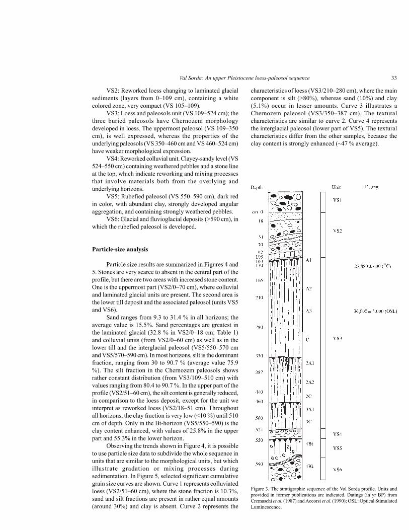
The starting point of the description was located atthe base of the till deposit covering the loess sequence, about3 m below the topographic surface. The upper part of thesequence was not described because of thick vegetationcover. The following units were recognized and describedfrom top to bottom (Figure 3):
VS1: Till, not described.
Figure 2. Geological section across the Garda moraines and Mt. Moscal. 1: bedrock; 2: till and fluvioglacial deposits (late middle Pleistocene); 3: loess(upper Pleistocene); 4: moraine ridges (late Pleistocene); 5: fluvial deposits (Holocene) (modified from Accorsi et al., 1990).
Val Sorda: An upper Pleistocene loess-paleosol sequence 33
VS2: Reworked loess changing to laminated glacialsediments (layers from 0–109 cm), containing a whitecolored zone, very compact (VS 105–109).
VS3: Loess and paleosols unit (VS 109–524 cm); thethree buried paleosols have Chernozem morphologydeveloped in loess. The uppermost paleosol (VS 109–350cm), is well expressed, whereas the properties of theunderlying paleosols (VS 350–460 cm and VS 460–524 cm)have weaker morphological expression.
VS4: Reworked colluvial unit. Clayey-sandy level (VS524–550 cm) containing weathered pebbles and a stone lineat the top, which indicate reworking and mixing processesthat involve materials both from the overlying andunderlying horizons.
VS5: Rubefied paleosol (VS 550–590 cm), dark redin color, with abundant clay, strongly developed angularaggregation, and containing strongly weathered pebbles.
VS6: Glacial and fluvioglacial deposits (>590 cm), inwhich the rubefied paleosol is developed.
Particle-size analysis
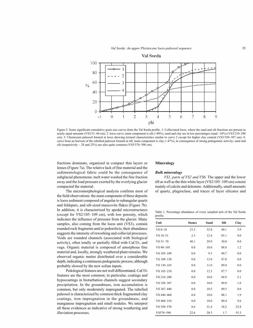
Particle size results are summarized in Figures 4 and5. Stones are very scarce to absent in the central part of theprofile, but there are two areas with increased stone content.One is the uppermost part (VS2/0–70 cm), where colluvialand laminated glacial units are present. The second area isthe lower till deposit and the associated paleosol (units VS5and VS6).
Sand ranges from 9.3 to 31.4 % in all horizons; theaverage value is 15.5%. Sand percentages are greatest inthe laminated glacial (32.8 % in VS2/0–18 cm; Table 1)and colluvial units (from VS2/0–60 cm) as well as in thelower till and the interglacial paleosol (VS5/550–570 cmand VS5/570–590 cm). In most horizons, silt is the dominantfraction, ranging from 30 to 90.7 % (average value 75.9%). The silt fraction in the Chernozem paleosols showsrather constant distribution (from VS3/109–510 cm) withvalues ranging from 80.4 to 90.7 %. In the upper part of theprofile (VS2/51–60 cm), the silt content is generally reduced,in comparison to the loess deposit, except for the unit weinterpret as reworked loess (VS2/18–51 cm). Throughoutall horizons, the clay fraction is very low (<10 %) until 510cm of depth. Only in the Bt-horizon (VS5/550–590) is theclay content enhanced, with values of 25.8% in the upperpart and 55.3% in the lower horizon.
Observing the trends shown in Figure 4, it is possibleto use particle size data to subdivide the whole sequence inunits that are similar to the morphological units, but whichillustrate gradation or mixing processes duringsedimentation. In Figure 5, selected significant cumulativegrain size curves are shown. Curve 1 represents colluviatedloess (VS2/51–60 cm), where the stone fraction is 10.3%,sand and silt fractions are present in rather equal amounts(around 30%) and clay is absent. Curve 2 represents the
characteristics of loess (VS3/210–280 cm), where the maincomponent is silt (>80%), whereas sand (10%) and clay(5.1%) occur in lesser amounts. Curve 3 illustrates aChernozem paleosol (VS3/350–387 cm). The texturalcharacteristics are similar to curve 2. Curve 4 representsthe interglacial paleosol (lower part of VS5). The texturalcharacteristics differ from the other samples, because theclay content is strongly enhanced (~47 % average).
Figure 3. The stratigraphic sequence of the Val Sorda profile. Units andprovided in former publications are indicated. Datings (in yr BP) fromCremaschi et al. (1987) and Accorsi et al. (1990); OSL: Optical StimulatedLuminescence.
Ferraro et al.34
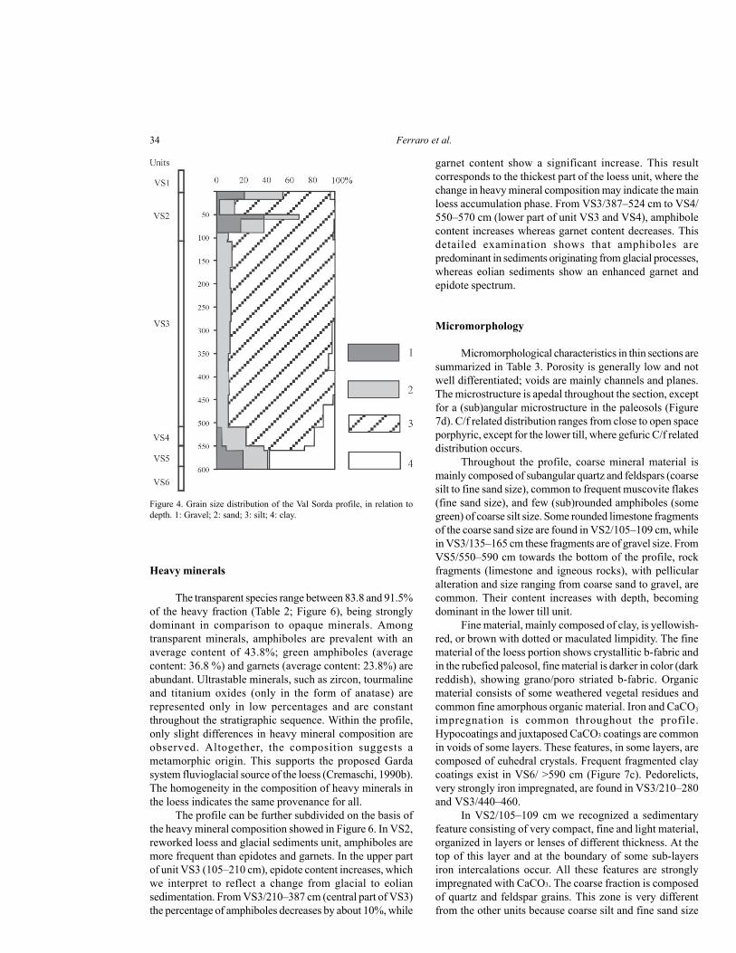
Heavy minerals
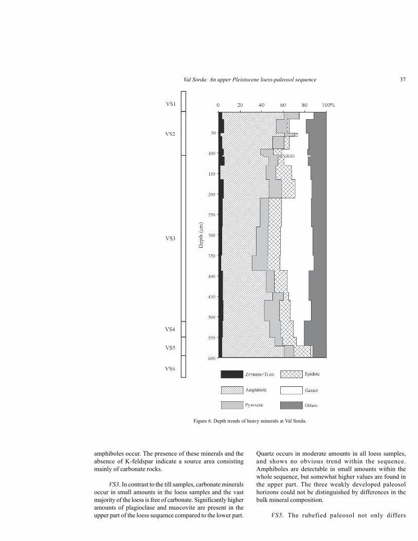
The transparent species range between 83.8 and 91.5%of the heavy fraction (Table 2; Figure 6), being stronglydominant in comparison to opaque minerals. Amongtransparent minerals, amphiboles are prevalent with anaverage content of 43.8%; green amphiboles (averagecontent: 36.8 %) and garnets (average content: 23.8%) areabundant. Ultrastable minerals, such as zircon, tourmalineand titanium oxides (only in the form of anatase) arerepresented only in low percentages and are constantthroughout the stratigraphic sequence. Within the profile,only slight differences in heavy mineral composition areobserved. Altogether, the composition suggests ametamorphic origin. This supports the proposed Gardasystem fluvioglacial source of the loess (Cremaschi, 1990b).The homogeneity in the composition of heavy minerals inthe loess indicates the same provenance for all.
The profile can be further subdivided on the basis ofthe heavy mineral composition showed in Figure 6. In VS2,reworked loess and glacial sediments unit, amphiboles aremore frequent than epidotes and garnets. In the upper partof unit VS3 (105–210 cm), epidote content increases, whichwe interpret to reflect a change from glacial to eoliansedimentation. From VS3/210–387 cm (central part of VS3)the percentage of amphiboles decreases by about 10%, while
garnet content show a significant increase. This resultcorresponds to the thickest part of the loess unit, where thechange in heavy mineral composition may indicate the mainloess accumulation phase. From VS3/387–524 cm to VS4/550–570 cm (lower part of unit VS3 and VS4), amphibolecontent increases whereas garnet content decreases. Thisdetailed examination shows that amphiboles arepredominant in sediments originating from glacial processes,whereas eolian sediments show an enhanced garnet andepidote spectrum.
Micromorphology
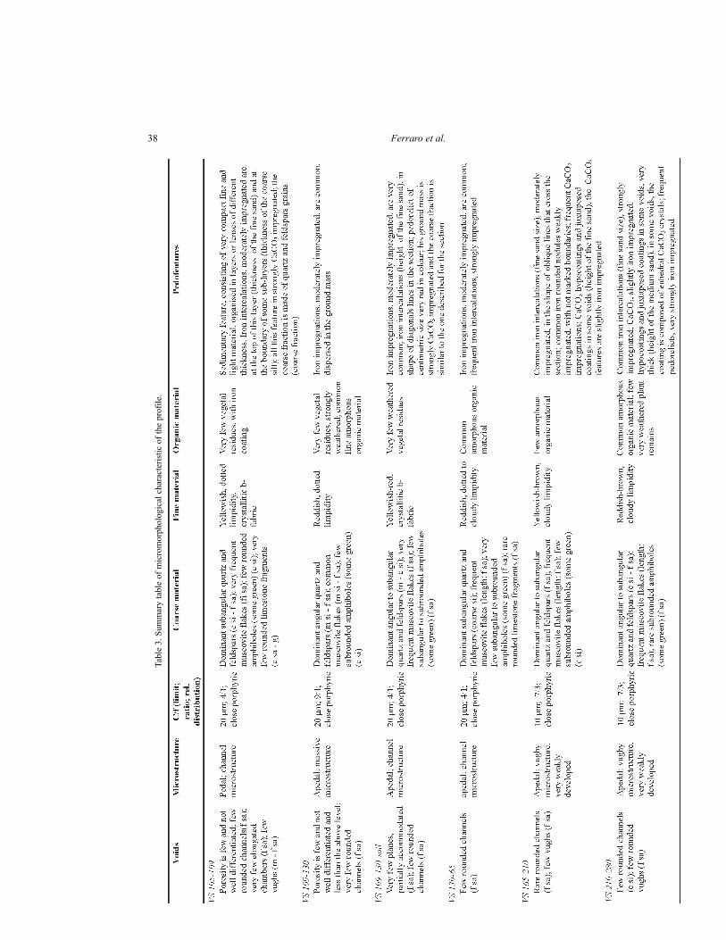
Micromorphological characteristics in thin sections aresummarized in Table 3. Porosity is generally low and notwell differentiated; voids are mainly channels and planes.The microstructure is apedal throughout the section, exceptfor a (sub)angular microstructure in the paleosols (Figure7d). C/f related distribution ranges from close to open spaceporphyric, except for the lower till, where gefuric C/f relateddistribution occurs.
Throughout the profile, coarse mineral material ismainly composed of subangular quartz and feldspars (coarsesilt to fine sand size), common to frequent muscovite flakes(fine sand size), and few (sub)rounded amphiboles (somegreen) of coarse silt size. Some rounded limestone fragmentsof the coarse sand size are found in VS2/105–109 cm, whilein VS3/135–165 cm these fragments are of gravel size. FromVS5/550–590 cm towards the bottom of the profile, rockfragments (limestone and igneous rocks), with pellicularalteration and size ranging from coarse sand to gravel, arecommon. Their content increases with depth, becomingdominant in the lower till unit.
Fine material, mainly composed of clay, is yellowish-red, or brown with dotted or maculated limpidity. The finematerial of the loess portion shows crystallitic b-fabric andin the rubefied paleosol, fine material is darker in color (darkreddish), showing grano/poro striated b-fabric. Organicmaterial consists of some weathered vegetal residues andcommon fine amorphous organic material. Iron and CaCO3
impregnation is common throughout the profile.Hypocoatings and juxtaposed CaCO3 coatings are commonin voids of some layers. These features, in some layers, arecomposed of euhedral crystals. Frequent fragmented claycoatings exist in VS6/ >590 cm (Figure 7c). Pedorelicts,very strongly iron impregnated, are found in VS3/210–280and VS3/440–460.
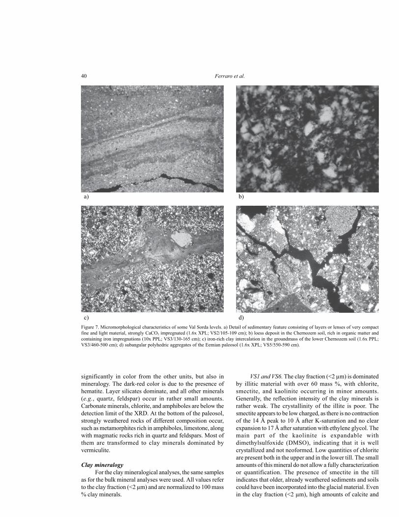
In VS2/105–109 cm we recognized a sedimentaryfeature consisting of very compact, fine and light material,organized in layers or lenses of different thickness. At thetop of this layer and at the boundary of some sub-layersiron intercalations occur. All these features are stronglyimpregnated with CaCO3. The coarse fraction is composedof quartz and feldspar grains. This zone is very differentfrom the other units because coarse silt and fine sand size
Figure 4. Grain size distribution of the Val Sorda profile, in relation todepth. 1: Gravel; 2: sand; 3: silt; 4: clay.
Val Sorda: An upper Pleistocene loess-paleosol sequence 35
Mineralogy
Bulk mineralogyVS1, parts of VS2 and VS6. The upper and the lower
till as well as the thin white layer (VS2/105–109 cm) consistmainly of calcite and dolomite. Additionally, small amountsof quartz, plagioclase, and traces of layer silicates and
fractions dominate, organized in compact thin layers orlenses (Figure 7a). The relative lack of fine material and thesedimentological fabric could be the consequence ofsubglacial phenomena: melt water washed the fine fractionaway and the load pressure exerted by the overlying glaciercompacted the material.
The micromorphological analysis confirms most ofthe field observations: the main component of these depositsis loess sediment composed of angular to subangular quartzand feldspars, and silt-sized muscovite flakes (Figure 7b).In addition, it is characterized by apedal microstructures(except for VS2/105–109 cm), with low porosity, whichindicates the influence of pressure from the glacier. Manysamples, also coming from the loess unit (VS3), containrounded rock fragments and/or pedorelicts; their abundancesuggests the intensity of reworking and colluvial processes.Voids are rounded channels (associated with biologicalactivity), often totally or partially filled with CaCO3, andvugs. Organic material is composed of amorphous finematerial and, locally, strongly weathered plant remains. Weobserved organic matter distributed over a considerabledepth, indicating a continuous pedogenetic process, althoughprobably slowed by the new eolian inputs.
Pedological features are not well differentiated. CaCO3
features are the most common; in particular, coatings andhypocoatings in bioturbation channels suggest secondaryprecipitation. In the groundmass, iron accumulation iscommon, but only moderately impregnated. The rubefiedpaleosol is characterized by common thick fragmented claycoatings, iron impregnation in the groundmass, andmanganese impregnation and small nodules. We interpretall these evidences as indicative of strong weathering andilluviation processes.
Table 1. Percentage abundance of every sampled unit of the Val Sordaprofile.
Unit Stones Sand Silt Clay
VS 0–18 23.2 32.8 40.1 3.9
VS 18–51 2.5 12.4 85.1 0.0
VS 51–70 40.1 29.9 30.0 0.0
VS 90–105 0.0 10.0 88.8 1.2
VS 105–109 0.0 9.3 90.7 0.0
VS 109–130 0.0 13.0 87.0 0.0
VS 130–165 0.0 11.0 89.0 0.0
VS 165–210 0.0 12.3 87.7 0.0
VS 210–280 0.0 10.0 84.9 5.1
VS 350–387 0.0 10.0 89.0 1.0
VS 387–440 0.0 10.5 89.5 0.0
VS 440–460 0.0 10.0 88.1 1.9
VS 460–510 0.0 10.0 80.4 9.6
VS 550–570 8.6 31.4 34.2 25.8
VS570–590 22.6 20.3 1.7 55.3
Figure 5. Some significant cumulative grain size curves from the Val Sorda profile. 1: Colluviated loess, where the sand and silt fractions are present innearly equal amounts (VS2/51–60 cm); 2: loess curve; main component is silt (>80%), sand and clay are in low percentages (sand ~10%) (VS3/210–280cm); 3: Chernozem paleosol formed in loess showing textural characteristics similar to curve 2 except for higher clay content (VS3/350–387 cm); 4:curve from an horizon of the rubefied paleosol formed in till; main component is clay (~47%), in consequence of strong pedogenetic activity; sand andsilt (respectively ~ 28 and 25%) are also quite common (VS5/570–590 cm).
Ferraro et al.36
Tabl
e 2.
Hea
vy m
iner
als a
ssem
blag
e of
the
prof
ile (e
xpre
ssed
in %
).
Val Sorda: An upper Pleistocene loess-paleosol sequence 37
amphiboles occur. The presence of these minerals and theabsence of K-feldspar indicate a source area consistingmainly of carbonate rocks.
VS3. In contrast to the till samples, carbonate mineralsoccur in small amounts in the loess samples and the vastmajority of the loess is free of carbonate. Significantly higheramounts of plagioclase and muscovite are present in theupper part of the loess sequence compared to the lower part.
Quartz occurs in moderate amounts in all loess samples,and shows no obvious trend within the sequence.Amphiboles are detectable in small amounts within thewhole sequence, but somewhat higher values are found inthe upper part. The three weakly developed paleosolhorizons could not be distinguished by differences in thebulk mineral composition.
VS5. The rubefied paleosol not only differs
Figure 6. Depth trends of heavy minerals at Val Sorda.
Ferraro et al.38
Tabl
e 3.
Sum
mar
y ta
ble
of m
icro
mor
phol
ogic
al c
hara
cter
istic
of t
he p
rofil
e.
Val Sorda: An upper Pleistocene loess-paleosol sequence 39
Tabl
e 3.
Con
tinue
d.
Ferraro et al.40
significantly in color from the other units, but also inmineralogy. The dark-red color is due to the presence ofhematite. Layer silicates dominate, and all other minerals(e.g., quartz, feldspar) occur in rather small amounts.Carbonate minerals, chlorite, and amphiboles are below thedetection limit of the XRD. At the bottom of the paleosol,strongly weathered rocks of different composition occur,such as metamorphites rich in amphiboles, limestone, alongwith magmatic rocks rich in quartz and feldspars. Most ofthem are transformed to clay minerals dominated byvermiculite.
Clay mineralogyFor the clay mineralogical analyses, the same samples
as for the bulk mineral analyses were used. All values referto the clay fraction (<2 µm) and are normalized to 100 mass% clay minerals.
VS1 and VS6. The clay fraction (<2 µm) is dominatedby illitic material with over 60 mass %, with chlorite,smectite, and kaolinite occurring in minor amounts.Generally, the reflection intensity of the clay minerals israther weak. The crystallinity of the illite is poor. Thesmectite appears to be low charged, as there is no contractionof the 14 Å peak to 10 Å after K-saturation and no clearexpansion to 17 Å after saturation with ethylene glycol. Themain part of the kaolinite is expandable withdimethylsulfoxide (DMSO), indicating that it is wellcrystallized and not neoformed. Low quantities of chloriteare present both in the upper and in the lower till. The smallamounts of this mineral do not allow a fully characterizationor quantification. The presence of smectite in the tillindicates that older, already weathered sediments and soilscould have been incorporated into the glacial material. Evenin the clay fraction (<2 µm), high amounts of calcite and
Figure 7. Micromorphological characteristics of some Val Sorda levels. a) Detail of sedimentary feature consisting of layers or lenses of very compactfine and light material, strongly CaCO3 impregnated (1.6x XPL; VS2/105-109 cm); b) loess deposit in the Chernozem soil, rich in organic matter andcontaining iron impregnations (10x PPL; VS3/130-165 cm); c) iron-rich clay intercalation in the groundmass of the lower Chernozem soil (1.6x PPL;VS3/460-500 cm); d) subangular polyhedric aggregates of the Eemian paleosol (1.6x XPL; VS5/550-590 cm).
a) b)
c) d)
Val Sorda: An upper Pleistocene loess-paleosol sequence 41
dolomite are present, reflecting the limestone that dominatesthe source area.
VS2. The clay mineral composition is very similar tothat of the till, i.e., more than 60 mass % illite and minoramounts of smectite, kaolinite, and chlorite. High amountsof carbonate minerals are present in the clay fraction as well.The similar clay mineral composition supports ourobservation regarding a common source for the reworkedunit and the overlying till.
VS3. Illite is present between 46 and 70 mass % andis the main clay mineral in all loess samples. Its crystallinityis quite high, indicating weak weathering influence (Figure8). Primary chlorite is of secondary importance, with 21 to37 mass %. Kaolinite is detectable in only very smallamounts (2–6 mass %), vermiculite (14Å) is detectable onlyin the uppermost and lowermost loess samples. All samplescontain a mixed layer mineral (6–13 mass %), most likelycomposed of illite and smectite. Smectite is not detectablein the loess samples. After heating to 550°C, the Mg-exchanged samples show a significant increase in peakintensities, indicating some recrystallization must haveoccurred. Except for the sporadic occurrence of vermiculite,the samples in the whole loess sequence are generallyhomogeneous. Clay minerals of the three paleosol horizonscannot be distinguished from the loess units they formed in,supporting our morphological interpretation of weakexpression and minimal pedogenesis.
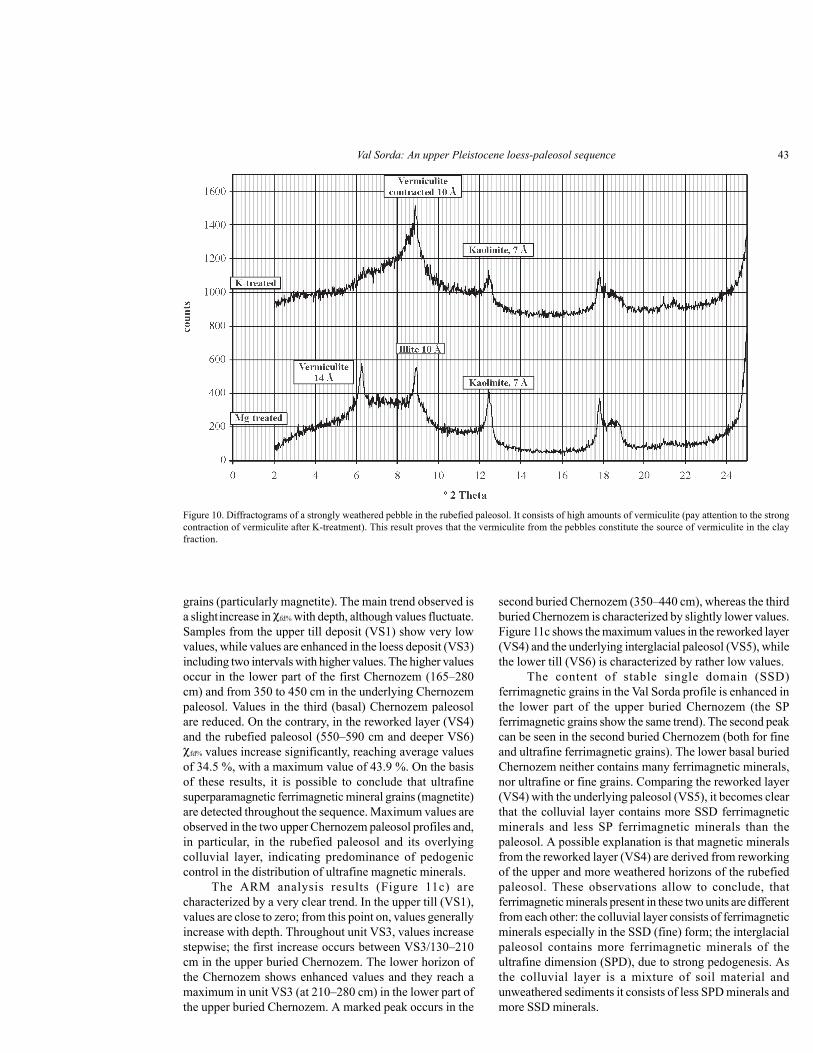
VS5. As in the bulk mineralogical composition, therubefied paleosol shows significant differences in the claymineralogical association compared to the other parts ofthe sequence. Primary chlorite is not detectable, which weinterpret as a result of weathering during the Eemianinterglacial. Illite is still predominant, with values between42 and 59 mass %, much less than in the loess sequence.Vermiculite (Figure 9) is present up to 48 mass %, and insome samples its content surpass that of illite. Compared tothe loess sequence, the chemically stable kaolinite can befound in significantly higher contents. It is poorlycrystallized, which means that the kaolinite ispedogenetically formed (Durn et al., 1999). The illite–smectite mixed-layer mineral can also be detected in tracesin the rubefied paleosol. Smectite is absent. Very stronglyweathered pebbles are abundant in the rubefied paleosol.They are mostly very soft and easily visible in the fine soilbecause of their different color. They are composed mostlyof vermiculite (Figure 10).
Below the rubefied paleosol and in the uppermost partof the till, there is a transitional horizon. This horizon hascharacteristics of both the above paleosol horizon and theunderlying till. It has the same clay mineralogicalcomposition as the till, but the clay fraction is free ofcarbonates, like in the paleosol.
The differences in the clay mineralogical compositionof loess and paleosols are evident when comparing the 060-reflections of the clay fractions. The samples from the loesssequence show two major peaks, one at d=1.535 Å and the
Figure 8. Diffractograms of the clay fraction of a loess sample after treatment with Mg2+ and K+. Reflections of illite, chlorite, and a mixed layer mineralare labeled.
Ferraro et al.42
other at d=1.50 Å. The 1.535 Å-peak represents trioctahedralclay minerals in the sample, with primary chlorite as themost important mineral of that group. The 1.50 Å-peakrepresents dioctahedral clay minerals, e.g. illite, kaoliniteand mixed-layer minerals. In the rubefied paleosol, only onereflection at 1.50 Å is observed, indicating that onlydioctahedral clay minerals are present. Therefore, theoccurring vermiculite in the paleosol must be dioctahedral.
Magnetic property analysis
The intensity of magnetic susceptibility (MS) of theVal Sorda sequence varies significantly with depth (Figure11a), with a main trend to increasing concentration offerrimagnetic minerals with depth. Throughout unit VS2,magnetic susceptibility values are low, gradually increasingwith depth, including into the upper portion of VS3. Thistrend suggests that the glacial sediments incorporated loessat the base. Beginning at 180 cm, the magnetic susceptibilityincreases in small steps. The first increase occurs in the upperpart of the buried Chernozem (VS3/130–210 cm). There isa second, stronger enhancement in unit VS3/210–280 cm,in the lower part of the upper buried Chernozem paleosol.This observation coincides with the occurrence of welldeveloped iron impregnation observed in thin section. Thethird increase corresponds to the second buried Chernozem(VS3/350–387 cm). From this point on, magneticsusceptibility shows similar values throughout the lower part
of unit VS3. In the basal (third) buried Chernozem (VS3/460–524 cm) only a weak increase is recognized. Weconsider the higher MS values in the paleosols correlatedwith the increase in the content of ultrafine ferrimagneticminerals produced in situ by weathering and bacterialactivity (Maher, 1998).
From a general point of view, the magneticsusceptibility of the whole loess unit VS3 is ratherhomogeneous, but enhanced in comparison to the magneticsusceptibility of the glacial sediments. The values in thecentral portion of the loess unit VS3 are slightly enhanced,maybe corresponding to the main loess accumulation phase.Buried Chernozem profiles show only a weak increased rateof concentration of ferromagnetic minerals, with respect tothe unweathered loess. This evidence indicates that themagnetic signal for this portion of the profile could beinterpreted as a sedimentation signal, more than as aweathering one.
A significant peak occurs in the reworked layer (VS4)and in the Bt-horizon of the interglacial paleosol (VS5). Inthe interglacial paleosol (VS5), the concentration offerromagnetic minerals is strongly enhanced as a responseto intense pedogenetic processes. First decreasing tendenciesbut also some strong variations and positive peaks occur inunit VS6, where the glacial and fluvioglacial deposits arepresent.
Frequency dependent susceptibility (χfd%) values(Figure 11b) can give more detailed information about theultrafine superparamagnetic (SP) ferrimagnetic mineral
Figure 9. Diffractograms of the clay fraction of the rubefied paleosol. The K+ treatment illustrates the contraction of vermiculite to 10 Å.
Val Sorda: An upper Pleistocene loess-paleosol sequence 43
grains (particularly magnetite). The main trend observed isa slight increase in χfd% with depth, although values fluctuate.Samples from the upper till deposit (VS1) show very lowvalues, while values are enhanced in the loess deposit (VS3)including two intervals with higher values. The higher valuesoccur in the lower part of the first Chernozem (165–280cm) and from 350 to 450 cm in the underlying Chernozempaleosol. Values in the third (basal) Chernozem paleosolare reduced. On the contrary, in the reworked layer (VS4)and the rubefied paleosol (550–590 cm and deeper VS6)χfd% values increase significantly, reaching average valuesof 34.5 %, with a maximum value of 43.9 %. On the basisof these results, it is possible to conclude that ultrafinesuperparamagnetic ferrimagnetic mineral grains (magnetite)are detected throughout the sequence. Maximum values areobserved in the two upper Chernozem paleosol profiles and,in particular, in the rubefied paleosol and its overlyingcolluvial layer, indicating predominance of pedogeniccontrol in the distribution of ultrafine magnetic minerals.
The ARM analysis results (Figure 11c) arecharacterized by a very clear trend. In the upper till (VS1),values are close to zero; from this point on, values generallyincrease with depth. Throughout unit VS3, values increasestepwise; the first increase occurs between VS3/130–210cm in the upper buried Chernozem. The lower horizon ofthe Chernozem shows enhanced values and they reach amaximum in unit VS3 (at 210–280 cm) in the lower part ofthe upper buried Chernozem. A marked peak occurs in the
second buried Chernozem (350–440 cm), whereas the thirdburied Chernozem is characterized by slightly lower values.Figure 11c shows the maximum values in the reworked layer(VS4) and the underlying interglacial paleosol (VS5), whilethe lower till (VS6) is characterized by rather low values.
The content of stable single domain (SSD)ferrimagnetic grains in the Val Sorda profile is enhanced inthe lower part of the upper buried Chernozem (the SPferrimagnetic grains show the same trend). The second peakcan be seen in the second buried Chernozem (both for fineand ultrafine ferrimagnetic grains). The lower basal buriedChernozem neither contains many ferrimagnetic minerals,nor ultrafine or fine grains. Comparing the reworked layer(VS4) with the underlying paleosol (VS5), it becomes clearthat the colluvial layer contains more SSD ferrimagneticminerals and less SP ferrimagnetic minerals than thepaleosol. A possible explanation is that magnetic mineralsfrom the reworked layer (VS4) are derived from reworkingof the upper and more weathered horizons of the rubefiedpaleosol. These observations allow to conclude, thatferrimagnetic minerals present in these two units are differentfrom each other: the colluvial layer consists of ferrimagneticminerals especially in the SSD (fine) form; the interglacialpaleosol contains more ferrimagnetic minerals of theultrafine dimension (SPD), due to strong pedogenesis. Asthe colluvial layer is a mixture of soil material andunweathered sediments it consists of less SPD minerals andmore SSD minerals.
Figure 10. Diffractograms of a strongly weathered pebble in the rubefied paleosol. It consists of high amounts of vermiculite (pay attention to the strongcontraction of vermiculite after K-treatment). This result proves that the vermiculite from the pebbles constitute the source of vermiculite in the clayfraction.
Ferraro et al.44
DISCUSSION
The Val Sorda sequence records severalsedimentological and pedological processes that reflectdifferent palaeoclimatic conditions during the upperPleistocene. The base of the sequence (VS6) is composedof a thick (more than 10 m) glacial and fluvioglacial deposit,cemented at its base. According to Venzo (1957), Mancini(1960), Cremaschi (1987b), and Accorsi et al. (1990), thisunit originated during the penultimate glacial event.
On the top of unit VS6, the rubefied paleosol ispreserved only as a Bt-horizon (VS5). The upper part hasbeen truncated, testifying to an erosional event. The claymineral spectrum is quite different from the underlying till,differing by the lack of smectite and the presence of adioctahedral vermiculite in large quantities. The dioctahedralnature of the vermiculite reflects stronger weatheringcompared to the loess sequence. It is generally acceptedthat trioctahedral minerals (containing Mg and Fe) are moresensitive to chemical weathering in contrast to the morestable dioctahedral minerals (containing Al). Transformationof smectite to vermiculite during pedogenesis is difficult toexplain. The strongly weathered soft pebbles, consisting ofvermiculite, could have influenced the whole clay mineralcomposition of the soil horizon, alternatively, vermiculiteclays could have been illuviated from upper horizons of thepaleosol that were subsequently eroded. The heavy mineralspectrum, with high amphibole content and traces of thismineral in the bulk sample, could be indicative of only
slightly wheatering of the soil horizon, and thus thevermiculite should be originated from the strongly weatheredpebbles from the till. Nevertheless, amphiboles are notdetectable in the clay fraction, carbonates are leached, andilluvial clay and high iron and manganese concentration arewell expressed in the paleosol, suggesting strong weathering.In addition, the enhancement of magnetic susceptibility isstriking, being more than two times higher than in interstadialpaleosols. The formation of this soil type requires aseasonally contrasted warm climate and humid periodsduring a long time span; these conditions only occur duringinterglacial periods. As the interglacial paleosol is occurringbetween sediments of the penultimate glacial stage and thelast glacial stage, it can be attributed to the Eemianinterglacial (isotopic substage 5e).
On the top of the Eemian paleosol, a reworked layerwas deposited (VS4), which shows characteristics of bothunderlying and overlying units. The unit VS4 is an admixtureof the underlying paleosol and the overlying loess, as isrecorded by the clayey-sandy texture, clay mineralogy, anda heavy mineral composition that is similar to the overlyingloess unit. Field and micromorphological evidence indicatethat soil material of the underlying paleosol is incorporatedin the layer VS4. In particular, the high magneticsusceptibility values reflect components of the underlyingrubefied paleosol (VS5).
The regular stone line at the top of the reworked layerconfirms that it has been transported by colluvial processes,which indicates a climatic degradation towards cold and wet
Figure 11. Magnetic susceptibility results from the Val Sorda profile. a) Mass specific magnetic susceptibility; b) frequency dependent susceptibility;and c) anhysteretic remanence magnetization.
a) c)b)
Val Sorda: An upper Pleistocene loess-paleosol sequence 45
conditions. As this layer is intercalated between the Eemianpaleosol (VS5) and the Middle Pleniglacial loess unit (VS3,age control discussed below), its age cannot be determinedexactly. For this period of transportation and accumulation,an Early Pleniglacial age as well as a Middle Pleniglacialage is possible.
Following the period of landscape instability andsediment reworking that created unit VS4, loessaccumulation dominated, resulting in unit VS3. Thelowermost loess layer contains pedorelicts and, locally, smallrounded rock fragments indicative of continued colluvialphenomena, which we consider related to more humidclimate episodes.
On the top of the reworked loess material, theformation of a Chernozem paleosol indicates a phase ofrelative climatic stability, which we relate to a continentalcold and dry environment (steppe climate), when loessdeposition was reduced relative to rates of pedogenesis.Following formation of the basal Chernozem, loessaccumulation continued, but was interrupted by two phasesof soil formation resulting in Chernozem-like paleosols.Therefore, we conclude that periods of loess depositionalternated with three stable phases of interstadialpedogenesis under steppe climate. We propose that the mainloess accumulation phase is recorded in VS3 between 180and 470 cm, as indicated by the maximum content of theheavy minerals epidote and garnet, the grain size dominatedby silt, and the high amounts of unweathered primary chloritein the clay fraction.
This pedological and paleoclimatic interpretation issupported by the palaeobotanical reconstruction proposedby Accorsi et al. (1990) for the Val Sorda sequence. Pollenanalysis of the Chernozem horizons reflects a steppeenvironment, with Graminae and Cichoriaceae speciesdominant throughout the sequence. Arboreal pollen is scarce,but some Pinus and Betula occur. These vegetal associationssuggest a dry and cold climate, with some warming evidentby the appearance of Quercus. The palaeobotanicalreconstruction of Val Sorda fits with the reconstruction ofthe whole Venetian Pre-Alps area proposed by Cattani(1990), who suggested an arid steppe that changed to steppegrassland during periods with a slight increase in temperatureand humidity during the Pleniglacial.
The first (uppermost) Chernozem displays thestrongest morphological expression of the three interstadialpaleosols in the sequence; this observation is supported bycharacteristics such as color and magnetic properties. Aradiocarbon age of 27,880 ± 600 years BP (Cremaschi etal., 1987) places the soil formation during a late phase ofthe Middle Pleniglacial (isotopic stage 3), which maycorrespond to the Denekamp–Interstadial north of the Alps(Behre and van der Plicht, 1992). The underlying loess layerprovided an OSL age of 36,000 ± 5,000 years BP (Accorsiet al., 1990). We interpret the second and third Chernozemprofiles to most probably represent the two older MiddlePleniglacial interstadials or even Early Pleniglacial
interstadials. Better age control is necessary, however.On the top of the uppermost Chernozem paleosol, the
deposition of laminated layers (VS2) suggests rapid andabrupt changes and, perhaps, faster deposition rates, linkedto the approach of the ice sheet. The white finely laminatedlayer (VS2/105–109 cm) is very compact, inclinedapproximately to the eastern direction of the section, andshows field and microscopic evidence of high pressure anddeformation. Thus, we attribute its formation to reworkingof the top of the loess sequence by the overthrusting glacierand deposition by melt waters of the glacier. The reworkedloess is covered by fluvioglacial sediments originating fromthe readvancing glacial front. These sediments were buriedby the youngest till of the study area, which is referred to asthe Solferino stage of the Upper Pleniglacial (isotope stage2) (Cremaschi, 1987b).
The upper Pleistocene Val Sorda section is in partcomparable to sequences north of the Alps. As in severalloess-paleosol sequences in middle Europe, the Eemianpaleosol is strongly developed as an intensively rubefiedBt-horizon and its upper horizons have been truncated (cf.Semmel, 1968; Ricken, 1983; Bibus, 1989; Bibus, 1996;Terhorst et al., 2001). Even though the age of the redepositedmaterial on top of the interglacial Bt-horizon is unknown, itis similar to other loess profiles. In Austria, a colluvial layerin a similar stratigraphic position comprises a time span fromthe Early to late Middle Pleniglacial (Terhorst et al., 2002).Only the upper part of VS3, corresponding to the uppermostChernozem and its parent material, can be reliably correlatedwith Middle European loess sequences because of the twonumerical ages. Based on the sedimentation age (OSL) of36,000 ± 5,000 years BP (Accorsi et al., 1990) and the ageof the soil formation at about 27,880 ± 600 years BP(Cremaschi et al., 1987), we correlate the uppermostChernozem with the Denekamp–Interstadial. In areas northof the Alps, such as in the Alpine foreland or the Rhine–Main area, this interstadial period is recorded by a weaklyexpressed brown soil (the Lohner Soil) interpreted to haveformed in a cold arctic climate. The difference inmorphological expression between the Val SordaChernozem and the Lohner Soil allows us to propose thatthe climatic gradient between areas north and south of theAlps must have been greater than present.
CONCLUSIONS
The Eemian paleosol at Val Sorda shows evidence ofcarbonate leaching, clay illuviation, and other interglacialscale pedogenic processes representative of a warm andseasonal climate. In contrast, in the three Chernozem profilesformed in isotope stage 3, loess express weak pedogenicorganization, namely bioturbation and recalcificationfeatures, along with no evidence of mineral weathering,which we interpret as interstadial pedogenesis under a steppeclimate. The interpretation proposed here agrees with recent
Ferraro et al.46
works on the Val Sorda sequence (Cremaschi, 1987b;Accorsi et al., 1990), although in this work we recognizethe three buried Chernozem paleosols in the main loessunit. We correlate the upper most Chernozem with theLohner Soil that occurs north of the Alps.
Loess is generally characterized by enhanced valuesof magnetic susceptibility, while glacial sediments showreduced values. Interstadial paleosols are poorlydiscriminated from loess by magnetic susceptibility, whereasthe Eemian paleosol shows a significant peak, presumablycorrelated to the in situ formation of ultrafine magneticminerals (Maher, 1998). Despite this, ultrafinesuperparamagnetic ferrimagnetic mineral grains (magnetite)are present with maximum values in the two upperChernozem paleosols and in particular in the rubefiedpaleosol and its overlying colluvial layer. For this reason(Dearing et al., 1997; Maher, 1998), the conclusion is thatthe presence of ultrafine (SP) minerals is due to pedogenicprocesses, and that they give a more sensible parameter forinterstadial soil formation in the study area than magneticsusceptibility can provide (Kukla et al., 1988).
Overall, the Val Sorda sequence preserves a verycomplex palaeoenvironmental record of landscape evolutionduring the upper Pleistocene in northern Italy. Further agecontrol is necessary to fully understand the chronology ofsedimentation and soil formation, in addition to correlationwith other European loess sequences.
ACKNOWLEDGMENTS
We wish to thank prof. E. Appel and his staff formagnetic measurements and for their help, and prof. E. Bibusfor fruitful discussions. We are grateful for financial supportprovided by the German Research Foundation (DFG, SFB275, TP C1).
REFERENCES
Accorsi, C.A., Baroni, C., Cremaschi, M., Filippi, N., Maggi, V., Magnani,P., Nisbet, R., 1990, The loess in Appenine Fringe, in Cremaschi,M. (ed.), The Loess in Northern and Central Italy; a Loess BasinBetween the Alps and the Mediterranean Region: Milano,Quaderni di Geodinamica Alpina e Quaternaria, 1, 73–101.
Behre, K.E., van der Plicht, J., 1992, Towards an absolute chronology forthe glacial period in Europe; radiocarbon dates from Oerel,northern Germany: Vegetation History and Archaeobotany, 1,111–117.
Bibus, E. (ed.), 1989, Paläoböden im mittleren Neckarbecken unterbesonderer Berücksichtigung von Lößstratigraphie undPaläoböden, Exkursionsführer, 8. Tagung des Arbeitskreises“Paläoböden” der Deutschen Bodenkundlichen Gesellschaft:Heilbronn, 31 p.
Bibus, E., 1996, Äolische Deckschichten, Paläoböden und Mindestalterder Terrassen in der Iller-Lech-Platte: Geologica Bavarica, 99,135–164.
Bullock, P., Fedoroff, N., Jongerius, A., Stoops, G., Tursina, T., Babel,C., 1985, Handbook for Soil Thin Section Description:Albrighton, Waine Research Publication, 152 p.
Brindley, G.W., Brown, G., 1980, Crystal Structures of Clay Mineralsand their X-Ray Identification: London, Mineralogical Society,495 p.
Cattani, L, 1990, Steppe environments at the margin of the Venetian Pre-Alps during the Pleniglacial and Late-Galcial periods, inCremaschi, M. (ed.), The Loess in Northern and Central Italy; aLoess Basin between the Alps and the Mediterranean Region:Quaderni di Geodinamica Alpina e Quaternaria, 1, 133–137.
Chiesa, S., Coltorti, M., Cremaschi, M., Ferraris, M., Floris, B., Prosperi,L., 1990, Loess sedimentation and quaternary deposits in theMarche Province, in Cremaschi, M. (ed.), The Loess in Northernand Central Italy; a Loess Basin between the Alps and theMediterranean Region: Quaderni di Geodinamica Alpina eQuaternaria, 1, 103–130.
Cremaschi, M., 1987a, Loess deposits of the Plain of the Po and of theadjoining Adriatic basin (Northern Italy), in Pécsi, M., French,H.M. (eds.), Loess and Periglacial Phenomena: Budapest,Akadémiai Kiadò, 125–140.
Cremaschi, M., 1987b, Paleosols and Vetusols in the Central Po Plain(Northern Italy); A study in Quaternary Geology and Soildevelopment: Milano, Unicopli, 316 p.
Cremaschi, M. (ed.), 1990a, The Loess in Northern and Central Italy; aLoess Basin between the Alps and the Mediterranean Region:Quaderni di Geodinamica Alpina e Quaternaria, 1, 187 p.
Cremaschi, M., 1990b, Sedimentazione loessica nel Bacino Padano-Adriatico durante il Pleistocene Superiore: Memorie della SocietàGeologica Italiana, 45, 843–856.
Cremaschi, M., Alessio, M., Allegri, L., Azzi, C., Calderoni, G., Cortesi,C., Petrone, V., Spezzi-Bottiani, C., 1987, Una dataradiocarbonica del paleosuolo su loess incluso nella successionestratigrafica della Val Sorda (sistema morenico del Garda):Rendiconti della Società Geologica Italiana, 10, 29–32.
Dearing, J.A., Bird, P.M., Dann, R.J.L., Benjamin, S.F., 1997, Secondaryferrimagnetic minerals in Welsh soils: a comparison of mineralmagnetic detection methods and implications for mineralformation: Geophysical Journal International, 130, 727–736.
Durn, G., Ottner, F., Slovenec, D., 1999, Clay minerals as an indicator ofpolygenetic origin of Terra Rossa in Istria, Croatia: Geoderma,91 (1-2), 125–150.
Fraenzle, O., 1965, Die Pleistozäne Klima und Landschaftsentwicklungder nördlichen Po-Ebene im Lichte bodengeographischerUntersuchungen: Akademie der Wissenschaften und derLiteratur in Mainz, Abhandlungen der Mathematisch-Naturwissenschaftliche Klasse 8, 336–456.
Gale, S.J., Hoare, P.G., 1991, Quaternary Sediments: New York, BelhavenPress, 323p.
Hodgson, J.M. (ed.), 1976, Soil Survey Field Handbook; Describing andSampling Soil Profiles: Harpenden, Soil Survey of England andWales, Soil Survey Technical Monograph, 5, 99 p.
Kukla, G., Heller, F., Liu, X.M., Xu, T.C., Liu, T.S., An, Z.S., 1988,Pleistocene climates in China dated by magnetic susceptibility:Geology, 16, 811–814.
Maher, B., 1998, Magnetic properties of modern soils and Quaternaryloessic paloesols: paleoclimatic implications: Palaeogeography,Palaeoclimatology, Palaeoecology, 137, 25–54.
Mancini, F., 1960, Osservazione sui loess e sui paleosuoli dell’Anfiteatroorientale del Garda e di quello di Rivoli Veronese: Atti dellaSocietà Italiana Scienze Naturali, 99, 221–250.
Mange, M.A., Maurer, H.F.W., 1992, Heavy Minerals in Colour: London,Chapman & Hall, 147 p.
Moore, D.M., Reynolds, R. C. Jr., 1997, X-Ray Diffraction and theIdentification and Analysis of Clay Minerals: New York, OxfordUniversity Press, 378 p.
Nicolis, E., 1899, Triplice estensione glaciale ad Oriente del Lago di Garda:Atti del Regio Istituto Veneto di Scienze, Lettere ed Arti, 58 (2),316–319.
Parfenoff, A., Pomerol, C., Tourenq, J., 1970, Les minéraux en grains:Paris, Masson et C.ie Editeurs, 578+21 p.
Ricken, W., 1983, Mittel- und jungpleistozäne Lößdecken imsüdwestlichen Harzvorland; Stratigraphie, Paläopedologie und
Val Sorda: An upper Pleistocene loess-paleosol sequence 47
Konnektierung in Flußterrassen: Catena, 3, 95–138.Semmel, A., 1968, Studien über den Verlauf jungpleistozäner Formung
in Hessen: Frankfurter Geographische Hefte, 45, 1–133.Stoops, G., 1998, Key to the ISSS “Handbook for Soil Thin Section
Palaeopedological and Clay Mineralogical Characteristics:Quaternary International, 106/107, 215–231
Terhorst, B., Appel, E., Werner, A., 2001, Results of paleopedologicaland magnetic susceptibility analyses in a loess exposure in SW-Germany: Quaternary International, 76/77, 231–240.
Terhorst, B., Frechen, M., Reitner, J., 2002, ChronostratigraphischeErgebnisse aus Lößprofilen der Inn- und Traun-Hochterrassenin Oberösterreich: Zeitschrift für Geomorphologie, Neue Folge,Supplementbände, 127, 213–232.
Venzo, S., 1957, Rilevamento geologico dell’anfiteatro morenico frontaledel Lago di Garda. Parte I: Tratto occidentale Gardone-Desenzano: Memorie della Società Italiana Scienze Naturali, 2(2), 73–140.
Venzo, S., 1961, Rilevamento geologico dell’anfiteatro morenico delGarda. Parte II: Tratto orientale Garda-Adige ed anfiteatro atesinodi Rivoli Veronese: Memorie della Società Italiana ScienzeNaturali, 14 (1), 82 p.
Walden, J., Olfield, F., Smith, J.P., 1999, Environmental Magnetism: apractical guide: London, Quaternary Research Association,Technical Guide No. 6, 250 p.
Manuscript received: July 3, 2002Corrected manuscript received: February 21, 2003Manuscript accepted: June 29, 2003