Follow this and additional works at: https://scholarworks.uni.edu/pias
Recommended Citation Recommended Citation Frest, Terrence J. and Dickson, Jeffrey R. (1986) "Land Snails (Pleistocene-Recent) of the Loess Hills: A Preliminary Survey," Proceedings of the Iowa Academy of Science, 93(3), 130-157. Available at: https://scholarworks.uni.edu/pias/vol93/iss3/7
This Research is brought to you for free and open access by the Iowa Academy of Science at UNI ScholarWorks. It has been accepted for inclusion in Proceedings of the Iowa Academy of Science by an authorized editor of UNI ScholarWorks. For more information, please contact [email protected].
Land Snails (Pleistocene-Recent) of the Loess Hills: A Preliminary Survey
TERRENCE J. FREST 1 and JEFFREY R. DICKSON2
The Loess Hills and Missouri Alluvial Plain landform regions of western Iowa were surveyed for molluscs in July and August, 1982. We focused on the modern fauna and that of the late Woodfordian (Wisconsinan) Peoria Loess, but a few localities with older and younger Pleistocene and Holocene faunas were also collected. Systematic bulk samples were taken at 95 localities: fauna! lists for 7 5 are included herein. The modern land snail fauna comprises 40 species, most of which are small, drought-resistant cosmopolitan or Interior Province forms. One, or possibly two, Rocky Mountain forms survive as relicts. The modern fauna is depauperate in comparison to that of eastern Iowa. No definite endemic taxa were noted, but several succineid taxa require further study. The Peoria Loess fauna is more diverse and heterogeneous than the extant in its affinities. The total (47 species) includes major Interior Rocky Mountain, Northern, and Midwest Biome components as well as widespread taxa. The Interior element has many more deciduous forest taxa than currently survive. The poorly-known Holocene fauna (34 species) comprises mostly cosmopolitan and Interior taxa, with a few Rocky Mountain or extinct holdovers. In the Loess Hills region, diversity increases pronouncedly from north to south for both Peoria Loess and modern faunas. No clear trend is evident for the Missouri Alluvial Plain. Peoria Loess faunas are most diverse within a mile of the west bluff edge: diversity declines rapidly at more interior easterly sites. INDEX DESCRIPTORS: Land snails, Gastropoda, Loess Hills, Missouri Alluvial Plain, Pleistocene, Holocene, recent, Iowa.
The Loess Hills region (Western Loess Hills landform region of Prior, 1976) of western Iowa constitutes one of the United States' most unusual terrains, perhaps exceeded in extent only by the physiographically similar area along the Yellow River in China. The loess, forming prominent ridges and valleys developed in unconsolidated Late Wisconsinan wind-blown (aeolian) silts, is assigned to two geologic formations, the Loveland Loess and (preeminently) the Peoria Loess. This latter unit forms the major soil bluffs along the Missouri, middle and lower Mississippi, Illinois, lower Ohio, and Wabash Rivers in Iowa, Nebraska, Kansas, Missouri, Illinois, Indiana, Ohio, Kentucky, Tennessee, Arkansas, and Louisiana. The Peoria Loess reaches thicknesses of 200 feet (6 lm) in western Iowa, as compared to 90 feet (27m) in the Illinois type area.
In the Loess Hills of western Iowa, the Peoria Loess outcrops extensively in a band averaging 10 miles (16 km) wide and about 160 miles (257 km) long, roughly paralleling the Missouri River immediately east of the Missouri Alluvial Plain (Prior, 1976; Fig. 1 herein). The loess dominates significant portions of the surficial landscape in Woodbury, Monona, Harrison, Pottawattamie, Mills, and Fremont Counties. Western Plymouth County is thinly loess-mantled, but its surface topography is controlled as much or more by Cretaceous bedrock. The loess bluffs thin rapidly away from their western periphery. In the same area, the bluffs are underlain by unconsolidated units including Lower to Upper Pleistocene alluvial fills ranging in coarseness from muds to gravels, plus lesser amounts of tills, lake and pond and fluvial deposits and volcanic ash; and by Pennsylvanian or Cretaceous bedrock. Succeeding the Peoria are widespread episodic Holocene deposits, mostly alluvial silts and clays. The pre-Pleistocene bedrock is locally extensively faulted, and younger (Pleistocene) faults occasionally affect unconsolidated materials; but generally modern surface topography is determined strictly by erosional and depositional, not structural, processes.
Much of the present landscape is comparatively youthful, a result of Holocene and modern downcutting of dominantly Late Pleistocene unconsolidated sediments. While a considerable amount of early Pleistocene and even Pliocene material is present, this is rarely seen at the surface. Most of it was deposited in the valleys and channels in the pre-Pleistocene bedrock surface, and was buried by aeolian silts and alluvial fills. An exception is the 700,000 YBP Hartford volcanic ash
1Division of Geology and Paleontology, Burke Museum, University of Washington, Seattle, Washington 98195
2 1215 Ashley Street, Iowa City, Iowa 52240
and associated water-lain silts, a member of the so-called Pearlette Ash complex (Boellerstorff, 1973) derived from Plio-Pleistocene volcanic activity in the Rockies and more extensively exposed in Nebraska, Kansas, and adjacent states to the west. Outcrops of one member, the Hartford Ash, occur rarely in the Loess Hills in Iowa (Izett and Wilcox, 1982). The best currently accessible is probably that in the county line gravel pit just south of the Harrison-Monona county line (Locality 38; see also Leonard, 1950; Paulson and Miller, 1983). Other early to middle Pleistocene units are exposed in quarries (e.g. Locality 48; Kaser quarry) which frequently have excellent Peoria Loess and late Wisconsinan to pre-Wisconsinan tills; and in gravel pits at the base of the bluffs (e.g. Locality 20, the Turin gravel pit) which sometimes contain diverse so-called "Aftonian" (Calvin, 1911) vertebrate faunas, as well as occasional Pliocene and Cretaceous fossils.
Most Pleistocene exposures in the Loess Hills are Peoria (Late Wisconsinan ofRuhe, 1983, in part) Loess, particularly within one to two miles of the Missouri River floodplain. In Iowa (Ruhe, 1969, 1983), it seems likely that the bulk of the unit was deposited in the period 28,000 - 14,000 YBP (Wisconsinan; Woodfordian). The loess just above the basal loess paleosol, generally dated at between 28,000-22, 000 YBP, is most frequently fossiliferous. Loess faunas described herein are nearly all basal faunas, i.e., collected just above the basal loess paleosol from Woodfordian sites without interloess tills (youngest and topmost loess unit). Such sites were preferentially searched for in order to provide the best available time line for regional biogeographic comparisons. In the deeper gullies, and often appearing immediately beneath the Peoria Loess, are scattered alluvial cut and fill deposits of early to late Wisconsinan age. In such sites younger (Holocene) alluvial terraces and fills also outcrop, in many places cut into Peorian Loess, especially adjacent to narrower, actively eroding streams. Ages of these deposits vary but collectively probably span the period from about 30,000 YBP to the present. Vertebrate faunas and paleoecologic implications of some of these units are currently under study by R.S. Rhodes, University of Iowa (Rhodes and Semken, 1976, Rhodes, 1984 and in prep.). For detailed discussion of geology and Pleistocene history of the region see papers by Bettis et al. and by Rhodes and Semken, this volume.
SCOPE AND PURPOSE
As part of general survey of the biota of the Loess Hills, the land snail fauna of the region was briefly surveyed in July and August of 1982. The approach of this study differs somewhat from that used for other groups in that it was thought useful to survey the fossil (i.e.
1
Frest and Dickson: Land Snails (Pleistocene-Recent) of the Loess Hills: A Preliminar
Published by UNI ScholarWorks, 1986
LAND SNAILS OF THE LOESS HILLS
Pleistocene) land snail fauna as well as the modern. There are several reasons for this approach. First and foremost, the name of the region derives from a geologic unit that is characteristically fossiliferous, and the primary fossils are gastropods, mostly terrestrial. Second, historically the ecological interpretation and depositional environment of the Peoria Loess hinged on the nature of the snail fauna, rather than physical characteristics (Shimek, 1930, 1931; Leonard and Frye, 1954). Third, from a paleontological point of view, this unit is perhaps the single best known Pleistocene deposit anywhere in the world, and most readily subject to biogeographic analysis. Major studies of the Peoria Loess and its time equivalents have been conducted in Nebraska, Missouri, Indiana, and Illinois (for references see Frest and Rhodes, 1981). Fourth, among the earliest Peorian sites to be studied were some in Iowa, including the Loess Hills; most particularly worth mentioning are the classical works of Shimek (1888, 1890, 1894, 1903, 1910) and Cameron (1940). Finally, the available literature shows that the fossil fauna was more diverse than the modern, and knowledge of it is useful in finding relict species.
Although the area is classic, few new sites had been reported from the Peoria Loess in the Loess Hills since 1940 (Ruhe, 1969 is an exception); taxonomic concepts have changed radically since that "time. Moreover, essentially all late Pleistocene-Holocene waterlain or aeolian units in the area contain molluscan fossils. We found fossil mollusc faunas much more common than either vertebrates or plants, even though diverse floras or nonmolluscan faunas also are common in the Loess Hills (Rhodes and Semken, 1976; Rhodes, 1984). Accordingly, while fossil faunas were collected primarily from the Peoria Loess, other units were surveyed as well, including the Holocene where possible.
Curiously, more information is available in the generally accessible literature on fossil mollusc faunas of the Loess Hills than the modern. References for the former in Iowa include Leonard, 1950 and Paulson and Miller, 1983 (Hartford Ash); Cameron, 1940; Shimek, 1888, 1890, 1898, 1903, 1910, 1915, 1930, and 1931 (Peoria Loess). The only major references to the current Loess Hills fauna of which we are aware are those of Shimek (1890, 1894, 1903, 1910, and 1915). During his tenure at the University of Iowa, Shimek made extensive collections of both fossil and modern mollusca in eastern Iowa and in the Loess Hills. Most of his collections are now in the National Museum of Natural History, but some lots are in the Museum of Natural History and in the Repository, Department of Geology, both at the U niversiry of Iowa. The relative scarcity of recent work on the Loess Hills land snail fauna is typical of the state as a whole. In his recent synthesis of land snail distributions in eastern North America, Hubricht (1985) listed Iowa, along with Wisconsin, Minnesota, and the Dakotas, as the areas most in need of detailed collection. Because of the paucity of data on the modern fauna, only a general survey could be attempted in the available time. Specialized or unusual environments were sampled only when encountered casually, rather than specifically looked for. Thus, the results provide an idea of minimum molluscan diversity only. Rare species may have been overlooked. A more complete survey of Peoria Loess molluscan biogeography and faunas is currently underway (Frest, in prep.). Material collected in the course of this study will be reposited in the Burke Museum (University of Washington) geological and paleontological collections.
Fig. 1. Map of westernmost tier of Iowa counties showing extent of Loess Hills and Missouri Alluvial Plain landform regions. Numbers refer to localities and faunal lists detailed in Appendices 1 and 2. Key: Open squares- live collections on floodplains; solid squares-stream drift and flood debris sites; open circles- pre-Woodfordian-Holocene and fossil (of uncertain age) sites; solid circles - Peoria Loess (fossil) and upland (modern) localities. Size of symbols irrelevant.
Y 0 N
s 0 u x
M 0 U T H
f;_{] LOESS HILLS
131
TTAMIE
2
Proceedings of the Iowa Academy of Science, Vol. 93 [1986], No. 3, Art. 7
https://scholarworks.uni.edu/pias/vol93/iss3/7
132 PROC. IOWA ACAD. SCI. 93(1986)
COLLECTING LOCALITIES AND METHODS
About 95 localities were collected in detail. Fauna! lists and locations for 75 of these are included here (Appendices). With one exception (Shimek's reported Vallonia gracilicosta site) only these sites are plotted on the species distribution maps. Brief stops were made in each of the 90 7 Yi' topographic quadrangles covering the Loess Hills. Many of these proved unsuitable for various reasons, so that collecting sites were established on rather fewer. Different collecting strategies were necessary for the two main foci of the survey, the Peoria Loess and the present land snail fauna.
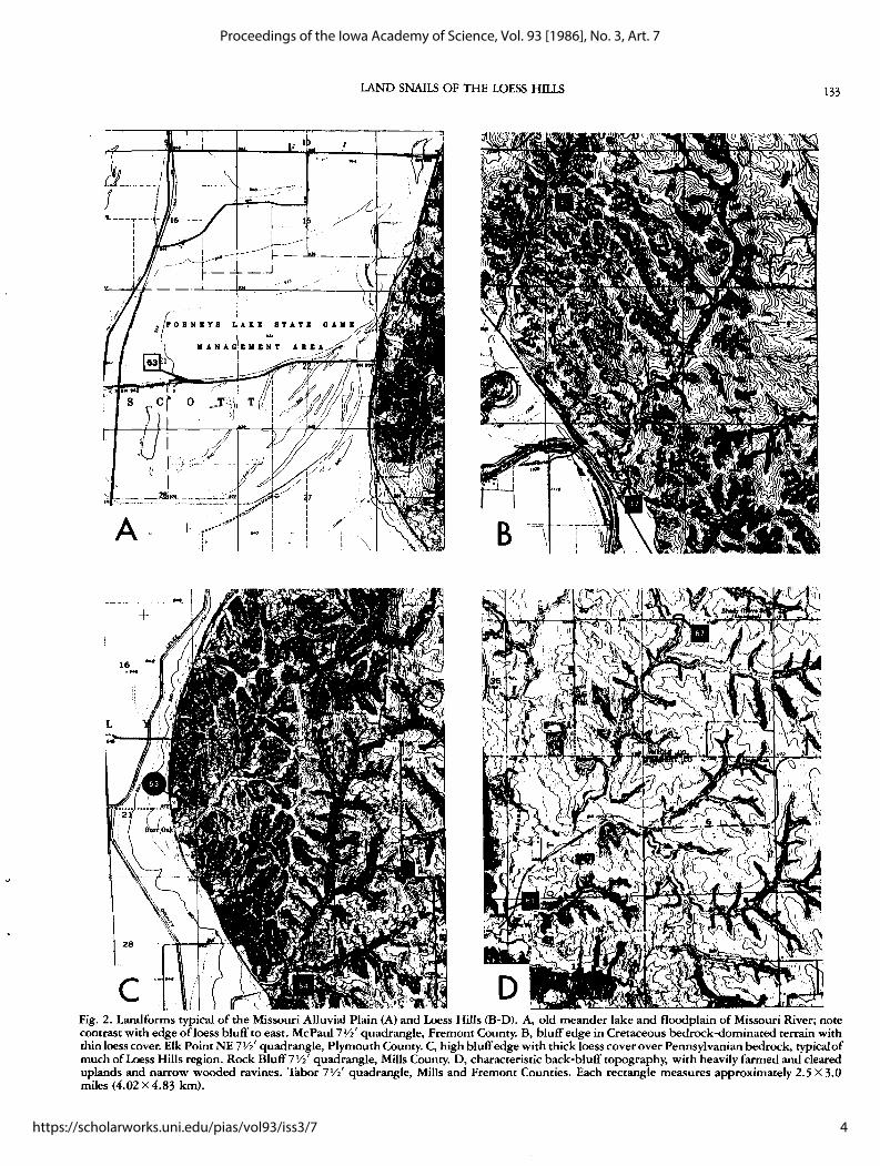
To cover the Peoria Loess, a sweep was first made along the main bluff line from Sioux City south to Hamburg (e.g., Figure 2C). An attempt was made to space sampling areas as closely as possible to 10 miles ( 16 km) apart.
A second pass was made 5-10 miles (8-16 km) directly east of the first line of sites. Finally, a third pass was designed to fill in gaps in the earlier passes. We had little difficulty finding fossiliferous localities, most often in roadcuts along paved and unpaved county and secondary roads along the bluff line, where the loess is the thickest. However, back-bluff localities (e.g., Figure 2D) with good faunas were much more difficult to find. About 24 bluff edge and 15 back-bluff sites were collected. Generally, the clearly Woodfordian fossil fauna commonly found near the base of each cut was the focus of interest. However, probable Holocene faunas encountered in loess-derived soil within a few feet of the modern vegetation line were also collected when present. Additionally, at each loess cut the modern fauna also was sampled. Though these faunas are low in diversity and abundance, they probably are typical of the present xeric upland conditions prevalent over much of the Loess Hills region.
Other Pleistocene sites were encountered sporadically and collected. These include one Hartford Ash site (Locality 30), several terrace sites along north and west-flowing permanent creeks and a number of alluvial fills beneath the Peoria Loess along small creeks and gullies either near (Figure 2C) or some distance east (Figure 2D) of the bluff line. Three of these (Localities 73-75) were bulk sampled and processed by R.S. Rhodes, (University of Iowa). More detailed analyses of these sites are in preparation by Rhodes and the senior author. Generally, it was not practical to sample the modern fauna at such sites.
Other localities (about half of the total) were selected to provide a general overview of the modern fauna in more protected situations. This was done via a sweep from the Cretaceous outcrop area in Plymouth County to the Missouri border, again following the bluff line. To obtain maximum diversity, small but steep and densely forested gullies with intermittent flowage were targeted (e.g. Figure 2A & C). Flood debris from late summer thunderstorms in such situations contains both bottomland and forest snails in huge numbers. By limiting sites to small drainages, we hoped to locate relict or rare species without detailed sampling. It was seldom possible to obtain live collections. Above-ground snail density was often quite low, and few live snails were seen unless conditions were ideal. Litter collections (the technique of choice in most forest situations) were not often practical due to the thinness of litter cover. Yields from those made early on were so low that the technique was abandoned at most sites. About 14 localities did have requisite conditions for litter sampling. In the more open and heavily farmed terrain east of the bluff edge, occasional modern collections were made along major rivers (e.g. the Nishnabotna) and major creeks (e.g. Localities 1, 7, and 33; Figure 2D). One other category of modern sites deserves special mention. Live collections were most practical in marshes and along the edges of lakes (mostly meander cutoffs) situated near the major rivers. This relatively moist and open habitat is not common in the Loess Hills proper, but is especially prevalent in the Missouri Alluvial Plain landform region immediately to the west (e.g. Figure 2A). Twelve
such localities were sampled in detail. These were mostly done in a single south-north pass from the Missouri border to Sioux City. Many of the localities are accessible from Interstate 29; where possible, an approximate 15-mile (24 km) spacing was attempted. In order to minimize human disturbance, older meander lakes were especially preferred.
Finally, because of its topographic distinctness (Figure 2B), a few sites were collected in the Cretaceous bedrock-controlled portion of the Loess Hills in Plymouth, 4'on and Sioux Counties. Only a few representative Plymouth County localities are included here.
Standard methods of sampling the modern land snail fauna of the Loess Hills were tried with only limited success. Absence of welldeveloped forest cover meant that litter sampling was unproductive at most localities. Generally, a single lO"X 1711 (25.4 cmX43.2 cm) duck bag provides sufficient material (i.e. a minimum of 200 to 300 snails). Aside from the difficulty of assembling that much material at many sites, such samples as were taken often had less than 50 snails when picked; certainly inadequate for all but the common species, and exceedingly difficult to process and pick. Over most of the area, litter samples (when used at all) were unusually bulky (weight averaging several pounds) and consisted mostly of soil. Richer samples were dried in the field, but processing could only be completed in the lab due to time limitations. These samples were then thoroughly dried (heated if necessary) and divided into portions of about 4 liters each and placed in 7 quart (6. 581) buckets. Hot water was added to each sample container to seven"eighths fullness, followed by 50 ml of industrial liquid detergent. The samples were soaked overnight and then separated on a standard sieve series (U.S.A. standard 5, 10, 20, and 40 mesh sizes; minimum opening 428 µm). Each fraction was then air dried and picked under a low-power microscope.
Unusually dry conditions over most of the Loess Hills in the summer of 1982 also greatly hampered live collection. Even in marshy areas and creek bottoms, land snail density was disappointingly low. Extremely wet areas typically had very low diversities while areas suspected to have higher diversities (judging from dead shells) often had few easily found live specimens. Generally, each collection required several hours of effort. Many standard procedures (early morning collecting, emphasis on areas under loose rock or logs, collection after moderate to heavy rainfall or during light rain, etc.) were effective for only a few common species. Because many of the live specimens were succineids, it proved necessary to subdivide the collections. The small and large common forms were allowed to desiccate while the difficult to diagnose succineids were placed immediately in 70% ethyl alcohol.
Drift and flood debris localities were much more productive. The prominent gullying, common Soil Conservation Service retention ponds, and narrow valleys of the Loess Hills create ideal conditions for the accumulation of very large flood debris piles. Compared to other parts of the state, however, in which piles resulting from a single major thunderstorm may last for months, those in the Loess Hills are short-lived. Also, the area had fewer than average thunderstorms in July and August, 1982. Those drift piles found were exceedingly rich, often containing literally millions of individuals of common species. Moreover, the typically high intensity, highly erosive runoff events in the steepest parts of the Loess Hills insured that even forest species would be well represented. Thus, the most completely sampled areas in the Loess Hills are flood debris piles from small to medium forested gullies near the west margin of the region, where litter is most apt to be accumulated on uplands and then eroded into lowlands drift piles. Flood debris localities generally were sampled by collecting a minimum of two lO"X 17" (25.4 cmX43.2 cm) bags. Often, a much larger sample (e.g. a 30-gallon (7. 92 l) lawn bag) was taken. If wet, such samples were quickly dried in the field, baked to insure dryness in the lab, and then processed in the same manner as litter samples.
Neither live, litter, nor drift sampling was effective for dry upland
3
Frest and Dickson: Land Snails (Pleistocene-Recent) of the Loess Hills: A Preliminar
Published by UNI ScholarWorks, 1986
LAND SNAILS OF THE LOESS HILLS 133
+
16 •N•
L
28
- ' l c
Fig. 2. Landforms typical of the Missouri Alluvial Plain (A) and Loess Hills (B-D). A, old meander lake and floodplain of Missouri River; note contrast with edge of loess bluff to east. McPaul 7 Yi' quadrangle, Fremont County. B, bluff edge in Cretaceous bedrock-dominated terrain with thin loess cover. Elk Point NE 7 Y2' quadrangle, Plymouth County. C, high bluff edge with thick loess cover over Pennsylvanian bedrock, typical of much of Loess Hills region. Rock Bluff 7 Y2' quadrangle, Mills County. D, characteristic back-bluff topography, with heavily farmed and cleared uplands and narrow wooded ravines. Tabor 7Yi' quadrangle, Mills and Fremont Counties. Each rectangle measures approximately 2.5 X 3.0 miles (4.02 X 4.83 km).
4
Proceedings of the Iowa Academy of Science, Vol. 93 [1986], No. 3, Art. 7
https://scholarworks.uni.edu/pias/vol93/iss3/7
134 PROC. IOWA ACAD. SCI. 93(1986)
Table 1. Land Snails of the Loess Hills Zonitoider arboreus x x x x x Hawaiia mir.uscula x x x x x
PLEISTO- HOLO- MODERN Euconulus fulvus x x x x
CENE CENE Flood- Dry Haplotrema concavum x
Early Late plain Upland Forest S tenotrema leai leai x x x x
Hendersonia occulta x x S. fraternum fraternum x x Carychium exiguum x x x x S. barbatum x Cochlicopa lubrica x x x Mesodon clausus clausus x x Vallonia pulchella x x x x T riodopsis alleni x x V. gracilicosta x x x x T. multilineata x x x V. parvula x x x x Allogona profunda x x Pupil/a muscorum x x Oreohelix strigosa cooperi x Pupoider albilabris x x x Pomatiopsis lapidaria x Gastrocopta procera x x x x grassy sites (i.e. most of the Loess Hills). For these, we cleared a one G. cristata x square meter area of large objects and excavated it to a depth of 10 cm G. proarmifera x or more. All material (20- 100 lbs. (9.08 - 45.4 kg) wet weight) was G. armifera x x x x x bagged, air-dried, and screened in the field using wet boxes with G. contracta x x x x x window-screen size openings, the bottoms and sides lined with one or G. holtzingeri x x x more additional layers of plastic screen, to reduce the sample volume. G. pentodon x x x x x Wash stations were set up at various state parks and other public G. tappaniana x x x facilities with an adequate water supply. These were generally used for G. corticaria x x several days accumulation of samples, then abandoned. To insure that Vertigo elatior x small species were not lost, a portion of each sample was screened V. wata x x x using the sieve series (sizes as above) rather than a wet box. If the soil V. pygmaea x sample was recalcitrant, processing was suspended and the whole was V. tridentata x x x stored for later lab processing. The residues were run through a sieve V. gouldi x series in the lab, then dried and picked as above. One unorthodox V. hubrichti x method which proved useful at many localities was to "peel back" loess V. occulta x exposures. Often, crevices behind large loess blocks near tops of V. n. sp. x exposures retained some soil moisture and had concentrations of live V. hannai x or recently dead land snails (possibly winter hibernaculae). Upland V. moderta modesta x x x succineids sometimes preferred such situations. Frequently, aban-V. modesta parietalis x cloned rodent burrows served a similar function. V. milium x x Peoria Loess and Holocene samples were collected and processed V. alpestris oughtoni x using standard methods. Search of fossiliferous sections was made for Columella columella especially rich portions. Generally, bulky samples were collected near
alticola x x x the base of the Peoria near the center of the cut after removing the C. simplex x x outermost several centimeters of material. Recent or Holocene con-Strobilops aenea x tamination of Peoria Loess cuts was not unusual if such precautions S. affinis x were not taken. Where possible, single "lenses" were followed S. labyrinthica x x x laterally and into the cut. Sections with modern plant roots or rodent S. sparsicosta x burrows, and strongly oxidized, weakly calcareous units were avoid-S uccinea walis x x ed. A minimum sample of 100 lbs. (45.4 kg.) was quarried, in large s. bakeri x x x blocks where possible. These samples were processed as described S. chittenangoensis x x previously. The whole field washing procedure typically required S. sp. 1 x x several hours per locality. In the lab, the residue was received, and the S. sp. 2 x fractions remaining dried and picked. Some Holocene and alluvial fill Catinella gelida x x x samples could not be adequately reduced in the field, and required "C. vermeta" x x treatment with various dispersing agents in the lab to remove silts and C. avara x x x x clays. Oxyloma retusa x x x
OVERVIEW OF LOESS HILLS LAND SNAILS 0. sp. 1 x Anguispira alternata x x x Of the 72 species of land snails noted during the project (Tables 1, Discus cronkhitei x x x 3, Appendix 3) 40 are extant (Table 3); However, nearly all of the D. macclintocki x modern fauna are known also as fossils, so the late Pleistocene and to a D. catskillensis x lesser degree Holocene faunas characteristically are more diverse in a D. patulus x given area (compare Fig. 3A and 3B). On the whole, the less diverse D. shimeki x modern fauna has lost not only taxa now extralimital in the Northern Helicodiscus parallelus x x x x x (Eastern Division) and Rocky Mountain (Western Division) prov-H. singleyanus x x inces, but also many woodland Interior fauna still living in eastern Punctum minutissimum x x Iowa (Table 2). Deroceras laeve x x x x x At a typical upland unforested locality (Fig. 2D) in the Loess Hills, D. aenigma x x the modern fauna would consist of roughly 9 species. Ubiquitous are Glyphyalinia indentata x x x x x such small forms as Zonitoider arboreus, Neswitrea ele,ctrina, Pupoider Neswitrea electrina x x x x x albilabris, Helicodiscus parallelus, Gastrocopta armifera, G. contracta, and
5
Frest and Dickson: Land Snails (Pleistocene-Recent) of the Loess Hills: A Preliminar
Published by UNI ScholarWorks, 1986
LAND SNAILS OF THE LOESS HILLS 135
Vallonia parvula. Large snails are rare or absent: Stenotrema leai leai and one or two succineids are most frequently seen. From north co south, there is little increase in diversity (Fig.· 3A), but such forms as Hawaiia minuscula, Gastrocopta pentodon, G. procera, and Helicodiscus singleyanus are perhaps more frequent at southern sites. The whole extant fauna consists largely of widespread Interior or cosmopolitan species (Table 3): that at upland sites completely lacks any but these two groups. Upland faunas are much like those typical of wide areas of the Plains States (e.g. Kansas; Leonard, 1959), especially disturbed prairies. These faunas are also very typical of farmed areas, roadsides, railroad rights-of-way, and abandoned farm sites throughout Iowa. Component taxa are mostly drought-tolerant, subterranean, or cryptic types that mostly live and breed underground and do not have specialized food or other requirements. Many are synanthromorphs.
Modern diversity seldom exceeds 12 species at a single upland site (Fig. 3A). No relict or disjunct forms were noted; however, one aspect of the upland fauna deserves further study. Succineids were common at some sites, and present at nearly all. Species identifications of some of these are uncertain despite abundant material. Unlike most North American land snails, succineids cannot always be identified on shell morphology alone. Some of the common forms were clearly wideranging species, but one or two (Succinea sp. 1, "Catinella vermeta") have not been seen elsewhere in Iowa, do not accord well with described taxa, and could be endemic species. Careful collection and dissection are required co clarify this point.
The modern land snail fauna associated with meander lakes and marshes, particularly those of the Missouri River (e.g., Fig. 2A) likewise is of some interest. Diversity is usually very low (frequently no more than five species: Fig. 3A), and abundance at a given locality was also unimpressive. Often, synanthromorphic forms like Gastrocopta contracta or Hawaiia minuscula were most abundant. All sites in this category showed some evidence of human disturbance, in most instances quite severe. Drift collections from such areas sometimes contained only such ubiquitous species as Zonitoide.s arboreus, Glyphyalinia indentata, or Nesovitrea electrina; all three also are common at most of the upland sites, despite the major differences in environment. Painstaking live collections were frequently required if drift was not available. Many wetland areas completely lacked molluscs. This suggests major human-mediated habitat change, as undisturbed marshes and cutoff lakes normally have substantial snail faunas.
As with the grassy upland sites, succineids were prominent wetland fauna! elements, particularly at the least disturbed sites. Species identifications of most forms are fairly secure, but two or three additional taxa assigned only to the generic level require further work including extensive dissection. The fauna of the Missouri River alluvial plain today consists largely of widespread Interior or cosmopolitan species. It is depauperate both because of the extensive human modification of the hydrologic regime of the river and because farming and wildlife management practices have completely transformed the floodplain itself. Alluvial plain woodlands which else-
Table 2. Species Now Extinct or Extirpated in the Loess Hills
Species
Hendersonia occulta Vallonia gracilicosta Pupil/a muscorum Gastrocopta cristata G. proarmifera Vertigo elatior V. pygmaea V. gouldi V. hubrichti V. occulta V. n. sp. V. hannai V. mode.sta mode.sta V. mode.sta parietalis V. alpestris oughtoni Columella columella alticola Strobilops aenea S. sparsicosta Succinea bakeri Succinea chittenangoensis Catinella gelida
Discus macclintocki D. catskillensis D. patulus D. shimeki Deroceras aenigma Haplotrema concavum Stenotrema barbatum Mesodon clausus clausus Triodopsis alleni Allogona profunda Oreohelix strigosa cooperi Pomatiopsis lapideria
Distribution and Remarks
Pleistocene relict: mostly NE Iowa with scattered colonies elsewhere Rocky Mountain form relict in SE Minnesota and NE Iowa, possibly also in Loess Hills Northern species Great Plains (Interior) form Extinct Northern form; relict rarely in northern and northeastern Iowa Northern form; one relict site in Iowa Basically Northern; common in NE Iowa Pleistocene relict surviving in NE Iowa, SE Minnesota, SW Wisconsin Pleistocene relict still found in NE Iowa, SE Minnesota, SW Wisconsin Pleistocene relict surviving in NE Iowa, SW Wisconsin Extinct Northern species Northern species Northern species Northern and Rocky Mountain form; one relict site in Loess Hills(?) Interior form rare in NE Iowa Extinct: fossil mostly co W and SW of Loess Hills Extinct: Loess fossil in Iowa, Nebraska, Kansas, Illinois, Indiana, Ohio, Kentucky, and Mississippi Pleistocene relict; one New York site, several for this or related form in SE Minnesota and NE Iowa Relict at a few sites in northeastern Iowa. Very common loess fossil with a broad midwest-southern U.S.
distribution (Hubricht, 1985, p. 99). Pleistocene relict, living in NE Iowa, NW Illinois Interior form native co NE United States; relict in NE Iowa, SE Minnesota Interior species, uncommon in E Iowa deciduous forests Rocky Mountain and Northern form Extinct; possible synonym of D. laeve Interior species frequent in forests of E Iowa Interior form common in forests in E Iowa Interior species frequent on moist ·open ground habitat in E and central Iowa Interior form common in forests of E and central Iowa Interior species, frequent in forests in E Iowa Widely distributed in the Rocky Mountain Province Interior-Austroriparian, infrequent in central and eastern Iowa
6
Proceedings of the Iowa Academy of Science, Vol. 93 [1986], No. 3, Art. 7
https://scholarworks.uni.edu/pias/vol93/iss3/7
136 PROC. IOWA ACAD. SCI. 93(1986)
where in the state often have a diverse land snail fauna, were also examined. Unfortunately, all examples seen were severely modified by human influences. No instances of even a marginally natural fauna were encountered in Iowa although a few relatively undisturbed sites were collected in the Nebraska Missouri Alluvial Plain. Floodplains of the major creeks and rivers draining the Loess Hills were only slightly less affected by human settlement and agriculture. Their land snail fuunas showed similar effects, particularly reduced diversity. If undisturbed river forest tracts remain in the Iowa Loess Hills, they presumably are very small. Most remaining forests on major stream floodplains consist of only a few disturbance-tolerant species, and very few trees appear to be over 40 years old.
Upland furest sites, especially those situated near the bluff edge (e.g., Fig. 2C), are less disturbed, and show more faunal diversity. Live collections from such areas could fully reflect the fauna, but drift and flood debris samples from forested ravines here probably better sample all but the rarest taxa. The minimum fauna of about 10 species includes all of those reported from grassy upland sites, most of those found on flood plains (except some succineids), plus a variety of common forest types not seen elsewhere in the Loess Hills. Such cosmopolitan forms as Stenotrema leai, leai, Succinea ova/is, and Anguispira alternata occur frequently, and several other large species were noted occasionally.
Diversity increases steadily from north to south, generally surpassing 20 species per site in Fremont and Mills Counties (Fig. 3A). Most
of the additional species are small gastrocoptids and vertigids, many of which are found at wet prairie sites in eastern and central Iowa. The diversity increase correlates reasonably well with the north-south increase in extent and diversity of woodland vegetation in the Loess Hills documented by Novachek et al. (1985). Very few species characteristic of eastern Iowa deciduous forests manage to survive in the Loess Hills today. Succineids are only a minor faunal element, and none of the species found in this habitat in the Loess Hills are likely to be endemics. With one exception, all species recorded are either Interior Province forms (as would be expected) or species common to several North American molluscan provinces.
The exception involves several apparently modern specimens of Columella columella alticola recovered in a flood debris sample from Waubonsie Creek (Locality 61) in Fremont County. This Rocky Mountain and Northern Province form is a common element of subtundra Peoria Loess faunas in the Loess Hills and across Iowa, Illinois, Indiana, and Ohio (see distribution map). Its current distribution is centered on the central and northern Rockies, but it has been reported in tundra as far east as Manitoba. The locality is near the bluff edge so that the snail colony could be located anywhere along the several miles of creek bottom and several tens of square miles of upland drained by Waubonsie Creek upstream of the site. However, judging by reported experiments with stream drift, there is a good chance the source colony is a mile or less upstream from Locality 61. Occasional Peorian sites have such excellent preservation that fossil specimens
40 MONONA POTTAWATTAMIE FREMONT
20
0 M M u R M u R
A
40 WOOOBURY HARRISON MILLS
20
0 2-5 >5 <1 2-5 >5 <1 2-5 >5
B
Fig. 3. North-south mean site diversity changes for modern (A) and Peoria Loess (B) localities in selected counties. Scale to left in both is number ofland snail species; M-Missouri Alluvial Plain sites; U-open, xeric upland sites; R-wooded gully and ravine sites. Numbers below column in B refer to distance in miles from west bluff edge. Metric equivalents: l mi.= 1.61 km, 2 mi.= 2.62 km, 5 mi.= 8.05 km. Too few localities between one and two miles from the bluff line were collected to allow inclusion on the figure.
7
Frest and Dickson: Land Snails (Pleistocene-Recent) of the Loess Hills: A Preliminar
Published by UNI ScholarWorks, 1986
LAND SNAILS OF THE LOESS HlllS 137
Table 3. Provincial affinities of Loess Hills land snails. Numbers in parentheses are percentages: bracketed figures assume that both Va/Ionia gracilirosta and Columella columella altirola are extant.
Province All Taxa Extant Only Peoria Loess Holocene
Present Loess Hills Fauna 40{42) Living Elsewhere in Iowa 21 Now Extinct in Iowa 11 {10)
could be mistaken for modern, but none of the known Loess Hills sites we collected shows such preservation. Redeposition of these specimens from a Holocene unit, a common source of well-preserved fossil specimens, is unlikely since the species has not been seen thus far in Holocene collections. So far, searches of the surrounding area have not turned up living specimens, but a detailed search was beyond the scope of the project.
Woodland elements typical of much of eastern North America were most frequent in Mills and Fremont Counties. Among others, Stenotrema fraternum fraternum, Columella simplex, Mesodon clausus clausus, Strobilops labyrinthica, and Punctum minutissimum presently live only at southern sites in the Loess Hills. The largest recorded live faunas, over 30 species, occurred along Waubonsie and Chaboneau Creeks in Mills and Fremont Counties. While this falls short of the 40 + species diversity of single sites in some northern Iowa counties, it is exceptional for the Missouri River border counties of western Iowa or for the adjacent parts of Nebraska or South Dakota. Highest diversities and abundances had a strong positive correlation. Unusually good sites were clustered in relatively small areas, all within one or two miles of the bluff edge, notably the following:
a. Sections 14 and 23, T70N, R43W, McPaul and Forney Lake bluffs; Tabor SW 7Y2 1 quadrangle, Mills County.
b. Drainages of Waubonsie, McPherron, and Chaboneau Creeks in parts ofl.fon, Scott, and Rawles Townships, Sections 12-14, 23-26, 35, 36, T71N R43W; Sections 5,7,8, 16-21, 29-32, T71N R42W; Sections 1,2, 13 and 12, T70N R42W, Tabor 7Yi' quadrangle, Mills and Fremont Counties (See Fig. 2D for topography of part of this area).
c. Rock Bluff, areas within one mile ( 1. 5 km) of bluff edge, from two miles (3 km) north of Burr Oak to the Mills-Fremont county line; Sections 10, 15, 16, 21, 22, 27, 34, and 35, T71N R43W, Rock Bluff quadrangle, Mills County (see Fig. 2C for topography of part of this area).
Holocene faunas in general closely resemble those of modern upland sites, but with higher average diversity (about 15 taxa). Almost all species are cosmopolitan or Interior, generally prairie or open ground types (Table 3). The major exception is Va/Ionia gracilicosta, a Rocky Mountain form also known as a modern relict in southeastern Minnesota and northeastern Iowa (Frest, in prep.) and very common in Peoria Loess sites in the upper Midwest. The }?OOr preservation of the few available "Holocene" specimens suggests that they could be Pleistocene contaminants. However, it is very possible that the species survived into the Holocene in the Loess Hills; it may still exist as a relict there. Shimek ( 1894) reported V. gracilicosta from
20 17
1[2]
2 40[42]
(50)[ 49] (42)[41] (5)
(3)[ 5]
15 15
3 6 7
47
(32) 14 (41) (32) 16 (,8)
(6) 3 (9) (13) (15)
(2) (3)
34
one Loess Hills site (the former town of Eastport, Fremont County: see distribution map) but a search of the NMNH collection in 1984 failed to locate the lot. Nevertheless, the species may still occur sporadically in the Loess Hills. Because few complete Holocene faunal lists were ready for inclusion in this report, a composite list of those species present at 50 percent or more of the known sites is included here:
Euconulus fulvus Helicodiscus parallelus Anguispira alternata H. singleyanus Zonitoides arboreus Hawaiia minuscula Nesovitrea electrina Gastrocopta armifera Vertigo ovata G. contracta V. milium G. holzingeri V. tridentata G. pentodon Va/Ionia pulchella G. procera V. parvula Deroceras laeve Succinea bakeri Pupoides albilabris Catinella gelida
As with upland forest localities, there is a trend in Holocene faunas toward increased diversity from north to south in the Loess Hills, though it is not very pronounced. Because most Holocene sites were near the bluff edge, where modern diversity is highest, mean Holocene diversity in the Loess Hills may be somewhat less. Nevertheless, it is interesting to note that total Holocene diversity is much less than extant (Table 3).
The only Hartford Ash site sampled had a diversity about average as compared to the more numerous Hartford sites in Kansas and Nebraska (Leonard, 1952). A number of extinct species, some probably valid, have been described by Leonard from this unit, which is not well exposed in Iowa. Most of the remaining land snails are cosmopolitan or Interior forms (plus one or two Northern species). This, together with the lack of large species and relatively low diversity may suggest cold, open conditions. A. nearby site with a very similar fauna has recently been described in more detail by Paulson and Miller (1983). One Great Plains form, Gastrocopta cristata, has been found in the Loess Hills at this locality.
Because of strong faunal resemblances and partial age overlap, Late Pleistocene alluvial and Peoria Loess sites are discussed together here. In general, maximum Peorian land snail diversity is quite high, exceeding that of the modern fauna in nearly all parts of the study area (compare Figures 3A and 3B). Average diversity per site increases from about 7 species in the northern Loess Hills to as much as 40 in Mills and Fremont Counties. The diversity trend is most evident when bluff-edge (less than one mile ( 1. 5 km) from the Missouri Alluvial Plain) localities are compared, but is also evident at more
8
Proceedings of the Iowa Academy of Science, Vol. 93 [1986], No. 3, Art. 7
https://scholarworks.uni.edu/pias/vol93/iss3/7
138 PROC. IOWA ACAD. SCI. 93(1986)
easterly sites. Taken as a whole, the fauna is decidely mixed (Tables 2, 3) with good representation from several current mollusc provinces and biomes; most of the extinct or extirpated taxa listed in Table 3 are confined to the Peoria Loess in this region. Rocky Mountain elements are very abundant, and include such common small taxa as Columella columella alticola, Discus shimeki, and Vallonia gracilicosta and the large form Oreohelix strigosa cooperi (Frest and Rhodes, 1981). Northern Province forms, mostly tundra and taiga dwellers today, are also common; notable are Pupil/a muscorum, Vertigo elatior, V. pygmaea, V. modesta modesta, and V. alpestris oughtoni. The Midwest Biome (Frest and Fay, 1980) is represented by Hendersonia occulta, Discus macclintocki, the extinct form Vertigo hannai, and the relicts V. hubrichti, V. occulta, and V. n.sp., all now found only on algific talus slopes in the Paleozoic Plateau (Driftless Area) of the upper Midwest (Frest, in prep.). One eastern Interior form (Discus catskillensis), also found live in Iowa only as a relict, also occurs at a few localities. These exotic elements make up nearly 40 percent of the Peorian fauna, and often are numerically dominant. The Interior element includes a number of forms now apparently extirpated or very rare in the Loess Hills (Tables 2, 3). Prominent are some large species such as Triodopsis alleni, Haplotrema concavum, Stenotrema barbatum, Allogona profunda, and Discus patulus. All of these are characteristic deciduous forest species with broad distributions to the east; all are common extant forms at many northeast Iowa sites.
Composition of the fauna at physiographically comparable sites changes dramatically from north to south in the Peoria Loess. Faunal lists of bluff-edge sites in Woodbury and northern Monona Counties consist mostly of Northern and Rocky Mountain species, many important in taiga or coniferous forests today. The Peorian land snail fu.una in southern Monona, Harrison, and northern Pottawattamie Counties grades from dominantly Northern to include many Midwest elements; and, occasionally, some types now found mostly in deciduous forests. Some Rocky Mountain elements also persist. To the south, especially in Mills and Fremont Counties, deciduous forest elements predominate, although decreasing percentages of Northern, Rocky Mountain, and Midwest species are still found. Although most clearly displayed by bluff edge localities, the same trends are also evident in back-bluff (more than 1. 5 km east of the bluff line) sites. Northern and Rocky Mountain elements are more prominent, and deciduous forest and more tolerant Interior species proportionately less evident, in localities more than two miles (2.6 km) east of the bluff edge (Fig. 3B).
Notable loess localities include the Kaser quarry (Locality 48), Burr Oak (53), and the North County quarry localities (64). A notable alluvial fill locality is Giangreco farm (73).
The malacofauna of the Creta(:eous-dominated section of the Loess Hills (Plymouth County: e.g., localities 2 and 3 on Fig. 1, 47 and 48 on Fig. 2B) was indistinguishable at the few localities sampled from upland localities to the south. The only fen site surveyed (Locality 4) was also not distinctive faunally.
SPECIES DISTRIBUTIONS
Most reliable records for modern eastern U.S. native land snails have been summarized and plotted by Hubricht (1985). This comprehensive work compiles records from Pilsbry (1939, 1940, 1946, 1948), Hubricht's own extensive collection, and records from several major U.S. institutions (NMNH, ANSP, MCZ, FMNH, UMMZ, CM). It is oflimited value, however, for determining ranges ofLoess Hills species. Iowa remains malacologically one of the most poorly known of the eastern states (Hubricht, 1985, p. 2). The two most comprehensive earlier surveys (Shimek, 1890, 1915) mention few Loess Hills localities specifically and are focused on eastern and north central Iowa. Relatively little published work on Iowa land snails postdates Shimek (but see Baerris, 1980; Hubricht, 1946, Frest and Fay, 1980). Hubricht's own work in Iowa seems to have been limited
to a few localities in northeastern Iowa. Hubricht (1985) is notably weak in its ccverage of fossil sites (few literature citations, and the extensive Shimek Loess collections in the NMNH were not utilized). Moreover, use of Hubricht's maps (useful though they are, and unlikely to be superceded in the near future) requires acceptance of his taxonomic philosophy. While much of his work may prove correct, some portions are currently controversial. Additionally, some treatments of particular species complexes in Hubricht (1985) have not yet been documented. Nevertheless, his species level taxonomy is in the main accepted. A few specific deviations from Hubricht (1985) are noted under individual species discussions, but treatments of three genera in particular should be mentioned here. Pending further study, only two species of Helicodiscus (parallelus and singleyanus) are accepted here as living in Iowa. We are unable to consistently distinguish H. shimeki Hubricht (Hubricht, 1962) from H. parallelus (Say). If Hubricht's criteria are accepted, both species live in the Loess Hills. Similarly, we could not readily separate H. singleyanus from H. inermis H. B. Baker. We found large drift lots of Gastrocopta armifera to contain complete series of intergrades with G. abbreviata (Sterki) and G. similis (Sterki); hence, we follow Pilsbry (1948) in treating both as forms rather than subspecies or species, as did Sterki (1909) and Hubricht (1972). Finally, with Harry (1951), Baerris (1980) and Burch and Van Devender ( 1980) we experienced considerable difficulty in separating Carychium exile Lea from C. exiguum Say, and regard all Iowa specimens as the latter.
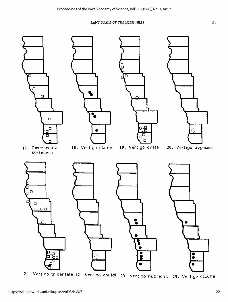
Our own Iowa collecting has been concentrated in the northeastern (300 sites) and east-central (200 sites) parts of the state, with only scattered localities elsewhere. Though it is hardly comprehensive and as yet unpublished, frequent reference will be made to this material. Since only a few Holocene sites have yet been examined, the distribution maps (Appendix 3) concentrate just on the modern (open squares) and Peoria Loess (Woodfordian, Wisconsinan; solid circles) fu.unas. A few ?pre-Woodfordian to Holocene alluvial fill sites are included for completeness (open circles, F designation in Appendix 2). Where the same site has both recent and Peoria Loess specimens of a taxon, that site is indicated by a solid triangle. Faunal lists for picked sites (Appendix 2) are more complete than the maps as the few definite Holocene lists and some fossil specimens of indeterminate provenance are included. Site locations on distribution maps (Appendix 3) are based on the larger index map (Fig. 1), which illustrates all picked numbered sites. Terminology for modern molluscan provinces follows Binney (1885), as modified by Bequaert and Miller (1972) and Burch (1962). 1. Hendersonia occulta (Say). Common loess fossil, especially in
Monona, Harrison, and Pottawattamie Counties. Extant at over 200 sites in northeast Iowa, scattered sites elsewhere: relict of Midwest Biome of Frest and Fay ( 1980), now in Interior Province, mostly in the Paleozoic Plateau and the Appalachians. Pre-W oodfordian and Holocene fossil, but not living in the Loess Hills currently.
2. Carychium exiguum (Say). Rare loess fossil in Fremont County (C. exile morph); rare at moist woodland and sheltered prairie sites (C. exiguum morph, generally) in the Loess Hills. May be common in Fremont and Mills Counties; very abundant in eastern Iowa. Modern distribution mostly in the northern half of the Interior Province.
3. Cochlicopa lubrica (Muller). Infrequent loess and Holocene fossil in the southern three counties. Infrequent throughout eastern Iowa in moist prairie and moist woodland sites. Uncommon in stream drift and wooded sites in the Loess Hills; most common in Fremont and Mills Counties. Hubricht (1985) accepts Kerney and Cameron's ( 1979) European-oriented treatment for the eastern U.S.; with more detailed study, this could prove valid. Based on illustrations, most Loess Hills specimens from open sites appear to be C. lubrica (Muller), while Mills and Fremont
9
Frest and Dickson: Land Snails (Pleistocene-Recent) of the Loess Hills: A Preliminar
Published by UNI ScholarWorks, 1986
LAND SNAILS OF THE LOESS HILLS 139
County wooded sites have C. TtWrseana (Doherty), if this treatment is accepted. Hubricht (1985, p. 61, Map 22) also lists C. lubricella (Porro) from Woodbury County. A widespread taxon in North America; most sites in the Interior Province.
4. Vallonia pulchella (Miiller). Moderately common in open, but not strongly xeric situations in the Loess Hills; one loess site in Fremont County. Also a ?pre-Woodfordian and Holocene fossil. Frequent in wet open sites throughout Iowa. Most eastern U.S. sites in the Interior, some in the Northern Province.
5. Vallonia gracilicosta (Reinhardt). Generally a Rocky Mountain taxon, with relict sites in the Palezoic Plateau in Minnesota and Iowa (Frest, in prep.). Shimek (1894, 1903, 1910, 1915) records it from Eastport in Fremont County and from the Lake Okoboji region. Very common loess fossil throughout the state; in the Loess Hills also, but especially in the northern four counties. Also a frequent ?pre-Woodfordian and Holocene fossil.
6. Vallonia parvula (Sterki). One of the most common modern Loess Hills species, found at wet Missouri Alluvial Plain (hereafter abbreviated as MAP) sites as well as in wooded bluff-edge ravines; but most common at dry, open, grassy upland sites in the Loess Hills proper (hereafter abbreviated as LH). A few loess sites in Fremont County. Common in eastern Iowa in both forests and prairies, live specimens frequent on loess outcrops. Interior Province species.
7. Pupil/a muscorum (Linne). Mostly a northern species, with a few disjunct Cumberland and Interior sites. Frequent loess fossil, becoming rare to the south; ?pre-Woodfordian also. Not currently living in the LH, nor seen elsewhere by the authors. The Johnson and Polk County citations in Hubricht (1985, p. 68, Map 35) could either be relict colonies or erroneous (e.g., loess fossils): the latter is likely. We follow most European authors (e.g., Kerney and Cameron, 1979) in not recognizing subspecies in P. muscorum. Unlike Hubricht ( 1985, p. 7) we regard P. sinistra Franzen as a full species.
8. Pupoides albilabris (C.B. Adams). Common modern species, especially in the Interior but also in the Texan and Austroriparian Provinces. Fossil only in ?pre-Woodfordian-Holocene alluvial fills in Fremont County. Largely an open-ground taxon, widely distributed in both upland and lowland sites.
9. Gastrocopta procera (Gould). Common modern species, often found associated with Pupoides albilabris in the LH, as elsewhere (Hubricht, 1985, p. 9). Rare loess fossil in Fremont County. For northern sites, see also maps and discussion in Reigle (1963) and Baerris (1980). Generally an Interior taxon: Texan Province and Western Division also.
10. Gastrocopta cristata (Pilsbry and Vanatta). Not a live or loess fossil; one Hartford Ash site. Essentially a western and southwestern plains (Interior) species (Hubricht, 1985, pp. 10, 72, Map 47).
11. Gastrocopta proarmifera (Leonard). Described originally as an extinct taxon. Hartford Ash only in Iowa (Paulson and Miller, 1983). Hubricht (1972, 1985) regards this taxon as a synonym of the extant G. ruidosemis (Cockerell) rather than an extinct taxon.
12. Gastrocopta armifera (Say). We construe this species broadly for the moment, as noted previously. One of the most common LH species in open and dry environments, but also present in the MAP. Occasional loess fossil, Harrison County and south. Rare ?pre-Woodfordian and Holocene fossil, Mills County. Common in open environments throughout the state. Seen often at base of grass tufts atop loess outcrops. Widely distributed in Interior Province.
13. Gastrocopta contracta (Say). Very widespread and very abundant in the LH. Occasional Woodfordian fossil (Fremont, Peoria Loess and Mills Counties only); occasionally ?pre- and post-Woodfordian taxon, Mills County. Abundant in a variety of situations throughout the state, as elsewhere in the Interior and, to a lesser
to a lesser extent, the Texan and Austroriparian Provinces. 14. Gastrocopta holzingeri (Sterki). Frequent wet prairie and forest
species elsewhere in Iowa; generally in forests or ravine bottoms in the LH. One loess site in Fremont County. Interior species.
15. Gastrocopta pentodon (Say). One of the more widespread LH species, though less common than G. armifera and G. contracta. Found in a variety of situations, but rare in the driest LH upland sites. Widely distributed in the state. Occasional fossil species in deposits of varying ages. Widely distributed in both North American Divisions.
16. Gastrocopta tappaniana (C. B. Adams). The status of this species has been debated (contrast Bequaert and Miller, 1973 with Hubricht, 1972), but based on our material we follow Hubricht (1985). Found at scattered LH and MAP sites, all lowland marshes or valley bottoms. Occurs throughout the state, in habitats as described by Hubricht (op. cit., p. 9). A Hartford Ash taxon, not otherwise yet seen fossil in the LH except in Holocene alluvial fills. Cosmopolitan species.
17. Gastrocopta corticaria (Say). Found in a few sites scattered through the length of the LH, mostly in stream drift. Eastern Iowa sites include logs and trees in forests and along stream terraces, but it is frequently seen in abundance also on seasonally wet calcareous outcrops. No fossil sites. Generally an Interior species.
18. Vertigo elatior (Sterki). Infrequent in loess sites, but absent from north and south extremes in the LH. Very abundant in the ca. 17 ,000 YBP Conklin local biota, Johnson County, Iowa (Frese, in Baker et al., in press). No live sites in LH. The Iowa localities cited by Miller (1966) and Hubricht (1985, p. 80, Map 69) could represent either subfossil material (Shimek's Lake Okoboji lots, NMNH, examined by the senior author, 1984) or relict sites. Definite relict sites have been located by the senior author in Johnson and Fayette Counties, but the taxon is basically a Northern species.
19. Vertigo wata (Say). Uncommon live in wet lowlands and bottoms of wooded ravines and in drift samples in two concentrations in the north and south extremes of the LH. Common in similar habitat elsewhere in Iowa. Also a common fossil in late Pleistocene-Holocene fills of uncertain age in Mills County. With V. milium one of the most cosmopolitan Vertigo species.
20. Vertigo pygmaea (Draparnaud). Present in the LH solely as an alluvial fill fossil; basically a northern species, but one relict site in eastern Iowa. Hubricht (1985, p. 84, Map 78) shows scattered sites in the northeast U.S., as fur west as north-central Indiana; the taxon is generally a Northern Province species.
21. Vertigo tridentata Wolf. The most common modern LH Vertigo, frequent in drift samples but found live in low, open ravine bottoms and in comparatively dry, upland forests in the LH. Hubricht ( 1985, p. 11) lists "herbs in low, sunny places" as its habitat. In eastern Iowa, common woodland Vertigo except in unusually moist or rich sites. Rare as a loess and Holocene fossil. Interior species.
22. Vertigo gouldi (A. Binney). Rare Holocene and ?pre-Woodfordian-Holocene alluvial fill fossil in the LH; not a loess fossil in Iowa. Common in rich woods in northeast Iowa, rare elsewhere in eastern Iowa. Northern portion of Interior Province - mostly Northern and Cumberlandian.
23. Vertigo hubrichti Pilsbry. We follow Leonard and Frye (1960) and Hubricht (1985) in regarding this as a full species. Infrequent in loess sites in the LH; absent from north and south extremes. Live at a number of relict sites in the Paleozoic Plateau (Frese and Fay, 1980; Frese, in prep.). Midwest Biome taxon.
24. Vertigo occulta Leonard. Rare loess fossil, mostly southern but also central LH. Live as a relict only as noted above for F. hubrichti, with which it occurs at a few sites. Midwest Biome taxon.
25. Vertigo n. sp. To be described in forthcoming paper on Paleozoic
10
Proceedings of the Iowa Academy of Science, Vol. 93 [1986], No. 3, Art. 7
https://scholarworks.uni.edu/pias/vol93/iss3/7
140 PROC. IOWA ACAD. SCI. 93(1986)
Plateau relicts. Rare loess fossil with similar distribution to preceding two. Relict only on a few algific talus slopes, associated with V. hubrichti, V. occulta, and Discus macclinlocki (Baker); references as above. Midwest Biome taxon.
26. Vertigo hannai Pilsbry. Here treated as full species, as by Pilsbry (1919) and Hubricht (1985), but not Pilsbry (1948). Extinct taxon confined to a few loess sites in the north (but not northernmost) LH. Rare as fossil elsewhere in Iowa and other Midwest states (see discussion in Frese in Baker et al., in press). Northern loess sites transitional between Midwest and Taiga Biomes.
27. Vertigo modesta modesta (Say). Most common loess Vertigo, abundant at all loess sites in the LH. A Northern and Rocky Mountain taxon; Hubricht (1985, p. 12) states that all definite eastern U.S. records are for fossils. Also a Holocene and ?preWoodfordian fossil in the LH. We follow Pilsbry (1948) in recognizing subspecies in both recent and fossil V. modesta.
28. Vertigo modesta parietalis (Ancey). A single loess site in the LH; Northern in the modern fauna, no good U.S. records. Examination of very large numbers of fossils indicates that it is locally common at a few late Woodfordian upper Midwest sites.
29. Vertigo milium (Gould). In the LH, found sparingly at a few bluffedge and forested ravine drift sites throughout the area, most commonly in Fremont and Mills Counties. Not a loess fossil, but part of the ?pre-Woodfordian Pleistocene and possibly Holocene fauna. Frequent in wet lowland and cool moist upland forest sites in eastern Iowa. Cosmopolitan in the Eastern Division.
30. Vertigo alpestris oughtoni Pilsbry. Absent from most loess sites, common at a few in the north half of the LH. An uncommon loess fossil, mostly found in sites near the glacial margin elsewhere in Iowa. A Northern taxon not currently living in the U.S. Common in the Conklin local biota, Johnson County (Frese, in Baker et al, in press).
31. Columella columella alticola (Ingersoll). Hubricht (1985) and Bequaert and Miller (1973) apparently follow Forcart (1959) in regarding this as the American subspecies of the Holartic C. columella. According to Hubricht (1985, p. 12) known only as a fossil in eastern North America. His map (1985, p. 87) shows the nearest live site in southwest Texas. A Northern and Rocky Mountain (most reported sites) taxon common to many late Woodfordian loess sites in the LH, as elsewhere in the Midwest. Often abundant, but uncommon in north and south; most LH counties. Also a Holocene and pre-Woodfordian fossil. One possible (stream drift only) relict live site in Fremont County.
32. Columella simplex (Gould). We follow Hubricht (1971, 1985) in accepting American specimens generally called C. edentula (Draparnaud) as distinct, based upon examination of European material in 1984 and 1985. Uncommon in the LH, live in wettest upland woods in Fremont and Mills Counties; also in a few drift samples. ?Pre-Woodfordian as a fossil (possibly Holocene also) but absent from the loess. Frequent in moist woods in eastern Iowa, but usually rare at each site. Hubricht (1985, p. 12) states that "C. simplex" compounds "at least two species, probably three." In view of the results of close examinations of"C. edentula Draparnaud" in Europe (Walden, 1966 and Paul, 1975) this is quite possible. As presently construed, an Interior (mostly) and Northern taxon.
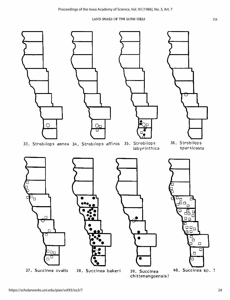
33. Strobilops aenea Pilsbry. Only as fossil in the LH; ?preWoodfordian and Woodfordian alluvial sites in Mills County. Rare on moist wooded rocky but well-shaped slopes in eastern Iowa (Hubricht, 1964; authors' collections). We have generally found it in association with S. labyrinthica, but only in exceptionally rich and humid forest or talus slope sites. Interior and Austroriparian taxon.
34. Strobilops affinis Pilsbry. Two modern sites in Fremont and Mills
Counties, LH. Elsewhere in Iowa common on partly forested rocky bluffs and somewhat dry wooded slopes and wooded uplands, only sometimes in association with S. labyrinthica (Say) (but compare Hubricht, 1985, p. 13). ?Pre-Woodfordian and Woodfordian fossil, Mills County; not found in LH loess sites, but occasionally in Peoria Loess elsewhere. Most sites are in the northern part of the Interior Province.
35. Stropbilops labyrinthica (Say). Recent and loess fossil at a few sites in Fremont and Mills Counties, generally near the bluff edge. Widely distributed in very wet to somewhat dry forest sites in eastern Iowa. Also a ?pre-Woodfordian and Woodfordian alluvial fossil in Mills County. Mostly Interior, but some Northern sites.
36. Strobilops sparsicosta (F.C. Baker). Found only as a fossil at two Hartford Ash sites in the LH. Fossils mostly from the Great Plains.
37. Succinea ova/is (Say). Generally an Interior taxon (some Northern sites) at present. Common in the MAP and on floodplains and moist wooded stream banks, often near the bluff edge, at thinly scattered sites along the length of the LH. Not recorded as a loess fossil in the LH, but occurs at southern loess localities (Hubricht, 1985, p. 94, Map 118). Uncommon alluvial fill and Hartford Ash fossil.
38. Succinea bakeri (Hubricht). The most widespread loess succineid in the LH, present at nearly all localities, declining in abundance only at southernmost localities. Also a Holocene and ?preWoodfordian fossil; apparently extinct.
39. Succinea chittenangoemis (Pilsbry)?. A tall, large loess fossil present in a few Peoria loess sites in the LH may be this taxon. The typical form is known only from the type locality at Chittenango Falls, NY; we think. the Appalachian localities reported by Hubricht (1985, p. 96, Map 125) are another taxon, but like Hubricht, prefer to regard the taxon as a subspecies or full species (for another view, see Solem, 1976). The LH specimens more closely resemble S. ova/is pleistocenica Baker or a similar relict taxon collected by us from eight sites in the Minnesota-Iowa Paleozoic Plateau and currently under study. This could prove to be S. chittengoemis or an independently derived taxon closely related to both S. ova/is and S. chittenangoemis. A very similar form is present at one Iowa Hartford Ash site.
40. Succinea sp. 1. The most common large succineid in the LH, found in a variety of open habitats, ranging from relatively moist meander lake edges and marshes to rather dry loess banks. Generally present in small numbers. Shell morphology much like S. indiana Pilsbry. No fossil record in the LH, and not seen by us outside the LH. Provincial assignment uncertain.
41. Succinea sp. 2. Uncommon, found only in a few sites, all of which are marshy areas on large stream floodplains. Shell morphology and dark mantle color with scattered yellow spots suggest S. grosvenori I. Lea or S. witteri Shimek. No fossils noted. None collected in eastern Iowa. Provincial assignment uncertain.
42. Catinella gelida (F. C. Baker). Widespread in LH loess collections, by far the most abundant succineid noted. Less common at extremes of the region; also a common ?pre-Woodfordian, Holocene, and Woodfordian alluvial deposit snail. Relict at a few sites in the Paleozoic Plateau in Iowa (Frese, in prep.)
43. "Catinella vermeta (Say)''. Most frequently encountered succineid in dry upland sites such as roadside loess exposures. Generally only a few are present at any site. Shell morphology suggests some morphs of C. avara (Say). Not seen as a fossil, or elsewhere in Iowa. Regarded as a synonym of C. avara by Hubricht (1985).
44. Catinella avara (Say). Abundant at scattered localities in the LH and MAP, generally on wet floodplains of small streams and in marshes and swamps associated with meander lakes. Frequent elsewhere in the state. Moderately common loess fossil; found also in Wisconsinan and Holocene alluvial deposits. Absent from
11
Frest and Dickson: Land Snails (Pleistocene-Recent) of the Loess Hills: A Preliminar
Published by UNI ScholarWorks, 1986
I.AND SNAILS OF THE LOESS HlllS 141
most northern loess sites. Mostly an Interior form. 57. Deroceras aenigma (Leonard). Extinct taxon, with scattered sites in 45. Oxyloma retusa (I. Lea) Noted live only at MAP sites, generally in the Great Plains and Illinois. Loess fossil elsewhere in Iowa, but
Scirpus marshes in this region. Common also in cattail marshes apparently not in the LH. Present at two Hartford Ash sites in and along pond margins elsewhere in the state. Very abundant at the LH. Possibly a synonym of D. laeve. sites where it occurs at all. No loess fossils, but present in ?pre- 58. Glyphyalinia indentata (Say). Common in a variety of sites in the Woodfordian and Holocene alluvial and fluvial deposits in Mills LH, and occasionally in the MAP also. Generally avoids the most
46. County. An Interior taxon generally. xeric LH localities. Abundant live throughout the state, but rare Oxyloma sp. 1. Uncommon in cattail and Scirpus marshes in the as a fossil. In the LH, loess fossil at one site in Fremont County; MAP; no fossil record. Occurs in similar habitat in eastern and found also in ?pre-Woodfordian-Holocene fills in Mills County. central Iowa. Provincial assignment uncertain. Hubricht (1985, p. 24) believes the name has been applied to "a
47. Anguispira alternata (Say). Common in a variety of situations in series of anatomical species, with little or no shell differences." the LH and MAP; generally prefers lowland habitat, but absent Cosmopolitan species: in Eastern Division, especially in Interior completely only from very xeric upland sites. Common through- Province. out the state. Occurs fossil both in the loess and in ?pre- 59. Nesovitrea electrina (Gould). Very widespread and abundant LH Woodfordian and Holocene deposits in Fremont and Mills and MAP species. Hubricht (1985, p. 23) characterizes it as a
48. Counties. Generally an Interior species, but some Northern sites. species of low, wet habitats; but in the LH it is also found in what Discus cronkhitei (Newcomb). Very common loess snail, present at appear to be quite xeric situations. Common throughout Iowa, most sites regardless of exposure; also a ?pre- and post-Woodfor- and more tolerant of human disturbance than most land snails. dian terrace and fill fossil. Common along floodplains and other Rare in bluff edge Peoria Loess sites from Monona County south. wet areas in most of the state, not abundant in the LH and MAP. Common in Holocene alluvium in Mills County. Characteris-Seen most often in low places in small drainages near the bluff tically Interior, but some Northern sites. edge in the LH, or occasionally in marshes on the MAP. 60. Zonitoides arboreus (Say). Probably the most widespread and Cosmopolitan taxon: Eastern Division sites mostly in Northern abundant medium-sized species in the LH and MAP, with and northern Interior Provinces. cosmopolitan distribution in the U.S. Fossil in bluff edge loess
49. Discus macdintocki (EC. Baker). Currently live only as a relict at a sites from Monona County south, and in Holocene sites in Mills few sites in the Iowa and Illinois Paleozoic Plateau (Frest, in and Fremont Counties. Cosmopolitan. prep.). Rare loess fossil in Harrison and Pottawattamie Counties; 61. Hawaiia minuscula (A. Binney). Very common and abundant LH also found in a W oodfordian fill in Mills County. Midwest Biome species, in a variety of open situations, as elsewhere in Iowa. taxon. Fossil in a few bluff edge Peorian sites from southern Monona
50. Discus catskillensis (Pilsbry). Relict in northeast Iowa and south- County south; also in Hartford Ash, Holocene and Woodfordian east Minnesota (Paleozic Plateau), more widely distributed LH localities. Cosmopolitan taxon. currently in glaciated central Minnesota. In LH, found only in a 62. Euconulus fulvus (Miiller). Infrequent in moist areas (often wood-Woodfordian fill in Mills County. Generally live now in transi- ed) in the LH and MAP; also in bluff-edge drift collections. tion zone between Northern and Interior Provinces: some sites in Much more common as a loess fossil at many LH localities. latter. Most sites in Northeast United States. Common in moist woodlands and shaded ravines throughout
51. Discus patulus (Deshayes). In the LH at a single Woodfordian fill Iowa. Fossil also in alluvial fills of Holocene-?pre-Woodfordian locality in Mills County. Infrequent in moderately dry to moist age in Mills and Fremont Counties. Interior (mostly) and upland woods in eastern Iowa. Interior taxon. Northern taxon.
52. Discus shimeki (Pilsbry). Common loess fossil found at most LH 63. Haplotrema concavum (Say). Fossil at a single Fremont County loess sites, both bluff edge and back bluff. Often abundant, particular- site. Subfossil shells were seen at several forested bluff-edge ly in the northern and central LH. Equally common at Peoria localities in Mills and Fremont Counties, suggesting it may still Loess sites elsewhere in the state. Also occurs with the other survive alive there. Common in eastern Iowa forests. Interior Discus species mentioned above in a Woodfordian alluvial fill in species. Mills County. Currently a Rocky Mountain and Northern taxon. 64. Stenotrema leai leai (A. Binney). The most ubiquitous large land
53. Helicodiscus para/le/us (Say). The type locality of this widespread snail in the LH, at both forested and open (though not strongly North American species is in the LH (Pilsbry, 1948, pp. 627.) xeric) sites; less common in the MAP. Loess fossil from Monona Occurs in a variety of habitats in both the LH and MAP; fossil at a County south. Frequently found living in eastern Iowa, though few sites of varying age (including loess sites) in Fremont and not in densely wooded areas. Interior taxon. Mills Counties. Common over the state. As discussed previously, 65. Stenotrema fraternum fraternum (Say). In the LH, live occasionally our species concept is broad, including forms described by at wooded sites throughout the Loess Hills and bluff edge loess Hubricht (1962) as H. shimeki. Cosmopolitan in the Eastern sites in Mills and Fremont Counties. One Holocene fill and Division. several of uncertain age site in Mills County also have this species.
54. Helicodiscus singleyanus (Pilsbry). Generally distributed over the Common in eastern Iowa in forested uplands and wooded slopes. LH in open grassy areas, including dry uplands. Occurs in the Generally Interior, but some Northern sites. same habitat over the state. Fossil in the LH only in Holocene 66. Stenotrema barbatum (Clapp). Found fossil in the LH at a Holocene sites in Mills County. Cosmopolitan taxon. site in Mills County, in association with S. fraternum fraternum.
55. Punctum minutissimum (I. Lea). Rare in the LH, in most deeply Subfossil shells noted in Fremont County. Quite common in forested sites in Monona, Mills, and Fremont Counties. Very forested eastern Iowa. Interior species. common in moist forests is in rich litter throughout eastern Iowa. 67. Mesodon clausus clausus (Say). Characteristic Interior taxon. Com-Loess fossil in Fremont and Mills County; also in a Holocene site mon in open areas and scrubby woods in eastern Iowa. In the LH, in Mills County. Mostly an Interior species. live only in Fremont County; Peoria loess fossil in three sites in
56. Deroceras laeve (Miiller). Common in open sites and drift accumu- Mills and Fremont Counties; also at a single Mills County lations in the LH. A frequent loess and Holocene fossil; more Holocene site. Based on subfossils, may be extant rarely over a abundant in less xeric but still open portions of the state. Interior wide portion of the LH. species. 68. Triodopsis alleni (Wetherby, in Sampson, 1883) Say. Frequent in
12
Proceedings of the Iowa Academy of Science, Vol. 93 [1986], No. 3, Art. 7
https://scholarworks.uni.edu/pias/vol93/iss3/7
142 PROC. IOWA ACAD. SCI. 93(1986)
woods in eastern Iowa; but subfossil shells only in the LH in bluff-edge sites in southern Mills and northern Fremont Counties. True fossils in the loess in the same area at two sites and at one Mills County ?pre-Woodfordian-Holocene site. Based on subfossils, may be extant rarely in Mills and Fremont Counties, LH. Interior taxon, with distribution largely to the west of T. albolabris (Say).
69. Triodopsis multilineata (Say). At a few wet sites in the MAP and bluff edge LH, uncommon compared to rest of state. Many LH colonies are unbanded. Small banded specimens of the type named altonensis by Baker are common in loess exposures south of Woodbury County. Holocene-?pre-Woodfordian and Woodfordian alluvial sites in Fremont and Mills Counties also have this taxon. Interior (especially northern half) species.
70. Allogona profunda (Say). Rare at two bluff-edge sites in Mills and Fremont Counties and at one Holocene-?pre-Woodfordian fill site in Mills County; in all three cases, associated with T. albolabis. Subfossil shells were seen at several of the most densely wooded sites in southern Mills and northern Fremont Counties. It may still survive in the LH. Common in wooded areas in eastern Iowa, especially around limestone outcrops. Interior species generally, but Cumberlandian also.
71. Pomatiopsis lapidaria (Say). This species and P. cincinnatiensis (I. Lea) are not uncommon in scattered streamside, wet marsh or spring sites in eastern Iowa, so it is surprising that no live sites were encountered in the LH. A Holocene-?pre-Woodfordian alluvial fill species in Mills County.
72. Oreohelix strigosa cooperi (Binney). In the Loess Hills, this Rocky Mountain taxon was found only in a Woodfordian fill site in Mills County. Elsewhere, it is an occasional late Woodfordian loess fossil (see Frest and Rhodes, 1981 for review of known Midwest occurrences). Interior-Austroriparian.
CONCLUSIONS
This reconnaissance survey probably missed some of the relict or rare forms. Further survey is needed in the most geologically and botanically rich parts of the area, especially Mills and Fremont Counties. The cold springs occasionally found at the base of the Pleistocene section, particularly below some of the tallest bluffs in Mills County, could offer suitable relict habitat. A detailed survey of the Loess Hills succineids might also yield endemic forms. Some effort should be made to precisely locate and protect the Waubonsie Creek Columella columella alticola colony, and to look for others in the immediately surrounding area.
As the Loess Hills derive their name and unique physiography from the Peoria Loess, some thought should be given to preserving and exhibiting a typical loess section and its fauna. Particularly good Pleistocene sites suitable for this purpose are the Kaser quarry (Locality 48) and North County quarry sections. Both of these also have good exposures of bedrock and of earlier Pleistocene units, and have archaeological sites closely associated. Some of the other molluscbearing units also should be considered as possible geological preserves. The early Pleistocene-late Pliocene age gravel pits sometimes contain excellent large mammal bones ("Aftonian gravels"); many extinct forms were originally described from such pits. The Turin pit (Locality 20), which also has Cretaceous fossils, is an especially good example. The Hartford volcanic ash and its associated fauna and flora offer another worthwhile possibility; the abandoned County Line pit (Locality 30) is a good nominee. Finally, the rich vertebrate, plant, and mollusc faunas associated with Late Pleistocene alluvial fills in Fremont and Mills Counties are likely to be of considerable interest in the future, and one or more may deserve preserve status. In particular, those along Waubonsie and Chaboneau Creek (the same area with Columella columella alticola) should be considered. For details about locations and faunas, see Semken and Rhodes, 1976; Rhodes, 1982;
1984. No defirite endemic modern land snails were found in the Loess
Hills, but there is some possibility that one or more succineids are. One, or possibly two if Vallonia gracilicosta occurs live, Rocky Mountain species survive as probable relicts. The total fauna exceeds 70 species (Table 1). It has major Interior and cosmopolitan representation, but also significant Rocky Mountain, Northern, and Midwest Biome components (Table 3). The total living fauna (40 species) is overwhelmingly generalized Interior and cosmopolitan, usually small and drought-tolerant forms. Loess Hills woodlands have a reduced fauna in comparison to that of forested northern Missouri or northeastern Iowa. The fossil fauna is more diverse and heterogenous in its biogeographic affinities. The total of about 50 species (47 in the Peoria Loess) has major Rocky Mountain, Northern, and Midwest Biome components, and the Interior component includes many more forest forms than the modern fauna. Judging by the Peoria Loess faunas, the Loess Hills in late Pleistocene times was much more environmentally diverse, with possible tundra, taiga, coniferous forest, moist and arid grassland, and rich moist deciduous forest representation.
Possible preserve status is suggested for several modern and Pleistocene sites. The wooded gullies and uplands in the southern part of the Loess Hills, particularly in Mills and Fremont Counties, have the highest diversity for both modern and Pleistocene land snails. In both cases, there is a definite increase in diversity from north to south, though for very different reasons. In the Peoria Loess, the range of environments is from a cold near-tundra analogue to warmer, only partly deciduous, forests. At present the range is from warm and dry conditions with little forest cover to slightly more moist, cool and more extensive but still sparse fully deciduous forests. Other sites of possible interest as geologic preserves include Hartford Ash, "Aftonian" gravel pits, and late Pleistocene alluvial fill localities.
ACKNOWLEDGEMENTS
This study was underwritten by a grant from the State Preserves Advisory Board. We especially thank Dean Roosa, State Ecologist, Iowa Department of Natural Resources, for his continued support and encouragement. Recent loess collections by George Hallberg, Art Bettis, and Tim Kemmis (Iowa Geological Survey) stimulated interest in the project. Alluvial collections at some localities were made by R. S. Rhodes (University of Iowa); permission to study this material and include fauna! lists for these sites is gratefully acknowledged.
REFERENCES
BAERRIS, D.A. 1980. Habitat and Climatic Interpretation from Terrestrial Gastropods at the Cherokee Site, pp. 101-122, in Duane C. Anderson and Holmes A. Semkin, Jr. (eds.) The Cherokee Excavations, Holocene Ecology and Human Adaptations in Northwestern Iowa. Academic Press, New York.
BAKER, R. G., DONALD P. SCHWERT, TERRENCE). FREST, R. SANDERS RHODES II, GEORGE R. HALLBERG, ALLEN C. ASHWORTH, and JAN A. JANSSENS (in press). A full glacial biota from southwestern Iowa. Int. J. Quat. Sci.
BEQUAERT, ). C. and W. B. MILLER. 1973. "The Mollusks of the Arid Southwest". Univ. Arizona Press, Phoenix 271 pp.
BINNEY, W. G. 1885. A manual of American land shells, U.S. National Museum Bull. 28: 1-528.
BOELLERSTORFF, J. D. 1973. Taphrocronology, petrology, and stratigraphy of some Pleistocene deposits in the Central Plains, U.S.A. Unpub. PhD dissertation, Louisiana State Univ. 197 pp.
BURCH, J. B. 1962. How to Know the Eastern Land Snails. W. B. Brown, Dubuque, Iowa 214 pp.
BURCH,]. B. and A. S. VANDEVENDER. 1980. Identification of eastern North American land snails. The Prosobranchia, Opisthobranchia and Pulmonata (Actophila). Trans. POETS Soc. 2:33-80.
CALVIN, S. 1911. Aftonian mammalian fauna II. Geo!. Soc. America Bull.
13
Frest and Dickson: Land Snails (Pleistocene-Recent) of the Loess Hills: A Preliminar
Published by UNI ScholarWorks, 1986
LAND SNAILS OF THE LOESS HILLS 143
22:207-216. CAMERON, C. C. 1940. The fossils of the Peoria Loess of Iowa. Unpub.
PhD thesis, Univ. of Iowa 79 pp. FOR CART, L. 1959. Die palaearktischen Arten des Genus Colurnella (Moll.
Styli., Pupillidae). Verh. naturf. Ges. Basel 70: 17-18. FREST, T. and L. P. FAY. 1980. Peoria Loess mollusc faunas and Woodfor
dian biomes of the upper Midwest. Amer. Quat. Assoc. Abstr. 1980:82. ----- and R. S. RHODES, (II). 1981. Oreohelix strigosa cooperi
(Binney) in the Midwest Pleistocene. Nautilus 95:47-55. HARRY, H. W. 1951. Carychium exiguum (Say) oflower Michigan; morphol
ogy, ecology, variation, and life history. Unpub PhD thesis, Univ. Michigan. 154 pp.
HUBRICHT, L. 1962. New species ofHelicodiscus from the eastern United States. Nautilus 7 4: 102-107.
78:27-28. 1964. Strobilops aenea west of the Mississippi River. Nautilus
1971. The land snails of Virginia. Srerkiana 42:41-45. 1972. Gastrocopta armifera (Say). Nautilus 85:73-78. 1985. The Distributions of the Native Land Mollusks of the
Eastern United Stares. Fieldiana Zoo!., n.s. 24, viii+ 191 pp. IZETT, G.A. and R. E. WILCOX. 1982. Map showing localities and
inferred distributions of the Huckleberry Ridge, Mesa Falls, and Lava Creek ash beds (Pear!erre family ash beds) of Pliocene and Pleistocene age in the western United Stares and southern Canada. U.S. Geo!. Sur. Misc. Inves. Ser., Map I - 1325.
KERNEY, M. P. and R. A. D. CAMERON. 1979. Field Guide to the Land Snails of the British Isles and Northwestern Europe. Collins, London. 288 pp.
LEONARD, A. B. 1950. A Yarmourhian molluscan fauna in the Midcontinenr Region of the United States. Univ. Kansas Paleontol. Contr. 8 (Mollusca 3), 48 pp.
-----· 1952. Illinois and Wisconsinan molluscan faunas in Kansas. Univ. Kansas Paleontol, Contr. 9 (Mollusca), 38 pp.
-----· 1959. Handbook of gastropods in Kansas. Univ. Kansas Mus. Nat. Hist., Misc. Pub. 20, 224 pp.
-----and]. C. FRYE. 1954. Ecological conditions accompanying loess deposition in the Great Plains region of the United States. ]our. Geo!. 62:399-404.
-----· 1960.
Wisconsinan molluscan faunas of the Illinois Valley region. Ill. State Geo!. Survey, Circ. 304, 32 pp.
MILLER, B. B. 1966. Five Illinoian molluscan faunas from the southern Grear Plains. Malacol. 4: 173-260.
NOVACHEK, ]. M., D. M. ROOSA and W. P. PUSATERI. 1985. The vegetation of the Loess Hills landform along the Missouri River. Proc. Iowa Acad. Sci. 92: 199-212.
PAUL, C.R. C. 1975. Columella in the British Isles. J. Conch. 28:371-383. PAULSON, G. F. and B. B. MILLER. 1983. Two fossil assemblages
associated with the Hartford ash from Little Sioux, Iowa. Geo!. Soc. America. Abstr. with Prog. 15:659.
PILSBRY, H. A. 1919. Manual of Conchology, series 2, v. 25. Acad. Nat. Sci. Philadelphia, 208 pp.
-----· 1939. LandMolluscaofNorrhAmerica(northorMexico), v. 1 Pt. 1. Acad. Nat. Sciences, Philadelphia. Mon. 3: 1-573.
-----· 1940. Land Mollusca of North America (north of Mexico), v. 1 Pt. 2. Acad. Nat. Sci. Philadelphia. Mon. 3:574-994.
-----· 1946. Land Mollusca of North America (north of Mexico), v. 2 Pr. 1. Acad. Nat. Sci. Philadelphia Mon. 3: 1-520.
-----· 1948. Land Mollusca of North America (north of Mexico), v. 2. Pt. 2. Acad. Nat. Sci. Philadelphia Mon. 3:521-1113.
PRIOR,]. C. 1976. A regional guide to Iowa landforms. Iowa Geo!. Survey, Educ. Ser. 3, 71 pp.
REIGLE, N. ]. 1963. Northern records of Gastrocopta procera. Nautilus 77: 16-18.
RUHE, R. V. 1969. Quaternary Landscapes in Iowa, Iowa State Univ. Press, Ames, 255 pp.
-----· 1983. Depositional Environment of Lare Wisconsin Loess in rheMidcontinental United Stares. pp 130-137 in Wright, H.E.,Jr. (ed.) Late Quaternary Environments of the United States, Vol. 1, The Late Pleistocene, S. C. Porter (ed.). Univ. Minnesota Press, 407 pp. .
RHODES, R. S., (II) 1982. Mammalian paleoecology of the Farmdalian Craigmile and the Woodfordian Waubonsie local faunas. Unpublished PhD thesis, University of Iowa, 132 pp.
-----· 1984. Paleoecology and Regional Paleoclimatic Implications
of the Farmdalian Craigmile and Woodfordian Waubonsie Mammalian Local Faunas, Southwestern Iowa, Illinois State Mus. Repts. Invest., 40, 51 pp.
-----and H. A. SEMKEN, JR. 1976. Paleontological investigations within the Waubonsie Creek watershed, Iowa. Final Report, National Park Service contract (X-1595-4-0138). 48 pp.
SHIMEK, B. 1888. Notes on the fossils of the loess at Iowa City, Iowa. Amer. GeoJ. 1: 149-152. I
-----· 1890. The Mollusca of eastern Iowa. Univ. Iowa Stud. Nat. Hist. 1:56-81.
-----· 1894. Additional notes on Iowa Mollusca. Proc. Iowa Acad. Sci. 1: 107-111.
-----· 1898. Is the Loess of Aqueous Origin? Proc. Iowa Acad. Sci. 5:32-45.
-----· 1903. Report by Professor B. Shimek on the fossils from the loess of Mills and Fremont Counties, pp. 170-175, in Udden, J.A. Geology of Mills and Fremont Counties. Iowa Geo!. Sur. Ann. Repr. 13 (1902):122-183.
-----· 1910. Geology of Harrison and Monona Counties. Iowa Geo!. Sur. Ann. Rept. 20 (1909):271-485.
-----· 1915. The plant geography of the Lake Okoboji region. Appendix: The Mollusca of the Okoboji region. Univ. Iowa Bull. Lab. Nat. Hist. 7:70-88.
-----· 1930. Land Snails as Indicators of Ecological Conditions. Ecol. 11:673-86.
SOLEM, A. 1976. Status of Succinea walis chittenangoensis Pilsbry, 1980. Nautilus 90: 107-116.
STERKI, V. 1909. Bilfidaria armifera Say, and its varieties. Nautilus 23:52-54.
WALDEN, H. W. 1966. Einige Bemerkungen zum Enganzungsband zu Ehymann's "Mollusca" in "Die Tierwelt Mirreleuropas". Arch. Molluskenk. 95:49-69.
APPENDIX 1. Collecting Localities
Nwnbers in parentheses refer co field designations; asterisks precede sites from which Pleistocene fuunas were also collected.
Plymouth County
1. (46) Akron. Drift and live collection along Big Sioux River NE of Akron at Big Sioux County Park, NWY4 NWY4 NWY4 Section 29, T93N, R48W, Akron quadrangle. Cretaceous-controlled open topography.
2. (47) Rock Creek. Drift near bridge on private road crossing Rock Creek, SWY4 SWY4 NEY4 Section 32, T91N, R48W, Elk Point NE quadrangle. Forested Cretaceous-controlled topography.
3. (48) Joy Creek. Drift in stream valley below power line, SWY4 NWY4 SWY4 Section 20, T91N, R48W, Elk Point NE quadrangle. Weakly forested Cretaceous-controlled topography.
4. (3) Broken Kettle Creek. Live collection from bog on north side of secondary road, SWY4 SEY4 SEY4 Section 35, T92N, R48W, l'v,fillnerville quadrangle. Bog above floodplain, Cretaceous bedrock.
5. (49) McCook Lake. Live collection on east shore of McCook Lake, a meander cut-off on Missouri River floodplain, in brushy area on west side of Sodric Park, SE Y4 Section 16, T89N, R48W, Jefferson quadrangle.
Woodbury County 6. (2) Dakota Point.
Live collection and drift behind and along lake in campground just outside of Stone State Park, SE Y4 NE Y4 SE Y4 Section 2, T89N, R48W, Sioux City North quadrangle. Cretaceous
14
Proceedings of the Iowa Academy of Science, Vol. 93 [1986], No. 3, Art. 7
https://scholarworks.uni.edu/pias/vol93/iss3/7
144 PROC. IOWA ACAD. SCI. 93(1986)
topography. 7. (50) Concord.
Live and drift collection on unnamed small creek tributary to Floyd River NE of Sioux Ciry. NE Y4 NE Y4 SW Y4 Section 17, T88N, R46W, James quadrangle. Cretaceous topography.
* 8. ( 1) Correctionville. Collection from Peoria Loess on north side of county road above Little Sioux River SW of Correctionville, center SE Y4 NE Y4 Section 2, T88N, R42W, Correctionville quadrangle. Loess Hills (Peoria Loess-controlled) topography.
* 9. (51) Eberly Cemetery. Collection from Peoria Loess on west side of county road about Ya mile north of US 20 and 2 Y2 miles west of Lawton, SE Y4 SEY4 SEY4 Section 35, T89N, R46W, Lawton quadrangle. Loess Hills topography.
10. (4) Brown's Lake. Live collection in swampy area of lakeshore near earth dam on cut-off meander of Missouri River, Brown's Lake State Park, SWY4 NEY4 SEY4 Section 32, T87N, R46W, Salix quadrangle. Missouri River floodplain.
* 11. (5) Luton East. Collection from Peoria Loess along county road about 4 Y2 miles east of Luton and lY2 miles east of bluff line, EY4 NEY4 NEY4 Section 24, T87N, R46W, Luton quadrangle. Strong Loess Hills topography.
* 12. (6) Climbing Hill. Collection from Peoria Loess along county road SW of Climbing Hill and above west fork, Little Sioux River, SE Y4 SE Y4 SEY4 Section 20, T87N, R45W, Climbing Hill quadrangle. Subdued Loess Hills topography.
* 13. (7) Oto West. Collection from Peoria Loess on north side of county road 43/4 miles west of Oto above Lum Hollow Creek, SE Y4 SE Y4 SE Y4 Section 5, T86N, R44W, Oto quadrangle. Subdued Loess Hills topography.
*14. (8) Cottonwood Hollow. Collection from Peoria Loess in roadcut near hill summit along county road NW of Rodney, SWY4 SWY4 NEY4 Section 8, T86N, R44W, Smithland quadrangle. Moderately developed Loess Hills topography.
* 15. (52) Dutch Creek. Collection from Peoria Loess in roadcut on county road above Dutch Creek, WY2 NWY4 NWY4 Section 36, T86N, R43W, Mapleton quadrangle. Subdued Loess Hills topography.
Monona County
* 16. (9) Whiting Woods. Live collection from scrubby woods and Peoria Loess collection from roadcut one mile NNE of Whiting Woods Recreation Area, NWY4 NWY4 NWY4 Section 29, T85N, R43W, Smithland quadrangle. Subdued Loess Hills topography.
17. (53) Lewis and Clark. Live collection on and along east-facing beach on Blue Lake Lewis and Clark State Park, NEY4 SWY4 SEY4 Section 35'. T84N, RllE, Onawa quadrangle. Missouri River meander lake and surrounding floodplain.
* 18. (12) Castana North. Peoria Loess collection from roadcut north of Castana at base of west bluff line, Maple River, NEY4 NEY4 SWY4 Section 13, T84N, R44W, Castana quadrangle. Moderately welldeveloped Loess Hills topography.
*19. (ll) Castana West. Peoria Loess collection from roadcut on county road just above Maple River floodplain about 1 mile west of Castana, SWY4 SEY4 SEY4 Section 23, T84N, R44W, Castana quadrangle.
Recent, possible Holocene, and Peoria Loess collections from vicinity of Turin gravel pit, immediately north of Turin, NE Y4 NEY4 NEY4 Section 9, T83N, R44W, Castana quadrangle. The gravel pit is an old classic locality for early Pleistocene-? late Pliocene vertebrates and Cretaceous fossils. Strong Loess Hills topography. Holocene (?) specimens not plotted on distribution maps.
*21. (13) Turin South. Roadcut on county road Ya mile south of intersection with IA 37, ca. 1. 5 miles SE of Turin; Peoria Loess. NWY4 NWY4 NWY4 Section 14, T83N, R44W, Castana quadrangle. Good Loess Hills topography.
*22. (15) St. Clair. Collection from Peoria Loess in roadcut on secondary road in St. Clair Township, SW Y4 SW Y4 SE Y4 Section 17, T84N, R42W, Mapleton SE quadrangle. Subdued Loess Hills topography.
*23. (16) Soldier North. Peoria Loess near base of bluff on county road 1. 7 miles N of Soldier, NWY4 SWY4 NEY4 Section 13, T83N, R43W, Mapleton SE quadrangle. Subdued Loess Hills topography.
*24. (18) Cottonwood Creek West. Peoria Loess exposures at top of high bluff overlooking Missouri River-Little Sioux River floodplain in bulldozed area at abandoned construction site, SWY4 Section 34, T83N, R44W, Moorhead NW quadrangle. Strong Loess Hills topography with good xeric vegetation.
*25. (14) Cottonwood Creek East. Peoria Loess in shallow roadcut on secondary road, SW Y4 NWY4 NEY4 Section 1, T82N, R44W, Moorhead NW quadrangle. Good Loess Hills topography.
*26. (20) Sioux. Collection from Peoria Loess in major roadcut on secondary road about Y4 mile from bluff edge above Little Sioux River, Sioux Township, SWY4 SWY4 NWY4 Section 22, T82N, R44W, Moorehead NW quadrangle. Excellent Loess Hills topography.
27. (19) Preparation Canyon. Live and litter collection in base and sides of wooded ravine, Preparation Canyon State Park, NEY4 NWY4 NEY4 Section 25, T82N, R44W, Moorehead NW quadrangle. Good wooded back-bluff Loess Hills terrain.
*28. (17) Moorehead South. Peoria Loess exposed in shallow roadcut along secondary road at midpoint of bluff south of the Soldier River and about 2. 8 miles south of Moorhead, NEY4 NEY4 SWY4 Section 22, T82N, R43W, Moorhead quadrangle. Subdued Loess Hills topography.
Harrison County 29. (65) Deer Island.
Live collection from marsh on north side of gravel road to Deer Island State Game Management Area, about 1. 1 mile west of Interstate 29-75 bridge over Monona-Harrison Ditch, SE Y4, NWY4 SWY4 Section 5, T21N, R12E, Little Sioux quadrangle (Note: location is only approximate). Missouri River meander cutoff lake.
*30. (54) County Line Pit. Collection from Hartford Ash (ca. 700,000YBP) exposed in abandoned gravel pit on county road just south of MononaHarrison County line, NEY4 NWY4 NEY4 Section 5, T81N R44W, Pisgah quadrangle. Good Loess Hills topography. This locality is probably the best Iowa exposure of the middle Pleistocene Hartford Ash.
*31. (22) Magnolia West.
15
Frest and Dickson: Land Snails (Pleistocene-Recent) of the Loess Hills: A Preliminar
Published by UNI ScholarWorks, 1986
LAND SNAILS OF THE LOESS HILLS 145
Peoria Loess exposed in extensive roadcut on Iowa 127 about 2. 7 miles west of Magnolia, SWY4 SWY4 NWY4 Section 36, T80N, R44W, Missouri Valley NW quadrangle. Good backbluff Loess Hills topography.
32. (55) Round Lake. Live collections from quarter mile stretch of SE shoreline of Round Lake, Round Lake State Wildlife Management Area, SWY4 NWY4 SEY4 Section 13. T80N, R45W, Mondamin quadrangle. Nearly filled Missouri River meander lake.
33. (56) Logan. Live and duff collection from brushy area behind abandoned quarry east of Logan, center SEY4 SEY4 Section 18, T79N, R42W, Logan quadrangle. Floodplain of Boyer River.
34. (57) DeSoto Bend. Live collection from wooded area and west shore of DeSoto Lake, DeSoto National Wildlife Refuge, SE Y4 NWY4 Section 14, T78N, R45W, Modale quadrangle (Note: location is approximate). Recent Missouri River meander lake.
*35. (58) Missouri Valley. Collection from Peoria Loess at base of large bluff just north of city limits of Missouri Valley along Iowa 183, NWY4 NWY4 SWY4 Section 10, T78N, R44W, Missouri Valley quadrangle. Excellent Loess Hills topography.
*36. (59) Beebeetown. Peoria Loess exposed in low roadcut on county road 1. 0 mile west of Beebeetown, SWY4 SWY4 SEY4 Section 27, T78N, R43W, Beebeetown quadrangle. Subdued Loess Hills topography.
*37. (30) Yorkshire. Collection from Peoria Loess in low roadcut on counry road about 0. 7 miles west ofYorkshire, SWY4 SWY4 SWY4 Section 29, T78N, R41W, Persia quadrangle. Subdued Loess Hills topography.
Pottawattamie County
*38. (60) Loveland. Peoria Loess on east side of oorrow pit at base of bluff just north of Loveland, NEY4 NEY4 SWY4 Section 3, T77N, R44W, Loveland quadrangle. Typical Loess Hills Topography.
*39. (32) Simon Run. Collection from Peoria Loess poorly exposed in low roadcut on secondary road about 1 mile north of its intersection with Iowa 183, NWY4 NEY4 NEY4 Section 18, T76N, R43W, Honey Creek quadrangle. Moderately developed Loess Hills topography.
*40. (28) Hazel Dell. Peoria Loess in shallow roadcut on secondary road in Hazel Dell Township, NEY4 SWY4 SEY4 Section 16, T76N, R43W, Honey Creek quadrangle. Moderately developed Loess Hills topography.
*41. (29) Neola West. Collection from Peoria Loess in roadcut at top of hill on secondary road 3.5 miles west of Neola. SWY4 SWY4 SEY4 Section 21, T77N, R42W, Underwood quadrangle. Subdued Loess Hills topography.
42. (61) Iowa Lake. Live collection from marsh and pond edges along road on southeast border of Iowa Lake, north of Council Bluffs, SEY4 SEY4 SEY4 Section 14, T75N, R44W, Council Bluffs North quadrangle. Strong Loess Hills topography.
*43. (24) Crescent. Peoria Loess on east side of Pennsylvanian quarry SW of Crescent, NEY4 NEY4 NEY4 Section 34, T76N, R44W, Omaha North quadrangle.
*44. (43) McClelland North. Low roadcut in Peoria Loess above Mosquite Creek 2. 5 miles
north of McClelland, NWY4 NWY4 SEY4 Section 21, T76N, R42W, McClelland quadrangle. Weak Loess Hills topography.
45. (21) Lake Manawa. Live collections from marsh on south end of Lake Manawa, Lake Manawa State Park, NEY4 SEY4 NEY4 Section 23, T74N, R44W, Council Bluffs South quadrangle. Missouri River floodplain and modified meander lake.
*46. (42) Council Bluffs East. Collection from Peoria Loess in steep roadcut on secondary road above Pony Creek, SWY4 SEY4 NEY4 Section 3, T74N, R43W, Council Bluffs South quadrangle. Typical Loess Hills topography.
*47. (23) Treynor East. Peoria Loess in low roadcut on Iowa 100, 2.3 miles east of Treynor, NWY4 NEY4 NWY4 Section 9, T74N, R41W, Treynor quadrangle, Subdued Loess Hills topography.
*48. (26) Kaser Quarry. Peoria Loess (including possible Loveland Silt) in excellent exposure in abandoned portion of Kaser Construction Company quarry, 3/4 mile north of Folsom, NE Y4 SE Y4 NWY4 Section 29, T73N, R43W, Pacific Junction quadrangle. Excellent Loess Hills topography.
49. (27) Folsom Lake. Drift and live collection along SW shore of Folsom Lake, SE Y4 SEY4 NEY4 Section 31, T73N, R43W, Pacific Junction quadrangle. Old meander lake (disturbed by human modification), Missouri River floodplain.
*50. (25) Folsom South. Shallow roadcut along county road 0. 7 mile south of Folsom. Oxidized red terrace silt (possibly Holocene). NE Y4 NE Y4 SWY4 Section 32, T73N, R43W, Pacific Junction quadrangle. Not plotted on distribution maps.
* 5 1. (3 1) Balfour. Poor exposure of Peoria Loess in C, B & Q Railroad cut about 33/4 miles east of Glenwood, SWY4 NWY4 SWY4 Section 10, T72N, R42W, Glenwood quadrangle. Excellent back-bluff Loess Hills topography.
52. (62) Willow Slough. Live and drift collection along south shore of Willow Slough, Willow Slough State Game Management Area, NE Y4 NE Y4 SEY4 Section 29 and NWY4 NWY4 SWY4 Section 28, T73N, R40W, Emerson quadrangle. Floodplain (ofNishnabotna River).
*53. (34) Burr Oak. Extensive Peoria Loess cut above north and west road of quarry just north of Burr Oak, SWY4 SEY4 NEY4 Section 21, T71N, R43W, Rock Bluff quadrangle. Exceptional Loess Hills topography.
54. (63) Walnut Grove West. Flood debris to north of secondary road in deep gully of intermittent stream, SEY4 NWY4 SEY4 Section 27, T71N, R43W, Rock Bluff quadrangle. Exceptional bluff-edge Loess Hills topography.
*55. (39) Walnut Grove South. Peoria Loess in deep cut along secondary road near Mills and Fremont County Line on branch ascending bluff. Center SWY4 SE Y4 Section 36, T71N, R43W, Rock Bluff quadrangle. Excellent bluff-edge Loess Hills topography.
56. (68) Waubonsie 1. Flood debris behind culvert north of bridge over Waubonsie Creek, NEY4 SEY4 NEY4 Section 7, T71N, R42W, Tabor quadrangle. Exceptional back-bluff Loess Hills topography.
*57. (40) Waubonsie 2. Peoria Loess in cut and on roadway, along dirt road to Waubonsie Creek, center WY2 SE Y4 SWY4 Section 18, T71N, R42W,
16
Proceedings of the Iowa Academy of Science, Vol. 93 [1986], No. 3, Art. 7
58. (64) Waubonsie 3. Flood debris along Waubonsie Creek north of bridge and in adjacent minor washout, NWY4 NEY4 NEY4 Section 25 and SWY4 SE Y4 SE Y4 Section 24, T71N, R42W, Tabor quadrangle. Good back-bluff Loess Hills terrain.
59. (66) Waubonsie 4. Flood debris on floodplain along major west tributary co Waubonsie Creek in back of SCS dam, NWY4 NEY4 NWY4 Section 35, T71N, R43W, Tabor quadrangle. Good back-bluff Loess Hills terrain.
60. (67) McPherron Creek. Flood debris and live collection made on quarter mile stretch of creek bottom north of bridge on county road co Shady Grove School. SWY4 SEY4 SWY4 Section 30, T71N, R42W, Tabor quadrangle. Excellent back-bluff Loess Hills topography.
F re1Tl()nf County 61. (41) Waubonsie 5.
Live collection and flood debris along 0.2 mile stretch of Waubonsie Creek above bridge along secondary road between Tabor and Bartlett. NEY4 NEY4 NEY4 Section 11, T70N, R43W, Tabor quadrangle. Very good back-bluff Loess Hills topography.
62. (38) Waubonsie 6. Flood debris and live collection east of culvert on county road crossing Waubonsie Creek Ditch 0.1 mile south of its junction with secondary road to Bartlett, NEY4 SWY4 NEY4 Section 11, T70N, R43W, Tabor quadrangle. Exceptional bluff-edge Loess Hills topography.
63. (44) Forney's Lake. Live collection from small swampy area on SW side of Forney Lake State Game Management Area, Center NW Y4 SE Y4 Section 21, T70N, R43W, McPaul quadrangle. Modified meander lake, Missouri River floodplain.
*64. (34) North County Quarry. Peoria Loess exposed along east wall of new Kaser Construction Company quarry co north of old Fremont County quarry, SEY4 SWY4 SWY4 Section 14, T70N, R43W, McPaul quadrangle. Very good bluff-edge Loess Hill topography.
*65. (36) Possum Creek North. Peoria Loess in roadcut on north side of county road co north of SCS reservoir, center NWY4 SWY4 Section 18, T69N, R42W, Tabor SW quadrangle. Excellent Loess Hill topography.
*66. (35) Possum Creek South. Peoria Loess collection and flood debris alongside spillway from SCS reservoir on east side of county road, NWY4 SWY4 SWY4 Section 18, T69N, R42W, Tabor West quadrangle. As above.
67. (37) Mc. Zion West. Flood debris in deep gully, west fork of north tributary co Camp Creek, north of county bridge, SWY4 SE Y4 SWY4 Section 27, T70N, R42W, Tabor SW quadrangle. Very good back-bluff Loess Hills terrain.
68. (69) Liebold Lake. Live collection from banks of West Benton Ditch and swampy area to west of ditch and lake, NWY4 SEY4 NWY4 Section 19, T68N, R4W, Nebraska City quadrangle.
*69. (70) Waubonsie Park North. Peoria Loess poorly exposed along county road at bluff base 0. 3 mile north of intersection with IA 2, and Y2 mile west of boundary of Waubonsie Scace Park, NE Y4 SE Y4 SE Y4 Section 19, T68N, R42W, Sidney quadrangle. Excellent bluff-edge Loess Hills topography.
70. (71) Militia Creek. Flood debris below camp along banks of Militia Creek, SE of
*71.
72.
Waubonsie Seate Park, SEY4 NWY4 NWY4 Section 5, T67N, R42W, Sidney quadrangle. Excellent Loess Hills topography. (33) Hamburg East. Collection from Peoria Loess in low road cut on county road 0. 7 mile east of Hamburg and 0.2 mile from intersection with US 275 - IA 333, NEY4 SEY4 SEY4 Section 22, T67N, R42W, Hamburg quadrangle. Subdued Loess Hills topography. (72) Riverton. Live collection from wooded area adjacent co state access road, Riverton State Game Management Area, SWY4 SWY4 SEY4 Section 18, T68N, R41W, Riverton quadrangle. Floodplain of Nishnabocna River.
Supplemental Localities
*73. (73) Giangreco Farm. Fossiliferous silts (estimated ages: 18,000 YBP, R. S. Rhodes, pers. comm. 1982; 11,000 YBP, R. S. Rhodes, 1984, p. 3) along unnamed tributary to Chaboneau Creek on J. Giangreco farm, NWY4 SWY4 SEY4 Section 14, T71N, R43W, Rock Bluff quadrangle, Mills County, Iowa. Excellent Loess Hills terrain. For detailed description, see Rhodes and Semken ( 1976). Collections from unit au of Rhodes and Semken ( 1976).
*74. (74) Craigmile Farm. Fossiliferous alluvium (gravel, sand, and silt) (radiocarbon age of unit g 14, 430-14,830 YBP; unit j is undated but overlies g and must be somewhat younger: R. S. Rhodes, pers. comm., 1986) of the Waubonsie local fauna (Rhodes, 1984) along Chaboneau Creek on Craigmile farm, NWY4 NWY4 NEY4 Section 13, T71N, R43W, Tabor quadrangle, Mills County, Iowa. Excellent Loess Hills topography. Collections from units g and j of Rhodes ( 1984); for detailed description, see Rhodes (1984).
*75. (75) Wilson Farm.
Key:
Fossiliferous alluvium (gravel, sand, silt) of the Chaboneau local fauna (Rhodes and Semken, 1976) in plunge pool below small gully draining into Chaboneau Creek, NEY4 SEY4 SWY4 Section 13, T71N, R43W, Tabor quadrangle, Mills County, Iowa. Excellent Loess Hills topography. Collections from unit c of Rhodes and Semken (1976). Radiocarbon age 705 A.D. (Rhodes, 1984). Noc plotted on distribution maps.
APPENDIX 2.
Faunal Lists
M =Modern Sites; L =Peoria Loess Sites; P =Early Pleistocene (Hartford Ash) Site; F =Alluvial Fill (Age= ?Pre-Woodfordian-Holocene) Sites; H =Holocene Sites.
Numbers refer co localities in Appendix 1. 1. Hendersonia occulta (Say). L: 18, 20, 21, 24, 26, 28,