72
Annex 4: Fisheries Expert Group Report

Annex 4:
Fisheries Expert Group Report

Annex 4 of the Prior Consultation Project Review Report– Fisheries Expert Group Report
1
1 Fish ecology and fisheries
1.1 Fish biodiversity and migration
The Mekong fish communities are characterised by high diversity of fish species with many exhibiting complex life cycles that involve migration between different areas of the river, particularly upstream migration to spawning areas. The general understanding of migration patterns in the Mekong is that there are three main groupings: the lower zone below Khone Falls, the zone upstream from the falls to Vientiane and the third zone upstream of Vientiane (See Annex 1 Figure 4). However, there are also a number of species that migrate between these zones, and potentially some species (possibly as many as 30 and often commercially valuable white fishes) that migrate longer distances. To complete these migrations requires unobstructed passage upstream, as well as the capacity for adults, larvae and juveniles to migrate or drift downstream. The timing of these upstream and downstream migrations is variable depending on life cycles, but importantly, there appears to be continuous spawning in the river with peaks, during the spring (February‐March) as the most important, followed by the onset of the flood (June‐July) and then when the water is receding (November).
The Xayaburi dam site and reservoir area are located in Zone 1 of the Mekong’s Ecological Reach (MRC 2010). Although the precise number of species in the region is unknown, about 200 species have been recorded from the MRC’s fisher catch monitoring near Luang Phabang; 64 species have been identified in market surveys (Annex 1, Table 1). These numbers are considerably more than the number of fish species recorded in the Dam EIA. A complete inventory of the fish biodiversity in the region is lacking from the EIA.
The dam area is in the middle of the upper Mekong migration system (Annex 1, Figure 4), immediately downstream of important fish spawning habitat and refuge areas for young of the year. It also has many deep pools that act as refuge for fish during the dry periods (MRC 2002 , 2006). This area is used by fish species that exhibit various migration patterns throughout the year, a major issue that is not fully considered in the EIA.
The Design report and EIA recognise the need for downstream migration to complete the life cycle (see Annex Section 3.3), but issues related to reduced current velocity and disruption to the hydrodynamics of the river as a result of the impoundment have been overlooked. It is estimated that flow velocity in the impoundment will be reduced from about 0.9 m/s to 0.1 m/s and this will most probably cause disruption of the life cycles of many species and loss of recruitment to the fish stocks. The EIA needs to explore data from other reservoirs in the region to identify the species most likely to be affected by this problem and the impact it has had in these systems.
Many of the abundant species caught in the lowlands of the Mekong River system spawn around the beginning of the flood season. This behaviour has been strongly selected for in the monsoonal ‘flood‐pulse’ environment. Flood‐related spawning results in the fish larvae and fry growing at a favourable time, when the available aquatic habitat is expanding and zooplankton (the essential food for most fish larvae) is becoming abundant. Some species spawn at other times of the year, but flood‐related spawning is the dominant pattern in the lowlands (see next paragraph). The situation at Xayaburi is not well‐understood, because the river at this point is transitional between a warm tropical lowland system connected to floodplains, and an elevated colder upland system that is relatively confined in a steep and rocky channel. Species found at this site may be resident, some may be tributary fishes that move into the Mekong during the dry season (as described by Taki, 1978) and some may migrate into this zone from elsewhere in the Mekong. Nevertheless, the larvae/fry study carried out by fisheries agencies (supported by the MRC) at 11 sites along the Mekong mainstream in 2009 found the highest abundance of fish larvae was associated with the

Annex 4 of the Prior Consultation Project Review Report– Fisheries Expert Group Report
2
start of the flood (Lao, 3 sites, peaks in May, June or July; Thailand, 2 sites, peaks in May; Cambodia,
3 sites, peaks in June or August; Viet Nam 2 sites, peaks in May)1.
The fish larval drift project carried out by MRC in 2009 and more intensively in 2010 in the Xayaburi dam area identified that large numbers of Cyprinidae, Micronema apogon, Pangasius macronema, Macrognathus siamensis and Mystus atrifasciatus larvae drift downstream during the dry season – the numbers caught suggest that downstream drift in the dry season could be equally as important as the wet season. MRC’s fisher catch monitoring shows daily catches near Luang Phabang over several years and indicate migration patterns for many species. There is little doubt that downstream drift will be compromised by the reduction in water velocity in the newly created impoundment. It should also be recognised that downstream drift occurs at different times of the year for different species and that downstream drift is not just associated with the flood season. Consequently any mitigation or compensation action must account for this inter‐seasonal variation.
The general spatial pattern of larval drift density is apparent from Figure1, which combines the drift sampling data (bongo net) from the six sampling occasions to show the total number of larvae collected at each site for the entire study. Overall, there was groupings in relative abundance of fish at family level at the 11 key stations. Three stations from the lower part (PP, BS, MK) were different from other stations in terms of species abundance and were dominated by large numbers of Clupidae (Figure 1). Luang Prabang was also different because of the high number of larval Gobiidae, although the density of larval drifting fish was similar to downstream sites. Three groupings were discriminated based on fish species abundance: group 1 = LP, group 2 = NK, NP, UB, PK, DS, ST, KT, and group 3 = PP, BS, MK. Group 2 was further separated into 2 sub groups.
• Group 2a: average similarity between groups was 31.2%, of which two families, Pangasiidae and Cyprinidae, contributed 57.7 and 24.7%, respectively.
• Group 2b: average similarity between groups was 62.5%, which was mostly contributed by Clupeidae (96.5%).
1 The cited data from the larvae survey is based on a preliminary analysis, is currently being reviewed and
finalized.
1 10 100 1000 10000
MK
BS
PP
KT
ST
DS
PK
UB
NP
NK
LP
Sam
plin
g si
tes
LogDensity(individual/1000m3)
Clupeoides borneensis Pangasius macronema Acanthopsoides hapaliasMacrognathus siamensis Henicorhynchus spp. Corica laciniataBrachirus sp.1 Laides longibarbis Cyprinidae spp.Leptobarbus hoeveni Puntioplites falcifer Gobiidae spp.Clupeichthys aesarnensis Henicorhynchus caudimaculatus Cirrhinus sp.1Sundasalanx mekongensis Cyclocheilichthys sp.1 Bagarius bagariusHenicorhynchus siamensis Pangasius spp. Datnioides pulcherClupeichthys spp. Micronema sp.1 Pangasiidae sp.1Cyprinus carpio Stenogobius mekongensis Raiamas guttatusPangasius conchophilus Barbonymus gonionotus Morulius chrysophekadionGobiopterus chuno Paralaubuca typus Botia helodes

Annex 4 of the Prior Consultation Project Review Report– Fisheries Expert Group Report
3
Figure 1. Diversity of fish species collected by bongo net at all stations – species level.
It should be noted that if the Luang Prabang area is important for recruitment downstream in the productive lowland reaches of the Mekong, we would expect to see larvae of the common species at Luang Prabang. Whilst there are some of the common species the dominance of Gobiidae suggests a different fish community type and potentially biodiversity issues arise. At least five IUCN Red‐list fish species are found in the impacted reservoir area that were not listed in the EIA report (EIA, page 5‐11). MRC fry monitoring during May‐ August 2010, by contrast showed that there are many fish species breeding in this zone, but peak densities of fry appear to be much lower than in Cambodia (Phnom Penh) and the Viet Nam delta. There are, however, abundant large mayfly nymphs and shrimp post‐larvae in these samples, and there has been no attempt to assess the impacts of the dam on these and other aquatic animals, which are all important directly and in the food chain.
The stretch between Xayaburi and Luang Prabang (the potentially impounded reach) is recognized as an area that contains a relatively high number of deep pools, and these deep pools are key habitats during the dry season for Mekong fishes, in particular the white fishes, and some species also rely on the pools for spawning (MRC 2002 , 2006). If for any reason these habitats are reduced in function, e.g. by siltation, or changed hydrodynamics (fast‐flowing water over deep pools to slow‐flowing water) the consequence will be that dry season survival of important commercial fishes will be reduced. The EIA does not consider this issue fully and does not consider whether the dam impoundment will provide alternative refuge habitat during the dry season. However, it is unlikely the reservoir will provide suitable habitat because it has different topographical features, different hydrodynamics and is relatively shallow compared with the deep pools that will potentially fill up with sediments, especially in the upper sections of the impoundment.
1.2 Fishery activities
Considerable fishing activity takes place in the impacted area, mainly based on the migratory fish species using an array of fishing gears such as bag nets and scoop nets, although smaller intercepting gears, such as gill nets set on bamboo arms, have been observed in the region. These generally operate during the period of upstream migrations of many species that is generally with increasing water levels during the rainy season.. However, these species are not the only ones captured; a wide diversity of finfish species is found in the markets, plus a range of amphibians, snails and mussels. The most obvious impact of damming to these sessile animals is burial under sediment deposit in the reservoir. Impoundments of rivers reduce water velocity and allow accumulation of silt; as this settles out it can often be deep enough to cover and suffocate the animals and lead to their eradication.
Another traditional food from the river, especially found around Luang Prabang, is the freshwater weed “Kai” Cladophora spp. This weed grows on underwater rocks and thrives in clear water areas; it will inevitably be lost from the impoundment area once inundated. There has been no mention of this aquatic resource or any evaluation of impacts and how to replace this important element of livelihoods and food supply.
It is estimated that some 40,000‐60,000 t/yr of fish are caught in the river system in the upper LMB zone 1 and it is highly likely this production will be compromised by the construction of Xayaburi (estimated to be 15‐16% according to the BDP), and more so if further dams are constructed in the region, especially as these will become a cascade of dam impoundments. Although there is a proliferation of tilapia in the markets, which could potentially substitute for any loss of from the capture fishery, it is unlikely this source of fish will benefit rural communities in terms of loss of

Annex 4 of the Prior Consultation Project Review Report– Fisheries Expert Group Report
4
fishing activity or food security. This is especially true for rural communities that will not have the capital or revenue to establish aquaculture production units.
1.3 Fish pass (upstream and downstream) options analysis
Fish migrate when they cannot complete their life cycle in a single habitat, especially for reproduction and feeding purposes. Many of these fish species exhibit various migration patterns throughout the year, and should have been covered in more depth in the EIA. These fundamental biological characteristics of fish (given is detail in Annex Section 2.1) are critical to develop effective fish passage. How these aspects relate specifically to fish pass design are summarised below.
Season
• Upstream migration of different groups of fishes occurs in different peaks throughout most of the dry and wet seasons, with little activity in the middle of the dry.
• There are few data on migration during peak flows but this coincides with the least fishing pressure. In other large bio‐diverse tropical rivers, high levels of fish migration occur in peak flows.
Implications for fish passage at proposed Xayaburi dam project
Fish passage is required from low flows to peak flows.
Biomass
• The migratory biomass of the Mekong is one of the largest of any river in the world.
• In the LMB upper migration zone the migratory biomass is estimated to be 36,000 tonnes; in the early wet season when large pangasiid catfishes and large cyprinids are migrating there may be 10,000 kg of fish per hour, if we assume the migration is evenly distributed over five months. There are also likely to be pulses of higher biomass with seasonal and diel peaks.
• Note that the LMB middle and lower migration systems have much greater migratory biomass and fish passage solutions developed for Xayaburi may not be transferable for these migration zones. For example, between 200,000 to 260,000 kg of fish per hour is estimated to be migrating upstream in the LMB lower migration system (using the MRC estimate of 0.75‐0.95 million tonnes migrating per year in the lower migration system (Barlow et al. 2008), spread over five months).
• Migration should be recognised as cyclic and, as well as upstream migration, considerable biomass, of larvae, juveniles and returning adults, can be expected to migrate downstream.
Implications for fish passage at proposed Xayaburi dam project
Effective fish passage at Xayaburi would need to pass a migratory biomass that is likely to be much higher than previously recorded in any fish passage facility globally. Hence, flow, space and volume, i.e. the scale of the fish passage facility will need to be much greater than used in other river systems.
Biodiversity
• Approximately 200 species, including the Mekong giant catfish, are considered to utilise the LMB area upstream of Vientiane. These comprise many ecological guilds with specific ecological needs and swimming abilities.
Implications for fish passage at proposed Xayaburi dam project
Annex 4 of the Prior Consultation Project Review Report– Fisheries Expert Group Report
5
Effective fish passage at Xayaburi would need to pass a range of species of different sizes and swimming capabilities. Consequently, fish passage facilities will need to accommodate small and large body‐length individuals, as well as those with weak swimming abilities.
It should be noted that the Xayaburi project is unlikely to have any impact of the Irrawaddy dolphins below Khone Falls.
Fish size
• The small cyprinids and pangasiids migrating upstream are generally between 15 to 30 cm long and the large cyprinids and pangasiids are between 60 and 150 cm long. There are a small number of larger species migrating upstream that are between 150 and 300 cm, including the giant Mekong catfish.
• Downstream migration would include the same size groups plus drifting larvae and fry.
Implications for fish passage at proposed Xayaburi dam project
The small fish of 15‐30 cm set the maximum water velocity and turbulence in the fishway and collection galleries; these fish can negotiate water velocities of < 1.0‐1.4 m/s (equivalent to 5‐10 cm head differential between pools in a pool‐type fishway) over short distances (10 cm) and turbulence of less than 30 W/m3 (Watts per cubic metre). In channels with laminar flow, such as collection galleries, these fish can negotiate 0.3 to 0.4 m/s over longer distances.
The large fish, along with the maximum biomass, set the minimum depths, widths and volumes in the fishway and this is determined more by behaviour of the fish than the physical dimensions of the fish. To be confident that Mekong Giant catfish would fully ascend a fishway the narrowest parts of the present river channel can be used as guide to behaviour; hence, provisional criteria could include a fishway that is generally 10 to 20 times the fish width (equivalent to a narrow section of river channel) and has short sections (equivalent to the distance between two large boulders) with a minimum width of three times the fish width. The fishway depth should be equal to the thalweg depth at low flows or at least 2/3 of this. It should be noted that this recommendation does not guarantee passage of giant catfish as no definitive information is available on their swimming capacities.
To guide adult fish that are migrating downstream, screens of less than 2 cm spacing would be required with low approach velocities to prevent impingement and approach vectors that guide fish across the screen to a bypass.
It is not practical to screen larvae and fry drifting downstream. Non‐salmonid larvae and fry have high mortalities (30‐100% depending on the species) in high‐head turbines, mainly due to sudden pressure change and shear stress. The main mitigation of this impact is to stop or minimise power generation during peak larvae migrations and maximise passage either through the spillway, which would need to be assessed, or using the sediment sluice gates with no head differential.
Fish behaviour
• The high diversity of fish includes surface, midwater and bottom‐dwelling fishes, including fish that orient to the thalweg (deepest part of the river channel).
• Migrating fish are attracted to flow, moving to the upstream limit of migration at structures, often following a path of low water velocities adjacent to high water velocities.

Annex 4 of the Prior Consultation Project Review Report– Fisheries Expert Group Report
6
Implications for fish passage at proposed Xayaburi dam project
To provide sufficient attraction for migrating fish, effective upstream fish passage at Xayaburi and other dams proposed on the mainstem Mekong River needs to pass 10% (100 m3/s) of low flows and 1% (230 m3/s) of the maximum design flow (currently regime unmodified by PR China developments).
Fish will be attracted to the flow from the turbines and will approach the flow from surface, midwater, along the river bottom, and along the thalweg; hence, fishway entrances need to accommodate these behaviours.
Fish will be attracted to either side of the spillway and will be able to swim upstream to different positions along each abutment, depending on the flow and the operation of the gates. Hence, fish passage is required on either side of the spillway and physical modelling is needed to determine the shape of the abutments and the location of the fishway entrances.
2 Measures proposed by the developer The measures to facilitate fish migration in both the upstream and downstream directions proposed by the developer’s are provided in the Design Report (2010) and reviewed in detail in Annex 1, Section 3. The proposed fish passage facilities are illustrated in the Design Report (Page ##). In summary, these measures are:
2.1 Upstream migration
• A vertical‐slot pool‐type fish pass
o 5% gradient o 0.3 m head differential between pools, generating a maximum water velocity of 2.4
m/s. o 10 m wide o 6 m deep o 4‐6 m long pools (indicative) o Intended for full headwater range, while dam is operational o Tailwater range is up to 1‐in‐2 year event (15,000 m3/s)
• Collection gallery above draft tubes of powerhouse; draft tubes from 209‐221 m ASL and invert of collection gallery at 233 m ASL.
• Spillway entrance in intermediate block on left‐hand side of spillway.
2.2 Downstream migration
• A Surface Bypass Collector from 265 m ASL up to FSL
• Downstream migration facilities only intended to operate during flood season.
• Spillway Passage
• Fish‐friendly turbines
3 Summary of findings and recommendations of MRC Fisheries review The fish passage design criteria proposed by the developers were evaluated against the considerable demands required to meet the needs to maintain both upstream and downstream migration. An
Annex 4 of the Prior Consultation Project Review Report– Fisheries Expert Group Report
7
array of problems was found with the proposed design at Xayaburi dam in relation to suitability for the Mekong fish fauna. However, it is suggested that some of the impact of the Xayaburi dam scheme on upstream passage can potentially be reduced by a significant extent through a revised design.
The proposed vertical‐slot fish pass is considered unsuitable because it has: i) insufficient capacity to pass high biomass, due largely to the low passing flow as well as other dimensions; ii) high water velocities (2.4 m/s maximum – a salmonid standard) and high turbulence, which would not pass small fishes (i.e. 15 cm long), including commercially important cyprinids; and iii) narrow slots in the baffles that would prevent or inhibit the passage of the larger fishes (150‐300 cm long).
Passage of high biomass of fish is a key design issue for dams in large tropical river systems and it is an issue that has not been fully addressed. In general, multiple, large fishways are needed in large rivers to pass a high biomass. Rather than the single fishway presently proposed, three fish passes are recommended for Xayaburi: i) a left bank fishway with a different design (see below), ii) a high capacity fish lift in the intermediate block and iii) modifying the navigation lock with extra gates and valves so it can be used to pass fish as well as navigation. An outline proposal for the type of design that should be provided is given in Figure 2. Detailed findings and recommendations over the fish passage design are provided in Annex #.1 and summarised in Sections #.3.1 and #.3.2 in relation to upstream and downstream migration and fish passage during construction.
3.1 Review of findings of fish passage design
Upstream migration
Vertical‐slot pool‐type fish pass
• Pass design is unlikely to pass the high biomass of fish expected in the Mekong.
• The design of the pass is unlikely to be effective for small fish passage because of the maximum water velocity of 2.4 m/s; this is standard for fish passes for salmon, which are capable of >5 m/s .
• The design of the pass is unlikely to pass the largest fishes, due to fish behaviourial constraints. This is a common problem of under‐sized fishways, and in the Mekong will likely lead to extirpation of giant catfish in the region.
• Pass design is unlikely to pass 10% of low flows or 1% of high flows (currently regime unmodified by PR China developments), whilst maintaining low turbulence for fish passage. These flows are required not only for attraction into the fishway, but also to pass the high biomass through the length of the fishway.
Collection gallery
• No consideration is given to attract midwater, benthic or thalweg‐oriented fish in collection gallery design.
Spillway entrance
• The single entrance on the left side of spillway is not considered adequate for the range of flow conditions, where fish would aggregate at different locations.

Annex 4 of the Prior Consultation Project Review Report– Fisheries Expert Group Report
8
Figure 2. Plan of Xayaburi Dam with recommendations from MRC Fisheries review.
Revise left-bank fishway concept.Needs to pass:
• 10% of low flows • 1% of high flows • Small fishes • Large fishes • High biomass
Potential options: i) Nature-like bypass <1:100 gradient ii) Two large fish locks
Existing thalweg
Existing thalweg
For thalweg-oriented fish, could create thalweg that leads to fishway
Navigation lock modified to provide fish passage as well as navigation. (Extra gates, valves would be needed and lock shape might change)
Entrances for low, medium and high flows, abutments shaped; to be refined in modelling. Also present on other side of spillway, for high capacity fish lift
Screens for benthic downstream-migrating fish. Option 1. Leading toward Intermediate block. Option 2, Leading to left bank.
High capacity fish lift
Fish lift exit channel
Fish lift entry channel
Collection gallery modified for surface, benthic, thalweg-oriented species. Spillway blocks and endsill re-
designed to have minimal impact on downstream-migrating fish.
Single or multiple over-shot gates for fish passage. Sluice gates for sediment to provide prime downstream fish passage in peak periods, with no head differential at dam.

Annex 4 of the Prior Consultation Project Review Report– Fisheries Expert Group Report
9
Downstream migration
Turbine passage
• The EIA does not provide experimental evidence to show that turbines are ‘fish‐friendly’ for Mekong fish species, but draws on literature that mainly relates to salmonid species, which is not comparable.
• Mortality of non‐salmonids through high‐head Kaplan turbines is between 10‐40% for juveniles and up to 100% for adult fish, caused by high pressure gradient, shear stress and, for large fish, blade strike.
• A major risk for the project arises if passage of fish through the turbines is not mitigated: mortality of adult and larval fishes will inevitably occur and thus the whole upper Mekong fish migration group is at risk and populations of those fish that migrate from the lower to the upper Mekong are at risk.
Surface bypass Collector
• Collector design would not prevent entrainment of midwater‐ and bottom‐dwelling species.
• The present screening has possibly not been optimised.
Spillway
• Undershot gates will cause injuries and mortalities of fish.
• Deflector and stilling basin endsill could injure fish.
Hydrodynamic barrier (or reservoir effect)
• Low water velocities caused by the impounded water of the dam would prevent downstream passage of drifting larvae and fry. These fish, particularly riverine species, would settle in sub‐optimal habitats without suitable food and this would likely result in high mortality. This represents a major risk for fish populations and for the Project.
Fish passage during construction
• Fish passage during construction is not presently addressed in the Project.
• Partially blocking the river during construction will reduce the cross‐sectional area of the river and will proportionally increase water velocities; this may impede fish passage depending on the flow, water velocity and size of migrating fish.
• There could be potential blockage of upstream migration during the second phase of construction when there will be a barrier due to the higher sill level of the spillway gates.
Monitoring fish passage
• The developers have proposed monitoring fish passage through direct observation (virtual continuous 50 minutes in every hour) and camera imagery, plus the use of PIT (Passive Integrated Tags) technology. Fish to be tagged will be collected in various chambers at the bottom and top of the dam.
• Visual techniques are unlikely to be appropriate in all but the dry season because of high turbidity preventing all but those fish close to the observation window being noted. It is also considered unrealistic to observe fish continually throughout the year.
• Whilst PIT technology may work on small systems the design of the detection arrays in the fish passes needs careful consideration as they are vulnerable to washout and must not be placed in conjunction with metal structures. Using PIT tags also depends on maintaining a PIT‐tagged fish population. In fish populations with high exploitation rates PIT tags are constantly leaving the riverine population in fisher catches and these need to be replaced. Hence, tagging riverine fish with PIT tags is an ongoing and intensive commitment for the life of an assessment program.
Annex 4 of the Prior Consultation Project Review Report– Fisheries Expert Group Report
10
3.2 Recommendation for resolving issues raised with respect to migration
To reduce the risk of non‐performance of the fish by‐pass facilities, the FEG recommends a series of improvements to the upstream and downstream passage design and operation as noted below. Even with these modifications, there is no assurance that the biodiversity linkages will be fully maintained nor the same scale of biomass will bypass the structure. Hence, there will be a need for a comprehensive monitoring system, processes for adaptive management and also provisions for compensation measures to affected communities in the event that residual impacts occur.
Upstream migration
• To pass the high biomass and biodiversity, three fish passes, passing a high flow, are required, combined with optimised dam operation.
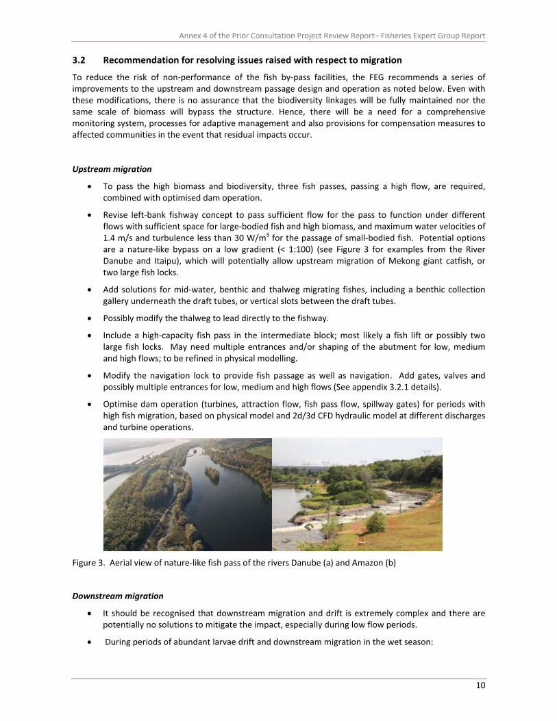
• Revise left‐bank fishway concept to pass sufficient flow for the pass to function under different flows with sufficient space for large‐bodied fish and high biomass, and maximum water velocities of 1.4 m/s and turbulence less than 30 W/m3 for the passage of small‐bodied fish. Potential options are a nature‐like bypass on a low gradient (< 1:100) (see Figure 3 for examples from the River Danube and Itaipu), which will potentially allow upstream migration of Mekong giant catfish, or two large fish locks.
• Add solutions for mid‐water, benthic and thalweg migrating fishes, including a benthic collection gallery underneath the draft tubes, or vertical slots between the draft tubes.
• Possibly modify the thalweg to lead directly to the fishway.
• Include a high‐capacity fish pass in the intermediate block; most likely a fish lift or possibly two large fish locks. May need multiple entrances and/or shaping of the abutment for low, medium and high flows; to be refined in physical modelling.
• Modify the navigation lock to provide fish passage as well as navigation. Add gates, valves and possibly multiple entrances for low, medium and high flows (See appendix 3.2.1 details).
• Optimise dam operation (turbines, attraction flow, fish pass flow, spillway gates) for periods with high fish migration, based on physical model and 2d/3d CFD hydraulic model at different discharges and turbine operations.
Figure 3. Aerial view of nature‐like fish pass of the rivers Danube (a) and Amazon (b)
Downstream migration
• It should be recognised that downstream migration and drift is extremely complex and there are potentially no solutions to mitigate the impact, especially during low flow periods.
• During periods of abundant larvae drift and downstream migration in the wet season:

Annex 4 of the Prior Consultation Project Review Report– Fisheries Expert Group Report
11
o the primary mitigation is to use the sediment sluice gates, with no differential head, which provides passage of larvae through the impoundment mitigating the hydrodynamic barrier of the impoundment and providing passage bypassing the turbines and spillway.
o the secondary mitigation is to maximise spill flow and minimize turbine passage by reducing power generation.
• During the dry period, consideration should be given to deflecting the downstream migrating fish through the fish bypass channel, hence the need to maintain adequate flows.
• Use benthic, as well as surface, screens.
• Use physical and 2d/3d CFD model to optimise screens. Screen spacing of 2 cm is required.
• Provide one or multiple overshot gates on the spillway for fish passage.
• Extend one or more spillway gates to the bottom of the reservoir to enable passage of bottom‐orientated fishes.
• Design deflectors and endsill to eliminate impact areas and minimise shear stress for fish.
• Get baseline data on larval drift to assess risk and mitigation strategies.
Fish passage during construction
• Incorporate a fish passage plan into the construction sequence.
• Investigate use of the navigation lock and intermediate block to provide fish passage during this period.
Monitoring fish passage
• It is recommended that DIDSON technology is used to monitor fish movements in the fish passage facilities. This technology is capable for visualising fish passage in turbid waters for a distance of 10‐15 m and thus suitable for the proposed fish pass.
• If PIT tag technology is adopted, the monitoring programme should widen the detection area by checking for tags in local markets to also attempt to check on exploitation patterns.
• See Section 6 for monitoring recommendations.
3.4 Risk assessment related to Xayaburi
Usually before any proposal for a run‐of‐river hydropower scheme is approved, a thorough assessment of the risks associated with the development should be undertaken. Risk assessment is a qualitative analysis of the consequence or scale of risk and the likelihood or probability of the risk occurring (Table 2). These two values are combined to produce an overall risk score (Table 3). A risk management framework operates by establishing the context (i.e. proposed hydropower development); identifying the risks on the existing situation (consequences and likelihood); assessing the risks; and treating the risks. Consequently, it is a useful tool to prioritise actions and resources, and to identify knowledge gaps, which then inform the monitoring programme. A measure of risk is typically derived by multiplying likelihood by consequence. The ratings refer to the probability (likelihood) of the impact (consequence) occurring if a scheme is proposed based on attributes about the ecology of the fish and other aquatic species and the riverine environment in which the development is being proposed. The consequence refers to the scale of the potential impact based on knowledge of ecological impact of the scheme from previous similar schemes. The ratings are, where possible, based on scientific evidence otherwise expert judgment is used, but this carries a higher degree of uncertainty in the assessment procedure that must be accounted for. Where possible, information should be drawn from approved documentation or case studies of existing schemes. Where knowledge is deficient or uncertainty high, the precautionary principle should come into force to prevent unforeseen impacts

Annex 4 of the Prior Consultation Project Review Report– Fisheries Expert Group Report
12
Table 2. Consequence and Likelihood scores.
Consequence Likelihood
Extreme Very likely
Major Likely
Moderate Possible
Minor Unlikely
Very minor (insignificant) Very unlikely (rare)
Table 3. Risk matrix.
Key: Low Moderate High Very High
Consequence
Very minor
Minor Moderate Major Extreme
Very likely M M H VH VH
Likely M M H H VH
Possible L M M H VH
Unlikely L L M M H
Likelih
ood
Very unlikely L L M M H
In this review we have assessed the risk of: i) the Proposed Design (Table 4) and ii) the Proposed Design after applying recommendations and mitigations from the present report (Table 5); the latter assesses the probability that the risk can be mitigated, which not only reflects the recommendations but also assumes ongoing discussion between the developer and the MRCS that would result in the optimal design being presented.
In these two risk assessments only the most important risks have been examined so that the consequence of these is either major or extreme and hence, the risk scores, based on differing likelihoods are Moderate, High or Very High. The risk assessment of the Proposed Design reflects the issues raised in this review, but importantly it prioritizes where the design needs to be improved. Those risks that are Very High or High are the highest priorities to address in the design. The risks can also be viewed as links in a chain for upstream and downstream migration – attraction into, passage through and exit of a fish pass are all essential to complete fish passage, as are the components for downstream passage. Hence, all risks in a horizontal block within the table need to be addressed to enable the full migration of that group to be completed. Other ecological links to complete life cycles are also essential, such as access to spawning and refuge areas, and these are addressed elsewhere in this report. The most striking feature of the two risk assessments is that the risks identified for upstream fish passage can potentially be reduced, but many of the risks for downstream passage are difficult to mitigate and there is less certainty about their effectiveness. These are the most significant risks for fish passage at the proposed dam and for fish populations in this region based on currently available information.
Identifying where there is less certainty and more risk about the design enables transparency about impacts and expected fish passage performance. It also acknowledges that the solution developed would not likely be the optimum and would likely need to be modified in the future. Where there is less certainty, an adaptive management approach should be taken, with intensive monitoring and ongoing reviews with workshops, aiming to reach an optimal solution. The uncertainty also emphasizes the need for a flexible operating strategy and a process of review, so that new knowledge can be incorporated into operations as well as modifications to fish passage facilities.

Annex 4 of the Prior Consultation Project Review Report– Fisheries Expert Group Report
13
The major issues highlighted in Table 5 following design modifications proposed in this report are mostly related to downstream migration, especially drift of larval life stages. It illustrates where bottlenecks to maintaining fish life cycles, and thus sustainable fisheries, are likely to occur and where efforts to overcome these problems should focus. Unfortunately, there are no obvious design modifications beyond those proposed that can further mitigate these issues, but dialogue should continue between the developer and MRC through the design phase to try and identify opportunities that may arise. The potential disruption of downstream migration and drift could have serious ramifications for maintaining the fishery production for this region, as highlighted in Section #.1.

Annex 4 of the Prior Consultation Project Review Report– Fisheries Expert Group Report
14
Table 4. Risk Assessment of Proposed Design. The table scores risks for passage based on criteria in Table 3 for each size class, behaviour category, and biomass.
Upstream Migration Downstream Migration Limited attraction
and entry into fish passage facilities
Limited ascent of fish pass
Ineffective exit – risk of fallback
Limited passage through impoundment
Limited attraction and entry into fish passage facilities
Limited passage and low survival at dam
Poor exit; risk of predation downstream
Life Stage Larvae & fry N/A N/A N/A Very High Very High Very High High Small‐bodied species (15 ‐30 cm) Moderate Very High Moderate High High Very High Moderate Medium‐bodied species (30‐150 cm) Moderate Moderate Moderate Moderate Very High Very High Moderate Large‐bodied species (150‐300 cm) Very High Very High Moderate Moderate Very High Very High Moderate Behaviour Surface Moderate Moderate Moderate N/A Moderate Moderate Moderate Mid‐water High Moderate Moderate N/A High High Moderate Benthic (including thalweg) Very High High Moderate N/A Very High Very High Moderate High Biomass Powerhouse Operating High Very High Moderate Very High Very High Very High High Powerhouse and Spillway Operating Very High Very High Moderate Moderate High Moderate High Table 5. Reassessment of risk of Proposed Design after applying recommendations and mitigations outlined in the present report. Upstream Migration Downstream Migration Limited attraction
and entry into fish passage facilities
Limited ascent of fish pass
Ineffective exit
Limited passage through impoundment
Limited attraction and entry into fish passage facilities
Limited passage and low survival at dam
Poor exit; risk of predation downstream
Life Stage Larvae & fry N/A N/A N/A Very High Very High Very High High Small‐bodied species (15 ‐30 cm) Moderate Moderate Moderate High High High Moderate Medium‐bodied species (30‐150 cm) Moderate Moderate Moderate Moderate Very High High Moderate Large‐bodied species (150‐300 cm) High High Moderate Moderate Very High High Moderate Behaviour Surface Moderate Moderate Moderate N/A Moderate Moderate Moderate Mid‐water Moderate Moderate Moderate N/A High High Moderate Benthic (including thalweg) High Moderate Moderate N/A High Very High Moderate High Biomass Powerhouse Operating Moderate High Moderate Very High High Very High High Powerhouse and Spillway Operating Moderate High Moderate Moderate Moderate Moderate Moderate

Annex 4 of the Prior Consultation Project Review Report– Fisheries Expert Group Report
15
3.5 Future development of the design
• The Design Report recommends “continuous dialogue with GOL, MRC and their expert groups”.
• It is recommended that continuous dialogue is maintained between the MRC, the Project Developer and other stakeholders to produce the most effective outcome for the project and for the countries of the Mekong.
• As a first step it is recommended that a workshop with the Developer’s Design Team to:
i) discuss the review, ii) develop a design process which includes continuous dialogue, and may include the
formation of a joint technical working group, and iii) discuss the most effective options for assessment and design development.
At this stage it is not possible to estimate the costs of the proposed changes because the recommendations are dealing with very broad concepts, and each concept would need an engineering assessment. Also the various concepts will likely change as discussions between the Developer and MRCS progress. It is important at this stage to establish: i) broad fish objectives (e.g. minimising loss in productivity; maintaining upper Mekong migration system), ii) specific fish passage objectives (e.g. upstream passage of benthic species) and iii) options that could meet these objectives (e.g. benthic collection gallery). The second stage is to workshop these options with the Developer (one of the recommendations) and thereafter the most feasible options should be costed, which would require appropriate design work by the Developer. Finally, the cost estimates should be used to select the option with the greatest benefit/cost. Adopting the workshop approach in the near future should not lead to any significant delay in presentation of the final proposal.
In terms of potential delays in construction’ the most important step at this stage is to establish the concepts that influence the major aspects of the design and footprint of the dam. Potentially the recommendations would cause little delay if the concept has not progressed beyond the Design Report and the drawings examined. It should be recognised that costs and delays are likely to escalate if large scale changes are made later in the design process, when opportunities to change the design obviously diminish as the project progresses. Early and frequent communication is essential at this formative stage of development.
4 Construction phase impacts This is one aspect of the Project Design that has been given little attention. Impacts during the construction phase concern environmental degradation, disruption of fish migration and loss of fish production. Impacts during the operational phase are equally important and encompassed in the impacts of the dam itself in terms of barriers to fish migration and mortality through turbines, together with superficial commentary on loss of biodiversity and fish production. The latter issues are discussed in detail in Annex 1 Sections 2 and 3, but there must be recognition that fisheries will potentially be heavily impacted during the construction phase. These impacts arise from a number of sources:
• Construction inevitably increases sediment loading and pollution (e.g. oil leakages) in the downstream reaches and these clog gills of fish and invertebrates (food of fish) leading to increased mortality and reduced growth rates.
• Most of the Mekong fishes are substrate spawners (either lithophils or phytophils), therefore, sediment and silt in the water can bury and harm fish eggs. It is unlikely (as mentioned in the EIA Page 5‐12) that there will be no significant change on spawning activities of fish.
Annex 4 of the Prior Consultation Project Review Report– Fisheries Expert Group Report
16
• Primary producers become less abundant in the impacted area because of the higher turbidity and siltation from the earth works. This will not only affect the low trophic level fauna but eventually the whole ecosystem. Thus there is likely to be considerable impact on plankton and benthic fauna that will cascade to higher trophic levels and eventually fish productivity.
• There is likely to be some diversion of flows during the construction phase and without an effective fish pass in place this could impede upstream and downstream migration (see section 3.3).
Considering the construction phase is up to 7 years these impacts are potentially long term and it is possible the fish populations will not recover from any disruption of stocks. Stronger provisions need to be made in the design proposal to mitigate these issues, including timing the construction and commissioning of the fish passage facilities to overcome any potential problems arising. The developers should also stage earthworks and implement appropriate measures to minimise erosion.
5 Socio‐economic issues 5.1 Importance of fisheries resources Fisheries resources (i.e. fish, other aquatic animals, and useful aquatic plants) have long been central to the lifestyles of four riparian countries of the Lower Mekong Basin (LMB), particularly to communities living in and around the corridor of 15 km of the river and its dependent floodplains. Some 40 million people or about two‐third of the LMB population are involved in the Mekong’s fisheries at least part‐time or seasonally. In Lao PDR, more than 70% of rural households are dependent on fishing and collecting other aquatic animals (OAAS) and useful aquatic plants (UAPs) to varying degrees for subsistence livelihoods and additional cash income. Consequently any risks and losses incurred by the Mekong terrestrial and aquatic ecosystems brought about by dam developments translate into threats to the livelihoods of millions of people – primarily through increasing food insecurity in the basin. Unfortunately, there is limited information on the socio‐economic dimensions of the dam proposal in the impacted region, including the importance of the fishery to food security and rural livelihoods, number of people affected and loss of ecosystem services to rural communities. In particular the Xayaburi EIA report provides only limited baseline and impact information on socioeconomic conditions of people living in the mainstream hydropower project‐affected areas (i.e. 20 km upstream of the Mekong River and 2 km downstream of Mekong River). It is mainly related to (1) public health and nutrition; (2) aesthetics, tourism and archaeology; (3) land use; and (4) land transportation and navigation, but did not provide any information and data on water resources related livelihoods, food security and nutrition. Furthermore, and critically, trans‐boundary baseline and impact information on socioeconomics and livelihoods were given little attention in the EIA report. This prevents a realistic assessment and formulation of (1) effective mitigation measures, (2) a practical and scientific standardized monitoring programme, and (3) an environment management plan to minimize negative impacts and gain positive impacts from the Xayaburi mainstream hydropower project.
5.2 Recommendations
• There is a need for a detailed baseline study on the socio‐economic impacts both in the immediate Xayaburi reach, including to the most upstream area likely to be impounded, and any trans‐boundary areas likely to be impacted by the development. This should include information and data on socioeconomics and water resources‐related livelihoods of people living within a corridor of 15 km either side of the Mekong River and its dependent

Annex 4 of the Prior Consultation Project Review Report– Fisheries Expert Group Report
17
tributaries and floodplains in Xayaburi mainstream project areas, Lao PDR (particularly the southern Lao Champassak Province), Thailand (particularly the northern Thai Chiang Rai areas), Cambodia (particularly the Cambodian Tonle Sap Great Lake areas) and Vietnam (particularly the Vietnamese Mekong delta areas). The baseline information required is outlined in Annex 1, Section 4, but the following indictors are proposed for long term monitoring programme of the Xayaburi hydropower project.
o Baseline vulnerability of water resources‐dependent communities o Dependency on fish o Dependency on OAAs o Dependence on UAPs or/and edible algae (EA) o Dependency on irrigation and riverbank cultivation o Resilience o Risks/shocks and trends
• In cases where it is not possible to mitigate the impacts of major infrastructure on people’s livelihoods, it may necessary to compensate the impacted households financially. The estimate of compensation costs by the developer for loss of people’s socioeconomic conditions and livelihoods is not appropriate and only relates to the Xayaburi hydropower project‐affected areas. Whilst it is not proposed that the Xayaburi developer compensates for losses beyond the immediately impacted area, the trans‐boundary impacts should be identified to enable appropriate compensation strategies to be developed. This is discussed further in Section #,7. The data/indicators collected through the proposed monitoring programme should be used to compute the likely costs of such compensation both locally and regionally. Mechanisms for funding the compensation actions that are not totally reliant on the developer, e.g. user‐pays principle, should be explored.
6 Fisheries monitoring, mitigation and compensation measures
6.1 Monitoring and mitigation measures proposed by the developer
• Only basic information is given on monitoring the fish populations and management of fisheries during and after the construction phase.
• The monitoring protocol proposed does not address some of the essential issues, such as downstream passage success and survival through turbines, and appears to be underfunded. It is not clear how either would be maintained for the life of the project.
• The findings on baseline conditions and impacts in the EIA are only general. Many issues are not covered, especially, the social and economic impacts, livelihoods analyses.
• There are likely to be considerable impacts during the construction phase concerning environmental degradation, disruption of fish migration and loss of fish production that have not been considered.
• The mitigation measures proposed relate mainly to management of the fisheries production in the reservoir rather than mitigation and compensation mechanisms required to address losses of migratory species that do not successfully pass the dam structure.
• The information provided are only responses to enhance fisheries in the impoundment, but because this reservoir is likely to be relatively unproductive, this offers no real solutions to compensate for loss of fishery production and does not address social and economic issues, fishery access issues or alternative exploitation tools and techniques.
Annex 4 of the Prior Consultation Project Review Report– Fisheries Expert Group Report
18
6.2 Proposed fisheries management and mitigation
The mitigation measures proposed are weak and more related to management of fisheries production in the reservoir impoundment rather than true mitigation and compensation mechanisms. They are orientated around stocking the impoundment, substitution of lost fish production through aquaculture and provision of fisheries staff to support development in the fishing community. These measures offer no real solutions and will unlikely compensate for loss of fishery production and do not address social and economic issues, fishery access issues or alternative exploitation tools and techniques. In particular, it is not known what role the fisheries personnel to be funded will pay, especially as building skills in aquaculture is unlikely to compensate local fishing communities for disruption to food security and livelihoods. The latter is a common misconception that local communities will take up aquaculture as an alternative to lost capture fishery production, but this requires considerable capital investment and recurring costs (mostly for purchase of fish feed) to be sustainable. Most rural communities do not have this capacity to invest and it is the more wealthy section of society that adopts these measures. Similarly, stocking is not considered an adequate solution because the impoundment above Xayaburi dam will be shallow, has a short retention time of approximately 3 days and subject to approximately 0.5 m daily water level fluctuations. This disrupts fish recruitment dynamics and food production in the reservoir.
Unfortunately there is no definitive solution to mitigate the lost fish production in the Xayaburi dam area. The changes in topography and flow dynamics preclude alternative solutions such as stocking and cage farming and none fisheries solution to compensate lost livelihoods will probably have to be sought. It is recommended, therefore, that a thorough situation analysis is carried out to determine the capacity of the local fishing communities to adapt to the potential changes that will arise from the proposed dam. There is also a need to undertake an alternative livelihoods analysis within the communities, again to identify opportunities for compensating losses incurred by the dam.
6.3 Proposed measures for upstream migration during the construction phase
Construction of the project is planned for 7¾years and will include two main phases when the river is modified by cofferdams. The first phase is scheduled for three years and will involve right bank construction of the spillway, navigation lock and part of the intermediate block. The river will remain in the original channel during this period and cofferdams will be used to isolate the work areas. Fish migration, navigation, and other in‐stream uses will be restricted to the left river channel
The second phase of the construction involves completion of the remainder of the intermediate block, the powerhouse, and the left bank fish passing facilities. During this period the reservoir will fill with water being discharged through the open spillway gates and over the sill of the spillway. The reservoir level will vary depending on the river flow. Upstream fish migration during the second construction stage appears to be restricted to the use of the navigation lock as the head difference across the spillway will be too large, while downstream migration is designed to occur through the spillway. This will likely lead to large scale disruption of upstream migration and potential extirpation of local stocks. It is therefore recommended that fish passage facilities are implemented in a phased approach with the nature‐like fish pass constructed during the first phase of the dam construction to be operation during the second phase.
6.4 Monitoring and assessment protocols
Throughout the EIA and Design Report, there is a lack of a comprehensive monitoring programme of the fish population dynamics and migratory behaviours that can be used to optimise fish passage and power generation. This limits the capacity to design mitigation measures for fish passage and offer opportunities to compensate for potential lost fish production and social disruption. It is
Annex 4 of the Prior Consultation Project Review Report– Fisheries Expert Group Report
19
therefore recommended that a comprehensive monitoring programme is established before and after dam construction, which includes:
• Composition, biomass, seasonality, diel patterns of migratory population: i) approaching the dam from upstream and downstream, ii) locating the fish passes, iii) ascending the fish passes, iv) leaving the fish pass and passing through the impoundment.
• Composition of the fish community: i) upstream of the proposed reservoir, ii) within the proposed reservoir, iii) downstream of the proposed reservoir.
• Migratory behaviour and fate (telemetry study of large fishes) of upstream and downstream migrating fishes.
• Comprehensive review and field monitoring of shifts in hydrology and geomorphological characteristics of the river upstream and downstream of dam during and after construction compared with the actual situation, including options for environmental flows.
• Transport and fate of larvae drifting into the low water velocity of the impoundment and at the dam and turbines.
• Monitoring needs to be linked to performance indicators and standards, and linked to dam operation.
• The monitoring should cover all animal species and extend to plants, which are equally relevant as many fish species also eat these algae and other fauna.
The monitoring protocol needs to be targeted and more comprehensive to account for daily and seasonal variability in ecological characteristics related to hydrological conditions, as well as establishing an early warning system to be proactive to respond to potential impacts of the development. This requires a realistic and properly costed monitoring programme that should build on existing MRC larval drift surveys, fisher catch monitoring, household surveys and market studies. The financial resources allocated to the monitoring programme are not sufficient given the high cost of such work and the scale of issues to be covered.
7 Fisheries, Xayaburi dam project and its trans‐boundary implications Impacts of multiple dams and transboundary effects have been analysed in detail in two studies: (1) BDP ‐ Basin Development Plan Programme ‐ Assessment of Basin‐wide Development Scenarios (MRC 2010) and (2) SEA MRC Strategic Environmental Assessment of hydropower on the Mekong mainstream (SEA, ICEM 2010). The studies differ in terms of scenarios analysed and methodology used. While BDP covers 16 scenarios related to the countries, SEA focuses on three scenarios related to 6 hydro‐ecological zones ((1) Lancang River; (2) Chiang Saen to Vientiane; (4) Vientiane to Pakse; (5) Pakse to Kratie; (6) Kratie to Phnom Penh).
1. Scenario 1: Baseline 2000 – Three existing Chinese mainstream dams (Manwan, Dachaoshan, and Jinghong), plus fifteen tributary dams.
2. Scenario 2: Definite Future 2015 – Eight existing and planned mainstream Chinese dams, plus twenty‐six tributary Dams.
3. Scenario 3: Foreseeable Future (i) – Eight existing and planned mainstream Chinese dams, without other planned mainstream dams, plus seventy‐one tributary dams.
4. Scenario 4: Foreseeable Future (ii) – Eight existing and planned mainstream Chinese dams, six mainstream dams in Lao PDR, plus seventy‐one tributary dams.
5. Scenario 5: Foreseeable Future (iii) – Eight existing and planned mainstream Chinese dams, six mainstream dams in Lao PDR, five Cambodia dams, plus seventy‐one tributary dams.

Annex 4 of the Prior Consultation Project Review Report– Fisheries Expert Group Report
20
To analyse the trans‐boundary effects of Xayaburi and the 6 mainstream dams in Laos, comparison between the Definite Future and Foreseeable Future (ii) is considered the most relevant.
Fish migration The first and foremost concern is the disruption to fish migration both in an upstream and downstream direction. These impacts are discussed more fully in Annex 1 Sections 2 and 3. The principal problem arises with potential disruption of long distance migrators that move considerable distances upstream to spawning grounds around and above Luang Prabang, including into tributaries in NE Thailand. These species tend to be important food fishes for both subsistence and commercial fisheries. Three main migration systems have been postulated: the lower migration system (from the Delta up to Khone Falls), the middle migration system (from Khone Falls up to Vientiane) and the upper migration system (from Vientiane up to China) (Poulsen et al. 2002).
However, these assemblages almost certainly support intermixing populations and some species will migrate between the units (e.g. Mekong giant catfish that spawns above Luang Prabang) and between the main river and tributaries. Recently, new migratory behaviours were identified for Pangasius krempfi, an important commercial species, spending a part of its life at sea and in the brackish water of the Mekong Delta before returning to spawn in fresh water. This anadromous fish travels at least 720 km to the Khone Falls, and possibly further upstream (Hogan 2007). If this species is obligatory anadromous populations found in Laos are depending on a free migratory corridor from the delta.
According to Poulsen et al. (2002) at least one third of Mekong fish species need to migrate between downstream floodplains where they feed and upstream tributaries where they breed. Quantifications of the contribution of migratory fish to the total fisheries yield of the LMB are not available. However, some fishery data underline the high importance of migratory fish: e.g. five species (Pangasius krempfi, Pangasius conchophilus, Paralaubuca typus, Pangasius macronema and Botia modesta) represent 47% of the total annual catch at Khone Falls (Baran 2006), and longitudinal migrants contribute 63% to the catch of the major Tonle Sap fisheries (Van Zalinge et al. 2000).
Although little is known about spawning requirements for most Mekong fishes, spawning habitats are generally believed to be associated with: (1) rapids and pools of the Mekong mainstream and tributaries; and (2) floodplains (e.g. among certain types of vegetation, depending on species). River channel habitats are, for example, used as spawning habitats by most of the large species of pangasiid catfishes and some large cyprinids such as Cyclocheilichthys enoplos, Cirrhinus microlepis, and Catlocarpio siamensis. Floodplain habitats are used as spawning habitats mainly by black‐fish species (Poulsen et al. 2002).
Other species may spawn in river channels in the open‐water column and rely on particular hydrological conditions to distribute the offspring (eggs and/or larvae) to downstream nursery rearing habitats. Information on spawning habitats for migratory species in the river channels of the Mekong Basin and described for only a few species, such as Probarbus spp. and Chitala spp., mainly because these species have conspicuous spawning behaviour at distinct spawning sites. For most other species, in particular for deep‐water mainstream spawners such as the river catfish species, spawning is virtually impossible to observe directly. Information about spawning is instead obtained through indirect observations such as presence of ripening eggs in fish. For fishes that spawn in main river channels, spawning is believed to occur in stretches where there are many rapids and deep pools, e.g. (1) the Kratie–Khone Falls stretch; (2) the Khone Falls to Khammouan/Nakhon Phanom stretch; and (3) from the mouth of the Loei River to Bokeo/Chiang Khong. Kratie‐Khone Falls stretch and the stretch from the Loei River to Luang Prabang are particularly important for spawning (Poulsen et al. 2002).
The existing data on migration suggests that Xayaburi is located in the middle of the upper Mekong migration system; hence the risk of poor fish passage is disruption of this migration system. Potential loss of those species dependent on migration past Xayaburi may lead to a possible fall in catches of

Annex 4 of the Prior Consultation Project Review Report– Fisheries Expert Group Report
21
important fish species. Some important larger‐sized fish species (e.g. Mekong giant catfish) use the whole length of the Mekong River and for these species migration past Xayaburi to key spawning areas might be critical. The proposed Xayaburi Dam would be the first mainstream dam within a major migration zone of the Mekong downstream of the Chinese dams and will likely contribute to disruption of indigenous fish production.
In view of the lack of detailed information on migration in the Xayaburi region, data on the loss of accessible upstream habitat in the mainstream and tributary system can be used as a surrogate for impacts on migratory fish populations (SEA):
• In 2000, 20.6% of the Lower Mekong Basin was already blocked by 16 dams and was inaccessible to fish species having to migrate to the upstream parts of the river network
• In 2015, this area will have increased by 14% (from 164,000 to 188,000 km2) totalling in 35 % of the Lower Mekong Basin;
• If no mainstream dams are built, the surface area made inaccessible to long distance migrant fish by dams on tributaries will represent 37.3% of the watershed.
• If all dams are built 81% of the basin will be blocked to migrant fish. The Lao upstream cluster of dams would directly block migration of at least 23 fish species, the Lao middle cluster of dams would block migration of at least 41 fish species and the Cambodian cluster of dams would block migration of at least 43 fish species (representing a third of the total annual Mekong fish yield). In addition, 58 species are highly vulnerable to mainstream dam development and a further 26 species are at medium risk of impact. Those 84 species only represent species at risk because of their migratory behaviour; the figure does not include the many species at risk because of environmental changes brought about by dams (e.g. another 41 species found only in the mainstream upstream of Vientiane are at risk if a cluster of 6 dams turns 90% of this river section into a reservoir). Overall the total number of species at risk of mainstream dam development is likely to be greater than 100, but is not precisely known (SEA).
It should be recognized, however, that non‐native species may exploit the opportunity to expand their populations in the newly created environment in the impoundment. Whether this will occur will depend on the environmental characteristics in the reservoir, but in Xayaburi these are potentially not conducive to exploitation by species such as Chinese carps and tilapia (see below).
A further complication arises if upstream migration can be facilitated by appropriate fish passage design, but downstream migration is disrupted by low velocities in the impoundment preventing downstream drifting of fish eggs, larvae and juvenile life stages and potentially high mortality of these and adult life stages occurring through the turbines (see sections #.3.1). Overall, the disruption to these migratory patterns could lead to local expiration of fish species, loss of production and fish yields of major food fish species, and possibly loss of genetic diversity in the LMB.
Inundation of refuge and spawning habitats The impounded water of the proposed dam would inundate deep pools and the change in hydrodynamics, from a pool in a complex flowing water habitat to a uniform slower flowing habitat, is likely to reduce their ecological value for fish due to reduction in complexity. If spawning areas are present within the impounded area, fish would no longer use them once they are inundated. The extent of spawning areas in the inundated area is unknown and the extent that these and the deep pools are used by fish from elsewhere in the LMB is unknown. However, there is a risk these are significant areas for migratory fishes from the upper Mekong migration system and these fish would be impacted by the proposed dam, together with possibly some long‐distance migrators. Without knowledge of the migration patterns of species in the Mekong it remains difficult to predict the overall disruption of Xayaburi on fish productivity and catches. If all dams are built, 76% of all rapids; 48% of all deep pools; and 16% of all sand bars are lost (SEA).

Annex 4 of the Prior Consultation Project Review Report– Fisheries Expert Group Report
22
Flooding and hydraulic regimes in lower basin and delta. Water levels in the delta are predicted to be higher during the dry season as a result of stabilised flows from various hydropower impoundments proposed, but potentially be lower during the peak flows in the flood season. Any impact from Xayaburi dam will, however, be much less than dams such as Nam Ngum and Nam Theun 2, which have a much bigger storage capacity.
Another potential impact of construction of all the dams on the mainstream is alteration of the flooding and tidal dynamics in the delta with the likelihood of reduced saline intrusion. One outcome of this change in saline intrusion is dissipation of the sterilizing benefits of higher salinity waters, potentially leading to greater prevalence of pathogens which may ultimately impact on the Pangasius aquaculture production in the region. Construction of all the dams is predicted to disrupt the flooding patterns into the Tonle Sap, with predicted loss in fish production. The contribution of Xayaburi to disruption of flooding and tidal regimes is likely to negligible given it is a run‐of‐river scheme with a reservoir retention time of 3‐4 days.
The capacity of fish to bypass natural and artificial barriers can also be compromised by the altered flow dynamics. Essentially fish have adapted to being able to negotiate barriers such as the Khone Falls under specific hydraulic conditions. If these hydraulic conditions are disrupted during critical periods, there are potential implications for migration throughout the LMB.
The major impact from the combined effect of the Yunnan cascade and the tributary developments will be the loss of the transition seasons in Zone 2 resulting from a more even hydrograph. The spates and first flushes of the transition to flood play an important part in triggering key ecosystem functions of the Mekong system including spawning and migration of aquatic biota, which will no longer occur under the 2030 foreseeable future scenario (SEA) for the following reasons.
• Timing: The timing of transition from the dry to the flood season will be most affected, starting approximately 7‐ 8 weeks earlier at Chiang Saen and about 1 week earlier at Kratie.
• Duration: Upstream of Pakse will experience a 2‐4week reduction in the duration of the transition season from Dry to Flood, which will drop to about 1 week in the Mekong floodplain. The duration of the flood season is not expected to be significantly affected except at the uppermost reaches of the LMB where the UMB flows still dominate wet season volumes.
• Magnitude: dry seasonal flows will increase by 70% at the most upstream stations falling to about a 10% increase in the Mekong Delta. Conversely, wet season flows will decrease by up to 18% in upstream stations decreasing to 2% change in the Mekong Delta.
• Flooded area: 2030 will see a typical reduction of about 300,000 ha in flooded area, the majority of which will affect areas with flood depths greater than 3 m. This will affect more than 15% of the flooded area in Thailand and Lao, and less than 5% of the area in Cambodia and Viet Nam.
Altered timing and magnitude of flow could severely impact migratory behaviour of fish. Although eight distinct waves of fish migration occur annually at Khone Falls in southern Lao PDR, 96% of the fish are caught at discharge rates of 2000 to 8000 m3/s, with a narrow range of the most important discharge for fisheries between 2000 and 3000 m3/s (Baran 2006).
Sediment and nutrient dynamics The cascade of 8 dams planned for Yunnan Province and the tributary projects of the LMB will reduce the sediment load of the Mekong River by 50% at Kratie and in the order of 80% in Zone 2. A significant load of nutrients is attached to these sediments resulting in a significant reduction in nutrient loads which will further reduce the productivity of the Mekong system (SEA).

Annex 4 of the Prior Consultation Project Review Report– Fisheries Expert Group Report
23
The MRC sediment review has highlighted potential changes in sediment dynamics throughout the LMB as a result of Xayaburi. However, Xayaburi and the other mainstream dams in Lao contribute little to the figures given above.
It is possible that judicious management of the sediment loadings behind the dam through routing, passing or flushing may offset the downstream loss of sediment to a certain extent, but delivery of sediment will most likely be single events over very short time periods each year. These need to be timed and managed to avoid sediment deposition of deep pools downstream or direct impacts of smothering on vulnerable life stages of fish and food resources.
The main potential downstream impact of Xayaburi and other Lao dams will be reservoir flushing. Conduits designed to flush sand deposited immediately upstream of the power house might cause critical loads of suspended sediments in downstream river sections that can result in fish kills. Reservoir flushing should therefore be limited to high flow conditions and guidelines for maximum concentration of suspended solids and flushing duration should be established.
8 Implications of multiple dams It must be recognised that Xayaburi is just one of 11 mainstem dams proposed in the LMB, in addition to 26 (40) new tributary dams by 2015 and 56 (71) tributary dams by 2030. The impacts of each individual dam are likely to be similar to those expounded throughout this report, although the spatial scale and intensity of the impact will vary depending of the dam design and operation, and success of proposed mitigation measures. The impact of the dams constructed in the middle and lower migration systems, i.e. above Khone Falls to Vientiane and below Khone Falls, will be greater than in the upper migration zone in the vicinity of Xayaburi. However, this does not mean that one should be complacent because the impact of each dam and the cumulative and additive impact of all dams is likely to be considerable. The key issues regarding the potential cumulative impact of multiple dams systems are as follows.
Multiple interruptions of fish passage Effects of multiple barriers to migration: each dam will potentially reduce the number of fish that are able to move further upstream. Even if the fish passage facilities are 95% efficient for all species, which is highly unlikely to be so effective, the cumulative effects will be multiplicative not additive. In addition, fish tire from continuous swimming up fish passes and the probability of bypassing several dams in series decreases with each successive dam.
Each impoundment will individually disrupt drift to replenish downstream fisheries. The scale of this disruption will depend on the hydraulic regime in the impoundments and downstream passage facilities. Again the cumulative effects of several dams will be multiplicative not additive.
As indicated previously, substantial mortality is likely to occur through the turbines. The level of mortality is potentially high, irrespective of the assertion that the turbines are ‘fish friendly’. The cumulative mortality rates through successive sets of turbines are likely to be considerable to the detriment of the fish recruitment and production.
Halls & Kshatriya (2009) modelled the cumulative barrier and passage effects of mainstream hydropower dams on migratory fish populations in the Lower Mekong Basin. In order to maintain viable exploited populations of the small species, fish ladders, locks or other structures would need to pass at least 60% to 87% of upstream migrating adults in the case of a single dam, rising to 80% to 95% if adult fish were obliged to cross two or more dams, to reach critical upstream spawning habitat. The results are based on estimated turbine mortality of 2% – 15%. However, much higher mortalities are expected to occur at LMB mainstream dams because of sudden pressure differences during turbine passage due to the high head of the dams. For large species (> 50 cm; H. malcolmi, C. harmandii, P.conchophilus, P. jullieni and P. gigas) passage of more than one dam would result in
Annex 4 of the Prior Consultation Project Review Report– Fisheries Expert Group Report
24
extinction of populations even if engineering solutions could be developed to re‐direct 75% of downstream migrating adults away from dam turbines and if upstream migrations were completely unhindered, i.e. 100% upstream passage success which cannot be achieved in reality (Halls & Kshatriya 2009).
Impacts of reservoirs The overall impact of a cascade of dams is modification of the riverine ecosystem into a series of lacustrine water bodies. This will result in flooding of spawning and nursery habitats and collapse of the traditional river stocks and fisheries. The fish community structure will inevitably change and productivity almost always declines, changing from large valuable riverine species to small still water species or a proliferation of alien invasive species such as Chinese carps or tilapia. The problem that is faced in the mainstream Mekong is that the impoundments that are created upstream of many of the dams are not conducive to natural fish production so there is the likelihood that yield from the modified river is heavily compromised and cannot be compensated by stocking or aquaculture. The situation could be further exacerbated by accumulation of sediments in the impoundments that smoother potential spawning habitat. The addition of the LMB mainstream projects will (SEA):
• Significantly reduce stream power and water velocity resulting in enhanced sedimentation and the formation of large deltaic‐type deposits at the head of each of the reservoirs. This will see sediment accumulate in sections of the river where it has never accumulated in the past; ��
• Increase the rate of sedimentation in areas of the reservoir not influenced by scour flow from the spillway and sediment gates – dependent on the sequencing of construction;
• Change the mechanics of sediment transport, by reducing the velocity of mean annual flood flow through the reservoir so that medium‐sized particles that moved in suspension will now move only partially in suspension and coarse‐sized particles that moved partially in suspension and partially as bed load will now move as bed load or not at all, causing greater retention rates in the impoundment of both medium and coarse sediment;
• Increase down‐cutting and channel bed and bank erosion in alluvial reaches of the Mekong (Zone 3); projects proposed for Zone 2 will further reduce the supply of bed load to the alluvial reach between Vientiane to Pakse, which will induce re‐mobilisation of the channel and bed sediments within the reach, increasing loss of riparian vegetation and agricultural areas (islands and riverbanks) as well as altering the course of the river thalweg.
The Lao cascade of 6 mainstream dams would transpose 90 % of Zone 2 into a cascade of reservoirs resulting in a loss of 39 % of riverine habitat within the LMB. During the dry season the flow velocity will be reduced to the level of stagnant waters, but during wet season flow conditions are again similar to pre‐impoundment conditions. Run‐off the river impoundments are therefore “hybrid systems”, which loose the function of rivers but do not fully gain those of natural lakes or stagnant reservoirs. Consequently, both riverine fish species and “stagnant” species have difficulties to develop viable populations. Even “generalists” have major problems to cope with the divergent flow conditions. Therefore, the expected fish production and potential fishery yield will be very low compared with current conditions (probably only 10 %).
A further problem that arises from the shift in habitat characteristics and species assemblage is the direct impact on fishing communities and food supply. Traditional capture methods will no longer be appropriate and the fishers will have to cope with change in capture methods and prevalence of more static water species. The loss of productivity and collapse of major traditional river fisheries could lead to social disruption. Mitigation measures such as cage culture or stocking are unlikely to compensate for this change or loss (see below).

Annex 4 of the Prior Consultation Project Review Report– Fisheries Expert Group Report
25
Estimated fisheries losses for dam scenarios A preliminary estimation of the likely impacts of dams on the extent and condition of habitats important for fisheries has been provided by the BDP for (i) river‐floodplain wetlands, (ii) rainfed wetlands and (iii) reservoirs. Fisheries yield per unit area is much higher in river‐floodplain wetlands than in the rainfed zone, but the river‐floodplain zone is much smaller, so total yield from the two main zones is similar. Reservoirs are of minor importance and contribute only 10 % to the overall yield (for details see “BDP Technical Note 11 ‐ Impacts on Fisheries; MRC 2010).
River‐floodplain wetlands (BDP estimates)
If all dams would be built the total loss to river‐floodplain catches is hypothesised as 593,000 tonnes per year or about 58% of the total yield from this habitat class. The country experiencing the largest impact as a percentage of existing catches would be Lao PDR, with a loss of 84% of its baseline of 92,000 tonnes, because of the likely high proportion of river‐dependent fish. However, the highest loss in absolute terms and the largest component of total losses will be in Cambodia, which would lose 354 of 565,000 tonnes, a 63% loss. Thailand (48 of 117,000 tonnes) and Viet Nam delta (105 of 260,000 tonnes) would experience smaller but nevertheless significant impacts by 2030 if all dams are built.
Comparable high impacts on river‐floodplain wetlands are estimated for Lao for the scenario without the mainstream dams in the lower LMB (73%) and the scenario without mainstream dams (64 %). Compared with the definite future scenario the impact of dams increases from 57 % to 73 % (+16 %) in the case of the lower LMB dams.
Total fisheries losses (SEA estimates)
The estimates fisheries losses are associated with a high level of uncertainty. Therefore, only ranges of total losses can be given:
• In 2015 the loss of fish compared to the 2000 baseline is expected to range between 150,000 and 480,000 tonnes annually. This fish loss will be due to 31 new dams on tributaries and to other factors such as loss of floodplains, habitat fragmentation, fishing intensification, etc.
• In 2030, with development basin wide and a total of 56 dams on tributaries, the loss of fish compared with the year 2000 is expected to amount to 210,000 – 540,000 tonnes in the absence of mainstream dams. This represents a loss of 10 to 26% of the baseline production or 3‐4% of the 2015 production, even though mainstream dams are not built.
• In 2030, if 6 dams are built upstream of Vientiane, a loss ranging between 270,000 and 600,000 tonnes is expected compared with the situation in 2000 (i.e. a fall of 13 – 29%). The additional loss compared with the situation in 2030 without mainstream dams would represent about 60,000 tonnes. This assessment is very conservative and is likely to be substantially higher than 60,000 tonnes ‐ but at this time it cannot be quantified.
• In 2030, if 11 mainstream dams are built in the LMB, the total fish loss forecasted would amount to 550,000 – 880,000 tonnes compared to the baseline (i.e. minus 26 – 42%).
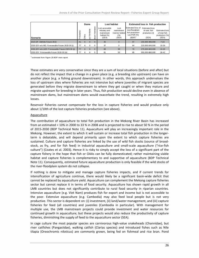
Annex 4 of the Prior Consultation Project Review Report– Fisheries Expert Group Report
26
Scenario Trib
utar
ies
Chi
na
up V
ient
iane
dow
n V
ient
iane Lost accessible
tributary and mainstream habitat (%)
(SEA)
Lost mainstream
riverine habitat (%)
(SEA)
Estimated loss of river/floodplain fish production Lao PDR (%)
(BDP)1
Estimated loss of total fish
production (t)
(SEA)
Estimated loss of total fish
production (%)(SEA)
2015-DF: Definite Future 2015 41 6 0 0 35 0 57 150,000-480,000 7-23
2030-20Y-w/o MD: Foreseeable Future 2020-30 (i) 77 6 0 0 37 0 64 210,000-540,000 10-26
2030-20Y-w/o LMD: Foreseeable Future 2020-30 (ii) 77 6 6 0 69 39 73 270,000-600,000 13-29
2030-20Y: Foreseeable Future 2020-30 (iii) 77 6 6 5 81 55 85 550,000-880,000 26-42
1 estimated from Figure 25 BDP main report
Lost habitatDams Estimated loss in fish production
These estimates are very conservative since they are a sum of local situations (before and after) but do not reflect the impact that a change in a given place (e.g. a breeding site upstream) can have on another place (e.g. a fishing ground downstream). In other words, this approach undervalues the loss of upstream sites where fisheries are not intensive but where juveniles of migrant species are generated before they migrate downstream to where they get caught or when they mature and migrate upstream for breeding in later years. Thus, fish production would decline even in absence of mainstream dams, but mainstream dams would exacerbate the trend, resulting in extremely high losses.
Reservoir fisheries cannot compensate for the loss in capture fisheries and would produce only about 1/10th of the lost capture fisheries production (see above).
Aquaculture
The contribution of aquaculture to total fish production in the Mekong River Basin has increased from an estimated < 10% in 2000 to 33 % in 2008 and is projected to rise to about 50 % in the period of 2015‐2030 (BDP Technical Note 11). Aquaculture will play an increasingly important role in the Mekong. However, the extent to which it will sustain or increase total fish production in the longer‐term is debatable, and will depend primarily upon the extent to which capture fisheries are sustained. Culture and capture fisheries are linked by the use of wild fish stocks (source of brood‐stock, as fry, and for fish feed) in industrial aquaculture and small‐scale aquaculture (“rice‐fish culture”) (Coates et al. 2003). Hence it is risky to simply accept the loss of a significant part of the capture fishery in the hope that fish or OAAs can be fully domesticated; rather maintaining viable habitat and capture fisheries is complementary to and supportive of aquaculture (BDP Technical Note 11). Consequently, estimated future aquaculture production is only feasible if the wild stocks of the river‐floodplain system do not collapse.
If nothing is done to mitigate and manage capture fisheries impacts, and if current trends for intensification of agriculture continue, there would likely be a significant basin‐wide deficit that cannot be replaced by aquaculture yield. Aquaculture can complement the Mekong capture fisheries sector but cannot replace it in terms of food security. Aquaculture has shown rapid growth in all LMB countries but does not significantly contribute to rural food security in riparian countries. Intensive aquaculture (e.g. Viet Nam) produces fish for export and income but is not accessible to the poor. Extensive aquaculture (e.g. Cambodia) may also feed local people but is not very productive. This sector is dependent on: (i) investment, (ii) land/water management, and (iii) capture fisheries for feed (all countries) and juveniles (Cambodia in particular). With management for multiple use, the LMB mainstream projects could provide investment and water resources for continued growth in aquaculture; but these projects would also reduce the productivity of capture fisheries, diminishing the supply of feed to the aquaculture sector (SEA).
In cage culture the most popular species are carnivorous high‐value snakeheads (Channidae), but river catfishes (Pangasiidae), walking catfish (Clarias species) and introduced fishes such as Nile tilapia (Oreochromis niloticus) are commonly grown, being fed on fishmeal and rice bran. Pond

Annex 4 of the Prior Consultation Project Review Report– Fisheries Expert Group Report
27
culture is expanding based on these species as well as some herbivorous fishes, but is still of very minor importance compared with the wild fishery. Aquaculture mostly entails grow‐out (i.e. rearing) of wild‐caught fish or fingerlings, which are themselves fed with small wild fish. For carnivorous species, typically 5 kg of fish as feed produces only 1 kg of fish as product, consequently the industry is a nett consumer of fish that cannot replace the wild fishery upon which it depends (Hortle et al. 2004).
Loss in inland fish production would have major implications for food security given the dependency of the LMB region on fish as a source of protein. 300,000 tonnes of fish lost in Cambodia would represent 150% of the current total livestock production; 30,000 tonnes of fish lost in Lao PDR would represent a third of the current protein supply of the country (Thailand and Viet Nam, where the livestock sector is more developed, would lose less than 5% each). The impact of such potential losses of fish protein on health and poverty in Cambodia and Lao PDR has not been assessed. Conversely, it is unclear how much time, land, forage and irrigation would be needed to achieve enough growth in the livestock sector so that fish protein lost can be replaced with meat protein. From a food security perspective, replacing capture fisheries production by aquaculture production is not realistic, because (SEA):
• the aquaculture sector depends largely on capture fisheries for feed (high value aquaculture fish being mostly carnivores fed with processed capture fish meat);
• intensive aquaculture requires a lot of investment and targets high value markets;
• it contributes to exports and GDP but usually not to rural food security;
• extensive aquaculture contributes usefully to local food security, poverty alleviation and livelihood diversification but is not very productive;
• at the national scale, producing one tonne of aquaculture fish requires land, feed, maintenance, time,
• it is ultimately much more costly than catching one tonne of fish from the wild when this good is naturally present (replacement cost is much higher than protection cost).
Missing scenario for river floodplain restoration and improved fisheries management The scenarios investigated in the BDP and SEA do not take into account the future fishery potential increased by restoring the Mekong and improving fisheries management. Fish productivity of tropical river/floodplain systems mainly depends on the hydrological connectivity between the river and the floodplain. Nowadays, many floodplains of the Mekong and tributary system are disconnected by levees and water‐gates, preventing or greatly restricting recruitment from the main rivers. Overfishing might have reduced fish stocks, e.g. individual fishermen catches in the Tonle Sap are nowadays about half of historical values (Baran et al. 2001). Large migratory species have significantly declined in comparison to the small migratory and non‐migratory species (Van Zalinge et al. 2000). Regulations for fishing are slowly developing, i.e. fishing ban for Mekong giant catfish in Cambodia and special permit requirement in Thailand (MGCWG 2008) or ban on the use of dais for juvenile catfishes by Viet Nam, bans on the use of destructive gears, restrictions on fishing effort (Coates et al. 2003)
Restoring or at least partly rehabilitating the hydrological connectivity between the mainstream river and the tributary/floodplain system and combating overfishing could increase fishery productivity. First attempts to reconnect floodplain habitats to the mainstream river are on the way and seem to be very promising. A small scale pilot study demonstrated successful passage of over 15,000 fish from 108 species through an experimental structure (fish pass) at irrigation sluice gates (Baumgartner et al. 2010).

Annex 4 of the Prior Consultation Project Review Report– Fisheries Expert Group Report
28
Social impacts (BDP) For the definite future scenario combined impacts of principally reservoir construction and wetland productivity reduction are estimated to put the livelihoods at risk of some 887,000 people within the LMB (Lao PDR ‐ 297,000; Thailand ‐ 46,000; Cambodia ‐ 102,000; Viet Nam ‐ 442,000).
In the foreseeable future scenario with 6 mainstream dams estimated livelihoods at risk are some 2,015,000 people within the LMB (Lao PDR ‐ 782,000; Thailand ‐ 210,000; Cambodia ‐ 262,000; Viet Nam ‐ 770,000).
In the foreseeable future scenario with 11 mainstream dams productivity reduction are estimated to put at risk the livelihoods of some 4,360,000 people within the LMB (Lao PDR ‐ 907,000; Thailand ‐ 516,000; Cambodia – 1,212, 000; Viet Nam – 1,725,000.
Construction activities, new reservoir fisheries and aquaculture forecast are predicted to generate new jobs (370,000 ‐ 1,240,000). However, any jobs created are unlikely to substitute for the loss of fisheries as they are different sectors often requiring capital investment that will not be available to rural poor. Aquaculture in particular requires both capital investment and recurrent financing for feed that will unlikely be available to the fishing communities. It should also be recognised that reservoir fisheries rarely achieved expected outputs and these figures are based on best case scenarios (see above).
Summary of dam impacts on habitat and fishery for different scenarios • Migratory fish species substantially contribute to fisheries yield in all zones of the LBM and are
the group of fish mainly affected by multiple dams. • Fish migration is blocked by dams in the LMB within and between upper, middle and lower
migration system. • Spawning and nursery habitats are located upstream of Xayaburi dam that are important for fish
species and populations below the Xayaburi dam. • The Xayaburi dam is the first of six dams, a cascade that would block 69 % of the accessible
habitat for migratory fish. • A minimum of 23 fish species but probably more than 100 species could be directly affected by
disrupted migration routes. • If the cascade of 6 Lao dams is built, 39 % of the riverine mainstream habitat is lost, representing
90 % of the upper migration system. • Fish will have major problems in adapting to unstable and unsuitable habitat conditions in
reservoirs resulting in probably 90 % loss of fisheries yield in reservoirs. • Intended flushing of reservoirs might have detrimental effects on downstream fish communities
in un‐impounded river sections. • In the case of multiple mainstream dams, viable fish populations of migratory species will not be
maintained even if highly efficient fish pass facilities are built. • If the cascade of 6 Lao dams is built, fisheries yield of river‐floodplain wetlands will be reduced
by 73 % in Laos (16 % more than in the definite future scenario) • If the cascade of 6 Lao dams is built the total loss of fishery yield will be 13‐29 % within the LMB
compared to 7‐23 % in the definite future scenario (6 % difference). • Estimates of fishery losses are very conservative and widely underestimated when compared
with lost accessible and riverine habitat, minimal reservoir yields and cumulated effects of habitat degradation.
• The estimated loss of fisheries production is likely to lead to considerable social disruption including food security problems and loss of livelihoods for rural poor communities along the river corridor.
• Aquaculture and fish stock enhancement are unlikely to mitigate these problems because it requires a lot of investment and targets high value markets.
Annex 4 of the Prior Consultation Project Review Report– Fisheries Expert Group Report
29
9 Gaps and uncertainties
• Details on disruption to fish migration: The MRC PDG implies there is a proportion of migratory fish species and sets targets for both upstream (primarily spawning adults) and downstream (returning adults and larvae/fry) passage. The developers have considered fish passage in both directions, although the level of information submitted on the underlying assumptions and design of the measures is limited to determine their effectiveness at this stage and should be the subject of a more detailed technical review, including modelling of the cumulative effects of reduced passage and increased mortality of fish on population dynamics.
• Details on fishway design are limited: Further information is required. The initial finding is that the design of both the upstream and downstream facilities may need significant revision to account for the full range and sizes of species (not just commercial species) that are likely to require the fishways (recognising the need to protect biodiversity), and to determine the accessibility of the fishways. Alternative studies of fishway designs may be required to determine the most effective approach; suggestions to optimise the design are included in this report.
• Feasibility of fishways unclear: It appears necessary for the developer to allocate funding for a more comprehensive feasibility study of fish passage involving world experts, with the results being used to guide the final design for the fishways. In the event that fishways are not considered feasible, alternative mechanisms should be outlined to mitigate and compensate for any impacts.
• Hydraulic information is limited: The above assessments need to be coupled with appropriate assessment of the hydraulic conditions likely to encountered in and around (entrances and exits) the fishways.
• No direct measures to mitigate or compensate for loss of fisheries are outlined: The information provided focuses on management responses to enhance fisheries in reservoirs which may be appropriate for communities living within the reservoir (lake type‐specific species), but is not appropriate for riverine fish species. Therefore, the management responses do not address any loss of natural fishery production further upstream or downstream. The extent and nature of any such losses are not included in the project mitigation measures. Social and economic issues, fishery access issues or alternative exploitation tools and techniques are not addressed.
• Hydrology and water quality aspects missing: The assessment in the feasibility study only covers fish passage around the dam structure, but does not address wider implications on fisheries of altered hydrology in the reservoir area and downstream of the dam, changes in water quality and issues related to aquatic food chains in maintaining viable populations.
• No information on the operating rules and hydrology associated with hydropower production at the dam is provided: This is a fundamental requirement to understand how the fish passes will function, and how the environmental conditions in the reservoir and downstream of the dam will be modified. This is also required to determine the effectiveness of any fish passage as it will be heavily influenced by the planned flow regime.
• Limited information on mitigation, compensation measures and monitoring: The existing feasibility study requires mitigation and compensation measures to be formulated and costed, as well as design of suitable monitoring protocols. The monitoring protocol needs to be targeted and more comprehensive to account for daily and seasonal variability in

Annex 4 of the Prior Consultation Project Review Report– Fisheries Expert Group Report
30
ecological characteristics related to hydrological conditions, as well as establishing an early warning system to be proactive to respond to potential impacts of the development. This requires a realistic properly costed monitoring programme.
• No information on the social and economic impacts on fishing and rural communities: There is an absence of information on the direct and indirect impacts of the dam proposal on fishing community livelihoods and food security, or the indirect impact on sustainable livelihoods of affected rural communities.
• Trans‐boundary issues: The impact assessment has restricted to the region immediately influenced by the proposal and wider trans‐boundary implications are not discussed in sufficient detail, particularly with respect to the likelihood and uncertainty of impacts on fisheries other regions.
10 Conclusions and recommendations (i) Fish Ecology
One of the major problems highlighted by the MRC review of Xayaburi is paucity of empirical data on how important the area is to fish migration in terms of biomass and species diversity. This partly arises from difficulties in studying fish populations in large rivers, but also the lack of investment in primary studies in the region prior to submission of proposal and reliance of the SEA documentation. The PDG is also not explicit in the information required to make such assessment.
• It is recommended fundamental gaps in knowledge about the ecology of the fish, status of the fisheries, livelihoods analyses in relation to operational design of the dam and upstream and downstream fishways are undertaken by the developer and made available to the MRCS. This should include evidence to justify the assumptions made in the design of the fishways.
• Where such data are not available, they should be collected during the construction phase and where necessary used to adapt the design criteria to ensure ecological needs of the fish, fisheries and other aquatic biodiversity are addressed.
• Full appraisal of the fisheries, species assemblage life cycles, migratory behaviour and biomass should be undertaken to underpin decisions made on mitigation measures proposed. This should include a meta‐analysis of the composition and ecology of the fauna in areas adjacent to dam site.
(ii) Modifications to Upstream Fish Passage Design
The developer has recognised the need to address the issue of fish passage in both upstream and downstream directions and the need for continuous dialogue with GOL and the MRC.
The submitted design and feasibility assessment of the fishways (both in upstream and downstream) are limited in both detail and scope. The developers have opted for a fishway designs based on the Columbia River system, but have not carried out a feasibility study of the potential likelihood of this design functioning or whether alterative options would be more appropriate.
• The MRC recommends a full review of upstream/downstream passage options, including a full cost and benefit analysis.
The developer has proposed one vertical‐slot fish pass (previously two in the EIA) with a collection gallery for upstream migration and a Surface Bypass Collector for downstream migration with “fish friendly” Kaplan turbines. MRCS is not aware whether a feasibility study for these designs has been
Annex 4 of the Prior Consultation Project Review Report– Fisheries Expert Group Report
31
carried out or whether alternative options, including different turbines, have been evaluated and considered.
Nevertheless, the vertical–slot design proposed is considered unsuitable for the high biomass, diverse size range, diverse swimming abilities and diverse behaviour of the Mekong River fishes expected near Xayaburi.
The documents submitted lack details of hydraulic conditions that are likely to be experienced or assessment of whether the target species will be able to tolerate the conditions encountered. Experience from other locations would indicate that most fish migrating upstream are likely to tire when ascending this type of fishway and fall back, thus a comparative analysis of other systems is important.
• The MRC recommends three upstream fish passes should be constructed to facilitate passage of the high biomass and diversity and accommodate the complex hydraulics that would occur during discharge from the powerhouse and spillway.
• The left‐bank fish pass should be revised to pass 10% of low flows with sufficient space for high biomass and low water velocities for the passage of the smaller species; potential solutions are a nature‐like bypass on a low gradient (< 1:100) or two large fish locks. A second high capacity fish pass, probably a fish lift, should be incorporated into the “intermediate block”. The third fish pass is the navigation lock, which can be modified to pass fish and provide navigation.
• The MRC considers that with a revised design, the impact of the Xayaburi Dam on upstream passage can potentially be reduced to a significant extent.
• A workshop is recommended with the MRC and the Developer’s Design Team to further evaluate the design and risks, and develop solutions.
The design of the upstream fishway entrances and exits lack detail, particularly the hydraulic conditions, to evaluate fully whether the fish would be able to find the entrance and whether they would be entrained by the turbine inflows.
• Fish pass entrances are a critical part of fishway design and physical modelling is recommended to optimise abutment shapes and spillway design to ensure they work in harmony with the fish passage facilities. Computer (CFD) modelling can also be used. These entrances, including the collection gallery, need to cover a variety of depths and locations to enable passage of surface, midwater, benthic and thalweg‐oriented fishes.
There is no definitive information on the operating rules and hydrology associated with hydropower production at the dam. This is a fundamental requirement to understand how the fish passes will function, and how the environmental conditions in the reservoir and downstream of the dam will be modified. This is also required to determine the effectiveness of any fish passage as it will be heavily influenced by the planned flow regime.
• Implement a feasibility study of fish passage by experts, with the results being used to guide the final designs of fishways. This feasibility study should include:
o Detail of technical aspects of assessment of fish passage including use of performance standards, taking into account high water turbidity.
o Further hydraulic modelling, including use of the existing physical model, should be undertaken to understand the conditions to be overcome and optimise the design of the fish passage facilities in relation to all fish species and sizes.
o Mitigation measures and their costs and benefits, including measures at critical locations for life‐cycle completion.
Annex 4 of the Prior Consultation Project Review Report– Fisheries Expert Group Report
32
(iii) Downstream fish passage
Similar issues exist with the downstream passage facilities. The limited information provided makes it difficult to interpret the design criteria and whether they would function as intended. This is particularly important given that all life stages (including eggs and larvae) and a range of sizes need to be accommodated and that one of the greatest risks to maintaining fish stocks is facilitating downstream movement.
• It is recommended that a more detailed technical analysis of downstream fish passage facilities, including fish collector system, appropriate to all species, life history stages and sizes, including benthic species, is carried out and mechanisms to improve downstream passage are integrated into the dam design.
For downstream migration there are two major impacts to consider: i) the hydrodynamic barrier (or reservoir effect) where low water velocities in the impoundment prevent passage of larvae downstream, and ii) passage at the dam. The first impact is not considered in the submitted documents and it can only be mitigated by operating the sluice gates of the dam with little head differential; this may coincide with passing sediment and this overlap should be investigated and maximized where possible.
The Surface Bypass Collector proposed for passage at the dam would be ineffective for benthic species and benthic screens should be included.
• Downstream passage at the spillway can be provided by one or more overshot gates and an improved stilling basin design, which can both be developed using the physical model.
There is a basic, unsubstantiated assumption that modern Kaplan turbine design is fish‐friendly and therefore fish survival is unlikely to be an issue.
• Specifications of fish‐friendly turbines, including performance standards, need to be specifically included in the design to justify this assumption.
• Assessment of turbine damage to Mekong species needs to be evaluated.
(iv) Fish passage during construction
Fish passage during construction is not presently considered and needs to be incorporated into the project.
• A full appraisal of impacts of dam development on fish and fisheries during and after construction phase, including appraisal of loss of ecosystem services, is recommended.
(v) Fisheries management and monitoring
There is limited information on the socio‐economic dimensions of the dam proposal in the impacted region, including the importance of the fishery to food security and rural livelihoods, number of people affected and loss of ecosystem services to rural communities. In particular the Xayaburi EIA report provides only limited baseline and impact information on socioeconomic conditions of people living in the mainstream hydropower project‐affected areas
• There is a need for a detailed baseline study on the socio‐economic impacts both in the immediate Xayaburi reach, including to the most upstream area likely to be impounded, and any trans‐boundary areas likely to be impacted by the development.
• Full social and economic impact analysis of livelihoods of those dependent on the fisheries coupled with an alternative livelihoods analysis to identify options to compensate the fishing communities is also required.
Only basic information is given on monitoring the fish populations and management of fisheries during and after the construction phase. The monitoring protocol proposed does not address some
Annex 4 of the Prior Consultation Project Review Report– Fisheries Expert Group Report
33
of the essential issues, such as downstream passage success and survival through turbines, and appears to be underfunded. It is not clear how either would be maintained for the life of the project.
• It is recommended a detailed monitoring programme is developed, which addresses knowledge gaps in fish biology that can improve dam and fish pass design and operation and assesses the impact of the dam on fish and fisheries, together with a response strategy for adverse impacts.
The options of management of the fishery post construction are considered weak and fail to address a number of aspects of management of the fishways, for example how to control fishing in and near the fish‐ways; how to limit predation in and near the fish‐ways; what prevents upstream‐swimming fish from immediately returning downstream, maintenance requirements and others.
• Measures to prevent fishing near the dam wall including in and near the fish‐ways.
The mitigation measures proposed are weak and more related to management of fisheries production in the reservoir impoundment rather than true mitigation and compensation mechanisms. They are orientated around stocking the impoundment, substitution of lost fish production through aquaculture and provision of fisheries staff to support development in the fishing community. These measures offer no real solutions and will unlikely compensate for loss of fishery production and do not address social and economic issues, fishery access issues or alternative exploitation tools and techniques.
• It is strongly recommended that a comprehensive appraisal of measures to mitigate loss of fisheries and biodiversity, targeting both upstream and downstream fishing communities, together with realistic associated costs is carried out as a matter of urgency.
• Details on how a fishery management system will be developed, monitored and sustained in project area is required.

Annex 4 of the Prior Consultation Project Review Report– Fisheries Expert Group Report
34
Annex 1
Annex 4 of the Prior Consultation Project Review Report– Fisheries Expert Group Report
35
1. Background Overall, consumption of fish and other aquatic animals (OAAs) in the LMB was estimated at about 2.8 million tonnes in 2008, with about one‐fifth of this consumption comprising OAAs (MRC, 2010; Hortle, 2007). Aquaculture contributed about 0.9 million tons and about one million tons of aquaculture products were exported from the basin, so the total yield in 2008 was about 3.9 million tons. Capture fisheries contributed about 1.9 million tons/year. At the current prices (US$ 1‐1.80/kg) the total value of the fishery is about US$ 3.9‐7 billion per year but its value could also be judged by its replacement cost, profitability, contribution to food security and nutrition (MRC, 2010). Between 40 and 70% of the catch is dependent on fish species that migrate long distances along the Mekong mainstream and into its tributaries (Barlow et al. 2008), and these fish stocks will be especially vulnerable to dams built on the mainstem. Average per capita consumption in the LMB, which was estimated at 45.4 kg, with Cambodia having the highest level at 52.4 kg/capita/year, followed by Vietnam (49.5 kg/capita/year), Thailand (46.9 kg/capita/year) and Lao PDR (43 kg/capita/year). These are amongst the highest rates of fish consumption in the world and other animal food sources assume comparatively minor importance in regional diets (Hortle 2007). About one‐third of fish consumed is preserved fish, with Thailand and Vietnam consuming about one‐third each of the total amount, while Cambodia consumes about one‐quarter and Lao PDR less than one‐tenth. Fishing communities living within Tonle Sap Great Lake consume more than 70 kg/capita/year (So, 2010). In many parts of the LMB, fish and OAAs is part of every meal. During lean seasons, fermented fish are used in place of fresh fish. Fish sauce is staple in the diet of most households all year round. Fish also have high levels of essential minerals (i.e. calcium, iron and zinc) and vitamins, particularly vitamin A essential to human health. Small fish generally have higher mineral content than larger fish, so they are particularly important to rural poor who tend to eat small fish and sell larger fish (Roos, 2003). There is acute concern over the impact of dams on the basin’s fisheries, both in terms of individual developments on a local and basin wide scale and the cumulative impact of multiple schemes. The impacts of damming, whether for hydropower, irrigation or flood control are numerous and can be summarized in terms of upstream and downstream effects. Figures 1 and 2 provide generic upstream and downstream cause effect scenarios for dam developments on river fisheries, and these issues form the basis of the assessment. The impacts for the Mekong mainstem hydropower dams have been summarized in the SEA (ICEM 2010) and the likely impacts in terms fish passage have been elucidated in PDG (MRC 2010). The dam itself creates a barrier to fish migration, which ultimately may lead to loss of fish species diversity unable to complete their life cycles, usually because they are isolated from their spawning and nursery areas. Occasionally if spawning conditions are suitable below the dam the species may survive but usually at considerably lower abundance. Similarly, some species are able to utilise the reservoir for feeding and complete their life cycles if they have access to spawning grounds in the upper reaches of the impounded river or tributaries. The scale of the impact is usually worse if major spawning tributaries are located upstream of the dam and drain into the impounded area. It is important to note that current technology in fish passage facilities is not sufficient to mitigate the barrier effects of high level dams to fish migration in tropical rivers. Current fish passage technology is not able to cope with either the volume of fishes or diversity of species required to bypass high level dams in tropical systems, and a new paradigm in fish passage is required in tropical rivers; however, it is still unlikely the technology to solve all fish passage issues at large tropical dams will be available in the foreseeable future (20+ years) because of the scale and complexities of the issues to be resolved.
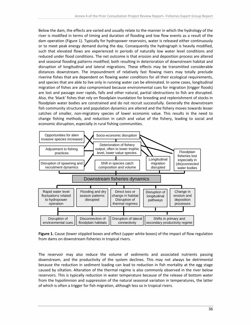
Annex 4 of the Prior Consultation Project Review Report– Fisheries Expert Group Report
36
Below the dam, the effects are varied and usually relate to the manner in which the hydrology of the river is modified in terms of timing and duration of flooding and low flow events as a result of the dam operation (Figure 1). Typically for hydropower reservoirs, water is released either continuously or to meet peak energy demand during the day. Consequently the hydrograph is heavily modified, such that elevated flows are experienced in periods of naturally low water level conditions and reduced under flood conditions. The net outcome is that erosion and deposition process are altered and seasonal flooding patterns modified; both resulting in deterioration of downstream habitat and disruption of longitudinal and lateral migrations. These effects may be transmitted considerable distances downstream. The impoundment of relatively fast flowing rivers may totally preclude riverine fishes that are dependent on flowing water conditions for all their ecological requirements, and species that are able to live only in running water can be eliminated. In some cases, longitudinal migration of fishes are also compromised because environmental cues for migration (trigger floods) are lost and passage over rapids, falls and other natural, partial obstructions to fish are disrupted. Also, the ‘black’ fishes that rely on floodplain inundation for breeding and replenishment of stocks in floodplain water bodies are constrained and do not recruit successfully. Generally the downstream fish community structure and population dynamics are altered and the fishery moves towards lesser catches of smaller, non‐migratory species of lower economic value. This results in the need to change fishing methods, and reduction in catch and value of the fishery, leading to social and economic disruption, especially in rural fishing communities.
Figure 1. Cause (lower stippled boxes and effect (upper white boxes) of the impact of flow regulation from dams on downstream fisheries in tropical rivers. The reservoir may also reduce the volume of sediments and associated nutrients passing downstream, and the productivity of the system declines. This may not always be detrimental because the reduction in sediment loading can lead to reduction in fish mortality at the egg stage caused by siltation. Alteration of the thermal regime is also commonly observed in the river below reservoirs. This is typically reduction in water temperature because of the release of bottom water from the hypolimnion and suppression of the natural seasonal variation in temperatures, the latter of which is often a trigger for fish migration, although less so in tropical rivers.
Downstream fisheries dynamics
Shift in species catch composition and volume
Socio-economic disruption
Deterioration of fishery output, often to lower trophic level, lower value species.
Opportunities for alien invasive species increased
Adjustment to fishing practices
Rapid water level fluctuations related
to hydropower operation
Flooding and dry season patterns
disrupted
Direct loss or change in habitat
Disruption of thermal regimes
Change in erosion and deposition processes
Disruption of environmental cues
Shifts in primary and secondary productivity regime
Disconnection of floodplain habitats
Disruption of lateral connectivity
Disruption of spawning and recruitment dynamics
Disruption of longitudinal pathways
Longitudinal migration disrupted
Floodplain fisheries lost especially in
(dis)connected water bodies
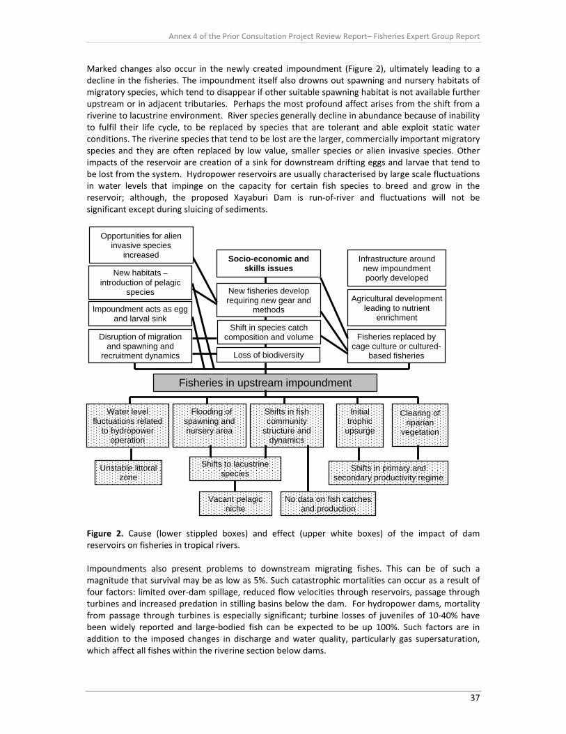
Annex 4 of the Prior Consultation Project Review Report– Fisheries Expert Group Report
37
Marked changes also occur in the newly created impoundment (Figure 2), ultimately leading to a decline in the fisheries. The impoundment itself also drowns out spawning and nursery habitats of migratory species, which tend to disappear if other suitable spawning habitat is not available further upstream or in adjacent tributaries. Perhaps the most profound affect arises from the shift from a riverine to lacustrine environment. River species generally decline in abundance because of inability to fulfil their life cycle, to be replaced by species that are tolerant and able exploit static water conditions. The riverine species that tend to be lost are the larger, commercially important migratory species and they are often replaced by low value, smaller species or alien invasive species. Other impacts of the reservoir are creation of a sink for downstream drifting eggs and larvae that tend to be lost from the system. Hydropower reservoirs are usually characterised by large scale fluctuations in water levels that impinge on the capacity for certain fish species to breed and grow in the reservoir; although, the proposed Xayaburi Dam is run‐of‐river and fluctuations will not be significant except during sluicing of sediments.
Figure 2. Cause (lower stippled boxes) and effect (upper white boxes) of the impact of dam reservoirs on fisheries in tropical rivers. Impoundments also present problems to downstream migrating fishes. This can be of such a magnitude that survival may be as low as 5%. Such catastrophic mortalities can occur as a result of four factors: limited over‐dam spillage, reduced flow velocities through reservoirs, passage through turbines and increased predation in stilling basins below the dam. For hydropower dams, mortality from passage through turbines is especially significant; turbine losses of juveniles of 10‐40% have been widely reported and large‐bodied fish can be expected to be up 100%. Such factors are in addition to the imposed changes in discharge and water quality, particularly gas supersaturation, which affect all fishes within the riverine section below dams.
Fisheries in upstream impoundment
Shift in species catch composition and volume Fisheries replaced by
cage culture or cultured- based fisheries
Infrastructure around new impoundment poorly developed
Socio-economic and skills issues
New fisheries develop requiring new gear and
methods
New habitats – introduction of pelagic
species
Water level fluctuations related
to hydropower operation
Flooding of spawning and nursery area
Shifts in fish community
structure and dynamics
Initial trophic
upsurge
Clearing of riparian
vegetation
Shifts to lacustrine species Shifts in primary and
secondary productivity regime
Vacant pelagic niche
No data on fish catches and production
Unstable littoral zone
Disruption of migration and spawning and
recruitment dynamics
Agricultural development leading to nutrient
enrichment Impoundment acts as egg
and larval sink
Loss of biodiversity
Opportunities for alien invasive species
increased
Annex 4 of the Prior Consultation Project Review Report– Fisheries Expert Group Report
38
The reservoir also has several other indirect effects on fish and fisheries. Species that are able to bypass the dam tend to lose the migratory stimulus of directed flow and get stranded in the reservoir. Similarly downstream migrants get lost in the reservoir. In both cases this leads to reduced fisheries output. Conversely, some species that are able to exploit the lake environment increase in abundance and contribute to important fisheries. This can be exacerbated by eutrophication of the lake caused by elevated nutrient run‐off from the lake hinterland where small‐scale agriculture often develops. Critically, it is usually alien invasive species that benefit most from this changing environment. In some cases where fishery production declines, efforts are made to substitute or replace the fisheries through culture‐based fisheries or cage culture. Whilst these may work in some cases, issues of ownership, access to the fisheries and high capital costs of setting up and operating such systems tend to be prohibitive for the rural fishing communities and it is the more‐wealthy classes of society that benefit. The upshot of the changing conditions is social upheaval and poverty generation. It is against this backdrop that assessment of the potential impact of Xayaburi dam on fisheries has been made. More explicitly, the review evaluates the EIS provided by the developers against the SEA and PDG, identify gaps in knowledge and makes recommendations for further actions. 2. Summary of scheme in relation to hydrology, impoundment and fisheries
and aquatic biodiversity in the dam area 2.1 Ecology of fish species in impacted reach The dam site and reservoir area locate in Zone 1 of the Mekong’s Ecological Reach (MRC 2010), which is characterized as a mountainous river in high altitude with rapids and pools, which sometimes extends to the piedmont. This zone is generally called the rhitron, where the water is relatively fast flowing and turbulent, with calmer stretches and occasional slack waters in the pools. Some fish species in this zone exclusively live in the strong flow condition and migrate little outside of the rhithronic zone (aka rhitronic species). Impoundment‐ and low flow‐ conditions will potentially result in demise of these fish species (welcomme et al. 2006). Such species, which are listed in the EIA study, include Balitora sp., Schistura spp., Glyptothorax fuscus, G. laoensis, Homoloptera smithi, Garra cambodgiensis and G. cyclostomata (Suvarnaraksha et al. unpublished data). Fish migrate when they cannot complete their life cycle in a single habitat, especially for reproduction and feeding purposes; the general migratory pattern of the Mekong fishes is shown in Figure 3. Only 2 samplings have been conducted as part of the EIA in the Xayaburi reach. The number recorded were considerably less than the number of fish species commonly recorded in the catch. At least 64 fish species are commonly caught in the proposed dam reach (Sjorslev 2000; Table 1), of which more than 65% are considered “white fish”, that undertake long distance migrations, in particular between the Mekong mainstem and floodplains in the tributaries. The proposed‐reservoir area is located in the upper Mekong migration system (Figure 4), where the vegetated banks from Pak Ou (the mouth of Nam Ou to Mekong mainstream) along the Nam Ou are important habitat for fishes to spawn and refuge for young of the year, thus should be reserved as wildlife conservation zone (Sayer 1993). These fish species exhibit various migration patterns throughout the year, a major issue that is not considered in the EIA. Variability in the timing of migration of some common species is illustrated in Figure 5 and shows different periods for individual species. This was confirmed by studies on the maturity status of key commercial species at different times of the year

Annex 4 of the Prior Consultation Project Review Report– Fisheries Expert Group Report
39
Table 1. Common catches (ranked by weight) in Luangprabang and Xayaburi area (Source: Sjorslev 2000) (Note: length is presented as in standard length)
Length at maturity No. Scientific name Guild Lmax 50% Min. Max.
Note
1 Osteochilus lini W 15 10 8 13 bentho‐pelagic 2 Amblyrhynchichthys
truncatus W 40 24 18 32 bentho‐pelagic
3 Poropuntius deauratus W 25 16 12 21 bentho‐pelagic 4 Oreochromis niloticus B 60 19 8 28 bentho‐pelagic; occur in a wide variety
of freshwater habitats 5 Cyprinus carpio W 110 40 30 54 bentho‐pelagic; occur in a wide variety
of freshwater habitats 6 Pangasius sanitwongsei W 300 140 105 190 bentho‐pelagic; inhabits exclusively in
large rivers 7 Hypsibarbus pierrei W 30 18 14 25 bentho‐pelagic 8 Clarias macrocephalus B 120 62 47 84 bentho‐pelagic; occur in a wide variety
of freshwater habitats 9 Hemibagrus nemurus W 65 37 27 49 bentho‐pelagic; occur in most habitat
types 10 Acanthopsoides sp. W 6 4 3 6 benthic, occurs over sandy bottoms in
medium to large rivers 11 Channa gachua B 20 11 8 15 benthic; found in hill streams; Inhabits
medium to large rivers, brooks, rapid‐running mountain streams
12 Mystacoleucus marginatus W 20 13 10 17 bentho‐pelagic 13 Kryptopterus bicirrhis W/G 15 10 7 13 bentho‐pelagic; prefer fast flowing
water and usually occurs along shores 14 Channa striata B 100 31 23 42 benthic; inhabits ponds, streams and
rivers, preferring stagnant and muddy water of plains
15 Osteochilus waandersii W 21 13 10 18 bentho‐pelagic; usually associated with clear, relatively fast flowing waters, with gravel to stony bottom
16 Toxotes chatareus B 40 23 17 31 pelagic 17 Cirrhinus chinensis W 55 32 23 42 bentho‐pelagic; live in midwater to
bottom depths and common found in rapids and slow deep reaches
18 Aaptosyax grypus W 130 67 50 90 pelagic, always found in middle to upper Mekong near deep rocky rapids
19 Krytopterus sp. W 60 34 26 46 benthic 20 Hemibagrus wycki W 71 40 30 53 benthic; lives in large rivers with fast
flowing water over muddy substrate 21 Hampala dispar W/G 35 21 16 28 bentho‐pelagic 22 Cynoglossus microlepis W 32 20 15 27 benthic; common name = Smallscale
tonguesole 23 Barbodes gonionotus W/G 40 24 18 32 bentho‐pelagic 24 Bagarius yarrelli W 200 95 73 130 benthic; occurs in large rivers on the
bottom, even with swift current 25 Probarbus labeamajor W 150 77 57 103 bentho‐pelagic; occurs in large upland
rivers 26 Esomus metallicus G 8 5 4 7 bentho‐pelagic 27 Lobocheilos melanotaenia W 20 13 10 17 bentho‐pelagic; feeds on periphyton
and phytoplankton which it scrapes from rocks

Annex 4 of the Prior Consultation Project Review Report– Fisheries Expert Group Report
40
Table 1 continued Length at maturity No. Scientific name Guild Lmax 50% Min. Max.
Note
28 Rasbora borapetensis G 6 5 3 6 bentho‐pelagic 29 Rasbora trilineata G 13 9 7 12 bentho‐pelagic 30 Hemibagrus wyckioides W 130 68 50 90 benthic; occurs in large upland rivers.
Common in areas with rocky bottoms and irregular depths
31 Clarias batrachus B 47 31 23 41 bentho‐pelagic; occur in a wide variety of freshwater habitats
32 Puntioplites proctozysron W 30 19 14 25 bentho‐pelagic 33 Mastacembelus armatus W 90 49 36 65 benthic; lives in highland streams to
lowland wetlands 34 Tenualosa thibaudeaui W 30 19 14 25 pelagic 35 Bangana sp. W 60 34 25 46 bentho‐pelagic; occurs in upland
reaches of the Mekong. Inhabits rocky stretches of the main stem of Mekong
36 Glossogobius giurus B 50 18 13 23 bentho‐pelagic 37 Systomus binotatus G 20 13 10 17 bentho‐pelagic 38 Clupisoma sinensis W 31 19 14 26 benthic 39 Anabas testudineus B 25 15 12 21 pelagic and often found in areas with
dense vegetation and can tolerate extremely unfavourable water conditions and is associated mainly with turbid, stagnant waters
40 Chela laubuca G 17 11 8 15 pelagic 41 Bagarius bagarius W 200 95 73 130 benthic; inhabits rapid and rocky pools
of large and medium‐sized rivers 42 Osphronemus gouramy B 70 39 29 52 bentho‐pelagic; enter flooded forest
but no report on migratory behaviour 43 Tor sinensis W 47 27 20 37 bentho‐pelagic; inhabits pools and runs
over gravel and cobble in clear rivers 44 Micronema apogon W 130 68 50 91 bentho‐pelagic; occurs in large rivers
with turbid waters 45 Osteochilus microcephalus W 24 15 11 20 bentho‐pelagic; occur in most habitat
types 46 Oxyeleotris marmorata B 65 37 27 49 benthic 47 Paralaubuca typus W 18 12 9 16 bentho‐pelagic 48 Luciocyprinus striolatus W 200 99 74 132 benthic; reported to prefer large, deep
rivers without much current 49 Luciosoma bleekeri W 25 16 12 21 pelagic; occurs at the surface of flowing
waters 50 Lycothrissa crocodilus W 30 19 14 25 pelagic 51 Tetraodon spp. B 10 7 6 10 benthic 52 Scaphognathops
stejnegeri W 25 16 12 21 bentho‐pelagic; occurs in large river
habitats; also found in rapid‐running mountain streams
53 Ompok krattensis W 45 27 20 35 benthic 54 Monopterus albus B 100 52 39 70 benthic; occur in most habitat types 55 Cirrhinus jullieni W 20 13 10 17 bentho‐pelagic

Annex 4 of the Prior Consultation Project Review Report– Fisheries Expert Group Report
41
Table 1 continued Length at maturity No. Scientific name Guild Lmax 50% Min. Max.
Note
56 Raiamas guttatus W 30 19 14 25 bentho‐pelagic; inhabits shady areas and muddy bottoms in deep hill streams
57 Pangasius macronema W 30 18 13 24 bentho‐pelagic; occurs in rivers, lakes and reservoirs and also found in rapids
58 Chitala blanci W 120 63 47 84 bentho‐pelagic; restricted to areas with fast flowing waters, deep pools or rapids
59 Probarbus jullieni W 150 77 57 103 bentho‐pelagic 60 Channa lucius B 40 24 17 32 benthic 61 Tor tambroides W/G 68 24 40 72 bentho‐pelagic 62 Barbodes altus W/G 20 13 9 17 bentho‐pelagic 63 Cosmochilus harmandi W 100 54 40 72 bentho‐pelagic; relatively common in
the upland river habitat of the Mekong 64 Hampala macrolepidota W/G 70 28 21 38 bentho‐pelagic; occurs mainly in clear
rivers or streams with running water and sandy to muddy bottoms
Figure 3. Generalized life cycle of potadromous Mekong fish (source Sverdrup‐Jensen 2003).
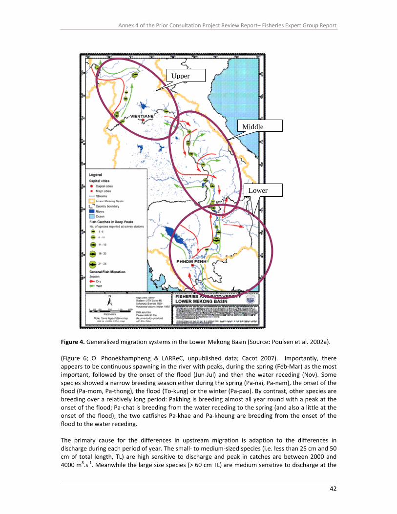
Annex 4 of the Prior Consultation Project Review Report– Fisheries Expert Group Report
42
Figure 4. Generalized migration systems in the Lower Mekong Basin (Source: Poulsen et al. 2002a). (Figure 6; O. Phonekhampheng & LARReC, unpublished data; Cacot 2007). Importantly, there appears to be continuous spawning in the river with peaks, during the spring (Feb‐Mar) as the most important, followed by the onset of the flood (Jun‐Jul) and then the water receding (Nov). Some species showed a narrow breeding season either during the spring (Pa‐nai, Pa‐nam), the onset of the flood (Pa‐mom, Pa‐thong), the flood (To‐kung) or the winter (Pa‐pao). By contrast, other species are breeding over a relatively long period: Pakhing is breeding almost all year round with a peak at the onset of the flood; Pa‐chat is breeding from the water receding to the spring (and also a little at the onset of the flood); the two catfishes Pa‐khae and Pa‐kheung are breeding from the onset of the flood to the water receding. The primary cause for the differences in upstream migration is adaption to the differences in discharge during each period of year. The small‐ to medium‐sized species (i.e. less than 25 cm and 50 cm of total length, TL) are high sensitive to discharge and peak in catches are between 2000 and 4000 m3.s‐1. Meanwhile the large size species (> 60 cm TL) are medium sensitive to discharge at the
Lower
Middle
Upper

Annex 4 of the Prior Consultation Project Review Report– Fisheries Expert Group Report
43
rate beyond 5000m3.s‐1, when catches of these large sized species are generally maximized (Baran et al. 2005) and this characteristic should be taken into consideration when designing fish passage facilities. Moreover, morphological characteristics (i.e. size and shape) of individual species as well as size at maturity of individual species (Table 1) should also be considered. Based on experience from the Mun River, the “pool and weir type” fish ladder is not suitable for the large size fishes and the species that occupy the bentho‐pelagic environment in the Mekong region (Jutagate et al. 2005), although experiments on migration of various species through vertical‐slot fish passes suggest that some species may be able to negotiate this type of pass if the hydraulic conditions are suitable.
Figure 5. Example of migratory patterns of fish in the upper portion in the Lower Mekong River (Source: Poulsen et al. 2002b)
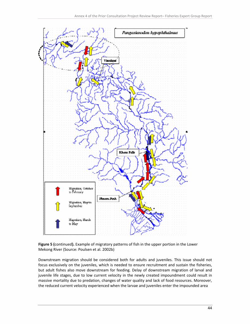
Annex 4 of the Prior Consultation Project Review Report– Fisheries Expert Group Report
44
Figure 5 (continued). Example of migratory patterns of fish in the upper portion in the Lower Mekong River (Source: Poulsen et al. 2002b) Downstream migration should be considered both for adults and juveniles. This issue should not focus exclusively on the juveniles, which is needed to ensure recruitment and sustain the fisheries, but adult fishes also move downstream for feeding. Delay of downstream migration of larval and juvenile life stages, due to low current velocity in the newly created impoundment could result in massive mortality due to predation, changes of water quality and lack of food resources. Moreover, the reduced current velocity experienced when the larvae and juveniles enter the impounded area

Annex 4 of the Prior Consultation Project Review Report– Fisheries Expert Group Report
45
Figure 5 (continued). Example of migratory patterns of fish in the upper portion in the Lower Mekong River (Source: Poulsen et al. 2002b) could potentially cause the larvae to settle out and not reach their feeding habitat, potentially causing high mortality and no reseeding of the fisheries in the lower reaches (see Section 3.2.2). In addition, the maximum threshold current velocities that the juveniles can tolerate are not known for the Mekong fishes and this issue should be further explored when designing the downstream passage.

Annex 4 of the Prior Consultation Project Review Report– Fisheries Expert Group Report
46
Figure 6. Presence of mature fishes (females bearing eggs) throughout the year (O. Phonekhampheng, unpublished data). 2.2 Migration issues Traditionally, fish migration around dams invariably only considers maintaining longitudinal connectivity in an upstream direction. This is recognised in the previous section and discussed in terms of provision of fish passage facilities past the barrier in Section 3.2. However, there is also a need to recognise that fish must also pass downstream to complete the life cycle. Whether this is adult fish returning to feeding and refuge areas or larval and juvenile fishes drifting or moving downstream to recruit to the fishery, they still require facilities to bypass the barrier. In this context, barriers to downstream migration fall into two categories, the dam itself and the impoundment created by the dam. Downstream migration passed the dam has been considered in the Design Report and EIA and is discussed in more detail in Section 3.3, but issues related to reduced current velocity and disruption to the hydrodynamics of the river as a result of the impoundment have been overlooked. It is estimated that flow velocity in the impoundment will be reduced from about 0.9 m/s to 0.1 m/s and this will most probably cause disruption of the life cycles of many species and loss of recruitment to the fish stocks. The EIA needs to explore data from other reservoirs in the region to identify the species most likely to be affected by this problem and the impact it has had in these systems. The fish larval drift project carried out by MRC in 2009 and more intensively in 2010 in the Xayaburi dam area identify some of the key species that migrate downstream. There is little doubt that downstream drift will be compromised by the reduction in water velocity in the newly created impoundment. It should also be recognised that downstream drift occurs at different times of the year for different species and that downstream drift is not just associated with the flood season. Consequently any mitigation or compensation action must account for this inter‐seasonal variation. 2.3 Conservation aspects At least five IUCN Red‐list fish species are found in the impacted reservoir area that were not listed in the EIA report (EIA, page 5‐11), viz., Pangasianodon gigas, Pangasius sanitwongsei, Probarbus labeomajor, P. julieni and Aaptosyax grypus. These fishes are large‐sized fish (i.e. sizes of adults are larger than 100 cm TL) and true rheophilic species (i.e. fishes that prefer running water and are not

Annex 4 of the Prior Consultation Project Review Report– Fisheries Expert Group Report
47
reported occupying stillwater habitats). They are also all potamodromous fishes that exhibit long distance migrations within the Mekong River Basin (Figure 5). It is therefore critical that longitudinal connectivity over long distances (100s of km) is maintained to ensure continuous recruitment of these species because it is expected that these fishes have low heterozygosity compared with other non‐endangered freshwater fish species, thus making them vulnerable to be extinct (Ngamsiri et al. 2007). The stretch between Xayaburi and Luang Prabang (the potentially impounded reach) is recognized as an area that contains a relatively high number of deep pools (Poulsen et al. 2002a) and these deep pools are key habitats during the dry season for Mekong fishes (Table 1), in particular the white fishes, and some species also rely on them for spawning (Baird 2006). If for any reason these habitats are reduced, e.g. by siltation, the consequence will be that dry season survival of important commercial fishes will be reduced. Local fishers, in Luang Prabang and Xayaburi also recognize the importance of the deep pools as their communities maintain fish sanctuaries near their villages. One third of these protected areas are associated with deep‐water pools in rivers and the fishers experienced improved catches after conserving the deep pools. 2.4 Fishery activities Considerable fishing activity takes place in the impacted area, mainly based on the migratory fish species using large fishing gears such as bag nets and scoop nets (Figure 7), although smaller interceptory gears, such as gill nets set of bamboo arms, have been observed in the region. These gears can yield high catches, and generally operate during the period of upstream migrations of many species (Figures 5 and 8). However, these species are not the only ones captured, as a diversity of finfish species are found in the market (Table 1) and a range of amphibians, snails and mussels, in which the snail is ranked the first, in terms of frequency, of common aquatic animals that people use as food (Sjorslev 2000). The most obvious impact, after damming, to these sessile animals is direct burial under sediment deposition in the reservoir.
Figure 7 Temporal CpUE of main fishing gears at Luang Prabang. 1=January, 12=December (Source: Sjorslev 2000). Impoundments of rivers reduce water velocity and allow accumulation of silt; as this settles out it can often be deep enough to cover and suffocate the animals and lead to their eradication, as has been reported elsewhere. Another traditional food from the river, especially found around Luang Prabang, is the freshwater weed “Kai” Cladophora spp. This weed grows on underwater rocks and thrives in clear water areas; it will inevitably be lost from the impoundment area once inundated.
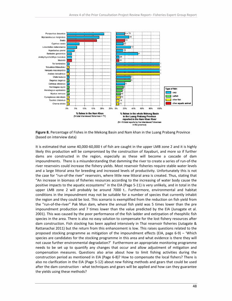
Annex 4 of the Prior Consultation Project Review Report– Fisheries Expert Group Report
48
Figure 8. Percentage of Fishes in the Mekong Basin and Nam khan in the Luang Prabang Province (based on interview data) It is estimated that some 40,000‐60,000 t of fish are caught in the upper LMB zone 2 and it is highly likely this production will be compromised by the construction of Xayaburi, and more so if further dams are constructed in the region, especially as these will become a cascade of dam impoundments. There is a misunderstanding that damming the river to create a series of run‐of‐the river reservoirs could increase the fishery yields. Most reservoir fisheries require stable water levels and a large littoral area for breeding and increased levels of productivity. Unfortunately this is not the case for “run‐of‐the river” reservoirs, where little new littoral area is created. Thus, stating that “An increase in biomass of fisheries resources according to the increasing of water body cause the positive impacts to the aquatic ecosystems” in the EIA (Page 5‐11) is very unlikely, and in total in the upper LMB zone 2 will probably be around 7000 t.. Furthermore, environmental and habitat conditions in the impoundment may not be suitable for a number of species that currently inhabit the region and they could be lost. This scenario is exemplified from the reduction on fish yield from the “run‐of‐the‐river” Pak Mun dam, where the annual fish yield was 5 times lower than the pre impoundment production and 7 times lower than the value predicted by the EIA (Junagate et al. 2001). This was caused by the poor performance of the fish ladder and extirpation of rheophilic fish species in the area. There is also no easy solution to compensate for the lost fishery resources after dam construction. Fish stocking has been applied intensively in Thai reservoir fisheries (Jutagate & Rattanachai 2011) but the return from this enhancement is low. This raises questions related to the proposed stocking programme as mitigation of the impoundment effects (EIA, page 6‐9) – ‘Which species are candidates for the stocking programme in this area and what evidence is there they will not cause further environmental degradation?’ Furthermore an appropriate monitoring programme needs to be set up to quantify any changes that occur and allow adjustment of mitigation and compensation measures. Questions also arise about how to limit fishing activities during the construction period as mentioned in EIA (Page 6‐8)? How to compensate the local fishers? There is also no clarification in the EIA (Page 5‐12) about new fishing methods and gears that could be used after the dam construction ‐ what techniques and gears will be applied and how can they guarantee the yields using these methods?

Annex 4 of the Prior Consultation Project Review Report– Fisheries Expert Group Report
49
2.5 Biodiversity and ecosystem functioning Little attention is given to biodiversity and ecosystem functioning in the region and the river as a whole. Dam developments are known to impact on species ecology and diversity. The altered environment results in certain species, usually with well defined habitat needs, being reduced in abundance or eliminated whilst others (eurytopic) with the ability to adapt then dominate. There is, for example, concern that drifting insects, such as Ephemeroptera (mayflies), which are found in extremely high abundance in the study area, will be lost or their numbers reduced substantially by the impoundment as they require flowing water environments. These drifting insects can potentially form a substantial part of the diet of fish and other organisms in the river and their loss could result in a collapse of the ecosystem function and simplification of the food web, ultimately resulting in a fall in fisheries productivity. There are also a number of ecosystem services that will be lost in addition to fisheries that may have an effect of the fisheries or more likely the fishing communities. These include:
• Regulation of ecosystem resilience • Water purification and removal of debris/rubbish build up. • Control of hazardous diseases (the more static water created by the reservoir could increase
prevalence of diseases such as malaria) • Non‐fisheries recreation (including terrestrial wildlife and plant associations) • Drinking water and other household applications
2.6 Summary A summary of the key issues, gaps in knowledge and recommendations relating to fish ecological inputs of the project design and impact assessment is given in Table 2. Table 2. Summary of key issues the relating to MRC technical review in fish ecology and fisheries for the Xayaburi‐HP Project Issues Gaps Recommendation/Solutions Fish ecology and fisheries information relies heavily on the MRC‐SEA document and other MRC reports
Gaps in knowledge about species diversity, ecology of downstream movements, the scale of fisheries in the affected region, livelihoods analyses and fishing activities Basic ecology of species or species groups not well developed, especially in relation to rhithronic species, and the impacts of impounding the river on community structure and functioning. IUCN Red‐listed species not mentioned in the study
Revise species inventory in the area, using surveys and Local Ecological Knowledge (LEK) methodologies to provide comprehensive baseline information of ecology Comprehensive review of the basic ecological needs of main commercial fish species that migrate in this reach of the mainstream Mekong Set up the monitoring programme for endangered species
Recognition that there is a the greater diversity of species present in this region (50+ species) and their
Little consideration given to transboundary issues, especially impact on fisheries reliant on long distance migrators. Limited recognition that each species
Comprehensive review of river basin wide fisheries impacts of single and multiple dam proposals Revise understanding in fish ecology of,

Annex 4 of the Prior Consultation Project Review Report– Fisheries Expert Group Report
50
differing migration behaviours and needs should be reviewed
has its own pattern of upstream and downstream migration Fish‐morphology also key factor that governs migratory behaviour and also influences fish passage design Limited studies on fish recruitment process and larval drift, which is also an important component of downstream migration
at least, common catch‐species in the area Monitoring programme on the performance of fish passage(s) Continue targeted larval drift studies initiated by MRC and interrogate data more fully to design mitigation measures. Due consideration must be given to non‐fish drifting organisms
Little consideration of the impacts of the proposed dam on fish habitat and environmental conditions
Little consideration of impacts both during construction and operation periods on major habitats such as deep pools and littoral areas along impounded reach No definitive picture on the likely changes in water quality
Make a clear understanding on the likely impacts to the major habitats and re‐assess the impact to fish community ‐ Re‐assess the consequent changes of water quality both after construction and operational phases and also re‐assess the impact to the fish community ‐ Sedimentation and siltation should be minimized
Scale and diversity of fisheries in impacted reach not given due recognition
‐ the EIA is not concerned on the impacts to fish community and ecosystem but just individual species ‐ No clear mitigation measures are proposed in the EIA (see Text)
‐ Fish stocking programs may be an option but the candidate species have to be investigated ‐ Compensation in loss to fisheries should be a high priority option.
3 Fish pass (upstream and downstream) options analysis 3.1 Overview 3.1.1 Background on fish biology In the Mekong River the migration of fish is characterised by a high biomass, high diversity and a wide size range of fish species (Section 2.1) including small cyprinids from 15‐30 cm, large cyprinids and pangasiids that are 60‐150 cm, and very large species up to 150‐300 cm long. These species include fish that specifically use the surface, mid‐water and bottom (benthic) zones, as well as those that specifically use the thalweg (deepest channel in the river). The smaller species often have weak swimming abilities and require lower water velocities in fish passes, while the larger fish have a greater swimming ability but require more space in fish passes. These fundamental biological characteristics are critical to develop effective fish passage. The designers of existing fish passes in large tropical rivers have generally: i) underestimated the upstream migratory biomass, and have undersized fish passes, including underestimating the

Annex 4 of the Prior Consultation Project Review Report– Fisheries Expert Group Report
51
required flow and space; ii) overestimated the swimming ability of smaller fishes, with high water velocities that fish could not negotiate; iii) underestimated the diverse behaviour of migratory fish, which swim to both sides of spillways and at various depths and locations along a powerhouse. 3.1.2 Measures proposed by the developer Upstream migration The proposal for upstream fish passage at Xayaburi Dam is described in the Design Report; in summary it is a single vertical‐slot pool‐type fish pass (5% gradient, 2.4 m/s maximum water velocity) with a collection gallery above the turbine draft tubes, which also includes a connection to a single entrance at the end of the stilling basin of the gated spillway. Downstream Migration The proposal for downstream fish passage at Xayaburi Dam is described in the Design Report; in summary it is a Surface Bypass Collector that diverts surface‐oriented, large‐bodied fish away from the turbines. “Fish‐friendly” Kaplan turbines are proposed but no data is provided to quantify safe passage of Mekong fish. The Design Report acknowledges that passage of fish would occur over the spillway. 3.2 Summary of findings and recommendations of MRC Fisheries EG 3.2.1 Upstream migration The proposed design is unsuitable for the Mekong fish fauna in its present form, although the EG considers that with a revised design, the impact of the Xayaburi dam scheme on upstream passage can potentially be reduced by a significant extent . The proposed vertical‐slot fish pass is unsuitable because it has: i) insufficient capacity to pass high biomass, due largely to the low passing flow as well as other dimensions; ii) high water velocities (2.4 m/s maximum – a salmonid standard) and turbulence, which would not pass small fishes (i.e. 15 cm long), including commercially important cyprinids; and iii) narrow slots in the baffles that would prevent or inhibit the passage of the larger fishes (150‐300 cm long). Passage of high biomass of fish is a key design issue for dams in large tropical river systems and it is an issue that has been poorly addressed. In general, multiple, large fishways are needed in large rivers to pass a high biomass. Rather than the single fishway presently proposed, the MRC EG recommends three fish passes for Xayaburi: i) a left bank fishway with a different design (see below), ii) a high capacity fish lift in the intermediate block and iii) modifying the navigation lock with extra gates and valves so it can be used to pass fish as well as navigation (Scoping Report Fig. 1). At large dams, multiple fishways are also needed to address the number of locations to which migrating fish are attracted. At Xayaburi this includes both sides of the spillway and at different distances from the spillway gates depending on flow, as well as the powerhouse. This accommodates the migratory behaviour of fish, to seek areas of low water velocities adjacent to high water velocities, and increases the capacity of the fish passage facilities to pass a high biomass. In diverse river systems the fish passage entrances need to accommodate a range of behaviour. At present the powerhouse collection gallery has entrances that are all at, or close to, the surface and there is a need for additional solutions for mid‐water, benthic and thalweg‐oriented fishes. Modifying the thalweg can also be considered to guide fish to the fishway. The location of the entrance and the flow conditions at the entrance are critical for fish to enter the fish pass successfully. The entrance should be located as close as possible to the dam but outside of

Annex 4 of the Prior Consultation Project Review Report– Fisheries Expert Group Report
52
areas with high flow velocities (> 1 m/s) and turbulent flow, which are features that can be incorporated into the design using physical modelling. Fish should be directly guided according to their migratory behaviour (surface or bottom orientated, strong or weak swimming capacity) by adequate flow velocities from their migration routes within the river to the fish pass entrances. Migrating fish are guided by the main current and therefore fish passes have to provide sufficient “attraction flow” in order to guide fish into the fish passes. Modern fish passes should provide 5‐10 % of the concurrent flow as attraction flow; 10% of all flows would be preferable for fish attraction, but it is not practical at sites with high flows so 10% of low flows is generally applied with a lesser percentage of high flows. The EG recommends redesigning the left‐bank fish pass to: i) pass 10 % of low flows and 1% of high flows to ensure attraction into the fishway and passage of high biomass, ii) have low water velocities (1.0 to 1.4 m/s maximum in confined areas, 0.05 to 0.3 m/s in open areas) and low turbulence (30 W/m3) for the passage of small fishes, and iii) sufficient space to pass large‐bodied fish. Possible fish pass options to met these criteria are: i) a large nature‐like bypass channel (NBC), which would be on less than a 1:100 gradient and would resemble a small river with rocks and habitat; and ii) two large fish locks (two would be used so that one was always attracting fish). The advantage of a NBC is that it provides a diverse hydraulic environment that a wide spectrum of different fish species can use. Large species with high swimming capacities use the deep mid‐channel section, while small species use the low velocities provided by the diverse channel features (shallow banks, rocks, woody debris). In addition, NBCs are also used as spawning and living habitat making them more attractive than technical solutions. NBCs can be designed to function across varying discharges with more roughness (large boulders) along the banks being utilised at greater depths. This enables optimisation of the required flow according to migratory periods. The gradient of the NBC should be less than 1% to limit minimum flow velocities within the migratory corridor to less than 1 m/s. The twin fish locks could provide the greatest depth and space of any fish pass and hence has a high likelihood of passing the largest species. Flow through fish locks can easily be adjusted to suit migration periods and available water. However, a limitation of fish locks is that they are cyclic and not continuous like a NBC or pool‐type pass, which creates a risk that fish will remain in the lock. The EG recommends a fish lift be incorporated into the “intermediate block”. Fish that migrate in the mid‐channel section and are attracted by the turbine outflows and open spillway gates should be guided with sufficient attraction flow into chambers of a fish lift at both sides of the intermediate block. Fish would be collected and concentrated in a chamber and periodically lifted upstream. A fish lift is a comparably cheap and efficient solution for high head dams. Operation of the fish lift (lifting frequencies and application of attraction flow) can be easily optimised according to migratory periods. The navigation lock represents another opportunity to increase upstream passage of fish. In particular, large‐bodied, bottom‐orientated fishes might use an adapted navigation lock more than other fish passes. To enable the navigation lock to function as a fish pass, there are three main stages, similar and complementary to a boat lockage:
i.) upstream‐migrating fish are attracted into the fish lock with the use of attraction flows (boats could enter the lock during or after fish attraction),
ii.) the lock then fills as it would for navigation (with fish and boats), and

Annex 4 of the Prior Consultation Project Review Report– Fisheries Expert Group Report
53
iii.) fish exit (at the same time, and/or including a period after, the boats leave) – in this latter phase a bypass flow is needed to creates a small current through the lock to attract fish out of the lock.
The structural modifications to achieve this dual‐use of the navigation lock include:
i.) The lock gates need to be designed so that they can support a small head differential (e.g. 0.1 to 0.3 m [maximum]) and be left open at different spacings. This enables attraction flow to create a velocity through the gates to attract fish.
ii.) New entrances with gates (possibly only 1‐2 m wide) opening directly onto the stilling basin through the right‐hand abutment. This is a essential feature because migrating fish would congregate in this area during spillway flow (Fig. 1). Three additional gates may be required for to provide entrances for low, medium and high flows, and the abutments would need to be shaped – the extent of these modifications would need to be refined in physical modelling.
iii.) Additional valves for controlling flow would be needed as fine control of discharge and water velocity through the lock is required for fish.
iv.) Flow meters and/or water level sensors are required to measure water velocity to provide feedback to valve openings.
Fish passage would need to be incorporated into the daily operation of the navigation lock, as well as into the operation of the main spillway gates to integrate fish attraction. Fish passage can be directly incorporated into boat lockages, as indicated above, and there can be separate lockages for fish. A combined fish and boat lockage would use a very similar volume of water to a lockage for boats only, except for probably an extra period for fish attraction and exit that would use a passing flow. During spillway flow there is surplus water so lockages during this period do not influence energy production. The inherent value of using the lock is the flexibility and adaptability of water use. Fish locks require constant attraction flow, as does any fishpass, but the lock enables this flow to be easily adjusted to the season and migratory biomass that is present. The number of lockages can also be adapted to suit the migration period. Real‐time data of migrating fish approaching the lock, which can be gathered from hydroacoustic equipment, can be used to automatically adjust the attraction flow and cycle times on a daily or even hourly basis. Hence, the EG considers there are considerable benefits in modifying the navigation to also pass fish for relatively little modification or cost. Physical models and 2D/3D CFD (Computational Fluid Dynamics) models are an essential part of modern fish pass design. These help to optimise entrance location, hydraulic conditions (to prevent masking of fish pass flow), attraction flow at different flow conditions and dam operations (turbine and spillway operation). 3.2.2 Downstream migration There are two barrier effects to consider in downstream migration i) the physical barrier of the dam itself and ii) the hydrodynamic barrier caused by a reduction in water velocity in the impoundment. The present project does not consider the second barrier effect but, although it is a subtle, it can be very damaging for fish populations (see Section 2.2). The hydraulic modelling suggests that the mean water velocity in the impoundment will reduce at low flows from approximately 0.9 m/s in pre‐dam conditions to 0.1 m/s in post‐dam conditions. Large‐bodied fish that are migrating downstream may be little affected as the hydraulic cue to provide direction would still be present in Xayaburi because the retention in the reservoir is short (2‐

Annex 4 of the Prior Consultation Project Review Report– Fisheries Expert Group Report
54
3 days), but larvae and fry would stop drifting downstream and would settle in the upper impoundment. Under low flows the impoundment would not have the hydrodynamic diversity presently in the river, specifically littoral [edge], benthic and backwater zones of low velocity adjacent to fast flowing water; these create areas that naturally accumulate plankton and other food and which subsequently enable high survival of fish larvae. Hence, the fish larvae that settle in the impoundment would probably have poor survival; this would apply to almost all riverine species but there will be a few species that have larvae with flexible biology that would survive in the stillwater (lentic) habitat of the impoundment, and indeed possibly thrive. Unfortunately it is difficult to determine which species, if any, would adapt to the changing environment. At higher flows (e.g. 10,000 m3/s) the mean water velocity in the impoundment increases, the natural hydrodynamics return and the barrier effect of reduced water velocities is not present. The only mitigation for the hydrodynamic barrier caused by a reduction in water velocity in the impoundment during lower flows is to operate the sluice gates of the dam and allow flows to pass directly through with little or no power generation. This may be possible in peak periods of larvae drift and may coincide with the need to pass sediment through the dam. At the dam itself, the main proposed solution for downstream migration is a Surface Bypass Collector which would not prevent benthic and thalweg‐oriented fishes from entering the turbines. The mortality of fish in Kaplan turbines is directly related to size, as well as physiology and condition, and adult fish have a very high mortality (up to 100%). Besides physical damage to fish by turbine blades, short‐term pressure differences and shear stress during turbine passage cause mortality in high head dams; fish are not able to adjust the pressure in the swim bladder and die. Haematomas caused by the pressure differences result in immediate or delayed mortality. Overall, there is a lack of a comprehensive solution for undamaged downstream passage for the project and it represents the most significant risk for fish passage and fish populations. Priority should be to avoid entrainment of fish into the turbines due to high mortality. Therefore, fish should be protected against turbine entrainment by screens with openings less than 2 cm. Benthic screens need to be applied; otherwise the risk of large fish passing through the turbines and dying is very high. Hence, the upstream fish pass could be very effective but downstream passage could reduce the population. These downstream facilities, like the solutions for upstream passage, need sufficient attraction flow to attract and pass fish, either through bypass channels and/or spillways. Spillway passage is mentioned in the design report but this can be a major option for downstream migration, especially with a well‐designed stilling basin. However, in the present design the undershot radial gates can cause injuries and mortalities in fish unless fully lifted and there are potential impact zones on the spillway that could injure fish. Providing an overshot design in one or more spillway gates, that would pass a high flow, would provide an effective downstream fish passage; although a significant knowledge gap is the response and survival of Mekong fishes over high spillways. A problem to consider for downstream fish passage at high dams is supersaturation of the water below the spillway. This generally occurs in deep tailwaters where water is recirculated in a hydraulic jump close to the spillway. The gates of the spillways need to be extended, if possible, to the bottom of the reservoir to provide passage of bottom‐orientated fish species. The operation of the spillways has to be adapted to the migratory needs of downstream migrating species and be integrated with attraction flow for the upstream fish passage facilities. Spillway gates close to the turbines should be opened first, as
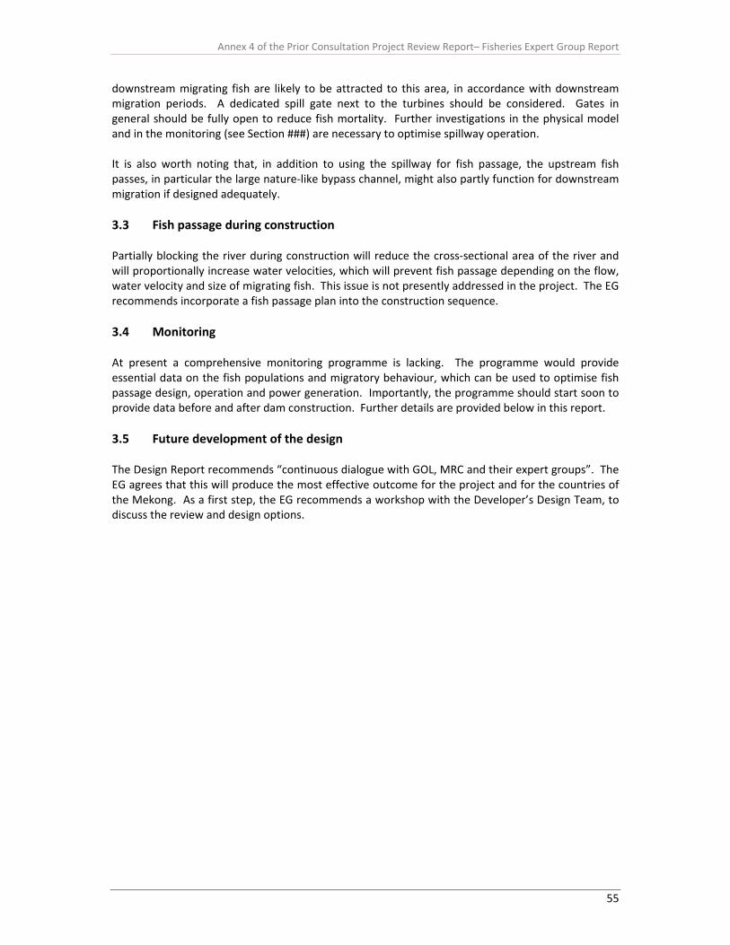
Annex 4 of the Prior Consultation Project Review Report– Fisheries Expert Group Report
55
downstream migrating fish are likely to be attracted to this area, in accordance with downstream migration periods. A dedicated spill gate next to the turbines should be considered. Gates in general should be fully open to reduce fish mortality. Further investigations in the physical model and in the monitoring (see Section ###) are necessary to optimise spillway operation. It is also worth noting that, in addition to using the spillway for fish passage, the upstream fish passes, in particular the large nature‐like bypass channel, might also partly function for downstream migration if designed adequately. 3.3 Fish passage during construction Partially blocking the river during construction will reduce the cross‐sectional area of the river and will proportionally increase water velocities, which will prevent fish passage depending on the flow, water velocity and size of migrating fish. This issue is not presently addressed in the project. The EG recommends incorporate a fish passage plan into the construction sequence. 3.4 Monitoring At present a comprehensive monitoring programme is lacking. The programme would provide essential data on the fish populations and migratory behaviour, which can be used to optimise fish passage design, operation and power generation. Importantly, the programme should start soon to provide data before and after dam construction. Further details are provided below in this report. 3.5 Future development of the design The Design Report recommends “continuous dialogue with GOL, MRC and their expert groups”. The EG agrees that this will produce the most effective outcome for the project and for the countries of the Mekong. As a first step, the EG recommends a workshop with the Developer’s Design Team, to discuss the review and design options.

Annex 4 of the Prior Consultation Project Review Report– Fisheries Expert Group Report
56
3.6 Summary A summary of the key issues, gaps in knowledge and recommendations relating to fish ecological inputs of the project design and impact assessment is given in Table 3. Table 3. Review of proposed fish passage from design report Proposed project (page
numbers from design report)
MRC Review Findings Recommendations
General Considerations (p.34)
“Continuous dialogue with GOL, MRC and their expert groups”
Agreed this is a productive approach As a first step the EG recommends a workshop with the Developer’s Design Team to:
i) discuss the review, ii) develop a design process which
includes continuous dialogue, and may include the formation of a joint technical working group.
iii) discuss the most effective options for assessment and design development.
Design targets
“Minimise as far as possible the impact of the project on the migrating habits of the different fish species present in the river reach”
Agreed this is a productive approach. Note that “fish species present in the river reach” includes fish that have migrated from other reaches.
“Fish passing structures . . . justified if all projects along the Mekong apply the same approach”
Agreed, a holistic approach to fish passage along the Mekong is needed.
Further Investigations Required
Investigate migration, as patterns from studies downstream might be different in time scale.
Agreed, this would be useful data. Need to include origin and destination of migrating fish is an important knowledge gap
Recommend investigations
Swimming performance May be useful, but fish size and migratory biomass is more important. Fish size can be used to interpret swimming ability in fishways from other fish passage studies.
Fish behaviour in fishways, river channels and tailwater is also an important aspect to investigate.
Investigate fish size, migratory biomass, migratory fish behaviour.
Operation. Develop a fish passage plan common to all hydroelectric mainstem
Agreed, this would be very productive.

Annex 4 of the Prior Consultation Project Review Report– Fisheries Expert Group Report
57
projects.
Identification of fish species and abundance
Agreed, this would be very useful. As mentioned above, it needs to include investigation of fish size to interpret swimming ability, and abundance should also include migratory biomass.
Identification and description of spawning habitats for future habitat recovery
Agreed, identification of spawning habitats is useful, but for protection and management of existing habitats rather than future habitat recovery.
General Design Criteria (p. 36)
Include flexibility in design. “It is essential that fish migrating facilities be designed to allow to the maximum feasible extent the possibility to adjust water flows, velocities and geometrical characteristics of fish ladders and other passages . . .”
Agreed, flexibility in design is essential to optimise fish passage at this site.
Range of River Flows and Water Levels (p.36)
Headwater (upstream) range is 2.5 m, from 272.5 m ASL to 275.0 m ASL; anticipated to be the full operational range.
Tailwater range of 18 m from a minimum of 236.00 m ASL (1000 m3/s) to 254 m ASL (15,000 m3/s).
Headwater range appears suitable if dam levels kept within predicted range.
Tailwater range appears to be up to 1:2 year flow of 15,000 m3/s; needs to extend up to 1:20 year flow of approximately 23,000 m3/s and a tailwater of EL 258 m. Note that high flows are important migratory periods and that the dam remains a barrier at these flows.
Expand tailwater range
Daily Hours of Operation (p.37)
“In principal the fish passage facilities ways should operate on a continuous basis” But consideration might be given to operating auxiliary water for 50% of the powerhouse time.
For the fishways to be an effective mitigation the full operation of the fishways should be tied into migration periods and intensity, not to energy production. Monitoring would quantify migration periods and intensity, enabling water use of the fishways to be tied into powerhouse operation.
Operate fishways and auxiliary water when fish are migrating.
Monitor migration periods – could use hydroacoustics (E.g. Didson) and/or telemetry to provide real‐time operational feedback to optimise water use.
Criteria for Upstream Migration facilities (p. 37)
General
Surface and benthic fishes identified and fishway entrances need to accommodate these differing behaviours.
Agreed. Also need to specifically add fish that use the thalweg.
Consider thalweg‐oriented fishes in design.
Fish attracted to powerhouse Agreed. Further investigation of this Recommend using navigation lock
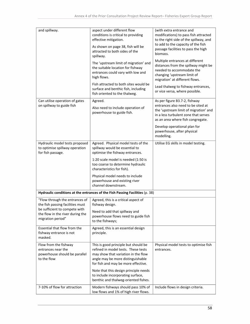
Annex 4 of the Prior Consultation Project Review Report– Fisheries Expert Group Report
58
and spillway. aspect under different flow conditions is critical to providing effective mitigation.
As shown on page 38, fish will be attracted to both sides of the spillway.
The ‘upstream limit of migration’ and the suitable location for fishway entrances could vary with low and high flows.
Fish attracted to both sites would be surface and benthic fish, including fish oriented to the thalweg.
(with extra entrance and modifications) to pass fish attracted to the right side of the spillway, and to add to the capacity of the fish passage facilities to pass the high biomass.
Multiple entrances at different distances from the spillway might be needed to accommodate the changing ‘upstream limit of migration’ at different flows.
Lead thalweg to fishway entrances, or vice versa, where possible.
Can utilise operation of gates on spillway to guide fish
Agreed.
Also need to include operation of powerhouse to guide fish.
As per figure B3.7‐2, fishway entrances also need to be sited at the ‘upstream limit of migration’ and in a less turbulent zone that serves as an area where fish congregate.
Develop operational plan for powerhouse, after physical modelling.
Hydraulic model tests proposed to optimise spillway operation for fish passage.
Agreed. Physical model tests of the spillway would be essential to optimise the fishway entrances.
1:20 scale model is needed (1:50 is too coarse to determine hydraulic characteristics for fish).
Physical model needs to include powerhouse and existing river channel downstream.
Utilise EG skills in model testing.
Hydraulic conditions at the entrances of the Fish Passing Facilities (p. 38)
“Flow through the entrances of the fish passing facilities must be sufficient to compete with the flow in the river during the migration period”
Agreed, this is a critical aspect of fishway design.
Need to add that spillway and powerhouse flows need to guide fish to the fishways;
Essential that flow from the fishway entrance is not masked.
Agreed, this is an essential design principle.
Flow from the fishway entrances near the powerhouse should be parallel to the flow
This is good principle but should be refined in model tests. These tests may show that variation in the flow angle may be more distinguishable for fish and may be more effective.
Note that this design principle needs to include incorporating surface, benthic and thalweg‐oriented fishes.
Physical model tests to optimise fish entrances.
7‐10% of flow for attraction Modern fishways should pass 10% of low flows and 1% of high river flows.
Include flows in design criteria.

Annex 4 of the Prior Consultation Project Review Report– Fisheries Expert Group Report
59
At Xayaburi this should be 100 m3/s at low flows (1000 m3/s) and 230 m3/s at 1:20 year flow (approx. 23,000 m3/s).
Adjust spillway gates to guide fish
Agreed, but as mentioned above this needs to be refined in physical model tests and it is possible that more than one entrance would be needed
Refine spillway operation in physical model tests; consider more than one fishway entrance.
Adjust water velocity over spillway to match swimming speed of fish
Not possible when the fish sizes vary from 0.15 m to over 1.0 m and swimming ability is generally directly related to length.
More effective to produce zones of low water velocity and turbulence at the upstream limit of migration, adjacent to high water velocities.
Investigate water velocity and manipulating zones of attraction in the physical model.
Powerhouse tailrace velocities of 0.5 – 0.6 m/s
This velocity will enable attraction of large‐bodied fish but will inhibit passage of small‐bodied fish.
Physical modelling would enable common zones of fish attraction to be developed.
Test in physical model of powerhouse.
Swimming ability in fishway discussion; 2.4 m/s proposed as a suitable velocity for the fishway entrance for 15 cm fish and above. 2.4 m/s used later for criterion for fishway
2.4 m/s is the salmonid standard for fish that are capable of >5 m/s; i.e. it is chosen for salmonids as a conservative figure to ensure passage. The same approach is recommended for Mekong species.
Fishway should use a maximum velocity of 1.0‐1.4 m/s to enable passage of 15 cm fish.
The fishway should include the capacity to use a high velocity of 2.4 m/s, which may be applicable to some periods if only large‐bodied fishes are migrating.
Turbulence, measured in Watts per cubic metre, is as important as velocity. Continuous zones of 30 W/m3 are needed for the passage of smaller fish. Present turbulence is too high.
Use 1.4 m/s as a criterion for maximum velocity, with capacity to have up to 2.4 m/s
Include continuous zones of 30 W/m3 for the passage of smaller fish.
Design principle: size of entrances to enable passage of the smallest and largest migrating fishes. Entrances have gates to enable changes.
Agreed. The entrances should start as wide as possible to ensure passage of schooling species and large‐bodied fish.
Outline Design (p.42)
Feasibility study proposed two fishways and design report
The proposal to have one fishway does not address two fundamental
The EG considers that three fishways are necessary to meet these two
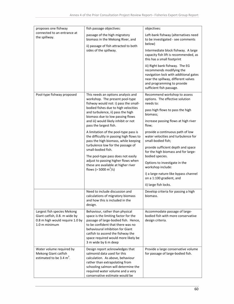
Annex 4 of the Prior Consultation Project Review Report– Fisheries Expert Group Report
60
proposes one fishway connected to an entrance at the spillway.
fish passage objectives:
passage of the high migratory biomass in the Mekong River, and
ii) passage of fish attracted to both sides of the spillway.
objectives:
Left‐bank fishway (alternatives need to be investigated ‐ see comments below)
Intermediate block fishway. A large capacity fish lift is recommended, as this has a small footprint
iii) Right bank fishway. The EG recommends modifying the navigation lock with additional gates near the spillway, different valves and programming to provide sufficient fish passage.
Pool‐type fishway proposed This needs an options analysis and workshop. The present pool‐type fishway would not: i) pass the small‐bodied fishes due to high velocities and turbulence, ii) pass the high biomass due to low passing flows and iii) would likely inhibit or not pass the largest fish.
A limitation of the pool‐type pass is the difficultly in passing high flows to pass the high biomass, while keeping turbulence low for the passage of small‐bodied fish.
The pool‐type pass does not easily adjust to passing higher flows when these are available at higher river flows (> 5000 m3/s)
Recommend workshop to assess options. The effective solution needs to:
pass high flows to pass the high biomass;
increase passing flows at high river flow;
provide a continuous path of low water velocities and turbulence for small‐bodied fish;
provide sufficient depth and space for the high biomass and for large‐bodied species.
Options to investigate in the workshop include:
i) a large nature‐like bypass channel on a 1:100 gradient, and
ii) large fish locks.
Need to include discussion and calculations of migratory biomass and how this is included in the design.
Develop criteria for passing a high biomass.
Largest fish species Mekong Giant catfish, 0.8. m wide by 0.8 m high would require 1.0 by 1.0 m minimum
Behaviour, rather than physical space is the limiting factor for the passage of large‐bodied fish. Hence, to be confident that there was no behavioural inhibition for Giant catfish to ascend the fishway the space required would more likely be 3 m wide by 6 m deep
Accommodate passage of large‐bodied fish with more conservative design criteria.
Water volume required by Mekong Giant catfish estimated to be 3.4 m3.
Design report acknowledges that salmonid data used for this calculation. As above, behaviour rather than extrapolating from schooling salmon will determine the required water volume and a very conservative estimate would be
Provide a large conservative volume for passage of large‐bodied fish.

Annex 4 of the Prior Consultation Project Review Report– Fisheries Expert Group Report
61
needed. A 300 kg catfish is unlikely to behave naturally in 3.4 m3 of water.
Minimum fishway pool length required for large bodied fish is three times the largest fish.
There is no published research on this aspect and passage of large‐bodied fish is problematic in fishways.
Need to be conservative to ensure passage of large fish.
Select the optimum rather than the minimum to ensure passage of large‐bodied fish.
Minimum depth of one metre quoted for salmonids
Minimum depths would again need to be conservative to enable the passage of large and high biomass.
The salmonid minimum appears not to be used in the present design and 6 m is used
Apply conservative criteria for depth. Thalweg depth for the entrance and possibly 2/3 of this depth for the fishway.
Medium for benthic species Agreed. This is a good feature.
Two stage lower section of fishway to accommodate highly variable tailwater
Design principle is a reasonable approach to the problem of variable tailwater, but attraction lows need to be maintained.
Bottom entrance elevation at 230 m ASL
Bottom entrance needs to be continuous with the thalweg
Head difference between pools 0.1 to 0.3 m
0.3 m head difference produces a maximum velocity of 2.4 m/s, which will be throughout most of the fishway. The lower 0.1 m head difference will be in the lower section at higher tailwater.
2.4 m/s is too high for small‐bodied fishes
Velocity through slots 1.4 to 2.4 m/s (depending on the geometry of the slots)
Geometry has little influence on the velocity compared to the head difference. Hence, the gradient and pool length will largely determine head differential and the maximum water velocity, which in the design is 2.4 m/s.
Design velocity is too high for small‐bodied fishes.
Develop common design criteria for all projects along the river
Agreed this is a very useful goal but initial flexibility is needed in the design and monitoring is needed to refine the criteria.
Integrate attraction flow and fishway flow to minimise turbulence
Agreed, this is a good design principle.
Fish species swimming performance not available for the Mekong
Extensive literature on the passage of a range of non‐salmonids through fishways that can be applied – some criteria for maximum velocity and turbulence are suggested above.
“The design shall also allow easy modifications of the
Agreed, a good design principle. However, the 5% grade, channel invert, and channel width are the

Annex 4 of the Prior Consultation Project Review Report– Fisheries Expert Group Report
62
hydraulics of the ladder” major limiting hydraulic features.
Main Fish Entrances (p. 46)
Three 9 m wide by 3 m orifices located on each side of the powerhouse; invert at 230 m ASL
Invert of fishway entrances should be at the thalweg which is less than 225m ASL.
Surface flow as well as orifice flow is needed for the entrance.
Consider creating thalweg that leads to the fishway entrance.
Ensure surface flow at entrances.
Spillway entrance: two orifices 9 m wide by 3 m deep.
As discussed above, more than one entrance location may be required.
As recommended earlier, this entrance should lead to a separate fish lift to pass the high biomass.
Physical model testing would resolve entrance number and location and attraction flow.
Collection Gallery
Invert of collection gallery is 231.5 m ASL and invert of draft tubes are at EL 209 m ASL;
Large‐bodied benthic species could aggregate at the lower level of the draft tube, probably to the side of the main current.
Recommend considering extending the collection gallery to include entrance at the sides of the draft tubes to EL 209 m ASL.
Velocity inside the chancel is 0.6 to 1.2 m/s
Velocity is too high for small‐bodied fish in a channel
Recommend a wider channel with 0.3 m/s
Orifice entrances. Need to accommodate surface‐oriented fish
Ensure entrances include surface flow
Auxiliary Water System
Water delivered through diffusion gratings and screens
The screens would need to be small enough to prevent passage of small fish.
The smallest fish migrating upstream is unknown but it is possible that it may be < 100 mm; hence 1 cm screens may be necessary
Auxiliary water pumped There is a risk of fish entrainment in the pumped water supply.
The screens for the pumps would need to have a fine mesh and a large surface area with low approach water velocities (e.g. 0.1 m/s) to prevent fish entrainment.
The site location of the intake for the pumps would be important to ensure this is not located where fish may be aggregating
Criteria for Downstream Migration facilities (p. 48)
Concept
Surface bypass collector (SBC) Does not address benthic species
Approach velocity on screens not provided
Angle of screens possibly not optimised
Investigate the use of benthic screens
Investigate the optimum screen design.
Spillway Passage Undershot gates on spillway will very likely injure fish.
Small overshot gates, within the undershot gate, are provided for debris; recommend enlarging these or replacing whole gates with overshot design, specifically for
Annex 4 of the Prior Consultation Project Review Report– Fisheries Expert Group Report
63
downstream fish passage.
Only operate undershot gates if they are lifted clear of the water.
Only operates in flood season Migratory patterns not fully understood at this site
Need to keep flexibility in operation and design
Operate toward the end of the wet season is likely
Fish Friendly turbine See detailed section of report on turbine passage
4 Socioeconomic and rural livelihoods analysis 4.1 Introduction In a river basin where 70% of communities are rural and where inland fisheries are the most intensive in the world, food security and livelihoods are still largely based on river dependent natural resources. Risks and losses incurred by the Mekong terrestrial and aquatic ecosystems translate into threats to the livelihoods of millions of people – primarily through increasing food insecurity in the basin. If natural resources productivity is reduced, the countries most at risk are Cambodia and Lao PDR (ICEM, 2010). 4.2 Importance of fisheries resources Fisheries resources (i.e. fish, other aquatic animal, and useful aquatic plants) have long been central to the lifestyles of four riparian countries of the Lower Mekong Basin (LMB), particularly to communities living in and around the corridor of 15 km of the river and its dependent floodplains, including Tonle Sap Great Lake in the Cambodia (MRC, 2010; ICEM, 2010). It was estimated that some 40 million people or about two‐third of the LMB population were involved in the Mekong’s fisheries at least part‐time or seasonally. In Lao PDR, more than 70% of rural households are dependent on fishing and collecting other aquatic animals (OAAS) and useful aquatic plants (UAPs) to varying degrees for subsistence livelihoods and additional cash income (MRC, 2010). In Cambodia, more than 40% of the total population is involved in fishing and fisheries related activities for their livelihoods (So, 2010). Over 1.2 million people residing in fishing communities around Tonle Sap Great Lake are reliant almost entirely fishing as their main livelihoods (Hap et al., 2006). Fisheries resources, including fish, OAAs and UAPs provide a vital contribution to regional food security and nutrition, in the form of consumption of fish, OAA and UAP collected or bought, cash income and employment and have strong cultural and religious significance. In the low land areas of the LMB, protein from fisheries resources contributes 40‐80% of the total animal intake. In Cambodia, fisheries resources, mainly fish, provide more than 80% of animal protein intake in rural areas (So, 2010). In Lao PDR, fish and OAAs contribute the main source of dietary animal protein and include a diverse array of products notably of frog, shrimp, snail/mollusc, crab and/or turtle (MRC, 2010; Hortle, 2007). The bulk of Mekong fish is consumed locally or traded at village, district or province markets. There is considerable trade in fish within the LMB and its neighbouring (trans‐boundary) catchments. Exports out of the region are limited, but increasing (Sverdrup‐Jensen 2002), although export of aquaculture from the delta region is approaching 1 million tonnes.
Annex 4 of the Prior Consultation Project Review Report– Fisheries Expert Group Report
64
4.3 Water and non‐water resources related sources of income Farming and fishing together are the most important economic activities in the LMB. Overall, the rural households are highly dependent on water resources for income (MRC, 2010). By far the most common source of income for the rural households of LMB corridor is the sale of rice (50% of households). This is followed by sale of aquatic products (including fish and OAAs, 38%). Other non‐aquatic resource income is remittances from family members (31%); local irrigation/seasonal employment (30%); full‐time employment (25%); sale of livestock (25%); business profit (19%); credit (14%); saving (13%); and other miscellaneous sources (less than 1% each). At Tonle Sap Great Lake, for example, households are highly dependent on water resources for income; fish are a source of income for more than 40% of households; at Siphandone, on the Lao mainstream, just under 40% of households get some income from fish, far more than in Thailand and Vietnam, where less than 10% of households obtain income from this source. 4.4 Socioeconomic and livelihoods impact The relationship between fisheries and agriculture, hydropower, navigation, tourism and other economic sectors are complex. Generally other sectors impact more on fisheries than fisheries exploitation and management activities. Usually the impacts are brought about through changes in the aquatic ecosystems, socioeconomic conditions or/and livelihoods of fisheries dependent communities. Mainstream hydropower projects are likely to have significant effects on riparian communities by disrupting their ways of life, cultures and sense of community. The proposed mainstream development would inhibit community access to, availability and quality of the food they eat, and increase the level of exposure to hazards or risks as they are highly reliant of aquatic resources (ICEM, 2010). The high degree of dependence of the population on fisheries resources for livelihoods and food security and nutrition implies a high vulnerability to declining availability, quality, and diversity of the resources. The uneven distribution of the population and varied degree of dependence suggest disparity in distribution of impacts changes in the resources across national, social and ecological boundaries and social groups (MRC, 2010). Impacts from other sectors are mostly negative; primarily the fishery relies on aquatic ecosystem health and integrity to maintain the resource base. Water, which is by far the most important of all natural resources in the LMB, is not abundant as previously believed, but finite and fragile. Its availability is increasingly influenced by development activities (including mainstream hydropower dams) at all levels, and conflicts over the allocation of water between the various sectors are escalating. 4.5 Developer’s views/ideas (Current) The Xayaburi EIA report provided only limited baseline and impact information on socioeconomic conditions of people living in the mainstream hydropower project affected areas (i.e. 20 km upstream of the Mekong River and 2 km downstream of Mekong River). It is mainly related to (1) public health and nutrition; (2) aesthetics, tourism and archaeology; (3) land use; and (4) land transportation and navigation, but did not provide any information and data on water resources related livelihoods, food security and nutrition. Furthermore, and critically trans‐boundary baseline and impact information on socioeconomics and livelihoods were not really considered in the EIA report. 4.6 Gaps and uncertainties (Review) Very little or no baseline and impact information and data on socioeconomic conditions and livelihoods of people living within the corridor 15 km either side of the Mekong River and its dependent tributaries and floodplains in the Xayaburi hydropower project areas, Lao PDR, Thailand

Annex 4 of the Prior Consultation Project Review Report– Fisheries Expert Group Report
65
(trans‐boundary between Lao PDR and Thailand), Cambodia (trans‐boundary between Lao PDR and Cambodia), and in Vietnam (trans‐boundary between Lao PDR and Vietnam) is available for preparing (1) effective mitigation measures, (2) a practical and scientific standardized monitoring programme, and (3) an environment management plan to minimize negative impacts and gain positive impacts from the Xayaburi mainstream hydropower project. The following detailed baseline and impact knowledge, information and data on socioeconomics and water resources related livelihoods of people living within a corridor of 15 km either side of the Mekong River and its dependent tributaries and floodplains in Xayaburi mainstream project areas, Lao PDR (particularly the southern Lao Champasack province), Thailand (particularly the northern Thai Chiang Rai areas), Cambodia (particularly the Cambodian Tonle Sap Great Lake areas) and Vietnam (particularly the Vietnamese Mekong delta areas) should be included in the EIA report. 1. Water/aquatic resources related communities, their activities and other characteristics 2. Baseline vulnerability and resilience
- Local contexts (project areas), - National contexts (Cambodia, Lao PDR, Thailand and Vietnam) - Regional contexts (trans‐boundary)
3. Livelihood strategies and dependency on aquatic resources - Occupation: main occupation of household members, occupation most important for
households, differences between project areas and countries, and trends - Livelihood activities: fishing and collecting OAAs, UAPs and edible algae
4. Dependency on fishing and collecting OAAs, UAPs and edible algae - Fishing and OAAs, UAPs and useful algae collection ecosystems - Seasonal variations - Fishing efforts - Disposal and market channel of aquatic products, - Perceived trends in fish catch and causes of consequences of change - Indicators of change
5. Income, expenditure and resilience: - Wealth categories - Occupations and livelihoods - Sources of income - Cash incomes - Water resources related sources of income compared with non‐water related sources - Expenditure - Livelihood assets
6. Values of aquatic resources (including fish, OAAs, UAPs and edible algae), - Use value (i.e. direct, indirect and optional value) - Use value (existence, bequest, culture and heritage value)
7. Food security, food consumption and nutrition - Types of foods - Food sources - Calories, protein, essential minerals (e.g. Ca, Zn, Fe) and vitamins (e.g. A and D) intake - Wealth status, types of target wealth groups/households and their nutrients intakes - Annual per capita consumption of fish and OAAs (kg) - Quantity and quality of food consumption by adults (particularly mothers of pre‐school
children) and children (particularly pre‐school children) in the selected households - Health and nutritional status of all members of the selected households by anthropometric
measurements (i.e. weight, height, Mid Upper Arm Circumference: MUAC, body mass index and dietary consumption) (See Figure 9)
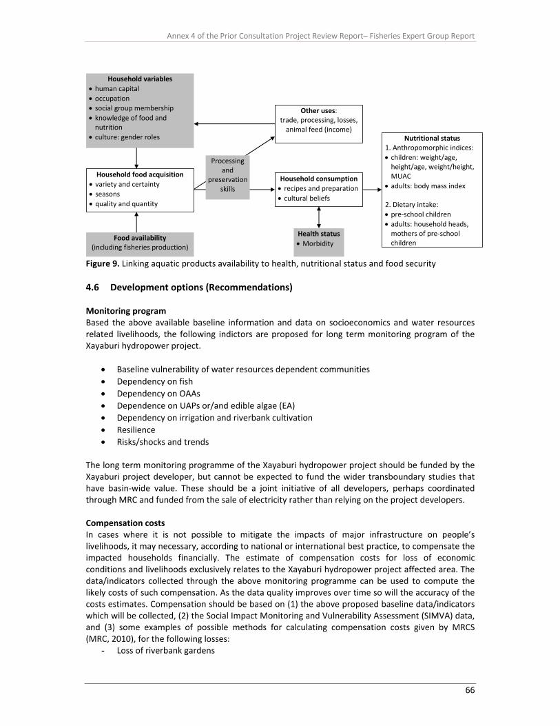
Annex 4 of the Prior Consultation Project Review Report– Fisheries Expert Group Report
66
Household variables • human capital • occupation • social group membership • knowledge of food and nutrition
• culture: gender roles
Household food acquisition • variety and certainty • seasons • quality and quantity
Food availability (including fisheries production)
Household consumption• recipes and preparation • cultural beliefs
Health status• Morbidity
Other uses:trade, processing, losses, animal feed (income)
Nutritional status1. Anthropomorphic indices: • children: weight/age, height/age, weight/height, MUAC
• adults: body mass index 2. Dietary intake: • pre‐school children • adults: household heads, mothers of pre‐school children
Processing and
preservation skills
Figure 9. Linking aquatic products availability to health, nutritional status and food security 4.6 Development options (Recommendations) Monitoring program Based the above available baseline information and data on socioeconomics and water resources related livelihoods, the following indictors are proposed for long term monitoring program of the Xayaburi hydropower project.
• Baseline vulnerability of water resources dependent communities • Dependency on fish • Dependency on OAAs • Dependence on UAPs or/and edible algae (EA) • Dependency on irrigation and riverbank cultivation • Resilience • Risks/shocks and trends
The long term monitoring programme of the Xayaburi hydropower project should be funded by the Xayaburi project developer, but cannot be expected to fund the wider transboundary studies that have basin‐wide value. These should be a joint initiative of all developers, perhaps coordinated through MRC and funded from the sale of electricity rather than relying on the project developers. Compensation costs In cases where it is not possible to mitigate the impacts of major infrastructure on people’s livelihoods, it may necessary, according to national or international best practice, to compensate the impacted households financially. The estimate of compensation costs for loss of economic conditions and livelihoods exclusively relates to the Xayaburi hydropower project affected area. The data/indicators collected through the above monitoring programme can be used to compute the likely costs of such compensation. As the data quality improves over time so will the accuracy of the costs estimates. Compensation should be based on (1) the above proposed baseline data/indicators which will be collected, (2) the Social Impact Monitoring and Vulnerability Assessment (SIMVA) data, and (3) some examples of possible methods for calculating compensation costs given by MRCS (MRC, 2010), for the following losses:
- Loss of riverbank gardens

Annex 4 of the Prior Consultation Project Review Report– Fisheries Expert Group Report
67
- Loss of or decline in fish catch and other aquatic animal and plant products - Loss of deep pools, sand bars and rapids - Loss of HH assets from flooding - Loss of valuable aesthetics, tourism and archaeology assets - Loss of sediments and associated nutrients to Tonle Sap system, and associated loss of
primary production and flooded forests - Loss of aquatic biodiversity - Loss or damage of crops (rice and other crops) due to water shortages and/or water excess - Loss of health and nutrition of HHs depending on water resources related livelihoods
References Baird I. 2006. Strength in diversity: fish sanctuaries and deep‐water pools in Lao PDR. Fisheries
Management & Ecology 13: 1‐8. For more detail see: Baran E., Baird I.G. & Cans G. 2005. Fisheries bioecology at the Khone Falls
(Mekong River,Southern Laos). WorldFish Centre. 84 p.. Hap N., Seng L. & Chuenpagdee R. 2006. Socioeconomics and livelihood values of Tonle Sap Lake
Fisheries. Inland Fisheries Research and Development Institute, Phnom Penh, Cambodia. 24 pp.
Hortle K.G. 2007. Consumption and the yield of fish and other aquatic animals from the Lower Mekong Basin. MRC Technical Paper No. 16, Mekong River Commission, Vientiane. 87 pp.
ICEM 2010. MRC Strategic Environmental Assessment (SEA) of hydropower on the Mekong mainstream. Hanoi, Viet Nam. 198 pp.
Jutagate T., Krudpan C., Ngamsnae P., Lamkom T. & Payooha K. 2005. Changes in the fish catches during the trial of opening the sluice gates of a run‐of‐the river reservoir in Thailand. Fisheries Management and Ecology 12: 57‐62.
Jutagate T., Lamkom T., Satapornwanit K., Naiwinit W. & Petchuay C. 2001. Fish species diversity and ichthyomass in Pak Mun Reservoir, Thailand, five years after impoundment. Asian Fishery Science 14: 417‐425.
Jutagate, T and Rattanachai A. 2011. Inland fisheries resource enhancement and conservation in Thailand In: De Silva S.S, Davy B. and Wiemian M. (eds.) Inland fisheries resource enhancement and conservation in Asia‐Pacific. FAO/RAP Technical Paper No. XX, pp. XX‐XX. FAO/RAP, Bangkok. To be published in 2011.
MRC 2010. State of the Basin Report 2010. Mekong River Commission, Vientiane, Lao PDR. 232 pp. MRC SEA for Hydropower on the Mekong mainstream: Fisheries baseline working paper Ngamsiri T., Nakajima M., Sukmanomon S., Sukumasavin N., Kamonrat W., Na‐Nakorn U., &
Taniguchi N. 2007. Genetic diversity of wild Mekong giant catfish Pangasianodon gigas collected from Thailand and Cambodia. Fisheries Science 73: 792‐799.
Poulsen A., Ouch P., Viravong S., Suntornratana U. & Tung N.T. 2002a. Deep pools as dry season fish habitats in the Mekong Basin. MRC Technical Paper No. 4, Mekong River Commission, Phnom Penh. 22 pp.
Poulsen A., Poeu O., Viravong S., Suntornratana U. and Tung N.T. 2002b. Fish migrations of the lower Mekong River basin: Implications for development, planning and environmental management. MRC Technical Paper No. 8, Mekong River Commission, Phnom Penh.
Roos N. 2003. Nutrition Values of Common Fish Species in Cambodia. Department of Human Nutrition, The Royal Veterinary and Agriculture University, Denmark. 14 pp.
Sayer J.. 1983. Nature conservation priorities in Laos. Tigerpaper 10, 10‐14. Sjorslev J.G. (ed.). 2000. Luangprabang Fisheries Survey, AMFC/MRC and LARReC/NAFRI; Vientiane. So N. 2010. Fisheries Resources in Cambodia‐ An Overview. Inland Fisheries Research and
Development Institute, Phnom Penh, Cambodia. 31 pp.

Annex 4 of the Prior Consultation Project Review Report– Fisheries Expert Group Report
68
Suvarnaraksha A., Lek S., Lek‐Ang S. & Jutagate T. Submitted. Fish diversity and assemblage patterns in a rhitral environment of Indo‐Burmese Region (the Ping‐Wang River‐basin, Thailand). Hydrobiologia
Suvarnaraksha A., Lek S. Lek‐Ang S. & Jutagate T.. In press. The life history of the riverine cyprinid Henicorhynchus siamensis (Sauvage, 1881) in a small reservoir. Journal of Applied Ichthyology
Sverdrup‐Jensen S. 2003. Fisheries in the Lower Mekong Basin: Status and Perspectives. MRC Technical Paper No. 6, Mekong River Commission, Phnom Penh, 103 pp.
Taki Y. 1978. An analytical study of the fish fauna of the Mekong Basin as a biological production system in nature. Research Institute of Evolutionary Biology Special Publications 1: 1‐77.
Welcomme R.L., K.O. Winemiller & I.G. Cowx 2006. Fish environmental guilds as a tool for assessment of ecological condition of rivers. River Research & Applications 22: 377‐396 for more detail.
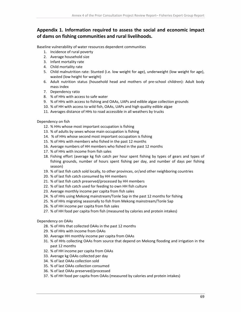
Annex 4 of the Prior Consultation Project Review Report– Fisheries Expert Group Report
69
Appendix 1. Information required to assess the social and economic impact of dams on fishing communities and rural livelihoods. Baseline vulnerability of water resources dependent communities
1. Incidence of rural poverty 2. Average household size 3. Infant mortality rate 4. Child mortality rate 5. Child malnutrition rate: Stunted (i.e. low weight for age), underweight (low weight for age),
wasted (low height for weight) 6. Adult nutrition status (household head and mothers of pre‐school children): Adult body
mass index 7. Dependency ratio 8. % of HHs with access to safe water 9. % of HHs with access to fishing and OAAs, UAPs and edible algae collection grounds 10. % of HH with access to wild fish, OAAs, UAPs and high quality edible algae 11. Averages distance of HHs to road accessible in all weathers by trucks
Dependency on fish
12. % HHs whose most important occupation is fishing 13. % of adults by sexes whose main occupation is fishing 14. % of HHs whose second most important occupation is fishing 15. % of HHs with members who fished in the past 12 months 16. Average numbers of HH members who fished in the past 12 months 17. % of HHs with income from fish sales 18. Fishing effort (average kg fish catch per hour spent fishing by types of gears and types of
fishing grounds, number of hours spent fishing per day, and number of days per fishing season)
19. % of last fish catch sold locally, to other provinces, or/and other neighboring countries 20. % of last fish catch consumed by HH members 21. % of last fish catch preserved/processed by HH members 22. % of last fish catch used for feeding to own HH fish culture 23. Average monthly income per capita from fish sales 24. % of HHs using Mekong mainstream/Tonle Sap in the past 12 months for fishing 25. % of HHs migrating seasonally to fish from Mekong mainstream/Tonle Sap 26. % of HH income per capita from fish sales 27. % of HH food per capita from fish (measured by calories and protein intakes)
Dependency on OAAs
28. % of HHs that collected OAAs in the past 12 months 29. % of HHs with income from OAAs 30. Average HH monthly income per capita from OAAs 31. % of HHs collecting OAAs from source that depend on Mekong flooding and irrigation in the
past 12 months 32. % of HH income per capita from OAAs 33. Average kg OAAs collected per day 34. % of last OAAs collection sold 35. % of last OAAs collection consumed 36. % of last OAAs preserved/processed 37. % of HH food per capita from OAAs (measured by calories and protein intakes)

Annex 4 of the Prior Consultation Project Review Report– Fisheries Expert Group Report
70
Dependence on UAPs or/and edible algae (EA)
38. % of HHs that collected UAPs or/and EA in the past 12 months 39. % of HHs with income from UAPs or/and EA 40. Average HH monthly income per capita from UAPs or/and EA 41. % of HHs collecting UAPs or/and EA from source that depend on Mekong flooding and
irrigation in the past 12 months 42. % of HH income per capita from UAPs or/and EA 43. Average kg UAPs or/and EA collected per day 44. % of last UAPs or/and EA collection sold 45. % of last UAPs or/and EA collection consumed 46. % of last % of last UAPs or/and EA collection preserved/processed 47. % of HH food per capita from UAPs or/and EA (measured by calories intake)
Dependency on irrigation and riverbank cultivation
48. Average land area cultivated by HH in the past 12 months 49. % of cultivated land with rice in the wet and dry seasons in the past 12 months 50. % of HHs dependent on water extracted from the Mekong for irrigation in the past 12
months 51. Average monthly income per capita from rice sales 52. % of HH income from irrigated crops including rice 53. % of HH rice produced under irrigation 54. % of HHs with riverbank cultivation 55. Average size of riverbank cultivation 56. Average income per annum from riverbank cultivation 57. % of HH income per capita from riverbank cultivation 58. % of HHs food per capita from riverbank cultivation
Resilience
59. % of HHs with non‐aquatic sources of income 60. % of adult HH members working outside the village 61. Average expenditure per capita per year 62. % of expenditure on non food items 63. Average monthly income from non‐aquatic sources 64. % of HHs engaged in aquaculture 65. % % saving they have alternative livelihood options 66. % of adult HH members who below to (specified) social group 67. % of HHs able to produce more than half their own food 68. Number of livestock units per capita 69. Average value of productive assets 70. Average value of non productive assets
Risks/shocks and trends
71. % of HHs whose primary domestic water sources runs dry for more than x weeks in the dry season
72. % of HHs experiencing losses from flooding in the past 12 months 73. % of HH assets lost in flooding in the past 12 months 74. Average number of months to recovery from last flood in the past five years 75. % of HHs reporting loss of Mekong/Tonle Sap mainstream deep pools, sand bars and rapids
in the past five years
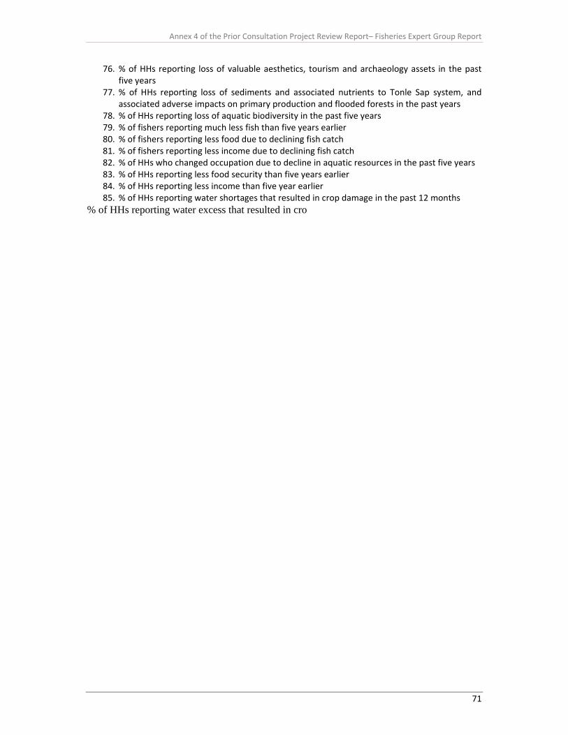
Annex 4 of the Prior Consultation Project Review Report– Fisheries Expert Group Report
71
76. % of HHs reporting loss of valuable aesthetics, tourism and archaeology assets in the past five years
77. % of HHs reporting loss of sediments and associated nutrients to Tonle Sap system, and associated adverse impacts on primary production and flooded forests in the past years
78. % of HHs reporting loss of aquatic biodiversity in the past five years 79. % of fishers reporting much less fish than five years earlier 80. % of fishers reporting less food due to declining fish catch 81. % of fishers reporting less income due to declining fish catch 82. % of HHs who changed occupation due to decline in aquatic resources in the past five years 83. % of HHs reporting less food security than five years earlier 84. % of HHs reporting less income than five year earlier 85. % of HHs reporting water shortages that resulted in crop damage in the past 12 months
% of HHs reporting water excess that resulted in cro


