ANTELOPE VALLEY REDEVELOPMENT PLAN LINCOLN, November 24, 2004 75 XV. TWO PROPOSED REDEVELOPMENT CONCEPTS The redevelopment planning process identified two catalyst concepts-called Proposed Redevelopment Concepts: Proposed Redevelopment Concept A-East Downtown is approximately a 5 block area located in East Downtown in the general vicinity of: > 17th to 19th, "O" to "P" Streets > 17th to 19th, "P" to "Q" Streets > 18th to 19th, "Q" to "R" Streets Proposed Redevelopment Concept B-Malone Neighborhood is a two block area in the Malone Neighborhood from 23rd to 24th Streets, "P" to "R" Streets. If viable, these two Proposed Redevelopment Concepts may later become Redevelopment Projects upon an amendment of this Redevelopment Plan. A. Proposed Redevelopment Concept A--East Downtown This concept includes mid-rise mixed-use buildings, such as residences, research and development activ- ities, office and retail. This area would be ideal for Nebraska alumni and other types of residential housing, enabling residents to be in close proximity to Downtown restaurants, entertainment and amenities, while being within walking distance of UNL educational, cultural and sport activities. East Downtown also abuts the UNL public research and development facilities. It is anticipated that private sector research and development enterprises would be interested in locating here to be in close proximi- ty to the University's R & D activities. Together, these primary uses would spin off other desirable land uses. The streetscape-oriented infill development should prominently feature the quality Duteau building, revitalize underdeveloped land and capitalize on inherent synergies of parking and open space. Off- street parking spaces should be below grade or in at- grade or above grade parking facilities that are hid- den or screened with buildings so that passerby pedestrians and motorists don't have to view parked cars or 'blank' wall parking garages. The Downtown Fire Station and administrative officers are located within the five block footprint. If redevelopment plans require the Downtown Fire Station to be relo- cated, then a suitable location (generally between 9th Street, 27th Street, Vine Street and "A" Street) Figure 22
Transcript
ANTELOPE VALLEY REDEVELOPMENT PLAN LINCOLN, November 24, 2004 75
XV. TWO PROPOSED REDEVELOPMENTCONCEPTS
The redevelopment planning process identified twocatalyst concepts-called Proposed RedevelopmentConcepts:
Proposed Redevelopment Concept A-EastDowntown is approximately a 5 block area locatedin East Downtown in the general vicinity of:
> 17th to 19th, "O" to "P" Streets> 17th to 19th, "P" to "Q" Streets> 18th to 19th, "Q" to "R" Streets
Proposed Redevelopment Concept B-MaloneNeighborhood is a two block area in the MaloneNeighborhood from 23rd to 24th Streets, "P" to"R" Streets.
If viable, these two Proposed RedevelopmentConcepts may later become Redevelopment Projectsupon an amendment of this Redevelopment Plan.
A. Proposed Redevelopment Concept A--EastDowntown
This concept includes mid-rise mixed-use buildings,such as residences, research and development activ-ities, office and retail. This area would be ideal for
Nebraska alumni and other types of residentialhousing, enabling residents to be in close proximityto Downtown restaurants, entertainment andamenities, while being within walking distance ofUNL educational, cultural and sport activities. EastDowntown also abuts the UNL public research anddevelopment facilities. It is anticipated that privatesector research and development enterprises wouldbe interested in locating here to be in close proximi-ty to the University's R & D activities. Together,these primary uses would spin off other desirableland uses.
The streetscape-oriented infill development shouldprominently feature the quality Duteau building,revitalize underdeveloped land and capitalize oninherent synergies of parking and open space. Off-street parking spaces should be below grade or in at-grade or above grade parking facilities that are hid-den or screened with buildings so that passerbypedestrians and motorists don't have to view parkedcars or 'blank' wall parking garages. The DowntownFire Station and administrative officers are locatedwithin the five block footprint. If redevelopmentplans require the Downtown Fire Station to be relo-cated, then a suitable location (generally between9th Street, 27th Street, Vine Street and "A" Street)
Figure 22
ANTELOPE VALLEY REDEVELOPMENT PLAN LINCOLN, November 24, 2004 76
Uses & Sources of FundsProposed Redevelopment Concept A -- East Downtown Six Block Project: 16th to 19th, O to P Streets; 17th to 19th, P to Q Streets, 18th to 19th, Q to R Streets
Uses
Acquisition of property, relocation of residents/businesses, removal of envi-ronmental constraints, demolition of structures and site preparation $5,647,180
Site improvements could include utility upgrades [water, sanitary sewer,strom water], street, sidewalk, and curb & gutter construction, parking andstreetscape improvements, fire station construction $14,025,000
Private uses for mixed-use developments $110,000,000
Total Uses $129,672,180
Sources
Project-generated sources could include: Community ImprovementFinancing, land sale proceeds, special assessments $10,002,500
Other sources could include: Utility revenues, parking revenues, street con-struction funds, general revenues, and LES $9,669,590
Private Sector Sources $110,000,000
Total Sources $129,672,180
Figure 23
would have to be secured and a new fire stationbuilt.
1. Illustrations:Proposed Redevelopment Concept A-EastDowntown, Illustrative Plan, Figure 22, illustrates apotential mixed-use vision of this East Downtownarea, while Proposed Redevelopment Concept A-East Downtown, Birds Eye Diagram, Figure 23, pro-vides a three dimensional perspective of the fiveblock area. These images are illustrative and differ-ent mixes and block locations would achieve similarobjectives. Because of the large site plan, the areamay need to be developed in phases.
Potential Program:SE Block
- Duteau Building rehabbed w/addition on19th/O for total of 68,000 sq.ft. office
- 50 unit new for rent residential building withtuck under parking
SW Block
- League of Human Dignity Building Remains- 60,000 sq.ft Office above:- 20,000 sq.ft Ground Floor Retail- 18 loft units of residential- 445 stall new parking garage
NE/NW Blocks- Gas Station/Convenience Store Remains- 522 stall new parking garage- 72 unit new for-rent residential building- 30 loft units Residential- 38 unit new for-rent residential building- 5,000 sq.ft of retail
2. Projected Uses and Sources of Funds: (See Figure23 below.)
ANTELOPE VALLEY REDEVELOPMENT PLAN LINCOLN, November 24, 2004 77
3. Fire Station ConsiderationThe Downtown Fire Station and administrativeofficers are located within the footprint of theProposed Redevelopment Concept A-EastDowntown. If redevelopment plans require theDowntown Fire Station to be relocated, then a suit-able location (generally between 9th Street, 27thStreet, Vine Street and "A" Street) would have to besecured and a new fire station built.
B. Proposed Redevelopment Concept B-Malone Neighborhood
Proposed Redevelopment Concept B centers on atwo block area in the Malone Neighborhood from23rd to 24th Streets, "P" to "R" Streets. Residentialredevelopment of this area east of the new water-way will help promote maximum private invest-ment adjacent to the waterway, once the designatedfloodplain is removed. Its close proximity to thenew waterway and the new East Downtown Park,will allow residents to enjoy the proposedamphitheatre, ice skating rink and fountain area.Redevelopment of this area could also spur futureredevelopment of the north edge of the "O" StreetCorridor.
This area should provide a quality residential tran-sition between the "O" Street mixed-use area andthe traditional residential neighborhood of theMalone/Hawley Neighborhood. Hopefully, theseblocks would be redeveloped with a mixture of tra-ditional and some housing products and designs-row homes, townhouse, cottages, granny flats. Todate, many of these new residential products havenot been built in Lincoln, but are proving successfulin other localities. Together, the existing and newgroup of residences would provide an attractiveneighborhood street fronts that would complementthe surrounding neighborhood’s urban design andarchitectural features.
In order to help achieve a sccussful redevelopmenteffort, it might be necessary to expand the initialtwo block ara to include the two blocks to the westfrom 22nd to 23rd Streets, “P” to “R” Streets. Thesetwo westerly blocks abut the east bank of the newwaterway. Expansion of the redevelopment effortto include waterway frontage housing may be nec-
essary to achieve overall project viability for theMalone Neighborhood. Yet, any larger redevelop-ment effort would have to take into considerationthat these two waterway frontage blocks arepresently located within the designated 100-yearflood plain. With completion of the new waterway,these additional two blocks will then be locatedoutside the designated 100-year floodplain.
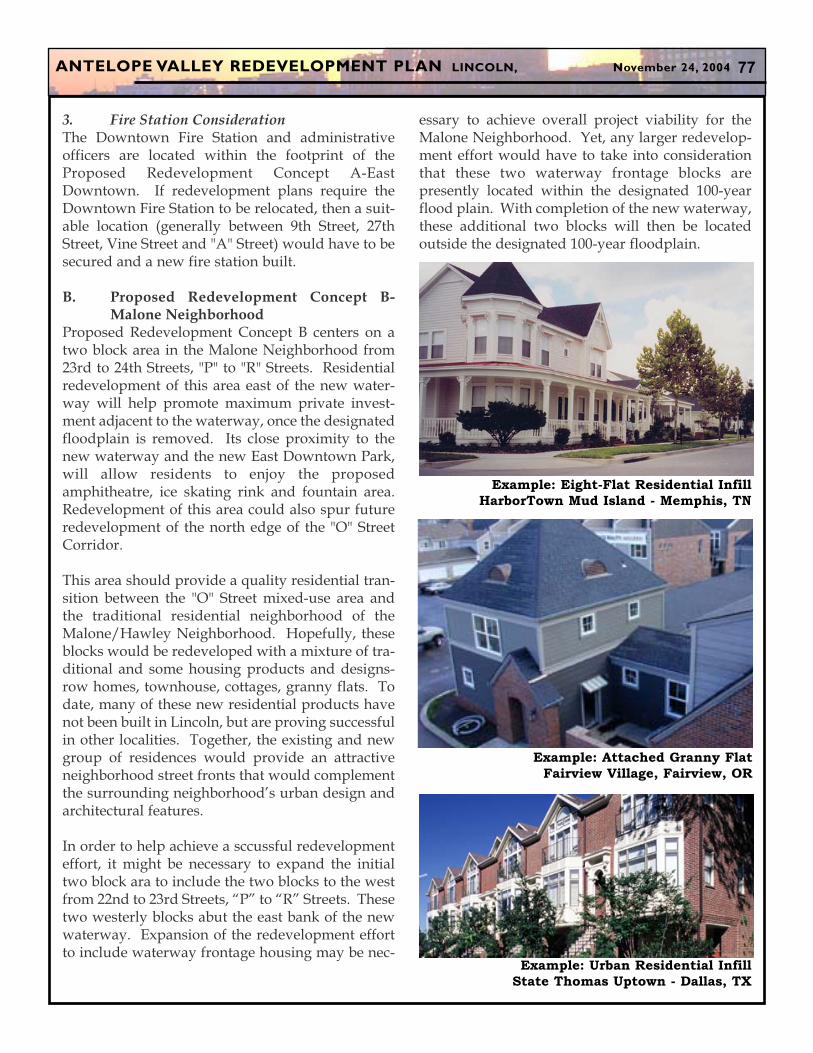
Example: Eight-Flat Residential Infill
HarborTown Mud Island - Memphis, TN
Example: Attached Granny Flat
Fairview Village, Fairview, OR
Example: Urban Residential Infill
State Thomas Uptown - Dallas, TX
ANTELOPE VALLEY REDEVELOPMENT PLAN LINCOLN, November 24, 2004 78
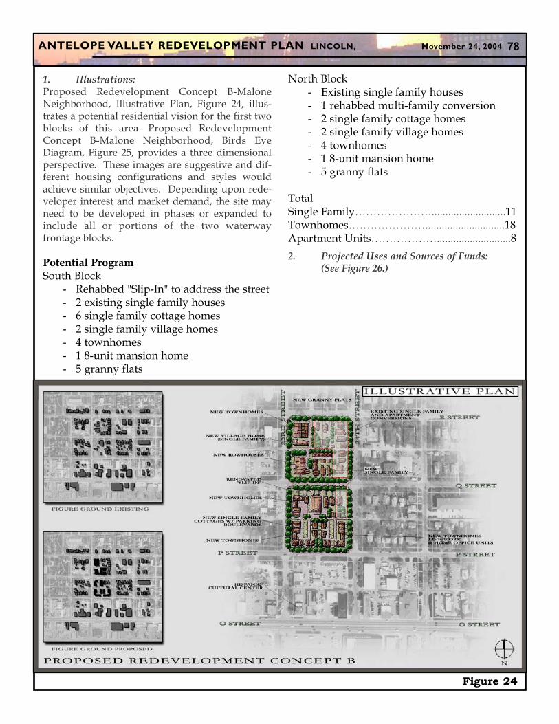
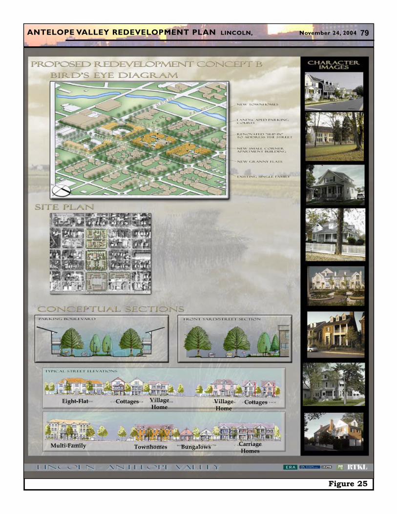
1. Illustrations:Proposed Redevelopment Concept B-MaloneNeighborhood, Illustrative Plan, Figure 24, illus-trates a potential residential vision for the first twoblocks of this area. Proposed RedevelopmentConcept B-Malone Neighborhood, Birds EyeDiagram, Figure 25, provides a three dimensionalperspective. These images are suggestive and dif-ferent housing configurations and styles wouldachieve similar objectives. Depending upon rede-veloper interest and market demand, the site mayneed to be developed in phases or expanded toinclude all or portions of the two waterwayfrontage blocks.
Potential ProgramSouth Block
- Rehabbed "Slip-In" to address the street- 2 existing single family houses- 6 single family cottage homes- 2 single family village homes- 4 townhomes- 1 8-unit mansion home- 5 granny flats
Figure 24
North Block- Existing single family houses- 1 rehabbed multi-family conversion- 2 single family cottage homes- 2 single family village homes- 4 townhomes- 1 8-unit mansion home- 5 granny flats
2. Projected Uses and Sources of Funds: (See Figure 26.)
ANTELOPE VALLEY REDEVELOPMENT PLAN LINCOLN, November 24, 2004 79
Figure 25
Eight-Flat Cottages VillageHome
Cottages
Multi-Family Townhomes BungalowsCarriageHomes
VillageHome
ANTELOPE VALLEY REDEVELOPMENT PLAN LINCOLN, November 24, 2004 80
Figure 26
ANTELOPE VALLEY REDEVELOPMENT PLAN LINCOLN, November 24, 2004 81
XVI. POTENTIAL REDEVE LOPMENT CON-CEPTS
As part of the Antelope Valley community revital-ization planning process, twenty-nine other con-cepts were identified and are called PotentialRedevelopment Concepts. Some of these conceptsare contingent upon future floodplain issues, theconstruction of the new roadway, etc., while othersmay proceed when feasible. The PotentialRedevelopment Concepts are located on Figure 28and summarized below.
A. Summary Description of PotentialRedevelopment Concepts(Not in priority order)
1. Grocery Store:Proposed locations: on the south side of"O" Street and east of 22nd Street.Grocery store of adequate size (approxi-mately 45,000 sq. ft.).Additional retail spaces and pad sites tomeet the needs of the surrounding neigh-borhoods and eastbound "O" Street travel-ers, along with potential residential unitsand loft spaces above the retail shops.Grocery/retail uses provide neighborhoodlevel services, e.g. cleaners, laundry, con-venience, hardware.New development should maintain strongbuilding edge on "O" Street with parkinglot at the rear or designed with features,such as a low wall which maintains thestreet edge and hide the parked cars andtrucks.Potential for farmer's or open air marketand community festival area.Design provides for pedestrian access on"O" Street and links to surrounding neigh-borhoods.Relocate or reposition existing businessesas needed.
2. "O" Street Mixed-Use:Proposed location: on the north side of"O" Street to "P" Street from 23rd to 25thStreets.
Hispanic Cultural Center building shouldremain.Adaptive reuse of existing buildings andnew development containing ground floorretail fronting on "O" Street, upper levellofts, townhomes, and small apartmentbuildings.New townhomes front on "P" Street andmaintain the strong street edge.New apartments and residential buildingsfront on 23rd, 24th, and 25th Streets andmaintain the strong street edge.Interior parking courts are constructed toprovide for residential parking, overflowretail parking and rear entry opportuni-ties.Relocate or reposition existing businessesas needed.
3. New Antelope Valley Parkway & "O"Street Southwest Mixed-Use:
Mixed-Use office/retail developmentsfocus on "O" Street, especially near 19thStreet.Mixed-Use residential development focusalong "N" Street.Transition area to more concentrated resi-dential uses to the south.New waterway will alleviate the designat-ed 100-year floodplain.Need to relocate or reposition existingbusinesses.
4. Large Employer Area:Exclusive location on the waterway forlarge scale office development.Easy access via Capitol Parkway.Brick telephone company building mayprovide architectural theme for the rede-velopment.New waterway will alleviate the designat-ed 100-year floodplain.Need to relocate or reposition existingbusinesses.
ANTELOPE VALLEY REDEVELOPMENT PLAN LINCOLN, November 24, 2004 82
5. Neighborhood Enhancements SubsequentPhases:
Potential improvements include newstreet trees, lighting, sidewalk improve-ments and potential curb replacements.Significant existing properties incorporat-ed into future development concepts.Redo past modifications that are inconsis-tent with the original style or context of thehouse.Carry out a maintenance program on qual-ity houses such as painting, reroofing, etc.Clear key existing structures redevelopedinto new mixed density housing.
6. N. 14th Street Area:Monitor affects of the Big "T" Bridge and14th Street closing on this part of theneighborhood.Subject to funding availability, Cityacquires property as it becomes available,with goal of new housing or green space.Emphasis on strengthening the housingalong 14th Street.Easy access to campus.Large portion of the area cleared for chan-nel construction and other City ownedproperty already.Architectural design elements on the road-way bridge walls will create a positivevisual experience.
7. North Bottoms University Parking LotArea:
New medium density residential opportu-nities.Easy access to campus.Site will not be available until after the "X"Street Bridge and related roadways arecomplete.Need to address floodplain issue.
8. 10th Street-North Bottoms Main Street:Lincoln's "Greenwich Village".Mixed-Use retail area integrating commer-cial and residential uses in the same build-ing.
Zero setback buildings with street level,outdoor shops provide the opportunity togenerate a creative pedestrian atmospherein the area.Retail and commercial uses focus on thearts, coffee shops and neighborhood serv-ices.Need to address floodplain issue.Need to relocate or reposition existingbusinesses.
9. North Bottoms South Edge:New medium density residential opportu-nities.Need to address floodplain issue.Need to relocate existing business.Recreation area.Easy access to campus.Passive Park/Open Space buffer area fromI-180.
10. North Bottoms Grocery/Retail:Grocery store sized to meet needs of theneighborhood and 10th Street travelers tothe north.Retail and commercial uses provide neigh-borhood level services, e.g. cleaners, laun-dry, gas, convenience.
11. Indian Center/Military ComplexCommunity Learning Center:
Develop community learning programsand facilities in coordination with theIndian Center and Military Department.Armory Building provides MilitaryDepartment uses as well as recreation,classroom and community meeting uses.Community learning programs supple-ment the core programs of the host center.Program examples could include beforeand after school child care/activity pro-grams, senior care and activities, healthcare programs, English Language Learnerclasses, etc.
12. Military Complex Reuse:Service buildings for UNL, State, County,or City agencies.
ANTELOPE VALLEY REDEVELOPMENT PLAN LINCOLN, November 24, 2004 83
Large apartments (4-5 bedrooms) for newimmigrant or new to Lincoln families.Multi-cultural business incubator.Recreation fields, offices, service facilitiesfor UNL athletic programs.Large portion of the area is out of thefloodplain.
13. Private Sector R&D/Flex Space:R&D Incubator area.Private development focuses on usesancillary to UNL proposed R&D develop-ment at Textron/Cushman site.Current Industrial zoning creates opportu-nity for R&D uses, e.g. vehicle testing, out-door labs, storage, etc.UNL service buildings are concentratednear this area.
14. Husker Link Residential Area:Relocate existing business and redevelopthe site to accommodate medium densityresidential.Townhomes, multi-unit mansion homes,and multi-family homes front on the trailand open space area. Vehicular access is atthe rear of the structure via alleys.Easy access to UNL/private sector R&Dand campus.Need to relocate existing business.
15. Whittier Education and CommunityLearning Center:
Reuse structure for education and educa-tional administration uses.Develop learning programs and educa-tional facilities in coordination with LPS,UNL and Southeast Community Collage.Building provides adaptive reuse oppor-tunities for recreation and communitymeeting uses.Community learning programs supple-ment the core programs of the host center.Program examples include before andafter school child care/activity programs,senior care and activities, health care pro-grams, English as a Second Languageclasses, etc.
16. Joint Community Center: Park andRecreation Center/relocated Clyde MaloneCommunity Center:
The new Joint Community Center wouldprovide community learning centeropportunities to the neighborhood year-round.Relocate Clyde Malone CommunityCenter, as part of Trago Park and CentralLincoln Community Center without losingthe Clyde Malone Community Centeridentity, and raze the existing MaloneCenter and return the area to park andrecreation space.New neighborhood pool (relocate KuklinPool).New waterway will alleviate the designat-ed 100-year floodplain.
17. Malone Waterway Residential Area:Higher-end, medium density residentialdevelopment that fronts on the waterwayand three block park.Residential development is characterizedby minimum setbacks, multi-story town-homes with rear vehicular access viaalleys.Quality development is desirable to makethis area an attractive mixed incomeneighborhood.New waterway will alleviate the designat-ed 100-year floodplain.
18. “N”-”P” Street Corridor:“N”-”P” Street Corridor is defined by theblocks between "P" and "N" Streets. The Corridor is intended to provide a cen-tral neighborhood programmatic amenityoffering service retail/office and uniquehousing choices.The "O" Street Corridor comprises theMixed-Use Retail (MURT) land use pat-tern.Development should take the form of newstreetscape, with new Mixed-Use build-ings accompanied by a strong emphasis onresidential andretail ground-level retaildesigned for sidewalk interaction.
ANTELOPE VALLEY REDEVELOPMENT PLAN LINCOLN, November 24, 2004 84
19. 27th & "O" Street Retail:Rehabilitate or construct new buildingsand streetscape to create a major gatewayinto downtown area.Retail and commercial uses focus onneighborhood and regional services, spe-cialty shops emphasize the ethnic diversi-ty of the area.Development is boosted by location on amajor north-south and east-west axis.Need to relocate or reposition existingbusinesses.
20. Elliott School Community Learning Center:Expand community learning programsand facilities in coordination with theElliott School, YMCA and other partners.School grounds provides adaptive afterschool and summer opportunities forrecreation and community uses.
21. Randolph Street to Elliott Residential Area:Higher-end, medium density residentialdevelopment that fronts on the water-way/park.Residential development is characterizedby high quality architecture of varyingstyles.Quality development is desirable to makethis area an attractive mixed incomeneighborhood.Focus area of development is on 24thStreet from Randolph Street to ElliottSchool.
22. 27th Street and Randolph Street Area:Mixed-Use redevelopment built aroundsuccessful existing grocery store and hard-ware uses.Retail/commercial focus on 27th Streetand Randolph Street.Demolition of existing warehouse build-ing with construction of new retail center.Relocate/upgrade utilities if necessary.Pave and landscape outside property line,driveways, approaches and sidewalks.Pave alley, off-street parking.Replat and rezone, as needed.
New waterway will alleviate the designat-ed 100-year floodplain.
23. Lincoln High Area:High school expansion area.Parking expansion area.Recreation field expansion area.New waterway will alleviate the designat-ed 100-year floodplain.Need landscape and streetscape improve-ments.
24. Capitol Parkway East Mixed-Use:Mixed-Use office development focuses onCapitol Parkway, especially near 19thStreet.Opportunity for uses supporting govern-ment and education.Gateway development opportunity onCapitol Parkway.New waterway will alleviate the designat-ed 100-year floodplain.
25. Capitol Parkway West Mixed-Use:Mixed-Use office development focuses onCapitol Parkway, especially near 19thStreet.Opportunity for uses supporting govern-ment and education (Hamilton College).Gateway development opportunity onCapitol Parkway.Need to address replacement parking inthe area.
26. Warehouse/Loft Area:Mixed-Use office focusing on loft infilldevelopment.Building in the area may be suitable forrehabilitation that provides opportunitiesfor both commercial and residential usesand live/work units.New waterway will alleviate the designat-ed 100-year floodplain.Need to relocate or reposition existingbusinesses.
ANTELOPE VALLEY REDEVELOPMENT PLAN LINCOLN, November 24, 2004 85
27. New N/S Roadway & "O" Street SoutheastMixed-Use:
Mixed-Use office/retail developmentfocuses on "O" Street, especially near 19thStreet and the waterway.Primary location for major business.Mixed-Use residential development focusalong "N" Street.Opportunity for residential frontingwaterway from the west side.New waterway will alleviate the designat-ed 100-year floodplain.Need to relocate or reposition existingbusinesses.
28. Rock Island Station Activity Area:Develop a Mixed-Use urban village retailcenter clustered around the historic RockIsland Station theme.Focus is retail uses.Create front door to the waterway/threeblock park area with a celebration arealinking "O" Street and "P" Street near theStation building.Antelope Drive (N. 21st Street) eventspace.New waterway will alleviate the designat-ed 100-year floodplain.Need to relocate or reposition existingbusinesses.
29. East Downtown Park Community ActivityArea:
Mixed-Use focusing on housing.Close proximity to the University andDowntown.Opportunities for both commercial andresidential uses and live/work units.New waterway will alleviate the designat-ed 100-year floodplain. Upon completionof new Antelope Valley Parkway, "P" and"Q" Streets are planned to carry two-waytraffic and less trips per day.
ANTELOPE VALLEY REDEVELOPMENT PLAN LINCOLN, November 24, 2004 86
Figure 27
ANTELOPE VALLEY REDEVELOPMENT PLAN LINCOLN, November 24, 2004 87
XVII. FUTURE PUBLIC FACILITIES
A. New Waterway, Parks & Open SpaceThe new Antelope Creek waterway offers a seriesof passive and active recreational opportunities. Indoing so, it creates connections between adjacentNeighborhoods and between the Antelope ValleyArea and the rest of the community. The AntelopeValley Projects have sought to improve the poten-tial area parks and recreation facilities--from thenew Fleming Fields Recreational Sports Park andredesign of Trago Park to the proposed EastDowntown Park and many miles of new trails.Ideally, every home could be within walking dis-tance of a high quality public park.
The urban design framework establishes a hierar-chy of green spaces and linkages along importantstreets that will be highly aesthetic with street treesand plantings. They should also include signagefor trail/bike routes. The improvement and main-tenance of parks and green space are important increating an attractive place in which to live, workand play. See Open Space Images, Figure 28.
Open spaces should be planned to encouragepedestrian activities. Therefore, they should belinked to key activity centers and pedestrian routesand should be sited to take advantage of climaticpatterns. Abutting parcels to the open space will bein high demand, spur future redevelopment andincrease surrounding land values. Uses and build-ing designs surrounding open spaces should inturn help energize these recreational areas.
1. East Downtown Park:While the new waterway will provide many newrecreation and redevelopment opportunities, themain focus area will be the East Downtown Parksection from "O" Street to "R" Street. See EastDowntown Park, Figure 29. As part of the con-struction of the new waterway, the City of Lincolnwill be investing approximately $2 million in thisstretch to provide the basic park infrastructure.Subsequent phases call for approximately $8 to 11million of park enhancements, such as a skatingrink, outdoor amphitheater, water fountains, play
features and other parkland and water activities.These funds will need to come from a variety of cor-porate, government, foundations, public entitiesand individuals in the form of grants, donations,memorials and gifts.
With the hiker/biker trail traveling through thewaterpark area and connecting with six other majortrail networks, the East Downtown Park will bereadily accessible to the surroundingNeighborhoods and community. East DowntownPark will become a major public gathering place--for events, concerts and festivals. It will also be aquiet place to stroll, feel the sun, eat lunch, read abook or simply reflect and gather thoughts.
B. Whittier Junior High SchoolTo say the former Whittier Junior High School is abig "issue" is an understatement. Physically, themassive three-story high Whittier building meas-ures 144,000 gross square feet. The building con-tains a 1,200 seat auditorium and extensive frontand side yards.
The LPS Board voted to close the school in 1977.The school was bought by the University ofNebraska Foundation in 1983. Subsequently, theFoundation transferred the buildings and groundsto UNL.
In turn, UNL has used parts of the former schoolbuilding for offices, research, storage and recre-ation. While UNL has done a good job securingand operating the building for these limited uses,the building continues to suffer from seriousdeferred maintenance. The outward appearanceand interior underutilization detracts from both theClinton and Malone Neighborhoods. Its conditionand appearance detracts from the Vine Streetentrance into the UNL campus. Whittier JuniorHigh School will impair future redevelopmentefforts in the area if not addressed.
Yet the building qualifies for listing on the NationalRegister of Historic Places under the U.S. InteriorDepartment as one of the first junior high schoolswest of the Mississippi River. Over the last several
ANTELOPE VALLEY REDEVELOPMENT PLAN LINCOLN, November 24, 2004 88
Figure 28
ANTELOPE VALLEY REDEVELOPMENT PLAN LINCOLN, November 24, 2004 89
years, Preservation Association of Lincoln (PAL)has worked with the three Antelope Valley Partnersto help find a reuse for this important communityasset.
In May 2002, the Board of Regents of the Universityof Nebraska granted to the City a three year Optionto acquire Whittier Junior High School for one dol-lar. As part of the Option, the City and Universityhave agreed to work together in a public process toexplore viable redevelopment opportunities ofWhittier. The proposed reuses must be "compati-ble" with the University's programs and uses on theUNL campus.
The Whittier School Citizen Committee wasappointed by the Mayor to explore all viableoptions. The Committee reviewed many alterna-tives, but settled on three major alternatives for there-use of Whittier School: housing uses, education-al uses and mixed-uses. Estimated costs were pre-pared by architects in consultation with buildingcontractors. Renovation estimates of the formerhistorical junior high school ranged from $12 to $15million.
A series of meetings were held with potential users:public and parochial educators, housing and com-mercial developers, government officials, humanservice providers, neighbors and students. Ideasthat were identified and discussed included: pub-lic or parochial classrooms, administrative offices,residences, student housing, community learningcenter, cultural school and center, fitness center,pre-school, child care, special education, adult care,library, art studios and galleries, academies for bio-science/ human science/ performing arts/ human-ity/ computer science, teaching kitchen, restaurant,and coffee bar. A common theme of the meetingswere the high renovation costs, difficulty of off-street parking issue and wishes that the buildingcould be rehabilitated back to its former grandeur.Overall, various educators expressed the strongestinterest in the re-use of the building.
The Mayor's Whittier School Citizen Committeemade a final recommendation, which reads as fol-lows:
Figure 29O Street
P Street
Q Street
East Downtown Park Plan
ANTELOPE VALLEY REDEVELOPMENT PLAN LINCOLN, November 24, 2004 90
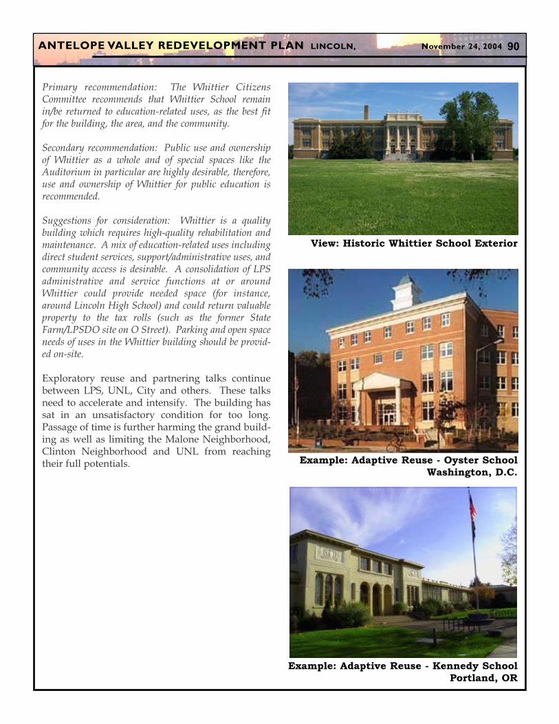
Primary recommendation: The Whittier CitizensCommittee recommends that Whittier School remainin/be returned to education-related uses, as the best fitfor the building, the area, and the community.
Secondary recommendation: Public use and ownershipof Whittier as a whole and of special spaces like theAuditorium in particular are highly desirable, therefore,use and ownership of Whittier for public education isrecommended.
Suggestions for consideration: Whittier is a qualitybuilding which requires high-quality rehabilitation andmaintenance. A mix of education-related uses includingdirect student services, support/administrative uses, andcommunity access is desirable. A consolidation of LPSadministrative and service functions at or aroundWhittier could provide needed space (for instance,around Lincoln High School) and could return valuableproperty to the tax rolls (such as the former StateFarm/LPSDO site on O Street). Parking and open spaceneeds of uses in the Whittier building should be provid-ed on-site.
Exploratory reuse and partnering talks continuebetween LPS, UNL, City and others. These talksneed to accelerate and intensify. The building hassat in an unsatisfactory condition for too long.Passage of time is further harming the grand build-ing as well as limiting the Malone Neighborhood,Clinton Neighborhood and UNL from reachingtheir full potentials.
View: Historic Whittier School Exterior
Example: Adaptive Reuse - Oyster School
Washington, D.C.
Example: Adaptive Reuse - Kennedy School
Portland, OR
ANTELOPE VALLEY REDEVELOPMENT PLAN LINCOLN, November 24, 2004 91
XVIII. FUTURE UTILITIES & INFRASTRUC-
TURE
As part of the Antelope Valley Projects several relo-cations are proposed to avoid conflicts with theflood control and transportation improvements.Along with these relocations, some considerationshave been taken into account for future redevelop-ment.
A. Water SystemAs new redevelopment projects are identified, theCity will need to carefully determine if the existingwater system can handle the new projects.
B. Sanitary Sewer SystemSimilarly, a detailed sanitary sewer capacity studyshould be conducted to identify specific needs andprojects, particularly on a case-by-case basis asredevelopment projects occur.
C. Storm Water SystemThe new waterway from "J" Street to Salt Creek willbe the most important storm water improvement inthe Antelope Valley Area. It is designed to safelycarry 100-year flood waters. The reduction of the 4to 6 block wide designated floodplain to within thenew waterway banks will remove 336 commercialand industrial structures, 961 residential structuresand 50 acres of the University of Nebraska proper-ties from the designated floodplain. The new aes-thetic stormwater conveyance system will generatenew public recreation opportunities, while encour-aging new private reinvestment.
D. Communication and Broadband While the new waterway, roadways and reinvest-ment projects will cause short term disruptions andrerouting of peoples' lives, the resulting gradingand right-of-ways provide exciting opportunities tobury communication, broadband, fiber optics, tele-phone and cable lines. New lines can also be co-located and buried. East Downtown and otherabutting properties to the roadways and waterwayhave the opportunity to become the most "wired"communication areas in Lincoln. This new commu-nication status will attract many new jobs, businessventures, and other economic opportunities forAntelope Valley and the community.
ANTELOPE VALLEY REDEVELOPMENT PLAN LINCOLN, November 24, 2004 92
XIX. FUTURE TRANSPORTATION,
STREETSCAPE & PARKING
A. Transportation PlanThe Transportation Plan strives to encouragepedestrian and bicycle travel. Improving sidewalksand trails is a major component of the AntelopeValley vision. In turn, improved public transit isvital to get people out of their cars as a means to goto work, to shop or for recreation.
An interconnected grid of streets and sidewalksallowing vehicles and pedestrians interconnectivitythrough the community defines the major portionof the Antelope Valley Transportation Plan. SeeTransportation, Figure 30. The plan intends a hier-archy of street-types which places emphasis notonly on the movement of the motor vehicles, butalso the experience of the pedestrian. This trans-portation hierarchy forms the organizational struc-ture upon which the Antelope Valley vision isorchestrated. See Streetscape, Figure 31.
Repair and rehabilitation of existing streets andsidewalks in the area are top priorities consideringthe timing of the planned improvements. TheTransportation Plan also envisions several newroads and roadway improvements.
B. Multi-Modal Transportation StudyThe City currently is completing a Multi-ModalTransportation Study based on the recommenda-tions of the Lincoln-Lancaster CountyComprehensive Plan to plan for the expansion ofopportunities for alternative modes of travel andmobility. The primary focus of this study is to iden-tify realistic means for expanding travel, mobilityand accessibility opportunities within the City andCounty by supporting and promoting alternativemodes of transportation. This includes a fullerunderstanding of the relationship that land use pol-icy, growth planning and design standards play infurthering the ultimate success of alternative modesof transportation.
The goal of the study is to define means for further-ing the usage of a wider range of travel modes tomeet the Comprehensive Plan and Long RangeTransportation Plan Vision for enhancing multi-
modal opportunities. This effort must at the sametime consider and acknowledge the community'scurrent dependence on the automobile while seek-ing greater usage of alternative modes of trans-portation.
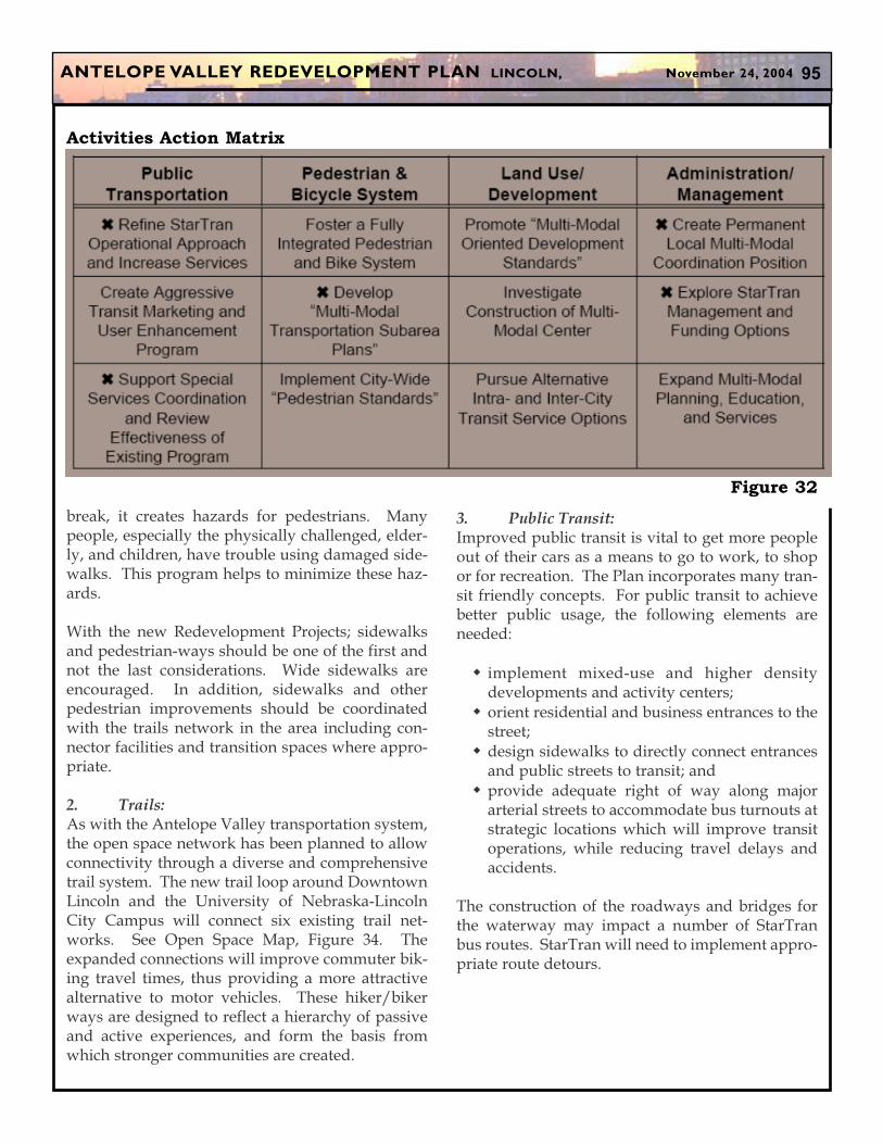
The study, which is scheduled for completion inJuly 2004, produced an Activities Action Matrixoutlining important steps to greater usage of alter-native transportation. The Matrix (currently awork-in-progress), figure 32, illustrates specificpolicy recommendations for four components ofthe multi-modal transportation system.
1. Sidewalks:Sidewalks are usually taken for granted. Yet, theyplay an important role in transportation, exerciseand overall quality of life. Years of wear and tearcan damage sidewalks, and many Lincoln side-walks need to be repaired.
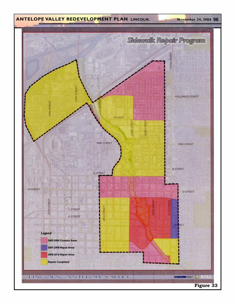
The Blight and Substandard Determination Studyidentified 9.2 percent of the sidewalks in either fairor poor condition. The City's sidewalk repair pro-gram has repaired some of these sidewalks, butother sidewalk sections continue to need repair orreplacement. Figure 33, shows the sidewalks theCity plans to repair or replace as part of theSidewalk Repair Program.
Within the Antelope Valley Redevelopment Areathere are a number of sidewalk repairs that will beimplemented in the next six years, in and aroundthe Antelope Valley Area. They include the followsareas:
Clinton Neighborhood and University ofNebraska area in 2004Downtown Lincoln (17th to 27th from "M" to"R") in 2004Downtown Lincoln (7th to 17th from "M" to"H") in 2004Woods Park (21st to 27th from "O" toRandolph) in 2010
The goal of this program is to make sidewalks safefor pedestrians and help prevent injuries caused bydamaged sidewalks. When sidewalks crack and
ANTELOPE VALLEY REDEVELOPMENT PLAN LINCOLN, November 24, 2004 93
Figure 30
An
telo
pe V
alley P
ark
way
Antelope Drive
Existing and Proposed Trails
ANTELOPE VALLEY REDEVELOPMENT PLAN LINCOLN, November 24, 2004 94
Figure 31
Varies Varies
Varies Varies
Varies Varies
Varies Varies
Varies Varies
Varies Varies
Varies Varies
11’ 11’
11’ 11’
11’ 11’
11’ 11’
11’ 11’
11’ 11’ 11’ 11’
11’ 11’ 11’ 11’ 11’ 11’ 11’11’ 11’Varies6’ 6’
6’ 6’
6’ 6’
6’6’
6’ 6’
6’ 6’
18’ 18’
8’
8’ 8’
8’ 8’
8’ 8’Varies
Varies
MEWS
30’ RESIDENTIALSTREET
EVENTSTREET
40’ RESIDENTIALSTREET
50’ MAIN STREET
70’ MAIN STREET
NORTH-SOUTH ROADWAY
70’ MAIN STREET
50’ MAIN STREET
40’ RESIDENTIALSTREET
EVENTSTREET
30’ RESIDENTIALSTREET
MEWS
EXAMPLES:TYPICAL
EXAMPLES:R STREET
24TH STREET
EXAMPLES:21ST STREET
22ND STREET
EXAMPLES:18TH STREET
P STREET
EXAMPLES:N STREET
EXAMPLES:O STREET
27TH STREET
ANTELOPE VALLEY REDEVELOPMENT PLAN LINCOLN, November 24, 2004 95
break, it creates hazards for pedestrians. Manypeople, especially the physically challenged, elder-ly, and children, have trouble using damaged side-walks. This program helps to minimize these haz-ards.
With the new Redevelopment Projects; sidewalksand pedestrian-ways should be one of the first andnot the last considerations. Wide sidewalks areencouraged. In addition, sidewalks and otherpedestrian improvements should be coordinatedwith the trails network in the area including con-nector facilities and transition spaces where appro-priate.
2. Trails: As with the Antelope Valley transportation system,the open space network has been planned to allowconnectivity through a diverse and comprehensivetrail system. The new trail loop around DowntownLincoln and the University of Nebraska-LincolnCity Campus will connect six existing trail net-works. See Open Space Map, Figure 34. Theexpanded connections will improve commuter bik-ing travel times, thus providing a more attractivealternative to motor vehicles. These hiker/bikerways are designed to reflect a hierarchy of passiveand active experiences, and form the basis fromwhich stronger communities are created.
3. Public Transit:Improved public transit is vital to get more peopleout of their cars as a means to go to work, to shopor for recreation. The Plan incorporates many tran-sit friendly concepts. For public transit to achievebetter public usage, the following elements areneeded:
implement mixed-use and higher densitydevelopments and activity centers;orient residential and business entrances to thestreet;design sidewalks to directly connect entrancesand public streets to transit; and provide adequate right of way along majorarterial streets to accommodate bus turnouts atstrategic locations which will improve transitoperations, while reducing travel delays andaccidents.
The construction of the roadways and bridges forthe waterway may impact a number of StarTranbus routes. StarTran will need to implement appro-priate route detours.
Figure 32
Activities Action Matrix
ANTELOPE VALLEY REDEVELOPMENT PLAN LINCOLN, November 24, 2004 96
Figure 33
ANTELOPE VALLEY REDEVELOPMENT PLAN LINCOLN, November 24, 2004 97
Figure 34
ANTELOPE VALLEY REDEVELOPMENT PLAN LINCOLN, November 24, 2004 98
C. Street RehabilitationIn the last several years, the City's Public WorksDepartment has resurfaced or repaired many localneighborhood streets. These infrastructureimprovements give a fresh image to older neigh-borhood streets.
Future rehabilitation of neighborhood streets isplanned on an annual basis in order to allow forflexibility to repair those streets that cannot waituntil some later date. Consideration for any newneighborhood street rehabilitation will also dependupon the completion of new projects within theAntelope Valley Redevelopment Area. Street reha-bilitation and widening for arterial streets that theCity plans to fund are identified in the City's CIP2004-2009.
D. Street ImprovementsSeventy coal and freight trains traversing theBurlington Northern Santa Fe Railroad lines areblocking the N. 14th Street and N. 17th Street atgrade crossings 5 hours out of every 24 hour peri-od. Major arterials are congested and a major pub-lic concern. Arterial congestion, in turn, is causingsome motorists to cut through local neighborhoodstreets which leads to other sets of undesirable con-sequences.
1. Antelope Valley Parkway and East/WestRoadway:The new major roadways--Antelope ValleyParkway (north/south roadway) and the east/westroadway--will decrease travel times and area trafficcongestion when completed. For example,Holdrege Street and N. 16th and N. 17th Streetthrough the University Campus will experience asignificant reduction in daily trips. The roadwayconstruction will be phased over the next six years,which means many redevelopment projects maychoose to wait in order to have a new image streetor to avoid disruption by road construction.
2. New Antelope Drive (21st Street):Another new road in the Antelope Valley vision isa new 21st Street/Antelope Drive (formerly calledthe Serpentine Road). See Figure 30. Antelope
Drive will be designed to foster redevelopmentprojects and be a local road providing local accessand much needed circulation to East Downtown.The new two-way traffic road is planned to start asa right-turn only movement at Capitol Parkwayapproximately a block east of S. 21st Street.Curving north, the Antelope Drive would bedesigned as a local street to discourage commutertraffic. North of "O" Street, Antelope Drive woulduse the existing N. 21st right-of-way. After crossing"Q" Street, Antelope Drive would curve followingthe waterway and connect with Antelope ValleyParkway near "S" Street.
The first segment of the new Antelope Drive (N.21st Street) between "O" and "P" Streets is tentative-ly scheduled to be completed in 2005 as part of util-ity relocation that is necessary to construct thefuture waterway. Funding of the remaining por-tion is uncertain. The City of Lincoln is presentlyfacing a road infrastructure financing shortfall. Thefunding of the remaining balance of Antelope Driveis not anticipated to be in the Capital ImprovementPlan (CIP) for the foreseeable future. Constructionof the remaining sections will have to depend uponTax Increment Financing funds and other relatedredevelopment monies.
ANTELOPE VALLEY REDEVELOPMENT PLAN LINCOLN, November 24, 2004 99
E. Parking
1. Parking Principles:Successful redevelopment and revitalization effortsin the Antelope Valley Area will need to properlylocate, design and operate on-street and off-streetparking without parking dominating the land-scape. Proper parking siting and design are criticalto provide convenient parking for residents, clients,customers and visitors, while preventing unfriend-ly pedestrian experiences -- walking by sterile park-ing spaces. Surface parking and garage parkingneed to be properly screened behind buildings,walls, and landscaped berms. Future parkingspaces should be located in the internal portions ofCity blocks. Placing buildings adjacent to the streetrights of way and parking in the back will helpinsure a more interesting pedestrian experience.Placement of parking in the internal portion of theblock will require extra design effort, but the extraeffort pays big dividends. Screened parking facili-ties also need extra attention to properly providelighting and other safety features so parkers andpedestrians do not worry about their personal safe-ty.
2. Downtown Master Plan Parking Strategies:Quality design, construction, maintenance andoperation of parking spaces are major public andprivate expenses in redevelopment projects. Thescope for the up-coming Downtown Master Planincludes addressing Downtown Lincoln's parkingprograms and strategies. The Downtown MasterPlan's strategies should prove valuable in identify-ing integrated parking approaches for bothTraditional Downtown and East Downtown. Thesenew strategies will result in improving the overallparking administration, efficiencies, and funding.
3. Parking in the Redevelopment Projects andRedevelopment Concepts:The Vine Street Redevelopment Project providesoff-street parking pursuant to the LincolnMunicipal Code. The other redevelopment project,the Neighborhood Enhancement Projectm, needs toproperly balance on-street parking with adequatesafety and streetscape design.
Proposed Redevelopment Concept A-EastDowntown, Figure 22, is primarily located withinthe B-4 zoning district. The City of Lincoln's B-4zoning district does not require a redeveloper toprovide parking in conjunction with new develop-ment. Proposed Redevelopment Concept B-Malone Neighborhood, Figure 24, is primarilylocated in the R-6 Residential District whichrequires residential parking pursuant to Section27.21.060 of the Lincoln Municipal Code. Parkingwill need to be added in conjunction with both pro-posed redevelopment concepts. The supply ofparking will address convenience, demand andcost to both construct and use. Parking forProposed Redevelopment Concept A-EastDowntown may include a combination of bothpublic and private parking and be configured withboth off-street surface lots and/or a structural park-ing garage. Most likely, parking for ProposedRedevelopment Concept B-Malone Neighborhoodwill include off-street surface parking.
Parking for the other Potential RedevelopmentConcepts, Figure 27, will include a combination ofboth public and private parking to be configuredwith both surface lots and/or structural parkinggarages. Parking should be located to minimize itsvisual impact on pedestrian travel and redevelop-ment efforts, while providing convenient, safe andcost effective parking for a variety of users.
Example: Parking Landscape Treatment
Dallas, TX
ANTELOPE VALLEY REDEVELOPMENT PLAN LINCOLN, November 24, 2004 100
XX. FUTURE HUMAN AND COMMUNITYSERVICES
Physical spaces (such as sound housing, retail,offices, parks, sidewalks and streets) are veryimportant to achieve a successful neighborhood.These spaces provide shelter, jobs, recreation, cul-tural enrichment, transportation and address basicphysical needs. Yet, citizens need more-health, per-sonal well-being and personal relationships.Therefore, the Antelope Valley Plan includes avision for how these cultural, social, mental andphysical needs can be addressed as communityrevitalization strategies.
Through the Antelope Valley process, the assis-tance of the Community Services Planning Cabinetwas sought to help address these future needs. TheAntelope Valley vision represents new opportuni-ties to improve services to historically underservedpopulations, while building from the strengths anddiversity of the area. The Antelope Valley Area ismore ethnically diverse and has a higher percent-age of English Language Learners than otherLincoln neighborhoods. The residents are moretransient and have lower median incomes thanother Lincoln residents. The area is younger in ageand its residents are more likely to live in multi-unitdwellings. This unique set of characteristics anddemographics means that a variety of services pro-vided in a variety of service settings is needed. Italso means that, as the area changes, so must thenature of the services provided. Under theAntelope Valley vision, when the area has moremixed income residents, the range and needs forservices will also change.
A. Leveraging: "Doing more with less"For the most part, agencies that provide humanservices in Lincoln and Lancaster County are not-for-profit agencies that rely on public and privatephilanthropic support, federal grant or programfunding, local community foundation support andUnited Way funding. For many agencies, thesefunding sources have decreased over the past sev-eral years, primarily as a result of the downturn inthe economy and perhaps due to a lack of strategicplanning, yet the need for services has increased. In
other words, these agencies are asked to do morewith less. They have become creative in meetingthe needs of the populations they serve; however,they have not been able to meet the rising demands.
As part of the development of this RedevelopmentPlan, a representative group of agencies that pro-vide service in the Antelope Valley Area wereasked whether a "one-stop" human service facility(such as a rehabilitated Whittier Junior HighSchool) may be a desirable goal so that individualscan access all needed services in a single location.The general consensus was that for most services, a"one-stop" facility may not be an appropriateoption. There were several concerns expressedsuch as physical structure limitations, staffingissues, resource availability and privacy, safety andconfidentiality concerns. Given the challenges andnew opportunities noted above, what is the bestway to ensure that services are provided in a man-ner appropriate to the current neighborhood resi-dents, and yet consistent with the vision for theAntelope Valley Community Revitalization effort?
B. New Community Learning Centers (CLC)Community Learning Centers (CLC) link localneighborhoods, people of all ages and backgroundsand other service providers without constructinganother costly physical space. Services provided byCLCs can include: child care, before and afterschool educational programs, English languagelearners, senior centers, computer labs, food servic-es, health services and classes covering health, fam-ily and job training matters. CLCs will need to con-tinue to focus on improved student learning, whiledeveloping stronger families and healthier neigh-borhoods.
Early on in the Antelope Valley process, five CLClocations were proposed at Elliott School, IndianCenter, former Whittier Junior High building,Clyde Malone Center, and a new facility near N.27th Street & Holdrege Street. The newNorthbridge Community Center at N. 27th Street &Holdrege Street vision has opened its doors andLincoln Public Schools and others have created aCLC at Elliott School. Discussions are underway todetermine the feasibility of replacing the Malone
ANTELOPE VALLEY REDEVELOPMENT PLAN LINCOLN, November 24, 2004 101
Center and have it join forces with the Parks andRecreation Department in a new CLC in TragoPark. See Section D., Proposed Joint CommunityCenter, below. Continued CLC dialogue andefforts should be extended to the Indian Center. Inaddition, CLC services could play an integral partof the redevelopment of Whittier Junior HighSchool.
Given the broad diversity, a variety of servicesmust be available, affordable and provided in avariety of neighborhood settings. The provision ofthese services must be sensitive to the culture of thepopulation, their language needs and any religiousdifferences. As the neighborhoods change andbecome more diverse, economically, culturally anddemographically, so must the mix and manner ofservices provided. However, as the faces of thecommunity change, it is important not to lose sightof the indigenous populations of the neighbor-hoods, and to continue to ensure that their needsare being served.
The CLC model is not a stagnant model for the pro-vision of services; it is constantly changing as indi-viduals', neighborhoods' and the community'sneeds and partnerships change. Each AntelopeValley Neighborhood has a unique identity, includ-ing a unique set of strengths and needs. As newservice needs are identified by the neighborhoodthrough the School Neighborhood AdvisoryCommittees, the core entity already involved (i.e.,the school, cultural center, recreation centers, etc.),will help determine the most appropriate locationand provider for the new services. This mayrequire that new partnerships are developed or thatexisting programs are changed or ended. It isimportant to understand that the needs of theneighborhoods are what drive the model.
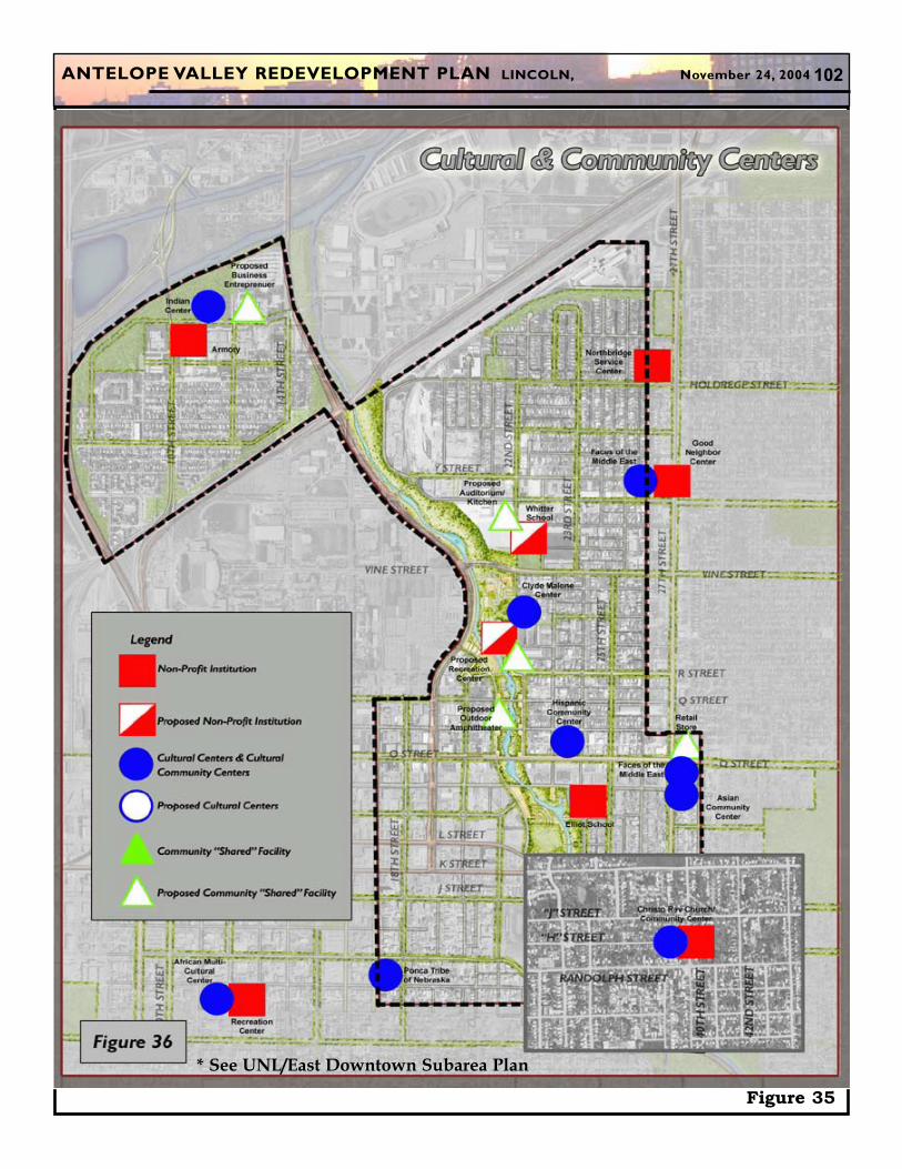
C. Sustainable Cultural CentersMost of Lincoln's eight ethnically based culturalcenters are located in the Antelope Valley Area. SeeCultural Centers, Figure 35. These centers serve avital mission of welcoming new arrivals to the com-munity and providing people of different cultures aplace to celebrate, provide support and practicetheir customs and traditions. Yet, many cultural
centers are financially struggling. The recent eco-nomic downfall and the resulting reduction in phil-anthropic support cause many of these centers towonder if they can survive.
As part of the Antelope Valley RedevelopmentPlan, the City and other community partners haveoffered to assist cultural centers in developing asustainable vision and plan. The City has assem-bled a resource team to assist any cultural centerdesiring facilitation and strategic planning assis-tance. Each cultural center is encouraged to devel-op a plan and a vision (with or without use of theCity's resource team) that would address these andany other important components.
Many of the cultural centers are exploring theoption of teaming up with an existing institution(such as a school, city recreation center or library).This model could allow cultural centers to "do morewith less" by sharing facilities, staff and resources,while still allowing the cultural center to keep itsstrong identity and practices. This model is similarto the partnering efforts that have generated thesuccessful Community Learning Centers.
Some of the cultural centers, such as the ClydeMalone Community Center and Asian Cultural andCommunity Center, are developing and imple-menting new strategic plans with the City to gainsustainability based upon this "shared resourcemodel".
D. Proposed Joint Community CenterThe Clyde Malone Community Center has played apivotal role helping three neighborhoods-Malone,Clinton and Hartley-at the same time providing keyleadership and programming activities to theAfrican-American community. In recent years, theMalone Center has faced a series of issues and chal-lenges: administrative difficulties, major cutbacksin philanthropic monies and a structural buildingassessment that the Center's building needed over$750,000 in repair and rehabilitation. The newboard leadership has responded with better man-agement practices and new partnering efforts.Recent dialogue has occurred between the MaloneCenter Board and the City Parks and Recreation
ANTELOPE VALLEY REDEVELOPMENT PLAN LINCOLN, November 24, 2004 102
Figure 35
* See UNL/East Downtown Subarea Plan
ANTELOPE VALLEY REDEVELOPMENT PLAN LINCOLN, November 24, 2004 103
Department to explore the possibility of a newshared campus facility that could house both a newCity Recreation Center (similar to the successful "F"Street Community Center) and a new ClydeMalone Community Center. To facilitate the dia-logue, the City, with the assistance of a profession-al master planning team, sought input from neigh-bors and other Lincoln citizens and prepared adraft master plan for a new shared facility in TragoPark.
The draft plan for the Joint Community Center pro-poses two separate building sections physicallyconnected, but owned and funded separately by thetwo respective entities. The shared location wouldgenerate the opportunity to reduce costs, increaseprogramming and service opportunities and pro-vide better coordination of spaces, operations andmaintenance. These potential savings, efficienciesand opportunities would improve the program-ming and delivery services for pre-school, seniorprograms, arts, aerobics, summer programs, educa-tion, community meeting spaces and other cultural,neighborhood and recreational needs.
The draft Joint Community Center master plan alsoproposes the relocation of Kuklin Pool as part of theTrago Park campus. Kuklin Pool is presently locat-ed at N. 23rd Street and "N" Street. Relocation ofKuklin pool is not required as part of the AntelopeValley waterway design. However, the pool is inneed of major rehabilitation. A new Kuklin Pool inTrago Park would improve the service areas forboth Woods Park Pool and Kuklin Pool.
E. Potential Expansion of the Elliott SchoolCommunity Learning CenterThere is great potential in expanding the ElliottSchool CLC partnership between Lincoln PublicSchools, YMCA of Lincoln Community ServicesBranch, and other community based organizations.One of the hallmarks of this partnership is the cre-ative blending of community resources to effective-ly enhance the academic learning and achievementof youth, strengthen families, and provide a con-necting point for the neighborhood. Blendingtogether LPS, YMCA, and other communityresources, Elliott School is used as a hub for a vari-
ety of educational, recreational, social service,enrichment, and service activities. Several organi-zations have entered into partnerships to deliverservices through this arrangement including: TheAsian Cultural and Community Center, Faces ofthe Middle East, Hispanic Community Center,Lincoln Action Program, Lincoln Literacy Council,and Malone Community Center. These organiza-tions have found that by working together in acoordinated system, progress comes much faster inachieving shared goals while concurrently creatingfinancial efficiencies.
Conversations are taking place between LPS andthe YMCA of Lincoln about how to enhance thisservice delivery model by expanding the physicalstructure at Elliott School. Among the proposedideas are: a multi-cultural pre-school, space for asenior center, medical screening rooms, counselingrooms, additional school/community classrooms(including a computer lab and art room), sharedLPS, YMCA, community partner administrativeand meeting space, and a family resource center. Itis possible that other community based organiza-tions could headquarter within the building as well.The vision for this structure is that the design willincorporate the needs of before and after schoolprogramming, school day learning, and eveningand weekend community programs so that thepublic can continuously utilize the space.
The programs would provide coordinationbetween services. For example, in one room seniorscan volunteer as caregivers in the pre-school alongwith a paid, certified LPS teacher and communitypartner staff. In another room parents can learncomputer, job, or parenting skills. In yet anotherroom school teachers are leading traditional class-rooms. Down the hall family members could bereceiving counseling or preventive health adviceand in the administration offices school and com-munity partners are sharing resources to create costefficiencies and coordination. By serving the com-munity holistically, and by blending resources, andfacilities, LPS, YMCA and community agency staffcan ensure long-term sustainability, financial effi-ciency and effective delivery of services and oppor-tunities for those people who need it most.
ANTELOPE VALLEY REDEVELOPMENT PLAN LINCOLN, November 24, 2004 104
F. Compassion Capital Fund DemonstrationProgramThe City of Lincoln, in a partnership between itsParks and Recreation and Urban DevelopmentDepartments, has applied to the US Department ofHealth and Human Services, Administration forChildren and Families, for a Compassion CapitalFund Demonstration Program grant. The goal ofthe program is to assist faith-based and communityorganizations to increase their effectiveness,enhance their ability to provide social services,expand their organizations, diversify their fundingsources, and create collaborations to better servethose most in need. If the City is awarded thegrant, the two departments intend to partner withthe area cultural centers to carry out the programgoals. All of the cultural centers have expressed aninterest in working with the City. Some of theactivities could include training in board develop-ment, fiscal management, grant writing, audits,need assessments and strategic planning, volunteermanagement, legal assistance, and assistance secur-ing a 501(c)(3) designation. Grant awards will beannounced October 1, 2004.
G. People's Health CenterThe People's Health Center partnered with the Cityof Lincoln to establish the new clinic as part ofLincoln's North 27th Street Redevelopment Planefforts. The clinic opened in the fall of 2003 andprovides access to primary medical, oral andbehavioral health care on a sliding scale basis toarea residents. A second campus building is sched-uled to be constructed in the near future in order tomeet the communities growing health needs.
H. Leveraging Other Ethnic and CulturalBased ActivitiesMany ethnic and cultural groups want and needtheir own place for identity. Presently, there areeight formally designated cultural centers. Yet,there are many potential services and programsthat cannot be physically or economically housed ineach center. Those services and programs needinga larger space that cannot be housed in a center
could possibly be housed in different locations andshared by many ethnic and cultural groups on aconcurring or nonconcurring basis. The People'sHealth Center and Nebraska Urban Indian HealthCoalition are examples of on-going shared pro-gramming. The proposed Joint Community Centerin Trago Park would be examples of future sharingarrangements. Stronger and more viable culturalcenters could spur and leverage other new ethnicand cultural based activities and links such as:
Indoor performances at a renovated theater inthe former Whittier Junior High School;Outdoor performances on the new outdooramphitheater stage in East Downtown Park;Ethnic, cultural, social and festival gatheringplaces in the East Downtown Park/Trago Parkarea and other central locations such as thesoon to be vacated Military Buildings onMilitary Road;Entrepreneur business center providing skillsand resources to new rising business leadersand employers;Kitchen classroom space to allow teaching citi-zens a variety of ethic food dishes; andRetail art and craft store to display a variety ofcultural arts.
View: Hispanic Center of Lincoln
ANTELOPE VALLEY REDEVELOPMENT PLAN LINCOLN, November 24, 2004 105
XXI. OTHER REDEVELOPMENT PRO-GRAMS
A. Focus AreasFocus Areas are an important neighborhood revi-talization strategy that concentrate public and pri-vate resources in small neighborhood areas (12 to30 blocks). This approach aims the City's limitedcommunity development resources towards strate-gic improvements, with an eye towards stimulatingprivate investment and increasing confidence in thearea. The Urban Development Department initiat-ed this strategy in 1993, and has subsequently fund-ed more than 2 million dollars in projects in ninedifferent Focus Areas across the community.Portions of all the Antelope Valley Neighborhoods(North Bottoms, Clinton, Malone/Hawley,Downtown, Woods Park and Near South) have orare implementing Focus Area strategies.
To be identified as a Focus Area, a neighborhoodmust be located in a certain area in a low to moder-ate income area; exhibit signs of decline, such asdeterioration of housing or public facilities; featurea neighborhood association that is committed toworking with the City to identify and implementimprovements; include key areas next to busystreets, public institutions (such as schools), or com-mercial areas; and be identified as an area of con-cern by other City departments.
Typically, Focus Area strategies address a varietyof goals and objectives for neighborhoods. Forexample: rehabilitate existing housing stock;improve streetscapes; resolve commercial zoningissues; address crime, security and street lightingconcerns; improve sidewalks, streets and alleys; fixoutdated utilities; resolve solid waste, junk car andother environmental issues; and improve bikepaths, parking and other transportation objectives.
B. North 27th Street Corridor and EnvironsRedevelopment PlanThe North 27th Street Corridor and EnvironsRedevelopment Plan was adopted by the CityCouncil in September 2002. This plan is considereda "sister" plan of the Antelope ValleyRedevelopment Plan because of its proximity to
Antelope Valley and comprising the eastern edge ofthe Antelope Valley Area north of "N" Street. Thetwo planning efforts have been coordinated formany years and have worked together in the con-struction of the Northbridge Community Centerand the People's Health Center along N. 27th Street.
Other projects completed under the North 27thStreet Redevelopment Plan include a new policestation, two new retail centers, removal of blightedhouses and a N. 27th Street streetscape project.Under construction in the spring and summer of2004 will be improvements in the right-of-wayaround the Salvation Army with expansion andimprovements to Pentzer Park and a new adminis-tration office and treatment facility forCenterPointe, Inc. Redevelopment of the oldCarpenter's Union is also planned, along with apedestrian trail bridge over 27th Street for theHusker Link trail along the former Missouri PacificRailroad right of way ("X" Street).
C. House Preservation and Infill ProgramConstruction of the new roadways, waterway andother Antelope Valley community revitalizationstrategies will require the acquisition of approxi-mately 47 residential structures. In response toneighborhood concerns, JAVA pledged an extraeffort to assist interested owner occupants andinvestor owners in moving their residential struc-tures to a new site. The House Preservation andInfill Program is JAVA's response to that pledge.
While house relocation is generally not cost effec-tive, there are other desirable public objectives andbenefits that prove difficult to value, and thus, areoften not considered in making the cost-benefitanalysis. Besides the benefit of preserving thememories and recycling the dwelling, the relocateddwelling can fill in a vacant or underutilized lot inestablished neighborhoods more successfully thanmany newer style and higher density buildings thatare often out of character with the established firstgeneration housing stock. The relocated housingcan provide homeownership opportunities to lowand moderate income households.
ANTELOPE VALLEY REDEVELOPMENT PLAN LINCOLN, November 24, 2004 106
Residential structures will be acquired at fair mar-ket value and eligible owners and tenants willreceive relocation assistance and payments to pro-vide decent, safe and sanitary replacement housingAs part of the acquisition process, owners canchoose to participate in the voluntary HousePreservation and Infill Program but in all cases, willbe paid fair market value and, if eligible, relocationassistance regardless of participation in the volun-tary program.
The City Urban Development Department, withassistance from JAVA, is responsible for carryingout The House Preservation and Infill Program.The City's Urban Development Department willneed to complete an interior inspection of thepotential dwellings and identify potential infill lotsites, including potential vacant and under utilizedparcels in close proximity to the roadways andwaterway.
In addition, four houses (125, 135, and 145 N. 22ndSt. and 1907 L St.) impacted by the Antelope ValleyProjects have historical value and were identified aseligible for listing in the National Register ofHistoric Places. JAVA has formally agreed to makeall reasonable efforts to relocate these four historichouses to other sites in the surrounding neighbor-hoods.
The Urban Development Department has contract-ed with Neighborhoods, Inc. to administer the pro-gram. The House Preservation and Infill Programdocument can be found on the City's website atwww.ci.lincoln.ne.us, then click on AntelopeValley, What's New.
D. Public ArtPublic and private art will play an important role inimproving the appearance of the Antelope ValleyArea. For example, artistic treatments and ele-ments have been incorporated into the design of the"X" shape bridge over the waterway and BNSF rail-road tracks. The City has also hired an art consult-ant to assist the community in developing a masterplan for public art in Antelope Valley. To date, theconsultant has facilitated a community kick-offworkshop with the public and key stakeholders toinitiate the public art master planning process.
Example: Housing Infill
Cincinnati, OH
Example: Housing Infill
Tompkins Co., New York
Example: Housing Infill
New York, NY
ANTELOPE VALLEY REDEVELOPMENT PLAN LINCOLN, November 24, 2004 107
Thoughtful placement of interesting and aestheti-cally pleasing works of art throughout the AntelopeValley Area will enhance its appeal for existing andnew residents and businesses and help develop thearea as a community-wide destination. Wheneverappropriate, opportunities for permanent and tem-porary displays of art, including both the visualand performing arts, should be incorporated intopublic improvements.
Private developers should be encouraged toinclude art in redevelopment projects. All publiclysupported projects should strive to have an artscomponent. The City should consider using TaxIncrement Financing (TIF) and establishing specialassessment districts to aid in this endeavor.
E. Free to GrowLincoln is one of several cities across the nation par-ticipating in a demonstration and evaluation proj-ect called Free to Grow. The environmentalapproach to this program works to improve thequality of life in a target area of the community bypromoting strong families and safe neighborhoods.Lincoln's program began in June 2003, and the revi-talization area includes 90+ properties in the
Clinton Neighborhood. Revitalization efforts so farhave included assisting neighbors to establishNeighborhood Watch groups, increased codeenforcement, increased police involvement, twoneighborhood clean ups and two graffiti clean-ups.
The Urban Development Department has beenworking with the Clinton NeighborhoodOrganization in a number of capacities for manyyears. The neighborhood developed a Focus AreaPlan with the City and has been actively involvedwith the Antelope Valley Projects. Selection of theFree to Grow target area was based on criteria setby the national model, which includes crime andproperty distress. The Free to Grow Core Teammeets bi-weekly and includes representatives fromthe Clinton Neighborhood Association, LincolnPolice Department, Urban DevelopmentDepartment, Building and Safety Department,Lincoln Lancaster County Health Department,Neighborhoods, Inc., and Lincoln Action Program.Future plans include continued physical improve-ments to the area along with further developmentof neighborhood leadership.