55 Anuário do Instituto de Geociências - UFRJ www.anuario.igeo.ufrj.br Analyzing Urban Sprawl of Tehran Metropolis in Iran (During 1956-2011) Análise da Expansão Urbana da Metrópole de Teerã (1956-2011), Irã Nader Zali 1 ; Farshid Hashemzadeh Ghal’ejough 2 & Yaghoub Esmailzadeh 2 1 University of Guilan, Art & Architecture Faculty, Associate professor, Urban Planning Department, Rasht, Iran 2 University of Guilan, Art & Architecture Faculty, M.A Students, Urban Planning Department, Rasht, Iran E-mails: [email protected]; [email protected]; [email protected]Recebido em: 18/05/2016 Aprovado em: 18/07/2016 DOI: http://dx.doi.org/10.11137/2016_3_55_62 Abstract Physical development is one of the requirements for urban growth. The uncontrolled urban growth especially for metropolis areas often results in undesirable phenomena such as environmental destruction, city creeping, creation of rural-urban environments and so forth. Today, urban sprawl has changed to a knotty problem for many developing areas. Urban sprawl has been known as a varied concept when it deals with automated development and low- density development. It has a significant effect on surrounding ecosystems. Tehran metropolis-known as the capital of Iran- is not excluded from this rule because sprawling has been intensified during 20th century and will have continued despite existing planning, rules and programs. In this respect, the present study attempts to examine and to assess sprawl in Tehran metropolis with Heldren model. The results indicate that the proportion of population growth in Tehran metropolis is generally more than the proportion of urban sprawl. Overall, between 1956 and 2011, the degree of Tehran physical growth was 73.3 percent owing to the population growth whereas 26.7 percent owing to city sprawl. Presence of a green belt around the city, emphasis on compact city and controlling the building are solutions that this study proposes to prevent Tehran sprawl. Keywords: Urban development; Urban sprawl; Metropolis areas; Heldren model; Tehran metropolis Resumo O desenvolvimento físico é um dos requisitos para o crescimento urbano. O descontrole neste processo, especialmente para áreas metropolitanas, geralmente resulta em fenômenos inadequados, tais como a destruição ambiental, espalhamento da malha urbana, a criação de ambientes rural-urbano e outros. Atualmente o espalhamento urbano modificou-se para um problema complexo para muitas áreas em desenvolvimento, o qual tem sido reconhecido pela variedade de conceitos em relação ao desenvolvimento automatizado e o desenvolvimento de baixa densidade. Ele possui um efeito significativo nos ecossistemas circundantes. A metrópolis de Teerã, capital do Irã, não é uma exceção à esta regra, devido ao espalhamento que se intensificou durante o século 20 e ainda continua, apesar do planejamento e programas de controle. Neste contexto, o presente estudo examina o espalhamento urbano de Teerã através do modelo de Heldren. Os resultados indicam que a proporção de crescimento da população em Teerã é geralmente maior que a proporção do espalhamento urbano. No geral, entre 1956 e 2011, o grau de crescimento físico de Teerã, foi 73,3%, devido ao crescimento da população, enquanto que 26,7% devido à expansão da cidade. A presença de um cinturão verde ao redor da cidade, a ênfase na cidade compacta e o controle em novas construções são soluções que este estudo propõe para controlar a expansão desordenada de Teerã. Palavras-chave: desenvolvimento urbano; crescimento urbano; Metropolis; modelo de Heldren; Teerã Anuário do Instituto de Geociências - UFRJ ISSN 0101-9759 e-ISSN 1982-3908 - Vol. 39 - 3 / 2016 p. 55-62
Transcript
55
Anuário do Instituto de Geociências - UFRJ www.anuario.igeo.ufrj.br
Analyzing Urban Sprawl of Tehran Metropolis in Iran (During 1956-2011)Análise da Expansão Urbana da Metrópole de Teerã (1956-2011), Irã
Physical development is one of the requirements for urban growth. The uncontrolled urban growth especially for metropolis areas often results in undesirable phenomena such as environmental destruction, city creeping, creation of rural-urban environments and so forth. Today, urban sprawl has changed to a knotty problem for many developing areas. Urban sprawl has been known as a varied concept when it deals with automated development and low- density development. It has a significant effect on surrounding ecosystems. Tehran metropolis-known as the capital of Iran- is not excluded from this rule because sprawling has been intensified during 20th century and will have continued despite existing planning, rules and programs. In this respect, the present study attempts to examine and to assess sprawl in Tehran metropolis with Heldren model. The results indicate that the proportion of population growth in Tehran metropolis is generally more than the proportion of urban sprawl. Overall, between 1956 and 2011, the degree of Tehran physical growth was 73.3 percent owing to the population growth whereas 26.7 percent owing to city sprawl. Presence of a green belt around the city, emphasis on compact city and controlling the building are solutions that this study proposes to prevent Tehran sprawl.Keywords: Urban development; Urban sprawl; Metropolis areas; Heldren model; Tehran metropolis
Resumo
O desenvolvimento físico é um dos requisitos para o crescimento urbano. O descontrole neste processo, especialmente para áreas metropolitanas, geralmente resulta em fenômenos inadequados, tais como a destruição ambiental, espalhamento da malha urbana, a criação de ambientes rural-urbano e outros. Atualmente o espalhamento urbano modificou-se para um problema complexo para muitas áreas em desenvolvimento, o qual tem sido reconhecido pela variedade de conceitos em relação ao desenvolvimento automatizado e o desenvolvimento de baixa densidade. Ele possui um efeito significativo nos ecossistemas circundantes. A metrópolis de Teerã, capital do Irã, não é uma exceção à esta regra, devido ao espalhamento que se intensificou durante o século 20 e ainda continua, apesar do planejamento e programas de controle. Neste contexto, o presente estudo examina o espalhamento urbano de Teerã através do modelo de Heldren. Os resultados indicam que a proporção de crescimento da população em Teerã é geralmente maior que a proporção do espalhamento urbano. No geral, entre 1956 e 2011, o grau de crescimento físico de Teerã, foi 73,3%, devido ao crescimento da população, enquanto que 26,7% devido à expansão da cidade. A presença de um cinturão verde ao redor da cidade, a ênfase na cidade compacta e o controle em novas construções são soluções que este estudo propõe para controlar a expansão desordenada de Teerã.Palavras-chave: desenvolvimento urbano; crescimento urbano; Metropolis; modelo de Heldren; Teerã
A n u á r i o d o I n s t i t u t o d e G e o c i ê n c i a s - U F R JISSN 0101-9759 e-ISSN 1982-3908 - Vol. 39 - 3 / 2016 p. 55-62
56A n u á r i o d o I n s t i t u t o d e G e o c i ê n c i a s - U F R JISSN 0101-9759 e-ISSN 1982-3908 - Vol. 39 - 3 / 2016 p. 55-62
Analyzing Urban Sprawl of Tehran Metropolis in Iran (During 1956-2011)Nader Zali; Farshid Hashemzadeh Ghal’ejough & Yaghoub Esmailzadeh
1 Introduction
Patterns of human settlement are changing rapidly around the world as the global population becomes increasingly urban (Kane et al., 2014). Cities are growing in population and size; and this expansion is a common urban challenge (Inostroza et al., 2013). The urbanization process and population growth complement each other. To predict the urban land demand, population forecasts were used as a measure) Kumar et al., 2013). According to the World Urbanization Prospects (United Nations, 2012), most population growth will be absorbed by urban areas on a global perspective which leads to increasing proportions of the population living in cities(Mikovits et al., 2014). Processes of change in land use and urban growth are important components of the global changes currently taking place in world. Today, more than half of the world’s population lives in cities and one important aspect of these is the type of growth pattern they present, whether in the Iberian Peninsula, the rest of Europe, the United States or Asia (Aguilera-Benavente et al., 2014:234). The capacity of land use planning influence a sustainable mode of urban expansion, therefore, relies principally on a policy commitment to growth control (Chorianopoulos et al., 2014:138). Urban containment policies basically have three major forms: urban growth boundaries (UGBs), urban service boundaries (USBs), and green belts. UGB is probably the best known among these urban containment boundaries (Wang, et al., 2014).
The important issue, especially in the third world countries, is skeletal growth and urban physical development pattern which mostly took place in a low density and a fragmented shape and became as a seeming feature for the majority of developing cities in the world (UN-Habitat, 2012). This phenomenon which has become a problem for many developing areas refers to the uncontrolled growth of an urban area where weak or unplanned urbanization happened (Mohd Noor & Rosni, 2013). Meanwhile it refers to a relatively new pattern for human settlements which is formed by accidentally aggregation of houses and buildings with low density and commercial strip developments and is also resulted by wide use of cars (Ewing, 1997).
In Iran, due to the lack of systematic view, inattention to the weak and strong points of cities
as well as their natural and human potentials, the traditional pattern of urban development failed to succeed; therefore, increasing of urban sprawl in most of Iran’s cities are resulting from non-normative and unscientific use of urban lands (Ebrahimzadeh et al., 2010).
Urban physical expansion is always a concern in planning affairs of Iran so far as we have witnessed changes in spatial structures of the large cities in its colorful history. Tehran city also as a metropolis area that has passed spatial development and growth process during less than 200 years faces many spatial and ecological problems in its geographical bed (Mojarrad & Hosseinifar, 2012). In Iran, the city growth was slow and gradual until the early 20th century, but since the arrival of modernism, Iran like other developing countries has started to grow fast; consequently the area of the city has increased to more than twentyfold and its population to twenty fivefold in less than 60 years (Master Plan of Tehran, 2007).
Regarding the importance of the subject, the present study attempts to examine the skeletal-spatial development pattern of Tehran city and to analyze its sprawl. The major aim of the study is to examine growth procedure of Tehran between 1956 and 2011. The most important proposed questions of this research are as follows:
1. Which factors had a great impact on the growth process of Tehran Metropolis between 1956 and 2011?
2. Did Tehran have an urban sprawl between 1956 and 2011?
3. In which period, Tehran had a highest sprawl?
2 The Importance of Studying the Urban Growth and Sprawl
Cities will expand, which is unavoidable, but how to avoid sprawl and manage the urban development in the highest compact way is a matter of urban planning (Inostroza et al., 2013). Actually Cities tend to growth and planned growth is reached while there is an appropriate proportion between urban growth and urban organism. But
57A n u á r i o d o I n s t i t u t o d e G e o c i ê n c i a s - U F R JISSN 0101-9759 e-ISSN 1982-3908 - Vol. 39 - 3 / 2016 p. 55-62
Analyzing Urban Sprawl of Tehran Metropolis in Iran (During 1956-2011)Nader Zali; Farshid Hashemzadeh Ghal’ejough & Yaghoub Esmailzadeh
when the growth is more than usual, its pressure on the boundaries, city will face new major problems (Habibi & Asadi, 2011).
Urban growth or expansion is generally considered to be a land use change from a non-urban category to an urban category (Linard et al., 2013). Urban growth involves two processes: dispersion of an urban area, through the generation of new urban fragments that emerge in the vicinity of the existing urban area, and aggregation or coalescence of these urban fragments, leading to saturation of the urban landscape (Aguilera-Benavente et al., 2014). The term of scattered growth of cities dates back to the mid-20th century when indiscriminate use of private automobile and expansion of highway system led to the expansion of urban areas in America (Hess, 2001).
While sprawl is principally considered to be an American phenomena, global urbanization and rapid population growth have made sprawl an international development form (Hamidi & Eving, 2014). Urban sprawl, has become a common phenomenon throughout the developing world over the past three decades, urban sprawl and its impacts have attracted increasing attention from planners and policy , resulting in heated discussions on its definition, measurement, causes and negative consequences (Yue et al., 2013). The phenomenon of urban sprawl occurs in a variety of forms which are strongly connected with geographical, economic and institutional contexts and is defined in many different ways (Verbeek et al., 2014). In the literature on urbanization, urban sprawl is described as ‘‘dispersed, low densities development on the edges of urban areas, characterized by fragmented and ribbon developments (Arribas-Bel et al., 2011).
The most common definition for urban sprawl as a fundamental issue is defined by Eving. He knows it as a form of spatial development which principally is created in open or rural lands on the edges of mother cities and characterized by low-density, scattered and discrete development, “nodal movement” development, separation of the uses in the shape of strip-center, and the use of private vehicles (Eving, 1997).
Torrens & Alberti call sprawl “a relatively wasteful method of urbanization, characterized by
uniform low densities” (Verbeek et al., 2014:49). The European Environment Agency (EEA) has described sprawl as the physical pattern of low-density expansion of large urban areas, under market conditions, mainly into the surrounding agricultural areas (Habibi & Asadi, 2011).
Glaeser defines scattered or fragmented development as “Decentralization of employment” whereas Fulton calls “Density” as the most important feature of fragmented development of cities (Habibi & Asadi, 2011:134). Related to sprawl, Burchell et al. (1998) have listed three characteristics; spatial patterns, generating factors, and sprawl main effects. Low density, unlimited outward expansion, land uses spatially segregated, discontinuous development, and the expansion of commercial strip are the features of sprawl spatial patterns. In addition, there are two basic reasons for sprawl, first lack of planning and central ownership and second various decisions on land- use. Consequently, transport dominancy, differences between fiscal capacity and ability of local governments, and finally removing low-income housing are three major outcomes of this phenomenon (Burchell et al., 1998).
3 Growth in Iran’s Cities
Uneven development and growth of cities in Iran may be worse than many developed countries. Taking a glance through development history of the cities of Iran, it can be said that cities of Iran have experienced two development scenarios that are as follows:
1. Urban development scenario in Organic model which had dominated cities’ spatial expansions during Pahlavi era, especially before “land reform” in 1960th that has influenced internal growth of urban population. In this process structural changes were generally contextual and the pattern of city growth remained compact.
2. Another scenario relates to the late of 20th
century, non-organic growth model. In this process, spatial growth was much faster than either population growth or the real need of cities through which cities faced uncontrolled expansions (Poormohammadi & Jamkasra, 2011). Today in Iran, due to traditional patterns of governance on urban development’s plans
58A n u á r i o d o I n s t i t u t o d e G e o c i ê n c i a s - U F R JISSN 0101-9759 e-ISSN 1982-3908 - Vol. 39 - 3 / 2016 p. 55-62
Analyzing Urban Sprawl of Tehran Metropolis in Iran (During 1956-2011)Nader Zali; Farshid Hashemzadeh Ghal’ejough & Yaghoub Esmailzadeh
and dominant management techniques of cities, urban pattern is a horizontally fragmented pattern. Therefore, to reduce many problems cities face there is no solution except moving toward compact cities (Mokhtari maelkabadi, et al., 2012:96).
4 Methodology
Based on the objective, the study is an applied research, the research methodology is descriptive and analytical, and it is a documentary data collecting. Data are collected through general census, urban development plans, books, and the related organizations and departments. Finally physical development procedure of Tehran metropolis and its expansion is examined and analyzed by Heldren model.
4.1 Heldren Model
Even though urban sprawl has been subject to research for more than twenty years now, there is no consensus on how the phenomenon can be best measured Verbeek et al., 2014).
Heldren model is one of the best methods for clarifying urban sprawl. In 1991, John Heldren applied this method both for determining the proportion of the horizontal development and population growth of city. Using this model helps to appraise what extent of the development is subject to the population and what degree to the urban sprawl
(this model help to specify the degree of population and urban growth distinctively) (Hekmatnia & Mousavi, 2011). The overall structure of the model is as follow:
Ln (P/w) + Ln (e/r) = Ln (y/s) (1)
In this formula, (P) stands for population by the end of the period, (W) for the population of the beginning of the period, (e) stands for gross per capita by the end of the period, (r) for per capita gross of the beginning of the period, (y) is city area by the end of period, and (s) is city area at the beginning of the period.
5 Case Study
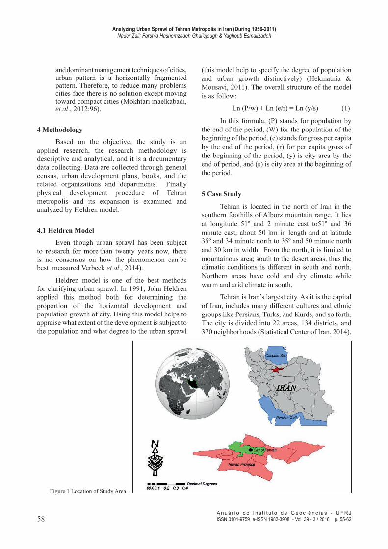
Tehran is located in the north of Iran in the southern foothills of Alborz mountain range. It lies at longitude 51º and 2 minute east to51º and 36 minute east, about 50 km in length and at latitude 35º and 34 minute north to 35º and 50 minute north and 30 km in width. From the north, it is limited to mountainous area; south to the desert areas, thus the climatic conditions is different in south and north. Northern areas have cold and dry climate while warm and arid climate in south.
Tehran is Iran’s largest city. As it is the capital of Iran, includes many different cultures and ethnic groups like Persians, Turks, and Kurds, and so forth. The city is divided into 22 areas, 134 districts, and 370 neighborhoods (Statistical Center of Iran, 2014).
Figure 1 Location of Study Area.
59A n u á r i o d o I n s t i t u t o d e G e o c i ê n c i a s - U F R JISSN 0101-9759 e-ISSN 1982-3908 - Vol. 39 - 3 / 2016 p. 55-62
Analyzing Urban Sprawl of Tehran Metropolis in Iran (During 1956-2011)Nader Zali; Farshid Hashemzadeh Ghal’ejough & Yaghoub Esmailzadeh
6 Procedure of Tehran Skeletal and Population Growth
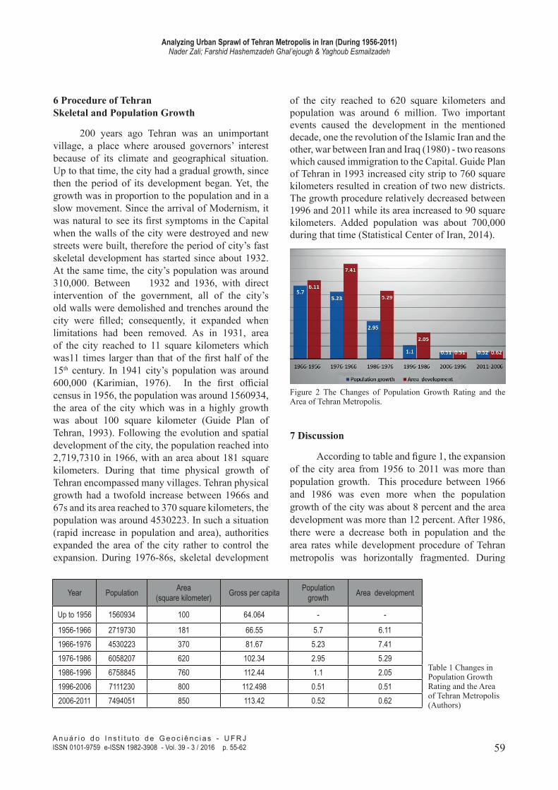
200 years ago Tehran was an unimportant village, a place where aroused governors’ interest because of its climate and geographical situation. Up to that time, the city had a gradual growth, since then the period of its development began. Yet, the growth was in proportion to the population and in a slow movement. Since the arrival of Modernism, it was natural to see its first symptoms in the Capital when the walls of the city were destroyed and new streets were built, therefore the period of city’s fast skeletal development has started since about 1932. At the same time, the city’s population was around 310,000. Between 1932 and 1936, with direct intervention of the government, all of the city’s old walls were demolished and trenches around the city were filled; consequently, it expanded when limitations had been removed. As in 1931, area of the city reached to 11 square kilometers which was11 times larger than that of the first half of the 15th century. In 1941 city’s population was around 600,000 (Karimian, 1976). In the first official census in 1956, the population was around 1560934, the area of the city which was in a highly growth was about 100 square kilometer (Guide Plan of Tehran, 1993). Following the evolution and spatial development of the city, the population reached into 2,719,7310 in 1966, with an area about 181 square kilometers. During that time physical growth of Tehran encompassed many villages. Tehran physical growth had a twofold increase between 1966s and 67s and its area reached to 370 square kilometers, the population was around 4530223. In such a situation (rapid increase in population and area), authorities expanded the area of the city rather to control the expansion. During 1976-86s, skeletal development
of the city reached to 620 square kilometers and population was around 6 million. Two important events caused the development in the mentioned decade, one the revolution of the Islamic Iran and the other, war between Iran and Iraq (1980) - two reasons which caused immigration to the Capital. Guide Plan of Tehran in 1993 increased city strip to 760 square kilometers resulted in creation of two new districts. The growth procedure relatively decreased between 1996 and 2011 while its area increased to 90 square kilometers. Added population was about 700,000 during that time (Statistical Center of Iran, 2014).
Year Population Area(square kilometer) Gross per capita Population
Table 1 Changes in Population Growth Rating and the Area of Tehran Metropolis (Authors)
Figure 2 The Changes of Population Growth Rating and the Area of Tehran Metropolis.
7 Discussion
According to table and figure 1, the expansion of the city area from 1956 to 2011 was more than population growth. This procedure between 1966 and 1986 was even more when the population growth of the city was about 8 percent and the area development was more than 12 percent. After 1986, there were a decrease both in population and the area rates while development procedure of Tehran metropolis was horizontally fragmented. During
60A n u á r i o d o I n s t i t u t o d e G e o c i ê n c i a s - U F R JISSN 0101-9759 e-ISSN 1982-3908 - Vol. 39 - 3 / 2016 p. 55-62
Analyzing Urban Sprawl of Tehran Metropolis in Iran (During 1956-2011)Nader Zali; Farshid Hashemzadeh Ghal’ejough & Yaghoub Esmailzadeh
1976-1996, factors like war with Iraq and the troubles of the early months of the revolution caused the increasing of population migration in a more quickly scale comparing to the before. At that time, Tehran metropolis was one of the most important centers for population attraction in the region and even in the country, but since those migrates were not wealthy habituated in suburbs. This had an impressive effect on the skeletal growth of Tehran city.
Undoubtedly, many factors are involved in physical growth of a city among which rural-urban immigration, comprehensive plans, the role of regulations and rules, and single-storied buildings are of the most important factors that affected Tehran metropolis. Although cultural factors play an important role in this field, government policies have the most effect.
To do the research well, time limit under investigation was divided into periods of 10 years within which the proportion of the population growth and sprawl growth and finally skeletal development of Tehran metropolis were computed and at last the total of periods from 1956 to 2011 were examined and analyzed. The aim was to recognize the government policies and rules toward physical growth of Tehran in each of these periods.
The results indicate that the proportion of the population growth in the degree of physical development of Tehran is more than urban sprawl proportion. Between 1956 and 1996, the proportion of sprawl in physical development of Tehran had an upward trend, so that it ascended from 6/42 percent in 1957 to about 46 percent in 1996 (Table 2). In this period, while Tehran population growth was more less than 4.5, its proportion in city’s growth decreased. Since then, the impact of demotic factors on Tehran development suddenly increased. In 1996, the proportion of this factor was about 99 percent. Indeed, in this period due to prohibitive regulations for suburb expansion, creation of new towns, and providing plan for Tehran city, population growth exceeded the urban area thus Tehran metropolis didn’t have a sprawl and its development was dependent on the population growth. Overall, between 1956 and 2011 physical development rate of Tehran was 73.3 % and 26.7% respectively due to demographic growth and urban sprawl.
It is concluded that Tehran metropolis had a rapid development in its own physical
development in recent decades that caused land-use changes, increasing of unused lands, decrease in population density, fragmentation of urban parts, and socialized severance
PeriodThe proportion of population in
Tehran metropolis development
The proportion of urban sprawl in the Tehran metropolis
Table 2 Population Growth and Physical Urban Sprawl Rating of Tehran during 1956-2011(Authors).
Investigations show that authorities apply short-term solutions instead of thinking about and applying a comprehensive and flexible long - term planning, given that with every rise in population they expand urban suburb for several years. Lack of monitoring constructions results in more critical condition; most probably, urban physical development out of determined limitation will take place. This condition in Tehran metropolis has been intensified since 1976 to 1986. In the second master plan of Tehran which passed in 1993, area of Tehran was identified for 2012, it was emphasized that all constructions will be built in the determined area; however, in practice constructions were built beyond the mentioned range. Although many of the areas of the strip are vacant, city development has placed out of the range.
Figure 3 Population Growth and Urban Sprawl Rating in Physical Development of Tehran.
61A n u á r i o d o I n s t i t u t o d e G e o c i ê n c i a s - U F R JISSN 0101-9759 e-ISSN 1982-3908 - Vol. 39 - 3 / 2016 p. 55-62
Analyzing Urban Sprawl of Tehran Metropolis in Iran (During 1956-2011)Nader Zali; Farshid Hashemzadeh Ghal’ejough & Yaghoub Esmailzadeh
As it is mentioned, government regulations and approvals and skeletal plans are determinant of urban physical development. Skeletal plans which have been provided since 1996 for Tehran failed to succeed in predicting future Tehran population and computing the amount of land required for the population. This mistake resulted in annexation of neighboring towns and villages to Tehran, a rise in land prices within added area, and finally indiscriminate construction. In the meanwhile, extensive measures have been done based on the related regulations including approbation of regulations like urban land law, the law of eliminating urban uncultivated lands tenure, the law of urban lands, etc. which increased legal tools for direct interfering in urban land markets. Direct interference in two ways caused horizontal expansion of the city.
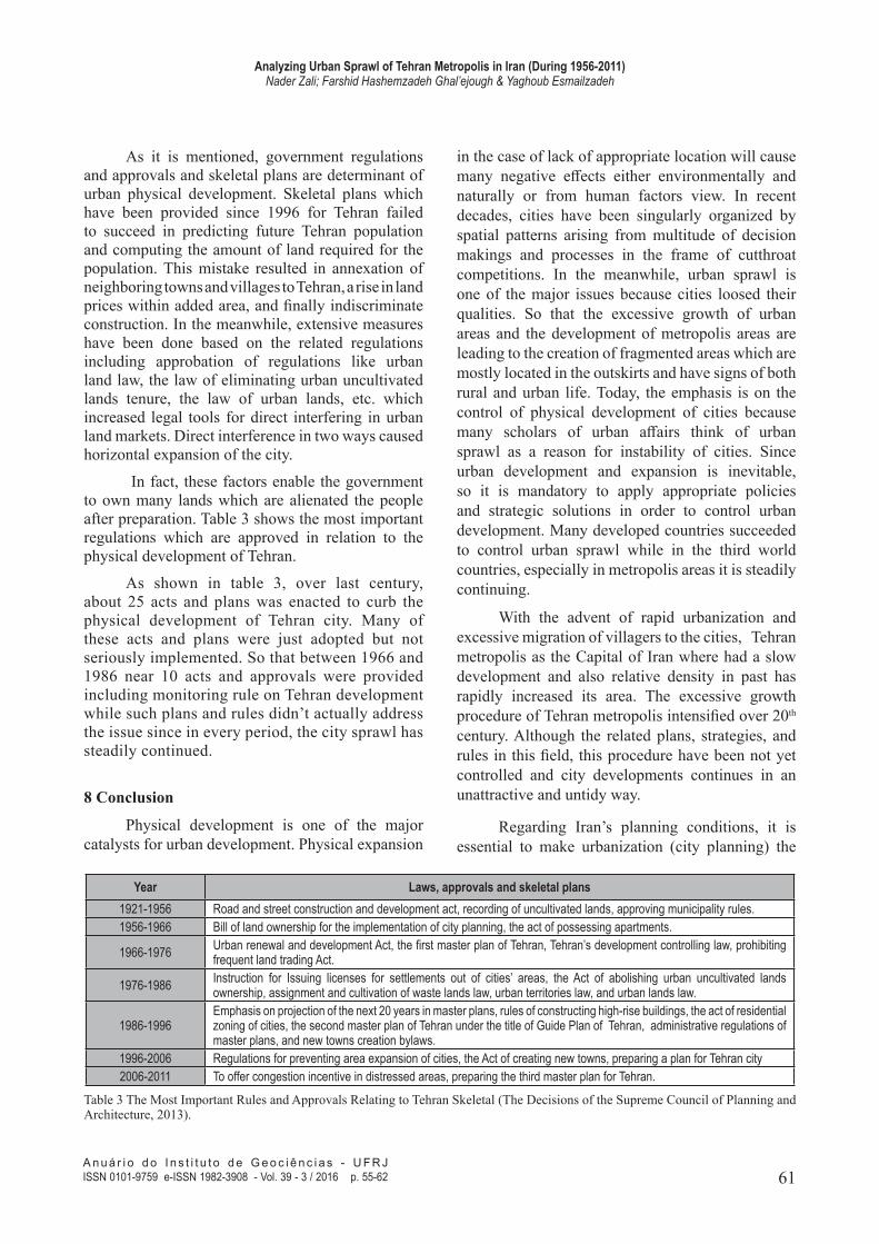
In fact, these factors enable the government to own many lands which are alienated the people after preparation. Table 3 shows the most important regulations which are approved in relation to the physical development of Tehran.
As shown in table 3, over last century, about 25 acts and plans was enacted to curb the physical development of Tehran city. Many of these acts and plans were just adopted but not seriously implemented. So that between 1966 and 1986 near 10 acts and approvals were provided including monitoring rule on Tehran development while such plans and rules didn’t actually address the issue since in every period, the city sprawl has steadily continued.
8 Conclusion
Physical development is one of the major catalysts for urban development. Physical expansion
in the case of lack of appropriate location will cause many negative effects either environmentally and naturally or from human factors view. In recent decades, cities have been singularly organized by spatial patterns arising from multitude of decision makings and processes in the frame of cutthroat competitions. In the meanwhile, urban sprawl is one of the major issues because cities loosed their qualities. So that the excessive growth of urban areas and the development of metropolis areas are leading to the creation of fragmented areas which are mostly located in the outskirts and have signs of both rural and urban life. Today, the emphasis is on the control of physical development of cities because many scholars of urban affairs think of urban sprawl as a reason for instability of cities. Since urban development and expansion is inevitable, so it is mandatory to apply appropriate policies and strategic solutions in order to control urban development. Many developed countries succeeded to control urban sprawl while in the third world countries, especially in metropolis areas it is steadily continuing.
With the advent of rapid urbanization and excessive migration of villagers to the cities, Tehran metropolis as the Capital of Iran where had a slow development and also relative density in past has rapidly increased its area. The excessive growth procedure of Tehran metropolis intensified over 20th century. Although the related plans, strategies, and rules in this field, this procedure have been not yet controlled and city developments continues in an unattractive and untidy way.
Regarding Iran’s planning conditions, it is essential to make urbanization (city planning) the
Year Laws, approvals and skeletal plans1921-1956 Road and street construction and development act, recording of uncultivated lands, approving municipality rules.1956-1966 Bill of land ownership for the implementation of city planning, the act of possessing apartments.
1966-1976 Urban renewal and development Act, the first master plan of Tehran, Tehran’s development controlling law, prohibiting frequent land trading Act.
1976-1986 Instruction for Issuing licenses for settlements out of cities’ areas, the Act of abolishing urban uncultivated lands ownership, assignment and cultivation of waste lands law, urban territories law, and urban lands law.
1986-1996Emphasis on projection of the next 20 years in master plans, rules of constructing high-rise buildings, the act of residential zoning of cities, the second master plan of Tehran under the title of Guide Plan of Tehran, administrative regulations of master plans, and new towns creation bylaws.
1996-2006 Regulations for preventing area expansion of cities, the Act of creating new towns, preparing a plan for Tehran city2006-2011 To offer congestion incentive in distressed areas, preparing the third master plan for Tehran.
Table 3 The Most Important Rules and Approvals Relating to Tehran Skeletal (The Decisions of the Supreme Council of Planning and Architecture, 2013).
62A n u á r i o d o I n s t i t u t o d e G e o c i ê n c i a s - U F R JISSN 0101-9759 e-ISSN 1982-3908 - Vol. 39 - 3 / 2016 p. 55-62
Analyzing Urban Sprawl of Tehran Metropolis in Iran (During 1956-2011)Nader Zali; Farshid Hashemzadeh Ghal’ejough & Yaghoub Esmailzadeh
priority over urbanity (transformation into a city) in order to achieve a balance in Tehran metropolis development. Weakness or lack of regulations and oversight of government agencies in city suburbs are the major causes of Tehran sprawl, but adopting more control policy on suburbs will be a solution to urban sprawl. Furthermore, locating suitable areas for cities’ physical development is an essential element for urban and regional planning which seems to be one of the most impressive solutions and strategies for controlling physical development of Tehran metropolis.
To achieve the objectives of sustainable urban development as well as to restrain Tehran metropolis sprawl, it is essential to have a green belt around the city. Other strategies which can help to control sprawling of Tehran include developing constructions in vacant spaces of the city, increasing congestion within the city, reducing the size of dwelling units, disseminating vertical growth of the city in order to protect the natural environment, reducing rural-urban migrations through providing services to rural areas, expanding the city within its context, examining and considering environmental factors in city growth, and finally informing the public of the long-term consequences of urban sprawl.
9 References
Aguilera-Benavente, F.; Botequilha Leitao, A. & Díaz-Varela, E. 2014. Detecting multi-scale urban growth patterns and processes in the Algarve region (Southern Portugal). Applied Geography, 53:234-245.
Arribas-Bel, D.; Nijkamp, P. & Scholten, H. 2011. Multidimensional urban sprawl in Europe: A self-organizing map approach. Computers, Environment and Urban Systems, 35:63–275.
Burchell, R.; Shad, N.; Listokin, D. & Phillips, H. 1998. The Costs of Sprawl-Revisited, Transportation Research Board, National Academy Press, Washington, D.C. 1998.
Chorianopoulos, I.; Tsilimigkas, G.; Koukoulas, S. & Balatsos, T. 2014. The shift to competitiveness and a new phase of sprawling the Mediterranean city: Enterprises guiding growthin Messoghia-Athens. Cities, 39:133–143.
Ebrahimzadeh, A.; Ebrahimzadeh. E & Habibi. M.A. 2010. Analyzing factors of physical development and sprawling of Tabas city after the earthquake by means of Heldren model. Geography and development, N. 19:25-46.
Ewing, R. 1997. Is Los Angeles-Style Sprawl Desirable? Journal
of the American Planning Association, 63(1):107-126.Hamidi, Sh. & Eving, R. 2014. A longitudinal study of changes
in urban sprawl between 2000 and 2010 in the United States. Landscape and Urban Planning, 128: 72–82.
Hekmatnia, H & Mousavi, M. 2011. Model Application in Geography with Emphasis on Regional and Urban Planning. Yazd, Elme Novin Publication, (2nd Ed.), 396p.
Hess, G. R. 2001. Just what is Sprawl, Anyway? Retrieved from www. Ncsu. Edu/grhess.
Inostroza, L.; Baur, R. & Csaplovics, E. 2013. Urban sprawl and fragmentation in Latin America: A dynamic quantification and characterization of spatial patterns. Environmental Management, 115:87-97.
Kane, K.; Connors, J.P. & Galletti, C.S. 2014 .Beyond fragmentation at the fringe: A path-dependent, higher solution analysis of urban land cover in Phoenix, Arizona. Applied Geography, 52:123-134.
Karimian, H. 1975. Tehran in the past and in the present. Shahid Beheshti university publication.
Kumar, D.; Arya, D.S. & Vojinovic, Z. 2013. Modeling of urban growth dynamics and its impact on surface runoff characteristics. Computers, Environment and Urban Systems, 41: 124–135.
Guide Plan of Tehran. 1993.Master Plan of Tehran. 2007.Mojarrad, F. & Hosenifar, S. 2011. Locating favorable areas
for physical development of Tehran metropolis based on climatic and geographical elements. Geography and environmental planning, 3: 23-42.
Mokhtari Malekabadi, R.; Ajza Shokoohi, M., & Ghasemi, Y. 2011. Analysis of urban development pattern of Behshahr based on quantitative models of regional planning. Urban research and planning, 8: 93-112.
Linard, C.J.; Tatem, A. & Gilbert, M. 2013. Modelling spatial patterns of urban growth in Africa. Applied Geography, 44: 23-32.
Mikovits, C.; Rauch, W. & Kleidorfer, M. 2014. Dynamics in urban development, population growth and their influences on urban water infrastructure. Procedia Engineering, 70:1147–1156.
Mohd Noor, N. & Rosni, N. 2013. Determination of Spatial Factors in Measuring Urban Sprawl in Kuantan Using Remote Sensing and GIS. Procedia-Social and Behavioral Sciences, 85:502–512.
Poormohammadi, M. & Jamkasra, M. 2000. Analysis of the untidy development pattern of Tabriz. Quarterly of geographical research, 100:35-49.
Statistical Center of Iran. 2014.UN-Habitat. 2012. State of the world’s cities 2012/2013.
Prosperity of Cities, p.150.Verbeek, T.; Boussauw, K. & Pisman, A. 2014. Presence
and trends of linear sprawl: Explaining ribbon development in the north of Belgium .Landscape and Urban Planning, 128:48–59.
Wang, L.; Han, H. & Lai, SH. 2014. Do plans contain urban sprawl? A comparison of Beijing and Taipei. Habitat International, 42:121-130.
Yue, W.; Liu, Y. & Fan, P. 2013. Measuring urban sprawl and its drivers in large Chinese cities: The case of Hangzhou. Land Use Policy, 31: 358– 370.