13
ANUPPUR DISTRICT MADHYA PRADESH Ministry of Water Resources Central Ground Water Board North Central Region Government of India 2013

ANUPPUR DISTRICT MADHYA PRADESH
Ministry of Water Resources Central Ground Water Board
North Central Region Government of India
2013

ANUPPUR DISTRICT PROFILE
S.No ITEMS STATISTICS
1 General Information
i) Geographical Area (Sq.Km) 3724
ii) Administrative Divisions ( as on year 2013 )
Number of Tehsil / Block
Number of Panchayats/ Villages
4/4
282/585
iii) Population (Census 2011 ) 7,49,521
iv) Normal Rainfall ( mm ) 1423.6
2 GEOMORPHOLOGY
Major Physiographic Units 1Pushprajgarh Plateau
2Son River Plateau
area
3Narmada Valley area
Major Drainage Johila sub-basin
Son sub-basin
Narmada basin
3 Land Use ( Sq. Km. ) i) Forest area :
ii) Net sown area :
iii) Cultivable area :
782
1052
1052
4 Major Soil Types Black Cotton, Sandy-
Loamy and Clayey-
Loamy
5 Area under principle crops ( 2006) Paddy, Wheat, Maize
and Gram
6 IRRIGATION BY DIFFERENT SOURCES
Structures No Area
( Sq. Km.)
Dug wells
Tube wells/ Bore wells
Tanks/ ponds
Canals
Other Sources
Net Irrigated Area.
Gross Irrigated Area
1992 15.14
104 2.86
185 2.0
80 8.00
15
43
43
7 Number of Ground Water Monitoring Wells
of CGWB ( As on 31-03-2013 )
No. of Dug Wells
No. of piezometers
16
05
8 PREDOMINANT GEOLOGICAL Archaeans,
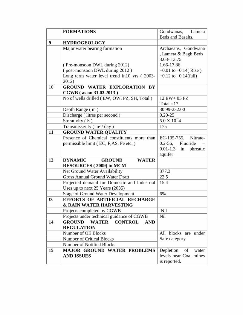
FORMATIONS Gondwanas, Lameta
Beds and Basalts.
9 HYDROGEOLOGY
Major water bearing formation
( Pre-monsoon DWL during 2012)
( post-monsoon DWL during 2012 )
Long term water level trend in10 yrs ( 2003-
2012)
Archaeans, Gondwana
, Lameta & Bagh Beds
3.03- 13.75
1.66-17.86
+0.01 to –0.14( Rise )
+0.12 to –0.14(fall)
10 GROUND WATER EXPLORATION BY
CGWB ( as on 31.03.2013 )
No of wells drilled ( EW, OW, PZ, SH, Total ) 12 EW+ 05 PZ
Total =17
Depth Range ( m ) 30.99-232.00
Discharge ( litres per second ) 0.20-25
Storativity ( S ) 5.0 X 10¯4
Transmissivity ( m² / day ) 175
11 GROUND WATER QUALITY
Presence of Chemical constituents more than
permissible limit ( EC, F,AS, Fe etc. )
EC-105-755, Nitrate-
0.2-56, Fluoride –
0.01-1.3 in phreatic
aquifer
12 DYNAMIC GROUND WATER
RESOURCES ( 2009) in MCM
Net Ground Water Availability 377.3
Gross Annual Ground Water Draft 22.5
Projected demand for Domestic and Industrial
Uses up to next 25 Years (2035)
15.4
Stage of Ground Water Development 6%
!3 EFFORTS OF ARTIFICIAL RECHARGE
& RAIN WATER HARVESTING
Projects completed by CGWB Nil
Projects under technical guidance of CGWB Nil
14 GROUND WATER CONTROL AND
REGULATION
Number of OE Blocks All blocks are under
Safe category
Number of Critical Blocks
Number of Notified Blocks
15 MAJOR GROUND WATER PROBLEMS
AND ISSUES
Depletion of water
levels near Coal mines
is reported.

1.0 INTRODUCTION
Anuppur is situated in eastern corner of Madhya Pradesh. It came into existence on 15th
August
2003, by reorganization of Shahdol district. The Anuppur is one of the tribal district of Madhya
Pradesh. Anuppur is also famous for Amarkantak hill and pilgrim station, where from two
important rivers namely, Narmada and the son originates. District Anuppur is surrounded by
Shahdol district in north, Umariya and Dindori districts in west and south-west, Bilaspur and
Korea districts of Chhattishgarh State in south and east sides. The district lies between North
latitude 22º 7’ and 23º25’ and East longitude 81º10’ and 82º 10’, falling in Survey of India
toposheet nos. 64E, 64F and 64 I. It extends for about 86 Km from north to south and 117 Km
from east to west.
The area of district is 3724 Sq. Km, and it has been divided into four tehsils and blocks ( Fig-
1 ). There are 585 villages in the district. Details of administrative divisions of the district is
given in Table-1.
Table-1 : Administrative divisions (Blocks), Anuppur district, M.P.
1 Pushprajgarh
2 Anuppur
3 Jaithari
4 Kotma
Drainage: Anuppur district falls under two river basins i.e. the Ganga and the Narmada.
Excepting small and narrow belt along the south-west boundary, in Pushprajgarh tehsil, which is
drained by the river Narmada, entire Anuppur district forms the part of the Ganga river system.
The river Son is an important tributary of the Ganga river. Both the Narmada and the Son
originates from Amarkantak hill of Maikal Range ( 1057 mamsl) at 22º40’ N 81º46’E from
Anuppur district. The river Narmada flows in west word direction in the district, while the river
Son flows from south-east to north-west direction. The important tributaries of Son river in the
district are Johila, Gujar Kewai and Tipan rivers. The Samrar nadi is only important tributary of
river the Narmada in the district.
CGWB Activities: Systematic hydrogeological surveys of the district was carried out by Shri
R.N.Sharma and Shri A.K.Budhauliya, then Junior Hydrogeologists, during year 1987-88. Shri
A.K.Jain, Junior Hydrogeologist carried out Reappraisal hydrogeological surveys of the district
during year 1998-99. Exploratory drilling in the district started in year 1979-80, to study inflow
of water in Jamuna coal field area of Kotma block. Subsequently CGWB had taken up regular
ground water exploration during period 1988-93. Total 12 exploratory wells and 5 Pz are drilled
at various places in different geological formations of the district. Under the World Bank assisted
Hydrology Project, 3 shallow and 2 deep Piezometers were constructed by CGWB at Anuppur,
Kotma and Rajendragram.
2.0 RAINFALL AND CLIMATE
For description of meterological parameters , data of nearest I.M.D. Observatory located at
Umariya has been used.
The normal annual rainfall of the district is 1235.0 mm. The district receives maximum rainfall
during south-west monsoon period from June to September. About 89.3 % of annual rainfall is
receieved during monsoon season. Only 10.7 % of the annual rainfall occurs during non-
monsoon period, from October to May. Thus maximum water available for ground water
recharge is during south-west monsoon season.
The normal maximum temperature recorded during the month of May is 41.3º C, and
minimum during the month of December is 8.4º C. The normal annual means maximum and
minimum temperatures of Anuppur district are 31.6º C and 18.2º C respectively.
During the south-west monsoon, the relative humidity generally exceeds 88 % during month
of August. Relative humidity decreases during non-monsoon season. In summer season, relative
humidity’s are less than 38 %. May is the driest month of the year.
The wind velocity in the area is higher, during pre-monsoon period as compared to post-
monsoon season. The maximum wind velocity 6.8 Km/hr is observed during the month of June
and minimum 2.3 Km/hr is recorded during month of November. The average normal annual
wind velocity of Anuppur district is 4.3 Km/hr
The climate of Anuppur district, is characterized by a hot summer and general dryness during
the south-west monsoon season. The year may be divided into four seasons. The cold season is
December to February and followed by the hot season from March to about the middle of June.
The period from middle of June to September is the south-west monsoon season. October and
November form the post-monsoon or transition period.

3.0 GEOMORPHOLOGY AND SOIL TYPES
3.1 Geomorphology : Anuppur is predominantly hilly and forested district. It is picturesque with certain
pockets and belt of Sal and mixed forest. From Geomorphological point of view, the district
consists of series of mountain ranges and rivers. It can be divided into three geographical
divisions :
1. High land of mountain ranges
2. The central plateau and
3. Low land of valley areas.
In general, Anuppur district is characterized by hilly to undulating terrain with altitude
ranging between 470 m and 1170 m, above mean sea level. The main high relief features of the
area are the Maikal Range and Maikal Plateau ( Amarkantak Plateau ) in south-east part of the
district covered with deccan Trap Basalts. Some denudational hills/ hillocks are at foot hills of
Rajendragram plateau. Linear ridges of intrusives ( Dolerites ) at northern and north-eastern
part, and Plateaus in remaining part of the district. The river Son is forming valley in the district.
3.2 Soils : The anuppur district is mainly occupied by four types of rocks, namely Basalts, Lametas,
Gondwanas and Archaeans. Soils are also depending upon lithology of the area. Hence soils of
the area are mainly:Black Cotton, Sandy-Loamy and Clayey-Loamy.
4.0 GROUND WATER SCENARIO
4.1 Hydrogeology:
Anuppur district is underlain by various geological formations, forming different types of
aquifers in the area (Fig 2). Main lithological units of the area are, Archaeans, Gondwanas,
Lametas and Basalts. Occurrence and movement of ground water in hard rocks is essentially by
development and nature of secondary porosity through joints and fractures. Primary porosity in
Gondwana rocks and vesicularity in basalts play and important role. Lametas are also potential
aquifers made up of relatively loose and friable material. Ground water in general occurs under
unconfined to semi-confined conditions. The occurrence and movement of ground water in
different lithological units is described below:

Archeans :
Granites and Granitic-Gneisses are main rock types, occurring in south-east part of the
district. They are crystalline hard rocks, forming basement in the district. They yield water
through fractures, joints and secondary porosity developed in weathered portions. In Jaithari
block area, quite many dug wells exists in these formations and wells yield moderate quantity of
ground water. The yield depends upon the saturated thickness of the weathered mantle overlying
the massive rock. The open wells that exists in these formations, range in depth from 8m to
20mbgl. The general yield potential of Archeans is less than 180 L.P.M..
Gondwanas : The semi-consolidated Gondwana group of rocks, that bears coal deposits are forming main
ground water reservoir in this district. The felspathic, medium to coarse grained sand stone, bears
ground water in the interconnected primary pores in the formation, as well as the contact planes
between shales and sand stones. Coal seams in Gondwana formations are acting as confining
layers giving rise to artesian conditions at several places. Ground water is also mined out along
with the coal in almost all coal fields of the district. Ground water occurs in unconfined, semi-
confined and confined conditions in the Gondwana formations of the district. It is reported that
due to excessive pumpage of ground water from the underneath coal mines, there has been

appreciable lowering of water levels in the phreatic ground water regime overlying the coal field
area, particularly in Kotma block area. Gondwana formation particularly the upper part of
Barakar Sandstone support development of phreatic aquifers, which extends from few metres
below ground level to 25 m below land surface. The Talchir formation of lower Gondwana
group, comprising of well sorted sandstone, olive green shales and basal conglomerates are
forming poor aquifer in the area. These formations are occurring southwards of Anuppur town.
Exploratory well drilled by CGWB in Anuppur town has yielded only 15 L.P.M.discharge in
Talchir formation. The Barakar formations which are upper part of lower Gondwanas are
forming potential aquifers in the area. These formations are covering north and eastern part of
Anuppur district. The yield of Barakar formations in the district is recorded between 150 and 960
L.P.M.
Lametas : These are sedimentary deposits resting over Archeans /Gondwana formations and are
overlain by Basalts. siliceous Lime stones of Lametas are compact and impervious in nature.
Nodular lime stone and poorly consolidated sand stone of Lametas are forming good aquifers in
the area. Lametas occurring below Basalts, are under semi-confined to confined conditions.
Lametas are occupying hilly and forested area, where population and habitation is rather poor.
Dug wells in this formation is generally used for drinking/domestic purposes by tribal
population. It is observed that 80 % of dugwells are within the depth range of 8 m to 16 m, below
ground level; with diameter of 3-4 m. CGWB had taken up exploratory drilling in Rajendragram
plateau of Pushprajgarh Block, where Lameta beds are occurring below Basalts at deeper level.
Since lametas are relatively loose and friable rocks found below Basalts at depth ( more than 100
m ), there is difficulty in drilling in this formation deploying DTH or DTH-Rotary Combination
rigs. After penetrating basalts, drilling in loose and friable Lameta beds at depth more than 100
m becomes unserviceable using these rigs, because available rigs can not function to operate
using rotary system at depth. Because of this reason CGWB had abandoned many exploratory
wells in Rajendragram plateau area , where Lametas are occurring below Basalts. Thickness of
Lameta Beds is recorded as 80 m at Keolari exploratory well site. Yield of Lameta beds recorded
during exploratory drilling vary from 180 to 1500 L.P.M.
Deccan Traps : These are Basaltic flows, forming hill ranges in south-western part of the district.
Rajendragram plateau of Pushprajgarh Block is fully occupied by basaltic rocks. In basaltic
terrain , ground water generally occurs under phreatic conditions in shallow weathered, jointed
and fractured horizons. Basalt does not exhibit uniform nature, both vertically and laterally.
Physiographic locations, thickness of weathered mantle, degree of joints, fractured or sheared
zones, characteristics of vesicular horizons and their inter-connections are important factors, that
play a decisive role in the yield capacity of open wells, tapping shallow aquifers. The deeper
aquifer system appears to be under semi-confined conditions. Jointed/fractured form of massive
unit is creating possibility of their acting as leaky confining bed, consequently resulting into
semi-confined conditions for water bearing vesicular unit occurring beneath it. On the other hand
if massive unit is compact and have not developed fractured porosity, then under favourable
conditions they may act as a confining bed for the water bearing vesicular horizon, occurring
below it and thus leading to confined conditions. Dugwells in basaltic flows of Deccan Traps
vary in depth from 6 to 15 m, below ground level and diameter ranges between 2 m to 3 m.
CGWB had drilled number of tube wells in Rajendragram plateau of Anuppur district, and
thickness of Basalt vary from 1 m ( at Keolari ) to 127 m ( at Karanpathar ). Yield of exploratory
wells ranges between 60 to 240 L.P.M.
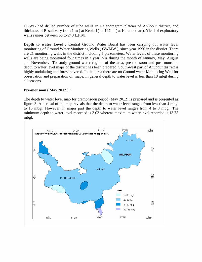
Depth to water Level : Central Ground Water Board has been carrying out water level
monitoring of Ground Water Monitoring Wells ( GWMW ), since year 1990 in the district. There
are 21 monitoring wells in the district including 5 piezometers. Water levels of these monitoring
wells are being monitored four times in a year; Viz during the month of January, May, August
and November. To study ground water regime of the area, pre-monsoon and post-monsoon
depth to water level maps of the district has been prepared. South-west part of Anuppur district is
highly undulating and forest covered. In that area there are no Ground water Monitoring Well for
observation and preparation of maps. In general depth to water level is less than 18 mbgl during
all seasons.
Pre-monsoon ( May 2012 ) :
The depth to water level map for premonsoon period (May 2012) is prepared and is presented as
figure 3. A perusal of the map reveals that the depth to water level ranges from less than 4 mbgl
to 16 mbgl. However, in major part the depth to water level ranges from 4 to 8 mbgl. The
minimum depth to water level recorded is 3.03 whereas maximum water level recorded is 13.75
mbgl.
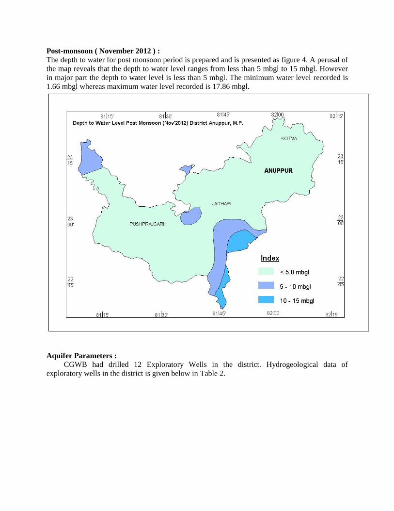
Post-monsoon ( November 2012 ) :
The depth to water for post monsoon period is prepared and is presented as figure 4. A perusal of
the map reveals that the depth to water level ranges from less than 5 mbgl to 15 mbgl. However
in major part the depth to water level is less than 5 mbgl. The minimum water level recorded is
1.66 mbgl whereas maximum water level recorded is 17.86 mbgl.
Aquifer Parameters : CGWB had drilled 12 Exploratory Wells in the district. Hydrogeological data of
exploratory wells in the district is given below in Table 2.
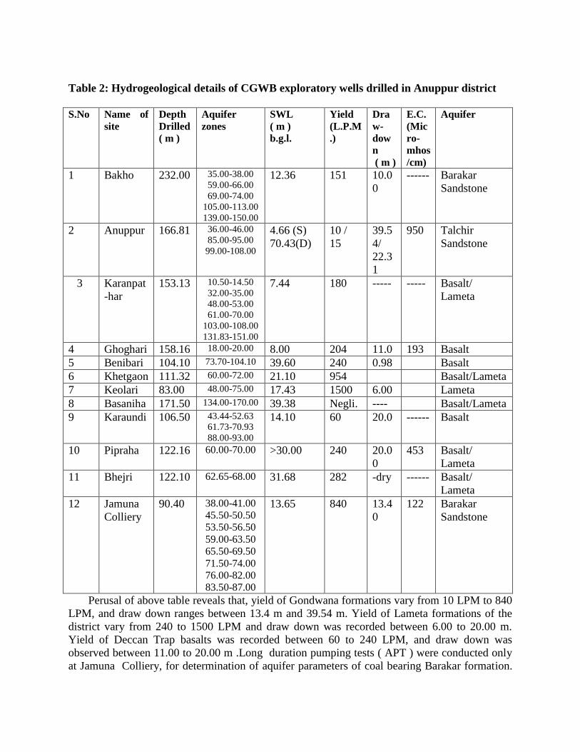
Table 2: Hydrogeological details of CGWB exploratory wells drilled in Anuppur district
S.No Name of
site
Depth
Drilled
( m )
Aquifer
zones
SWL
( m )
b.g.l.
Yield
(L.P.M
.)
Dra
w-
dow
n
( m )
E.C.
(Mic
ro-
mhos
/cm)
Aquifer
1 Bakho 232.00 35.00-38.00
59.00-66.00
69.00-74.00
105.00-113.00
139.00-150.00
12.36 151 10.0
0
------ Barakar
Sandstone
2 Anuppur 166.81 36.00-46.00
85.00-95.00
99.00-108.00
4.66 (S)
70.43(D)
10 /
15
39.5
4/
22.3
1
950 Talchir
Sandstone
3 Karanpat
-har
153.13 10.50-14.50
32.00-35.00
48.00-53.00
61.00-70.00
103.00-108.00
131.83-151.00
7.44 180 ----- ----- Basalt/
Lameta
4 Ghoghari 158.16 18.00-20.00 8.00 204 11.0 193 Basalt
5 Benibari 104.10 73.70-104.10 39.60 240 0.98 Basalt
6 Khetgaon 111.32 60.00-72.00 21.10 954 Basalt/Lameta
7 Keolari 83.00 48.00-75.00 17.43 1500 6.00 Lameta
8 Basaniha 171.50 134.00-170.00 39.38 Negli. ---- Basalt/Lameta
9 Karaundi 106.50 43.44-52.63
61.73-70.93
88.00-93.00
14.10 60 20.0 ------ Basalt
10 Pipraha 122.16 60.00-70.00 >30.00 240 20.0
0
453 Basalt/
Lameta
11 Bhejri 122.10 62.65-68.00 31.68 282 -dry ------ Basalt/
Lameta
12 Jamuna
Colliery
90.40 38.00-41.00
45.50-50.50
53.50-56.50
59.00-63.50
65.50-69.50
71.50-74.00
76.00-82.00
83.50-87.00
13.65 840 13.4
0
122 Barakar
Sandstone
Perusal of above table reveals that, yield of Gondwana formations vary from 10 LPM to 840
LPM, and draw down ranges between 13.4 m and 39.54 m. Yield of Lameta formations of the
district vary from 240 to 1500 LPM and draw down was recorded between 6.00 to 20.00 m.
Yield of Deccan Trap basalts was recorded between 60 to 240 LPM, and draw down was
observed between 11.00 to 20.00 m .Long duration pumping tests ( APT ) were conducted only
at Jamuna Colliery, for determination of aquifer parameters of coal bearing Barakar formation.
At this site well field , consisting of one pumping well, 5 observation wells and 2 piezometers
was constructed , in which Step Drawdown and long duration Aquifer Performance Tests were
conducted. Analysis of A.P.T. results reveals that regional transmissivity of barakar sediments is
estimated to be 175 m²/ day, while the hydraulic conductivity is 5 m/day. The specific yield of
the dewatered material has been computed as 0.038. Co-efficient of storage was computed as 5.0
x 10¯4.
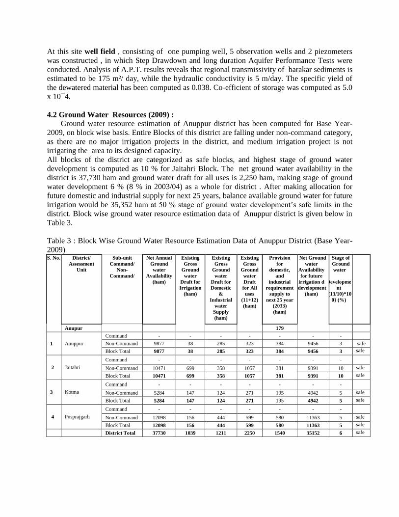
4.2 Ground Water Resources (2009) : Ground water resource estimation of Anuppur district has been computed for Base Year-
2009, on block wise basis. Entire Blocks of this district are falling under non-command category,
as there are no major irrigation projects in the district, and medium irrigation project is not
irrigating the area to its designed capacity.
All blocks of the district are categorized as safe blocks, and highest stage of ground water
development is computed as 10 % for Jaitahri Block. The net ground water availability in the
district is 37,730 ham and ground water draft for all uses is 2,250 ham, making stage of ground
water development 6 % (8 % in 2003/04) as a whole for district . After making allocation for
future domestic and industrial supply for next 25 years, balance available ground water for future
irrigation would be 35,352 ham at 50 % stage of ground water development’s safe limits in the
district. Block wise ground water resource estimation data of Anuppur district is given below in
Table 3.
Table 3 : Block Wise Ground Water Resource Estimation Data of Anuppur District (Base Year-
2009) S. No. District/
Assessment
Unit
Sub-unit
Command/
Non-
Command/
Net Annual
Ground
water
Availability
(ham)
Existing
Gross
Ground
water
Draft for
Irrigation
(ham)
Existing
Gross
Ground
water
Draft for
Domestic
&
Industrial
water
Supply
(ham)
Existing
Gross
Ground
water
Draft
for All
uses
(11+12)
(ham)
Provision
for
domestic,
and
industrial
requirement
supply to
next 25 year
(2033)
(ham)
Net Ground
water
Availability
for future
irrigation d
development
(ham)
Stage of
Ground
water
Developme
nt
{(13/10)*10
0} (%)
Anupur 179
1 Anuppur
Command - - - - - - -
Non-Command 9877 38 285 323 384 9456 3 safe
Block Total 9877 38 285 323 384 9456 3 safe
2 Jaitahri
Command - - - - - - - Non-Command 10471 699 358 1057 381 9391 10 safe Block Total 10471 699 358 1057 381 9391 10 safe
3 Kotma
Command - - - - - - - Non-Command 5284 147 124 271 195 4942 5 safe Block Total 5284 147 124 271 195 4942 5 safe
4 Pusprajgarh
Command - - - - - - - Non-Command 12098 156 444 599 580 11363 5 safe Block Total 12098 156 444 599 580 11363 5 safe
District Total 37730 1039 1211 2250 1540 35152 6 safe
4.3 Ground Water Quality (2011):
Ground water quality of the district, is accessed annually by CGWB on the basis of water
samples collected from Ground Water Monitoring Wells. Electric conductivity vary between 105
to 755 µs/cm at 25º C. The concentration of fluoride is within permissible limits, fluoride ranges
between 0.01 mg/l to 1.3 mg/l. The concentration of Nitrate ranges between 0.2 mg/l to 56 mg/l.
However water samples collected from CGWB piezometers located at Anuppur and Kotma are
having nitrate concentration 125 and 52 mg/l respectively, which is in excess to permissible
limits of 45 mg/l. Excessive nitrate content in ground water system, may be because of seepage
from sewage waste or due to high uses of nitrate fertilizers.


![[XLS] · Web viewChamba Badgam Chatra Bangalore Rural Ernakulam Anuppur Akola Churachandpur East Khasi Hills Champhai Kiphire Boudh (Bauda) Barnala Alwar West Sikkim Chennai North](https://static.documents.pub/doc/80x56/5abce46a7f8b9a567c8e5284/xls-viewchamba-badgam-chatra-bangalore-rural-ernakulam-anuppur-akola-churachandpur.jpg)


