Page 1
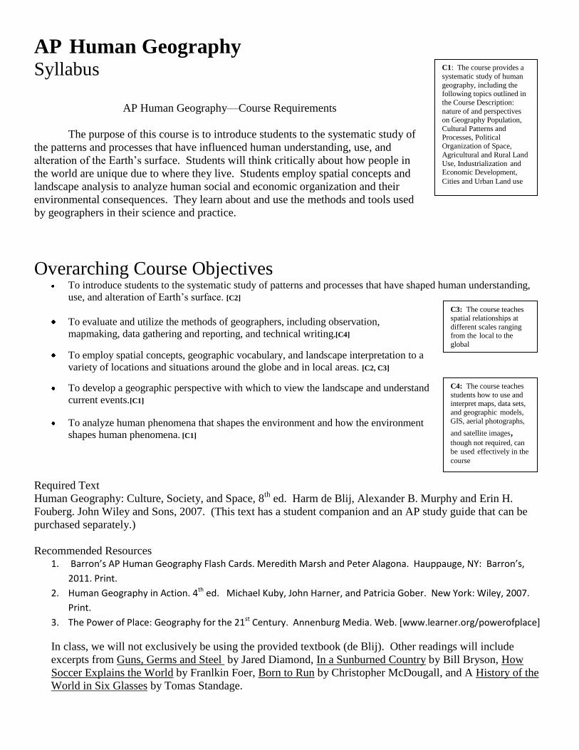
C1: The course provides a
systematic study of human
geography, including the following topics outlined in
the Course Description:
nature of and perspectives on Geography Population, Cultural Patterns and
Processes, Political Organization of Space,
Agricultural and Rural Land
Use, Industrialization and Economic Development,
Cities and Urban Land use
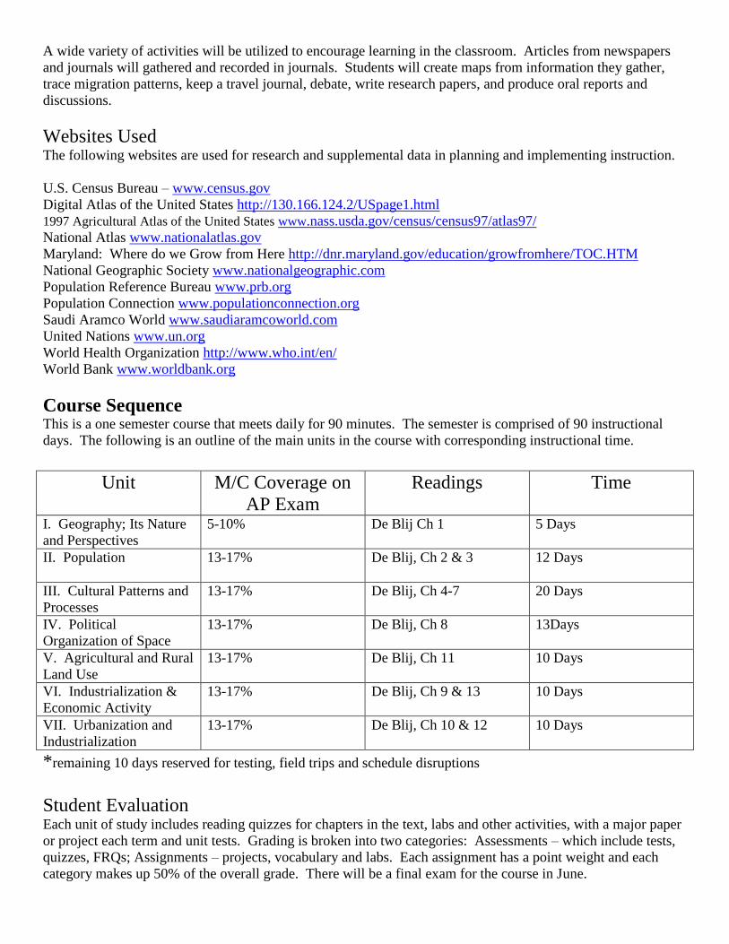
C3: The course teaches
spatial relationships at
different scales ranging from the local to the
global
C4: The course teaches
students how to use and interpret maps, data sets,
and geographic models,
GIS, aerial photographs,
and satellite images, though not required, can
be used effectively in the
course
AP Human Geography Syllabus
AP Human Geography—Course Requirements
The purpose of this course is to introduce students to the systematic study of
the patterns and processes that have influenced human understanding, use, and
alteration of the Earth’s surface. Students will think critically about how people in
the world are unique due to where they live. Students employ spatial concepts and
landscape analysis to analyze human social and economic organization and their
environmental consequences. They learn about and use the methods and tools used
by geographers in their science and practice.
Overarching Course Objectives To introduce students to the systematic study of patterns and processes that have shaped human understanding,
use, and alteration of Earth’s surface. [C2]
To evaluate and utilize the methods of geographers, including observation,
mapmaking, data gathering and reporting, and technical writing.[C4]
To employ spatial concepts, geographic vocabulary, and landscape interpretation to a
variety of locations and situations around the globe and in local areas. [C2, C3]
To develop a geographic perspective with which to view the landscape and understand
current events.[C1]
To analyze human phenomena that shapes the environment and how the environment
shapes human phenomena. [C1]
Required Text
Human Geography: Culture, Society, and Space, 8th
ed. Harm de Blij, Alexander B. Murphy and Erin H.
Fouberg. John Wiley and Sons, 2007. (This text has a student companion and an AP study guide that can be
purchased separately.)
Recommended Resources 1. Barron’s AP Human Geography Flash Cards. Meredith Marsh and Peter Alagona. Hauppauge, NY: Barron’s,
2011. Print.
2. Human Geography in Action. 4th ed. Michael Kuby, John Harner, and Patricia Gober. New York: Wiley, 2007.
Print.
3. The Power of Place: Geography for the 21st Century. Annenburg Media. Web. [www.learner.org/powerofplace]
In class, we will not exclusively be using the provided textbook (de Blij). Other readings will include
excerpts from Guns, Germs and Steel by Jared Diamond, In a Sunburned Country by Bill Bryson, How
Soccer Explains the World by Franlkin Foer, Born to Run by Christopher McDougall, and A History of the
World in Six Glasses by Tomas Standage.
Page 2
A wide variety of activities will be utilized to encourage learning in the classroom. Articles from newspapers
and journals will gathered and recorded in journals. Students will create maps from information they gather,
trace migration patterns, keep a travel journal, debate, write research papers, and produce oral reports and
discussions.
Websites Used The following websites are used for research and supplemental data in planning and implementing instruction.
U.S. Census Bureau – www.census.gov
Digital Atlas of the United States http://130.166.124.2/USpage1.html
1997 Agricultural Atlas of the United States www.nass.usda.gov/census/census97/atlas97/
National Atlas www.nationalatlas.gov
Maryland: Where do we Grow from Here http://dnr.maryland.gov/education/growfromhere/TOC.HTM
National Geographic Society www.nationalgeographic.com
Population Reference Bureau www.prb.org
Population Connection www.populationconnection.org
Saudi Aramco World www.saudiaramcoworld.com
United Nations www.un.org
World Health Organization http://www.who.int/en/
World Bank www.worldbank.org
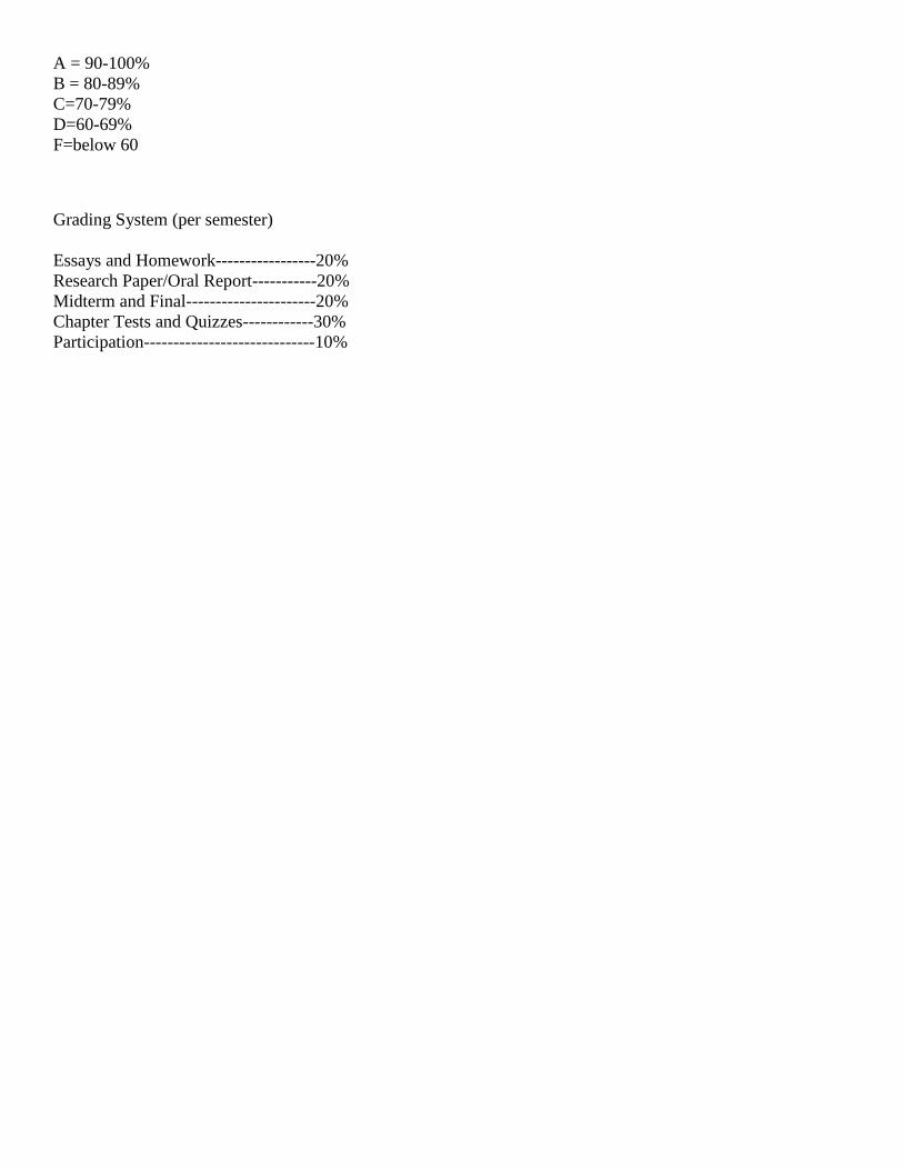
Course Sequence This is a one semester course that meets daily for 90 minutes. The semester is comprised of 90 instructional
days. The following is an outline of the main units in the course with corresponding instructional time.
Unit M/C Coverage on
AP Exam
Readings Time
I. Geography; Its Nature
and Perspectives
5-10% De Blij Ch 1
5 Days
II. Population 13-17% De Blij, Ch 2 & 3
12 Days
III. Cultural Patterns and
Processes
13-17% De Blij, Ch 4-7
20 Days
IV. Political
Organization of Space
13-17% De Blij, Ch 8
13Days
V. Agricultural and Rural
Land Use
13-17% De Blij, Ch 11
10 Days
VI. Industrialization &
Economic Activity
13-17% De Blij, Ch 9 & 13
10 Days
VII. Urbanization and
Industrialization
13-17% De Blij, Ch 10 & 12
10 Days
*remaining 10 days reserved for testing, field trips and schedule disruptions
Student Evaluation Each unit of study includes reading quizzes for chapters in the text, labs and other activities, with a major paper
or project each term and unit tests. Grading is broken into two categories: Assessments – which include tests,
quizzes, FRQs; Assignments – projects, vocabulary and labs. Each assignment has a point weight and each
category makes up 50% of the overall grade. There will be a final exam for the course in June.
Page 3
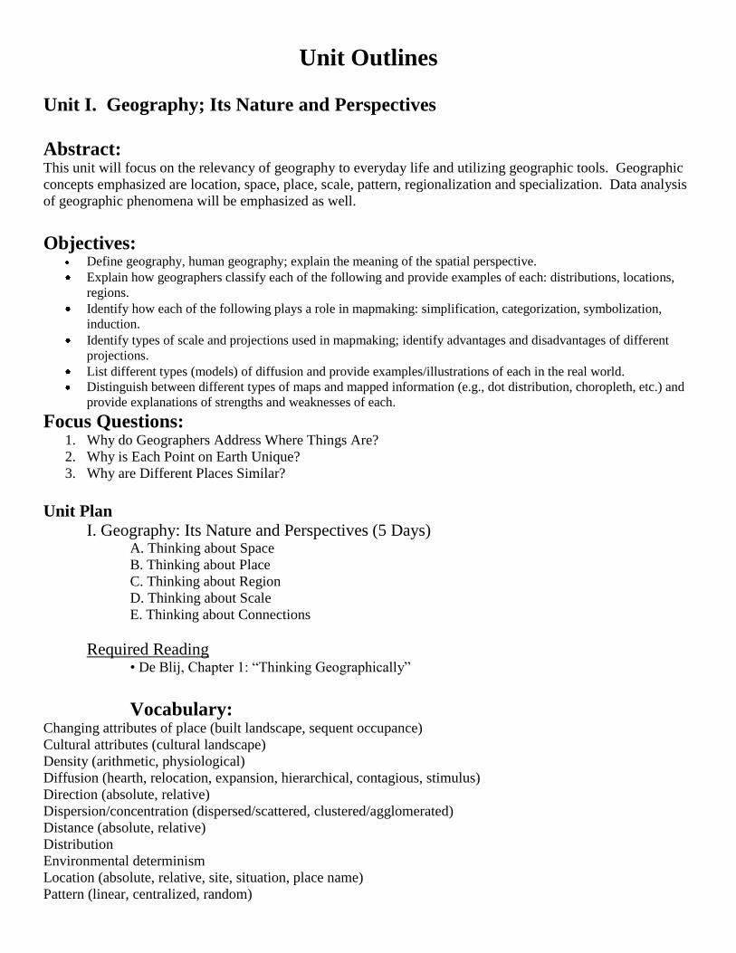
A = 90-100%
B = 80-89%
C=70-79%
D=60-69%
F=below 60
Grading System (per semester)
Essays and Homework-----------------20%
Research Paper/Oral Report-----------20%
Midterm and Final----------------------20%
Chapter Tests and Quizzes------------30%
Participation-----------------------------10%
Page 4
Unit Outlines
Unit I. Geography; Its Nature and Perspectives
Abstract: This unit will focus on the relevancy of geography to everyday life and utilizing geographic tools. Geographic
concepts emphasized are location, space, place, scale, pattern, regionalization and specialization. Data analysis
of geographic phenomena will be emphasized as well.
Objectives: Define geography, human geography; explain the meaning of the spatial perspective.
Explain how geographers classify each of the following and provide examples of each: distributions, locations,
regions.
Identify how each of the following plays a role in mapmaking: simplification, categorization, symbolization,
induction.
Identify types of scale and projections used in mapmaking; identify advantages and disadvantages of different
projections.
List different types (models) of diffusion and provide examples/illustrations of each in the real world.
Distinguish between different types of maps and mapped information (e.g., dot distribution, choropleth, etc.) and
provide explanations of strengths and weaknesses of each.
Focus Questions: 1. Why do Geographers Address Where Things Are?
2. Why is Each Point on Earth Unique?
3. Why are Different Places Similar?
Unit Plan
I. Geography: Its Nature and Perspectives (5 Days) A. Thinking about Space
B. Thinking about Place
C. Thinking about Region
D. Thinking about Scale
E. Thinking about Connections
Required Reading • De Blij, Chapter 1: “Thinking Geographically”
Vocabulary: Changing attributes of place (built landscape, sequent occupance)
Cultural attributes (cultural landscape)
Density (arithmetic, physiological)
Diffusion (hearth, relocation, expansion, hierarchical, contagious, stimulus)
Direction (absolute, relative)
Dispersion/concentration (dispersed/scattered, clustered/agglomerated)
Distance (absolute, relative)
Distribution
Environmental determinism
Location (absolute, relative, site, situation, place name)
Pattern (linear, centralized, random)
Page 5
Physical attributes (natural landscape)
Possibilism
Region (formal/uniform, functional/nodal, perceptual/vernacular)
Scale (implied degree of generalization)
Size
Spatial (of or pertaining to space on or near Earth’s surface)
Spatial interaction (accessibility, connectivity, network, distance decay, friction of distance, time-space
compression)
Geographic Tools Distortion
Geographic Information System (GIS)
Global Positioning System (GPS)
Grid (North and South Poles, latitude, parallel, equator, longitude, meridian, prime meridian, international date
line)
Map (Maps are the tool most uniquely identified with geography; the ability to use and interpret maps is an
essential geographic skill.)
Map scale (distance on a map relative to distance on Earth)
Map types (thematic, statistical, cartogram, dot, choropleth, isoline)
Mental map
Model (a simplified abstraction of reality, structured to clarify causal relationships): Geographers use models
(e.g., Demographic Transition, Epidemiological Transition, Gravity, Von Thünen, Weber, Stages of Growth
[Rostow], Concentric Circle [Burgess], Sector [Hoyt], Multiple Nuclei, Central Place [Christaller], and so on) to
explain patterns, make informed decisions, and predict future behaviors.
Projection
Remote sensing
Time zones
Page 6
C2: The course teaches
the use of spatial
concepts and landscape analysis to examine
human organization of
space
C4: The course teaches
students how to use and
interpret maps, data sets, and geographic models,
GIS, aerial photographs,
and satellite images, though not required, can be used effectively in the
course
Unit II.
Population and Migration
Abstract: This unit will investigate the spatial phenomena of diffusion of people and human characteristics on the Earth’s
surface. Use of data to analyze population pyramids and generate hypothesis about aging in individual
societies. Evaluate the push and pull factors of migration.
Objectives: Map major and emerging population concentrations and describe demographic characteristics of each
Consider the concepts of ecumene and nonecumene and consider: a) Why do most people live where they do? b)
For what reasons have humans historically avoided certain areas? c) Where do nonexamples of each exist? Why?
Calculate arithmetic, agricultural, and physiological densities and describe the strengths and weaknesses of each
for demographic analysis.
Explain the elements of a population pyramid and distinguish between characteristic shapes.
Explain the demographic transition model: a) What are its components? b) Which countries does it describe in
each phase? c) Why might it not predict the future for developing countries today?
Give examples of pro- and antinatalist policies and their effects in example countries.
Define key demographic terms and identify regions in which high and low extreme examples of each can be
found.
Concerning natural hazards, do the following: a) list various types of natural hazards and disasters
b) map the areas most affected by them c) compare with the map of population distribution
Focus Questions 1. Where is the World’s Population Distributed?
2. Where Has the world’s population increased?
3. Why is population increasing at different rates in different countries?
4. Why might the world face an overpopulation problem?
5. Why do people migrate
6. Where are migrants distributed?
7. Why do Migrants face obstacles?
8. Why do people migrate within a country?
Unit Plan II. Population Geography (12 Days)
A. Where the World’s Population Is Distributed [C2]
B. Where the World’s Population Has Increased [C2]
C. Population Is Increasing at Different Rates in Different Countries
D. Demographic Transition Model [C4]
E. The World Might Face an Overpopulation Problem
F. Why People Migrate
G. Distribution of Migrants [C2]
H. Obstacles Faced by Migrants
I. People Migrate Within a County
Page 7
Required Reading and Activities • De Blij, Chapters 2 and 3: “Population” and “Migration”
• PRB Web site: “Making Population Real: New Lesson Plans and Classroom Activities”
[http://prb.org/Educators/]
Obituary Activity: Using obituaries from the local newspaper, have students plot on a map where people were born and where they
died. [C4]
Have them use the following key to sort data according when people were born: Before 1920, 1920–1945,
1946–1965, 1966 to present. Draw lines, using the color for the birth year, from places of birth to the local
region. Have students analyze the patterns and relate them to migration trends. [C4]
(For example, most people born before 1920 came to Oregon from the Midwest while more people who were
born from 1966 to the present came from Latin America and Asia.)
Helpful reading for teacher: Bailey, Adrian, Making Population Geography. London: Hodder & Stoughton
Educational, 2005.
Vocabulary Population Age distribution
Carrying capacity
Cohort
Demographic equation
Demographic momentum
Demographic regions
Demographic Transition model
Dependency ratio
Diffusion of fertility control
Disease diffusion
Doubling time
Ecumene
Epidemiological Transition
model
Gendered space
Infant mortality rate
J-curve
Maladaptation
Malthus, Thomas
Mortality
Natality
Neo-Malthusian
Overpopulation
Population densities
Population distributions
Population explosion
Population projection
Population pyramid
Rate of natural increase
S-curve
Sex ratio
Standard of living
Sustainability
Underpopulation
Zero population growth
Migration Activity space
Chain migration
Cyclic movement
Distance decay
Forced
Gravity model
Internal migration
Intervening opportunity
Migration patterns
• Intercontinental
• Interregional
• Rural-urban
Migratory movement
Periodic movement
Personal space
Place utility
Push-pull factors
Refugee
Space-time prism
Step migration
Transhumance
Transmigration
Voluntary
Page 8
Unit III
Cultural Patterns and Processes
Abstract: This unit will cover the basics concepts of cultural geography, methods of diffusion, and the impact of culture
on the environment and the environment on culture. The diffusion of language and religion will also be
explored. Issues surrounding ethnicity and conflict arising from cultural traits will also be studied from a
geographic perspective.
Objectives: Define culture and cultural geography.
Compare and contrast the following aspects of folk and popular culture: a) origins b) methods of diffusion c)
culture regions
Examine specific examples of folk culture and regions.
Examine examples of specific popular cultural traits and discuss their diffusion.
Discuss ways in which cultural traits are affected by and affect the natural environment.
Discuss the role of racism and ethnocentrism in the understanding of the cultural landscape.
Language:
Discuss the importance and role of language as an element of culture.
Explain how languages are classified and related.
Map the distribution of major language families worldwide
Show the division of Europe into the following language groups and give specific examples from major groups: a)
Germanic b) Slavic c) Romance
Describe the following characteristics of English: a) origin and historical development b) worldwide diffusion c)
spatial variation d) role in cultural convergence
Explain the how, why, and where of language change.
Discuss the regional and local variety in language using the following terms: a) slang b) isogloss c) accent
Explain how toponyms are derived and classified and give various examples.
Religion
Identify the following characteristics of all major religions: a) point of origin b) method of diffusion c) current
distribution d) landscape expression
Map the religious regions of the United States.
Discuss the major branches, their origins, and their current distributions for the following religions: a) Christianity
b) Islam c) Buddhism
Distinguish between ethnic and universalizing religions: a) holy sites b) holy days c) methods of diffusion
Describe ways in which the environment influences religion and ways in which religions affect the natural
environment.
Discuss various specific religious conflicts around the world in terms of the following: a) religion versus politics
b) religion versus religion—interfaith conflicts c) religion versus religion—intrafaith conflicts
Page 9
Focus Questions: 1. Where do folk and popular cultures originate and diffuse?
2. Why is folk culture clustered?
3. Why is popular culture widely distributed?
4. What role does television play in diffusing popular culture?
5. What role does technology such as the Internet play in diffusion of popular culture?
6. How does government control of technology impact the spread of popular culture?
7. Why does globalization of popular culture cause problems?
8. What is the environmental impact of popular culture?
9. Where are English language speakers distributed and why?
10. Why is English related to other languages and how?
11. Where are other language families distributed and why?
12. Why do people preserve local languages?
13. Where are religions distributed?
14. Why do religions have different distributions?
15. Why do religions organize space indistinctive patterns and what are these patterns?
16. Why do territorial conflicts arise among religious groups?
17. Where are ethnicities distributed?
18. Why have ethnicities been transformed into nationalities?
19. Why do ethnicities clash?
20. What is ethnic cleansing, where and why has it taken place?
III. Cultural Patterns and Processes (20 Days) A. Folk and Pop Culture (5 Days)
1. Where Folk and Popular Cultures Originate and Diffuse
2. Folk and Popular Culture and the Cultural Landscape [C2]
3. Folk Culture Is Clustered
4. Popular Culture Is Widely Distributed
5. Globalization of Popular Culture Causes Problems
Required Reading and Activities - De Blij, Chapter 4: “Folk and Popular Culture”
B. Language (5 Days)
1. Where English Language Speakers Are Distributed
2. Indo-European Languages
3. Where Other Language Families Are Distributed
4. People Preserve Local Languages
Required Reading - De Blij, Chapter 6: “Language”
C. Religion (5 days)
1. Universalizing and Ethnic Religions
2. Origin and Diffusion of Religions [C4]
3. Religions Organize Space
C4—The course teaches students how to use and
interpret maps, data sets,
and geographic models. GIS, aerial photographs,
and satellite images,
though not required, can be used effectively in the
course.
C2—The course teaches the
use of spatial concepts and
landscape analysis to examine
human organization of space
Page 10
Required Reading • De Blij, Chapter 7: “Religion”
• Szulc, Tad, “Abraham: Journey of Faith,” National Geographic (December, 2001): pp. 90–
129.
• “Islam: An Introduction”, A special pull-out section, Saudi Aramco World
(January/February 2002).
D. Ethnicity (5 Days)
1. Distribution of Ethnicities [C4]
2. Why Some Ethnicities Have Been Transformed into Nationalities
3. The Clash of Ethnicities
Required Reading • De Blij, Chapter 5: “Ethnicity”
• individual articles from Refugees magazine, published by the UN Refugee Agency
(UNHCR), online at http://www.unhcr.org/
Vocabulary Concepts of Culture Acculturation
Assimilation
Cultural adaptation
Cultural core/periphery pattern
Cultural ecology
Cultural identity
Cultural landscape
Cultural realm
Culture
Culture region
• Formal—core,
periphery
• Functional—node
• Vernacular
(perceptual)—regional
self-awareness
Diffusion types
• Expansion—
hierarchical, contagious,
stimulus
• Relocation
Innovation adoption
Maladaptive diffusion
Page 11
Folk and Popular Culture
Adaptive strategies
Anglo-American landscape
characteristics
Architectural form
Built environment
Folk culture
Folk food
Folk house
Folk songs
Folklore
Material culture
Nonmaterial culture
Popular culture
Survey systems
Traditional architecture
Language Creole
Dialect
Indo-European languages
Isogloss
Language
Language family
Language group
Language subfamily
Lingua franca
Linguistic diversity
Monolingual/multilingual
Official language
Pidgin
Toponymy
Trade language
Religion
Animism
Buddhism
Cargo cult pilgrimage
Christianity
Confucianism
Ethnic religion
Exclave/enclave
Fundamentalism
Geomancy (feng shui)
Hadj
Hinduism
Interfaith boundaries
Islam
Jainism
Judaism
Landscapes of the dead
Monotheism/polytheism
Mormonism
Muslim pilgrimage
Muslim population
Proselytic religion
Reincarnation
Religion (groups, places)
Religious architectural styles
Religious conflict
Religious culture hearth
Religious toponym
Sacred space
Secularism
Shamanism
Sharia law
Shintoism
Sikhism
Sunni/Shia
Taoism
Theocracy
Universalizing
Zoroastrianism
Ethnicity Acculturation
Adaptive strategy
Assimilation
Barrio
Chain migration
Cultural adaptation
Cultural shatterbelt
Ethnic cleansing
Ethnic conflict
Ethnic enclave
Ethnic group
Ethnic homeland
Ethnic landscape
Ethnic neighborhood
Ethnicity
Ethnocentrism
Ghetto
Plural society
Race
Segregation
Social distance
Gender Dowry death
Enfranchisement
Gender
Gender gap
Infanticide
Longevity gap
Maternal mortality rate
Page 12
Unit IV
Political Organization of Space
Abstract: This unit focuses on the political organization of the world; how regions are defined and identified, case studies
of political conflicts, the rise of nations, states and nation-states. Also evaluated will be the problems faced by
stateless nations and multinational states. Additionally the impact of colonialism and imperialism will be
analyzed.
Objectives: Describe the distribution of major ethnicities within the United States: a) identify states/regions in which they
are clustered b) identify regions in which they are mostly absent c) provide reasons for the present distribution
Examine case studies of ethnic conflicts from different regions.
Consider ways in which gender-related issues are expressed spatially, particularly: a) economic roles and activity
b) health and reproduction c) level of education
Discuss various nation-state configurations and illustrate them with examples: a) nation-state b) part-nation state
c) multinational state d) stateless nation
Explain the concept of state by: a) identifying necessary qualifications and characteristics b) listing examples of
states in various regions c) describing quasi-states
Describe the problems of multinational states and stateless nations.
List advantages and disadvantages of different types of boundaries and provide real-world examples of: a)
natural/physical boundaries b) cultural boundaries c) geometric boundaries
List advantages and disadvantages of different shapes of states and provide examples.
Discuss the concepts of imperialism and colonialism and illustrate some of their consequences on the
contemporary political map.
Define irredentism and devolution and illustrate with examples.
Summarize the history of the United Nations and identify issues of current importance regarding it.
Focus Questions: 1. Where are states located and why?
2. Why do boundaries cause problems?
3. What are the basic shapes of states and how does shape impact political conflict/stability?
4. What are the basic types of political boundaries and how are they used to divide territory; what problems
arise from this division?
5. How are states organized from within; what are the basic organization of states within their boundaries?
6. Why do states cooperate with each other?
7. What types of political and military cooperation do states engage in?
8. What forms of economic cooperation exist and how do they impact the relationship between and
amongst states?
9. What roles do states play in terrorism and terrorism play in states?
10. Why has terrorism increased over time?
11. Why would states support terrorism?
Page 13
Unit Plan IV. Political Geography (13 Days)
A. The Difference Between a State and a Nation
B. Boundaries [C4][C2]
C. Boundary Problems
D. Cooperation Between States [C3]
E. A Look at Terrorism
Required Reading and Activities • De Blij, Chapter 8: “Political Geography”
Vocabulary: Annexation
Antarctica
Apartheid
Balkanization
Border landscape
Boundary, disputes
(definitional, locational,
operational, allocational)
Boundary, origin (antecedent,
subsequent, superimposed,
relic)
Boundary, process (definition,
delimitation, demarcation)
Boundary, type
(natural/physical,
ethnographic/cultural,
geometric)
Buffer state
Capital
Centrifugal
Centripetal
City-state
Colonialism
Confederation
Conference of Berlin (1884)
Core/periphery
Decolonization
Devolution
Domino theory
EEZ (Exclusive Economic
Zone)
Electoral regions
Enclave/exclave
Ethnic conflict
European Union
Federal
Forward capital
Frontier
Geopolitics
Gerrymander
Global commons
Heartland/rimland
Immigrant states
International organization
Iron Curtain
Irredentism
Israel/Palestine
Landlocked
Law of the Sea
Lebanon
Mackinder, Halford J.
Manifest destiny
Median-line principle
Microstate
Ministate
Nation
National iconography
Nation-state
Nunavut
Raison d’être
Reapportionment
Regionalism
Religious conflict
Reunification
Satellite state
Self-determination
Shatterbelt
Sovereignty
State
Stateless ethnic groups
Stateless nation
Suffrage
Supranationalism
Territorial disputes
Territorial morphology
(compact, fragmented,
elongated, prorupt, perforated)
Territoriality
Theocracy
Treaty ports
UNCLOS (United Nations
Convention on the Law of the
Sea)
Unitary
USSR collapse
Women’s enfranchisement
C2—The course teaches the
use of spatial concepts and
landscape analysis to examine
human organization of space
C3—The course teaches
spatial relationships at
different scales ranging from the local to the
global
C4—The course teaches students how to use and interpret
maps, data sets, and geographic models. GIS, aerial
photographs, and satellite images, though not required, can
be used effectively in the course.
Page 14
Unit V.
Agricultural and Rural Land Use
Abstract: This unit focuses on how people utilize the land for agricultural purposes. Students will evaluate levels of
development in nations and analyze why these different levels exist. An analysis of the evolution of agricultural
practices and origin and identification of various hearths will be studied. The distribution of settlements will
also be evaluated.
Objectives: Use examples of human welfare indicators to distinguish between relatively developed and less developed
countries.
Use examples of economic indicators to classify countries as less developed or relatively developed.
Draw the Brandt line on a world or regional map.
Compare and contrast different theories and models of economic development and the relationship between less
developed and relatively developed countries.
Provide examples of the different sectors of a country’s economy and explain the economic relationship between
them.
Explain how agriculture originated and identify its various hearths.
Describe the evolution of agricultural practices from their first use until today.
a)Neolithic Revolution
b)Second Agricultural Revolution
c)Green Revolution and biotechnology
Consider how each of the following correlates with specific agricultural regions: a) climate b) terrain c) culture d)
situation with regard to world markets
Describe and apply the von Thünen model to both small- and large-scale situations.
Identify the predominant agricultural practices associated with various regions of the world.
Use agricultural practice to differentiate between less developed and relatively developed countries.
Compare and contrast different types of rural landscapes and
Settlements: a) linear villages b) cluster villages c) dispersed settlements
Focus Questions: 1. Why does development vary among countries?
2. Where are more and less developed countries distributed and why?
3. Where does level of development vary by gender and what causes this variation?
4. Why do less developed countries face obstacles to development and how can they overcome
these obstacles?
5. Where did agriculture originate and why?
6. Where are agricultural regions in less developed countries?
7. Where are agricultural regions in more developed countries; what is the difference and why?
8. Why do farmers face economic difficulties?
Page 15
Unit Plan
V. Agricultural and Rural Land Use (10 Days) A. Economic, Social, and Demographic Indicators [C4]
B. More Developed Regions versus Less Developed Regions
C. Obstacles to Development
Required Reading and Activities (5 Days) • De Blij, Chapter 10: “Development”
• Friedman, Thomas L., The World is Flat [Updated and Expanded]:A Brief History of the
Twenty-First Century. New York: Farrar, Straus and Giroux, 2006, Chapters 1 and 2 are required
VI. Agriculture and Rural Land Use (5 Days) A. Agricultural Hearths
B. Classification of Agricultural Regions
C. Agriculture in Less Developed Countries
D. Agriculture in More Developed Countries
E. Economic Issues Involving Agriculture
F. Rural Land Use
G. Rural Landscape Analysis [C2]
Lecture Notes: “Geography of Modern Agriculture” from David A. Lanegran, Macalester College, St.
Paul Minnesota, 2005.
http://www.macalester.edu/geography/courses/geog111/Lanegran/modern_ag.pdf
Required Reading and Activities • De Blij, Chapter 11: “Agriculture”
Rural Land Use Project: This project requires fieldwork.
Groups of students are assigned different sections of the school district to explore, observe, and collect
data. [C2]
They then analyze the data they collected and give presentations. The presentations must include a map
of their area. This can be a hand drawn map, an aerial photo with explanation, or a GIS generated map.
They must apply the principles of Von Thǜnen’s Model in their analysis. [C4]
Vocabulary: Agricultural and Rural Land
Use
Adaptive strategies
Agrarian
Agribusiness
Agricultural industrialization
Agricultural landscape
Agricultural location model
Agricultural origins
Agriculture
Animal domestication
Aquaculture
Biorevolution
Biotechnology
Collective farm
Commercial agriculture
(intensive, extensive)
Core/periphery
Crop rotation
Cultivation regions
Dairying
Debt-for-nature swap
Diffusion
Double cropping
Economic activity (primary,
secondary, tertiary, quaternary,
quinary)
Environmental modification
(pesticides, soil erosion,
desertification)
Extensive subsistence
agriculture (shifting cultivation
[slash-and- burn, milpa,
swidden], nomadic
herding/pastoralism)
Extractive industry
Farm crisis
Farming
Feedlot
First agricultural revolution
Fishing
C2—The course teaches the use of spatial concepts and
landscape analysis to examine
human organization of space
C4—The course teaches
students how to use and
interpret maps, data sets,
and geographic models.
GIS, aerial photographs,
and satellite images, though not required, can
be used effectively in the
course.
Page 16
Food chain
Forestry
Globalized agriculture
Green revolution
Growing season
Hunting and gathering
Intensive subsistence
agriculture
Intertillage
Livestock ranching
Market gardening
Mediterranean agriculture
Mineral fuels
Mining
Planned economy
Plant domestication
Plantation agriculture
Renewable/nonrenewable
Rural settlement (dispersed,
nucleated, building material,
village form)
Sauer, Carl O.
Second agricultural revolution
Specialization
Staple grains
Suitcase farm
Survey patterns (long lots,
metes and bounds, township-
and-range)
Sustainable yield
Third agricultural revolution
(mechanization, chemical
farming, food manufacturing)
“Tragedy of the commons”
Transhumance
Truck farm
Von Thünen, Johann Heinrich
Page 17
C2—The course teaches the
use of spatial concepts and landscape analysis to examine
human organization of space
Unit 6
Industrialization & Economic Activity
Abstract: This unit evaluates the impact of the Industrial revolution and industrialization on economic development. The
factors for industrialization will be assessed. Students will analyze the distribution of industrialization
throughout the world and evaluate the problems associated with industrialization.
Objectives: Explain the Industrial Revolution by: a) describing its origin b) describing its diffusion and current pattern of
industrial regions
Map regional manufacturing zones in each continent and identify the following for each: a) origin and resources
b) current strengths and/or problems
Compare and contrast preindustrial, industrial, and postindustrial life and landscape.
Describe how site and situation factors influence the location of manufacturing and give examples.
Discuss the problems created by or associated with industrialization in: a) developed countries b) developing
countries
Make graphic models that describe the inputs and connections of various industries.
Focus Questions 1. Where did industry originate and what factors led to the growth of industry?
2. Where is industry distributed and why?
3. Why do industries have different distributions?
4. Why do industries have problems and what problems do they cause?
5. What is the environmental and cultural impact of industry?
6. Where did services originate?
7. Why are consumer services distributed in a regular pattern?
8. Why do business services locate in large settlements?
9. Why do services cluster downtown?
Unit Plan
VII. Industrialization (10 Days) A. Origins of Industrial Revolution
B. Distribution of Industry
C. Situation Factors and Site Factors
D. Weber’s Industrial Location Model [C4]
E. Obstacles to Optimum Locations
F. Problems Faced by Industry
G. A Look at NAFTA
Required Reading and Activity • De Blij, Chapter 12 “Industry”
C4—The course teaches
students how to use and
interpret maps, data sets, and geographic models.
GIS, aerial photographs,
and satellite images, though not required, can
be used effectively in the
course.
Page 18
VIII. Settlement and Services (5 Days) A. Where Services Originated
B. Rural Settlements
C. Distribution of Services
D. 1. Central Place Theory [C4]
2. Market Area Analysis
E. Business Services in Large Settlements
F. Central Business District
Required Reading and Activities • De Blij, Chapter 12: Services
Vocabulary:
Development Agricultural labor force
Calorie consumption
Core-periphery model
Cultural convergence
Dependency theory
Development
Energy consumption
Foreign direct investment
Gender
Gross domestic product (GDP)
Gross national product (GNP)
Human Development Index
Levels of development
Measures of development
Neocolonialism
Physical Quality of Life Index
Purchasing power parity
Rostow, W. W.
“Stages of Growth” model
Technology gap
Technology transfer
Third World
World Systems Theory
Industrialization Acid rain
Agglomeration
Agglomeration economies
Air pollution
Aluminum industry (factors of
production, location)
Assembly line
production/Fordism
Bid rent theory Break-of-bulk
point
Canadian industrial heartland
Carrier efficiency
Comparative advantage
Cumulative causation
Deglomeration
Deindustrialization
Economic sectors
Economies of scale
Ecotourism
Energy resources
Entrepôt
Export processing zone
Fixed costs
Footloose industry
Four Tigers
Greenhouse effect
Growth poles
Heartland/rimland
Industrial location theory
Industrial regions (place, fuel
source, characteristics)
Industrial Revolution
Industry (receding, growing)
Infrastructure
International division of labor
Labor-intensive
Least-cost location
Major manufacturing regions
Manufacturing exports
Manufacturing/warehouse
location (industrial parks,
agglomeration, shared services,
zoning, transportation, taxes,
environmental considerations)
Maquiladora
Market orientation
Multiplier effect
NAFTA
Outsourcing
Ozone depletion
Plant location (supplies, “just in
time” delivery)
Postindustrial
Refrigeration
Resource crisis
Resource orientation
Special economic zones (China)
Specialized economic zones
Substitution principle
Threshold/range
Time-space compression
Topocide
Trade (complementarity)
Transnational corporation
Ubiquitous
Variable costs
Weber, Alfred
Weight-gaining
Weight-losing
World cities
C4—The course teaches students how to use and
interpret maps, data sets, and geographic models.
GIS, aerial photographs,
and satellite images, though not required, can
be used effectively in the
course.
Page 19
C2—The course teaches the use of spatial concepts and
landscape analysis to examine
human organization of space
Unit VII.
Urbanization and Industrialization
Abstract: This unit will address the distribution of cities and reasons for this distribution. Elements of urban models will
be evaluated using case studies as well as the impact of urban growth on the creation of suburbs. Spatial
characteristics of regions will be addressed, and models of urban hierarchy will be studied. This unit includes
an urban field study project.
Objectives: Contrast European and North American cities: a) Central business districts b) Suburbs and suburban growth
Compare and contrast elements of the following urban models: a) concentric zone b) sector c) multiple-nuclei d)
galactic city/edge cities
Describe the move of retail and industry to the suburbs.
Explain the growth of suburbs in terms of social, transportation, and economic changes.
Differentiate between three models of North American cities.
Compare and contrast spatial characteristics of cities in the following regions: a) Latin America b) Africa c)
Southeast Asia
List and evaluate the problems of the inner city.
Explain and illustrate important models dealing with the urban hierarchy: a) central-place theory b) rank-size rule
and primate cities
Focus Questions: 1. Where have urban areas grown and why?
2. Where are people distributed within urban areas and why?
3. Why do inner cities have distinctive problems and how do these problems differ as well?
4. Why do suburbs have distinctive problems and how are they different from cities?
IX. Urban Patterns (5 Days) A. Origin and Location of Urban Areas at Multiple Scales [C3]
B. Urban Models
C. Problems of Inner Cities
D. Problems in Suburbs
Required Reading & Activities De Blij, Chapter 9: “Urban Geography”
Case Study: Kowloon City (http://www.archidose.org/KWC/) [C2]
X.Land Use/Resources (5 Days)
A. Depletion of Resources
B. Pollution
C. Renewable Resources
D. Sustainability
Required Reading & Activities De Blij, Chapter 13: “Human Environment” [C2]
C3—The course teaches
spatial relationships at
different scales ranging from the local to the
global
Page 20
Vocabulary: Cities and Urban Land Use
Agglomeration
Barriadas
Bid-rent theory
Blockbusting
CBD (central business district)
Census tract
Centrality
Centralization
Central-place theory
Christaller, Walter
City
Cityscapes
Colonial city
Commercialization
Commuter zone
Concentric zone model
Counterurbanization
Decentralization
Deindustrialization
Early cities
Economic base (basic/nonbasic)
Edge city
Emerging cities
Employment structure
Entrepôt
Ethnic neighborhood
Favela
Female-headed household
Festival landscape
Gateway city
Gender
Gentrification
Ghetto
Globalization
Great cities
High-tech corridors
Hinterland
Hydraulic civilization
Indigenous city
In-filling
Informal sector
Infrastructure
Inner city
Invasion and succession
Lateral commuting
Medieval cities
Megacities
Megalopolis/conurbation
Metropolitan area
Multiple nuclei model
Multiplier effect
Neighborhood
Office park
Peak land value intersection
Planned communities
Postindustrial city
Postmodern urban landscape
Primate city
Racial steering
Rank-size rule
Redlining
Restrictive covenants
Sector model
Segregation
Settlement form (nucleated,
dispersed, elongated)
Shopping mall
Site/situation
Slum
Social structure
Specialization
Squatter settlement
Street pattern (grid, dendritic;
access, control)
Suburb
Suburbanization
Symbolic landscape
Tenement
Threshold/range
Town
Underclass
Underemployment
Urban growth rate
Urban function
Urban hearth area
Urban heat island
Urban hierarchy
Urban hydrology
Urban morphology
Urbanization
Urbanized population
World city
Zone in transition
Zoning