39
Appendix 10.3 Soil and Peat Management Plan August 2018

Appendix 10.3 Soil and Peat
Management Plan
August 2018
A9 Dualling Northern Section (Dalraddy to Inverness) A9 Dualling Dalraddy to Slochd Stage 3 Environmental Statement
A9P11-AMJ-EGT-A-ZZZZ-ZZ-RP-EN-0002 i
Table of Contents
1. Introduction 1
2. Scope of Work 2
3. Methodology / Approach 3 3.1. Peat Avoidance by Design 3 3.2. Classification of Excavated Material 4 3.3. Calculating Soil and Peat Volumes 4 3.4. Consideration of Re-use Options 5
4. Baseline Conditions 6 4.1. Ground Investigation Data 6 4.2. Peat Cores 7 4.3. Peat Area Descriptions 7
5. Soil and Peat Excavation Volumes 23 5.1. Introduction 23 5.2. Road Design 23 5.3. Drainage Design 29
6. Re-use Options for Soil and Peat 30 6.1. Introduction 30 6.2. Re-Use Options Within the Proposed Scheme 30 6.3. Re-Use Options Outwith the Proposed Scheme 33 6.4. Pre-Treatment for Re-Use 33 6.5. Environmental Considerations for Re-Use 33
7. Storage and Handling of Material 34
8. Disposal Route 35
9. Monitoring and Construction Mitigation 35
10. Conclusions 36
Tables Table 3.1: SNH Peat Importance Class 3 Table 3.2: Peat Classification (Organic Soil Depth Greater Than 0.5m) 4 Table 4.1: Peat Areas P1-P14 within the Study Area 9 Table 5.1: Peat Volumes at Specified Peat Areas 26 Table 5.2 Excavation Volumes to 0.3m 29 Table 5.3 Excavation Volumes for Ponds 29 Table 6.1: Volume Estimation for Landscaping Scenarios 30 Table 6.2: Peat and Soil Volumes (After Shrinkage) 31
A9 Dualling Northern Section (Dalraddy to Inverness) A9 Dualling Dalraddy to Slochd Stage 3 Environmental Statement
A9P11-AMJ-EGT-A-ZZZZ-ZZ-RP-EN-0002 A10.3-1
1. Introduction
1.1.1. This report forms a Technical Appendix to Chapter 10: Geology, Soils and Groundwater as part of the DMRB Stage 3 assessment for A9 Dualling Dalraddy to Slochd scheme, and should be read with reference to Chapter 10 and Chapter 18 Materials in the Environmental Statement and the Engineering Assessment.
1.1.2. The Proposed Scheme is located between the settlements of Aviemore, Avielochan, Carrbridge and Slochd in The Highland Council area, where deposits of peaty soils and peat have been identified within the DMRB Stage 2 assessment. Feedback from stakeholders as part of the DMRB Stage 2 assessment has highlighted the requirement for a Soil and Peat Management Plan for the Proposed Scheme.
1.1.3. The Scottish Environment Protection Agency (SEPA), has issued a regulatory position statement for Developments on Peat (2010), stating that “developments on peat should seek to minimise peat excavation and disturbance to prevent the unnecessary production of waste soils and peat”. Article 4 of the Revised Waste Framework Directive (2008/98/EC) also details the waste hierarchy is to be applied as a priority order in waste prevention and management legislation and policy.
1.1.4. The waste hierarchy sets out the principles to reduce waste, including:
• Waste prevention;
• Re-use;
• Recycling;
• Other recovery (including energy recovery); and
• Disposal.
1.1.5. Soil and peat management during the construction process falls into four main categories:
• Excavation – at the location of all site infrastructure, including mainline carriageway, drainage infrastructure, areas of hardstanding and site compounds during construction works;
• Re-use – including re-use on slopes and embankments. There may be options for re-use of excavated material both within the Proposed Scheme and off-site;
• Storage – including both the short-term storage of excavated material before re-use for landscaping and restoration of the Proposed Scheme, and storage of excavated material to facilitate potential restoration at off-site locations; and
• Disposal – where there is an excess of excavated material over reasonable opportunities for re-use, in accordance with good practice, there may be a requirement for disposal of that material to a licensed waste facility.
1.1.6. This report reviews the volume of soil and peat likely to be excavated during the construction process, the potential to minimise excavation of peat and identifies potential re-uses of soil and peat within the Proposed Scheme. It is recognised that while re-use of any soil and peat during the construction process represents the preferred option, any such use should be carefully considered regarding risks to the environment or human health.

A9 Dualling Northern Section (Dalraddy to Inverness) A9 Dualling Dalraddy to Slochd Stage 3 Environmental Statement
A9P11-AMJ-EGT-A-ZZZZ-ZZ-RP-EN-0002 A10.3-2
2. Scope of Work
2.1.1. During the construction phase there will be a need to excavate soil and peat for the Proposed Scheme. Where there is not a defined use for this material during the construction process, excess material will be considered for off-site use, for potential restoration and enhancement. If no re-use options are viable, then it would be considered as waste and would need to be disposed of, in accordance with regulatory requirements.
2.1.2. This report reviews the likely excavation volumes based on the data available and examines potential re-use strategies for the excavated material. While there may be minor amendments to the site layout as the planning process progresses and during construction, evaluating the likely volumes of material requiring excavation, storage, re-use and disposal (if unavoidable) at this stage facilitates early engagement in this process in advance of the construction phase. This approach is aimed to allow diverse options to be given due consideration in order to assess feasibility.
2.1.3. Reference has been made to the following guidance documents during the development of this report:
• Developments on Peatland: Guidance on the assessment of peat volumes, reuse of excavated peat and the minimisation of wastei;
• Developments on Peat and Off-site Uses of Waste Peatii;
• Restoration Techniques Using Peat Spoil from Construction Worksiii;
• Promoting the Sustainable Reuse of Greenfield Soils in Constructioniv;
• SEPA Regulatory Position Statement – Developments on Peatv;
• Joint Nature Conservation Committee (JNCC). Report No. 445 Towards an Assessment of the state of UK Peatlandsvi;
• Developments on Peatland: Site Surveys and Best Practice, SNH, SEPA, Scottish Government and The James Hutton Institute (2011)vii;
• Restoration Techniques Using Peat Spoil from Construction Works, EnviroCentre and SEPA (2011)viii;
• Developments on Peatland: Guidance on the Assessment of Peat Volumes, Reuse of Excavated Peat and the Minimisation of Waste, Scottish Renewables and SEPA (2012)ix; and
• Land Use Planning System, SEPA Guidance Note 4, Planning guidance on on-shore windfarm developments (2014)x.
2.1.4. Further ecology data has also been considered:
• SNH Carbon-rich soil, deep peat and priority peatland habitat mapxi; and
• National Vegetation Classification (NVC) data for the Proposed Scheme.
2.1.5. The characteristics of peat encountered across the Proposed Scheme from site walkovers, peat probing surveys, desktop studies and geotechnical analysis is provided in full detail in Appendix 10.2 Peat Stability Risk Assessment.

A9 Dualling Northern Section (Dalraddy to Inverness) A9 Dualling Dalraddy to Slochd Stage 3 Environmental Statement
A9P11-AMJ-EGT-A-ZZZZ-ZZ-RP-EN-0002 A10.3-3
3. Methodology / Approach
3.1. Peat Avoidance by Design
3.1.1. Peat constraints have been considered throughout the design process at Stages 2 and 3.
3.1.2. Areas of peat were identified through collation of data from the SNH priority peatland mapping. A summary description of the Carbon and Peatland ‘importance’ classes are provided in Table 3.1, listed in order of importance:
Table 3.1: SNH Peat Importance Class
Peat Importance Class Description
1 Nationally important carbon-rich and peaty soils, deep peat and priority peatland habitat likely to be of high conservation value
2 Nationally important carbon-rich and peaty soils, deep peat and priority peatland habitat likely to be of potentially high conservation value and restoration potential.
3
Dominant vegetation cover does not indicate priority peatland habitat, but is associated with wet and acidic type. Occasional peatland habitats can be found. Most of the soils are carbon-rich soil, with some areas of deep peat
5 Soil information takes precedence over vegetation data and there is no peatland habitat recorded, but all soils are carbon-rich and peaty soil and deep peat
4 Areas unlikely to be associated with peatland habitats or wet and acidic type, and unlikely to include carbon-rich or peat soils
0 Mineral soils where peatland habitats are not typically found
-1 Unknown soil types
-2 Non-soil (i.e. loch, built up area, rock and scree)
Source: Scottish Natural Heritage (SNH). (2016). Carbon-rich soil, deep peat and priority peatland habitat map.
3.1.3. Areas of Class 1 peatland, deep peat and priority peatland have largely been avoided through option selection at Stage 2, with further consideration of peat areas within the Proposed Scheme footprint undertaken at Stage 3.
3.1.4. At the Stage 2 route selection process avoiding the Class 1 Priority Peatland west of Black Mount and north of Slochd, and large areas of Class 3 peatland adjacent to the Allt Creag Bheithin, west of Baddengorm.
3.1.5. The Stage 3 design development process considered peat as a constraint at the proposed Black Mount Junction, where deeper peat on Class 1 priority peatland to the south was avoided. Tier 3 access tracks had potential to impact on Class 1 Priority peatland west of Black Mount too, this peat data along with other considerations led to the discontinuation of these particular design options. The land take required for each of the three main junctions was also reduced through the inclusion of Compact Grade Separated Junctions (CGSJ). The junction form has also reduced the volume of excavation and fill associated with each junction.

A9 Dualling Northern Section (Dalraddy to Inverness) A9 Dualling Dalraddy to Slochd Stage 3 Environmental Statement
A9P11-AMJ-EGT-A-ZZZZ-ZZ-RP-EN-0002 A10.3-4
3.2. Classification of Excavated Material
3.2.1. Topsoil has been defined using the definition of Class 5 material in Series 600: Earthworks of the MCDHW Volume 1vi.
3.2.2. In terms of classification of peat, definitions of each class have been based on JNCC Report 445 definitionsvi. These include:
• Peat: a soil with a surface organic layer greater than 0.5m deep which has an organic matter content of more than 60%; and
• Deep peat: a peat soil with a surface organic layer greater than 1.0m deep.
3.2.3. Therefore, peat has been classified into the following groups as detailed in Table 3.2, with these theoretical values applied for the delivery of this report. Site peat classification shall be undertaken in due course by appropriately qualified site personnel to ensure applicable management practices are adopted.
Table 3.2: Peat Classification (Organic Soil Depth Greater Than 0.5m)
Classification Peat Depth range (m)
Peat – Acrotelm 0.0 - < 0.3
Peat – Fibrous Catotelm 0.3 - < 1.0
Peat – Amorphous Catotelm > 1.0
3.2.4. For the purpose of this report, the following assumptions have been made:
• The depth of the acrotelm / catotelm boundary is assumed to occur 0.3m from the surface of the peat in areas that have a proven depth of greater than 0.5m. This is a conservative estimate, with peat core samples unable to provide a specific boundary. The change in depth between fibrous and amorphous catotelmic peat is estimated at 1.0m, based on Von Post classification (as reported in Technical Appendix A10.2) data for continuous peat core data. This surface peat zone would include vegetated peat turves.
• Where peat has been encountered underneath the mainline footprint, along major side roads and at major junctions, the whole peat depth requires excavation (as it will not be sealed in-situ) or piling to the peat surface. Where peat is encountered on minor side roads and access tracks, the underlying peat may not require excavation (i.e. floating roads could be employed).
3.3. Calculating Soil and Peat Volumes
3.3.1. A Cut and Fill Assessment, undertaken as part of the Engineering Assessment, identified volumes of soils and peat in areas of cut, underlying proposed infrastructure such as the widened carriageway, embankments, access tracks and SuDS ponds.
3.3.2. Peat volumes were calculated for each area in accordance with the following approach:
• Where major peat areas have been identified, i.e. where peat depth is greater than or equal to 1m and the peat surface area is extensive, a 3D model was created to estimate the peat volumes.
• The 3D models were created by importing the ground investigation information (field geological information) from HoleBase SI software into Civils 3D software using the HoleBase SI extension. A surface representing the peat base was created for each area by interpolating between the bases of the peat recorded at each of the GI

A9 Dualling Northern Section (Dalraddy to Inverness) A9 Dualling Dalraddy to Slochd Stage 3 Environmental Statement
A9P11-AMJ-EGT-A-ZZZZ-ZZ-RP-EN-0002 A10.3-5
locations. The surfaces were smoothed using the Natural Neighbour Interpolation (NNI) method. The 3D topographical survey was then uploaded into the model, and the difference between the peat base and the topography was taken as the peat stratum.
• In areas where the peat extent was localised and peat thickness was less than 1m, the volume of peat was approximated from the available information, such as: exploratory borehole logs, cross-sections and long-sections.
3.3.3. The following assumptions were made in the calculation of the peat volumes:
• Where the historical ground investigations undertaken prior to the construction of the A9 indicate peat beneath the now existing road and associated earthworks, it was assumed that these deposits had been excavated and replaced as part of the construction of the A9.
• Where the more recent ground investigations (undertaken following the construction of the A9) indicate the presence of peat beneath the existing road and associated earthworks, these deposits were not included in the volume calculation.
• The extent and depth of peat deposits were approximated by interpolating between the available ground investigation locations.
• In the Feith Mhor floodplain area, the available ground investigation locations were insufficient to interpolate the extent and depth of peat in the direction perpendicular to the road; therefore, “dummy” points were added in the model, based on engineering judgement, to define the peat base, and the surface was interpolated between the available GI points and the “dummy” points.
• At locations where both a peat probe and a Mackintosh probe were coincident and the recorded peat depths were different, the deeper value was applied to ensure a conservative approach.
• In the case of proposed embankment widening in areas underlain by peat, it was assumed that the peat beneath the extension would be excavated, and a 1V:5H slope would be formed in the peat beyond the toe of the proposed embankment. An exception was made for the area at the start of the scheme (CH 200-400), where there was insufficient space to create a 1V:5H slope in the peat deposits due to constraint caused by a watercourse located near the proposed embankment toe. In this area, it was assumed that the peat would be excavated to a distance of 1.5m from the toe.
3.4. Consideration of Re-use Options
3.4.1. An appraisal was undertaken to look at potential re-uses of soil and peat both within the Proposed Scheme and offsite should this be required due to an excess of excavated soil and peat materials.
Re-use Within the Proposed Scheme
3.4.2. The main on-site re-uses that were considered include the following:
• Fill/dressing on landscaping embankments;
• Creation of wet woodland habitat in appropriate locations; and
• Creation of grassland and dry heath habitat.
3.4.3. With regard to fill / dressing within landscaping, the estimated required volume as discussed in further detail in Section 6 assumes that a 100 to 150mm thickness would

A9 Dualling Northern Section (Dalraddy to Inverness) A9 Dualling Dalraddy to Slochd Stage 3 Environmental Statement
A9P11-AMJ-EGT-A-ZZZZ-ZZ-RP-EN-0002 A10.3-6
be applied in grassed verge areas with a 50mm thickness used in all other landscaping areas away from the immediate verge area. It would be recommended that use of relocated turf material would be more viable with a minimum depth of 300mm, where local conditions permit.
3.4.4. There were a number of constraints within the Proposed Scheme when undertaking the appraisal including, although not limited to, the following:
• Unsuitability of peat material for the full depth of landscaped slopes due to the required depths to the base of the engineered slope potentially causing it to become unstable;
• Presence of other environmental mitigation, for landscape and drainage, presence of existing peatland, or where peat or peaty soils are unsuitable for required planting;
• Avoiding additional loss of existing habitats for a new peatland area which would itself require additional ecological mitigation;
• Lack of suitable ground conditions (i.e. comprises free draining soils) which would result in the degradation of the peat; and
• Steep slopes (i.e. above 6 degrees) which may result in an increased risk of peat slides.
Re-use Outwith the Proposed Scheme
3.4.5. Should there be an excess volume of peat that cannot be used within the Proposed Scheme, then alternative off-site locations suitable for peat re-use would be sought, in preference to disposal. Re-use options adjacent to the scheme and within the local area would be considered, with the aim to reduce or eliminate the amount of waste being sent to landfill.
3.4.6. Good practice for the re-use of peat includes the prioritisation of application as close to the point of extraction as is possible. This minimises the storage requirements and transportation of peat which can contribute towards the loss of structure.
3.4.7. In the early stages of the Proposed Scheme development potential off-site uses/locations were scoped for suitability, which included:
• Existing areas of recently felled forestry where peatland habitats could be created;
• Areas of Class 1 or Class 2 Priority peatland, and other areas of blanket bog, where there may be the potential for peatland restoration through drain blocking to restore water levels;
• Restoration of sites previously used for peat excavation for horticultural use; and
• Borrow pits in existing local quarries where peat ponds/basins could be established to recreate wetland habitats.
4. Baseline Conditions
4.1. Ground Investigation Data
4.1.1. Project information was obtained and applied from two phases of Ground Investigation works:

A9 Dualling Northern Section (Dalraddy to Inverness) A9 Dualling Dalraddy to Slochd Stage 3 Environmental Statement
A9P11-AMJ-EGT-A-ZZZZ-ZZ-RP-EN-0002 A10.3-7
• Stage 2 peat probing and Mackintosh probing (December 2015). Where peat probing and Mackintosh probing were coincident, for the purposes of this report we applied the maximum depth value; and
• Stage 2 Preliminary Ground Investigation worksxii (March 2017) including peat probing locations, 60 boreholes and 76 trial pits.
4.1.2. Historical Ground Investigation information (outside of the Proposed Scheme) was also obtained:
• A9 Kincraig to Dalraddy Ground Investigationxiii (June to October 2014) – peat probing; and
• Historical GI information – including topsoil and peat records along the scheme.
4.1.3. The various stages of Ground Investigation have provided data for areas where peat has been encountered across the Proposed Scheme. A total dataset of 1,279 peat depth records were collated for this assessment. These results are summarised in Chapter 10: Geology, Soils and Groundwater with detailed methodology and mapping within Technical Appendix 10.2, Peat Stability Assessment.
4.1.4. The maximum peat depth recorded was 7.6m, on Class 1 peatland west of Black Mount at NH 8296 2600. The average peat depth is 0.70m, taking account of all project data sources and this average value is skewed by some very deep values. Over 60% of soil / peat depth records were shallower than 0.5m, demonstrating that although there are defined areas of deep soil / peat present within the site, in general it is less than 0.5m and not classified as peat. It should be noted that The Soil Survey of Scotland and Peat Landslide Hazard and Risk Assessments: Best Practice Guide for Proposed Electricity Generation Developmentsxiv, both indicate a minimum depth for soil to be defined as peat of 0.5m.
4.2. Peat Cores
4.2.1. Peat cores were obtained at four locations across the Proposed Scheme, providing information on the structure and characteristic of peat encountered, this data is provided in Appendix 10.2 Peat Stability Risk Assessment. The core locations relate to peat areas P5 (DS-PC-04), P8 (DS-PC-03), P10 (DS-PC-02) and P11 (DS-PC-01).
4.2.2. In summary, the peat core results suggest that the levels of decomposition and organic material at the representative peat core locations are less than would be typically expected in peat, indicating that some core locations may be peat-containing soils, which would be expected to have a greater structural integrity than peat and of less sensitivity in terms of excavation and re-use. The core data indicates that shallow cores retained physical structure and that peat material is increasingly decomposed at greater depth, with amorphous catotelmic peat likely to be generally limited to depths of greater than 1.0m.
4.3. Peat Area Descriptions
4.3.1. 14 areas of peat were identified (P1 – P14) in order to highlight areas where excavated peat material may originate. Details for each area are provided in Table 4.1.
4.3.2. In addition to the data from the ground investigation works, the British Geological Survey superficial geological and bedrock geology maps of Scotland at 1:50,000 scale, the SNH Carbon and Peatland 2016 Map and project NVC data have also been considered during the baseline study.

A9 Dualling Northern Section (Dalraddy to Inverness) A9 Dualling Dalraddy to Slochd Stage 3 Environmental Statement
A9P11-AMJ-EGT-A-ZZZZ-ZZ-RP-EN-0002 A10.3-8
4.3.3. Areas P1 – P14 are also shown on Figure A10.3.1 a-q (Sheets 1-17).

A9 Dualling Northern Section (Dalraddy to Inverness) A9 Dualling Dalraddy to Slochd Stage 3 Environmental Statement
A9P11-AMJ-EGT-A-ZZZZ-ZZ-RP-EN-0002 A10.3-9
Table 4.1: Peat Areas P1-P14 within the Study Area
Area ID, Area Name, Chainage, Sheet reference and area size
Description Photographs
P1
Dalraddy
Ch 200 – 400
Sheet 1 of 17
(0.12ha)
This area is located east and downslope of the Proposed Scheme, under the widened footprint of the mainline and featuring embankments on the southbound carriageway.
This area gently slopes south-east towards Allt an Fhearna. Allt an Fhearna, a tributary of Loch Alvie, runs parallel to the area.
There are a large number of peat probing records in this area, with peat depth varying between 0m and 1.2m.
This area is underlain by alluvium superficial deposits upon Felsic Rock bedrock based on geological mappingxv
Based on the SNH Carbon and Peatland 2016 mappingxi, this area is considered Class 0, locally described as smooth grass/low scrub and undifferentiated mixed woodland.
Based on NVC surveys the area features broad-leaved semi natural woodland and improved grassland habitats.
NGR NH 8541 0920 facing east looking downstream along the Allt na Fhearna across grassland.
A9 Dualling Northern Section (Dalraddy to Inverness) A9 Dualling Dalraddy to Slochd Stage 3 Environmental Statement
A9P11-AMJ-EGT-A-ZZZZ-ZZ-RP-EN-0002 A10.3-10
Area ID, Area Name, Chainage, Sheet reference and area size
Description Photographs
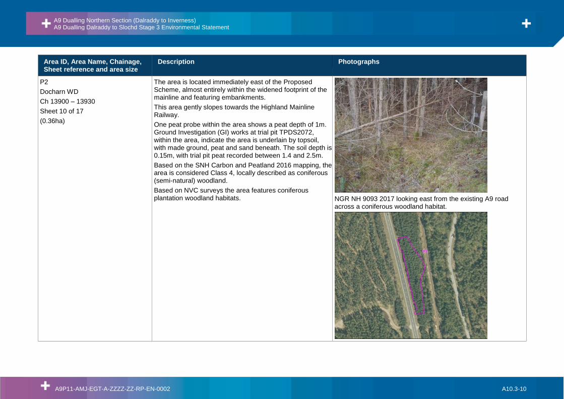
P2
Docharn WD
Ch 13900 – 13930
Sheet 10 of 17
(0.36ha)
The area is located immediately east of the Proposed Scheme, almost entirely within the widened footprint of the mainline and featuring embankments.
This area gently slopes towards the Highland Mainline Railway.
One peat probe within the area shows a peat depth of 1m. Ground Investigation (GI) works at trial pit TPDS2072, within the area, indicate the area is underlain by topsoil, with made ground, peat and sand beneath. The soil depth is 0.15m, with trial pit peat recorded between 1.4 and 2.5m.
Based on the SNH Carbon and Peatland 2016 mapping, the area is considered Class 4, locally described as coniferous (semi-natural) woodland.
Based on NVC surveys the area features coniferous plantation woodland habitats.
NGR NH 9093 2017 looking east from the existing A9 road across a coniferous woodland habitat.
A9 Dualling Northern Section (Dalraddy to Inverness) A9 Dualling Dalraddy to Slochd Stage 3 Environmental Statement
A9P11-AMJ-EGT-A-ZZZZ-ZZ-RP-EN-0002 A10.3-11
Area ID, Area Name, Chainage, Sheet reference and area size
Description Photographs
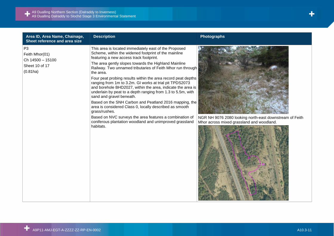
P3
Feith Mhor(01)
Ch 14500 – 15100
Sheet 10 of 17
(0.81ha)
This area is located immediately east of the Proposed Scheme, within the widened footprint of the mainline featuring a new access track footprint.
The area gently slopes towards the Highland Mainline Railway. Two unnamed tributaries of Feith Mhor run through the area.
Four peat probing results within the area record peat depths ranging from 1m to 3.2m. GI works at trial pit TPDS2073 and borehole BHD2027, within the area, indicate the area is underlain by peat to a depth ranging from 1.3 to 5.5m, with sand and gravel beneath.
Based on the SNH Carbon and Peatland 2016 mapping, the area is considered Class 0, locally described as smooth grass/rushes.
Based on NVC surveys the area features a combination of coniferous plantation woodland and unimproved grassland habitats.
NGR NH 9076 2080 looking north-east downstream of Feith Mhor across mixed grassland and woodland.
A9 Dualling Northern Section (Dalraddy to Inverness) A9 Dualling Dalraddy to Slochd Stage 3 Environmental Statement
A9P11-AMJ-EGT-A-ZZZZ-ZZ-RP-EN-0002 A10.3-12
Area ID, Area Name, Chainage, Sheet reference and area size
Description Photographs
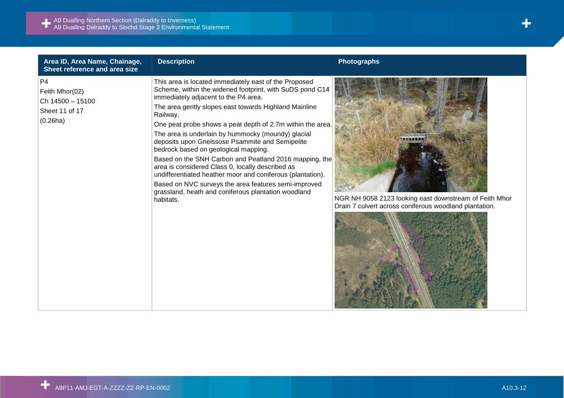
P4
Feith Mhor(02)
Ch 14500 – 15100
Sheet 11 of 17
(0.26ha)
This area is located immediately east of the Proposed Scheme, within the widened footprint, with SuDS pond C14 immediately adjacent to the P4 area.
The area gently slopes east towards Highland Mainline Railway,
One peat probe shows a peat depth of 2.7m within the area.
The area is underlain by hummocky (moundy) glacial deposits upon Gneissose Psammite and Semipelite bedrock based on geological mapping.
Based on the SNH Carbon and Peatland 2016 mapping, the area is considered Class 0, locally described as undifferentiated heather moor and coniferous (plantation).
Based on NVC surveys the area features semi-improved grassland, heath and coniferous plantation woodland habitats.
NGR NH 9058 2123 looking east downstream of Feith Mhor Drain 7 culvert across coniferous woodland plantation.

A9 Dualling Northern Section (Dalraddy to Inverness) A9 Dualling Dalraddy to Slochd Stage 3 Environmental Statement
A9P11-AMJ-EGT-A-ZZZZ-ZZ-RP-EN-0002 A10.3-13
Area ID, Area Name, Chainage, Sheet reference and area size
Description Photographs
P5
Feith Mhor
Ch 14950-15000
Sheet 11 of 17
(0.21ha)
This area is located immediately west of the Proposed Scheme, within the widened footprint featuring new cuttings and embankments.
The area is located at the base of a small hill.
One peat probe within the area, with a peat depth of 4.3m. GI works at trial pit TPDS2074, immediately east, indicate the area is underlain by topsoil, embankment fill and peat, with sand and gravel beneath. Peat was encountered at 1.2m.
Peat core DS-PC-04 collected in this area.
Based on the SNH Carbon and Peatland 2016 mapping, the area is considered Class 0, locally described as undifferentiated heather moor and coniferous (plantation).
Based on NVC surveys the area features a mixture of blanket bog, coniferous plantation woodland and semi-improved acid grassland habitats.
NGR NH 9056 2122 looking south-west towards Carn Lethendry across mixed grassland and coniferous woodland.

A9 Dualling Northern Section (Dalraddy to Inverness) A9 Dualling Dalraddy to Slochd Stage 3 Environmental Statement
A9P11-AMJ-EGT-A-ZZZZ-ZZ-RP-EN-0002 A10.3-14
Area ID, Area Name, Chainage, Sheet reference and area size
Description Photographs
P6
Ellan WD
Ch 15380
Sheet 11 of 17
(0.13ha)
Small area located downslope of the Proposed Scheme, within the widened footprint featuring embankments.
The area gently slopes east towards the Highland Mainline Railway.
There are five peat probing records within 10m of area P6, with peat depths ranging from 0.1m to 1.1m. GI works at trial pit TPDS2076, immediately south of the area, indicate the area is underlain by topsoil, with sand and gravel beneath.
Based on the SNH Carbon and Peatland 2016 mapping, the area is considered Class 0, locally described as open canopy (young plantation) and coniferous plantation.
Based on NVC surveys the area features semi-improved grassland habitats.
No photograph available for this area.

A9 Dualling Northern Section (Dalraddy to Inverness) A9 Dualling Dalraddy to Slochd Stage 3 Environmental Statement
A9P11-AMJ-EGT-A-ZZZZ-ZZ-RP-EN-0002 A10.3-15
Area ID, Area Name, Chainage, Sheet reference and area size
Description Photographs
P7
South of Black Mount Junction
Ch 18410
Sheet 13 of 17
(0.015ha)
Small area located immediately south-west of the Proposed Scheme, within the widened footprint featuring embankments on the northbound carriageway.
The area gently slopes south from the carriageway.
One peat core located 6m north of the area, indicates peat depth is 1.1m.
The area is underlain by hummocky (moundy) glacial superficial deposits upon Gneissose Psammite and Gneissose Semipelite based on geological mapping.
Based on the SNH Carbon and Peatland 2016 mapping, the area is considered Class 4, locally described as recent ploughing.
Based on NVC surveys the area features dense/continuous scrub habitat.
NGR NH 8848 2382 looking south west along watercourse.

A9 Dualling Northern Section (Dalraddy to Inverness) A9 Dualling Dalraddy to Slochd Stage 3 Environmental Statement
A9P11-AMJ-EGT-A-ZZZZ-ZZ-RP-EN-0002 A10.3-16
Area ID, Area Name, Chainage, Sheet reference and area size
Description Photographs
P8
Black Mount Junction
East of Ch 18800
Sheet 13 of 17
(0.25ha)
The area is located north of the Proposed Scheme, within the Black Mount Junction and includes SuDS pond N4 footprint, with SuDS pond N5 located 170m west.
The area gently slopes north towards the Highland Mainline Railway.
Five peat probing records within the area, indicate peat depths ranging from 0.4m to 2.2m.
Peat core DS-PC-03 collected in this area.
The area is underlain by hummocky (moundy) glacial deposits upon Gneissose Psammite and Gneissose Semipelite based on geological mapping.
Based on the SNH Carbon and Peatland 2016 mapping, the area is considered Class 3, locally described as smooth grass/rushes.
Based on NVC surveys the area features a mix of swamp and broad-leaved semi-natural habitat.
NGR NH 8804 2407 looking north-east towards the Highland Mainline Railway embankment across a grassland area.
A9 Dualling Northern Section (Dalraddy to Inverness) A9 Dualling Dalraddy to Slochd Stage 3 Environmental Statement
A9P11-AMJ-EGT-A-ZZZZ-ZZ-RP-EN-0002 A10.3-17
Area ID, Area Name, Chainage, Sheet reference and area size
Description Photographs
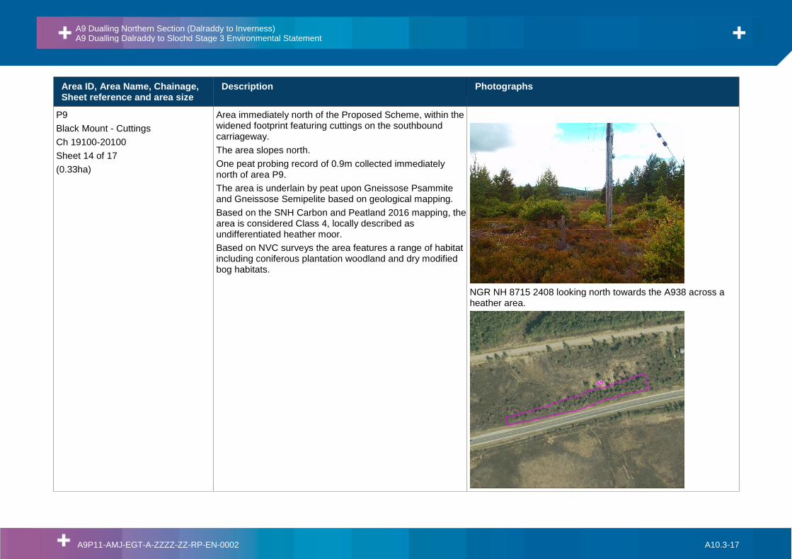
P9
Black Mount - Cuttings
Ch 19100-20100
Sheet 14 of 17
(0.33ha)
Area immediately north of the Proposed Scheme, within the widened footprint featuring cuttings on the southbound carriageway.
The area slopes north.
One peat probing record of 0.9m collected immediately north of area P9.
The area is underlain by peat upon Gneissose Psammite and Gneissose Semipelite based on geological mapping.
Based on the SNH Carbon and Peatland 2016 mapping, the area is considered Class 4, locally described as undifferentiated heather moor.
Based on NVC surveys the area features a range of habitat including coniferous plantation woodland and dry modified bog habitats.
NGR NH 8715 2408 looking north towards the A938 across a heather area.

A9 Dualling Northern Section (Dalraddy to Inverness) A9 Dualling Dalraddy to Slochd Stage 3 Environmental Statement
A9P11-AMJ-EGT-A-ZZZZ-ZZ-RP-EN-0002 A10.3-18
Area ID, Area Name, Chainage, Sheet reference and area size
Description Photographs
P10
Black Mount – Embankment(01)
Ch 20100-21000
Sheet 14 of 17
(0.99ha)
Area immediately north of the Proposed Scheme, within the widened footprint, featuring embankments on the southbound carriageway.
The area gently slopes east from the road embankment.
Peat probing, at several locations within the area, indicate peat depths ranging from 1.7m to 3.1m. GI works at trial pit TPDS2081, 13m north of the area, indicates the area is underlain by peat (1.9mbgl) upon sand and gravel.
Peat core DS-PC-02 collected in this area.
Based on the SNH Carbon and Peatland 2016 mapping, the area is considered partially Class 4 (locally as described undifferentiated heather moor), and 5 (locally described as smooth grass/rushes and undifferentiated heather moor).
Based on NVC surveys the area features a range of habitats including marshy grassland and blanket bog habitats.
NH 8625 2389 looking north across a grassland habitat.
A9 Dualling Northern Section (Dalraddy to Inverness) A9 Dualling Dalraddy to Slochd Stage 3 Environmental Statement
A9P11-AMJ-EGT-A-ZZZZ-ZZ-RP-EN-0002 A10.3-19
Area ID, Area Name, Chainage, Sheet reference and area size
Description Photographs
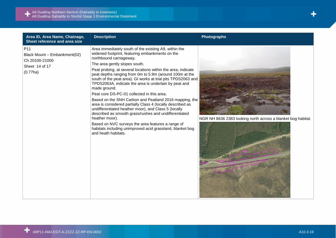
P11
Black Mount – Embankment(02)
Ch 20100-21000
Sheet 14 of 17
(0.77ha)
Area immediately south of the existing A9, within the widened footprint, featuring embankments on the northbound carriageway.
The area gently slopes south.
Peat probing, at several locations within the area, indicate peat depths ranging from 0m to 5.9m (around 100m at the south of the peat area). GI works at trial pits TPDS2063 and TPDS2063A, indicate the area is underlain by peat and made ground.
Peat core DS-PC-01 collected in this area.
Based on the SNH Carbon and Peatland 2016 mapping, the area is considered partially Class 4 (locally described as undifferentiated heather moor), and Class 5 (locally described as smooth grass/rushes and undifferentiated heather moor).
Based on NVC surveys the area features a range of habitats including unimproved acid grassland, blanket bog and heath habitats.
NGR NH 8636 2383 looking north across a blanket bog habitat.

A9 Dualling Northern Section (Dalraddy to Inverness) A9 Dualling Dalraddy to Slochd Stage 3 Environmental Statement
A9P11-AMJ-EGT-A-ZZZZ-ZZ-RP-EN-0002 A10.3-20
Area ID, Area Name, Chainage, Sheet reference and area size
Description Photographs
P12
Black Mount – Embankment(03)
Ch 20100-21000
Sheet 14 of 17
(0.74ha)
Area immediately north of the existing A9, within the widened footprint, featuring embankments on the southbound carriageway.
The area gently slopes north towards secondary road,
Peat probing, at five locations within the area, indicate peat depths ranging from 0.9m to 2.0m. GI works, at trial pits TPDS2050 and TPDS2082, indicate the area is underlain by peat, topsoil, embankment fill, upon sand and gravel.
Based on the SNH Carbon and Peatland 2016 mapping, the area is considered partially Class 5 and 0, locally described as smooth grass/rushes.
Based on NVC surveys the area features a range of habitats including basin mire and coniferous plantation woodland habitats.
NGR NH 8625 2389 looking west across a mixed grassland and coniferous plantation woodland habitat.

A9 Dualling Northern Section (Dalraddy to Inverness) A9 Dualling Dalraddy to Slochd Stage 3 Environmental Statement
A9P11-AMJ-EGT-A-ZZZZ-ZZ-RP-EN-0002 A10.3-21
Area ID, Area Name, Chainage, Sheet reference and area size
Description Photographs
P13
Slochd
Ch 24200-24300
Sheets 16 & 17 of 17
(0.098ha)
Small area located north-east of the Proposed Scheme, within the widened footprint, featuring a new underpass.
The area moderately slopes north-east towards Slochd Summit.
Peat probing at one location immediately west of the area, indicates peat depth of 1.5m.
The area is underlain by till (diamicton) superficial deposits upon Semipelite bedrock based on geological mapping.
Based on the SNH Carbon and Peatland 2016 mapping, the area is considered Class 5, locally described as dry heather moor.
Based on NVC surveys the area features unimproved acid grassland habitat.
NGR NH 8348 2567 looking downstream of Allt Slochd Mhuic.

A9 Dualling Northern Section (Dalraddy to Inverness) A9 Dualling Dalraddy to Slochd Stage 3 Environmental Statement
A9P11-AMJ-EGT-A-ZZZZ-ZZ-RP-EN-0002 A10.3-22
Area ID, Area Name, Chainage, Sheet reference and area size
Description Photographs
P14
Slochd
Ch 24450-25000
Sheet 17 of 17
(0.24ha)
This area is located immediately north-east of the existing A9, within the widened footprint, featuring cuttings on the southbound carriageway.
at the base of the Slochd Summit,
Peat probing, at two locations within the area, records peat depths varying from 0.5m to 3.1m.
The area is underlain by peat upon Gneissose Psammite and Gneissose Semipelite based on geological mapping.
Based on the SNH Carbon and Peatland 2016 mapping, the area is considered Class 5, locally described as dry heather moor.
Based on NVC surveys the area features unimproved grassland and heath habitats.
NGR NH 8307 2607 looking north towards Slochd Summit
A9 Dualling Northern Section (Dalraddy to Inverness) A9 Dualling Dalraddy to Slochd Stage 3 Environmental Statement
A9P11-AMJ-EGT-A-ZZZZ-ZZ-RP-EN-0002 A10.3-23
5. Soil and Peat Excavation Volumes
5.1. Introduction
5.1.1. The Proposed Scheme has 14 defined peat areas along the mainline and junctions, based on the interpretation of the data from the investigation works, in combination with the superficial geological map and the SNH Carbon and Peatland 2016 map. These areas have been used when calculating the peat volumes following the methodology described in Section 3.
5.2. Road Design
Construction Techniques to Minimise Peat Excavation
5.2.1. Taking due consideration of the requirements of HD22/08 – Managing Geotechnical Riskxvi, and common industry practice, the standard option to fully mitigate risks posed by peat deposits to the final works is to excavate and replace peat deposits with a suitable, well compacted engineered fill.
5.2.2. However, the direct loss of underlying peat and adjacent peat associated with excavate and replace is likely to be considerable to the fact that the embankment slopes will extend below the surface of the peat until competent ground is reached. Additionally, the excavation will need to be battered back to provide a stable, safe working area. Although some of this peat can be replaced after construction is complete, the structure of the peat and its hydrological conditions will have been altered. This is likely to result in a strip of altered vegetation adjacent to the mainline, which may extend out to areas of peat that have not been physically disturbed but which are affected by the secondary changes to the hydrology in the temporary excavation area. This will ultimately result in a greater impact on the peatland habitats in this area.
5.2.3. It is recognised that where extensive (lateral and depth) peat deposits are anticipated the standard excavate and replace approach may not represent best or sustainable practice. The strategy could lead to potential disturbance and / or loss of local habitats / ecosystems and affect natural groundwater flows. Similarly, it may not represent the most practical or economic engineered solution.
5.2.4. As an optioneering exercise, a number of geotechnical solutions were therefore considered as part of the Peat Strategy for the Proposed Scheme for locations where peat could not be avoided. This included:
• Preloading with rest period;
• Floating roads, incorporating basal reinforcement;
• Lightweight fill materials;
• Peat displacement;
• Ground improvement – Lined vibro replacement (Concrete or Stone columns);
• Rigid inclusions;
• Controlled displacement;
• Soil mixing;
• Bog Blasting;

A9 Dualling Northern Section (Dalraddy to Inverness) A9 Dualling Dalraddy to Slochd Stage 3 Environmental Statement
A9P11-AMJ-EGT-A-ZZZZ-ZZ-RP-EN-0002 A10.3-24
• Piling, and;
• Freestanding structures.
5.2.5. Most of these alternatives to the standard excavation and replacement method were not considered as suitable for the Proposed Scheme and subsequently discounted as non-viable solutions. Floating roads, soil mixing and piling were initially considered as viable alternatives given varying local characteristics and requirements. Environmental considerations, including the direct environmental impact on peatland habitats, carbon losses, waste management and land take implications were also considered as part of this process.
5.2.6. It was concluded that piling would be the best geotechnical option to preserve peat within the mainline/junction footprint of the Proposed Scheme and although minor compression, surface excavation and displacement of in situ peat may be anticipated, this approach will minimise direct impact and indirect impact on adjacent peatland. Piling transfers loads created by the proposed assets to a competent underlying bearing stratum. As peat offers no lateral resistance, the piles would be required to be set within / upon such a competent underlying bearing stratum. Individual piles would be combined with a load transfer platform to distribute the asset load across the piles.
5.2.7. Feith Mhor (P3 and P4) and Black Mount (P10, P11 and P12) peat areas have been selected as feasible piling locations, where ground condition data currently available indicates that the founding materials will typically comprise dense to very dense glacial fluvial deposits with extensive cobbles and boulders underlying the peat.
5.2.8. The specific piling methodology applied will be informed by additional ground investigation information at each location that will be available at the detailed design stage and with contractor input. Therefore, following the precautionary principle, a range of surface peat excavation values, from no excavation up to a maximum depth of 1.0m, have been reported for piling locations, to enable pragmatic and comprehensive consideration of the potential range of peat excavation and re-use volumes involved.
5.2.9. In addition to piling, another area with extensive peat deposits was identified in the Black Mount sector, where an access road is located south of the mainline (Ch 20700 – 21000), with local peat depths reaching 5.4m. A floating road will be constructed to avoid peat extraction but maintain access to the mainline at this location.
5.2.10. As the design progresses, it may become apparent that alternatives to excavation and replacement techniques, at non-piling locations, are feasible and provide benefits to the Proposed Scheme at specific locations. Such alternatives and specific piling techniques shall remain open for consideration as the design progresses, with comparisons undertaken to consider technical feasibility, environmental impact and economic value (including landtake requirements).
Excavated Peat Volumes
5.2.11. Table 5.1 provides a summary of the volumes of peat (sub-divided into acrotelm and catotelm – fibrous and amorphous) for each of the peat areas (P1 - P14). The locations of these peat areas are presented on Figure A10.3.1.
5.2.12. The strategy to adopt piling construction techniques for crossing peat areas at Feith Mhor floodplain (P3 and P4) and for the embankments at Black Mount (P10, P11 and P12) substantially reduces the peat excavation volumes for the Proposed Scheme, with measures that enable the avoidance of any surface peat excavation providing the greatest benefit.

A9 Dualling Northern Section (Dalraddy to Inverness) A9 Dualling Dalraddy to Slochd Stage 3 Environmental Statement
A9P11-AMJ-EGT-A-ZZZZ-ZZ-RP-EN-0002 A10.3-25
5.2.13. Taking account of the range of surface peat excavation anticipated at piled locations, from none to 1.0m, there is a total peat excavation volume estimated as ranging from 19,020m3 – 49,010m3. The excavated peat mainly consists of fibrous catotelmic peat (7,910m3 – 26,750m3), plus acrotelmic peat (5,260m3 – 16,410m3), with lower volumes of amorphous catotelmic peat (5,850m3), which is not influenced by potential surface peat removal at the piling locations.
5.2.14. The maximum peat depth for each of the 14 areas are also summarised in Table 5.1, with maximum depths generally within each area but including data immediately adjacent, if considered representative of local conditions.

A9 Dualling Northern Section (Dalraddy to Inverness) A9 Dualling Dalraddy to Slochd Stage 3 Environmental Statement
A9P11-AMJ-EGT-A-ZZZZ-ZZ-RP-EN-0002 A10.3-26
Table 5.1: Peat Volumes at Specified Peat Areas
Peat Sector name
Chainage Peat Area ID
Peat maximum depth
(m)
Peat Acrotelm (m3)
Peat
Fibrous Catotelm (m3)
Peat
Amorphous Catotelm
(m3)
Geotechnical Solution
Total Peat Volume Excavated
(m3)
Civil 3D Model Volume Estimation
Dalraddy Ch 200 to 400
P1 1.2 640 970 90 Excavation and Replacement
1,700 No
Docharn WD Ch 13900 to 13930
P2 1.4 - 2.5 1,220 2,000 1,340 Excavation and Replacement
4,560 No
Feith Mhor floodplain
Ch 14500 to 15100
P3
P4
6.4*
2.7 3,110 6,330 12,180 Piling 0 - 9,440** Yes
Feith Mhor Ch 14950 to 1500
P5 4.3 800 1,540 3,400 Excavation and Replacement
5,740 No
Ellan WD Ch 15380 P6 0.6 - 1.1 370 380 - Excavation and Replacement
750 No
South of Black Mount Junction
Ch 18410 P7 0.5 - 1.1 50 110 20 Excavation and Replacement
180 No
Black Mount Junction
East of Ch 18800
P8 2.55 730 1,220 250 Excavation and Replacement
2,200 Yes
Black Mount – cuttings
Ch 19100 to 20100
P9 0.0-0.9 560 370 - Excavation and Replacement
930 Yes
Black Mount – embankments
Ch 20100 to 21000
P10
P11
P12
3.1
4.6
3.1
8,040 12,510 11,630 Piling 0 - 20,550** Yes
Slochd Ch 24200 to 24300
P13 1.5 310 450 220 Excavation and Replacement
980 No

A9 Dualling Northern Section (Dalraddy to Inverness) A9 Dualling Dalraddy to Slochd Stage 3 Environmental Statement
A9P11-AMJ-EGT-A-ZZZZ-ZZ-RP-EN-0002 A10.3-27
Peat Sector name
Chainage Peat Area ID
Peat maximum depth
(m)
Peat Acrotelm (m3)
Peat
Fibrous Catotelm (m3)
Peat
Amorphous Catotelm
(m3)
Geotechnical Solution
Total Peat Volume Excavated
(m3)
Civil 3D Model Volume Estimation
Slochd Ch 24450 to 25000
P14 3.1 580 870 530 Excavation and Replacement
1,980 Yes
Total Peat Excavated (m3)
5,260 – 16,410**
7,910 – 26,750**
5,850 19,020 – 49,010**
*Peat was recorded to the maximum depth of 5.55m bgl, underlain by a layer of soft silt to a depth of 6.4mbgl. The layer of soft silt was included in the calculation of the volume to be excavated
**Precautionary volumes assuming that 1.0m of surface peat in piled areas will require excavation

A9 Dualling Northern Section (Dalraddy to Inverness) A9 Dualling Dalraddy to Slochd Stage 3 Environmental Statement
A9P11-AMJ-EGT-A-ZZZZ-ZZ-RP-EN-0002 A10.3-28
Acrotelmic Peat and Fibrous Catotelmic Peat
5.2.15. The combined volumetric total within the upper 1.0m of peat is estimated as ranging from 13,170m3 – 43,160m3, dependent on surface peat removal requirements in piled areas.
5.2.16. Acrotelmic peat, which represents the surface layer of peat to a depth of 0.3m, is encountered at a number of locations across the Proposed Scheme, with a total excavation volume ranging between 5,260m3 - 16,410m3.
5.2.17. Fibrous catotelmic peat, which has been assumed as occurring in peat deposits between depths of 0.3m – 1.0m, is also encountered at a number of locations, with a total volume ranging from 7,910m3 - 26,750m3 along the scheme.
Amorphous Catotelmic Peat
5.2.18. A threshold value of 1.0m depth for amorphous catotelmic peat has been suggested as a generally accepted value by SEPA in the published waste guidance related to peatlandxvii. Given soil map evidence and local characteristics across the large site area, it is likely that applying the 1.0m threshold value is reasonably precautionary and potentially still overestimates amorphous catotelmic peat conditions that would require excavation below infrastructure.
5.2.19. Less amorphous catotelmic peat is anticipated to be excavated within the Proposed Scheme than topsoil and the combined fibrous peat classifications, with a total of 5,850m3 of this material requiring excavation. As the potential for surface peat removal at piled locations is limited to 1.0m depth, amorphous catotelmic peat is not expected to be removed at piled areas.
5.2.20. The strategy for piling rather than peat excavation at 2 key areas where extensive peat deposits were identified has substantially reduced the excavation of this sensitive material. The Feith Mhor area (P5) represents the area with the greatest volume of this material requiring excavation (3,400m3). During the detailed design stage, this location in particular will be considered further to ascertain feasible opportunities to reduce local peat excavation.
5.2.21. Due to the inherent lack of structure and high water content in amorphous catotelmic peat, it is difficult to manage and successfully re-use this material following excavation. Thus, the Proposed Scheme design has sought to avoid excavating such material in the first instance by both footprint design and adopting piling techniques in appropriate locations.
Excavated Topsoil Volume
5.2.22. The Engineering Design team provided a total topsoil estimated volume of 317,169m3 as material that will require excavation to a depth of 0.3m for the Proposed Scheme. Of this total, 269,974m3 is associated with the mainline and junctions, with track and side road excavation representing an additional volume of 47,195m3. These values include acrotelmic peat and assume all infrastructure requires excavation.
5.2.23. The topsoil volume requiring excavation ranges from 306,019m3 – 317,169m3, including 300,759m3 of topsoil and 5,260m3 – 16,410m3 of acrotelmic peat. This information is provided in Table 5.2, with the difference due to the requirement for surface peat excavation in piled locations.

A9 Dualling Northern Section (Dalraddy to Inverness) A9 Dualling Dalraddy to Slochd Stage 3 Environmental Statement
A9P11-AMJ-EGT-A-ZZZZ-ZZ-RP-EN-0002 A10.3-29
Table 5.2 Excavation Volumes to 0.3m
Material Total Soil Volume
(No excavation in piled areas)
(m3)
Total Soil Volume
(If up to 1.0m of surface material excavated in piled areas)
(m3)
Topsoil 300,759 300,759
Acrotelmic Peat
(that will be excavated, rather than piled)
5,260 16,410
Total Excavation Volume 306,019 317,169
5.3. Drainage Design
5.3.1. The Engineering Drainage team provided a total net soil volume of 50,718m3 as excess material after the construction of the ponds along the Proposed Scheme. A total of 32 ponds were considered, with detail of soil volumes provided in Table 5.3.
5.3.2. Depending of the depth of the ponds, the material that will need to be excavated may include soil and also underlying sedimentary deposits, including peat.
5.3.3. The majority of the ponds are confirmed to be located in non-peat areas. Two ponds are planned in peatland areas, both of which are in or adjacent to the P8 Black Mount Junction area; ponds N4 and N5. Average peat depth data is approximately 0.7m at pond N4 and 0.5m at pond N5, with each of these pond locations taking into account the objective to minimise peat excavation. These locations are summarised in terms of material excavation requirements in Table 5.3.
Table 5.3 Excavation Volumes for Ponds
Ponds Drainage Design Net Excavated Volume (m3)
Comment
30 Ponds 39,504 No material excavated is considered to be peat
Pond N4 506 All material excavated is anticipated to be peat
Pond N5 10,708 A proportion of the material excavated from this location is anticipated to be peat
Total Excavated Volume 50,718
5.3.4. As pond excavations will need to meet a number of inter-related design requirements, it is difficult to definitively establish the relative proportion of soil, acrotelmic and catotelmic material, requiring to be excavated at ponds N4 and N5, however, peat depth data specific to the pond footprints suggest total peat volumes to be excavated of approximately 3,378m3 (1,722m3 acrotelmic and 1,656m3 fibrous catotelmic peat). Descriptions of acrotelmic and catotelmic peat categories are provided in the Road Design section above.
5.3.5. There will also be a requirement to excavate soil and peat for drainage channels at the Proposed Scheme, these channels shall typically be of relatively small dimensions in

A9 Dualling Northern Section (Dalraddy to Inverness) A9 Dualling Dalraddy to Slochd Stage 3 Environmental Statement
A9P11-AMJ-EGT-A-ZZZZ-ZZ-RP-EN-0002 A10.3-30
comparison to the ponds and other infrastructure evaluated in this report. Ditches identified in peat areas have an estimated total peat excavation volume of 632m3 (480m3 of acrotelmic and 152m3 of fibrous catotelmic peat). This estimation is based on a project-specific drainage design for a standard ditch with cross sectional area of 0.75m2, based on the minimum depth of 0.5m (base width = 0.5m x depth = 0.5m with a side slope of 1:2).
5.3.6. Most ditches and drains will be located in non-peat areas. It is considered that these channels represent a negligible change in excavated non-peat material volumes, in comparison with pond values and topsoil volumes.
6. Re-use Options for Soil and Peat
6.1. Introduction
6.1.1. SEPA guidance, as detailed in their Position Statement on Peat, states: “Developers should attempt to re-use as much of the peat produced on-site as is possible”iv.
6.1.2. This section details the re-use opportunity for soil and peat materials within the Proposed Scheme and also considers the options for off-site re-use. This uses the results presented in Sections 4 and 5 above on the classification and volumes of soil and peat likely to be encountered during the construction works.
6.1.3. Initial consideration was given to potential for peatland restoration using excavated materials from the Proposed Scheme, however, following review of peatland characteristics within and adjacent to the existing A9, there were no apparent areas which presented viable opportunities to be included within this document. Should such opportunities be identified as the programme for the Proposed Scheme develops, the viability of on-site and local off-site locations shall be discussed with appropriate stakeholders and good practice followed. During discussions with SEPA relating to Peat Management, it was acknowledged that adjacent areas did not appear viable for this purpose.
6.2. Re-Use Options Within the Proposed Scheme
6.2.1. Fill and landscape requirements for the Proposed Scheme will predominantly use appropriate geotechnical material, applying topsoil as surface dressing. The re-use of material for landscaping (dressing), considering grassland and woodland requirements, will require between 213,400m3 - 298,550m3 of soil. Table 6.1 provides details about the estimated volume for each planting type, supplied by the landscaping team for the Proposed Scheme.
Table 6.1: Volume Estimation for Landscaping Scenarios
Planting type Lower landscaping estimated volume
(m3)
Higher landscaping estimated volume
(m3)
Grassland 85,650 94,150
Woodland 127,750 204,400
TOTAL 213,400 298,550

A9 Dualling Northern Section (Dalraddy to Inverness) A9 Dualling Dalraddy to Slochd Stage 3 Environmental Statement
A9P11-AMJ-EGT-A-ZZZZ-ZZ-RP-EN-0002 A10.3-31
6.2.2. It is anticipated that peat material will be re-used in the creation of woodland areas, grassland and potentially dry heath areas. At this stage of the study, we are assuming a typical volumetric ratio of 1:4 for peat to soil. On the basis of this ratio in relation to Table 6.1, the requirement for peat would range from 42,680m3 – 59,710m3, based on the lower and higher landscaping scenarios, respectively.
6.2.3. There is potential for peat material to shrink due to a reduction in water content when used for landscaping purposes. It is anticipated that acrotelmic peat will undergo a slight shrinkage in volume of 10%, whereas it is assumed that both fibrous and amorphous catotelmic peat will undergo an estimated shrinkage in volume of 50% due to dewatering / drying / mixing with topsoil.
Table 6.2: Peat and Soil Volumes (After Shrinkage)
Categories Peat -
Acrotelm (m3)
Peat -
Fibrous Catotelm (m3)
Peat -
Amorphous Catotelm (m3)
Total Peat Volume (m3)
Topsoil and Other Material (m3)
Total Volume Available
(m3)
Road Design 5,260 -
16,410*
7,910 -
26,750* 5,850
19,020 -
49,010* 300,759
319,779 -
349,769*
Drainage Design
2,202 1,808 4,010 47,340 51,350
Factor of peat volume reduction due to shrinkage
0.9 0.5 0.5 - 1 -
Final available volume
(after shrinkage)
6,716 -
16,751*
4,859 -
14,279* 2,925
14,500 -
33,955* 348,099
362,599 -
382,054*
* Precautionary volumes assuming that 1.0m of surface peat in piled areas will require excavation
6.2.4. Taking account of all materials (and the peat shrinkage factors), there is a volume ranging from 362,599m3 - 382,054m3 of material available for re-use (Table 6.2). Topsoil for Road Design represents the vast majority of this material, 300,759m3, with Drainage Design generating a further 47,340m3 of topsoil material. From the total excavated volume of peat ranging from 23,030m3 – 53,020m3, taking account of shrinkage, the volume that is available to be re-used for landscaping ranges from 14,500m3 – 33,955m3, dependent on surface peat removal for piling locations.
6.2.5. Depending on the volume needed for landscaping (with a large variation between the lower and higher estimated volumes presented in Table 6.1), there are 2 different scenarios:
• Higher estimated landscaping requirement (298,550m3):
All peat material, with a total volume ranging between 14,500m3 - 33,955m3, shall be re-used within the site.
There is a surplus of topsoil and other materials ranging between 64,049m3 - 83,504m3.
• Lower estimated landscaping volume requirement (213,400m3):

A9 Dualling Northern Section (Dalraddy to Inverness) A9 Dualling Dalraddy to Slochd Stage 3 Environmental Statement
A9P11-AMJ-EGT-A-ZZZZ-ZZ-RP-EN-0002 A10.3-32
All peat material, with a total volume ranging from 14,500m3 - 33,955m3, shall be re-used within the site.
There is a surplus of topsoil and other material ranging from 149,199m3 –168,654m3.
6.2.6. In both scenarios, it is anticipated that all the excavated peat, fibrous and amorphous material, would be prioritised for on-site landscaping requirements.
6.2.7. Both acrotelmic and fibrous catotelmic peat are likely to be suitable for re-use throughout the Proposed Scheme due to the fibrous structure giving good potential for application. This material is anticipated to be excavated as the upper 1.0m of peat. The acrotelm and the fibrous catotelmic peat has been anticipated to be mixed with the topsoil and soil in order to produce a peaty soil for dressing within landscaping areas.
6.2.8. The amorphous catotelmic peat (excavated at greater than 1.0m depth), generally has a higher water content and very low tensile strength, which makes it more difficult to manage due these physical properties. If used directly for restoration or for landscaping this material could lead to a number of issues including low bearing capacity, propensity to slide-off slopes and potential to release water with high suspended solids content. It is estimated that there is 5,850m3 of amorphous catotelmic peat that will require to be excavated during the construction works, across a number of discrete locations. This is expected to be excavated during various stages of the construction programme. It is proposed, at this stage, that the amorphous peat will be pre-treated to provide a more stable combined structure through drying and mixing with peaty soils. This will require to be discussed with the relevant statutory body as to the suitability of pre-treatment options and subsequent re-use.
6.2.9. At applicable locations, cut turves shall be retained for local surface dressing and the remainder of acrotelmic and catotelmic material generally blended with topsoil to create a peaty soil substrate. Peaty soils are present locally, with dry upland heath habitat often including a shallow peat horizon on better-draining soils, including on moderate to steep upland slopes. The ratio of peat:soil mix (typically 1:4) would be altered to match local soil conditions.
6.2.10. There may be further opportunities for re-use of topsoil and other soil material within the Proposed Scheme, with these opportunities to reduce off-site re-use to be further considered and feasibility established as the design progresses. Areas likely to retain higher levels of soil moisture may be considered for potential peatland creation or to aid peatland restoration, at such locations separate storage of peat and prompt local re-use (avoiding soil mixing and peat drying processes) or even direct transfer of excavated amorphous catotelmic peat could be applicable, such as at Black Mount.
6.2.11. Suitability for re-use, such as for landscaping or peatland restoration purposes, is ultimately dependent on the structure of the material excavated during the construction works, this would require assessment and confirmation of appropriate application by the Contractor, taking account of geotechnical inputs, and in consultation with the Environmental Clerk of Works (EnvCoW). The EnvCoW will be appointed by the Contractor and report to the Environmental Coordinator and be present during the construction period to monitor the implementation of mitigation measures and ensure activities are carried out in such a manner to prevent or reduce impacts on the environment.
A9 Dualling Northern Section (Dalraddy to Inverness) A9 Dualling Dalraddy to Slochd Stage 3 Environmental Statement
A9P11-AMJ-EGT-A-ZZZZ-ZZ-RP-EN-0002 A10.3-33
6.3. Re-Use Options Outwith the Proposed Scheme
6.3.1. Depending on the final volume needed for landscaping (currently estimated as requiring between 213,400 - 298,550m3 of material), up to 168,654m3 of the surplus topsoil and other non-peat material excavated may require to be considered for re-use off-site (assuming both lower estimate landscaping and surface peat removal at piled locations). This material would be transferred off-site in preference to the more sensitive peat and particularly amorphous catotelmic peat material.
6.3.2. As discussed above, peatland restoration opportunities were not available in the local area, which determined the approach outlined at this stage. Following refinement at the detailed design stage, off-site re-use options will be further developed with local stakeholders, which will include ongoing dialogue regarding potential for off-site peatland restoration.
6.4. Pre-Treatment for Re-Use
6.4.1. As discussed above, the acrotelm and the fibrous catotelmic peat will be mixed with the topsoil in order to produce a peaty soil for dressing within landscaping areas. The mixing of peat with topsoil has been considered as a viable treatment option in areas which already host peaty soil, depending on the proposed ecology and landscape mitigation planned for the area.
6.4.2. The mixing of peat with topsoil is not generally recommended due to the following issues that may arise:
• If mixing is not done correctly pockets of peat may form, which may affect planting;
• The peat material may not meet specific requirements for nutrient, pH values, etc., which may not meet British Standards required for planting requirements; and
• The properties of the peat once removed are likely to change and can become unpredictable in its nature.
6.4.3. However, in this instance most of the material along the Proposed Scheme is already characterised as peaty soil and the intention is to promote the establishment of vegetation in landscaping areas similar to that of the adjacent surrounding areas. As such, it has been considered acceptable to mix topsoil and peat in order to create a peaty soil similar to local conditions.
6.4.4. It is estimated that there is 5,850 m3 of amorphous catotelmic peat that will also require to be excavated in total for the Proposed Scheme. Discrete volumes from individual peat areas have been estimated along the Proposed Scheme.
6.4.5. Pre-treatment measures under consideration include reducing volume and improving the mechanical properties of the amorphous catotelmic peat by de-watering and then mixing with peaty soils. Good practice, assuming no peatland restoration locations are identified in due course, would be to dry peat naturally, storing and re-using locally to where the peat had been abstracted.
6.5. Environmental Considerations for Re-Use
6.5.1. When considering the potential re-use options, the following considerations should also be taken into account:
• Potential impacts on peat stability created from re-use;

A9 Dualling Northern Section (Dalraddy to Inverness) A9 Dualling Dalraddy to Slochd Stage 3 Environmental Statement
A9P11-AMJ-EGT-A-ZZZZ-ZZ-RP-EN-0002 A10.3-34
• Potential impacts on water quality and geomorphology of watercourses;
• Potential loss of existing valuable ecological habitats within the area of re-use; and
• Impacts on drainage and flood risk where the hydrological and sub-surface regime could be impacted.
6.5.2. It is important to consider a number of factors for potential landscaping / restoration work in accordance with current guidance, these include:
• Topography – ensure peat remains stable in each location, with consideration given to subsurface flows that may also contribute to hydrological flow, as well as downstream receptors that could be adversely affected by peat/sediment becoming entrained in runoff;
• Hydrogeology – near surface groundwater levels to allow some level of hydraulic connectivity between the peat and underlying aquifer;
• Existing peatland condition – the condition of existing peatland and land use needs to be considered for any peatland restoration work to be successful; and
• Ecology – need to ensure no additional impacts on existing habitats and woodlands are created as a result of peat re-use.
7. Storage and Handling of Material
7.1.1. It is assumed that both peat required for re-use and for disposal (if there is no re-use potential) may require material storage areas. If it is deemed suitable, any pre-treatment of the peat may also require storage either prior to or after treatment, prior to re-use application.
7.1.2. A preliminary review of the indicative land made available (LMA) and of adjacent land indicates that there will be sufficient suitable land in the vicinity of the Proposed Scheme to safely store this material, in compliance with the good practice methods and the requirements of the Waste Management Licence Regulations as discussed below.
7.1.3. It is anticipated that not all peat will need to be stored at the same time, due to the phasing of the construction programme. The estimated volume of excavated peat and soil, within discrete areas along the Proposed Scheme, are detailed in Table 6.2 and shown on Figure A10.3.1. Furthermore, the peat excavation volumes calculated indicate that amorphous catotelmic peat will be excavated at several discrete locations, with the largest volume anticipated to be excavated at Feith Mhor (P5) of 3,400m3, as shown on Table 5.1. An initial review of the adjacent land suggests that sufficient suitable land can be found adjacent to each of these areas for the pre-treatment drying of this material.
7.1.4. In due course, this should allow planning of the anticipated location and size of storage areas by the contractor(s), with these details determined at the detailed design stage. It is expected that prior to construction commencing, the contractor will provide an updated plan detailing potential locations for temporary storage and an outline programme indicating the duration and quantity of stored peat and measures to mitigate and/or capture sediment run-off from stored material. At all times, the primary objectives shall be to minimise both the time and volume of temporary storage, and to prevent sedimentation of any watercourse or waterbody.
7.1.5. Excavated soil and peat would be carefully separated to ensure they are kept apart and stored in appropriately designated areas. Bunding would be installed, where appropriate, to minimise any pollution risks.

A9 Dualling Northern Section (Dalraddy to Inverness) A9 Dualling Dalraddy to Slochd Stage 3 Environmental Statement
A9P11-AMJ-EGT-A-ZZZZ-ZZ-RP-EN-0002 A10.3-35
7.1.6. Elements of the management and re-use of excavated peat could require approval from stakeholders and should be factored into timescales. Any mixing, drying or other pre-treatment of excavated material would be undertaken with prior stakeholder approval and following strict and agreed protocols.
Good Practice Methods
7.1.7. Good practice storage and handling methods would include:
• Careful removal of vegetated turves (acrotelmic vegetated surface layer);
• Turves should be kept vegetated side up to prevent damage to the living vegetation;
• Short timescales between lifting and replacement of turves (with a 6 week reinstatement objective) and ensuring stored turves are kept in good condition (including watering during dry weather conditions which could lead to the peat drying out);
• Revegetation of bare soil with native vegetation would be encouraged as soon as practicable;
• The maximum storage depth of peat should not exceed 2.0m in depth and volume should not exceed 20,000m3 per hectareiii;
• Storage as close as practicable to the excavation location and/or planned re-use location; and
• Storage of materials at a minimum distance of 10m from any watercourses and 50m from any watercourse identified on Ordnance Survey 50,000 scale mapping and taking account of other environmental or engineering sensitivities. It would be anticipated to store material in same catchment as excavated.
Amorphous Catotelmic Peat
7.1.8. As it is anticipated that sensitive amorphous catotelmic peat will require excavation during pre-construction or construction activities, confirmation of acceptable pre-treatment, storage, transfer methods and re-use should be obtained from the relevant statutory bodies and embedded within construction phase environmental and waste management plans.
8. Disposal Route
8.1.1. Should there be an excess of excavated material that cannot be re-used, due to material characteristics or lack of re-use opportunity, options will be explored and recommendations made as to the potential disposal routes for any such material, as a last option.
8.1.2. Disposal of amorphous catotelmic peat can lead to a number of issues due to the high water content and low tensile strength and will require further consideration under Waste Management Licensing and the potential requirement for pre-treatment prior to disposal.
9. Monitoring and Construction Mitigation
9.1.1. Further pre-construction Ground Investigation works will allow opportunity for peat volumes to be refined on the basis of more detailed data becoming available.
A9 Dualling Northern Section (Dalraddy to Inverness) A9 Dualling Dalraddy to Slochd Stage 3 Environmental Statement
A9P11-AMJ-EGT-A-ZZZZ-ZZ-RP-EN-0002 A10.3-36
9.1.2. The volumes outlined in the Soil and Peat Management Plan and other environmental management documents should be updated before and during construction in line with as-built recordsi.
9.1.3. To ensure that peat volumes are minimised during construction, and to reduce impact on peat areas, the Contractor and EnvCoW will be responsible for ensuring the Soil and Peat Management Plan is adhered to and this document is updated as the Proposed Scheme progresses, including potential revisions to mitigation measures. When peat will be excavated, the Contractor should also ensure that the peat dries naturally, preferably locally to where the peat had been abstracted.
9.1.4. Monitoring should be carried out during baseline, construction and restoration phases of peat re-use areas. This may include ecological surveys to determine the habitat and vegetation type, for species such as sphagnum moss, and groundwater monitoring to determine whether water levels have increased as a result of restorationiii.
10. Conclusions
10.1.1. This report identifies the estimated total volume of soil, topsoil and peat to be excavated along the Proposed Scheme as ranging from 371,129m3- 401,119m3, with the higher value representing the precautionary approach that there is a requirement to excavate surface peat to a maximum depth of 1.0m at all piling locations.
10.1.2. The predominant excavated material is topsoil for road design (300,759m3), with a further 47,340m3 of non-peat soil materials also requiring excavation for the construction of the ponds.
10.1.3. There is also a requirement to excavate an estimated 23,030m3 – 53,020m3 of peat material. This includes 5,850m3 of amorphous catotelmic peat, with this material considered as all peat excavated beyond 1.0m depth and the most sensitive in terms of handling and management.
10.1.4. Although dependent upon the finalised landscaping requirement, it is anticipated that all the peat and most of the topsoil and non-peat soils excavated as part of the Proposed Scheme would be re-used for landscaping within the scheme boundary, including for the precautionary approach in volume calculations for piling locations. This will require ongoing consultation with the relevant stakeholders regarding the suitability of application, specific locations and pre-treatment methods. The application of piling at the five specified locations results in an estimated peat excavation saving of 23,810m3 – 53,800m3, dependent upon the surface peat removal requirement.
10.1.5. Based on the volume estimates and scenarios adopted, there is a surplus of topsoil and other soil that may need to be re-used off-site (of up to 168,654m3), although this requirement would be reduced should there be less material requiring excavation or further opportunities for on-site re-use, including landscaping. Cut and fill balance of the scheme will be developed further as the programme progresses, with potential for excavated material to be re-used appropriately in raising mainline and junction levels. Should off-site re-use be necessary, topsoil and other soils are less sensitive to handling and transport and have a wider range of potential re-use options than peat.
10.1.6. It has been established that there is the potential, based on reasonable and pragmatic assumptions, to re-use all excavated peat generated from the Proposed Scheme on-site. Where amorphous catotelmic material is encountered and excavated, it will be re-used locally on-site, thereby minimising handling, transfer and storage issues, with the specific sensitivities of this material recognised. Actual peat material excavated may

A9 Dualling Northern Section (Dalraddy to Inverness) A9 Dualling Dalraddy to Slochd Stage 3 Environmental Statement
A9P11-AMJ-EGT-A-ZZZZ-ZZ-RP-EN-0002 A10.3-37
have more fibrous characteristics than anticipated and therefore have more potential applications and/or less pre-treatment requirement. With peat conditions potentially varying over relatively short distances and at different depths, management strategies for specific peat characteristics will require to be confirmed during pre-construction with the contractor, regulators, Cairngorms National Park Authority, landowners and other stakeholders. Ongoing liaison will occur with such stakeholders and third parties during construction to ensure good practice is adhered to, lessons learned and any new opportunities for peatland restoration are considered.
i Scottish Renewables and SEPA (2012). Guidance on the assessment of peat volumes, reuse of excavated peat and the minimisation of waste. Version 1, January 2012. ii SEPA. (2017). Developments on Peat and Off-site uses of Waste Peat. Guidance Note 52. Version 1. iii SEPA (2011). Restoration techniques using peat spoil from construction works. Final Report prepared by Envirocentre. iv Natural Scotland (2010). Regulatory Guidance – Promoting the sustainable use of greenfield soils in construction. Issued March 2010. v SEPA (2010). Regulatory Position Statement – Developments on Peat. vi Joint Nature Conservation Committee (2001). JNCC Report No. 445 Towards an Assessment of the state of UK Peatlands. vii Scottish Government (2014) Guidance on Developments on Peatland - Site Surveys. viii SEPA (2011). Restoration Techniques Using Peat Spoil from Construction Works. Report Number 4468. ix Scottish Renewables. (2011). Guidance on the Assessment of Peat Volumes, Reuse of Excavated Peat and Minimisation of Waste. A joint publication between Scottish Renewables and the Scottish Environment Protection Agency. x SEPA. (2014). Planning Guidance for Onshore Windfarm Developments. SEPA Guidance Note 4. Version 7. xi Scottish Natural Heritage (SNH). (2016). Carbon-rich soil, deep peat and priority peatland habitat map. xii Transport Scotland (2017). Draft Report – A9 Dualling – Dalraddy to Slochd Report on Stage 2 Preliminary Ground Investigation. xiii Transport Scotland. (2015). Final Report - A9 Dualling – Kincraig to Dalraddy Ground Investigation – Report on Ground Investigation. xiv Scottish Government (2017). Peat Landslide Hazard and Risk Assessments: Best Practice Guide for Proposed Electricity Generation Developments. xv British Geological Survey (BGS). (2015). Superficial and Bedrock Geology mapping 1:50,000. xvi Highways Agency, Design Manual for Roads and Bridges (DMRB), Volume 4, Section 1, Part 2, Managing Geotechnical Risk, (HD22/08). xvii SEPA (2010). Development on Peatland Guidance – Waste. Available at: http://www.sepa.org.uk/media/144152/development_on_peatland_guidance_final_august_2010.pdf or via http://www.sepa.org.uk/environment/energy/renewable/


