165
APPENDIX B ENVIRONMENTAL DATA RESOURCES, INC. Radius Map™ Report Certified Sanborn ® Map Report Aerial Photo Decade Package

APPENDIX B
ENVIRONMENTAL DATA RESOURCES, INC.
Radius Map™ ReportCertified Sanborn® Map ReportAerial Photo Decade Package

FORM-LBD-RG
®kcehCoeG htiw tropeR ™paM suidaR RDE ehT
6 Armstrong Road, 4th floorShelton, CT 06484Toll Free: 800.352.0050www.edrnet.com
Commercial Property227 East Main StreetHart, MI 49420
Inquiry Number: 5765045.2sAugust 26, 2019

SECTION PAGE
Executive Summary ES1
Overview Map 2
Detail Map 3
Map Findings Summary 4
Map Findings 8
Orphan Summary 60
Government Records Searched/Data Currency Tracking GR-1
GEOCHECK ADDENDUM
Physical Setting Source Addendum A-1
Physical Setting Source Summary A-2
Physical Setting SSURGO Soil Map A-5
Physical Setting Source Map A-17
Physical Setting Source Map Findings A-19
Physical Setting Source Records Searched PSGR-1
TC5765045.2s Page 1
Thank you for your business.Please contact EDR at 1-800-352-0050
with any questions or comments.
Disclaimer - Copyright and Trademark Notice
This Report contains certain information obtained from a variety of public and other sources reasonably available to Environmental DataResources, Inc. It cannot be concluded from this Report that coverage information for the target and surrounding properties does not exist fromother sources. NO WARRANTY EXPRESSED OR IMPLIED, IS MADE WHATSOEVER IN CONNECTION WITH THIS REPORT. ENVIRONMENTALDATA RESOURCES, INC. SPECIFICALLY DISCLAIMS THE MAKING OF ANY SUCH WARRANTIES, INCLUDING WITHOUT LIMITATION,MERCHANTABILITY OR FITNESS FOR A PARTICULAR USE OR PURPOSE. ALL RISK IS ASSUMED BY THE USER. IN NO EVENT SHALLENVIRONMENTAL DATA RESOURCES, INC. BE LIABLE TO ANYONE, WHETHER ARISING OUT OF ERRORS OR OMISSIONS, NEGLIGENCE,ACCIDENT OR ANY OTHER CAUSE, FOR ANY LOSS OF DAMAGE, INCLUDING, WITHOUT LIMITATION, SPECIAL, INCIDENTAL,CONSEQUENTIAL, OR EXEMPLARY DAMAGES. ANY LIABILITY ON THE PART OF ENVIRONMENTAL DATA RESOURCES, INC. IS STRICTLYLIMITED TO A REFUND OF THE AMOUNT PAID FOR THIS REPORT. Purchaser accepts this Report "AS IS". Any analyses, estimates, ratings,environmental risk levels or risk codes provided in this Report are provided for illustrative purposes only, and are not intended to provide, norshould they be interpreted as providing any facts regarding, or prediction or forecast of, any environmental risk for any property. Only a Phase IEnvironmental Site Assessment performed by an environmental professional can provide information regarding the environmental risk for anyproperty. Additionally, the information provided in this Report is not to be construed as legal advice.
Copyright 2019 by Environmental Data Resources, Inc. All rights reserved. Reproduction in any media or format, in wholeor in part, of any report or map of Environmental Data Resources, Inc., or its affiliates, is prohibited without prior written permission.
EDR and its logos (including Sanborn and Sanborn Map) are trademarks of Environmental Data Resources, Inc. or its affiliates. All othertrademarks used herein are the property of their respective owners.
TABLE OF CONTENTS

EXECUTIVE SUMMARY
TC5765045.2s EXECUTIVE SUMMARY 1
A search of available environmental records was conducted by Environmental Data Resources, Inc (EDR).The report was designed to assist parties seeking to meet the search requirements of EPA’s Standardsand Practices for All Appropriate Inquiries (40 CFR Part 312), the ASTM Standard Practice forEnvironmental Site Assessments (E 1527-13), the ASTM Standard Practice for Environmental SiteAssessments for Forestland or Rural Property (E 2247-16), the ASTM Standard Practice for LimitedEnvironmental Due Diligence: Transaction Screen Process (E 1528-14) or custom requirements developedfor the evaluation of environmental risk associated with a parcel of real estate.
TARGET PROPERTY INFORMATION
ADDRESS
227 EAST MAIN STREETHART, MI 49420
COORDINATES
43.7023580 - 43˚ 42’ 8.48’’Latitude (North): 86.3619720 - 86˚ 21’ 43.09’’Longitude (West): Zone 16Universal Tranverse Mercator: 551409.9UTM X (Meters): 4838797.0UTM Y (Meters): 654 ft. above sea levelElevation:
USGS TOPOGRAPHIC MAP ASSOCIATED WITH TARGET PROPERTY
6066034 HART, MITarget Property Map:2014Version Date:
6066036 MEARS, MIWest Map:2014Version Date:
AERIAL PHOTOGRAPHY IN THIS REPORT
20140923Portions of Photo from:USDASource:

5765045.2s Page 2
H39 STOKELY USA INC 409 WOOD ST LUST, UST, NPDES, WDS Higher 2103, 0.398, South
H38 DAVES PARTY STORE 408 WOOD ST LUST, INVENTORY, Financial Assurance Higher 2063, 0.391, South
H37 DAVES PARTY STORE 408 WOOD ST INVENTORY Higher 2063, 0.391, South
36 GRISWOLD STREET AT J GRISWOLD STREET AT J INVENTORY Higher 1831, 0.347, SE
G35 504 SOUTH STATE STRE 504 SOUTH STATE STRE INVENTORY Higher 1677, 0.318, SSW
G34 504 SOUTH STATE STRE 504 SOUTH STATE STRE BEA Higher 1677, 0.318, SSW
G33 FARMERS PETROLEUM CO 504 S STATE ST LUST, UST, BROWNFIELDS, INVENTORY Higher 1677, 0.318, SSW
32 FORD GARAGE 151 W MAIN ST LUST, UST Lower 1392, 0.264, WNW
31 HART PUBLIC SCHOOLS 300 JOHNSON ST LUST, UST Higher 1106, 0.209, South
30 LARSONS SONS 4 LINCOLN AST Higher 1097, 0.208, WSW
F29 101 SOUTH WATER STRE 101 SOUTH WATER STRE INVENTORY Higher 1025, 0.194, West
F28 HART BODY SHOP 101 WATER ST RCRA-CESQG, FINDS, ECHO Higher 1025, 0.194, West
F27 HART POWER PLT 100 WATER ST SEMS-ARCHIVE Higher 986, 0.187, West
F26 GRAND HAVEN BL&P 100 WATER STREET COAL ASH Higher 986, 0.187, West
E25 BLARNEY CASTLE OIL C 223 S STATE ST RCRA-CESQG, FINDS, ECHO Higher 807, 0.153, SSW
E24 HART EZ MART 223 S STATE ST LUST, UST, INVENTORY Higher 807, 0.153, SSW
D23 RIGHT OF WAY 108 S COURTLAND ST UST Higher 654, 0.124, WSW
D22 RIGHT OF WAY 108 S COURTLAND ST LUST Higher 654, 0.124, WSW
C21 100 SOUTH UNION STRE 100 SOUTH UNION STRE INVENTORY Higher 515, 0.098, ESE
C20 100 SOUTH UNION STRE 100 SOUTH UNION STRE BEA Higher 515, 0.098, ESE
B19 STATE STREET ROW 45 N STATE ST UST Lower 409, 0.077, NW
B18 HART TAX INCREMENT F 3 N STATE ST RCRA NonGen / NLR Lower 400, 0.076, WNW
B17 HART TAX INCREMENT F 3 N STATE ST INVENTORY, BEA, WDS Lower 400, 0.076, WNW
B16 HART EZ MART 3 N STATE ST LUST, UST, INVENTORY, Financial Assurance Lower 400, 0.076, WNW
B15 DOWNTOWN MOBIL 3 N STATE ST EDR Hist Auto Lower 400, 0.076, WNW
B14 BLARNEY CASTLE OIL C 3 S STATE ST EDR Hist Auto Lower 379, 0.072, WNW
13 COUNTY OF OCEANA 100 S STATE ST UST Higher 373, 0.071, WSW
B12 26 NORTH STATE STREE 26 NORTH STATE STREE BEA Lower 370, 0.070, NW
B11 MERSKIN & MERSKIN PC 26 N STATE ST LUST, UST, INVENTORY, WDS Lower 370, 0.070, NW
B10 24 AND 26 NORTH STAT 24 AND 26 NORTH STAT INVENTORY Lower 370, 0.070, NW
B9 26 NORTH STATE STREE 26 NORTH STATE STREE INVENTORY Lower 370, 0.070, NW
B8 MERSKIN & MERSKIN PC 26 NORTH STATE STREE AUL Lower 370, 0.070, NW
B7 24 AND 26 NORTH STAT 24 AND 26 NORTH STAT BEA Lower 370, 0.070, NW
B6 COUNTRYMARK, INC 3 E MAIN ST UST Lower 295, 0.056, WNW
B5 NORTH CENTRAL CO-OP 3 E MAIN AST Lower 295, 0.056, WNW
B4 FARMERS PETROLEUM 17 E MAIN AST Lower 270, 0.051, WNW
B3 FREMONT COOPERATIVE 17 E MAIN ST RCRA NonGen / NLR, FINDS, ECHO Lower 270, 0.051, WNW
A2 GREINERS GARAGE 311 E MAIN ST UST Lower 51, 0.010, NE
A1 GREINERS GARAGE 311 E MAIN EDR Hist Auto Lower 51, 0.010, NE
MAPPED SITES SUMMARY
Target Property Address:227 EAST MAIN STREETHART, MI 49420
Click on Map ID to see full detail.
MAP RELATIVE DIST (ft. & mi.)ID DATABASE ACRONYMS ELEVATION DIRECTIONSITE NAME ADDRESS

5765045.2s Page 3
41 OCEANA CO RD COMM HA 3501 WEST POLK ROAD INVENTORY, PART 201 Higher 5015, 0.950, South
40 HART PRISONER-OF-WAR FUDS Higher 4694, 0.889, SSW
MAPPED SITES SUMMARY
Target Property Address:227 EAST MAIN STREETHART, MI 49420
Click on Map ID to see full detail.
MAP RELATIVE DIST (ft. & mi.)ID DATABASE ACRONYMS ELEVATION DIRECTIONSITE NAME ADDRESS

EXECUTIVE SUMMARY
TC5765045.2s EXECUTIVE SUMMARY 4
TARGET PROPERTY SEARCH RESULTS
The target property was not listed in any of the databases searched by EDR.
DATABASES WITH NO MAPPED SITES
No mapped sites were found in EDR’s search of available ("reasonably ascertainable ") governmentrecords either on the target property or within the search radius around the target property for thefollowing databases:
STANDARD ENVIRONMENTAL RECORDS
Federal NPL site list
NPL National Priority ListProposed NPL Proposed National Priority List SitesNPL LIENS Federal Superfund Liens
Federal Delisted NPL site list
Delisted NPL National Priority List Deletions
Federal CERCLIS list
FEDERAL FACILITY Federal Facility Site Information listingSEMS Superfund Enterprise Management System
Federal RCRA CORRACTS facilities list
CORRACTS Corrective Action Report
Federal RCRA non-CORRACTS TSD facilities list
RCRA-TSDF RCRA - Treatment, Storage and Disposal
Federal RCRA generators list
RCRA-LQG RCRA - Large Quantity GeneratorsRCRA-SQG RCRA - Small Quantity Generators
Federal institutional controls / engineering controls registries
LUCIS Land Use Control Information SystemUS ENG CONTROLS Engineering Controls Sites ListUS INST CONTROL Sites with Institutional Controls
Federal ERNS list
ERNS Emergency Response Notification System

EXECUTIVE SUMMARY
TC5765045.2s EXECUTIVE SUMMARY 5
State- and tribal - equivalent CERCLIS
SHWS This state does not maintain a SHWS list. See the Federal CERCLIS list and Federal NPL list.
State and tribal landfill and/or solid waste disposal site lists
SWF/LF Solid Waste Facilities Database
State and tribal leaking storage tank lists
INDIAN LUST Leaking Underground Storage Tanks on Indian Land
State and tribal registered storage tank lists
FEMA UST Underground Storage Tank ListingINDIAN UST Underground Storage Tanks on Indian Land
State and tribal voluntary cleanup sites
INDIAN VCP Voluntary Cleanup Priority Listing
ADDITIONAL ENVIRONMENTAL RECORDS
Local Brownfield lists
US BROWNFIELDS A Listing of Brownfields Sites
Local Lists of Landfill / Solid Waste Disposal Sites
HIST LF Inactive Solid Waste FacilitiesSWRCY Recycling FacilitiesINDIAN ODI Report on the Status of Open Dumps on Indian LandsODI Open Dump InventoryDEBRIS REGION 9 Torres Martinez Reservation Illegal Dump Site LocationsIHS OPEN DUMPS Open Dumps on Indian Land
Local Lists of Hazardous waste / Contaminated Sites
US HIST CDL Delisted National Clandestine Laboratory RegisterCDL Clandestine Drug Lab ListingDEL PART 201 Delisted List of Contaminated SitesUS CDL National Clandestine Laboratory Register
Local Land Records
LIENS Lien ListLIENS 2 CERCLA Lien Information
Records of Emergency Release Reports
HMIRS Hazardous Materials Information Reporting SystemSPILLS Pollution Emergency Alerting System

EXECUTIVE SUMMARY
TC5765045.2s EXECUTIVE SUMMARY 6
Other Ascertainable Records
DOD Department of Defense SitesSCRD DRYCLEANERS State Coalition for Remediation of Drycleaners ListingUS FIN ASSUR Financial Assurance InformationEPA WATCH LIST EPA WATCH LIST2020 COR ACTION 2020 Corrective Action Program ListTSCA Toxic Substances Control ActTRIS Toxic Chemical Release Inventory SystemSSTS Section 7 Tracking SystemsROD Records Of DecisionRMP Risk Management PlansRAATS RCRA Administrative Action Tracking SystemPRP Potentially Responsible PartiesPADS PCB Activity Database SystemICIS Integrated Compliance Information SystemFTTS FIFRA/ TSCA Tracking System - FIFRA (Federal Insecticide, Fungicide, & Rodenticide Act)/TSCA (Toxic Substances Control Act)MLTS Material Licensing Tracking SystemCOAL ASH DOE Steam-Electric Plant Operation DataCOAL ASH EPA Coal Combustion Residues Surface Impoundments ListPCB TRANSFORMER PCB Transformer Registration DatabaseRADINFO Radiation Information DatabaseHIST FTTS FIFRA/TSCA Tracking System Administrative Case ListingDOT OPS Incident and Accident DataCONSENT Superfund (CERCLA) Consent DecreesINDIAN RESERV Indian ReservationsFUSRAP Formerly Utilized Sites Remedial Action ProgramUMTRA Uranium Mill Tailings SitesLEAD SMELTERS Lead Smelter SitesUS AIRS Aerometric Information Retrieval System Facility SubsystemUS MINES Mines Master Index FileABANDONED MINES Abandoned MinesFINDS Facility Index System/Facility Registry SystemUXO Unexploded Ordnance SitesECHO Enforcement & Compliance History InformationDOCKET HWC Hazardous Waste Compliance Docket ListingFUELS PROGRAM EPA Fuels Program Registered ListingAIRS Permit and Emissions Inventory DataASBESTOS ASBESTOSDRYCLEANERS Drycleaning EstablishmentsFinancial Assurance Financial Assurance Information ListingLEAD Lead Safe Housing RegistryNPDES List of Active NPDES PermitsUIC Underground Injection Wells DatabaseWDS Waste Data System
EDR HIGH RISK HISTORICAL RECORDS
EDR Exclusive Records
EDR MGP EDR Proprietary Manufactured Gas PlantsEDR Hist Cleaner EDR Exclusive Historical Cleaners

EXECUTIVE SUMMARY
TC5765045.2s EXECUTIVE SUMMARY 7
EDR RECOVERED GOVERNMENT ARCHIVES
Exclusive Recovered Govt. Archives
RGA PART 201 Recovered Government Archive State Hazardous Waste Facilities ListRGA LF Recovered Government Archive Solid Waste Facilities ListRGA LUST Recovered Government Archive Leaking Underground Storage Tank
SURROUNDING SITES: SEARCH RESULTS
Surrounding sites were identified in the following databases.
Elevations have been determined from the USGS Digital Elevation Model and should be evaluated ona relative (not an absolute) basis. Relative elevation information between sites of close proximityshould be field verified. Sites with an elevation equal to or higher than the target property have beendifferentiated below from sites with an elevation lower than the target property.Page numbers and map identification numbers refer to the EDR Radius Map report where detaileddata on individual sites can be reviewed.
Sites listed in bold italics are in multiple databases.
Unmappable (orphan) sites are not considered in the foregoing analysis.
STANDARD ENVIRONMENTAL RECORDS
Federal CERCLIS NFRAP site list
SEMS-ARCHIVE: SEMS-ARCHIVE (Superfund Enterprise Management System Archive) tracks sites that have nofurther interest under the Federal Superfund Program based on available information. The list was formerlyknown as the CERCLIS-NFRAP, renamed to SEMS ARCHIVE by the EPA in 2015. EPA may perform a minimal level ofassessment work at a site while it is archived if site conditions change and/or new information becomesavailable. Archived sites have been removed and archived from the inventory of SEMS sites. Archived statusindicates that, to the best of EPA’s knowledge, assessment at a site has been completed and that EPA hasdetermined no further steps will be taken to list the site on the National Priorities List (NPL), unlessinformation indicates this decision was not appropriate or other considerations require a recommendation forlisting at a later time. The decision does not necessarily mean that there is no hazard associated with agiven site; it only means that. based upon available information, the location is not judged to be potentialNPL site.
A review of the SEMS-ARCHIVE list, as provided by EDR, and dated 04/11/2019 has revealed that there is 1 SEMS-ARCHIVE site within approximately 0.5 miles of the target property.
PageMap IDDirection / Distance Address Equal/Higher Elevation ____________________ ________ ___________________ _____ _____
HART POWER PLT 100 WATER ST W 1/8 - 1/4 (0.187 mi.) F27 38Site ID: 0503174EPA Id: MID980993000

EXECUTIVE SUMMARY
TC5765045.2s EXECUTIVE SUMMARY 8
Federal RCRA generators list
RCRA-CESQG: RCRAInfo is EPA’s comprehensive information system, providing access to data supportingthe Resource Conservation and Recovery Act (RCRA) of 1976 and the Hazardous and Solid Waste Amendments (HSWA)of 1984. The database includes selective information on sites which generate, transport, store, treat and/ordispose of hazardous waste as defined by the Resource Conservation and Recovery Act (RCRA). Conditionallyexempt small quantity generators (CESQGs) generate less than 100 kg of hazardous waste, or less than 1 kg ofacutely hazardous waste per month.
A review of the RCRA-CESQG list, as provided by EDR, and dated 03/25/2019 has revealed that there are 2 RCRA-CESQG sites within approximately 0.25 miles of the target property.
PageMap IDDirection / Distance Address Equal/Higher Elevation ____________________ ________ ___________________ _____ _____
BLARNEY CASTLE OIL C 223 S STATE ST SSW 1/8 - 1/4 (0.153 mi.) E25 36EPA ID:: MIK882613494
HART BODY SHOP 101 WATER ST W 1/8 - 1/4 (0.194 mi.) F28 40EPA ID:: MID985577451
State and tribal leaking storage tank lists
LUST: The Leaking Underground Storage Tank Incident Reports contain an inventory of reportedleaking underground storage tank incidents. The data come from the Department of Environmental Quality’sLeaking Underground Storage Tank (LUST) Database.
A review of the LUST list, as provided by EDR, and dated 05/03/2019 has revealed that there are 9 LUST sites within approximately 0.5 miles of the target property.
PageMap IDDirection / Distance Address Equal/Higher Elevation ____________________ ________ ___________________ _____ _____
RIGHT OF WAY 108 S COURTLAND ST WSW 0 - 1/8 (0.124 mi.) D22 28Release Status: ClosedSubstance Release: GasolineFacility Id: 50005385
HART EZ MART 223 S STATE ST SSW 1/8 - 1/4 (0.153 mi.) E24 29Release Status: OpenSubstance Release: UnknownFacility Id: 00008478
HART PUBLIC SCHOOLS 300 JOHNSON ST S 1/8 - 1/4 (0.209 mi.) 31 43Release Status: ClosedSubstance Release: UnknownFacility Id: 00035597
FARMERS PETROLEUM CO 504 S STATE ST SSW 1/4 - 1/2 (0.318 mi.) G33 49Release Status: OpenFacility Id: 00004787
DAVES PARTY STORE 408 WOOD ST S 1/4 - 1/2 (0.391 mi.) H38 54Release Status: OpenSubstance Release: GasolineFacility Id: 00035885
STOKELY USA INC 409 WOOD ST S 1/4 - 1/2 (0.398 mi.) H39 55Release Status: Closed

EXECUTIVE SUMMARY
TC5765045.2s EXECUTIVE SUMMARY 9
Facility Id: 00004355
PageMap IDDirection / Distance Address Lower Elevation ____________________ ________ ___________________ _____ _____
MERSKIN & MERSKIN PC 26 N STATE ST NW 0 - 1/8 (0.070 mi.) B11 17Release Status: ClosedSubstance Release: Diesel,GasolineFacility Id: 00001715
HART EZ MART 3 N STATE ST WNW 0 - 1/8 (0.076 mi.) B16 21Release Status: ClosedFacility Id: 00003366
FORD GARAGE 151 W MAIN ST WNW 1/4 - 1/2 (0.264 mi.) 32 46Release Status: ClosedSubstance Release: GasolineFacility Id: 00040604
State and tribal registered storage tank lists
UST: The Underground Storage Tank database contains registered USTs. USTs are regulated underSubtitle I of the Resource Conservation and Recovery Act (RCRA). The data come from the Department ofEnvironmental Quality’s Michigan UST database.
A review of the UST list, as provided by EDR, has revealed that there are 9 UST sites within approximately 0.25 miles of the target property.
PageMap IDDirection / Distance Address Equal/Higher Elevation ____________________ ________ ___________________ _____ _____
COUNTY OF OCEANA 100 S STATE ST WSW 0 - 1/8 (0.071 mi.) 13 19Database: UST, Date of Government Version: 02/06/2019Tank Status: Removed from GroundFacility Type: CLOSEDFacility Id: 00008330
RIGHT OF WAY 108 S COURTLAND ST WSW 0 - 1/8 (0.124 mi.) D23 28Database: UST, Date of Government Version: 02/06/2019Tank Status: Removed from GroundFacility Type: CLOSEDFacility Id: 50005385
HART EZ MART 223 S STATE ST SSW 1/8 - 1/4 (0.153 mi.) E24 29Database: UST, Date of Government Version: 02/06/2019Tank Status: Currently In UseTank Status: Removed from GroundFacility Type: ACTIVEFacility Id: 00008478
HART PUBLIC SCHOOLS 300 JOHNSON ST S 1/8 - 1/4 (0.209 mi.) 31 43Database: UST, Date of Government Version: 02/06/2019Tank Status: Removed from GroundFacility Type: CLOSEDFacility Id: 00035597
PageMap IDDirection / Distance Address Lower Elevation ____________________ ________ ___________________ _____ _____
GREINERS GARAGE 311 E MAIN ST NE 0 - 1/8 (0.010 mi.) A2 8Database: UST, Date of Government Version: 02/06/2019

EXECUTIVE SUMMARY
TC5765045.2s EXECUTIVE SUMMARY 10
Tank Status: Removed from GroundFacility Type: CLOSEDFacility Id: 00012024
COUNTRYMARK, INC 3 E MAIN ST WNW 0 - 1/8 (0.056 mi.) B6 13Database: UST, Date of Government Version: 02/06/2019Tank Status: Removed from GroundFacility Type: CLOSEDFacility Id: 00017953
MERSKIN & MERSKIN PC 26 N STATE ST NW 0 - 1/8 (0.070 mi.) B11 17Database: UST, Date of Government Version: 02/06/2019Tank Status: Closed in GroundFacility Type: CLOSEDFacility Id: 00001715
HART EZ MART 3 N STATE ST WNW 0 - 1/8 (0.076 mi.) B16 21Database: UST, Date of Government Version: 02/06/2019Tank Status: Removed from GroundFacility Type: CLOSEDFacility Id: 00003366
STATE STREET ROW 45 N STATE ST NW 0 - 1/8 (0.077 mi.) B19 26Database: UST, Date of Government Version: 02/06/2019Tank Status: Removed from GroundFacility Type: CLOSEDFacility Id: 00042522
AST: The Aboveground Storage Tank database contains registered ASTs. The data come from theDepartment of Natural Resources’ Michigan AST database.
A review of the AST list, as provided by EDR, and dated 01/15/2019 has revealed that there are 3 AST sites within approximately 0.25 miles of the target property.
PageMap IDDirection / Distance Address Equal/Higher Elevation ____________________ ________ ___________________ _____ _____
LARSONS SONS 4 LINCOLN WSW 1/8 - 1/4 (0.208 mi.) 30 43Facility Id: 92064054Removed/Closed Date: 11/03/2014Removed/Closed Date: 10/23/2006Tank Status: Removed from Premises
PageMap IDDirection / Distance Address Lower Elevation ____________________ ________ ___________________ _____ _____
FARMERS PETROLEUM 17 E MAIN WNW 0 - 1/8 (0.051 mi.) B4 12Facility Id: 92064003Removed/Closed Date: 12/08/2003Tank Status: Removed from Premises
NORTH CENTRAL CO-OP 3 E MAIN WNW 0 - 1/8 (0.056 mi.) B5 13Facility Id: 92085089Removed/Closed Date: 01/11/2012Removed/Closed Date: 04/19/2017Tank Status: Removed from PremisesTank Status: Removed from Ground

EXECUTIVE SUMMARY
TC5765045.2s EXECUTIVE SUMMARY 11
State and tribal institutional control / engineering control registries
AUL: A listing of sites with institutional and/or engineering controls in place.
A review of the AUL list, as provided by EDR, and dated 03/19/2019 has revealed that there is 1 AUL site within approximately 0.5 miles of the target property.
PageMap IDDirection / Distance Address Lower Elevation ____________________ ________ ___________________ _____ _____
MERSKIN & MERSKIN PC 26 NORTH STATE STREE NW 0 - 1/8 (0.070 mi.) B8 15Facility ID: 00001715
State and tribal Brownfields sites
BROWNFIELDS: Brownfields and USTfield Site Database.
A review of the BROWNFIELDS list, as provided by EDR, has revealed that there is 1 BROWNFIELDS site within approximately 0.5 miles of the target property.
PageMap IDDirection / Distance Address Equal/Higher Elevation ____________________ ________ ___________________ _____ _____
FARMERS PETROLEUM CO 504 S STATE ST SSW 1/4 - 1/2 (0.318 mi.) G33 49Database: BROWNFIELDS, Date of Government Version: 01/15/2016Facility Id: 00004787
ADDITIONAL ENVIRONMENTAL RECORDS
Local Lists of Hazardous waste / Contaminated Sites
PART 201: A Part 201 Listed site is a location that has been evaluated and scored by the DEQ usingthe Part 201 scoring model. The location is or includes a "facility" as defined by Part 201, where there hasbeen a release of a hazardous substance(s) in excess of the Part 201 residential criteria, and/or wherecorrective actions have not been completed under Part 201 to meet the applicable cleanup criteria forunrestricted residential use. The Part 201 List does not include all of the sites of contamination that aresubject to regulation under Part 201 because owners are not required to inform the DEQ about the sites and canpursue cleanup independently. Sites of environmental contamination that are not known to DEQ are not on thelist, nor are sites with releases that resulted in low environmental impact.
A review of the PART 201 list, as provided by EDR, and dated 10/01/2013 has revealed that there is 1 PART 201 site within approximately 1 mile of the target property.
PageMap IDDirection / Distance Address Equal/Higher Elevation ____________________ ________ ___________________ _____ _____
OCEANA CO RD COMM HA 3501 WEST POLK ROAD S 1/2 - 1 (0.950 mi.) 41 58Facility Status: Interim Response conductedFacility ID: 64000005

EXECUTIVE SUMMARY
TC5765045.2s EXECUTIVE SUMMARY 12
INVENTORY: The Inventory of Facilities has three data sources: Facilities under Part 201,Environmental Remediation, of the Natural Resources and Environmental Protection Act, 1994 PA 451, as amended(NREPA) identified through state funded or private party response activities (Projects); Facilities under Part213, Leaking Underground Storage Tanks of the NREPA; and Facilities identified through submittals of BaselineEnvironmental Assessments (BEA) submitted pursuant to Part 201 or Part 213 of the NREPA. The Part 201Projects Inventory does not include all of the facilities that are subject to regulation under Part 201because owners are not required to inform the Department of Environmental Quality (DEQ) about the facilitiesand can pursue cleanup independently. Facilities that are not known to DEQ are not on the Inventory, nor arelocations with releases that resulted in low environmental impact. Part 213 facilities listed here may havemore than one release; a list of releases for which corrective actions have been completed and list ofreleases for which corrective action has not been completed is located on the Leaking Underground StorageTanks Site Search webpage. The DEQ may or may not have reviewed and concurred with the conclusion that thecorrective actions described in a closure report meets criteria. A BEA is a document that new or prospectiveproperty owners/operations disclose to the DEQ identifying the property as a facility pursuant to Part 201 andPart 213. The Inventory of BEA Facilities overlaps in part with the Part 201 Projects facilities and Part 213facilities. There may be more than one BEA for each facility.
A review of the INVENTORY list, as provided by EDR, and dated 04/23/2019 has revealed that there are 13 INVENTORY sites within approximately 0.5 miles of the target property.
PageMap IDDirection / Distance Address Equal/Higher Elevation ____________________ ________ ___________________ _____ _____
100 SOUTH UNION STRE 100 SOUTH UNION STRE ESE 0 - 1/8 (0.098 mi.) C21 27Facility ID: 64000107
HART EZ MART 223 S STATE ST SSW 1/8 - 1/4 (0.153 mi.) E24 29Facility ID: 00008478
101 SOUTH WATER STRE 101 SOUTH WATER STRE W 1/8 - 1/4 (0.194 mi.) F29 42 FARMERS PETROLEUM CO 504 S STATE ST SSW 1/4 - 1/2 (0.318 mi.) G33 49
Facility ID: 00004787
504 SOUTH STATE STRE 504 SOUTH STATE STRE SSW 1/4 - 1/2 (0.318 mi.) G35 53 GRISWOLD STREET AT J GRISWOLD STREET AT J SE 1/4 - 1/2 (0.347 mi.) 36 53
Facility ID: 64000109
DAVES PARTY STORE 408 WOOD ST S 1/4 - 1/2 (0.391 mi.) H37 54Facility ID: 00035885
DAVES PARTY STORE 408 WOOD ST S 1/4 - 1/2 (0.391 mi.) H38 54Facility ID: 64000110
PageMap IDDirection / Distance Address Lower Elevation ____________________ ________ ___________________ _____ _____
26 NORTH STATE STREE 26 NORTH STATE STREE NW 0 - 1/8 (0.070 mi.) B9 16Facility ID: 64000063
24 AND 26 NORTH STAT 24 AND 26 NORTH STAT NW 0 - 1/8 (0.070 mi.) B10 17 MERSKIN & MERSKIN PC 26 N STATE ST NW 0 - 1/8 (0.070 mi.) B11 17
Facility ID: 00001715
HART EZ MART 3 N STATE ST WNW 0 - 1/8 (0.076 mi.) B16 21Facility ID: 00003366
HART TAX INCREMENT F 3 N STATE ST WNW 0 - 1/8 (0.076 mi.) B17 24

EXECUTIVE SUMMARY
TC5765045.2s EXECUTIVE SUMMARY 13
Other Ascertainable Records
RCRA NonGen / NLR: RCRAInfo is EPA’s comprehensive information system, providing access to data supportingthe Resource Conservation and Recovery Act (RCRA) of 1976 and the Hazardous and Solid Waste Amendments (HSWA)of 1984. The database includes selective information on sites which generate, transport, store, treat and/ordispose of hazardous waste as defined by the Resource Conservation and Recovery Act (RCRA). Non-Generators donot presently generate hazardous waste.
A review of the RCRA NonGen / NLR list, as provided by EDR, and dated 03/25/2019 has revealed that there are 2 RCRA NonGen / NLR sites within approximately 0.25 miles of the target property.
PageMap IDDirection / Distance Address Lower Elevation ____________________ ________ ___________________ _____ _____
FREMONT COOPERATIVE 17 E MAIN ST WNW 0 - 1/8 (0.051 mi.) B3 10EPA ID:: MIK111735221
HART TAX INCREMENT F 3 N STATE ST WNW 0 - 1/8 (0.076 mi.) B18 25EPA ID:: MIK147629455
FUDS: The Listing includes locations of Formerly Used Defense Sites Properties where the US ArmyCorps Of Engineers is actively working or will take necessary cleanup actions.
A review of the FUDS list, as provided by EDR, and dated 03/07/2019 has revealed that there is 1 FUDS site within approximately 1 mile of the target property.
PageMap IDDirection / Distance Address Equal/Higher Elevation ____________________ ________ ___________________ _____ _____
HART PRISONER-OF-WAR SSW 1/2 - 1 (0.889 mi.) 40 58
BEA: A BEA is a document that new or prospective property owners/operations disclose to the DEQidentifying the property as a facility pursuant to Part 201 and Part 213. The Inventory of BEA Facilitiesoverlaps in part with the Part 201 Projects facilities and Part 213 facilities. There may be more than one BEAfor each facility.
A review of the BEA list, as provided by EDR, and dated 08/21/2013 has revealed that there are 5 BEA sites within approximately 0.5 miles of the target property.
PageMap IDDirection / Distance Address Equal/Higher Elevation ____________________ ________ ___________________ _____ _____
100 SOUTH UNION STRE 100 SOUTH UNION STRE ESE 0 - 1/8 (0.098 mi.) C20 27 504 SOUTH STATE STRE 504 SOUTH STATE STRE SSW 1/4 - 1/2 (0.318 mi.) G34 53
PageMap IDDirection / Distance Address Lower Elevation ____________________ ________ ___________________ _____ _____
24 AND 26 NORTH STAT 24 AND 26 NORTH STAT NW 0 - 1/8 (0.070 mi.) B7 15 26 NORTH STATE STREE 26 NORTH STATE STREE NW 0 - 1/8 (0.070 mi.) B12 19 HART TAX INCREMENT F 3 N STATE ST WNW 0 - 1/8 (0.076 mi.) B17 24

EXECUTIVE SUMMARY
TC5765045.2s EXECUTIVE SUMMARY 14
Coal fired power plants in Southeast Michigan that have coal ash handling on site.
A review of the COAL ASH list, as provided by EDR, and dated 10/20/2016 has revealed that there is 1 COAL ASH site within approximately 0.5 miles of the target property.
PageMap IDDirection / Distance Address Equal/Higher Elevation ____________________ ________ ___________________ _____ _____
GRAND HAVEN BL&P 100 WATER STREET W 1/8 - 1/4 (0.187 mi.) F26 38Facility Id: 12425
EDR HIGH RISK HISTORICAL RECORDS
EDR Exclusive Records
EDR Hist Auto: EDR has searched selected national collections of business directories and has collectedlistings of potential gas station/filling station/service station sites that were available to EDRresearchers. EDR’s review was limited to those categories of sources that might, in EDR’s opinion, includegas station/filling station/service station establishments. The categories reviewed included, but were notlimited to gas, gas station, gasoline station, filling station, auto, automobile repair, auto service station,service station, etc. This database falls within a category of information EDR classifies as "High RiskHistorical Records", or HRHR. EDR’s HRHR effort presents unique and sometimes proprietary data about pastsites and operations that typically create environmental concerns, but may not show up in current governmentrecords searches.
A review of the EDR Hist Auto list, as provided by EDR, has revealed that there are 3 EDR Hist Auto sites within approximately 0.125 miles of the target property.
PageMap IDDirection / Distance Address Lower Elevation ____________________ ________ ___________________ _____ _____
GREINERS GARAGE 311 E MAIN NE 0 - 1/8 (0.010 mi.) A1 8 BLARNEY CASTLE OIL C 3 S STATE ST WNW 0 - 1/8 (0.072 mi.) B14 21 DOWNTOWN MOBIL 3 N STATE ST WNW 0 - 1/8 (0.076 mi.) B15 21

EXECUTIVE SUMMARY
TC5765045.2s EXECUTIVE SUMMARY 15
Due to poor or inadequate address information, the following sites were not mapped. Count: 1 records.
Site Name Database(s)____________ ____________
HART HYDRO ELECTRIC PLANT PART 201, DEL PART 201

EDR Inc.EDR Inc.EDR Inc.EDR Inc.EDR Inc.EDR Inc.EDR Inc.EDR Inc.EDR Inc.EDR Inc.EDR Inc.EDR Inc.EDR Inc.EDR Inc.EDR Inc.EDR Inc.EDR Inc.EDR Inc.EDR Inc.EDR Inc.EDR Inc.EDR Inc.EDR Inc.EDR Inc.EDR Inc.EDR Inc.EDR Inc.EDR Inc.EDR Inc.EDR Inc.EDR Inc.EDR Inc.EDR Inc.EDR Inc.EDR Inc.EDR Inc.EDR Inc.EDR Inc.EDR Inc.EDR Inc.
64
0
6 8 0
6 8 0
6 80
680
6 8 0
6 8 0
6 8 0
68
0
0
72
0
6 80
72
0
7 2 0
68
0
640
64
0
6 4 0
640
6
4 0
64
0
64
0
64
0
64
0
64
064
0
68
0
6 8 0
6 8 0 6 8 0
68 0
6
80
6 8 0
680
68
0
6 8 0
68
0
7 2 0
7 2 0
7 2 07 2
0

EDR Inc.EDR Inc.EDR Inc.EDR Inc.EDR Inc.EDR Inc.EDR Inc.EDR Inc.EDR Inc.EDR Inc.EDR Inc.EDR Inc.EDR Inc.EDR Inc.EDR Inc.EDR Inc.EDR Inc.EDR Inc.EDR Inc.EDR Inc.EDR Inc.EDR Inc.EDR Inc.EDR Inc.EDR Inc.EDR Inc.EDR Inc.EDR Inc.EDR Inc.EDR Inc.EDR Inc.EDR Inc.EDR Inc.EDR Inc.EDR Inc.EDR Inc.EDR Inc.EDR Inc.EDR Inc.EDR Inc.
640
64
64064
0
680
680

MAP FINDINGS SUMMARY
SearchTargetDistance Total
Database Property(Miles) < 1/8 1/8 - 1/4 1/4 - 1/2 1/2 - 1 > 1 Plotted
STANDARD ENVIRONMENTAL RECORDS
Federal NPL site list
0 NR 0 0 0 0 1.000NPL 0 NR 0 0 0 0 1.000Proposed NPL 0 NR 0 0 0 0 1.000NPL LIENS
Federal Delisted NPL site list
0 NR 0 0 0 0 1.000Delisted NPL
Federal CERCLIS list
0 NR NR 0 0 0 0.500FEDERAL FACILITY 0 NR NR 0 0 0 0.500SEMS
Federal CERCLIS NFRAP site list
1 NR NR 0 1 0 0.500SEMS-ARCHIVE
Federal RCRA CORRACTS facilities list
0 NR 0 0 0 0 1.000CORRACTS
Federal RCRA non-CORRACTS TSD facilities list
0 NR NR 0 0 0 0.500RCRA-TSDF
Federal RCRA generators list
0 NR NR NR 0 0 0.250RCRA-LQG 0 NR NR NR 0 0 0.250RCRA-SQG 2 NR NR NR 2 0 0.250RCRA-CESQG
Federal institutional controls /engineering controls registries
0 NR NR 0 0 0 0.500LUCIS 0 NR NR 0 0 0 0.500US ENG CONTROLS 0 NR NR 0 0 0 0.500US INST CONTROL
Federal ERNS list
0 NR NR NR NR 0 0.001ERNS
State- and tribal - equivalent CERCLIS
0 NR 0 0 0 0 1.000SHWS
State and tribal landfill and/orsolid waste disposal site lists
0 NR NR 0 0 0 0.500SWF/LF
State and tribal leaking storage tank lists
9 NR NR 4 2 3 0.500LUST 0 NR NR 0 0 0 0.500INDIAN LUST
State and tribal registered storage tank lists
0 NR NR NR 0 0 0.250FEMA UST
TC5765045.2s Page 4

MAP FINDINGS SUMMARY
SearchTargetDistance Total
Database Property(Miles) < 1/8 1/8 - 1/4 1/4 - 1/2 1/2 - 1 > 1 Plotted
9 NR NR NR 2 7 0.250UST 3 NR NR NR 1 2 0.250AST 0 NR NR NR 0 0 0.250INDIAN UST
State and tribal institutionalcontrol / engineering control registries
1 NR NR 0 0 1 0.500AUL
State and tribal voluntary cleanup sites
0 NR NR 0 0 0 0.500INDIAN VCP
State and tribal Brownfields sites
1 NR NR 1 0 0 0.500BROWNFIELDS
ADDITIONAL ENVIRONMENTAL RECORDS
Local Brownfield lists
0 NR NR 0 0 0 0.500US BROWNFIELDS
Local Lists of Landfill / SolidWaste Disposal Sites
0 NR NR 0 0 0 0.500HIST LF 0 NR NR 0 0 0 0.500SWRCY 0 NR NR 0 0 0 0.500INDIAN ODI 0 NR NR 0 0 0 0.500ODI 0 NR NR 0 0 0 0.500DEBRIS REGION 9 0 NR NR 0 0 0 0.500IHS OPEN DUMPS
Local Lists of Hazardous waste /Contaminated Sites
0 NR NR NR NR 0 0.001US HIST CDL 1 NR 1 0 0 0 1.000PART 201 13 NR NR 5 2 6 0.500INVENTORY 0 NR NR NR NR 0 0.001CDL 0 NR 0 0 0 0 1.000DEL PART 201 0 NR NR NR NR 0 0.001US CDL
Local Land Records
0 NR NR NR NR 0 0.001LIENS 0 NR NR NR NR 0 0.001LIENS 2
Records of Emergency Release Reports
0 NR NR NR NR 0 0.001HMIRS 0 NR NR NR NR 0 0.001SPILLS
Other Ascertainable Records
2 NR NR NR 0 2 0.250RCRA NonGen / NLR 1 NR 1 0 0 0 1.000FUDS 0 NR 0 0 0 0 1.000DOD 0 NR NR 0 0 0 0.500SCRD DRYCLEANERS
TC5765045.2s Page 5

MAP FINDINGS SUMMARY
SearchTargetDistance Total
Database Property(Miles) < 1/8 1/8 - 1/4 1/4 - 1/2 1/2 - 1 > 1 Plotted
0 NR NR NR NR 0 0.001US FIN ASSUR 0 NR NR NR NR 0 0.001EPA WATCH LIST 0 NR NR NR 0 0 0.2502020 COR ACTION 0 NR NR NR NR 0 0.001TSCA 0 NR NR NR NR 0 0.001TRIS 0 NR NR NR NR 0 0.001SSTS 0 NR 0 0 0 0 1.000ROD 0 NR NR NR NR 0 0.001RMP 0 NR NR NR NR 0 0.001RAATS 0 NR NR NR NR 0 0.001PRP 0 NR NR NR NR 0 0.001PADS 0 NR NR NR NR 0 0.001ICIS 0 NR NR NR NR 0 0.001FTTS 0 NR NR NR NR 0 0.001MLTS 0 NR NR NR NR 0 0.001COAL ASH DOE 0 NR NR 0 0 0 0.500COAL ASH EPA 0 NR NR NR NR 0 0.001PCB TRANSFORMER 0 NR NR NR NR 0 0.001RADINFO 0 NR NR NR NR 0 0.001HIST FTTS 0 NR NR NR NR 0 0.001DOT OPS 0 NR 0 0 0 0 1.000CONSENT 0 NR 0 0 0 0 1.000INDIAN RESERV 0 NR 0 0 0 0 1.000FUSRAP 0 NR NR 0 0 0 0.500UMTRA 0 NR NR NR NR 0 0.001LEAD SMELTERS 0 NR NR NR NR 0 0.001US AIRS 0 NR NR NR 0 0 0.250US MINES 0 NR NR NR 0 0 0.250ABANDONED MINES 0 NR NR NR NR 0 0.001FINDS 0 NR 0 0 0 0 1.000UXO 0 NR NR NR NR 0 0.001ECHO 0 NR NR NR NR 0 0.001DOCKET HWC 0 NR NR NR 0 0 0.250FUELS PROGRAM 0 NR NR NR NR 0 0.001AIRS 0 NR NR NR NR 0 0.001ASBESTOS 5 NR NR 1 0 4 0.500BEA 1 NR NR 0 1 0 0.500COAL ASH 0 NR NR NR 0 0 0.250DRYCLEANERS 0 NR NR NR NR 0 0.001Financial Assurance 0 NR NR NR NR 0 0.001LEAD 0 NR NR NR NR 0 0.001NPDES 0 NR NR NR NR 0 0.001UIC 0 NR NR NR NR 0 0.001WDS
EDR HIGH RISK HISTORICAL RECORDS
EDR Exclusive Records
0 NR 0 0 0 0 1.000EDR MGP 3 NR NR NR NR 3 0.125EDR Hist Auto 0 NR NR NR NR 0 0.125EDR Hist Cleaner
TC5765045.2s Page 6

MAP FINDINGS SUMMARY
SearchTargetDistance Total
Database Property(Miles) < 1/8 1/8 - 1/4 1/4 - 1/2 1/2 - 1 > 1 Plotted
EDR RECOVERED GOVERNMENT ARCHIVES
Exclusive Recovered Govt. Archives
0 NR NR NR NR 0 0.001RGA PART 201 0 NR NR NR NR 0 0.001RGA LF 0 NR NR NR NR 0 0.001RGA LUST
52 0 2 11 11 28 0- Totals --
NOTES:
TP = Target Property
NR = Not Requested at this Search Distance
Sites may be listed in more than one database
TC5765045.2s Page 7

MAP FINDINGSMap IDDirection
EDR ID NumberDistanceEPA ID NumberDatabase(s)SiteElevation
General Automotive Repair Shops1989 GREINERS GARAGE General Automotive Repair Shops1988 GREINERS GARAGE General Automotive Repair Shops1987 GREINERS GARAGE General Automotive Repair Shops1971 GREINERS GARAGE General Automotive Repair Shops1970 GREINERS GARAGE General Automotive Repair Shops1969 GREINERS GARAGE Type:Year: Name:
EDR Hist Auto
51 ft. Site 1 of 2 in cluster A0.010 mi.
Relative:Lower
Actual:649 ft.
< 1/8 HART, MI 49420NE 311 E MAIN N/AA1 EDR Hist AutoGREINERS GARAGE 1020497590
-86.36226Longitude: 43.70257Latitude: Not reportedImpressed Device: Asphalt Coated or Bare SteelTank Construction: Not reportedPiping Type: UnknownPiping Material: Not reportedPipe Release Detection: Not reportedTank Release Detection: Not reportedTank Details Compartments: UTK-006198-15Tank Number: 01/01/1987Remove Date: 04/29/1974Install Date: GasolineSubstance: Removed from GroundTank Status: 500Capacity: 3Tank ID: Region 3 - Grand Rapids District OfficeDistrict: Address Matching-House NumberMethod of Collection: Plant Entrance (Freight)Desc Category: POINTPoint Line Area: STATE OF MICHIGANSource: FEETAccuracy Value Unit: NAD83Horizontal Datum: 100Accuracy: 01/11/2001Date of Collection: ( ) -Contact Phone: Not reportedContact: 8434090Owner Phone: Not reportedOwner Contact: 49431Owner Zip: MIOwner State: LUDINGTONOwner City: 52 S JEBAVYOwner Address: BOONSTRA OIL CO INCOwner Name: 3Facility Region: 00012024Facility ID: CLOSEDFacility Type:
UST:
51 ft. Site 2 of 2 in cluster A0.010 mi.
Relative:Lower
Actual:649 ft.
< 1/8 HART, MI 49420NE 311 E MAIN ST N/AA2 USTGREINERS GARAGE U003328417
TC5765045.2s Page 8

MAP FINDINGSMap IDDirection
EDR ID NumberDistanceEPA ID NumberDatabase(s)SiteElevation
Plant Entrance (Freight)Desc Category: POINTPoint Line Area: STATE OF MICHIGANSource: FEETAccuracy Value Unit: NAD83Horizontal Datum: 100Accuracy: 01/11/2001Date of Collection: ( ) -Contact Phone: Not reportedContact: 8434090Owner Phone: Not reportedOwner Contact: 49431Owner Zip: MIOwner State: LUDINGTONOwner City: 52 S JEBAVYOwner Address: BOONSTRA OIL CO INCOwner Name: 3Facility Region: 00012024Facility ID: CLOSEDFacility Type:
-86.36226Longitude: 43.70257Latitude: Not reportedImpressed Device: Asphalt Coated or Bare SteelTank Construction: Not reportedPiping Type: UnknownPiping Material: Not reportedPipe Release Detection: Not reportedTank Release Detection: Not reportedTank Details Compartments: UTK-020341-15Tank Number: 01/01/1987Remove Date: 04/29/1974Install Date: GasolineSubstance: Removed from GroundTank Status: 1000Capacity: 2Tank ID: Region 3 - Grand Rapids District OfficeDistrict: Address Matching-House NumberMethod of Collection: Plant Entrance (Freight)Desc Category: POINTPoint Line Area: STATE OF MICHIGANSource: FEETAccuracy Value Unit: NAD83Horizontal Datum: 100Accuracy: 01/11/2001Date of Collection: ( ) -Contact Phone: Not reportedContact: 8434090Owner Phone: Not reportedOwner Contact: 49431Owner Zip: MIOwner State: LUDINGTONOwner City: 52 S JEBAVYOwner Address: BOONSTRA OIL CO INCOwner Name: 3Facility Region: 00012024Facility ID: CLOSEDFacility Type:
GREINERS GARAGE (Continued) U003328417
TC5765045.2s Page 9

MAP FINDINGSMap IDDirection
EDR ID NumberDistanceEPA ID NumberDatabase(s)SiteElevation
-86.36226Longitude: 43.70257Latitude: Not reportedImpressed Device: Asphalt Coated or Bare SteelTank Construction: Not reportedPiping Type: UnknownPiping Material: Not reportedPipe Release Detection: Not reportedTank Release Detection: Not reportedTank Details Compartments: UTK-049614-15Tank Number: 01/01/1987Remove Date: 04/29/1976Install Date: GasolineSubstance: Removed from GroundTank Status: 2000Capacity: 1Tank ID: Region 3 - Grand Rapids District OfficeDistrict: Address Matching-House NumberMethod of Collection:
GREINERS GARAGE (Continued) U003328417
NO ACTIVE O/OP AS NOT GENERATING WASTEOwner/operator name:
Not reportedOwner/Op end date: 04/03/2005Owner/Op start date: OperatorOwner/Operator Type: PrivateLegal status: Not reportedOwner/operator extension: Not reportedOwner/operator fax: Not reportedOwner/operator email: Not reportedOwner/operator telephone: Not reportedOwner/operator country: Not reported Not reportedOwner/operator address: NO ACTIVE O/OP AS NOT GENERATING WASTEOwner/operator name:
Owner/Operator Summary:
Handler: Non-Generators do not presently generate hazardous wasteDescription: Non-GeneratorClassification: Other land typeLand type: 05EPA Region: Not reportedContact email: 231-873-3042Contact telephone: USContact country: HART, MI 49420 17 E MAIN STContact address: TOM SAYLESContact: MIK111735221EPA ID: HART, MI 49420 17 E MAIN STFacility address: FREMONT COOPERATIVE PRODUCE INCFacility name: 04/02/2005Date form received by agency:
RCRA NonGen / NLR:
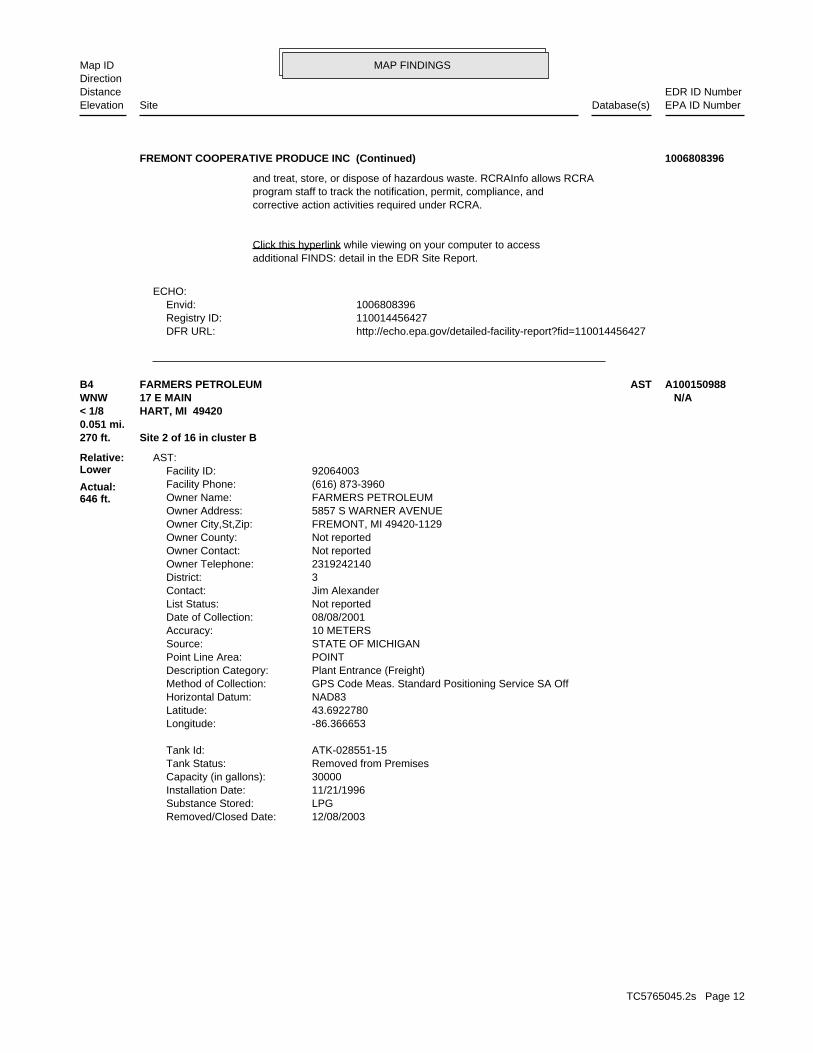
270 ft. Site 1 of 16 in cluster B0.051 mi.
Relative:Lower
Actual:646 ft.
< 1/8 ECHOHART, MI 49420WNW FINDS17 E MAIN ST MIK111735221B3 RCRA NonGen / NLRFREMONT COOPERATIVE PRODUCE INC 1006808396
TC5765045.2s Page 10

MAP FINDINGSMap IDDirection
EDR ID NumberDistanceEPA ID NumberDatabase(s)SiteElevation
events and activities related to facilities that generate, transport,Conservation and Recovery Act (RCRA) program through the tracking ofRCRAInfo is a national information system that supports the Resource Environmental Interest/Information System
110014456427Registry ID:
FINDS:
StateEvaluation lead agency: Not reportedDate achieved compliance: Not reportedArea of violation: COMPLIANCE EVALUATION INSPECTION ON-SITEEvaluation: 03/27/2003Evaluation date:
Evaluation Action Summary:
No violations foundViolation Status:
IGNITABLE WASTE. Waste name: D001. Waste code:
Hazardous Waste Summary:
Small Quantity GeneratorClassification: FREMONT COOPERATIVE PRODUCE INCSite name: 02/25/2003Date form received by agency:
Historical Generators:
NoUsed oil transporter: NoUsed oil transfer facility: NoUsed oil Specification marketer: NoUsed oil fuel marketer to burner: NoUser oil refiner: NoUsed oil processor: NoUsed oil fuel burner: NoFurnace exemption: NoOn-site burner exemption: NoUnderground injection activity: NoTreater, storer or disposer of HW: NoTransporter of hazardous waste: NoRecycler of hazardous waste: NoMixed waste (haz. and radioactive): NoU.S. importer of hazardous waste:
Handler Activities Summary:
Not reportedOwner/Op end date: 04/03/2005Owner/Op start date: OwnerOwner/Operator Type: PrivateLegal status: Not reportedOwner/operator extension: Not reportedOwner/operator fax: Not reportedOwner/operator email: Not reportedOwner/operator telephone: Not reportedOwner/operator country: Not reported Not reportedOwner/operator address:
FREMONT COOPERATIVE PRODUCE INC (Continued) 1006808396
TC5765045.2s Page 11
MAP FINDINGSMap IDDirection
EDR ID NumberDistanceEPA ID NumberDatabase(s)SiteElevation
http://echo.epa.gov/detailed-facility-report?fid=110014456427DFR URL: 110014456427Registry ID: 1006808396Envid:
ECHO:
additional FINDS: detail in the EDR Site Report.Click this hyperlink while viewing on your computer to access
corrective action activities required under RCRA.program staff to track the notification, permit, compliance, andand treat, store, or dispose of hazardous waste. RCRAInfo allows RCRA
FREMONT COOPERATIVE PRODUCE INC (Continued) 1006808396
12/08/2003Removed/Closed Date: LPGSubstance Stored: 11/21/1996Installation Date: 30000Capacity (in gallons): Removed from PremisesTank Status: ATK-028551-15Tank Id:
-86.366653Longitude: 43.6922780Latitude: NAD83Horizontal Datum: GPS Code Meas. Standard Positioning Service SA OffMethod of Collection: Plant Entrance (Freight)Description Category: POINTPoint Line Area: STATE OF MICHIGANSource: 10 METERSAccuracy: 08/08/2001Date of Collection: Not reportedList Status: Jim AlexanderContact: 3District: 2319242140Owner Telephone: Not reportedOwner Contact: Not reportedOwner County: FREMONT, MI 49420-1129Owner City,St,Zip: 5857 S WARNER AVENUEOwner Address: FARMERS PETROLEUMOwner Name: (616) 873-3960Facility Phone: 92064003Facility ID:
AST:
270 ft. Site 2 of 16 in cluster B0.051 mi.
Relative:Lower
Actual:646 ft.
< 1/8 HART, MI 49420WNW 17 E MAIN N/AB4 ASTFARMERS PETROLEUM A100150988
TC5765045.2s Page 12

MAP FINDINGSMap IDDirection
EDR ID NumberDistanceEPA ID NumberDatabase(s)SiteElevation
01/11/2012Removed/Closed Date: LPGSubstance Stored: Not reportedInstallation Date: 500Capacity (in gallons): Removed from PremisesTank Status: ATK-123226-15Tank Id:
04/19/2017Removed/Closed Date: LPGSubstance Stored: 01/11/2012Installation Date: 500Capacity (in gallons): Removed from GroundTank Status: ATK-138158-15Tank Id:
-86.365693Longitude: 43.7027380Latitude: NAD83Horizontal Datum: GPS Code Meas. Standard Positioning Service SA OffMethod of Collection: Plant Entrance (Freight)Description Category: POINTPoint Line Area: STATE OF MICHIGANSource: 40 FEETAccuracy: 08/21/2007Date of Collection: Not reportedList Status: Jerry DennisContact: 3District: Not reportedOwner Telephone: Not reportedOwner Contact: Not reportedOwner County: MUSKEGON, MI 49420Owner City,St,Zip: 1535 S WALKER RDOwner Address: NORTH CENTRAL CO-OP INCOwner Name: (616) 837-7366Facility Phone: 92085089Facility ID:
AST:
295 ft. Site 3 of 16 in cluster B0.056 mi.
Relative:Lower
Actual:646 ft.
< 1/8 HART, MI 49420WNW 3 E MAIN N/AB5 ASTNORTH CENTRAL CO-OP INC A100319858
6168732158Owner Phone: Not reportedOwner Contact: 49420-1129Owner Zip: MIOwner State: HARTOwner City: 3 E MAIN STOwner Address: COUNTRYMARK, INCOwner Name: 3Facility Region: 00017953Facility ID: CLOSEDFacility Type:
UST:
295 ft. Site 4 of 16 in cluster B0.056 mi.
Relative:Lower
Actual:646 ft.
< 1/8 HART, MI 49420WNW 3 E MAIN ST N/AB6 USTCOUNTRYMARK, INC U003867597
TC5765045.2s Page 13

MAP FINDINGSMap IDDirection
EDR ID NumberDistanceEPA ID NumberDatabase(s)SiteElevation
Not reportedTank Details Compartments: UTK-039685-15Tank Number: 10/01/1990Remove Date: 05/03/1971Install Date: DieselSubstance: Removed from GroundTank Status: 550Capacity: 1Tank ID: Region 3 - Grand Rapids District OfficeDistrict: Address Matching-House NumberMethod of Collection: Plant Entrance (Freight)Desc Category: POINTPoint Line Area: STATE OF MICHIGANSource: FEETAccuracy Value Unit: NAD83Horizontal Datum: 100Accuracy: 01/11/2001Date of Collection: (616) 873-2158Contact Phone: DONALD WALSWORTHContact: 6168732158Owner Phone: Not reportedOwner Contact: 49420-1129Owner Zip: MIOwner State: HARTOwner City: 3 E MAIN STOwner Address: COUNTRYMARK, INCOwner Name: 3Facility Region: 00017953Facility ID: CLOSEDFacility Type:
-86.36345Longitude: 43.70262Latitude: Not reportedImpressed Device: Asphalt Coated or Bare SteelTank Construction: Not reportedPiping Type: Galvanized SteelPiping Material: Not reportedPipe Release Detection: Not reportedTank Release Detection: Not reportedTank Details Compartments: UTK-101268-15Tank Number: 10/01/1990Remove Date: 05/03/1971Install Date: GasolineSubstance: Removed from GroundTank Status: 550Capacity: 2Tank ID: Region 3 - Grand Rapids District OfficeDistrict: Address Matching-House NumberMethod of Collection: Plant Entrance (Freight)Desc Category: POINTPoint Line Area: STATE OF MICHIGANSource: FEETAccuracy Value Unit: NAD83Horizontal Datum: 100Accuracy: 01/11/2001Date of Collection: (616) 873-2158Contact Phone: DONALD WALSWORTHContact:
COUNTRYMARK, INC (Continued) U003867597
TC5765045.2s Page 14

MAP FINDINGSMap IDDirection
EDR ID NumberDistanceEPA ID NumberDatabase(s)SiteElevation
-86.36345Longitude: 43.70262Latitude: Not reportedImpressed Device: Asphalt Coated or Bare SteelTank Construction: Not reportedPiping Type: Galvanized SteelPiping Material: Not reportedPipe Release Detection: Not reportedTank Release Detection:
COUNTRYMARK, INC (Continued) U003867597
Storage Tank DivisionDivision Assigned: mecherbReviewer: AffirmedDetermination 20107A: No Hazardous Substance(s)Category: 1Petition Disclosure: AffirmedPetition Determination: Lake Pointe LDHALPSubmitter Name: 04/23/2008Date Received: Grand RapidsDistrict: 2275BEA Number: Not reportedSecondary Address:
BEA:
370 ft. Site 5 of 16 in cluster B0.070 mi.
Relative:Lower
Actual:635 ft.
< 1/8 HART, MI 49420NW 24 AND 26 NORTH STATE STREET N/AB7 BEA24 AND 26 NORTH STATE STREET S109094160
Nicholas EkelIndividual Or Staff Assoc With The Mapping: 05/11/2015Date Data Entry Finished: 05/11/2015Date Data Entry Started: 0.0009Mapped Polygons Area In Square Miles: 0.59960000000000002Mapped Polygons Area In Acres: U:\\KERMIT\\11121314180.PDFFile Name Of Hyperlinked Legal Doc: RDLead Division: Not reportedProperty Or Description Restricted Area: RC-RRD-213-14-180MDEQ Reference Number: 11121314180Based On The Deq Ref #: Not reportedLegal Description Of Property: 02/11/2015Program Support Assigned Date: Nicholas EkelProgram Support Assigned User: Part 213Program Type: RCLand Use Restriction Type: on-siteProperty: Not reportedSite Name: RecordedStatus: HART, MI 49420City,State,Zip: 26 NORTH STATE STREETAddress: MERSKIN & MERSKIN PCName:
AUL:
370 ft. Site 6 of 16 in cluster B0.070 mi.
Relative:Lower
Actual:635 ft.
< 1/8 HART, MI 49420NW 26 NORTH STATE STREET N/AB8 AULMERSKIN & MERSKIN PC S117369634
TC5765045.2s Page 15

MAP FINDINGSMap IDDirection
EDR ID NumberDistanceEPA ID NumberDatabase(s)SiteElevation
mapped in KERMIT - Nick Ekel 20150211 - LRUR is NOT mapped in KERMIT - Nick Ekel 20150511 - LRUR isMap Comments: August 29, 2014 consultant requested DEQ reference #.Comment: 0There Is A Permanent Marker On The Site: 0There Is A Health And Safety Plan: 0There Is An Exposure Barrier In Place: 0Monitoring Well Protected, No Tampering Or Removal: 0There Is A Restriction On All Construction: 0Soil Movement Requirements: 0Excavation And Soil Movement Restrictions: 1Special Building Restrictions: 0Special Well Construction Requirements: 0Groundwater Contact Restrictions: 1Groundwater Consumption Restrictions: 1Site Specific Restrictions: 0Multiple Land-Use Restrictions: 0Recreational Land Use Restriction: 0Residential Land Use Restriction: 0Industrial Land Use Restriction: 0Commercial Iv Land Use Restriction: 0Commercial Iii Land Use Restriction: 0Commercial Ii Land Use Restriction: 0Commercial I Land Use Restriction: 01/14/2015Date Legal Paperwork Stamped/Filed/Register Of Deeds: ArcGIS 10.2Program Used To Map Restricted Features:
MERSKIN & MERSKIN PC (Continued) S117369634
-86.36363Longitude:43.70312Latitude:BEAData Source:Grand RapidsDistrict:HartTownship:201303551GRBea Number:
Not reportedLongitude:Not reportedLatitude:BEAData Source:Grand RapidsDistrict:HartTownship:200301233GRBea Number:
INVENTORY:
370 ft. Site 7 of 16 in cluster B0.070 mi.
Relative:Lower
Actual:635 ft.
< 1/8 OCEANA (County), MI 49420NW 26 NORTH STATE STREET N/AB9 INVENTORY26 NORTH STATE STREET S114029409
TC5765045.2s Page 16

MAP FINDINGSMap IDDirection
EDR ID NumberDistanceEPA ID NumberDatabase(s)SiteElevation
Not reportedLongitude:Not reportedLatitude:BEAData Source:Grand RapidsDistrict:HartTownship:200802275GRBea Number:
INVENTORY:
370 ft. Site 8 of 16 in cluster B0.070 mi.
Relative:Lower
Actual:635 ft.
< 1/8 OCEANA (County), MI 49420NW 24 AND 26 NORTH STATE STREET N/AB10 INVENTORY24 AND 26 NORTH STATE STREET S114024104
(616) 845-6251Contact Phone: DAVID L HATCHContact: 6168732111Owner Phone: Not reportedOwner Contact: 49420-1121Owner Zip: MIOwner State: HARTOwner City: 26 N STATE STOwner Address: MERSKIN & MERSKIN PCOwner Name: 3Facility Region: 00001715Facility ID: CLOSEDFacility Type:
UST:
01/22/2015Release Closed Date: ClosedRelease Status: Diesel,GasolineSubstance Released: 11/06/1992Release Date: C-1985-92Leak Number:
Plant Entrance (Freight)Desc Category: POINTPoint Line Area: NAD83Horizontal Data: FEETAccuracy Value Unit: 100Accuracy: Address Matching-House NumberMethod of Collection: 01/11/2001Date of Collection: -86.36344Longitude: 43.70292Latitude: Merskin And MerskinSite Name: Grand RapidsDistrict: USACountry: (616) 873-2111Owner Phone: Not reportedOwner Contact: Hart, MI 49420-1121Owner City,St,Zip: 26 N State StOwner Address: Merskin & Merskin PcOwner Name: STATE OF MICHIGANSource: 00001715Facility ID:
LUST:
370 ft. Site 9 of 16 in cluster B0.070 mi. WDS
Relative:Lower
Actual:635 ft.
< 1/8 INVENTORYHART, MI 49420NW UST26 N STATE ST N/AB11 LUSTMERSKIN & MERSKIN PC U002302857
TC5765045.2s Page 17

MAP FINDINGSMap IDDirection
EDR ID NumberDistanceEPA ID NumberDatabase(s)SiteElevation
Not reportedPipe Release Detection: Not reportedTank Release Detection: Not reportedTank Details Compartments: UTK-077977-15Tank Number: 05/20/1994Remove Date: 04/02/1966Install Date: DieselSubstance: Closed in GroundTank Status: 1000Capacity: 1Tank ID: Region 3 - Grand Rapids District OfficeDistrict: Address Matching-House NumberMethod of Collection: Plant Entrance (Freight)Desc Category: POINTPoint Line Area: STATE OF MICHIGANSource: FEETAccuracy Value Unit: NAD83Horizontal Datum: 100Accuracy: 01/11/2001Date of Collection: (616) 845-6251Contact Phone: DAVID L HATCHContact: 6168732111Owner Phone: Not reportedOwner Contact: 49420-1121Owner Zip: MIOwner State: HARTOwner City: 26 N STATE STOwner Address: MERSKIN & MERSKIN PCOwner Name: 3Facility Region: 00001715Facility ID: CLOSEDFacility Type:
-86.36344Longitude: 43.70292Latitude: Not reportedImpressed Device: Asphalt Coated or Bare SteelTank Construction: Not reportedPiping Type: Galvanized SteelPiping Material: Not reportedPipe Release Detection: Not reportedTank Release Detection: Not reportedTank Details Compartments: UTK-077980-15Tank Number: 05/20/1994Remove Date: 04/03/1971Install Date: GasolineSubstance: Closed in GroundTank Status: 1200Capacity: 2Tank ID: Region 3 - Grand Rapids District OfficeDistrict: Address Matching-House NumberMethod of Collection: Plant Entrance (Freight)Desc Category: POINTPoint Line Area: STATE OF MICHIGANSource: FEETAccuracy Value Unit: NAD83Horizontal Datum: 100Accuracy: 01/11/2001Date of Collection:
MERSKIN & MERSKIN PC (Continued) U002302857
TC5765045.2s Page 18

MAP FINDINGSMap IDDirection
EDR ID NumberDistanceEPA ID NumberDatabase(s)SiteElevation
OCEANAMailing County: 49420Mailing City/State/Zip: 26 N STATE STMailing Address: MERSKIN & MERSKIN PCSite Specific Name: 416820WMD Id: MIG000038992Site Id:
WDS:
-86.36344Longitude:43.70293Latitude:Part 213Data Source:Grand RapidsDistrict:Not reportedTownship:Not reportedBea Number:
INVENTORY:
-86.36344Longitude: 43.70292Latitude: Not reportedImpressed Device: Asphalt Coated or Bare SteelTank Construction: Not reportedPiping Type: Galvanized SteelPiping Material:
MERSKIN & MERSKIN PC (Continued) U002302857
Storage Tank DivisionDivision Assigned: mecherbReviewer: No RequestDetermination 20107A: No Hazardous Substance(s)Category: 0Petition Disclosure: No RequestPetition Determination: Gayle FornerSubmitter Name: 06/27/2003Date Received: Grand RapidsDistrict: 1233BEA Number: Not reportedSecondary Address:
BEA:
370 ft. Site 10 of 16 in cluster B0.070 mi.
Relative:Lower
Actual:635 ft.
< 1/8 HART, MI 49420NW 26 NORTH STATE STREET N/AB12 BEA26 NORTH STATE STREET S105966576
HARTOwner City: PO BOX 14Owner Address: COUNTY OF OCEANAOwner Name: 3Facility Region: 00008330Facility ID: CLOSEDFacility Type:
UST:
373 ft.0.071 mi.
Relative:Higher
Actual:657 ft.
< 1/8 HART, MI 49420WSW 100 S STATE ST N/A13 USTCOUNTY OF OCEANA U003866790
TC5765045.2s Page 19

MAP FINDINGSMap IDDirection
EDR ID NumberDistanceEPA ID NumberDatabase(s)SiteElevation
GasolineSubstance: Removed from GroundTank Status: 2000Capacity: 1Tank ID: Region 3 - Grand Rapids District OfficeDistrict: Interpolation-MapMethod of Collection: Not reportedDesc Category: POINTPoint Line Area: STATE OF MICHIGANSource: METERSAccuracy Value Unit: NAD83Horizontal Datum: 15Accuracy: 11/04/2006Date of Collection: (616) 873-4835Contact Phone: Paul E InglisContact: 6168734835Owner Phone: Not reportedOwner Contact: 49420-0014Owner Zip: MIOwner State: HARTOwner City: PO BOX 14Owner Address: COUNTY OF OCEANAOwner Name: 3Facility Region: 00008330Facility ID: CLOSEDFacility Type:
-86.36346Longitude: 43.70184Latitude: Not reportedImpressed Device: Asphalt Coated or Bare SteelTank Construction: Not reportedPiping Type: Galvanized SteelPiping Material: Not reportedPipe Release Detection: Not reportedTank Release Detection: Not reportedTank Details Compartments: UTK-043294-15Tank Number: 04/13/1992Remove Date: 04/01/1967Install Date: DieselSubstance: Removed from GroundTank Status: 1500Capacity: 2Tank ID: Region 3 - Grand Rapids District OfficeDistrict: Interpolation-MapMethod of Collection: Not reportedDesc Category: POINTPoint Line Area: STATE OF MICHIGANSource: METERSAccuracy Value Unit: NAD83Horizontal Datum: 15Accuracy: 11/04/2006Date of Collection: (616) 873-4835Contact Phone: Paul E InglisContact: 6168734835Owner Phone: Not reportedOwner Contact: 49420-0014Owner Zip: MIOwner State:
COUNTY OF OCEANA (Continued) U003866790
TC5765045.2s Page 20

MAP FINDINGSMap IDDirection
EDR ID NumberDistanceEPA ID NumberDatabase(s)SiteElevation
-86.36346Longitude: 43.70184Latitude: Not reportedImpressed Device: Asphalt Coated or Bare SteelTank Construction: Not reportedPiping Type: Galvanized SteelPiping Material: Not reportedPipe Release Detection: Not reportedTank Release Detection: Not reportedTank Details Compartments: UTK-100769-15Tank Number: 04/13/1992Remove Date: 04/01/1967Install Date:
COUNTY OF OCEANA (Continued) U003866790
Gasoline Service Stations1994 BLARNEY CASTLE OIL CO Type:Year: Name:
EDR Hist Auto
379 ft. Site 11 of 16 in cluster B0.072 mi.
Relative:Lower
Actual:640 ft.
< 1/8 HART, MI 49420WNW 3 S STATE ST N/AB14 EDR Hist AutoBLARNEY CASTLE OIL CO 1021144449
Gasoline Service Stations1983 DOWNTOWN MOBIL Gasoline Service Stations1982 DOWNTOWN MOBIL Gasoline Service Stations1980 DOWNTOWN MOBIL Gasoline Service Stations1979 DOWNTOWN MOBIL Gasoline Service Stations1978 DOWNTOWN MOBIL Gasoline Service Stations1977 DOWNTOWN MOBIL Gasoline Service Stations1976 DOWNTOWN MOBIL Gasoline Service Stations1975 DOWNTOWN MOBIL Gasoline Service Stations1974 DOWNTOWN MOBIL Gasoline Service Stations1973 DOWNTOWN MOBIL Type:Year: Name:
EDR Hist Auto
400 ft. Site 12 of 16 in cluster B0.076 mi.
Relative:Lower
Actual:638 ft.
< 1/8 HART, MI 49420WNW 3 N STATE ST N/AB15 EDR Hist AutoDOWNTOWN MOBIL 1021664184
PO Box 246Owner Address: Blarney Castle Oil CoOwner Name: STATE OF MICHIGANSource: 00003366Facility ID:
LUST:
400 ft. Site 13 of 16 in cluster B0.076 mi. Financial Assurance
Relative:Lower
Actual:638 ft.
< 1/8 INVENTORYHART, MI 49420WNW UST3 N STATE ST N/AB16 LUSTHART EZ MART U003327746
TC5765045.2s Page 21

MAP FINDINGSMap IDDirection
EDR ID NumberDistanceEPA ID NumberDatabase(s)SiteElevation
Not reportedImpressed Device: Fiberglass Reinforced Plastic,UnknownTank Construction: Not reportedPiping Type: Galvanized SteelPiping Material: Automatic Line Leak DetectorsPipe Release Detection: Automatic Tank Gauging,Manual (Static) Tank GaugingTank Release Detection: Not reportedTank Details Compartments: UTK-051159-15Tank Number: 04/28/1997Remove Date: 04/24/1966Install Date: GasolineSubstance: Removed from GroundTank Status: 5000Capacity: 3Tank ID: Region 3 - Grand Rapids District OfficeDistrict: Interpolation-MapMethod of Collection: Plant Entrance (Freight)Desc Category: POINTPoint Line Area: STATE OF MICHIGANSource: FEETAccuracy Value Unit: NAD83Horizontal Datum: 40Accuracy: 10/23/2007Date of Collection: (616) 864-3111Contact Phone: David MeadContact: 2318643111Owner Phone: Not reportedOwner Contact: 49614Owner Zip: MIOwner State: BEAR LAKEOwner City: PO BOX 246Owner Address: BLARNEY CASTLE OIL COOwner Name: 3Facility Region: 00003366Facility ID: CLOSEDFacility Type:
UST:
07/18/2011Release Closed Date: ClosedRelease Status: Not reportedSubstance Released: 01/01/1987Release Date: C-1317-85Leak Number:
Plant Entrance (Freight)Desc Category: POINTPoint Line Area: NAD83Horizontal Data: FEETAccuracy Value Unit: 40Accuracy: Interpolation-MapMethod of Collection: 10/23/2007Date of Collection: -86.36397Longitude: 43.70273Latitude: Hart EZ Mart - Superior Oil CompanySite Name: Grand RapidsDistrict: USACountry: (231) 864-3111Owner Phone: Not reportedOwner Contact: Bear Lake, MI 49614Owner City,St,Zip:
HART EZ MART (Continued) U003327746
TC5765045.2s Page 22

MAP FINDINGSMap IDDirection
EDR ID NumberDistanceEPA ID NumberDatabase(s)SiteElevation
FEETAccuracy Value Unit: NAD83Horizontal Datum: 40Accuracy: 10/23/2007Date of Collection: (616) 864-3111Contact Phone: David MeadContact: 2318643111Owner Phone: Not reportedOwner Contact: 49614Owner Zip: MIOwner State: BEAR LAKEOwner City: PO BOX 246Owner Address: BLARNEY CASTLE OIL COOwner Name: 3Facility Region: 00003366Facility ID: CLOSEDFacility Type:
-86.36397Longitude: 43.70273Latitude: Not reportedImpressed Device: Asphalt Coated or Bare Steel,Lined InteriorTank Construction: Not reportedPiping Type: Fiberglass Reinforced PlasticPiping Material: Automatic Line Leak DetectorsPipe Release Detection: Automatic Tank Gauging,Manual (Static) Tank GaugingTank Release Detection: Not reportedTank Details Compartments: UTK-051156-15Tank Number: 04/28/1997Remove Date: 04/24/1966Install Date: GasolineSubstance: Removed from GroundTank Status: 5000Capacity: 2Tank ID: Region 3 - Grand Rapids District OfficeDistrict: Interpolation-MapMethod of Collection: Plant Entrance (Freight)Desc Category: POINTPoint Line Area: STATE OF MICHIGANSource: FEETAccuracy Value Unit: NAD83Horizontal Datum: 40Accuracy: 10/23/2007Date of Collection: (616) 864-3111Contact Phone: David MeadContact: 2318643111Owner Phone: Not reportedOwner Contact: 49614Owner Zip: MIOwner State: BEAR LAKEOwner City: PO BOX 246Owner Address: BLARNEY CASTLE OIL COOwner Name: 3Facility Region: 00003366Facility ID: CLOSEDFacility Type:
-86.36397Longitude: 43.70273Latitude:
HART EZ MART (Continued) U003327746
TC5765045.2s Page 23

MAP FINDINGSMap IDDirection
EDR ID NumberDistanceEPA ID NumberDatabase(s)SiteElevation
Not reportedLongitude:Not reportedLatitude:BEAData Source:Grand RapidsDistrict:HartTownship:200401479GRBea Number:
-86.36398Longitude:43.70273Latitude:Part 213Data Source:Grand RapidsDistrict:Not reportedTownship:Not reportedBea Number:
INVENTORY:
-86.36397Longitude: 43.70273Latitude: Not reportedImpressed Device: Asphalt Coated or Bare Steel,Lined InteriorTank Construction: Not reportedPiping Type: Fiberglass Reinforced PlasticPiping Material: Automatic Line Leak DetectorsPipe Release Detection: Automatic Tank Gauging,Manual (Static) Tank GaugingTank Release Detection: Not reportedTank Details Compartments: UTK-041917-15Tank Number: 04/28/1997Remove Date: 04/24/1966Install Date: GasolineSubstance: Removed from GroundTank Status: 8000Capacity: 1Tank ID: Region 3 - Grand Rapids District OfficeDistrict: Interpolation-MapMethod of Collection: Plant Entrance (Freight)Desc Category: POINTPoint Line Area: STATE OF MICHIGANSource:
HART EZ MART (Continued) U003327746
City of HartSubmitter Name: 01/19/2011Date Received: Grand RapidsDistrict: 2879BEA Number: Not reportedSecondary Address:
BEA:
Not reportedLongitude:Not reportedLatitude:BEAData Source:Grand RapidsDistrict:HartTownship:201102879GRBea Number:
INVENTORY:
400 ft. Site 14 of 16 in cluster B0.076 mi.
Relative:Lower
Actual:638 ft.
< 1/8 WDSHART, MI 49420WNW BEA3 N STATE ST N/AB17 INVENTORYHART TAX INCREMENT FINANCE AUTHORITY S110748221
TC5765045.2s Page 24

MAP FINDINGSMap IDDirection
EDR ID NumberDistanceEPA ID NumberDatabase(s)SiteElevation
OCEANAMailing County: 49420Mailing City/State/Zip: 407 N STATE STMailing Address: FORMER EZ MARTSite Specific Name: 487944WMD Id: MIK147629455Site Id:
WDS:
Storage Tank DivisionDivision Assigned: mecherbReviewer: No RequestDetermination 20107A: Not reportedCategory: 0Petition Disclosure: No RequestPetition Determination:
HART TAX INCREMENT FINANCE AUTHORITY (Continued) S110748221
Not reportedOwner/operator country: Not reported Not reportedOwner/operator address: HART TAX INCREMENT FINANCE AUTHORITYOwner/operator name:
Not reportedOwner/Op end date: 02/01/2001Owner/Op start date: OwnerOwner/Operator Type: MunicipalLegal status: Not reportedOwner/operator extension: Not reportedOwner/operator fax: Not reportedOwner/operator email: Not reportedOwner/operator telephone: Not reportedOwner/operator country: Not reported Not reportedOwner/operator address: HART TAX INCREMENT FINANCE AUTHORITYOwner/operator name:
Owner/Operator Summary:
Handler: Non-Generators do not presently generate hazardous wasteDescription: Non-GeneratorClassification: 05EPA Region: Not reportedContact email: 231-873-2488Contact telephone: USContact country: HART, MI 49420 3 N STATE STContact address: STANLEY RICKARDContact: HART, MI 49420 407 N STATE STMailing address: MIK147629455EPA ID: HART, MI 49420 3 N STATE STFacility address: HART TAX INCREMENT FINANCE AUTHORITYFacility name: 06/01/2010Date form received by agency:
RCRA NonGen / NLR:
400 ft. Site 15 of 16 in cluster B0.076 mi.
Relative:Lower
Actual:638 ft.
< 1/8 HART, MI 49420WNW 3 N STATE ST MIK147629455B18 RCRA NonGen / NLRHART TAX INCREMENT FINANCE AUTHORITY 1014391450
TC5765045.2s Page 25

MAP FINDINGSMap IDDirection
EDR ID NumberDistanceEPA ID NumberDatabase(s)SiteElevation
No violations foundViolation Status:
IGNITABLE WASTE. Waste name: D001. Waste code:
Hazardous Waste Summary:
NoUsed oil transporter: NoUsed oil transfer facility: NoUsed oil Specification marketer: NoUsed oil fuel marketer to burner: NoUser oil refiner: NoUsed oil processor: NoUsed oil fuel burner: NoFurnace exemption: NoOn-site burner exemption: NoUnderground injection activity: NoTreater, storer or disposer of HW: NoTransporter of hazardous waste: NoRecycler of hazardous waste: NoMixed waste (haz. and radioactive): NoU.S. importer of hazardous waste:
Handler Activities Summary:
Not reportedOwner/Op end date: 02/01/2001Owner/Op start date: OperatorOwner/Operator Type: MunicipalLegal status: Not reportedOwner/operator extension: Not reportedOwner/operator fax: Not reportedOwner/operator email: Not reportedOwner/operator telephone:
HART TAX INCREMENT FINANCE AUTHORITY (Continued) 1014391450
Not reportedPoint Line Area: Not reportedSource: Not reportedAccuracy Value Unit: Not reportedHorizontal Datum: Not reportedAccuracy: Not reportedDate of Collection: Not reportedContact Phone: Not reportedContact: 2318732488Owner Phone: Not reportedOwner Contact: 49420Owner Zip: MIOwner State: HARTOwner City: 407 S STATE STOwner Address: CITY OF HARTOwner Name: 3Facility Region: 00042522Facility ID: CLOSEDFacility Type:
UST:
409 ft. Site 16 of 16 in cluster B0.077 mi.
Relative:Lower
Actual:637 ft.
< 1/8 HART, MI 49420NW 45 N STATE ST N/AB19 USTSTATE STREET ROW U004225639
TC5765045.2s Page 26

MAP FINDINGSMap IDDirection
EDR ID NumberDistanceEPA ID NumberDatabase(s)SiteElevation
Not reportedLongitude: Not reportedLatitude: Not reportedImpressed Device: Other,UnknownTank Construction: Not reportedPiping Type: UnknownPiping Material: OtherPipe Release Detection: Not reportedTank Release Detection: Not reportedTank Details Compartments: UTK-139576-15Tank Number: 07/01/2014Remove Date: Not reportedInstall Date: Not reportedSubstance: Removed from GroundTank Status: 160Capacity: 1Tank ID: Region 3 - Grand Rapids District OfficeDistrict: Not reportedMethod of Collection: Not reportedDesc Category:
STATE STREET ROW (Continued) U004225639
Environmental Response DivisionDivision Assigned: obrient1Reviewer: No RequestDetermination 20107A: No Hazardous Substance(s)Category: 0Petition Disclosure: No RequestPetition Determination: City of HartSubmitter Name: 01/15/2003Date Received: Grand RapidsDistrict: 1128BEA Number: Not reportedSecondary Address:
BEA:
515 ft. Site 1 of 2 in cluster C0.098 mi.
Relative:Higher
Actual:662 ft.
< 1/8 HART, MI 49420ESE 100 SOUTH UNION STREET N/AC20 BEA100 SOUTH UNION STREET S105768623
Grand RapidsDistrict:HartTownship:Not reportedBea Number:
Not reportedLongitude:Not reportedLatitude:BEAData Source:Grand RapidsDistrict:HartTownship:200301128GRBea Number:
INVENTORY:
515 ft. Site 2 of 2 in cluster C0.098 mi.
Relative:Higher
Actual:662 ft.
< 1/8 HART, MI 49420ESE 100 SOUTH UNION STREET N/AC21 INVENTORY100 SOUTH UNION STREET S114021790
TC5765045.2s Page 27
MAP FINDINGSMap IDDirection
EDR ID NumberDistanceEPA ID NumberDatabase(s)SiteElevation
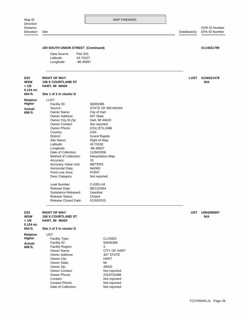
-86.35897Longitude:43.70107Latitude:Part 201Data Source:
100 SOUTH UNION STREET (Continued) S114021790
01/30/2015Release Closed Date: ClosedRelease Status: GasolineSubstance Released: 08/12/2004Release Date: C-0351-04Leak Number:
Not reportedDesc Category: POINTPoint Line Area: NAD83Horizontal Data: METERSAccuracy Value Unit: 15Accuracy: Interpolation-MapMethod of Collection: 11/04/2006Date of Collection: -86.36607Longitude: 43.70192Latitude: Right of WaySite Name: Grand RapidsDistrict: USACountry: (231) 873-2488Owner Phone: Not reportedOwner Contact: Hart, MI 49420Owner City,St,Zip: 407 StateOwner Address: City of HartOwner Name: STATE OF MICHIGANSource: 50005385Facility ID:
LUST:
654 ft. Site 1 of 2 in cluster D0.124 mi.
Relative:Higher
Actual:658 ft.
< 1/8 HART, MI 49420WSW 108 S COURTLAND ST N/AD22 LUSTRIGHT OF WAY S106521478
Not reportedDate of Collection: Not reportedContact Phone: Not reportedContact: 2318732488Owner Phone: Not reportedOwner Contact: 49420Owner Zip: MIOwner State: HARTOwner City: 407 STATEOwner Address: CITY OF HARTOwner Name: 3Facility Region: 50005385Facility ID: CLOSEDFacility Type:
UST:
654 ft. Site 2 of 2 in cluster D0.124 mi.
Relative:Higher
Actual:658 ft.
< 1/8 HART, MI 49420WSW 108 S COURTLAND ST N/AD23 USTRIGHT OF WAY U004295607
TC5765045.2s Page 28

MAP FINDINGSMap IDDirection
EDR ID NumberDistanceEPA ID NumberDatabase(s)SiteElevation
Not reportedLongitude: Not reportedLatitude: Not reportedImpressed Device: Asphalt Coated or Bare SteelTank Construction: Not reportedPiping Type: Galvanized SteelPiping Material: Not reportedPipe Release Detection: Not reportedTank Release Detection: Not reportedTank Details Compartments: UTK-120071-15Tank Number: 08/06/2004Remove Date: Not reportedInstall Date: Not reportedSubstance: Removed from GroundTank Status: 500Capacity: 1Tank ID: Not reportedDistrict: Not reportedMethod of Collection: Not reportedDesc Category: Not reportedPoint Line Area: Not reportedSource: Not reportedAccuracy Value Unit: Not reportedHorizontal Datum: Not reportedAccuracy:
RIGHT OF WAY (Continued) U004295607
Not reportedRelease Closed Date: OpenRelease Status: UnknownSubstance Released: 12/21/1999Release Date: C-0004-00Leak Number:
Plant Entrance (Freight)Desc Category: POINTPoint Line Area: NAD83Horizontal Data: METERSAccuracy Value Unit: 10Accuracy: GPS Code Meas. Standard Positioning Service SA OffMethod of Collection: 04/17/2001Date of Collection: -86.36390Longitude: 43.70035Latitude: Hart EZ Mart #213Site Name: Grand RapidsDistrict: USACountry: (231) 864-3111Owner Phone: Not reportedOwner Contact: Bear Lake, MI 49614Owner City,St,Zip: PO Box 246Owner Address: Blarney Castle Oil CoOwner Name: STATE OF MICHIGANSource: 00008478Facility ID:
LUST:
807 ft. Site 1 of 2 in cluster E0.153 mi.
Relative:Higher
Actual:675 ft.
1/8-1/4 INVENTORYHART, MI 49420SSW UST223 S STATE ST N/AE24 LUSTHART EZ MART U003328167
TC5765045.2s Page 29

MAP FINDINGSMap IDDirection
EDR ID NumberDistanceEPA ID NumberDatabase(s)SiteElevation
(231) 864-3111Contact Phone: Veronica CollierContact: 2318643111Owner Phone: Not reportedOwner Contact: 49614Owner Zip: MIOwner State: BEAR LAKEOwner City: PO BOX 246Owner Address: BLARNEY CASTLE OIL COOwner Name: 3Facility Region: 00008478Facility ID: ACTIVEFacility Type:
-86.36390Longitude: 43.70035Latitude: Not reportedImpressed Device: Cathodically Protected SteelTank Construction: Pressure (Remote)Piping Type: Fiberglass Reinforced Plastic,UnknownPiping Material: Containment Automatic Line Leak Detectors,Interstitial Monitoring SecondPipe Release Detection: Inventory Control,Manual (Static) Tank GaugingTank Release Detection: Not reportedTank Details Compartments: UTK-085951-15Tank Number: 08/03/1999Remove Date: 10/25/1991Install Date: Used OilSubstance: Removed from GroundTank Status: 550Capacity: 9Tank ID: Region 3 - Grand Rapids District OfficeDistrict: GPS Code Meas. Standard Positioning Service SA OffMethod of Collection: Plant Entrance (Freight)Desc Category: POINTPoint Line Area: STATE OF MICHIGANSource: METERSAccuracy Value Unit: NAD83Horizontal Datum: 10Accuracy: 04/17/2001Date of Collection: (231) 864-3111Contact Phone: Veronica CollierContact: 2318643111Owner Phone: Not reportedOwner Contact: 49614Owner Zip: MIOwner State: BEAR LAKEOwner City: PO BOX 246Owner Address: BLARNEY CASTLE OIL COOwner Name: 3Facility Region: 00008478Facility ID: ACTIVEFacility Type:
UST:
Not reportedRelease Closed Date: OpenRelease Status: UnknownSubstance Released: 10/21/1991Release Date: C-2182-91Leak Number:
HART EZ MART (Continued) U003328167
TC5765045.2s Page 30

MAP FINDINGSMap IDDirection
EDR ID NumberDistanceEPA ID NumberDatabase(s)SiteElevation
Inventory Control,Manual (Static) Tank Gauging,Other CommentTank Release Detection: Not reportedTank Details Compartments: UTK-007988-15Tank Number: Not reportedRemove Date: 10/25/1991Install Date: GasolineSubstance: Currently In UseTank Status: 12000Capacity: 7Tank ID: Region 3 - Grand Rapids District OfficeDistrict: GPS Code Meas. Standard Positioning Service SA OffMethod of Collection: Plant Entrance (Freight)Desc Category: POINTPoint Line Area: STATE OF MICHIGANSource: METERSAccuracy Value Unit: NAD83Horizontal Datum: 10Accuracy: 04/17/2001Date of Collection: (231) 864-3111Contact Phone: Veronica CollierContact: 2318643111Owner Phone: Not reportedOwner Contact: 49614Owner Zip: MIOwner State: BEAR LAKEOwner City: PO BOX 246Owner Address: BLARNEY CASTLE OIL COOwner Name: 3Facility Region: 00008478Facility ID: ACTIVEFacility Type:
-86.36390Longitude: 43.70035Latitude: Not reportedImpressed Device: Cathodically Protected Steel,OtherTank Construction: Pressure (Remote)Piping Type: Fiberglass Reinforced PlasticPiping Material: Containment,Line Tightness Testing,Other,Other Comment Automatic Line Leak Detectors,Interstitial Monitoring SecondPipe Release Detection: Inventory Control,Manual (Static) Tank Gauging,Other CommentTank Release Detection: Not reportedTank Details Compartments: UTK-085947-15Tank Number: Not reportedRemove Date: 10/25/1991Install Date: GasolineSubstance: Currently In UseTank Status: 12000Capacity: 8Tank ID: Region 3 - Grand Rapids District OfficeDistrict: GPS Code Meas. Standard Positioning Service SA OffMethod of Collection: Plant Entrance (Freight)Desc Category: POINTPoint Line Area: STATE OF MICHIGANSource: METERSAccuracy Value Unit: NAD83Horizontal Datum: 10Accuracy: 04/17/2001Date of Collection:
HART EZ MART (Continued) U003328167
TC5765045.2s Page 31

MAP FINDINGSMap IDDirection
EDR ID NumberDistanceEPA ID NumberDatabase(s)SiteElevation
Not reportedOwner Contact: 49614Owner Zip: MIOwner State: BEAR LAKEOwner City: PO BOX 246Owner Address: BLARNEY CASTLE OIL COOwner Name: 3Facility Region: 00008478Facility ID: ACTIVEFacility Type:
-86.36390Longitude: 43.70035Latitude: Not reportedImpressed Device: Cathodically Protected Steel,OtherTank Construction: Pressure (Remote)Piping Type: Fiberglass Reinforced PlasticPiping Material: Containment,Line Tightness Testing,Other,Other Comment Automatic Line Leak Detectors,Interstitial Monitoring SecondPipe Release Detection: Inventory Control,Manual (Static) Tank Gauging,Other CommentTank Release Detection: Not reportedTank Details Compartments: UTK-085940-15Tank Number: Not reportedRemove Date: 10/25/1991Install Date: GasolineSubstance: Currently In UseTank Status: 8000Capacity: 6Tank ID: Region 3 - Grand Rapids District OfficeDistrict: GPS Code Meas. Standard Positioning Service SA OffMethod of Collection: Plant Entrance (Freight)Desc Category: POINTPoint Line Area: STATE OF MICHIGANSource: METERSAccuracy Value Unit: NAD83Horizontal Datum: 10Accuracy: 04/17/2001Date of Collection: (231) 864-3111Contact Phone: Veronica CollierContact: 2318643111Owner Phone: Not reportedOwner Contact: 49614Owner Zip: MIOwner State: BEAR LAKEOwner City: PO BOX 246Owner Address: BLARNEY CASTLE OIL COOwner Name: 3Facility Region: 00008478Facility ID: ACTIVEFacility Type:
-86.36390Longitude: 43.70035Latitude: Not reportedImpressed Device: Cathodically Protected Steel,OtherTank Construction: Pressure (Remote)Piping Type: Fiberglass Reinforced PlasticPiping Material: Containment,Line Tightness Testing,Other,Other Comment Automatic Line Leak Detectors,Interstitial Monitoring SecondPipe Release Detection:
HART EZ MART (Continued) U003328167
TC5765045.2s Page 32

MAP FINDINGSMap IDDirection
EDR ID NumberDistanceEPA ID NumberDatabase(s)SiteElevation
UTK-085923-15Tank Number: 10/27/1991Remove Date: 04/04/1975Install Date: DieselSubstance: Removed from GroundTank Status: 4000Capacity: 4Tank ID: Region 3 - Grand Rapids District OfficeDistrict: GPS Code Meas. Standard Positioning Service SA OffMethod of Collection: Plant Entrance (Freight)Desc Category: POINTPoint Line Area: STATE OF MICHIGANSource: METERSAccuracy Value Unit: NAD83Horizontal Datum: 10Accuracy: 04/17/2001Date of Collection: (231) 864-3111Contact Phone: Veronica CollierContact: 2318643111Owner Phone: Not reportedOwner Contact: 49614Owner Zip: MIOwner State: BEAR LAKEOwner City: PO BOX 246Owner Address: BLARNEY CASTLE OIL COOwner Name: 3Facility Region: 00008478Facility ID: ACTIVEFacility Type:
-86.36390Longitude: 43.70035Latitude: Not reportedImpressed Device: Asphalt Coated or Bare SteelTank Construction: Not reportedPiping Type: Bare SteelPiping Material: Not reportedPipe Release Detection: Not reportedTank Release Detection: Not reportedTank Details Compartments: UTK-085929-15Tank Number: 10/27/1991Remove Date: Not reportedInstall Date: Used OilSubstance: Removed from GroundTank Status: 500Capacity: 5Tank ID: Region 3 - Grand Rapids District OfficeDistrict: GPS Code Meas. Standard Positioning Service SA OffMethod of Collection: Plant Entrance (Freight)Desc Category: POINTPoint Line Area: STATE OF MICHIGANSource: METERSAccuracy Value Unit: NAD83Horizontal Datum: 10Accuracy: 04/17/2001Date of Collection: (231) 864-3111Contact Phone: Veronica CollierContact: 2318643111Owner Phone:
HART EZ MART (Continued) U003328167
TC5765045.2s Page 33

MAP FINDINGSMap IDDirection
EDR ID NumberDistanceEPA ID NumberDatabase(s)SiteElevation
Not reportedOwner Contact: 49614Owner Zip: MIOwner State: BEAR LAKEOwner City: PO BOX 246Owner Address: BLARNEY CASTLE OIL COOwner Name: 3Facility Region: 00008478Facility ID: ACTIVEFacility Type:
-86.36390Longitude: 43.70035Latitude: Not reportedImpressed Device: Asphalt Coated or Bare SteelTank Construction: Not reportedPiping Type: Bare SteelPiping Material: Not reportedPipe Release Detection: Not reportedTank Release Detection: Not reportedTank Details Compartments: UTK-085917-15Tank Number: 10/27/1991Remove Date: 04/04/1975Install Date: GasolineSubstance: Removed from GroundTank Status: 5000Capacity: 3Tank ID: Region 3 - Grand Rapids District OfficeDistrict: GPS Code Meas. Standard Positioning Service SA OffMethod of Collection: Plant Entrance (Freight)Desc Category: POINTPoint Line Area: STATE OF MICHIGANSource: METERSAccuracy Value Unit: NAD83Horizontal Datum: 10Accuracy: 04/17/2001Date of Collection: (231) 864-3111Contact Phone: Veronica CollierContact: 2318643111Owner Phone: Not reportedOwner Contact: 49614Owner Zip: MIOwner State: BEAR LAKEOwner City: PO BOX 246Owner Address: BLARNEY CASTLE OIL COOwner Name: 3Facility Region: 00008478Facility ID: ACTIVEFacility Type:
-86.36390Longitude: 43.70035Latitude: Not reportedImpressed Device: Asphalt Coated or Bare SteelTank Construction: Not reportedPiping Type: Bare SteelPiping Material: Not reportedPipe Release Detection: Not reportedTank Release Detection: Not reportedTank Details Compartments:
HART EZ MART (Continued) U003328167
TC5765045.2s Page 34

MAP FINDINGSMap IDDirection
EDR ID NumberDistanceEPA ID NumberDatabase(s)SiteElevation
UTK-085904-15Tank Number: 10/27/1991Remove Date: 04/04/1983Install Date: GasolineSubstance: Removed from GroundTank Status: 12000Capacity: 1Tank ID: Region 3 - Grand Rapids District OfficeDistrict: GPS Code Meas. Standard Positioning Service SA OffMethod of Collection: Plant Entrance (Freight)Desc Category: POINTPoint Line Area: STATE OF MICHIGANSource: METERSAccuracy Value Unit: NAD83Horizontal Datum: 10Accuracy: 04/17/2001Date of Collection: (231) 864-3111Contact Phone: Veronica CollierContact: 2318643111Owner Phone: Not reportedOwner Contact: 49614Owner Zip: MIOwner State: BEAR LAKEOwner City: PO BOX 246Owner Address: BLARNEY CASTLE OIL COOwner Name: 3Facility Region: 00008478Facility ID: ACTIVEFacility Type:
-86.36390Longitude: 43.70035Latitude: Not reportedImpressed Device: Asphalt Coated or Bare SteelTank Construction: Not reportedPiping Type: Bare SteelPiping Material: Not reportedPipe Release Detection: Not reportedTank Release Detection: Not reportedTank Details Compartments: UTK-085911-15Tank Number: 10/27/1991Remove Date: 04/03/1977Install Date: GasolineSubstance: Removed from GroundTank Status: 8000Capacity: 2Tank ID: Region 3 - Grand Rapids District OfficeDistrict: GPS Code Meas. Standard Positioning Service SA OffMethod of Collection: Plant Entrance (Freight)Desc Category: POINTPoint Line Area: STATE OF MICHIGANSource: METERSAccuracy Value Unit: NAD83Horizontal Datum: 10Accuracy: 04/17/2001Date of Collection: (231) 864-3111Contact Phone: Veronica CollierContact: 2318643111Owner Phone:
HART EZ MART (Continued) U003328167
TC5765045.2s Page 35

MAP FINDINGSMap IDDirection
EDR ID NumberDistanceEPA ID NumberDatabase(s)SiteElevation
-86.3639Longitude:43.70035Latitude:Part 213Data Source:Grand RapidsDistrict:Not reportedTownship:Not reportedBea Number:
INVENTORY:
-86.36390Longitude: 43.70035Latitude: Not reportedImpressed Device: Asphalt Coated or Bare SteelTank Construction: Not reportedPiping Type: Bare SteelPiping Material: Not reportedPipe Release Detection: Not reportedTank Release Detection: Not reportedTank Details Compartments:
HART EZ MART (Continued) U003328167
Not reportedOwner/operator address: BLARNEY CASTLE OIL COOwner/operator name:
Owner/Operator Summary:
hazardous waste the cleanup of a spill, into or on any land or water, of acutely any residue or contaminated soil, waste or other debris resulting from time: 1 kg or less of acutely hazardous waste; or 100 kg or less of hazardous waste during any calendar month, and accumulates at any from the cleanup of a spill, into or on any land or water, of acutely of any residue or contaminated soil, waste or other debris resulting land or water, of acutely hazardous waste; or generates 100 kg or less other debris resulting from the cleanup of a spill, into or on any waste; or 100 kg or less of any residue or contaminated soil, waste or month, and accumulates at any time: 1 kg or less of acutely hazardous or generates 1 kg or less of acutely hazardous waste per calendar month, and accumulates 1000 kg or less of hazardous waste at any time; Handler: generates 100 kg or less of hazardous waste per calendarDescription: Conditionally Exempt Small Quantity GeneratorClassification: 05EPA Region: [email protected] email: 106Telephone ext.: 231-864-3111Contact telephone: Not reportedContact country: Not reported Not reportedContact address: ERIK A JOHNSONContact: MIK882613494EPA ID: HART, MI 49420 223 S STATE STFacility address: BLARNEY CASTLE OIL COFacility name: 11/04/2015Date form received by agency:
RCRA-CESQG:
807 ft. Site 2 of 2 in cluster E0.153 mi.
Relative:Higher
Actual:675 ft.
1/8-1/4 ECHOHART, MI 49420SSW FINDS223 S STATE ST MIK882613494E25 RCRA-CESQGBLARNEY CASTLE OIL CO 1018157790
TC5765045.2s Page 36

MAP FINDINGSMap IDDirection
EDR ID NumberDistanceEPA ID NumberDatabase(s)SiteElevation
and treat, store, or dispose of hazardous waste. RCRAInfo allows RCRAevents and activities related to facilities that generate, transport,Conservation and Recovery Act (RCRA) program through the tracking ofRCRAInfo is a national information system that supports the Resource Environmental Interest/Information System
110067044200Registry ID:
FINDS:
No violations foundViolation Status:
IGNITABLE WASTE. Waste name: D001. Waste code:
Hazardous Waste Summary:
NoUsed oil transporter: NoUsed oil transfer facility: NoUsed oil Specification marketer: NoUsed oil fuel marketer to burner: NoUser oil refiner: NoUsed oil processor: NoUsed oil fuel burner: NoFurnace exemption: NoOn-site burner exemption: NoUnderground injection activity: NoTreater, storer or disposer of HW: NoTransporter of hazardous waste: NoRecycler of hazardous waste: NoMixed waste (haz. and radioactive): NoU.S. importer of hazardous waste:
Handler Activities Summary:
Not reportedOwner/Op end date: 01/30/1996Owner/Op start date: OperatorOwner/Operator Type: PrivateLegal status: Not reportedOwner/operator extension: Not reportedOwner/operator fax: Not reportedOwner/operator email: Not reportedOwner/operator telephone: Not reportedOwner/operator country: Not reported Not reportedOwner/operator address: BLARNEY CASTLE OIL COOwner/operator name:
Not reportedOwner/Op end date: 01/30/1996Owner/Op start date: OwnerOwner/Operator Type: PrivateLegal status: Not reportedOwner/operator extension: Not reportedOwner/operator fax: Not reportedOwner/operator email: Not reportedOwner/operator telephone: Not reportedOwner/operator country: Not reported
BLARNEY CASTLE OIL CO (Continued) 1018157790
TC5765045.2s Page 37

MAP FINDINGSMap IDDirection
EDR ID NumberDistanceEPA ID NumberDatabase(s)SiteElevation
http://echo.epa.gov/detailed-facility-report?fid=110067044200DFR URL: 110067044200Registry ID: 1018157790Envid:
ECHO:
additional FINDS: detail in the EDR Site Report.Click this hyperlink while viewing on your computer to access
corrective action activities required under RCRA.program staff to track the notification, permit, compliance, and
BLARNEY CASTLE OIL CO (Continued) 1018157790
Not reportedComments: Not reportedIncised or Raised?: Not reportedSurface Impoundments?: MI0058209NPDES Permit Number: Tom BerdinskiCompliance Staff: Grand RapidsDistrict: Electric ServicesSIC Description: 4911SIC Code: 2Version: NoMajor: Not reportedFacility Status: 12425Facility Id:
COAL ASH:
986 ft. Site 1 of 4 in cluster F0.187 mi.
Relative:Higher
Actual:661 ft.
1/8-1/4 HART, MI 49420West 100 WATER STREET N/AF26 COAL ASHGRAND HAVEN BL&P S119762141
VSAction Code: 00OU: NFF: NNPL: HART POWER PLTSite Name: MID980993000EPA ID: 0503174Site ID: 05Region:
SEMS Archive Detail:
NFRAP-Site does not qualify for the NPL based on existing informationNon NPL Status: Not on the NPLNPL: NFF: 26127FIPS Code: 09Cong District: MID980993000EPA ID: 0503174Site ID:
SEMS Archive:
986 ft. Site 2 of 4 in cluster F0.187 mi.
Relative:Higher
Actual:661 ft.
1/8-1/4 HART, MI 49420West 100 WATER ST MID980993000F27 SEMS-ARCHIVEHART POWER PLT 1003871502
TC5765045.2s Page 38

MAP FINDINGSMap IDDirection
EDR ID NumberDistanceEPA ID NumberDatabase(s)SiteElevation
NNPL: HART POWER PLTSite Name: MID980993000EPA ID: 0503174Site ID: 05Region:
EPA PerfCurrent Action Lead: Not reportedQual: 1984-06-01 05:00:00Finish Date: 1984-06-01 05:00:00Start Date: 1SEQ: DISCVRYAction Name: DSAction Code: 00OU: NFF: NNPL: HART POWER PLTSite Name: MID980993000EPA ID: 0503174Site ID: 05Region:
EPA PerfCurrent Action Lead: NQual: 1986-07-28 04:00:00Finish Date: Not reportedStart Date: 1SEQ: HAZRANKAction Name: HRAction Code: 00OU: NFF: NNPL: HART POWER PLTSite Name: MID980993000EPA ID: 0503174Site ID: 05Region:
EPA PerfCurrent Action Lead: NQual: 1986-06-24 04:00:00Finish Date: Not reportedStart Date: 1SEQ: SIAction Name: SIAction Code: 00OU: NFF: NNPL: HART POWER PLTSite Name: MID980993000EPA ID: 0503174Site ID: 05Region:
EPA Perf In-HseCurrent Action Lead: Not reportedQual: 1996-01-10 05:00:00Finish Date: Not reportedStart Date: 1SEQ: ARCH SITEAction Name:
HART POWER PLT (Continued) 1003871502
TC5765045.2s Page 39

MAP FINDINGSMap IDDirection
EDR ID NumberDistanceEPA ID NumberDatabase(s)SiteElevation
St PerfCurrent Action Lead: LQual: 1985-07-24 05:00:00Finish Date: Not reportedStart Date: 1SEQ: PAAction Name: PAAction Code: 00OU: NFF:
HART POWER PLT (Continued) 1003871502
OperatorOwner/Operator Type: PrivateLegal status: Not reportedOwner/operator extension: Not reportedOwner/operator fax: Not reportedOwner/operator email: Not reportedOwner/operator telephone: Not reportedOwner/operator country: Not reported Not reportedOwner/operator address: RONALD BENNINGOwner/operator name:
Owner/Operator Summary:
hazardous waste the cleanup of a spill, into or on any land or water, of acutely any residue or contaminated soil, waste or other debris resulting from time: 1 kg or less of acutely hazardous waste; or 100 kg or less of hazardous waste during any calendar month, and accumulates at any from the cleanup of a spill, into or on any land or water, of acutely of any residue or contaminated soil, waste or other debris resulting land or water, of acutely hazardous waste; or generates 100 kg or less other debris resulting from the cleanup of a spill, into or on any waste; or 100 kg or less of any residue or contaminated soil, waste or month, and accumulates at any time: 1 kg or less of acutely hazardous or generates 1 kg or less of acutely hazardous waste per calendar month, and accumulates 1000 kg or less of hazardous waste at any time; Handler: generates 100 kg or less of hazardous waste per calendarDescription: Conditionally Exempt Small Quantity GeneratorClassification: 05EPA Region: Not reportedContact email: 616-873-2316Contact telephone: USContact country: HART, MI 49420 101 WATER STContact address: RON BENNINGContact: MID985577451EPA ID: HART, MI 49420 101 WATER STFacility address: HART BODY SHOPFacility name: 12/31/2002Date form received by agency:
RCRA-CESQG:
1025 ft. Site 3 of 4 in cluster F0.194 mi.
Relative:Higher
Actual:660 ft.
1/8-1/4 ECHOHART, MI 49420West FINDS101 WATER ST MID985577451F28 RCRA-CESQGHART BODY SHOP 1000391154
TC5765045.2s Page 40

MAP FINDINGSMap IDDirection
EDR ID NumberDistanceEPA ID NumberDatabase(s)SiteElevation
NoUsed oil transfer facility: NoUsed oil Specification marketer: NoUsed oil fuel marketer to burner: NoUser oil refiner: NoUsed oil processor: NoUsed oil fuel burner: NoFurnace exemption: NoOn-site burner exemption: NoUnderground injection activity: NoTreater, storer or disposer of HW: NoTransporter of hazardous waste: NoRecycler of hazardous waste: NoMixed waste (haz. and radioactive): NoU.S. importer of hazardous waste:
Handler Activities Summary:
Not reportedOwner/Op end date: 01/01/1970Owner/Op start date: OwnerOwner/Operator Type: PrivateLegal status: Not reportedOwner/operator extension: Not reportedOwner/operator fax: Not reportedOwner/operator email: Not reportedOwner/operator telephone: Not reportedOwner/operator country: Not reported Not reportedOwner/operator address: RABY GALE COwner/operator name:
Not reportedOwner/Op end date: 08/01/1997Owner/Op start date: OwnerOwner/Operator Type: PrivateLegal status: Not reportedOwner/operator extension: Not reportedOwner/operator fax: Not reportedOwner/operator email: Not reportedOwner/operator telephone: Not reportedOwner/operator country: Not reported Not reportedOwner/operator address: RONALD BENNINGOwner/operator name:
Not reportedOwner/Op end date: 01/01/1970Owner/Op start date: OperatorOwner/Operator Type: PrivateLegal status: Not reportedOwner/operator extension: Not reportedOwner/operator fax: Not reportedOwner/operator email: Not reportedOwner/operator telephone: Not reportedOwner/operator country: Not reported Not reportedOwner/operator address: RABY GALE COwner/operator name:
Not reportedOwner/Op end date: 08/01/1997Owner/Op start date:
HART BODY SHOP (Continued) 1000391154
TC5765045.2s Page 41

MAP FINDINGSMap IDDirection
EDR ID NumberDistanceEPA ID NumberDatabase(s)SiteElevation
http://echo.epa.gov/detailed-facility-report?fid=110003638948DFR URL: 110003638948Registry ID: 1000391154Envid:
ECHO:
additional FINDS: detail in the EDR Site Report.Click this hyperlink while viewing on your computer to access
corrective action activities required under RCRA.program staff to track the notification, permit, compliance, andand treat, store, or dispose of hazardous waste. RCRAInfo allows RCRAevents and activities related to facilities that generate, transport,Conservation and Recovery Act (RCRA) program through the tracking ofRCRAInfo is a national information system that supports the Resource Environmental Interest/Information System
110003638948Registry ID:
FINDS:
No violations foundViolation Status:
IGNITABLE WASTE. Waste name: D001. Waste code:
Hazardous Waste Summary:
Small Quantity GeneratorClassification: HART BODY SHOPSite name: 04/02/1990Date form received by agency:
Historical Generators:
NoUsed oil transporter:
HART BODY SHOP (Continued) 1000391154
Not reportedLongitude:Not reportedLatitude:BEAData Source:Grand RapidsDistrict:HartTownship:201503920GRBea Number:
INVENTORY:
1025 ft. Site 4 of 4 in cluster F0.194 mi.
Relative:Higher
Actual:660 ft.
1/8-1/4 OCEANA (County), MI 49420West 101 SOUTH WATER STREET N/AF29 INVENTORY101 SOUTH WATER STREET S117440188
TC5765045.2s Page 42

MAP FINDINGSMap IDDirection
EDR ID NumberDistanceEPA ID NumberDatabase(s)SiteElevation
11/03/2014Removed/Closed Date: LPGSubstance Stored: 10/23/2006Installation Date: 500Capacity (in gallons): Removed from PremisesTank Status: ATK-122419-15Tank Id:
10/23/2006Removed/Closed Date: LPGSubstance Stored: 06/30/1997Installation Date: 500Capacity (in gallons): Removed from PremisesTank Status: ATK-040110-15Tank Id:
-86.365027Longitude: 43.7006843Latitude: NAD83Horizontal Datum: GPS Code Meas. Standard Positioning Service SA OffMethod of Collection: Plant Entrance (Freight)Description Category: POINTPoint Line Area: STATE OF MICHIGANSource: 40 FEETAccuracy: 04/28/2009Date of Collection: Not reportedList Status: AngieContact: 3District: 2318653665Owner Telephone: Not reportedOwner Contact: Not reportedOwner County: FRUITPORT, MI 49420-1136Owner City,St,Zip: 365 SOUTH 3RD AVENUEOwner Address: LARSONS SONSOwner Name: (231) 924-2140Facility Phone: 92064054Facility ID:
AST:
1097 ft.0.208 mi.
Relative:Higher
Actual:654 ft.
1/8-1/4 HART, MI 49420WSW 4 LINCOLN N/A30 ASTLARSONS SONS A100318360
Hart Public SchoolsSite Name: Grand RapidsDistrict: USACountry: (616) 873-4080Owner Phone: Not reportedOwner Contact: Hart, MI 49420-8514Owner City,St,Zip: 2266 E Polk RdOwner Address: Hart Public SchoolsOwner Name: STATE OF MICHIGANSource: 00035597Facility ID:
LUST:
1106 ft.0.209 mi.
Relative:Higher
Actual:683 ft.
1/8-1/4 HART, MI 49420South UST300 JOHNSON ST N/A31 LUSTHART PUBLIC SCHOOLS 1000526750
TC5765045.2s Page 43

MAP FINDINGSMap IDDirection
EDR ID NumberDistanceEPA ID NumberDatabase(s)SiteElevation
3Facility Region: 00035597Facility ID: CLOSEDFacility Type:
-86.36220Longitude: 43.69914Latitude: Not reportedImpressed Device: Asphalt Coated or Bare SteelTank Construction: Suction:Valve at TankPiping Type: Galvanized SteelPiping Material: Not reportedPipe Release Detection: Not reportedTank Release Detection: Not reportedTank Details Compartments: UTK-010750-15Tank Number: 10/23/1991Remove Date: Not reportedInstall Date: DieselSubstance: Removed from GroundTank Status: 1000Capacity: 3Tank ID: Region 3 - Grand Rapids District OfficeDistrict: Address Matching-House NumberMethod of Collection: Plant Entrance (Freight)Desc Category: POINTPoint Line Area: STATE OF MICHIGANSource: FEETAccuracy Value Unit: NAD83Horizontal Datum: 100Accuracy: 01/11/2001Date of Collection: (616) 873-5691Contact Phone: JAMES JOHNSONContact: 6168734080Owner Phone: Not reportedOwner Contact: 49420-8514Owner Zip: MIOwner State: HARTOwner City: 2266 E POLK RDOwner Address: HART PUBLIC SCHOOLSOwner Name: 3Facility Region: 00035597Facility ID: CLOSEDFacility Type:
UST:
02/27/1997Release Closed Date: ClosedRelease Status: UnknownSubstance Released: 10/23/1991Release Date: C-2228-91Leak Number:
Plant Entrance (Freight)Desc Category: POINTPoint Line Area: NAD83Horizontal Data: FEETAccuracy Value Unit: 100Accuracy: Address Matching-House NumberMethod of Collection: 01/11/2001Date of Collection: -86.36220Longitude: 43.69914Latitude:
HART PUBLIC SCHOOLS (Continued) 1000526750
TC5765045.2s Page 44

MAP FINDINGSMap IDDirection
EDR ID NumberDistanceEPA ID NumberDatabase(s)SiteElevation
1Tank ID: Region 3 - Grand Rapids District OfficeDistrict: Address Matching-House NumberMethod of Collection: Plant Entrance (Freight)Desc Category: POINTPoint Line Area: STATE OF MICHIGANSource: FEETAccuracy Value Unit: NAD83Horizontal Datum: 100Accuracy: 01/11/2001Date of Collection: (616) 873-5691Contact Phone: JAMES JOHNSONContact: 6168734080Owner Phone: Not reportedOwner Contact: 49420-8514Owner Zip: MIOwner State: HARTOwner City: 2266 E POLK RDOwner Address: HART PUBLIC SCHOOLSOwner Name: 3Facility Region: 00035597Facility ID: CLOSEDFacility Type:
-86.36220Longitude: 43.69914Latitude: Not reportedImpressed Device: Asphalt Coated or Bare SteelTank Construction: Suction:Valve at TankPiping Type: Galvanized SteelPiping Material: Not reportedPipe Release Detection: Not reportedTank Release Detection: Not reportedTank Details Compartments: UTK-013700-15Tank Number: 10/23/1991Remove Date: Not reportedInstall Date: GasolineSubstance: Removed from GroundTank Status: 1000Capacity: 2Tank ID: Region 3 - Grand Rapids District OfficeDistrict: Address Matching-House NumberMethod of Collection: Plant Entrance (Freight)Desc Category: POINTPoint Line Area: STATE OF MICHIGANSource: FEETAccuracy Value Unit: NAD83Horizontal Datum: 100Accuracy: 01/11/2001Date of Collection: (616) 873-5691Contact Phone: JAMES JOHNSONContact: 6168734080Owner Phone: Not reportedOwner Contact: 49420-8514Owner Zip: MIOwner State: HARTOwner City: 2266 E POLK RDOwner Address: HART PUBLIC SCHOOLSOwner Name:
HART PUBLIC SCHOOLS (Continued) 1000526750
TC5765045.2s Page 45

MAP FINDINGSMap IDDirection
EDR ID NumberDistanceEPA ID NumberDatabase(s)SiteElevation
-86.36220Longitude: 43.69914Latitude: Not reportedImpressed Device: Asphalt Coated or Bare SteelTank Construction: Not reportedPiping Type: Galvanized SteelPiping Material: Not reportedPipe Release Detection: Not reportedTank Release Detection: Not reportedTank Details Compartments: UTK-086017-15Tank Number: 10/23/1991Remove Date: Not reportedInstall Date: Used OilSubstance: Removed from GroundTank Status: 500Capacity:
HART PUBLIC SCHOOLS (Continued) 1000526750
49420Owner Zip: MIOwner State: HARTOwner City: 407 STATEOwner Address: CITY OF HARTOwner Name: 3Facility Region: 00040604Facility ID: CLOSEDFacility Type:
UST:
09/29/2015Release Closed Date: ClosedRelease Status: GasolineSubstance Released: 02/08/2001Release Date: C-0096-01Leak Number:
Not reportedDesc Category: POINTPoint Line Area: NAD83Horizontal Data: FEETAccuracy Value Unit: 100Accuracy: Address Matching-House NumberMethod of Collection: 10/05/2004Date of Collection: -86.36454Longitude: 43.70317Latitude: City Of Hart - Ford GarageSite Name: Grand RapidsDistrict: USACountry: (231) 873-2488Owner Phone: Not reportedOwner Contact: Hart, MI 49420Owner City,St,Zip: 407 StateOwner Address: City of HartOwner Name: STATE OF MICHIGANSource: 00040604Facility ID:
LUST:
1392 ft.0.264 mi.
Relative:Lower
Actual:626 ft.
1/4-1/2 HART, MI 49420WNW UST151 W MAIN ST N/A32 LUSTFORD GARAGE U003790699
TC5765045.2s Page 46
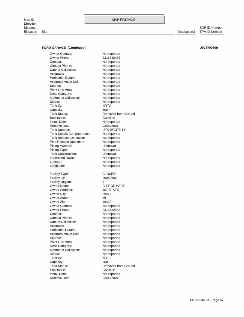
MAP FINDINGSMap IDDirection
EDR ID NumberDistanceEPA ID NumberDatabase(s)SiteElevation
02/09/2001Remove Date: Not reportedInstall Date: GasolineSubstance: Removed from GroundTank Status: 500Capacity: NRT1Tank ID: Not reportedDistrict: Not reportedMethod of Collection: Not reportedDesc Category: Not reportedPoint Line Area: Not reportedSource: Not reportedAccuracy Value Unit: Not reportedHorizontal Datum: Not reportedAccuracy: Not reportedDate of Collection: Not reportedContact Phone: Not reportedContact: 2318732488Owner Phone: Not reportedOwner Contact: 49420Owner Zip: MIOwner State: HARTOwner City: 407 STATEOwner Address: CITY OF HARTOwner Name: 3Facility Region: 00040604Facility ID: CLOSEDFacility Type:
Not reportedLongitude: Not reportedLatitude: Not reportedImpressed Device: UnknownTank Construction: Not reportedPiping Type: UnknownPiping Material: Not reportedPipe Release Detection: Not reportedTank Release Detection: Not reportedTank Details Compartments: UTK-089373-15Tank Number: 02/09/2001Remove Date: Not reportedInstall Date: GasolineSubstance: Removed from GroundTank Status: 500Capacity: NRT2Tank ID: Not reportedDistrict: Not reportedMethod of Collection: Not reportedDesc Category: Not reportedPoint Line Area: Not reportedSource: Not reportedAccuracy Value Unit: Not reportedHorizontal Datum: Not reportedAccuracy: Not reportedDate of Collection: Not reportedContact Phone: Not reportedContact: 2318732488Owner Phone: Not reportedOwner Contact:
FORD GARAGE (Continued) U003790699
TC5765045.2s Page 47

MAP FINDINGSMap IDDirection
EDR ID NumberDistanceEPA ID NumberDatabase(s)SiteElevation
-86.36454Longitude: 43.70317Latitude: Not reportedImpressed Device: Asphalt Coated or Bare SteelTank Construction: Not reportedPiping Type: UnknownPiping Material: Not reportedPipe Release Detection: Not reportedTank Release Detection: Not reportedTank Details Compartments: UTK-007990-15Tank Number: 02/09/2001Remove Date: Not reportedInstall Date: GasolineSubstance: Removed from GroundTank Status: 500Capacity: 1Tank ID: Region 3 - Grand Rapids District OfficeDistrict: Address Matching-House NumberMethod of Collection: Not reportedDesc Category: POINTPoint Line Area: STATE OF MICHIGANSource: FEETAccuracy Value Unit: NAD83Horizontal Datum: 100Accuracy: 10/05/2004Date of Collection: (231) 873-2488Contact Phone: SCOTT HUEBLERContact: 2318732488Owner Phone: Not reportedOwner Contact: 49420Owner Zip: MIOwner State: HARTOwner City: 407 STATEOwner Address: CITY OF HARTOwner Name: 3Facility Region: 00040604Facility ID: CLOSEDFacility Type:
Not reportedLongitude: Not reportedLatitude: Not reportedImpressed Device: UnknownTank Construction: Not reportedPiping Type: UnknownPiping Material: Not reportedPipe Release Detection: Not reportedTank Release Detection: Not reportedTank Details Compartments: UTK-007931-15Tank Number:
FORD GARAGE (Continued) U003790699
TC5765045.2s Page 48

MAP FINDINGSMap IDDirection
EDR ID NumberDistanceEPA ID NumberDatabase(s)SiteElevation
Not reportedInstall Date: Not reportedSubstance: Non-Registered TankTank Status: 500Capacity: NRT5Tank ID: Not reportedDistrict: Not reportedMethod of Collection: Not reportedDesc Category: Not reportedPoint Line Area: Not reportedSource: Not reportedAccuracy Value Unit: Not reportedHorizontal Datum: Not reportedAccuracy: Not reportedDate of Collection: Not reportedContact Phone: Not reportedContact: 5173237000Owner Phone: Not reportedOwner Contact: 48909-8460Owner Zip: MIOwner State: LANSINGOwner City: PO BOX 30960Owner Address: FARMERS PETRO COOP INCOwner Name: 3Facility Region: 00004787Facility ID: CLOSEDFacility Type:
UST:
Not reportedRelease Closed Date: OpenRelease Status: Not reportedSubstance Released: 06/08/1988Release Date: C-1320-85Leak Number:
Plant Entrance (Freight)Desc Category: POINTPoint Line Area: NAD83Horizontal Data: FEETAccuracy Value Unit: 100Accuracy: Address Matching-House NumberMethod of Collection: 01/11/2001Date of Collection: -86.36371Longitude: 43.69758Latitude: Farmers Petroleum Cooperative IncSite Name: Grand RapidsDistrict: USACountry: (517) 323-7000Owner Phone: Not reportedOwner Contact: Lansing, MI 48909-8460Owner City,St,Zip: PO Box 30960Owner Address: Farmers Petro Coop IncOwner Name: STATE OF MICHIGANSource: 00004787Facility ID:
LUST:
1677 ft. Site 1 of 3 in cluster G0.318 mi. INVENTORY
Relative:Higher
Actual:683 ft.
1/4-1/2 BROWNFIELDSHART, MI 49420SSW UST504 S STATE ST N/AG33 LUSTFARMERS PETROLEUM CO-OP INC U003866543
TC5765045.2s Page 49

MAP FINDINGSMap IDDirection
EDR ID NumberDistanceEPA ID NumberDatabase(s)SiteElevation
MIOwner State: LANSINGOwner City: PO BOX 30960Owner Address: FARMERS PETRO COOP INCOwner Name: 3Facility Region: 00004787Facility ID: CLOSEDFacility Type:
Not reportedLongitude: Not reportedLatitude: Not reportedImpressed Device: Not reportedTank Construction: Not reportedPiping Type: Not reportedPiping Material: Not reportedPipe Release Detection: Not reportedTank Release Detection: Not reportedTank Details Compartments: UTK-081623-15Tank Number: Not reportedRemove Date: Not reportedInstall Date: Not reportedSubstance: Non-Registered TankTank Status: 1000Capacity: NRT4Tank ID: Not reportedDistrict: Not reportedMethod of Collection: Not reportedDesc Category: Not reportedPoint Line Area: Not reportedSource: Not reportedAccuracy Value Unit: Not reportedHorizontal Datum: Not reportedAccuracy: Not reportedDate of Collection: Not reportedContact Phone: Not reportedContact: 5173237000Owner Phone: Not reportedOwner Contact: 48909-8460Owner Zip: MIOwner State: LANSINGOwner City: PO BOX 30960Owner Address: FARMERS PETRO COOP INCOwner Name: 3Facility Region: 00004787Facility ID: CLOSEDFacility Type:
Not reportedLongitude: Not reportedLatitude: Not reportedImpressed Device: Not reportedTank Construction: Not reportedPiping Type: Not reportedPiping Material: Not reportedPipe Release Detection: Not reportedTank Release Detection: Not reportedTank Details Compartments: UTK-081625-15Tank Number: Not reportedRemove Date:
FARMERS PETROLEUM CO-OP INC (Continued) U003866543
TC5765045.2s Page 50

MAP FINDINGSMap IDDirection
EDR ID NumberDistanceEPA ID NumberDatabase(s)SiteElevation
04/29/1961Install Date: GasolineSubstance: Removed from GroundTank Status: 550Capacity: 2Tank ID: Region 3 - Grand Rapids District OfficeDistrict: Address Matching-House NumberMethod of Collection: Plant Entrance (Freight)Desc Category: POINTPoint Line Area: STATE OF MICHIGANSource: FEETAccuracy Value Unit: NAD83Horizontal Datum: 100Accuracy: 01/11/2001Date of Collection: (517) 323-7000Contact Phone: WAYNE GAYContact: 5173237000Owner Phone: Not reportedOwner Contact: 48909-8460Owner Zip: MIOwner State: LANSINGOwner City: PO BOX 30960Owner Address: FARMERS PETRO COOP INCOwner Name: 3Facility Region: 00004787Facility ID: CLOSEDFacility Type:
-86.36371Longitude: 43.69758Latitude: Not reportedImpressed Device: Asphalt Coated or Bare Steel,Cathodically Protected SteelTank Construction: Not reportedPiping Type: Galvanized SteelPiping Material: Not reportedPipe Release Detection: Not reportedTank Release Detection: Not reportedTank Details Compartments: UTK-076161-15Tank Number: 06/08/1988Remove Date: 04/29/1961Install Date: GasolineSubstance: Removed from GroundTank Status: 550Capacity: 3Tank ID: Region 3 - Grand Rapids District OfficeDistrict: Address Matching-House NumberMethod of Collection: Plant Entrance (Freight)Desc Category: POINTPoint Line Area: STATE OF MICHIGANSource: FEETAccuracy Value Unit: NAD83Horizontal Datum: 100Accuracy: 01/11/2001Date of Collection: (517) 323-7000Contact Phone: WAYNE GAYContact: 5173237000Owner Phone: Not reportedOwner Contact: 48909-8460Owner Zip:
FARMERS PETROLEUM CO-OP INC (Continued) U003866543
TC5765045.2s Page 51

MAP FINDINGSMap IDDirection
EDR ID NumberDistanceEPA ID NumberDatabase(s)SiteElevation
Not reportedErnie Id Number: Not reportedBEA: Not reportedProperry Use: Not reportedStatus: 1Region: 00004787Facility ID:
BROWNFIELDS:
-86.36371Longitude: 43.69758Latitude: Not reportedImpressed Device: Asphalt Coated or Bare Steel,Cathodically Protected SteelTank Construction: Not reportedPiping Type: Galvanized SteelPiping Material: Not reportedPipe Release Detection: Not reportedTank Release Detection: Not reportedTank Details Compartments: UTK-076153-15Tank Number: 06/08/1988Remove Date: 04/29/1961Install Date: GasolineSubstance: Removed from GroundTank Status: 1000Capacity: 1Tank ID: Region 3 - Grand Rapids District OfficeDistrict: Address Matching-House NumberMethod of Collection: Plant Entrance (Freight)Desc Category: POINTPoint Line Area: STATE OF MICHIGANSource: FEETAccuracy Value Unit: NAD83Horizontal Datum: 100Accuracy: 01/11/2001Date of Collection: (517) 323-7000Contact Phone: WAYNE GAYContact: 5173237000Owner Phone: Not reportedOwner Contact: 48909-8460Owner Zip: MIOwner State: LANSINGOwner City: PO BOX 30960Owner Address: FARMERS PETRO COOP INCOwner Name: 3Facility Region: 00004787Facility ID: CLOSEDFacility Type:
-86.36371Longitude: 43.69758Latitude: Not reportedImpressed Device: Asphalt Coated or Bare Steel,Cathodically Protected SteelTank Construction: Not reportedPiping Type: Galvanized SteelPiping Material: Not reportedPipe Release Detection: Not reportedTank Release Detection: Not reportedTank Details Compartments: UTK-076157-15Tank Number: 06/08/1988Remove Date:
FARMERS PETROLEUM CO-OP INC (Continued) U003866543
TC5765045.2s Page 52

MAP FINDINGSMap IDDirection
EDR ID NumberDistanceEPA ID NumberDatabase(s)SiteElevation
-86.36372Longitude:43.69758Latitude:Part 213Data Source:Grand RapidsDistrict:Not reportedTownship:Not reportedBea Number:
INVENTORY:
FARMERS PETROLEUM CO-OP INC (Continued) U003866543
Storage Tank DivisionDivision Assigned: mecherbReviewer: No RequestDetermination 20107A: No Hazardous Substance(s)Category: 0Petition Disclosure: No RequestPetition Determination: Gayle FornerSubmitter Name: 11/21/2003Date Received: Grand RapidsDistrict: 1313BEA Number: Not reportedSecondary Address:
BEA:
1677 ft. Site 2 of 3 in cluster G0.318 mi.
Relative:Higher
Actual:683 ft.
1/4-1/2 HART, MI 49420SSW 504 SOUTH STATE STREET N/AG34 BEA504 SOUTH STATE STREET S106096693
Not reportedLongitude:Not reportedLatitude:BEAData Source:Grand RapidsDistrict:HartTownship:200301313GRBea Number:
INVENTORY:
1677 ft. Site 3 of 3 in cluster G0.318 mi.
Relative:Higher
Actual:683 ft.
1/4-1/2 OCEANA (County), MI 49420SSW 504 SOUTH STATE STREET N/AG35 INVENTORY504 SOUTH STATE STREET S114027464
-86.35639Longitude:43.69882Latitude:Part 201Data Source:Grand RapidsDistrict:Not reportedTownship:Not reportedBea Number:
INVENTORY:
1831 ft.0.347 mi.
Relative:Higher
Actual:668 ft.
1/4-1/2 HART, MI SE GRISWOLD STREET AT JOHNSON STREET N/A36 INVENTORYGRISWOLD STREET AT JOHNSON STREET, HART, S123643094
TC5765045.2s Page 53

MAP FINDINGSMap IDDirection
EDR ID NumberDistanceEPA ID NumberDatabase(s)SiteElevation
-86.36099Longitude:43.69675Latitude:Part 213Data Source:Grand RapidsDistrict:Not reportedTownship:Not reportedBea Number:
INVENTORY:
2063 ft. Site 1 of 3 in cluster H0.391 mi.
Relative:Higher
Actual:685 ft.
1/4-1/2 HART, MI 49420South 408 WOOD ST N/AH37 INVENTORYDAVES PARTY STORE S122251596
-86.36096Longitude:43.69677Latitude:Part 201Data Source:Grand RapidsDistrict:Not reportedTownship:Not reportedBea Number:
INVENTORY:
Not reportedRelease Closed Date: OpenRelease Status: GasolineSubstance Released: 11/12/2017Release Date: C-0294-17Leak Number:
Plant Entrance (Freight)Desc Category: POINTPoint Line Area: NAD83Horizontal Data: FEETAccuracy Value Unit: 100Accuracy: GPS Code Meas. Standard Positioning Service SA OffMethod of Collection: 10/21/2003Date of Collection: -86.36098Longitude: 43.69674Latitude: Daves Party StoreSite Name: Grand RapidsDistrict: USACountry: (616) 873-2620Owner Phone: Not reportedOwner Contact: Hart, MI 49420-1350Owner City,St,Zip: 408 Wood StOwner Address: Dave’s Party StoreOwner Name: STATE OF MICHIGANSource: 00035885Facility ID:
LUST:
2063 ft. Site 2 of 3 in cluster H0.391 mi.
Relative:Higher
Actual:685 ft.
1/4-1/2 Financial AssuranceHART, MI 49420South INVENTORY408 WOOD ST N/AH38 LUSTDAVES PARTY STORE S118615850
TC5765045.2s Page 54

MAP FINDINGSMap IDDirection
EDR ID NumberDistanceEPA ID NumberDatabase(s)SiteElevation
03/04/1961Install Date: Other(#6 FUEL OIL)Substance: Currently In UseTank Status: 10000Capacity: 3Tank ID: Not reportedDistrict: Not reportedMethod of Collection: Not reportedDesc Category: Not reportedPoint Line Area: Not reportedSource: Not reportedAccuracy Value Unit: Not reportedHorizontal Datum: Not reportedAccuracy: Not reportedDate of Collection: Not reportedContact Phone: Not reportedContact: 4145671731Owner Phone: Not reportedOwner Contact: 53066-4829Owner Zip: WIOwner State: OCONOMOWOCOwner City: 1055 CORPORATE CENTER DROwner Address: STOKELY USA INCOwner Name: 3Facility Region: 00004355Facility ID: CLOSEDFacility Type:
UST:
02/16/1993Release Closed Date: ClosedRelease Status: Not reportedSubstance Released: 02/14/1990Release Date: C-0612-90Leak Number:
Plant Entrance (Freight)Desc Category: POINTPoint Line Area: NAD83Horizontal Data: FEETAccuracy Value Unit: 100Accuracy: Address Matching-House NumberMethod of Collection: 01/11/2001Date of Collection: -86.36108Longitude: 43.69625Latitude: Stokely UsaSite Name: Grand RapidsDistrict: USACountry: (414) 567-1731Owner Phone: Not reportedOwner Contact: Oconomowoc, WI 53066-4829Owner City,St,Zip: 1055 Corporate Center DrOwner Address: Stokely USA IncOwner Name: STATE OF MICHIGANSource: 00004355Facility ID:
LUST:
2103 ft. Site 3 of 3 in cluster H0.398 mi. WDS
Relative:Higher
Actual:685 ft.
1/4-1/2 NPDESHART, MI 49420South UST409 WOOD ST N/AH39 LUSTSTOKELY USA INC U002302861
TC5765045.2s Page 55

MAP FINDINGSMap IDDirection
EDR ID NumberDistanceEPA ID NumberDatabase(s)SiteElevation
WIOwner State: OCONOMOWOCOwner City: 1055 CORPORATE CENTER DROwner Address: STOKELY USA INCOwner Name: 3Facility Region: 00004355Facility ID: CLOSEDFacility Type:
-86.36108Longitude: 43.69625Latitude: Not reportedImpressed Device: Asphalt Coated or Bare SteelTank Construction: Not reportedPiping Type: Galvanized SteelPiping Material: Not reportedPipe Release Detection: Not reportedTank Release Detection: Not reportedTank Details Compartments: UTK-037452-15Tank Number: 04/01/1990Remove Date: 03/04/1981Install Date: GasolineSubstance: Removed from GroundTank Status: 500Capacity: 2Tank ID: Region 3 - Grand Rapids District OfficeDistrict: Address Matching-House NumberMethod of Collection: Plant Entrance (Freight)Desc Category: POINTPoint Line Area: STATE OF MICHIGANSource: FEETAccuracy Value Unit: NAD83Horizontal Datum: 100Accuracy: 01/11/2001Date of Collection: (616) 873-2136Contact Phone: ROGER F. WARMUSKERKENContact: 4145671731Owner Phone: Not reportedOwner Contact: 53066-4829Owner Zip: WIOwner State: OCONOMOWOCOwner City: 1055 CORPORATE CENTER DROwner Address: STOKELY USA INCOwner Name: 3Facility Region: 00004355Facility ID: CLOSEDFacility Type:
Not reportedLongitude: Not reportedLatitude: Not reportedImpressed Device: Asphalt Coated or Bare SteelTank Construction: Not reportedPiping Type: Galvanized SteelPiping Material: Not reportedPipe Release Detection: Not reportedTank Release Detection: Not reportedTank Details Compartments: UTK-060928-15Tank Number: Not reportedRemove Date:
STOKELY USA INC (Continued) U002302861
TC5765045.2s Page 56

MAP FINDINGSMap IDDirection
EDR ID NumberDistanceEPA ID NumberDatabase(s)SiteElevation
Grand RapidsDEQ District Email: Not reportedCOC Permit Category: ExtendedPermit Status: 4050007Hydrologic Unit Code: LONLon Type Code: WLon Direction: -86.361111Longitude: LATLat Type Code: NLat Direction: 43.696388Latitude: Indian Summer Co-op-HartDesigned Name: Not reportedFacility Name 4: Not reportedFacility Name 3: Not reportedFacility Name 2: NPDES Individual PermitPermit Type: Ludington, MI 49431Permittee City,St,Zip: Not reportedPermittee Addr2: 3958 West Chauvez RoadPermittee Address: Indian Summer Co-operative, Inc.Permittee Name: 10/01/2016Expiration Date: 11/01/2014Effective Date: 09/30/2014Issue Date: Not reportedPermitee Email: NPermitee PO Box: MI0001309Permit Number:
MI NPDES:
-86.36108Longitude: 43.69625Latitude: Not reportedImpressed Device: Asphalt Coated or Bare SteelTank Construction: Not reportedPiping Type: Galvanized SteelPiping Material: Not reportedPipe Release Detection: Not reportedTank Release Detection: Not reportedTank Details Compartments: UTK-026739-15Tank Number: 04/01/1990Remove Date: 03/04/1966Install Date: GasolineSubstance: Removed from GroundTank Status: 1000Capacity: 1Tank ID: Region 3 - Grand Rapids District OfficeDistrict: Address Matching-House NumberMethod of Collection: Plant Entrance (Freight)Desc Category: POINTPoint Line Area: STATE OF MICHIGANSource: FEETAccuracy Value Unit: NAD83Horizontal Datum: 100Accuracy: 01/11/2001Date of Collection: (616) 873-2136Contact Phone: ROGER F. WARMUSKERKENContact: 4145671731Owner Phone: Not reportedOwner Contact: 53066-4829Owner Zip:
STOKELY USA INC (Continued) U002302861
TC5765045.2s Page 57

MAP FINDINGSMap IDDirection
EDR ID NumberDistanceEPA ID NumberDatabase(s)SiteElevation
OCEANAMailing County: 49420Mailing City/State/Zip: PO BOX 150Mailing Address: STOKLEY USASite Specific Name: 451009WMD Id: MIG000024469Site Id:
WDS:
[email protected] Permit Compliance Manager Email: Thomas BerdinskiDEQ Permit Compliance Manager:
STOKELY USA INC (Continued) U002302861
-86.369166669999998Longitude: 43.690277780000002Latitude: 43.690277780096302Y Coord: -86.369166669805296X Coord: Not reportedCurrent Owner: Properties without projectsStatus: Louisville District (LRL)USACE District: Great Lakes and Ohio River Division (LRD)USACE Division: 502-315-6768Telephone: OCEANACounty: MIState: HARTCity: E05MI0027FUDS Number: HART PRISONER-OF-WAR CAMPFacility Name: 2Congressional District Number: MI59799F684200Installation ID: 5EPA Region:
FUDS:
4694 ft.0.889 mi.
Relative:Higher
Actual:713 ft.
1/2-1 HART, MI SSW N/A40 FUDSHART PRISONER-OF-WAR CAMP 1024900300
22SAM Score: Road CommissionSource: Interim Response conductedFacility Status: 64000005Facility ID:
PART 201:
-86.36466Longitude:43.68818Latitude:Part 201Data Source:Grand RapidsDistrict:HartTownship:Not reportedBea Number:
INVENTORY:
5015 ft.0.950 mi.
Relative:Higher
Actual:707 ft.
1/2-1 HART, MI 49420South PART 2013501 WEST POLK ROAD N/A41 INVENTORYOCEANA CO RD COMM HART S105965691
TC5765045.2s Page 58

MAP FINDINGSMap IDDirection
EDR ID NumberDistanceEPA ID NumberDatabase(s)SiteElevation
Benzene; Cl; Ethylbenzene; Toluene; XylenesPollutants: NWQuarter/Quarter: NEQuarter: 20Section: 17WRange: 15NTownship: 11/09/2005SAM Score Date:
OCEANA CO RD COMM HART (Continued) S105965691
TC5765045.2s Page 59
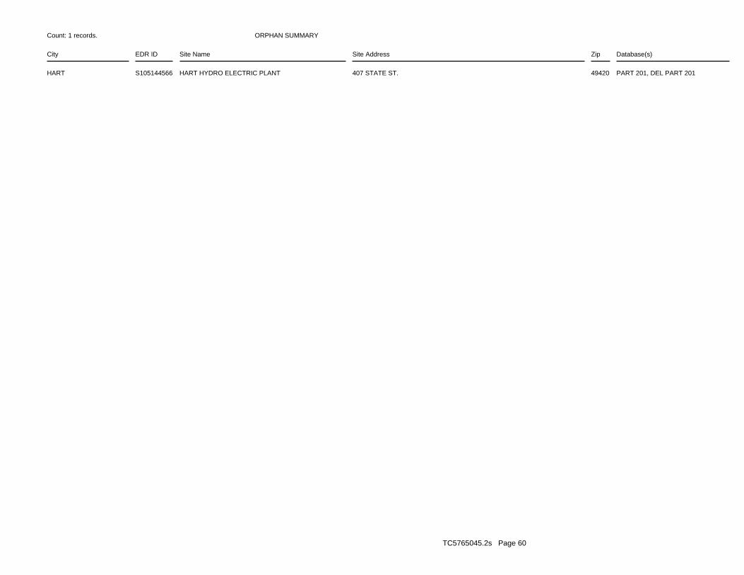
ORPHAN SUMMARY
City EDR ID Site Name Site Address Zip Database(s)
Count: 1 records.
HART S105144566 HART HYDRO ELECTRIC PLANT 407 STATE ST. 49420 PART 201, DEL PART 201
TC5765045.2s Page 60

To maintain currency of the following federal and state databases, EDR contacts the appropriate governmental agencyon a monthly or quarterly basis, as required.
Number of Days to Update: Provides confirmation that EDR is reporting records that have been updated within 90 daysfrom the date the government agency made the information available to the public.
STANDARD ENVIRONMENTAL RECORDS
Federal NPL site list
NPL: National Priority ListNational Priorities List (Superfund). The NPL is a subset of CERCLIS and identifies over 1,200 sites for prioritycleanup under the Superfund Program. NPL sites may encompass relatively large areas. As such, EDR provides polygoncoverage for over 1,000 NPL site boundaries produced by EPA’s Environmental Photographic Interpretation Center(EPIC) and regional EPA offices.
Date of Government Version: 04/11/2019Date Data Arrived at EDR: 04/18/2019Date Made Active in Reports: 05/14/2019Number of Days to Update: 26
Source: EPATelephone: N/ALast EDR Contact: 07/02/2019Next Scheduled EDR Contact: 10/14/2019Data Release Frequency: Quarterly
NPL Site Boundaries
Sources:
EPA’s Environmental Photographic Interpretation Center (EPIC)Telephone: 202-564-7333
EPA Region 1 EPA Region 6Telephone 617-918-1143 Telephone: 214-655-6659
EPA Region 3 EPA Region 7Telephone 215-814-5418 Telephone: 913-551-7247
EPA Region 4 EPA Region 8Telephone 404-562-8033 Telephone: 303-312-6774
EPA Region 5 EPA Region 9Telephone 312-886-6686 Telephone: 415-947-4246
EPA Region 10Telephone 206-553-8665
Proposed NPL: Proposed National Priority List SitesA site that has been proposed for listing on the National Priorities List through the issuance of a proposed rulein the Federal Register. EPA then accepts public comments on the site, responds to the comments, and places onthe NPL those sites that continue to meet the requirements for listing.
Date of Government Version: 04/11/2019Date Data Arrived at EDR: 04/18/2019Date Made Active in Reports: 05/14/2019Number of Days to Update: 26
Source: EPATelephone: N/ALast EDR Contact: 07/02/2019Next Scheduled EDR Contact: 10/14/2019Data Release Frequency: Quarterly
NPL LIENS: Federal Superfund LiensFederal Superfund Liens. Under the authority granted the USEPA by CERCLA of 1980, the USEPA has the authorityto file liens against real property in order to recover remedial action expenditures or when the property ownerreceived notification of potential liability. USEPA compiles a listing of filed notices of Superfund Liens.
TC5765045.2s Page GR-1
GOVERNMENT RECORDS SEARCHED / DATA CURRENCY TRACKING

Date of Government Version: 10/15/1991Date Data Arrived at EDR: 02/02/1994Date Made Active in Reports: 03/30/1994Number of Days to Update: 56
Source: EPATelephone: 202-564-4267Last EDR Contact: 08/15/2011Next Scheduled EDR Contact: 11/28/2011Data Release Frequency: No Update Planned
Federal Delisted NPL site list
Delisted NPL: National Priority List DeletionsThe National Oil and Hazardous Substances Pollution Contingency Plan (NCP) establishes the criteria that theEPA uses to delete sites from the NPL. In accordance with 40 CFR 300.425.(e), sites may be deleted from theNPL where no further response is appropriate.
Date of Government Version: 04/11/2019Date Data Arrived at EDR: 04/18/2019Date Made Active in Reports: 05/14/2019Number of Days to Update: 26
Source: EPATelephone: N/ALast EDR Contact: 07/02/2019Next Scheduled EDR Contact: 10/14/2019Data Release Frequency: Quarterly
Federal CERCLIS list
FEDERAL FACILITY: Federal Facility Site Information listingA listing of National Priority List (NPL) and Base Realignment and Closure (BRAC) sites found in the ComprehensiveEnvironmental Response, Compensation and Liability Information System (CERCLIS) Database where EPA Federal FacilitiesRestoration and Reuse Office is involved in cleanup activities.
Date of Government Version: 04/03/2019Date Data Arrived at EDR: 04/05/2019Date Made Active in Reports: 05/14/2019Number of Days to Update: 39
Source: Environmental Protection AgencyTelephone: 703-603-8704Last EDR Contact: 07/03/2019Next Scheduled EDR Contact: 10/14/2019Data Release Frequency: Varies
SEMS: Superfund Enterprise Management SystemSEMS (Superfund Enterprise Management System) tracks hazardous waste sites, potentially hazardous waste sites,and remedial activities performed in support of EPA’s Superfund Program across the United States. The list wasformerly know as CERCLIS, renamed to SEMS by the EPA in 2015. The list contains data on potentially hazardouswaste sites that have been reported to the USEPA by states, municipalities, private companies and private persons,pursuant to Section 103 of the Comprehensive Environmental Response, Compensation, and Liability Act (CERCLA).This dataset also contains sites which are either proposed to or on the National Priorities List (NPL) and thesites which are in the screening and assessment phase for possible inclusion on the NPL.
Date of Government Version: 04/11/2019Date Data Arrived at EDR: 04/18/2019Date Made Active in Reports: 05/23/2019Number of Days to Update: 35
Source: EPATelephone: 800-424-9346Last EDR Contact: 07/02/2019Next Scheduled EDR Contact: 10/28/2019Data Release Frequency: Quarterly
Federal CERCLIS NFRAP site list
SEMS-ARCHIVE: Superfund Enterprise Management System Archive
TC5765045.2s Page GR-2
GOVERNMENT RECORDS SEARCHED / DATA CURRENCY TRACKING

SEMS-ARCHIVE (Superfund Enterprise Management System Archive) tracks sites that have no further interest underthe Federal Superfund Program based on available information. The list was formerly known as the CERCLIS-NFRAP,renamed to SEMS ARCHIVE by the EPA in 2015. EPA may perform a minimal level of assessment work at a site whileit is archived if site conditions change and/or new information becomes available. Archived sites have been removedand archived from the inventory of SEMS sites. Archived status indicates that, to the best of EPA’s knowledge,assessment at a site has been completed and that EPA has determined no further steps will be taken to list thesite on the National Priorities List (NPL), unless information indicates this decision was not appropriate orother considerations require a recommendation for listing at a later time. The decision does not necessarily meanthat there is no hazard associated with a given site; it only means that. based upon available information, thelocation is not judged to be potential NPL site.
Date of Government Version: 04/11/2019Date Data Arrived at EDR: 04/18/2019Date Made Active in Reports: 05/23/2019Number of Days to Update: 35
Source: EPATelephone: 800-424-9346Last EDR Contact: 07/02/2019Next Scheduled EDR Contact: 10/28/2019Data Release Frequency: Quarterly
Federal RCRA CORRACTS facilities list
CORRACTS: Corrective Action ReportCORRACTS identifies hazardous waste handlers with RCRA corrective action activity.
Date of Government Version: 03/25/2019Date Data Arrived at EDR: 03/27/2019Date Made Active in Reports: 04/17/2019Number of Days to Update: 21
Source: EPATelephone: 800-424-9346Last EDR Contact: 06/26/2019Next Scheduled EDR Contact: 10/07/2019Data Release Frequency: Quarterly
Federal RCRA non-CORRACTS TSD facilities list
RCRA-TSDF: RCRA - Treatment, Storage and DisposalRCRAInfo is EPA’s comprehensive information system, providing access to data supporting the Resource Conservationand Recovery Act (RCRA) of 1976 and the Hazardous and Solid Waste Amendments (HSWA) of 1984. The databaseincludes selective information on sites which generate, transport, store, treat and/or dispose of hazardous wasteas defined by the Resource Conservation and Recovery Act (RCRA). Transporters are individuals or entities thatmove hazardous waste from the generator offsite to a facility that can recycle, treat, store, or dispose of thewaste. TSDFs treat, store, or dispose of the waste.
Date of Government Version: 03/25/2019Date Data Arrived at EDR: 03/27/2019Date Made Active in Reports: 04/17/2019Number of Days to Update: 21
Source: Environmental Protection AgencyTelephone: 312-886-6186Last EDR Contact: 06/26/2019Next Scheduled EDR Contact: 10/07/2019Data Release Frequency: Quarterly
Federal RCRA generators list
RCRA-LQG: RCRA - Large Quantity GeneratorsRCRAInfo is EPA’s comprehensive information system, providing access to data supporting the Resource Conservationand Recovery Act (RCRA) of 1976 and the Hazardous and Solid Waste Amendments (HSWA) of 1984. The databaseincludes selective information on sites which generate, transport, store, treat and/or dispose of hazardous wasteas defined by the Resource Conservation and Recovery Act (RCRA). Large quantity generators (LQGs) generateover 1,000 kilograms (kg) of hazardous waste, or over 1 kg of acutely hazardous waste per month.
Date of Government Version: 03/25/2019Date Data Arrived at EDR: 03/27/2019Date Made Active in Reports: 04/17/2019Number of Days to Update: 21
Source: Environmental Protection AgencyTelephone: 312-886-6186Last EDR Contact: 06/26/2019Next Scheduled EDR Contact: 10/07/2019Data Release Frequency: Quarterly
TC5765045.2s Page GR-3
GOVERNMENT RECORDS SEARCHED / DATA CURRENCY TRACKING

RCRA-SQG: RCRA - Small Quantity GeneratorsRCRAInfo is EPA’s comprehensive information system, providing access to data supporting the Resource Conservationand Recovery Act (RCRA) of 1976 and the Hazardous and Solid Waste Amendments (HSWA) of 1984. The databaseincludes selective information on sites which generate, transport, store, treat and/or dispose of hazardous wasteas defined by the Resource Conservation and Recovery Act (RCRA). Small quantity generators (SQGs) generatebetween 100 kg and 1,000 kg of hazardous waste per month.
Date of Government Version: 03/25/2019Date Data Arrived at EDR: 03/27/2019Date Made Active in Reports: 04/17/2019Number of Days to Update: 21
Source: Environmental Protection AgencyTelephone: 312-886-6186Last EDR Contact: 06/26/2019Next Scheduled EDR Contact: 10/07/2019Data Release Frequency: Quarterly
RCRA-CESQG: RCRA - Conditionally Exempt Small Quantity GeneratorsRCRAInfo is EPA’s comprehensive information system, providing access to data supporting the Resource Conservationand Recovery Act (RCRA) of 1976 and the Hazardous and Solid Waste Amendments (HSWA) of 1984. The databaseincludes selective information on sites which generate, transport, store, treat and/or dispose of hazardous wasteas defined by the Resource Conservation and Recovery Act (RCRA). Conditionally exempt small quantity generators(CESQGs) generate less than 100 kg of hazardous waste, or less than 1 kg of acutely hazardous waste per month.
Date of Government Version: 03/25/2019Date Data Arrived at EDR: 03/27/2019Date Made Active in Reports: 04/17/2019Number of Days to Update: 21
Source: Environmental Protection AgencyTelephone: 312-886-6186Last EDR Contact: 06/26/2019Next Scheduled EDR Contact: 10/07/2019Data Release Frequency: Quarterly
Federal institutional controls / engineering controls registries
LUCIS: Land Use Control Information SystemLUCIS contains records of land use control information pertaining to the former Navy Base Realignment and Closureproperties.
Date of Government Version: 02/22/2019Date Data Arrived at EDR: 03/07/2019Date Made Active in Reports: 04/17/2019Number of Days to Update: 41
Source: Department of the NavyTelephone: 843-820-7326Last EDR Contact: 05/10/2019Next Scheduled EDR Contact: 08/26/2019Data Release Frequency: Varies
US ENG CONTROLS: Engineering Controls Sites ListA listing of sites with engineering controls in place. Engineering controls include various forms of caps, buildingfoundations, liners, and treatment methods to create pathway elimination for regulated substances to enter environmentalmedia or effect human health.
Date of Government Version: 01/31/2019Date Data Arrived at EDR: 02/04/2019Date Made Active in Reports: 03/08/2019Number of Days to Update: 32
Source: Environmental Protection AgencyTelephone: 703-603-0695Last EDR Contact: 05/29/2019Next Scheduled EDR Contact: 09/09/2019Data Release Frequency: Varies
US INST CONTROL: Sites with Institutional ControlsA listing of sites with institutional controls in place. Institutional controls include administrative measures,such as groundwater use restrictions, construction restrictions, property use restrictions, and post remediationcare requirements intended to prevent exposure to contaminants remaining on site. Deed restrictions are generallyrequired as part of the institutional controls.
Date of Government Version: 01/31/2019Date Data Arrived at EDR: 02/04/2019Date Made Active in Reports: 03/08/2019Number of Days to Update: 32
Source: Environmental Protection AgencyTelephone: 703-603-0695Last EDR Contact: 05/29/2019Next Scheduled EDR Contact: 09/09/2019Data Release Frequency: Varies
TC5765045.2s Page GR-4
GOVERNMENT RECORDS SEARCHED / DATA CURRENCY TRACKING

Federal ERNS list
ERNS: Emergency Response Notification SystemEmergency Response Notification System. ERNS records and stores information on reported releases of oil and hazardoussubstances.
Date of Government Version: 03/25/2019Date Data Arrived at EDR: 03/26/2019Date Made Active in Reports: 05/01/2019Number of Days to Update: 36
Source: National Response Center, United States Coast GuardTelephone: 202-267-2180Last EDR Contact: 06/26/2019Next Scheduled EDR Contact: 10/07/2019Data Release Frequency: Quarterly
State- and tribal - equivalent CERCLIS
SHWS: This state does not maintain a SHWS list. See the Federal CERCLIS list and Federal NPL list.This state does not maintain a SHWS list. See the Federal CERCLIS list and Federal NPL list.
Date of Government Version: N/ADate Data Arrived at EDR: 10/31/2013Date Made Active in Reports: 11/20/2013Number of Days to Update: 20
Source: Department of Environment, Great Lakes, and EnergyTelephone: 517-284-5103Last EDR Contact: 07/22/2019Next Scheduled EDR Contact: 11/04/2019Data Release Frequency: No Update Planned
State and tribal landfill and/or solid waste disposal site lists
SWF/LF: Solid Waste Facilities DatabaseSolid Waste Facilities/Landfill Sites. SWF/LF type records typically contain an inventory of solid waste disposalfacilities or landfills in a particular state. Depending on the state, these may be active or inactive facilitiesor open dumps that failed to meet RCRA Subtitle D Section 4004 criteria for solid waste landfills or disposalsites.
Date of Government Version: 03/26/2019Date Data Arrived at EDR: 03/27/2019Date Made Active in Reports: 05/07/2019Number of Days to Update: 41
Source: Department of Environment, Great Lakes, and EnergyTelephone: 517-335-4035Last EDR Contact: 06/26/2019Next Scheduled EDR Contact: 10/07/2019Data Release Frequency: Semi-Annually
State and tribal leaking storage tank lists
LUST: Leaking Underground Storage Tank SitesLeaking Underground Storage Tank Incident Reports. LUST records contain an inventory of reported leaking undergroundstorage tank incidents. Not all states maintain these records, and the information stored varies by state.
Date of Government Version: 05/03/2019Date Data Arrived at EDR: 05/14/2019Date Made Active in Reports: 06/05/2019Number of Days to Update: 22
Source: Department of Environment, Great Lakes, and EnergyTelephone: 517-373-9837Last EDR Contact: 05/14/2019Next Scheduled EDR Contact: 08/26/2019Data Release Frequency: Annually
INDIAN LUST R10: Leaking Underground Storage Tanks on Indian LandLUSTs on Indian land in Alaska, Idaho, Oregon and Washington.
Date of Government Version: 10/17/2018Date Data Arrived at EDR: 03/07/2019Date Made Active in Reports: 05/01/2019Number of Days to Update: 55
Source: EPA Region 10Telephone: 206-553-2857Last EDR Contact: 07/24/2019Next Scheduled EDR Contact: 11/04/2019Data Release Frequency: Varies
INDIAN LUST R7: Leaking Underground Storage Tanks on Indian LandLUSTs on Indian land in Iowa, Kansas, and Nebraska
TC5765045.2s Page GR-5
GOVERNMENT RECORDS SEARCHED / DATA CURRENCY TRACKING

Date of Government Version: 02/19/2019Date Data Arrived at EDR: 03/07/2019Date Made Active in Reports: 05/01/2019Number of Days to Update: 55
Source: EPA Region 7Telephone: 913-551-7003Last EDR Contact: 07/24/2019Next Scheduled EDR Contact: 11/04/2019Data Release Frequency: Varies
INDIAN LUST R8: Leaking Underground Storage Tanks on Indian LandLUSTs on Indian land in Colorado, Montana, North Dakota, South Dakota, Utah and Wyoming.
Date of Government Version: 10/16/2018Date Data Arrived at EDR: 03/07/2019Date Made Active in Reports: 05/01/2019Number of Days to Update: 55
Source: EPA Region 8Telephone: 303-312-6271Last EDR Contact: 07/24/2019Next Scheduled EDR Contact: 11/04/2019Data Release Frequency: Varies
INDIAN LUST R4: Leaking Underground Storage Tanks on Indian LandLUSTs on Indian land in Florida, Mississippi and North Carolina.
Date of Government Version: 09/24/2018Date Data Arrived at EDR: 03/12/2019Date Made Active in Reports: 05/01/2019Number of Days to Update: 50
Source: EPA Region 4Telephone: 404-562-8677Last EDR Contact: 07/23/2019Next Scheduled EDR Contact: 11/04/2019Data Release Frequency: Varies
INDIAN LUST R9: Leaking Underground Storage Tanks on Indian LandLUSTs on Indian land in Arizona, California, New Mexico and Nevada
Date of Government Version: 10/10/2018Date Data Arrived at EDR: 03/08/2019Date Made Active in Reports: 05/01/2019Number of Days to Update: 54
Source: Environmental Protection AgencyTelephone: 415-972-3372Last EDR Contact: 07/24/2019Next Scheduled EDR Contact: 11/04/2019Data Release Frequency: Varies
INDIAN LUST R6: Leaking Underground Storage Tanks on Indian LandLUSTs on Indian land in New Mexico and Oklahoma.
Date of Government Version: 11/01/2018Date Data Arrived at EDR: 03/07/2019Date Made Active in Reports: 05/01/2019Number of Days to Update: 55
Source: EPA Region 6Telephone: 214-665-6597Last EDR Contact: 07/24/2019Next Scheduled EDR Contact: 11/04/2019Data Release Frequency: Varies
INDIAN LUST R5: Leaking Underground Storage Tanks on Indian LandLeaking underground storage tanks located on Indian Land in Michigan, Minnesota and Wisconsin.
Date of Government Version: 10/12/2018Date Data Arrived at EDR: 03/07/2019Date Made Active in Reports: 05/01/2019Number of Days to Update: 55
Source: EPA, Region 5Telephone: 312-886-7439Last EDR Contact: 07/24/2019Next Scheduled EDR Contact: 11/04/2019Data Release Frequency: Varies
INDIAN LUST R1: Leaking Underground Storage Tanks on Indian LandA listing of leaking underground storage tank locations on Indian Land.
Date of Government Version: 10/13/2018Date Data Arrived at EDR: 03/07/2019Date Made Active in Reports: 05/01/2019Number of Days to Update: 55
Source: EPA Region 1Telephone: 617-918-1313Last EDR Contact: 07/24/2019Next Scheduled EDR Contact: 11/04/2019Data Release Frequency: Varies
State and tribal registered storage tank lists
TC5765045.2s Page GR-6
GOVERNMENT RECORDS SEARCHED / DATA CURRENCY TRACKING

FEMA UST: Underground Storage Tank ListingA listing of all FEMA owned underground storage tanks.
Date of Government Version: 05/15/2017Date Data Arrived at EDR: 05/30/2017Date Made Active in Reports: 10/13/2017Number of Days to Update: 136
Source: FEMATelephone: 202-646-5797Last EDR Contact: 07/10/2019Next Scheduled EDR Contact: 10/21/2019Data Release Frequency: Varies
UST: Underground Storage Tank Facility ListRegistered Underground Storage Tanks. UST’s are regulated under Subtitle I of the Resource Conservation and RecoveryAct (RCRA) and must be registered with the state department responsible for administering the UST program. Availableinformation varies by state program.
Date of Government Version: 02/06/2019Date Data Arrived at EDR: 02/13/2019Date Made Active in Reports: 03/25/2019Number of Days to Update: 40
Source: Department of Licensing & Regulatory AffairsTelephone: 517-373-1820Last EDR Contact: 05/17/2019Next Scheduled EDR Contact: 08/26/2019Data Release Frequency: Annually
UST 2: Underground Storage Tank ListingA listing of underground storage tank site locations that have unknown owner information.
Date of Government Version: 04/23/2018Date Data Arrived at EDR: 04/25/2018Date Made Active in Reports: 06/27/2018Number of Days to Update: 63
Source: Department of Licensing & Regulatory AffairsTelephone: 517-373-1820Last EDR Contact: 07/10/2019Next Scheduled EDR Contact: 10/28/2019Data Release Frequency: Varies
AST: Aboveground TanksRegistered Aboveground Storage Tanks.
Date of Government Version: 01/15/2019Date Data Arrived at EDR: 01/24/2019Date Made Active in Reports: 03/25/2019Number of Days to Update: 60
Source: Department of Licensing & Regulatory AffairsTelephone: 517-373-1820Last EDR Contact: 05/10/2019Next Scheduled EDR Contact: 08/26/2019Data Release Frequency: No Update Planned
INDIAN UST R5: Underground Storage Tanks on Indian LandThe Indian Underground Storage Tank (UST) database provides information about underground storage tanks on Indianland in EPA Region 5 (Michigan, Minnesota and Wisconsin and Tribal Nations).
Date of Government Version: 10/12/2018Date Data Arrived at EDR: 03/07/2019Date Made Active in Reports: 05/01/2019Number of Days to Update: 55
Source: EPA Region 5Telephone: 312-886-6136Last EDR Contact: 07/24/2019Next Scheduled EDR Contact: 11/04/2019Data Release Frequency: Varies
INDIAN UST R4: Underground Storage Tanks on Indian LandThe Indian Underground Storage Tank (UST) database provides information about underground storage tanks on Indianland in EPA Region 4 (Alabama, Florida, Georgia, Kentucky, Mississippi, North Carolina, South Carolina, Tennesseeand Tribal Nations)
Date of Government Version: 09/24/2018Date Data Arrived at EDR: 03/12/2019Date Made Active in Reports: 05/01/2019Number of Days to Update: 50
Source: EPA Region 4Telephone: 404-562-9424Last EDR Contact: 07/23/2019Next Scheduled EDR Contact: 11/04/2019Data Release Frequency: Varies
TC5765045.2s Page GR-7
GOVERNMENT RECORDS SEARCHED / DATA CURRENCY TRACKING

INDIAN UST R7: Underground Storage Tanks on Indian LandThe Indian Underground Storage Tank (UST) database provides information about underground storage tanks on Indianland in EPA Region 7 (Iowa, Kansas, Missouri, Nebraska, and 9 Tribal Nations).
Date of Government Version: 11/07/2018Date Data Arrived at EDR: 03/07/2019Date Made Active in Reports: 05/01/2019Number of Days to Update: 55
Source: EPA Region 7Telephone: 913-551-7003Last EDR Contact: 07/24/2019Next Scheduled EDR Contact: 11/04/2019Data Release Frequency: Varies
INDIAN UST R1: Underground Storage Tanks on Indian LandThe Indian Underground Storage Tank (UST) database provides information about underground storage tanks on Indianland in EPA Region 1 (Connecticut, Maine, Massachusetts, New Hampshire, Rhode Island, Vermont and ten TribalNations).
Date of Government Version: 10/03/2018Date Data Arrived at EDR: 03/07/2019Date Made Active in Reports: 05/01/2019Number of Days to Update: 55
Source: EPA, Region 1Telephone: 617-918-1313Last EDR Contact: 07/24/2019Next Scheduled EDR Contact: 11/04/2019Data Release Frequency: Varies
INDIAN UST R10: Underground Storage Tanks on Indian LandThe Indian Underground Storage Tank (UST) database provides information about underground storage tanks on Indianland in EPA Region 10 (Alaska, Idaho, Oregon, Washington, and Tribal Nations).
Date of Government Version: 10/17/2018Date Data Arrived at EDR: 03/07/2019Date Made Active in Reports: 05/01/2019Number of Days to Update: 55
Source: EPA Region 10Telephone: 206-553-2857Last EDR Contact: 07/24/2019Next Scheduled EDR Contact: 11/04/2019Data Release Frequency: Varies
INDIAN UST R9: Underground Storage Tanks on Indian LandThe Indian Underground Storage Tank (UST) database provides information about underground storage tanks on Indianland in EPA Region 9 (Arizona, California, Hawaii, Nevada, the Pacific Islands, and Tribal Nations).
Date of Government Version: 10/10/2018Date Data Arrived at EDR: 03/08/2019Date Made Active in Reports: 05/01/2019Number of Days to Update: 54
Source: EPA Region 9Telephone: 415-972-3368Last EDR Contact: 07/24/2019Next Scheduled EDR Contact: 11/04/2019Data Release Frequency: Varies
INDIAN UST R8: Underground Storage Tanks on Indian LandThe Indian Underground Storage Tank (UST) database provides information about underground storage tanks on Indianland in EPA Region 8 (Colorado, Montana, North Dakota, South Dakota, Utah, Wyoming and 27 Tribal Nations).
Date of Government Version: 10/16/2018Date Data Arrived at EDR: 03/07/2019Date Made Active in Reports: 05/01/2019Number of Days to Update: 55
Source: EPA Region 8Telephone: 303-312-6137Last EDR Contact: 04/26/2019Next Scheduled EDR Contact: 08/05/2019Data Release Frequency: Varies
INDIAN UST R6: Underground Storage Tanks on Indian LandThe Indian Underground Storage Tank (UST) database provides information about underground storage tanks on Indianland in EPA Region 6 (Louisiana, Arkansas, Oklahoma, New Mexico, Texas and 65 Tribes).
Date of Government Version: 11/01/2018Date Data Arrived at EDR: 03/07/2019Date Made Active in Reports: 05/01/2019Number of Days to Update: 55
Source: EPA Region 6Telephone: 214-665-7591Last EDR Contact: 07/24/2019Next Scheduled EDR Contact: 11/04/2019Data Release Frequency: Varies
TC5765045.2s Page GR-8
GOVERNMENT RECORDS SEARCHED / DATA CURRENCY TRACKING

State and tribal institutional control / engineering control registries
AUL: Engineering and Institutional ControlsA listing of sites with institutional and/or engineering controls in place.
Date of Government Version: 03/19/2019Date Data Arrived at EDR: 03/20/2019Date Made Active in Reports: 05/07/2019Number of Days to Update: 48
Source: Department of Environment, Great Lakes, and EnergyTelephone: 517-373-4828Last EDR Contact: 05/28/2019Next Scheduled EDR Contact: 09/09/2019Data Release Frequency: Quarterly
State and tribal voluntary cleanup sites
INDIAN VCP R7: Voluntary Cleanup Priority LisitngA listing of voluntary cleanup priority sites located on Indian Land located in Region 7.
Date of Government Version: 03/20/2008Date Data Arrived at EDR: 04/22/2008Date Made Active in Reports: 05/19/2008Number of Days to Update: 27
Source: EPA, Region 7Telephone: 913-551-7365Last EDR Contact: 04/20/2009Next Scheduled EDR Contact: 07/20/2009Data Release Frequency: Varies
INDIAN VCP R1: Voluntary Cleanup Priority ListingA listing of voluntary cleanup priority sites located on Indian Land located in Region 1.
Date of Government Version: 07/27/2015Date Data Arrived at EDR: 09/29/2015Date Made Active in Reports: 02/18/2016Number of Days to Update: 142
Source: EPA, Region 1Telephone: 617-918-1102Last EDR Contact: 06/20/2019Next Scheduled EDR Contact: 10/07/2019Data Release Frequency: Varies
State and tribal Brownfields sites
BROWNFIELDS: Brownfields and USTfield Site DatabaseAll state funded Part 201 and 213 sites, as well as LUST sites that have been redeveloped by private entitiesusing the BEA process. Be aware that this is not a list of all of the potential brownfield sites in Michigan.
Date of Government Version: 01/15/2016Date Data Arrived at EDR: 02/02/2016Date Made Active in Reports: 04/04/2016Number of Days to Update: 62
Source: Department of Environment, Great Lakes, and EnergyTelephone: 517-373-4805Last EDR Contact: 07/22/2019Next Scheduled EDR Contact: 11/04/2019Data Release Frequency: Varies
BROWNFIELDS 2: Brownfields Building and Land Site LocationsA listing of brownfield building and land site locations. The listing is a collaborative effort of Michigan EconomicDevelopment Corporation, Michigan Economic Developers Association, Detrot Edison, Detroit Area Commercial Boardof Realtors
Date of Government Version: 04/23/2019Date Data Arrived at EDR: 04/24/2019Date Made Active in Reports: 06/04/2019Number of Days to Update: 41
Source: Economic Development CorporationTelephone: 888-522-0103Last EDR Contact: 07/23/2019Next Scheduled EDR Contact: 11/04/2019Data Release Frequency: Varies
ADDITIONAL ENVIRONMENTAL RECORDS
Local Brownfield lists
US BROWNFIELDS: A Listing of Brownfields SitesBrownfields are real property, the expansion, redevelopment, or reuse of which may be complicated by the presenceor potential presence of a hazardous substance, pollutant, or contaminant. Cleaning up and reinvesting in theseproperties takes development pressures off of undeveloped, open land, and both improves and protects the environment.Assessment, Cleanup and Redevelopment Exchange System (ACRES) stores information reported by EPA Brownfieldsgrant recipients on brownfields properties assessed or cleaned up with grant funding as well as information onTargeted Brownfields Assessments performed by EPA Regions. A listing of ACRES Brownfield sites is obtained fromCleanups in My Community. Cleanups in My Community provides information on Brownfields properties for which informationis reported back to EPA, as well as areas served by Brownfields grant programs.
TC5765045.2s Page GR-9
GOVERNMENT RECORDS SEARCHED / DATA CURRENCY TRACKING

Date of Government Version: 12/17/2018Date Data Arrived at EDR: 12/18/2018Date Made Active in Reports: 01/11/2019Number of Days to Update: 24
Source: Environmental Protection AgencyTelephone: 202-566-2777Last EDR Contact: 06/04/2019Next Scheduled EDR Contact: 09/30/2019Data Release Frequency: Semi-Annually
Local Lists of Landfill / Solid Waste Disposal Sites
HIST LF: Inactive Solid Waste FacilitiesThe database contains historical information and is no longer updated.
Date of Government Version: 03/01/1997Date Data Arrived at EDR: 02/28/2003Date Made Active in Reports: 03/06/2003Number of Days to Update: 6
Source: Department of Environment, Great Lakes, and EnergyTelephone: 517-335-4034Last EDR Contact: 02/28/2003Next Scheduled EDR Contact: N/AData Release Frequency: No Update Planned
SWRCY: Recycling FacilitiesA listing of recycling center locations.
Date of Government Version: 03/20/2019Date Data Arrived at EDR: 03/21/2019Date Made Active in Reports: 05/14/2019Number of Days to Update: 54
Source: Department of Environment, Great Lakes, and EnergyTelephone: 517-241-5719Last EDR Contact: 06/20/2019Next Scheduled EDR Contact: 10/07/2019Data Release Frequency: Varies
INDIAN ODI: Report on the Status of Open Dumps on Indian LandsLocation of open dumps on Indian land.
Date of Government Version: 12/31/1998Date Data Arrived at EDR: 12/03/2007Date Made Active in Reports: 01/24/2008Number of Days to Update: 52
Source: Environmental Protection AgencyTelephone: 703-308-8245Last EDR Contact: 04/26/2019Next Scheduled EDR Contact: 08/12/2019Data Release Frequency: Varies
ODI: Open Dump InventoryAn open dump is defined as a disposal facility that does not comply with one or more of the Part 257 or Part 258Subtitle D Criteria.
Date of Government Version: 06/30/1985Date Data Arrived at EDR: 08/09/2004Date Made Active in Reports: 09/17/2004Number of Days to Update: 39
Source: Environmental Protection AgencyTelephone: 800-424-9346Last EDR Contact: 06/09/2004Next Scheduled EDR Contact: N/AData Release Frequency: No Update Planned
DEBRIS REGION 9: Torres Martinez Reservation Illegal Dump Site LocationsA listing of illegal dump sites location on the Torres Martinez Indian Reservation located in eastern RiversideCounty and northern Imperial County, California.
Date of Government Version: 01/12/2009Date Data Arrived at EDR: 05/07/2009Date Made Active in Reports: 09/21/2009Number of Days to Update: 137
Source: EPA, Region 9Telephone: 415-947-4219Last EDR Contact: 07/19/2019Next Scheduled EDR Contact: 11/04/2019Data Release Frequency: No Update Planned
IHS OPEN DUMPS: Open Dumps on Indian LandA listing of all open dumps located on Indian Land in the United States.
Date of Government Version: 04/01/2014Date Data Arrived at EDR: 08/06/2014Date Made Active in Reports: 01/29/2015Number of Days to Update: 176
Source: Department of Health & Human Serivces, Indian Health ServiceTelephone: 301-443-1452Last EDR Contact: 04/23/2019Next Scheduled EDR Contact: 08/12/2019Data Release Frequency: Varies
TC5765045.2s Page GR-10
GOVERNMENT RECORDS SEARCHED / DATA CURRENCY TRACKING

Local Lists of Hazardous waste / Contaminated Sites
US HIST CDL: National Clandestine Laboratory RegisterA listing of clandestine drug lab locations that have been removed from the DEAs National Clandestine LaboratoryRegister.
Date of Government Version: 02/24/2019Date Data Arrived at EDR: 02/26/2019Date Made Active in Reports: 04/17/2019Number of Days to Update: 50
Source: Drug Enforcement AdministrationTelephone: 202-307-1000Last EDR Contact: 05/24/2019Next Scheduled EDR Contact: 09/09/2019Data Release Frequency: No Update Planned
INVENTORY: Inventory of FacilitiesThe Inventory of Facilities has three data sources: Facilities under Part 201, Environmental Remediation, of theNatural Resources and Environmental Protection Act, 1994 PA 451, as amended (NREPA) identified through statefunded or private party response activities (Projects); Facilities under Part 213, Leaking Underground StorageTanks of the NREPA; and Facilities identified through submittals of Baseline Environmental Assessments (BEA)submitted pursuant to Part 201 or Part 213 of the NREPA. The Part 201 Projects Inventory does not include allof the facilities that are subject to regulation under Part 201 because owners are not required to inform theDepartment of Environmental Quality (DEQ) about the facilities and can pursue cleanup independently. Facilitiesthat are not known to DEQ are not on the Inventory, nor are locations with releases that resulted in low environmentalimpact. Part 213 facilities listed here may have more than one release; a list of releases for which correctiveactions have been completed and list of releases for which corrective action has not been completed is locatedon the Leaking Underground Storage Tanks Site Search webpage. The DEQ may or may not have reviewed and concurredwith the conclusion that the corrective actions described in a closure report meets criteria. A BEA is a documentthat new or prospective property owners/operations disclose to the DEQ identifying the property as a facilitypursuant to Part 201 and Part 213. The Inventory of BEA Facilities overlaps in part with the Part 201 Projectsfacilities and Part 213 facilities. There may be more than one BEA for each facility.
Date of Government Version: 04/23/2019Date Data Arrived at EDR: 04/24/2019Date Made Active in Reports: 06/05/2019Number of Days to Update: 42
Source: Department of Environment, Great Lakes, and EnergyTelephone: 517-284-5136Last EDR Contact: 07/23/2019Next Scheduled EDR Contact: 11/04/2019Data Release Frequency: Quarterly
PART 201: Part 201 Site ListA Part 201 Listed site is a location that has been evaluated and scored by the DEQ using the Part 201 scoringmodel. The location is or includes a "facility" as defined by Part 201, where there has been a release of a hazardoussubstance(s) in excess of the Part 201 residential criteria, and/or where corrective actions have not been completedunder Part 201 to meet the applicable cleanup criteria for unrestricted residential use. The Part 201 List doesnot include all of the sites of contamination that are subject to regulation under Part 201 because owners arenot required to inform the DEQ about the sites and can pursue cleanup independently. Sites of environmental contaminationthat are not known to DEQ are not on the list, nor are sites with releases that resulted in low environmentalimpact.
Date of Government Version: 10/01/2013Date Data Arrived at EDR: 10/03/2014Date Made Active in Reports: 10/03/2014Number of Days to Update: 0
Source: Department of Environment, Great Lakes, and EnergyTelephone: 517-284-5103Last EDR Contact: 07/22/2019Next Scheduled EDR Contact: 11/04/2019Data Release Frequency: No Update Planned
CDL: Clandestine Drug Lab ListingA listing of clandestine drug lab locations.
Date of Government Version: 11/14/2018Date Data Arrived at EDR: 02/04/2019Date Made Active in Reports: 03/21/2019Number of Days to Update: 45
Source: Department of Community HealthTelephone: 517-373-3740Last EDR Contact: 07/22/2019Next Scheduled EDR Contact: 11/04/2019Data Release Frequency: No Update Planned
TC5765045.2s Page GR-11
GOVERNMENT RECORDS SEARCHED / DATA CURRENCY TRACKING

DEL PART 201: Delisted List of Contaminated SitesA deleted site has been removed from the Part 201 List because information known to the DEQ at the time of theevaluation does not support inclusion on the Part 201 List. This designation is often applied to sites where changesin cleanup criteria resulted in a determination that the site no longer exceeds any applicable cleanup criterion.A delisted site has been removed from the Part 201 List because response actions have reduced the levels of contaminantsto concentrations which meet or are below the criteria for unrestricted residential use.
Date of Government Version: 08/01/2013Date Data Arrived at EDR: 08/01/2013Date Made Active in Reports: 09/11/2013Number of Days to Update: 41
Source: Department of Environment, Great Lakes, and EnergyTelephone: 517-373-9541Last EDR Contact: 07/22/2019Next Scheduled EDR Contact: 11/04/2019Data Release Frequency: Varies
US CDL: Clandestine Drug LabsA listing of clandestine drug lab locations. The U.S. Department of Justice ("the Department") provides thisweb site as a public service. It contains addresses of some locations where law enforcement agencies reportedthey found chemicals or other items that indicated the presence of either clandestine drug laboratories or dumpsites.In most cases, the source of the entries is not the Department, and the Department has not verified the entryand does not guarantee its accuracy. Members of the public must verify the accuracy of all entries by, for example,contacting local law enforcement and local health departments.
Date of Government Version: 02/24/2019Date Data Arrived at EDR: 02/26/2019Date Made Active in Reports: 04/17/2019Number of Days to Update: 50
Source: Drug Enforcement AdministrationTelephone: 202-307-1000Last EDR Contact: 05/24/2019Next Scheduled EDR Contact: 09/09/2019Data Release Frequency: Quarterly
PFAS: PFAS Contaminated Sites ListingPFAS have been widely used in numerous industrial and residential applications since the 1950a??s. Their stabilityand unique chemical properties produce waterproof, stain resistant, and nonstick qualities in products. They arefound in some firefighting foams and a wide range of consumer products such as carpet treatments, non-stick cookware,water-resistant fabrics, food packaging materials, and personal care products.
Date of Government Version: 04/04/2019Date Data Arrived at EDR: 05/15/2019Date Made Active in Reports: 07/12/2019Number of Days to Update: 58
Source: Department of Environment, Great Lakes & EnergyTelephone: 517-284-9278Last EDR Contact: 05/15/2019Next Scheduled EDR Contact: 08/26/2019Data Release Frequency: Varies
Local Land Records
LIENS: Lien ListAn Environmental Lien is a charge, security, or encumbrance upon title to a property to secure the payment ofa cost, damage, debt, obligation, or duty arising out of response actions, cleanup, or other remediation of hazardoussubstances or petroleum products upon a property, including (but not limited to) liens imposed pursuant to CERCLA42 USC * 9607(1) and similar state or local laws. In other words: a lien placed upon a property’s title dueto an environmental condition
Date of Government Version: 11/02/2018Date Data Arrived at EDR: 01/17/2019Date Made Active in Reports: 03/21/2019Number of Days to Update: 63
Source: Department of Environment, Great Lakes, and EnergyTelephone: 517-241-7603Last EDR Contact: 07/19/2019Next Scheduled EDR Contact: 10/28/2019Data Release Frequency: Varies
LIENS 2: CERCLA Lien InformationA Federal CERCLA (’Superfund’) lien can exist by operation of law at any site or property at which EPA has spentSuperfund monies. These monies are spent to investigate and address releases and threatened releases of contamination.CERCLIS provides information as to the identity of these sites and properties.
TC5765045.2s Page GR-12
GOVERNMENT RECORDS SEARCHED / DATA CURRENCY TRACKING

Date of Government Version: 04/11/2019Date Data Arrived at EDR: 04/18/2019Date Made Active in Reports: 05/23/2019Number of Days to Update: 35
Source: Environmental Protection AgencyTelephone: 202-564-6023Last EDR Contact: 07/02/2019Next Scheduled EDR Contact: 10/14/2019Data Release Frequency: Semi-Annually
Records of Emergency Release Reports
HMIRS: Hazardous Materials Information Reporting SystemHazardous Materials Incident Report System. HMIRS contains hazardous material spill incidents reported to DOT.
Date of Government Version: 03/25/2019Date Data Arrived at EDR: 03/26/2019Date Made Active in Reports: 05/14/2019Number of Days to Update: 49
Source: U.S. Department of TransportationTelephone: 202-366-4555Last EDR Contact: 06/26/2019Next Scheduled EDR Contact: 10/07/2019Data Release Frequency: Quarterly
PEAS: Pollution Emergency Alerting SystemEnvironmental pollution emergencies reported to the Department of Environmental Quality such as tanker accidents,pipeline breaks, and release of reportable quantities of hazardous substances.
Date of Government Version: 12/31/2018Date Data Arrived at EDR: 01/25/2019Date Made Active in Reports: 03/21/2019Number of Days to Update: 55
Source: Department of Environment, Great Lakes, and EnergyTelephone: 517-373-8427Last EDR Contact: 07/24/2019Next Scheduled EDR Contact: 11/04/2019Data Release Frequency: Quarterly
Other Ascertainable Records
RCRA NonGen / NLR: RCRA - Non Generators / No Longer RegulatedRCRAInfo is EPA’s comprehensive information system, providing access to data supporting the Resource Conservationand Recovery Act (RCRA) of 1976 and the Hazardous and Solid Waste Amendments (HSWA) of 1984. The databaseincludes selective information on sites which generate, transport, store, treat and/or dispose of hazardous wasteas defined by the Resource Conservation and Recovery Act (RCRA). Non-Generators do not presently generate hazardouswaste.
Date of Government Version: 03/25/2019Date Data Arrived at EDR: 03/27/2019Date Made Active in Reports: 04/17/2019Number of Days to Update: 21
Source: Environmental Protection AgencyTelephone: 312-886-6186Last EDR Contact: 06/26/2019Next Scheduled EDR Contact: 10/07/2019Data Release Frequency: Quarterly
FUDS: Formerly Used Defense SitesThe listing includes locations of Formerly Used Defense Sites properties where the US Army Corps of Engineersis actively working or will take necessary cleanup actions.
Date of Government Version: 03/07/2019Date Data Arrived at EDR: 04/03/2019Date Made Active in Reports: 05/23/2019Number of Days to Update: 50
Source: U.S. Army Corps of EngineersTelephone: 202-528-4285Last EDR Contact: 05/21/2019Next Scheduled EDR Contact: 09/02/2019Data Release Frequency: Varies
DOD: Department of Defense SitesThis data set consists of federally owned or administered lands, administered by the Department of Defense, thathave any area equal to or greater than 640 acres of the United States, Puerto Rico, and the U.S. Virgin Islands.
Date of Government Version: 12/31/2005Date Data Arrived at EDR: 11/10/2006Date Made Active in Reports: 01/11/2007Number of Days to Update: 62
Source: USGSTelephone: 888-275-8747Last EDR Contact: 07/09/2019Next Scheduled EDR Contact: 10/21/2019Data Release Frequency: Semi-Annually
TC5765045.2s Page GR-13
GOVERNMENT RECORDS SEARCHED / DATA CURRENCY TRACKING

FEDLAND: Federal and Indian LandsFederally and Indian administrated lands of the United States. Lands included are administrated by: Army Corpsof Engineers, Bureau of Reclamation, National Wild and Scenic River, National Wildlife Refuge, Public Domain Land,Wilderness, Wilderness Study Area, Wildlife Management Area, Bureau of Indian Affairs, Bureau of Land Management,Department of Justice, Forest Service, Fish and Wildlife Service, National Park Service.
Date of Government Version: 12/31/2005Date Data Arrived at EDR: 02/06/2006Date Made Active in Reports: 01/11/2007Number of Days to Update: 339
Source: U.S. Geological SurveyTelephone: 888-275-8747Last EDR Contact: 07/10/2019Next Scheduled EDR Contact: 10/21/2019Data Release Frequency: N/A
SCRD DRYCLEANERS: State Coalition for Remediation of Drycleaners ListingThe State Coalition for Remediation of Drycleaners was established in 1998, with support from the U.S. EPA Officeof Superfund Remediation and Technology Innovation. It is comprised of representatives of states with establisheddrycleaner remediation programs. Currently the member states are Alabama, Connecticut, Florida, Illinois, Kansas,Minnesota, Missouri, North Carolina, Oregon, South Carolina, Tennessee, Texas, and Wisconsin.
Date of Government Version: 01/01/2017Date Data Arrived at EDR: 02/03/2017Date Made Active in Reports: 04/07/2017Number of Days to Update: 63
Source: Environmental Protection AgencyTelephone: 615-532-8599Last EDR Contact: 05/13/2019Next Scheduled EDR Contact: 08/26/2019Data Release Frequency: Varies
US FIN ASSUR: Financial Assurance InformationAll owners and operators of facilities that treat, store, or dispose of hazardous waste are required to provideproof that they will have sufficient funds to pay for the clean up, closure, and post-closure care of their facilities.
Date of Government Version: 03/25/2019Date Data Arrived at EDR: 03/26/2019Date Made Active in Reports: 05/07/2019Number of Days to Update: 42
Source: Environmental Protection AgencyTelephone: 202-566-1917Last EDR Contact: 06/26/2019Next Scheduled EDR Contact: 10/07/2019Data Release Frequency: Quarterly
EPA WATCH LIST: EPA WATCH LISTEPA maintains a "Watch List" to facilitate dialogue between EPA, state and local environmental agencies on enforcementmatters relating to facilities with alleged violations identified as either significant or high priority. Beingon the Watch List does not mean that the facility has actually violated the law only that an investigation byEPA or a state or local environmental agency has led those organizations to allege that an unproven violationhas in fact occurred. Being on the Watch List does not represent a higher level of concern regarding the allegedviolations that were detected, but instead indicates cases requiring additional dialogue between EPA, state andlocal agencies - primarily because of the length of time the alleged violation has gone unaddressed or unresolved.
Date of Government Version: 08/30/2013Date Data Arrived at EDR: 03/21/2014Date Made Active in Reports: 06/17/2014Number of Days to Update: 88
Source: Environmental Protection AgencyTelephone: 617-520-3000Last EDR Contact: 05/06/2019Next Scheduled EDR Contact: 08/19/2019Data Release Frequency: Quarterly
2020 COR ACTION: 2020 Corrective Action Program ListThe EPA has set ambitious goals for the RCRA Corrective Action program by creating the 2020 Corrective ActionUniverse. This RCRA cleanup baseline includes facilities expected to need corrective action. The 2020 universecontains a wide variety of sites. Some properties are heavily contaminated while others were contaminated buthave since been cleaned up. Still others have not been fully investigated yet, and may require little or no remediation.Inclusion in the 2020 Universe does not necessarily imply failure on the part of a facility to meet its RCRA obligations.
Date of Government Version: 09/30/2017Date Data Arrived at EDR: 05/08/2018Date Made Active in Reports: 07/20/2018Number of Days to Update: 73
Source: Environmental Protection AgencyTelephone: 703-308-4044Last EDR Contact: 05/10/2019Next Scheduled EDR Contact: 08/19/2019Data Release Frequency: Varies
TC5765045.2s Page GR-14
GOVERNMENT RECORDS SEARCHED / DATA CURRENCY TRACKING

TSCA: Toxic Substances Control ActToxic Substances Control Act. TSCA identifies manufacturers and importers of chemical substances included on theTSCA Chemical Substance Inventory list. It includes data on the production volume of these substances by plantsite.
Date of Government Version: 12/31/2016Date Data Arrived at EDR: 06/21/2017Date Made Active in Reports: 01/05/2018Number of Days to Update: 198
Source: EPATelephone: 202-260-5521Last EDR Contact: 06/18/2019Next Scheduled EDR Contact: 09/30/2019Data Release Frequency: Every 4 Years
TRIS: Toxic Chemical Release Inventory SystemToxic Release Inventory System. TRIS identifies facilities which release toxic chemicals to the air, water andland in reportable quantities under SARA Title III Section 313.
Date of Government Version: 12/31/2016Date Data Arrived at EDR: 01/10/2018Date Made Active in Reports: 01/12/2018Number of Days to Update: 2
Source: EPATelephone: 202-566-0250Last EDR Contact: 05/24/2019Next Scheduled EDR Contact: 09/02/2019Data Release Frequency: Annually
SSTS: Section 7 Tracking SystemsSection 7 of the Federal Insecticide, Fungicide and Rodenticide Act, as amended (92 Stat. 829) requires allregistered pesticide-producing establishments to submit a report to the Environmental Protection Agency by March1st each year. Each establishment must report the types and amounts of pesticides, active ingredients and devicesbeing produced, and those having been produced and sold or distributed in the past year.
Date of Government Version: 12/31/2009Date Data Arrived at EDR: 12/10/2010Date Made Active in Reports: 02/25/2011Number of Days to Update: 77
Source: EPATelephone: 202-564-4203Last EDR Contact: 04/24/2019Next Scheduled EDR Contact: 08/05/2019Data Release Frequency: Annually
ROD: Records Of DecisionRecord of Decision. ROD documents mandate a permanent remedy at an NPL (Superfund) site containing technicaland health information to aid in the cleanup.
Date of Government Version: 04/11/2019Date Data Arrived at EDR: 04/18/2019Date Made Active in Reports: 05/23/2019Number of Days to Update: 35
Source: EPATelephone: 703-416-0223Last EDR Contact: 07/01/2019Next Scheduled EDR Contact: 09/16/2019Data Release Frequency: Annually
RMP: Risk Management Plans
TC5765045.2s Page GR-15
GOVERNMENT RECORDS SEARCHED / DATA CURRENCY TRACKING

When Congress passed the Clean Air Act Amendments of 1990, it required EPA to publish regulations and guidancefor chemical accident prevention at facilities using extremely hazardous substances. The Risk Management ProgramRule (RMP Rule) was written to implement Section 112(r) of these amendments. The rule, which built upon existingindustry codes and standards, requires companies of all sizes that use certain flammable and toxic substancesto develop a Risk Management Program, which includes a(n): Hazard assessment that details the potential effectsof an accidental release, an accident history of the last five years, and an evaluation of worst-case and alternativeaccidental releases; Prevention program that includes safety precautions and maintenance, monitoring, and employeetraining measures; and Emergency response program that spells out emergency health care, employee training measuresand procedures for informing the public and response agencies (e.g the fire department) should an accident occur.
Date of Government Version: 04/25/2019Date Data Arrived at EDR: 05/02/2019Date Made Active in Reports: 05/23/2019Number of Days to Update: 21
Source: Environmental Protection AgencyTelephone: 202-564-8600Last EDR Contact: 07/22/2019Next Scheduled EDR Contact: 11/04/2019Data Release Frequency: Varies
RAATS: RCRA Administrative Action Tracking SystemRCRA Administration Action Tracking System. RAATS contains records based on enforcement actions issued under RCRApertaining to major violators and includes administrative and civil actions brought by the EPA. For administrationactions after September 30, 1995, data entry in the RAATS database was discontinued. EPA will retain a copy ofthe database for historical records. It was necessary to terminate RAATS because a decrease in agency resourcesmade it impossible to continue to update the information contained in the database.
Date of Government Version: 04/17/1995Date Data Arrived at EDR: 07/03/1995Date Made Active in Reports: 08/07/1995Number of Days to Update: 35
Source: EPATelephone: 202-564-4104Last EDR Contact: 06/02/2008Next Scheduled EDR Contact: 09/01/2008Data Release Frequency: No Update Planned
PRP: Potentially Responsible PartiesA listing of verified Potentially Responsible Parties
Date of Government Version: 04/11/2019Date Data Arrived at EDR: 04/18/2019Date Made Active in Reports: 05/23/2019Number of Days to Update: 35
Source: EPATelephone: 202-564-6023Last EDR Contact: 07/01/2019Next Scheduled EDR Contact: 08/19/2019Data Release Frequency: Quarterly
PADS: PCB Activity Database SystemPCB Activity Database. PADS Identifies generators, transporters, commercial storers and/or brokers and disposersof PCB’s who are required to notify the EPA of such activities.
Date of Government Version: 03/20/2019Date Data Arrived at EDR: 04/10/2019Date Made Active in Reports: 05/14/2019Number of Days to Update: 34
Source: EPATelephone: 202-566-0500Last EDR Contact: 07/12/2019Next Scheduled EDR Contact: 10/21/2019Data Release Frequency: Annually
ICIS: Integrated Compliance Information SystemThe Integrated Compliance Information System (ICIS) supports the information needs of the national enforcementand compliance program as well as the unique needs of the National Pollutant Discharge Elimination System (NPDES)program.
Date of Government Version: 11/18/2016Date Data Arrived at EDR: 11/23/2016Date Made Active in Reports: 02/10/2017Number of Days to Update: 79
Source: Environmental Protection AgencyTelephone: 202-564-2501Last EDR Contact: 07/03/2019Next Scheduled EDR Contact: 10/21/2019Data Release Frequency: Quarterly
TC5765045.2s Page GR-16
GOVERNMENT RECORDS SEARCHED / DATA CURRENCY TRACKING

FTTS: FIFRA/ TSCA Tracking System - FIFRA (Federal Insecticide, Fungicide, & Rodenticide Act)/TSCA (Toxic Substances Control Act)FTTS tracks administrative cases and pesticide enforcement actions and compliance activities related to FIFRA,TSCA and EPCRA (Emergency Planning and Community Right-to-Know Act). To maintain currency, EDR contacts theAgency on a quarterly basis.
Date of Government Version: 04/09/2009Date Data Arrived at EDR: 04/16/2009Date Made Active in Reports: 05/11/2009Number of Days to Update: 25
Source: EPA/Office of Prevention, Pesticides and Toxic SubstancesTelephone: 202-566-1667Last EDR Contact: 08/18/2017Next Scheduled EDR Contact: 12/04/2017Data Release Frequency: No Update Planned
FTTS INSP: FIFRA/ TSCA Tracking System - FIFRA (Federal Insecticide, Fungicide, & Rodenticide Act)/TSCA (Toxic Substances Control Act)A listing of FIFRA/TSCA Tracking System (FTTS) inspections and enforcements.
Date of Government Version: 04/09/2009Date Data Arrived at EDR: 04/16/2009Date Made Active in Reports: 05/11/2009Number of Days to Update: 25
Source: EPATelephone: 202-566-1667Last EDR Contact: 08/18/2017Next Scheduled EDR Contact: 12/04/2017Data Release Frequency: No Update Planned
MLTS: Material Licensing Tracking SystemMLTS is maintained by the Nuclear Regulatory Commission and contains a list of approximately 8,100 sites whichpossess or use radioactive materials and which are subject to NRC licensing requirements. To maintain currency,EDR contacts the Agency on a quarterly basis.
Date of Government Version: 08/30/2016Date Data Arrived at EDR: 09/08/2016Date Made Active in Reports: 10/21/2016Number of Days to Update: 43
Source: Nuclear Regulatory CommissionTelephone: 301-415-7169Last EDR Contact: 07/22/2019Next Scheduled EDR Contact: 11/04/2019Data Release Frequency: Quarterly
COAL ASH DOE: Steam-Electric Plant Operation DataA listing of power plants that store ash in surface ponds.
Date of Government Version: 12/31/2005Date Data Arrived at EDR: 08/07/2009Date Made Active in Reports: 10/22/2009Number of Days to Update: 76
Source: Department of EnergyTelephone: 202-586-8719Last EDR Contact: 06/07/2019Next Scheduled EDR Contact: 09/16/2019Data Release Frequency: Varies
COAL ASH EPA: Coal Combustion Residues Surface Impoundments ListA listing of coal combustion residues surface impoundments with high hazard potential ratings.
Date of Government Version: 07/01/2014Date Data Arrived at EDR: 09/10/2014Date Made Active in Reports: 10/20/2014Number of Days to Update: 40
Source: Environmental Protection AgencyTelephone: N/ALast EDR Contact: 06/07/2019Next Scheduled EDR Contact: 09/16/2019Data Release Frequency: Varies
PCB TRANSFORMER: PCB Transformer Registration DatabaseThe database of PCB transformer registrations that includes all PCB registration submittals.
Date of Government Version: 05/24/2017Date Data Arrived at EDR: 11/30/2017Date Made Active in Reports: 12/15/2017Number of Days to Update: 15
Source: Environmental Protection AgencyTelephone: 202-566-0517Last EDR Contact: 04/26/2019Next Scheduled EDR Contact: 08/05/2019Data Release Frequency: Varies
RADINFO: Radiation Information DatabaseThe Radiation Information Database (RADINFO) contains information about facilities that are regulated by U.S.Environmental Protection Agency (EPA) regulations for radiation and radioactivity.
TC5765045.2s Page GR-17
GOVERNMENT RECORDS SEARCHED / DATA CURRENCY TRACKING

Date of Government Version: 04/02/2019Date Data Arrived at EDR: 04/02/2019Date Made Active in Reports: 05/14/2019Number of Days to Update: 42
Source: Environmental Protection AgencyTelephone: 202-343-9775Last EDR Contact: 07/01/2019Next Scheduled EDR Contact: 10/14/2019Data Release Frequency: Quarterly
HIST FTTS: FIFRA/TSCA Tracking System Administrative Case ListingA complete administrative case listing from the FIFRA/TSCA Tracking System (FTTS) for all ten EPA regions. Theinformation was obtained from the National Compliance Database (NCDB). NCDB supports the implementation of FIFRA(Federal Insecticide, Fungicide, and Rodenticide Act) and TSCA (Toxic Substances Control Act). Some EPA regionsare now closing out records. Because of that, and the fact that some EPA regions are not providing EPA Headquarterswith updated records, it was decided to create a HIST FTTS database. It included records that may not be includedin the newer FTTS database updates. This database is no longer updated.
Date of Government Version: 10/19/2006Date Data Arrived at EDR: 03/01/2007Date Made Active in Reports: 04/10/2007Number of Days to Update: 40
Source: Environmental Protection AgencyTelephone: 202-564-2501Last EDR Contact: 12/17/2007Next Scheduled EDR Contact: 03/17/2008Data Release Frequency: No Update Planned
HIST FTTS INSP: FIFRA/TSCA Tracking System Inspection & Enforcement Case ListingA complete inspection and enforcement case listing from the FIFRA/TSCA Tracking System (FTTS) for all ten EPAregions. The information was obtained from the National Compliance Database (NCDB). NCDB supports the implementationof FIFRA (Federal Insecticide, Fungicide, and Rodenticide Act) and TSCA (Toxic Substances Control Act). SomeEPA regions are now closing out records. Because of that, and the fact that some EPA regions are not providingEPA Headquarters with updated records, it was decided to create a HIST FTTS database. It included records thatmay not be included in the newer FTTS database updates. This database is no longer updated.
Date of Government Version: 10/19/2006Date Data Arrived at EDR: 03/01/2007Date Made Active in Reports: 04/10/2007Number of Days to Update: 40
Source: Environmental Protection AgencyTelephone: 202-564-2501Last EDR Contact: 12/17/2008Next Scheduled EDR Contact: 03/17/2008Data Release Frequency: No Update Planned
DOT OPS: Incident and Accident DataDepartment of Transporation, Office of Pipeline Safety Incident and Accident data.
Date of Government Version: 12/03/2018Date Data Arrived at EDR: 01/29/2019Date Made Active in Reports: 03/21/2019Number of Days to Update: 51
Source: Department of Transporation, Office of Pipeline SafetyTelephone: 202-366-4595Last EDR Contact: 04/30/2019Next Scheduled EDR Contact: 08/12/2019Data Release Frequency: Quarterly
CONSENT: Superfund (CERCLA) Consent DecreesMajor legal settlements that establish responsibility and standards for cleanup at NPL (Superfund) sites. Releasedperiodically by United States District Courts after settlement by parties to litigation matters.
Date of Government Version: 03/31/2019Date Data Arrived at EDR: 04/23/2019Date Made Active in Reports: 05/23/2019Number of Days to Update: 30
Source: Department of Justice, Consent Decree LibraryTelephone: VariesLast EDR Contact: 07/08/2019Next Scheduled EDR Contact: 10/21/2019Data Release Frequency: Varies
BRS: Biennial Reporting SystemThe Biennial Reporting System is a national system administered by the EPA that collects data on the generationand management of hazardous waste. BRS captures detailed data from two groups: Large Quantity Generators (LQG)and Treatment, Storage, and Disposal Facilities.
Date of Government Version: 12/31/2015Date Data Arrived at EDR: 02/22/2017Date Made Active in Reports: 09/28/2017Number of Days to Update: 218
Source: EPA/NTISTelephone: 800-424-9346Last EDR Contact: 06/26/2019Next Scheduled EDR Contact: 10/07/2019Data Release Frequency: Biennially
TC5765045.2s Page GR-18
GOVERNMENT RECORDS SEARCHED / DATA CURRENCY TRACKING

INDIAN RESERV: Indian ReservationsThis map layer portrays Indian administered lands of the United States that have any area equal to or greaterthan 640 acres.
Date of Government Version: 12/31/2014Date Data Arrived at EDR: 07/14/2015Date Made Active in Reports: 01/10/2017Number of Days to Update: 546
Source: USGSTelephone: 202-208-3710Last EDR Contact: 07/10/2019Next Scheduled EDR Contact: 10/21/2019Data Release Frequency: Semi-Annually
FUSRAP: Formerly Utilized Sites Remedial Action ProgramDOE established the Formerly Utilized Sites Remedial Action Program (FUSRAP) in 1974 to remediate sites whereradioactive contamination remained from Manhattan Project and early U.S. Atomic Energy Commission (AEC) operations.
Date of Government Version: 08/08/2017Date Data Arrived at EDR: 09/11/2018Date Made Active in Reports: 09/14/2018Number of Days to Update: 3
Source: Department of EnergyTelephone: 202-586-3559Last EDR Contact: 05/02/2019Next Scheduled EDR Contact: 08/19/2019Data Release Frequency: Varies
UMTRA: Uranium Mill Tailings SitesUranium ore was mined by private companies for federal government use in national defense programs. When the millsshut down, large piles of the sand-like material (mill tailings) remain after uranium has been extracted fromthe ore. Levels of human exposure to radioactive materials from the piles are low; however, in some cases tailingswere used as construction materials before the potential health hazards of the tailings were recognized.
Date of Government Version: 06/23/2017Date Data Arrived at EDR: 10/11/2017Date Made Active in Reports: 11/03/2017Number of Days to Update: 23
Source: Department of EnergyTelephone: 505-845-0011Last EDR Contact: 05/24/2019Next Scheduled EDR Contact: 09/02/2019Data Release Frequency: Varies
LEAD SMELTER 1: Lead Smelter SitesA listing of former lead smelter site locations.
Date of Government Version: 04/11/2019Date Data Arrived at EDR: 04/18/2019Date Made Active in Reports: 05/14/2019Number of Days to Update: 26
Source: Environmental Protection AgencyTelephone: 703-603-8787Last EDR Contact: 07/01/2019Next Scheduled EDR Contact: 10/14/2019Data Release Frequency: Varies
LEAD SMELTER 2: Lead Smelter SitesA list of several hundred sites in the U.S. where secondary lead smelting was done from 1931and 1964. These sitesmay pose a threat to public health through ingestion or inhalation of contaminated soil or dust
Date of Government Version: 04/05/2001Date Data Arrived at EDR: 10/27/2010Date Made Active in Reports: 12/02/2010Number of Days to Update: 36
Source: American Journal of Public HealthTelephone: 703-305-6451Last EDR Contact: 12/02/2009Next Scheduled EDR Contact: N/AData Release Frequency: No Update Planned
US AIRS (AFS): Aerometric Information Retrieval System Facility Subsystem (AFS)The database is a sub-system of Aerometric Information Retrieval System (AIRS). AFS contains compliance dataon air pollution point sources regulated by the U.S. EPA and/or state and local air regulatory agencies. Thisinformation comes from source reports by various stationary sources of air pollution, such as electric power plants,steel mills, factories, and universities, and provides information about the air pollutants they produce. Action,air program, air program pollutant, and general level plant data. It is used to track emissions and compliancedata from industrial plants.
TC5765045.2s Page GR-19
GOVERNMENT RECORDS SEARCHED / DATA CURRENCY TRACKING

Date of Government Version: 10/12/2016Date Data Arrived at EDR: 10/26/2016Date Made Active in Reports: 02/03/2017Number of Days to Update: 100
Source: EPATelephone: 202-564-2496Last EDR Contact: 09/26/2017Next Scheduled EDR Contact: 01/08/2018Data Release Frequency: Annually
US AIRS MINOR: Air Facility System DataA listing of minor source facilities.
Date of Government Version: 10/12/2016Date Data Arrived at EDR: 10/26/2016Date Made Active in Reports: 02/03/2017Number of Days to Update: 100
Source: EPATelephone: 202-564-2496Last EDR Contact: 09/26/2017Next Scheduled EDR Contact: 01/08/2018Data Release Frequency: Annually
US MINES: Mines Master Index FileContains all mine identification numbers issued for mines active or opened since 1971. The data also includesviolation information.
Date of Government Version: 11/27/2018Date Data Arrived at EDR: 02/27/2019Date Made Active in Reports: 04/01/2019Number of Days to Update: 33
Source: Department of Labor, Mine Safety and Health AdministrationTelephone: 303-231-5959Last EDR Contact: 05/29/2019Next Scheduled EDR Contact: 09/09/2019Data Release Frequency: Semi-Annually
US MINES 2: Ferrous and Nonferrous Metal Mines Database ListingThis map layer includes ferrous (ferrous metal mines are facilities that extract ferrous metals, such as ironore or molybdenum) and nonferrous (Nonferrous metal mines are facilities that extract nonferrous metals, suchas gold, silver, copper, zinc, and lead) metal mines in the United States.
Date of Government Version: 12/05/2005Date Data Arrived at EDR: 02/29/2008Date Made Active in Reports: 04/18/2008Number of Days to Update: 49
Source: USGSTelephone: 703-648-7709Last EDR Contact: 05/31/2019Next Scheduled EDR Contact: 09/09/2019Data Release Frequency: Varies
US MINES 3: Active Mines & Mineral Plants Database ListingActive Mines and Mineral Processing Plant operations for commodities monitored by the Minerals Information Teamof the USGS.
Date of Government Version: 04/14/2011Date Data Arrived at EDR: 06/08/2011Date Made Active in Reports: 09/13/2011Number of Days to Update: 97
Source: USGSTelephone: 703-648-7709Last EDR Contact: 05/31/2019Next Scheduled EDR Contact: 09/09/2019Data Release Frequency: Varies
ABANDONED MINES: Abandoned MinesAn inventory of land and water impacted by past mining (primarily coal mining) is maintained by OSMRE to provideinformation needed to implement the Surface Mining Control and Reclamation Act of 1977 (SMCRA). The inventorycontains information on the location, type, and extent of AML impacts, as well as, information on the cost associatedwith the reclamation of those problems. The inventory is based upon field surveys by State, Tribal, and OSMREprogram officials. It is dynamic to the extent that it is modified as new problems are identified and existingproblems are reclaimed.
Date of Government Version: 03/27/2019Date Data Arrived at EDR: 03/28/2019Date Made Active in Reports: 05/01/2019Number of Days to Update: 34
Source: Department of InteriorTelephone: 202-208-2609Last EDR Contact: 06/19/2019Next Scheduled EDR Contact: 09/23/2019Data Release Frequency: Quarterly
TC5765045.2s Page GR-20
GOVERNMENT RECORDS SEARCHED / DATA CURRENCY TRACKING
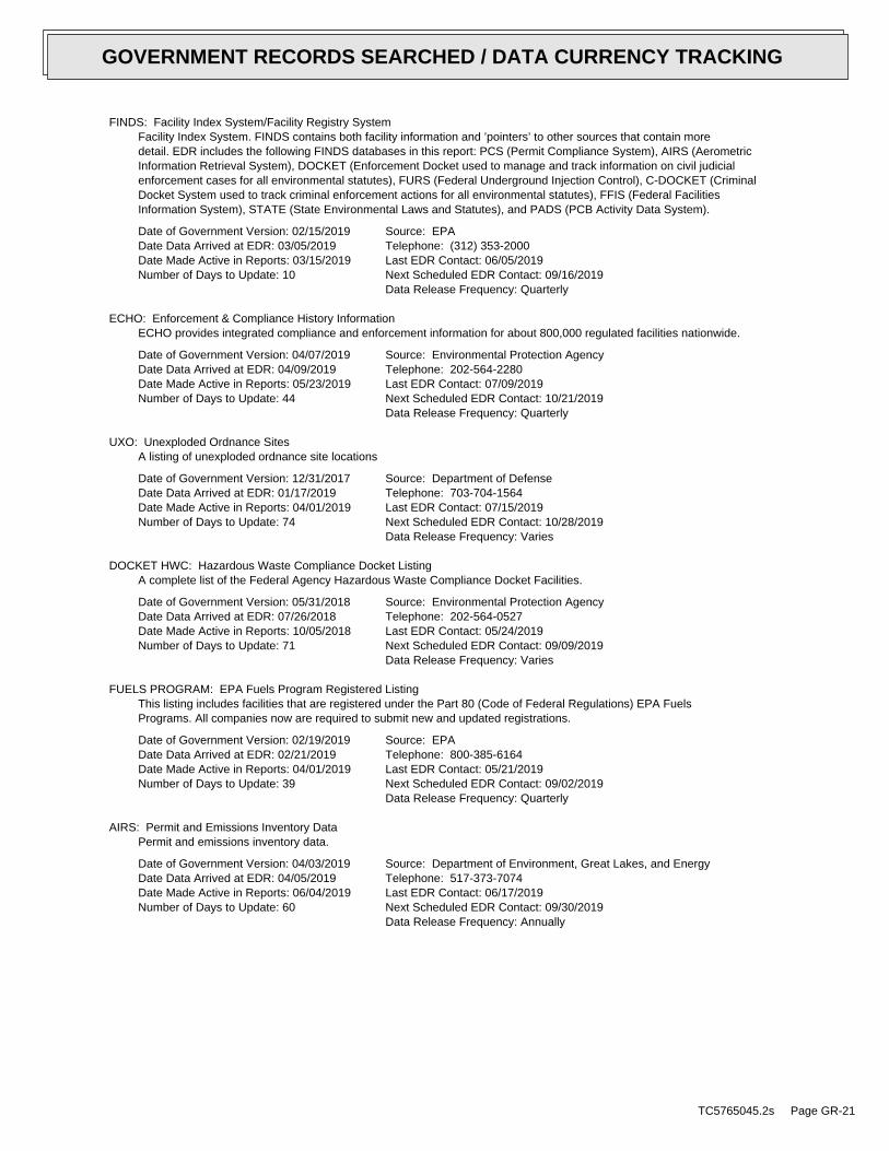
FINDS: Facility Index System/Facility Registry SystemFacility Index System. FINDS contains both facility information and ’pointers’ to other sources that contain moredetail. EDR includes the following FINDS databases in this report: PCS (Permit Compliance System), AIRS (AerometricInformation Retrieval System), DOCKET (Enforcement Docket used to manage and track information on civil judicialenforcement cases for all environmental statutes), FURS (Federal Underground Injection Control), C-DOCKET (CriminalDocket System used to track criminal enforcement actions for all environmental statutes), FFIS (Federal FacilitiesInformation System), STATE (State Environmental Laws and Statutes), and PADS (PCB Activity Data System).
Date of Government Version: 02/15/2019Date Data Arrived at EDR: 03/05/2019Date Made Active in Reports: 03/15/2019Number of Days to Update: 10
Source: EPATelephone: (312) 353-2000Last EDR Contact: 06/05/2019Next Scheduled EDR Contact: 09/16/2019Data Release Frequency: Quarterly
ECHO: Enforcement & Compliance History InformationECHO provides integrated compliance and enforcement information for about 800,000 regulated facilities nationwide.
Date of Government Version: 04/07/2019Date Data Arrived at EDR: 04/09/2019Date Made Active in Reports: 05/23/2019Number of Days to Update: 44
Source: Environmental Protection AgencyTelephone: 202-564-2280Last EDR Contact: 07/09/2019Next Scheduled EDR Contact: 10/21/2019Data Release Frequency: Quarterly
UXO: Unexploded Ordnance SitesA listing of unexploded ordnance site locations
Date of Government Version: 12/31/2017Date Data Arrived at EDR: 01/17/2019Date Made Active in Reports: 04/01/2019Number of Days to Update: 74
Source: Department of DefenseTelephone: 703-704-1564Last EDR Contact: 07/15/2019Next Scheduled EDR Contact: 10/28/2019Data Release Frequency: Varies
DOCKET HWC: Hazardous Waste Compliance Docket ListingA complete list of the Federal Agency Hazardous Waste Compliance Docket Facilities.
Date of Government Version: 05/31/2018Date Data Arrived at EDR: 07/26/2018Date Made Active in Reports: 10/05/2018Number of Days to Update: 71
Source: Environmental Protection AgencyTelephone: 202-564-0527Last EDR Contact: 05/24/2019Next Scheduled EDR Contact: 09/09/2019Data Release Frequency: Varies
FUELS PROGRAM: EPA Fuels Program Registered ListingThis listing includes facilities that are registered under the Part 80 (Code of Federal Regulations) EPA FuelsPrograms. All companies now are required to submit new and updated registrations.
Date of Government Version: 02/19/2019Date Data Arrived at EDR: 02/21/2019Date Made Active in Reports: 04/01/2019Number of Days to Update: 39
Source: EPATelephone: 800-385-6164Last EDR Contact: 05/21/2019Next Scheduled EDR Contact: 09/02/2019Data Release Frequency: Quarterly
AIRS: Permit and Emissions Inventory DataPermit and emissions inventory data.
Date of Government Version: 04/03/2019Date Data Arrived at EDR: 04/05/2019Date Made Active in Reports: 06/04/2019Number of Days to Update: 60
Source: Department of Environment, Great Lakes, and EnergyTelephone: 517-373-7074Last EDR Contact: 06/17/2019Next Scheduled EDR Contact: 09/30/2019Data Release Frequency: Annually
TC5765045.2s Page GR-21
GOVERNMENT RECORDS SEARCHED / DATA CURRENCY TRACKING

ASBESTOS: Asbestos Notification ListingAsbestos
Date of Government Version: 04/30/2019Date Data Arrived at EDR: 05/07/2019Date Made Active in Reports: 06/04/2019Number of Days to Update: 28
Source: Department of Licensing & Regulatory AffairsTelephone: 517-284-7699Last EDR Contact: 07/01/2019Next Scheduled EDR Contact: 08/12/2019Data Release Frequency: Quarterly
BEA: Baseline Environmental Assessment DatabaseA BEA is a document that new or prospective property owners/operations disclose to the DEQ identifying the propertyas a facility pursuant to Part 201 and Part 213. The Inventory of BEA Facilities overlaps in part with the Part201 Projects facilities and Part 213 facilities. There may be more than one BEA for each facility.
Date of Government Version: 08/21/2013Date Data Arrived at EDR: 08/23/2013Date Made Active in Reports: 09/12/2013Number of Days to Update: 20
Source: Department of Environment, Great Lakes, and EnergyTelephone: 517-373-9541Last EDR Contact: 05/10/2019Next Scheduled EDR Contact: 08/26/2019Data Release Frequency: No Update Planned
COAL ASH: Coal Ash Disposal SitesCoal fired power plants in Southeast Michigan that have coal ash handling on site.
Date of Government Version: 10/20/2016Date Data Arrived at EDR: 02/02/2017Date Made Active in Reports: 04/20/2017Number of Days to Update: 77
Source: Department of Environment, Great Lakes, and EnergyTelephone: 586-753-3754Last EDR Contact: 06/26/2019Next Scheduled EDR Contact: 10/14/2019Data Release Frequency: Varies
DRYCLEANERS: Drycleaning EstablishmentsA listing of drycleaning facilities in Michigan.
Date of Government Version: 01/15/2019Date Data Arrived at EDR: 01/17/2019Date Made Active in Reports: 04/01/2019Number of Days to Update: 74
Source: Department of Environment, Great Lakes, and EnergyTelephone: 517-335-4586Last EDR Contact: 07/19/2019Next Scheduled EDR Contact: 10/28/2019Data Release Frequency: Quarterly
Financial Assurance 1: Financial Assurance Information ListingFinancial assurance information.
Date of Government Version: 04/10/2019Date Data Arrived at EDR: 04/11/2019Date Made Active in Reports: 05/07/2019Number of Days to Update: 26
Source: Department of Environment, Great Lakes, and EnergyTelephone: 517-335-6610Last EDR Contact: 06/26/2019Next Scheduled EDR Contact: 10/14/2019Data Release Frequency: Semi-Annually
FINANCIAL ASSURANCE 3: Financial Assurance Information ListingFinancial assurance information for underground storage tank facilities.
Date of Government Version: 04/08/2019Date Data Arrived at EDR: 04/24/2019Date Made Active in Reports: 06/14/2019Number of Days to Update: 51
Source: Department of Licensing & Regulatory AffairsTelephone: 517-335-7279Last EDR Contact: 06/26/2019Next Scheduled EDR Contact: 10/14/2019Data Release Frequency: Varies
Financial Assurance 2: Financial Assurance Information ListingA listing of financial assurance information for solid waste facilities. Financial assurance is intended to ensurethat resources are available to pay for the cost of closure, post-closure care, and corrective measures if theowner or operator of a regulated facility is unable or unwilling to pay.
TC5765045.2s Page GR-22
GOVERNMENT RECORDS SEARCHED / DATA CURRENCY TRACKING

Date of Government Version: 02/19/2019Date Data Arrived at EDR: 02/22/2019Date Made Active in Reports: 03/22/2019Number of Days to Update: 28
Source: Department of Environment, Great Lakes, and EnergyTelephone: 517-335-4034Last EDR Contact: 06/20/2019Next Scheduled EDR Contact: 10/07/2019Data Release Frequency: Varies
LEAD CERT: Lead Safe Housing RegistryA listing of Michigan properties included in the Lead Safe Housing Registry.
Date of Government Version: 09/15/2015Date Data Arrived at EDR: 09/16/2015Date Made Active in Reports: 09/30/2015Number of Days to Update: 14
Source: Department of Community HealthTelephone: 517-335-9699Last EDR Contact: 06/03/2019Next Scheduled EDR Contact: 09/16/2019Data Release Frequency: Quarterly
NPDES: List of Active NPDES PermitsGeneral information regarding NPDES (National Pollutant Discharge Elimination System) permits and NPDES StormWater permits.
Date of Government Version: 03/27/2019Date Data Arrived at EDR: 04/03/2019Date Made Active in Reports: 05/07/2019Number of Days to Update: 34
Source: Department of Environment, Great Lakes, and EnergyTelephone: 517-241-1300Last EDR Contact: 07/03/2019Next Scheduled EDR Contact: 10/14/2019Data Release Frequency: Varies
UIC: Underground Injection Wells DatabaseA listing of underground injection well locations. The UIC Program is responsible for regulating the construction,operation, permitting, and closure of injection wells that place fluids underground for storage or disposal.
Date of Government Version: 01/29/2019Date Data Arrived at EDR: 01/30/2019Date Made Active in Reports: 04/01/2019Number of Days to Update: 61
Source: Department of Environment, Great Lakes, and EnergyTelephone: 517-241-1515Last EDR Contact: 07/09/2019Next Scheduled EDR Contact: 11/04/2019Data Release Frequency: Quarterly
WDS: Waste Data SystemThe Waste Data System (WDS) tracks activities at facilities regulated by the Solid Waste, Scrap Tire, HazardousWaste, and Liquid Industrial Waste programs.
Date of Government Version: 05/17/2019Date Data Arrived at EDR: 05/17/2019Date Made Active in Reports: 06/05/2019Number of Days to Update: 19
Source: Department of Environment, Great Lakes, and EnergyTelephone: 517-284-6562Last EDR Contact: 05/16/2019Next Scheduled EDR Contact: 09/02/2019Data Release Frequency: Varies
EDR HIGH RISK HISTORICAL RECORDS
EDR Exclusive Records
EDR MGP: EDR Proprietary Manufactured Gas PlantsThe EDR Proprietary Manufactured Gas Plant Database includes records of coal gas plants (manufactured gas plants)compiled by EDR’s researchers. Manufactured gas sites were used in the United States from the 1800’s to 1950’sto produce a gas that could be distributed and used as fuel. These plants used whale oil, rosin, coal, or a mixtureof coal, oil, and water that also produced a significant amount of waste. Many of the byproducts of the gas production,such as coal tar (oily waste containing volatile and non-volatile chemicals), sludges, oils and other compoundsare potentially hazardous to human health and the environment. The byproduct from this process was frequentlydisposed of directly at the plant site and can remain or spread slowly, serving as a continuous source of soiland groundwater contamination.
Date of Government Version: N/ADate Data Arrived at EDR: N/ADate Made Active in Reports: N/ANumber of Days to Update: N/A
Source: EDR, Inc.Telephone: N/ALast EDR Contact: N/ANext Scheduled EDR Contact: N/AData Release Frequency: No Update Planned
TC5765045.2s Page GR-23
GOVERNMENT RECORDS SEARCHED / DATA CURRENCY TRACKING

EDR Hist Auto: EDR Exclusive Historical Auto StationsEDR has searched selected national collections of business directories and has collected listings of potentialgas station/filling station/service station sites that were available to EDR researchers. EDR’s review was limitedto those categories of sources that might, in EDR’s opinion, include gas station/filling station/service stationestablishments. The categories reviewed included, but were not limited to gas, gas station, gasoline station,filling station, auto, automobile repair, auto service station, service station, etc. This database falls withina category of information EDR classifies as "High Risk Historical Records", or HRHR. EDR’s HRHR effort presentsunique and sometimes proprietary data about past sites and operations that typically create environmental concerns,but may not show up in current government records searches.
Date of Government Version: N/ADate Data Arrived at EDR: N/ADate Made Active in Reports: N/ANumber of Days to Update: N/A
Source: EDR, Inc.Telephone: N/ALast EDR Contact: N/ANext Scheduled EDR Contact: N/AData Release Frequency: Varies
EDR Hist Cleaner: EDR Exclusive Historical CleanersEDR has searched selected national collections of business directories and has collected listings of potentialdry cleaner sites that were available to EDR researchers. EDR’s review was limited to those categories of sourcesthat might, in EDR’s opinion, include dry cleaning establishments. The categories reviewed included, but werenot limited to dry cleaners, cleaners, laundry, laundromat, cleaning/laundry, wash & dry etc. This database fallswithin a category of information EDR classifies as "High Risk Historical Records", or HRHR. EDR’s HRHR effortpresents unique and sometimes proprietary data about past sites and operations that typically create environmentalconcerns, but may not show up in current government records searches.
Date of Government Version: N/ADate Data Arrived at EDR: N/ADate Made Active in Reports: N/ANumber of Days to Update: N/A
Source: EDR, Inc.Telephone: N/ALast EDR Contact: N/ANext Scheduled EDR Contact: N/AData Release Frequency: Varies
EDR RECOVERED GOVERNMENT ARCHIVES
Exclusive Recovered Govt. Archives
RGA PART 201: Recovered Government Archive State Hazardous Waste Facilities ListThe EDR Recovered Government Archive State Hazardous Waste database provides a list of SHWS incidents derivedfrom historical databases and includes many records that no longer appear in current government lists. Compiledfrom Records formerly available from the Department of Environmental Quality in Michigan.
Date of Government Version: N/ADate Data Arrived at EDR: 07/01/2013Date Made Active in Reports: 12/24/2013Number of Days to Update: 176
Source: Department of Environment, Great Lakes, and EnergyTelephone: N/ALast EDR Contact: 06/01/2012Next Scheduled EDR Contact: N/AData Release Frequency: Varies
RGA LF: Recovered Government Archive Solid Waste Facilities ListThe EDR Recovered Government Archive Landfill database provides a list of landfills derived from historical databasesand includes many records that no longer appear in current government lists. Compiled from Records formerly availablefrom the Department of Environmental Quality in Michigan.
Date of Government Version: N/ADate Data Arrived at EDR: 07/01/2013Date Made Active in Reports: 01/13/2014Number of Days to Update: 196
Source: Department of Environment, Great Lakes, and EnergyTelephone: N/ALast EDR Contact: 06/01/2012Next Scheduled EDR Contact: N/AData Release Frequency: Varies
RGA LUST: Recovered Government Archive Leaking Underground Storage TankThe EDR Recovered Government Archive Leaking Underground Storage Tank database provides a list of LUST incidentsderived from historical databases and includes many records that no longer appear in current government lists.Compiled from Records formerly available from the Department of Environmental Quality in Michigan.
TC5765045.2s Page GR-24
GOVERNMENT RECORDS SEARCHED / DATA CURRENCY TRACKING

Date of Government Version: N/ADate Data Arrived at EDR: 07/01/2013Date Made Active in Reports: 12/24/2013Number of Days to Update: 176
Source: Department of Environment, Great Lakes, and EnergyTelephone: N/ALast EDR Contact: 06/01/2012Next Scheduled EDR Contact: N/AData Release Frequency: Varies
OTHER DATABASE(S)
Depending on the geographic area covered by this report, the data provided in these specialty databases may or may not becomplete. For example, the existence of wetlands information data in a specific report does not mean that all wetlands in thearea covered by the report are included. Moreover, the absence of any reported wetlands information does not necessarilymean that wetlands do not exist in the area covered by the report.
CT MANIFEST: Hazardous Waste Manifest DataFacility and manifest data. Manifest is a document that lists and tracks hazardous waste from the generator throughtransporters to a tsd facility.
Date of Government Version: 02/11/2019Date Data Arrived at EDR: 02/12/2019Date Made Active in Reports: 03/04/2019Number of Days to Update: 20
Source: Department of Energy & Environmental ProtectionTelephone: 860-424-3375Last EDR Contact: 05/14/2019Next Scheduled EDR Contact: 08/26/2019Data Release Frequency: No Update Planned
NJ MANIFEST: Manifest InformationHazardous waste manifest information.
Date of Government Version: 12/31/2018Date Data Arrived at EDR: 04/10/2019Date Made Active in Reports: 05/16/2019Number of Days to Update: 36
Source: Department of Environmental ProtectionTelephone: N/ALast EDR Contact: 07/09/2019Next Scheduled EDR Contact: 10/21/2019Data Release Frequency: Annually
NY MANIFEST: Facility and Manifest DataManifest is a document that lists and tracks hazardous waste from the generator through transporters to a TSDfacility.
Date of Government Version: 01/01/2019Date Data Arrived at EDR: 05/01/2019Date Made Active in Reports: 06/21/2019Number of Days to Update: 51
Source: Department of Environmental ConservationTelephone: 518-402-8651Last EDR Contact: 05/01/2019Next Scheduled EDR Contact: 08/12/2019Data Release Frequency: Quarterly
PA MANIFEST: Manifest InformationHazardous waste manifest information.
Date of Government Version: 12/31/2017Date Data Arrived at EDR: 10/23/2018Date Made Active in Reports: 11/27/2018Number of Days to Update: 35
Source: Department of Environmental ProtectionTelephone: 717-783-8990Last EDR Contact: 07/15/2019Next Scheduled EDR Contact: 10/28/2019Data Release Frequency: Annually
RI MANIFEST: Manifest informationHazardous waste manifest information
Date of Government Version: 12/31/2017Date Data Arrived at EDR: 02/23/2018Date Made Active in Reports: 04/09/2018Number of Days to Update: 45
Source: Department of Environmental ManagementTelephone: 401-222-2797Last EDR Contact: 05/17/2019Next Scheduled EDR Contact: 09/02/2019Data Release Frequency: Annually
TC5765045.2s Page GR-25
GOVERNMENT RECORDS SEARCHED / DATA CURRENCY TRACKING

WI MANIFEST: Manifest InformationHazardous waste manifest information.
Date of Government Version: 12/31/2017Date Data Arrived at EDR: 06/15/2018Date Made Active in Reports: 07/09/2018Number of Days to Update: 24
Source: Department of Natural ResourcesTelephone: N/ALast EDR Contact: 06/10/2019Next Scheduled EDR Contact: 09/23/2019Data Release Frequency: Annually
Oil/Gas PipelinesSource: PennWell CorporationPetroleum Bundle (Crude Oil, Refined Products, Petrochemicals, Gas Liquids (LPG/NGL), and SpecialtyGases (Miscellaneous)) N = Natural Gas Bundle (Natural Gas, Gas Liquids (LPG/NGL), and Specialty Gases(Miscellaneous)). This map includes information copyrighted by PennWell Corporation. This informationis provided on a best effort basis and PennWell Corporation does not guarantee its accuracy nor warrantits fitness for any particular purpose. Such information has been reprinted with the permission of PennWell.
Electric Power Transmission Line DataSource: PennWell CorporationThis map includes information copyrighted by PennWell Corporation. This information is provided on a besteffort basis and PennWell Corporation does not guarantee its accuracy nor warrant its fitness for anyparticular purpose. Such information has been reprinted with the permission of PennWell.
Sensitive Receptors: There are individuals deemed sensitive receptors due to their fragile immune systems and special sensitivityto environmental discharges. These sensitive receptors typically include the elderly, the sick, and children. While the location of allsensitive receptors cannot be determined, EDR indicates those buildings and facilities - schools, daycares, hospitals, medical centers,and nursing homes - where individuals who are sensitive receptors are likely to be located.
AHA Hospitals:Source: American Hospital Association, Inc.Telephone: 312-280-5991The database includes a listing of hospitals based on the American Hospital Association’s annual survey of hospitals.
Medical Centers: Provider of Services ListingSource: Centers for Medicare & Medicaid ServicesTelephone: 410-786-3000A listing of hospitals with Medicare provider number, produced by Centers of Medicare & Medicaid Services,a federal agency within the U.S. Department of Health and Human Services.
Nursing HomesSource: National Institutes of HealthTelephone: 301-594-6248Information on Medicare and Medicaid certified nursing homes in the United States.
Public SchoolsSource: National Center for Education StatisticsTelephone: 202-502-7300The National Center for Education Statistics’ primary database on elementaryand secondary public education in the United States. It is a comprehensive, annual, national statisticaldatabase of all public elementary and secondary schools and school districts, which contains data that arecomparable across all states.
Private SchoolsSource: National Center for Education StatisticsTelephone: 202-502-7300The National Center for Education Statistics’ primary database on private school locations in the United States.
Daycare Centers: Day Care Centers, Group & Family HomesSource: Bureau of REgulatory ServicesTelephone: 517-373-8300
Flood Zone Data: This data was obtained from the Federal Emergency Management Agency (FEMA). It depicts 100-year and500-year flood zones as defined by FEMA. It includes the National Flood Hazard Layer (NFHL) which incorporates FloodInsurance Rate Map (FIRM) data and Q3 data from FEMA in areas not covered by NFHL.
Source: FEMATelephone: 877-336-2627Date of Government Version: 2003, 2015
TC5765045.2s Page GR-26
GOVERNMENT RECORDS SEARCHED / DATA CURRENCY TRACKING

NWI: National Wetlands Inventory. This data, available in select counties across the country, was obtained by EDRin 2002, 2005 and 2010 from the U.S. Fish and Wildlife Service.
State Wetlands Data: Wetlands InventorySource: Department of Natural ResourcesTelephone: 517-241-2254
Current USGS 7.5 Minute Topographic MapSource: U.S. Geological Survey
STREET AND ADDRESS INFORMATION
© 2015 TomTom North America, Inc. All rights reserved. This material is proprietary and the subject of copyright protectionand other intellectual property rights owned by or licensed to Tele Atlas North America, Inc. The use of this material is subjectto the terms of a license agreement. You will be held liable for any unauthorized copying or disclosure of this material.
TC5765045.2s Page GR-27
GOVERNMENT RECORDS SEARCHED / DATA CURRENCY TRACKING

TC5765045.2s Page A-1
geologic strata.of the soil, and nearby wells. Groundwater flow velocity is generally impacted by the nature of theGroundwater flow direction may be impacted by surface topography, hydrology, hydrogeology, characteristics
2. Groundwater flow velocity. 1. Groundwater flow direction, and
Assessment of the impact of contaminant migration generally has two principle investigative components:
forming an opinion about the impact of potential contaminant migration.EDR’s GeoCheck Physical Setting Source Addendum is provided to assist the environmental professional in
2014Version Date:6066036 MEARS, MIWest Map:
2014Version Date:6066034 HART, MITarget Property Map:
USGS TOPOGRAPHIC MAP
654 ft. above sea levelElevation:4838797.0UTM Y (Meters): 551409.9UTM X (Meters): Zone 16Universal Tranverse Mercator: 86.361972 - 86˚ 21’ 43.10’’Longitude (West): 43.702358 - 43˚ 42’ 8.49’’Latitude (North):
TARGET PROPERTY COORDINATES
HART, MI 49420227 EAST MAIN STREETCOMMERCIAL PROPERTY
TARGET PROPERTY ADDRESS
®GEOCHECK - PHYSICAL SETTING SOURCE ADDENDUM®

TC5765045.2s Page A-2
should be field verified.on a relative (not an absolute) basis. Relative elevation information between sites of close proximitySource: Topography has been determined from the USGS 7.5’ Digital Elevation Model and should be evaluated
SURROUNDING TOPOGRAPHY: ELEVATION PROFILES
Ele
vatio
n (f
t)E
leva
tion
(ft)
TP
TP0 1/2 1 Miles
✩Target Property Elevation: 654 ft.
North South
West East
694
692
690
685
681
688
680
684668654620
620
620
684
696
702
706
699
704675
680
678
677
675
673
637
657
651
654
646
662
687
694
695
698
694
721
740
General NNWGeneral Topographic Gradient:TARGET PROPERTY TOPOGRAPHY
should contamination exist on the target property, what downgradient sites might be impacted.assist the environmental professional in forming an opinion about the impact of nearby contaminated properties or,Surface topography may be indicative of the direction of surficial groundwater flow. This information can be used toTOPOGRAPHIC INFORMATION
collected on nearby properties, and regional groundwater flow information (from deep aquifers).sources of information, such as surface topographic information, hydrologic information, hydrogeologic datausing site-specific well data. If such data is not reasonably ascertainable, it may be necessary to rely on otherGroundwater flow direction for a particular site is best determined by a qualified environmental professionalGROUNDWATER FLOW DIRECTION INFORMATION
®GEOCHECK - PHYSICAL SETTING SOURCE SUMMARY®

TC5765045.2s Page A-3
Not Reported
GENERAL DIRECTIONLOCATIONGROUNDWATER FLOWFROM TPMAP ID
hydrogeologically, and the depth to water table.authorities at select sites and has extracted the date of the report, groundwater flow direction as determinedflow at specific points. EDR has reviewed reports submitted by environmental professionals to regulatoryEDR has developed the AQUIFLOW Information System to provide data on the general direction of groundwater
AQUIFLOW®
Search Radius: 1.000 Mile.
Not found Status:1.25 miles Search Radius:
Site-Specific Hydrogeological Data*:
* ©1996 Site−specific hydrogeological data gathered by CERCLIS Alerts, Inc., Bainbridge Island, WA. All rights reserved. All of the information and opinions presented are those of the cited EPA report(s), which were completed undera Comprehensive Environmental Response Compensation and Liability Information System (CERCLIS) investigation.
contamination exist on the target property, what downgradient sites might be impacted.environmental professional in forming an opinion about the impact of nearby contaminated properties or, shouldof groundwater flow direction in the immediate area. Such hydrogeologic information can be used to assist theHydrogeologic information obtained by installation of wells on a specific site can often be an indicatorHYDROGEOLOGIC INFORMATION
YES - refer to the Overview Map and Detail MapHART
NATIONAL WETLAND INVENTORYNWI ElectronicData CoverageNWI Quad at Target Property
FEMA FIRM Flood data26127C0150C
Additional Panels in search area: FEMA Source Type
FEMA FIRM Flood data26127C0175C
Flood Plain Panel at Target Property FEMA Source Type
FEMA FLOOD ZONE
and bodies of water).Refer to the Physical Setting Source Map following this summary for hydrologic information (major waterways
contamination exist on the target property, what downgradient sites might be impacted.the environmental professional in forming an opinion about the impact of nearby contaminated properties or, shouldSurface water can act as a hydrologic barrier to groundwater flow. Such hydrologic information can be used to assistHYDROLOGIC INFORMATION
®GEOCHECK - PHYSICAL SETTING SOURCE SUMMARY®

TC5765045.2s Page A-4
Map, USGS Digital Data Series DDS - 11 (1994).of the Conterminous U.S. at 1:2,500,000 Scale - a digital representation of the 1974 P.B. King and H.M. BeikmanGeologic Age and Rock Stratigraphic Unit Source: P.G. Schruben, R.E. Arndt and W.J. Bawiec, Geology
ROCK STRATIGRAPHIC UNIT GEOLOGIC AGE IDENTIFICATION
Stratified SequenceCategory:PaleozoicEra:MississippianSystem:Osagean and Kinderhookian SeriesSeries:M1Code: (decoded above as Era, System & Series)
at which contaminant migration may be occurring.Geologic information can be used by the environmental professional in forming an opinion about the relative speedGEOLOGIC INFORMATION IN GENERAL AREA OF TARGET PROPERTY
move more quickly through sandy-gravelly types of soils than silty-clayey types of soils.characteristics data collected on nearby properties and regional soil information. In general, contaminant plumesto rely on other sources of information, including geologic age identification, rock stratigraphic unit and soilusing site specific geologic and soil strata data. If such data are not reasonably ascertainable, it may be necessaryGroundwater flow velocity information for a particular site is best determined by a qualified environmental professionalGROUNDWATER FLOW VELOCITY INFORMATION
®GEOCHECK - PHYSICAL SETTING SOURCE SUMMARY®

EDR Inc.EDR Inc.EDR Inc.EDR Inc.EDR Inc.EDR Inc.EDR Inc.EDR Inc.EDR Inc.EDR Inc.EDR Inc.EDR Inc.EDR Inc.EDR Inc.EDR Inc.EDR Inc.EDR Inc.EDR Inc.EDR Inc.EDR Inc.EDR Inc.EDR Inc.EDR Inc.EDR Inc.EDR Inc.EDR Inc.EDR Inc.EDR Inc.EDR Inc.EDR Inc.EDR Inc.EDR Inc.EDR Inc.EDR Inc.EDR Inc.EDR Inc.EDR Inc.EDR Inc.EDR Inc.EDR Inc.
2
8
7
5
1
6
45
9 2
33
0 1/16 1/8 1/4 Miles
TC5765045.2s Page A-6
Min: 5.1Max: 7.3
Min: 42Max: 141
Silty Sand.Sands with fines,SOILS, Sands,COARSE-GRAINED
Sand.200), Finepassing No.pct. or lessmaterials (35Granularsand59 inches46 inches 3
Min: 5.1Max: 7.3
Min: 42Max: 141
Silty Sand.Sands with fines,SOILS, Sands,COARSE-GRAINED
Sand.200), Finepassing No.pct. or lessmaterials (35Granularsand46 inches 7 inches 2
Min: 5.1Max: 7.3
Min: 42Max: 141
Silty Sand.Sands with fines,SOILS, Sands,COARSE-GRAINED
Sand.200), Finepassing No.pct. or lessmaterials (35Granularsand 7 inches 0 inches 1
Soil Layer Information
Boundary Classification Saturatedhydraulicconductivitymicro m/sec
Layer Upper Lower Soil Texture Class AASHTO Group Unified Soil Soil Reaction(pH)
> 0 inchesDepth to Watertable Min:
> 0 inchesDepth to Bedrock Min:
LowCorrosion Potential - Uncoated Steel:
Hydric Status: Partially hydric
Excessively drainedSoil Drainage Class:
excessively drained sands and gravels.Class A - High infiltration rates. Soils are deep, well drained toHydrologic Group:
sandSoil Surface Texture:
BenonaSoil Component Name:
Soil Map ID: 1
in a landscape. The following information is based on Soil Conservation Service SSURGO data.for privately owned lands in the United States. A soil map in a soil survey is a representation of soil patternsSurvey (NCSS) and is responsible for collecting, storing, maintaining and distributing soil survey informationThe U.S. Department of Agriculture’s (USDA) Soil Conservation Service (SCS) leads the National Cooperative Soil
DOMINANT SOIL COMPOSITION IN GENERAL AREA OF TARGET PROPERTY
®GEOCHECK - PHYSICAL SETTING SOURCE SUMMARY®

TC5765045.2s Page A-7
Min: 7.9Max: 8.4
Min: 0.42Max: 1.4
50%), Lean Claylimit less thanClays (liquidSOILS, Silts andFINE-GRAINED
Soils.200), Siltypassing No.than 35 pct.Materials (moreSilt-Clayloam 9 inches 0 inches 1
Soil Layer Information
Boundary Classification Saturatedhydraulicconductivitymicro m/sec
Layer Upper Lower Soil Texture Class AASHTO Group Unified Soil Soil Reaction(pH)
> 0 inchesDepth to Watertable Min:
> 0 inchesDepth to Bedrock Min:
HighCorrosion Potential - Uncoated Steel:
Hydric Status: Not hydric
Well drainedSoil Drainage Class:
movement of water, or soils with moderately fine or fine textures.Class C - Slow infiltration rates. Soils with layers impeding downwardHydrologic Group:
loamSoil Surface Texture:
PerrintonSoil Component Name:
Soil Map ID: 3
No Layer Information available.
> 0 inchesDepth to Watertable Min:
> 0 inchesDepth to Bedrock Min:
Not ReportedCorrosion Potential - Uncoated Steel:
Hydric Status: UnknownSoil Drainage Class:
excessively drained sands and gravels.Class A - High infiltration rates. Soils are deep, well drained toHydrologic Group:
sandSoil Surface Texture:
WaterSoil Component Name:
Soil Map ID: 2
®GEOCHECK - PHYSICAL SETTING SOURCE SUMMARY®

TC5765045.2s Page A-8
> 0 inchesDepth to Watertable Min:
> 0 inchesDepth to Bedrock Min:
LowCorrosion Potential - Uncoated Steel:
Hydric Status: Not hydric
Excessively drainedSoil Drainage Class:
excessively drained sands and gravels.Class A - High infiltration rates. Soils are deep, well drained toHydrologic Group:
sandSoil Surface Texture:
GrattanSoil Component Name:
Soil Map ID: 4
Min: 7.9Max: 8.4
Min: 0.42Max: 1.4
50%), Lean Claylimit less thanClays (liquidSOILS, Silts andFINE-GRAINED
Soils.200), Siltypassing No.than 35 pct.Materials (moreSilt-Claysilty clay59 inches35 inches 4
Min: 7.9Max: 8.4
Min: 0.42Max: 1.4
50%), Lean Claylimit less thanClays (liquidSOILS, Silts andFINE-GRAINED
Soils.200), Siltypassing No.than 35 pct.Materials (moreSilt-Claysilty clay35 inches18 inches 3
Min: 7.9Max: 8.4
Min: 0.42Max: 1.4
50%), Lean Claylimit less thanClays (liquidSOILS, Silts andFINE-GRAINED
Soils.200), Siltypassing No.than 35 pct.Materials (moreSilt-Clayfine sandy loam18 inches 9 inches 2
Soil Layer Information
Boundary Classification Saturatedhydraulicconductivitymicro m/sec
Layer Upper Lower Soil Texture Class AASHTO Group Unified Soil Soil Reaction(pH)
®GEOCHECK - PHYSICAL SETTING SOURCE SUMMARY®

TC5765045.2s Page A-9
> 0 inchesDepth to Watertable Min:
> 0 inchesDepth to Bedrock Min:
LowCorrosion Potential - Uncoated Steel:
Hydric Status: Partially hydric
Excessively drainedSoil Drainage Class:
excessively drained sands and gravels.Class A - High infiltration rates. Soils are deep, well drained toHydrologic Group:
sandSoil Surface Texture:
GrattanSoil Component Name:
Soil Map ID: 5
Min: 5.6Max: 7.3
Min: 42Max: 141
Silty Sand.Sands with fines,SOILS, Sands,COARSE-GRAINEDsand.Poorly gradedClean Sands,SOILS, Sands,COARSE-GRAINED
Sand.200), Finepassing No.pct. or lessmaterials (35Granularsand59 inches31 inches 3
Min: 5.6Max: 7.3
Min: 42Max: 141
Silty Sand.Sands with fines,SOILS, Sands,COARSE-GRAINEDsand.Poorly gradedClean Sands,SOILS, Sands,COARSE-GRAINED
Sand.200), Finepassing No.pct. or lessmaterials (35Granularsand31 inches 3 inches 2
Min: 5.6Max: 7.3
Min: 42Max: 141
Silty Sand.Sands with fines,SOILS, Sands,COARSE-GRAINEDsand.Poorly gradedClean Sands,SOILS, Sands,COARSE-GRAINED
Sand.200), Finepassing No.pct. or lessmaterials (35Granularsand 3 inches 0 inches 1
Soil Layer Information
Boundary Classification Saturatedhydraulicconductivitymicro m/sec
Layer Upper Lower Soil Texture Class AASHTO Group Unified Soil Soil Reaction(pH)
®GEOCHECK - PHYSICAL SETTING SOURCE SUMMARY®

TC5765045.2s Page A-10
> 84 inchesDepth to Watertable Min:
> 0 inchesDepth to Bedrock Min:
LowCorrosion Potential - Uncoated Steel:
Hydric Status: Partially hydric
Moderately well drainedSoil Drainage Class:
excessively drained sands and gravels.Class A - High infiltration rates. Soils are deep, well drained toHydrologic Group:
sandSoil Surface Texture:
CovertSoil Component Name:
Soil Map ID: 6
Min: 5.6Max: 7.3
Min: 42Max: 141
Silty Sand.Sands with fines,SOILS, Sands,COARSE-GRAINEDsand.Poorly gradedClean Sands,SOILS, Sands,COARSE-GRAINED
Sand.200), Finepassing No.pct. or lessmaterials (35Granularsand59 inches31 inches 3
Min: 5.6Max: 7.3
Min: 42Max: 141
Silty Sand.Sands with fines,SOILS, Sands,COARSE-GRAINEDsand.Poorly gradedClean Sands,SOILS, Sands,COARSE-GRAINED
Sand.200), Finepassing No.pct. or lessmaterials (35Granularsand31 inches 3 inches 2
Min: 5.6Max: 7.3
Min: 42Max: 141
Silty Sand.Sands with fines,SOILS, Sands,COARSE-GRAINEDsand.Poorly gradedClean Sands,SOILS, Sands,COARSE-GRAINED
Sand.200), Finepassing No.pct. or lessmaterials (35Granularsand 3 inches 0 inches 1
Soil Layer Information
Boundary Classification Saturatedhydraulicconductivitymicro m/sec
Layer Upper Lower Soil Texture Class AASHTO Group Unified Soil Soil Reaction(pH)
®GEOCHECK - PHYSICAL SETTING SOURCE SUMMARY®

TC5765045.2s Page A-11
> 0 inchesDepth to Watertable Min:
> 0 inchesDepth to Bedrock Min:
LowCorrosion Potential - Uncoated Steel:
Hydric Status: Not hydric
Excessively drainedSoil Drainage Class:
excessively drained sands and gravels.Class A - High infiltration rates. Soils are deep, well drained toHydrologic Group:
sandSoil Surface Texture:
GrattanSoil Component Name:
Soil Map ID: 7
Min: 5.1Max: 7.3
Min: 42Max: 141
Silty Sand.Sands with fines,SOILS, Sands,COARSE-GRAINED
Sand.200), Finepassing No.pct. or lessmaterials (35Granularsand59 inches33 inches 3
Min: 5.1Max: 7.3
Min: 42Max: 141
Silty Sand.Sands with fines,SOILS, Sands,COARSE-GRAINED
Sand.200), Finepassing No.pct. or lessmaterials (35Granularsand33 inches 0 inches 2
Min: 5.1Max: 7.3
Min: 42Max: 141
Silty Sand.Sands with fines,SOILS, Sands,COARSE-GRAINED
Sand.200), Finepassing No.pct. or lessmaterials (35Granularsand 0 inches 0 inches 1
Soil Layer Information
Boundary Classification Saturatedhydraulicconductivitymicro m/sec
Layer Upper Lower Soil Texture Class AASHTO Group Unified Soil Soil Reaction(pH)
®GEOCHECK - PHYSICAL SETTING SOURCE SUMMARY®

TC5765045.2s Page A-12
> 0 inchesDepth to Watertable Min:
> 0 inchesDepth to Bedrock Min:
LowCorrosion Potential - Uncoated Steel:
Hydric Status: Not hydric
Well drainedSoil Drainage Class:
excessively drained sands and gravels.Class A - High infiltration rates. Soils are deep, well drained toHydrologic Group:
loamy fine sandSoil Surface Texture:
SpinksSoil Component Name:
Soil Map ID: 8
Min: 5.6Max: 7.3
Min: 42Max: 141
Silty Sand.Sands with fines,SOILS, Sands,COARSE-GRAINEDsand.Poorly gradedClean Sands,SOILS, Sands,COARSE-GRAINED
Sand.200), Finepassing No.pct. or lessmaterials (35Granularsand59 inches31 inches 3
Min: 5.6Max: 7.3
Min: 42Max: 141
Silty Sand.Sands with fines,SOILS, Sands,COARSE-GRAINEDsand.Poorly gradedClean Sands,SOILS, Sands,COARSE-GRAINED
Sand.200), Finepassing No.pct. or lessmaterials (35Granularsand31 inches 3 inches 2
Min: 5.6Max: 7.3
Min: 42Max: 141
Silty Sand.Sands with fines,SOILS, Sands,COARSE-GRAINEDsand.Poorly gradedClean Sands,SOILS, Sands,COARSE-GRAINED
Sand.200), Finepassing No.pct. or lessmaterials (35Granularsand 3 inches 0 inches 1
Soil Layer Information
Boundary Classification Saturatedhydraulicconductivitymicro m/sec
Layer Upper Lower Soil Texture Class AASHTO Group Unified Soil Soil Reaction(pH)
®GEOCHECK - PHYSICAL SETTING SOURCE SUMMARY®

TC5765045.2s Page A-13
> 0 inchesDepth to Watertable Min:
> 0 inchesDepth to Bedrock Min:
LowCorrosion Potential - Uncoated Steel:
Hydric Status: Not hydric
Excessively drainedSoil Drainage Class:
excessively drained sands and gravels.Class A - High infiltration rates. Soils are deep, well drained toHydrologic Group:
sandSoil Surface Texture:
GrattanSoil Component Name:
Soil Map ID: 9
Min: 5.6Max: 7.8
Min: 14Max: 42
Silty Sand.Sands with fines,SOILS, Sands,COARSE-GRAINEDClayey sand.Sands with fines,SOILS, Sands,COARSE-GRAINED
and Sand.Clayey Gravel200), Silty, orpassing No.pct. or lessmaterials (35Granularsand59 inches24 inches 3
Min: 5.6Max: 7.8
Min: 14Max: 42
Silty Sand.Sands with fines,SOILS, Sands,COARSE-GRAINEDClayey sand.Sands with fines,SOILS, Sands,COARSE-GRAINED
and Sand.Clayey Gravel200), Silty, orpassing No.pct. or lessmaterials (35Granularfine sand24 inches 9 inches 2
Min: 5.6Max: 7.8
Min: 14Max: 42
Silty Sand.Sands with fines,SOILS, Sands,COARSE-GRAINEDClayey sand.Sands with fines,SOILS, Sands,COARSE-GRAINED
and Sand.Clayey Gravel200), Silty, orpassing No.pct. or lessmaterials (35Granularloamy fine sand 9 inches 0 inches 1
Soil Layer Information
Boundary Classification Saturatedhydraulicconductivitymicro m/sec
Layer Upper Lower Soil Texture Class AASHTO Group Unified Soil Soil Reaction(pH)
®GEOCHECK - PHYSICAL SETTING SOURCE SUMMARY®

TC5765045.2s Page A-14
1.000State DatabaseNearest PWS within 1 mileFederal FRDS PWS1.000Federal USGS
WELL SEARCH DISTANCE INFORMATION
SEARCH DISTANCE (miles)DATABASE
opinion about the impact of contaminant migration on nearby drinking water wells.professional in assessing sources that may impact ground water flow direction, and in forming anEDR Local/Regional Water Agency records provide water well information to assist the environmental
LOCAL / REGIONAL WATER AGENCY RECORDS
Min: 5.6Max: 7.3
Min: 42Max: 141
Silty Sand.Sands with fines,SOILS, Sands,COARSE-GRAINEDsand.Poorly gradedClean Sands,SOILS, Sands,COARSE-GRAINED
Sand.200), Finepassing No.pct. or lessmaterials (35Granularsand59 inches31 inches 3
Min: 5.6Max: 7.3
Min: 42Max: 141
Silty Sand.Sands with fines,SOILS, Sands,COARSE-GRAINEDsand.Poorly gradedClean Sands,SOILS, Sands,COARSE-GRAINED
Sand.200), Finepassing No.pct. or lessmaterials (35Granularsand31 inches 3 inches 2
Min: 5.6Max: 7.3
Min: 42Max: 141
Silty Sand.Sands with fines,SOILS, Sands,COARSE-GRAINEDsand.Poorly gradedClean Sands,SOILS, Sands,COARSE-GRAINED
Sand.200), Finepassing No.pct. or lessmaterials (35Granularsand 3 inches 0 inches 1
Soil Layer Information
Boundary Classification Saturatedhydraulicconductivitymicro m/sec
Layer Upper Lower Soil Texture Class AASHTO Group Unified Soil Soil Reaction(pH)
®GEOCHECK - PHYSICAL SETTING SOURCE SUMMARY®

TC5765045.2s Page A-15
1/2 - 1 Mile EastMI4000000589950 K371/2 - 1 Mile ENEMI4000000591016 361/2 - 1 Mile EastMI4000000584718 K351/2 - 1 Mile NNWMI4000000591043 341/2 - 1 Mile NNEMI4000000584701 331/2 - 1 Mile NNEMI4000000584709 I321/2 - 1 Mile NNWMI4000000586891 J311/2 - 1 Mile NNWMI4000000586853 J301/2 - 1 Mile NEMI4000000584721 G291/2 - 1 Mile NorthMI4000000589836 I281/2 - 1 Mile NNEMI4000000587874 H271/2 - 1 Mile NEMI4000000589825 261/2 - 1 Mile NNEMI4000000587351 F251/2 - 1 Mile NorthMI4000000587352 F241/2 - 1 Mile NNEMI4000000584714 H231/2 - 1 Mile NNEMI4000000590527 H221/2 - 1 Mile NEMI4000000587602 G211/2 - 1 Mile ENEMI4000000590041 201/2 - 1 Mile NorthMI4000000589029 F191/2 - 1 Mile NNEMI4000000584712 F181/2 - 1 Mile NorthMI4000000587629 F171/2 - 1 Mile NNEMI4000000587417 E161/2 - 1 Mile NNEMI4000000586889 E151/4 - 1/2 Mile NorthMI4000000590222 C141/4 - 1/2 Mile NNEMI4000000584704 E131/4 - 1/2 Mile NWMI4000000584715 D121/4 - 1/2 Mile NWMI4000000584716 D111/4 - 1/2 Mile NorthMI4000000584702 B101/4 - 1/2 Mile NorthMI4000000587826 B91/4 - 1/2 Mile NorthMI4000000584707 B81/4 - 1/2 Mile NorthMI4000000590071 C71/4 - 1/2 Mile NorthMI4000000589313 B61/4 - 1/2 Mile NNWMI4000000584710 51/4 - 1/2 Mile NorthMI4000000584713 A41/4 - 1/2 Mile NNWMI4000000584711 A20 - 1/8 Mile NWMI4000000584763 1
STATE DATABASE WELL INFORMATION
LOCATIONFROM TPWELL IDMAP ID
Note: PWS System location is not always the same as well location.
1/4 - 1/2 Mile SSWMI0003060 3
FEDERAL FRDS PUBLIC WATER SUPPLY SYSTEM INFORMATION
LOCATIONFROM TPWELL IDMAP ID
No Wells Found
FEDERAL USGS WELL INFORMATION
LOCATIONFROM TPWELL IDMAP ID
®GEOCHECK - PHYSICAL SETTING SOURCE SUMMARY®

TC5765045.2s Page A-16
1/2 - 1 Mile NorthMI4000000588478 891/2 - 1 Mile SWMI4000000589054 X881/2 - 1 Mile SWMI4000000584769 X871/2 - 1 Mile EastMI4000000587957 V861/2 - 1 Mile NorthMI4000000589215 W851/2 - 1 Mile EastMI4000000584750 V841/2 - 1 Mile WNWMI4000000588992 831/2 - 1 Mile WSWMI4000000584760 821/2 - 1 Mile SWMI4000000589270 T811/2 - 1 Mile WSWMI4000000588178 U801/2 - 1 Mile WNWMI4000000588901 S791/2 - 1 Mile SWMI4000000584768 T781/2 - 1 Mile WSWMI4000000584759 R771/2 - 1 Mile SWMI4000000586896 T761/2 - 1 Mile NNWMI4000000589952 751/2 - 1 Mile NorthMI4000000584703 741/2 - 1 Mile SWMI4000000584761 R731/2 - 1 Mile WSWMI4000000584764 R721/2 - 1 Mile EastMI4000000588158 711/2 - 1 Mile SWMI4000000584758 T701/2 - 1 Mile SWMI4000000589796 T691/2 - 1 Mile WSWMI4000000584762 R681/2 - 1 Mile SWMI4000000584770 T671/2 - 1 Mile WestMI4000000584699 661/2 - 1 Mile WSWMI4000000588448 U651/2 - 1 Mile NEMI4000000589031 641/2 - 1 Mile NNWMI4000000586890 P631/2 - 1 Mile SWMI4000000584765 T621/2 - 1 Mile WNWMI4000000588226 S611/2 - 1 Mile WSWMI4000000587156 Q601/2 - 1 Mile WSWMI4000000584755 R591/2 - 1 Mile SWMI4000000584753 R581/2 - 1 Mile SWMI4000000584771 O571/2 - 1 Mile WestMI4000000584774 561/2 - 1 Mile WSWMI4000000590249 R551/2 - 1 Mile WSWMI4000000589515 Q541/2 - 1 Mile NNWMI4000000589185 P531/2 - 1 Mile SWMI4000000584751 O521/2 - 1 Mile NNEMI4000000584706 N511/2 - 1 Mile SWMI4000000584752 O501/2 - 1 Mile SWMI4000000584754 L491/2 - 1 Mile SWMI4000000584757 L481/2 - 1 Mile NEMI4000000587443 M471/2 - 1 Mile SWMI4000000584766 O461/2 - 1 Mile SWMI4000000587964 L451/2 - 1 Mile NNEMI4000000584705 N441/2 - 1 Mile EastMI4000000590243 K431/2 - 1 Mile NEMI4000000584722 M421/2 - 1 Mile SWMI4000000584767 L411/2 - 1 Mile NNWMI4000000588207 401/2 - 1 Mile SWMI4000000584756 L391/2 - 1 Mile NNWMI4000000589423 38
STATE DATABASE WELL INFORMATION
LOCATIONFROM TPWELL IDMAP ID
®GEOCHECK - PHYSICAL SETTING SOURCE SUMMARY®

TC5765045.2s Page A-17
1/2 - 1 Mile NNWMIOG11000056527 1
STATE OIL/GAS WELL INFORMATION
LOCATIONFROM TPWELL IDMAP ID
OTHER STATE DATABASE INFORMATION
1/2 - 1 Mile NEMI4000000584724 Y981/2 - 1 Mile EastMI4000000587155 971/2 - 1 Mile EastMI4000000584749 V961/2 - 1 Mile SWMI4000000589028 951/2 - 1 Mile WestMI4000000588016 941/2 - 1 Mile NNEMI4000000589983 931/2 - 1 Mile NEMI4000000588766 921/2 - 1 Mile NEMI4000000588129 Y911/2 - 1 Mile NorthMI4000000589213 W90
STATE DATABASE WELL INFORMATION
LOCATIONFROM TPWELL IDMAP ID
®GEOCHECK - PHYSICAL SETTING SOURCE SUMMARY®

EDR Inc.EDR Inc.EDR Inc.EDR Inc.EDR Inc.EDR Inc.EDR Inc.EDR Inc.EDR Inc.EDR Inc.EDR Inc.EDR Inc.EDR Inc.EDR Inc.EDR Inc.EDR Inc.EDR Inc.EDR Inc.EDR Inc.EDR Inc.EDR Inc.EDR Inc.EDR Inc.EDR Inc.EDR Inc.EDR Inc.EDR Inc.EDR Inc.EDR Inc.EDR Inc.EDR Inc.EDR Inc.EDR Inc.EDR Inc.EDR Inc.EDR Inc.EDR Inc.EDR Inc.EDR Inc.EDR Inc.
64
0
6 8 0
6 80
6 4 0
6 4 0
7 20
6 80
6 8 0
7 2 0
6 8 06 8 0
68
0 6806 8 0
6 8 0
68
0
7 2 0
0
7 6 0
0
60
0
720
64 0
680
7
2 0
72
0
7 2 0
7
680
68
0
64
06
40
6 4 0
6 4 0
64
0
6 4 0
64
0
64
0
64
0
64
0
7 6 0
64
064
0
68
0
68
06
8 0
6 8 0 6 8 0
68
0
68
0
68 0
6
80
6 8 0
680
68
0
6 8 0
68
0
7 2 0
7 2 0
7 2 0
7 2 0
7 2 0
7 20
00
8 0 0
7 6 0
7 6 07 6 0
7 6 0
MI

TC5765045.2s Page A-19
49420Contactzip: MIContactstate: HARTContactcity: Not ReportedContactaddress2: 407 State StreetContactaddress1: 231-873-2488Contactphone: RICKARD, STANContactorgname: RICKARD, STANContact: Local_GovtOwner: CWSPwstype: GroundwaterPsource longname: 884Pwssvcconn: 1915Retpopsrvd: ActiveStatus: 26127Fipscounty: Not ReportedZipserved: MIStateserved: Not ReportedCityserved: HARTPwsname: MI0003060Pwsid: MIState: 05Epa region:
3SSW1/4 - 1/2 MileHigher
MI0003060FRDS PWS
640Elevation:YWell Grouted:UnknownTest Method:12Test Water Flow Rate:1Test Hours:41Test Drawdown Depth:NFlowing:41Static Water Level:60Screen End Depth:50Screen Start Depth:60Casing Depth (ft):5Case Diameter (in):Not ReportedOther Casing Info:PVC PlasticCasing Type:1988-02-26 00:00:00Construction Date:Not ReportedOther Method Info:RotaryDrill Method:64-1743Driller ID:Not ReportedWell #:Not ReportedWell Supply Serial #:Not ReportedOther Status Info:Not ReportedWell Status:Not ReportedOther Type Info:Heat PumpWell Type:60Well Depth:WADEL, RICKOwner:Not ReportedPermit #:64000001755Well ID:
A2NNW1/4 - 1/2 MileLower
MI4000000584711MI WELLS
640Elevation:NWell Grouted:UnknownTest Method:20Test Water Flow Rate:0Test Hours:0Test Drawdown Depth:YFlowing:0Static Water Level:122Screen End Depth:118Screen Start Depth:118Casing Depth (ft):2Case Diameter (in):Not ReportedOther Casing Info:Steel-blackCasing Type:1986-08-14 00:00:00Construction Date:Not ReportedOther Method Info:RotaryDrill Method:64-0407Driller ID:Not ReportedWell #:Not ReportedWell Supply Serial #:Not ReportedOther Status Info:Not ReportedWell Status:Not ReportedOther Type Info:HouseholdWell Type:122Well Depth:FATSEAS, DOROTHYOwner:Not ReportedPermit #:64000001808Well ID:
1NW0 - 1/8 MileLower
MI4000000584763MI WELLS
Map IDDirectionDistanceElevation EDR ID NumberDatabase
®GEOCHECK - PHYSICAL SETTING SOURCE MAP FINDINGS®

TC5765045.2s Page A-20
0Test Hours:0Test Drawdown Depth:NFlowing:50Static Water Level:109Screen End Depth:100Screen Start Depth:100Casing Depth (ft):2Case Diameter (in):Not ReportedOther Casing Info:UnknownCasing Type:1967-01-27 00:00:00Construction Date:Not ReportedOther Method Info:RotaryDrill Method:64-0407Driller ID:Not ReportedWell #:Not ReportedWell Supply Serial #:Not ReportedOther Status Info:Not ReportedWell Status:Not ReportedOther Type Info:HouseholdWell Type:109Well Depth:BRUNIX, ADAMOwner:Not ReportedPermit #:64000001754Well ID:
5NNW1/4 - 1/2 MileLower
MI4000000584710MI WELLS
650Elevation:YWell Grouted:UnknownTest Method:20Test Water Flow Rate:1Test Hours:80Test Drawdown Depth:NFlowing:20Static Water Level:120Screen End Depth:110Screen Start Depth:120Casing Depth (ft):5Case Diameter (in):Not ReportedOther Casing Info:PVC PlasticCasing Type:1990-08-22 00:00:00Construction Date:Not ReportedOther Method Info:RotaryDrill Method:64-1587Driller ID:Not ReportedWell #:Not ReportedWell Supply Serial #:Not ReportedOther Status Info:Not ReportedWell Status:Not ReportedOther Type Info:HouseholdWell Type:120Well Depth:REID, WILLIAMOwner:Not ReportedPermit #:64000001757Well ID:
A4North1/4 - 1/2 MileHigher
MI4000000584713MI WELLS
0862150Longitude: 434153Latitude:
UntreatedTreatment: 1,001 - 2,500 PersonsPopulation served:
49420System zip: MISystem state: HARTSystem city: 218 WASHINGTON STREETSystem address: CITY OF HARTSystem address: HARTSystem name: 00001942Retail population: Not ReportedDate system deactivated: Not ReportedDate system activated: ActiveActivity status: MI0003060PWS ID: Not ReportedPWS zip: Not ReportedPWS state: Not ReportedPWS city: Not ReportedPWS address: Not ReportedPWS name: Not ReportedPWS type: MI0003060PWS ID:
1942Population: Ground waterSource code: HARTOwner: 49420Zip: MIState: HARTCity: CITY OF HARTCare of: 407 STATE STREETAddress: HARTPWS name: MI0003060PWS ID:
APwsactivitycode:
®GEOCHECK - PHYSICAL SETTING SOURCE MAP FINDINGS®

TC5765045.2s Page A-21
Not ReportedOther Casing Info:UnknownCasing Type:1977-12-16 00:00:00Construction Date:Not ReportedOther Method Info:Hollow RodDrill Method:Not ReportedDriller ID:Not ReportedWell #:Not ReportedWell Supply Serial #:Not ReportedOther Status Info:Not ReportedWell Status:Not ReportedOther Type Info:HouseholdWell Type:139Well Depth:JUSKA, TONYOwner:Not ReportedPermit #:64000001750Well ID:
B8North1/4 - 1/2 MileHigher
MI4000000584707MI WELLS
0Elevation:YWell Grouted:Test PumpTest Method:15Test Water Flow Rate:1Test Hours:90Test Drawdown Depth:NFlowing:65Static Water Level:145Screen End Depth:135Screen Start Depth:125Casing Depth (ft):5Case Diameter (in):Not ReportedOther Casing Info:PVC PlasticCasing Type:2009-11-15 00:00:00Construction Date:Not ReportedOther Method Info:RotaryDrill Method:64-1743Driller ID:Not ReportedWell #:Not ReportedWell Supply Serial #:Not ReportedOther Status Info:ActiveWell Status:Not ReportedOther Type Info:HouseholdWell Type:145Well Depth:ROBERT ROOINMSOwner:640006718Permit #:64000006554Well ID:
C7North1/4 - 1/2 MileHigher
MI4000000590071MI WELLS
0Elevation:YWell Grouted:AirTest Method:15Test Water Flow Rate:1Test Hours:59Test Drawdown Depth:NFlowing:58Static Water Level:141Screen End Depth:131Screen Start Depth:141Casing Depth (ft):5Case Diameter (in):Not ReportedOther Casing Info:PVC PlasticCasing Type:2006-06-05 00:00:00Construction Date:Not ReportedOther Method Info:RotaryDrill Method:64-1587Driller ID:Not ReportedWell #:Not ReportedWell Supply Serial #:Not ReportedOther Status Info:ActiveWell Status:Not ReportedOther Type Info:HouseholdWell Type:141Well Depth:WILLIAM REILLYOwner:640005462Permit #:64000005714Well ID:
B6North1/4 - 1/2 MileHigher
MI4000000589313MI WELLS
659Elevation:YWell Grouted:UnknownTest Method:0Test Water Flow Rate:
®GEOCHECK - PHYSICAL SETTING SOURCE MAP FINDINGS®

TC5765045.2s Page A-22
Not ReportedOther Status Info:ActiveWell Status:Not ReportedOther Type Info:Type I PublicWell Type:124Well Depth:CITY OF HARTOwner:Not ReportedPermit #:64000001760Well ID:
D11NW1/4 - 1/2 MileLower
MI4000000584716MI WELLS
702Elevation:NWell Grouted:UnknownTest Method:15Test Water Flow Rate:0Test Hours:65Test Drawdown Depth:NFlowing:50Static Water Level:212Screen End Depth:208Screen Start Depth:208Casing Depth (ft):2Case Diameter (in):Not ReportedOther Casing Info:UnknownCasing Type:1981-04-22 00:00:00Construction Date:Not ReportedOther Method Info:JettedDrill Method:64-0407Driller ID:Not ReportedWell #:Not ReportedWell Supply Serial #:Not ReportedOther Status Info:Not ReportedWell Status:Not ReportedOther Type Info:HouseholdWell Type:212Well Depth:LONGCORE, RONALDOwner:Not ReportedPermit #:64000001745Well ID:
B10North1/4 - 1/2 MileHigher
MI4000000584702MI WELLS
0Elevation:YWell Grouted:OtherTest Method:20Test Water Flow Rate:1Test Hours:160Test Drawdown Depth:NFlowing:88Static Water Level:179Screen End Depth:169Screen Start Depth:179Casing Depth (ft):5Case Diameter (in):Not ReportedOther Casing Info:PVC PlasticCasing Type:2002-06-12 00:00:00Construction Date:Not ReportedOther Method Info:RotaryDrill Method:64-1587Driller ID:Not ReportedWell #:Not ReportedWell Supply Serial #:Not ReportedOther Status Info:ActiveWell Status:Not ReportedOther Type Info:HouseholdWell Type:179Well Depth:ALBERT RIDDELLOwner:640003205Permit #:64000004034Well ID:
B9North1/4 - 1/2 MileHigher
MI4000000587826MI WELLS
682Elevation:YWell Grouted:UnknownTest Method:0Test Water Flow Rate:0Test Hours:0Test Drawdown Depth:NFlowing:55Static Water Level:139Screen End Depth:135Screen Start Depth:135Casing Depth (ft):2Case Diameter (in):
®GEOCHECK - PHYSICAL SETTING SOURCE MAP FINDINGS®

TC5765045.2s Page A-23
689Elevation:NWell Grouted:UnknownTest Method:0Test Water Flow Rate:0Test Hours:0Test Drawdown Depth:NFlowing:62Static Water Level:108Screen End Depth:104Screen Start Depth:104Casing Depth (ft):2Case Diameter (in):Not ReportedOther Casing Info:UnknownCasing Type:1979-08-31 00:00:00Construction Date:Not ReportedOther Method Info:RotaryDrill Method:64-0529Driller ID:Not ReportedWell #:Not ReportedWell Supply Serial #:Not ReportedOther Status Info:Not ReportedWell Status:Not ReportedOther Type Info:HouseholdWell Type:108Well Depth:RUMICS, MILDRED C.Owner:Not ReportedPermit #:64000001747Well ID:
E13NNE1/4 - 1/2 MileHigher
MI4000000584704MI WELLS
657Elevation:YWell Grouted:UnknownTest Method:0Test Water Flow Rate:0Test Hours:0Test Drawdown Depth:NFlowing:10Static Water Level:125Screen End Depth:0Screen Start Depth:0Casing Depth (ft):8Case Diameter (in):Not ReportedOther Casing Info:UnknownCasing Type:1971-01-01 00:00:00Construction Date:Not ReportedOther Method Info:UnknownDrill Method:Not ReportedDriller ID:HART WELL #6 (Hardy #1)Well #:3060Well Supply Serial #:Not ReportedOther Status Info:ActiveWell Status:Not ReportedOther Type Info:Type I PublicWell Type:125Well Depth:CITY OF HARTOwner:Not ReportedPermit #:64000001759Well ID:
D12NW1/4 - 1/2 MileLower
MI4000000584715MI WELLS
636Elevation:YWell Grouted:UnknownTest Method:0Test Water Flow Rate:0Test Hours:0Test Drawdown Depth:NFlowing:10Static Water Level:124Screen End Depth:0Screen Start Depth:0Casing Depth (ft):4Case Diameter (in):Not ReportedOther Casing Info:UnknownCasing Type:1971-01-01 00:00:00Construction Date:Not ReportedOther Method Info:UnknownDrill Method:Not ReportedDriller ID:HART WELL #7 (Hardy #2)Well #:3060Well Supply Serial #:
®GEOCHECK - PHYSICAL SETTING SOURCE MAP FINDINGS®

TC5765045.2s Page A-24
NFlowing:63Static Water Level:182Screen End Depth:162Screen Start Depth:182Casing Depth (ft):5Case Diameter (in):Not ReportedOther Casing Info:PVC PlasticCasing Type:2001-06-12 00:00:00Construction Date:Not ReportedOther Method Info:RotaryDrill Method:64-1587Driller ID:Not ReportedWell #:Not ReportedWell Supply Serial #:Not ReportedOther Status Info:ActiveWell Status:Not ReportedOther Type Info:HouseholdWell Type:182Well Depth:Russell JohnsonOwner:64-01560Permit #:64000003621Well ID:
E16NNE1/2 - 1 MileHigher
MI4000000587417MI WELLS
600Elevation:YWell Grouted:AirTest Method:20Test Water Flow Rate:1Test Hours:105Test Drawdown Depth:NFlowing:75Static Water Level:183Screen End Depth:173Screen Start Depth:173Casing Depth (ft):5Case Diameter (in):Not ReportedOther Casing Info:PVC PlasticCasing Type:1999-12-10 10:28:37Construction Date:Not ReportedOther Method Info:RotaryDrill Method:64-1587Driller ID:Not ReportedWell #:Not ReportedWell Supply Serial #:Not ReportedOther Status Info:Not ReportedWell Status:Not ReportedOther Type Info:UnknownWell Type:183Well Depth:DON BUSCHOwner:64-01741Permit #:64000002980Well ID:
E15NNE1/2 - 1 MileHigher
MI4000000586889MI WELLS
0Elevation:YWell Grouted:AirTest Method:20Test Water Flow Rate:1Test Hours:90Test Drawdown Depth:NFlowing:75Static Water Level:170Screen End Depth:162Screen Start Depth:160Casing Depth (ft):5Case Diameter (in):Not ReportedOther Casing Info:PVC PlasticCasing Type:2011-09-23 00:00:00Construction Date:Not ReportedOther Method Info:RotaryDrill Method:64-1587Driller ID:Not ReportedWell #:Not ReportedWell Supply Serial #:Not ReportedOther Status Info:ActiveWell Status:Not ReportedOther Type Info:HouseholdWell Type:170Well Depth:Schaner, JerryOwner:640007231Permit #:64000006746Well ID:
C14North1/4 - 1/2 MileHigher
MI4000000590222MI WELLS
Map IDDirectionDistanceElevation EDR ID NumberDatabase
®GEOCHECK - PHYSICAL SETTING SOURCE MAP FINDINGS®

TC5765045.2s Page A-25
2005-07-18 00:00:00Construction Date:Not ReportedOther Method Info:RotaryDrill Method:64-1587Driller ID:Not ReportedWell #:Not ReportedWell Supply Serial #:Not ReportedOther Status Info:ActiveWell Status:Not ReportedOther Type Info:HouseholdWell Type:160Well Depth:NOEL SOBERSOwner:640005068Permit #:64000005397Well ID:
F19North1/2 - 1 MileHigher
MI4000000589029MI WELLS
699Elevation:YWell Grouted:UnknownTest Method:15Test Water Flow Rate:1Test Hours:77Test Drawdown Depth:NFlowing:77Static Water Level:127Screen End Depth:107Screen Start Depth:107Casing Depth (ft):5Case Diameter (in):Not ReportedOther Casing Info:PVC PlasticCasing Type:1990-06-01 00:00:00Construction Date:Not ReportedOther Method Info:RotaryDrill Method:64-1743Driller ID:Not ReportedWell #:Not ReportedWell Supply Serial #:Not ReportedOther Status Info:Not ReportedWell Status:Not ReportedOther Type Info:HouseholdWell Type:127Well Depth:DUNN, ROBERTOwner:Not ReportedPermit #:64000001756Well ID:
F18NNE1/2 - 1 MileHigher
MI4000000584712MI WELLS
0Elevation:YWell Grouted:Test PumpTest Method:16Test Water Flow Rate:1Test Hours:95Test Drawdown Depth:NFlowing:70Static Water Level:136Screen End Depth:126Screen Start Depth:99Casing Depth (ft):5Case Diameter (in):Not ReportedOther Casing Info:PVC PlasticCasing Type:2001-11-12 00:00:00Construction Date:Not ReportedOther Method Info:RotaryDrill Method:64-1743Driller ID:Not ReportedWell #:Not ReportedWell Supply Serial #:Not ReportedOther Status Info:ActiveWell Status:Not ReportedOther Type Info:HouseholdWell Type:136Well Depth:HABITAT FOR HUMANITYOwner:64-01651Permit #:64000003837Well ID:
F17North1/2 - 1 MileHigher
MI4000000587629MI WELLS
0Elevation:YWell Grouted:AirTest Method:20Test Water Flow Rate:1Test Hours:100Test Drawdown Depth:
®GEOCHECK - PHYSICAL SETTING SOURCE MAP FINDINGS®

TC5765045.2s Page A-26
Not ReportedOther Type Info:HouseholdWell Type:164Well Depth:Alan HuronOwner:64-7660Permit #:64000007075Well ID:
H22NNE1/2 - 1 MileHigher
MI4000000590527MI WELLS
0Elevation:YWell Grouted:UnknownTest Method:28Test Water Flow Rate:3Test Hours:80Test Drawdown Depth:NFlowing:58Static Water Level:144Screen End Depth:139Screen Start Depth:139Casing Depth (ft):4Case Diameter (in):Not ReportedOther Casing Info:Steel-blackCasing Type:2001-08-01 00:00:00Construction Date:Not ReportedOther Method Info:RotaryDrill Method:64-0407Driller ID:Not ReportedWell #:Not ReportedWell Supply Serial #:Not ReportedOther Status Info:ActiveWell Status:Not ReportedOther Type Info:HouseholdWell Type:144Well Depth:EDWARD LOSEMAN JROwner:64-02831Permit #:64000003810Well ID:
G21NE1/2 - 1 MileHigher
MI4000000587602MI WELLS
0Elevation:YWell Grouted:PlungerTest Method:30Test Water Flow Rate:1Test Hours:79Test Drawdown Depth:NFlowing:70Static Water Level:86Screen End Depth:81Screen Start Depth:81Casing Depth (ft):4Case Diameter (in):Not ReportedOther Casing Info:Steel-GalvanizedCasing Type:2009-11-12 00:00:00Construction Date:Not ReportedOther Method Info:RotaryDrill Method:34-2126Driller ID:Not ReportedWell #:Not ReportedWell Supply Serial #:Not ReportedOther Status Info:ActiveWell Status:Not ReportedOther Type Info:HouseholdWell Type:86Well Depth:JOHN AND SANDY DIEHLOwner:640006673Permit #:64000006522Well ID:
20ENE1/2 - 1 MileHigher
MI4000000590041MI WELLS
699Elevation:YWell Grouted:AirTest Method:20Test Water Flow Rate:1Test Hours:130Test Drawdown Depth:NFlowing:80Static Water Level:160Screen End Depth:150Screen Start Depth:160Casing Depth (ft):5Case Diameter (in):Not ReportedOther Casing Info:PVC PlasticCasing Type:
®GEOCHECK - PHYSICAL SETTING SOURCE MAP FINDINGS®

TC5765045.2s Page A-27
0Elevation:YWell Grouted:AirTest Method:20Test Water Flow Rate:1Test Hours:120Test Drawdown Depth:NFlowing:81Static Water Level:184Screen End Depth:174Screen Start Depth:184Casing Depth (ft):5Case Diameter (in):Not ReportedOther Casing Info:PVC PlasticCasing Type:2001-07-02 00:00:00Construction Date:Not ReportedOther Method Info:RotaryDrill Method:64-1587Driller ID:Not ReportedWell #:Not ReportedWell Supply Serial #:Not ReportedOther Status Info:ActiveWell Status:Not ReportedOther Type Info:HouseholdWell Type:184Well Depth:PAM FLAHARTYOwner:64-02475Permit #:64000003551Well ID:
F24North1/2 - 1 MileHigher
MI4000000587352MI WELLS
699Elevation:NWell Grouted:UnknownTest Method:0Test Water Flow Rate:0Test Hours:0Test Drawdown Depth:NFlowing:80Static Water Level:Not ReportedScreen End Depth:Not ReportedScreen Start Depth:0Casing Depth (ft):0Case Diameter (in):Not ReportedOther Casing Info:UnknownCasing Type:1991-09-10 00:00:00Construction Date:Not ReportedOther Method Info:UnknownDrill Method:64-1743Driller ID:Not ReportedWell #:Not ReportedWell Supply Serial #:Not ReportedOther Status Info:Not ReportedWell Status:Not ReportedOther Type Info:UnknownWell Type:112Well Depth:LIPSKI, CRAIGOwner:Not ReportedPermit #:64000001758Well ID:
H23NNE1/2 - 1 MileHigher
MI4000000584714MI WELLS
0Elevation:YWell Grouted:Test PumpTest Method:16Test Water Flow Rate:1Test Hours:96Test Drawdown Depth:NFlowing:82Static Water Level:164Screen End Depth:159Screen Start Depth:159Casing Depth (ft):5Case Diameter (in):Not ReportedOther Casing Info:PVC PlasticCasing Type:2013-11-06 00:00:00Construction Date:Not ReportedOther Method Info:RotaryDrill Method:64-1743Driller ID:Not ReportedWell #:Not ReportedWell Supply Serial #:Not ReportedOther Status Info:ActiveWell Status:
®GEOCHECK - PHYSICAL SETTING SOURCE MAP FINDINGS®

TC5765045.2s Page A-28
NFlowing:50Static Water Level:118Screen End Depth:108Screen Start Depth:108Casing Depth (ft):5Case Diameter (in):Not ReportedOther Casing Info:PVC PlasticCasing Type:2002-08-31 00:00:00Construction Date:Not ReportedOther Method Info:RotaryDrill Method:64-1743Driller ID:Not ReportedWell #:Not ReportedWell Supply Serial #:Not ReportedOther Status Info:ActiveWell Status:Not ReportedOther Type Info:HouseholdWell Type:118Well Depth:Maria ThorntonOwner:640003008Permit #:64000004083Well ID:
H27NNE1/2 - 1 MileHigher
MI4000000587874MI WELLS
0Elevation:YWell Grouted:AirTest Method:16Test Water Flow Rate:1Test Hours:33Test Drawdown Depth:NFlowing:40Static Water Level:40Screen End Depth:35Screen Start Depth:35Casing Depth (ft):4Case Diameter (in):Not ReportedOther Casing Info:Steel-GalvanizedCasing Type:2008-09-11 00:00:00Construction Date:Not ReportedOther Method Info:JettedDrill Method:61-2040Driller ID:Not ReportedWell #:Not ReportedWell Supply Serial #:Not ReportedOther Status Info:ActiveWell Status:Not ReportedOther Type Info:HouseholdWell Type:40Well Depth:TED STRALEYOwner:640006406Permit #:64000006267Well ID:
26NE1/2 - 1 MileHigher
MI4000000589825MI WELLS
0Elevation:YWell Grouted:AirTest Method:20Test Water Flow Rate:1Test Hours:100Test Drawdown Depth:NFlowing:51Static Water Level:182Screen End Depth:172Screen Start Depth:182Casing Depth (ft):5Case Diameter (in):Not ReportedOther Casing Info:PVC PlasticCasing Type:2001-06-20 00:00:00Construction Date:Not ReportedOther Method Info:UnknownDrill Method:64-1587Driller ID:Not ReportedWell #:Not ReportedWell Supply Serial #:Not ReportedOther Status Info:ActiveWell Status:Not ReportedOther Type Info:HouseholdWell Type:182Well Depth:TIM WHITEOwner:64-02519Permit #:64000003550Well ID:
F25NNE1/2 - 1 MileHigher
MI4000000587351MI WELLS
Map IDDirectionDistanceElevation EDR ID NumberDatabase
®GEOCHECK - PHYSICAL SETTING SOURCE MAP FINDINGS®

TC5765045.2s Page A-29
1974-09-10 00:00:00Construction Date:Not ReportedOther Method Info:RotaryDrill Method:64-0407Driller ID:001Well #:2005464Well Supply Serial #:Not ReportedOther Status Info:ActiveWell Status:Not ReportedOther Type Info:Type II PublicWell Type:120Well Depth:GATEWAY MOTELOwner:Not ReportedPermit #:64000002943Well ID:
J30NNW1/2 - 1 MileHigher
MI4000000586853MI WELLS
679Elevation:YWell Grouted:UnknownTest Method:0Test Water Flow Rate:0Test Hours:0Test Drawdown Depth:NFlowing:18Static Water Level:38Screen End Depth:34Screen Start Depth:0Casing Depth (ft):2Case Diameter (in):Not ReportedOther Casing Info:Steel-blackCasing Type:1975-05-21 00:00:00Construction Date:Not ReportedOther Method Info:Hollow RodDrill Method:Not ReportedDriller ID:Not ReportedWell #:Not ReportedWell Supply Serial #:Not ReportedOther Status Info:Not ReportedWell Status:Not ReportedOther Type Info:HouseholdWell Type:38Well Depth:STRALEY, TEDOwner:Not ReportedPermit #:64000001765Well ID:
G29NE1/2 - 1 MileHigher
MI4000000584721MI WELLS
0Elevation:YWell Grouted:Test PumpTest Method:16Test Water Flow Rate:1Test Hours:75Test Drawdown Depth:NFlowing:55Static Water Level:96Screen End Depth:86Screen Start Depth:90Casing Depth (ft):5Case Diameter (in):Not ReportedOther Casing Info:PVC PlasticCasing Type:2008-12-01 00:00:00Construction Date:Not ReportedOther Method Info:RotaryDrill Method:64-1743Driller ID:Not ReportedWell #:Not ReportedWell Supply Serial #:Not ReportedOther Status Info:ActiveWell Status:Not ReportedOther Type Info:HouseholdWell Type:96Well Depth:ALAN PEERAEROwner:640006486Permit #:64000006281Well ID:
I28North1/2 - 1 MileHigher
MI4000000589836MI WELLS
0Elevation:YWell Grouted:Test PumpTest Method:15Test Water Flow Rate:1Test Hours:90Test Drawdown Depth:
®GEOCHECK - PHYSICAL SETTING SOURCE MAP FINDINGS®

TC5765045.2s Page A-30
Not ReportedOther Type Info:HouseholdWell Type:97Well Depth:PEERAER, ALLENOwner:Not ReportedPermit #:64000001744Well ID:
33NNE1/2 - 1 MileHigher
MI4000000584701MI WELLS
702Elevation:NWell Grouted:UnknownTest Method:45Test Water Flow Rate:0Test Hours:0Test Drawdown Depth:NFlowing:68Static Water Level:138Screen End Depth:129Screen Start Depth:129Casing Depth (ft):4Case Diameter (in):Not ReportedOther Casing Info:UnknownCasing Type:1971-07-24 00:00:00Construction Date:Not ReportedOther Method Info:RotaryDrill Method:64-0407Driller ID:Not ReportedWell #:Not ReportedWell Supply Serial #:Not ReportedOther Status Info:Not ReportedWell Status:CommercialOther Type Info:OtherWell Type:138Well Depth:HART REDI MIXOwner:Not ReportedPermit #:64000001753Well ID:
I32NNE1/2 - 1 MileHigher
MI4000000584709MI WELLS
0Elevation:YWell Grouted:AirTest Method:26Test Water Flow Rate:2Test Hours:85Test Drawdown Depth:NFlowing:80Static Water Level:162Screen End Depth:156Screen Start Depth:162Casing Depth (ft):5Case Diameter (in):Not ReportedOther Casing Info:PVC PlasticCasing Type:1999-10-28 11:14:21Construction Date:Not ReportedOther Method Info:RotaryDrill Method:53-1917Driller ID:Not ReportedWell #:Not ReportedWell Supply Serial #:Not ReportedOther Status Info:Not ReportedWell Status:Not ReportedOther Type Info:HouseholdWell Type:162Well Depth:RUSS JOHNSONOwner:64-01512Permit #:64000002982Well ID:
J31NNW1/2 - 1 MileHigher
MI4000000586891MI WELLS
261.81Elevation:YWell Grouted:UnknownTest Method:65Test Water Flow Rate:0Test Hours:0Test Drawdown Depth:NFlowing:78Static Water Level:120Screen End Depth:100Screen Start Depth:100Casing Depth (ft):4Case Diameter (in):Not ReportedOther Casing Info:UnknownCasing Type:
®GEOCHECK - PHYSICAL SETTING SOURCE MAP FINDINGS®

TC5765045.2s Page A-31
689Elevation:YWell Grouted:UnknownTest Method:0Test Water Flow Rate:0Test Hours:0Test Drawdown Depth:NFlowing:40Static Water Level:151Screen End Depth:147Screen Start Depth:0Casing Depth (ft):0Case Diameter (in):Not ReportedOther Casing Info:UnknownCasing Type:1982-12-16 00:00:00Construction Date:Not ReportedOther Method Info:Hollow RodDrill Method:Not ReportedDriller ID:Not ReportedWell #:Not ReportedWell Supply Serial #:Not ReportedOther Status Info:Not ReportedWell Status:Not ReportedOther Type Info:HouseholdWell Type:151Well Depth:GEHL, BOBOwner:Not ReportedPermit #:64000001762Well ID:
K35East1/2 - 1 MileHigher
MI4000000584718MI WELLS
0Elevation:YWell Grouted:AirTest Method:40Test Water Flow Rate:1Test Hours:130Test Drawdown Depth:NFlowing:73Static Water Level:140Screen End Depth:130Screen Start Depth:130Casing Depth (ft):5Case Diameter (in):Not ReportedOther Casing Info:PVC PlasticCasing Type:2016-11-18 00:00:00Construction Date:Not ReportedOther Method Info:RotaryDrill Method:64-1587Driller ID:Not ReportedWell #:Not ReportedWell Supply Serial #:Not ReportedOther Status Info:ActiveWell Status:Not ReportedOther Type Info:HouseholdWell Type:140Well Depth:Mike EricksonOwner:64-8931Permit #:64000007629Well ID:
34NNW1/2 - 1 MileHigher
MI4000000591043MI WELLS
702Elevation:NWell Grouted:UnknownTest Method:14Test Water Flow Rate:1Test Hours:78Test Drawdown Depth:NFlowing:78Static Water Level:97Screen End Depth:92Screen Start Depth:92Casing Depth (ft):2Case Diameter (in):Not ReportedOther Casing Info:UnknownCasing Type:1982-09-20 00:00:00Construction Date:Not ReportedOther Method Info:Hollow RodDrill Method:64-1743Driller ID:Not ReportedWell #:Not ReportedWell Supply Serial #:Not ReportedOther Status Info:Not ReportedWell Status:
®GEOCHECK - PHYSICAL SETTING SOURCE MAP FINDINGS®

TC5765045.2s Page A-32
NFlowing:50Static Water Level:175Screen End Depth:170Screen Start Depth:170Casing Depth (ft):4Case Diameter (in):Not ReportedOther Casing Info:Steel-GalvanizedCasing Type:2007-01-04 00:00:00Construction Date:Not ReportedOther Method Info:Cable ToolDrill Method:70-0337Driller ID:Not ReportedWell #:Not ReportedWell Supply Serial #:Not ReportedOther Status Info:ActiveWell Status:Not ReportedOther Type Info:HouseholdWell Type:175Well Depth:Troy Van GerladerenOwner:640005631Permit #:64000005824Well ID:
38NNW1/2 - 1 MileHigher
MI4000000589423MI WELLS
0Elevation:YWell Grouted:AirTest Method:20Test Water Flow Rate:1Test Hours:43Test Drawdown Depth:NFlowing:28Static Water Level:120Screen End Depth:110Screen Start Depth:111Casing Depth (ft):5Case Diameter (in):Not ReportedOther Casing Info:PVC PlasticCasing Type:2010-03-23 00:00:00Construction Date:Not ReportedOther Method Info:RotaryDrill Method:64-1587Driller ID:Not ReportedWell #:Not ReportedWell Supply Serial #:Not ReportedOther Status Info:ActiveWell Status:Not ReportedOther Type Info:HouseholdWell Type:120Well Depth:Geoff HansenOwner:640006794Permit #:64000006414Well ID:
K37East1/2 - 1 MileHigher
MI4000000589950MI WELLS
0Elevation:YWell Grouted:AirTest Method:15Test Water Flow Rate:1.5Test Hours:60Test Drawdown Depth:NFlowing:25Static Water Level:98Screen End Depth:93Screen Start Depth:95Casing Depth (ft):5Case Diameter (in):Not ReportedOther Casing Info:PVC PlasticCasing Type:2016-09-09 00:00:00Construction Date:Not ReportedOther Method Info:RotaryDrill Method:64-0407Driller ID:Not ReportedWell #:Not ReportedWell Supply Serial #:Not ReportedOther Status Info:ActiveWell Status:Not ReportedOther Type Info:HouseholdWell Type:98Well Depth:DAVID & MAUREEN DAVISOwner:64-8692Permit #:64000007602Well ID:
36ENE1/2 - 1 MileHigher
MI4000000591016MI WELLS
Map IDDirectionDistanceElevation EDR ID NumberDatabase
®GEOCHECK - PHYSICAL SETTING SOURCE MAP FINDINGS®

TC5765045.2s Page A-33
1988-04-13 00:00:00Construction Date:Not ReportedOther Method Info:RotaryDrill Method:64-1743Driller ID:Not ReportedWell #:Not ReportedWell Supply Serial #:Not ReportedOther Status Info:Not ReportedWell Status:Not ReportedOther Type Info:HouseholdWell Type:50Well Depth:FILD, JONOwner:Not ReportedPermit #:64000001812Well ID:
L41SW1/2 - 1 MileHigher
MI4000000584767MI WELLS
0Elevation:YWell Grouted:AirTest Method:12Test Water Flow Rate:1Test Hours:0Test Drawdown Depth:NFlowing:40Static Water Level:100Screen End Depth:90Screen Start Depth:90Casing Depth (ft):5Case Diameter (in):Not ReportedOther Casing Info:PVC PlasticCasing Type:2003-07-04 00:00:00Construction Date:Not ReportedOther Method Info:RotaryDrill Method:41-1987Driller ID:Not ReportedWell #:Not ReportedWell Supply Serial #:Not ReportedOther Status Info:ActiveWell Status:Not ReportedOther Type Info:HouseholdWell Type:100Well Depth:GLEN TOWNEOwner:640003682Permit #:64000004471Well ID:
40NNW1/2 - 1 MileHigher
MI4000000588207MI WELLS
679Elevation:NWell Grouted:UnknownTest Method:12Test Water Flow Rate:0Test Hours:0Test Drawdown Depth:NFlowing:32Static Water Level:50Screen End Depth:46Screen Start Depth:46Casing Depth (ft):2Case Diameter (in):Not ReportedOther Casing Info:UnknownCasing Type:1972-12-12 00:00:00Construction Date:Not ReportedOther Method Info:JettedDrill Method:64-0407Driller ID:Not ReportedWell #:Not ReportedWell Supply Serial #:Not ReportedOther Status Info:Not ReportedWell Status:Not ReportedOther Type Info:HouseholdWell Type:50Well Depth:M.W. VANDERVEEN CONST. CO.Owner:Not ReportedPermit #:64000001801Well ID:
L39SW1/2 - 1 MileHigher
MI4000000584756MI WELLS
0Elevation:YWell Grouted:PlungerTest Method:50Test Water Flow Rate:1Test Hours:0Test Drawdown Depth:
®GEOCHECK - PHYSICAL SETTING SOURCE MAP FINDINGS®

TC5765045.2s Page A-34
Not ReportedOther Type Info:HouseholdWell Type:130Well Depth:COLE, THEODOREOwner:Not ReportedPermit #:64000001748Well ID:
N44NNE1/2 - 1 MileHigher
MI4000000584705MI WELLS
0Elevation:YWell Grouted:AirTest Method:20Test Water Flow Rate:2Test Hours:85Test Drawdown Depth:NFlowing:70Static Water Level:168Screen End Depth:160Screen Start Depth:160Casing Depth (ft):5Case Diameter (in):Not ReportedOther Casing Info:PVC PlasticCasing Type:2011-12-22 00:00:00Construction Date:Not ReportedOther Method Info:RotaryDrill Method:64-1587Driller ID:Not ReportedWell #:Not ReportedWell Supply Serial #:Not ReportedOther Status Info:ActiveWell Status:Not ReportedOther Type Info:HouseholdWell Type:168Well Depth:Longcore, RonOwner:640007281Permit #:64000006768Well ID:
K43East1/2 - 1 MileHigher
MI4000000590243MI WELLS
659Elevation:YWell Grouted:UnknownTest Method:25Test Water Flow Rate:1Test Hours:60Test Drawdown Depth:YFlowing:0Static Water Level:106Screen End Depth:101Screen Start Depth:106Casing Depth (ft):5Case Diameter (in):Not ReportedOther Casing Info:PVC PlasticCasing Type:1989-06-28 00:00:00Construction Date:Not ReportedOther Method Info:RotaryDrill Method:62-0359Driller ID:Not ReportedWell #:Not ReportedWell Supply Serial #:Not ReportedOther Status Info:Not ReportedWell Status:Not ReportedOther Type Info:HouseholdWell Type:106Well Depth:ALTLAND, THOMASOwner:Not ReportedPermit #:64000001766Well ID:
M42NE1/2 - 1 MileHigher
MI4000000584722MI WELLS
679Elevation:YWell Grouted:UnknownTest Method:10Test Water Flow Rate:1Test Hours:26Test Drawdown Depth:NFlowing:26Static Water Level:50Screen End Depth:40Screen Start Depth:50Casing Depth (ft):5Case Diameter (in):Not ReportedOther Casing Info:PVC PlasticCasing Type:
®GEOCHECK - PHYSICAL SETTING SOURCE MAP FINDINGS®

TC5765045.2s Page A-35
679Elevation:NWell Grouted:UnknownTest Method:0Test Water Flow Rate:0Test Hours:0Test Drawdown Depth:NFlowing:29Static Water Level:46Screen End Depth:41Screen Start Depth:0Casing Depth (ft):0Case Diameter (in):Not ReportedOther Casing Info:Steel-blackCasing Type:1987-10-27 00:00:00Construction Date:Not ReportedOther Method Info:RotaryDrill Method:64-0529Driller ID:Not ReportedWell #:Not ReportedWell Supply Serial #:Not ReportedOther Status Info:Not ReportedWell Status:Not ReportedOther Type Info:HouseholdWell Type:46Well Depth:HART PUBLIC SCHOOLSOwner:Not ReportedPermit #:64000001811Well ID:
O46SW1/2 - 1 MileHigher
MI4000000584766MI WELLS
0Elevation:YWell Grouted:UnknownTest Method:29Test Water Flow Rate:1Test Hours:70Test Drawdown Depth:NFlowing:41Static Water Level:84Screen End Depth:74Screen Start Depth:84Casing Depth (ft):5Case Diameter (in):Not ReportedOther Casing Info:PVC PlasticCasing Type:2002-10-16 00:00:00Construction Date:Not ReportedOther Method Info:RotaryDrill Method:64-1587Driller ID:Not ReportedWell #:Not ReportedWell Supply Serial #:Not ReportedOther Status Info:ActiveWell Status:Not ReportedOther Type Info:HouseholdWell Type:84Well Depth:JOHN & LOIS SULLIVANOwner:640003431Permit #:64000004176Well ID:
L45SW1/2 - 1 MileHigher
MI4000000587964MI WELLS
728Elevation:NWell Grouted:UnknownTest Method:15Test Water Flow Rate:0Test Hours:0Test Drawdown Depth:NFlowing:75Static Water Level:130Screen End Depth:126Screen Start Depth:126Casing Depth (ft):2Case Diameter (in):Not ReportedOther Casing Info:UnknownCasing Type:1976-08-22 00:00:00Construction Date:Not ReportedOther Method Info:JettedDrill Method:64-0407Driller ID:Not ReportedWell #:Not ReportedWell Supply Serial #:Not ReportedOther Status Info:Not ReportedWell Status:
®GEOCHECK - PHYSICAL SETTING SOURCE MAP FINDINGS®

TC5765045.2s Page A-36
NFlowing:20Static Water Level:50Screen End Depth:46Screen Start Depth:0Casing Depth (ft):4Case Diameter (in):Not ReportedOther Casing Info:UnknownCasing Type:1980-11-05 00:00:00Construction Date:Not ReportedOther Method Info:RotaryDrill Method:64-0529Driller ID:Not ReportedWell #:Not ReportedWell Supply Serial #:Not ReportedOther Status Info:Not ReportedWell Status:Not ReportedOther Type Info:HouseholdWell Type:50Well Depth:HART PUBLIC SCHOOLSOwner:Not ReportedPermit #:64000001799Well ID:
L49SW1/2 - 1 MileHigher
MI4000000584754MI WELLS
679Elevation:NWell Grouted:UnknownTest Method:25Test Water Flow Rate:0Test Hours:0Test Drawdown Depth:NFlowing:25Static Water Level:48Screen End Depth:42Screen Start Depth:42Casing Depth (ft):3Case Diameter (in):Not ReportedOther Casing Info:UnknownCasing Type:1973-01-03 00:00:00Construction Date:Not ReportedOther Method Info:Auger/BoredDrill Method:64-0407Driller ID:Not ReportedWell #:Not ReportedWell Supply Serial #:Not ReportedOther Status Info:Not ReportedWell Status:Not ReportedOther Type Info:HouseholdWell Type:48Well Depth:M.W. VANDERVEEN CONST. CO.Owner:Not ReportedPermit #:64000001802Well ID:
L48SW1/2 - 1 MileHigher
MI4000000584757MI WELLS
0Elevation:YWell Grouted:AirTest Method:20Test Water Flow Rate:1Test Hours:100Test Drawdown Depth:NFlowing:60Static Water Level:142Screen End Depth:132Screen Start Depth:142Casing Depth (ft):5Case Diameter (in):Not ReportedOther Casing Info:PVC PlasticCasing Type:2000-10-13 00:00:00Construction Date:Not ReportedOther Method Info:RotaryDrill Method:64-1587Driller ID:Not ReportedWell #:Not ReportedWell Supply Serial #:Not ReportedOther Status Info:ActiveWell Status:Not ReportedOther Type Info:HouseholdWell Type:142Well Depth:Johnny Michael McElroyOwner:64-02231Permit #:64000003648Well ID:
M47NE1/2 - 1 MileHigher
MI4000000587443MI WELLS
Map IDDirectionDistanceElevation EDR ID NumberDatabase
®GEOCHECK - PHYSICAL SETTING SOURCE MAP FINDINGS®

TC5765045.2s Page A-37
1983-11-08 00:00:00Construction Date:Not ReportedOther Method Info:RotaryDrill Method:64-0529Driller ID:Not ReportedWell #:Not ReportedWell Supply Serial #:Not ReportedOther Status Info:Not ReportedWell Status:Not ReportedOther Type Info:HouseholdWell Type:46Well Depth:HART SCHOOL BUILDING TRADESOwner:Not ReportedPermit #:64000001796Well ID:
O52SW1/2 - 1 MileHigher
MI4000000584751MI WELLS
728Elevation:NWell Grouted:UnknownTest Method:65Test Water Flow Rate:0Test Hours:0Test Drawdown Depth:NFlowing:78Static Water Level:120Screen End Depth:100Screen Start Depth:100Casing Depth (ft):4Case Diameter (in):Not ReportedOther Casing Info:UnknownCasing Type:1974-09-10 00:00:00Construction Date:Not ReportedOther Method Info:RotaryDrill Method:64-0407Driller ID:Not ReportedWell #:Not ReportedWell Supply Serial #:Not ReportedOther Status Info:Not ReportedWell Status:Not ReportedOther Type Info:HouseholdWell Type:120Well Depth:GATEWAY MOTELOwner:Not ReportedPermit #:64000001749Well ID:
N51NNE1/2 - 1 MileHigher
MI4000000584706MI WELLS
679Elevation:NWell Grouted:UnknownTest Method:0Test Water Flow Rate:0Test Hours:0Test Drawdown Depth:NFlowing:30Static Water Level:50Screen End Depth:46Screen Start Depth:45Casing Depth (ft):4Case Diameter (in):Not ReportedOther Casing Info:UnknownCasing Type:1982-10-04 00:00:00Construction Date:Not ReportedOther Method Info:RotaryDrill Method:64-0529Driller ID:Not ReportedWell #:Not ReportedWell Supply Serial #:Not ReportedOther Status Info:Not ReportedWell Status:Not ReportedOther Type Info:HouseholdWell Type:50Well Depth:HART PUBLIC SCHOOLSOwner:Not ReportedPermit #:64000001797Well ID:
O50SW1/2 - 1 MileHigher
MI4000000584752MI WELLS
679Elevation:NWell Grouted:UnknownTest Method:0Test Water Flow Rate:0Test Hours:0Test Drawdown Depth:
®GEOCHECK - PHYSICAL SETTING SOURCE MAP FINDINGS®

TC5765045.2s Page A-38
Not ReportedOther Type Info:HouseholdWell Type:61Well Depth:Herbert G. FosterOwner:640007133Permit #:64000006774Well ID:
R55WSW1/2 - 1 MileHigher
MI4000000590249MI WELLS
0Elevation:YWell Grouted:AirTest Method:10Test Water Flow Rate:1Test Hours:28Test Drawdown Depth:NFlowing:19Static Water Level:45Screen End Depth:35Screen Start Depth:45Casing Depth (ft):5Case Diameter (in):Not ReportedOther Casing Info:PVC PlasticCasing Type:2007-05-09 00:00:00Construction Date:Not ReportedOther Method Info:RotaryDrill Method:64-1587Driller ID:Not ReportedWell #:Not ReportedWell Supply Serial #:Not ReportedOther Status Info:ActiveWell Status:Not ReportedOther Type Info:HouseholdWell Type:45Well Depth:RITA ROBBINSOwner:640005855Permit #:64000005929Well ID:
Q54WSW1/2 - 1 MileHigher
MI4000000589515MI WELLS
0Elevation:YWell Grouted:Test PumpTest Method:16Test Water Flow Rate:1Test Hours:60Test Drawdown Depth:NFlowing:45Static Water Level:126Screen End Depth:116Screen Start Depth:90Casing Depth (ft):5Case Diameter (in):Not ReportedOther Casing Info:PVC PlasticCasing Type:2005-10-14 00:00:00Construction Date:Not ReportedOther Method Info:RotaryDrill Method:64-1743Driller ID:Not ReportedWell #:Not ReportedWell Supply Serial #:Not ReportedOther Status Info:ActiveWell Status:Not ReportedOther Type Info:HouseholdWell Type:126Well Depth:CHAD HUIZENGAOwner:6400047447Permit #:64000005572Well ID:
P53NNW1/2 - 1 MileLower
MI4000000589185MI WELLS
679Elevation:NWell Grouted:UnknownTest Method:0Test Water Flow Rate:0Test Hours:0Test Drawdown Depth:NFlowing:29Static Water Level:46Screen End Depth:41Screen Start Depth:44Casing Depth (ft):4Case Diameter (in):Not ReportedOther Casing Info:UnknownCasing Type:
®GEOCHECK - PHYSICAL SETTING SOURCE MAP FINDINGS®

TC5765045.2s Page A-39
686Elevation:NWell Grouted:UnknownTest Method:60Test Water Flow Rate:0Test Hours:0Test Drawdown Depth:NFlowing:46Static Water Level:93Screen End Depth:88Screen Start Depth:87Casing Depth (ft):4Case Diameter (in):Not ReportedOther Casing Info:Steel-blackCasing Type:1991-12-30 00:00:00Construction Date:Not ReportedOther Method Info:RotaryDrill Method:64-0407Driller ID:Not ReportedWell #:Not ReportedWell Supply Serial #:Not ReportedOther Status Info:Not ReportedWell Status:Not ReportedOther Type Info:HouseholdWell Type:93Well Depth:HIGGINSON, JANETOwner:Not ReportedPermit #:64000001817Well ID:
O57SW1/2 - 1 MileHigher
MI4000000584771MI WELLS
679Elevation:NWell Grouted:UnknownTest Method:10Test Water Flow Rate:1Test Hours:34Test Drawdown Depth:NFlowing:34Static Water Level:50Screen End Depth:45Screen Start Depth:50Casing Depth (ft):2Case Diameter (in):Not ReportedOther Casing Info:UnknownCasing Type:1978-07-08 00:00:00Construction Date:Not ReportedOther Method Info:Hollow RodDrill Method:58-0646Driller ID:Not ReportedWell #:Not ReportedWell Supply Serial #:Not ReportedOther Status Info:Not ReportedWell Status:Not ReportedOther Type Info:HouseholdWell Type:50Well Depth:ROUGHT, MYRONOwner:Not ReportedPermit #:64000001820Well ID:
56West1/2 - 1 MileHigher
MI4000000584774MI WELLS
0Elevation:YWell Grouted:Test PumpTest Method:25Test Water Flow Rate:1Test Hours:42Test Drawdown Depth:NFlowing:34Static Water Level:61Screen End Depth:51Screen Start Depth:51Casing Depth (ft):4Case Diameter (in):Not ReportedOther Casing Info:Steel-GalvanizedCasing Type:2011-12-02 00:00:00Construction Date:Not ReportedOther Method Info:JettedDrill Method:64-0407Driller ID:Not ReportedWell #:Not ReportedWell Supply Serial #:Not ReportedOther Status Info:ActiveWell Status:
®GEOCHECK - PHYSICAL SETTING SOURCE MAP FINDINGS®

TC5765045.2s Page A-40
YFlowing:0Static Water Level:100Screen End Depth:90Screen Start Depth:100Casing Depth (ft):5Case Diameter (in):Not ReportedOther Casing Info:PVC PlasticCasing Type:2000-05-24 00:00:00Construction Date:Not ReportedOther Method Info:RotaryDrill Method:64-1587Driller ID:Not ReportedWell #:Not ReportedWell Supply Serial #:Not ReportedOther Status Info:ActiveWell Status:Not ReportedOther Type Info:HouseholdWell Type:100Well Depth:Linda ThrailkillOwner:64-01735Permit #:64000003349Well ID:
Q60WSW1/2 - 1 MileHigher
MI4000000587156MI WELLS
686Elevation:NWell Grouted:UnknownTest Method:0Test Water Flow Rate:0Test Hours:0Test Drawdown Depth:NFlowing:35Static Water Level:50Screen End Depth:36Screen Start Depth:45Casing Depth (ft):0Case Diameter (in):Not ReportedOther Casing Info:UnknownCasing Type:1979-11-09 00:00:00Construction Date:Not ReportedOther Method Info:RotaryDrill Method:64-0529Driller ID:Not ReportedWell #:Not ReportedWell Supply Serial #:Not ReportedOther Status Info:Not ReportedWell Status:Not ReportedOther Type Info:HouseholdWell Type:50Well Depth:HART PUBLIC SCHOOLSOwner:Not ReportedPermit #:64000001800Well ID:
R59WSW1/2 - 1 MileHigher
MI4000000584755MI WELLS
682Elevation:NWell Grouted:UnknownTest Method:0Test Water Flow Rate:0Test Hours:0Test Drawdown Depth:NFlowing:25Static Water Level:50Screen End Depth:46Screen Start Depth:45Casing Depth (ft):0Case Diameter (in):Not ReportedOther Casing Info:Steel-blackCasing Type:1981-10-26 00:00:00Construction Date:Not ReportedOther Method Info:RotaryDrill Method:64-0529Driller ID:Not ReportedWell #:Not ReportedWell Supply Serial #:Not ReportedOther Status Info:Not ReportedWell Status:Not ReportedOther Type Info:HouseholdWell Type:50Well Depth:HART PUBLIC SCHOOLSOwner:Not ReportedPermit #:64000001798Well ID:
R58SW1/2 - 1 MileHigher
MI4000000584753MI WELLS
Map IDDirectionDistanceElevation EDR ID NumberDatabase
®GEOCHECK - PHYSICAL SETTING SOURCE MAP FINDINGS®

TC5765045.2s Page A-41
1999-12-08 10:48:37Construction Date:Not ReportedOther Method Info:RotaryDrill Method:64-1587Driller ID:Not ReportedWell #:Not ReportedWell Supply Serial #:Not ReportedOther Status Info:Not ReportedWell Status:Not ReportedOther Type Info:HouseholdWell Type:90Well Depth:WM. BURD JR.Owner:64-01621Permit #:64000002981Well ID:
P63NNW1/2 - 1 MileHigher
MI4000000586890MI WELLS
689Elevation:NWell Grouted:UnknownTest Method:0Test Water Flow Rate:0Test Hours:0Test Drawdown Depth:NFlowing:49Static Water Level:94Screen End Depth:86Screen Start Depth:0Casing Depth (ft):0Case Diameter (in):Not ReportedOther Casing Info:Steel-blackCasing Type:1986-04-10 00:00:00Construction Date:Not ReportedOther Method Info:RotaryDrill Method:64-0529Driller ID:Not ReportedWell #:Not ReportedWell Supply Serial #:Not ReportedOther Status Info:Not ReportedWell Status:Not ReportedOther Type Info:HouseholdWell Type:94Well Depth:PEARSON, RAYMONDOwner:Not ReportedPermit #:64000001810Well ID:
T62SW1/2 - 1 MileHigher
MI4000000584765MI WELLS
0Elevation:YWell Grouted:AirTest Method:12Test Water Flow Rate:1Test Hours:55Test Drawdown Depth:NFlowing:51Static Water Level:97Screen End Depth:87Screen Start Depth:97Casing Depth (ft):5Case Diameter (in):Not ReportedOther Casing Info:PVC PlasticCasing Type:2003-06-30 00:00:00Construction Date:Not ReportedOther Method Info:RotaryDrill Method:64-1587Driller ID:Not ReportedWell #:Not ReportedWell Supply Serial #:Not ReportedOther Status Info:ActiveWell Status:Not ReportedOther Type Info:HouseholdWell Type:97Well Depth:CHARLES CUTLEROwner:640003812Permit #:64000004491Well ID:
S61WNW1/2 - 1 MileHigher
MI4000000588226MI WELLS
0Elevation:YWell Grouted:AirTest Method:20Test Water Flow Rate:1Test Hours:60Test Drawdown Depth:
®GEOCHECK - PHYSICAL SETTING SOURCE MAP FINDINGS®

TC5765045.2s Page A-42
Public Well Type UnknownOther Type Info:OtherWell Type:74Well Depth:HEGG, CHARLESOwner:Not ReportedPermit #:64000001742Well ID:
66West1/2 - 1 MileHigher
MI4000000584699MI WELLS
673Elevation:YWell Grouted:UnknownTest Method:28Test Water Flow Rate:0Test Hours:0Test Drawdown Depth:NFlowing:24Static Water Level:91Screen End Depth:86Screen Start Depth:86Casing Depth (ft):4Case Diameter (in):Not ReportedOther Casing Info:Steel-UnknownCasing Type:1992-04-14 00:00:00Construction Date:Not ReportedOther Method Info:RotaryDrill Method:64-0407Driller ID:001Well #:2023064Well Supply Serial #:Not ReportedOther Status Info:ActiveWell Status:Not ReportedOther Type Info:Type II PublicWell Type:91Well Depth:Church of Latter Day SaintsOwner:Not ReportedPermit #:64000004735Well ID:
U65WSW1/2 - 1 MileHigher
MI4000000588448MI WELLS
0Elevation:YWell Grouted:PlungerTest Method:30Test Water Flow Rate:1Test Hours:0Test Drawdown Depth:NFlowing:40Static Water Level:127Screen End Depth:122Screen Start Depth:122Casing Depth (ft):4Case Diameter (in):Not ReportedOther Casing Info:Steel-GalvanizedCasing Type:2005-09-27 00:00:00Construction Date:Not ReportedOther Method Info:Cable ToolDrill Method:70-0337Driller ID:Not ReportedWell #:Not ReportedWell Supply Serial #:Not ReportedOther Status Info:ActiveWell Status:Not ReportedOther Type Info:HouseholdWell Type:127Well Depth:Gordon FethkeOwner:610005130Permit #:64000005400Well ID:
64NE1/2 - 1 MileHigher
MI4000000589031MI WELLS
715.04Elevation:YWell Grouted:AirTest Method:20Test Water Flow Rate:.5Test Hours:70Test Drawdown Depth:NFlowing:35Static Water Level:90Screen End Depth:80Screen Start Depth:80Casing Depth (ft):5Case Diameter (in):Not ReportedOther Casing Info:PVC PlasticCasing Type:
®GEOCHECK - PHYSICAL SETTING SOURCE MAP FINDINGS®

TC5765045.2s Page A-43
689Elevation:NWell Grouted:UnknownTest Method:11Test Water Flow Rate:0Test Hours:0Test Drawdown Depth:NFlowing:32Static Water Level:47Screen End Depth:43Screen Start Depth:43Casing Depth (ft):2Case Diameter (in):Not ReportedOther Casing Info:UnknownCasing Type:1973-01-05 00:00:00Construction Date:Not ReportedOther Method Info:JettedDrill Method:64-0407Driller ID:Not ReportedWell #:Not ReportedWell Supply Serial #:Not ReportedOther Status Info:Not ReportedWell Status:Not ReportedOther Type Info:HouseholdWell Type:47Well Depth:M.W. VANDERVEEN CONST. CO.Owner:Not ReportedPermit #:64000001807Well ID:
R68WSW1/2 - 1 MileHigher
MI4000000584762MI WELLS
650Elevation:YWell Grouted:UnknownTest Method:20Test Water Flow Rate:1Test Hours:75Test Drawdown Depth:NFlowing:55Static Water Level:90Screen End Depth:80Screen Start Depth:80Casing Depth (ft):5Case Diameter (in):Not ReportedOther Casing Info:PVC PlasticCasing Type:1991-04-18 00:00:00Construction Date:Not ReportedOther Method Info:RotaryDrill Method:64-1587Driller ID:Not ReportedWell #:Not ReportedWell Supply Serial #:Not ReportedOther Status Info:Not ReportedWell Status:Not ReportedOther Type Info:HouseholdWell Type:90Well Depth:STOVALL, MARKOwner:Not ReportedPermit #:64000001815Well ID:
T67SW1/2 - 1 MileHigher
MI4000000584770MI WELLS
686Elevation:NWell Grouted:UnknownTest Method:60Test Water Flow Rate:3Test Hours:60Test Drawdown Depth:NFlowing:46Static Water Level:74Screen End Depth:64Screen Start Depth:64Casing Depth (ft):4Case Diameter (in):Not ReportedOther Casing Info:UnknownCasing Type:1967-07-10 00:00:00Construction Date:Not ReportedOther Method Info:RotaryDrill Method:64-0407Driller ID:Not ReportedWell #:Not ReportedWell Supply Serial #:Not ReportedOther Status Info:Not ReportedWell Status:
®GEOCHECK - PHYSICAL SETTING SOURCE MAP FINDINGS®

TC5765045.2s Page A-44
NFlowing:85Static Water Level:156Screen End Depth:136Screen Start Depth:156Casing Depth (ft):5Case Diameter (in):Not ReportedOther Casing Info:PVC PlasticCasing Type:2003-04-30 00:00:00Construction Date:Not ReportedOther Method Info:RotaryDrill Method:64-1587Driller ID:Not ReportedWell #:Not ReportedWell Supply Serial #:Not ReportedOther Status Info:ActiveWell Status:Not ReportedOther Type Info:HouseholdWell Type:156Well Depth:BILL ADAMSOwner:640003831Permit #:64000004388Well ID:
71East1/2 - 1 MileHigher
MI4000000588158MI WELLS
689Elevation:NWell Grouted:UnknownTest Method:15Test Water Flow Rate:0Test Hours:0Test Drawdown Depth:NFlowing:30Static Water Level:86Screen End Depth:82Screen Start Depth:82Casing Depth (ft):2Case Diameter (in):Not ReportedOther Casing Info:UnknownCasing Type:1967-11-12 00:00:00Construction Date:Not ReportedOther Method Info:RotaryDrill Method:64-0407Driller ID:Not ReportedWell #:Not ReportedWell Supply Serial #:Not ReportedOther Status Info:Not ReportedWell Status:Not ReportedOther Type Info:HouseholdWell Type:86Well Depth:WOLTING, JAYOwner:Not ReportedPermit #:64000001803Well ID:
T70SW1/2 - 1 MileLower
MI4000000584758MI WELLS
0Elevation:YWell Grouted:AirTest Method:10Test Water Flow Rate:1Test Hours:90Test Drawdown Depth:NFlowing:65Static Water Level:101Screen End Depth:91Screen Start Depth:101Casing Depth (ft):8Case Diameter (in):Not ReportedOther Casing Info:PVC PlasticCasing Type:2008-07-10 00:00:00Construction Date:Not ReportedOther Method Info:RotaryDrill Method:64-1587Driller ID:Not ReportedWell #:Not ReportedWell Supply Serial #:Not ReportedOther Status Info:ActiveWell Status:Not ReportedOther Type Info:HouseholdWell Type:101Well Depth:MARY BRICKEROwner:640006313Permit #:64000006238Well ID:
T69SW1/2 - 1 MileHigher
MI4000000589796MI WELLS
Map IDDirectionDistanceElevation EDR ID NumberDatabase
®GEOCHECK - PHYSICAL SETTING SOURCE MAP FINDINGS®

TC5765045.2s Page A-45
1979-10-29 00:00:00Construction Date:Not ReportedOther Method Info:RotaryDrill Method:64-0407Driller ID:Not ReportedWell #:Not ReportedWell Supply Serial #:Not ReportedOther Status Info:Not ReportedWell Status:Not ReportedOther Type Info:HouseholdWell Type:167Well Depth:HART BRAND TRUCKINGOwner:Not ReportedPermit #:64000001746Well ID:
74North1/2 - 1 MileHigher
MI4000000584703MI WELLS
689Elevation:NWell Grouted:UnknownTest Method:15Test Water Flow Rate:0Test Hours:0Test Drawdown Depth:NFlowing:27Static Water Level:44Screen End Depth:40Screen Start Depth:40Casing Depth (ft):2Case Diameter (in):Not ReportedOther Casing Info:UnknownCasing Type:1973-01-11 00:00:00Construction Date:Not ReportedOther Method Info:JettedDrill Method:64-0407Driller ID:Not ReportedWell #:Not ReportedWell Supply Serial #:Not ReportedOther Status Info:Not ReportedWell Status:Not ReportedOther Type Info:HouseholdWell Type:44Well Depth:M.W. VANDERVEEN CONST. CO.Owner:Not ReportedPermit #:64000001806Well ID:
R73SW1/2 - 1 MileHigher
MI4000000584761MI WELLS
689Elevation:YWell Grouted:UnknownTest Method:0Test Water Flow Rate:0Test Hours:0Test Drawdown Depth:NFlowing:31Static Water Level:40Screen End Depth:35Screen Start Depth:35Casing Depth (ft):0Case Diameter (in):Not ReportedOther Casing Info:Steel-blackCasing Type:1984-10-09 00:00:00Construction Date:Not ReportedOther Method Info:RotaryDrill Method:64-0529Driller ID:Not ReportedWell #:Not ReportedWell Supply Serial #:Not ReportedOther Status Info:Not ReportedWell Status:Not ReportedOther Type Info:HouseholdWell Type:40Well Depth:HART PUBLIC SCHOOLSOwner:Not ReportedPermit #:64000001809Well ID:
R72WSW1/2 - 1 MileHigher
MI4000000584764MI WELLS
0Elevation:YWell Grouted:OtherTest Method:20Test Water Flow Rate:1Test Hours:120Test Drawdown Depth:
®GEOCHECK - PHYSICAL SETTING SOURCE MAP FINDINGS®

TC5765045.2s Page A-46
Not ReportedOther Type Info:HouseholdWell Type:103Well Depth:HART BUILDERS SUPPLYOwner:Not ReportedPermit #:64000001804Well ID:
R77WSW1/2 - 1 MileHigher
MI4000000584759MI WELLS
663Elevation:YWell Grouted:Test PumpTest Method:16Test Water Flow Rate:1Test Hours:32Test Drawdown Depth:NFlowing:32Static Water Level:52Screen End Depth:42Screen Start Depth:42Casing Depth (ft):5Case Diameter (in):Not ReportedOther Casing Info:PVC PlasticCasing Type:1999-09-25 13:05:32Construction Date:Not ReportedOther Method Info:RotaryDrill Method:64-1743Driller ID:Not ReportedWell #:Not ReportedWell Supply Serial #:Not ReportedOther Status Info:Not ReportedWell Status:Not ReportedOther Type Info:HouseholdWell Type:52Well Depth:JOHN CARLSONOwner:64-01719Permit #:64000002987Well ID:
T76SW1/2 - 1 MileHigher
MI4000000586896MI WELLS
0Elevation:YWell Grouted:AirTest Method:20Test Water Flow Rate:1Test Hours:99Test Drawdown Depth:NFlowing:75Static Water Level:132Screen End Depth:122Screen Start Depth:123Casing Depth (ft):5Case Diameter (in):Not ReportedOther Casing Info:PVC PlasticCasing Type:2010-03-17 00:00:00Construction Date:Not ReportedOther Method Info:RotaryDrill Method:64-1587Driller ID:Not ReportedWell #:Not ReportedWell Supply Serial #:Not ReportedOther Status Info:ActiveWell Status:Not ReportedOther Type Info:HouseholdWell Type:132Well Depth:Kathy BebeeOwner:640006755Permit #:64000006417Well ID:
75NNW1/2 - 1 MileHigher
MI4000000589952MI WELLS
728Elevation:NWell Grouted:UnknownTest Method:0Test Water Flow Rate:0Test Hours:0Test Drawdown Depth:NFlowing:80Static Water Level:167Screen End Depth:152Screen Start Depth:152Casing Depth (ft):4Case Diameter (in):Not ReportedOther Casing Info:UnknownCasing Type:
®GEOCHECK - PHYSICAL SETTING SOURCE MAP FINDINGS®

TC5765045.2s Page A-47
0Elevation:YWell Grouted:PlungerTest Method:15Test Water Flow Rate:1Test Hours:62Test Drawdown Depth:NFlowing:62Static Water Level:75Screen End Depth:71Screen Start Depth:72Casing Depth (ft):2Case Diameter (in):Not ReportedOther Casing Info:Steel-UnknownCasing Type:2005-03-10 00:00:00Construction Date:Not ReportedOther Method Info:Auger/BoredDrill Method:64-1743Driller ID:Not ReportedWell #:Not ReportedWell Supply Serial #:Not ReportedOther Status Info:ActiveWell Status:Not ReportedOther Type Info:HouseholdWell Type:75Well Depth:MARK FOSTEROwner:640004866Permit #:64000005261Well ID:
S79WNW1/2 - 1 MileHigher
MI4000000588901MI WELLS
692Elevation:NWell Grouted:UnknownTest Method:0Test Water Flow Rate:0Test Hours:0Test Drawdown Depth:NFlowing:32.5Static Water Level:44Screen End Depth:40Screen Start Depth:40Casing Depth (ft):2Case Diameter (in):Not ReportedOther Casing Info:Steel-blackCasing Type:1987-03-26 00:00:00Construction Date:Not ReportedOther Method Info:Hollow RodDrill Method:Not ReportedDriller ID:Not ReportedWell #:Not ReportedWell Supply Serial #:Not ReportedOther Status Info:Not ReportedWell Status:Not ReportedOther Type Info:HouseholdWell Type:44Well Depth:BRICKER, MARYOwner:Not ReportedPermit #:64000001813Well ID:
T78SW1/2 - 1 MileHigher
MI4000000584768MI WELLS
689Elevation:NWell Grouted:UnknownTest Method:35Test Water Flow Rate:0Test Hours:0Test Drawdown Depth:NFlowing:11Static Water Level:103Screen End Depth:98Screen Start Depth:98Casing Depth (ft):4Case Diameter (in):Not ReportedOther Casing Info:UnknownCasing Type:1969-10-23 00:00:00Construction Date:Not ReportedOther Method Info:RotaryDrill Method:64-0407Driller ID:Not ReportedWell #:Not ReportedWell Supply Serial #:Not ReportedOther Status Info:Not ReportedWell Status:
®GEOCHECK - PHYSICAL SETTING SOURCE MAP FINDINGS®

TC5765045.2s Page A-48
NFlowing:42Static Water Level:86Screen End Depth:80Screen Start Depth:80Casing Depth (ft):4Case Diameter (in):Not ReportedOther Casing Info:UnknownCasing Type:1969-05-14 00:00:00Construction Date:Not ReportedOther Method Info:RotaryDrill Method:64-0407Driller ID:Not ReportedWell #:Not ReportedWell Supply Serial #:Not ReportedOther Status Info:Not ReportedWell Status:Not ReportedOther Type Info:HouseholdWell Type:86Well Depth:WOLTING, JAYOwner:Not ReportedPermit #:64000001805Well ID:
82WSW1/2 - 1 MileHigher
MI4000000584760MI WELLS
0Elevation:YWell Grouted:PlungerTest Method:75Test Water Flow Rate:2Test Hours:65Test Drawdown Depth:NFlowing:54Static Water Level:83Screen End Depth:73Screen Start Depth:73Casing Depth (ft):4Case Diameter (in):Not ReportedOther Casing Info:Steel-GalvanizedCasing Type:2006-07-19 00:00:00Construction Date:Not ReportedOther Method Info:Cable ToolDrill Method:53-1659Driller ID:Not ReportedWell #:Not ReportedWell Supply Serial #:Not ReportedOther Status Info:ActiveWell Status:Not ReportedOther Type Info:HouseholdWell Type:83Well Depth:Not ReportedOwner:640005367Permit #:64000005670Well ID:
T81SW1/2 - 1 MileHigher
MI4000000589270MI WELLS
673Elevation:YWell Grouted:BailerTest Method:10Test Water Flow Rate:1Test Hours:26Test Drawdown Depth:NFlowing:16Static Water Level:107Screen End Depth:97Screen Start Depth:107Casing Depth (ft):4Case Diameter (in):Not ReportedOther Casing Info:Steel-GalvanizedCasing Type:2003-07-01 00:00:00Construction Date:Not ReportedOther Method Info:Cable ToolDrill Method:61-2074Driller ID:Not ReportedWell #:Not ReportedWell Supply Serial #:Not ReportedOther Status Info:ActiveWell Status:Not ReportedOther Type Info:HouseholdWell Type:107Well Depth:HENRY LEHMANOwner:640003848Permit #:64000004409Well ID:
U80WSW1/2 - 1 MileHigher
MI4000000588178MI WELLS
Map IDDirectionDistanceElevation EDR ID NumberDatabase
®GEOCHECK - PHYSICAL SETTING SOURCE MAP FINDINGS®

TC5765045.2s Page A-49
2005-06-24 00:00:00Construction Date:Not ReportedOther Method Info:RotaryDrill Method:64-0407Driller ID:Not ReportedWell #:Not ReportedWell Supply Serial #:Not ReportedOther Status Info:ActiveWell Status:Not ReportedOther Type Info:Test WellWell Type:95Well Depth:HARRISON LANDING, STEVE BRUCEOwner:Not ReportedPermit #:64000005605Well ID:
W85North1/2 - 1 MileHigher
MI4000000589215MI WELLS
738Elevation:NWell Grouted:UnknownTest Method:100Test Water Flow Rate:0Test Hours:0Test Drawdown Depth:NFlowing:50Static Water Level:118Screen End Depth:100Screen Start Depth:100Casing Depth (ft):6Case Diameter (in):Not ReportedOther Casing Info:UnknownCasing Type:1970-06-29 00:00:00Construction Date:Not ReportedOther Method Info:RotaryDrill Method:64-0407Driller ID:Not ReportedWell #:Not ReportedWell Supply Serial #:Not ReportedOther Status Info:Not ReportedWell Status:Type Use UnknownOther Type Info:OtherWell Type:118Well Depth:LONGCORR, RONALDOwner:Not ReportedPermit #:64000001794Well ID:
V84East1/2 - 1 MileHigher
MI4000000584750MI WELLS
676Elevation:YWell Grouted:AirTest Method:12Test Water Flow Rate:1Test Hours:72Test Drawdown Depth:NFlowing:58Static Water Level:103Screen End Depth:93Screen Start Depth:103Casing Depth (ft):5Case Diameter (in):Not ReportedOther Casing Info:PVC PlasticCasing Type:2005-05-23 00:00:00Construction Date:Not ReportedOther Method Info:RotaryDrill Method:64-1587Driller ID:Not ReportedWell #:Not ReportedWell Supply Serial #:Not ReportedOther Status Info:ActiveWell Status:Not ReportedOther Type Info:HouseholdWell Type:103Well Depth:SHARON POUNDSOwner:640004977Permit #:64000005360Well ID:
83WNW1/2 - 1 MileHigher
MI4000000588992MI WELLS
689Elevation:NWell Grouted:UnknownTest Method:45Test Water Flow Rate:0Test Hours:0Test Drawdown Depth:
®GEOCHECK - PHYSICAL SETTING SOURCE MAP FINDINGS®

TC5765045.2s Page A-50
Not ReportedOther Type Info:HouseholdWell Type:103Well Depth:COZART CONSTRUCTION COZARTOwner:640005085Permit #:64000005438Well ID:
X88SW1/2 - 1 MileHigher
MI4000000589054MI WELLS
699Elevation:YWell Grouted:UnknownTest Method:12Test Water Flow Rate:1Test Hours:84Test Drawdown Depth:NFlowing:40Static Water Level:95Screen End Depth:91Screen Start Depth:95Casing Depth (ft):2Case Diameter (in):Not ReportedOther Casing Info:Steel-blackCasing Type:1988-03-09 00:00:00Construction Date:Not ReportedOther Method Info:Driven HandDrill Method:64-1587Driller ID:Not ReportedWell #:Not ReportedWell Supply Serial #:Not ReportedOther Status Info:Not ReportedWell Status:Not ReportedOther Type Info:HouseholdWell Type:95Well Depth:BONSTALL, MIKEOwner:Not ReportedPermit #:64000001814Well ID:
X87SW1/2 - 1 MileHigher
MI4000000584769MI WELLS
0Elevation:YWell Grouted:OtherTest Method:25Test Water Flow Rate:1Test Hours:80Test Drawdown Depth:NFlowing:54Static Water Level:102Screen End Depth:82Screen Start Depth:102Casing Depth (ft):5Case Diameter (in):Not ReportedOther Casing Info:PVC PlasticCasing Type:2002-10-04 00:00:00Construction Date:Not ReportedOther Method Info:RotaryDrill Method:16-1582Driller ID:Not ReportedWell #:Not ReportedWell Supply Serial #:Not ReportedOther Status Info:ActiveWell Status:Not ReportedOther Type Info:HouseholdWell Type:102Well Depth:ROBERT WILSONOwner:640003541Permit #:64000004169Well ID:
V86East1/2 - 1 MileHigher
MI4000000587957MI WELLS
0Elevation:YWell Grouted:Test PumpTest Method:20Test Water Flow Rate:4Test Hours:74Test Drawdown Depth:NFlowing:29.7Static Water Level:94Screen End Depth:90Screen Start Depth:90Casing Depth (ft):4Case Diameter (in):Not ReportedOther Casing Info:Steel-UnknownCasing Type:
®GEOCHECK - PHYSICAL SETTING SOURCE MAP FINDINGS®

TC5765045.2s Page A-51
0Elevation:YWell Grouted:Test PumpTest Method:30Test Water Flow Rate:2Test Hours:70Test Drawdown Depth:NFlowing:36Static Water Level:75Screen End Depth:70Screen Start Depth:70Casing Depth (ft):4Case Diameter (in):Not ReportedOther Casing Info:Steel-UnknownCasing Type:2005-10-10 00:00:00Construction Date:Not ReportedOther Method Info:RotaryDrill Method:64-0407Driller ID:Not ReportedWell #:Not ReportedWell Supply Serial #:Not ReportedOther Status Info:ActiveWell Status:Not ReportedOther Type Info:HouseholdWell Type:75Well Depth:BRETT CHASEOwner:64-05206Permit #:64000005603Well ID:
W90North1/2 - 1 MileHigher
MI4000000589213MI WELLS
0Elevation:YWell Grouted:AirTest Method:35Test Water Flow Rate:2Test Hours:85Test Drawdown Depth:NFlowing:78Static Water Level:180Screen End Depth:170Screen Start Depth:180Casing Depth (ft):5Case Diameter (in):Not ReportedOther Casing Info:PVC PlasticCasing Type:2003-12-09 00:00:00Construction Date:Not ReportedOther Method Info:RotaryDrill Method:53-1917Driller ID:Not ReportedWell #:Not ReportedWell Supply Serial #:Not ReportedOther Status Info:ActiveWell Status:Not ReportedOther Type Info:HouseholdWell Type:180Well Depth:KEVIN KECKOwner:640004092Permit #:64000004766Well ID:
89North1/2 - 1 MileHigher
MI4000000588478MI WELLS
0Elevation:YWell Grouted:AirTest Method:20Test Water Flow Rate:1Test Hours:75Test Drawdown Depth:NFlowing:53Static Water Level:103Screen End Depth:93Screen Start Depth:103Casing Depth (ft):5Case Diameter (in):Not ReportedOther Casing Info:PVC PlasticCasing Type:2005-10-13 00:00:00Construction Date:Not ReportedOther Method Info:RotaryDrill Method:64-1587Driller ID:Not ReportedWell #:Not ReportedWell Supply Serial #:Not ReportedOther Status Info:ActiveWell Status:
®GEOCHECK - PHYSICAL SETTING SOURCE MAP FINDINGS®

TC5765045.2s Page A-52
NFlowing:75Static Water Level:132Screen End Depth:122Screen Start Depth:122Casing Depth (ft):5Case Diameter (in):Not ReportedOther Casing Info:PVC PlasticCasing Type:2009-04-25 00:00:00Construction Date:Not ReportedOther Method Info:RotaryDrill Method:64-1587Driller ID:Not ReportedWell #:Not ReportedWell Supply Serial #:Not ReportedOther Status Info:ActiveWell Status:Not ReportedOther Type Info:HouseholdWell Type:132Well Depth:JANET SETTLEROwner:640006531Permit #:64000006455Well ID:
93NNE1/2 - 1 MileHigher
MI4000000589983MI WELLS
699Elevation:YWell Grouted:AirTest Method:15Test Water Flow Rate:2Test Hours:15Test Drawdown Depth:NFlowing:10Static Water Level:34Screen End Depth:26Screen Start Depth:26Casing Depth (ft):5Case Diameter (in):Not ReportedOther Casing Info:PVC PlasticCasing Type:2004-09-24 00:00:00Construction Date:Not ReportedOther Method Info:RotaryDrill Method:53-1917Driller ID:Not ReportedWell #:Not ReportedWell Supply Serial #:Not ReportedOther Status Info:ActiveWell Status:Not ReportedOther Type Info:HouseholdWell Type:34Well Depth:BARRY FRASIEROwner:640004624Permit #:64000005120Well ID:
92NE1/2 - 1 MileHigher
MI4000000588766MI WELLS
0Elevation:YWell Grouted:AirTest Method:8Test Water Flow Rate:1Test Hours:129Test Drawdown Depth:NFlowing:50Static Water Level:139Screen End Depth:129Screen Start Depth:129Casing Depth (ft):5Case Diameter (in):Not ReportedOther Casing Info:PVC PlasticCasing Type:2003-05-13 00:00:00Construction Date:Not ReportedOther Method Info:RotaryDrill Method:61-2040Driller ID:Not ReportedWell #:Not ReportedWell Supply Serial #:Not ReportedOther Status Info:ActiveWell Status:Not ReportedOther Type Info:HouseholdWell Type:139Well Depth:MATT RIGGSOwner:640003739Permit #:64000004358Well ID:
Y91NE1/2 - 1 MileHigher
MI4000000588129MI WELLS
Map IDDirectionDistanceElevation EDR ID NumberDatabase
®GEOCHECK - PHYSICAL SETTING SOURCE MAP FINDINGS®

TC5765045.2s Page A-53
1977-06-17 00:00:00Construction Date:Not ReportedOther Method Info:RotaryDrill Method:64-0407Driller ID:Not ReportedWell #:Not ReportedWell Supply Serial #:Not ReportedOther Status Info:Not ReportedWell Status:Not ReportedOther Type Info:HouseholdWell Type:117Well Depth:SPENCER, MARSHALLOwner:Not ReportedPermit #:64000001793Well ID:
V96East1/2 - 1 MileHigher
MI4000000584749MI WELLS
692Elevation:YWell Grouted:AirTest Method:20Test Water Flow Rate:1Test Hours:52Test Drawdown Depth:NFlowing:30Static Water Level:100Screen End Depth:90Screen Start Depth:100Casing Depth (ft):5Case Diameter (in):Not ReportedOther Casing Info:PVC PlasticCasing Type:2005-08-02 00:00:00Construction Date:Not ReportedOther Method Info:RotaryDrill Method:64-1587Driller ID:Not ReportedWell #:Not ReportedWell Supply Serial #:Not ReportedOther Status Info:ActiveWell Status:Not ReportedOther Type Info:HouseholdWell Type:100Well Depth:MANUEL VILANUEVAOwner:640005077Permit #:64000005396Well ID:
95SW1/2 - 1 MileHigher
MI4000000589028MI WELLS
0Elevation:YWell Grouted:UnknownTest Method:20Test Water Flow Rate:1Test Hours:44Test Drawdown Depth:NFlowing:26Static Water Level:54Screen End Depth:44Screen Start Depth:54Casing Depth (ft):5Case Diameter (in):Not ReportedOther Casing Info:PVC PlasticCasing Type:2002-11-17 00:00:00Construction Date:Not ReportedOther Method Info:RotaryDrill Method:64-1587Driller ID:Not ReportedWell #:Not ReportedWell Supply Serial #:Not ReportedOther Status Info:ActiveWell Status:Not ReportedOther Type Info:HouseholdWell Type:54Well Depth:FRANK MASTOwner:640003396Permit #:64000004231Well ID:
94West1/2 - 1 MileHigher
MI4000000588016MI WELLS
0Elevation:YWell Grouted:AirTest Method:20Test Water Flow Rate:1Test Hours:120Test Drawdown Depth:
®GEOCHECK - PHYSICAL SETTING SOURCE MAP FINDINGS®

TC5765045.2s Page A-54
689Elevation:YWell Grouted:UnknownTest Method:23Test Water Flow Rate:1Test Hours:87Test Drawdown Depth:NFlowing:70Static Water Level:122Screen End Depth:112Screen Start Depth:112Casing Depth (ft):5Case Diameter (in):Not ReportedOther Casing Info:PVC PlasticCasing Type:1985-08-14 00:00:00Construction Date:Not ReportedOther Method Info:RotaryDrill Method:Not ReportedDriller ID:Not ReportedWell #:Not ReportedWell Supply Serial #:Not ReportedOther Status Info:Not ReportedWell Status:Not ReportedOther Type Info:HouseholdWell Type:122Well Depth:MANGOLD, LARRYOwner:Not ReportedPermit #:64000001768Well ID:
Y98NE1/2 - 1 MileHigher
MI4000000584724MI WELLS
0Elevation:YWell Grouted:AirTest Method:35Test Water Flow Rate:4.5Test Hours:95Test Drawdown Depth:NFlowing:73Static Water Level:208Screen End Depth:198Screen Start Depth:198Casing Depth (ft):4Case Diameter (in):Not ReportedOther Casing Info:Steel-blackCasing Type:2000-06-09 00:00:00Construction Date:Not ReportedOther Method Info:RotaryDrill Method:64-0407Driller ID:Not ReportedWell #:Not ReportedWell Supply Serial #:Not ReportedOther Status Info:ActiveWell Status:Not ReportedOther Type Info:HouseholdWell Type:208Well Depth:Max Tibbitts, Jr.Owner:64-0215Permit #:64000003348Well ID:
97East1/2 - 1 MileHigher
MI4000000587155MI WELLS
758Elevation:NWell Grouted:UnknownTest Method:60Test Water Flow Rate:0Test Hours:0Test Drawdown Depth:NFlowing:73Static Water Level:117Screen End Depth:112Screen Start Depth:112Casing Depth (ft):4Case Diameter (in):Not ReportedOther Casing Info:UnknownCasing Type:
®GEOCHECK - PHYSICAL SETTING SOURCE MAP FINDINGS®

TC5765045.2s Page A-55
0H2S Concentration:Not ReportedPlug Date:Not ReportedPermit Date:0Federally Owned Land:0State Owned Land:Not ReportedSurface Owner:CARTER OIL COCompany Name:472Operator #:1Well #:Anna Foster et alLease Name:Not ReportedProduction Unit:0Production Unit #:Not ReportedProduction Formation:Not ReportedFormation Tops:Not ReportedDeepest Formation:0Kickoff Point of TVD:0True Vertical Depth:0Total Depth Drilled:VSlant:Mineral (Non-Confidential)Bore Type:Not ReportedWell Status:THWell Type:0Completion:0Permit #:21127611307000API Well #:32844Gas/Oil:
1NNW1/2 - 1 Mile
MIOG11000056527OIL_GAS
Map IDDirectionDistance EDR ID NumberDatabase
®GEOCHECK - PHYSICAL SETTING SOURCE MAP FINDINGS®

TC5765045.2s Page A-56
494200.3<2/2/2007494201.710/23/2004494201.72/2/2002494201.711/12/1996494201.811/2/2005494201.82/7/2009494201.82/11/2008494201.81/14/2008494201.812/29/2008494201.91/31/2009494201.91/29/2001494201.811/14/2002494201.911/1/2002494201.010/30/2007494201.01/20/2007494201.02/9/2009494201.011/30/1993494201.011/5/2003494201.01/21/2002494201.03/10/2003494201.12/5/2007494201.12/5/2007494201.111/30/1993494201.11/27/1997494201.22/12/2009494201.11/27/1999494201.111/12/1996494201.111/9/1996494201.22/7/2001494201.312/6/1999494201.31/15/2005494201.311/10/2005494201.31/12/2002494201.312/8/1997494201.311/1/2008494201.310/28/2006494201.42/28/2006494201.45/26/2009494201.53/5/2009494201.411/8/2003494201.511/4/2002494201.52/2/2007494201.61/30/2001494201.511/6/1997494201.511/10/1997494201.63/9/200949420
_________________________ResultLT SignTest DateZipcode
Radon Test Results
State Database: MI Radon
AREA RADON INFORMATION
GEOCHECK - PHYSICAL SETTING SOURCE MAP FINDINGSRADON
®

TC5765045.2s Page A-57
494200.510/16/2001494200.711/5/1996494200.93/27/2009494200.83/5/2009494200.81/31/2009494200.62/26/2009494200.63/6/2009494200.99/15/1994494200.81/20/2009494200.81/30/2009494200.62/20/2009494200.71/24/2009494200.82/14/2001494200.62/12/2001494200.91/24/2006494200.92/28/2005494200.93/1/2005494200.64/3/2007494200.611/14/2007494200.911/2/2005494200.71/31/2008494200.81/24/2006494200.61/28/2006494200.911/3/2003494200.73/8/2004494200.92/25/1999494200.811/17/1998494201.02/14/2009494200.3<1/11/1999494200.3<12/6/2005494200.3<3/12/2004494200.3<12/10/2005494200.3<11/5/1996494200.3<11/12/1996494200.3<9/5/2007494200.3<1/31/2006494200.3<2/9/2002494200.3<11/6/2008494200.3<7/15/2006494200.3<1/31/2005494200.3<1/25/2006494200.3<1/31/2006494200.3<4/16/2003494200.3<11/4/2002494200.53/23/2007494200.51/28/2008494200.52/19/2007494200.51/29/2007494200.51/14/2006494200.3<1/26/2004494200.3<4/20/1996494200.3<10/25/2006494200.3<11/18/2005494200.3<11/5/2005494200.3<11/5/2005494200.3<11/14/1997
AREA RADON INFORMATION
GEOCHECK - PHYSICAL SETTING SOURCE MAP FINDINGSRADON
®

TC5765045.2s Page A-58
Not Reported : Zone 3 indoor average level < 2 pCi/L. : Zone 2 indoor average level >= 2 pCi/L and <= 4 pCi/L. Note: Zone 1 indoor average level > 4 pCi/L.
Federal EPA Radon Zone for OCEANA County: 3
2.02/13/2009494202.13/31/2001494202.111/4/1999494202.12/19/2001494202.13/1/2006494202.14/30/2004494202.111/4/2002494206.24/20/2002494200.3<1/24/2009494200.3<1/20/2009494200.3<1/23/2010494200.3<6/22/2009494203.112/2/1996494203.22/9/2009494203.211/2/1999494200.3<3/5/2001494200.3<3/5/2001494200.3<2/3/2001494200.3<2/12/2000494203.62/13/2001494200.3<11/30/1993494200.3<2/23/2009494200.3<2/21/2009494200.3<2/17/2009494202.76/13/2009494202.611/1/2008494202.11/28/2002494202.22/6/2001494202.35/24/2002494202.32/2/2009494202.311/7/2008494202.46/1/2001494202.511/6/1996494202.92/1/2001494202.64/20/2009494200.611/18/2002494200.51/28/2002
AREA RADON INFORMATION
GEOCHECK - PHYSICAL SETTING SOURCE MAP FINDINGSRADON
®

TOPOGRAPHIC INFORMATION
USGS 7.5’ Digital Elevation Model (DEM)Source: United States Geologic SurveyEDR acquired the USGS 7.5’ Digital Elevation Model in 2002 and updated it in 2006. The 7.5 minute DEM correspondsto the USGS 1:24,000- and 1:25,000-scale topographic quadrangle maps. The DEM provides elevation datawith consistent elevation units and projection.
Current USGS 7.5 Minute Topographic MapSource: U.S. Geological Survey
HYDROLOGIC INFORMATION
Flood Zone Data: This data was obtained from the Federal Emergency Management Agency (FEMA). It depicts 100-year and500-year flood zones as defined by FEMA. It includes the National Flood Hazard Layer (NFHL) which incorporates FloodInsurance Rate Map (FIRM) data and Q3 data from FEMA in areas not covered by NFHL.
Source: FEMATelephone: 877-336-2627Date of Government Version: 2003, 2015
NWI: National Wetlands Inventory. This data, available in select counties across the country, was obtained by EDRin 2002, 2005 and 2010 from the U.S. Fish and Wildlife Service.
State Wetlands Data: Wetlands InventorySource: Department of Natural ResourcesTelephone: 517-241-2254
HYDROGEOLOGIC INFORMATION
AQUIFLOW Information SystemR
Source: EDR proprietary database of groundwater flow informationEDR has developed the AQUIFLOW Information System (AIS) to provide data on the general direction of groundwater
flow at specific points. EDR has reviewed reports submitted to regulatory authorities at select sites and hasextracted the date of the report, hydrogeologically determined groundwater flow direction and depth to water tableinformation.
GEOLOGIC INFORMATION
Geologic Age and Rock Stratigraphic UnitSource: P.G. Schruben, R.E. Arndt and W.J. Bawiec, Geology of the Conterminous U.S. at 1:2,500,000 Scale - A digitalrepresentation of the 1974 P.B. King and H.M. Beikman Map, USGS Digital Data Series DDS - 11 (1994).
STATSGO: State Soil Geographic DatabaseSource: Department of Agriculture, Natural Resources Conservation Service (NRCS)The U.S. Department of Agriculture’s (USDA) Natural Resources Conservation Service (NRCS) leads the nationalConservation Soil Survey (NCSS) and is responsible for collecting, storing, maintaining and distributing soilsurvey information for privately owned lands in the United States. A soil map in a soil survey is a representationof soil patterns in a landscape. Soil maps for STATSGO are compiled by generalizing more detailed (SSURGO)soil survey maps.
SSURGO: Soil Survey Geographic DatabaseSource: Department of Agriculture, Natural Resources Conservation Service (NRCS)Telephone: 800-672-5559SSURGO is the most detailed level of mapping done by the Natural Resources Conservation Service, mappingscales generally range from 1:12,000 to 1:63,360. Field mapping methods using national standards are used toconstruct the soil maps in the Soil Survey Geographic (SSURGO) database. SSURGO digitizing duplicates theoriginal soil survey maps. This level of mapping is designed for use by landowners, townships and countynatural resource planning and management.
TC5765045.2s Page PSGR-1
PHYSICAL SETTING SOURCE RECORDS SEARCHED

LOCAL / REGIONAL WATER AGENCY RECORDS
FEDERAL WATER WELLS
PWS: Public Water SystemsSource: EPA/Office of Drinking WaterTelephone: 202-564-3750Public Water System data from the Federal Reporting Data System. A PWS is any water system which provides water to at
least 25 people for at least 60 days annually. PWSs provide water from wells, rivers and other sources.
PWS ENF: Public Water Systems Violation and Enforcement DataSource: EPA/Office of Drinking WaterTelephone: 202-564-3750Violation and Enforcement data for Public Water Systems from the Safe Drinking Water Information System (SDWIS) after
August 1995. Prior to August 1995, the data came from the Federal Reporting Data System (FRDS).
USGS Water Wells: USGS National Water Inventory System (NWIS)This database contains descriptive information on sites where the USGS collects or has collected data on surfacewater and/or groundwater. The groundwater data includes information on wells, springs, and other sources of groundwater.
STATE RECORDS
Water Well DataSource: Department of Environmental QualityTelephone: 517-335-9218The data in this file was obtained from Wellogic, the Michigan Department of Environmental Quality Statewide Groundwater
Database (SGWD). Wellogic contains approximately 425,000 water well records found within the State of Michigan,and although it represents the best available data, it cannot be considered a complete database of all the wellsor well records in existence. Locations of verified municipal and private water well sites compiled from MichiganDepartment of Public Health, Water Well and Pump Records. Available in the following MI counties: Calhoun, Eaton,Genesee, Ingham, Jackson, Kalamazoo, Kent, Midland, Muskegon, Oakland, Ottawaw, Saginaw, St. Clair, Washtenaw.
OTHER STATE DATABASE INFORMATION
Michigan Oil and Gas WellsSource: Department of Environmental QualityTelephone: 517-241-1528Locations of oil and gas wells are compiled from permit records on file at the Geological Survey Division (GSD),
Michigan Department of Natural Resources.
RADON
State Database: MI RadonSource: Department of Environmental QualityTelephone: 517-335-9551Radon Test Results
Michigan Radon Test ResultsSource: Department of Environmental QualityTelephone: 517-335-8037These results are from test kits distributed by the local health departments and used byMichigan residents. There is no way of knowing whether the devices were used properly, whether there are duplicates(or repeat verification) test (i.e., more than one sample per home), etc.
Area Radon InformationSource: USGSTelephone: 703-356-4020The National Radon Database has been developed by the U.S. Environmental Protection Agency(USEPA) and is a compilation of the EPA/State Residential Radon Survey and the National Residential Radon Survey.The study covers the years 1986 - 1992. Where necessary data has been supplemented by information collected atprivate sources such as universities and research institutions.
TC5765045.2s Page PSGR-2
PHYSICAL SETTING SOURCE RECORDS SEARCHED

EPA Radon ZonesSource: EPATelephone: 703-356-4020Sections 307 & 309 of IRAA directed EPA to list and identify areas of U.S. with the potential for elevated indoorradon levels.
OTHER
Airport Landing Facilities: Private and public use landing facilitiesSource: Federal Aviation Administration, 800-457-6656
Epicenters: World earthquake epicenters, Richter 5 or greaterSource: Department of Commerce, National Oceanic and Atmospheric Administration
Earthquake Fault Lines: The fault lines displayed on EDR’s Topographic map are digitized quaternary faultlines, preparedin 1975 by the United State Geological Survey
STREET AND ADDRESS INFORMATION
© 2015 TomTom North America, Inc. All rights reserved. This material is proprietary and the subject of copyright protectionand other intellectual property rights owned by or licensed to Tele Atlas North America, Inc. The use of this material is subjectto the terms of a license agreement. You will be held liable for any unauthorized copying or disclosure of this material.
TC5765045.2s Page PSGR-3
PHYSICAL SETTING SOURCE RECORDS SEARCHED


