APPENDIX D RESPONSES TO PUBLIC COMMENTS This Appendix includes responses to written public and agency comments received during the 30-day public comment period. Written comments are presented in their original format in Final EA Appendix C along with annotations that separate and identify each individual comment. A list of the comment letters and the order in which they are addressed is also shown in Appendix C. Responses to those individual comments are provided in this Appendix, alongside the text of each corresponding comment. To allow for a more detailed response to an issue of particular concern to the public, this Appendix also includes “Master Response 1,” which addresses the geological conditions underlying the LBNL site. D-1
Transcript
APPENDIX D RESPONSES TO PUBLIC COMMENTS
This Appendix includes responses to written public and agency comments received during the 30-day public comment period. Written comments are presented in their original format in Final EA Appendix C along with annotations that separate and identify each individual comment. A list of the comment letters and the order in which they are addressed is also shown in Appendix C. Responses to those individual comments are provided in this Appendix, alongside the text of each corresponding comment. To allow for a more detailed response to an issue of particular concern to the public, this Appendix also includes “Master Response 1,” which addresses the geological conditions underlying the LBNL site.
D-1
L A W R E N C E B E R K E L E Y N A T I O N A L L A B O R A T O R Y
S E I S M I C P H A S E 2 B P R O J E C T E A A P P E N D I X D : R E S P O N S E S T O P U B L I C C O M M E N T S
1. Master Response 1 – Geological Conditions Underlying the LBNL site
Many public comments on the Draft EA state or suggest that no more buildings should be constructed at Lawrence Berkeley National Laboratory (LBNL) due to the unstable geological conditions of the main hill site. Comments largely reiterate or mirror the hypotheses put forward by University of California Berkeley (UCB) Professor Emeritus Garniss Curtis in an article published in the Berkeley Daily Planet in the autumn of 2008. This master response has been developed to address comments from the public regarding the geology of the main hill site and to correct factual errors and misrepresentations presented in those public comments. In his 2008 article, Professor Emeritus Curtis argued that LBNL is underlain by two geologic structures of concern: 1) a volcanic caldera containing material with low strength, and 2) west-dipping Cretaceous strata sub-parallel to the slope above Foothill student housing. He alleged that the latter feature could cause the slope to fail during a major earthquake on the Hayward Fault and destroy all the buildings from the western margin of the LBNL site to Doe Library on the UCB campus and beyond, a distance of over 1,000 feet west of Gayley Road. In January 2010, the organization Save Strawberry Canyon and one of its representatives sent a letter to UC LBNL, posted a video to the web featuring Professor Emeritus Curtis, and published a commentary in the Berkeley Daily Planet reiterating these concerns. The letter and video presented a geologic cross-section of the LBNL main hill campus, and the video also presented a geologic map of LBNL. These figures portrayed most of the LBNL site as underlain by volcanic rock filling a caldera, portray this caldera fill as hundreds of feet thick, and indicate this fill is in direct contact with Cretaceous strata to the west. Public comments on the Seismic Phase 2 project Draft EA make repeated reference to these submissions and to Professor Emeritus Curtis’ hypotheses of 2008.
D-2
L A W R E N C E B E R K E L E Y N A T I O N A L L A B O R A T O R Y
S E I S M I C P H A S E 2 B P R O J E C T E A A P P E N D I X D : R E S P O N S E S T O P U B L I C C O M M E N T S
Figure 1 shows the most recent and comprehensive bedrock geology map of the entire LBNL site, which was prepared by Parsons Engineering Science, Inc. (PES) and UC LBNL. This mapping data was drawn from hundreds of borings as well as from trenches, outcrops, construction excavations, and road cuts (PES and UC LBNL 2000). This map indicates that, contrary to the assertions by some commenters, volcanic rocks do not underlie most of the LBNL site, but rather occur in various isolated to semi-isolated masses. Calculations from this map indicate that 46 acres of the 202-acre site, or 23 percent of the LBNL property, is underlain by volcanic rock, sedimentary rock intercalated with volcanic rock, and sedimentary rock including volcaniclastics. The majority of these 43 acres are currently not developed, and the LBNL 2006 Long Range Development Plan (LRDP) and EIR do not anticipate further development in these areas. Figure 2 shows a geologic section through the LBNL site from PES and UC LBNL (2000), again based on data from many years of borings, outcrops, road cuts and construction excavations. In particular, the thickness of all the volcanic rock masses is less than 100 feet. None of these masses is in contact with Cretaceous strata, but rather are underlain by the Tertiary Orinda Formation. The theory that volcanic rocks at LBNL originated in an alleged caldera collapse alluded to by some commenters is not borne out in the geologic observations of the LBNL site. Volcanic masses at LBNL do not contain the high proportion of tuff (consolidated volcanic ash) indicative of collapse synchronous with eruption that is a defining feature of collapsed calderas. Further, none of the breccias (coarse angular volcanic fragments) observed at LBNL exhibit the welding expected to occur in at least some of them had they been formed in a caldera coincident to eruption. In short, the geometry of the volcanic rock masses does not accord with a caldera collapse origin.
D-3
L A W R E N C E B E R K E L E Y N A T I O N A L L A B O R A T O R Y
S E I S M I C P H A S E 2 B P R O J E C T E A A P P E N D I X D : R E S P O N S E S T O P U B L I C C O M M E N T S
Some public comments characterize the volcanic rocks at LBNL as having little to no strength and are thus unsuitable to support structures. This is not consonant with the observation that these same materials underlie ridges and sidehill benches, and promontories, such as that occupied by the Lawrence Hall of Science. These geomorphic features indicate this material generally has higher strength and erosion resistance than the surrounding materials.1 Studies undertaken by PES and UC LBNL (2000), Fugro (2002), and Kleinfelder (2006) on the western slope of LBNL did not find west-dipping Cretaceous strata sub-parallel to the slope above Foothill student housing. These successive studies found these strata generally dip north between 20 and 50 degrees. The mischaracterization of the attitude of these Cretaceous strata aside, the larger concern raised by public comments regards potential failure of this slope and damage to areas of the campus to the west during a strong-to-major earthquake (magnitude 6 to 8) on the Hayward Fault. The lack of terraces on this slope indicates it has risen over at least tens of thousands of years, during which time it is believed to have experienced hundreds of strong-to-major
1 This is corroborated by geotechnical studies demonstrating the
strength of LBNL volcanic rock samples (comprehensive test results for the entire LBNL site are not available; these results are based on a sampling of several years of such studies that covered a broad swath of the LBNL site). High-blow counts recorded during sampling indicate that these underlying materials act more like rock than soil. These tests were conducted using a 2-inch diameter split spoon sampler driven with a 140-pound hammer dropped 30 inches. A wireline was used, as required, and samples were taken typically in excess of 50 blows per foot. Measurements from samples of these materials also indicate the breccias have an unconfined, undrained shear strength well in excess of 1,000 pounds per square foot, the threshold below which soils are considered “soft.”
D-4
L A W R E N C E B E R K E L E Y N A T I O N A L L A B O R A T O R Y
S E I S M I C P H A S E 2 B P R O J E C T E A A P P E N D I X D : R E S P O N S E S T O P U B L I C C O M M E N T S
earthquakes on the Hayward Fault. Bedrock failure of this slope during any of these earthquakes would have deposited material derived from the Cretaceous strata at the toe of the slope, which is occupied by the Hayward Fault. Fault and geotechnical investigations for Foothill Student Housing in this location did not encounter such landslide deposits. Rather, bedrock was encountered beneath a few feet of natural soils between two active strands of the Hayward Fault, indicating no significant burial of this location by landslides. In addition, an inactive shear zone located generally along Gayley Road to the west (the “Louderback trace”) was overlain by only a few feet of natural soil deposits. The last movement on this shear zone was at least 11,000 years ago, indicating that any landslide deposits in this location are at least that old. Consequently the geologic record indicates the western slope of LBNL is stable with regard to potential bedrock landslides impinging on areas beyond the toe of the slope posited in the public comments. The potential for landslides in the Berkeley Hills exists whether or not the Department of Energy maintains a national laboratory on the LBNL site. LBNL development now and in the future provides the impetus for identifying and mitigating potential slope stability issues.
D-5
90E
70E
51
N
61
2A
13D
71Q
56
51
50
70
2
680
10
7
516
425
76
7569
77
31
66
62
70A
46
71
55
64
51B
90
88
58
54
8384
74
30
35
38
29
10
30
45
7563
25
35 1510
7560
65
62
2232
35
20
2525
30
55
45
30
60
28
26
25
60
40-60
40
45-60
25
FA
UL
T
FA
UL
T
FA
ULT
ZO
NE
HA
YW
AR
D
CA
NY
ON
EA
ST
WIL
DC
AT
?
?
?\?
?
?
?
?
?
?
A
A'
K gv
K gv
T o
T o
T o
T o
T c
T c
T c
T o
T m
T m
T m
T m
T m
K gv
T m
T m(ls )
T m(ls )
T m(ls )
T m(ls )
T o
T mT o
T m(ls )
T sp
T sp
T c
T c
J K f
J K f
K gv
J K f
J K f
K gv
K gv
K gv
T o
T o
K gv
T m(ls )
T m(ls )
T m(ls )
T m(ls )
T m(ls )
T m(ls )
T o
T o
J K f
T o
T o T m(ls )
T o
0 500 1000ft
S C ALE 1:9000
C ONT OUR INT E R V AL 10 F E E T
UC
gri
d N
ort
h
Mag
netic
Nor
th
T rue North
AP P R OXIMAT E ME ANDE C LINAT ION, 1969
16¡17¡
0
400 N
800 N
1200 N
1600 N
2000 N
400 S
800 S
1200 S
1600 S
6000 E5400 E4800 E4200 E3600 E3000 E 2400 E1800 E1200 E 600 E0
2400 E1800 E1200 E 600 E0 6000 E5400 E4800 E4200 E3600 E3000 E
2000 S
0
400 N
800 N
1200 N
1600 N
2000 N
400 S
800 S
1200 S
1600 S
2000 S
Moraga F ormationls des ignates probable lands lide deposits
Orinda F ormation
S an P ablo G roup
C laremont F ormation
G reat V alley G roup
F ranciscan C omplex
C ontact, showing dipdashed where approximately
located; dotted where concealed
F ault, showing dipdashed where approximately
located; dotted where concealed;queried where probable
S trike and dip of beds
Historic springs(modified from S oule, 1875)
B oundary of LawrenceB erkeley National Laboratory
J K f
T o
T sp
T c
K gv
T m
T m(ls )
Moraga F ormationls des ignates probable lands lide deposits
?35
75
60
S trike and dip of overturned beds
tinted box indicates unit appearson map
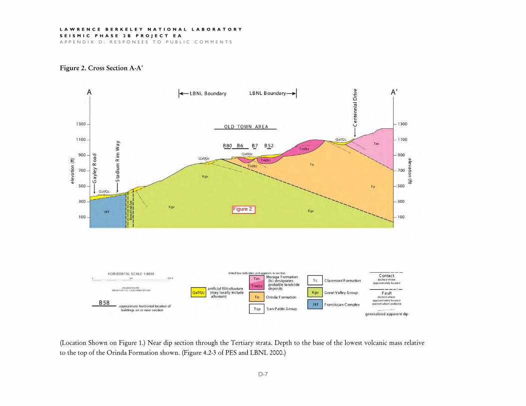
Figure 1. B edrock geologic map of L B NL . (modified from Figure 4.2-1 of PE S and L B NL 2000)
elevation from the UNIV E R S IT Y OF C ALIF OR NIA DAT UM
L A W R E N C E B E R K E L E Y N A T I O N A L L A B O R A T O R Y
S E I S M I C P H A S E 2 B P R O J E C T E A A P P E N D I X D : R E S P O N S E S T O P U B L I C C O M M E N T S
Figure 2. Cross Section A-A'
(Location Shown on Figure 1.) Near dip section through the Tertiary strata. Depth to the base of the lowest volcanic mass relative to the top of the Orinda Formation shown. (Figure 4.2-3 of PES and LBNL 2000.)
D-7
L A W R E N C E B E R K E L E Y N A T I O N A L L A B O R A T O R Y
S E I S M I C P H A S E 2 B P R O J E C T E A A P P E N D I X D : R E S P O N S E S T O P U B L I C C O M M E N T S
RESPONSE TO COMMENTS MATRIX
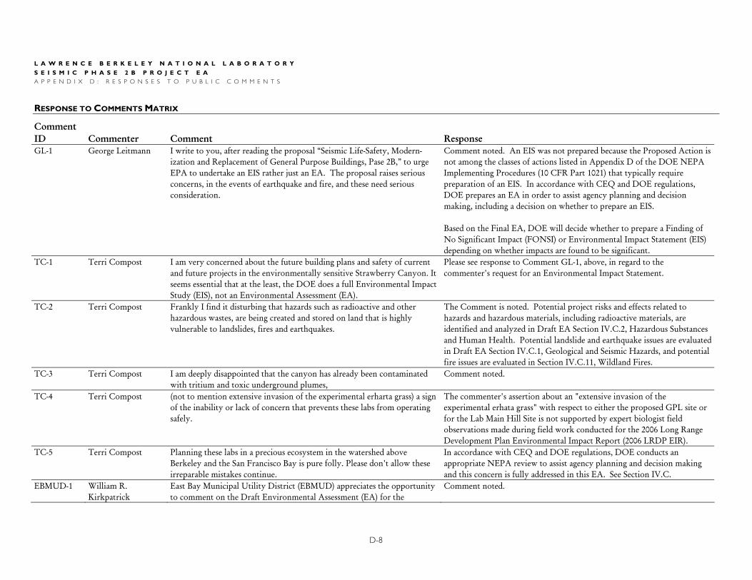
Comment ID Commenter Comment Response GL-1 George Leitmann I write to you, after reading the proposal “Seismic Life-Safety, Modern-
ization and Replacement of General Purpose Buildings, Pase 2B,” to urge EPA to undertake an EIS rather just an EA. The proposal raises serious concerns, in the events of earthquake and fire, and these need serious consideration.
Comment noted. An EIS was not prepared because the Proposed Action is not among the classes of actions listed in Appendix D of the DOE NEPA Implementing Procedures (10 CFR Part 1021) that typically require preparation of an EIS. In accordance with CEQ and DOE regulations, DOE prepares an EA in order to assist agency planning and decision making, including a decision on whether to prepare an EIS. Based on the Final EA, DOE will decide whether to prepare a Finding of No Significant Impact (FONSI) or Environmental Impact Statement (EIS) depending on whether impacts are found to be significant.
TC-1 Terri Compost I am very concerned about the future building plans and safety of current and future projects in the environmentally sensitive Strawberry Canyon. It seems essential that at the least, the DOE does a full Environmental Impact Study (EIS), not an Environmental Assessment (EA).
Please see response to Comment GL-1, above, in regard to the commenter's request for an Environmental Impact Statement.
TC-2 Terri Compost Frankly I find it disturbing that hazards such as radioactive and other hazardous wastes, are being created and stored on land that is highly vulnerable to landslides, fires and earthquakes.
The Comment is noted. Potential project risks and effects related to hazards and hazardous materials, including radioactive materials, are identified and analyzed in Draft EA Section IV.C.2, Hazardous Substances and Human Health. Potential landslide and earthquake issues are evaluated in Draft EA Section IV.C.1, Geological and Seismic Hazards, and potential fire issues are evaluated in Section IV.C.11, Wildland Fires.
TC-3 Terri Compost I am deeply disappointed that the canyon has already been contaminated with tritium and toxic underground plumes,
Comment noted.
TC-4 Terri Compost (not to mention extensive invasion of the experimental erharta grass) a sign of the inability or lack of concern that prevents these labs from operating safely.
The commenter's assertion about an "extensive invasion of the experimental erhata grass" with respect to either the proposed GPL site or for the Lab Main Hill Site is not supported by expert biologist field observations made during field work conducted for the 2006 Long Range Development Plan Environmental Impact Report (2006 LRDP EIR).
TC-5 Terri Compost Planning these labs in a precious ecosystem in the watershed above Berkeley and the San Francisco Bay is pure folly. Please don't allow these irreparable mistakes continue.
In accordance with CEQ and DOE regulations, DOE conducts an appropriate NEPA review to assist agency planning and decision making and this concern is fully addressed in this EA. See Section IV.C.
EBMUD-1 William R. Kirkpatrick
East Bay Municipal Utility District (EBMUD) appreciates the opportunity to comment on the Draft Environmental Assessment (EA) for the
Comment noted.
D-8
L A W R E N C E B E R K E L E Y N A T I O N A L L A B O R A T O R Y
S E I S M I C P H A S E 2 B P R O J E C T E A A P P E N D I X D : R E S P O N S E S T O P U B L I C C O M M E N T S
ESPONSE TO OMMENTS ATRIX CONTINUEDR C M ( )
D-9
Comment ID Commenter Comment Response
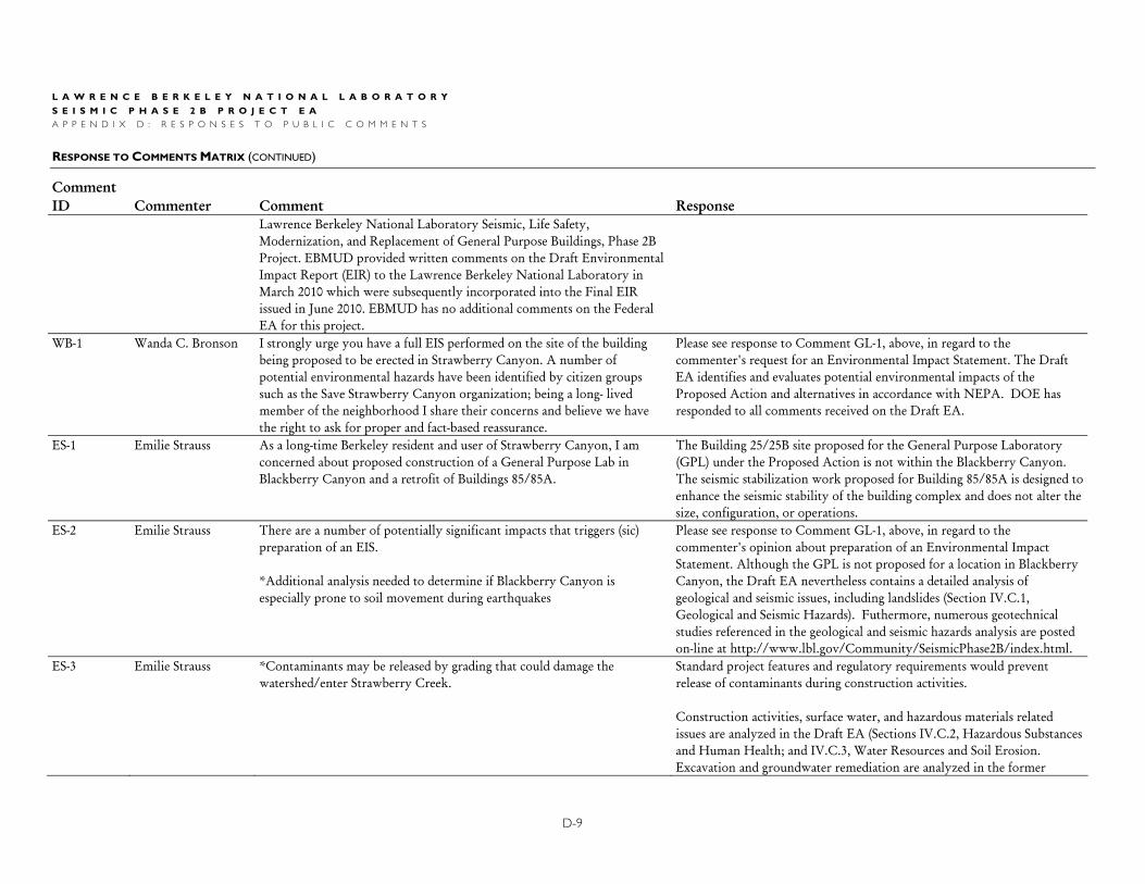
Lawrence Berkeley National Laboratory Seismic, Life Safety, Modernization, and Replacement of General Purpose Buildings, Phase 2B Project. EBMUD provided written comments on the Draft Environmental Impact Report (EIR) to the Lawrence Berkeley National Laboratory in March 2010 which were subsequently incorporated into the Final EIR issued in June 2010. EBMUD has no additional comments on the Federal EA for this project.
WB-1 Wanda C. Bronson I strongly urge you have a full EIS performed on the site of the building being proposed to be erected in Strawberry Canyon. A number of potential environmental hazards have been identified by citizen groups such as the Save Strawberry Canyon organization; being a long- lived member of the neighborhood I share their concerns and believe we have the right to ask for proper and fact-based reassurance.
Please see response to Comment GL-1, above, in regard to the commenter's request for an Environmental Impact Statement. The Draft EA identifies and evaluates potential environmental impacts of the Proposed Action and alternatives in accordance with NEPA. DOE has responded to all comments received on the Draft EA.
ES-1 Emilie Strauss As a long-time Berkeley resident and user of Strawberry Canyon, I am concerned about proposed construction of a General Purpose Lab in Blackberry Canyon and a retrofit of Buildings 85/85A.
The Building 25/25B site proposed for the General Purpose Laboratory (GPL) under the Proposed Action is not within the Blackberry Canyon. The seismic stabilization work proposed for Building 85/85A is designed to enhance the seismic stability of the building complex and does not alter the size, configuration, or operations.
ES-2 Emilie Strauss There are a number of potentially significant impacts that triggers (sic) preparation of an EIS. *Additional analysis needed to determine if Blackberry Canyon is especially prone to soil movement during earthquakes
Please see response to Comment GL-1, above, in regard to the commenter's opinion about preparation of an Environmental Impact Statement. Although the GPL is not proposed for a location in Blackberry Canyon, the Draft EA nevertheless contains a detailed analysis of geological and seismic issues, including landslides (Section IV.C.1, Geological and Seismic Hazards). Futhermore, numerous geotechnical studies referenced in the geological and seismic hazards analysis are posted on-line at http://www.lbl.gov/Community/SeismicPhase2B/index.html.
ES-3 Emilie Strauss *Contaminants may be released by grading that could damage the watershed/enter Strawberry Creek.
Standard project features and regulatory requirements would prevent release of contaminants during construction activities. Construction activities, surface water, and hazardous materials related issues are analyzed in the Draft EA (Sections IV.C.2, Hazardous Substances and Human Health; and IV.C.3, Water Resources and Soil Erosion. Excavation and groundwater remediation are analyzed in the former
L A W R E N C E B E R K E L E Y N A T I O N A L L A B O R A T O R Y
S E I S M I C P H A S E 2 B P R O J E C T E A A P P E N D I X D : R E S P O N S E S T O P U B L I C C O M M E N T S
ESPONSE TO OMMENTS ATRIX CONTINUED R C M ( )
D-10
Comment ID Commenter Comment Response
section. Water resources, erosion control, and project stormwater pollution prevention planning and permitting is discussed in the latter section.
ES-4 Emilie Strauss *Proposed pier design will not prevent or protect the (85/85A) structures from slides generated by mudstone.
The 85/85A seismic strengthening includes drilled piers and tiebacks that extend into rock characterized as in-place (i.e. not landslide materials). The forces that landslide materials will exert on the below-grade restraint system were evaluated using methods contained in the official State of California guidelines that pertain to seismically-induced landsliding. The landslide restraint system itself was designed in accordance with the structural provisions of the California Building Code. Engineering analyses show that the Building 85/85A seismic strengthening systems will restrain and control landslide movement thereby protecting the facility from landslide-related hazards.
ES-5 Emilie Strauss *Wildfires could release many toxic compounds into the air. If the fire was driven by west winds (as was true in the Oakland Fire) it would affect where I reside on Hearst Ave.
Please see responses to Comments LS-14, LS-15, and GW-15. As described in the EA, the General Purpose Lab would contain conventional laboratories with ordinary laboratory chemicals. Given the extensive measures taken by LBNL to prevent and control wildland fires on its site, and given the fire safety systems that would be included in the building, a wildland fire inundating the General Purpose Lab would not be a reasonably foreseeable event pursuant to NEPA Section 40 CFR 1502.22.
ES-6 Emilie Strauss *All activities occur in or near habitat for the federally-threatened Alameda whipsnake.
The Proposed Action would neither take place in nor impact US Fish and Wildlife designated critical habitat for the Alameda whipsnake, nor would it create a substantial risk for individual "taking" of individuals or negatively impact recovery of the species. Almost all elements of the Proposed Action would take place on currently developed areas, and inclusion of "Standard Project Features" designed to avoid disturbance of Alameda whipsnake would further minimize such risk. Please refer to the analysis of this issue in EA Section IV.C.4 and Appendix A SPF BIO 5 (a)-(f) that specifically addresses the whipsnake issue.
ES-7 Emilie Strauss In summary, due to a number of significant potential imacts, the Environmental Analysis for these two projects necessitates preparation of an EIS, not EA, as mandated by NEPA.
Please see response to Comment GL-1, above, in regard to the commenter's observation about preparing an Environmental Impact Statement.
L A W R E N C E B E R K E L E Y N A T I O N A L L A B O R A T O R Y
S E I S M I C P H A S E 2 B P R O J E C T E A A P P E N D I X D : R E S P O N S E S T O P U B L I C C O M M E N T S
ESPONSE TO OMMENTS ATRIX CONTINUEDR C M ( )
D-11
Comment ID Commenter Comment Response GW-1 Georgia Wright Alan Kropp and Associates (AKA) reports for Building 25 or the General
Purpose Laboratory, cited in the Final EIR on disc and on the web, were only added to the web after their absence was reported to LBNL. As they were used in the “matrix” of the FEIR to contest points made by several individuals, they would appear to be important.
As noted by the comment, the referenced Alan Kropp Associates reports are available for review on the LBNL website http://www.lbl.gov/ Community/SeismicPhase2B/index.html.
GW-2 Georgia Wright AKA, May 29, 2009, a preliminary report, made in two weeks “to meet LBNL’s objectives,” lays out the problems and what additional work will be necessary to help solve them. 1) AKA’s preliminary investigation of old boring logs are consistent with the presence of a paleolandslide under B25. 2) Orinda Formation under the Lawrence Road (south and downhill from 25), is potentially part of a palealandslide rather than in-place bedrock. 3) Offsets in the curbs are not sufficient to evaluate historic slides. [Evidently AKA was not given access to the files on historic landslides.] 4) The borings suggest very low factors of safety, although these may be based upon conservative measures. 5) Additional trenching is needed (to establish whether the paleolandslide has moved recently.) AKA, April 2, 2010. Trenches 1 and 2 are mentioned but only T-1 (southwest of 25, 8’ deep) appears on the map. There are no photos of the trench nor is it discussed. The “general sketch” at the end of the report is indeed too general. Were there slickensides, indicative of movement?
Two trenches were excavated by Fugro William Lettis & Associates, Inc. to evaluate the geologic stability of the Building 25 site. Both were logged by a team of geologists that checked for slickensides and other types of deformation-related features. Notably, the eastern trench found the Moraga Formation and Orinda Formation in depositional contact, with no slickensides present.
GW-3 Georgia Wright Historical borings around B25 indicate Moraga volcanics which “break into rubble during drilling.” Gravity has moved colluvium downslope. Moraga Formation is highly permeable (although is it called “bedrock,” which in common or dictionary definition means hard rock. Neither Moraga Formation nor Orinda Formation fit that definition.
Comment noted. It is well recognized that the Moraga Formation includes materials that are fractured, and that additional fracturing can occur during drilling and sampling operations. Historically, LBNL geologists/ geotechnical consultants have used the terms "rock" and/or "bedrock" to describe in-place Moraga and Orinda Formation materials. The terminology does not affect the analysis of the impacts.
GW-4 Georgia Wright AKA, May 29, 2010 , supplemental report Boring log #1 (north of 25) has 8’ of fill. Clay to 11.5’, and silty clay below
The comment asserts that the Orinda Formation siltstone and claystone encountered in borings may "slump or flow" and therefore not be a
L A W R E N C E B E R K E L E Y N A T I O N A L L A B O R A T O R Y
S E I S M I C P H A S E 2 B P R O J E C T E A A P P E N D I X D : R E S P O N S E S T O P U B L I C C O M M E N T S
ESPONSE TO OMMENTS ATRIX CONTINUED R C M ( )
D-12
Comment ID Commenter Comment Response
that. Boring 2 (south of 25) Moraga volcanics with weak rhyolite, then andesite down to 90’ where Orinda claystone and siltstone are found. (Muds and mudstones give rise to manyu problems in civil engineering because they are weak and shrink or swell on being dried or wetted.” Mudstones are siltstone, mud-shale, or claystone. “Muds are very reactive to physical disturbances or differential loading, and they slump and flow easily when subjected to stress.” (Oxford Companion to the Earth, 2000, p. 715) A three-story General Purpose Laboratory would indeed exert differential loaking and stress.
suitable foundation material for the three-story General Purpose Laboratory building. LBNL consultants have evaluated the strength and stability of the Orinda Formation at the General Purpose Laboratory site using onsite data and established geotechnical and geologic analysis methods and found it to be stable and capable of supporting the building loads.
GW-5 Georgia Wright Boring 3 (south of 2) Orinda Formation Boring 5 & 6 “southern side of proposed central plant site” (not on map): Atterberg Limits; Boring 5, (4-4.5’ deep)Plasticity Index 56,; Boring 6,( 6 – 6/5’ deep), Plasticity Index 46. “Onsite soils having a PI of 15 or less are generally considered to have a sufficiently low expansion potential to be used as non-expansive fill.” 5 and 6 are marked “Fat Clay” and not to be used for fill. AKA says these must be removed.
DOE agrees that soils with a PI of 46 and 56 are not suitable for direct re-use as engineered fill. Future work at the site will be in accordance with the recommendations presented in the geotechnical investigation report. Appendix A SPF GEO-2 requires a site-specific, design level geotechnical investigation for each LBNL building project.
GW-6 Georgia Wright In effect after all these reports AKA has not come to a conclusion that the Moraga volcanics are a paleolandslide or in-place “bedrock”.
The commenter is correct with respect to the General Purpose Laboratory site. The geotechnical analysis done in “Paleaeolandslide Investigation Building 25,” 2009 (footnote 16) determined that the GPL site is geologically stable in either case. The geotechnical and geologic investigation report for the Building 85 strengthening (AKA 2010) indicates that the paleolandslide deposits previously mapped within the East Canyon do not underlie Building 85 or 85A. These two buildings are underlain by much smaller landslides that will be restrained as part of the seismic strengthening project.
GW-7 Georgia Wright AKA did not examine the trench for slickensides, nor did it dig a second trench.
Two trenches were excavated by Fugro William Lettis & Associates, Inc. to evaluate the geologic stability of the Building 25 site. Both were logged by a team of geologists that checked for slickensides and other types of deformation-related features. Notably, the eastern trench found the Moraga
L A W R E N C E B E R K E L E Y N A T I O N A L L A B O R A T O R Y
S E I S M I C P H A S E 2 B P R O J E C T E A A P P E N D I X D : R E S P O N S E S T O P U B L I C C O M M E N T S
ESPONSE TO OMMENTS ATRIX CONTINUEDR C M ( )
D-13
Comment ID Commenter Comment Response
Formation and Orinda Formation in depositional contact, with no slickensides present.
GW-8 Georgia Wright Moving or not, should you build on “weak volcanics that break into rubble during drilling”?
As discussed in EA Section IV.C.1 (Geologic and Seismic Hazards) and associated geotechnical studies, the General Purpose Laboratory site is atop a resistant block of Moraga Formation that geologic analysis has shown to be stable for thousands of years. From geologic and engineering perspectives, it is well suited for the planned General Purpose Laboratory building. Also please see response to Comment GW-6.
GW-9 Georgia Wright Will spread footings do the trick when the earthquake strikes? In accordance with the provisions of the California Building Code, spread footings are an appropriate foundation type and are very capable of supporting the design loads for both non-earthquake and earthquake conditions.
GW-10 Georgia Wright What about the contact with Orinda mudstones? See response to Comment GW-4.
GW-11 Georgia Wright Both Buildings 85 and 85A are shown in the FEIR for CEQA to straddle two paleolandslides, characterized in several earlier consulting reports as potentially liable to move in a major seismic event and at different rates. Slickensides were prevalent throughout the area. In earlier reports 60% of the HWHF buildings (the southwestern parts) overlie the Orinda Formation clays. In the EA, however, AKA’s plans show only QLS2 (or QLS4 on the colored map) crossing all but a small part of 85 and no characterization of the leftover area. AKA had declared in an earlier report that 10 feet of Moraga Formation lies under the northeast corner of the buildings, and below that 25 feet of Orinda Formation. What is under this area?
Boring AKA-11 was drilled east of the northern portion of Building 85. The upper portion of the boring encountered approximately 20 feet of fill comprised of soil mixed with Moraga Formation materials. Below the fill, AKA-11 encountered about a foot of natural Moraga Formation materials (i.e. not fill) over a clay seam. In-place Orinda Formation is logged starting at a depth of 22 feet and underlies this area. Details on the geologic characterization of the Building 85/85A area are presented in the geotechnical study posted on-line (http://www.lbl.gov/Community/ SeismicPhase2B/index.html).
GW-12 Georgia Wright AKA proposes drilling 21 piers around two sides of B85 and 9 piers around two sides of B85A, these to be 5 feet in diameter and 40 to 50 feet deep, TO STOP THE LANDSLIDE, evidently the top one of Moraga Formation (hard but fractured volcanics.) What will stop the building from being torn apart? Has anyone ever used piers to stop a landlside? Into what will those piers be drilled that is less expansionary and stronger than mudstones? (AKA 2006, a propos the Animal Care Facility nearby, suggested a mat under the building so that it might move integrally, a proposal AKA could
The piers and tiebacks comprising the below-grade landslide restrain system will be anchored in in-place Orinda Formation rock below the landslide materials. Geotechnical engineering analyses were performed to calculate the loads that the landslide restraint system would need to resist in order to limit earthquake deformations to so that the building would not be "torn apart." Drilled piers and tiebacks are commonly used, individually or in combination, to restrain landslides in California.
L A W R E N C E B E R K E L E Y N A T I O N A L L A B O R A T O R Y
S E I S M I C P H A S E 2 B P R O J E C T E A A P P E N D I X D : R E S P O N S E S T O P U B L I C C O M M E N T S
ESPONSE TO OMMENTS ATRIX CONTINUED R C M ( )
D-14
Comment ID Commenter Comment Response
not make, evidently, for 85, as it would entail rebuilding.) See response to Comment ES-4.
GW-13 Georgia Wright Missing from the reports are 9 boring logs, AKA 7 – 16. Where are these and their interpretations? They will be needed to determine the quality of the Moraga volcanics, the Orinda mudstones, and whatever lies beneath.
Appendix A of the Building 85/85A strengthening report (AKA 2010) includes logs of Borings AKA-8 through AKA-16. The log of Boring AKA-7 is in geotechnical report Appendix D. The referenced report is posted online at (http://www.lbl.gov/Community/SeismicPhase 2B/index.html).
GW-14 Georgia Wright What does lie not far below the surface is water! In the EIR are tables recording water heights, taken from monitoring wells. The EA refers to them on p. 22. North of 85 the water measured from 16 to 12 feet below surface while south of 85 the range was from 40 to 35 feet.. Accounting for the difference in elevations the water table seems to be level there. But east of 85A at the same elevation as the well south of 85, the difference is huge—the level according to AKA ranges between 24 and 0.3 feet. This means that there is a “perched water table” or reservoir and that the other two wells may have penetrated a separate reservoir. This is just what one expects in the caldera of the volcano upon which the Lab has constructed its buildings. When such a reservoir breaks during a seismic event (the breaks in 1973 may have been caused by a series of small events), the landslides may be devastating as they were in 1973. The unpredictable reservoirs, springs, and aquifers mean that conatminants spread all over. Monitorying wells are seldom left open for long. See the report Contaminant Plumes of the Lawrence Berkeley National Laboratory… (2007)http://berkeleycitizen.org/lbnl/cmtw1.html
Water is accounted for in the analysis and the design recommendations. Water levels recorded shortly after drilling may differ from "stabilized" groundwater levels; consequently, differences in groundwater elevations shown on the borings logs do not necessarily mean there are perched conditions or a "reservoir" present. Please see Master Response 1 – Geological Conditions Underlying the LBNL Site regarding the Commenter’s assertion of Caldera.
GW-15 Georgia Wright Fire What are the plans in case of a wildlands firestorm? The East Canyon site is heavily wooded, with pines and eucalyptus, grasses and scotch broom, all flammable. The HWHF contains radioactive waste on the first floor and mixed solvents and volatile organic compounds on the second floor of 85. There are a number of storage sheds for liquid and dry combustible compounds. How are these protected from a fire like that of 1991 (2000 degrees, destroying concrete, “fireproof” safes, metals, etc.)?
As noted in the EA, the scope of work for the HWHF Building 85 is to seismically upgrade the building and does not change the operation of the building or extend its intended life. The EA therefore, only considered the impacts resulting from the construction identified in the EA. DOE Environmental Assessment DOE/EA-0423 Construction and Operation of the Replacement Hazardous Waste Handling Facility at LBNL considered the impacts of the construction and operation of the HWHF and found no significant impacts.
L A W R E N C E B E R K E L E Y N A T I O N A L L A B O R A T O R Y
S E I S M I C P H A S E 2 B P R O J E C T E A A P P E N D I X D : R E S P O N S E S T O P U B L I C C O M M E N T S
ESPONSE TO OMMENTS ATRIX CONTINUEDR C M ( )
D-15
Comment ID Commenter Comment Response
During the 1991 fire, which reached the south wall of the next, Claremont canyon, Director Shank ordered all personnel to leave. Is this the plan today? How will people, air, water, and earth be protected when the fire reaches the East Canyon buildings or those generating the wastes? We are about due for another wildland fire, which come at 20 year intervals.
Wildland fires are addressed at Section IV.C.11 of this EA. According to the California Department of Forestry and Fire Protection (CDF) Natural Hazard Disclosure Map Images and Data for Alameda County, components of the Proposed Action are not located in an area that has a substantially high potential for wildland fires. For more information regarding the performance of Building 85 during a wildland fire, please refer to the HWHF EA. See responses to Comments LS-14, LS-15, GG-3, TC-2, ES-5, CMTW-11, and GW-16. In addition, UC LBNL has identified fire prevention and response measures in its 1994 Wildland Fire Evacuation/Relocation Plan which further reduce associated risks. Please refer to the plan for details of the evacuation procedure.
GW-16 Georgia Wright There is a brief paragraph dealing with fire in the EA. In essence it says ”trust us!” It says LBNL has been declared a site with “not a high potential for wildland fires.” But FEMA was willing to grant a huge amount of money to ridding the Canyon of trees above the site, a project now on hold. . On EA p. 141, “In 1994, UC LBNL published a Wildland Fire Evacuation/Relocation Plan. The plan, which would apply to the Proposed Action, is based on a wildland fire scenario that would require rapid mobilization of resources, quick decision making and well-coordinated execution by emergency responders during a wildland fire.” The footnote sends one to a website that is no longer operating. Have the plans also been abandoned? The 1994 plan was evidently motivated by the lack of a plan in 1991.
The 1994 Wildland Fire Evacuation/Relocation Plan can be found at: http://www.osti.gov/bridge/product.biblio.jsp?osti_id=10174461. Please also see http://www.lbl.gov/ehs/ep/ for the laboratory’s emergency website which includes the Master Emergency Service Plan and evacuation plans. Please refer to response to Comment GW-15.
GW-17 Georgia Wright At a “Community Advisory Group” meeting in June, someone asked about emergency plans. Evidently there were none!
There was no LBNL Community Advisory Group (CAG) meeting in June 2010. The comment appears to refer to a CAG meeting on April 28, 2010 where the issue of emergency planning was raised by a member of the public. Because the meeting was scheduled to focus on traffic issues, LBNL
L A W R E N C E B E R K E L E Y N A T I O N A L L A B O R A T O R Y
S E I S M I C P H A S E 2 B P R O J E C T E A A P P E N D I X D : R E S P O N S E S T O P U B L I C C O M M E N T S
ESPONSE TO OMMENTS ATRIX CONTINUED R C M ( )
D-16
Comment ID Commenter Comment Response
emergency planning experts were not present to answer the participants' question regarding emergency planning. LBNL engages in extensive disaster and emergency planning at all levels of the organization. For more information on this topic, please refer to the 2006 LRDP EIR for an overview and to the Lab's EH&S website for information regarding the Lab's Emergency Response Organization and Master Emergency Program Plan (see http://www.lbl.gov/ehs/ep/).]
GW-18 Georgia Wright There is no other building on Lab property which would fill the requirements for the HWHF, so this very dangerous site must remain exposed to fire and landslide with little reinforcing of the building itself. The interim storage of hazardous materials is impossible because they would need more than the 90 days permitted, while the HWHF has a special dispensation, over one year, to sort them out and to find permanent disposal sitse. Which buildings produce all of these radioactive wastes, volatile organic compounds, solvents, etc. that accummulate in 85 and the sheds? How are they protected?
Please see response to Comment GW-15 regarding the operations of the HWHF.
GW-19 Georgia Wright How does LBNL rationalize the LRDP in an area so dangerously unstable, so close to the Hayward Fault, and so close to wildlands?
It is not clear to DOE what is intended by the commenter's assertion that "LBNL rationalize the LRDP in an area so dangerously unstable, so close to the Hayward Fault, and so close to wildlands." The Lab's Long Range Development Plan (LRDP) is a planning document that covers the entire LBNL main hill site. It appears the comment is referring to the HWHF, please refer to response to Comment GW-15.
GW-20 Georgia Wright The best alternative for the LRDP is UC’s Richmond Field Station, where there is plenty of room for both buildings and parking, construction would be much cheaper on the flat land, and the site is farther from the Hayward Fault.
Comment noted. It appears that the comment may be referring to the GPL or some other component of the project. The EA considers the Richmond Field Station as an alternative site.
GW-21 Georgia Wright The only negative that LBNL is willing to mention is invalid. The hill site is NOT served by public transit but by Lab shuttle buses, just like Richmond! As bus and BART are to the present site, so BART is to Richmond with a stop one mile away. The RFS is 6 miles or 20 minutes
The EA describes access to the RFS by public transit, noting that bus connections to the RFS from either BART station in Richmond require travel times of more than 30 minutes. Additionally, the EA notes that many UC LBNL employees live in Berkeley and that consequently the
L A W R E N C E B E R K E L E Y N A T I O N A L L A B O R A T O R Y
S E I S M I C P H A S E 2 B P R O J E C T E A A P P E N D I X D : R E S P O N S E S T O P U B L I C C O M M E N T S
ESPONSE TO OMMENTS ATRIX CONTINUEDR C M ( )
D-17
Comment ID Commenter Comment Response
from UC campus. commute to the LBNL main hill site is easier and quicker for them than a commute to the RFS would be.
GW-22 Georgia Wright Evidently the problem lies elsewhere—“scientific adjacencies.” This argument has never been explained. The scientists at LBNL, like those everywhere, find their natural colleagues all over the globe! One need only search LBNL personnel’s publications! We suspect there is not all that much lab equipment sharing or conversations after work, The reasons for holding so tightly to this dangerous site appear to be that the view of the Bay plus the name “Berkeley” would attract more visiting scientists than “Richmond,” although the latter has tremendous views and a sylvan setting!
In the 2005-2006 LBNL Annual Report, former LBNL Director Steve Chu explained the concept of scientific adjacencies, saying: in “a culture of interdisciplinary problem-solving,” it is beneficial to have the opportunity to “spontaneously” form “research partnerships over lunch in the cafeteria, after seminars, and in social events.” Chu further explained that, in a light of LBNL’s history of maintaining a collaborative approach to science, he viewed a “major” part of his job was making the “collaborative environment even better.” Accordingly, increasing efficiency of LBNL research operations and promoting scientific adjacencies by offering modern, cost-effective consolidated space at the LBNL main hill site has been set as an objective of the Seismic Phase 2B project. Please see EA Section Purpose and Need which cites need for scientific adjacencies and collocation. The LRDP EIR describes the merit and value of these adjacencies, a position which was sustained at the trial and appellate level by the California courts.
GW-23 Georgia Wright We hope that the Department of Energy will be more wary of approving dangerous projects after the miserable performance of the Minerals Management Services. The least the Department can do is to perform an EIS with many more logs of trenches and borings and fewer desperate “solutions” for building over landslides!
Comment noted. Please see response to Comment GL-1 regarding the preparation of an EIS.
LS-1 Laurie Sarachan Several years ago I participated in submitting comments re: the Draft Environmental Impact Report for the LBNL Computational Research and Theory Facility building proposed to be built on the ridge above Cyclotron Road. This was before the court established that the CRT merited federal environmental review. I believe it is fortunate for everyone concerned that the CRT facility, planned to intrude upon a natural and precarious landscape, has not been built at that site. In the instance of the "Seismic Life-Safety, Modernization and Replacement of General Purpose
Comment noted. Please see response to Comment GL-1 regarding the preparation of an EIS.
L A W R E N C E B E R K E L E Y N A T I O N A L L A B O R A T O R Y
S E I S M I C P H A S E 2 B P R O J E C T E A A P P E N D I X D : R E S P O N S E S T O P U B L I C C O M M E N T S
ESPONSE TO OMMENTS ATRIX CONTINUED R C M ( )
D-18
Comment ID Commenter Comment Response
Buildings, Phase 2B" it seems obligatory that a full EIS be prepared.
LS-2 Laurie Sarachan I have reviewed the EA for the Phase 2B project. I discovered immediately that the title of the project is misleading. Both "seismic" and "life-safety" appear to be misnomers for a project that cannot actually "fix" existing unfavorable conditions for large industrial type buildings on the slopes of Strawberry and Blackberry Canyons.
Comment noted.
LS-3 Laurie Sarachan In addition to the existing environmental risks, this project has the potential to increase future environmental risks and to cause further degradation of significant natural resources.
The Draft EA identifies and analyzes potential risks associated with the Proposed Action in 20 resource categories as required under NEPA.
LS-4 Laurie Sarachan First, it is incredible that there is a Hazardous Waste Handling Facility located in Strawberry Canyon. Because I live in the adjacent Claremont Canyon to the south, I know that Strawberry Canyon is an irresponsible site to place any industrial building, but especially a building that houses contaminated, toxic, and/or radioactive materials. Information regarding the operations and reason for the Hazardous Facility needs to be more complete. What exact materials and quantities are taken there? From where? From which other facility? How are the materials taken there? What is meant by "storage?" How long is each material stored there? What physical barrier is constructed in the facilities that gives the public assurance that the hazardous/radioactive waste "would not be released to the environment?" Why is this the best site for handling, placement, and/or storage? Would it not be more financially prudent to take or store all waste materials in a non-seismically challenged site? If, in fact, certain waste materials are required to stay on the LBNL site for a required amount of time, then is this not one of the most compelling reasons to move all of LBNL 's research out of the Canyons? I urge that it is essential to discuss fully in an EIS the whys and wherefores of an appropiate alternative site other than the current LBNL location.
Comment noted. Please see response to Comment GW-15 regarding the operations of the HWHF. Please see response to Comment GL-1 regarding the preparation of an EIS. Please refer to EA Section III.D.3 for discussion of relocating the HWHF.
LS-5 Laurie Sarachan The EA also ignores, by definition, a respectful discussion of the Hazardous Facility presence within a significant natural park resource. How does the Hazardous Facility affect the aesthetic and cultural value of Strawberry Canyon? Re-establishing high-tech, waste management
Please see response to Comment GW-15 for HWHF issues unrelated to the scope of the Seismic Phase 2B Proposed Action. NEPA Section 101(b) stipulates that the Federal Government use all
L A W R E N C E B E R K E L E Y N A T I O N A L L A B O R A T O R Y
S E I S M I C P H A S E 2 B P R O J E C T E A A P P E N D I X D : R E S P O N S E S T O P U B L I C C O M M E N T S
ESPONSE TO OMMENTS ATRIX CONTINUEDR C M ( )
D-19
Comment ID Commenter Comment Response
buildings and the associated diesel truck traffic into a valued landscape corridor seems contrary to NEPA Section 101(b) which makes it the responsibility of the federal government to: assure for all Americans safe, healthful, productive, and aesthetically and culturally pleasing surroundings ... attain the widest range of beneficial uses of the environment without degradation, risk to health or safety, or other undesirable and unintended consequences ... [and] preserve important historic, cultural, and natural aspects our national heritage ... How the Hazardous Facility will further impact the irreplaceable physical assets of the Canyon and its social benefits to the adjacent university and urban community must not be overlooked. Any overriding reason to justify seismically strengthening the Hazardous Facility at this site, rather than removing it to an alternative site for the purpose of protecting a beneficial natural environment, merits comprehensive information and discussion.
"practicable means" to achieve the goals paraphrased by the commenter, and that their attainment be "consistent with other essential considerations of national policy..." The EA analysis shows that the Proposed Action is consistent with and not contrary to NEPA Section 101(b). Specifically, the EA demonstrates that seismic improvements to the HWHF would not create impacts that would noticeably diminish or impact "the irreplaceable physical assets of the Canyon and its social benefits to the adjacent university and urban community." In addition, the Proposed Action specifically meets the intent of NEPA Section 101(b) by improving Federal "functions, programs, and resources," by assuring safety and productivity (101(b) provision #2), and by enhancing "the quality of renewable resources (101(b) provision #6) while not substantially impacting the environment. Please refer to EA Section III.D.3 for discussion of relocating the HWHF.
LS-6 Laurie Sarachan Due diligence in compliance with NEPA would seem to indicate that the Hazardous Waste Handling Facility merits a stand alone EIS, independent of the other proposed actions in the Phase 2B proposal.
Please see response to Comment GL-1 regarding the preparation of an EIS. The Draft EA provides a full analysis of potential impacts resulting from the proposed seismic strengthening of the HWHF. Please see response to Comment GW-15 regarding the operations of the HWHF.
LS-7 Laurie Sarachan The LBNL objective to establish the General Purpose Laboratory as a modern research and office space within the Blackberry Canyon area also raises many questions that should determine an EIS is in order. The GPL design, its footprint and height, 43,000 sq. ft., with 3 stories and two exhaust stacks, is inappropriate for the hillsides of Berkeley.
Comment noted. The potential aesthetic impacts of the Proposed Action and alternatives are identified and analyzed in the EA. With regard to the location of the Proposed Action, please see responses to Comments ES-1 and ES-2. With regard to the need for an EIS, please see response to Comment GL-1.
LS-8 Laurie Sarachan It seems obvious that LBNL's Long Range Development Plan to develop a 21st Century research "park" within what was once a clean watershed source, defined by oaks, bays and buckeyes, is short-sighted and a risk. No "seismic" bracing or concrete footing can secure such a building, as well as
The comment refers to the LBNL 2006 LRDP which is beyond the scope of this EA. The performance standards for GPL and the seismic strengthening of Building 85/85A are discussed in the EA. Additionally, for a discussion of Geological Conditions Underlying the LBNL Site,
L A W R E N C E B E R K E L E Y N A T I O N A L L A B O R A T O R Y
S E I S M I C P H A S E 2 B P R O J E C T E A A P P E N D I X D : R E S P O N S E S T O P U B L I C C O M M E N T S
ESPONSE TO OMMENTS ATRIX CONTINUED R C M ( )
D-20
Comment ID Commenter Comment Response
additional buildings, in this unstable location. please see Master Response 1.
LS-9 Laurie Sarachan The building design itself (might be termed in this location as "green wash") and the planting of a non-native industrial park landscape (after removing 2 coast live oak trees) with surrounding parking spaces belongs elsewhere. Please refer to NEPA Section 101 (b), as quoted above, to reassess the wisdom of building any laboratory and office facility such as the GPL in Blackberry Canyon.
The comment refers to the construction of the GPL on the site of Building 25/25B under the Proposed Action. At this location, essentially no undeveloped land would be disturbed for construction of the GPL or the associated parking lot. As described in the EA, the trees removed would be replaced at a ratio of 1-to-1. Please see response to Comment LS-5 regarding consistency with NEPA Section 101(b).
LS-10 Laurie Sarachan The description of the GPL project and proposed alternatives raises more questions. How would private/corporate participation be defined at such a laboratory? How would the LBNL staff be linked to any private/corporate investment or research? Should there be a disclosure of private investment in regards to conflict of interest (BP comes to mind)? Is the financing of the facility only from federal sources? What federal sources? Is there a time-frame that is mandatory in relationship to the availability of federal financing?
These comments go beyond he scope of this EA. However, the GPL would be a federal funded facility engaged in implementing the U.S. Department of Energy's research mission at the Lawrence Berkeley National Laboratory. One aspect of DOE’s mission is to make the scientific and technical expertise and resources of the DOE’s National Laboratory system available to other federal agencies and domestic and international academic and industrial concerns. Under this so called Work for Others program, DOE laboratories perform research work for the above mentioned sponsors under a cost reimbursement arrangement. It is likely that some research work conducted by researchers housed in the GPL would fall under the Work for Others program. The intellectual property rights that attach to WFO program work are defined in the Management and Operating Contract between DOE and The Regents of the University of California for the management and operation of LBNL.
LS-11 Laurie Sarachan What is meant by offices? If the 3-story GPL is designed to provide 60% office use, then why is an urban setting, such as Richmond accessible to Highway 80, not more suitable? How will the office and wet-lab research address the Congressional initiative to stimulate economic recovery? Why would not a location such as Richmond be a location that would comprehensively stimulate
"Offices" are intended to be conventional enclosed rooms, partitioned cubicles, or open work spaces that support clerical, desk, meeting, paperwork, and other typical "office" type uses. The office space in the GPL would be used to support the research taking place in the adjacent laboratory space. Please refer to the discussion of project "purpose and need" on EA for major factors that would influence
L A W R E N C E B E R K E L E Y N A T I O N A L L A B O R A T O R Y
S E I S M I C P H A S E 2 B P R O J E C T E A A P P E N D I X D : R E S P O N S E S T O P U B L I C C O M M E N T S
ESPONSE TO OMMENTS ATRIX CONTINUEDR C M ( )
D-21
Comment ID Commenter Comment Response
economic recovery, involving broad community needs, create a new center for research with a civic profile, while also being linked to a University research center?
siting of the proposed GPL. In addition, please see EA project alternatives analysis in chapter 5, which includes an analysis of the Richmond Field Station.
LS-12 Laurie Sarachan I am concerned especially that the EA lacks detailed information regarding what will take place in the proposed wet-lab multi-program of the GPL. The EA description of the kinds of research seems to leave nothing out in the form of a general listing, but gives no specifics about potential environmental impacts of any of the kinds of research. The EA is too vague about the kinds of waste.
The EA includes a general description of the types of laboratory chemicals -- including equipment and very low level radioactive substances -- that are expected to be used in the General Purpose Laboratory building. Section IV.C.8 includes an analysis of laboratory TAC emissions. Further discussion of potential laboratory-related human health risks from chemicals, substances, and equipment is included in EA Section IV.C.2 (Hazardous Substances and Human Health).
LS-13 Laurie Sarachan In particular, it is unclear how extensive the scientific research will be to create and use man-made nanoparticles. The Molecular Foundry, dedicated to state of the art nanosceince was built by LBNL and DOE without the benefit of environmental review. Now it would be irresponsible not to ask about the potential for the cumulative presence of man-made nanoparticles in the atmosphere due to LBNL activities. There is increasing concern about man-made nanoparticles in the atmosphere. This subject deserves serious detailed discussion in an EIS. What is the volume of man-made nanoparticles at LBNL? Has there been any location-site testing of man-made nanoparticles at LBNL surrounding the Molecular Foundry? Could there be a release of nanoparticles through a cooling system? The exhaust stacks? Into the water and waste system? What about potential release into the Strawberry Creek watershed and, thus, into the Bay? What about the wind patterns extending across the Bay to Marin?
The General Purpose Lab is not expected to support research efforts involving nano-particles. The LBNL Molecular Foundry did undergo full environmental review pursuant to NEPA, CEQA, and all other applicable requirements. A NEPA Environmental Assessment and FONSI (DOE/EA-1441) and a CEQA Initial Study/Negative Declaration (SCH #2002122051) were both prepared and circulated for public and agency review and comment. Both were approved in 2003. The Commenter's questions about general nano-particle related research at LBNL is outside the scope of this EA, but information on that topic can be found in the above-mentioned Molecular Foundry documents and also in the 2006 Long Range Development Environmental Impact Report.
LS-14 Laurie Sarachan I lived through the terror of the Oakland Firestorm of 1991. We had to evacuate our home and for a time we believed that Claremont Canyon had been consumed. It was only a miracle that it was not. A historic fire in 1923 beginning along the ridge of the East Bay Hills consumed all of North Berkeley, stopping just north of Blackberry Canyon. Urban wildland fires are devastating and promise to return to the Oakland-Berkeley Hills. The EA fails to reflect the reality of the dangers. How can the EA minimizes [sic] the threat of urban wildland fires? It is a stated danger for all of Califomia. How can there be a serious discussion of the issue when
The EA includes a full analysis of potential wildland fires in Section IV.C.11 (Wildland Fires). Following the 1991 East Bay Hills fire cited by the commenter, the DOE and University embarked on an intensive site-wide program to reduce wildland fire risks at the LBNL site. Measures included creating a firebreak through vegetation management (e.g., removing eucalyptus and annually managing grasslands); "limbing" trees and controlling ground vegetation to remove "ladder" fuels and to reduce calculated flame heights; adding a third
L A W R E N C E B E R K E L E Y N A T I O N A L L A B O R A T O R Y
S E I S M I C P H A S E 2 B P R O J E C T E A A P P E N D I X D : R E S P O N S E S T O P U B L I C C O M M E N T S
ESPONSE TO OMMENTS ATRIX CONTINUED R C M ( )
D-22
Comment ID Commenter Comment Response
Alameda County map in the EA rationalizes the non-threat of urban wildfires by portraying non-incorporated areas. What about the East Bay Park ridgelands? The Canyons? What about the urban and residential areas adjacent to the wildlands? The potential for urban-wildland fires alone is reason to move all of LBNL elsewhere.
200,000-gallon water storage tank to provide continuous fire-suppressing water pressure even in the event of earthquake; contracting with Alameda County to staff the Lab's on-site fire station; ensuring automatic gas shut-off valves to the Lab's main gas lines; and instituting extensive emergency planning. These activities are not project-specific to the Proposed Action but have long been Lab-wide practices. Information sought by the commenter concerning areas distant from the Proposed Action and that are not on the LBNL site or under DOE control would not be affected by the Proposed Action and are not warranted for discussion in this EA.
LS-15 Laurie Sarachan Finally, if a fire occurred, possibly due to a seismic event, how would fire and life-safety be managed at LBNL? The potential for disaster is reason enough to reconsider the LBNL LRDP, in particular the Hazardous Waste Handling Facility and the General Purpose Laboratory.
Please refer to responses to Comments LS-14 and GW-15 for additional information on wildland fire safety at LBNL. A scenario where a large seismic event might trigger a fire and simultaneously impair conventional abilities to fight such fires is specifically addressed in detail in LBNL's 2006 Long Range Development Plan EIR (Section IV.F.3.5). LBNL is uniquely situated to address such fires, in part because it maintains three 200,000-gallon water tanks designed to provide pressurized water for fire suppression, even in the event that an earthquake disrupts EBMUD water service to the region, but also because it has an around-the-clock manned fire station on site, along with automatic gas shut-off valves (in the event seismic events rupture gas mains), emergency procedures and planning, etc.
CS-1 Carole Schemmerling
The Strawberry Creek Watershed Council wishes to comment on the EA for the Seismic Safety projects Phase 2B. We approve the plans for the removal of buildings 25/25B, 55 and the trailers at building 71. This plan is welcome, up to a point.....but there are serious issues being overlooked.
Comment is noted.
CS-2 Carole Schemmerling
The plans to "strengthen" building 85/85A are so ill- conceived that it is hard to believe that this is a serious proposal. You claim that your upgrades "would prevent movement of the underlying slide in an earthquake" is a perfect example of Wishful Thinking!
Please responses to Comments GW-8 and GW-12. See EA Sections III.B.4.a and III.B.4.b.
CS-3 Carole Schemmerling
Therefore we insist that a separate EIS be done for this facility. Please see response to Comment GL-1, above, in regard to the commenter's request for an Environmental Impact Statement.
L A W R E N C E B E R K E L E Y N A T I O N A L L A B O R A T O R Y
S E I S M I C P H A S E 2 B P R O J E C T E A A P P E N D I X D : R E S P O N S E S T O P U B L I C C O M M E N T S
ESPONSE TO OMMENTS ATRIX CONTINUEDR C M ( )
D-23
Comment ID Commenter Comment Response CS-4 Carole
Schemmerling Buildings 85/85A are on an old landslide, there is No bedrock and it has so much water below, that this project stands alone as one that should be removed all together ASAP.
The geotechnical and geologic investigation report for the Building 85/85A strengthening (AKA 2010) includes the logs of four borings (AKA-10 through AKA-13) drilled in the area of Building 85. Geologic analysis of the core samples shows all four of the borings extended into in-place Orinda Formation materials. Subsurface water was considered in the engineering analyses used to develop recommendations for the landslide restraints (drilled piers and tiebacks). Also please see response to Comment GW-12.
CS-5 Carole Schemmerling
Your plans for the 25/25B site, are also of great concern. According to the "Bedrock" geological map of LBNL which you sent to us, has No indication of where this Bedrock might be, shows that the 25/25B site is an area of landslide deposits.
See response to Comment GW-3 regarding the location of bedrock.
CS-6 Carole Schemmerling
And that this is an area that is an active ground water remediation site. Where is the logic in paving over a site when you don't know how much contamination is there? How do you prevent detected contamination from migrating through the ground water? Have you ever accomplished that at LBNL?
Please refer to response to Comment ES-3, and EA Sections IV.C.2 and IV.C.3 for discussion of groundwater remediation issues. As a result of this project, there would be an opportunity to conduct further investigation and improve the existing groundwater remediation system.
CS-7 Carole Schemmerling
You certainly have not done so with the tritium plume. Please refer to response to Comment CS-6. Comment does not address the Proposed Action, its alternatives, or the adequacy of the EA, thus no further response is warranted.
CS-8 Carole Schemmerling
To construct the GPL on the 25/25B site is another very bad idea. All of the issues mentioned above are rational obstructions to the development of this site. There are other sites than LBNL available for new construction. It is totally irrational to construct any new buildings on a hill that is contaminated with huge amounts of toxins, on the Hayward Fault, on the headwaters of 12 tributaries of Strawberry Creek, in the fire zone and believe it or not, the northern end of the Sibley Volcanic Caldera Complex. Maybe LBNL thinks there is no limit to the funds available for this very costly project, but if public funds are going to be used, we believe it that it is incumbent on the lab to construct on a site that is cost effective!
Comment noted. Please refer to the EA for a discussion of off-site alternatives to constructing the GPL building, and for a discussion of hazardous material contamination on the site, geotechnical conditions, wildland fire, and water quality. Please refer to Master Response-1, Geologic Conditions of the LBNL Site.
L A W R E N C E B E R K E L E Y N A T I O N A L L A B O R A T O R Y
S E I S M I C P H A S E 2 B P R O J E C T E A A P P E N D I X D : R E S P O N S E S T O P U B L I C C O M M E N T S
ESPONSE TO OMMENTS ATRIX CONTINUED R C M ( )
D-24
Comment ID Commenter Comment Response CS-9 Carole
Schemmerling The nearly 20 million gallon a year Gorilla missing from the plans is the WATER. Without acknowledging the huge amount of water that is there, the Lab will never understand how irrational their plans are. If their magical thinking allows them to continue to ignore the natural hazards of the site, as well as those they have placed there, then just as has happened in the Gulf, we will all pay dearly.
Comment noted. See response to Comment GW-14 regarding water.
JMP-1 Jennifer Mary Pearson
While the Seismic Life Safety Modernisation and Replacement of General Purpose Buildings Phase 2B lumps together disparate projects, all involve disturbing once again the hilly terrain at LBNL, and a brings to the fore a host of interconnected leftover situations.
Comment noted.
JMP-2 Jennifer Mary Pearson
Thus, this commentary is underlain with concern for our scarce public water asset value, our most precious resource that is stored beneath the LBNL and East Bay Regional Parks--at times referred to as the pure geologic water of the Lennert Aquifer, discovered over 30 years. I SUSTAINABLE DEVELOPMENT at LBNL-- HYDROGRAPH - WATER ASSETS The Brundtland Commission Report of 1987 stated we must " meet the needs of the present without compromising the ability of future generations to meet their own needs". Simply stated, rather than building by building demolition and construction at LBNL, the entire hydrograph of LBNL campus and beyond requires a full study. With respect to embracing the principles of sustainable development aren't we compelled to preserve our scarce public trust water for future generations? Thus, a full Environmental Analysis is called for; the alternative site of Richmond Field Station may be far more sustainable, more secure and have less impacts on sustainable water assets, not threatening downstream, downhill residents as it fronts on marshlands. One can argue that this planned construction can hinder progress toward
The EA includes a discussion of potential impacts to water resources. The EA also notes that groundwater is not currently used as a supply of potable water at LBNL, nor is it likely to be used for drinking water in the future. Further, the EA explains that a Stormwater Pollution Prevention Plan (SWPPP) would be prepared for the project. Additionally, the Lennert Aquifer, to which the commenter refers, is inferred to be the permeable volcanic unit that underlies the ridge northeast of Building 77 and northwest of Building 85/85A. The presence of this feature is well-recognized and has been accounted for in the Building 85/85A seismic strengthening design component of the Seismic Phase 2B Project. This feature is not close to and would not be impacted by the proposed General Purpose Lab. A study of the entire hydrograph of the entire LBNL Site and beyond is outside the scope of this EA.
L A W R E N C E B E R K E L E Y N A T I O N A L L A B O R A T O R Y
S E I S M I C P H A S E 2 B P R O J E C T E A A P P E N D I X D : R E S P O N S E S T O P U B L I C C O M M E N T S
ESPONSE TO OMMENTS ATRIX CONTINUEDR C M ( )
D-25
Comment ID Commenter Comment Response
sustainable development. The narrative justifies that safety of human life from seismic threats can be met by developing a General Purpose Lab, retrofitting the Waste Facility and building out 10 more facilities for a complex research campus on the Hill. The GPL building and the concepts of the research projects that it will house may narrowly work towards meeting the needs of the present goal of sustainability--a safer work environment and good research on sustainable energy innovations. However the siting of this building perched on hilly terrain up hill and upstream from where we live and work does not address the needs of the future for the larger community who share the hydrograph beneath us--in short our future drinking water resources asset will be threatened. Again, those of us who live and work close-by in the same bioregion as LBNL share the local hydrograph--in the global hydrological cycle that is a significant and inseparable component of the water cycle, of the climate, of the basis of life forms. In short the local water footprint is significant for the needs of the present and for our future. Water that sheds from rainfall permeating the ground along with seeps of upsurges of geologic water abound in the Berkeley Oakland Hills --some flows downhill 900 feet to the SF Bay in open creeks following the basins carved by seismic and water movement; most flows beneath the ground (groundwater in hidden creeks) and permeates into perched water retained below us in the water table, in larger bodies of water as aquifers, which will soon be explored for our drinking water recharge opportunities, These future water sources for human sustainability--for our children and grandchildren deserve fierce consideration. We are facing water scarcity now.
JMP-3 Jennifer Mary Pearson
Although the present Phase 2B Project has stimulated some progress in selected borings for geologic engineering or goeengineering design, it has not met the goal of the Bruntland Commission.
Comment noted.
JMP-4 Jennifer Mary Pearson
II THE DEPARTMENT OF ENERGY THEMES; and LBNL LEADERSHIP VALUES On current DOE web-pages, the post Cold-War mission of the Department of Energy for Federal Scientific Laboratories sets forth three
Comment does not address the Proposed Action, its alternatives, or the adequacy of the EA, thus no further response is warranted.
L A W R E N C E B E R K E L E Y N A T I O N A L L A B O R A T O R Y
S E I S M I C P H A S E 2 B P R O J E C T E A A P P E N D I X D : R E S P O N S E S T O P U B L I C C O M M E N T S
ESPONSE TO OMMENTS ATRIX CONTINUED R C M ( )
D-26
Comment ID Commenter Comment Response
themes: the stockpiling of weapons of mass destruction; environmental cleanup; and, technical development and research. In late 2009, after 20 years at the Lab, Dr. A. Paul Alivisatos took over steering a new course as Director of the Berkeley Lab. The new imagery of the lab describes research across a wide range of scientific disciplines with a strong commitment to sustainable energy innovations and cites: BERKELEY LAB VALUES are: Overarching commitment to pioneering science Highest integrity/impeccable ethics Uncompromising safety Diversity in people and thought Sense of urgency It is most significant that in 2010 the Director has elevated the Lab's community outreach efforts, hiring staff who listen and inviting community partners to meet with himself and the major decision makers in a friendly Community Advisory Group. Given the above, we encourage the Director to put out a call in confidence to past employees and long time community members to work up an All Hazards Vulnerability List for the goal of uncompromising safety. Such could enable his management to address the 'dark secrets' that remain underground from past years of classified research using radionucleides, volatile organic chemicals, biological organisms and much that we do not yet know about that were 'stealthily buried' in the softer soils. Further reading on DOE pages, states that there are scattered patches of radionucleides or toxic chemicals embedded in the land and buildings on national laboratory sites that can serve as TESTBEDS for pioneering cleanup techniques.
L A W R E N C E B E R K E L E Y N A T I O N A L L A B O R A T O R Y
S E I S M I C P H A S E 2 B P R O J E C T E A A P P E N D I X D : R E S P O N S E S T O P U B L I C C O M M E N T S
ESPONSE TO OMMENTS ATRIX CONTINUEDR C M ( )
D-27
Comment ID Commenter Comment Response JMP-5a Jennifer Mary
Pearson III LBNL HAS TESTBEDS: The challenge of pioneering environmental waste cleanup technologies for identified underground contaminant plumes: The LBNL was once listed to be designated as a Superfund Site to receive funding for environmental cleanup under CERCLA (Comprehensive Environmental Response and Liability Act (1980). Unfortunately, LBNL was de-listed administratively/politically with no explanation while Lawrence Livermore Laboratory which had military base legacy contaminants receives robust funding to the present day. Following the first six years, the Federal Government enacted SARA, Superfund Amendments Research Act (1986) to add a focus on innovative research for hazardous waste cleanup.
The comment is noted. Because it does not address the scope or impacts of the Proposed Action, its alternatives, or the Environmental Assessment, no further response is warranted. The Commenter is incorrect in asserting that LBNL was once "listed to be designated a Superfund site," and that LBNL was "de-listed ... with no explanation." LBNL was, in fact, investigated by the US Environmental Protection Agency (EPA) in the late 1990s at the request of local concerns. At that time, LBNL was designated as "potentially eligible" for the federal National Priorities List (NPL) until the EPA investigation could be concluded. "After reviewing extensive environmental sampling data," EPA concluded in a public statement issued in 2002, it would not list LBNL on the NPL and no further Superfund program involvement was needed, because Tritium levels at LBNL (the subject of the investigation) were far below federal health thresholds.
JMP-5b Jennifer Mary Pearson
We learned recently, that UC Berkeley Engineering Professor Lisa Alvarez-Cohen received a SARA, Superfund Research Program grant. Her team leads in the discovery and application of novel micro-organisms and biochemical pathways for microbial degradation of environmental contaminants to improve bioremediation of superfund contaminants. Perhaps, there are other researchers working on cleaning water, cleaning soils of hot and cold contaminants who receive SARA funding?
Comment noted. Because it does not address the scope or impacts of the Proposed Action, its alternatives, or the Environmental Assessment, no further response is warranted.
JMP-6 Jennifer Mary Pearson
If such funded research projects allow experimental work on testbed sites that are not designated Superfund sites, then it begs the obvious question: Is anyone at LBNL researching improved cleanup methods for the celebrity, Tritium and other radionucleides, and the synergized toxic chemicals that have been identified in the 'hot zones' of ground, soils, rock layers, creeks, perched water pockets or vaults, and underground waterways, identified in LBNL documents? Is any effort underway to interest scientists to work pioneering cleanup
Comment noted. Because it does not address the scope or impacts of the Proposed Action, its alternatives, or the Environmental Assessment, no further response is warranted.
L A W R E N C E B E R K E L E Y N A T I O N A L L A B O R A T O R Y
S E I S M I C P H A S E 2 B P R O J E C T E A A P P E N D I X D : R E S P O N S E S T O P U B L I C C O M M E N T S
ESPONSE TO OMMENTS ATRIX CONTINUED R C M ( )
D-28
Comment ID Commenter Comment Response
techniques at any of these plume testbed? Given that Tritium has such a long life, and we hear of traces of tritium found all over the country, it would be consistent with the DOE mission of technical development and research for safe methods of environmental cleanup. These hot zones provide an opportunity! And we learned from previous employees that there are the 'cold zones' of decomposing biological waste.
JMP-7a Jennifer Mary Pearson
1V SEISMIC LIFE SAFETY; THE GENERAL PURPOSE LAB AND SAFE WASTE HANDLING BUILDINGS--SAFETY FIRST! There is so much that we don't yet know of what lies beneath the LBNL, and what has flowed downhill beneath the UCB Campus, and further downhill deep beneath our homes and businesses in Berkeley.
Subsurface characterization is provided in EA Chapter IV.C.2 (Hazardous Substances and Human Health). This EA addresses known hazards and state of the art engineering and cannot predict further engineering or testing developments.
JMP-7b Jennifer Mary Pearson
And we don't know how and where the earth will open up when the Hayward Fault faults. We don't know what will happen to contaminated plumes; we don't know if the splays that lace the Berkeley hills between the many identified faults will zig zag open, that plentiful geologic water from the Lennert Aquifer beneath the Lab will surge up, or contaminated waste water wil spring up in old traces of springs and seeps in our gardens downhill at our homes.
The project is not in an Alquist Priolo Earthquake Fault Zone. Comment does not address the Proposed Action, its alternatives, or the adequacy of the EA, thus no further response is warranted.
JMP-8 Jennifer Mary Pearson
While geotechnical engineers can assure us that sample borings and soil studies indicate what they assert IS beneath the LBNL, their studies are shallow nor do they apply to every square foot beneath existing buildings. Thus, an expert engineer in 2010 can design a geoenginered foundation for a new facility where he believes can be safely anchored over earthquake fault splays, underground streams, perched water ponds and layers of rock which sometimes is referred to as 'solid ground'. In earthquake country solid ground is questionable. Ten years hence, in 2020, another geotechnical engineer may throw out that analysis and design and provide a stricter set of standards of construction, Or, he may recommend no construction whatsoever at that
This EA addresses known hazards using state of the art engineering and cannot predict future engineering or testing developments.
L A W R E N C E B E R K E L E Y N A T I O N A L L A B O R A T O R Y
S E I S M I C P H A S E 2 B P R O J E C T E A A P P E N D I X D : R E S P O N S E S T O P U B L I C C O M M E N T S
ESPONSE TO OMMENTS ATRIX CONTINUEDR C M ( )
D-29
Comment ID Commenter Comment Response
site as he has subsequently learned of a Pandora's Box of warning alerts that cumulatively strike him as an unsustainable site for future generations of humans.
JMP-9 Jennifer Mary Pearson
The forces of nature elude forecasters who presume stationarity when using risk analyses. Climate changes of excessive rainstorms, droughts, killer heatwaves, volcanic ash clouds, earth fault movements, firestorms, impact landslides, sinkholes, underground aquifers depletions or floods, dissolved rock, landslides--all manner of dynamic changes from largely natural forces are risks. The cumulative risks of more and more disturbances of the steep hills at the LBNL site when more and more construction begins, have yet to be discovered and established for NEPA staff to review. The standards of development set by DOE Facility Safety Office Of Health, Safety, and Security to protect Lab personnel to work in a safe, healthy, and environmentally sound manner will change as future scientists pioneer research. V ERNEST LAWRENCE CHOSE AN ALTERNATIVE SITE FOR THE SAFETY OF COLLEAGUES AND TEAM Ernest Lawrence never imagined the Lab he founded would move soil, build, demolish, and rebuild filling out the land he choose as an alternative site to protect the health and safety of his academic colleagues. Ernest Lawrence moved his high energy physics research unit from the UCB Campus to the alternative hill site creating the Radiation Laboratory and in two canyons east of UCB. The land was empty, quite inaccessible for the public; he theorised that the slopes could absorb radioactivity from the accelerator experiments. VI WOULD LAWRENCE TODAY CONTRIBUTE TO AN ALL HAZARDS VULNERABILITY INDEX COMMUNITY PROCESS? Lawrence never imagined the range of classified research that took place in the "hot" zones and the problems of "hot" waste which for years were
Comment noted. The EA examines, as directed in NEPA 40 CFR 1502.22, "reasonably foreseeable adverse effects" that are "supported by credible scientific evidence, (are) not based on pure conjecture, and (are) within the rule of reason." In the list of hypothetical risks posed by the Comment, the comment does not present evidence that there is credible information that has not been considered by DOE in this analysis.
L A W R E N C E B E R K E L E Y N A T I O N A L L A B O R A T O R Y
S E I S M I C P H A S E 2 B P R O J E C T E A A P P E N D I X D : R E S P O N S E S T O P U B L I C C O M M E N T S
ESPONSE TO OMMENTS ATRIX CONTINUED R C M ( )
D-30
Comment ID Commenter Comment Response
buried in pits in the ground--some forgotten-- and now ly beneath buildings that may soon be demolished or retrofitted. Had he lived until today, he likely would have learned of the high seismic risk and perhaps, even have contributed to an All Hazards Vulnerability Index. People following the new course of values for the LBNL say it is time now to stop and follow the legacy of Lawrence to not compromise safety. Embrace the Bruntland sustainability: to not comprise the needs of the future generations by present use of resources. VII A SATELLITE CAMPUS? Let LBNL revered and feared! become LBNL revered! We request all readers to commit to a smart satellite campus for upcoming facilities development where no humans lives downhill, downstream.
JMP-10 Jennifer Mary Pearson
Compare costs of changing the construction of the General Purpose Lab site to Richmond Field Station. A new GPL at a safe, modern, high accuracy research facility suitable for co-located and co-ordinated research at Richmond Field Station Add a lounge and indoor/outdoor cafe space for teams of individuals with different expertise to share knowledges. Scientists from UCSF who presently research at RSF could join in conversations. Clean Bay air, a beautiful view and ample parking with a a10 minute shuttle ride to the UCB main Campus.
The EA includes an analysis of off-site alternatives for the Proposed Action, including a Richmond Field Station alternative.
JMP-11 Jennifer Mary Pearson
Just imagine Physicist Steven Hawkings coming to visit in his wheelchair and the lack of American Disabilities Act access at the current Lab as opposed to a lovely scenic new laboratory campus on flat Richmond Field Station?
LBNL provides reasonable accommodations pursuant to ADA. Further, the General Purpose Laboratory would be fully accessible and ADA compliant.
JMP-12 Jennifer Mary Pearson
VIII ALTERNATIVE WASTE HANDLING FACILITY AT RFS Entertain constructing a new state of the art Waste Handling Facility at RFS and then abandoning the current facility. If the building as planned and a satellite campus starting with the GPL is developed at RSF, another waste handling facility will be needed. Templates abound on DOE websites for safe waste facilities; indeed the nearby State Department of Health secure facility or Bayer Labs can provide tours that may assist in realising
The comment is noted; DOE acknowledges the Commenter's suggestion for the HWHF. Please see response to Comment GW-15.
L A W R E N C E B E R K E L E Y N A T I O N A L L A B O R A T O R Y
S E I S M I C P H A S E 2 B P R O J E C T E A A P P E N D I X D : R E S P O N S E S T O P U B L I C C O M M E N T S
ESPONSE TO OMMENTS ATRIX CONTINUEDR C M ( )
D-31
Comment ID Commenter Comment Response
that the site of the present WHF is far too vulnerable.
JMP-13 Jennifer Mary Pearson
IX CURRENT SHODDY PERIMETER SECURITY AT LBNL The responses on page 54 Section IV.B.7. Intentional Destructive Acts states an UNTRUTH. We can easily see a rusty falling down fence with holes that we could crawl through in many steep slopes or follow the creeks uphill from the roadway by the Strawberry Canyon Recreation Facility or the creek in Blackberry Canyon. These old rusty fences are not secure. The hills above the lab are accessible by car and foot. Homes are within a few hundred feet of the weak fencing. We do not see any walls, lighting, cameras, etc... "The Proposed Action is not expected to require additional security for the LBNL site The entire LBNL site is fenced, and controlled access is available only at three entry gates. Card Keys would be used for building access." And, "The building would have a guard on the door during normal business hours and card key access." " If the GPL were to be built at the RFS, the security configuration would be similar..." This last statement is doubtful. Would DOE permit a skimpy security design for a new asset, a laboratory worth millions of dollars with research projects that are priceless?
As described in EA Section III.B.5, the administrative and scientific activities that would be conducted in the proposed GPL would be typical of current LBNL laboratories located on- and off-site. Consequently, they are not anticipated to require additional security measures for the LBNL site. The security configuration at the RFS would be similar to the Proposed Action.
JMP-14 Jennifer Mary Pearson
Aside from Lawrence Berkeley and classified Livermore, that lack a perimeter buffer zone to insulate surrounding civilian communities--is there any other Federal Lab that lacks a state of the art secure perimeter?
Comment does not address the Proposed Action, its alternatives, or the adequacy of the EA, thus no further response is warranted.
JMP-15 Jennifer Mary Pearson
X WHAT ARE DOE SECURITY STANDARDS? A 200 feet no private vehicle perimeter? A blast standoff area? Perimeter lighting of complex? An access control center and security plan that can override key controls to all doors and gates?
DOE security standards can be found at DOE G 413.3-3 which references DOE 470 series of Orders and Manuals on this topic. The Proposed Action is designed to meet all applicable federal and state standards, including for security.
L A W R E N C E B E R K E L E Y N A T I O N A L L A B O R A T O R Y
S E I S M I C P H A S E 2 B P R O J E C T E A A P P E N D I X D : R E S P O N S E S T O P U B L I C C O M M E N T S
ESPONSE TO OMMENTS ATRIX CONTINUED R C M ( )
D-32
Comment ID Commenter Comment Response
loading docks outside footprint of main building? (There is much more available on the internet.) We continue to request that staff look at asset values and geographic range of threats related to this ICONIC government facility in concert with local law enforcement leadership who know the terrain.
JMP-16 Jennifer Mary Pearson
XI FEARED 'COLD' BIOHAZARD LEGACY WASTE ? An in confidence call to the larger community to partner with the management at LBNL to produce an ALL HAZARDS VULNERABILITY INDEX would allow recognition and future pioneering research on not only the 'hot' waste, but could flesh out the legacy of biological organisms waste that was secretly dumped and buried--the 'cold' biohazard waste of decomposing bodies of experiments with animals. Years and years ago, when the Lab was still the Rad Lab and highly secretive it was called the "Stealth Lab". We recall the caged hyenas (from above Strawberry Canyon that were screaming when we took our children to swim at the University's pool--i.,e., until their vocal chords were severed); the frightened beagle dogs that barked all night long that we could hear for miles--other animals used in classified research including the radioactive chickens we saw in the poultry facility adjacent to Chicken Creek just up the road from the pool. Much is still there that we don't see or know about. Some organic bio-agents may still be alive. Metaphorically, one can imagine a 15th Century nightmare illustration of evil sinister chimeras lurking below ground awaiting a time to arise and plague the living with 'the sins of our fathers.'. This may not be likely; however it could serve for another testbed research project for SARA funding.
Comment does not address the Proposed Action, its alternatives, or the adequacy of the EA, thus no further response is warranted.
JMP-17 Jennifer Mary Pearson
XII HOPE FOR FUTURE GENERATIONS If we could work together towards an open transparent knowledge process, commit to the best possible clean-up, protect our reserve drinking water bank, and support a beautiful modern secure satellite campus at more stable
Comment noted.
L A W R E N C E B E R K E L E Y N A T I O N A L L A B O R A T O R Y
S E I S M I C P H A S E 2 B P R O J E C T E A A P P E N D I X D : R E S P O N S E S T O P U B L I C C O M M E N T S
ESPONSE TO OMMENTS ATRIX CONTINUEDR C M ( )
D-33
Comment ID Commenter Comment Response
land of Richmond Field Station perhaps the LAB will no longer be feared, it will be highly revered and attract even more of the best scientists for pioneering research for sustainable practices for all peoples worldwide.
ST-1 Stephanie Thomas I am writing to strongly request that this project, Seismic Life- safety, Modernization and Replacement of general Purpose buildings- Phase 2B undergo a full environmental review. Because of the many hazards and dangers of the area an Environmental Impact Study (EIS), not an Environmental Assessment (EA ) is needed so that all of these risks can be discussed as well as how to protect the watershed lands and the cultural heritage of this area.
Please refer to response to Comment GL-1 regarding the preparation of an EIS
ST-2 Stephanie Thomas I have attended lectures and seen films of the area and the problems and dangers of putting buildings in that area. These dangers include the unstable earth below which is made up of mudstone and other material that will move in when the expected major quake occurs on the Hayward Fault.
Please see Master Response 1 – Geological Conditions Underlying the LBNL Site.
ST-3 Stephanie Thomas Also The committee to Minimize Toxic wastes has shown that the site is full of contaminants that will be disturbed when graded during construction.. This is a volatile area and too dangerous to disturb near the UC Campus and the neighborhoods nearby as well as the entire area.
Please refer to responses to Comments ES-3, GW-7, GW-11, and GW-12.
ST-4 Stephanie Thomas In addition Building 85 and 85A have radioactive waste and VOCs. They straddle 2 old landslides, The solution of the piers will not be sufficient.
Please refer to responses to Comments ES-3, GW-7, GW-11, and GW-12.
ST-5 Stephanie Thomas I have learned that there is a new issue of what will happen if fire in that area should come down into these proposed facilities, potentially burning and dispersing radioactive and VOCs into the air and watershed into the bay.
The EA includes a full analysis of potential wildland fires in Section IV.C.11 (Wildland Fires). Additionally, please see response to Comment GW-15.
ST-6 Stephanie Thomas As I am sure you are aware these are serious issues to consider and they require the fullest study and chance for all experts to testify. It would be a serious mistake to allow this to proceed and possibly have this community suffer an inevitable calamity of several sorts. If you had a son or daughter who attends school there or if you or a family member lived near by, i am sure you would want this to have a full assessment. I have lived in Berkeley over 40 years, have walked the hills in Strawberry
Comment noted. The EA identifies and analyzes impacts to biological resources and aesthetics. See EA Sections IV.C.4 Biological Resources and IV.C.5 Aesthetics.
L A W R E N C E B E R K E L E Y N A T I O N A L L A B O R A T O R Y
S E I S M I C P H A S E 2 B P R O J E C T E A A P P E N D I X D : R E S P O N S E S T O P U B L I C C O M M E N T S
ESPONSE TO OMMENTS ATRIX CONTINUED R C M ( )
D-34
Comment ID Commenter Comment Response
Canyon enjoying the views and the wildlife. I have attended walking lectures about this special watershed area and it's importance to the wildlife and the culture of the area. It has quite a history.
ST-7 Stephanie Thomas This is not the place for such buildings- too much risk- too much disruption to what we should preserve. there are alternatives- in Richmond and in Oakland and elsewhere. This is why this drastic proposal need an EIS.
The Proposed Action would take place entirely on or adjacent to previously disturbed land and would not result in the development of undisturbed land. Additionally, the EA analyzes alternatives which would see the project implemented in part on sites in Richmond or in the area such as Potter Street in West Berkeley. Please see response to Comment GL-1, above, in regard to the comment about preparation of an Environmental Impact Statement.
CMW-1 Charlene M. Woodcock
I write to express my strong objection to LBL's building plans for the very sensitive areas in Strawberry and Blackberry Canyons above Berkeley in an area of earthquake faults, fire danger, mudslides, and generally unstable terrain. In addition, the proposed site around Building 25 is proven to be contaminated with toxic wastes, Buildings 85 and 85A have radioactive waste contamination and are also on unstable ground.
The EA includes a discussion of geological and seismic hazards, wildland fires, and hazardous substances and human health. The discussion identifies and analyzes the potential risks as required under NEPA. Additionally, please see response to Comment GW-15. Please also see Master Response 1, Geological Conditions Underlying the LBNL Site.
CMW-2 Charlene M. Woodcock
This area is obviously very inappropriate for the existing Hazardous Waste Facility above the botanical garden and the campus. How can a serious plan be put forth to add to the dangers already existing by planning another building in such an unstable area, with so much potential for disaster?
Please refer to response to Comment GW-15 concerning the HWHF. Please also see Master Response 1, Geological Conditions Underlying the LBNL Site.
CMW-3 Charlene M. Woodcock
At the very least, an objective, scientifically sound Environmental Impact Study is essential. Citizens of Berkeley should not have the watershed above our city threatened by these ambitious LBNL building projects without a very thorough examination of the risks and safer alternatives, that would not require extraordinary efforts and costs to ensure safety.
Please see response to Comment GL-1. The EA evaluates water resources and alternatives.
MLN-1 Mary Lee Noonan I trust that the Department of Energy will insist that a full federal environmental review be conducted for the projects currently in the planning stages at the Lawrence Berkeley National Laboratory. The risks of soil instability and the potential dispersal of contaminants are significant at the sites, for example, of both the proposed General Purpose Laboratory and the Hazardous Waste Facility. The legacy of the ancient caldera
A federal environmental review pursuant to the National Environmental Policy has been conducted by the Department of Energy. The EA prepared as part of that review analyzes issues concerning soil stability (Section IV.C.1), and potential contamination (Section IV.C.2 and IV.C.8). The issue as to whether an ancient caldera underlies the LBNL site is addressed in Master Response 1 Geological Conditions Underlying the
L A W R E N C E B E R K E L E Y N A T I O N A L L A B O R A T O R Y
S E I S M I C P H A S E 2 B P R O J E C T E A A P P E N D I X D : R E S P O N S E S T O P U B L I C C O M M E N T S
ESPONSE TO OMMENTS ATRIX CONTINUEDR C M ( )
D-35
Comment ID Commenter Comment Response
cannot be ignored. LBNL Site.
MLN-2 Mary Lee Noonan Even my cleaning lady has spoken up on the hazards. Many years ago she was the university's gardener at the Lawrence Hall of Science. She can remember vividly conversations with a seismologist who had been brought in from Texas as a consultant on various ground water problems which they had been experiencing. "When the Hayward Fault goes," he told her, " this will all be down at Center and Shattuck." LBNL minimizes these perils at its own risk - and at ours as residents of Berkeley.
See Master Response 1 Geological Conditions Underlying the LBNL Site.
GG-1 Gale E. Garcia Full compliance with the National Environmental Protection Act (NEPA) is necessary for the LBNL Plan to build new research facilities in the hills above the University. The area is an earthquake zone and a landslide zone, and is difficult to access. The "Seismic Life Safety, Modernization, and Replacement of General Purpose Buildings, Phase 2 Project", includes a major bioresearch building and a toxic waste building. It therefore needs full disclosure and discussion in a Environmental Impact Statement.
This EA has been prepared in full compliance with NEPA. Additionally, please see response to Comment GL-1, above, in regard to preparation of an Environmental Impact Statement. Please also see Master Response 1, Geological Conditions Underlying the LBNL Site.
GG-2 Gale E. Garcia I believe that the Environmental Assessment (EA) is very superficial. It is not persuasive that the natural setting of the Berkeley-Oakland hillsides is worth sacrificing for large glass and steel research and waste buildings. The EA has no serious discussion of the importance of the Strawberry Creek watershed or the connection of the hills to Tilden Park and the East Bay Regional Parks.
Comment noted. The EA addresses environmental impacts of the Proposed Action and reasonable alternatives. The Proposed Action would take place entirely on or adjacent to previously disturbed land and a Stormwater Pollution Prevention Plan (SWPPP) would be prepared for the project. The EA also includes a discussion of potential impacts to water resources and a discussion of potential impacts to biological resources.
GG-3 Gale E. Garcia It is significant that the EA ignores discussion of disaster preparedness and safety issues. Also, the burden upon our residential population on a daily basis or in the event of a disaster is ignored. Here are some quotes from City and University officials that can be found in a June, 2005 article on the California Planning & Development Report website: http://www.cp-dr.com/node/415. 1.) '''It's a built-out environment. Every piece of land has a use of some kind on it,' O'Banion said. For new buildings and facilities, campus
The Seismic Phase 2B project is predicated on improving the safety of workers and guests at LBNL. The EA cites a number of LBNL documents related to emergency preparedness and safety, including the Hazardous Materials Business Plan, which identifies appropriate procedures for emergency training and response procedures to address the accidental release of hazardous materials; the Self-Assessment Summary Report and the Site Environmental Report prepared annually to aid in compliance with environmental laws and regulations governing hazardous materials, and worker safety, emergency response, and environmental protection; the
L A W R E N C E B E R K E L E Y N A T I O N A L L A B O R A T O R Y
S E I S M I C P H A S E 2 B P R O J E C T E A A P P E N D I X D : R E S P O N S E S T O P U B L I C C O M M E N T S
ESPONSE TO OMMENTS ATRIX CONTINUED R C M ( )
D-36
Comment ID Commenter Comment Response
planners are eyeing places that are underused, obsolete or seismically questionable ... " (Emphasis added).
LBNL EH&S Manual, Pub 3000; and the 1994 UC LBNL Wildland Fire Evacuation/Relocation Plan. The O'Banion quote applies to the University of California Berkeley Campus and not LBNL.
GG-4a Gale E. Garcia 2.) 'The third issue is money, specifically fees for municipal services that the city provides. City officials say the city provides $13.5 million worth of services to UC every year, a tab that will increase by $2 million annually under the LRDP. The city's lawsuit argues, 'The university does not commit under the LRDP to pay for the impacts on city services used by the university or to lessen those impacts through effective mitigation.'"
The 2005 article pertains to the University of California at Berkeley and its 2020 Long Range Development Plan. It is not pertinent to LBNL, and moreover, to the scope of the Proposed Action, alternatives, or the Environmental Assessment.
GG-4b Gale E. Garcia 3.) '''For example,' added DeVries, 'we provide the entirety of the university's fire protection and ambulance services. We essentially provide a fire department for a community of 50,000 people at no charge.'" (Mr. DeVries was employed at that time in the City of Berkeley Mayor's office).
Please see response to Comment GG-4a.
GG-5 Gale E. Garcia Also, I am attaching two pages from the City of Berkeley General Plan about disaster preparedness and safety issues. They can be found at: http://www.ci.berkeley.ca.us/ContentPrint.aspx?id=496.
Comment noted.
GG-6 Gale E. Garcia The Department of Energy must take full responsibility for all impacts & liabilities at the LBNL site. I believe that a full EIS is mandatory under NEPA for this project because it will "significantly affect the quality of the human environment" and cause cumulative risk in the event of a disaster.
Please see response to Comment GL-1.
GG-7 Gale E. Garcia Attachment: Two pages from the General Plan - Disaster Preparedness and Safety Element – City of Berkeley, CA (http://www.ci.berkeley.ca.us/ ContentPrint.aspx?id=496)
The EA identifies and analyzes potential impacts related to geological and seismic hazards. Please also see Master Response 1, Geological Conditions Underlying the LBNL Site.
GB-1 Gene Bernardi My comments are directed to·the Seismic Strenghtening of the Hazardous Waste Handling Facility (HWHF) consisting of buildings 85, 85A, 85B, a yard and prefabricated units. To be be brief, the Seismic Life Safety of the HWHF is likely also brief. In 1989 it was predicted "The Big One" will occur on the Hayward Fault within 30 years; that's just 9 years to go! The replacement HWHF should never have been built in its present
As noted in the EA, the scope of work for the HWHF Building 85 is to seismically upgrade the building and does not change the operation of the building or extend its intended life. The EA therefore, only considered the impacts resulting from the construction identified in the EA. DOE Environmental Assessment DOE/EA-0423 Construction and Operation of the Replacement Hazardous Waste Handling Facility at LBNL considered the impacts of the construction and operation of the HWHF and found no
L A W R E N C E B E R K E L E Y N A T I O N A L L A B O R A T O R Y
S E I S M I C P H A S E 2 B P R O J E C T E A A P P E N D I X D : R E S P O N S E S T O P U B L I C C O M M E N T S
ESPONSE TO OMMENTS ATRIX CONTINUEDR C M ( )
D-37
Comment ID Commenter Comment Response
location, situated behind Lawrence Berkeley Lab's Strawberry Canyon gate in Oakland on the East Canyon "Feature", a branch of the Wildcat Fault. In order to build the Non-Nuclear Facility, for the storage and treatment of radioactive and hazardous waste, it was necessary to do at least 4 things: 1. Ignore the Wildcat and East Canyon Faults and any branch "Features" upon which the Hazardous Waste Handling Facillty now sits. 2. Ignore the safety implications of slope stability problems. The Lab ignored slope stability problems despite: a) its own revelation in "Response to Public Comments" IS-7 (LBNL, April 1997) which indicated that a slide 50 feet long by 100 feet wide occurred along the access road to the site of the replacement HWHF in the Winter of 1994/95. (Not an ancient slide !) b) the knowledge provided in Public Comment, of a UC Berkeley press release which reported that Centennial Drive, which connects to the access road to the HWHF, was closed for 8 months in 1983/84 due to a huge slide. (Press release enclosed).
significant impacts.
GB-2 Gene Bernardi 3. Fail~ to do a Supplementary ElR when 2 major changes were made to the Original EIR: a) First: building a Non-Nuclear Facility for storage and treatment of radioactive waste and hazardous waste because Department of Energy's (DOE) Western Division "determined that the benefits of constructing a Nuclear Facility do not Justify the additional costs," (April 5, 1994 memo to Joe Boda from Alex Dong - enclosed). Surely a Nuclear Facility has more safety features than a Non-Nuclear Facility. Is safety not worth the cost? In order to fall below the threshold for a Category 3 Non-Reactor Nuclear Facility, the one the original EIR Indicated was to be built, theTritium
Comment does not address the Proposed Action, its alternatives, or the adequacy of the EA, thus no further response is warranted.
L A W R E N C E B E R K E L E Y N A T I O N A L L A B O R A T O R Y
S E I S M I C P H A S E 2 B P R O J E C T E A A P P E N D I X D : R E S P O N S E S T O P U B L I C C O M M E N T S
ESPONSE TO OMMENTS ATRIX CONTINUED R C M ( )
D-38
Comment ID Commenter Comment Response
Focus Group was actually able to get the DOE to change the threshold from 1000 Curies (Ci) to 16,600 Cil (U.S. Dept. of Energy, DOE Standard "Hazard Categorization and Accident Analysis... DOE STD-1027-92, Dec. 1992, Change Notice no.l, September 1997 - See Attach. I pp A-10, for Isotope H3, and A 12 footnote * - enclosed)
GB-3 Gene Bernardi b) Second: moving the fence-line a considerable distance from the then existing fence-line around the HWHF in order to declare they are not exceeding the allowable radiation dose to the public. This would not be possible without a public hearlng and eminent domain proceedings if private property, rather than UC Regents' property were located outside the existing fence-line. (See enclosed: 7/21/99 letter to Watson Gin, DTSC from G. Bernardi CMTW: 2/20/96 memo from G. Weinstein to. D.Balgobin, LBNL: 7/14/94 letter to G. Bernardi from T. Powell, LBNL; 3/28/96 memo to H. Mitchell, UC and K. Berkner, LBNL from L. Bean, UC and R. Camper, LBNL).
Comment does not address the Proposed Action, its alternatives, or the adequacy of the EA, thus no further response is warranted.
GB-4 Gene Bernardi I don't find it strange that the safety of the public and employees was not the paramount concern, and that CEQA was violated and radiation thresholds were changed to fulfill the headstrong plans and cost saving motives of the HWHF decision makers as this was done under the tutelage of the University of California, the manager of the Lab. One can see parallels to UC's actions regarding the Memorial Stadium, wherein UC claimed it could dispense with the supporting concrete pier footing tied into the stadium, when the Judge ruled it violated the Alquist-Priolo law. Next, UC saw to it that the Stadium and other State buildings be totally exempted from Alquist-Priolo through the Omnibus Bill (2009). Such amendments are required to be non-controversial!
Comment does not address the Proposed Action, its alternatives, or the adequacy of the EA, thus no further response is warranted.
GB-5 Gene Bernardi LBNL has expressed concem (DEIR Vol. I. 1/29/10 - p. 3-17) that the HWHF (Bldg 85/85A and 85B) is in the area of the official State of California Earthquake Induced Landslide Hazard Zone and that presents a hazard to the HWHF in case a landslide wae mobilized in the event of a major earthquake. A sincere concern would mean compliance with the Alquist-Priolo Act.
As stated in the EA, Section IV.C.1.a.ii, none of the Proposed Action components are located in the AP zone.
L A W R E N C E B E R K E L E Y N A T I O N A L L A B O R A T O R Y
S E I S M I C P H A S E 2 B P R O J E C T E A A P P E N D I X D : R E S P O N S E S T O P U B L I C C O M M E N T S
ESPONSE TO OMMENTS ATRIX CONTINUEDR C M ( )
D-39
Comment ID Commenter Comment Response
Do the cost and specifications of the system of concrete pier foundations and tiebacks to stabilize Bldgs. 85/85A comply with Alquist-Priolo? If not, does this mean safety conscious members of the public and potential employees need to avoid both State and Federal government buildings in California?
GB-6 Gene Bernardi Attachments (15 pages). Comment noted. The attachments do not pertain to the scope of the Proposed Action and are outside the scope of the EA.
BR-1 Barbara Robben First I want to thank you for mailing me a copy of the draft Environmental Assessment document. It is essential to have the document in hand, in order to be able to read it and to comment on it. When the final Environmental Assessment is published, I will need to have a copy of that, as well. Thank you in advance for sending it. Apologies if I have inadvertently mis-named any of the agencies involved. I know that the University of California, the Lawrence Berkeley National Laboratory, the Department of Energy and perhaps others interact in their functions and responsibilities there on the Hill. I have included comments that I made for the Draft Environmental Impact Report, General Purpose Buildings, Phase 2 project, submitted on March 15, 2010.
Comment noted.
BR-2 Barbara Robben Ground Water. In the final EIR of this project, dated June 21, 2010, I had made some comments on the toxic contamination of the groundwater by LBNL, noting that the U.C. site originally was selected because of its abundant fresh water springs suitable for drinking water. (5-280) Your response to my comment (BR-26) is: “As for groundwater contamination, UC LBNL is cleaning up the groundwater under the regulatory authority of California Dept. of Toxic Substances Control. The long term goal is to restore all groundwater at the site to drinking water standards, if practicable, even though the
EA Section IV.C.2., (Hazardous Substances and Human Health), discusses contamination issues pertinent to this project. The Comment concerning the Livermore Laboratory is not pertinent to the scope of the Proposed Action, alternatives, or the Environmental Assessment. See response to Comment CS-6.
L A W R E N C E B E R K E L E Y N A T I O N A L L A B O R A T O R Y
S E I S M I C P H A S E 2 B P R O J E C T E A A P P E N D I X D : R E S P O N S E S T O P U B L I C C O M M E N T S
ESPONSE TO OMMENTS ATRIX CONTINUED R C M ( )
D-40
Comment ID Commenter Comment Response
groundwater is not used as a source of drinking water.” There are several things wrong here. There is the admission that toxic contamination has taken place, and that the site is under the supervision of the California Dept. of Toxic Substances. This suggests that damage has been done at the site in the past. Logic suggests that the site be cleaned up. This should be accomplishes before any thoughts of future building at the site. Step #1 should always be to remedy one's mistakes before considering any other desired outcomes. “If practicable” is such a hedge. Once the Lab gets its desired buildings, what incentive does it have to remember its promise to “restore groundwater at the site to drinking water standards?” And then the site would be covered with the building(s). Let’s examine your sister lab at Lawrence Livermore National Laboratory, my understanding of this site is that it is a “superfund” site. Remedial work done at this site is not done “if practicable”. It is a national priority to clean up this site. Hundreds of wells and over a thousand bore-holes have been drilled to monitor the contamination. Now that it’s known where the contaminates are the problems are to clean up, capture the water, prevent migration. 37 treatment facilities are on site. There are constant new problems and unexpected costs. There is regulatory oversight at all times.
BR-3 Barbara Robben My question is: was LBNL ever considered for a “superfund” site designation? When was this and what was the outcome? Community members could be rightly nervous about the toxic legacy of the Lab even if it was not a designated site. Is LBNL a ‘second-tier toxic site,’ and what went into the decision?
Please refer to response to Comment JMP-5a.
BR-4 Barbara Robben In any case, it is awkward to imagine the basement of a new General Purpose Lab being drilled for bore-holes and wells to monitor the contamination. The common sense conclusion is inescapable: clean up the toxics at the Lab before any consideration of future building. This should not be a ‘long-term goal”. It should be an immediate goal. The long term goal should be to keep it free of toxics ever after.
See EA Sections IV.C.2.b.i and III.B.1.d.
L A W R E N C E B E R K E L E Y N A T I O N A L L A B O R A T O R Y
S E I S M I C P H A S E 2 B P R O J E C T E A A P P E N D I X D : R E S P O N S E S T O P U B L I C C O M M E N T S
ESPONSE TO OMMENTS ATRIX CONTINUEDR C M ( )
D-41
Comment ID Commenter Comment Response BR-5 Barbara Robben If the Lab is under the regulatory authority of the California Dept. of
Toxic Substances, how does this conform with regulatory agencies at national level?
The Department of Toxic Substances Control is implementing the Federal Resource Conservation and Recovery Act (RCRA) at the LBNL Site.
BR-6 Barbara Robben The public was invited to comment on LBNL’s Draft EIR, and we received the outcome of that in a document dated June 21, 2010, the final EIR, a State of California document: CEQA: California Environmental Quality Act. One week later, however, on June 28, 2010, a second opportunity appeared for citizen comment: a draft Environmental Assessment from the Dept. of Energy, a national document: NEPA: National Environmental Policy Act.
Comment noted.
BR-7 Barbara Robben Will the toxic substances regulation become more strict at the national level? What agency will be supervising the future clean-up?
It is not known whether toxic substances regulation will become stricter at the national level. It is anticipated that DTSC and DOE would continue to supervise any future cleanup.
BR-8 Barbara Robben And finally I would like to comment on LBNL’s response, “even though the groundwater is not used as a source of drinking water.” Groundwater by its nature is a shared resource. LBNL may possibly choose not to drink the groundwater from a well on its property, but the neighbors of the Lab may drill a well into that same aquifer with the expectation of being able to drink it. The underground reservoir of water does not stop at the LBNL fence-line. The same applies to Strawberry Creek. It is a shared resource with those downstream. Strawberry Creek flows through the City of Berkeley. People--and animals--should be free to use the creek without threat of contamination in the water. When the water reaches the Bay, and subsequently the ocean, it must be free of LBNL contamination.
The Proposed Action would comply with applicable regulatory requirements related to groundwater and surface water. Please refer to Section IV.C.2 (Hazardous Substances and Human Health) and IV.C.3 (Water Resources and Soil Erosion).
BR-9 Barbara Robben [Attachment: Map of Strawberry Valley and Vicinity] Included is a map of Strawberry Valley, 1875, “Showing the Natural Sources of the Water Supply of the University of California” prepared by Frank Soule', Jr., Prof. Eng. This map has been photocopied, probably many times, so that it is somewhat difficult to pin-point each of the springs shown on the map, so I have marked as many as I could find in red. No doubt the original may be
Please refer to Sections IV.C.1 (Geological and Seismic Hazards), IV.C.2 (Hazardous Substances and Human Health), and IV.C.3 (Water Resources and Soil Erosion).
L A W R E N C E B E R K E L E Y N A T I O N A L L A B O R A T O R Y
S E I S M I C P H A S E 2 B P R O J E C T E A A P P E N D I X D : R E S P O N S E S T O P U B L I C C O M M E N T S
ESPONSE TO OMMENTS ATRIX CONTINUED R C M ( )
D-42
Comment ID Commenter Comment Response
found in U.C. archives. Unfortunately the U.C. Berkeley “water resources center archives” seems to be in the process of being dispersed to various locations statewide, to its detriment. My point is that it has been known for a long time that there exists plentiful amounts of fresh water in the aquifers, springs and creeks of Strawberry Canyon, and it should come as no surprise that buildings placed there would have hydrologic issues. Underground water will be affecting the stability of buildings; add costs to construction; contribute to landslides, soil creep, erosion; and thru fissures in the bedrock, allow toxic substances known to be present at LBNL, and in the soil, to enter into the aquifer and the surface drainage system as well.
BR-10 Barbara Robben Please include either my copy of Soule's map in your Environmental Assessment report, or a more superior version from your archives. I am also including two recent newspaper articles about the water archives and the University’s attempts to conserve water by installing aerators and shower timers on campus. These articles point up the fact that there are gaps in the way that the University of California is managing its water resources and its usage. You may eliminate these two newspaper articles from your E.A., since they pertain to the campus. Yet, as is stated in the D.O.E Document: “LBNL is operated by the University of California…” and, “drinking water is supplied to LBNL and the cities of Berkeley and Richmond by the East Bay Municipal Utility District (EBMUD).” The survival of humans on this planet may hinge on whether we are able to understand Earth’s natural systems and not abuse them. All of Earth’s systems--plants, animals, humans, weather, oceans, marine life--we all rely on water. We must be good stewards of water if we are to survive.
The comment is noted. The Commenter’s materials have been included in this Final EA.
BR-11 Barbara Robben I would like to see a more thorough discussion of the hydraugers and storm water mentioned in IV.C.3. Please include facts about the landslides that triggered the need for the hydraugers. Do the hydraugers solve the imminent landslide problem?
As stated in the EA (see Footnote 44), Hydraugers are in-hill drainage pipes installed at locations throughout the Lab to draw groundwater out of the hillside and prevent saturation of the soil that otherwise could lead to slumps and landslides.
L A W R E N C E B E R K E L E Y N A T I O N A L L A B O R A T O R Y
S E I S M I C P H A S E 2 B P R O J E C T E A A P P E N D I X D : R E S P O N S E S T O P U B L I C C O M M E N T S
ESPONSE TO OMMENTS ATRIX CONTINUEDR C M ( )
D-43
Comment ID Commenter Comment Response
Master Response-1, Geological Conditions Underlying the LBNL Site, addresses landslides at LBNL. Because the Proposed Action would not alter the Hydrauger system, the discussion in the EA is adequate.
BR-12 Barbara Robben I would also like you to include information on the well or wells that were subsequently drilled. What is the flow from drilled well(s)? What use is made of that water? Please include results of water quality tests.
The information about wells is available at the Public Library in environmental restoration reports and online at http://www.lbl.gov/ehs/erp/html/documents.shtml.
BR-13 Barbara Robben It is important that a map of the hydrology of the canyon be included. It should include the location of hydraugers, wells, storage tanks, pipes, culverts, storm drains, sanitary sewers, inlets etc.: all of the infrastructure that has been installed since the time of Soule', in fact. This is particularly important in the light of the fact that water runs downhill. At the base of LBNL lies the Hayward fault… and of course, most of the City of Berkeley. Any of LBNL’s pipes, culverts, storm drains, and sanitary sewers that cross the fault will likely be severed and rendered inoperative by a major rupture of the fault. What are LBNL’s emergency plans in this regard? Please be specific.
This EA addresses hydrology, hydraugers, wells, storage tanks, pipes, culverts, storm drains, sanitary sewers, inlets, etc relevant to the Proposed Action. None of the project components cross the Hayward fault.
BR-14 Barbara Robben The Use, Hazards, and Demolition of Trailers. III.B.3 What was the justification of bringing trailers to the Lab? Was there a plan to utilize trailers on the Hill or was it more of an expedient measure to house a particular experiment, or to accommodate a prestigeous professor, or because funding suddenly became available. My point here is that if the trailers appeared suddenly and randomly, and if their arrival was not well thought out, then when LBNL is thinking of demolishing then and replacing them with large, modern and expensive
Comment does not address the Proposed Action, its alternatives, or the adequacy of the EA. See also Executive Summary regarding the rationale for removing the trailers.
L A W R E N C E B E R K E L E Y N A T I O N A L L A B O R A T O R Y
S E I S M I C P H A S E 2 B P R O J E C T E A A P P E N D I X D : R E S P O N S E S T O P U B L I C C O M M E N T S
ESPONSE TO OMMENTS ATRIX CONTINUED R C M ( )
D-44
Comment ID Commenter Comment Response
buildings, it might be at least wise to examine the origin of the initial trailers. If the reasons for bringing in the trailers was somehow flawed, the idea of replacing the trailers with permanent buildings would be like building on a flawed foundation. Have you a historical summary of the dates and uses of the various trailers? Likely there were no permits involved but LBNL could at least discuss this in the Environmental Assessment. Regarding the use of trailers at LBNL: In some respects trailers might be the ideal ‘building’ on the Hill. They are low-lying, a single story, with escape exits near at hand. If the trailer should happen to slide down hill in a landslide, the whole trailer would probably slide as a unit. Are you able to find documentation of this type of thinking in your archives? The reason for trailers?
BR-15 Barbara Robben A large, glassy, modern building such as the proposed General Purpose Lab seems so out-of-character with the environment of the canyon. This is not to say that experiments of the 2000’s must be housed in trailers but only that it would be wise to consider alternatives to the traditional generic large glassy building: if LBNL prefers this type of construction, then it would be prudent to look at other building sites. (Your alternatives III.C.2 and 3.)
Potential aesthetic impacts from the Proposed Action are identified and analyzed in the EA. As described in the EA, the proposed GPL would be heavily screened by existing vegetation and topography. Additionally, as noted in the document, incorporation of SPF VIS-4 (a) through (c), from Appendix A, would minimize light and glare from the building through design standards that preclude or limit reflective exterior wall materials. The EA also considers two off-site alternatives to the construction of the GPL on the LBNL site.
BR-16 Barbara Robben Since the inception of the Lab on the Hill in the 1940s, had only a few small experiments been done in a few small trailer-like facilities, there would likely not be the community objections that are the result of LBNL’s enormous ever-increasing activities and building projects in a highly un-suitable location. It is the location, the scale, and in some cases the nature of the experiments being done, that worries the citizens and neighbors.
Comment noted. The history, location, mission, and scale of the Lawrence Berkeley National Laboratory is not pertinent to the scope of the Proposed Action, its alternatives, or the Environmental Assessment.
BR-17 Barbara Robben IV.B.6 Soils This section should be removed from IV.B, “Issues Determined Not to
The concerns mentioned by the commenter (erosion, run-off, slope, landslides, shrinking and swelling etc.) are addressed in the EA, the
L A W R E N C E B E R K E L E Y N A T I O N A L L A B O R A T O R Y
S E I S M I C P H A S E 2 B P R O J E C T E A A P P E N D I X D : R E S P O N S E S T O P U B L I C C O M M E N T S
ESPONSE TO OMMENTS ATRIX CONTINUEDR C M ( )
D-45
Comment ID Commenter Comment Response
Warrant Further Consideration,” and moved to IV.C, “Issues Determined to Warrant Further Consideration,” where there is an opportunity to consider erosion, run-off, slope, landslides, etc. With clay soil there will be shrinkage and swelling. The “attachment to bedrock” that you mention sounds substantial, but that bedrock is actually weak.
geotechnical investigation report for the project, and/or the project design.
BR-18 Barbara Robben IV.B.7 Intentional Destructive Acts This section should similarly be moved to IV.C. to allow for further consideration. Since LBNL activities seem to require constant surveillance and guarded perimeters these activities also expose residents outside of the fence to danger should something untoward happen. Your document claims that Phase 2B projects “would not result in a change to the risk of intentional destructive acts.” But by substituting a large modern building for trailers commits LBNL far into the future…and terrorism seems to be on the rise.
Please see response to Comment JMP-13.
BR-19 Barbara Robben V.C.3. Water Resources. (Comments also applicable to other sections) LBNL seems to put great emphasis in its Environmental Assessment documents on the supposition that the new G.P.L. project will not further damage the environment: “previously developed land… no changes in run-off or groundwater infiltration… would not contribute to loss... no increases….”. A large part of what the community is objecting to is the damage that has already been done! To say that any new project won’t make it worse is to miss the point entirely. The actuality is that building a large state-of-the art structure as a ‘replacement’ for some small falling-apart structures escalates the problems, and commits everyone involved to a certain course of action for a long, long time.
Comment noted.
BR-20 Barbara Robben “Minimal impact… only 8% added impervious surface…. removal of 9.5 acres of habitat… removal off 5 acres… loss of 3.14 acres…” These are cumulative impacts. Page 158 lists additional projects, huge projects, quite nearby. All of the many projects that have been added to the Hill since 1940 to the present are accepted as “baseline.” As in “oh, all those other buildings and projects, well, we don’t make it any worse, so it’s ok.”
Chapter 5 of the EA considers potential cumulative impacts from the Proposed Action. Pursuant to NEPA, a cumulative impact is "the impact on the environment which results from the incremental impact of the action when added to other past, present, and reasonably foreseeable future actions regardless of what agency or person undertakes such other actions." The EA has considered impacts resulting from the combination of existing conditions, the Proposed Action, and the foreseeable projects listed in
L A W R E N C E B E R K E L E Y N A T I O N A L L A B O R A T O R Y
S E I S M I C P H A S E 2 B P R O J E C T E A A P P E N D I X D : R E S P O N S E S T O P U B L I C C O M M E N T S
ESPONSE TO OMMENTS ATRIX CONTINUED R C M ( )
D-46
Comment ID Commenter Comment Response
Chapter 5 of the EA. Therefore, the EA has considered cumulative impacts as required under NEPA.
BR-21 Barbara Robben V.C and Alternatives This report states that tritium, radio-active materials, V.O.C.s etc. have been released in the area in the past, and yet asks us to believe that there is nothing to worry about at present. It basically asks concerned citizens to trust the agencies that caused the contamination to be the agencies that will determine our safety now. This is inadequate. The alternative chosen must thus be a “no project” alternative, or else, a full environmental impact study: E.I.S.
Comment noted. Please refer to EA Section IV.C.2 (Hazardous Substances and Human Health). Please refer to response to Comment GL-1.
BR-22 Barbara Robben As to the “reduced project” alternatives, it has been stated in the E.A. that those alternatives do not meet modern research program needs. The point is exactly that. Haphazard building was allowed on the hillside for over 60 years, and now, because it was done, LBNL believes that we as a nation, as a state, or as a university, must rebuild the mess to a higher standard. I would argue for the opposite conclusion: the Lab as it is, has been built in helter-skelter fashion as opportunities presented themselves, and that if it does not meet modern needs, it should be gradually phased out, and removed from its basically unsuitable hillside location. At the very least, a full Environmental Impact Study is called for.
Comment noted. The history, location, mission, and scale of the Lawrence Berkeley National Laboratory is not pertinent to the scope of the Proposed Action, its alternatives, or the Environmental Assessment. See also response to Comment GL-1 in regard to the request for an EIS.
BR-23 Barbara Robben Attachment: "Universities to obtain UC Berkeley water archive," Bay Area News Group, July 23, 2010.
Comment noted. The attachment does not pertain to the scope of the Proposed Action and is outside the scope of the EA.
BR-24 Barbara Robben Attachment: "Obstacles Remain in Campus Efforts to Conserve Water," Daily Cal, July 26, 2010.
Comment noted. The attachment does not pertain to the scope of the Proposed Action and is outside the scope of the EA.
BR-25 Barbara Robben A comment on the Errata of June 29, 2010 Final Environmental Impact Report: I had requested a geologic cross-section for the area in question. It was added as a notice of errata.
Comment noted. The Master Response-1, Geological Conditions Underlying the LBNL Site, contains maps that identify the underlying rock formations in the area. Historically, LBNL geologists/geotechnical consultants have used the
L A W R E N C E B E R K E L E Y N A T I O N A L L A B O R A T O R Y
S E I S M I C P H A S E 2 B P R O J E C T E A A P P E N D I X D : R E S P O N S E S T O P U B L I C C O M M E N T S
ESPONSE TO OMMENTS ATRIX CONTINUEDR C M ( )
D-47
Comment ID Commenter Comment Response
I much prefer my own drawings (enclosed) made when a student at U.C. Berkeley in geology and soil science. I believe the information is presented in a more helpful and visual way. Perhaps you could do something similar to help readers understand the underlying rock formations of the area. To many people, “bedrock” means “solid.” That is not the case in much of the material that underlies the Lab buildings. [2 drawings attached]
terms "rock" and/or "bedrock" to describe in-place Moraga and Orinda Formation materials.
BR-26 Barbara Robben Attachment: Comments on the Draft Environmental Impact Report, General Purpose Buildings, Phase 2 Project, for University of California, Lawrence Berkeley National Laboratory, Berkeley, CA. Submitted by Barbara Robben, 15 March 2010.
The comment is noted. The attached material is commentary on an Environmental Impact Report (EIR) prepared by the University of California pursuant to the California Environmental Quality Act (CEQA). The University of California responded to those comments as part of the CEQA process in its ensuing Final EIR, which was certified by the University in July 2010. The subject Environmental Assessment is prepared by DOE pursuant to National Environmental Policy Act (NEPA), an entirely different report and process.
SSC-1 Georgia Wright Having reviewed the EA for the Lawrence Berkeley National Laboratory (LBNL) Phase 2 Project, Save Strawberry Canyon (SSC) urges the Office of Science to determine that an Environmental Impact Statement (EIS) is required in order to be in compliance with the National Environmental Policy Act (NEPA). SSC, a non-profit organization with some 400 members, believes that the Canyon lands are a significant environmental resource of unique geological character, deserving of protection and preservation. As LBNL continues to proceed in its efforts to implement its 2006 Long Range Development Plan (Plan), intending to build major research facilities on the Canyon hillsides, defined by unstable soils and a complex watershed, our concerns continue. Without a Site-wide EIS, the EA for the Phase 2 Project fails to adequately describe the affected environment, to assess the existing and potential environmental impacts and risks, and to consider a range of alternative choices that could fulfill the project building(s) purposes.
Please see response to Comment GL-1. The comment request for an EIS to consider the impacts of the UC LBNL 2006 LRDP is beyond the scope of the Seismic Phase 2B project.
L A W R E N C E B E R K E L E Y N A T I O N A L L A B O R A T O R Y
S E I S M I C P H A S E 2 B P R O J E C T E A A P P E N D I X D : R E S P O N S E S T O P U B L I C C O M M E N T S
ESPONSE TO OMMENTS ATRIX CONTINUED R C M ( )
D-48
Comment ID Commenter Comment Response SSC-2 Georgia Wright Undertaking further federal action to implement the proposed Phase 2
Project, including the General Purpose Laboratory (Building 25) in Blackberry Canyon and the Hazardous Waste Handling Facility (Building 85 and 85A) in Strawberry Canyon, should not proceed without detailed analysis of the geological conditions of each site. In a glaring omission, the EA ignores the fact that the hill campus is encompassed by the western edge of a collapse caldera, formed after a volcanic eruption some 10 million years ago. The caldera presents geological dangers that deserve comprehensive assessment.
The EA identifies and analyzes potential impacts related to geological and seismic hazards. Please see Master Response 1, Geological Conditions Underlying the LBNL Site.
SSC-3 Georgia Wright It is troubling, furthermore, that the EA relies solely upon the LBNL California Environmental Quality Act (CEQA) Environmental Impact Report (EIR) and the Phase 2 Project EIR for background information and analysis regarding the geology of the area. (Please see attachments #1, Letter, March 15,2010, #2, Letter, July 9, 2010) le [sic] this reliance has led incorrectly to a conclusion that no significant impacts are likely. It is critical to note that the EA conclusions neither stand on their own merit, nor are they substantiated by the incomplete information in the Phase 2 Project EIR. Based on the lack of geotechnical analysis in the EA alone, the EA is an insufficient agency action.
The analysis of geological and seismic hazards included in the EA relies on geological and geotechnical reports prepared for the Seismic Phase 2B project. The reports are equally applicable to the NEPA and CEQA processes. They include the following reports cited in the EA: Geotechnical Investigation Report, GPL at B25 Site (April 2010) and Summary Report: Initial Landslide Study, Building 85 (2006). Please see Master Response 1, Geological Conditions Underlying the LBNL Main Hill Site.
SSC-4 Georgia Wright SSC refers to the Phase 2 Project EIR materials and in particular the Alan Kropp and Associates (AKA) reports: *The AKA reports for Building 25 or the General Purpose Laboratory, cited in the Final EIR on disc and on the web, were only added to the web after their absence was reported to LBNL. As they were used in the" matrix" of the FEIR to contest points made by several individuals, they would appear to be important.
Comment noted.
SSC-5 Georgia Wright * AKA, May 29, 2009, a preliminary report, made in two weeks “to meet LBNL’s objectives,” lays out the problems and what additional work will be necessary to help solve them. 1) AKA’s preliminary investigation of old boring logs are consistent with the presence of a paleolandslide under B25. 2) Orinda Formation under the Lawrence Road (south and downhill from
Please see response to Comment GW-2.
L A W R E N C E B E R K E L E Y N A T I O N A L L A B O R A T O R Y
S E I S M I C P H A S E 2 B P R O J E C T E A A P P E N D I X D : R E S P O N S E S T O P U B L I C C O M M E N T S
ESPONSE TO OMMENTS ATRIX CONTINUEDR C M ( )
D-49
Comment ID Commenter Comment Response
25), is potentially part of a paleolandslide rather than in-place bedrock. 3) Offsets in the curbs are not sufficient to evaluate historic slides. [Evidently AKA was not given access to the files on historic landslides.] 4) The borings suggest very low factors of safety, although these may be based upon conservative measures. 5) Additional trenching is needed (to establish whether the paleolandslide has moved recently.) * AKA, April 2, 2010. Trenches 1 and 2 are mentioned but only T-1 (southwest of 25, 8’ deep) appears on the map. There are no photos of the trench nor is it discussed. The “general sketch” at the end of the report is indeed too general. Were there slickensides, indicative of movement?
SSC-6 Georgia Wright Historical borings around B25 indicate Moraga volcanics which “break into rubble during drilling.” Gravity has moved colluvium downslope. Moraga Formation is highly permeable (although is it called “bedrock,” which in common or dictionary definition means hard rock. Neither Moraga Formation nor Orinda Formation fit that definition.
Please see responses to Comments GW-3, GW-7, and GW-8.
SSC-7 Georgia Wright * AKA, May 29, 2010, supplemental report Boring log #1 (north of 25) has 8’ of fill. Clay to 11.5’, and silty clay below that. Boring #2 (south of 25) Moraga volcanics with weak rhyolite, then andesite down to 90’ where Orinda claystone and siltstone are found. (Muds and mudstones give rise to many problems in civil engineering because they are weak and shrink or swell on being dried or wetted.” Mudstones are siltstone, mud-shale, or claystone. “Muds are very reactive to physical disturbances or differential loading, and they slump and flow easily when subjected to stress.” (Oxford Companion to the Earth, 2000, p. 715) A three-story General Purpose Laboratory would indeed exert differential loading and stress.
Please see responses to Comments GW-3, GW-4, and GW-5.
SSC-8 Georgia Wright Boring #3 (south of 2) Orinda Formation Boring #5 & 6 “southern side of proposed central plant site” (not on map): Atterberg Limits;
Please see responses to Comments GW-5.
L A W R E N C E B E R K E L E Y N A T I O N A L L A B O R A T O R Y
S E I S M I C P H A S E 2 B P R O J E C T E A A P P E N D I X D : R E S P O N S E S T O P U B L I C C O M M E N T S
ESPONSE TO OMMENTS ATRIX CONTINUED R C M ( )
D-50
Comment ID Commenter Comment Response
Boring #5, (4-4.5’ deep) Plasticity Index 56; Boring #6, (6 – 6/5’ deep), Plasticity Index 46. “Onsite soils having a PI of 15 or less are generally considered to have a sufficiently low expansion potential to be used as non-expansive fill.” 5 and 6 are marked “Fat Clay” and not to be used for fill. AKA says these must be removed.
SSC-9 Georgia Wright In effect after all these reports AKA has not come to a conclusion that the Moraga volcanics are a paleolandslide or in-place “bedrock”. AKA did not examine the trench for slickensides, nor did it dig a second trench. Moving or not, it is critical to ask whether building on “weak volcanics that break into rubble during drilling” is responsible. And, to ask whether spread footings will do the trick when the earthquake strikes. Or, what will be the affect of contact with Orinda mudstones.
Please see response to Comment GW-6 through GW-10.
SSC-10 Georgia Wright Both Buildings 85 and 85A are shown in the EIR to straddle two paleolandslides, characterized in several earlier consulting reports as potentially liable to move in a major seismic event and at different rates. Slickensides were prevalent throughout the area. In earlier reports 60% of the HWHF buildings (the southwestern parts) overlie the Orinda Formation clays. In the EA, however, AKA’s plans show only QLS2 (Moraga landslide) crossing all but a small part of 85 and no characterization of the leftover area (please see attachment #3: Figures 1 and 2). AKA had declared in an earlier report that 10 feet of Moraga Formation lies under the northeast corner of the buildings, and below that 25 feet of Orinda Formation. It is significant that what is under the area is unknown.
Please see response to Comment GW-11.
SSC-11 Georgia Wright AKA proposes drilling 21 piers around two sides of B85 and 9 piers around two sides of B85A, these to be 5 feet in diameter and 40 to 50 feet deep, TO STOP THE LANDSLIDE, evidently the top one of Moraga Formation (hard but fractured volcanics.) What will stop the building from being torn apart? Has anyone ever used piers to stop a landslide? Into what will those piers be drilled that is less expansionary and stronger than mudstones? (AKA 2006, a propos the nearby Animal Care Facility, suggested a mat under the building so that it might move integrally, a proposal AKA could
Please see response to Comment GW-12.
L A W R E N C E B E R K E L E Y N A T I O N A L L A B O R A T O R Y
S E I S M I C P H A S E 2 B P R O J E C T E A A P P E N D I X D : R E S P O N S E S T O P U B L I C C O M M E N T S
ESPONSE TO OMMENTS ATRIX CONTINUEDR C M ( )
D-51
Comment ID Commenter Comment Response
not make, evidently, for 85, as it would entail rebuilding.)
SSC-12 Georgia Wright Missing from the reports are 9 boring logs, AKA 7 – 16. Where are these and their interpretations? They will be needed to determine the quality of the Moraga volcanics, the Orinda mudstones, and whatever lies beneath.
Please see response to Comment GW-13.
SSC-13 Georgia Wright What does lie not far below the surface is water! In the EIR there are tables recording water heights, taken from monitoring wells. The EA refers to them on p. 22. North of 85 the water measured from 16 to 12 feet below surface while south of 85 the range was from 40 to 35 feet.. Accounting for the difference in elevations the water table seems to be level at that point. But east of 85A at the same elevation as the well south of 85, the difference is huge—the level according to AKA ranges between 24 and 0.3 feet. This means that there is a “perched water table” or reservoir and that the other two wells may have penetrated a separate reservoir. This variance is just what one expects in the caldera of the volcano upon which LBNL has constructed its buildings. When such a reservoir breaks during a seismic event (the breaks in 1973 may have been caused by a series of small events), the landslides could be devastating as they were in 1973. The unpredictable reservoirs, springs, and aquifers mean that contaminants may have spread all over. Monitoring wells are seldom left open for long. See the report Contaminant Plumes of the Lawrence Berkeley National Laboratory… (2007)http://berkeleycitizen.org/lbnl/cmtw1.html.
Please see response to Comment GW-14.
SSC-14 Georgia Wright The EA notably has only a brief paragraph dealing with fire and concludes that there is no significant finding of an existing or potential hazardous fire impact. Again, in essence it says "trust us!" relying on the Plan EIR that has declared the site to be "not a high potential for wildland fires." This is an obvious oversight as LBNL is located in an area that already has a history of being threatened by the one of the most damaging California urban/wildland fires on record. The Oakland Firestorm of 1991, in fact, reached the south wall of the adjacent Claremont Canyon. At that time LBNL Director Charles Shank ordered all personnel to leave the LBNL site.
The EA includes a full analysis of potential wildland fires in Section IV.C.11 (Wildland Fires). Additionally, please see responses to Comments GW-15 and GW-16.
L A W R E N C E B E R K E L E Y N A T I O N A L L A B O R A T O R Y
S E I S M I C P H A S E 2 B P R O J E C T E A A P P E N D I X D : R E S P O N S E S T O P U B L I C C O M M E N T S
ESPONSE TO OMMENTS ATRIX CONTINUED R C M ( )
D-52
Comment ID Commenter Comment Response SSC-15 Georgia Wright In particular, The Hazardous Waste Handling Facility site in Strawberry
Canyon is in a heavily wooded location, with pines and eucalyptus, grasses and scotch broom, all flammable. Building 85 contains radioactive waste on the first floor and mixed solvents and volatile organic compounds on the second floor. There are a number of storage sheds for liquid and dry combustible compounds. How are these highly flammable and environmentally detrimental structures to be protected from a fire like that of the 1991 Firestorm (2000 degrees, destroying concrete, "fireproof” safes, metals, etc.)?
For information concerning the location, design, and operation of the HWHF, please see response to Comment GW-15.
SSC-16 Georgia Wright This is another oversight that has led incorrectly to a conclusion that no significant impacts are likely. It is, in fact, not congruent that a sizable Federal Emergency Management Agency grant has been proposed to rid the Canyons of trees because of potential urban/wildland fires and is currently under NEPA review. Please note p. 141 of the EA, "In 1994, UC LBNL published a Wildland Fire Evacuation/Relocation Plan. The plan, which would apply to the Proposed Action, is based on a wildland fire scenario that would require rapid mobilization of resources, quick decision making and well-coordinated execution by emergency responders during a wildland fire." The footnote sends one to a website that is no longer operating. Have the plans been abandoned? The 1994 plan was evidently motivated by the lack of a plan in 1991. At a "Community Advisory Group" meeting in June, someone asked about emergency plans. Evidently there were none!
Please see responses to Comments GW-15 and GW-16.
SSC-17 Georgia Wright In closing, for the above reasons and others not enumerated, SSC urges the Office of Science to determine that an EIS is required for the Phase 2 Project in order to be in compliance with NEPA.
Please see response to Comment GL-1.
SSC-18 Georgia Wright Attachments: #1. Letter from Garniss Curtis, Georgia Wright, and John R, Shively to Jeff Philliber, LBNL, March 15,2010, with attachments #2. Letter from SSC to Russell Gould, Chairman Board of Regents, July 9,2010, with attachments #8. Figure 1: From Alan Kropp & Assoc; Inc 2006A Geotechnical Investigation Report: Animal Care Facility, and Figure 2: From Phase 2
Comment noted. Because the attachment material appears to be informational only and/or because the material does not address the Proposed NEPA Action, its alternatives, or the Environmental Assessment, no response in this Final EA is warranted.
L A W R E N C E B E R K E L E Y N A T I O N A L L A B O R A T O R Y
S E I S M I C P H A S E 2 B P R O J E C T E A A P P E N D I X D : R E S P O N S E S T O P U B L I C C O M M E N T S
ESPONSE TO OMMENTS ATRIX CONTINUEDR C M ( )
D-53
Comment ID Commenter Comment Response
Project EA, p. 20
CMTW-1 Pamela Sihvola Landslides at LBNL have created havoc at the site since the inception of the University of California Radiation Laboratory (UC Rad Lab) in the 1940s. Attachment 1. "Chronology of the Campus Hill Area Development and Slope Instability through 1984" is especially noteworthy, since it shows how major slides started occurring immediately after and as a result of construction on the hill.
The EA, including Master Response 1, Geological Conditions Underlying the LBNL Site, addresses landslides.
CMTW-2 Pamela Sihvola The Department of Energy (DOE) has not fulfilled its obligation under the National Environmental Policy Act (NEPA) to adequately describe, analyze and consider the natural and man-made hazards at each of the sites of the proposed Seismic Life-Safety Phase 2B project (the Project). Indeed, the 43,000 square foot General Purpose Laboratory (GPL) building is proposed to be constructed in the Old Strawberry Canyon landslide Area on top of the most contaminated soils and groundwater contamination plumes extending under the entire B25/GPL site. In the East Canyon. B85 Complex, the lab’s Hazardous Waste handling, Storage and Treatment Facility is undermined by the East Canyon Slide and is yet unknown, undetermined impacts/influences and transport paths of the millions of gallons of perched groundwater along the Wildcat Fault; And in the Blackberry Canyon B55 and B71 sites are impacted by the Blackberry canyon slide, radioactive and chemical contamination in soil and groundwater and the influences of springs. Earthquake faults and the North Fork of Strawberry Creek.
The EA identifies and analyzes potential impacts related to hazardous substances and human health, and to geological and seismic hazards. Please also see Master Response 1, Geological Conditions Underlying the LBNL Site.
CMTW-3 Pamela Sihvola In an article "Geologist reveals nature's plan in Berkeley hill walk" (Hills Publication/Berkeley Voice February 24, 1994) retired geologist Hal Wel1enberg states: "One plant engineer said this is the last place to build a national laboratory", about the unstable ground (Attachment 2.) And yet, the projects continue with deficient analysis fueled by the seemingly unending taxpayer funded ARRA monies. (Attachment 3 A & B)
Comment noted. The history, location, mission, and scale of the Lawrence Berkeley National Laboratory is not pertinent to the scope of the Proposed Action, its alternatives, or the Environmental Assessment.
CMTW-4 Pamela Sihvola Attachment 1: Chronology of the Campus Hill Area Development and Slope Instability
Comment noted. The attachment does not pertain to the scope of the Proposed Action and is outside the scope of the EA.
L A W R E N C E B E R K E L E Y N A T I O N A L L A B O R A T O R Y
S E I S M I C P H A S E 2 B P R O J E C T E A A P P E N D I X D : R E S P O N S E S T O P U B L I C C O M M E N T S
ESPONSE TO OMMENTS ATRIX CONTINUED R C M ( )
D-54
Comment ID Commenter Comment Response
Through 1984
CMTW-5 Pamela Sihvola In addition to the information above, by 1987 LBNL had mapped some 30 landslides within the lab's Strawberry and Blackberry Canyons, and by 2008 the number of slides was up to 40, including LBNL's East Canyon landslide area. Regarding Building 46 slide (see above), notes from a site visit by Robert Dunn and Professor Richard Goodman (October 18, 1976) states: Building 46 was "first founded on what was thought to be solid basalt-actually was LARGE BLOCKS." See also attached figure of the collapsed caldera (after Garniss Curtis, Professor Emeritus) at LBNL.
See Master Response 1, Geological Conditions Underlying the LBNL Site.
Comment noted. The attachment does not pertain to the scope of the Proposed Action and is outside the scope of the EA.
CMTW-7 Pamela Sihvola Again. DOE has failed to follow NEPA regulations regarding communicating with the public the most important information pertaining to the LBNL site, including, but not limited to the critical significance of the CURTIS CALDERA, inside which LBNL buildings are located, including all the components of this Project on the unconsolidated mélange of volcanic fragmental debris left behind when the caldera collapsed. (Attachment 4 A & B) In fact LBNL is located in the northwestern crater (Curtis Caldera) of the Sibley Volcanic Cluster, connected to the Sibley Volcanic Regional Preserve at the East Bay Regional Park District. Information provided by the Sibley Volcanic Preserve states the Following: 10 million years ago volcanic eruptions began near what is now Round Top Volcano in Sibley Park. The magma may have risen through a fractured zone now known as "Wildcat Fault". Two volcanic centers developed here, a larger volcano rose to the west, a smaller cone (Round Top Volcano) formed on the eastern flank of the larger. The two eruptive
See Master Response 1, Geological Conditions Underlying the LBNL Site.
L A W R E N C E B E R K E L E Y N A T I O N A L L A B O R A T O R Y
S E I S M I C P H A S E 2 B P R O J E C T E A A P P E N D I X D : R E S P O N S E S T O P U B L I C C O M M E N T S
ESPONSE TO OMMENTS ATRIX CONTINUEDR C M ( )
D-55
Comment ID Commenter Comment Response
centers were separated by the Wildcat Fault. a branch of the large Hayward Fault System. 9 million seven hundred thousand years ago a violent eruption blew the lid off the larger volcano. Rhyolite ash spread over 3 counties. Ash deposits have been traced many miles to the east and south - and can be found today 40 miles north at Sears Point. Following this great eruption, the volcano collapsed to form a crater or "caldera" 2 miles long and a mile wide. The Lawrence Berkeley Laboratory is now located on the deeply eroded remains of this volcanic caldera. The Sibley Volcanic Preserve's informational brochure further states: "How many volcanos? Round Top is the obvious one. There are smaller ones outside the Preserve to the north and southeast. Another, of rhyodacitic composition (rather like the ash from Mount St. Helens), underlies the Lawrence Berkeley Laboratory and Little Grizzly Peak in Tilden Regional Park. About 9.8 million years ago it was erupting beside Round Top. Subsequently it was shifted about 3.5 miles northwest by movement along Wildcat Fault. That makes a total of 4 volcanoes." (Attachment 5, 2 pages).
CMTW-8 Pamela Sihvola The proposed Project does not assure, as required by NEPA, "safe, healthful surroundings", due to the UNMITIGABLE nature of the site itself. Elevated Life-Safety Risks will continue at the lab as long as LBNL operates at the current site on the unconsolidated soils of the collapsed caldera. The DEA projects a false sense of security/safety as it ignores the fact that seismic upgrading of buildings does not remedy the instability of the site. Indeed, CONDITIONS OF LAND ARE THE DOMINANT HAZARD FEATURES, NOT BUILDINGS ALONE.
The EA identifies and analyzes potential impacts related to geological and seismic hazards. Please also see Master Response 1, Geological Conditions Underlying the LBNL Site.
CMTW-9 Pamela Sihvola Attachment 4A (1 page) Attachment 4B (3 pages Attachment 5 (2 pages each in color and black/white)
Please see Master Response 1, Geological Conditions Underlying the LBNL Site.
CMTW-10 Pamela Sihvola The Curtis caldera at LBNL is like a giant bowl, basin, syncline holding millions of gallons of water, perched groundwater, at various elevations
Please see Master Response 1, Geological Conditions Underlying the LBNL Site.
L A W R E N C E B E R K E L E Y N A T I O N A L L A B O R A T O R Y
S E I S M I C P H A S E 2 B P R O J E C T E A A P P E N D I X D : R E S P O N S E S T O P U B L I C C O M M E N T S
ESPONSE TO OMMENTS ATRIX CONTINUED R C M ( )
D-56
Comment ID Commenter Comment Response
causing instability in the hillside soils, landslides. Groundwater moves along the many earthquake faults at the lab site, comes up to the surface from springs, associated with the faulta continually causing havoc. (Attachment 6.) Of special interest is the presence and movement of groundwater along the Wildcat Fault in the East Canyon at LBNL's Hazardous Waste Handling Facility site, B85 complex. We understand that a project/study, titled NUMO, funded by the Japanese Nuclear Waste interests, is presently investigating the movement of water along the Wildcat Fault. The DEA is extremely deficient in addressing concerns related to soils and groundwater. Indeed, the DEA completely excluded the analysis of soils (IV.B.6./p.49/53), and the importance of groundwater, its impacts on soils and movement along faults IV.C.3./p.79) We therefore request that a full-scale EIS (Environmental Impact Statement) be prepared to address these and other concerns. We also ask that the findings of the NUMO Study, including the analysis of the two 500 feet deep soil borings, taken at the HWHF site be included in the EIS. As Attachment 7, we are enclosing the HYDROGEOLOGIC INVESTIGATION section (#5) of the Converse Consultants, Inc. 1984 HILL AREA DEWATERING AND STABILIZATION STUDIES, illustrating the continuing nature of slope stability problems at LBNL.
Soils are addressed in Section IV.C Issues Determined to Warrant Further Consideration in the EA, the geotechnical investigation report for the project, and the project design. Please see response to Comment GL-1 in regards to an EIS. The commenter refers to groundwater movement along the Wildcat Fault in the East Canyon at LBNL's Hazardous Waste Handling Facility site; however the Wildcat fault does not intersect the HWHF as they are on opposite sides of the canyon.
CMTW-11 Pamela Sihvola Another glaring omission of the DEA was the total exclusion of analysis of Hazards from Wildfires under Cumulative Effects (V.B.I .160). LBNL is located in a High Risk Wi1d1and Fire Zone/Critical Fire Area (California Fire Hazard Severity Zone. In 1991 when some 4000 structures burnt in the Berkeley-Oakland Hills Firestorm, just 3/4 miles from LBNL, one canyon away, the entire lab was evacuated. The lab director gave orders to the 2 remaining firefighters at the lab's fires station to evacuate, all LBNL firetrucks had already been sent
Please refer to response to Comment GW-15. LBNL has in place adequate fire protection plans in place to protect its assets and surrounding areas. See e.g. LBNL PUB-3000 Chapter 12, Fire Protection and Prevention located at http://www.lbl.gov/ehs/ pub3000/CH12.html.
L A W R E N C E B E R K E L E Y N A T I O N A L L A B O R A T O R Y
S E I S M I C P H A S E 2 B P R O J E C T E A A P P E N D I X D : R E S P O N S E S T O P U B L I C C O M M E N T S
ESPONSE TO OMMENTS ATRIX CONTINUEDR C M ( )
D-57
Comment ID Commenter Comment Response
to Oakland, and thus the Nuclear-Industrial Complex, in the middle of a residential neighborhood, during a historic firestorm was left alone, unprotected. What indeed are LBNL's plans to fight a radioactive fire? What plans are in place to protect the surrounding residential neighborhoods from radioactive fallout? Are there any coordinated efforts to evacuate surrounding residents, some only some 100 meters from LBNL's fence1ine? The more laboratory buildings in the canyon, the more chemical and radioactive materials and waste will result, all of this needs detailed analysis in a full-scale EIS:
Attachments 6 and 7 are referred to in Comment CMTW-10.
CMTW-13 Pamela Sihvola We also ask that the EIS include the entire transcript from LBNL's July 8, 2010 Community Advisory Group (CAG) meeting. The agenda included presentations and discussions related to LBNL geology and geotechnical status of the Berkeley Lab site, as well as comments from concerned members of the public. (Attachment 8) Many conflicting statements were made by LBNL geotechnical experts.
Please refer to response to Comment GL-1 in regard to whether an EIS would be prepared. The CAG is an open forum discussion and not intended as a public comment forum for NEPA. There was a NEPA Public Meeting on July 15, 2010 specifically to address the Proposed Action and Alternatives and to solicit public input. Attachment 8 also references the scope of the CAG meeting did not relate to the Proposed Action.
CMTW-14 Pamela Sihvola Also, after reviewing some of LBNL's geotechnical reports associate with the DEA projects, it appears that extreme time pressure was put on contractors. For instance Alan Kropp &Associates (AKA) Memorandum of May 29, 2009 regarding B25 Slide Investigation, states: "The preliminary study was conducted over a two week-period in order to meet LBNL schedule objectives. For this reason, the scope of our investigation and analyses were limited to what could be reasonably completed within the targeted timeframe." The study, contained data sheets for 3 test borings first numbered as WLA-B 1 to 3 (William Lettis &Associates), then changed to AKA 1 to 3, with a notation that AKA-3 was AKA-4 (?), there were references to 25 photos, which were not included in our copy, and a
Geotechnical and geologic studies are often conducted in phases and AKA's preliminary study of the Building 25 site was followed shortly thereafter by a detailed geologic evaluation.
L A W R E N C E B E R K E L E Y N A T I O N A L L A B O R A T O R Y
S E I S M I C P H A S E 2 B P R O J E C T E A A P P E N D I X D : R E S P O N S E S T O P U B L I C C O M M E N T S
ESPONSE TO OMMENTS ATRIX CONTINUED R C M ( )
D-58
Comment ID Commenter Comment Response
page titled Soil Boring Locations Near Bldg's 25&48, without any map showing the boring locations.
CMTW-15 Pamela Sihvola An other report by Furgo William Lettis &Associated, dated December 10, 2009 regarding LBNL B25-Core Review for the GPL Geotechnical Study makes the following statements:" …samples appeared to be missing …samples were not readily found by FWLA in the core library. According to LBNL staff, logs for soil borings SB25-95-1 through SB25A-95-1 are not available …evaluating physical properties (e.g. stiffness and plasticity) is difficult to impossible because the samples are on the order of 10 to 15 years old and thus, the original moisture content in unknown…some key samples were not located in the core library (borings W25-95-26) and thus we are unable to evaluate the quality of these boring logs…etc.”
The comment is noted. The report cited in the comment discloses that the library of existing core samples taken 10 to 15 years ago was not usable for this EA analysis due to the age-related loss of core sample moisture content. In addition, a small number of those 10 to 15 year-old samples were not located in the library. Accordingly, new core sampling was conducted at the site in the past year to provide geotechnical data that is complete and appropriately recent. This data was used to support the geotechnical studies conducted for the Proposed Action and EA analysis.
CMTW-16 Pamela Sihvola Furthermore, Appendices attached to AKA's April 2, 2010 Report regarding geotechnical investigations GPL at B25 Site, included Logs of Borings by AKA/WLA, Logs of Borings from Previous Geotechnical Reports by Others and Logs of Previous Environmental Borings by LBNL but excluded all reports and conclusions. We therefore ask that all these reports be included in their entirety as Appendices to the EIS!
Please see response to Comment GL-1. Geotechnical reports utilized in the Seismic EA can be found at: http://www.lbl.gov/Community/SeismicPhase2B/index.html.
CMTW-17 Pamela Sihvola We also ask that a Report by Laurel M. Collins titled "Geology of the East Canyon and the Proposed Hazardous Waste Handling Facility, LBNL" be included as an Appendix to the EIS. (A Draft of April 1993 is enclosed as Attachment 9)
Please see response to Comment GL-1. Geotechnical reports utilized in the Seismic EA can be found at: http://www.lbl.gov/Community/SeismicPhase2B/index.html. LBNL geotechnical experts considered the Collins paper in their investigations.
CMTW-18 Pamela Sihvola Also statements such as: "The recommendations presented herein are not intended to stabilize the site or mitigate the potential for landslide type movement", by AKA (April 8,2010, Geotechical Investigation, B7l BELLA) reflect the limitations of geotechnical experts regarding the uncertainties associated with sites, such as LBNL.
The BELLA project involves localized improvements at an existing LBNL building (Building 71). The referenced statement simply means that the localized improvements at the building will have no effect upon slope stability; it does not mean that the Building 71 site has been found to be unstable, or that slope stability hazard is known to exist. The stated limitation applied to a particular scope of work during a particular phase; it cannot be extrapolated to reflect the limitations on LBNL geotechnical
Please see responses to Comments CMTW-13 and CMTW-17.
CMTW-20 Pamela Sihvola In 1998 the US Environmental Protection Agency declared LBNL eligible for listing on the National Priorities List (NPL) for Superfund clean-up. The legacy contamination at LBNL is significant and a couple of pump and treat operations do not adequately deal with the contamination issues. LBNL has never mapped the site's hydrostratigraphic units (HSUs) to better understand the hydraulic connection between various permeable layers of the HSU's sedimentary sequences to facilitate a more accurate construction of groundwater flow and contaminant fate-and-transport model. We ask that DOE fund a rigorous mapping of all the HSUs associated with the Project sites and that this mapping be included in the EIS. Section IV.C.2 was superficial and did not adequately address the serious contamination present at LBNL. As a reference to groundwater cleanup we include a presentation by Lawrence Livermore National Laboratory's Site Restoration Program Leader, available at UC later Resources Center Archives' website. (Attachment 10.)
Please see response to Comment JMP-5a. This EA including Section IV.C.2 adequately addresses contamination issues associated with the components of the Proposed Action. The remainder of the comment is outside the Proposed Action of this EA.
CMTW-21 Pamela Sihvola After 70 years in Strawberry Canyon, it is time for LBNL to move offsite to better facilitate the vision of its current director Alivisatos (Attachment 11. p.2) to reorganize the lab's physical layout and create a second campus. The lab's antiquated concept of co-locating research (buildings) should be changed to embrace a modern "Global Network University" concept with "Portals" (campuses not just in different cities but countries, which is the cutting edge trend among universities (NYU) and other institutions of higher learning.
The comment is noted. An analysis of reasonable alternatives, including off-site alternatives, is included in the EA.
CMTW-22 Pamela Sihvola To exercise the principle of co-locating research in every day lab life is impossible, based on the DEA's description (IV.B.7/p.54) of lab practices to prevent Intentional Destructive Acts. "The entire LBNL site is fenced, and controlled access is available only at three entry gates. Card keys would be used for building access… The building would have a guard on
Security measures at LBNL would not constrain authorized visitors and personnel from scientific collaboration.
L A W R E N C E B E R K E L E Y N A T I O N A L L A B O R A T O R Y
S E I S M I C P H A S E 2 B P R O J E C T E A A P P E N D I X D : R E S P O N S E S T O P U B L I C C O M M E N T S
ESPONSE TO OMMENTS ATRIX CONTINUED R C M ( )
D-60
Comment ID Commenter Comment Response
the door during normal business hours and card key access. " Indeed, no one from the outside, even from labs next door can casually walk in and "exchange ideas", as is continually purported by LBNL officials. In fact access to any building/lab/office is strictly controlled and available only on a "need to know" basis.
CMTW-23 Pamela Sihvola For the reasons stated above, we ask that LBNL very seriously consider expanding the co-location concept to the entire Bay Area, i.e. consider alternative locations for the second campus in Richmond (Richmond Field Station), Vallejo (Mare Island), Oakland (former Navy Base), Alameda (former Naval Station) and in Fremont (former NUMMI plant/See attachment 12.) to avoid continuing logistical, environmental., geotechnical constraints and legal challenges, currently crippling LBNL and its future:
Comment noted. The attachments do not address the Proposed Action, its alternatives, or the adequacy of the EA, thus no further response is warranted.
CMTW-25 Pamela Sihvola Since the Project is so huge, expensive and controversial we are submitting all of our 3 previous comment letters*to the CEQA process to be considered (and responded to) as comments to the NEPA DEA process. Especially we ask you to review our report titled. "Contaminant Plumes of the Lawrence Berkeley National Laboratory and their interrelation to Faults, Landslides, and Streams in Strawberry Canyon, Berkeley and Oakland, Ca1ifornia", specifically sections dealing with Contaminant Sites, both regarding chemical and hazardous contamination and radioactive contamination, Drainage Network mapping, Geologic "Bedrock" (Formation) Mapping, Fault Mapping, Landslide Mapping, Plume Monitoring Sites and Zones of Concern for Potential Plume Mitigation, as well as Future Development and Site Conditions and in conclusion our General Recommendations warrant careful consideration in the full-scale EIS, as they deal with concerns related to Project sites, i.e. B85 complex, B25 complex (GPL) and B 71/55 sites of the DEA. (Attachment 13).
Comment noted. The 3 previous comment letters are attached to the EA and have been considered. The responses to comments identified in Comments Letters 3 of 5, 4 of 5, and 5 of 5, can be found in the table below entitled DOE’s Response to CMTW DEIR Comments.
CMTW-26 Pamela Sihvola Inadequacies of the DEA are blatant, uncertainties associated with these sites enormous, "Detailed information concerning significant environmental impacts" (required by NEPA were glaringly missing, thus
See response to Comment GL-1.
L A W R E N C E B E R K E L E Y N A T I O N A L L A B O R A T O R Y
S E I S M I C P H A S E 2 B P R O J E C T E A A P P E N D I X D : R E S P O N S E S T O P U B L I C C O M M E N T S
RESPONSE TO COMMENTS MATRIX (CONTINUED)
D-61
Comment ID Commenter Comment Response
denying decision makers the ability to adequately assess all potential and existing environmental risks associated with the Project. THUS A FULL SCALE EIS IS REQUIRED, especially since significant amounts of public, taxpayer funds under ARRA are proposed to be committed to this ill conceived Project with extreme risks inherent at the site.
L A W R E N C E B E R K E L E Y N A T I O N A L L A B O R A T O R Y
S E I S M I C P H A S E 2 B P R O J E C T E A A P P E N D I X D : R E S P O N S E S T O P U B L I C C O M M E N T S
DOE’S RESPONSE TO CMTW DEIR COMMENTS
DEIR Comment ID Comment UC EIR Response DOE Response CMTW-1 The [subject] Project consists of the demolition of
Buildings 25, 25B and 55, six modular trailers associated with Building 71, the construction of an approximately 43,000 gross square foot General Purpose Laboratory (GPL), and the seismic strengthening of the Building 85 complex - LBNL's Hazardous Waste Handling, Treatment and Storage Facility, all located in the Strawberry Creek Watershed's Strawberry and Blackberry Canyons. Our comments are provided in two (2) parts. Since all the project components (areas associated with B85 complex, B25 and B71) are located site-wide at LBNL, in areas of great concern to the community, i.e. on top of earthquake faults, active landslides, radioactive and chemical contamination plumes (both soil and groundwater), creeks and networks of creeks etc., Part 1 of our comment letter is titled: Contaminant Plumes of the Lawrence Berkeley National Laboratory and their Interrelation to Faults, Landslides, and Streams in Strawberry Canyon, Berkeley and Oakland, California, and cover our concerns in the following areas evaluated in the DEIR: Biological Resources, Geology and Soils, Hazards and Hazardous Materials, Hydrology and Water Quality, Land Use and Planning, Transportation and Traffic, Utilities and Service Systems - and we ask that you respond to our concerns in a comprehensive and serious manner.
The location of the project is described in Chapter 3 of the Draft EIR, and Figure 4.8-1 of the Draft EIR shows a delineation of Strawberry Canyon Watershed and Blackberry Canyon Watershed. The comment is noted. No further response is needed.
Comment noted.
CMTW-2 Part 2 of our comment letter on DEIR consists of all the comments we provided on the Notice of Preparation (NOP) of the above referenced document, as these comments and concerns were largely ignored in the preparation of DEIR .The only changes that occurred between the NOP and the NOA (Notice of Availability) of the DEIR related to the demolition of several buildings and structures in the Old Town area, i.e. Buildings 4, 5, 14, 16,
Please refer to response to Comment PH-41. Comment does not address the Proposed NEPA Action, its alternatives, or the adequacy of the EA, thus no further response is warranted.
D-62
L A W R E N C E B E R K E L E Y N A T I O N A L L A B O R A T O R Y
S E I S M I C P H A S E 2 B P R O J E C T E A A P P E N D I X D : R E S P O N S E S T O P U B L I C C O M M E N T S
DOE’S RESPONSE TO CMTW DEIR COMMENTS ( C O N T I N U E D )
D-63
DEIR Comment ID Comment UC EIR Response DOE Response
and 17, possibly some of the most contaminated buildings at LBNL, and Building 74F in the East Canyon, which were all removed from the EIR process, escaped all public and agency comment as they were secretly included into the Old Town Demolition Project, ... … for which a Categorical Exclusion under NEPA was filed in December 2009, without any notice to the public. Please, explain why?
CMTW-3 We also ask that a full blown EIS under NEPA be prepared for the Old Town Demolition project.
The comment is noted. The Department of Energy is the federal decisionmaker for NEPA issues concerning the Old Town demolition project.
Please see response to comment GL-1.
CMTW-4 Every single structure evaluated in the DEIR is located in a landslide area, as officially defined by the State of California, as being in an Earthquake Induced Landslide Hazard Zone, i.e. landslides will be mobilized in the event of a major earthquake - expected to happen any day now on the active Hayward Fault! (See attachment 1).
For a discussion of earthquake induced landslide hazards, please see pages 4.5-19 through 4.5-22 of the Draft EIR and Master Response 1, Geological Conditions Underlying the LBNL Main Hill Site.
The EA discusses earthquake induced landslide hazards. See also Master Response 1, Geological Conditions Underlying the LBNL Site.
CMTW-5 Furthermore all the components of this Project are located in areas of LBNL where legacy chemical and radioactive contamination is present in the soil and groundwater, due to operations during the last 70 years, which the DEIR failed to describe in the kind of detail that the site and its history warrants!
As directed by CEQA, Section 15125, the DEIR must include a description of the physical environmental conditions in the vicinity of the project as they exist at the time the notice of preparation is published, so as to establish a baseline for determining whether an impact is significant. The description shall be no longer than is necessary to an understanding of the significant effects of the proposed project and its alternatives. Pages 4.7-17 through 4.7-22 of the DEIR provide a description of the presence of chemical and radioactive contamination in relation to the project sites, as well as a description of the processes by which these issues have been addressed in the past, are currently addressed, and would be addressed in the event that contaminants are disclosed during the site demolition process.
The EA discusses legacy contamination and radioactive contamination.
L A W R E N C E B E R K E L E Y N A T I O N A L L A B O R A T O R Y
S E I S M I C P H A S E 2 B P R O J E C T E A A P P E N D I X D : R E S P O N S E S T O P U B L I C C O M M E N T S
DOE’S RESPONSE TO CMTW DEIR COMMENTS ( C O N T I N U E D )
D-64
DEIR Comment ID Comment UC EIR Response DOE Response CMTW-6 The DEIR is deficient, inadequate, misleading and in
sections erroneous. For instance a claim is made that the new proposed location of the GPL is not located in Strawberry Canyon, when indeed Figure 4.8-1 of the DEIR shows the Strawberry Creek Watershed divisions into Blackberry Canyon and Strawberry Canyon, indicating clearly that the entire Building 25 site, the proposed location of the GPL, is in Strawberry Canyon, in the middle of the Building 25 slide and Building 25A Lobe of the Old Town Groundwater Solvent (VOC) Plume! (See attachment 2, A and B)
Please see the delineation of the Strawberry Canyon Watershed and the Blackberry Canyon Watershed in Figure 4.8-1 of the Draft EIR. Building 25/25B and Building 85/85A are located in the Strawberry Canyon Watershed, however, Building 55 and Building 71 trailers are not. The Draft EIR has been revised to clarify the location of project components, as shown in Chapter 3 of this Final EIR. Regarding groundwater contamination at the LBNL main hill site, please see response to Comment CMTW-5 and pages 4.7-17 through 4.7-22 of the Draft EIR.
The comment is regarding the DEIR and no response is required under NEPA.
CMTW-7 In conclusion, LBNL, DC and the Department of Energy (DOE) continue to willfully ignore and exclude the most significant, fundamental facts related to the Lab site, i.e. the unconsolidated nature of the volcanic rocks, mud and water that fill an old crater, a collapsed caldera, on which LBNL facilities were built starting in 1940!
Please see Master Response 1, Geological Conditions Underlying the LBNL Main Hill Site, and responses to Comments PH-17, GC-5, GC-10, GC-11, GC-12, GC-14, GC-17, GC-24, and GC-27.
Please see Master Response 1, Geological Conditions Underlying the LBNL Site in the NEPA EA.
CMTW-8 What is the use of drilling 35-50 foot deep holes for piers into this unconsolidated melange of volcanic fragmental debris, without ever reaching bedrock, to attempt to tieback the Lab's Hazardous and Radioactive Waste Treatment and Storage Facility (B85 complex), further wasting taxpayer funds!
As discussed in responses to Comments PH-15, PH-32, PH-35, all of the pier holes will extend into in-place bedrock. Regarding Geology and Soils, please also refer to Ch. 4.5 of the Draft EIR and Master Response 1, Geological Conditions Underlying the LBNL Main Hill Site.
Please see Response to Comment ES-4.
CMTW-9 The landslide on which the Hazardous Waste Handling Facility (HWHF) was built is over 2200 feet (7+ football fields) long, between the East Canyon Fault (with its numerous springs already identified by UC in 1875) and the Wildcat Fault.(See attachment 3, A and B).
Attachment 3 is from the “Initial Landslide Characterization Study, East Canyon – Buildings 85 and 85A” by Alan Kropp & Associates (AKA), which is dated July 31, 2006. This report and the referenced figure are superseded by the “design-level” geotechnical investigation report for the Building 85 seismic strengthening project, which is dated April 2, 2010. The design-level report includes onsite geologic data that was not available in 2006, much of which was
Attachment 3 is from the “Initial Landslide Characterization Study, East Canyon – Buildings 85 and 85A” by Alan Kropp & Associates (AKA), which is dated July 31, 2006. This report and the referenced figure are superseded by the “design-level” geotechnical investigation report for the Building 85 seismic strengthening project, which is dated April 2, 2010. The design-level report includes onsite geologic data that was not available in 2006, much of which
L A W R E N C E B E R K E L E Y N A T I O N A L L A B O R A T O R Y
S E I S M I C P H A S E 2 B P R O J E C T E A A P P E N D I X D : R E S P O N S E S T O P U B L I C C O M M E N T S
DOE’S RESPONSE TO CMTW DEIR COMMENTS ( C O N T I N U E D )
D-65
DEIR Comment ID Comment UC EIR Response DOE Response
obtained through geologic explorations conducted in 2009. These data were obtained through borings, test pits, and an exploratory rock cut, all of which were performed to resolve geologic ambiguities that remained at the end of the previous “initial” landslide characterization study. As a result of this additional work, we now have a better understanding of the geologic conditions within the East Canyon and, specifically, in the area of the HWHF. Notably, the work performed in 2009 included drilling four borings in the upper and lower yards of the HWHF as well as three borings and three test pits in the vicinity of the old quarry downslope and southeast of the HWHF. A new Site Geologic Map (Figure 9) is presented in the April 2, 2010 design-level report that supersedes the previous “initial” geologic map of Attachment 3. The 2010 Site Geologic Map differs from the 2006 geologic map in the following ways:
♦ The large masses of landslide deposits that occupy much of the floor of the East Canyon do NOT underlie the HWHF buildings (Buildings 85 and 85A), or the quarry southeast of the HWHF. The landslide deposit mapped as Qls-1 on Figure 9 of the April 2, 2010 report is therefore smaller (about 1100 feet long by 300 feet wide) and is oriented such that sliding would cause it to slide past or move away from the planned below-grade seismic strengthening elements located east of the HWHF buildings.
♦ Much smaller masses of landslide deposits exist beneath the HWHF buildings that generally trend northwest-southeast, the direction of maximum slope coming off of the ridge that flanks the western side of the East Canyon. These landslide deposits mapped as Qls-3 and Qls-4 on Figure 9 of the April
was obtained through geologic explorations conducted in 2009. These data were obtained through borings, test pits, and an exploratory rock cut, all of which were performed to resolve geologic ambiguities that remained at the end of the previous “initial” landslide characterization study. As a result of this additional work, we now have a better understanding of the geologic conditions within the East Canyon and, specifically, in the area of the HWHF. Notably, the work performed in 2009 included drilling four borings in the upper and lower yards of the HWHF as well as three borings and three test pits in the vicinity of the old quarry downslope and southeast of the HWHF. A new Site Geologic Map (Figure 9) is presented in the April 2, 2010 design-level report that supersedes the previous “initial” geologic map of Attachment 3. The 2010 Site Geologic Map differs from the 2006 geologic map in the following ways: The large masses of landslide deposits that occupy much of the floor of the East Canyon do NOT underlie the HWHF buildings (Buildings 85 and 85A), or the quarry southeast of the HWHF. The landslide deposit mapped as Qls-1 on Figure 9 of the April 2, 2010 report is therefore smaller (about 1100 feet long by 300 feet wide) and is oriented such that sliding would cause it to slide past or move away from the planned below-grade seismic strengthening elements located east of the HWHF buildings. Much smaller masses of landslide deposits exist beneath the HWHF buildings that generally trend northwest-southeast, the direction of maximum slope coming off of the ridge that flanks the western side of the East Canyon. These landslide deposits mapped as Qls-3 and Qls-4 on Figure 9 of the April 2, 2010
L A W R E N C E B E R K E L E Y N A T I O N A L L A B O R A T O R Y
S E I S M I C P H A S E 2 B P R O J E C T E A A P P E N D I X D : R E S P O N S E S T O P U B L I C C O M M E N T S
DOE’S RESPONSE TO CMTW DEIR COMMENTS ( C O N T I N U E D )
D-66
DEIR Comment ID Comment DOE Response UC EIR Response
2, 2010 report are about 15 and 20 feet, respectively. It is these smaller landslides that would be retained by the planned below-grade seismic strengthening elements located east of the HWHF buildings.
The East Canyon fault, Wildcat fault, and the historic springs shown on the referenced 1875 map (Attachment 3B) are shown on the geologic maps presented in both the “initial” (2006) and design-level (2010) reports. In 2008, William Lettis & Associates (WLA) excavated a continuous exploratory trench south and southwest of the HWHF that demonstrated that the East Canyon fault does not exist, as mapped. Also in 2008, WLA excavated exploratory trenches on the opposite side of the East Canyon (southeast of Building 74) that showed the Wildcat fault is not Holocene-active (i.e. active within about the last 11,000 years). The springs shown on the 1875 map exist near the depositional contact between the more permeable Moraga Formation volcanic rocks and the underlying less permeable rocks of the Orinda formation. This location provides a reasonable explanation for the alignment of these natural springs. In summary, the East Canyon fault, Wildcat fault, and springs referred to by the commenter have been investigated, considered, and accounted for in the design of the proposed seismic strengthening project.
report are about 15 and 20 feet, respectively. It is these smaller landslides that would be retained by the planned below-grade seismic strengthening elements located east of the HWHF buildings. The East Canyon fault, Wildcat fault, and the historic springs shown on the referenced 1875 map (Attachment 3B) are shown on the geologic maps presented in both the “initial” (2006) and design-level (2010) reports. In 2008, William Lettis & Associates (WLA) excavated a continuous exploratory trench south and southwest of the HWHF that demonstrated that the East Canyon fault does not exist, as mapped. Also in 2008, WLA excavated exploratory trenches on the opposite side of the East Canyon (southeast of Building 74) that showed the Wildcat fault is not Holocene-active (i.e. active within about the last 11,000 years). The springs shown on the 1875 map exist near the depositional contact between the more permeable Moraga Formation volcanic rocks and the underlying less permeable rocks of the Orinda formation. This location provides a reasonable explanation for the alignment of these natural springs. In summary, the East Canyon fault, Wildcat fault, and springs referred to by the commenter have been investigated, considered, and accounted for in the design of the proposed seismic strengthening project.
CMTW-10 The same danger is present at the B71 and B25 sites, as both are on top of active landslides (See attachment 1).
The referenced figure shows hypothesized “paleolandslides” and not “active landslides,” as they are referred to by the commenter. Recent trenching near Building 25/25B exposed volcanic rock in depositional contact with underlying older sedimentary rock and not the volcanic paleolandslide body shown on the attachment referenced by the
The referenced figure shows hypothesized “paleolandslides” and not “active landslides,” as they are referred to by the commenter. Recent trenching near Building 25/25B exposed volcanic rock in depositional contact with underlying older sedimentary rock and not the volcanic paleolandslide body shown on the attachment referenced by the
L A W R E N C E B E R K E L E Y N A T I O N A L L A B O R A T O R Y
S E I S M I C P H A S E 2 B P R O J E C T E A A P P E N D I X D : R E S P O N S E S T O P U B L I C C O M M E N T S
DOE’S RESPONSE TO CMTW DEIR COMMENTS ( C O N T I N U E D )
D-67
DEIR Comment ID Comment UC EIR Response DOE Response
commenter. Geologic review and analysis shows that the Building 25/25B (GPL) site has been geologically stable for thousands of years as indicated on page 4.5-20 of the Draft EIR.
commenter. Geologic review and analysis shows that the Building 25/25B (GPL) site has been geologically stable for thousands of years as indicated in Section IV.C.2.b.ii of the EA.
CMTW-11 We therefore ask that LBNL/DOE/UC immediately issue a site-wide MORATORIUM to any new construction and immediately assemble an international, worldclass, independent group of geotechnical experts to perform all-encompassing, site-wide geological investigations and excavations regarding faulting, geology and landslides in the Strawberry and Blackberry Canyons, and that these experts be paid by some of the $ 264 million of ARRA (American Recovery and Reinvestment Act) funds, already received by LBNL! (See attachment 4, A and B)
The comment is noted. Comment noted.
CMTW-12 We also ask that at the same time, during the moratorium, a comprehensive Environmental Impact Statement (EIS) under the National Environmental Policy Act (NEPA) be prepared for this Project!
The comment is noted. The Department of Energy is the federal Lead Agency and decision maker for NEPA issues concerning the Seismic Phase 2 Project.
See Response to Comment GL-1.
CMTW-13 Attachment 1: LBNL Geologic Map from the RFI (Parsons, 2000) Report
The comment is noted. The Attachment is included in the EA.
CMTW-14 Attachment 1A: Wright, George. January 28-February 3, 2010. The Volcano Beneath. The Berkeley Daily Planet. pp 1, 26.
The comment is noted. Please see Master Response 1, Geological Conditions Underlying the LBNL Main Hill Site.
The Attachment is included in the EA. Please see Master Response 1, Geological Conditions Underlying the LBNL Site.
CMTW-15 Attachment 2A: Lawrence Berkeley National Laboratory, Seismic Phase 2 Project EIR. Storm Water Pollution Prevention Plan. Attachment 2B: Site Environmental Report for 1997. Section 5.6. E. Stormwater.
The comment is a photocopy of Figure 4.8-1 from the DEIR showing the proposed GPL located in the Strawberry Canyon Watershed. The comment is noted. Please see response to Comment CMTW-6. The comment is a photocopy from the 1997 Site Environmental Review which includes the source map
Attachments 2A and 2B are included in the EA. Attachment 2A, LBNL Seismic Phase 2 Project EIR Storm Water Pollution Prevention Plan Figure. Attachment 2B: Site Environmental Report for 1997. Section 5.6. E. Stormwater.
L A W R E N C E B E R K E L E Y N A T I O N A L L A B O R A T O R Y
S E I S M I C P H A S E 2 B P R O J E C T E A A P P E N D I X D : R E S P O N S E S T O P U B L I C C O M M E N T S
DOE’S RESPONSE TO CMTW DEIR COMMENTS ( C O N T I N U E D )
D-68
DEIR Comment ID Comment UC EIR Response DOE Response
for Figure 4.8-1 from the DEIR showing the boundaries of the Strawberry Canyon and Blackberry Canyon Watersheds. The photocopy includes an underlined passage explaining the subdivision of the Strawberry Creek Watershed into the Strawberry Canyon and Blackberry Canyon Watersheds. The comment is noted. Please see response to Comment CMTW-6.
CMTW-16 Attachment 3A: Geological Map of the East Canyon Area. Attachment 3B: Map of Strawberry Valley and Vicinity.
The comment is noted. Attachments 3A and 3B are included in the EA.
CMTW-17 Attachment 4A: Marcaret, Cristian. Tuesday, February 2, 2010. Berkeley Lab Reaps Benefits of Stimulus. The Daily Californian. Attachment 4B: Chen, Christine. Monday, March 3, 2010. Lawrence Berkeley Lab Gains Federal Funds. The Daily Californian.
The comment is noted. Attachment 4A and 4b are included in the EA.
CMTW-18 Since 1940, land use and planning at LBNL has been sporadic, haphazard, initially due to the secret nature of the Manhattan Project and later, during the cold war, the culture of secrecy continued under the Atomic Energy Commission and Department of Energy. If indeed UC considers this site to be a viable Hill Campus - now is the time to finally determine that fact, ...
Issues related to the long term planning and development of LBNL at the LBNL main hill site are identified in the 2006 Long Range Development Plan (LRDP).
Comment does not address the proposed action, its alternatives, or the adequacy of the EA, thus no further response is warranted.
CMTW-19 ... and if the unconsolidated soils of the collapsed caldera are deemed unsuitable for future development, it is critical that no more taxpayer funds be wasted into this landsliding, fault fractured sinkhole, but instead in the future of a new LBNL, campus in Richmond or Oakland!
The comment is noted. Please see Master Response 1, Geological Conditions Underlying the LBNL Main Hill Site.
Please see Master Response 1, Geological Conditions Underlying the LBNL Site in the NEPA EA.
CMTW-20 What is the total estimated cost of the Project? Please list projected costs per each Project component.
This comment does not raise an environmental issue, and no response is required.
Comment does not address the proposed action, its alternatives, or the adequacy of the EA, thus no further response is warranted.
L A W R E N C E B E R K E L E Y N A T I O N A L L A B O R A T O R Y
S E I S M I C P H A S E 2 B P R O J E C T E A A P P E N D I X D : R E S P O N S E S T O P U B L I C C O M M E N T S
DOE’S RESPONSE TO CMTW DEIR COMMENTS ( C O N T I N U E D )
D-69
DEIR Comment ID Comment UC EIR Response DOE Response CMTW-21 How much of the Project is funded by LBNL's $ 264
million ARRA funds? Please list ARRA funded portions, in dollar ($) amounts per each Project component.
This comment does not raise an environmental issue, and no response is required.
Comment does not address the proposed action, its alternatives, or the adequacy of the EA, thus no further response is warranted.
CMTW-22 Attachment: Collins, Laurel, Geomorphologist. Contaminant Plumes of the Lawrence Berkeley Laboratory and Their interrelation to Faults, Landslides, and Streams in Strawberry Canyon, Berkeley and Oakland, California. [refer to attachment for full text]
The comment, as well as the reference supplied by the commenter, is noted. The Seismic Phase 2 EIR includes analysis of potential hazards and hazardous materials (Section 4.7), geologic conditions and soils (Section 4.5), and water issues (Section 4.8). These analyses are based on recent as well as long-term investigations, and include results from geotechnical borings and other sampling methods, by independent, qualified geotechnical experts, other independent environmental scientists and consultants, and LBNL Environmental Health and Safety specialists. The Draft EIR analysis has identified its methodology for these analyses and has produced the reports prepared to support the EIR analyses referenced herein. The extents of groundwater contamination plumes at the LBNL main hill site have been determined using information collected from more than 300 wells. Based on this information, which is available both on line and in the public library, none of these plumes extends beyond the LBNL site boundary. Extensive cleanup efforts carried out at LBNL during the last decade have reduced the contamination level in groundwater several orders of magnitude. In fact, at this time the quality of groundwater in one of the plumes is very close to the drinking water standard. LBNL Environmental Restoration Program's Quarterly Progress Reports are available online at: http://www.lbl.gov/ehs/erp/html/documents.shtml.
L A W R E N C E B E R K E L E Y N A T I O N A L L A B O R A T O R Y
S E I S M I C P H A S E 2 B P R O J E C T E A A P P E N D I X D : R E S P O N S E S T O P U B L I C C O M M E N T S
DOE’S RESPONSE TO CMTW DEIR COMMENTS ( C O N T I N U E D )
D-70
DEIR Comment ID Comment UC EIR Response DOE Response CMTW-23 Comments on the Notice of Preparation
(NOP)/Environmental Impact Report (EIR) under CEQA and Environmental Assessment (EA) under NEPA for Seismic Life Safety Phase 2B Project at the Lawrence Berkeley National Laboratory. Again - another proposed project, this time with at least 17 (seventeen) individual components, in the treacherous Strawberry Canyon Caldera, the location of the Lawrence Berkeley National Laboratory (LBNL). It will be impossible to adequately analyze the environmental impacts of these 17 individual projects in one EIR/EA as proposed. At minimum we ask that the project be severed to its 5 major geographical components, as described in Figure 3 of the NOP's project information section, and that 5 separate, individual, EIR/EA/EIS reports be prepared, for the reasons stated below.
The five components of the proposed project are evaluated in a single EIR because they all address seismic strengthening and are therefore related.
The EA fully addresses the environmental impacts of the Proposed Action. The comment is noted.
CMTW-24 The entire LBNL campus is situated in the HAYWARD EARTHQUAKE FAULT IMPACT ZONE (HEQFIZ), as seen in the 1992 USGS map (page 2), sandwiched between the Hayward Fault and the Wildcat Fault. The inadvisability of any development/any new development in the Strawberry Canyon Caldera is very soberly described by UC Berkeley's Garniss H. Curtis, Professor Emeritus, Department of Earth and Planetary Science in his May 11, 2008 comment letter (pages 3-5). We ask that all these concerns be addressed in the EIR/EA/EIS reports' Geology and Soils section. It appears that, since the collapsed caldera is filled with unstable landslide materials, a major earthquake along the Hayward Fault will have Potentially Significant Impacts, that cannot be mitigated by
The Draft EIR Geology and Soils section (Section 4.5) analyzes geotechnical issues of constructing the proposed GPL. Please also see the Master Response 1, Geological Conditions Underlying the LBNL Main Hill Site.
The EA, including Master Response 1, Geological Conditions Underlying the LBNL Site, adequately addresses geotechnical issues. See also, Response to Comment GL-1.
L A W R E N C E B E R K E L E Y N A T I O N A L L A B O R A T O R Y
S E I S M I C P H A S E 2 B P R O J E C T E A A P P E N D I X D : R E S P O N S E S T O P U B L I C C O M M E N T S
DOE’S RESPONSE TO CMTW DEIR COMMENTS ( C O N T I N U E D )
D-71
DEIR Comment ID Comment UC EIR Response DOE Response
anything other than not building in the canyon, i.e. a complete moratorium on new construction at LBNL and a gradual off-loading of facilities from the Hill to safer areas. We ask that this scenario be included in the scope of the EIR/EIS.
CMTW-25 Figure 11-20. Map Showing Alquist Priolo Zones and Wildcat Fault. Lawrence Berkeley Laboratory.
The comment is noted. Please see Master Response 1, Geological Conditions Underlying the LBNL Main Hill Site.
The referenced attachment is included. Please see Master Response 1, Geological Conditions Underlying the LBNL Site.
CMTW-26 Statement of Garniss H. Curtis, Professor Emeritus, Department of Earth and Planetary Science, U.C. Berkeley. May 11, 2009. [refer to statement for full text]
The comment is noted. Please see Master Response 1, Geological Conditions Underlying the LBNL Main Hill Site.
The referenced attachment is included. Please see Master Response 1, Geological Conditions Underlying the LBNL Site.
CMTW-27 LBNL is a nuclear-industrial complex and many of the 14 structures proposed for demolition have been potentially used for work involving radioactive and hazardous materials and are potentially located on contaminated soil and on top of known radioactive and hazardous waste contamination plumes. The NOP document referred to these 14 structures as trailers, labs and shops without any specifics as to their past use. LBNL's Site Environmental Reports provide the following names and descriptions:
LBNL is a non-nuclear facility. The Seismic Phase 2 project will demolish Buildings 25/25B, 55, and the Building 71 trailers. Specific histories of each of the buildings proposed for demolition, and descriptions of any hazards expected to be found therein, are included in the Draft EIR, particularly in Chapter 3, Project Description; on pages 4.4-8 through 4.4-10 (Cultural Resources Section); and in the discussion of impacts in Section 4.7 (Hazards and Hazardous Materials). There are eight locations (not nine) in Building 55 where researchers are authorized to use radioactive materials, as reported in the "Radionuclide Air Emission Report for 2008" (available online at http://www.lbl.gov/ehs/esg/Reports/tableforreports.shtml). This number stayed the same in 2009. These annual reports are available online going back 10 years to 1998 and provide information on all locations where radioactive materials have been used during that time. The Draft EIR is a stand-alone CEQA document and is not paired with a NEPA document (i.e., it is not an EIR/EIS). Draft Section 4.7 (pages 4.7-16 and 17)
LBNL is a non-nuclear facility. The Proposed Action will demolish Buildings 25/25B, 55, and the Building 71 trailers. Hazards expected to be found in the buildings proposed for demolition are included in Sections III.B and IV.C of the EA.
L A W R E N C E B E R K E L E Y N A T I O N A L L A B O R A T O R Y
S E I S M I C P H A S E 2 B P R O J E C T E A A P P E N D I X D : R E S P O N S E S T O P U B L I C C O M M E N T S
DOE’S RESPONSE TO CMTW DEIR COMMENTS ( C O N T I N U E D )
D-72
DEIR Comment ID Comment UC EIR Response DOE Response
describes in overview the history and uses of the buildings proposed for demolition, and the types of hazards and wastes expected in those facilities. Pages 4.7-17 through 4.7-22 describes subsurface contamination known to exist from or around those facilities. SP2 Impact HAZ-2 (pages 4.7-25 through 4.7-32) discloses and describes the results of surveys to identify hazardous materials in the buildings proposed for demolition. In addition, the Draft EIR identifies that “to address the hazardous materials issues identified during the survey as well as other safety issues, a Hazardous Analysis Report (HAR) was prepared for the proposed project in 2009.” This HAR is referenced in the Draft EIR and is made available as part of the public record for this project.
Buildings 25 Mechanical Technology/Engineering Shop 25B Waste Treatment Facility 55 Research Medicine/Radiation Biophysics (74 Research Medicine/Radiation Biophysics, Cell&Molecular Biology Laboratory) 74F Housing for animals used for research at facility above 4 Magnetic Fusion Energy (MFE)/ALS Support Facility 5 Magnetic Fusion Energy (MFE)/Accelerator and Fusion Research 14 Accelerator & Fusion Research & Earth Sciences 16 Magnetic Fusion Energy Laboratory/Accelerator and Fusion Research Laboratory 17 EH&S/Applied Sciences Lab (71 Heavy Ion Linear Accelerator (HILAC/Center for Beam Physics, Ion Beam Technology) 71 C, D, F, H, J, P B-Factory associated with facility above LBNL operates facilities which contain Radioactive Material Areas (RMAs) that are subject to radioactive air emissions regulations of NESHAPs (National Emission Standard for Hazardous Airborne Pollutants) and have the
L A W R E N C E B E R K E L E Y N A T I O N A L L A B O R A T O R Y
S E I S M I C P H A S E 2 B P R O J E C T E A A P P E N D I X D : R E S P O N S E S T O P U B L I C C O M M E N T S
DOE’S RESPONSE TO CMTW DEIR COMMENTS ( C O N T I N U E D )
D-73
DEIR Comment ID Comment UC EIR Response DOE Response
pontential to emit radionuclides into the atmosphere. Building 55 has at least 9 such sources. We ask that the Hazards and Hazardous Materials sections of the EIR/EIS address/describe in detail the history of the uses of all the 14 buildings proposed for demolition and list all the equipment and radioactive/hazardous materials used at these structures and the various kinds of wastes generated there during their lifetime. This will help to better assess the degree of contamination associated with each of the structures, lab equipment, waste water/ sewer lines, sumps etc. Especially, as you know, almost 3 pounds of mercury was recently found in a Building 71Q storm drain sump, (pages 7-8) estimated to have been there from 10 to 40 years.
CMTW-28 Attachment: CAT OE-Operational Emergencies, B71 Occurrence Report, discovery date 9/25/05. [refer to report for full text]
The commenter's materials have been received and reviewed. Because they do not address the adequacy of the EIR, no further response is warranted.
The referenced attachment is included in the EA.
CMTW-29 To further illuminate our concerns we are enclosing a copy of CMTW's March 2007 Report titled: Contaminant Plumes of the Lawrence Berkeley National Laboratory and their Interrelation to Faults, Landslides, and Streams in Strawberry Canyon, Berkeley and Oakland, California (as a CD). We specifically ask you to review sections on CONTAMINANT SITES (Chemical and Hazardous Contamination and Radioactive Contamination), DRAINAGE NETWORK MAPPING, FAULT MAPPING,LANDSLIDE MAPPING, ZONES OF CONCERN FOR POTENTIAL PLUME MIGRATION and FUTURE DEVELOPMENT AND SITE
UC LBNL has reviewed the commenter’s supplementary materials. The Draft EIR has addressed contamination and plumes (Section 4.7), drainage (Section 4.8), and seismic and soils issues (Section 4.5). “Site conditions” are identified and addressed throughout the entire Environmental Evaluation chapter (Section 4). Future development is addressed in the Draft EIR cumulative impacts discussion (Section 4.D and throughout each of the environmental resource discussion areas, and in the Lab’s 2006 Long Range Development Plan (LRDP) and LRDP EIR. Please also refer to Master Response 1, Geological Conditions Underlying the LBNL main hill site.
The referenced attachment is included in the EA. The EA has addressed contamination and plumes, drainage, and seismic and soils issues. “Site conditions” are identified and addressed in the EA. Future development is addressed in the EA cumulative impacts discussion. Please also refer to Master Response 1, Geological Conditions Underlying the LBNL Site.
L A W R E N C E B E R K E L E Y N A T I O N A L L A B O R A T O R Y
S E I S M I C P H A S E 2 B P R O J E C T E A A P P E N D I X D : R E S P O N S E S T O P U B L I C C O M M E N T S
DOE’S RESPONSE TO CMTW DEIR COMMENTS ( C O N T I N U E D )
D-74
DEIR Comment ID Comment UC EIR Response DOE Response
CONDITIONS.
CMTW-30 Figure 2. in our Report (page 10) shows a significant VOC (Volatile Organic Compound) groundwater plume associated with B 71 and its "trailer" area, surrounded by a radioactive tritium soil plume. In the "Old Town" area buildings 4, 5, 14, 16 and 17 are all located on top of the huge Old Town VOC groundwater solvent plume. In the East Canyon the B 74 Diesel plume is migrating into the area of the proposed General Purpose Lab.
Concentrations of VOCs are well below the drinking water standard under B71 and its trailer area. UC LBNL disagrees that a radioactive tritium soil plume is present in the B71 area or that the Building 74 diesel plume is migrating. Please see pages 4.7-16 to 4.7-17 of the Draft EIR regarding the current use and management of hazardous materials at the Project Site. Quarterly reports prepared by the UC LBNL Environmental Restoration Program and submitted to the Department of Toxic Substances Control confirm this conclusion. Please see page 4.7-28 of the Draft EIR.
Concentrations of VOCs are well below the drinking water standard under B71 and its trailer area. DOE disagrees that a radioactive tritium soil plume is present in the B71 area or that the Building 74 diesel plume is migrating. Please see Section IV of the EA regarding the current use and management of hazardous materials at the Project Site. Please see also Response to Comment BR-12.
CMTW-31 Figure 18 a. shows the Zones of Concern at LBNL for Groundwater Plume Expansion along Faults, Bedrock contacts, Landslides, Historic and Modern Creeks. Please note and address in the EIR/EIS that all 5 areas of the proposed "Seimic Life Safety Phase 2B Project" are impacted by migrating groundwater contaminant plumes, earthquake faults and landslides. (page 11.)
The comment references Figure 18a of a report appended to the comment letter submitted in January 2009 and requests that the DEIR address the zones of concern for groundwater plume expansion shown on the figure. Chemical contamination at the proposed project site from historical hazardous materials uses is described and analyzed on pages 4.7-1 through 4.7-36 of the DEIR. UC LBNL notes that there are four – not five – general areas where Seismic Phase 2 activities would take place at the LBNL main hill site. The LBNL RCRA Facility Investigation, Corrective Measures Study and subsequent quarterly progress reports provide data showing that the groundwater contaminant plumes at LBNL are not currently spreading, but are either stable or shrinking. The Draft EIR is a stand-alone CEQA document and is not paired with a NEPA document (i.e., it is not an EIR/EIS).
Chemical contamination at the proposed project site from historical hazardous materials uses is described and analyzed in Section IV of the EA. There are four – not five – general areas where Seismic Phase 2B activities would take place at the LBNL site. The LBNL RCRA Facility Investigation, Corrective Measures Study and subsequent quarterly progress reports provide data showing that the groundwater contaminant plumes at LBNL are not currently spreading, but are either stable or shrinking. See also Response to Comment BR-12.
CMTW-32 Figures 10 and 14 show the mapping of Wildcat Fault and the East Canyon Fault as well as the huge landslide area associated with these faults. It is quite incredible to observe
Please see response to comment PH-13, below. Please see Master Response 1, Geological Conditions Underlying the LBNL Main Hill Site.
Comment does not address the proposed action, its alternatives, or the adequacy of the EA, thus no further response is warranted.
L A W R E N C E B E R K E L E Y N A T I O N A L L A B O R A T O R Y
S E I S M I C P H A S E 2 B P R O J E C T E A A P P E N D I X D : R E S P O N S E S T O P U B L I C C O M M E N T S
DOE’S RESPONSE TO CMTW DEIR COMMENTS ( C O N T I N U E D )
D-75
DEIR Comment ID Comment UC EIR Response DOE Response
that indeed LBNL/DOE (Department of Energy) knew of the presence of these earthquake faults and landslide areas, and yet proceeded with the construction of the Lab's Hazardous and Radioactive Waste Handling, Storage and Treatment Facility in this treacherous area in 1996, and now must attempt with seismic upgrades of the building (B 85), and the stabilization of the landslide beneath it. (pages 12-13)
See also Response to Comment GW-15 and Master Response 1, Geological Conditions Underlying the LBNL Site.
CMTW-33 Figure 20 a. (page 14) shows various site conditions at future sites of LBNL's Long Range Development Plan.
The diagram provided by the Commenter is noted. Please see the 2006 Long Range Development Plan EIR for UC LBNL information on constraints and conditions related to the LBNL main hill site as well as to the Illustrative Development Scenario which is depicted on the Commenter's diagram. Please see Master Response 1, Geological Conditions Underlying the LBNL Main Hill Site.
Comment does not address the proposed action, its alternatives, or the adequacy of the EA, thus no further response is warranted. See also Master Response 1, Geological Conditions Underlying the LBNL Site.
CMTW-34 Please read carefully Garniss H. Curtis' comments: " Most of the buildings of the Lawrence Lab. are on unstable ground filling the old caldera… The buildings on them will certainly move a few feet in a major earthquake if not hundreds of feet."
Please see Master Response 1, Geological Conditions Underlying the LBNL Main Hill Site.
Please see Master Response 1, Geological Conditions Underlying the LBNL Site.
CMTW-35 We ask you to include a very serious analysis of the B 85 situation and instead of a Band-Aid, a plan for relocating these dangerous operations to a more stable and accessible area.
The purpose of the proposed project is to create seismically safe, modern research facilities for UC LBNL programs and personnel. As described in the Draft EIR, a key objective is to remedy high seismic life safety risks in general purpose research facilities and lab-wide resource buildings. The Draft EIR includes an analysis of seismic hazards associated with Building 85/85A and a discussion of the seismic strengthening activities proposed to address them. The seismic safety rating of Building 85/85A would be "good" under the UC Seismic Rating System after completion of the proposed improvements. Also, please see Master Response 1, Geological Conditions
The purpose of the proposed project is to create seismically safe, modern research facilities for LBNL programs and personnel. As described in the EA, a key objective is to remedy high seismic life safety risks in general purpose research facilities and lab-wide resource buildings. The EA includes an analysis of seismic hazards associated with Building 85/85A and a discussion of the seismic strengthening activities proposed to address them. The seismic safety rating of Building 85/85A would be "good" under the UC Seismic Rating System after completion of the proposed improvements. Also, please see Master Response 1, Geological Conditions Underlying the
L A W R E N C E B E R K E L E Y N A T I O N A L L A B O R A T O R Y
S E I S M I C P H A S E 2 B P R O J E C T E A A P P E N D I X D : R E S P O N S E S T O P U B L I C C O M M E N T S
DOE’S RESPONSE TO CMTW DEIR COMMENTS ( C O N T I N U E D )
D-76
DEIR Comment ID Comment UC EIR Response DOE Response
Underlying the LBNL Main Hill Site. For a discussion of alternatives to the proposed project, please see Chapter 5 of the Draft EIR.
LBNL Site. For a discussion of alternatives to the proposed project, please see Chapter III of the EA.
CMTW-36 Attachment: Figure 2. LBNL Site Map, Groundwater Contamination Plumes and Contaminated Soil Site.
The commenter's materials have been received and reviewed. Because they do not address the adequacy of the EIR, no further response is warranted.
The referenced attachment is included in the EA.
CMTW-37 Attachment: Figure 18a. Zones of Concern for Groundwater Plume Expansion Along Comp8led Faults, Bedrock Contacts, Landslides, Historic and Modern Creeks.
The commenter's materials have been received and reviewed. Because they do not address the adequacy of the EIR, no further response is warranted.
The referenced attachment is included in the EA.
CMTW-38 Attachment: Figure 10. Compilation of Fault Mapping at LBNL in Strawberry Canyon Relative to Soil and Groundwater Contaminant Plumes.
The commenter's materials have been received and reviewed. Because they do not address the adequacy of the EIR, no further response is warranted.
The referenced attachment is included in the EA.
CMTW-39 Attachment: Figure 14. Compilation of Landslide and Surficial Geology Maps 13a-13f in Strawberry Canyon.
The commenter's materials have been received and reviewed. Because they do not address the adequacy of the EIR, no further response is warranted.
The referenced attachment is included in the EA.
CMTW-40 Attachment: Figure 20a. Various Compiled Site Conditi0ons at Future Building Sites of LBNL's Long Range Development Plan.
The commenter's materials have been received and reviewed. Because they do not address the adequacy of the EIR, no further response is warranted.
The referenced attachment is included in the EA.
CMTW-41 Attachment: Contaminant Plumes of the Lawrence Berkeley National Laboratory and their Interrelation to Faults, Landslides, and Streams in Strawberry Canyon, Berkeley and Oakland, California. March 2007.
The commenter's materials have been received and reviewed. Because they do not address the adequacy of the EIR, no further response is warranted.
The referenced attachment is included in the EA.
CMTW-42 Attachment: Picture. Contaminant Plumes of the Lawrence Berkeley National Laboratory and their Interrelation to Faults, Landslides, and Streams in Strawberry Canyon, Berkeley and Oakland, California. March 2007.
The commenter's materials have been received and reviewed. Because they do not address the adequacy of the EIR, no further response is warranted.
The referenced attachment is included in the EA.
CMTW-43 Attachment: Announcement for Immediate Release. 5/9/84. Berkeley-Centennial Drive, connecting to "main" University of California-Berkeley campus to hilltop facilities, will reopen tomorrow (Thurs., May 10) after an eight-month closing. [refer to announcement for full text]
The commenter's materials have been received and reviewed. Because they do not address the adequacy of the EIR, no further response is warranted.
The referenced attachment is included in the EA.
L A W R E N C E B E R K E L E Y N A T I O N A L L A B O R A T O R Y
S E I S M I C P H A S E 2 B P R O J E C T E A A P P E N D I X D : R E S P O N S E S T O P U B L I C C O M M E N T S
DOE’S RESPONSE TO CMTW DEIR COMMENTS ( C O N T I N U E D )
D-77
DEIR Comment ID Comment UC EIR Response DOE Response CMTW-44 Attachment: Letter from John R. Shively, Consulting
Engineer. 5/28/99. Subject: City of Berkeley Fire Fighting System. [refer to letter for full text]
The commenter's referenced materials -- a 1999 letter from John Shively regarding the City of Berkeley fire fighting system -- has been reviewed but does not address the adequacy of the EIR. However, as general information for the commenter, the Hillwater Fire Fighting System described in Shively's letter was not pursued by UC LBNL. In the 11 years since Shively wrote his letter, LBNL has seismically retrofitted its two existing 200,000 gallon water storage tanks and has added a third. These tanks are fed by EBMUD water and not local well water.
The referenced attachment is included in the EA.
CMTW-45 The same seismic and landslide hazards that afflict the B 85 site are present at the proposed 43,000 sq.ft. Bio Lab (General Purpose Laboratory) location, just some 200 yards downhill to the SE, on top of the Wildcat Canyon Fault. The massive East Canyon Slide (see Figure 14.) extends all the way down to the bottom of Strawberry Canyon and continually undermines the stability of Centennial Drive, the only public (and emergency access) road through the Canyon. We ask that you abandon this new construction project at the proposed East Canyon site and instead very seriously consider the UC owned Richmond Field Station, as an alternative location.
The comment requests that construction of the proposed GPL at the Richmond Field Station be considered seriously as an alternative site, due to the seismic and landslide hazards that exist at the Building 74 SE Parking Lot site originally proposed for GPL construction. On pages 2-2 through 2-3, the DEIR notes that the project has been revised since the NOP and the location proposed for the GPL is no longer at the Building 74 SE Parking Lot site. Further, the Richmond Field Station is analyzed as an alternative site for GPL construction on pages 5-18 through 5-25 of the DEIR. The question of developing further facilities offsite was considered in the EIR prepared for the UC LBNL Long Range Development Plan. Based on that EIR, the Regents decided not to adopt an offsite alternative for the long range development of the Lab. That decision of the Regents was upheld in Jones v. Regents (2010) 183 Cal.App.4th 818.
The EA adequately addresses Seismic and landslides hazards and has analyzed the Richmond Field Station as an alternative location.
L A W R E N C E B E R K E L E Y N A T I O N A L L A B O R A T O R Y
S E I S M I C P H A S E 2 B P R O J E C T E A A P P E N D I X D : R E S P O N S E S T O P U B L I C C O M M E N T S
DOE’S RESPONSE TO CMTW DEIR COMMENTS ( C O N T I N U E D )
D-78
DEIR Comment ID Comment UC EIR Response DOE Response CMTW-46 Indeed, the RFS, a prime Bay View property, must be
considered as the future site for all LBNL Bio Science (Life Science) facilities, as well as for the Helios/EBl and CRT projects, in order to avoid the potential catastrophic failures predicted for the Strawberry Canyon Caldera during the next major earthquake - and to save publicly funded facilities, equipment and some 5000 human lives:
The Richmond Field Station is considered as an alternative in the Seismic Phase 2 EIR. See EIR Chapter 5. Also, please refer to response to Comment JMP-1-16. See response to comment CMTW-45.
The Richmond Field Station is considered as an alternative to the Proposed Action.
CMTW-47 PS. Landslides in the Strawberry Canyon are triggered by heavy rains and underground water sources (during the dry season). The attached UC Press release of May 9,1984 describes the closure of Centennial Drive for a period of eight months, due to heavy rains and run-off in one of the main landslide areas. (page 17) Former UC Engineer John R. Shively describes a dry season landslide of August 1974, due to impounded hillwater of the Lennert Aquifer, as previous dewatering attempts by hydraugers had failed. (page 18) The EIR/ElS reports must include rainfall data for at least the past 40 years for the highest LBNL locations/elevations as well as current data regarding the Lennert Aquifer and its impacts at LBNL.
The comment, originally submitted in January 2009 and resubmitted in March 2010, states that landslides in Strawberry Canyon are triggered by heavy rains and underground water sources. The commenter thereby requests that rainfall data for the past 40 years at the proposed project site be included in the Final EIR. It is well known that small landslides have been triggered in the past by heavy rains at locations within the Berkeley Hills, including at LBNL. The landslide referred to in the commenter's 1984 article occurred on University land outside of LBNL. No LBNL buildings exist in the area proximate to this particular landslide. The landslides that occurred in 1974 were located in the general area of LBNL Building 77. These areas have subsequently been repaired and improved. No significant landsliding has occurred in this general area since that time despite multiple back-to-back wet winters and many subsequent storm events and incidents of heavy rainfall. The Lennert Aquifer is inferred to be the permeable volcanic unit that underlies the ridge northeast of Building 77 and northwest of Building 85/85A. The presence of this feature is well-recognized and has been accounted for in the Building 85/85A seismic strengthening design component of the Seismic Phase 2 Project. This feature is not close to and would have no effect upon
It is well known that small landslides have been triggered in the past by heavy rains at locations within the Berkeley Hills, including at LBNL. The landslide referred to in the comment's 1984 article occurred on University land outside of LBNL. No LBNL buildings exist in the area proximate to this particular landslide. The landslides that occurred in 1974 were located in the general area of LBNL Building 77. These areas have subsequently been repaired and improved. No significant landsliding has occurred in this general area since that time despite multiple back-to-back wet winters and many subsequent storm events and incidents of heavy rainfall. The Lennert Aquifer is inferred to be the permeable volcanic unit that underlies the ridge northeast of Building 77 and northwest of Building 85/85A. The presence of this feature is well-recognized and has been accounted for in the Building 85/85A seismic strengthening design component of the Seismic Phase 2B Project. This feature is not close to and would have no effect upon the proposed General Purpose Lab. Please see Section IV in the EA.
L A W R E N C E B E R K E L E Y N A T I O N A L L A B O R A T O R Y
S E I S M I C P H A S E 2 B P R O J E C T E A A P P E N D I X D : R E S P O N S E S T O P U B L I C C O M M E N T S
DOE’S RESPONSE TO CMTW DEIR COMMENTS ( C O N T I N U E D )
D-79
DEIR Comment ID Comment UC EIR Response DOE Response
the proposed General Purpose Lab. Please see Chapter 4.5 in the Draft EIR for a discussion of the Geology and Soils.
L A W R E N C E B E R K E L E Y N A T I O N A L L A B O R A T O R Y
S E I S M I C P H A S E 2 B P R O J E C T E A A P P E N D I X D : R E S P O N S E S T O P U B L I C C O M M E N T S