82
APPENDIX E EDR REPORT

APPENDIX E
EDR REPORT


FORM-NULL-BXD
®kcehCoeG htiw tropeR ™paM suidaR RDE ehT
440 Wheelers Farms RoadMilford, CT 06461Toll Free: 800.352.0050www.edrnet.com
Wagon Wheel Creek Restoration Plan30952 Oso ParkwayTrabuco Canyon, CA 92679
Inquiry Number: 3304666.1sApril 17, 2012

SECTION PAGE
Executive Summary ES1
Overview Map 2
Detail Map 3
Map Findings Summary 4
Map Findings 8
Orphan Summary 17
Government Records Searched/Data Currency Tracking GR-1
GEOCHECK ADDENDUM
Physical Setting Source Addendum A-1
Physical Setting Source Summary A-2
Physical Setting SSURGO Soil Map A-5
Physical Setting Source Map A-14
Physical Setting Source Map Findings A-16
Physical Setting Source Records Searched A-17
TC3304666.1s Page 1
Thank you for your business.Please contact EDR at 1-800-352-0050
with any questions or comments.
Disclaimer - Copyright and Trademark Notice
This Report contains certain information obtained from a variety of public and other sources reasonably available to Environmental DataResources, Inc. It cannot be concluded from this Report that coverage information for the target and surrounding properties does not exist fromother sources. NO WARRANTY EXPRESSED OR IMPLIED, IS MADE WHATSOEVER IN CONNECTION WITH THIS REPORT. ENVIRONMENTALDATA RESOURCES, INC. SPECIFICALLY DISCLAIMS THE MAKING OF ANY SUCH WARRANTIES, INCLUDING WITHOUT LIMITATION,MERCHANTABILITY OR FITNESS FOR A PARTICULAR USE OR PURPOSE. ALL RISK IS ASSUMED BY THE USER. IN NO EVENT SHALLENVIRONMENTAL DATA RESOURCES, INC. BE LIABLE TO ANYONE, WHETHER ARISING OUT OF ERRORS OR OMISSIONS, NEGLIGENCE,ACCIDENT OR ANY OTHER CAUSE, FOR ANY LOSS OF DAMAGE, INCLUDING, WITHOUT LIMITATION, SPECIAL, INCIDENTAL,CONSEQUENTIAL, OR EXEMPLARY DAMAGES. ANY LIABILITY ON THE PART OF ENVIRONMENTAL DATA RESOURCES, INC. IS STRICTLYLIMITED TO A REFUND OF THE AMOUNT PAID FOR THIS REPORT. Purchaser accepts this Report "AS IS". Any analyses, estimates, ratings,environmental risk levels or risk codes provided in this Report are provided for illustrative purposes only, and are not intended to provide, norshould they be interpreted as providing any facts regarding, or prediction or forecast of, any environmental risk for any property. Only a Phase IEnvironmental Site Assessment performed by an environmental professional can provide information regarding the environmental risk for anyproperty. Additionally, the information provided in this Report is not to be construed as legal advice.
Copyright 2012 by Environmental Data Resources, Inc. All rights reserved. Reproduction in any media or format, in wholeor in part, of any report or map of Environmental Data Resources, Inc., or its affiliates, is prohibited without prior written permission.
EDR and its logos (including Sanborn and Sanborn Map) are trademarks of Environmental Data Resources, Inc. or its affiliates. All othertrademarks used herein are the property of their respective owners.
TABLE OF CONTENTS
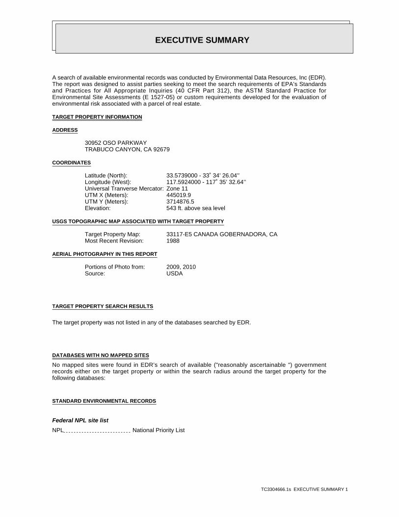
EXECUTIVE SUMMARY
TC3304666.1s EXECUTIVE SUMMARY 1
A search of available environmental records was conducted by Environmental Data Resources, Inc (EDR).The report was designed to assist parties seeking to meet the search requirements of EPA’s Standardsand Practices for All Appropriate Inquiries (40 CFR Part 312), the ASTM Standard Practice forEnvironmental Site Assessments (E 1527-05) or custom requirements developed for the evaluation ofenvironmental risk associated with a parcel of real estate.
TARGET PROPERTY INFORMATION
ADDRESS
30952 OSO PARKWAYTRABUCO CANYON, CA 92679
COORDINATES
33.5739000 - 33˚ 34’ 26.04’’Latitude (North): 117.5924000 - 117˚ 35’ 32.64’’Longitude (West): Zone 11Universal Tranverse Mercator: 445019.9UTM X (Meters): 3714876.5UTM Y (Meters): 543 ft. above sea levelElevation:
USGS TOPOGRAPHIC MAP ASSOCIATED WITH TARGET PROPERTY
33117-E5 CANADA GOBERNADORA, CATarget Property Map:1988Most Recent Revision:
AERIAL PHOTOGRAPHY IN THIS REPORT
2009, 2010Portions of Photo from:USDASource:
TARGET PROPERTY SEARCH RESULTS
The target property was not listed in any of the databases searched by EDR.
DATABASES WITH NO MAPPED SITES
No mapped sites were found in EDR’s search of available ("reasonably ascertainable ") governmentrecords either on the target property or within the search radius around the target property for thefollowing databases:
STANDARD ENVIRONMENTAL RECORDS
Federal NPL site list
NPL National Priority List

EXECUTIVE SUMMARY
TC3304666.1s EXECUTIVE SUMMARY 2
Proposed NPL Proposed National Priority List SitesNPL LIENS Federal Superfund Liens
Federal Delisted NPL site list
Delisted NPL National Priority List Deletions
Federal CERCLIS list
CERCLIS Comprehensive Environmental Response, Compensation, and Liability Information SystemFEDERAL FACILITY Federal Facility Site Information listing
Federal CERCLIS NFRAP site List
CERC-NFRAP CERCLIS No Further Remedial Action Planned
Federal RCRA CORRACTS facilities list
CORRACTS Corrective Action Report
Federal RCRA non-CORRACTS TSD facilities list
RCRA-TSDF RCRA - Treatment, Storage and Disposal
Federal RCRA generators list
RCRA-LQG RCRA - Large Quantity GeneratorsRCRA-SQG RCRA - Small Quantity GeneratorsRCRA-CESQG RCRA - Conditionally Exempt Small Quantity Generator
Federal institutional controls / engineering controls registries
US ENG CONTROLS Engineering Controls Sites ListUS INST CONTROL Sites with Institutional Controls
Federal ERNS list
ERNS Emergency Response Notification System
State- and tribal - equivalent NPL
RESPONSE State Response Sites
State- and tribal - equivalent CERCLIS
ENVIROSTOR EnviroStor Database
State and tribal landfill and/or solid waste disposal site lists
SWF/LF Solid Waste Information System
State and tribal leaking storage tank lists
SLIC Statewide SLIC CasesINDIAN LUST Leaking Underground Storage Tanks on Indian Land

EXECUTIVE SUMMARY
TC3304666.1s EXECUTIVE SUMMARY 3
State and tribal registered storage tank lists
INDIAN UST Underground Storage Tanks on Indian LandFEMA UST Underground Storage Tank Listing
State and tribal voluntary cleanup sites
VCP Voluntary Cleanup Program PropertiesINDIAN VCP Voluntary Cleanup Priority Listing
ADDITIONAL ENVIRONMENTAL RECORDS
Local Brownfield lists
US BROWNFIELDS A Listing of Brownfields Sites
Local Lists of Landfill / Solid Waste Disposal Sites
DEBRIS REGION 9 Torres Martinez Reservation Illegal Dump Site LocationsODI Open Dump InventoryWMUDS/SWAT Waste Management Unit DatabaseSWRCY Recycler DatabaseHAULERS Registered Waste Tire Haulers ListingINDIAN ODI Report on the Status of Open Dumps on Indian Lands
Local Lists of Hazardous waste / Contaminated Sites
US CDL Clandestine Drug LabsHIST Cal-Sites Historical Calsites DatabaseSCH School Property Evaluation ProgramToxic Pits Toxic Pits Cleanup Act SitesCDL Clandestine Drug LabsUS HIST CDL National Clandestine Laboratory Register
Local Lists of Registered Storage Tanks
CA FID UST Facility Inventory DatabaseHIST UST Hazardous Substance Storage Container DatabaseSWEEPS UST SWEEPS UST Listing
Local Land Records
LIENS 2 CERCLA Lien InformationLUCIS Land Use Control Information SystemLIENS Environmental Liens ListingDEED Deed Restriction Listing
Records of Emergency Release Reports
HMIRS Hazardous Materials Information Reporting SystemLDS Land Disposal Sites ListingMCS Military Cleanup Sites ListingOrange Co. Industrial Site List of Industrial Site Cleanups

EXECUTIVE SUMMARY
TC3304666.1s EXECUTIVE SUMMARY 4
Other Ascertainable Records
RCRA-NonGen RCRA - Non GeneratorsDOT OPS Incident and Accident DataDOD Department of Defense SitesFUDS Formerly Used Defense SitesCONSENT Superfund (CERCLA) Consent DecreesROD Records Of DecisionUMTRA Uranium Mill Tailings SitesMINES Mines Master Index FileTRIS Toxic Chemical Release Inventory SystemTSCA Toxic Substances Control ActFTTS FIFRA/ TSCA Tracking System - FIFRA (Federal Insecticide, Fungicide, & Rodenticide Act)/TSCA (Toxic Substances Control Act)HIST FTTS FIFRA/TSCA Tracking System Administrative Case ListingSSTS Section 7 Tracking SystemsICIS Integrated Compliance Information SystemPADS PCB Activity Database SystemMLTS Material Licensing Tracking SystemRADINFO Radiation Information DatabaseRAATS RCRA Administrative Action Tracking SystemCA BOND EXP. PLAN Bond Expenditure PlanWDS Waste Discharge SystemCortese "Cortese" Hazardous Waste & Substances Sites ListNotify 65 Proposition 65 RecordsDRYCLEANERS Cleaner FacilitiesWIP Well Investigation Program Case ListENF Enforcement Action ListingEMI Emissions Inventory DataINDIAN RESERV Indian ReservationsSCRD DRYCLEANERS State Coalition for Remediation of Drycleaners ListingCOAL ASH EPA Coal Combustion Residues Surface Impoundments ListPROC Certified Processors DatabaseHWT Registered Hazardous Waste Transporter DatabaseHWP EnviroStor Permitted Facilities ListingCOAL ASH DOE Sleam-Electric Plan Operation DataPCB TRANSFORMER PCB Transformer Registration DatabaseFINANCIAL ASSURANCE Financial Assurance Information ListingMWMP Medical Waste Management Program Listing
EDR PROPRIETARY RECORDS
EDR Proprietary Records
Manufactured Gas Plants EDR Proprietary Manufactured Gas PlantsEDR Historical Auto Stations EDR Proprietary Historic Gas StationsEDR Historical Cleaners EDR Proprietary Historic Dry Cleaners
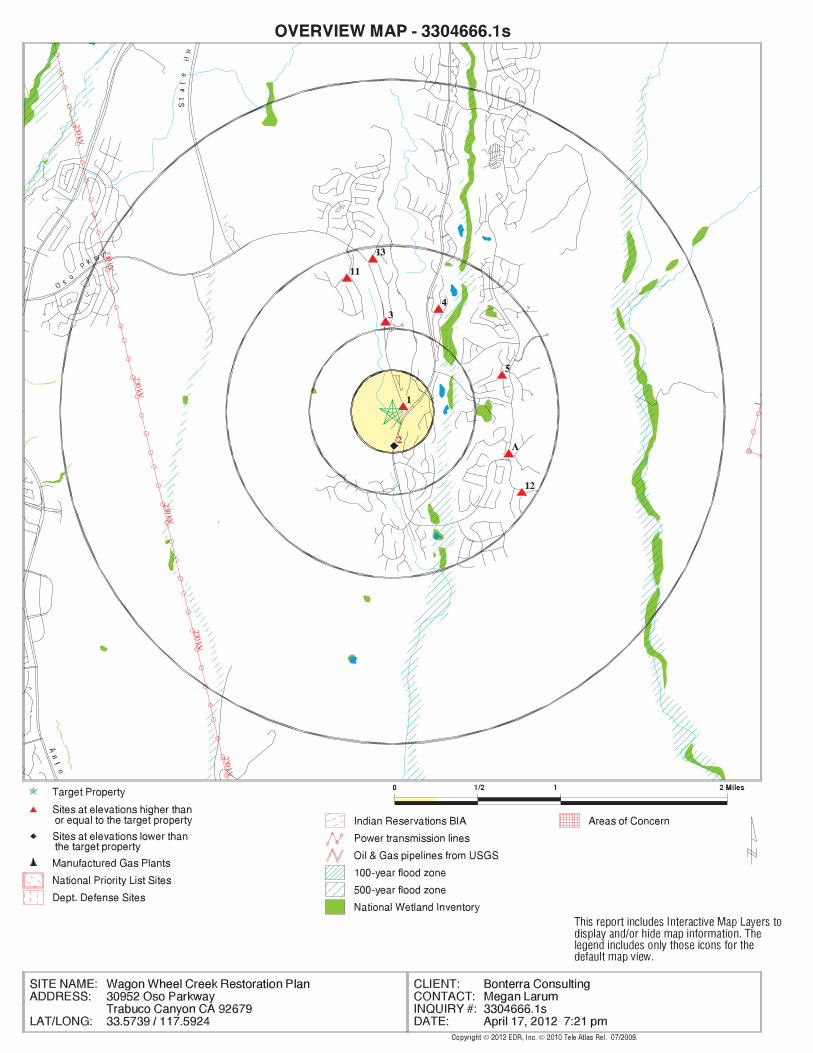
SURROUNDING SITES: SEARCH RESULTS
Surrounding sites were identified in the following databases.

EXECUTIVE SUMMARY
TC3304666.1s EXECUTIVE SUMMARY 5
Elevations have been determined from the USGS Digital Elevation Model and should be evaluated ona relative (not an absolute) basis. Relative elevation information between sites of close proximityshould be field verified. Sites with an elevation equal to or higher than the target property have beendifferentiated below from sites with an elevation lower than the target property.Page numbers and map identification numbers refer to the EDR Radius Map report where detaileddata on individual sites can be reviewed.
Sites listed in bold italics are in multiple databases.
Unmappable (orphan) sites are not considered in the foregoing analysis.
STANDARD ENVIRONMENTAL RECORDS
State and tribal leaking storage tank lists
LUST: The Leaking Underground Storage Tank Incident Reports contain an inventory of reportedleaking underground storage tank incidents. The data come from the State Water Resources Control Board LeakingUnderground Storage Tank Information System.
A review of the LUST list, as provided by EDR, and dated 01/20/2012 has revealed that there is 1 LUST site within approximately 1.5 miles of the target property.
PageMap IDDirection / Distance Address Equal/Higher Elevation ____________________ ________ ___________________ _____ _____
COTA DE CAZA GOLF&RACQUET 25541 VISTA DEL VERDE ESE 1/2 - 1 (0.744 mi.) A7 11
State and tribal registered storage tank lists
UST: The Underground Storage Tank database contains registered USTs. USTs are regulated underSubtitle I of the Resource Conservation and Recovery Act (RCRA). The data come from the State Water ResourcesControl Board’s Hazardous Substance Storage Container Database.
A review of the UST list, as provided by EDR, and dated 01/20/2012 has revealed that there are 2 UST sites within approximately 1.25 miles of the target property.
PageMap IDDirection / Distance Address Equal/Higher Elevation ____________________ ________ ___________________ _____ _____
COTO DE CAZA MAINT YARD 1 COTO DE CAZA DR ENE 0 - 1/8 (0.073 mi.) 1 8 COTO DE CAZA-GOLF COURSE 25541 VISTA DEL VERDE ESE 1/2 - 1 (0.744 mi.) A9 13
AST: The Aboveground Storage Tank database contains registered ASTs. The data come from theState Water Resources Control Board’s Hazardous Substance Storage Container Database.
A review of the AST list, as provided by EDR, and dated 08/01/2009 has revealed that there is 1 AST site within approximately 1.25 miles of the target property.
PageMap IDDirection / Distance Address Equal/Higher Elevation ____________________ ________ ___________________ _____ _____
Not reported 25541 VISTA DEL VERDE ESE 1/2 - 1 (0.744 mi.) A8 12

EXECUTIVE SUMMARY
TC3304666.1s EXECUTIVE SUMMARY 6
ADDITIONAL ENVIRONMENTAL RECORDS
Records of Emergency Release Reports
CHMIRS: The California Hazardous Material Incident Report System contains information on reportedhazardous material incidents, i.e., accidental releases or spills. The source is the California Office ofEmergency Services.
A review of the CHMIRS list, as provided by EDR, and dated 12/31/2010 has revealed that there are 2 CHMIRS sites within approximately 1 mile of the target property.
PageMap IDDirection / Distance Address Equal/Higher Elevation ____________________ ________ ___________________ _____ _____
Not reported 38 CARNOUSTIE WAY NNE 1/2 - 1 (0.679 mi.) 4 9 Not reported 25543 VISTA DEL VERDE ESE 1/2 - 1 (0.749 mi.) A10 13
Other Ascertainable Records
FINDS: The Facility Index System contains both facility information and "pointers" to othersources of information that contain more detail. These include: RCRIS; Permit Compliance System (PCS);Aerometric Information Retrieval System (AIRS); FATES (FIFRA [Federal Insecticide Fungicide Rodenticide Act]and TSCA Enforcement System, FTTS [FIFRA/TSCA Tracking System]; CERCLIS; DOCKET (Enforcement Docket used tomanage and track information on civil judicial enforcement cases for all environmental statutes); FederalUnderground Injection Control (FURS); Federal Reporting Data System (FRDS); Surface Impoundments (SIA); TSCAChemicals in Commerce Information System (CICS); PADS; RCRA-J (medical waste transporters/disposers); TRIS;and TSCA. The source of this database is the U.S. EPA/NTIS.
A review of the FINDS list, as provided by EDR, and dated 10/23/2011 has revealed that there is 1 FINDS site within approximately 1 mile of the target property.
PageMap IDDirection / Distance Address Equal/Higher Elevation ____________________ ________ ___________________ _____ _____
WAGON WHEEL ELEMENTARY 30912 BRIDLE PATH N 1/2 - 1 (0.546 mi.) 3 8
NPDES: A listing of NPDES permits, including stormwater.
A review of the NPDES list, as provided by EDR, and dated 02/20/2012 has revealed that there is 1 NPDES site within approximately 1 mile of the target property.
PageMap IDDirection / Distance Address Lower Elevation ____________________ ________ ___________________ _____ _____
27207 SOUTH BEND 27207 S BEND RD S 1/8 - 1/4 (0.207 mi.) 2 8
HIST CORTESE: The sites for the list are designated by the State Water Resource Control Board [LUST],the Integrated Waste Board [SWF/LS], and the Department of Toxic Substances Control [CALSITES]. Thislisting is no longer updated by the state agency.
A review of the HIST CORTESE list, as provided by EDR, and dated 04/01/2001 has revealed that there is 1 HIST CORTESE site within approximately 1.5 miles of the target property.
PageMap IDDirection / Distance Address Equal/Higher Elevation ____________________ ________ ___________________ _____ _____
COTA DE CAZA GOLF&RACQUET 25541 VISTA DEL VERDE ESE 1/2 - 1 (0.744 mi.) A7 11

EXECUTIVE SUMMARY
TC3304666.1s EXECUTIVE SUMMARY 7
HAZNET: The data is extracted from the copies of hazardous waste manifests received each year bythe DTSC. The annual volume of manifests is typically 700,000-1,000,000 annually, representing approximately350,000-500,000 shipments. Data from non-California manifests & continuation sheets are not included at thepresent time. Data are from the manifests submitted without correction, and therefore many contain someinvalid values for data elements such as generator ID, TSD ID, waste category, & disposal method. The sourceis the Department of Toxic Substance Control is the agency
A review of the HAZNET list, as provided by EDR, and dated 12/31/2010 has revealed that there are 6 HAZNET sites within approximately 1 mile of the target property.
PageMap IDDirection / Distance Address Equal/Higher Elevation ____________________ ________ ___________________ _____ _____
PRUDENTAL CALIFORNIA REALTY 24 DARTMOUTH LN ENE 1/2 - 1 (0.696 mi.) 5 10 COTO DE CAZA GOLF & RACQUET CL 25541 VISTA DEL VERDE ESE 1/2 - 1 (0.744 mi.) A6 11 COTA DE CAZA GOLF&RACQUET 25541 VISTA DEL VERDE ESE 1/2 - 1 (0.744 mi.) A7 11 PRUDENTIAL CALIFORNIA REALTY 24 KINGFISHER NNW 1/2 - 1 (0.851 mi.) 11 14 CASE RESIDENCE 6 FALCONRIDGE DR ESE 1/2 - 1 (0.918 mi.) 12 15 PRUDENTIAL CALIFORNIA REALTY 1 GINGHAM N 1/2 - 1 (0.930 mi.) 13 15

EXECUTIVE SUMMARY
TC3304666.1s EXECUTIVE SUMMARY 8
Due to poor or inadequate address information, the following sites were not mapped. Count: 27 records.
Site Name Database(s)____________ ____________
BEACON SERVICE STATION HIST CORTESETRACT 16461 NPDESNORTH BASIN BARRIER PROJECT- WELL NPDESUPPER CHIQUITA RESERVIOR NPDES, HAZNETSADDLEBACK VALLEY CHRISTIAN NPDES
NPDES, CHMIRSTRABUCO CREEK ROAD RESURFACING AND NPDES
CDLCOTO DE CAZA LIFT STATION USTPACIFIC BELL MOBILE SERVICES HAZNETSANTA MARGARITA WATER DISTRICT - C HAZNETCOTO DE CAZA CONSTRUCTION SITE HAZNETLUCAS & MERCIER CONSTRUCTION CORP HAZNETLUCAS & MERCIER CONSTRUCTION CORP HAZNETCHINO VALLEY DISTRIBUTION INC HAZNETSAN DIEGO GAS & ELECTRIC/CAPISTRAN HAZNETCOUNTY ORANGE/EMA HAZNETSAN JUAN FIRE STATION HAZNET1X FORD MOTOR LAND DEVELOPMENT CO HAZNETPACER CARTAGE HAZNETDIST 12/CONSTR/EA12-0F1804 HAZNETTENTATIVE TRACT MAP NO. 17325, COT Orange Co. Industrial SiteEL MORRO CONVERSION TO CAMPGRO WDSSR-241 BRIDGE WIDENING DEWATER WDSOSO ROAD CROSSING RESTORATION WDSTCWD GOREN WTP WDSVULCAN MATERIALS CO. MINES
EDR Inc.EDR Inc.EDR Inc.EDR Inc.EDR Inc.EDR Inc.EDR Inc.EDR Inc.EDR Inc.EDR Inc.EDR Inc.EDR Inc.EDR Inc.EDR Inc.EDR Inc.EDR Inc.EDR Inc.EDR Inc.EDR Inc.EDR Inc.EDR Inc.EDR Inc.EDR Inc.EDR Inc.EDR Inc.EDR Inc.EDR Inc.EDR Inc.EDR Inc.EDR Inc.EDR Inc.EDR Inc.EDR Inc.EDR Inc.EDR Inc.EDR Inc.EDR Inc.EDR Inc.EDR Inc.EDR Inc.
1
230 kV
230 kV
230 kV
230 kV
230 kV
230 kV
68
06
40
64
06
40
72
0
68
0
7206 8 0
64
0
64
0
6 4 0
8 4 08 0 0
7
6 0720
7
2 0
00
60
0
60
0
8 8 0
8
80
8 4 08 0 0
8 00
7 6 0
7 6 0
800
760
84
08
0 0
76
0
7 2 0
7 20
7 20
72
0
6 8 0
8 0
6 8 0
68
0
6 8 0
680
6 4 0
0
6 4 0
6 4 0
6 8 0
6 4 0
60
0
00
6 0 0
6 0 0
6 0 0
6 0 0
60
0 6 00
440 48
0
40
6 40
48
0
52
0
5
60
6
56
05
60
6 0
5 6 0
5
6 0
0
20
0
1 040
20
201
1 0 001 0 00
8 00 920
920960
600
6
64
0
88
0
9201040
6 40
1 2 8 01
000
1 2 40
96
0 9 6 0
96
0
9
60
960
1
96
0
92
0
9 6 0
6
80
68
0
92
0 9
2 0
9
20
9 2 0
920
92
0
9 2 0
6
8
0
7 2 0
72 0
7 20
920
92
0
92
0
92
0
92
08
80
880
8 80
8 8 0
88
0
840
7
2 0
880
9
2 0
64
0
0
6
8 0
88
0
88 0
8 8 0
88
0
8 8 0
8
80
880
88
0
88
0
8 8 0
8 80
80
0
20
0
7 2 0
72
0
11
60
1
8 0 07 60
7 6 0
7 60
7 6 0
7 6 0
7 60
11
20
1 120
1
12
0
8 0 0
8 0 0
8 00
8 0 0
80
08
0 0
08
0
10
80
1 0
1 0 8 0
1
10
640
10
40
10
40
1 0 40
1
0
10
10 4
10
00
1 0 001
0
0 0
1 000
1
88
0
8
8 0
76
08
00 7
20
600
96
0
9 6 0
96
0
960
960
840
880
8 4 0
8 4 0
84
0
8
40
8 0 0
72084
0
92
0
92
0
920
92
0
9
840
60
0
880
88
08
80
88 0
88
0
88
0
8 8 08
80
880
8 8 0
8
88
0
6
00
8
80
8
4 0 800
76
08
00
8 4 0
8 4 0
8 4 08 4 0
84 0
8 4 0
84
0
840
84
0
8 40
8 4 0
8 4 0
840
840
84
0
8 4 0
8 40
84
0
84
0
84
0
8 40
8 40
8 40
8
4 0
84
0
84
0
84
0
8
40
40
84
08
4 0 8
8
84
0
8 4 0
84
0
84
0
60
0 5608 4
0
72
0
80
0
7 20
6 80
6 80
800
920 8 00
920 88
0
84
0
6
80
7
20
600 7
60
840
680
7 20
84
0
8408
00
80 0
8
0 0
8 0 0
8 0 0
80
0
80
0
8 0 0
80
0
80
08
00
8 0 0
80 0
8 00
8
00
80
0
8 0 0
80
08
00
8 0 0
800
80
0
80
0
80
0
8 0 0
8
0 0
8 00
80
08
0 0
80
0
80
0
80
0
80
0
80
0
80
08 0 0
80 0
8
0 0
8 0 0
8 00
80
0
600
8 005 20
7 60
7 6 0600
800
76
0
76
0
76
0
7 6 0
00
48
0
32
0
32
0
60
3 6 0
3 6 0
3 6 0
4 0 0
4
0 0
4 0 0
4 00
4
00 4 0 0
4
0 0
40
04
00
40
0
4
00
4
4 4 0
44
0
44
04 4 0
440
44 0 4 4
0
4 4 0
4 4 0
44
0
44
0
44 0
44
0
44
0
4 4 0
44
0
44
0
44
0
4 80
4
8 04
80
4
80
4 8 0
4 8 0
4 8 0
48
0
4 80
80 0
4 8 0
4 8 0
48
0
48
0
48
0
480
48
0
4 8 0
48
04
8 0
4
8 0
48
0
48
0
48
0
48
0
48
0
55
20
52
0
520
52
0
5
20
5
20
5 20 5
20
520
5 2 0
20
52
0
5 2 0
52
0
52
0
52
05
20
52
0
52
0
5 20
5 2 0
5 2 0
5 2 0
5 2 0
52
0
5 2 0
5 2 0
0
52
0
52
0
5 2 0
52
0
52
0
5 2 0
52
0
56
0
56
0
5 60
5 60
5 6 0
56
0
5 6 0
56
0
56
0
56
0
5 6 0
56
0
56
0
56
05
6 0
5 6 0
560 5
60
5 6 0
5 6 0
56
05
60
56
0
56
0
56
0
560
5 6 0
5 6 0
5 60
5 6 0
5 6 0
5 6 0
5 6 0
5 6 0
560
56 0
5 6 0
56
0
5 6 0
56
0
56
0
560
56
0
56
05
6 0
6 0 0
60
0
600
6 0 0
6 0 0
60
0
6
00
60
0
60
0
600
60
0
6 00
60
0
60
0
60
0
60
0
60
0
60
0
60
0
6 0 0
60
0
600
6 00
6 0 0
6 0 0
6 0 0
6
00
6 0 0
6 0 0
6 0 0
6 0 0
6 0 0
6 0 0
600
6
0 0
60
06
00
60
0
60
0
60
0
60
0
6
0 0
60
0
6
40
64
0
6
4 0
64 0
6
4 0
6 4 0
640
64
0
64
0
64
0
640
640
6 40
6 4 0
6 4 0
6 40
64
0
64 0
64
06
40
64
0
64
0
64
0
6 4 0
64 0
6
4 0
640
640
6 4 0
6 4 0
6 40
6 4 0
6 4 0
6 4 0
6 40
64
0
640
6 40
6 4 0
64
0
6 4 0
6
4 0
64 0
64
0
64
0
64
0
6
4 0
6 4 0
64
0
64
0
6 40
64
68
0
68
0
68
0
680
6 80
6
8 0
6 80
6 8 0
680
6 80
6
80
68
0
680
68
0
6
8 0
6 8 06 8 0
6 80
68
0
68
0
68
0
6 8 0
6
8 0
6 8 0
6 8 0
6 8 0
6 80
6 80
6 8 0
68
0
6
80
6 8 0
6 8 0
6 8 0
68
0
68
0
6 80
6 8 0
6 8 0
68
0
6 8 0
6 8 0
68
06
80
6 8 0
68
0
68
0
6 8 0
6 80
6 8 06
80
68
0
6 80 6
80
68
0
6
72
0
72
0
72
07
20
72
0
7 20
72
0
7 20
72
0
72
0
7
2 0
72
0
72
0
7
2 0
72
0
7 20
72
0
7
2 0
72
0
72
0
7 2 0
72
0
7
2 0
7 2 0
72
0
720
7 2 0
7 2 0
7 2 0
7 2 0
7 2 0
7 2 0
7 2 0
7 20
7 2 07 2 0
0
720
7 2 0
7 2 0
7
2 0
720
7 2 0
72
0
72
0
72
07
20
72
07
20
720
7 2 0
7
20
7 2 0
720
72
0
72
0 72
7
76
0
76
0
76
07
6 0
7
6 0
760
76
07
6 0
7 60
7 6 0 76
0
7 60
760
7 60
76
0
760
7 6 0
76 0
76
0
76
0
7 6 0
7
6 0
76
0
7 6 0
7 60
7 60
7 6 0
7 6 0
7
6 0
76
0
76
0
7
6 0
7 6 0
76
0
7
6 0
76
0
7 6 0
7 60
76
0
76
0
76 0 7
60
76
07
60
7 6 0
7
6 0
76
0
7 6 0
760
76
0
7

EDR Inc.EDR Inc.EDR Inc.EDR Inc.EDR Inc.EDR Inc.EDR Inc.EDR Inc.EDR Inc.EDR Inc.EDR Inc.EDR Inc.EDR Inc.EDR Inc.EDR Inc.EDR Inc.EDR Inc.EDR Inc.EDR Inc.EDR Inc.EDR Inc.EDR Inc.EDR Inc.EDR Inc.EDR Inc.EDR Inc.EDR Inc.EDR Inc.EDR Inc.EDR Inc.EDR Inc.EDR Inc.EDR Inc.EDR Inc.EDR Inc.EDR Inc.EDR Inc.EDR Inc.EDR Inc.EDR Inc.
600
600
640
600
520
560
560
600
600
600
MAP FINDINGS SUMMARY
SearchTargetDistance Total
Database Property(Miles) < 1/8 1/8 - 1/4 1/4 - 1/2 1/2 - 1 > 1 Plotted
STANDARD ENVIRONMENTAL RECORDS
Federal NPL site list
0 0 0 0 0 0 2.000NPL 0 0 0 0 0 0 2.000Proposed NPL 0 NR 0 0 0 0 1.000NPL LIENS
Federal Delisted NPL site list
0 0 0 0 0 0 2.000Delisted NPL
Federal CERCLIS list
0 0 0 0 0 0 1.500CERCLIS 0 0 0 0 0 0 2.000FEDERAL FACILITY
Federal CERCLIS NFRAP site List
0 0 0 0 0 0 1.500CERC-NFRAP
Federal RCRA CORRACTS facilities list
0 0 0 0 0 0 2.000CORRACTS
Federal RCRA non-CORRACTS TSD facilities list
0 0 0 0 0 0 1.500RCRA-TSDF
Federal RCRA generators list
0 0 0 0 0 0 1.250RCRA-LQG 0 0 0 0 0 0 1.250RCRA-SQG 0 0 0 0 0 0 1.250RCRA-CESQG
Federal institutional controls /engineering controls registries
0 0 0 0 0 0 1.500US ENG CONTROLS 0 0 0 0 0 0 1.500US INST CONTROL
Federal ERNS list
0 NR 0 0 0 0 1.000ERNS
State- and tribal - equivalent NPL
0 0 0 0 0 0 2.000RESPONSE
State- and tribal - equivalent CERCLIS
0 0 0 0 0 0 2.000ENVIROSTOR
State and tribal landfill and/orsolid waste disposal site lists
0 0 0 0 0 0 1.500SWF/LF
State and tribal leaking storage tank lists
1 0 1 0 0 0 1.500LUST 0 0 0 0 0 0 1.500SLIC
TC3304666.1s Page 4

MAP FINDINGS SUMMARY
SearchTargetDistance Total
Database Property(Miles) < 1/8 1/8 - 1/4 1/4 - 1/2 1/2 - 1 > 1 Plotted
0 0 0 0 0 0 1.500INDIAN LUST
State and tribal registered storage tank lists
2 0 1 0 0 1 1.250UST 1 0 1 0 0 0 1.250AST 0 0 0 0 0 0 1.250INDIAN UST 0 0 0 0 0 0 1.250FEMA UST
State and tribal voluntary cleanup sites
0 0 0 0 0 0 1.500VCP 0 0 0 0 0 0 1.500INDIAN VCP
ADDITIONAL ENVIRONMENTAL RECORDS
Local Brownfield lists
0 0 0 0 0 0 1.500US BROWNFIELDS
Local Lists of Landfill / SolidWaste Disposal Sites
0 0 0 0 0 0 1.500DEBRIS REGION 9 0 0 0 0 0 0 1.500ODI 0 0 0 0 0 0 1.500WMUDS/SWAT 0 0 0 0 0 0 1.500SWRCY 0 NR 0 0 0 0 1.000HAULERS 0 0 0 0 0 0 1.500INDIAN ODI
Local Lists of Hazardous waste /Contaminated Sites
0 NR 0 0 0 0 1.000US CDL 0 0 0 0 0 0 2.000HIST Cal-Sites 0 0 0 0 0 0 1.250SCH 0 0 0 0 0 0 2.000Toxic Pits 0 NR 0 0 0 0 1.000CDL 0 NR 0 0 0 0 1.000US HIST CDL
Local Lists of Registered Storage Tanks
0 0 0 0 0 0 1.250CA FID UST 0 0 0 0 0 0 1.250HIST UST 0 0 0 0 0 0 1.250SWEEPS UST
Local Land Records
0 NR 0 0 0 0 1.000LIENS 2 0 0 0 0 0 0 1.500LUCIS 0 NR 0 0 0 0 1.000LIENS 0 0 0 0 0 0 1.500DEED
Records of Emergency Release Reports
0 NR 0 0 0 0 1.000HMIRS 2 NR 2 0 0 0 1.000CHMIRS 0 NR 0 0 0 0 1.000LDS
TC3304666.1s Page 5

MAP FINDINGS SUMMARY
SearchTargetDistance Total
Database Property(Miles) < 1/8 1/8 - 1/4 1/4 - 1/2 1/2 - 1 > 1 Plotted
0 NR 0 0 0 0 1.000MCS 0 NR 0 0 0 0 1.000Orange Co. Industrial Site
Other Ascertainable Records
0 0 0 0 0 0 1.250RCRA-NonGen 0 NR 0 0 0 0 1.000DOT OPS 0 0 0 0 0 0 2.000DOD 0 0 0 0 0 0 2.000FUDS 0 0 0 0 0 0 2.000CONSENT 0 0 0 0 0 0 2.000ROD 0 0 0 0 0 0 1.500UMTRA 0 0 0 0 0 0 1.250MINES 0 NR 0 0 0 0 1.000TRIS 0 NR 0 0 0 0 1.000TSCA 0 NR 0 0 0 0 1.000FTTS 0 NR 0 0 0 0 1.000HIST FTTS 0 NR 0 0 0 0 1.000SSTS 0 NR 0 0 0 0 1.000ICIS 0 NR 0 0 0 0 1.000PADS 0 NR 0 0 0 0 1.000MLTS 0 NR 0 0 0 0 1.000RADINFO 1 NR 1 0 0 0 1.000FINDS 0 NR 0 0 0 0 1.000RAATS 0 0 0 0 0 0 2.000CA BOND EXP. PLAN 1 NR 0 0 1 0 1.000NPDES 0 NR 0 0 0 0 1.000WDS 0 0 0 0 0 0 1.500Cortese 1 0 1 0 0 0 1.500HIST CORTESE 0 0 0 0 0 0 2.000Notify 65 0 0 0 0 0 0 1.250DRYCLEANERS 0 0 0 0 0 0 1.250WIP 0 NR 0 0 0 0 1.000ENF 6 NR 6 0 0 0 1.000HAZNET 0 NR 0 0 0 0 1.000EMI 0 0 0 0 0 0 2.000INDIAN RESERV 0 0 0 0 0 0 1.500SCRD DRYCLEANERS 0 0 0 0 0 0 1.500COAL ASH EPA 0 0 0 0 0 0 1.500PROC 0 0 0 0 0 0 1.250HWT 0 0 0 0 0 0 2.000HWP 0 NR 0 0 0 0 1.000COAL ASH DOE 0 NR 0 0 0 0 1.000PCB TRANSFORMER 0 NR 0 0 0 0 1.000FINANCIAL ASSURANCE 0 0 0 0 0 0 1.250MWMP
EDR PROPRIETARY RECORDS
EDR Proprietary Records
0 0 0 0 0 0 2.000Manufactured Gas Plants 0 0 0 0 0 0 1.250EDR Historical Auto Stations
TC3304666.1s Page 6

MAP FINDINGS SUMMARY
SearchTargetDistance Total
Database Property(Miles) < 1/8 1/8 - 1/4 1/4 - 1/2 1/2 - 1 > 1 Plotted
0 0 0 0 0 0 1.250EDR Historical Cleaners
NOTES:
TP = Target Property
NR = Not Requested at this Search Distance
Sites may be listed in more than one database
TC3304666.1s Page 7

MAP FINDINGSMap IDDirection
EDR ID NumberDistanceEPA ID NumberDatabase(s)SiteElevation
-117.59131Longitude:33.57425Latitude:3549Facility ID:
UST:
388 ft.0.073 mi.
Relative:Higher
Actual:566 ft.
< 1/8 TRABUCO CANYON, CA 92679ENE 1 COTO DE CAZA DR N/A1 USTCOTO DE CAZA MAINT YARD U003778721
92679Discharge Zip: CaliforniaDischarge State: Coto De CazaDischarge City: 23333 Avenida La CazaDischarge Address: Coto De Caza LtdDischarge Name: 09/02/2010Termination Date Of Regulatory Measure: Not reportedExpiration Date Of Regulatory Measure: 12/07/1995Effective Date Of Regulatory Measure: Not reportedAdoption Date Of Regulatory Measure: ConstructionProgram Type: 9 30C305368WDID: Not reportedPlace Id: EnrolleeRegulatory Measure Type: 2009-0009-DWQOrder No: 286178Regulatory Measure Id: 9Region: 0Agency Id: TerminatedFacility Status: CAS000002Npdes Number:
NPDES:
1093 ft.0.207 mi.
Relative:Lower
Actual:520 ft.
1/8-1/4 COTO DE CAZA, CA 92679South 27207 S BEND RD N/A2 NPDES27207 SOUTH BEND S109434467
sciences.United States and other nations and the institute of educationentity for collecting and analyzing data related to education in theNCES (National Center for Education Statistics) is the primary federal Environmental Interest/Information System
110037016635Registry ID:
FINDS:
2883 ft.0.546 mi.
Relative:Higher
Actual:651 ft.
1/2-1 COTO DE CAZA, CA 92679North 30912 BRIDLE PATH N/A3 FINDSWAGON WHEEL ELEMENTARY 1008273361
TC3304666.1s Page 8

MAP FINDINGSMap IDDirection
EDR ID NumberDistanceEPA ID NumberDatabase(s)SiteElevation
Not reportedAmount: Orange County Emergency Managment DivAdmin Agency: 10/10/200112:00:00 AMIncident Date: Santa Margarita Water DistAgency: 2001Year: Not reportedDate/Time: Not reportedOther: Not reportedMeasure: Not reportedType: Not reportedWhat Happened: Not reportedContainment: Reporting PartyCleanup By: Not reportedSpill Site: Not reportedWaterway: NoWaterway Involved: Not reportedFacility Telephone: Not reportedComments: Not reportedReport Date: Not reportedReporting Officer Name/ID: Not reportedCompany Name: Not reportedCA/DOT/PUC/ICC Number: Not reportedVehicle Id Number: Not reportedVehicle State: Not reportedVehicle License Number: Not reportedVehicle Make/year: Not reportedOthers Number Of Fatalities: Not reportedOthers Number Of Injuries: Not reportedOthers Number Of Decontaminated: Not reportedResponding Agency Personel # Of Fatalities: Not reportedResponding Agency Personel # Of Injuries: Not reportedResp Agncy Personel # Of Decontaminated: Not reportedMore Than Two Substances Involved?: Not reportedSpecial Studies 6: Not reportedSpecial Studies 5: Not reportedSpecial Studies 4: Not reportedSpecial Studies 3: Not reportedSpecial Studies 2: Not reportedSpecial Studies 1: Not reportedProperty Management: Not reportedEstimated Temperature: Not reportedSurrounding Area: Not reportedTime Completed: Not reportedTime Notified: Not reportedAgency Incident Number: Not reportedAgency Id Number: Not reportedProperty Use: Not reportedDate Completed: Not reportedIncident Date: Not reportedOES Time: Not reportedOES Date: 10/19/200102:10:21 PMOES notification: 01-5995OES Incident Number:
CHMIRS:
3584 ft.0.679 mi.
Relative:Higher
Actual:585 ft.
1/2-1 TRABUCO CANYON, CA 92679NNE 38 CARNOUSTIE WAY N/A4 CHMIRS S105671244
TC3304666.1s Page 9

MAP FINDINGSMap IDDirection
EDR ID NumberDistanceEPA ID NumberDatabase(s)SiteElevation
15 May 1997 and concluded 10 Oct 2001. substance has been recovered. The leak is estimated to have started that substance exited from.NOTE: Line has sense been repaired and all up substance four feet later. Alternate pipe is horizontal with pipe A Broken 4 Sewer lateral Spilt substance and a alternate line pickedDescription: 0Number of Fatalities: 0Number of Injuries: 0Evacuations: 0.000000Unknown: 0Tons: 0Sheen: 0Quarts: 0Pints: 0Ounces: 0Liters: 0Pounds: 0Grams: 342Gallons: 0CUFT: 0Cups: 0BBLS: Not reportedQuantity Released: SewageSubstance: Not reportedE Date: ResidenceSite Type: YesContained:
(Continued) S105671244
Not reportedFacility County: 0.06Tons: D99Disposal Method: Household wasteWaste Category: SacramentoTSD County: Not reportedTSD EPA ID: OrangeGen County: IRVINE, CA 926140000Mailing City,St,Zip: 2405 MC CABE WY STE 211Mailing Address: Not reportedMailing Name: 6264427200Telephone: JEFF HARRIS/PRIME ENVIROContact: CAC002428095Gepaid: 2002Year:
HAZNET:
3675 ft.0.696 mi.
Relative:Higher
Actual:566 ft.
1/2-1 COTO DE CAZA, CA 92679ENE 24 DARTMOUTH LN N/A5 HAZNETPRUDENTAL CALIFORNIA REALTY S106085500
TC3304666.1s Page 10

MAP FINDINGSMap IDDirection
EDR ID NumberDistanceEPA ID NumberDatabase(s)SiteElevation
Not reportedFacility County: 2.71Tons: R01Disposal Method: Waste oil and mixed oilWaste Category: Los AngelesTSD County: CAD099452708TSD EPA ID: OrangeGen County: COTO DE CAZA, CA 926790000Mailing City,St,Zip: 25291 VISTA DEL VERDEMailing Address: Not reportedMailing Name: 9498582775Telephone: ROBERT BLALOCKContact: CAL000208613Gepaid: 2004Year:
HAZNET:
3927 ft. Site 1 of 5 in cluster A0.744 mi.
Relative:Higher
Actual:560 ft.
1/2-1 COTO DE CAZA, CA 92679ESE 25541 VISTA DEL VERDE N/AA6 HAZNETCOTO DE CAZA GOLF & RACQUET CLUB S108203772
02/08/1999Release Date: Not reportedBegan Monitor: Not reportedRemed Action: / /Remed Plan: Not reportedDesc Pollution: / /Prelim Assess: 3/3/99Submit Workplan: / /Confirm Date: / /Date Stopped: 02/08/1999Date Found: Soil onlyCase Type: Local AgencyLead Agency: UnknownCause: UnknownSource: Not reportedHow Stopped: Not reportedHow Found: OrangeLocal Agency: Not reportedAbate Method: Not reportedQty Leaked: DieselSubstance: 99UT19Local Case: 9UT3808Case Number: Case ClosedStatus: 9Region:
LUST REG 9:
9UT3808Reg Id: LTNKAReg By: 30Facility County Code: CORTESERegion:
CORTESE:
3927 ft. Site 2 of 5 in cluster A0.744 mi.
Relative:Higher
Actual:560 ft.
1/2-1 HAZNETCOTO DE CAZA, CA 92679ESE LUST25541 VISTA DEL VERDE N/AA7 HIST CORTESECOTA DE CAZA GOLF&RACQUET S103723419
TC3304666.1s Page 11

MAP FINDINGSMap IDDirection
EDR ID NumberDistanceEPA ID NumberDatabase(s)SiteElevation
OrangeFacility County: 7.506Tons: (H010-H129) OR (H131-H135) STORAGE, BULKING, AND/OR TRANSFER OFF SITE--NO TREATMENT/REOVERYDisposal Method: Unspecified oil-containing wasteWaste Category: Los AngelesTSD County: CAD981696420TSD EPA ID: OrangeGen County: COTO DE CAZA, CA 926790000Mailing City,St,Zip: 25291 VISTA DEL VERDEMailing Address: Not reportedMailing Name: 9498582775Telephone: D FLAXBEARD DIR OF GOLF OPTNSContact: CAL000208613Gepaid: 2009Year:
OrangeFacility County: 3.336Tons: (H010-H129) OR (H131-H135) STORAGE, BULKING, AND/OR TRANSFER OFF SITE--NO TREATMENT/REOVERYDisposal Method: Unspecified oil-containing wasteWaste Category: Not reportedTSD County: CAD981696420TSD EPA ID: Not reportedGen County: COTO DE CAZA, CA 926790000Mailing City,St,Zip: 25291 VISTA DEL VERDEMailing Address: Not reportedMailing Name: 9498582775Telephone: KEN NEWCOMB/DIR OF GOLF OPTNSContact: CAL000208613Gepaid: 2010Year:
HAZNET:
Not reportedWaste Discharge Requirement Number: Not reportedCleanup and Abatement order Number: Not reportedInterim Remedial Actions: Administratively opened on database, however no file physically existsFile Dispn: 2APriority: Not reportedNPDES Number: MUNBUBeneficial Use: >41GW Depth: 901.24Basin Number: LOPPilot Program: Not reportedEnforce Type: 11/5/99Closed Date: Not reportedEnforce Date:
COTA DE CAZA GOLF&RACQUET (Continued) S103723419
OrangeCertified Unified Program Agencies: 1,320Total Gallons: COTO DE CAZA GOLF COURSEOwner:
AST:
3927 ft. Site 3 of 5 in cluster A0.744 mi.
Relative:Higher
Actual:560 ft.
1/2-1 COTO DE CAZA, CA 92679ESE 25541 VISTA DEL VERDE N/AA8 AST A100323501
TC3304666.1s Page 12

MAP FINDINGSMap IDDirection
EDR ID NumberDistanceEPA ID NumberDatabase(s)SiteElevation
-117.58018Longitude:33.57032Latitude:3499Facility ID:
UST:
3927 ft. Site 4 of 5 in cluster A0.744 mi.
Relative:Higher
Actual:560 ft.
1/2-1 TRABUCO CANYON, CA 92679ESE 25541 VISTA DEL VERDE N/AA9 USTCOTO DE CAZA-GOLF COURSE U003778689
Not reportedContainment: UnknownCleanup By: Not reportedSpill Site: Storm Drain/Gobernadora CreekWaterway: Not reportedWaterway Involved: Not reportedFacility Telephone: Not reportedComments: Not reportedReport Date: Not reportedReporting Officer Name/ID: Not reportedCompany Name: Not reportedCA/DOT/PUC/ICC Number: Not reportedVehicle Id Number: Not reportedVehicle State: Not reportedVehicle License Number: Not reportedVehicle Make/year: Not reportedOthers Number Of Fatalities: Not reportedOthers Number Of Injuries: Not reportedOthers Number Of Decontaminated: Not reportedResponding Agency Personel # Of Fatalities: Not reportedResponding Agency Personel # Of Injuries: Not reportedResp Agncy Personel # Of Decontaminated: Not reportedMore Than Two Substances Involved?: Not reportedSpecial Studies 6: Not reportedSpecial Studies 5: Not reportedSpecial Studies 4: Not reportedSpecial Studies 3: Not reportedSpecial Studies 2: Not reportedSpecial Studies 1: Not reportedProperty Management: Not reportedEstimated Temperature: Not reportedSurrounding Area: Not reportedTime Completed: Not reportedTime Notified: Not reportedAgency Incident Number: Not reportedAgency Id Number: Not reportedProperty Use: Not reportedDate Completed: Not reportedIncident Date: Not reportedOES Time: Not reportedOES Date: 8/10/200505:01:01 PMOES notification: 05-4713OES Incident Number:
CHMIRS:
3957 ft. Site 5 of 5 in cluster A0.749 mi.
Relative:Higher
Actual:556 ft.
1/2-1 COTO DE CAZA, CA 91679ESE 25543 VISTA DEL VERDE N/AA10 CHMIRS S108404598
TC3304666.1s Page 13

MAP FINDINGSMap IDDirection
EDR ID NumberDistanceEPA ID NumberDatabase(s)SiteElevation
qts of Dursban Pro was the amount of chemical mixed with the water. Substance was released from a spray container into a storm drain. 2Description: 0Number of Fatalities: 0Number of Injuries: 0Evacuations: 0Unknown: 0Tons: 0Sheen: 0Quarts: 0Pints: 0Ounces: 0Liters: 0Pounds: 0Grams: 150Gallons: 0CUFT: 0Cups: 0BBLS: Not reportedQuantity Released: Dursban Pro with waterSubstance: Not reportedE Date: Merchant/BusinessSite Type: YesContained: Not reportedAmount: Orange County Emergency Management DivisionAdmin Agency: 8/10/200512:00:00 AMIncident Date: Coto De Caza Golf and Racquet ClubAgency: 2005Year: Not reportedDate/Time: Not reportedOther: Not reportedMeasure: Not reportedType: Not reportedWhat Happened:
(Continued) S108404598
CAC001320096Gepaid: 1999Year:
OrangeFacility County: 0.005Tons: D99Disposal Method: Unspecified solvent mixtureWaste Category: 0TSD County: TND000772186TSD EPA ID: OrangeGen County: IRVINE, CA 926120000Mailing City,St,Zip: 3333 MICHELSON DR STE 910Mailing Address: Not reportedMailing Name: 9498336886Telephone: PRUDENTIAL CALIFORNIA REALTYContact: CAC001320096Gepaid: 1999Year:
HAZNET:
4495 ft.0.851 mi.
Relative:Higher
Actual:714 ft.
1/2-1 TRABUCO CANYON, CA 92679NNW 24 KINGFISHER N/A11 HAZNETPRUDENTIAL CALIFORNIA REALTY S104566369
TC3304666.1s Page 14

MAP FINDINGSMap IDDirection
EDR ID NumberDistanceEPA ID NumberDatabase(s)SiteElevation
OrangeFacility County: 0.0775Tons: H01Disposal Method: Off-specification, aged or surplus organicsWaste Category: Los AngelesTSD County: CAD028409019TSD EPA ID: OrangeGen County: IRVINE, CA 926120000Mailing City,St,Zip: 3333 MICHELSON DR STE 910Mailing Address: Not reportedMailing Name: 9498336886Telephone: PRUDENTIAL CALIFORNIA REALTYContact:
PRUDENTIAL CALIFORNIA REALTY (Continued) S104566369
OrangeFacility County: 0.37Tons: R01Disposal Method: etc) Halogenated solvents (chloroforms, methyl chloride, perchloroethylene,Waste Category: Los AngelesTSD County: CAD008252405TSD EPA ID: OrangeGen County: COTO DE CAZA, CA 926795136Mailing City,St,Zip: 6 FALCONRIDGE DRMailing Address: Not reportedMailing Name: 9498881246Telephone: PETER P CASEContact: CAR000175653Gepaid: 2006Year:
HAZNET:
4845 ft.0.918 mi.
Relative:Higher
Actual:577 ft.
1/2-1 COTO DE CAZA, CA 92679ESE 6 FALCONRIDGE DR N/A12 HAZNETCASE RESIDENCE S108744204
0.12Tons: D99Disposal Method: Off-specification, aged or surplus organicsWaste Category: SacramentoTSD County: Not reportedTSD EPA ID: OrangeGen County: IRVINE, CA 92614Mailing City,St,Zip: 405 MC CABE WY STE 211Mailing Address: Not reportedMailing Name: 9498336886Telephone: NANCY BROWNContact: CAC002556729Gepaid: 2002Year:
HAZNET:
4913 ft.0.930 mi.
Relative:Higher
Actual:722 ft.
1/2-1 TRABUCO CANYON, CA 92679North 1 GINGHAM N/A13 HAZNETPRUDENTIAL CALIFORNIA REALTY S106089140
TC3304666.1s Page 15
MAP FINDINGSMap IDDirection
EDR ID NumberDistanceEPA ID NumberDatabase(s)SiteElevation
Not reportedFacility County:
PRUDENTIAL CALIFORNIA REALTY (Continued) S106089140
TC3304666.1s Page 16

ORPHAN SUMMARY
City EDR ID Site Name Site Address Zip Database(s)
Count: 27 records.
COTO DE CAZA S103980527 PACIFIC BELL MOBILE SERVICES 23293 COTO DE CAZA DR 92679 HAZNETCOTO DE CAZA S111084234 SANTA MARGARITA WATER DISTRICT - C 24263 COTO DE CAZA 92679 HAZNETCOTO DE CAZA S105093826 COTO DE CAZA CONSTRUCTION SITE SALINGER CT 92679 HAZNETCOTO DE CAZA S111293226 TENTATIVE TRACT MAP NO. 17325, COT ZERO VAN GOGH WAY & OAK CYN 92679 Orange Co. Industrial SiteLADERA RANCH S108750549 LUCAS & MERCIER CONSTRUCTION CORP W LAT 3333029N LONG 11738115 92694 HAZNETLADERA RANCH S108750550 LUCAS & MERCIER CONSTRUCTION CORP LONG 3332347 N 92694 HAZNETNEWPORT BEACH S109461526 TRACT 16461 SE OF RIDGE ROUTE RD / WEST 92694 NPDESORANGE COUNTY S107537591 AT DEAD END OF BLACK STAR CYN, 0 CDLORANGE COUNTY M300003124 VULCAN MATERIALS CO. IRVINE LAKE (#014) MINESORANGE COUNTY S111292265 NORTH BASIN BARRIER PROJECT- WELL 2000’ NORTH OF N. STATE COLLEG NPDESORANGE COUNTY S106905435 EL MORRO CONVERSION TO CAMPGRO PACIFIC COAST HWY 0 WDSRANCHO SANTA MARGAR S106800940 SR-241 BRIDGE WIDENING DEWATER SR241 AT ARROYO TRABUCO CREEK 92688 WDSRANCHO SANTA MARGAR S109694124 UPPER CHIQUITA RESERVIOR 21355 OSO PKWY 92688 NPDES, HAZNETSAN JUAN CAPISTRANO S109424632 CHINO VALLEY DISTRIBUTION INC I 5 NBOFORTEGA HWY S 92675 HAZNETSAN JUAN CAPISTRANO S109456882 SADDLEBACK VALLEY CHRISTIAN CAMINO CAPISTRANO OSO RD 92675 NPDESSAN JUAN CAPISTRANO S110419512 32250 LAPATA RD 92675 NPDES, CHMIRSSAN JUAN CAPISTRANO S109431249 SAN DIEGO GAS & ELECTRIC/CAPISTRAN LONG 117395833W LAT 3330449N 92675 HAZNETSAN JUAN CAPISTRANO S103653287 COUNTY ORANGE/EMA 3301 ORETAGA HWY 92675 HAZNETSAN JUAN CAPISTRANO S105026328 BEACON SERVICE STATION 33977 ORTEGA HWY/LUC 92675 HIST CORTESESAN JUAN CAPISTRANO S108219579 SAN JUAN FIRE STATION 35 ORTEGA HWY 92675 HAZNETSAN JUAN CAPISTRANO S100926569 1X FORD MOTOR LAND DEVELOPMENT CO 3360 ORTIGA HWY 92675 HAZNETSAN JUAN CAPISTRANO S106447239 OSO ROAD CROSSING RESTORATION OSO ROAD AT TRABUCO CREEK 92675 WDSSAN JUAN CAPISTRANO S107144482 PACER CARTAGE I5 SB & ORTEGA HWY 92675 HAZNETSANTA MARGARITA S109425798 DIST 12/CONSTR/EA12-0F1804 RTE 241 NB PM 18.5 92688 HAZNETTRABUCO CANYON S106203240 TCWD GOREN WTP LIVE OAK CANYON ROAD 0 WDSTRABUCO CANYON S111292980 TRABUCO CREEK ROAD RESURFACING AND TRABUCO CREEK RD 92679 NPDESTRABUCO CYN U003785050 COTO DE CAZA LIFT STATION 24262 COTO DE CAZA DR 92679 UST
TC3304666.1s Page 17

To maintain currency of the following federal and state databases, EDR contacts the appropriate governmental agencyon a monthly or quarterly basis, as required.
Number of Days to Update: Provides confirmation that EDR is reporting records that have been updated within 90 daysfrom the date the government agency made the information available to the public.
STANDARD ENVIRONMENTAL RECORDS
Federal NPL site list
NPL: National Priority ListNational Priorities List (Superfund). The NPL is a subset of CERCLIS and identifies over 1,200 sites for prioritycleanup under the Superfund Program. NPL sites may encompass relatively large areas. As such, EDR provides polygoncoverage for over 1,000 NPL site boundaries produced by EPA’s Environmental Photographic Interpretation Center(EPIC) and regional EPA offices.
Date of Government Version: 09/07/2011Date Data Arrived at EDR: 10/12/2011Date Made Active in Reports: 03/01/2012Number of Days to Update: 141
Source: EPATelephone: N/ALast EDR Contact: 04/05/2012Next Scheduled EDR Contact: 07/23/2012Data Release Frequency: Quarterly
NPL Site Boundaries
Sources:
EPA’s Environmental Photographic Interpretation Center (EPIC)Telephone: 202-564-7333
EPA Region 1 EPA Region 6Telephone 617-918-1143 Telephone: 214-655-6659
EPA Region 3 EPA Region 7Telephone 215-814-5418 Telephone: 913-551-7247
EPA Region 4 EPA Region 8Telephone 404-562-8033 Telephone: 303-312-6774
EPA Region 5 EPA Region 9Telephone 312-886-6686 Telephone: 415-947-4246
EPA Region 10Telephone 206-553-8665
Proposed NPL: Proposed National Priority List SitesA site that has been proposed for listing on the National Priorities List through the issuance of a proposed rulein the Federal Register. EPA then accepts public comments on the site, responds to the comments, and places onthe NPL those sites that continue to meet the requirements for listing.
Date of Government Version: 09/07/2011Date Data Arrived at EDR: 10/12/2011Date Made Active in Reports: 03/01/2012Number of Days to Update: 141
Source: EPATelephone: N/ALast EDR Contact: 04/05/2012Next Scheduled EDR Contact: 07/23/2012Data Release Frequency: Quarterly
NPL LIENS: Federal Superfund LiensFederal Superfund Liens. Under the authority granted the USEPA by CERCLA of 1980, the USEPA has the authorityto file liens against real property in order to recover remedial action expenditures or when the property ownerreceived notification of potential liability. USEPA compiles a listing of filed notices of Superfund Liens.
Date of Government Version: 10/15/1991Date Data Arrived at EDR: 02/02/1994Date Made Active in Reports: 03/30/1994Number of Days to Update: 56
Source: EPATelephone: 202-564-4267Last EDR Contact: 08/15/2011Next Scheduled EDR Contact: 11/28/2011Data Release Frequency: No Update Planned
TC3304666.1s Page GR-1
GOVERNMENT RECORDS SEARCHED / DATA CURRENCY TRACKING
Federal Delisted NPL site list
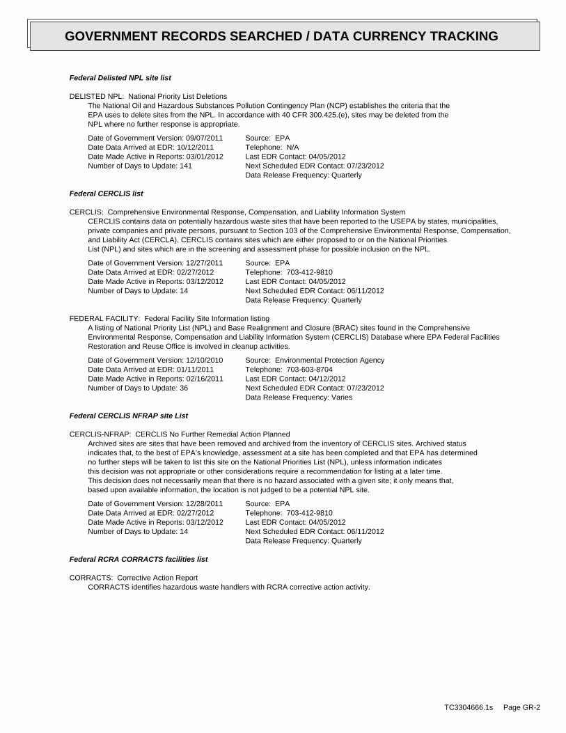
DELISTED NPL: National Priority List DeletionsThe National Oil and Hazardous Substances Pollution Contingency Plan (NCP) establishes the criteria that theEPA uses to delete sites from the NPL. In accordance with 40 CFR 300.425.(e), sites may be deleted from theNPL where no further response is appropriate.
Date of Government Version: 09/07/2011Date Data Arrived at EDR: 10/12/2011Date Made Active in Reports: 03/01/2012Number of Days to Update: 141
Source: EPATelephone: N/ALast EDR Contact: 04/05/2012Next Scheduled EDR Contact: 07/23/2012Data Release Frequency: Quarterly
Federal CERCLIS list
CERCLIS: Comprehensive Environmental Response, Compensation, and Liability Information SystemCERCLIS contains data on potentially hazardous waste sites that have been reported to the USEPA by states, municipalities,private companies and private persons, pursuant to Section 103 of the Comprehensive Environmental Response, Compensation,and Liability Act (CERCLA). CERCLIS contains sites which are either proposed to or on the National PrioritiesList (NPL) and sites which are in the screening and assessment phase for possible inclusion on the NPL.
Date of Government Version: 12/27/2011Date Data Arrived at EDR: 02/27/2012Date Made Active in Reports: 03/12/2012Number of Days to Update: 14
Source: EPATelephone: 703-412-9810Last EDR Contact: 04/05/2012Next Scheduled EDR Contact: 06/11/2012Data Release Frequency: Quarterly
FEDERAL FACILITY: Federal Facility Site Information listingA listing of National Priority List (NPL) and Base Realignment and Closure (BRAC) sites found in the ComprehensiveEnvironmental Response, Compensation and Liability Information System (CERCLIS) Database where EPA Federal FacilitiesRestoration and Reuse Office is involved in cleanup activities.
Date of Government Version: 12/10/2010Date Data Arrived at EDR: 01/11/2011Date Made Active in Reports: 02/16/2011Number of Days to Update: 36
Source: Environmental Protection AgencyTelephone: 703-603-8704Last EDR Contact: 04/12/2012Next Scheduled EDR Contact: 07/23/2012Data Release Frequency: Varies
Federal CERCLIS NFRAP site List
CERCLIS-NFRAP: CERCLIS No Further Remedial Action PlannedArchived sites are sites that have been removed and archived from the inventory of CERCLIS sites. Archived statusindicates that, to the best of EPA’s knowledge, assessment at a site has been completed and that EPA has determinedno further steps will be taken to list this site on the National Priorities List (NPL), unless information indicatesthis decision was not appropriate or other considerations require a recommendation for listing at a later time.This decision does not necessarily mean that there is no hazard associated with a given site; it only means that,based upon available information, the location is not judged to be a potential NPL site.
Date of Government Version: 12/28/2011Date Data Arrived at EDR: 02/27/2012Date Made Active in Reports: 03/12/2012Number of Days to Update: 14
Source: EPATelephone: 703-412-9810Last EDR Contact: 04/05/2012Next Scheduled EDR Contact: 06/11/2012Data Release Frequency: Quarterly
Federal RCRA CORRACTS facilities list
CORRACTS: Corrective Action ReportCORRACTS identifies hazardous waste handlers with RCRA corrective action activity.
TC3304666.1s Page GR-2
GOVERNMENT RECORDS SEARCHED / DATA CURRENCY TRACKING

Date of Government Version: 08/19/2011Date Data Arrived at EDR: 08/31/2011Date Made Active in Reports: 01/10/2012Number of Days to Update: 132
Source: EPATelephone: 800-424-9346Last EDR Contact: 02/13/2012Next Scheduled EDR Contact: 05/28/2012Data Release Frequency: Quarterly
Federal RCRA non-CORRACTS TSD facilities list
RCRA-TSDF: RCRA - Treatment, Storage and DisposalRCRAInfo is EPA’s comprehensive information system, providing access to data supporting the Resource Conservationand Recovery Act (RCRA) of 1976 and the Hazardous and Solid Waste Amendments (HSWA) of 1984. The databaseincludes selective information on sites which generate, transport, store, treat and/or dispose of hazardous wasteas defined by the Resource Conservation and Recovery Act (RCRA). Transporters are individuals or entities thatmove hazardous waste from the generator offsite to a facility that can recycle, treat, store, or dispose of thewaste. TSDFs treat, store, or dispose of the waste.
Date of Government Version: 11/10/2011Date Data Arrived at EDR: 01/05/2012Date Made Active in Reports: 03/12/2012Number of Days to Update: 67
Source: Environmental Protection AgencyTelephone: (415) 495-8895Last EDR Contact: 04/04/2012Next Scheduled EDR Contact: 07/16/2012Data Release Frequency: Quarterly
Federal RCRA generators list
RCRA-LQG: RCRA - Large Quantity GeneratorsRCRAInfo is EPA’s comprehensive information system, providing access to data supporting the Resource Conservationand Recovery Act (RCRA) of 1976 and the Hazardous and Solid Waste Amendments (HSWA) of 1984. The databaseincludes selective information on sites which generate, transport, store, treat and/or dispose of hazardous wasteas defined by the Resource Conservation and Recovery Act (RCRA). Large quantity generators (LQGs) generateover 1,000 kilograms (kg) of hazardous waste, or over 1 kg of acutely hazardous waste per month.
Date of Government Version: 11/10/2011Date Data Arrived at EDR: 01/05/2012Date Made Active in Reports: 03/12/2012Number of Days to Update: 67
Source: Environmental Protection AgencyTelephone: (415) 495-8895Last EDR Contact: 04/04/2012Next Scheduled EDR Contact: 07/16/2012Data Release Frequency: Quarterly
RCRA-SQG: RCRA - Small Quantity GeneratorsRCRAInfo is EPA’s comprehensive information system, providing access to data supporting the Resource Conservationand Recovery Act (RCRA) of 1976 and the Hazardous and Solid Waste Amendments (HSWA) of 1984. The databaseincludes selective information on sites which generate, transport, store, treat and/or dispose of hazardous wasteas defined by the Resource Conservation and Recovery Act (RCRA). Small quantity generators (SQGs) generatebetween 100 kg and 1,000 kg of hazardous waste per month.
Date of Government Version: 11/10/2011Date Data Arrived at EDR: 01/05/2012Date Made Active in Reports: 03/12/2012Number of Days to Update: 67
Source: Environmental Protection AgencyTelephone: (415) 495-8895Last EDR Contact: 04/04/2012Next Scheduled EDR Contact: 07/16/2012Data Release Frequency: Quarterly
RCRA-CESQG: RCRA - Conditionally Exempt Small Quantity GeneratorsRCRAInfo is EPA’s comprehensive information system, providing access to data supporting the Resource Conservationand Recovery Act (RCRA) of 1976 and the Hazardous and Solid Waste Amendments (HSWA) of 1984. The databaseincludes selective information on sites which generate, transport, store, treat and/or dispose of hazardous wasteas defined by the Resource Conservation and Recovery Act (RCRA). Conditionally exempt small quantity generators(CESQGs) generate less than 100 kg of hazardous waste, or less than 1 kg of acutely hazardous waste per month.
Date of Government Version: 11/10/2011Date Data Arrived at EDR: 01/05/2012Date Made Active in Reports: 03/12/2012Number of Days to Update: 67
Source: Environmental Protection AgencyTelephone: (415) 495-8895Last EDR Contact: 04/04/2012Next Scheduled EDR Contact: 07/16/2012Data Release Frequency: Varies
TC3304666.1s Page GR-3
GOVERNMENT RECORDS SEARCHED / DATA CURRENCY TRACKING

Federal institutional controls / engineering controls registries
US ENG CONTROLS: Engineering Controls Sites ListA listing of sites with engineering controls in place. Engineering controls include various forms of caps, buildingfoundations, liners, and treatment methods to create pathway elimination for regulated substances to enter environmentalmedia or effect human health.
Date of Government Version: 12/30/2011Date Data Arrived at EDR: 12/30/2011Date Made Active in Reports: 01/10/2012Number of Days to Update: 11
Source: Environmental Protection AgencyTelephone: 703-603-0695Last EDR Contact: 03/12/2012Next Scheduled EDR Contact: 06/25/2012Data Release Frequency: Varies
US INST CONTROL: Sites with Institutional ControlsA listing of sites with institutional controls in place. Institutional controls include administrative measures,such as groundwater use restrictions, construction restrictions, property use restrictions, and post remediationcare requirements intended to prevent exposure to contaminants remaining on site. Deed restrictions are generallyrequired as part of the institutional controls.
Date of Government Version: 12/30/2011Date Data Arrived at EDR: 12/30/2011Date Made Active in Reports: 01/10/2012Number of Days to Update: 11
Source: Environmental Protection AgencyTelephone: 703-603-0695Last EDR Contact: 03/12/2012Next Scheduled EDR Contact: 06/25/2012Data Release Frequency: Varies
Federal ERNS list
ERNS: Emergency Response Notification SystemEmergency Response Notification System. ERNS records and stores information on reported releases of oil and hazardoussubstances.
Date of Government Version: 10/03/2011Date Data Arrived at EDR: 10/04/2011Date Made Active in Reports: 11/11/2011Number of Days to Update: 38
Source: National Response Center, United States Coast GuardTelephone: 202-267-2180Last EDR Contact: 04/03/2012Next Scheduled EDR Contact: 07/16/2012Data Release Frequency: Annually
State- and tribal - equivalent NPL
RESPONSE: State Response SitesIdentifies confirmed release sites where DTSC is involved in remediation, either in a lead or oversight capacity.These confirmed release sites are generally high-priority and high potential risk.
Date of Government Version: 03/14/2012Date Data Arrived at EDR: 03/15/2012Date Made Active in Reports: 04/02/2012Number of Days to Update: 18
Source: Department of Toxic Substances ControlTelephone: 916-323-3400Last EDR Contact: 03/15/2012Next Scheduled EDR Contact: 05/21/2012Data Release Frequency: Quarterly
State- and tribal - equivalent CERCLIS
ENVIROSTOR: EnviroStor DatabaseThe Department of Toxic Substances Control’s (DTSC’s) Site Mitigation and Brownfields Reuse Program’s (SMBRP’s)EnviroStor database identifes sites that have known contamination or sites for which there may be reasons to investigatefurther. The database includes the following site types: Federal Superfund sites (National Priorities List (NPL));State Response, including Military Facilities and State Superfund; Voluntary Cleanup; and School sites. EnviroStorprovides similar information to the information that was available in CalSites, and provides additional site information,including, but not limited to, identification of formerly-contaminated properties that have been released forreuse, properties where environmental deed restrictions have been recorded to prevent inappropriate land uses,and risk characterization information that is used to assess potential impacts to public health and the environmentat contaminated sites.
TC3304666.1s Page GR-4
GOVERNMENT RECORDS SEARCHED / DATA CURRENCY TRACKING

Date of Government Version: 03/14/2012Date Data Arrived at EDR: 03/15/2012Date Made Active in Reports: 04/02/2012Number of Days to Update: 18
Source: Department of Toxic Substances ControlTelephone: 916-323-3400Last EDR Contact: 03/15/2012Next Scheduled EDR Contact: 05/21/2012Data Release Frequency: Quarterly
State and tribal landfill and/or solid waste disposal site lists
SWF/LF (SWIS): Solid Waste Information SystemActive, Closed and Inactive Landfills. SWF/LF records typically contain an inve ntory of solid waste disposalfacilities or landfills. These may be active or i nactive facilities or open dumps that failed to meet RCRA Section4004 criteria for solid waste landfills or disposal sites.
Date of Government Version: 02/20/2012Date Data Arrived at EDR: 02/20/2012Date Made Active in Reports: 03/29/2012Number of Days to Update: 38
Source: Department of Resources Recycling and RecoveryTelephone: 916-341-6320Last EDR Contact: 02/20/2012Next Scheduled EDR Contact: 06/04/2012Data Release Frequency: Quarterly
State and tribal leaking storage tank lists
LUST REG 6L: Leaking Underground Storage Tank Case ListingFor more current information, please refer to the State Water Resources Control Board’s LUST database.
Date of Government Version: 09/09/2003Date Data Arrived at EDR: 09/10/2003Date Made Active in Reports: 10/07/2003Number of Days to Update: 27
Source: California Regional Water Quality Control Board Lahontan Region (6)Telephone: 530-542-5572Last EDR Contact: 09/12/2011Next Scheduled EDR Contact: 12/26/2011Data Release Frequency: No Update Planned
LUST: Geotracker’s Leaking Underground Fuel Tank ReportLeaking Underground Storage Tank Incident Reports. LUST records contain an inventory of reported leaking undergroundstorage tank incidents. Not all states maintain these records, and the information stored varies by state. Formore information on a particular leaking underground storage tank sites, please contact the appropriate regulatoryagency.
Date of Government Version: 01/20/2012Date Data Arrived at EDR: 01/20/2012Date Made Active in Reports: 02/21/2012Number of Days to Update: 32
Source: State Water Resources Control BoardTelephone: see region listLast EDR Contact: 03/21/2012Next Scheduled EDR Contact: 07/02/2012Data Release Frequency: Quarterly
LUST REG 9: Leaking Underground Storage Tank ReportOrange, Riverside, San Diego counties. For more current information, please refer to the State Water ResourcesControl Board’s LUST database.
Date of Government Version: 03/01/2001Date Data Arrived at EDR: 04/23/2001Date Made Active in Reports: 05/21/2001Number of Days to Update: 28
Source: California Regional Water Quality Control Board San Diego Region (9)Telephone: 858-637-5595Last EDR Contact: 09/26/2011Next Scheduled EDR Contact: 01/09/2012Data Release Frequency: No Update Planned
LUST REG 2: Fuel Leak ListLeaking Underground Storage Tank locations. Alameda, Contra Costa, Marin, Napa, San Francisco, San Mateo, SantaClara, Solano, Sonoma counties.
Date of Government Version: 09/30/2004Date Data Arrived at EDR: 10/20/2004Date Made Active in Reports: 11/19/2004Number of Days to Update: 30
Source: California Regional Water Quality Control Board San Francisco Bay Region (2)Telephone: 510-622-2433Last EDR Contact: 09/19/2011Next Scheduled EDR Contact: 01/02/2012Data Release Frequency: Quarterly
TC3304666.1s Page GR-5
GOVERNMENT RECORDS SEARCHED / DATA CURRENCY TRACKING
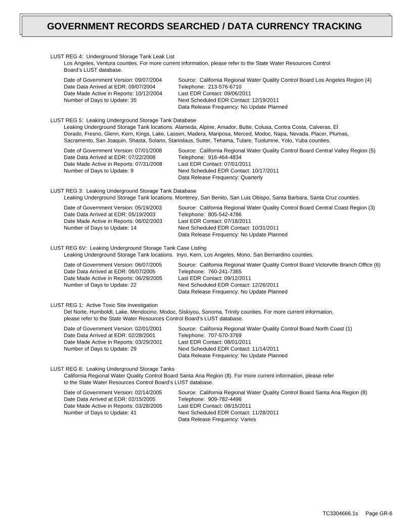
LUST REG 4: Underground Storage Tank Leak ListLos Angeles, Ventura counties. For more current information, please refer to the State Water Resources ControlBoard’s LUST database.
Date of Government Version: 09/07/2004Date Data Arrived at EDR: 09/07/2004Date Made Active in Reports: 10/12/2004Number of Days to Update: 35
Source: California Regional Water Quality Control Board Los Angeles Region (4)Telephone: 213-576-6710Last EDR Contact: 09/06/2011Next Scheduled EDR Contact: 12/19/2011Data Release Frequency: No Update Planned
LUST REG 5: Leaking Underground Storage Tank DatabaseLeaking Underground Storage Tank locations. Alameda, Alpine, Amador, Butte, Colusa, Contra Costa, Calveras, ElDorado, Fresno, Glenn, Kern, Kings, Lake, Lassen, Madera, Mariposa, Merced, Modoc, Napa, Nevada, Placer, Plumas,Sacramento, San Joaquin, Shasta, Solano, Stanislaus, Sutter, Tehama, Tulare, Tuolumne, Yolo, Yuba counties.
Date of Government Version: 07/01/2008Date Data Arrived at EDR: 07/22/2008Date Made Active in Reports: 07/31/2008Number of Days to Update: 9
Source: California Regional Water Quality Control Board Central Valley Region (5)Telephone: 916-464-4834Last EDR Contact: 07/01/2011Next Scheduled EDR Contact: 10/17/2011Data Release Frequency: Quarterly
LUST REG 3: Leaking Underground Storage Tank DatabaseLeaking Underground Storage Tank locations. Monterey, San Benito, San Luis Obispo, Santa Barbara, Santa Cruz counties.
Date of Government Version: 05/19/2003Date Data Arrived at EDR: 05/19/2003Date Made Active in Reports: 06/02/2003Number of Days to Update: 14
Source: California Regional Water Quality Control Board Central Coast Region (3)Telephone: 805-542-4786Last EDR Contact: 07/18/2011Next Scheduled EDR Contact: 10/31/2011Data Release Frequency: No Update Planned
LUST REG 6V: Leaking Underground Storage Tank Case ListingLeaking Underground Storage Tank locations. Inyo, Kern, Los Angeles, Mono, San Bernardino counties.
Date of Government Version: 06/07/2005Date Data Arrived at EDR: 06/07/2005Date Made Active in Reports: 06/29/2005Number of Days to Update: 22
Source: California Regional Water Quality Control Board Victorville Branch Office (6)Telephone: 760-241-7365Last EDR Contact: 09/12/2011Next Scheduled EDR Contact: 12/26/2011Data Release Frequency: No Update Planned
LUST REG 1: Active Toxic Site InvestigationDel Norte, Humboldt, Lake, Mendocino, Modoc, Siskiyou, Sonoma, Trinity counties. For more current information,please refer to the State Water Resources Control Board’s LUST database.
Date of Government Version: 02/01/2001Date Data Arrived at EDR: 02/28/2001Date Made Active in Reports: 03/29/2001Number of Days to Update: 29
Source: California Regional Water Quality Control Board North Coast (1)Telephone: 707-570-3769Last EDR Contact: 08/01/2011Next Scheduled EDR Contact: 11/14/2011Data Release Frequency: No Update Planned
LUST REG 8: Leaking Underground Storage TanksCalifornia Regional Water Quality Control Board Santa Ana Region (8). For more current information, please referto the State Water Resources Control Board’s LUST database.
Date of Government Version: 02/14/2005Date Data Arrived at EDR: 02/15/2005Date Made Active in Reports: 03/28/2005Number of Days to Update: 41
Source: California Regional Water Quality Control Board Santa Ana Region (8)Telephone: 909-782-4496Last EDR Contact: 08/15/2011Next Scheduled EDR Contact: 11/28/2011Data Release Frequency: Varies
TC3304666.1s Page GR-6
GOVERNMENT RECORDS SEARCHED / DATA CURRENCY TRACKING

LUST REG 7: Leaking Underground Storage Tank Case ListingLeaking Underground Storage Tank locations. Imperial, Riverside, San Diego, Santa Barbara counties.
Date of Government Version: 02/26/2004Date Data Arrived at EDR: 02/26/2004Date Made Active in Reports: 03/24/2004Number of Days to Update: 27
Source: California Regional Water Quality Control Board Colorado River Basin Region (7)Telephone: 760-776-8943Last EDR Contact: 08/01/2011Next Scheduled EDR Contact: 11/14/2011Data Release Frequency: No Update Planned
SLIC: Statewide SLIC CasesThe SLIC (Spills, Leaks, Investigations and Cleanup) program is designed to protect and restore water qualityfrom spills, leaks, and similar discharges.
Date of Government Version: 01/20/2012Date Data Arrived at EDR: 01/20/2012Date Made Active in Reports: 02/21/2012Number of Days to Update: 32
Source: State Water Resources Control BoardTelephone: 866-480-1028Last EDR Contact: 03/21/2012Next Scheduled EDR Contact: 07/02/2012Data Release Frequency: Varies
SLIC REG 1: Active Toxic Site InvestigationsThe SLIC (Spills, Leaks, Investigations and Cleanup) program is designed to protect and restore water qualityfrom spills, leaks, and similar discharges.
Date of Government Version: 04/03/2003Date Data Arrived at EDR: 04/07/2003Date Made Active in Reports: 04/25/2003Number of Days to Update: 18
Source: California Regional Water Quality Control Board, North Coast Region (1)Telephone: 707-576-2220Last EDR Contact: 08/01/2011Next Scheduled EDR Contact: 11/14/2011Data Release Frequency: No Update Planned
SLIC REG 2: Spills, Leaks, Investigation & Cleanup Cost Recovery ListingThe SLIC (Spills, Leaks, Investigations and Cleanup) program is designed to protect and restore water qualityfrom spills, leaks, and similar discharges.
Date of Government Version: 09/30/2004Date Data Arrived at EDR: 10/20/2004Date Made Active in Reports: 11/19/2004Number of Days to Update: 30
Source: Regional Water Quality Control Board San Francisco Bay Region (2)Telephone: 510-286-0457Last EDR Contact: 09/19/2011Next Scheduled EDR Contact: 01/02/2012Data Release Frequency: Quarterly
SLIC REG 3: Spills, Leaks, Investigation & Cleanup Cost Recovery ListingThe SLIC (Spills, Leaks, Investigations and Cleanup) program is designed to protect and restore water qualityfrom spills, leaks, and similar discharges.
Date of Government Version: 05/18/2006Date Data Arrived at EDR: 05/18/2006Date Made Active in Reports: 06/15/2006Number of Days to Update: 28
Source: California Regional Water Quality Control Board Central Coast Region (3)Telephone: 805-549-3147Last EDR Contact: 07/18/2011Next Scheduled EDR Contact: 10/31/2011Data Release Frequency: Semi-Annually
SLIC REG 4: Spills, Leaks, Investigation & Cleanup Cost Recovery ListingThe SLIC (Spills, Leaks, Investigations and Cleanup) program is designed to protect and restore water qualityfrom spills, leaks, and similar discharges.
Date of Government Version: 11/17/2004Date Data Arrived at EDR: 11/18/2004Date Made Active in Reports: 01/04/2005Number of Days to Update: 47
Source: Region Water Quality Control Board Los Angeles Region (4)Telephone: 213-576-6600Last EDR Contact: 07/01/2011Next Scheduled EDR Contact: 10/17/2011Data Release Frequency: Varies
TC3304666.1s Page GR-7
GOVERNMENT RECORDS SEARCHED / DATA CURRENCY TRACKING

SLIC REG 5: Spills, Leaks, Investigation & Cleanup Cost Recovery ListingThe SLIC (Spills, Leaks, Investigations and Cleanup) program is designed to protect and restore water qualityfrom spills, leaks, and similar discharges.
Date of Government Version: 04/01/2005Date Data Arrived at EDR: 04/05/2005Date Made Active in Reports: 04/21/2005Number of Days to Update: 16
Source: Regional Water Quality Control Board Central Valley Region (5)Telephone: 916-464-3291Last EDR Contact: 09/12/2011Next Scheduled EDR Contact: 12/26/2011Data Release Frequency: Semi-Annually
SLIC REG 6V: Spills, Leaks, Investigation & Cleanup Cost Recovery ListingThe SLIC (Spills, Leaks, Investigations and Cleanup) program is designed to protect and restore water qualityfrom spills, leaks, and similar discharges.
Date of Government Version: 05/24/2005Date Data Arrived at EDR: 05/25/2005Date Made Active in Reports: 06/16/2005Number of Days to Update: 22
Source: Regional Water Quality Control Board, Victorville BranchTelephone: 619-241-6583Last EDR Contact: 08/15/2011Next Scheduled EDR Contact: 11/28/2011Data Release Frequency: Semi-Annually
SLIC REG 6L: SLIC SitesThe SLIC (Spills, Leaks, Investigations and Cleanup) program is designed to protect and restore water qualityfrom spills, leaks, and similar discharges.
Date of Government Version: 09/07/2004Date Data Arrived at EDR: 09/07/2004Date Made Active in Reports: 10/12/2004Number of Days to Update: 35
Source: California Regional Water Quality Control Board, Lahontan RegionTelephone: 530-542-5574Last EDR Contact: 08/15/2011Next Scheduled EDR Contact: 11/28/2011Data Release Frequency: No Update Planned
SLIC REG 7: SLIC ListThe SLIC (Spills, Leaks, Investigations and Cleanup) program is designed to protect and restore water qualityfrom spills, leaks, and similar discharges.
Date of Government Version: 11/24/2004Date Data Arrived at EDR: 11/29/2004Date Made Active in Reports: 01/04/2005Number of Days to Update: 36
Source: California Regional Quality Control Board, Colorado River Basin RegionTelephone: 760-346-7491Last EDR Contact: 08/01/2011Next Scheduled EDR Contact: 11/14/2011Data Release Frequency: No Update Planned
SLIC REG 8: Spills, Leaks, Investigation & Cleanup Cost Recovery ListingThe SLIC (Spills, Leaks, Investigations and Cleanup) program is designed to protect and restore water qualityfrom spills, leaks, and similar discharges.
Date of Government Version: 04/03/2008Date Data Arrived at EDR: 04/03/2008Date Made Active in Reports: 04/14/2008Number of Days to Update: 11
Source: California Region Water Quality Control Board Santa Ana Region (8)Telephone: 951-782-3298Last EDR Contact: 09/12/2011Next Scheduled EDR Contact: 12/26/2011Data Release Frequency: Semi-Annually
SLIC REG 9: Spills, Leaks, Investigation & Cleanup Cost Recovery ListingThe SLIC (Spills, Leaks, Investigations and Cleanup) program is designed to protect and restore water qualityfrom spills, leaks, and similar discharges.
Date of Government Version: 09/10/2007Date Data Arrived at EDR: 09/11/2007Date Made Active in Reports: 09/28/2007Number of Days to Update: 17
Source: California Regional Water Quality Control Board San Diego Region (9)Telephone: 858-467-2980Last EDR Contact: 08/08/2011Next Scheduled EDR Contact: 11/21/2011Data Release Frequency: Annually
TC3304666.1s Page GR-8
GOVERNMENT RECORDS SEARCHED / DATA CURRENCY TRACKING
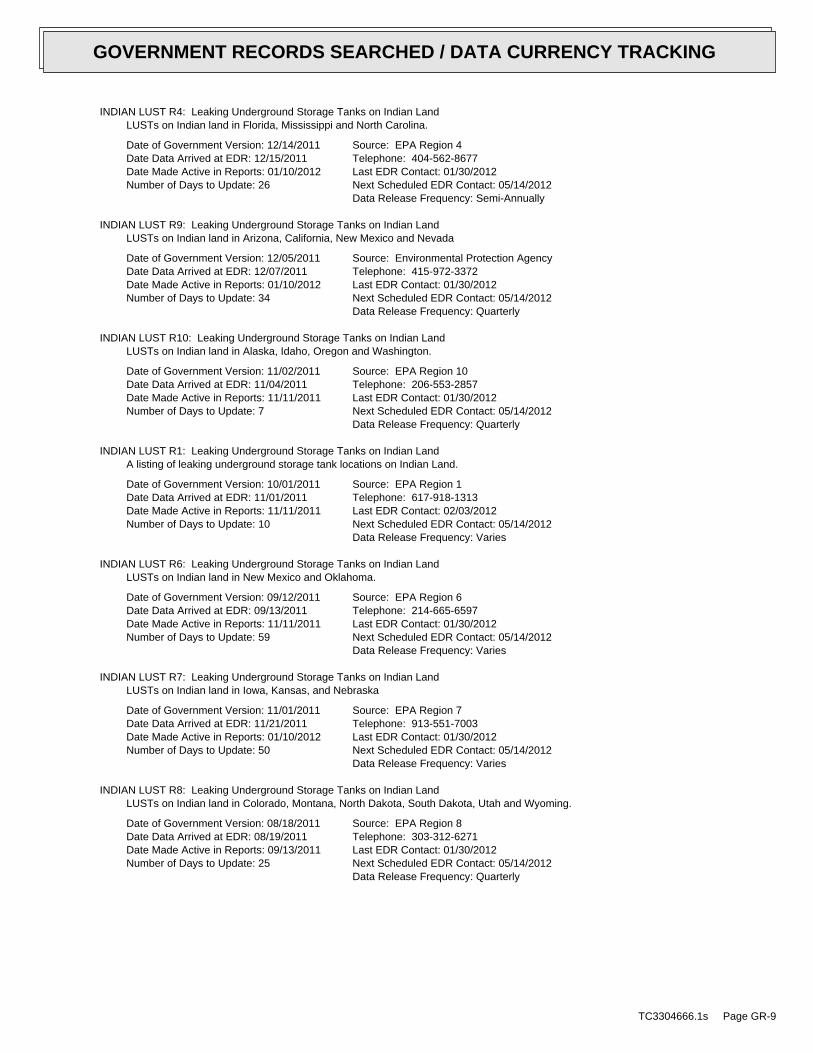
INDIAN LUST R4: Leaking Underground Storage Tanks on Indian LandLUSTs on Indian land in Florida, Mississippi and North Carolina.
Date of Government Version: 12/14/2011Date Data Arrived at EDR: 12/15/2011Date Made Active in Reports: 01/10/2012Number of Days to Update: 26
Source: EPA Region 4Telephone: 404-562-8677Last EDR Contact: 01/30/2012Next Scheduled EDR Contact: 05/14/2012Data Release Frequency: Semi-Annually
INDIAN LUST R9: Leaking Underground Storage Tanks on Indian LandLUSTs on Indian land in Arizona, California, New Mexico and Nevada
Date of Government Version: 12/05/2011Date Data Arrived at EDR: 12/07/2011Date Made Active in Reports: 01/10/2012Number of Days to Update: 34
Source: Environmental Protection AgencyTelephone: 415-972-3372Last EDR Contact: 01/30/2012Next Scheduled EDR Contact: 05/14/2012Data Release Frequency: Quarterly
INDIAN LUST R10: Leaking Underground Storage Tanks on Indian LandLUSTs on Indian land in Alaska, Idaho, Oregon and Washington.
Date of Government Version: 11/02/2011Date Data Arrived at EDR: 11/04/2011Date Made Active in Reports: 11/11/2011Number of Days to Update: 7
Source: EPA Region 10Telephone: 206-553-2857Last EDR Contact: 01/30/2012Next Scheduled EDR Contact: 05/14/2012Data Release Frequency: Quarterly
INDIAN LUST R1: Leaking Underground Storage Tanks on Indian LandA listing of leaking underground storage tank locations on Indian Land.
Date of Government Version: 10/01/2011Date Data Arrived at EDR: 11/01/2011Date Made Active in Reports: 11/11/2011Number of Days to Update: 10
Source: EPA Region 1Telephone: 617-918-1313Last EDR Contact: 02/03/2012Next Scheduled EDR Contact: 05/14/2012Data Release Frequency: Varies
INDIAN LUST R6: Leaking Underground Storage Tanks on Indian LandLUSTs on Indian land in New Mexico and Oklahoma.
Date of Government Version: 09/12/2011Date Data Arrived at EDR: 09/13/2011Date Made Active in Reports: 11/11/2011Number of Days to Update: 59
Source: EPA Region 6Telephone: 214-665-6597Last EDR Contact: 01/30/2012Next Scheduled EDR Contact: 05/14/2012Data Release Frequency: Varies
INDIAN LUST R7: Leaking Underground Storage Tanks on Indian LandLUSTs on Indian land in Iowa, Kansas, and Nebraska
Date of Government Version: 11/01/2011Date Data Arrived at EDR: 11/21/2011Date Made Active in Reports: 01/10/2012Number of Days to Update: 50
Source: EPA Region 7Telephone: 913-551-7003Last EDR Contact: 01/30/2012Next Scheduled EDR Contact: 05/14/2012Data Release Frequency: Varies
INDIAN LUST R8: Leaking Underground Storage Tanks on Indian LandLUSTs on Indian land in Colorado, Montana, North Dakota, South Dakota, Utah and Wyoming.
Date of Government Version: 08/18/2011Date Data Arrived at EDR: 08/19/2011Date Made Active in Reports: 09/13/2011Number of Days to Update: 25
Source: EPA Region 8Telephone: 303-312-6271Last EDR Contact: 01/30/2012Next Scheduled EDR Contact: 05/14/2012Data Release Frequency: Quarterly
TC3304666.1s Page GR-9
GOVERNMENT RECORDS SEARCHED / DATA CURRENCY TRACKING
State and tribal registered storage tank lists
UST: Active UST FacilitiesActive UST facilities gathered from the local regulatory agencies
Date of Government Version: 01/20/2012Date Data Arrived at EDR: 01/20/2012Date Made Active in Reports: 02/22/2012Number of Days to Update: 33
Source: SWRCBTelephone: 916-480-1028Last EDR Contact: 03/21/2012Next Scheduled EDR Contact: 07/02/2012Data Release Frequency: Semi-Annually
AST: Aboveground Petroleum Storage Tank FacilitiesRegistered Aboveground Storage Tanks.
Date of Government Version: 08/01/2009Date Data Arrived at EDR: 09/10/2009Date Made Active in Reports: 10/01/2009Number of Days to Update: 21
Source: State Water Resources Control BoardTelephone: 916-341-5712Last EDR Contact: 01/23/2012Next Scheduled EDR Contact: 04/23/2012Data Release Frequency: Quarterly
INDIAN UST R1: Underground Storage Tanks on Indian LandThe Indian Underground Storage Tank (UST) database provides information about underground storage tanks on Indianland in EPA Region 1 (Connecticut, Maine, Massachusetts, New Hampshire, Rhode Island, Vermont and ten TribalNations).
Date of Government Version: 10/01/2011Date Data Arrived at EDR: 11/01/2011Date Made Active in Reports: 11/11/2011Number of Days to Update: 10
Source: EPA, Region 1Telephone: 617-918-1313Last EDR Contact: 02/03/2012Next Scheduled EDR Contact: 05/14/2012Data Release Frequency: Varies
INDIAN UST R6: Underground Storage Tanks on Indian LandThe Indian Underground Storage Tank (UST) database provides information about underground storage tanks on Indianland in EPA Region 6 (Louisiana, Arkansas, Oklahoma, New Mexico, Texas and 65 Tribes).
Date of Government Version: 05/10/2011Date Data Arrived at EDR: 05/11/2011Date Made Active in Reports: 06/14/2011Number of Days to Update: 34
Source: EPA Region 6Telephone: 214-665-7591Last EDR Contact: 01/30/2012Next Scheduled EDR Contact: 05/14/2012Data Release Frequency: Semi-Annually
INDIAN UST R10: Underground Storage Tanks on Indian LandThe Indian Underground Storage Tank (UST) database provides information about underground storage tanks on Indianland in EPA Region 10 (Alaska, Idaho, Oregon, Washington, and Tribal Nations).
Date of Government Version: 11/02/2011Date Data Arrived at EDR: 11/04/2011Date Made Active in Reports: 11/11/2011Number of Days to Update: 7
Source: EPA Region 10Telephone: 206-553-2857Last EDR Contact: 01/30/2012Next Scheduled EDR Contact: 05/14/2012Data Release Frequency: Quarterly
INDIAN UST R7: Underground Storage Tanks on Indian LandThe Indian Underground Storage Tank (UST) database provides information about underground storage tanks on Indianland in EPA Region 7 (Iowa, Kansas, Missouri, Nebraska, and 9 Tribal Nations).
Date of Government Version: 11/01/2011Date Data Arrived at EDR: 11/21/2011Date Made Active in Reports: 01/10/2012Number of Days to Update: 50
Source: EPA Region 7Telephone: 913-551-7003Last EDR Contact: 01/30/2012Next Scheduled EDR Contact: 05/14/2012Data Release Frequency: Varies
TC3304666.1s Page GR-10
GOVERNMENT RECORDS SEARCHED / DATA CURRENCY TRACKING
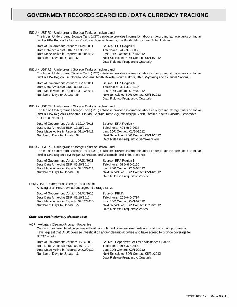
INDIAN UST R9: Underground Storage Tanks on Indian LandThe Indian Underground Storage Tank (UST) database provides information about underground storage tanks on Indianland in EPA Region 9 (Arizona, California, Hawaii, Nevada, the Pacific Islands, and Tribal Nations).
Date of Government Version: 11/28/2011Date Data Arrived at EDR: 11/29/2011Date Made Active in Reports: 01/10/2012Number of Days to Update: 42
Source: EPA Region 9Telephone: 415-972-3368Last EDR Contact: 01/30/2012Next Scheduled EDR Contact: 05/14/2012Data Release Frequency: Quarterly
INDIAN UST R8: Underground Storage Tanks on Indian LandThe Indian Underground Storage Tank (UST) database provides information about underground storage tanks on Indianland in EPA Region 8 (Colorado, Montana, North Dakota, South Dakota, Utah, Wyoming and 27 Tribal Nations).
Date of Government Version: 08/18/2011Date Data Arrived at EDR: 08/19/2011Date Made Active in Reports: 09/13/2011Number of Days to Update: 25
Source: EPA Region 8Telephone: 303-312-6137Last EDR Contact: 01/30/2012Next Scheduled EDR Contact: 05/14/2012Data Release Frequency: Quarterly
INDIAN UST R4: Underground Storage Tanks on Indian LandThe Indian Underground Storage Tank (UST) database provides information about underground storage tanks on Indianland in EPA Region 4 (Alabama, Florida, Georgia, Kentucky, Mississippi, North Carolina, South Carolina, Tennesseeand Tribal Nations)
Date of Government Version: 12/14/2011Date Data Arrived at EDR: 12/15/2011Date Made Active in Reports: 01/10/2012Number of Days to Update: 26
Source: EPA Region 4Telephone: 404-562-9424Last EDR Contact: 01/30/2012Next Scheduled EDR Contact: 05/14/2012Data Release Frequency: Semi-Annually
INDIAN UST R5: Underground Storage Tanks on Indian LandThe Indian Underground Storage Tank (UST) database provides information about underground storage tanks on Indianland in EPA Region 5 (Michigan, Minnesota and Wisconsin and Tribal Nations).
Date of Government Version: 07/01/2011Date Data Arrived at EDR: 08/26/2011Date Made Active in Reports: 09/13/2011Number of Days to Update: 18
Source: EPA Region 5Telephone: 312-886-6136Last EDR Contact: 01/30/2012Next Scheduled EDR Contact: 05/14/2012Data Release Frequency: Varies
FEMA UST: Underground Storage Tank ListingA listing of all FEMA owned underground storage tanks.
Date of Government Version: 01/01/2010Date Data Arrived at EDR: 02/16/2010Date Made Active in Reports: 04/12/2010Number of Days to Update: 55
Source: FEMATelephone: 202-646-5797Last EDR Contact: 04/10/2012Next Scheduled EDR Contact: 07/30/2012Data Release Frequency: Varies
State and tribal voluntary cleanup sites
VCP: Voluntary Cleanup Program PropertiesContains low threat level properties with either confirmed or unconfirmed releases and the project proponentshave request that DTSC oversee investigation and/or cleanup activities and have agreed to provide coverage forDTSC’s costs.
Date of Government Version: 03/14/2012Date Data Arrived at EDR: 03/15/2012Date Made Active in Reports: 04/02/2012Number of Days to Update: 18
Source: Department of Toxic Substances ControlTelephone: 916-323-3400Last EDR Contact: 03/15/2012Next Scheduled EDR Contact: 05/21/2012Data Release Frequency: Quarterly
TC3304666.1s Page GR-11
GOVERNMENT RECORDS SEARCHED / DATA CURRENCY TRACKING
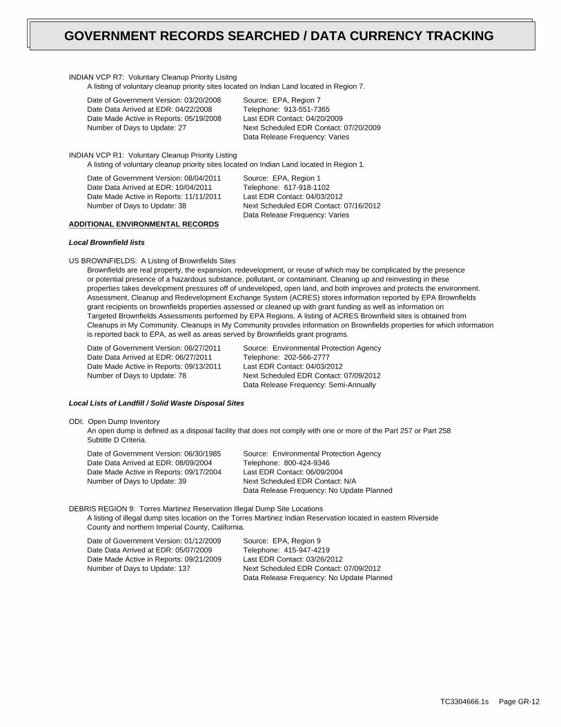
INDIAN VCP R7: Voluntary Cleanup Priority LisitngA listing of voluntary cleanup priority sites located on Indian Land located in Region 7.
Date of Government Version: 03/20/2008Date Data Arrived at EDR: 04/22/2008Date Made Active in Reports: 05/19/2008Number of Days to Update: 27
Source: EPA, Region 7Telephone: 913-551-7365Last EDR Contact: 04/20/2009Next Scheduled EDR Contact: 07/20/2009Data Release Frequency: Varies
INDIAN VCP R1: Voluntary Cleanup Priority ListingA listing of voluntary cleanup priority sites located on Indian Land located in Region 1.
Date of Government Version: 08/04/2011Date Data Arrived at EDR: 10/04/2011Date Made Active in Reports: 11/11/2011Number of Days to Update: 38
Source: EPA, Region 1Telephone: 617-918-1102Last EDR Contact: 04/03/2012Next Scheduled EDR Contact: 07/16/2012Data Release Frequency: Varies
ADDITIONAL ENVIRONMENTAL RECORDS
Local Brownfield lists
US BROWNFIELDS: A Listing of Brownfields SitesBrownfields are real property, the expansion, redevelopment, or reuse of which may be complicated by the presenceor potential presence of a hazardous substance, pollutant, or contaminant. Cleaning up and reinvesting in theseproperties takes development pressures off of undeveloped, open land, and both improves and protects the environment.Assessment, Cleanup and Redevelopment Exchange System (ACRES) stores information reported by EPA Brownfieldsgrant recipients on brownfields properties assessed or cleaned up with grant funding as well as information onTargeted Brownfields Assessments performed by EPA Regions. A listing of ACRES Brownfield sites is obtained fromCleanups in My Community. Cleanups in My Community provides information on Brownfields properties for which informationis reported back to EPA, as well as areas served by Brownfields grant programs.
Date of Government Version: 06/27/2011Date Data Arrived at EDR: 06/27/2011Date Made Active in Reports: 09/13/2011Number of Days to Update: 78
Source: Environmental Protection AgencyTelephone: 202-566-2777Last EDR Contact: 04/03/2012Next Scheduled EDR Contact: 07/09/2012Data Release Frequency: Semi-Annually
Local Lists of Landfill / Solid Waste Disposal Sites
ODI: Open Dump InventoryAn open dump is defined as a disposal facility that does not comply with one or more of the Part 257 or Part 258Subtitle D Criteria.
Date of Government Version: 06/30/1985Date Data Arrived at EDR: 08/09/2004Date Made Active in Reports: 09/17/2004Number of Days to Update: 39
Source: Environmental Protection AgencyTelephone: 800-424-9346Last EDR Contact: 06/09/2004Next Scheduled EDR Contact: N/AData Release Frequency: No Update Planned
DEBRIS REGION 9: Torres Martinez Reservation Illegal Dump Site LocationsA listing of illegal dump sites location on the Torres Martinez Indian Reservation located in eastern RiversideCounty and northern Imperial County, California.
Date of Government Version: 01/12/2009Date Data Arrived at EDR: 05/07/2009Date Made Active in Reports: 09/21/2009Number of Days to Update: 137
Source: EPA, Region 9Telephone: 415-947-4219Last EDR Contact: 03/26/2012Next Scheduled EDR Contact: 07/09/2012Data Release Frequency: No Update Planned
TC3304666.1s Page GR-12
GOVERNMENT RECORDS SEARCHED / DATA CURRENCY TRACKING
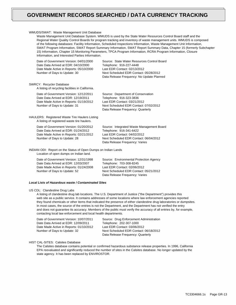
WMUDS/SWAT: Waste Management Unit DatabaseWaste Management Unit Database System. WMUDS is used by the State Water Resources Control Board staff and theRegional Water Quality Control Boards for program tracking and inventory of waste management units. WMUDS is composedof the following databases: Facility Information, Scheduled Inspections Information, Waste Management Unit Information,SWAT Program Information, SWAT Report Summary Information, SWAT Report Summary Data, Chapter 15 (formerly Subchapter15) Information, Chapter 15 Monitoring Parameters, TPCA Program Information, RCRA Program Information, ClosureInformation, and Interested Parties Information.
Date of Government Version: 04/01/2000Date Data Arrived at EDR: 04/10/2000Date Made Active in Reports: 05/10/2000Number of Days to Update: 30
Source: State Water Resources Control BoardTelephone: 916-227-4448Last EDR Contact: 02/13/2012Next Scheduled EDR Contact: 05/28/2012Data Release Frequency: No Update Planned
SWRCY: Recycler DatabaseA listing of recycling facilities in California.
Date of Government Version: 12/12/2011Date Data Arrived at EDR: 12/19/2011Date Made Active in Reports: 01/19/2012Number of Days to Update: 31
Source: Department of ConservationTelephone: 916-323-3836Last EDR Contact: 03/21/2012Next Scheduled EDR Contact: 07/02/2012Data Release Frequency: Quarterly
HAULERS: Registered Waste Tire Haulers ListingA listing of registered waste tire haulers.
Date of Government Version: 01/20/2012Date Data Arrived at EDR: 01/24/2012Date Made Active in Reports: 02/21/2012Number of Days to Update: 28
Source: Integrated Waste Management BoardTelephone: 916-341-6422Last EDR Contact: 04/02/2012Next Scheduled EDR Contact: 06/04/2012Data Release Frequency: Varies
INDIAN ODI: Report on the Status of Open Dumps on Indian LandsLocation of open dumps on Indian land.
Date of Government Version: 12/31/1998Date Data Arrived at EDR: 12/03/2007Date Made Active in Reports: 01/24/2008Number of Days to Update: 52
Source: Environmental Protection AgencyTelephone: 703-308-8245Last EDR Contact: 02/06/2012Next Scheduled EDR Contact: 05/21/2012Data Release Frequency: Varies
Local Lists of Hazardous waste / Contaminated Sites
US CDL: Clandestine Drug LabsA listing of clandestine drug lab locations. The U.S. Department of Justice ("the Department") provides thisweb site as a public service. It contains addresses of some locations where law enforcement agencies reportedthey found chemicals or other items that indicated the presence of either clandestine drug laboratories or dumpsites.In most cases, the source of the entries is not the Department, and the Department has not verified the entryand does not guarantee its accuracy. Members of the public must verify the accuracy of all entries by, for example,contacting local law enforcement and local health departments.
Date of Government Version: 10/07/2011Date Data Arrived at EDR: 12/09/2011Date Made Active in Reports: 01/10/2012Number of Days to Update: 32
Source: Drug Enforcement AdministrationTelephone: 202-307-1000Last EDR Contact: 03/06/2012Next Scheduled EDR Contact: 06/18/2012Data Release Frequency: Quarterly
HIST CAL-SITES: Calsites DatabaseThe Calsites database contains potential or confirmed hazardous substance release properties. In 1996, CaliforniaEPA reevaluated and significantly reduced the number of sites in the Calsites database. No longer updated by thestate agency. It has been replaced by ENVIROSTOR.
TC3304666.1s Page GR-13
GOVERNMENT RECORDS SEARCHED / DATA CURRENCY TRACKING

Date of Government Version: 08/08/2005Date Data Arrived at EDR: 08/03/2006Date Made Active in Reports: 08/24/2006Number of Days to Update: 21
Source: Department of Toxic Substance ControlTelephone: 916-323-3400Last EDR Contact: 02/23/2009Next Scheduled EDR Contact: 05/25/2009Data Release Frequency: No Update Planned
SCH: School Property Evaluation ProgramThis category contains proposed and existing school sites that are being evaluated by DTSC for possible hazardousmaterials contamination. In some cases, these properties may be listed in the CalSites category depending on thelevel of threat to public health and safety or the environment they pose.
Date of Government Version: 03/14/2012Date Data Arrived at EDR: 03/15/2012Date Made Active in Reports: 04/02/2012Number of Days to Update: 18
Source: Department of Toxic Substances ControlTelephone: 916-323-3400Last EDR Contact: 03/15/2012Next Scheduled EDR Contact: 05/21/2012Data Release Frequency: Quarterly
TOXIC PITS: Toxic Pits Cleanup Act SitesToxic PITS Cleanup Act Sites. TOXIC PITS identifies sites suspected of containing hazardous substances where cleanuphas not yet been completed.
Date of Government Version: 07/01/1995Date Data Arrived at EDR: 08/30/1995Date Made Active in Reports: 09/26/1995Number of Days to Update: 27
Source: State Water Resources Control BoardTelephone: 916-227-4364Last EDR Contact: 01/26/2009Next Scheduled EDR Contact: 04/27/2009Data Release Frequency: No Update Planned
CDL: Clandestine Drug LabsA listing of drug lab locations. Listing of a location in this database does not indicate that any illegal druglab materials were or were not present there, and does not constitute a determination that the location eitherrequires or does not require additional cleanup work.
Date of Government Version: 12/31/2011Date Data Arrived at EDR: 02/14/2012Date Made Active in Reports: 02/21/2012Number of Days to Update: 7
Source: Department of Toxic Substances ControlTelephone: 916-255-6504Last EDR Contact: 04/02/2012Next Scheduled EDR Contact: 07/16/2012Data Release Frequency: Varies
US HIST CDL: National Clandestine Laboratory RegisterA listing of clandestine drug lab locations. The U.S. Department of Justice ("the Department") provides thisweb site as a public service. It contains addresses of some locations where law enforcement agencies reportedthey found chemicals or other items that indicated the presence of either clandestine drug laboratories or dumpsites.In most cases, the source of the entries is not the Department, and the Department has not verified the entryand does not guarantee its accuracy. Members of the public must verify the accuracy of all entries by, for example,contacting local law enforcement and local health departments.
Date of Government Version: 09/01/2007Date Data Arrived at EDR: 11/19/2008Date Made Active in Reports: 03/30/2009Number of Days to Update: 131
Source: Drug Enforcement AdministrationTelephone: 202-307-1000Last EDR Contact: 03/23/2009Next Scheduled EDR Contact: 06/22/2009Data Release Frequency: No Update Planned
Local Lists of Registered Storage Tanks
CA FID UST: Facility Inventory DatabaseThe Facility Inventory Database (FID) contains a historical listing of active and inactive underground storagetank locations from the State Water Resource Control Board. Refer to local/county source for current data.
Date of Government Version: 10/31/1994Date Data Arrived at EDR: 09/05/1995Date Made Active in Reports: 09/29/1995Number of Days to Update: 24
Source: California Environmental Protection AgencyTelephone: 916-341-5851Last EDR Contact: 12/28/1998Next Scheduled EDR Contact: N/AData Release Frequency: No Update Planned
TC3304666.1s Page GR-14
GOVERNMENT RECORDS SEARCHED / DATA CURRENCY TRACKING

UST MENDOCINO: Mendocino County UST DatabaseA listing of underground storage tank locations in Mendocino County.
Date of Government Version: 09/23/2009Date Data Arrived at EDR: 09/23/2009Date Made Active in Reports: 10/01/2009Number of Days to Update: 8
Source: Department of Public HealthTelephone: 707-463-4466Last EDR Contact: 12/05/2012Next Scheduled EDR Contact: 06/18/2012Data Release Frequency: Annually
HIST UST: Hazardous Substance Storage Container DatabaseThe Hazardous Substance Storage Container Database is a historical listing of UST sites. Refer to local/countysource for current data.
Date of Government Version: 10/15/1990Date Data Arrived at EDR: 01/25/1991Date Made Active in Reports: 02/12/1991Number of Days to Update: 18
Source: State Water Resources Control BoardTelephone: 916-341-5851Last EDR Contact: 07/26/2001Next Scheduled EDR Contact: N/AData Release Frequency: No Update Planned
SWEEPS UST: SWEEPS UST ListingStatewide Environmental Evaluation and Planning System. This underground storage tank listing was updated andmaintained by a company contacted by the SWRCB in the early 1990’s. The listing is no longer updated or maintained.The local agency is the contact for more information on a site on the SWEEPS list.
Date of Government Version: 06/01/1994Date Data Arrived at EDR: 07/07/2005Date Made Active in Reports: 08/11/2005Number of Days to Update: 35
Source: State Water Resources Control BoardTelephone: N/ALast EDR Contact: 06/03/2005Next Scheduled EDR Contact: N/AData Release Frequency: No Update Planned
Local Land Records
LIENS 2: CERCLA Lien InformationA Federal CERCLA (’Superfund’) lien can exist by operation of law at any site or property at which EPA has spentSuperfund monies. These monies are spent to investigate and address releases and threatened releases of contamination.CERCLIS provides information as to the identity of these sites and properties.
Date of Government Version: 09/09/2011Date Data Arrived at EDR: 09/16/2011Date Made Active in Reports: 09/29/2011Number of Days to Update: 13
Source: Environmental Protection AgencyTelephone: 202-564-6023Last EDR Contact: 01/30/2012Next Scheduled EDR Contact: 05/14/2012Data Release Frequency: Varies
LUCIS: Land Use Control Information SystemLUCIS contains records of land use control information pertaining to the former Navy Base Realignment and Closureproperties.
Date of Government Version: 12/09/2005Date Data Arrived at EDR: 12/11/2006Date Made Active in Reports: 01/11/2007Number of Days to Update: 31
Source: Department of the NavyTelephone: 843-820-7326Last EDR Contact: 04/03/2012Next Scheduled EDR Contact: 06/04/2012Data Release Frequency: Varies
LIENS: Environmental Liens ListingA listing of property locations with environmental liens for California where DTSC is a lien holder.
Date of Government Version: 03/12/2012Date Data Arrived at EDR: 03/13/2012Date Made Active in Reports: 04/02/2012Number of Days to Update: 20
Source: Department of Toxic Substances ControlTelephone: 916-323-3400Last EDR Contact: 03/12/2012Next Scheduled EDR Contact: 06/25/2012Data Release Frequency: Varies
TC3304666.1s Page GR-15
GOVERNMENT RECORDS SEARCHED / DATA CURRENCY TRACKING

DEED: Deed Restriction ListingSite Mitigation and Brownfields Reuse Program Facility Sites with Deed Restrictions & Hazardous Waste ManagementProgram Facility Sites with Deed / Land Use Restriction. The DTSC Site Mitigation and Brownfields Reuse Program(SMBRP) list includes sites cleaned up under the program’s oversight and generally does not include currentor former hazardous waste facilities that required a hazardous waste facility permit. The list represents deedrestrictions that are active. Some sites have multiple deed restrictions. The DTSC Hazardous Waste ManagementProgram (HWMP) has developed a list of current or former hazardous waste facilities that have a recorded landuse restriction at the local county recorder’s office. The land use restrictions on this list were required bythe DTSC HWMP as a result of the presence of hazardous substances that remain on site after the facility (orpart of the facility) has been closed or cleaned up. The types of land use restriction include deed notice, deedrestriction, or a land use restriction that binds current and future owners.
Date of Government Version: 03/12/2012Date Data Arrived at EDR: 03/13/2012Date Made Active in Reports: 04/02/2012Number of Days to Update: 20
Source: Department of Toxic Substances ControlTelephone: 916-323-3400Last EDR Contact: 03/13/2012Next Scheduled EDR Contact: 06/25/2012Data Release Frequency: Semi-Annually
Records of Emergency Release Reports
HMIRS: Hazardous Materials Information Reporting SystemHazardous Materials Incident Report System. HMIRS contains hazardous material spill incidents reported to DOT.
Date of Government Version: 10/04/2011Date Data Arrived at EDR: 10/04/2011Date Made Active in Reports: 11/11/2011Number of Days to Update: 38
Source: U.S. Department of TransportationTelephone: 202-366-4555Last EDR Contact: 04/03/2012Next Scheduled EDR Contact: 07/16/2012Data Release Frequency: Annually
CHMIRS: California Hazardous Material Incident Report SystemCalifornia Hazardous Material Incident Reporting System. CHMIRS contains information on reported hazardous materialincidents (accidental releases or spills).
Date of Government Version: 12/31/2010Date Data Arrived at EDR: 05/03/2011Date Made Active in Reports: 06/15/2011Number of Days to Update: 43
Source: Office of Emergency ServicesTelephone: 916-845-8400Last EDR Contact: 01/30/2012Next Scheduled EDR Contact: 05/14/2012Data Release Frequency: Varies
LDS: Land Disposal Sites ListingThe Land Disposal program regulates of waste discharge to land for treatment, storage and disposal in waste managementunits.
Date of Government Version: 01/20/2012Date Data Arrived at EDR: 01/20/2012Date Made Active in Reports: 02/21/2012Number of Days to Update: 32
Source: State Water Qualilty Control BoardTelephone: 866-480-1028Last EDR Contact: 03/21/2012Next Scheduled EDR Contact: 07/02/2012Data Release Frequency: Quarterly
MCS: Military Cleanup Sites ListingThe State Water Resources Control Board and nine Regional Water Quality Control Boards partner with the Departmentof Defense (DoD) through the Defense and State Memorandum of Agreement (DSMOA) to oversee the investigationand remediation of water quality issues at military facilities.
Date of Government Version: 01/20/2012Date Data Arrived at EDR: 01/20/2012Date Made Active in Reports: 02/21/2012Number of Days to Update: 32
Source: State Water Resources Control BoardTelephone: 866-480-1028Last EDR Contact: 03/21/2012Next Scheduled EDR Contact: 07/02/2012Data Release Frequency: Quarterly
Other Ascertainable Records
TC3304666.1s Page GR-16
GOVERNMENT RECORDS SEARCHED / DATA CURRENCY TRACKING

RCRA-NonGen: RCRA - Non GeneratorsRCRAInfo is EPA’s comprehensive information system, providing access to data supporting the Resource Conservationand Recovery Act (RCRA) of 1976 and the Hazardous and Solid Waste Amendments (HSWA) of 1984. The databaseincludes selective information on sites which generate, transport, store, treat and/or dispose of hazardous wasteas defined by the Resource Conservation and Recovery Act (RCRA). Non-Generators do not presently generate hazardouswaste.
Date of Government Version: 11/10/2011Date Data Arrived at EDR: 01/05/2012Date Made Active in Reports: 03/12/2012Number of Days to Update: 67
Source: Environmental Protection AgencyTelephone: (415) 495-8895Last EDR Contact: 04/04/2012Next Scheduled EDR Contact: 07/16/2012Data Release Frequency: Varies
DOT OPS: Incident and Accident DataDepartment of Transporation, Office of Pipeline Safety Incident and Accident data.
Date of Government Version: 07/29/2011Date Data Arrived at EDR: 08/09/2011Date Made Active in Reports: 11/11/2011Number of Days to Update: 94
Source: Department of Transporation, Office of Pipeline SafetyTelephone: 202-366-4595Last EDR Contact: 02/07/2012Next Scheduled EDR Contact: 05/21/2012Data Release Frequency: Varies
DOD: Department of Defense SitesThis data set consists of federally owned or administered lands, administered by the Department of Defense, thathave any area equal to or greater than 640 acres of the United States, Puerto Rico, and the U.S. Virgin Islands.
Date of Government Version: 12/31/2005Date Data Arrived at EDR: 11/10/2006Date Made Active in Reports: 01/11/2007Number of Days to Update: 62
Source: USGSTelephone: 888-275-8747Last EDR Contact: 04/16/2012Next Scheduled EDR Contact: 07/30/2012Data Release Frequency: Semi-Annually
FUDS: Formerly Used Defense SitesThe listing includes locations of Formerly Used Defense Sites properties where the US Army Corps of Engineersis actively working or will take necessary cleanup actions.
Date of Government Version: 12/31/2009Date Data Arrived at EDR: 08/12/2010Date Made Active in Reports: 12/02/2010Number of Days to Update: 112
Source: U.S. Army Corps of EngineersTelephone: 202-528-4285Last EDR Contact: 03/12/2012Next Scheduled EDR Contact: 06/25/2012Data Release Frequency: Varies
CONSENT: Superfund (CERCLA) Consent DecreesMajor legal settlements that establish responsibility and standards for cleanup at NPL (Superfund) sites. Releasedperiodically by United States District Courts after settlement by parties to litigation matters.
Date of Government Version: 12/01/2011Date Data Arrived at EDR: 01/25/2012Date Made Active in Reports: 03/01/2012Number of Days to Update: 36
Source: Department of Justice, Consent Decree LibraryTelephone: VariesLast EDR Contact: 04/02/2012Next Scheduled EDR Contact: 07/16/2012Data Release Frequency: Varies
ROD: Records Of DecisionRecord of Decision. ROD documents mandate a permanent remedy at an NPL (Superfund) site containing technicaland health information to aid in the cleanup.
Date of Government Version: 09/28/2011Date Data Arrived at EDR: 12/14/2011Date Made Active in Reports: 01/10/2012Number of Days to Update: 27
Source: EPATelephone: 703-416-0223Last EDR Contact: 03/14/2012Next Scheduled EDR Contact: 06/25/2012Data Release Frequency: Annually
TC3304666.1s Page GR-17
GOVERNMENT RECORDS SEARCHED / DATA CURRENCY TRACKING

UMTRA: Uranium Mill Tailings SitesUranium ore was mined by private companies for federal government use in national defense programs. When the millsshut down, large piles of the sand-like material (mill tailings) remain after uranium has been extracted fromthe ore. Levels of human exposure to radioactive materials from the piles are low; however, in some cases tailingswere used as construction materials before the potential health hazards of the tailings were recognized.
Date of Government Version: 09/14/2010Date Data Arrived at EDR: 10/07/2011Date Made Active in Reports: 03/01/2012Number of Days to Update: 146
Source: Department of EnergyTelephone: 505-845-0011Last EDR Contact: 02/28/2012Next Scheduled EDR Contact: 06/11/2012Data Release Frequency: Varies
MINES: Mines Master Index FileContains all mine identification numbers issued for mines active or opened since 1971. The data also includesviolation information.
Date of Government Version: 08/18/2011Date Data Arrived at EDR: 09/08/2011Date Made Active in Reports: 09/29/2011Number of Days to Update: 21
Source: Department of Labor, Mine Safety and Health AdministrationTelephone: 303-231-5959Last EDR Contact: 03/07/2012Next Scheduled EDR Contact: 06/18/2012Data Release Frequency: Semi-Annually
TRIS: Toxic Chemical Release Inventory SystemToxic Release Inventory System. TRIS identifies facilities which release toxic chemicals to the air, water andland in reportable quantities under SARA Title III Section 313.
Date of Government Version: 12/31/2009Date Data Arrived at EDR: 09/01/2011Date Made Active in Reports: 01/10/2012Number of Days to Update: 131
Source: EPATelephone: 202-566-0250Last EDR Contact: 02/28/2012Next Scheduled EDR Contact: 06/11/2012Data Release Frequency: Annually
TSCA: Toxic Substances Control ActToxic Substances Control Act. TSCA identifies manufacturers and importers of chemical substances included on theTSCA Chemical Substance Inventory list. It includes data on the production volume of these substances by plantsite.
Date of Government Version: 12/31/2006Date Data Arrived at EDR: 09/29/2010Date Made Active in Reports: 12/02/2010Number of Days to Update: 64
Source: EPATelephone: 202-260-5521Last EDR Contact: 03/28/2012Next Scheduled EDR Contact: 07/09/2012Data Release Frequency: Every 4 Years
FTTS: FIFRA/ TSCA Tracking System - FIFRA (Federal Insecticide, Fungicide, & Rodenticide Act)/TSCA (Toxic Substances Control Act)FTTS tracks administrative cases and pesticide enforcement actions and compliance activities related to FIFRA,TSCA and EPCRA (Emergency Planning and Community Right-to-Know Act). To maintain currency, EDR contacts theAgency on a quarterly basis.
Date of Government Version: 04/09/2009Date Data Arrived at EDR: 04/16/2009Date Made Active in Reports: 05/11/2009Number of Days to Update: 25
Source: EPA/Office of Prevention, Pesticides and Toxic SubstancesTelephone: 202-566-1667Last EDR Contact: 02/27/2012Next Scheduled EDR Contact: 06/11/2012Data Release Frequency: Quarterly
FTTS INSP: FIFRA/ TSCA Tracking System - FIFRA (Federal Insecticide, Fungicide, & Rodenticide Act)/TSCA (Toxic Substances Control Act)A listing of FIFRA/TSCA Tracking System (FTTS) inspections and enforcements.
Date of Government Version: 04/09/2009Date Data Arrived at EDR: 04/16/2009Date Made Active in Reports: 05/11/2009Number of Days to Update: 25
Source: EPATelephone: 202-566-1667Last EDR Contact: 02/27/2012Next Scheduled EDR Contact: 06/11/2012Data Release Frequency: Quarterly
TC3304666.1s Page GR-18
GOVERNMENT RECORDS SEARCHED / DATA CURRENCY TRACKING

HIST FTTS: FIFRA/TSCA Tracking System Administrative Case ListingA complete administrative case listing from the FIFRA/TSCA Tracking System (FTTS) for all ten EPA regions. Theinformation was obtained from the National Compliance Database (NCDB). NCDB supports the implementation of FIFRA(Federal Insecticide, Fungicide, and Rodenticide Act) and TSCA (Toxic Substances Control Act). Some EPA regionsare now closing out records. Because of that, and the fact that some EPA regions are not providing EPA Headquarterswith updated records, it was decided to create a HIST FTTS database. It included records that may not be includedin the newer FTTS database updates. This database is no longer updated.
Date of Government Version: 10/19/2006Date Data Arrived at EDR: 03/01/2007Date Made Active in Reports: 04/10/2007Number of Days to Update: 40
Source: Environmental Protection AgencyTelephone: 202-564-2501Last EDR Contact: 12/17/2007Next Scheduled EDR Contact: 03/17/2008Data Release Frequency: No Update Planned
HIST FTTS INSP: FIFRA/TSCA Tracking System Inspection & Enforcement Case ListingA complete inspection and enforcement case listing from the FIFRA/TSCA Tracking System (FTTS) for all ten EPAregions. The information was obtained from the National Compliance Database (NCDB). NCDB supports the implementationof FIFRA (Federal Insecticide, Fungicide, and Rodenticide Act) and TSCA (Toxic Substances Control Act). SomeEPA regions are now closing out records. Because of that, and the fact that some EPA regions are not providingEPA Headquarters with updated records, it was decided to create a HIST FTTS database. It included records thatmay not be included in the newer FTTS database updates. This database is no longer updated.
Date of Government Version: 10/19/2006Date Data Arrived at EDR: 03/01/2007Date Made Active in Reports: 04/10/2007Number of Days to Update: 40
Source: Environmental Protection AgencyTelephone: 202-564-2501Last EDR Contact: 12/17/2008Next Scheduled EDR Contact: 03/17/2008Data Release Frequency: No Update Planned
SSTS: Section 7 Tracking SystemsSection 7 of the Federal Insecticide, Fungicide and Rodenticide Act, as amended (92 Stat. 829) requires allregistered pesticide-producing establishments to submit a report to the Environmental Protection Agency by March1st each year. Each establishment must report the types and amounts of pesticides, active ingredients and devicesbeing produced, and those having been produced and sold or distributed in the past year.
Date of Government Version: 12/31/2009Date Data Arrived at EDR: 12/10/2010Date Made Active in Reports: 02/25/2011Number of Days to Update: 77
Source: EPATelephone: 202-564-4203Last EDR Contact: 01/30/2012Next Scheduled EDR Contact: 05/14/2012Data Release Frequency: Annually
ICIS: Integrated Compliance Information SystemThe Integrated Compliance Information System (ICIS) supports the information needs of the national enforcementand compliance program as well as the unique needs of the National Pollutant Discharge Elimination System (NPDES)program.
Date of Government Version: 07/20/2011Date Data Arrived at EDR: 11/10/2011Date Made Active in Reports: 01/10/2012Number of Days to Update: 61
Source: Environmental Protection AgencyTelephone: 202-564-5088Last EDR Contact: 03/26/2012Next Scheduled EDR Contact: 07/09/2012Data Release Frequency: Quarterly
PADS: PCB Activity Database SystemPCB Activity Database. PADS Identifies generators, transporters, commercial storers and/or brokers and disposersof PCB’s who are required to notify the EPA of such activities.
Date of Government Version: 11/01/2010Date Data Arrived at EDR: 11/10/2010Date Made Active in Reports: 02/16/2011Number of Days to Update: 98
Source: EPATelephone: 202-566-0500Last EDR Contact: 04/17/2012Next Scheduled EDR Contact: 07/30/2012Data Release Frequency: Annually
TC3304666.1s Page GR-19
GOVERNMENT RECORDS SEARCHED / DATA CURRENCY TRACKING

MLTS: Material Licensing Tracking SystemMLTS is maintained by the Nuclear Regulatory Commission and contains a list of approximately 8,100 sites whichpossess or use radioactive materials and which are subject to NRC licensing requirements. To maintain currency,EDR contacts the Agency on a quarterly basis.
Date of Government Version: 06/21/2011Date Data Arrived at EDR: 07/15/2011Date Made Active in Reports: 09/13/2011Number of Days to Update: 60
Source: Nuclear Regulatory CommissionTelephone: 301-415-7169Last EDR Contact: 03/12/2012Next Scheduled EDR Contact: 06/25/2012Data Release Frequency: Quarterly
RADINFO: Radiation Information DatabaseThe Radiation Information Database (RADINFO) contains information about facilities that are regulated by U.S.Environmental Protection Agency (EPA) regulations for radiation and radioactivity.
Date of Government Version: 01/10/2012Date Data Arrived at EDR: 01/12/2012Date Made Active in Reports: 03/01/2012Number of Days to Update: 49
Source: Environmental Protection AgencyTelephone: 202-343-9775Last EDR Contact: 04/10/2012Next Scheduled EDR Contact: 07/23/2012Data Release Frequency: Quarterly
FINDS: Facility Index System/Facility Registry SystemFacility Index System. FINDS contains both facility information and ’pointers’ to other sources that contain moredetail. EDR includes the following FINDS databases in this report: PCS (Permit Compliance System), AIRS (AerometricInformation Retrieval System), DOCKET (Enforcement Docket used to manage and track information on civil judicialenforcement cases for all environmental statutes), FURS (Federal Underground Injection Control), C-DOCKET (CriminalDocket System used to track criminal enforcement actions for all environmental statutes), FFIS (Federal FacilitiesInformation System), STATE (State Environmental Laws and Statutes), and PADS (PCB Activity Data System).
Date of Government Version: 10/23/2011Date Data Arrived at EDR: 12/13/2011Date Made Active in Reports: 03/01/2012Number of Days to Update: 79
Source: EPATelephone: (415) 947-8000Last EDR Contact: 03/13/2012Next Scheduled EDR Contact: 06/25/2012Data Release Frequency: Quarterly
RAATS: RCRA Administrative Action Tracking SystemRCRA Administration Action Tracking System. RAATS contains records based on enforcement actions issued under RCRApertaining to major violators and includes administrative and civil actions brought by the EPA. For administrationactions after September 30, 1995, data entry in the RAATS database was discontinued. EPA will retain a copy ofthe database for historical records. It was necessary to terminate RAATS because a decrease in agency resourcesmade it impossible to continue to update the information contained in the database.
Date of Government Version: 04/17/1995Date Data Arrived at EDR: 07/03/1995Date Made Active in Reports: 08/07/1995Number of Days to Update: 35
Source: EPATelephone: 202-564-4104Last EDR Contact: 06/02/2008Next Scheduled EDR Contact: 09/01/2008Data Release Frequency: No Update Planned
BRS: Biennial Reporting SystemThe Biennial Reporting System is a national system administered by the EPA that collects data on the generationand management of hazardous waste. BRS captures detailed data from two groups: Large Quantity Generators (LQG)and Treatment, Storage, and Disposal Facilities.
Date of Government Version: 12/31/2009Date Data Arrived at EDR: 03/01/2011Date Made Active in Reports: 05/02/2011Number of Days to Update: 62
Source: EPA/NTISTelephone: 800-424-9346Last EDR Contact: 02/27/2012Next Scheduled EDR Contact: 06/11/2012Data Release Frequency: Biennially
TC3304666.1s Page GR-20
GOVERNMENT RECORDS SEARCHED / DATA CURRENCY TRACKING

CA BOND EXP. PLAN: Bond Expenditure PlanDepartment of Health Services developed a site-specific expenditure plan as the basis for an appropriation ofHazardous Substance Cleanup Bond Act funds. It is not updated.
Date of Government Version: 01/01/1989Date Data Arrived at EDR: 07/27/1994Date Made Active in Reports: 08/02/1994Number of Days to Update: 6
Source: Department of Health ServicesTelephone: 916-255-2118Last EDR Contact: 05/31/1994Next Scheduled EDR Contact: N/AData Release Frequency: No Update Planned
NPDES: NPDES Permits ListingA listing of NPDES permits, including stormwater.
Date of Government Version: 02/20/2012Date Data Arrived at EDR: 02/20/2012Date Made Active in Reports: 03/29/2012Number of Days to Update: 38
Source: State Water Resources Control BoardTelephone: 916-445-9379Last EDR Contact: 02/20/2012Next Scheduled EDR Contact: 06/04/2012Data Release Frequency: Quarterly
WDS: Waste Discharge SystemSites which have been issued waste discharge requirements.
Date of Government Version: 06/19/2007Date Data Arrived at EDR: 06/20/2007Date Made Active in Reports: 06/29/2007Number of Days to Update: 9
Source: State Water Resources Control BoardTelephone: 916-341-5227Last EDR Contact: 02/27/2012Next Scheduled EDR Contact: 06/11/2012Data Release Frequency: Quarterly
CORTESE: "Cortese" Hazardous Waste & Substances Sites ListThe sites for the list are designated by the State Water Resource Control Board (LUST), the Integrated WasteBoard (SWF/LS), and the Department of Toxic Substances Control (Cal-Sites).
Date of Government Version: 01/03/2012Date Data Arrived at EDR: 01/03/2012Date Made Active in Reports: 01/19/2012Number of Days to Update: 16
Source: CAL EPA/Office of Emergency InformationTelephone: 916-323-3400Last EDR Contact: 04/03/2012Next Scheduled EDR Contact: 07/16/2012Data Release Frequency: Quarterly
HIST CORTESE: Hazardous Waste & Substance Site ListThe sites for the list are designated by the State Water Resource Control Board [LUST], the Integrated Waste Board[SWF/LS], and the Department of Toxic Substances Control [CALSITES]. This listing is no longer updated by thestate agency.
Date of Government Version: 04/01/2001Date Data Arrived at EDR: 01/22/2009Date Made Active in Reports: 04/08/2009Number of Days to Update: 76
Source: Department of Toxic Substances ControlTelephone: 916-323-3400Last EDR Contact: 01/22/2009Next Scheduled EDR Contact: N/AData Release Frequency: No Update Planned
NOTIFY 65: Proposition 65 RecordsListings of all Proposition 65 incidents reported to counties by the State Water Resources Control Board and theRegional Water Quality Control Board. This database is no longer updated by the reporting agency.
Date of Government Version: 10/21/1993Date Data Arrived at EDR: 11/01/1993Date Made Active in Reports: 11/19/1993Number of Days to Update: 18
Source: State Water Resources Control BoardTelephone: 916-445-3846Last EDR Contact: 03/26/2012Next Scheduled EDR Contact: 07/09/2012Data Release Frequency: No Update Planned
TC3304666.1s Page GR-21
GOVERNMENT RECORDS SEARCHED / DATA CURRENCY TRACKING
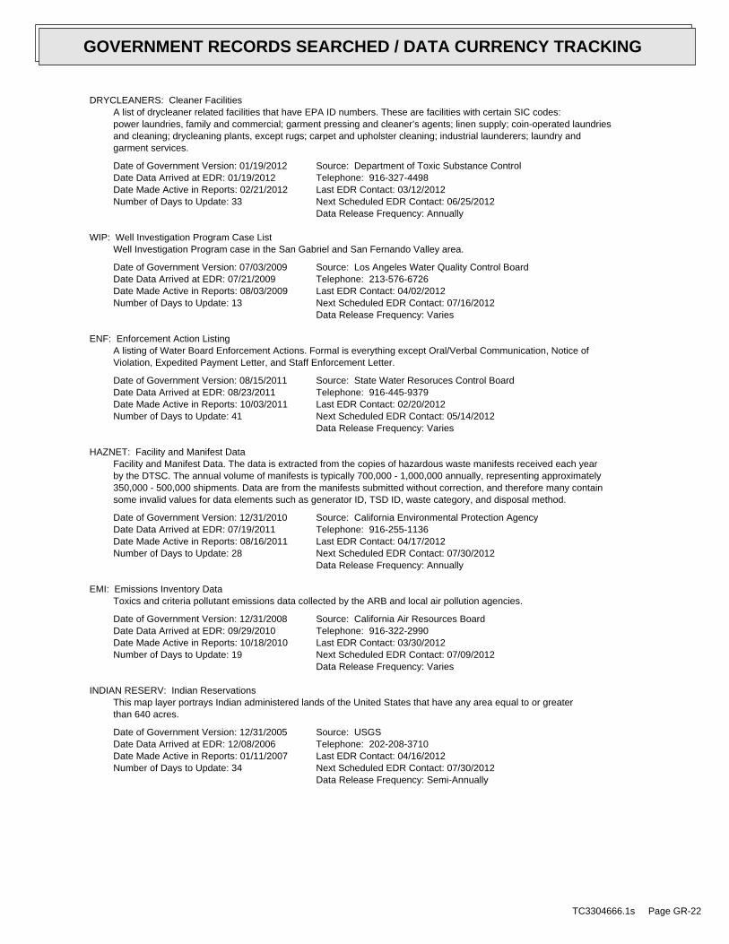
DRYCLEANERS: Cleaner FacilitiesA list of drycleaner related facilities that have EPA ID numbers. These are facilities with certain SIC codes:power laundries, family and commercial; garment pressing and cleaner’s agents; linen supply; coin-operated laundriesand cleaning; drycleaning plants, except rugs; carpet and upholster cleaning; industrial launderers; laundry andgarment services.
Date of Government Version: 01/19/2012Date Data Arrived at EDR: 01/19/2012Date Made Active in Reports: 02/21/2012Number of Days to Update: 33
Source: Department of Toxic Substance ControlTelephone: 916-327-4498Last EDR Contact: 03/12/2012Next Scheduled EDR Contact: 06/25/2012Data Release Frequency: Annually
WIP: Well Investigation Program Case ListWell Investigation Program case in the San Gabriel and San Fernando Valley area.
Date of Government Version: 07/03/2009Date Data Arrived at EDR: 07/21/2009Date Made Active in Reports: 08/03/2009Number of Days to Update: 13
Source: Los Angeles Water Quality Control BoardTelephone: 213-576-6726Last EDR Contact: 04/02/2012Next Scheduled EDR Contact: 07/16/2012Data Release Frequency: Varies
ENF: Enforcement Action ListingA listing of Water Board Enforcement Actions. Formal is everything except Oral/Verbal Communication, Notice ofViolation, Expedited Payment Letter, and Staff Enforcement Letter.
Date of Government Version: 08/15/2011Date Data Arrived at EDR: 08/23/2011Date Made Active in Reports: 10/03/2011Number of Days to Update: 41
Source: State Water Resoruces Control BoardTelephone: 916-445-9379Last EDR Contact: 02/20/2012Next Scheduled EDR Contact: 05/14/2012Data Release Frequency: Varies
HAZNET: Facility and Manifest DataFacility and Manifest Data. The data is extracted from the copies of hazardous waste manifests received each yearby the DTSC. The annual volume of manifests is typically 700,000 - 1,000,000 annually, representing approximately350,000 - 500,000 shipments. Data are from the manifests submitted without correction, and therefore many containsome invalid values for data elements such as generator ID, TSD ID, waste category, and disposal method.
Date of Government Version: 12/31/2010Date Data Arrived at EDR: 07/19/2011Date Made Active in Reports: 08/16/2011Number of Days to Update: 28
Source: California Environmental Protection AgencyTelephone: 916-255-1136Last EDR Contact: 04/17/2012Next Scheduled EDR Contact: 07/30/2012Data Release Frequency: Annually
EMI: Emissions Inventory DataToxics and criteria pollutant emissions data collected by the ARB and local air pollution agencies.
Date of Government Version: 12/31/2008Date Data Arrived at EDR: 09/29/2010Date Made Active in Reports: 10/18/2010Number of Days to Update: 19
Source: California Air Resources BoardTelephone: 916-322-2990Last EDR Contact: 03/30/2012Next Scheduled EDR Contact: 07/09/2012Data Release Frequency: Varies
INDIAN RESERV: Indian ReservationsThis map layer portrays Indian administered lands of the United States that have any area equal to or greaterthan 640 acres.
Date of Government Version: 12/31/2005Date Data Arrived at EDR: 12/08/2006Date Made Active in Reports: 01/11/2007Number of Days to Update: 34
Source: USGSTelephone: 202-208-3710Last EDR Contact: 04/16/2012Next Scheduled EDR Contact: 07/30/2012Data Release Frequency: Semi-Annually
TC3304666.1s Page GR-22
GOVERNMENT RECORDS SEARCHED / DATA CURRENCY TRACKING

SCRD DRYCLEANERS: State Coalition for Remediation of Drycleaners ListingThe State Coalition for Remediation of Drycleaners was established in 1998, with support from the U.S. EPA Officeof Superfund Remediation and Technology Innovation. It is comprised of representatives of states with establisheddrycleaner remediation programs. Currently the member states are Alabama, Connecticut, Florida, Illinois, Kansas,Minnesota, Missouri, North Carolina, Oregon, South Carolina, Tennessee, Texas, and Wisconsin.
Date of Government Version: 03/07/2011Date Data Arrived at EDR: 03/09/2011Date Made Active in Reports: 05/02/2011Number of Days to Update: 54
Source: Environmental Protection AgencyTelephone: 615-532-8599Last EDR Contact: 02/06/2012Next Scheduled EDR Contact: 05/07/2012Data Release Frequency: Varies
FEDLAND: Federal and Indian LandsFederally and Indian administrated lands of the United States. Lands included are administrated by: Army Corpsof Engineers, Bureau of Reclamation, National Wild and Scenic River, National Wildlife Refuge, Public Domain Land,Wilderness, Wilderness Study Area, Wildlife Management Area, Bureau of Indian Affairs, Bureau of Land Management,Department of Justice, Forest Service, Fish and Wildlife Service, National Park Service.
Date of Government Version: 12/31/2005Date Data Arrived at EDR: 02/06/2006Date Made Active in Reports: 01/11/2007Number of Days to Update: 339
Source: U.S. Geological SurveyTelephone: 888-275-8747Last EDR Contact: 04/16/2012Next Scheduled EDR Contact: 07/30/2012Data Release Frequency: N/A
FINANCIAL ASSURANCE 2: Financial Assurance Information ListingA listing of financial assurance information for solid waste facilities. Financial assurance is intended to ensurethat resources are available to pay for the cost of closure, post-closure care, and corrective measures if theowner or operator of a regulated facility is unable or unwilling to pay.
Date of Government Version: 02/22/2012Date Data Arrived at EDR: 02/24/2012Date Made Active in Reports: 04/04/2012Number of Days to Update: 40
Source: California Integrated Waste Management BoardTelephone: 916-341-6066Last EDR Contact: 02/20/2012Next Scheduled EDR Contact: 06/04/2012Data Release Frequency: Varies
FINANCIAL ASSURANCE 1: Financial Assurance Information ListingFinancial Assurance information
Date of Government Version: 03/01/2007Date Data Arrived at EDR: 06/01/2007Date Made Active in Reports: 06/29/2007Number of Days to Update: 28
Source: Department of Toxic Substances ControlTelephone: 916-255-3628Last EDR Contact: 02/03/2012Next Scheduled EDR Contact: 05/14/2012Data Release Frequency: Varies
PCB TRANSFORMER: PCB Transformer Registration DatabaseThe database of PCB transformer registrations that includes all PCB registration submittals.
Date of Government Version: 02/01/2011Date Data Arrived at EDR: 10/19/2011Date Made Active in Reports: 01/10/2012Number of Days to Update: 83
Source: Environmental Protection AgencyTelephone: 202-566-0517Last EDR Contact: 02/03/2012Next Scheduled EDR Contact: 05/14/2012Data Release Frequency: Varies
COAL ASH EPA: Coal Combustion Residues Surface Impoundments ListA listing of coal combustion residues surface impoundments with high hazard potential ratings.
Date of Government Version: 08/17/2010Date Data Arrived at EDR: 01/03/2011Date Made Active in Reports: 03/21/2011Number of Days to Update: 77
Source: Environmental Protection AgencyTelephone: N/ALast EDR Contact: 03/16/2012Next Scheduled EDR Contact: 06/25/2012Data Release Frequency: Varies
TC3304666.1s Page GR-23
GOVERNMENT RECORDS SEARCHED / DATA CURRENCY TRACKING

COAL ASH DOE: Sleam-Electric Plan Operation DataA listing of power plants that store ash in surface ponds.
Date of Government Version: 12/31/2005Date Data Arrived at EDR: 08/07/2009Date Made Active in Reports: 10/22/2009Number of Days to Update: 76
Source: Department of EnergyTelephone: 202-586-8719Last EDR Contact: 04/16/2012Next Scheduled EDR Contact: 07/30/2012Data Release Frequency: Varies
HWP: EnviroStor Permitted Facilities ListingDetailed information on permitted hazardous waste facilities and corrective action ("cleanups") tracked in EnviroStor.
Date of Government Version: 08/09/2010Date Data Arrived at EDR: 08/11/2010Date Made Active in Reports: 08/20/2010Number of Days to Update: 9
Source: Department of Toxic Substances ControlTelephone: 916-323-3400Last EDR Contact: 12/02/2011Next Scheduled EDR Contact: 03/12/2012Data Release Frequency: Quarterly
HWT: Registered Hazardous Waste Transporter DatabaseA listing of hazardous waste transporters. In California, unless specifically exempted, it is unlawful for anyperson to transport hazardous wastes unless the person holds a valid registration issued by DTSC. A hazardouswaste transporter registration is valid for one year and is assigned a unique registration number.
Date of Government Version: 01/18/2012Date Data Arrived at EDR: 01/18/2012Date Made Active in Reports: 02/21/2012Number of Days to Update: 34
Source: Department of Toxic Substances ControlTelephone: 916-440-7145Last EDR Contact: 04/12/2012Next Scheduled EDR Contact: 07/30/2012Data Release Frequency: Quarterly
PROC: Certified Processors DatabaseA listing of certified processors.
Date of Government Version: 12/12/2011Date Data Arrived at EDR: 12/19/2011Date Made Active in Reports: 01/19/2012Number of Days to Update: 31
Source: Department of ConservationTelephone: 916-323-3836Last EDR Contact: 03/21/2012Next Scheduled EDR Contact: 07/02/2012Data Release Frequency: Quarterly
MWMP: Medical Waste Management Program ListingThe Medical Waste Management Program (MWMP) ensures the proper handling and disposal of medical waste by permittingand inspecting medical waste Offsite Treatment Facilities (PDF) and Transfer Stations (PDF) throughout thestate. MWMP also oversees all Medical Waste Transporters.
Date of Government Version: 02/24/2012Date Data Arrived at EDR: 03/13/2012Date Made Active in Reports: 04/02/2012Number of Days to Update: 20
Source: Department of Public HealthTelephone: 916-558-1784Last EDR Contact: 03/12/2012Next Scheduled EDR Contact: 06/25/2012Data Release Frequency: Varies
EDR PROPRIETARY RECORDS
EDR Proprietary Records
Manufactured Gas Plants: EDR Proprietary Manufactured Gas PlantsThe EDR Proprietary Manufactured Gas Plant Database includes records of coal gas plants (manufactured gas plants)compiled by EDR’s researchers. Manufactured gas sites were used in the United States from the 1800’s to 1950’sto produce a gas that could be distributed and used as fuel. These plants used whale oil, rosin, coal, or a mixtureof coal, oil, and water that also produced a significant amount of waste. Many of the byproducts of the gas production,such as coal tar (oily waste containing volatile and non-volatile chemicals), sludges, oils and other compoundsare potentially hazardous to human health and the environment. The byproduct from this process was frequentlydisposed of directly at the plant site and can remain or spread slowly, serving as a continuous source of soiland groundwater contamination.
TC3304666.1s Page GR-24
GOVERNMENT RECORDS SEARCHED / DATA CURRENCY TRACKING

Date of Government Version: N/ADate Data Arrived at EDR: N/ADate Made Active in Reports: N/ANumber of Days to Update: N/A
Source: EDR, Inc.Telephone: N/ALast EDR Contact: N/ANext Scheduled EDR Contact: N/AData Release Frequency: No Update Planned
EDR Historical Auto Stations: EDR Proprietary Historic Gas StationsEDR has searched selected national collections of business directories and has collected listings of potentialgas station/filling station/service station sites that were available to EDR researchers. EDR’s review was limitedto those categories of sources that might, in EDR’s opinion, include gas station/filling station/service stationestablishments. The categories reviewed included, but were not limited to gas, gas station, gasoline station,filling station, auto, automobile repair, auto service station, service station, etc.
Date of Government Version: N/ADate Data Arrived at EDR: N/ADate Made Active in Reports: N/ANumber of Days to Update: N/A
Source: EDR, Inc.Telephone: N/ALast EDR Contact: N/ANext Scheduled EDR Contact: N/AData Release Frequency: Varies
EDR Historical Cleaners: EDR Proprietary Historic Dry CleanersEDR has searched selected national collections of business directories and has collected listings of potentialdry cleaner sites that were available to EDR researchers. EDR’s review was limited to those categories of sourcesthat might, in EDR’s opinion, include dry cleaning establishments. The categories reviewed included, but werenot limited to dry cleaners, cleaners, laundry, laundromat, cleaning/laundry, wash & dry etc.
Date of Government Version: N/ADate Data Arrived at EDR: N/ADate Made Active in Reports: N/ANumber of Days to Update: N/A
Source: EDR, Inc.Telephone: N/ALast EDR Contact: N/ANext Scheduled EDR Contact: N/AData Release Frequency: Varies
COUNTY RECORDS
ALAMEDA COUNTY:
Contaminated SitesA listing of contaminated sites overseen by the Toxic Release Program (oil and groundwater contamination fromchemical releases and spills) and the Leaking Underground Storage Tank Program (soil and ground water contaminationfrom leaking petroleum USTs).
Date of Government Version: 01/12/2012Date Data Arrived at EDR: 01/13/2012Date Made Active in Reports: 02/21/2012Number of Days to Update: 39
Source: Alameda County Environmental Health ServicesTelephone: 510-567-6700Last EDR Contact: 04/02/2012Next Scheduled EDR Contact: 07/16/2012Data Release Frequency: Semi-Annually
Underground TanksUnderground storage tank sites located in Alameda county.
Date of Government Version: 01/12/2012Date Data Arrived at EDR: 01/13/2012Date Made Active in Reports: 02/24/2012Number of Days to Update: 42
Source: Alameda County Environmental Health ServicesTelephone: 510-567-6700Last EDR Contact: 04/02/2012Next Scheduled EDR Contact: 07/16/2012Data Release Frequency: Semi-Annually
CONTRA COSTA COUNTY:
TC3304666.1s Page GR-25
GOVERNMENT RECORDS SEARCHED / DATA CURRENCY TRACKING

Site ListList includes sites from the underground tank, hazardous waste generator and business plan/2185 programs.
Date of Government Version: 11/28/2011Date Data Arrived at EDR: 11/29/2011Date Made Active in Reports: 12/13/2011Number of Days to Update: 14
Source: Contra Costa Health Services DepartmentTelephone: 925-646-2286Last EDR Contact: 02/07/2012Next Scheduled EDR Contact: 05/21/2012Data Release Frequency: Semi-Annually
KERN COUNTY:
Underground Storage Tank Sites & Tank ListingKern County Sites and Tanks Listing.
Date of Government Version: 08/31/2010Date Data Arrived at EDR: 09/01/2010Date Made Active in Reports: 09/30/2010Number of Days to Update: 29
Source: Kern County Environment Health Services DepartmentTelephone: 661-862-8700Last EDR Contact: 03/16/2012Next Scheduled EDR Contact: 05/28/2012Data Release Frequency: Quarterly
LOS ANGELES COUNTY:
San Gabriel Valley Areas of ConcernSan Gabriel Valley areas where VOC contamination is at or above the MCL as designated by region 9 EPA office.
Date of Government Version: 03/30/2009Date Data Arrived at EDR: 03/31/2009Date Made Active in Reports: 10/23/2009Number of Days to Update: 206
Source: EPA Region 9Telephone: 415-972-3178Last EDR Contact: 03/26/2012Next Scheduled EDR Contact: 07/09/2012Data Release Frequency: No Update Planned
HMS: Street Number ListIndustrial Waste and Underground Storage Tank Sites.
Date of Government Version: 09/29/2011Date Data Arrived at EDR: 12/15/2011Date Made Active in Reports: 01/19/2012Number of Days to Update: 35
Source: Department of Public WorksTelephone: 626-458-3517Last EDR Contact: 04/10/2012Next Scheduled EDR Contact: 07/30/2012Data Release Frequency: Semi-Annually
List of Solid Waste FacilitiesSolid Waste Facilities in Los Angeles County.
Date of Government Version: 01/23/2012Date Data Arrived at EDR: 01/24/2012Date Made Active in Reports: 02/21/2012Number of Days to Update: 28
Source: La County Department of Public WorksTelephone: 818-458-5185Last EDR Contact: 01/24/2012Next Scheduled EDR Contact: 05/07/2012Data Release Frequency: Varies
City of Los Angeles LandfillsLandfills owned and maintained by the City of Los Angeles.
Date of Government Version: 03/05/2009Date Data Arrived at EDR: 03/10/2009Date Made Active in Reports: 04/08/2009Number of Days to Update: 29
Source: Engineering & Construction DivisionTelephone: 213-473-7869Last EDR Contact: 11/17/2011Next Scheduled EDR Contact: 03/05/2012Data Release Frequency: Varies
TC3304666.1s Page GR-26
GOVERNMENT RECORDS SEARCHED / DATA CURRENCY TRACKING

Site Mitigation ListIndustrial sites that have had some sort of spill or complaint.
Date of Government Version: 12/29/2011Date Data Arrived at EDR: 02/02/2012Date Made Active in Reports: 02/21/2012Number of Days to Update: 19
Source: Community Health ServicesTelephone: 323-890-7806Last EDR Contact: 04/16/2012Next Scheduled EDR Contact: 08/06/2012Data Release Frequency: Annually
City of El Segundo Underground Storage TankUnderground storage tank sites located in El Segundo city.
Date of Government Version: 01/23/2012Date Data Arrived at EDR: 01/25/2012Date Made Active in Reports: 02/22/2012Number of Days to Update: 28
Source: City of El Segundo Fire DepartmentTelephone: 310-524-2236Last EDR Contact: 04/17/2012Next Scheduled EDR Contact: 08/06/2012Data Release Frequency: Semi-Annually
City of Long Beach Underground Storage TankUnderground storage tank sites located in the city of Long Beach.
Date of Government Version: 03/28/2003Date Data Arrived at EDR: 10/23/2003Date Made Active in Reports: 11/26/2003Number of Days to Update: 34
Source: City of Long Beach Fire DepartmentTelephone: 562-570-2563Last EDR Contact: 03/05/2012Next Scheduled EDR Contact: 05/14/2012Data Release Frequency: Annually
City of Torrance Underground Storage TankUnderground storage tank sites located in the city of Torrance.
Date of Government Version: 01/16/2012Date Data Arrived at EDR: 01/18/2012Date Made Active in Reports: 02/22/2012Number of Days to Update: 35
Source: City of Torrance Fire DepartmentTelephone: 310-618-2973Last EDR Contact: 04/10/2012Next Scheduled EDR Contact: 07/30/2012Data Release Frequency: Semi-Annually
MARIN COUNTY:
Underground Storage Tank SitesCurrently permitted USTs in Marin County.
Date of Government Version: 01/13/2012Date Data Arrived at EDR: 01/24/2012Date Made Active in Reports: 02/22/2012Number of Days to Update: 29
Source: Public Works Department Waste ManagementTelephone: 415-499-6647Last EDR Contact: 04/09/2012Next Scheduled EDR Contact: 07/23/2012Data Release Frequency: Semi-Annually
NAPA COUNTY:
Sites With Reported ContaminationA listing of leaking underground storage tank sites located in Napa county.
Date of Government Version: 12/05/2011Date Data Arrived at EDR: 12/06/2011Date Made Active in Reports: 02/07/2012Number of Days to Update: 63
Source: Napa County Department of Environmental ManagementTelephone: 707-253-4269Last EDR Contact: 03/05/2012Next Scheduled EDR Contact: 06/18/2012Data Release Frequency: No Update Planned
TC3304666.1s Page GR-27
GOVERNMENT RECORDS SEARCHED / DATA CURRENCY TRACKING

Closed and Operating Underground Storage Tank SitesUnderground storage tank sites located in Napa county.
Date of Government Version: 01/15/2008Date Data Arrived at EDR: 01/16/2008Date Made Active in Reports: 02/08/2008Number of Days to Update: 23
Source: Napa County Department of Environmental ManagementTelephone: 707-253-4269Last EDR Contact: 12/05/2012Next Scheduled EDR Contact: 06/18/2012Data Release Frequency: No Update Planned
ORANGE COUNTY:
List of Industrial Site CleanupsPetroleum and non-petroleum spills.
Date of Government Version: 02/01/2012Date Data Arrived at EDR: 02/17/2012Date Made Active in Reports: 02/21/2012Number of Days to Update: 4
Source: Health Care AgencyTelephone: 714-834-3446Last EDR Contact: 02/13/2012Next Scheduled EDR Contact: 05/28/2012Data Release Frequency: Annually
List of Underground Storage Tank CleanupsOrange County Underground Storage Tank Cleanups (LUST).
Date of Government Version: 02/01/2012Date Data Arrived at EDR: 02/17/2012Date Made Active in Reports: 02/21/2012Number of Days to Update: 4
Source: Health Care AgencyTelephone: 714-834-3446Last EDR Contact: 02/13/2012Next Scheduled EDR Contact: 05/28/2012Data Release Frequency: Quarterly
List of Underground Storage Tank FacilitiesOrange County Underground Storage Tank Facilities (UST).
Date of Government Version: 02/01/2012Date Data Arrived at EDR: 02/17/2012Date Made Active in Reports: 04/03/2012Number of Days to Update: 46
Source: Health Care AgencyTelephone: 714-834-3446Last EDR Contact: 02/13/2012Next Scheduled EDR Contact: 05/28/2012Data Release Frequency: Quarterly
PLACER COUNTY:
Master List of FacilitiesList includes aboveground tanks, underground tanks and cleanup sites.
Date of Government Version: 03/19/2012Date Data Arrived at EDR: 03/19/2012Date Made Active in Reports: 04/04/2012Number of Days to Update: 16
Source: Placer County Health and Human ServicesTelephone: 530-889-7312Last EDR Contact: 03/12/2012Next Scheduled EDR Contact: 06/25/2012Data Release Frequency: Semi-Annually
RIVERSIDE COUNTY:
Listing of Underground Tank Cleanup SitesRiverside County Underground Storage Tank Cleanup Sites (LUST).
Date of Government Version: 01/18/2012Date Data Arrived at EDR: 01/26/2012Date Made Active in Reports: 02/21/2012Number of Days to Update: 26
Source: Department of Environmental HealthTelephone: 951-358-5055Last EDR Contact: 12/21/2011Next Scheduled EDR Contact: 04/09/2012Data Release Frequency: Quarterly
TC3304666.1s Page GR-28
GOVERNMENT RECORDS SEARCHED / DATA CURRENCY TRACKING

Underground Storage Tank Tank ListUnderground storage tank sites located in Riverside county.
Date of Government Version: 01/18/2012Date Data Arrived at EDR: 01/26/2012Date Made Active in Reports: 02/24/2012Number of Days to Update: 29
Source: Department of Environmental HealthTelephone: 951-358-5055Last EDR Contact: 12/21/2011Next Scheduled EDR Contact: 04/26/2012Data Release Frequency: Quarterly
SACRAMENTO COUNTY:
Toxic Site Clean-Up ListList of sites where unauthorized releases of potentially hazardous materials have occurred.
Date of Government Version: 08/02/2011Date Data Arrived at EDR: 10/12/2011Date Made Active in Reports: 11/08/2011Number of Days to Update: 27
Source: Sacramento County Environmental ManagementTelephone: 916-875-8406Last EDR Contact: 04/09/2012Next Scheduled EDR Contact: 07/23/2012Data Release Frequency: Quarterly
Master Hazardous Materials Facility ListAny business that has hazardous materials on site - hazardous material storage sites, underground storage tanks,waste generators.
Date of Government Version: 08/02/2011Date Data Arrived at EDR: 10/14/2011Date Made Active in Reports: 11/08/2011Number of Days to Update: 25
Source: Sacramento County Environmental ManagementTelephone: 916-875-8406Last EDR Contact: 04/09/2012Next Scheduled EDR Contact: 07/23/2012Data Release Frequency: Quarterly
SAN BERNARDINO COUNTY:
Hazardous Material PermitsThis listing includes underground storage tanks, medical waste handlers/generators, hazardous materials handlers,hazardous waste generators, and waste oil generators/handlers.
Date of Government Version: 03/01/2012Date Data Arrived at EDR: 03/01/2012Date Made Active in Reports: 03/27/2012Number of Days to Update: 26
Source: San Bernardino County Fire Department Hazardous Materials DivisionTelephone: 909-387-3041Last EDR Contact: 02/13/2012Next Scheduled EDR Contact: 05/28/2012Data Release Frequency: Quarterly
SAN DIEGO COUNTY:
Hazardous Materials Management Division DatabaseThe database includes: HE58 - This report contains the business name, site address, business phone number, establishment’H’ permit number, type of permit, and the business status. HE17 - In addition to providing the same informationprovided in the HE58 listing, HE17 provides inspection dates, violations received by the establishment, hazardouswaste generated, the quantity, method of storage, treatment/disposal of waste and the hauler, and informationon underground storage tanks. Unauthorized Release List - Includes a summary of environmental contamination casesin San Diego County (underground tank cases, non-tank cases, groundwater contamination, and soil contaminationare included.)
Date of Government Version: 09/09/2010Date Data Arrived at EDR: 09/15/2010Date Made Active in Reports: 09/29/2010Number of Days to Update: 14
Source: Hazardous Materials Management DivisionTelephone: 619-338-2268Last EDR Contact: 03/16/2012Next Scheduled EDR Contact: 06/25/2012Data Release Frequency: Quarterly
TC3304666.1s Page GR-29
GOVERNMENT RECORDS SEARCHED / DATA CURRENCY TRACKING

Solid Waste FacilitiesSan Diego County Solid Waste Facilities.
Date of Government Version: 10/31/2011Date Data Arrived at EDR: 11/04/2011Date Made Active in Reports: 12/13/2011Number of Days to Update: 39
Source: Department of Health ServicesTelephone: 619-338-2209Last EDR Contact: 01/30/2012Next Scheduled EDR Contact: 05/14/2012Data Release Frequency: Varies
Environmental Case ListingThe listing contains all underground tank release cases and projects pertaining to properties contaminated withhazardous substances that are actively under review by the Site Assessment and Mitigation Program.
Date of Government Version: 03/23/2010Date Data Arrived at EDR: 06/15/2010Date Made Active in Reports: 07/09/2010Number of Days to Update: 24
Source: San Diego County Department of Environmental HealthTelephone: 619-338-2371Last EDR Contact: 03/12/2012Next Scheduled EDR Contact: 06/25/2012Data Release Frequency: No Update Planned
SAN FRANCISCO COUNTY:
Local Oversite FacilitiesA listing of leaking underground storage tank sites located in San Francisco county.
Date of Government Version: 09/19/2008Date Data Arrived at EDR: 09/19/2008Date Made Active in Reports: 09/29/2008Number of Days to Update: 10
Source: Department Of Public Health San Francisco CountyTelephone: 415-252-3920Last EDR Contact: 02/13/2012Next Scheduled EDR Contact: 05/28/2012Data Release Frequency: Quarterly
Underground Storage Tank InformationUnderground storage tank sites located in San Francisco county.
Date of Government Version: 11/29/2010Date Data Arrived at EDR: 03/10/2011Date Made Active in Reports: 03/15/2011Number of Days to Update: 5
Source: Department of Public HealthTelephone: 415-252-3920Last EDR Contact: 02/13/2012Next Scheduled EDR Contact: 05/28/2012Data Release Frequency: Quarterly
SAN JOAQUIN COUNTY:
San Joaquin Co. USTA listing of underground storage tank locations in San Joaquin county.
Date of Government Version: 01/18/2012Date Data Arrived at EDR: 01/18/2012Date Made Active in Reports: 02/22/2012Number of Days to Update: 35
Source: Environmental Health DepartmentTelephone: N/ALast EDR Contact: 03/26/2012Next Scheduled EDR Contact: 07/09/2012Data Release Frequency: Semi-Annually
SAN MATEO COUNTY:
Business InventoryList includes Hazardous Materials Business Plan, hazardous waste generators, and underground storage tanks.
Date of Government Version: 01/17/2012Date Data Arrived at EDR: 01/17/2012Date Made Active in Reports: 02/21/2012Number of Days to Update: 35
Source: San Mateo County Environmental Health Services DivisionTelephone: 650-363-1921Last EDR Contact: 03/19/2012Next Scheduled EDR Contact: 07/02/2012Data Release Frequency: Annually
TC3304666.1s Page GR-30
GOVERNMENT RECORDS SEARCHED / DATA CURRENCY TRACKING

Fuel Leak ListA listing of leaking underground storage tank sites located in San Mateo county.
Date of Government Version: 12/15/2011Date Data Arrived at EDR: 12/15/2011Date Made Active in Reports: 01/19/2012Number of Days to Update: 35
Source: San Mateo County Environmental Health Services DivisionTelephone: 650-363-1921Last EDR Contact: 03/19/2012Next Scheduled EDR Contact: 07/02/2012Data Release Frequency: Semi-Annually
SANTA CLARA COUNTY:
HIST LUST - Fuel Leak Site Activity ReportA listing of open and closed leaking underground storage tanks. This listing is no longer updated by the county.Leaking underground storage tanks are now handled by the Department of Environmental Health.
Date of Government Version: 03/29/2005Date Data Arrived at EDR: 03/30/2005Date Made Active in Reports: 04/21/2005Number of Days to Update: 22
Source: Santa Clara Valley Water DistrictTelephone: 408-265-2600Last EDR Contact: 03/23/2009Next Scheduled EDR Contact: 06/22/2009Data Release Frequency: No Update Planned
LOP ListingA listing of leaking underground storage tanks located in Santa Clara county.
Date of Government Version: 03/05/2012Date Data Arrived at EDR: 03/07/2012Date Made Active in Reports: 03/27/2012Number of Days to Update: 20
Source: Department of Environmental HealthTelephone: 408-918-3417Last EDR Contact: 03/05/2012Next Scheduled EDR Contact: 06/18/2012Data Release Frequency: Annually
Hazardous Material FacilitiesHazardous material facilities, including underground storage tank sites.
Date of Government Version: 02/16/2012Date Data Arrived at EDR: 02/17/2012Date Made Active in Reports: 02/21/2012Number of Days to Update: 4
Source: City of San Jose Fire DepartmentTelephone: 408-535-7694Last EDR Contact: 02/13/2012Next Scheduled EDR Contact: 05/28/2012Data Release Frequency: Annually
SOLANO COUNTY:
Leaking Underground Storage TanksA listing of leaking underground storage tank sites located in Solano county.
Date of Government Version: 12/19/2011Date Data Arrived at EDR: 01/06/2012Date Made Active in Reports: 01/27/2012Number of Days to Update: 21
Source: Solano County Department of Environmental ManagementTelephone: 707-784-6770Last EDR Contact: 03/19/2012Next Scheduled EDR Contact: 07/02/2012Data Release Frequency: Quarterly
Underground Storage TanksUnderground storage tank sites located in Solano county.
Date of Government Version: 12/19/2011Date Data Arrived at EDR: 01/17/2012Date Made Active in Reports: 02/24/2012Number of Days to Update: 38
Source: Solano County Department of Environmental ManagementTelephone: 707-784-6770Last EDR Contact: 03/19/2012Next Scheduled EDR Contact: 07/02/2012Data Release Frequency: Quarterly
SONOMA COUNTY:
TC3304666.1s Page GR-31
GOVERNMENT RECORDS SEARCHED / DATA CURRENCY TRACKING

Leaking Underground Storage Tank SitesA listing of leaking underground storage tank sites located in Sonoma county.
Date of Government Version: 04/05/2011Date Data Arrived at EDR: 04/06/2011Date Made Active in Reports: 05/12/2011Number of Days to Update: 36
Source: Department of Health ServicesTelephone: 707-565-6565Last EDR Contact: 04/02/2012Next Scheduled EDR Contact: 07/16/2012Data Release Frequency: Quarterly
SUTTER COUNTY:
Underground Storage TanksUnderground storage tank sites located in Sutter county.
Date of Government Version: 03/12/2012Date Data Arrived at EDR: 03/13/2012Date Made Active in Reports: 04/03/2012Number of Days to Update: 21
Source: Sutter County Department of AgricultureTelephone: 530-822-7500Last EDR Contact: 03/12/2012Next Scheduled EDR Contact: 06/25/2012Data Release Frequency: Semi-Annually
VENTURA COUNTY:
Business Plan, Hazardous Waste Producers, and Operating Underground TanksThe BWT list indicates by site address whether the Environmental Health Division has Business Plan (B), WasteProducer (W), and/or Underground Tank (T) information.
Date of Government Version: 02/03/2012Date Data Arrived at EDR: 02/22/2012Date Made Active in Reports: 03/29/2012Number of Days to Update: 36
Source: Ventura County Environmental Health DivisionTelephone: 805-654-2813Last EDR Contact: 02/20/2012Next Scheduled EDR Contact: 06/04/2012Data Release Frequency: Quarterly
Inventory of Illegal Abandoned and Inactive SitesVentura County Inventory of Closed, Illegal Abandoned, and Inactive Sites.
Date of Government Version: 12/01/2011Date Data Arrived at EDR: 12/01/2011Date Made Active in Reports: 01/19/2012Number of Days to Update: 49
Source: Environmental Health DivisionTelephone: 805-654-2813Last EDR Contact: 04/09/2012Next Scheduled EDR Contact: 07/23/2012Data Release Frequency: Annually
Listing of Underground Tank Cleanup SitesVentura County Underground Storage Tank Cleanup Sites (LUST).
Date of Government Version: 05/29/2008Date Data Arrived at EDR: 06/24/2008Date Made Active in Reports: 07/31/2008Number of Days to Update: 37
Source: Environmental Health DivisionTelephone: 805-654-2813Last EDR Contact: 02/20/2012Next Scheduled EDR Contact: 06/04/2012Data Release Frequency: Quarterly
Medical Waste Program ListTo protect public health and safety and the environment from potential exposure to disease causing agents, theEnvironmental Health Division Medical Waste Program regulates the generation, handling, storage, treatment anddisposal of medical waste throughout the County.
Date of Government Version: 12/27/2011Date Data Arrived at EDR: 02/03/2012Date Made Active in Reports: 02/21/2012Number of Days to Update: 18
Source: Ventura County Resource Management AgencyTelephone: 805-654-2813Last EDR Contact: 01/30/2012Next Scheduled EDR Contact: 05/14/2012Data Release Frequency: Quarterly
TC3304666.1s Page GR-32
GOVERNMENT RECORDS SEARCHED / DATA CURRENCY TRACKING
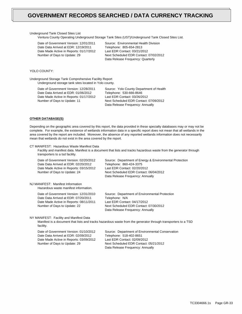
Underground Tank Closed Sites ListVentura County Operating Underground Storage Tank Sites (UST)/Underground Tank Closed Sites List.
Date of Government Version: 12/01/2011Date Data Arrived at EDR: 12/19/2011Date Made Active in Reports: 01/17/2012Number of Days to Update: 29
Source: Environmental Health DivisionTelephone: 805-654-2813Last EDR Contact: 03/21/2012Next Scheduled EDR Contact: 07/02/2012Data Release Frequency: Quarterly
YOLO COUNTY:
Underground Storage Tank Comprehensive Facility ReportUnderground storage tank sites located in Yolo county.
Date of Government Version: 12/28/2011Date Data Arrived at EDR: 01/06/2012Date Made Active in Reports: 01/17/2012Number of Days to Update: 11
Source: Yolo County Department of HealthTelephone: 530-666-8646Last EDR Contact: 03/26/2012Next Scheduled EDR Contact: 07/09/2012Data Release Frequency: Annually
OTHER DATABASE(S)
Depending on the geographic area covered by this report, the data provided in these specialty databases may or may not becomplete. For example, the existence of wetlands information data in a specific report does not mean that all wetlands in thearea covered by the report are included. Moreover, the absence of any reported wetlands information does not necessarilymean that wetlands do not exist in the area covered by the report.
CT MANIFEST: Hazardous Waste Manifest DataFacility and manifest data. Manifest is a document that lists and tracks hazardous waste from the generator throughtransporters to a tsd facility.
Date of Government Version: 02/20/2012Date Data Arrived at EDR: 02/20/2012Date Made Active in Reports: 03/15/2012Number of Days to Update: 24
Source: Department of Energy & Environmental ProtectionTelephone: 860-424-3375Last EDR Contact: 02/20/2012Next Scheduled EDR Contact: 06/04/2012Data Release Frequency: Annually
NJ MANIFEST: Manifest InformationHazardous waste manifest information.
Date of Government Version: 12/31/2010Date Data Arrived at EDR: 07/20/2011Date Made Active in Reports: 08/11/2011Number of Days to Update: 22
Source: Department of Environmental ProtectionTelephone: N/ALast EDR Contact: 04/17/2012Next Scheduled EDR Contact: 07/30/2012Data Release Frequency: Annually
NY MANIFEST: Facility and Manifest DataManifest is a document that lists and tracks hazardous waste from the generator through transporters to a TSDfacility.
Date of Government Version: 01/10/2012Date Data Arrived at EDR: 02/09/2012Date Made Active in Reports: 03/09/2012Number of Days to Update: 29
Source: Department of Environmental ConservationTelephone: 518-402-8651Last EDR Contact: 02/09/2012Next Scheduled EDR Contact: 05/21/2012Data Release Frequency: Annually
TC3304666.1s Page GR-33
GOVERNMENT RECORDS SEARCHED / DATA CURRENCY TRACKING

PA MANIFEST: Manifest InformationHazardous waste manifest information.
Date of Government Version: 12/31/2009Date Data Arrived at EDR: 01/26/2012Date Made Active in Reports: 03/06/2012Number of Days to Update: 40
Source: Department of Environmental ProtectionTelephone: 717-783-8990Last EDR Contact: 01/23/2012Next Scheduled EDR Contact: 05/07/2012Data Release Frequency: Annually
RI MANIFEST: Manifest informationHazardous waste manifest information
Date of Government Version: 12/31/2010Date Data Arrived at EDR: 06/24/2011Date Made Active in Reports: 06/30/2011Number of Days to Update: 6
Source: Department of Environmental ManagementTelephone: 401-222-2797Last EDR Contact: 02/27/2012Next Scheduled EDR Contact: 06/11/2012Data Release Frequency: Annually
WI MANIFEST: Manifest InformationHazardous waste manifest information.
Date of Government Version: 12/31/2010Date Data Arrived at EDR: 08/19/2011Date Made Active in Reports: 09/15/2011Number of Days to Update: 27
Source: Department of Natural ResourcesTelephone: N/ALast EDR Contact: 03/19/2012Next Scheduled EDR Contact: 07/02/2012Data Release Frequency: Annually
Oil/Gas Pipelines: This data was obtained by EDR from the USGS in 1994. It is referred to by USGS as GeoData Digital Line Graphsfrom 1:100,000-Scale Maps. It was extracted from the transportation category including some oil, but primarilygas pipelines.
Electric Power Transmission Line DataSource: Rextag Strategies Corp.Telephone: (281) 769-2247U.S. Electric Transmission and Power Plants Systems Digital GIS Data
Sensitive Receptors: There are individuals deemed sensitive receptors due to their fragile immune systems and special sensitivityto environmental discharges. These sensitive receptors typically include the elderly, the sick, and children. While the location of allsensitive receptors cannot be determined, EDR indicates those buildings and facilities - schools, daycares, hospitals, medical centers,and nursing homes - where individuals who are sensitive receptors are likely to be located.
AHA Hospitals:Source: American Hospital Association, Inc.Telephone: 312-280-5991The database includes a listing of hospitals based on the American Hospital Association’s annual survey of hospitals.
Medical Centers: Provider of Services ListingSource: Centers for Medicare & Medicaid ServicesTelephone: 410-786-3000A listing of hospitals with Medicare provider number, produced by Centers of Medicare & Medicaid Services,a federal agency within the U.S. Department of Health and Human Services.
Nursing HomesSource: National Institutes of HealthTelephone: 301-594-6248Information on Medicare and Medicaid certified nursing homes in the United States.
Public SchoolsSource: National Center for Education StatisticsTelephone: 202-502-7300The National Center for Education Statistics’ primary database on elementaryand secondary public education in the United States. It is a comprehensive, annual, national statisticaldatabase of all public elementary and secondary schools and school districts, which contains data that arecomparable across all states.
Private SchoolsSource: National Center for Education StatisticsTelephone: 202-502-7300The National Center for Education Statistics’ primary database on private school locations in the United States.
TC3304666.1s Page GR-34
GOVERNMENT RECORDS SEARCHED / DATA CURRENCY TRACKING

Daycare Centers: Licensed FacilitiesSource: Department of Social ServicesTelephone: 916-657-4041
Flood Zone Data: This data, available in select counties across the country, was obtained by EDR in 2003 & 2011 from the FederalEmergency Management Agency (FEMA). Data depicts 100-year and 500-year flood zones as defined by FEMA.
NWI: National Wetlands Inventory. This data, available in select counties across the country, was obtained by EDRin 2002 and 2005 from the U.S. Fish and Wildlife Service.
Scanned Digital USGS 7.5’ Topographic Map (DRG)Source: United States Geologic SurveyA digital raster graphic (DRG) is a scanned image of a U.S. Geological Survey topographic map. The map imagesare made by scanning published paper maps on high-resolution scanners. The raster imageis georeferenced and fit to the Universal Transverse Mercator (UTM) projection.
STREET AND ADDRESS INFORMATION
© 2010 Tele Atlas North America, Inc. All rights reserved. This material is proprietary and the subject of copyright protectionand other intellectual property rights owned by or licensed to Tele Atlas North America, Inc. The use of this material is subjectto the terms of a license agreement. You will be held liable for any unauthorized copying or disclosure of this material.
TC3304666.1s Page GR-35
GOVERNMENT RECORDS SEARCHED / DATA CURRENCY TRACKING

TC3304666.1s Page A-1
geologic strata.of the soil, and nearby wells. Groundwater flow velocity is generally impacted by the nature of theGroundwater flow direction may be impacted by surface topography, hydrology, hydrogeology, characteristics
2. Groundwater flow velocity. 1. Groundwater flow direction, and
Assessment of the impact of contaminant migration generally has two principal investigative components:
forming an opinion about the impact of potential contaminant migration.EDR’s GeoCheck Physical Setting Source Addendum is provided to assist the environmental professional in
1988Most Recent Revision:33117-E5 CANADA GOBERNADORA, CATarget Property Map:
USGS TOPOGRAPHIC MAP
543 ft. above sea levelElevation:3714876.5UTM Y (Meters): 445019.9UTM X (Meters): Zone 11Universal Tranverse Mercator: 117.5924 - 117˚ 35’ 32.64’’Longitude (West): 33.5739 - 33˚ 34’ 26.04’’Latitude (North):
TARGET PROPERTY COORDINATES
TRABUCO CANYON, CA 9267930952 OSO PARKWAYWAGON WHEEL CREEK RESTORATION PLAN
TARGET PROPERTY ADDRESS
®GEOCHECK - PHYSICAL SETTING SOURCE ADDENDUM®

TC3304666.1s Page A-2
should be field verified.on a relative (not an absolute) basis. Relative elevation information between sites of close proximitySource: Topography has been determined from the USGS 7.5’ Digital Elevation Model and should be evaluated
SURROUNDING TOPOGRAPHY: ELEVATION PROFILES
Ele
vatio
n (f
t)E
leva
tion
(ft)
TP
TP0 1/2 1 Miles
✩Target Property Elevation: 543 ft.
North South
West East
589522
553
527481
491
511
514
524
543
561
603
625
651
687
730
759
828
838656
799 701
878
689 603
675 604 553
543
560 482
482
546
523
559
596
616
745
General ESEGeneral Topographic Gradient:TARGET PROPERTY TOPOGRAPHY
should contamination exist on the target property, what downgradient sites might be impacted.assist the environmental professional in forming an opinion about the impact of nearby contaminated properties or,Surface topography may be indicative of the direction of surficial groundwater flow. This information can be used toTOPOGRAPHIC INFORMATION
collected on nearby properties, and regional groundwater flow information (from deep aquifers).sources of information, such as surface topographic information, hydrologic information, hydrogeologic datausing site-specific well data. If such data is not reasonably ascertainable, it may be necessary to rely on otherGroundwater flow direction for a particular site is best determined by a qualified environmental professionalGROUNDWATER FLOW DIRECTION INFORMATION
®GEOCHECK - PHYSICAL SETTING SOURCE SUMMARY®
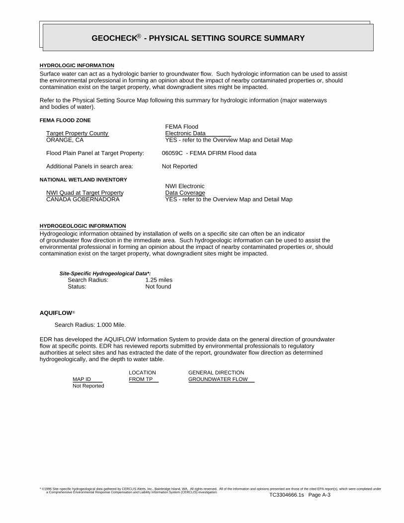
TC3304666.1s Page A-3
Not Reported
GENERAL DIRECTIONLOCATIONGROUNDWATER FLOWFROM TPMAP ID
hydrogeologically, and the depth to water table.authorities at select sites and has extracted the date of the report, groundwater flow direction as determinedflow at specific points. EDR has reviewed reports submitted by environmental professionals to regulatoryEDR has developed the AQUIFLOW Information System to provide data on the general direction of groundwater
AQUIFLOW®
Search Radius: 1.000 Mile.
Not found Status:1.25 miles Search Radius:
Site-Specific Hydrogeological Data*:
* ©1996 Site−specific hydrogeological data gathered by CERCLIS Alerts, Inc., Bainbridge Island, WA. All rights reserved. All of the information and opinions presented are those of the cited EPA report(s), which were completed undera Comprehensive Environmental Response Compensation and Liability Information System (CERCLIS) investigation.
contamination exist on the target property, what downgradient sites might be impacted.environmental professional in forming an opinion about the impact of nearby contaminated properties or, shouldof groundwater flow direction in the immediate area. Such hydrogeologic information can be used to assist theHydrogeologic information obtained by installation of wells on a specific site can often be an indicatorHYDROGEOLOGIC INFORMATION
YES - refer to the Overview Map and Detail MapCANADA GOBERNADORA
NATIONAL WETLAND INVENTORYNWI ElectronicData CoverageNWI Quad at Target Property
Not ReportedAdditional Panels in search area:
06059C - FEMA DFIRM Flood dataFlood Plain Panel at Target Property:
YES - refer to the Overview Map and Detail MapORANGE, CA
FEMA FLOOD ZONEFEMA FloodElectronic DataTarget Property County
and bodies of water).Refer to the Physical Setting Source Map following this summary for hydrologic information (major waterways
contamination exist on the target property, what downgradient sites might be impacted.the environmental professional in forming an opinion about the impact of nearby contaminated properties or, shouldSurface water can act as a hydrologic barrier to groundwater flow. Such hydrologic information can be used to assistHYDROLOGIC INFORMATION
®GEOCHECK - PHYSICAL SETTING SOURCE SUMMARY®

TC3304666.1s Page A-4
Map, USGS Digital Data Series DDS - 11 (1994).of the Conterminous U.S. at 1:2,500,000 Scale - a digital representation of the 1974 P.B. King and H.M. BeikmanGeologic Age and Rock Stratigraphic Unit Source: P.G. Schruben, R.E. Arndt and W.J. Bawiec, Geology
ROCK STRATIGRAPHIC UNIT GEOLOGIC AGE IDENTIFICATION
Stratified SequenceCategory:CenozoicEra:TertiarySystem:PaleoceneSeries:TxCode: (decoded above as Era, System & Series)
at which contaminant migration may be occurring.Geologic information can be used by the environmental professional in forming an opinion about the relative speedGEOLOGIC INFORMATION IN GENERAL AREA OF TARGET PROPERTY
move more quickly through sandy-gravelly types of soils than silty-clayey types of soils.characteristics data collected on nearby properties and regional soil information. In general, contaminant plumesto rely on other sources of information, including geologic age identification, rock stratigraphic unit and soilusing site specific geologic and soil strata data. If such data are not reasonably ascertainable, it may be necessaryGroundwater flow velocity information for a particular site is best determined by a qualified environmental professionalGROUNDWATER FLOW VELOCITY INFORMATION
®GEOCHECK - PHYSICAL SETTING SOURCE SUMMARY®

EDR Inc.EDR Inc.EDR Inc.EDR Inc.EDR Inc.EDR Inc.EDR Inc.EDR Inc.EDR Inc.EDR Inc.EDR Inc.EDR Inc.EDR Inc.EDR Inc.EDR Inc.EDR Inc.EDR Inc.EDR Inc.EDR Inc.EDR Inc.EDR Inc.EDR Inc.EDR Inc.EDR Inc.EDR Inc.EDR Inc.EDR Inc.EDR Inc.EDR Inc.EDR Inc.EDR Inc.EDR Inc.EDR Inc.EDR Inc.EDR Inc.EDR Inc.EDR Inc.EDR Inc.EDR Inc.EDR Inc.
5
1
2 3
5
56
7
1
5
6
2
7
5 46
7
6
8
0 1/16 1/8 1/4 Miles

TC3304666.1s Page A-6
Min: 5.6Max: 7.3
Min: 14Max: 42
Silty Sand.Sands with fines,SOILS, Sands,COARSE-GRAINED
and Sand.Clayey Gravel200), Silty, orpassing No.pct. or lessmaterials (35Granularfine sandy loam64 inches27 inches 2
Min: 5.6Max: 7.3
Min: 14Max: 42
Silty Sand.Sands with fines,SOILS, Sands,COARSE-GRAINED
and Sand.Clayey Gravel200), Silty, orpassing No.pct. or lessmaterials (35Granularsandy loam27 inches 0 inches 1
Soil Layer Information
Boundary Classification Saturatedhydraulicconductivitymicro m/sec
Layer Upper Lower Soil Texture Class AASHTO Group Unified Soil Soil Reaction(pH)
> 0 inchesDepth to Watertable Min:
> 0 inchesDepth to Bedrock Min:
LowCorrosion Potential - Uncoated Steel:
Hydric Status: Not hydric
Well drainedSoil Drainage Class:
textures.moderately well and well drained soils with moderately coarseClass B - Moderate infiltration rates. Deep and moderately deep,Hydrologic Group:
sandy loamSoil Surface Texture:
CAPISTRANOSoil Component Name:
Soil Map ID: 1
in a landscape. The following information is based on Soil Conservation Service SSURGO data.for privately owned lands in the United States. A soil map in a soil survey is a representation of soil patternsSurvey (NCSS) and is responsible for collecting, storing, maintaining and distributing soil survey informationThe U.S. Department of Agriculture’s (USDA) Soil Conservation Service (SCS) leads the National Cooperative Soil
DOMINANT SOIL COMPOSITION IN GENERAL AREA OF TARGET PROPERTY
®GEOCHECK - PHYSICAL SETTING SOURCE SUMMARY®

TC3304666.1s Page A-7
> 0 inchesDepth to Watertable Min:
> 0 inchesDepth to Bedrock Min:
HighCorrosion Potential - Uncoated Steel:
Hydric Status: Not hydric
Moderately well drainedSoil Drainage Class:
water table, or are shallow to an impervious layer.Class D - Very slow infiltration rates. Soils are clayey, have a highHydrologic Group:
sandy loamSoil Surface Texture:
MYFORDSoil Component Name:
Soil Map ID: 3
Min: 7.4Max: 8.4
Min: 1.4Max: 4 Not reportedNot reportedsandy clay loam66 inches35 inches 3
Min: 7.4Max: 8.4
Min: 1.4Max: 4 Not reportedNot reportedsilty clay loam35 inches 7 inches 2
Min: 7.4Max: 8.4
Min: 1.4Max: 4 Not reportedNot reportedclay loam 7 inches 0 inches 1
Soil Layer Information
Boundary Classification Saturatedhydraulicconductivitymicro m/sec
Layer Upper Lower Soil Texture Class AASHTO Group Unified Soil Soil Reaction(pH)
> 0 inchesDepth to Watertable Min:
> 0 inchesDepth to Bedrock Min:
ModerateCorrosion Potential - Uncoated Steel:
Hydric Status: Not hydric
Well drainedSoil Drainage Class:
textures.moderately well and well drained soils with moderately coarseClass B - Moderate infiltration rates. Deep and moderately deep,Hydrologic Group:
clay loamSoil Surface Texture:
BOTELLASoil Component Name:
Soil Map ID: 2
®GEOCHECK - PHYSICAL SETTING SOURCE SUMMARY®

TC3304666.1s Page A-8
Min: 6.1Max: 6.5
Min: 4Max: 14
50%), silt.limit less thanClays (liquidSOILS, Silts andFINE-GRAINED50%), Lean Clay.limit less thanClays (liquidSOILS, Silts andFINE-GRAINED
and Sand.Clayey Gravel200), Silty, orpassing No.pct. or lessmaterials (35Granularsandy loam79 inches64 inches 5
Min: 6.1Max: 6.5
Min: 4Max: 14
50%), silt.limit less thanClays (liquidSOILS, Silts andFINE-GRAINED50%), Lean Clay.limit less thanClays (liquidSOILS, Silts andFINE-GRAINED
and Sand.Clayey Gravel200), Silty, orpassing No.pct. or lessmaterials (35Granularsandy clay loam64 inches20 inches 4
Min: 6.1Max: 6.5
Min: 4Max: 14
50%), silt.limit less thanClays (liquidSOILS, Silts andFINE-GRAINED50%), Lean Clay.limit less thanClays (liquidSOILS, Silts andFINE-GRAINED
and Sand.Clayey Gravel200), Silty, orpassing No.pct. or lessmaterials (35Granularsandy clay loam20 inches11 inches 3
Min: 6.1Max: 6.5
Min: 4Max: 14
50%), silt.limit less thanClays (liquidSOILS, Silts andFINE-GRAINED50%), Lean Clay.limit less thanClays (liquidSOILS, Silts andFINE-GRAINED
and Sand.Clayey Gravel200), Silty, orpassing No.pct. or lessmaterials (35Granularsandy clay11 inches 7 inches 2
Min: 6.1Max: 6.5
Min: 4Max: 14
50%), silt.limit less thanClays (liquidSOILS, Silts andFINE-GRAINED50%), Lean Clay.limit less thanClays (liquidSOILS, Silts andFINE-GRAINED
and Sand.Clayey Gravel200), Silty, orpassing No.pct. or lessmaterials (35Granularsandy loam 7 inches 0 inches 1
Soil Layer Information
Boundary Classification Saturatedhydraulicconductivitymicro m/sec
Layer Upper Lower Soil Texture Class AASHTO Group Unified Soil Soil Reaction(pH)
®GEOCHECK - PHYSICAL SETTING SOURCE SUMMARY®
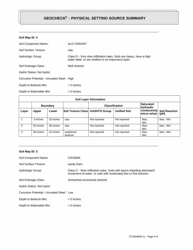
TC3304666.1s Page A-9
> 0 inchesDepth to Watertable Min:
> 0 inchesDepth to Bedrock Min:
LowCorrosion Potential - Uncoated Steel:
Hydric Status: Not hydric
Somewhat excessively drainedSoil Drainage Class:
movement of water, or soils with moderately fine or fine textures.Class C - Slow infiltration rates. Soils with layers impeding downwardHydrologic Group:
sandy loamSoil Surface Texture:
CIENEBASoil Component Name:
Soil Map ID: 5
Max: Min: Min: Max: Not reportedNot reported
bedrockweathered42 inches38 inches 3
Max: Min: Min: Max: Not reportedNot reportedclay38 inches25 inches 2
Max: Min: Min: Max: Not reportedNot reportedclay25 inches 0 inches 1
Soil Layer Information
Boundary Classification Saturatedhydraulicconductivitymicro m/sec
Layer Upper Lower Soil Texture Class AASHTO Group Unified Soil Soil Reaction(pH)
> 0 inchesDepth to Watertable Min:
> 0 inchesDepth to Bedrock Min:
HighCorrosion Potential - Uncoated Steel:
Hydric Status: Not hydric
Well drainedSoil Drainage Class:
water table, or are shallow to an impervious layer.Class D - Very slow infiltration rates. Soils are clayey, have a highHydrologic Group:
claySoil Surface Texture:
ALO VARIANTSoil Component Name:
Soil Map ID: 4
®GEOCHECK - PHYSICAL SETTING SOURCE SUMMARY®

TC3304666.1s Page A-10
Min: 7.4Max: 8.4
Min: 1.4Max: 4
50%), Lean Claylimit less thanClays (liquidSOILS, Silts andFINE-GRAINED
Soils.200), Clayeypassing No.than 35 pct.Materials (moreSilt-Clayclay loam 7 inches 0 inches 1
Soil Layer Information
Boundary Classification Saturatedhydraulicconductivitymicro m/sec
Layer Upper Lower Soil Texture Class AASHTO Group Unified Soil Soil Reaction(pH)
> 0 inchesDepth to Watertable Min:
> 0 inchesDepth to Bedrock Min:
ModerateCorrosion Potential - Uncoated Steel:
Hydric Status: Not hydric
Well drainedSoil Drainage Class:
textures.moderately well and well drained soils with moderately coarseClass B - Moderate infiltration rates. Deep and moderately deep,Hydrologic Group:
clay loamSoil Surface Texture:
BOTELLASoil Component Name:
Soil Map ID: 6
Max: Min: Min: 0Max: 0.42 Not reported
Soils.200), Siltypassing No.than 35 pct.Materials (moreSilt-Clay
bedrockweathered11 inches 7 inches 2
Max: Min: Min: 0Max: 0.42 Not reported
Soils.200), Siltypassing No.than 35 pct.Materials (moreSilt-Claysandy loam 7 inches 0 inches 1
Soil Layer Information
Boundary Classification Saturatedhydraulicconductivitymicro m/sec
Layer Upper Lower Soil Texture Class AASHTO Group Unified Soil Soil Reaction(pH)
®GEOCHECK - PHYSICAL SETTING SOURCE SUMMARY®
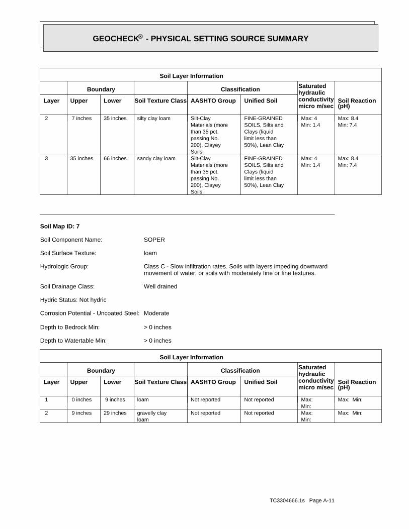
TC3304666.1s Page A-11
Max: Min: Min: Max: Not reportedNot reported
loamgravelly clay29 inches 9 inches 2
Max: Min: Min: Max: Not reportedNot reportedloam 9 inches 0 inches 1
Soil Layer Information
Boundary Classification Saturatedhydraulicconductivitymicro m/sec
Layer Upper Lower Soil Texture Class AASHTO Group Unified Soil Soil Reaction(pH)
> 0 inchesDepth to Watertable Min:
> 0 inchesDepth to Bedrock Min:
ModerateCorrosion Potential - Uncoated Steel:
Hydric Status: Not hydric
Well drainedSoil Drainage Class:
movement of water, or soils with moderately fine or fine textures.Class C - Slow infiltration rates. Soils with layers impeding downwardHydrologic Group:
loamSoil Surface Texture:
SOPERSoil Component Name:
Soil Map ID: 7
Min: 7.4Max: 8.4
Min: 1.4Max: 4
50%), Lean Claylimit less thanClays (liquidSOILS, Silts andFINE-GRAINED
Soils.200), Clayeypassing No.than 35 pct.Materials (moreSilt-Claysandy clay loam66 inches35 inches 3
Min: 7.4Max: 8.4
Min: 1.4Max: 4
50%), Lean Claylimit less thanClays (liquidSOILS, Silts andFINE-GRAINED
Soils.200), Clayeypassing No.than 35 pct.Materials (moreSilt-Claysilty clay loam35 inches 7 inches 2
Soil Layer Information
Boundary Classification Saturatedhydraulicconductivitymicro m/sec
Layer Upper Lower Soil Texture Class AASHTO Group Unified Soil Soil Reaction(pH)
®GEOCHECK - PHYSICAL SETTING SOURCE SUMMARY®

TC3304666.1s Page A-12
Min: 6.1Max: 6.5
Min: 4Max: 14
50%), silt.limit less thanClays (liquidSOILS, Silts andFINE-GRAINED50%), Lean Clay.limit less thanClays (liquidSOILS, Silts andFINE-GRAINED
and Sand.Clayey Gravel200), Silty, orpassing No.pct. or lessmaterials (35Granularsandy clay18 inches11 inches 2
Min: 6.1Max: 6.5
Min: 4Max: 14
50%), silt.limit less thanClays (liquidSOILS, Silts andFINE-GRAINED50%), Lean Clay.limit less thanClays (liquidSOILS, Silts andFINE-GRAINED
and Sand.Clayey Gravel200), Silty, orpassing No.pct. or lessmaterials (35Granularsandy loam11 inches 0 inches 1
Soil Layer Information
Boundary Classification Saturatedhydraulicconductivitymicro m/sec
Layer Upper Lower Soil Texture Class AASHTO Group Unified Soil Soil Reaction(pH)
> 0 inchesDepth to Watertable Min:
> 0 inchesDepth to Bedrock Min:
HighCorrosion Potential - Uncoated Steel:
Hydric Status: Not hydric
Moderately well drainedSoil Drainage Class:
water table, or are shallow to an impervious layer.Class D - Very slow infiltration rates. Soils are clayey, have a highHydrologic Group:
sandy loamSoil Surface Texture:
MYFORDSoil Component Name:
Soil Map ID: 8
Max: Min: Min: Max: Not reportedNot reported
bedrockweathered33 inches29 inches 3
Soil Layer Information
Boundary Classification Saturatedhydraulicconductivitymicro m/sec
Layer Upper Lower Soil Texture Class AASHTO Group Unified Soil Soil Reaction(pH)
®GEOCHECK - PHYSICAL SETTING SOURCE SUMMARY®

TC3304666.1s Page A-13
1.000State DatabaseNearest PWS within 1 mileFederal FRDS PWS1.000Federal USGS
WELL SEARCH DISTANCE INFORMATION
SEARCH DISTANCE (miles)DATABASE
opinion about the impact of contaminant migration on nearby drinking water wells.professional in assessing sources that may impact ground water flow direction, and in forming anEDR Local/Regional Water Agency records provide water well information to assist the environmental
LOCAL / REGIONAL WATER AGENCY RECORDS
Min: 6.1Max: 6.5
Min: 4Max: 14
50%), silt.limit less thanClays (liquidSOILS, Silts andFINE-GRAINED50%), Lean Clay.limit less thanClays (liquidSOILS, Silts andFINE-GRAINED
and Sand.Clayey Gravel200), Silty, orpassing No.pct. or lessmaterials (35Granularsandy loam79 inches70 inches 5
Min: 6.1Max: 6.5
Min: 4Max: 14
50%), silt.limit less thanClays (liquidSOILS, Silts andFINE-GRAINED50%), Lean Clay.limit less thanClays (liquidSOILS, Silts andFINE-GRAINED
and Sand.Clayey Gravel200), Silty, orpassing No.pct. or lessmaterials (35Granularsandy clay loam70 inches27 inches 4
Min: 6.1Max: 6.5
Min: 4Max: 14
50%), silt.limit less thanClays (liquidSOILS, Silts andFINE-GRAINED50%), Lean Clay.limit less thanClays (liquidSOILS, Silts andFINE-GRAINED
and Sand.Clayey Gravel200), Silty, orpassing No.pct. or lessmaterials (35Granularsandy clay loam27 inches18 inches 3
Soil Layer Information
Boundary Classification Saturatedhydraulicconductivitymicro m/sec
Layer Upper Lower Soil Texture Class AASHTO Group Unified Soil Soil Reaction(pH)
®GEOCHECK - PHYSICAL SETTING SOURCE SUMMARY®

TC3304666.1s Page A-14
No Wells Found
STATE DATABASE WELL INFORMATION
LOCATIONFROM TPWELL IDMAP ID
Note: PWS System location is not always the same as well location.
No PWS System Found
FEDERAL FRDS PUBLIC WATER SUPPLY SYSTEM INFORMATION
LOCATIONFROM TPWELL IDMAP ID
No Wells Found
FEDERAL USGS WELL INFORMATION
LOCATIONFROM TPWELL IDMAP ID
®GEOCHECK - PHYSICAL SETTING SOURCE SUMMARY®
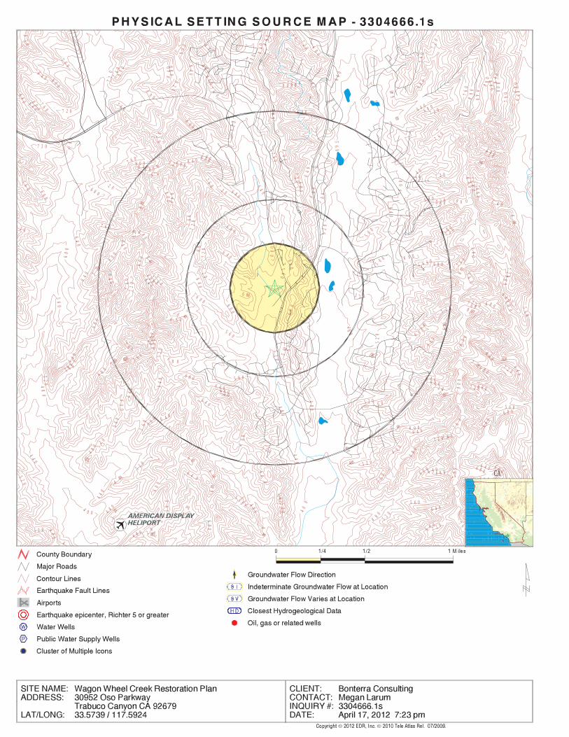
EDR Inc.EDR Inc.EDR Inc.EDR Inc.EDR Inc.EDR Inc.EDR Inc.EDR Inc.EDR Inc.EDR Inc.EDR Inc.EDR Inc.EDR Inc.EDR Inc.EDR Inc.EDR Inc.EDR Inc.EDR Inc.EDR Inc.EDR Inc.EDR Inc.EDR Inc.EDR Inc.EDR Inc.EDR Inc.EDR Inc.EDR Inc.EDR Inc.EDR Inc.EDR Inc.EDR Inc.EDR Inc.EDR Inc.EDR Inc.EDR Inc.EDR Inc.EDR Inc.EDR Inc.EDR Inc.EDR Inc.
92
0
92
0
92
08
80
84
0
92
0
0 840
9 20
9 2 0
88
0
8 8 08 8 0
88 0
0
88
0
80
0
8 0 0
880 6
40
920 8 8
0
72
0
60
0
840
80
0
800
72
084
0
6 00
8 4 0
8 0060
0
88
088
0
88
08
40
80
0
8 4 08
4 0
0
84
08 4 0
84
0
84
0
8 4 0
84
0
84
0
84
0
84
0
84
0
800
60
0
5607 2 0
80
0
7 607 2 06 8 0
6 8 0
520 6 80
60
0
76
0
680
520
560
80
0
8 0 0
80
0
8
0 0
8 0 0
80
0
80
0
80
0
80
0
80
0
8 0 0
8
0 0
80
0
80
0
80
0
8 0 0
80
0
80
0
7 6 0
7
40 0 4
00
44
40
44
04 4 0
440
44
0
44
0
48
0
48
0
48
0
480
4 8 0
48
0
48
0
48
0
48
0
480
4
8 0
5 2 0
52
0
52
0
5
2 0
5 2 0
5 20
520
52
0 52
0
5 2 0
52
0 52
0
52
0
5 2 0
52
0
5 2 0
5 2 0
5 2 0
52 0
56
0
5 6 0
56
0
56
0
56
0
5 60 5
605
60
5 6 0
5 6 0
56
05
60
5
60
56
0
5
6 0
5
6 0
5 6 0
5 60
5
60
5 6 0
5
6 0
56
0
5 6 0
56
0
60
0
6 00
60
0
6 0 06
00
60
06
00
6
00
6 0 0
6 00
60
0
6
00
60
0
600
60
0
6 0 0
6 0 0
6 0 0
6 00
6 0 0 6 0 0
6 0 0
600
60
06
00
64
0
64
0
64
0
64
0 64
0
6 4 0
6 4 0
6 4 0
6 4 0
6 40
64
0
6 4 0
64
06
40
64
0
640
6 4 0
6
4 0
6 4 0
6 40 640
6 4 0
6 4 0
6 4 0
6 4 06
4 0
6 4 0
64
0
64
0
64 0
6 40
6 4 0
64
0
68
0
68
0
6 8 0
68
0
6 8 0
68 0
6 8 0
68
0
6 8 0
6 8 0
68
0
6 8 0
68
0
6 8 0
6 8 0
6 8 0
6 8 0
6 8 0
6
80
6 8 0
68
0
6 8 0
6 8 0
6 8 0
6 8 0
6 8 0
6 8 0
6 8 0
68
0
68
0
6 8 0
68
0
2 0
7 2 0
7 2 07
20
7
2 0
720
72
0
720
72
0
72 0
72
0
7
2 0
72
0
72
0
7 2 0
72
0 72
0
7 2 0
7 2 0
7 2 0
7 2 0
7 2 0
7 2 0
7 2 0
7 2 0 7 2 0
7 2 0
7 20
7 2 0
72
0
72
0
7 2 0
76
0
76 0
7 60
76
0
7 6 0
7 6 0
7 6 0
76
0
7
6 0
7 6 0
76 0
76
0
76
0
7 6 0
76
0
76
0
7 6 0
60
76
0
76
0
7 6 0
7 6 0
76 0
76
0
7 6 0
7 6 0
76
07
60
76
0
CA
TC3304666.1s Page A-16
Not ReportedNot ReportedNot ReportedNot ReportedBasementNot ReportedNot ReportedNot ReportedNot ReportedLiving Area - 2nd Floor0%0%100%0.763 pCi/LLiving Area - 1st Floor
% >20 pCi/L% 4-20 pCi/L% <4 pCi/LAverage ActivityArea
Number of sites tested: 30
Federal Area Radon Information for ORANGE COUNTY, CA
: Zone 3 indoor average level < 2 pCi/L. : Zone 2 indoor average level >= 2 pCi/L and <= 4 pCi/L. Note: Zone 1 indoor average level > 4 pCi/L.
Federal EPA Radon Zone for ORANGE County: 3
010092679
______________________> 4 pCi/LNum TestsZipcode
Radon Test Results
State Database: CA Radon
AREA RADON INFORMATION
®GEOCHECK - PHYSICAL SETTING SOURCE MAP FINDINGSRADON
®

TOPOGRAPHIC INFORMATION
USGS 7.5’ Digital Elevation Model (DEM)Source: United States Geologic SurveyEDR acquired the USGS 7.5’ Digital Elevation Model in 2002 and updated it in 2006. The 7.5 minute DEM correspondsto the USGS 1:24,000- and 1:25,000-scale topographic quadrangle maps. The DEM provides elevation datawith consistent elevation units and projection.
Scanned Digital USGS 7.5’ Topographic Map (DRG)Source: United States Geologic SurveyA digital raster graphic (DRG) is a scanned image of a U.S. Geological Survey topographic map. The map imagesare made by scanning published paper maps on high-resolution scanners. The raster imageis georeferenced and fit to the Universal Transverse Mercator (UTM) projection.
HYDROLOGIC INFORMATION
Flood Zone Data: This data, available in select counties across the country, was obtained by EDR in 2003 & 2011 from the FederalEmergency Management Agency (FEMA). Data depicts 100-year and 500-year flood zones as defined by FEMA.
NWI: National Wetlands Inventory. This data, available in select counties across the country, was obtained by EDRin 2002 and 2005 from the U.S. Fish and Wildlife Service.
HYDROGEOLOGIC INFORMATION
AQUIFLOW Information SystemR
Source: EDR proprietary database of groundwater flow informationEDR has developed the AQUIFLOW Information System (AIS) to provide data on the general direction of groundwater
flow at specific points. EDR has reviewed reports submitted to regulatory authorities at select sites and hasextracted the date of the report, hydrogeologically determined groundwater flow direction and depth to water tableinformation.
GEOLOGIC INFORMATION
Geologic Age and Rock Stratigraphic UnitSource: P.G. Schruben, R.E. Arndt and W.J. Bawiec, Geology of the Conterminous U.S. at 1:2,500,000 Scale - A digitalrepresentation of the 1974 P.B. King and H.M. Beikman Map, USGS Digital Data Series DDS - 11 (1994).
STATSGO: State Soil Geographic DatabaseSource: Department of Agriculture, Natural Resources Conservation ServicesThe U.S. Department of Agriculture’s (USDA) Natural Resources Conservation Service (NRCS) leads the nationalConservation Soil Survey (NCSS) and is responsible for collecting, storing, maintaining and distributing soilsurvey information for privately owned lands in the United States. A soil map in a soil survey is a representationof soil patterns in a landscape. Soil maps for STATSGO are compiled by generalizing more detailed (SSURGO)soil survey maps.
SSURGO: Soil Survey Geographic DatabaseSource: Department of Agriculture, Natural Resources Conservation Services (NRCS)Telephone: 800-672-5559SSURGO is the most detailed level of mapping done by the Natural Resources Conservation Services, mappingscales generally range from 1:12,000 to 1:63,360. Field mapping methods using national standards are used toconstruct the soil maps in the Soil Survey Geographic (SSURGO) database. SSURGO digitizing duplicates theoriginal soil survey maps. This level of mapping is designed for use by landowners, townships and countynatural resource planning and management.
TC3304666.1s Page A-17
PHYSICAL SETTING SOURCE RECORDS SEARCHED

LOCAL / REGIONAL WATER AGENCY RECORDS
FEDERAL WATER WELLS
PWS: Public Water SystemsSource: EPA/Office of Drinking WaterTelephone: 202-564-3750Public Water System data from the Federal Reporting Data System. A PWS is any water system which provides water to at
least 25 people for at least 60 days annually. PWSs provide water from wells, rivers and other sources.
PWS ENF: Public Water Systems Violation and Enforcement DataSource: EPA/Office of Drinking WaterTelephone: 202-564-3750Violation and Enforcement data for Public Water Systems from the Safe Drinking Water Information System (SDWIS) after
August 1995. Prior to August 1995, the data came from the Federal Reporting Data System (FRDS).
USGS Water Wells: USGS National Water Inventory System (NWIS)This database contains descriptive information on sites where the USGS collects or has collected data on surfacewater and/or groundwater. The groundwater data includes information on wells, springs, and other sources of groundwater.
STATE RECORDS
Water Well DatabaseSource: Department of Water ResourcesTelephone: 916-651-9648
California Drinking Water Quality DatabaseSource: Department of Health ServicesTelephone: 916-324-2319The database includes all drinking water compliance and special studies monitoring for the state of California
since 1984. It consists of over 3,200,000 individual analyses along with well and water system information.
OTHER STATE DATABASE INFORMATION
California Oil and Gas Well LocationsSource: Department of ConservationTelephone: 916-323-1779Oil and Gas well locations in the state.
RADON
State Database: CA RadonSource: Department of Health ServicesTelephone: 916-324-2208Radon Database for California
Area Radon InformationSource: USGSTelephone: 703-356-4020The National Radon Database has been developed by the U.S. Environmental Protection Agency(USEPA) and is a compilation of the EPA/State Residential Radon Survey and the National Residential Radon Survey.The study covers the years 1986 - 1992. Where necessary data has been supplemented by information collected atprivate sources such as universities and research institutions.
EPA Radon ZonesSource: EPATelephone: 703-356-4020Sections 307 & 309 of IRAA directed EPA to list and identify areas of U.S. with the potential for elevated indoorradon levels.
TC3304666.1s Page A-18
PHYSICAL SETTING SOURCE RECORDS SEARCHED

OTHER
Airport Landing Facilities: Private and public use landing facilitiesSource: Federal Aviation Administration, 800-457-6656
Epicenters: World earthquake epicenters, Richter 5 or greaterSource: Department of Commerce, National Oceanic and Atmospheric Administration
California Earthquake Fault Lines: The fault lines displayed on EDR’s Topographic map are digitized quaternary fault lines,prepared in 1975 by the United State Geological Survey. Additional information (also from 1975) regarding activity at specific faultlines comes from California’s Preliminary Fault Activity Map prepared by the California Division of Mines and Geology.
STREET AND ADDRESS INFORMATION
© 2010 Tele Atlas North America, Inc. All rights reserved. This material is proprietary and the subject of copyright protectionand other intellectual property rights owned by or licensed to Tele Atlas North America, Inc. The use of this material is subjectto the terms of a license agreement. You will be held liable for any unauthorized copying or disclosure of this material.
TC3304666.1s Page A-19
PHYSICAL SETTING SOURCE RECORDS SEARCHED

ORPHAN SUMMARY
City EDR ID Site Name Site Address Zip Database(s)
Count: 27 records
COTO DE CAZA S103980527 PACIFIC BELL MOBILE SERVICES 23293 COTO DE CAZA DR 92679 HAZNETCOTO DE CAZA S111084234 SANTA MARGARITA WATER DISTRICT - COTO DE 24263 COTO DE CAZA 92679 HAZNET
CAZA LIFT STATIONCOTO DE CAZA S105093826 COTO DE CAZA CONSTRUCTION SITE SALINGER CT NEAR HAWTHORNE SALINGER COUR 92679 HAZNETCOTO DE CAZA S111293226 TENTATIVE TRACT MAP NO. 17325, COTO DE 0 VAN GOGH WAY & OAK CANYON 92679 Orange Co. Industrial Site
CAZA DEVELOPMENTLADERA RANCH S108750549 LUCAS & MERCIER CONSTRUCTION CORP LAT 3333.029N LONG 11738.115 W 92694 HAZNETLADERA S108750550 LUCAS & MERCIER CONSTRUCTION CORP LONG N 3332.347 LAT W 11734.9 92694 HAZNETNEWPORT BEACH S109461526 TRACT 16461 SE OF RIDGE ROUTE RD & WEST COASTAL PEAK 92694 NPDESORANGE COUNTY S107537591 AT DEAD END OF BLACK STAR CYN, T.G. 772 E6, UNINCORP AREA CDL
OFORANGE COUNTY M300003124 VULCAN MATERIALS CO. IRVINE LAKE (#014) MINESORANGE COUNTY S111292265 NORTH BASIN BARRIER PROJECT- WELL #1 2000’ NORTH OF N. STATE COLLEGE BLVD. & E. ORANGTHORPE NPDES
(EW-1) AVECOUNTY S106905435 EL MORRO CONVERSION TO CAMPGRO PACIFIC COAST HWY 0 WDSRANCHO SANTA MARGAR S106800940 SR-241 BRIDGE WIDENING DEWATER SR241 AT ARROYO TRABUCO CREEK 92688 WDSRANCHO SANTA MARGAR S109694124 SUKUT EQUIPMENT INC 21355 OSO PARKWAY 92688 NPDES, HAZNETSAN JUAN CAPISTRANO S109424632 CHINO VALLEY DISTRIBUTION INC NB I-5 S OF ORTEGA HWY 92675 HAZNETSAN JUAN CAPISTRANO S109456882 SADDLEBACK VALLEY CHRISTIAN CAMINO CAPISTRANO OSO RD 92675 NPDESSAN JUAN CAPISTRANO S110419512 MM DESHECHA ENERGY LLC 32250 LAPATA RD 92675 NPDES, CHMIRSSAN JUAN CAPISTRANO S109431249 SAN DIEGO GAS & ELECTRIC/CAPISTRANO SUB LONG 117.3.958.33W LAT 33.3044.9N 92675 HAZNET
STATSAN JUAN CAPISTRANO S103653287 COUNTY ORANGE/EMA 3301 ORETAGA HWY 92675 HAZNETSAN JUAN CAPISTRANO S105026328 BEACON SERVICE STATION 33977 ORTEGA HWY/LUC 92675 HIST CORTESESAN JUAN CAPISTRANO S108219579 SAN JUAN FIRE STATION 35-505 ORTEGA HIGHWAY 92675 HAZNETSAN JUAN CAPISTRANO S100926569 1X FORD MOTOR LAND DEVELOPMENT CO 3360 ORTIGA HIGHWAY 92675 HAZNETSAN JUAN CAPISTRANO S106447239 OSO ROAD CROSSING RESTORATION OSO ROAD AT TRABUCO CREEK 92675 WDSSAN JUAN CAPISTRANO S107144482 PACER CARTAGE I5 SB @ ORTEGA HWY 92675 HAZNETSANTA MARGARITA S109425798 DIST 12/CONSTR/EA12-0F1804 RTE 241 NB PM 18.5 92688 HAZNETTRABUCO CANYON S106203240 TCWD GOREN WTP LIVE OAK CANYON ROAD 0 WDSTRABUCO CANYON S111292980 TRABUCO CREEK ROAD RESURFACING AND TRABUCO CREEK ROAD 92679 NPDES
IMPROVEMENTSTRABUCO CYN U003785050 COTO DE CAZA LIFT STATION 24262 COTO DE CAZA 92679 UST
TC3304666.1s Page 1 of 1

DETAILED ORPHAN LISTING
EDR ID NumberEPA ID NumberDatabase(s)Site
OrangeFacility County: .0025Tons: H01Disposal Method: Other organic solidsWaste Category: Los AngelesTSD County: CAD008302903TSD EPA ID: OrangeGen County: PLEASANTON, CA 945880000Mailing City,St,Zip: 4420 ROSEWOOD DR BLDG 2 4TH FLMailing Address: Not reportedMailing Name: 0000000000Telephone: PAC BELL MOBIL SVCSContact: CAC001271696Gepaid: 1998Year:
HAZNET:
COTO DE CAZA, CA 9267923293 COTO DE CAZA DR N/A
HAZNETPACIFIC BELL MOBILE SERVICES S103980527
OrangeFacility County: 0.0252Tons: ORGANICS RECOVERY ECT OTHER RECOVERY OF RECLAMATION FOR REUSE INCLUDING ACID REGENERATION,Disposal Method: Aqueous solution with total organic residues less than 10 percentWaste Category: Not reportedTSD County: CAT080013352TSD EPA ID: Not reportedGen County: MISSION VIEJO, CA 926907005Mailing City,St,Zip: PO BOX 7005Mailing Address: Not reportedMailing Name: 9494596561Telephone: RISH KISSEEContact: CAL000352735Gepaid: 2010Year:
HAZNET:
COTO DE CAZA, CA 9267924263 COTO DE CAZA N/A
HAZNETSANTA MARGARITA WATER DISTRICT - COTO DE CAZA LIFT STATION S111084234
R01Disposal Method: Unspecified organic liquid mixtureWaste Category: Los AngelesTSD County: CAD008302903TSD EPA ID: OrangeGen County: COTO DE CAZA, CA 926790000Mailing City,St,Zip: Salinger Ct Near Hawthorne Salinger CourMailing Address: Not reportedMailing Name: 0000000000Telephone: COTO DE CAZA CONSTRUCTION SITEContact: CAP000065888Gepaid: 2000Year:
HAZNET:
COTO DE CAZA, CA 92679SALINGER CT NEAR HAWTHORNE SALINGER COUR N/A
HAZNETCOTO DE CAZA CONSTRUCTION SITE S105093826
ORPHAN DETAIL TC3304666.1s Page 1

DETAILED ORPHAN LISTING
EDR ID NumberEPA ID NumberDatabase(s)Site
OrangeFacility County: .0050Tons: H01Disposal Method: Other inorganic solid wasteWaste Category: Los AngelesTSD County: CAD008302903TSD EPA ID: OrangeGen County: COTO DE CAZA, CA 926790000Mailing City,St,Zip: Salinger Ct Near Hawthorne Salinger CourMailing Address: Not reportedMailing Name: 0000000000Telephone: COTO DE CAZA CONSTRUCTION SITEContact: CAP000065888Gepaid: 2000Year:
OrangeFacility County: .2085Tons: R01Disposal Method: etc) Halogenated solvents (chloroforms, methyl chloride, perchloroethylene,Waste Category: Los AngelesTSD County: CAD008302903TSD EPA ID: OrangeGen County: COTO DE CAZA, CA 926790000Mailing City,St,Zip: Salinger Ct Near Hawthorne Salinger CourMailing Address: Not reportedMailing Name: 0000000000Telephone: COTO DE CAZA CONSTRUCTION SITEContact: CAP000065888Gepaid: 2000Year:
OrangeFacility County: .0200Tons: H01Disposal Method: Alkaline solution without metals pH >= 12.5Waste Category: Los AngelesTSD County: CAD008302903TSD EPA ID: OrangeGen County: COTO DE CAZA, CA 926790000Mailing City,St,Zip: Salinger Ct Near Hawthorne Salinger CourMailing Address: Not reportedMailing Name: 0000000000Telephone: COTO DE CAZA CONSTRUCTION SITEContact: CAP000065888Gepaid: 2000Year:
OrangeFacility County: .1251Tons:
S105093826COTO DE CAZA CONSTRUCTION SITE (Continued)
RO0003566Record ID: ORANGERegion: 11IC014Case ID:
Orange Co. Industrial Site:
COTO DE CAZA, CA 926790 VAN GOGH WAY & OAK CANYON N/A
Orange Co. Industrial SiteTENTATIVE TRACT MAP NO. 17325, COTO DE CAZA DEVELOPMENT S111293226
ORPHAN DETAIL TC3304666.1s Page 2

DETAILED ORPHAN LISTING
EDR ID NumberEPA ID NumberDatabase(s)Site
Not reportedReleased Chemical: Not reportedClosure Type: OPENCurrent Status:
S111293226TENTATIVE TRACT MAP NO. 17325, COTO DE CAZA DEVELOPMENT (Continued)
OrangeFacility County: 1.6Tons: H14Disposal Method: Off-specification, aged or surplus organicsWaste Category: Los AngelesTSD County: CAD028409019TSD EPA ID: OrangeGen County: RCHO STA MARG, CA 92688Mailing City,St,Zip: 29712 AVENIDA DE LOS BANDERASMailing Address: Not reportedMailing Name: 9495894480Telephone: TONY CLEMENT/EQUIPMENT MGRContact: CAC002608986Gepaid: 2006Year:
HAZNET:
LADERA RANCH, CA 92694LAT 3333.029N LONG 11738.115 W N/A
HAZNETLUCAS & MERCIER CONSTRUCTION CORP S108750549
San MateoFacility County: 0.68Tons: H13Disposal Method: Aqueous solution with total organic residues less than 10 percentWaste Category: Los AngelesTSD County: CAD028409019TSD EPA ID: San MateoGen County: RCHO STA MARG, CA 926882606Mailing City,St,Zip: 29712 AVENIDA DE LAS BANDERAMailing Address: Not reportedMailing Name: 9495894480Telephone: TONY CLEMENT/EQUIPMENT MGRContact: CAC002608557Gepaid: 2006Year:
HAZNET:
LADERA, CA 92694LONG N 3332.347 LAT W 11734.9 N/A
HAZNETLUCAS & MERCIER CONSTRUCTION CORP S108750550
207898Regulatory Measure Id: 8Region: 0Agency Id: TerminatedFacility Status: CAS000002Npdes Number:
NPDES:
NEWPORT BEACH, CA 92694SE OF RIDGE ROUTE RD & WEST COASTAL PEAK N/A
NPDESTRACT 16461 S109461526
ORPHAN DETAIL TC3304666.1s Page 3

DETAILED ORPHAN LISTING
EDR ID NumberEPA ID NumberDatabase(s)Site
92127Discharge Zip: CaliforniaDischarge State: San DiegoDischarge City: 16745 W Bernardo Dr Ste 140Discharge Address: Taylor Woodrow Homes - IrvineDischarge Name: 02/23/2009Termination Date Of Regulatory Measure: Not reportedExpiration Date Of Regulatory Measure: 12/30/2003Effective Date Of Regulatory Measure: Not reportedAdoption Date Of Regulatory Measure: ConstructionProgram Type: 8 30C325323WDID: Not reportedPlace Id: EnrolleeRegulatory Measure Type: 2009-0009-DWQOrder No:
S109461526TRACT 16461 (Continued)
drug lab where drug lab waste and/or equipment were abandoned. Abandoned Drug Lab Waste (A) - location away from an actual illegalLab Type: 200209012Facility ID:
CDL:
ORANGE COUNTY, CA AT DEAD END OF BLACK STAR CYN, T.G. 772 E6, UNINCORP AREA OF N/A
CDL S107537591
The facility is both a mine and a plantSite Type: -117.6969Longitude: 33.7739Latitude: Sand and GravelCommodity: 3968Mine ID:
Ferrous and Nonferrous Metal Mines Database:
ORANGE COUNTY, CA IRVINE LAKE (#014) N/A
MINESVULCAN MATERIALS CO. M300003124
Bakersfield Well & Pump CoDischarge Name: 07/01/2009Termination Date Of Regulatory Measure: 11/01/2012Expiration Date Of Regulatory Measure: 03/24/2008Effective Date Of Regulatory Measure: Not reportedAdoption Date Of Regulatory Measure: NPDESProgram Type: 8 303556001WDID: 715600Place Id: EnrolleeRegulatory Measure Type: Not reportedOrder No: 343219Regulatory Measure Id: 8Region: 3929Agency Id: HistoricalFacility Status: CAG918002Npdes Number:
NPDES:
ORANGE COUNTY, CA 2000’ NORTH OF N. STATE COLLEGE BLVD. & E. ORANGTHORPE AVE N/A
NPDESNORTH BASIN BARRIER PROJECT- WELL #1 (EW-1) S111292265
ORPHAN DETAIL TC3304666.1s Page 4

DETAILED ORPHAN LISTING
EDR ID NumberEPA ID NumberDatabase(s)Site
93308Discharge Zip: CADischarge State: BakersfieldDischarge City: 7212 Fruitvale AvenueDischarge Address:
S111292265NORTH BASIN BARRIER PROJECT- WELL #1 (EW-1) (Continued)
dairy waste ponds. dischargers having waste storage systems with land disposal such as disposal systems, such as septic systems with subsurface disposal, or management practices, facilities with passive waste treatment and cooling water dischargers or thosewho must comply through best Category C - Facilities having no waste treatment systems, such asComplexity: 0Treat To Water: Not reportedPOTW: Not reportedReclamation: 0Baseline Flow: 0Design Flow: Not reportedSecondary Waste Type: Not reportedSecondary Waste: Not reportedPrimary Waste Type: Not reportedPrimary Waste: Not reportedSIC Code 2: 0SIC Code: StateAgency Type: 9494920802Agency Telephone: RICHARD ROZZELLEAgency Contact: SAN CLEMENTE 92672Agency City,St,Zip: 3030 AVENIDA DEL PRESIDENTEAgency Address: CA DEPT OF PARKS & RECAgency Name: Not reportedFacility Contact: Not reportedFacility Telephone: 9Subregion: Not reportedNPDES Number: under Waste Discharge Requirements. Active - Any facility with a continuous or seasonal discharge that isFacility Status: Industrial, Agricultural or Solid Waste (Class I, II or III) Other - Does not fall into the category of Municipal/Domestic,Facility Type: San Diego 000001293Facility ID:
CA WDS:
COUNTY, CA 0PACIFIC COAST HWY N/A
WDSEL MORRO CONVERSION TO CAMPGRO S106905435
9Subregion: are assigned by the Regional Board CAG919002 The 1st 2 characters designate the state. The remaining 7NPDES Number: under Waste Discharge Requirements. Active - Any facility with a continuous or seasonal discharge that isFacility Status: Industrial, Agricultural or Solid Waste (Class I, II or III) Other - Does not fall into the category of Municipal/Domestic,Facility Type: San Diego 000001142Facility ID:
CA WDS:
RANCHO SANTA MARGARITA, CA 92688SR241 AT ARROYO TRABUCO CREEK N/A
WDSSR-241 BRIDGE WIDENING DEWATER S106800940
ORPHAN DETAIL TC3304666.1s Page 5

DETAILED ORPHAN LISTING
EDR ID NumberEPA ID NumberDatabase(s)Site
leak detection systems or ground water monitoring wells. (particularly those with toxicwastes) with numerous discharge points, disposal site. Includes any small-volume complex facility discharge was made to surface or ground waters, or any Class I (particularly those with toxic wastes) that would be a major if Category A - Any major NPDES facility, any non-NPDES facilityComplexity: represent no threat to water quality. Level. A Zero (0) may be used to code those NURDS that are found to considered a minor threat to water quality unless coded at a higher to a major or minor threat. Not: All nurds without a TTWQ will be should cause a relatively minor impairment of beneficial uses compared Minor Threat to Water Quality. A violation of a regional board orderTreat To Water: Not reportedPOTW: Not reportedReclamation: 0Baseline Flow: 0Design Flow: Not reportedSecondary Waste Type: Not reportedSecondary Waste: inorganic salts and heavy metals) are included in this category. Hardness, TRF, Chloride). ’Manageable’ hazardous wastes (E.G., water quality because of their high concentrations (E.G., BOD, Designated/Influent or Solid Wastes that pose a significant threat toPrimary Waste Type: seepage and other wastes of this type) overflow, swimming pool wastes, water ride wastewater, ground water Miscellaneous (Includes wastes from dewatering, recreational lakePrimary Waste: Not reportedSIC Code 2: 1623SIC Code: PrivateAgency Type: 9497543400Agency Telephone: MACIE CLEARLY-MILANAgency Contact: IRVINE 92618Agency City,St,Zip: 125 PACIFICAAgency Address: TRANSPORTATION CORRIDOR AGENCYAgency Name: MICHAEL KENNEDYFacility Contact: 6194433891Facility Telephone:
S106800940SR-241 BRIDGE WIDENING DEWATER (Continued)
PO Box 7005Discharge Address: Santa Margarita Water DistrictDischarge Name: Not reportedTermination Date Of Regulatory Measure: Not reportedExpiration Date Of Regulatory Measure: 05/20/2009Effective Date Of Regulatory Measure: Not reportedAdoption Date Of Regulatory Measure: ConstructionProgram Type: 9 30C355408WDID: Not reportedPlace Id: EnrolleeRegulatory Measure Type: 2009-0009-DWQOrder No: 365523Regulatory Measure Id: 9Region: 0Agency Id: ActiveFacility Status: CAS000002Npdes Number:
NPDES:
RANCHO SANTA MARGARI, CA 92688HAZNET21355 OSO PARKWAY N/A
NPDESSUKUT EQUIPMENT INC S109694124
ORPHAN DETAIL TC3304666.1s Page 6

DETAILED ORPHAN LISTING
EDR ID NumberEPA ID NumberDatabase(s)Site
OrangeFacility County: 0.125Tons: (H010-H129) OR (H131-H135) STORAGE, BULKING, AND/OR TRANSFER OFF SITE--NO TREATMENT/REOVERYDisposal Method: Other organic solidsWaste Category: Not reportedTSD County: CAD981696420TSD EPA ID: Not reportedGen County: SANTA ANA, CA 927045202Mailing City,St,Zip: 4010 W CHANDLER AVEMailing Address: Not reportedMailing Name: 7143454459Telephone: JOEL SENDELContact: CAC002644079Gepaid: 2010Year:
HAZNET:
92690Discharge Zip: CaliforniaDischarge State: Mission ViejoDischarge City:
S109694124SUKUT EQUIPMENT INC (Continued)
OrangeFacility County: 0.3Tons: (H010-H129) OR (H131-H135) STORAGE, BULKING, AND/OR TRANSFER OFF SITE--NO TREATMENT/REOVERYDisposal Method: Unspecified oil-containing wasteWaste Category: Los AngelesTSD County: CAD028409019TSD EPA ID: OrangeGen County: CHINO, CA 917106931Mailing City,St,Zip: 14191 DURAZNO AVEMailing Address: Not reportedMailing Name: 9096064180Telephone: CURTIS VANDIESTContact: CAC002624206Gepaid: 2007Year:
HAZNET:
SAN JUAN CAPISTRANO, CA 92675NB I-5 S OF ORTEGA HWY N/A
HAZNETCHINO VALLEY DISTRIBUTION INC S109424632
Not reportedPlace Id: EnrolleeRegulatory Measure Type: 2009-0009-DWQOrder No: 214534Regulatory Measure Id: 9Region: 0Agency Id: TerminatedFacility Status: CAS000002Npdes Number:
NPDES:
SAN JUAN CAPISTRANO, CA 92675CAMINO CAPISTRANO OSO RD N/A
NPDESSADDLEBACK VALLEY CHRISTIAN S109456882
ORPHAN DETAIL TC3304666.1s Page 7

DETAILED ORPHAN LISTING
EDR ID NumberEPA ID NumberDatabase(s)Site
92675Discharge Zip: CaliforniaDischarge State: San Juan CapistranoDischarge City: 26333 Oso RdDischarge Address: Saddleback Valley Christian SchoolDischarge Name: 06/29/2010Termination Date Of Regulatory Measure: Not reportedExpiration Date Of Regulatory Measure: 02/01/2000Effective Date Of Regulatory Measure: Not reportedAdoption Date Of Regulatory Measure: ConstructionProgram Type: 9 30C312543WDID:
S109456882SADDLEBACK VALLEY CHRISTIAN (Continued)
Not reportedSpecial Studies 5: Not reportedSpecial Studies 4: Not reportedSpecial Studies 3: Not reportedSpecial Studies 2: Not reportedSpecial Studies 1: Not reportedProperty Management: Not reportedEstimated Temperature: Not reportedSurrounding Area: Not reportedTime Completed: Not reportedTime Notified: Not reportedAgency Incident Number: Not reportedAgency Id Number: Not reportedProperty Use: Not reportedDate Completed: Not reportedIncident Date: Not reportedOES Time: Not reportedOES Date: 4/12/2008 10:59:04 AMOES notification: ’08-2737OES Incident Number:
CHMIRS:
95661Discharge Zip: CaliforniaDischarge State: RosevilleDischarge City: 3005 Douglas Blvd Ste 105Discharge Address: MM Prima Deshecha Energy LLCDischarge Name: Not reportedTermination Date Of Regulatory Measure: Not reportedExpiration Date Of Regulatory Measure: 08/24/1999Effective Date Of Regulatory Measure: Not reportedAdoption Date Of Regulatory Measure: IndustrialProgram Type: 9 30I015350WDID: Not reportedPlace Id: EnrolleeRegulatory Measure Type: 97-03-DWQOrder No: 214880Regulatory Measure Id: 9Region: 0Agency Id: ActiveFacility Status: CAS000001Npdes Number:
NPDES:
SAN JUAN CAPISTRANO, CA 92675CHMIRS32250 LAPATA RD N/A NPDESMM DESHECHA ENERGY LLC S110419512
ORPHAN DETAIL TC3304666.1s Page 8

DETAILED ORPHAN LISTING
EDR ID NumberEPA ID NumberDatabase(s)Site
this time. The truck had readings of 14.5 at surface, 12.3 at one Prima Landfill, San Juan Capistrano scale. The vehicle is isolated at RP states that a CR&R trash truck caused a radiological alarm at theDescription: 0Number of Fatalities: 0Number of Injuries: 0Evacuations: Not reportedUnknown: Not reportedTons: Not reportedSheen: Not reportedQuarts: Not reportedPints: Not reportedOunces: Not reportedLiters: Not reportedPounds: Not reportedGrams: Not reportedGallons: Not reportedCUFT: Not reportedCups: Not reportedBBLS: 14.5 microQuantity Released: Radiological AlarmSubstance: Not reportedE Date: Not reportedSite Type: YesContained: Not reportedAmount: Orange County Emergency Managment DivAdmin Agency: 4/12/2008Incident Date: Prima Landfill San Juan CapistranoAgency: 2008Year: 1005Date/Time: Not reportedOther: UnknownMeasure: Not reportedType: Not reportedWhat Happened: Not reportedContainment: UnknownCleanup By: OtherSpill Site: Not reportedWaterway: NoWaterway Involved: Not reportedFacility Telephone: Not reportedComments: Not reportedReport Date: Not reportedReporting Officer Name/ID: Not reportedCompany Name: Not reportedCA/DOT/PUC/ICC Number: Not reportedVehicle Id Number: Not reportedVehicle State: Not reportedVehicle License Number: Not reportedVehicle Make/year: Not reportedOthers Number Of Fatalities: Not reportedOthers Number Of Injuries: Not reportedOthers Number Of Decontaminated: Not reportedResponding Agency Personel # Of Fatalities: Not reportedResponding Agency Personel # Of Injuries: Not reportedResp Agncy Personel # Of Decontaminated: Not reportedMore Than Two Substances Involved?: Not reportedSpecial Studies 6:
S110419512MM DESHECHA ENERGY LLC (Continued)
ORPHAN DETAIL TC3304666.1s Page 9

DETAILED ORPHAN LISTING
EDR ID NumberEPA ID NumberDatabase(s)Site
foot away and 10.4 at three foot away.
S110419512MM DESHECHA ENERGY LLC (Continued)
OrangeFacility County: 30.02Tons: 01Disposal Method: Polychlorinated biphenyls and material containing PCBsWaste Category: Not reportedTSD County: AZR000031823TSD EPA ID: OrangeGen County: SAN DIEGO, CA 921212602Mailing City,St,Zip: 6875 CONSOLIDATED WAY SD1373Mailing Address: Not reportedMailing Name: 8585415915Telephone: CHRIS CASTROContact: CAC002621919Gepaid: 2007Year:
HAZNET:
SAN JUAN CAPISTRANO, CA 92675LONG 117.3.958.33W LAT 33.3044.9N N/A
HAZNETSAN DIEGO GAS & ELECTRIC/CAPISTRANO SUB STAT S109431249
OrangeFacility County: .4795Tons: H01Disposal Method: Hydrocarbon solvents (benzene, hexane, Stoddard, Etc.)Waste Category: 99TSD County: AZD049318009TSD EPA ID: OrangeGen County: ANAHEIM, CA 928060000Mailing City,St,Zip: 10852 DOUGLASS RDMailing Address: Not reportedMailing Name: 0000000000Telephone: ORANGE COUNTYContact: CAC001110208Gepaid: 1996Year:
OrangeFacility County: .2710Tons: R01Disposal Method: Hydrocarbon solvents (benzene, hexane, Stoddard, Etc.)Waste Category: 99TSD County: AZD049318009TSD EPA ID: OrangeGen County: ANAHEIM, CA 928060000Mailing City,St,Zip: 10852 DOUGLASS RDMailing Address: Not reportedMailing Name: 0000000000Telephone: ORANGE COUNTYContact: CAC001110208Gepaid: 1996Year:
HAZNET:
SAN JUAN CAPISTRANO, CA 926753301 ORETAGA HWY N/A
HAZNETCOUNTY ORANGE/EMA S103653287
ORPHAN DETAIL TC3304666.1s Page 10

DETAILED ORPHAN LISTING
EDR ID NumberEPA ID NumberDatabase(s)Site
3043Reg Id: LTNKAReg By: 30Facility County Code: CORTESERegion:
CORTESE:
SAN JUAN CAPISTRANO, CA 9267533977 ORTEGA HWY/LUC N/A
HIST CORTESEBEACON SERVICE STATION S105026328
Not reportedFacility County: 0.1Tons: H01Disposal Method: Off-specification, aged or surplus organicsWaste Category: Los AngelesTSD County: CAD028409019TSD EPA ID: OrangeGen County: SAN DIEGO, CA 921272107Mailing City,St,Zip: 10845 RANCHO BERNARDO RD_STE 200Mailing Address: Not reportedMailing Name: 8586742990Telephone: NOELLE GRAHAM-WAKOSKI/ENVIRO.Contact: CAC002578006Gepaid: 2004Year:
HAZNET:
SAN JUAN CAPISTRANO, CA 9267535-505 ORTEGA HIGHWAY N/A
HAZNETSAN JUAN FIRE STATION S108219579
OrangeFacility County: .9174Tons: R01Disposal Method: Liquids with halogenated organic compounds >= 1,000 Mg./LWaste Category: Los AngelesTSD County: CAD008252405TSD EPA ID: OrangeGen County: DEARBORN, MI 841260000Mailing City,St,Zip: ONE PARKLANE BLVDMailing Address: Not reportedMailing Name: 0000000000Telephone: FORD MOTOR COMPANYContact: CAC000749384Gepaid: 1997Year:
HAZNET:
SAN JUAN CAPISTRANO, CA 926753360 ORTIGA HIGHWAY N/A
HAZNET1X FORD MOTOR LAND DEVELOPMENT CO S100926569
ORPHAN DETAIL TC3304666.1s Page 11

DETAILED ORPHAN LISTING
EDR ID NumberEPA ID NumberDatabase(s)Site
dairy waste ponds. dischargers having waste storage systems with land disposal such as disposal systems, such as septic systems with subsurface disposal, or management practices, facilities with passive waste treatment and cooling water dischargers or thosewho must comply through best Category C - Facilities having no waste treatment systems, such asComplexity: 0Treat To Water: The facility is not a POTW.POTW: No reclamation requirements associated with this facility.Reclamation: 0Baseline Flow: 0Design Flow: Not reportedSecondary Waste Type: Not reportedSecondary Waste: Not reportedPrimary Waste Type: Not reportedPrimary Waste: Not reportedSIC Code 2: 0SIC Code: PrivateAgency Type: 9494434050Agency Telephone: BRUCE HARBINAgency Contact: SAN JUAN CAPISTRANO 92675Agency City,St,Zip: 26333 OSO ROADAgency Address: SADDLEBACK VALLEY CHRISTIANAgency Name: BRUCE HARBINFacility Contact: 9494434050Facility Telephone: 9Subregion: Not reportedNPDES Number: under Waste Discharge Requirements. Active - Any facility with a continuous or seasonal discharge that isFacility Status: Industrial, Agricultural or Solid Waste (Class I, II or III) Other - Does not fall into the category of Municipal/Domestic,Facility Type: San Diego 000000991Facility ID:
CA WDS:
SAN JUAN CAPISTRANO, CA 92675OSO ROAD AT TRABUCO CREEK N/A
WDSOSO ROAD CROSSING RESTORATION S106447239
2003Year:
Not reportedFacility County: 1.25Tons: H01Disposal Method: Unspecified oil-containing wasteWaste Category: Los AngelesTSD County: CAD028409019TSD EPA ID: OrangeGen County: LOS ANGELES, CA 90040Mailing City,St,Zip: 5800 E SHEILAMailing Address: Not reportedMailing Name: 3237201771Telephone: NORM BLACKContact: CAC002580094Gepaid: 2004Year:
HAZNET:
SAN JUAN CAPISTRANO, CA 92675I5 SB @ ORTEGA HWY N/A
HAZNETPACER CARTAGE S107144482
ORPHAN DETAIL TC3304666.1s Page 12

DETAILED ORPHAN LISTING
EDR ID NumberEPA ID NumberDatabase(s)Site
OrangeFacility County: 33.71Tons: Not reportedDisposal Method: Asbestos containing wasteWaste Category: OrangeTSD County: AZC980823111TSD EPA ID: OrangeGen County: LOS ANGELES, CA 90040Mailing City,St,Zip: 5800 E SHEILAMailing Address: Not reportedMailing Name: 3237201771Telephone: NORM BLACKContact: CAC002580094Gepaid:
S107144482PACER CARTAGE (Continued)
San Luis ObispoFacility County: 10.11Tons: INCLUDE ON-SITE TREATMENT AND/OR STABILIZATION) LANDFILL OR SURFACE IMPOUNDMENT THAT WILL BE CLOSED AS LANDFILL( TODisposal Method: Other inorganic solid wasteWaste Category: Los AngelesTSD County: CAT080012933TSD EPA ID: San Luis ObispoGen County: TUSTIN, CA 92780Mailing City,St,Zip: 15700 TUSTIN VILLAGE WAY STE 1Mailing Address: Not reportedMailing Name: 9492798468Telephone: GHASSEM(GUS) ZIAEIANContact: CAC002617941Gepaid: 2007Year:
HAZNET:
SANTA MARGARITA, CA 92688RTE 241 NB PM 18.5 N/A
HAZNETDIST 12/CONSTR/EA12-0F1804 S109425798
Not reportedAgency Contact: 0Agency City,St,Zip: Not reportedAgency Address: SOCWA-RECYCLED WATER USEAgency Name: BRUCE GORENFacility Contact: 3104418411Facility Telephone: 9Subregion: Not reportedNPDES Number: under Waste Discharge Requirements. Active - Any facility with a continuous or seasonal discharge that isFacility Status: less than 1,000 gallons per day). systems (excluding individual subsurface leaching systems disposing of communities, hospitals, schools, and publicly or privately owned predominantly sewage and other waste from districts, municipalities, Municipal/Domestic - Facility that treats sewage or a mixture ofFacility Type: San Diego 000001059Facility ID:
CA WDS:
TRABUCO CANYON, CA 0LIVE OAK CANYON ROAD N/A
WDSTCWD GOREN WTP S106203240
ORPHAN DETAIL TC3304666.1s Page 13

DETAILED ORPHAN LISTING
EDR ID NumberEPA ID NumberDatabase(s)Site
leak detection systems or ground water monitoring wells. (particularly those with toxicwastes) with numerous discharge points, disposal site. Includes any small-volume complex facility discharge was made to surface or ground waters, or any Class I (particularly those with toxic wastes) that would be a major if Category A - Any major NPDES facility, any non-NPDES facilityComplexity: toxic substances. growth areas of aquatic resources, or directly expose the public to result in long-term deleterious effects on shell fish spawning or water supply, require closure of an area used for contact recreation, ground water or surface water resource used as a significant drink Major Threat to Water Quality. A violation could render unusable aTreat To Water: the regional board and/or EPA. may have local pretreatment programs that have not been approved by The POTW Does not have an approved pretreatment program. Some POTWsPOTW: producer of reclaimed water who also uses the product. Producer-User: Reclamation requirements that have been issued to aReclamation: 0Baseline Flow: 0Design Flow: Not reportedSecondary Waste Type: Not reportedSecondary Waste: inorganic salts and heavy metals) are included in this category. Hardness, TRF, Chloride). ’Manageable’ hazardous wastes (E.G., water quality because of their high concentrations (E.G., BOD, Designated/Influent or Solid Wastes that pose a significant threat toPrimary Waste Type: Domestic SewagePrimary Waste: Not reportedSIC Code 2: 4952SIC Code: sanitary districts, water districts irrigation districts, etc.) Special District (Includes districts established under general acts,Agency Type: Not reportedAgency Telephone:
S106203240TCWD GOREN WTP (Continued)
92701Discharge Zip: CaliforniaDischarge State: Santa AnaDischarge City: 1152 E Fruit StDischarge Address: County of Orange OCPW OC InspectionDischarge Name: Not reportedTermination Date Of Regulatory Measure: Not reportedExpiration Date Of Regulatory Measure: 09/21/2011Effective Date Of Regulatory Measure: Not reportedAdoption Date Of Regulatory Measure: ConstructionProgram Type: 9 30C362004WDID: Not reportedPlace Id: EnrolleeRegulatory Measure Type: 2009-0009-DWQOrder No: 420168Regulatory Measure Id: 9Region: 0Agency Id: ActiveFacility Status: CAS000002Npdes Number:
NPDES:
TRABUCO CANYON, CA 92679TRABUCO CREEK ROAD N/A
NPDESTRABUCO CREEK ROAD RESURFACING AND IMPROVEMENTS S111292980
ORPHAN DETAIL TC3304666.1s Page 14

DETAILED ORPHAN LISTING
EDR ID NumberEPA ID NumberDatabase(s)Site
-117.5731Longitude:33.63578Latitude:15020Facility ID:
UST:
TRABUCO CYN, CA 9267924262 COTO DE CAZA N/A
USTCOTO DE CAZA LIFT STATION U003785050
ORPHAN DETAIL TC3304666.1s Page 15

FORM-NULL-PVC
tropeR paM suidaR yrammuS RDE
440 Wheelers Farms RoadMilford, CT 06461Toll Free: 800.352.0050www.edrnet.com
Wagon Wheel Creek Restoration Plan30952 Oso ParkwayTrabuco Canyon, CA 92679
Inquiry Number: 3304666.1sApril 17, 2012

SECTION PAGE
Executive Summary ES1
Overview Map 2
Detail Map 3
Map Findings Summary 4
Map Findings 8
Orphan Summary 17
Government Records Searched/Data Currency Tracking GR-1
GEOCHECK ADDENDUM
Physical Setting Source Addendum A-1
Physical Setting Source Summary A-2
Physical Setting SSURGO Soil Map A-5
Physical Setting Source Map A-14
Physical Setting Source Map Findings A-16
Physical Setting Source Records Searched A-17
TC3304666.1s Page 1
Thank you for your business.Please contact EDR at 1-800-352-0050
with any questions or comments.
Disclaimer - Copyright and Trademark Notice
This Report contains certain information obtained from a variety of public and other sources reasonably available to Environmental DataResources, Inc. It cannot be concluded from this Report that coverage information for the target and surrounding properties does not exist fromother sources. NO WARRANTY EXPRESSED OR IMPLIED, IS MADE WHATSOEVER IN CONNECTION WITH THIS REPORT. ENVIRONMENTALDATA RESOURCES, INC. SPECIFICALLY DISCLAIMS THE MAKING OF ANY SUCH WARRANTIES, INCLUDING WITHOUT LIMITATION,MERCHANTABILITY OR FITNESS FOR A PARTICULAR USE OR PURPOSE. ALL RISK IS ASSUMED BY THE USER. IN NO EVENT SHALLENVIRONMENTAL DATA RESOURCES, INC. BE LIABLE TO ANYONE, WHETHER ARISING OUT OF ERRORS OR OMISSIONS, NEGLIGENCE,ACCIDENT OR ANY OTHER CAUSE, FOR ANY LOSS OF DAMAGE, INCLUDING, WITHOUT LIMITATION, SPECIAL, INCIDENTAL,CONSEQUENTIAL, OR EXEMPLARY DAMAGES. ANY LIABILITY ON THE PART OF ENVIRONMENTAL DATA RESOURCES, INC. IS STRICTLYLIMITED TO A REFUND OF THE AMOUNT PAID FOR THIS REPORT. Purchaser accepts this Report "AS IS". Any analyses, estimates, ratings,environmental risk levels or risk codes provided in this Report are provided for illustrative purposes only, and are not intended to provide, norshould they be interpreted as providing any facts regarding, or prediction or forecast of, any environmental risk for any property. Only a Phase IEnvironmental Site Assessment performed by an environmental professional can provide information regarding the environmental risk for anyproperty. Additionally, the information provided in this Report is not to be construed as legal advice.
Copyright 2012 by Environmental Data Resources, Inc. All rights reserved. Reproduction in any media or format, in wholeor in part, of any report or map of Environmental Data Resources, Inc., or its affiliates, is prohibited without prior written permission.
EDR and its logos (including Sanborn and Sanborn Map) are trademarks of Environmental Data Resources, Inc. or its affiliates. All othertrademarks used herein are the property of their respective owners.
TABLE OF CONTENTS

EXECUTIVE SUMMARY
TC3304666.1s EXECUTIVE SUMMARY 1
A search of available environmental records was conducted by Environmental Data Resources, Inc (EDR).The report was designed to assist parties seeking to meet the search requirements of EPA’s Standardsand Practices for All Appropriate Inquiries (40 CFR Part 312), the ASTM Standard Practice forEnvironmental Site Assessments (E 1527-05) or custom requirements developed for the evaluation ofenvironmental risk associated with a parcel of real estate.
TARGET PROPERTY INFORMATION
ADDRESS
30952 OSO PARKWAYTRABUCO CANYON, CA 92679
COORDINATES
33.5739000 - 33˚ 34’ 26.04’’Latitude (North): 117.5924000 - 117˚ 35’ 32.64’’Longitude (West): Zone 11Universal Tranverse Mercator: 445019.9UTM X (Meters): 3714876.5UTM Y (Meters): 543 ft. above sea levelElevation:
USGS TOPOGRAPHIC MAP ASSOCIATED WITH TARGET PROPERTY
TP Target Property:USGS 7.5 min quad indexSource:
AERIAL PHOTOGRAPHY IN THIS REPORT
2009, 2010Portions of Photo from:USDASource:

3304666.1s Page 2
13 PRUDENTIAL CALIFORNI 1 GINGHAM HAZNET Higher 4913, North
12 CASE RESIDENCE 6 FALCONRIDGE DR HAZNET Higher 4845, ESE
11 PRUDENTIAL CALIFORNI 24 KINGFISHER HAZNET Higher 4495, NNW
A10 25543 VISTA DEL VERD CHMIRS Higher 3957, ESE
A9 COTO DE CAZA-GOLF CO 25541 VISTA DEL VERD UST Higher 3927, ESE
A8 25541 VISTA DEL VERD AST Higher 3927, ESE
A7 COTA DE CAZA GOLF&RA 25541 VISTA DEL VERD HIST CORTESE, LUST, HAZNET Higher 3927, ESE
A6 COTO DE CAZA GOLF & 25541 VISTA DEL VERD HAZNET Higher 3927, ESE
5 PRUDENTAL CALIFORNIA 24 DARTMOUTH LN HAZNET Higher 3675, ENE
4 38 CARNOUSTIE WAY CHMIRS Higher 3584, NNE
3 WAGON WHEEL ELEMENTA 30912 BRIDLE PATH FINDS Higher 2883, North
2 27207 SOUTH BEND 27207 S BEND RD NPDES Lower 1093, South
1 COTO DE CAZA MAINT Y 1 COTO DE CAZA DR UST Higher 388, ENE
MAPPED SITES SUMMARY
Target Property Address:30952 OSO PARKWAYTRABUCO CANYON, CA 92679
Click on Map ID to see full detail.
MAP RELATIVE DIST (ft.)ID DATABASE ACRONYMS ELEVATION DIRECTIONSITE NAME ADDRESS

EXECUTIVE SUMMARY
TC3304666.1s EXECUTIVE SUMMARY 3
TARGET PROPERTY SEARCH RESULTS
The target property was not listed in any of the databases searched by EDR.
SURROUNDING SITES: SEARCH RESULTS
Surrounding sites were identified in the following databases.
Elevations have been determined from the USGS Digital Elevation Model and should be evaluated ona relative (not an absolute) basis. Relative elevation information between sites of close proximityshould be field verified. Sites with an elevation equal to or higher than the target property have beendifferentiated below from sites with an elevation lower than the target property.Page numbers and map identification numbers refer to the EDR Radius Map report where detaileddata on individual sites can be reviewed.
Sites listed in bold italics are in multiple databases.
Unmappable (orphan) sites are not considered in the foregoing analysis.
STANDARD ENVIRONMENTAL RECORDS
State and tribal leaking storage tank lists
LUST: A review of the LUST list, as provided by EDR, and dated 01/20/2012 has revealed that there is1 LUST site within approximately 1.5 miles of the target property.
PageMap IDDirection / Distance Address Equal/Higher Elevation ____________________ ________ ___________________ _____ _____
COTA DE CAZA GOLF&RA 25541 VISTA DEL VERD ESE 1/2 - 1 (0.744 mi.) A7 9
State and tribal registered storage tank lists
UST: A review of the UST list, as provided by EDR, and dated 01/20/2012 has revealed that there are 2UST sites within approximately 1.25 miles of the target property.
PageMap IDDirection / Distance Address Equal/Higher Elevation ____________________ ________ ___________________ _____ _____
COTO DE CAZA MAINT Y 1 COTO DE CAZA DR ENE 0 - 1/8 (0.073 mi.) 1 8 COTO DE CAZA-GOLF CO 25541 VISTA DEL VERD ESE 1/2 - 1 (0.744 mi.) A9 9
AST: A review of the AST list, as provided by EDR, and dated 08/01/2009 has revealed that there is 1AST site within approximately 1.25 miles of the target property.
PageMap IDDirection / Distance Address Equal/Higher Elevation ____________________ ________ ___________________ _____ _____
Not reported 25541 VISTA DEL VERD ESE 1/2 - 1 (0.744 mi.) A8 9

EXECUTIVE SUMMARY
TC3304666.1s EXECUTIVE SUMMARY 4
ADDITIONAL ENVIRONMENTAL RECORDS
Records of Emergency Release Reports
CHMIRS: A review of the CHMIRS list, as provided by EDR, and dated 12/31/2010 has revealed that thereare 2 CHMIRS sites within approximately 1 mile of the target property.
PageMap IDDirection / Distance Address Equal/Higher Elevation ____________________ ________ ___________________ _____ _____
Not reported 38 CARNOUSTIE WAY NNE 1/2 - 1 (0.679 mi.) 4 8 Not reported 25543 VISTA DEL VERD ESE 1/2 - 1 (0.749 mi.) A10 9
Other Ascertainable Records
FINDS: A review of the FINDS list, as provided by EDR, and dated 10/23/2011 has revealed that thereis 1 FINDS site within approximately 1 mile of the target property.
PageMap IDDirection / Distance Address Equal/Higher Elevation ____________________ ________ ___________________ _____ _____
WAGON WHEEL ELEMENTA 30912 BRIDLE PATH N 1/2 - 1 (0.546 mi.) 3 8
NPDES: A review of the NPDES list, as provided by EDR, and dated 02/20/2012 has revealed that thereis 1 NPDES site within approximately 1 mile of the target property.
PageMap IDDirection / Distance Address Lower Elevation ____________________ ________ ___________________ _____ _____
27207 SOUTH BEND 27207 S BEND RD S 1/8 - 1/4 (0.207 mi.) 2 8
HIST CORTESE: A review of the HIST CORTESE list, as provided by EDR, and dated 04/01/2001 hasrevealed that there is 1 HIST CORTESE site within approximately 1.5 miles of the target property.
PageMap IDDirection / Distance Address Equal/Higher Elevation ____________________ ________ ___________________ _____ _____
COTA DE CAZA GOLF&RA 25541 VISTA DEL VERD ESE 1/2 - 1 (0.744 mi.) A7 9
HAZNET: A review of the HAZNET list, as provided by EDR, and dated 12/31/2010 has revealed that thereare 6 HAZNET sites within approximately 1 mile of the target property.
PageMap IDDirection / Distance Address Equal/Higher Elevation ____________________ ________ ___________________ _____ _____
PRUDENTAL CALIFORNIA 24 DARTMOUTH LN ENE 1/2 - 1 (0.696 mi.) 5 8 COTO DE CAZA GOLF & 25541 VISTA DEL VERD ESE 1/2 - 1 (0.744 mi.) A6 8 COTA DE CAZA GOLF&RA 25541 VISTA DEL VERD ESE 1/2 - 1 (0.744 mi.) A7 9 PRUDENTIAL CALIFORNI 24 KINGFISHER NNW 1/2 - 1 (0.851 mi.) 11 9 CASE RESIDENCE 6 FALCONRIDGE DR ESE 1/2 - 1 (0.918 mi.) 12 9 PRUDENTIAL CALIFORNI 1 GINGHAM N 1/2 - 1 (0.930 mi.) 13 10

ED
R Inc.
ED
R Inc.
ED
R Inc.
ED
R Inc.
ED
R Inc.
ED
R Inc.
ED
R Inc.
ED
R Inc.
ED
R Inc.
ED
R Inc.
ED
R Inc.
ED
R Inc.
ED
R Inc.
ED
R Inc.
ED
R Inc.
ED
R Inc.
ED
R Inc.
ED
R Inc.
ED
R Inc.
ED
R Inc.
ED
R Inc.
ED
R Inc.
ED
R Inc.
ED
R Inc.
ED
R Inc.
ED
R Inc.
ED
R Inc.
ED
R Inc.
ED
R Inc.
ED
R Inc.
ED
R Inc.
ED
R Inc.
ED
R Inc.
ED
R Inc.
ED
R Inc.
ED
R Inc.
ED
R Inc.
ED
R Inc.
ED
R Inc.
ED
R Inc.
ORPHAN SUMMARY
City EDR ID Site Name Site Address Zip Database(s)
Count: 27 records.
COTO DE CAZA S103980527 PACIFIC BELL MOBILE SERVICES 23293 COTO DE CAZA DR 92679 HAZNETCOTO DE CAZA S111084234 SANTA MARGARITA WATER DISTRICT - C 24263 COTO DE CAZA 92679 HAZNETCOTO DE CAZA S105093826 COTO DE CAZA CONSTRUCTION SITE SALINGER CT 92679 HAZNETCOTO DE CAZA S111293226 TENTATIVE TRACT MAP NO. 17325, COT ZERO VAN GOGH WAY & OAK CYN 92679 Orange Co. Industrial SiteLADERA RANCH S108750549 LUCAS & MERCIER CONSTRUCTION CORP W LAT 3333029N LONG 11738115 92694 HAZNETLADERA RANCH S108750550 LUCAS & MERCIER CONSTRUCTION CORP LONG 3332347 N 92694 HAZNETNEWPORT BEACH S109461526 TRACT 16461 SE OF RIDGE ROUTE RD / WEST 92694 NPDESORANGE COUNTY S107537591 AT DEAD END OF BLACK STAR CYN, 0 CDLORANGE COUNTY M300003124 VULCAN MATERIALS CO. IRVINE LAKE (#014) MINESORANGE COUNTY S111292265 NORTH BASIN BARRIER PROJECT- WELL 2000’ NORTH OF N. STATE COLLEG NPDESORANGE COUNTY S106905435 EL MORRO CONVERSION TO CAMPGRO PACIFIC COAST HWY 0 WDSRANCHO SANTA MARGAR S106800940 SR-241 BRIDGE WIDENING DEWATER SR241 AT ARROYO TRABUCO CREEK 92688 WDSRANCHO SANTA MARGAR S109694124 UPPER CHIQUITA RESERVIOR 21355 OSO PKWY 92688 NPDES, HAZNETSAN JUAN CAPISTRANO S109424632 CHINO VALLEY DISTRIBUTION INC I 5 NBOFORTEGA HWY S 92675 HAZNETSAN JUAN CAPISTRANO S109456882 SADDLEBACK VALLEY CHRISTIAN CAMINO CAPISTRANO OSO RD 92675 NPDESSAN JUAN CAPISTRANO S110419512 32250 LAPATA RD 92675 NPDES, CHMIRSSAN JUAN CAPISTRANO S109431249 SAN DIEGO GAS & ELECTRIC/CAPISTRAN LONG 117395833W LAT 3330449N 92675 HAZNETSAN JUAN CAPISTRANO S103653287 COUNTY ORANGE/EMA 3301 ORETAGA HWY 92675 HAZNETSAN JUAN CAPISTRANO S105026328 BEACON SERVICE STATION 33977 ORTEGA HWY/LUC 92675 HIST CORTESESAN JUAN CAPISTRANO S108219579 SAN JUAN FIRE STATION 35 ORTEGA HWY 92675 HAZNETSAN JUAN CAPISTRANO S100926569 1X FORD MOTOR LAND DEVELOPMENT CO 3360 ORTIGA HWY 92675 HAZNETSAN JUAN CAPISTRANO S106447239 OSO ROAD CROSSING RESTORATION OSO ROAD AT TRABUCO CREEK 92675 WDSSAN JUAN CAPISTRANO S107144482 PACER CARTAGE I5 SB & ORTEGA HWY 92675 HAZNETSANTA MARGARITA S109425798 DIST 12/CONSTR/EA12-0F1804 RTE 241 NB PM 18.5 92688 HAZNETTRABUCO CANYON S106203240 TCWD GOREN WTP LIVE OAK CANYON ROAD 0 WDSTRABUCO CANYON S111292980 TRABUCO CREEK ROAD RESURFACING AND TRABUCO CREEK RD 92679 NPDESTRABUCO CYN U003785050 COTO DE CAZA LIFT STATION 24262 COTO DE CAZA DR 92679 UST
TC3304666.1s Page 17

EDR Inc.EDR Inc.EDR Inc.EDR Inc.EDR Inc.EDR Inc.EDR Inc.EDR Inc.EDR Inc.EDR Inc.EDR Inc.EDR Inc.EDR Inc.EDR Inc.EDR Inc.EDR Inc.EDR Inc.EDR Inc.EDR Inc.EDR Inc.EDR Inc.EDR Inc.EDR Inc.EDR Inc.EDR Inc.EDR Inc.EDR Inc.EDR Inc.EDR Inc.EDR Inc.EDR Inc.EDR Inc.EDR Inc.EDR Inc.EDR Inc.EDR Inc.EDR Inc.EDR Inc.EDR Inc.EDR Inc.
1
230 kV
230 kV
230 kV
230 kV
230 kV
230 kV
68
06
40
64
06
40
72
0
68
0
7206 8 0
64
0
64
0
6 4 0
8 4 08 0 0
7
6 0720
7
2 0
00
60
0
60
0
8 8 0
8
80
8 4 08 0 0
8 00
7 6 0
7 6 0
800
760
84
08
0 0
76
0
7 2 0
7 20
7 20
72
0
6 8 0
8 0
6 8 0
68
0
6 8 0
680
6 4 0
0
6 4 0
6 4 0
6 8 0
6 4 0
60
0
00
6 0 0
6 0 0
6 0 0
6 0 0
60
0 6 00
440 48
0
40
6 40
48
0
52
0
5
60
6
56
05
60
6 0
5 6 0
5
6 0
0
20
0
1 040
20
201
1 0 001 0 00
8 00 920
920960
600
6
64
0
88
0
9201040
6 40
1 2 8 01
000
1 2 40
96
0 9 6 0
96
0
9
60
960
1
96
0
92
0
9 6 0
6
80
68
0
92
0 9
2 0
9
20
9 2 0
920
92
0
9 2 0
6
8
0
7 2 0
72 0
7 20
920
92
0
92
0
92
0
92
08
80
880
8 80
8 8 0
88
0
840
7
2 0
880
9
2 0
64
0
0
6
8 0
88
0
88 0
8 8 0
88
0
8 8 0
8
80
880
88
0
88
0
8 8 0
8 80
80
0
20
0
7 2 0
72
0
11
60
1
8 0 07 60
7 6 0
7 60
7 6 0
7 6 0
7 60
11
20
1 120
1
12
0
8 0 0
8 0 0
8 00
8 0 0
80
08
0 0
08
0
10
80
1 0
1 0 8 0
1
10
640
10
40
10
40
1 0 40
1
0
10
10 4
10
00
1 0 001
0
0 0
1 000
1
88
0
8
8 0
76
08
00 7
20
600
96
0
9 6 0
96
0
960
960
840
880
8 4 0
8 4 0
84
0
8
40
8 0 0
72084
0
92
0
92
0
920
92
0
9
840
60
0
880
88
08
80
88 0
88
0
88
0
8 8 08
80
880
8 8 0
8
88
0
6
00
8
80
8
4 0 800
76
08
00
8 4 0
8 4 0
8 4 08 4 0
84 0
8 4 0
84
0
840
84
0
8 40
8 4 0
8 4 0
840
840
84
0
8 4 0
8 40
84
0
84
0
84
0
8 40
8 40
8 40
8
4 0
84
0
84
0
84
0
8
40
40
84
08
4 0 8
8
84
0
8 4 0
84
0
84
0
60
0 5608 4
0
72
0
80
0
7 20
6 80
6 80
800
920 8 00
920 88
0
84
0
6
80
7
20
600 7
60
840
680
7 20
84
0
8408
00
80 0
8
0 0
8 0 0
8 0 0
80
0
80
0
8 0 0
80
0
80
08
00
8 0 0
80 0
8 00
8
00
80
0
8 0 0
80
08
00
8 0 0
800
80
0
80
0
80
0
8 0 0
8
0 0
8 00
80
08
0 0
80
0
80
0
80
0
80
0
80
0
80
08 0 0
80 0
8
0 0
8 0 0
8 00
80
0
600
8 005 20
7 60
7 6 0600
800
76
0
76
0
76
0
7 6 0
00
48
0
32
0
32
0
60
3 6 0
3 6 0
3 6 0
4 0 0
4
0 0
4 0 0
4 00
4
00 4 0 0
4
0 0
40
04
00
40
0
4
00
4
4 4 0
44
0
44
04 4 0
440
44 0 4 4
0
4 4 0
4 4 0
44
0
44
0
44 0
44
0
44
0
4 4 0
44
0
44
0
44
0
4 80
4
8 04
80
4
80
4 8 0
4 8 0
4 8 0
48
0
4 80
80 0
4 8 0
4 8 0
48
0
48
0
48
0
480
48
0
4 8 0
48
04
8 0
4
8 0
48
0
48
0
48
0
48
0
48
0
55
20
52
0
520
52
0
5
20
5
20
5 20 5
20
520
5 2 0
20
52
0
5 2 0
52
0
52
0
52
05
20
52
0
52
0
5 20
5 2 0
5 2 0
5 2 0
5 2 0
52
0
5 2 0
5 2 0
0
52
0
52
0
5 2 0
52
0
52
0
5 2 0
52
0
56
0
56
0
5 60
5 60
5 6 0
56
0
5 6 0
56
0
56
0
56
0
5 6 0
56
0
56
0
56
05
6 0
5 6 0
560 5
60
5 6 0
5 6 0
56
05
60
56
0
56
0
56
0
560
5 6 0
5 6 0
5 60
5 6 0
5 6 0
5 6 0
5 6 0
5 6 0
560
56 0
5 6 0
56
0
5 6 0
56
0
56
0
560
56
0
56
05
6 0
6 0 0
60
0
600
6 0 0
6 0 0
60
0
6
00
60
0
60
0
600
60
0
6 00
60
0
60
0
60
0
60
0
60
0
60
0
60
0
6 0 0
60
0
600
6 00
6 0 0
6 0 0
6 0 0
6
00
6 0 0
6 0 0
6 0 0
6 0 0
6 0 0
6 0 0
600
6
0 0
60
06
00
60
0
60
0
60
0
60
0
6
0 0
60
0
6
40
64
0
6
4 0
64 0
6
4 0
6 4 0
640
64
0
64
0
64
0
640
640
6 40
6 4 0
6 4 0
6 40
64
0
64 0
64
06
40
64
0
64
0
64
0
6 4 0
64 0
6
4 0
640
640
6 4 0
6 4 0
6 40
6 4 0
6 4 0
6 4 0
6 40
64
0
640
6 40
6 4 0
64
0
6 4 0
6
4 0
64 0
64
0
64
0
64
0
6
4 0
6 4 0
64
0
64
0
6 40
64
68
0
68
0
68
0
680
6 80
6
8 0
6 80
6 8 0
680
6 80
6
80
68
0
680
68
0
6
8 0
6 8 06 8 0
6 80
68
0
68
0
68
0
6 8 0
6
8 0
6 8 0
6 8 0
6 8 0
6 80
6 80
6 8 0
68
0
6
80
6 8 0
6 8 0
6 8 0
68
0
68
0
6 80
6 8 0
6 8 0
68
0
6 8 0
6 8 0
68
06
80
6 8 0
68
0
68
0
6 8 0
6 80
6 8 06
80
68
0
6 80 6
80
68
0
6
72
0
72
0
72
07
20
72
0
7 20
72
0
7 20
72
0
72
0
7
2 0
72
0
72
0
7
2 0
72
0
7 20
72
0
7
2 0
72
0
72
0
7 2 0
72
0
7
2 0
7 2 0
72
0
720
7 2 0
7 2 0
7 2 0
7 2 0
7 2 0
7 2 0
7 2 0
7 20
7 2 07 2 0
0
720
7 2 0
7 2 0
7
2 0
720
7 2 0
72
0
72
0
72
07
20
72
07
20
720
7 2 0
7
20
7 2 0
720
72
0
72
0 72
7
76
0
76
0
76
07
6 0
7
6 0
760
76
07
6 0
7 60
7 6 0 76
0
7 60
760
7 60
76
0
760
7 6 0
76 0
76
0
76
0
7 6 0
7
6 0
76
0
7 6 0
7 60
7 60
7 6 0
7 6 0
7
6 0
76
0
76
0
7
6 0
7 6 0
76
0
7
6 0
76
0
7 6 0
7 60
76
0
76
0
76 0 7
60
76
07
60
7 6 0
7
6 0
76
0
7 6 0
760
76
0
7

EDR Inc.EDR Inc.EDR Inc.EDR Inc.EDR Inc.EDR Inc.EDR Inc.EDR Inc.EDR Inc.EDR Inc.EDR Inc.EDR Inc.EDR Inc.EDR Inc.EDR Inc.EDR Inc.EDR Inc.EDR Inc.EDR Inc.EDR Inc.EDR Inc.EDR Inc.EDR Inc.EDR Inc.EDR Inc.EDR Inc.EDR Inc.EDR Inc.EDR Inc.EDR Inc.EDR Inc.EDR Inc.EDR Inc.EDR Inc.EDR Inc.EDR Inc.EDR Inc.EDR Inc.EDR Inc.EDR Inc.
600
600
640
600
520
560
560
600
600
600

EDR Inc.EDR Inc.EDR Inc.EDR Inc.EDR Inc.EDR Inc.EDR Inc.EDR Inc.EDR Inc.EDR Inc.EDR Inc.EDR Inc.EDR Inc.EDR Inc.EDR Inc.EDR Inc.EDR Inc.EDR Inc.EDR Inc.EDR Inc.EDR Inc.EDR Inc.EDR Inc.EDR Inc.EDR Inc.EDR Inc.EDR Inc.EDR Inc.EDR Inc.EDR Inc.EDR Inc.EDR Inc.EDR Inc.EDR Inc.EDR Inc.EDR Inc.EDR Inc.EDR Inc.EDR Inc.EDR Inc.
MAP FINDINGS SUMMARY
SearchTargetDistance Total
Database Property(Miles) < 1/8 1/8 - 1/4 1/4 - 1/2 1/2 - 1 > 1 Plotted
STANDARD ENVIRONMENTAL RECORDS
Federal NPL site list
0 0 0 0 0 0 2.000NPL 0 0 0 0 0 0 2.000Proposed NPL 0 NR 0 0 0 0 1.000NPL LIENS
Federal Delisted NPL site list
0 0 0 0 0 0 2.000Delisted NPL
Federal CERCLIS list
0 0 0 0 0 0 1.500CERCLIS 0 0 0 0 0 0 2.000FEDERAL FACILITY
Federal CERCLIS NFRAP site List
0 0 0 0 0 0 1.500CERC-NFRAP
Federal RCRA CORRACTS facilities list
0 0 0 0 0 0 2.000CORRACTS
Federal RCRA non-CORRACTS TSD facilities list
0 0 0 0 0 0 1.500RCRA-TSDF
Federal RCRA generators list
0 0 0 0 0 0 1.250RCRA-LQG 0 0 0 0 0 0 1.250RCRA-SQG 0 0 0 0 0 0 1.250RCRA-CESQG
Federal institutional controls /engineering controls registries
0 0 0 0 0 0 1.500US ENG CONTROLS 0 0 0 0 0 0 1.500US INST CONTROL
Federal ERNS list
0 NR 0 0 0 0 1.000ERNS
State- and tribal - equivalent NPL
0 0 0 0 0 0 2.000RESPONSE
State- and tribal - equivalent CERCLIS
0 0 0 0 0 0 2.000ENVIROSTOR
State and tribal landfill and/orsolid waste disposal site lists
0 0 0 0 0 0 1.500SWF/LF
State and tribal leaking storage tank lists
1 0 1 0 0 0 1.500LUST 0 0 0 0 0 0 1.500SLIC
TC3304666.1s Page 4

MAP FINDINGS SUMMARY
SearchTargetDistance Total
Database Property(Miles) < 1/8 1/8 - 1/4 1/4 - 1/2 1/2 - 1 > 1 Plotted
0 0 0 0 0 0 1.500INDIAN LUST
State and tribal registered storage tank lists
2 0 1 0 0 1 1.250UST 1 0 1 0 0 0 1.250AST 0 0 0 0 0 0 1.250INDIAN UST 0 0 0 0 0 0 1.250FEMA UST
State and tribal voluntary cleanup sites
0 0 0 0 0 0 1.500VCP 0 0 0 0 0 0 1.500INDIAN VCP
ADDITIONAL ENVIRONMENTAL RECORDS
Local Brownfield lists
0 0 0 0 0 0 1.500US BROWNFIELDS
Local Lists of Landfill / SolidWaste Disposal Sites
0 0 0 0 0 0 1.500DEBRIS REGION 9 0 0 0 0 0 0 1.500ODI 0 0 0 0 0 0 1.500WMUDS/SWAT 0 0 0 0 0 0 1.500SWRCY 0 NR 0 0 0 0 1.000HAULERS 0 0 0 0 0 0 1.500INDIAN ODI
Local Lists of Hazardous waste /Contaminated Sites
0 NR 0 0 0 0 1.000US CDL 0 0 0 0 0 0 2.000HIST Cal-Sites 0 0 0 0 0 0 1.250SCH 0 0 0 0 0 0 2.000Toxic Pits 0 NR 0 0 0 0 1.000CDL 0 NR 0 0 0 0 1.000US HIST CDL
Local Lists of Registered Storage Tanks
0 0 0 0 0 0 1.250CA FID UST 0 0 0 0 0 0 1.250HIST UST 0 0 0 0 0 0 1.250SWEEPS UST
Local Land Records
0 NR 0 0 0 0 1.000LIENS 2 0 0 0 0 0 0 1.500LUCIS 0 NR 0 0 0 0 1.000LIENS 0 0 0 0 0 0 1.500DEED
Records of Emergency Release Reports
0 NR 0 0 0 0 1.000HMIRS 2 NR 2 0 0 0 1.000CHMIRS 0 NR 0 0 0 0 1.000LDS
TC3304666.1s Page 5

MAP FINDINGS SUMMARY
SearchTargetDistance Total
Database Property(Miles) < 1/8 1/8 - 1/4 1/4 - 1/2 1/2 - 1 > 1 Plotted
0 NR 0 0 0 0 1.000MCS 0 NR 0 0 0 0 1.000Orange Co. Industrial Site
Other Ascertainable Records
0 0 0 0 0 0 1.250RCRA-NonGen 0 NR 0 0 0 0 1.000DOT OPS 0 0 0 0 0 0 2.000DOD 0 0 0 0 0 0 2.000FUDS 0 0 0 0 0 0 2.000CONSENT 0 0 0 0 0 0 2.000ROD 0 0 0 0 0 0 1.500UMTRA 0 0 0 0 0 0 1.250MINES 0 NR 0 0 0 0 1.000TRIS 0 NR 0 0 0 0 1.000TSCA 0 NR 0 0 0 0 1.000FTTS 0 NR 0 0 0 0 1.000HIST FTTS 0 NR 0 0 0 0 1.000SSTS 0 NR 0 0 0 0 1.000ICIS 0 NR 0 0 0 0 1.000PADS 0 NR 0 0 0 0 1.000MLTS 0 NR 0 0 0 0 1.000RADINFO 1 NR 1 0 0 0 1.000FINDS 0 NR 0 0 0 0 1.000RAATS 0 0 0 0 0 0 2.000CA BOND EXP. PLAN 1 NR 0 0 1 0 1.000NPDES 0 NR 0 0 0 0 1.000WDS 0 0 0 0 0 0 1.500Cortese 1 0 1 0 0 0 1.500HIST CORTESE 0 0 0 0 0 0 2.000Notify 65 0 0 0 0 0 0 1.250DRYCLEANERS 0 0 0 0 0 0 1.250WIP 0 NR 0 0 0 0 1.000ENF 6 NR 6 0 0 0 1.000HAZNET 0 NR 0 0 0 0 1.000EMI 0 0 0 0 0 0 2.000INDIAN RESERV 0 0 0 0 0 0 1.500SCRD DRYCLEANERS 0 0 0 0 0 0 1.500COAL ASH EPA 0 0 0 0 0 0 1.500PROC 0 0 0 0 0 0 1.250HWT 0 0 0 0 0 0 2.000HWP 0 NR 0 0 0 0 1.000COAL ASH DOE 0 NR 0 0 0 0 1.000PCB TRANSFORMER 0 NR 0 0 0 0 1.000FINANCIAL ASSURANCE 0 0 0 0 0 0 1.250MWMP
EDR PROPRIETARY RECORDS
EDR Proprietary Records
0 0 0 0 0 0 2.000Manufactured Gas Plants 0 0 0 0 0 0 1.250EDR Historical Auto Stations
TC3304666.1s Page 6

MAP FINDINGS SUMMARY
SearchTargetDistance Total
Database Property(Miles) < 1/8 1/8 - 1/4 1/4 - 1/2 1/2 - 1 > 1 Plotted
0 0 0 0 0 0 1.250EDR Historical Cleaners
NOTES:
TP = Target Property
NR = Not Requested at this Search Distance
Sites may be listed in more than one database
TC3304666.1s Page 7

TC3304666.1s Page 8
A6 HAZNETCOTO DE CAZA GOLF & RACQUET CLUB S108203772ESE 25541 VISTA DEL VERDE N/A1/2-1 COTO DE CAZA, CA 92679
Relative:Higher
Click here for full text details
0.744 mi.3927 ft.
5 HAZNETPRUDENTAL CALIFORNIA REALTY S106085500ENE 24 DARTMOUTH LN N/A1/2-1 COTO DE CAZA, CA 92679
Relative:Higher
Click here for full text details
0.696 mi.3675 ft.
4 CHMIRS S105671244NNE 38 CARNOUSTIE WAY N/A1/2-1 TRABUCO CANYON, CA 92679
Relative:Higher
Click here for full text details
0.679 mi.3584 ft.
3 FINDSWAGON WHEEL ELEMENTARY 1008273361North 30912 BRIDLE PATH N/A1/2-1 COTO DE CAZA, CA 92679
Relative:Higher
Click here for full text details
0.546 mi.2883 ft.
2 NPDES27207 SOUTH BEND S109434467South 27207 S BEND RD N/A1/8-1/4 COTO DE CAZA, CA 92679
Relative:Lower
Click here for full text details
0.207 mi.1093 ft.
NPDES Facility Status: Terminated
1 USTCOTO DE CAZA MAINT YARD U003778721ENE 1 COTO DE CAZA DR N/A< 1/8 TRABUCO CANYON, CA 92679
Relative:Higher
Click here for full text details
0.073 mi.388 ft.
MAP FINDINGSMap IDDirection
EDR ID NumberDistanceEPA ID NumberDatabase(s)SiteElevation

TC3304666.1s Page 9
12 HAZNETCASE RESIDENCE S108744204ESE 6 FALCONRIDGE DR N/A1/2-1 COTO DE CAZA, CA 92679
Relative:Higher
Click here for full text details
0.918 mi.4845 ft.
11 HAZNETPRUDENTIAL CALIFORNIA REALTY S104566369NNW 24 KINGFISHER N/A1/2-1 TRABUCO CANYON, CA 92679
Relative:Higher
Click here for full text details
0.851 mi.4495 ft.
A10 CHMIRS S108404598ESE 25543 VISTA DEL VERDE N/A1/2-1 COTO DE CAZA, CA 91679
Relative:Higher
Click here for full text details
0.749 mi.3957 ft.
A9 USTCOTO DE CAZA-GOLF COURSE U003778689ESE 25541 VISTA DEL VERDE N/A1/2-1 TRABUCO CANYON, CA 92679
Relative:Higher
Click here for full text details
0.744 mi.3927 ft.
A8 AST A100323501ESE 25541 VISTA DEL VERDE N/A1/2-1 COTO DE CAZA, CA 92679
Relative:Higher
Click here for full text details
0.744 mi.3927 ft.
A7 HIST CORTESECOTA DE CAZA GOLF&RACQUET S103723419ESE LUST25541 VISTA DEL VERDE N/A1/2-1 HAZNETCOTO DE CAZA, CA 92679
Relative:Higher
Click here for full text details
0.744 mi.3927 ft.
LUST Status: Case Closed
MAP FINDINGSMap IDDirection
EDR ID NumberDistanceEPA ID NumberDatabase(s)SiteElevation

TC3304666.1s Page 10
13 HAZNETPRUDENTIAL CALIFORNIA REALTY S106089140North 1 GINGHAM N/A1/2-1 TRABUCO CANYON, CA 92679
Relative:Higher
Click here for full text details
0.930 mi.4913 ft.
MAP FINDINGSMap IDDirection
EDR ID NumberDistanceEPA ID NumberDatabase(s)SiteElevation

ED
R Inc.
ED
R Inc.
ED
R Inc.
ED
R Inc.
ED
R Inc.
ED
R Inc.
ED
R Inc.
ED
R Inc.
ED
R Inc.
ED
R Inc.
ED
R Inc.
ED
R Inc.
ED
R Inc.
ED
R Inc.
ED
R Inc.
ED
R Inc.
ED
R Inc.
ED
R Inc.
ED
R Inc.
ED
R Inc.
ED
R Inc.
ED
R Inc.
ED
R Inc.
ED
R Inc.
ED
R Inc.
ED
R Inc.
ED
R Inc.
ED
R Inc.
ED
R Inc.
ED
R Inc.
ED
R Inc.
ED
R Inc.
ED
R Inc.
ED
R Inc.
ED
R Inc.
ED
R Inc.
ED
R Inc.
ED
R Inc.
ED
R Inc.
ED
R Inc.
ED
R Inc.
ED
R Inc.
ED
R Inc.
ED
R Inc.
ED
R Inc.
ED
R Inc.
ED
R Inc.
ED
R Inc.
ED
R Inc.
ED
R Inc.
ED
R Inc.
ED
R Inc.
ED
R Inc.
ED
R Inc.
ED
R Inc.
ED
R Inc.
ED
R Inc.
ED
R Inc.
ED
R Inc.
ED
R Inc.
ED
R Inc.
ED
R Inc.
ED
R Inc.
ED
R Inc.
ED
R Inc.
ED
R Inc.
ED
R Inc.
ED
R Inc.
ED
R Inc.
ED
R Inc.
ED
R Inc.
ED
R Inc.
ED
R Inc.
ED
R Inc.
ED
R Inc.
ED
R Inc.
ED
R Inc.
ED
R Inc.
ED
R Inc.
ED
R Inc.
CA AST Aboveground Petroleum Storage Tank Facilities State Water Resources Control Board 08/01/2009 09/10/2009 10/01/2009CA CA BOND EXP. PLAN Bond Expenditure Plan Department of Health Services 01/01/1989 07/27/1994 08/02/1994CA CA FID UST Facility Inventory Database California Environmental Protection Agency 10/31/1994 09/05/1995 09/29/1995CA CDL Clandestine Drug Labs Department of Toxic Substances Control 12/31/2011 02/14/2012 02/21/2012CA CHMIRS California Hazardous Material Incident Report System Office of Emergency Services 12/31/2010 05/03/2011 06/15/2011CA CORTESE "Cortese" Hazardous Waste & Substances Sites List CAL EPA/Office of Emergency Information 01/03/2012 01/03/2012 01/19/2012CA DEED Deed Restriction Listing Department of Toxic Substances Control 03/12/2012 03/13/2012 04/02/2012CA DRYCLEANERS Cleaner Facilities Department of Toxic Substance Control 01/19/2012 01/19/2012 02/21/2012CA EMI Emissions Inventory Data California Air Resources Board 12/31/2008 09/29/2010 10/18/2010CA ENF Enforcement Action Listing State Water Resoruces Control Board 08/15/2011 08/23/2011 10/03/2011CA ENVIROSTOR EnviroStor Database Department of Toxic Substances Control 03/14/2012 03/15/2012 04/02/2012CA FINANCIAL ASSURANCE 1 Financial Assurance Information Listing Department of Toxic Substances Control 03/01/2007 06/01/2007 06/29/2007CA FINANCIAL ASSURANCE 2 Financial Assurance Information Listing California Integrated Waste Management Board 02/22/2012 02/24/2012 04/04/2012CA HAULERS Registered Waste Tire Haulers Listing Integrated Waste Management Board 01/20/2012 01/24/2012 02/21/2012CA HAZNET Facility and Manifest Data California Environmental Protection Agency 12/31/2010 07/19/2011 08/16/2011CA HIST CAL-SITES Calsites Database Department of Toxic Substance Control 08/08/2005 08/03/2006 08/24/2006CA HIST CORTESE Hazardous Waste & Substance Site List Department of Toxic Substances Control 04/01/2001 01/22/2009 04/08/2009CA HIST UST Hazardous Substance Storage Container Database State Water Resources Control Board 10/15/1990 01/25/1991 02/12/1991CA HWP EnviroStor Permitted Facilities Listing Department of Toxic Substances Control 08/09/2010 08/11/2010 08/20/2010CA HWT Registered Hazardous Waste Transporter Database Department of Toxic Substances Control 01/18/2012 01/18/2012 02/21/2012CA LDS Land Disposal Sites Listing State Water Qualilty Control Board 01/20/2012 01/20/2012 02/21/2012CA LIENS Environmental Liens Listing Department of Toxic Substances Control 03/12/2012 03/13/2012 04/02/2012CA LUST Geotracker’s Leaking Underground Fuel Tank Report State Water Resources Control Board 01/20/2012 01/20/2012 02/21/2012CA LUST REG 1 Active Toxic Site Investigation California Regional Water Quality Control Boa 02/01/2001 02/28/2001 03/29/2001CA LUST REG 2 Fuel Leak List California Regional Water Quality Control Boa 09/30/2004 10/20/2004 11/19/2004CA LUST REG 3 Leaking Underground Storage Tank Database California Regional Water Quality Control Boa 05/19/2003 05/19/2003 06/02/2003CA LUST REG 4 Underground Storage Tank Leak List California Regional Water Quality Control Boa 09/07/2004 09/07/2004 10/12/2004CA LUST REG 5 Leaking Underground Storage Tank Database California Regional Water Quality Control Boa 07/01/2008 07/22/2008 07/31/2008CA LUST REG 6L Leaking Underground Storage Tank Case Listing California Regional Water Quality Control Boa 09/09/2003 09/10/2003 10/07/2003CA LUST REG 6V Leaking Underground Storage Tank Case Listing California Regional Water Quality Control Boa 06/07/2005 06/07/2005 06/29/2005CA LUST REG 7 Leaking Underground Storage Tank Case Listing California Regional Water Quality Control Boa 02/26/2004 02/26/2004 03/24/2004CA LUST REG 8 Leaking Underground Storage Tanks California Regional Water Quality Control Boa 02/14/2005 02/15/2005 03/28/2005CA LUST REG 9 Leaking Underground Storage Tank Report California Regional Water Quality Control Boa 03/01/2001 04/23/2001 05/21/2001CA MCS Military Cleanup Sites Listing State Water Resources Control Board 01/20/2012 01/20/2012 02/21/2012CA MWMP Medical Waste Management Program Listing Department of Public Health 02/24/2012 03/13/2012 04/02/2012CA NOTIFY 65 Proposition 65 Records State Water Resources Control Board 10/21/1993 11/01/1993 11/19/1993CA NPDES NPDES Permits Listing State Water Resources Control Board 02/20/2012 02/20/2012 03/29/2012CA PROC Certified Processors Database Department of Conservation 12/12/2011 12/19/2011 01/19/2012CA RESPONSE State Response Sites Department of Toxic Substances Control 03/14/2012 03/15/2012 04/02/2012CA SCH School Property Evaluation Program Department of Toxic Substances Control 03/14/2012 03/15/2012 04/02/2012CA SLIC Statewide SLIC Cases State Water Resources Control Board 01/20/2012 01/20/2012 02/21/2012CA SLIC REG 1 Active Toxic Site Investigations California Regional Water Quality Control Boa 04/03/2003 04/07/2003 04/25/2003CA SLIC REG 2 Spills, Leaks, Investigation & Cleanup Cost Recovery Listing Regional Water Quality Control Board San Fran 09/30/2004 10/20/2004 11/19/2004CA SLIC REG 3 Spills, Leaks, Investigation & Cleanup Cost Recovery Listing California Regional Water Quality Control Boa 05/18/2006 05/18/2006 06/15/2006CA SLIC REG 4 Spills, Leaks, Investigation & Cleanup Cost Recovery Listing Region Water Quality Control Board Los Angele 11/17/2004 11/18/2004 01/04/2005CA SLIC REG 5 Spills, Leaks, Investigation & Cleanup Cost Recovery Listing Regional Water Quality Control Board Central 04/01/2005 04/05/2005 04/21/2005CA SLIC REG 6L SLIC Sites California Regional Water Quality Control Boa 09/07/2004 09/07/2004 10/12/2004
TC3304666.1s Page GR-1
GOVERNMENT RECORDS SEARCHED / DATA CURRENCY TRACKING
St Acronym Full Name Government Agency Gov Date Arvl. Date Active Date

CA SLIC REG 6V Spills, Leaks, Investigation & Cleanup Cost Recovery Listing Regional Water Quality Control Board, Victorv 05/24/2005 05/25/2005 06/16/2005CA SLIC REG 7 SLIC List California Regional Quality Control Board, Co 11/24/2004 11/29/2004 01/04/2005CA SLIC REG 8 Spills, Leaks, Investigation & Cleanup Cost Recovery Listing California Region Water Quality Control Board 04/03/2008 04/03/2008 04/14/2008CA SLIC REG 9 Spills, Leaks, Investigation & Cleanup Cost Recovery Listing California Regional Water Quality Control Boa 09/10/2007 09/11/2007 09/28/2007CA SWEEPS UST SWEEPS UST Listing State Water Resources Control Board 06/01/1994 07/07/2005 08/11/2005CA SWF/LF (SWIS) Solid Waste Information System Department of Resources Recycling and Recover 02/20/2012 02/20/2012 03/29/2012CA SWRCY Recycler Database Department of Conservation 12/12/2011 12/19/2011 01/19/2012CA TOXIC PITS Toxic Pits Cleanup Act Sites State Water Resources Control Board 07/01/1995 08/30/1995 09/26/1995CA UST Active UST Facilities SWRCB 01/20/2012 01/20/2012 02/22/2012CA UST MENDOCINO Mendocino County UST Database Department of Public Health 09/23/2009 09/23/2009 10/01/2009CA VCP Voluntary Cleanup Program Properties Department of Toxic Substances Control 03/14/2012 03/15/2012 04/02/2012CA WDS Waste Discharge System State Water Resources Control Board 06/19/2007 06/20/2007 06/29/2007CA WIP Well Investigation Program Case List Los Angeles Water Quality Control Board 07/03/2009 07/21/2009 08/03/2009CA WMUDS/SWAT Waste Management Unit Database State Water Resources Control Board 04/01/2000 04/10/2000 05/10/2000US BRS Biennial Reporting System EPA/NTIS 12/31/2009 03/01/2011 05/02/2011US CERCLIS Comprehensive Environmental Response, Compensation, and Liab EPA 12/27/2011 02/27/2012 03/12/2012US CERCLIS-NFRAP CERCLIS No Further Remedial Action Planned EPA 12/28/2011 02/27/2012 03/12/2012US COAL ASH DOE Sleam-Electric Plan Operation Data Department of Energy 12/31/2005 08/07/2009 10/22/2009US COAL ASH EPA Coal Combustion Residues Surface Impoundments List Environmental Protection Agency 08/17/2010 01/03/2011 03/21/2011US CONSENT Superfund (CERCLA) Consent Decrees Department of Justice, Consent Decree Library 12/01/2011 01/25/2012 03/01/2012US CORRACTS Corrective Action Report EPA 08/19/2011 08/31/2011 01/10/2012US DEBRIS REGION 9 Torres Martinez Reservation Illegal Dump Site Locations EPA, Region 9 01/12/2009 05/07/2009 09/21/2009US DELISTED NPL National Priority List Deletions EPA 09/07/2011 10/12/2011 03/01/2012US DOD Department of Defense Sites USGS 12/31/2005 11/10/2006 01/11/2007US DOT OPS Incident and Accident Data Department of Transporation, Office of Pipeli 07/29/2011 08/09/2011 11/11/2011US EDR Historical Auto Stations EDR Proprietary Historic Gas Stations EDR, Inc.US EDR Historical Cleaners EDR Proprietary Historic Dry Cleaners EDR, Inc.US ERNS Emergency Response Notification System National Response Center, United States Coast 10/03/2011 10/04/2011 11/11/2011US FEDERAL FACILITY Federal Facility Site Information listing Environmental Protection Agency 12/10/2010 01/11/2011 02/16/2011US FEDLAND Federal and Indian Lands U.S. Geological Survey 12/31/2005 02/06/2006 01/11/2007US FEMA UST Underground Storage Tank Listing FEMA 01/01/2010 02/16/2010 04/12/2010US FINDS Facility Index System/Facility Registry System EPA 10/23/2011 12/13/2011 03/01/2012US FTTS FIFRA/ TSCA Tracking System - FIFRA (Federal Insecticide, Fu EPA/Office of Prevention, Pesticides and Toxi 04/09/2009 04/16/2009 05/11/2009US FTTS INSP FIFRA/ TSCA Tracking System - FIFRA (Federal Insecticide, Fu EPA 04/09/2009 04/16/2009 05/11/2009US FUDS Formerly Used Defense Sites U.S. Army Corps of Engineers 12/31/2009 08/12/2010 12/02/2010US HIST FTTS FIFRA/TSCA Tracking System Administrative Case Listing Environmental Protection Agency 10/19/2006 03/01/2007 04/10/2007US HIST FTTS INSP FIFRA/TSCA Tracking System Inspection & Enforcement Case Lis Environmental Protection Agency 10/19/2006 03/01/2007 04/10/2007US HMIRS Hazardous Materials Information Reporting System U.S. Department of Transportation 10/04/2011 10/04/2011 11/11/2011US ICIS Integrated Compliance Information System Environmental Protection Agency 07/20/2011 11/10/2011 01/10/2012US INDIAN LUST R1 Leaking Underground Storage Tanks on Indian Land EPA Region 1 10/01/2011 11/01/2011 11/11/2011US INDIAN LUST R10 Leaking Underground Storage Tanks on Indian Land EPA Region 10 11/02/2011 11/04/2011 11/11/2011US INDIAN LUST R4 Leaking Underground Storage Tanks on Indian Land EPA Region 4 12/14/2011 12/15/2011 01/10/2012US INDIAN LUST R6 Leaking Underground Storage Tanks on Indian Land EPA Region 6 09/12/2011 09/13/2011 11/11/2011US INDIAN LUST R7 Leaking Underground Storage Tanks on Indian Land EPA Region 7 11/01/2011 11/21/2011 01/10/2012US INDIAN LUST R8 Leaking Underground Storage Tanks on Indian Land EPA Region 8 08/18/2011 08/19/2011 09/13/2011US INDIAN LUST R9 Leaking Underground Storage Tanks on Indian Land Environmental Protection Agency 12/05/2011 12/07/2011 01/10/2012US INDIAN ODI Report on the Status of Open Dumps on Indian Lands Environmental Protection Agency 12/31/1998 12/03/2007 01/24/2008
TC3304666.1s Page GR-2
GOVERNMENT RECORDS SEARCHED / DATA CURRENCY TRACKING
St Acronym Full Name Government Agency Gov Date Arvl. Date Active Date

US INDIAN RESERV Indian Reservations USGS 12/31/2005 12/08/2006 01/11/2007US INDIAN UST R1 Underground Storage Tanks on Indian Land EPA, Region 1 10/01/2011 11/01/2011 11/11/2011US INDIAN UST R10 Underground Storage Tanks on Indian Land EPA Region 10 11/02/2011 11/04/2011 11/11/2011US INDIAN UST R4 Underground Storage Tanks on Indian Land EPA Region 4 12/14/2011 12/15/2011 01/10/2012US INDIAN UST R5 Underground Storage Tanks on Indian Land EPA Region 5 07/01/2011 08/26/2011 09/13/2011US INDIAN UST R6 Underground Storage Tanks on Indian Land EPA Region 6 05/10/2011 05/11/2011 06/14/2011US INDIAN UST R7 Underground Storage Tanks on Indian Land EPA Region 7 11/01/2011 11/21/2011 01/10/2012US INDIAN UST R8 Underground Storage Tanks on Indian Land EPA Region 8 08/18/2011 08/19/2011 09/13/2011US INDIAN UST R9 Underground Storage Tanks on Indian Land EPA Region 9 11/28/2011 11/29/2011 01/10/2012US INDIAN VCP R1 Voluntary Cleanup Priority Listing EPA, Region 1 08/04/2011 10/04/2011 11/11/2011US INDIAN VCP R7 Voluntary Cleanup Priority Lisitng EPA, Region 7 03/20/2008 04/22/2008 05/19/2008US LIENS 2 CERCLA Lien Information Environmental Protection Agency 09/09/2011 09/16/2011 09/29/2011US LUCIS Land Use Control Information System Department of the Navy 12/09/2005 12/11/2006 01/11/2007US MINES Mines Master Index File Department of Labor, Mine Safety and Health A 08/18/2011 09/08/2011 09/29/2011US MLTS Material Licensing Tracking System Nuclear Regulatory Commission 06/21/2011 07/15/2011 09/13/2011US Manufactured Gas Plants EDR Proprietary Manufactured Gas Plants EDR, Inc.US NPL National Priority List EPA 09/07/2011 10/12/2011 03/01/2012US NPL LIENS Federal Superfund Liens EPA 10/15/1991 02/02/1994 03/30/1994US ODI Open Dump Inventory Environmental Protection Agency 06/30/1985 08/09/2004 09/17/2004US PADS PCB Activity Database System EPA 11/01/2010 11/10/2010 02/16/2011US PCB TRANSFORMER PCB Transformer Registration Database Environmental Protection Agency 02/01/2011 10/19/2011 01/10/2012US Proposed NPL Proposed National Priority List Sites EPA 09/07/2011 10/12/2011 03/01/2012US RAATS RCRA Administrative Action Tracking System EPA 04/17/1995 07/03/1995 08/07/1995US RADINFO Radiation Information Database Environmental Protection Agency 01/10/2012 01/12/2012 03/01/2012US RCRA-CESQG RCRA - Conditionally Exempt Small Quantity Generators Environmental Protection Agency 11/10/2011 01/05/2012 03/12/2012US RCRA-LQG RCRA - Large Quantity Generators Environmental Protection Agency 11/10/2011 01/05/2012 03/12/2012US RCRA-NonGen RCRA - Non Generators Environmental Protection Agency 11/10/2011 01/05/2012 03/12/2012US RCRA-SQG RCRA - Small Quantity Generators Environmental Protection Agency 11/10/2011 01/05/2012 03/12/2012US RCRA-TSDF RCRA - Treatment, Storage and Disposal Environmental Protection Agency 11/10/2011 01/05/2012 03/12/2012US ROD Records Of Decision EPA 09/28/2011 12/14/2011 01/10/2012US SCRD DRYCLEANERS State Coalition for Remediation of Drycleaners Listing Environmental Protection Agency 03/07/2011 03/09/2011 05/02/2011US SSTS Section 7 Tracking Systems EPA 12/31/2009 12/10/2010 02/25/2011US TRIS Toxic Chemical Release Inventory System EPA 12/31/2009 09/01/2011 01/10/2012US TSCA Toxic Substances Control Act EPA 12/31/2006 09/29/2010 12/02/2010US UMTRA Uranium Mill Tailings Sites Department of Energy 09/14/2010 10/07/2011 03/01/2012US US BROWNFIELDS A Listing of Brownfields Sites Environmental Protection Agency 06/27/2011 06/27/2011 09/13/2011US US CDL Clandestine Drug Labs Drug Enforcement Administration 10/07/2011 12/09/2011 01/10/2012US US ENG CONTROLS Engineering Controls Sites List Environmental Protection Agency 12/30/2011 12/30/2011 01/10/2012US US HIST CDL National Clandestine Laboratory Register Drug Enforcement Administration 09/01/2007 11/19/2008 03/30/2009US US INST CONTROL Sites with Institutional Controls Environmental Protection Agency 12/30/2011 12/30/2011 01/10/2012
TC3304666.1s Page GR-3
GOVERNMENT RECORDS SEARCHED / DATA CURRENCY TRACKING
St Acronym Full Name Government Agency Gov Date Arvl. Date Active Date

CT CT MANIFEST Hazardous Waste Manifest Data Department of Energy & Environmental Protecti 02/20/2012 02/20/2012 03/15/2012NJ NJ MANIFEST Manifest Information Department of Environmental Protection 12/31/2010 07/20/2011 08/11/2011NY NY MANIFEST Facility and Manifest Data Department of Environmental Conservation 01/10/2012 02/09/2012 03/09/2012PA PA MANIFEST Manifest Information Department of Environmental Protection 12/31/2009 01/26/2012 03/06/2012RI RI MANIFEST Manifest information Department of Environmental Management 12/31/2010 06/24/2011 06/30/2011WI WI MANIFEST Manifest Information Department of Natural Resources 12/31/2010 08/19/2011 09/15/2011
US Oil/Gas Pipelines GeoData Digital Line Graphs from 1:100,000-Scale Maps USGSUS Electric Power Lines Electric Power Transmission Line Data Rextag Strategies Corp.
US AHA Hospitals Sensitive Receptor: AHA Hospitals American Hospital Association, Inc.US Medical Centers Sensitive Receptor: Medical Centers Centers for Medicare & Medicaid ServicesUS Nursing Homes Sensitive Receptor: Nursing Homes National Institutes of HealthUS Public Schools Sensitive Receptor: Public Schools National Center for Education StatisticsUS Private Schools Sensitive Receptor: Private Schools National Center for Education StatisticsCA Daycare Centers Sensitive Receptor: Licensed Facilities Department of Social Services
US Flood Zones 100-year and 500-year flood zones Emergency Management Agency (FEMA)US NWI National Wetlands Inventory U.S. Fish and Wildlife ServiceUS USGS 7.5’ Topographic Map Scanned Digital USGS 7.5’ Topographic Map (DRG) USGS
STREET AND ADDRESS INFORMATION
© 2010 Tele Atlas North America, Inc. All rights reserved. This material is proprietary and the subject of copyright protectionand other intellectual property rights owned by or licensed to Tele Atlas North America, Inc. The use of this material is subjectto the terms of a license agreement. You will be held liable for any unauthorized copying or disclosure of this material.
TC3304666.1s Page GR−4
GOVERNMENT RECORDS SEARCHED / DATA CURRENCY TRACKING
St Acronym Full Name Government Agency Gov Date Arvl. Date Active Date

TC3304666.1s Page A-1
geologic strata.of the soil, and nearby wells. Groundwater flow velocity is generally impacted by the nature of theGroundwater flow direction may be impacted by surface topography, hydrology, hydrogeology, characteristics
2. Groundwater flow velocity. 1. Groundwater flow direction, and
Assessment of the impact of contaminant migration generally has two principal investigative components:
forming an opinion about the impact of potential contaminant migration.EDR’s GeoCheck Physical Setting Source Addendum is provided to assist the environmental professional in
1988Most Recent Revision:33117-E5 CANADA GOBERNADORA, CATarget Property Map:
USGS TOPOGRAPHIC MAP
543 ft. above sea levelElevation:3714876.5UTM Y (Meters): 445019.9UTM X (Meters): Zone 11Universal Tranverse Mercator: 117.5924 - 117˚ 35’ 32.64’’Longitude (West): 33.5739 - 33˚ 34’ 26.04’’Latitude (North):
TARGET PROPERTY COORDINATES
TRABUCO CANYON, CA 9267930952 OSO PARKWAYWAGON WHEEL CREEK RESTORATION PLAN
TARGET PROPERTY ADDRESS
®GEOCHECK - PHYSICAL SETTING SOURCE ADDENDUM®

TC3304666.1s Page A-2
should be field verified.on a relative (not an absolute) basis. Relative elevation information between sites of close proximitySource: Topography has been determined from the USGS 7.5’ Digital Elevation Model and should be evaluated
SURROUNDING TOPOGRAPHY: ELEVATION PROFILES
Ele
vatio
n (f
t)E
leva
tion
(ft)
TP
TP0 1/2 1 Miles
✩Target Property Elevation: 543 ft.
North South
West East
589522
553
527481
491
511
514
524
543
561
603
625
651
687
730
759
828
838656
799 701
878
689 603
675 604 553
543
560 482
482
546
523
559
596
616
745
General ESEGeneral Topographic Gradient:TARGET PROPERTY TOPOGRAPHY
should contamination exist on the target property, what downgradient sites might be impacted.assist the environmental professional in forming an opinion about the impact of nearby contaminated properties or,Surface topography may be indicative of the direction of surficial groundwater flow. This information can be used toTOPOGRAPHIC INFORMATION
collected on nearby properties, and regional groundwater flow information (from deep aquifers).sources of information, such as surface topographic information, hydrologic information, hydrogeologic datausing site-specific well data. If such data is not reasonably ascertainable, it may be necessary to rely on otherGroundwater flow direction for a particular site is best determined by a qualified environmental professionalGROUNDWATER FLOW DIRECTION INFORMATION
®GEOCHECK - PHYSICAL SETTING SOURCE SUMMARY®

TC3304666.1s Page A-3
Not Reported
GENERAL DIRECTIONLOCATIONGROUNDWATER FLOWFROM TPMAP ID
hydrogeologically, and the depth to water table.authorities at select sites and has extracted the date of the report, groundwater flow direction as determinedflow at specific points. EDR has reviewed reports submitted by environmental professionals to regulatoryEDR has developed the AQUIFLOW Information System to provide data on the general direction of groundwater
AQUIFLOW®
Search Radius: 1.000 Mile.
Not found Status:1.25 miles Search Radius:
Site-Specific Hydrogeological Data*:
* ©1996 Site−specific hydrogeological data gathered by CERCLIS Alerts, Inc., Bainbridge Island, WA. All rights reserved. All of the information and opinions presented are those of the cited EPA report(s), which were completed undera Comprehensive Environmental Response Compensation and Liability Information System (CERCLIS) investigation.
contamination exist on the target property, what downgradient sites might be impacted.environmental professional in forming an opinion about the impact of nearby contaminated properties or, shouldof groundwater flow direction in the immediate area. Such hydrogeologic information can be used to assist theHydrogeologic information obtained by installation of wells on a specific site can often be an indicatorHYDROGEOLOGIC INFORMATION
YES - refer to the Overview Map and Detail MapCANADA GOBERNADORA
NATIONAL WETLAND INVENTORYNWI ElectronicData CoverageNWI Quad at Target Property
Not ReportedAdditional Panels in search area:
06059C - FEMA DFIRM Flood dataFlood Plain Panel at Target Property:
YES - refer to the Overview Map and Detail MapORANGE, CA
FEMA FLOOD ZONEFEMA FloodElectronic DataTarget Property County
and bodies of water).Refer to the Physical Setting Source Map following this summary for hydrologic information (major waterways
contamination exist on the target property, what downgradient sites might be impacted.the environmental professional in forming an opinion about the impact of nearby contaminated properties or, shouldSurface water can act as a hydrologic barrier to groundwater flow. Such hydrologic information can be used to assistHYDROLOGIC INFORMATION
®GEOCHECK - PHYSICAL SETTING SOURCE SUMMARY®

TC3304666.1s Page A-4
Map, USGS Digital Data Series DDS - 11 (1994).of the Conterminous U.S. at 1:2,500,000 Scale - a digital representation of the 1974 P.B. King and H.M. BeikmanGeologic Age and Rock Stratigraphic Unit Source: P.G. Schruben, R.E. Arndt and W.J. Bawiec, Geology
ROCK STRATIGRAPHIC UNIT GEOLOGIC AGE IDENTIFICATION
Stratified SequenceCategory:CenozoicEra:TertiarySystem:PaleoceneSeries:TxCode: (decoded above as Era, System & Series)
at which contaminant migration may be occurring.Geologic information can be used by the environmental professional in forming an opinion about the relative speedGEOLOGIC INFORMATION IN GENERAL AREA OF TARGET PROPERTY
move more quickly through sandy-gravelly types of soils than silty-clayey types of soils.characteristics data collected on nearby properties and regional soil information. In general, contaminant plumesto rely on other sources of information, including geologic age identification, rock stratigraphic unit and soilusing site specific geologic and soil strata data. If such data are not reasonably ascertainable, it may be necessaryGroundwater flow velocity information for a particular site is best determined by a qualified environmental professionalGROUNDWATER FLOW VELOCITY INFORMATION
®GEOCHECK - PHYSICAL SETTING SOURCE SUMMARY®

EDR Inc.EDR Inc.EDR Inc.EDR Inc.EDR Inc.EDR Inc.EDR Inc.EDR Inc.EDR Inc.EDR Inc.EDR Inc.EDR Inc.EDR Inc.EDR Inc.EDR Inc.EDR Inc.EDR Inc.EDR Inc.EDR Inc.EDR Inc.EDR Inc.EDR Inc.EDR Inc.EDR Inc.EDR Inc.EDR Inc.EDR Inc.EDR Inc.EDR Inc.EDR Inc.EDR Inc.EDR Inc.EDR Inc.EDR Inc.EDR Inc.EDR Inc.EDR Inc.EDR Inc.EDR Inc.EDR Inc.
5
1
2 3
5
56
7
1
5
6
2
7
5 46
7
6
8
0 1/16 1/8 1/4 Miles

TC3304666.1s Page A-6
Min: 5.6Max: 7.3
Min: 14Max: 42
Silty Sand.Sands with fines,SOILS, Sands,COARSE-GRAINED
and Sand.Clayey Gravel200), Silty, orpassing No.pct. or lessmaterials (35Granularfine sandy loam64 inches27 inches 2
Min: 5.6Max: 7.3
Min: 14Max: 42
Silty Sand.Sands with fines,SOILS, Sands,COARSE-GRAINED
and Sand.Clayey Gravel200), Silty, orpassing No.pct. or lessmaterials (35Granularsandy loam27 inches 0 inches 1
Soil Layer Information
Boundary Classification Saturatedhydraulicconductivitymicro m/sec
Layer Upper Lower Soil Texture Class AASHTO Group Unified Soil Soil Reaction(pH)
> 0 inchesDepth to Watertable Min:
> 0 inchesDepth to Bedrock Min:
LowCorrosion Potential - Uncoated Steel:
Hydric Status: Not hydric
Well drainedSoil Drainage Class:
textures.moderately well and well drained soils with moderately coarseClass B - Moderate infiltration rates. Deep and moderately deep,Hydrologic Group:
sandy loamSoil Surface Texture:
CAPISTRANOSoil Component Name:
Soil Map ID: 1
in a landscape. The following information is based on Soil Conservation Service SSURGO data.for privately owned lands in the United States. A soil map in a soil survey is a representation of soil patternsSurvey (NCSS) and is responsible for collecting, storing, maintaining and distributing soil survey informationThe U.S. Department of Agriculture’s (USDA) Soil Conservation Service (SCS) leads the National Cooperative Soil
DOMINANT SOIL COMPOSITION IN GENERAL AREA OF TARGET PROPERTY
®GEOCHECK - PHYSICAL SETTING SOURCE SUMMARY®

TC3304666.1s Page A-7
> 0 inchesDepth to Watertable Min:
> 0 inchesDepth to Bedrock Min:
HighCorrosion Potential - Uncoated Steel:
Hydric Status: Not hydric
Moderately well drainedSoil Drainage Class:
water table, or are shallow to an impervious layer.Class D - Very slow infiltration rates. Soils are clayey, have a highHydrologic Group:
sandy loamSoil Surface Texture:
MYFORDSoil Component Name:
Soil Map ID: 3
Min: 7.4Max: 8.4
Min: 1.4Max: 4 Not reportedNot reportedsandy clay loam66 inches35 inches 3
Min: 7.4Max: 8.4
Min: 1.4Max: 4 Not reportedNot reportedsilty clay loam35 inches 7 inches 2
Min: 7.4Max: 8.4
Min: 1.4Max: 4 Not reportedNot reportedclay loam 7 inches 0 inches 1
Soil Layer Information
Boundary Classification Saturatedhydraulicconductivitymicro m/sec
Layer Upper Lower Soil Texture Class AASHTO Group Unified Soil Soil Reaction(pH)
> 0 inchesDepth to Watertable Min:
> 0 inchesDepth to Bedrock Min:
ModerateCorrosion Potential - Uncoated Steel:
Hydric Status: Not hydric
Well drainedSoil Drainage Class:
textures.moderately well and well drained soils with moderately coarseClass B - Moderate infiltration rates. Deep and moderately deep,Hydrologic Group:
clay loamSoil Surface Texture:
BOTELLASoil Component Name:
Soil Map ID: 2
®GEOCHECK - PHYSICAL SETTING SOURCE SUMMARY®

TC3304666.1s Page A-8
Min: 6.1Max: 6.5
Min: 4Max: 14
50%), silt.limit less thanClays (liquidSOILS, Silts andFINE-GRAINED50%), Lean Clay.limit less thanClays (liquidSOILS, Silts andFINE-GRAINED
and Sand.Clayey Gravel200), Silty, orpassing No.pct. or lessmaterials (35Granularsandy loam79 inches64 inches 5
Min: 6.1Max: 6.5
Min: 4Max: 14
50%), silt.limit less thanClays (liquidSOILS, Silts andFINE-GRAINED50%), Lean Clay.limit less thanClays (liquidSOILS, Silts andFINE-GRAINED
and Sand.Clayey Gravel200), Silty, orpassing No.pct. or lessmaterials (35Granularsandy clay loam64 inches20 inches 4
Min: 6.1Max: 6.5
Min: 4Max: 14
50%), silt.limit less thanClays (liquidSOILS, Silts andFINE-GRAINED50%), Lean Clay.limit less thanClays (liquidSOILS, Silts andFINE-GRAINED
and Sand.Clayey Gravel200), Silty, orpassing No.pct. or lessmaterials (35Granularsandy clay loam20 inches11 inches 3
Min: 6.1Max: 6.5
Min: 4Max: 14
50%), silt.limit less thanClays (liquidSOILS, Silts andFINE-GRAINED50%), Lean Clay.limit less thanClays (liquidSOILS, Silts andFINE-GRAINED
and Sand.Clayey Gravel200), Silty, orpassing No.pct. or lessmaterials (35Granularsandy clay11 inches 7 inches 2
Min: 6.1Max: 6.5
Min: 4Max: 14
50%), silt.limit less thanClays (liquidSOILS, Silts andFINE-GRAINED50%), Lean Clay.limit less thanClays (liquidSOILS, Silts andFINE-GRAINED
and Sand.Clayey Gravel200), Silty, orpassing No.pct. or lessmaterials (35Granularsandy loam 7 inches 0 inches 1
Soil Layer Information
Boundary Classification Saturatedhydraulicconductivitymicro m/sec
Layer Upper Lower Soil Texture Class AASHTO Group Unified Soil Soil Reaction(pH)
®GEOCHECK - PHYSICAL SETTING SOURCE SUMMARY®

TC3304666.1s Page A-9
> 0 inchesDepth to Watertable Min:
> 0 inchesDepth to Bedrock Min:
LowCorrosion Potential - Uncoated Steel:
Hydric Status: Not hydric
Somewhat excessively drainedSoil Drainage Class:
movement of water, or soils with moderately fine or fine textures.Class C - Slow infiltration rates. Soils with layers impeding downwardHydrologic Group:
sandy loamSoil Surface Texture:
CIENEBASoil Component Name:
Soil Map ID: 5
Max: Min: Min: Max: Not reportedNot reported
bedrockweathered42 inches38 inches 3
Max: Min: Min: Max: Not reportedNot reportedclay38 inches25 inches 2
Max: Min: Min: Max: Not reportedNot reportedclay25 inches 0 inches 1
Soil Layer Information
Boundary Classification Saturatedhydraulicconductivitymicro m/sec
Layer Upper Lower Soil Texture Class AASHTO Group Unified Soil Soil Reaction(pH)
> 0 inchesDepth to Watertable Min:
> 0 inchesDepth to Bedrock Min:
HighCorrosion Potential - Uncoated Steel:
Hydric Status: Not hydric
Well drainedSoil Drainage Class:
water table, or are shallow to an impervious layer.Class D - Very slow infiltration rates. Soils are clayey, have a highHydrologic Group:
claySoil Surface Texture:
ALO VARIANTSoil Component Name:
Soil Map ID: 4
®GEOCHECK - PHYSICAL SETTING SOURCE SUMMARY®

TC3304666.1s Page A-10
Min: 7.4Max: 8.4
Min: 1.4Max: 4
50%), Lean Claylimit less thanClays (liquidSOILS, Silts andFINE-GRAINED
Soils.200), Clayeypassing No.than 35 pct.Materials (moreSilt-Clayclay loam 7 inches 0 inches 1
Soil Layer Information
Boundary Classification Saturatedhydraulicconductivitymicro m/sec
Layer Upper Lower Soil Texture Class AASHTO Group Unified Soil Soil Reaction(pH)
> 0 inchesDepth to Watertable Min:
> 0 inchesDepth to Bedrock Min:
ModerateCorrosion Potential - Uncoated Steel:
Hydric Status: Not hydric
Well drainedSoil Drainage Class:
textures.moderately well and well drained soils with moderately coarseClass B - Moderate infiltration rates. Deep and moderately deep,Hydrologic Group:
clay loamSoil Surface Texture:
BOTELLASoil Component Name:
Soil Map ID: 6
Max: Min: Min: 0Max: 0.42 Not reported
Soils.200), Siltypassing No.than 35 pct.Materials (moreSilt-Clay
bedrockweathered11 inches 7 inches 2
Max: Min: Min: 0Max: 0.42 Not reported
Soils.200), Siltypassing No.than 35 pct.Materials (moreSilt-Claysandy loam 7 inches 0 inches 1
Soil Layer Information
Boundary Classification Saturatedhydraulicconductivitymicro m/sec
Layer Upper Lower Soil Texture Class AASHTO Group Unified Soil Soil Reaction(pH)
®GEOCHECK - PHYSICAL SETTING SOURCE SUMMARY®

TC3304666.1s Page A-11
Max: Min: Min: Max: Not reportedNot reported
loamgravelly clay29 inches 9 inches 2
Max: Min: Min: Max: Not reportedNot reportedloam 9 inches 0 inches 1
Soil Layer Information
Boundary Classification Saturatedhydraulicconductivitymicro m/sec
Layer Upper Lower Soil Texture Class AASHTO Group Unified Soil Soil Reaction(pH)
> 0 inchesDepth to Watertable Min:
> 0 inchesDepth to Bedrock Min:
ModerateCorrosion Potential - Uncoated Steel:
Hydric Status: Not hydric
Well drainedSoil Drainage Class:
movement of water, or soils with moderately fine or fine textures.Class C - Slow infiltration rates. Soils with layers impeding downwardHydrologic Group:
loamSoil Surface Texture:
SOPERSoil Component Name:
Soil Map ID: 7
Min: 7.4Max: 8.4
Min: 1.4Max: 4
50%), Lean Claylimit less thanClays (liquidSOILS, Silts andFINE-GRAINED
Soils.200), Clayeypassing No.than 35 pct.Materials (moreSilt-Claysandy clay loam66 inches35 inches 3
Min: 7.4Max: 8.4
Min: 1.4Max: 4
50%), Lean Claylimit less thanClays (liquidSOILS, Silts andFINE-GRAINED
Soils.200), Clayeypassing No.than 35 pct.Materials (moreSilt-Claysilty clay loam35 inches 7 inches 2
Soil Layer Information
Boundary Classification Saturatedhydraulicconductivitymicro m/sec
Layer Upper Lower Soil Texture Class AASHTO Group Unified Soil Soil Reaction(pH)
®GEOCHECK - PHYSICAL SETTING SOURCE SUMMARY®

TC3304666.1s Page A-12
Min: 6.1Max: 6.5
Min: 4Max: 14
50%), silt.limit less thanClays (liquidSOILS, Silts andFINE-GRAINED50%), Lean Clay.limit less thanClays (liquidSOILS, Silts andFINE-GRAINED
and Sand.Clayey Gravel200), Silty, orpassing No.pct. or lessmaterials (35Granularsandy clay18 inches11 inches 2
Min: 6.1Max: 6.5
Min: 4Max: 14
50%), silt.limit less thanClays (liquidSOILS, Silts andFINE-GRAINED50%), Lean Clay.limit less thanClays (liquidSOILS, Silts andFINE-GRAINED
and Sand.Clayey Gravel200), Silty, orpassing No.pct. or lessmaterials (35Granularsandy loam11 inches 0 inches 1
Soil Layer Information
Boundary Classification Saturatedhydraulicconductivitymicro m/sec
Layer Upper Lower Soil Texture Class AASHTO Group Unified Soil Soil Reaction(pH)
> 0 inchesDepth to Watertable Min:
> 0 inchesDepth to Bedrock Min:
HighCorrosion Potential - Uncoated Steel:
Hydric Status: Not hydric
Moderately well drainedSoil Drainage Class:
water table, or are shallow to an impervious layer.Class D - Very slow infiltration rates. Soils are clayey, have a highHydrologic Group:
sandy loamSoil Surface Texture:
MYFORDSoil Component Name:
Soil Map ID: 8
Max: Min: Min: Max: Not reportedNot reported
bedrockweathered33 inches29 inches 3
Soil Layer Information
Boundary Classification Saturatedhydraulicconductivitymicro m/sec
Layer Upper Lower Soil Texture Class AASHTO Group Unified Soil Soil Reaction(pH)
®GEOCHECK - PHYSICAL SETTING SOURCE SUMMARY®

TC3304666.1s Page A-13
1.000State DatabaseNearest PWS within 1 mileFederal FRDS PWS1.000Federal USGS
WELL SEARCH DISTANCE INFORMATION
SEARCH DISTANCE (miles)DATABASE
opinion about the impact of contaminant migration on nearby drinking water wells.professional in assessing sources that may impact ground water flow direction, and in forming anEDR Local/Regional Water Agency records provide water well information to assist the environmental
LOCAL / REGIONAL WATER AGENCY RECORDS
Min: 6.1Max: 6.5
Min: 4Max: 14
50%), silt.limit less thanClays (liquidSOILS, Silts andFINE-GRAINED50%), Lean Clay.limit less thanClays (liquidSOILS, Silts andFINE-GRAINED
and Sand.Clayey Gravel200), Silty, orpassing No.pct. or lessmaterials (35Granularsandy loam79 inches70 inches 5
Min: 6.1Max: 6.5
Min: 4Max: 14
50%), silt.limit less thanClays (liquidSOILS, Silts andFINE-GRAINED50%), Lean Clay.limit less thanClays (liquidSOILS, Silts andFINE-GRAINED
and Sand.Clayey Gravel200), Silty, orpassing No.pct. or lessmaterials (35Granularsandy clay loam70 inches27 inches 4
Min: 6.1Max: 6.5
Min: 4Max: 14
50%), silt.limit less thanClays (liquidSOILS, Silts andFINE-GRAINED50%), Lean Clay.limit less thanClays (liquidSOILS, Silts andFINE-GRAINED
and Sand.Clayey Gravel200), Silty, orpassing No.pct. or lessmaterials (35Granularsandy clay loam27 inches18 inches 3
Soil Layer Information
Boundary Classification Saturatedhydraulicconductivitymicro m/sec
Layer Upper Lower Soil Texture Class AASHTO Group Unified Soil Soil Reaction(pH)
®GEOCHECK - PHYSICAL SETTING SOURCE SUMMARY®

TC3304666.1s Page A-14
No Wells Found
STATE DATABASE WELL INFORMATION
LOCATIONFROM TPWELL IDMAP ID
Note: PWS System location is not always the same as well location.
No PWS System Found
FEDERAL FRDS PUBLIC WATER SUPPLY SYSTEM INFORMATION
LOCATIONFROM TPWELL IDMAP ID
No Wells Found
FEDERAL USGS WELL INFORMATION
LOCATIONFROM TPWELL IDMAP ID
®GEOCHECK - PHYSICAL SETTING SOURCE SUMMARY®

EDR Inc.EDR Inc.EDR Inc.EDR Inc.EDR Inc.EDR Inc.EDR Inc.EDR Inc.EDR Inc.EDR Inc.EDR Inc.EDR Inc.EDR Inc.EDR Inc.EDR Inc.EDR Inc.EDR Inc.EDR Inc.EDR Inc.EDR Inc.EDR Inc.EDR Inc.EDR Inc.EDR Inc.EDR Inc.EDR Inc.EDR Inc.EDR Inc.EDR Inc.EDR Inc.EDR Inc.EDR Inc.EDR Inc.EDR Inc.EDR Inc.EDR Inc.EDR Inc.EDR Inc.EDR Inc.EDR Inc.
92
0
92
0
92
08
80
84
0
92
0
0 840
9 20
9 2 0
88
0
8 8 08 8 0
88 0
0
88
0
80
0
8 0 0
880 6
40
920 8 8
0
72
0
60
0
840
80
0
800
72
084
0
6 00
8 4 0
8 0060
0
88
088
0
88
08
40
80
0
8 4 08
4 0
0
84
08 4 0
84
0
84
0
8 4 0
84
0
84
0
84
0
84
0
84
0
800
60
0
5607 2 0
80
0
7 607 2 06 8 0
6 8 0
520 6 80
60
0
76
0
680
520
560
80
0
8 0 0
80
0
8
0 0
8 0 0
80
0
80
0
80
0
80
0
80
0
8 0 0
8
0 0
80
0
80
0
80
0
8 0 0
80
0
80
0
7 6 0
7
40 0 4
00
44
40
44
04 4 0
440
44
0
44
0
48
0
48
0
48
0
480
4 8 0
48
0
48
0
48
0
48
0
480
4
8 0
5 2 0
52
0
52
0
5
2 0
5 2 0
5 20
520
52
0 52
0
5 2 0
52
0 52
0
52
0
5 2 0
52
0
5 2 0
5 2 0
5 2 0
52 0
56
0
5 6 0
56
0
56
0
56
0
5 60 5
605
60
5 6 0
5 6 0
56
05
60
5
60
56
0
5
6 0
5
6 0
5 6 0
5 60
5
60
5 6 0
5
6 0
56
0
5 6 0
56
0
60
0
6 00
60
0
6 0 06
00
60
06
00
6
00
6 0 0
6 00
60
0
6
00
60
0
600
60
0
6 0 0
6 0 0
6 0 0
6 00
6 0 0 6 0 0
6 0 0
600
60
06
00
64
0
64
0
64
0
64
0 64
0
6 4 0
6 4 0
6 4 0
6 4 0
6 40
64
0
6 4 0
64
06
40
64
0
640
6 4 0
6
4 0
6 4 0
6 40 640
6 4 0
6 4 0
6 4 0
6 4 06
4 0
6 4 0
64
0
64
0
64 0
6 40
6 4 0
64
0
68
0
68
0
6 8 0
68
0
6 8 0
68 0
6 8 0
68
0
6 8 0
6 8 0
68
0
6 8 0
68
0
6 8 0
6 8 0
6 8 0
6 8 0
6 8 0
6
80
6 8 0
68
0
6 8 0
6 8 0
6 8 0
6 8 0
6 8 0
6 8 0
6 8 0
68
0
68
0
6 8 0
68
0
2 0
7 2 0
7 2 07
20
7
2 0
720
72
0
720
72
0
72 0
72
0
7
2 0
72
0
72
0
7 2 0
72
0 72
0
7 2 0
7 2 0
7 2 0
7 2 0
7 2 0
7 2 0
7 2 0
7 2 0 7 2 0
7 2 0
7 20
7 2 0
72
0
72
0
7 2 0
76
0
76 0
7 60
76
0
7 6 0
7 6 0
7 6 0
76
0
7
6 0
7 6 0
76 0
76
0
76
0
7 6 0
76
0
76
0
7 6 0
60
76
0
76
0
7 6 0
7 6 0
76 0
76
0
7 6 0
7 6 0
76
07
60
76
0
CA

EDR Inc.EDR Inc.EDR Inc.EDR Inc.EDR Inc.EDR Inc.EDR Inc.EDR Inc.EDR Inc.EDR Inc.EDR Inc.EDR Inc.EDR Inc.EDR Inc.EDR Inc.EDR Inc.EDR Inc.EDR Inc.EDR Inc.EDR Inc.EDR Inc.EDR Inc.EDR Inc.EDR Inc.EDR Inc.EDR Inc.EDR Inc.EDR Inc.EDR Inc.EDR Inc.EDR Inc.EDR Inc.EDR Inc.EDR Inc.EDR Inc.EDR Inc.EDR Inc.EDR Inc.EDR Inc.EDR Inc.
GEOCHECK - PHYSICAL SETTING SOURCE MAP FINDINGS®
Map IDDirectionDistanceElevation EDR ID NumberDatabase
Page: 1

Not ReportedNot ReportedNot ReportedNot ReportedBasementNot ReportedNot ReportedNot ReportedNot ReportedLiving Area - 2nd Floor0%0%100%0.763 pCi/LLiving Area - 1st Floor
% >20 pCi/L% 4-20 pCi/L% <4 pCi/LAverage ActivityArea
Number of sites tested: 30
Federal Area Radon Information for ORANGE COUNTY, CA
: Zone 3 indoor average level < 2 pCi/L. : Zone 2 indoor average level >= 2 pCi/L and <= 4 pCi/L. Note: Zone 1 indoor average level > 4 pCi/L.
Federal EPA Radon Zone for ORANGE County: 3
010092679
______________________> 4 pCi/LNum TestsZipcode
Radon Test Results
State Database: CA Radon
AREA RADON INFORMATION
®GEOCHECK - PHYSICAL SETTING SOURCE MAP FINDINGSRADON
®
TC3304666.1s Page 2

EDR Inc.EDR Inc.EDR Inc.EDR Inc.EDR Inc.EDR Inc.EDR Inc.EDR Inc.EDR Inc.EDR Inc.EDR Inc.EDR Inc.EDR Inc.EDR Inc.EDR Inc.EDR Inc.EDR Inc.EDR Inc.EDR Inc.EDR Inc.EDR Inc.EDR Inc.EDR Inc.EDR Inc.EDR Inc.EDR Inc.EDR Inc.EDR Inc.EDR Inc.EDR Inc.EDR Inc.EDR Inc.EDR Inc.EDR Inc.EDR Inc.EDR Inc.EDR Inc.EDR Inc.EDR Inc.EDR Inc.
TOPOGRAPHIC INFORMATION
USGS 7.5’ Digital Elevation Model (DEM)Source: United States Geologic SurveyEDR acquired the USGS 7.5’ Digital Elevation Model in 2002 and updated it in 2006. The 7.5 minute DEM correspondsto the USGS 1:24,000- and 1:25,000-scale topographic quadrangle maps. The DEM provides elevation datawith consistent elevation units and projection.
Scanned Digital USGS 7.5’ Topographic Map (DRG)Source: United States Geologic SurveyA digital raster graphic (DRG) is a scanned image of a U.S. Geological Survey topographic map. The map imagesare made by scanning published paper maps on high-resolution scanners. The raster imageis georeferenced and fit to the Universal Transverse Mercator (UTM) projection.
HYDROLOGIC INFORMATION
Flood Zone Data: This data, available in select counties across the country, was obtained by EDR in 2003 & 2011 from the FederalEmergency Management Agency (FEMA). Data depicts 100-year and 500-year flood zones as defined by FEMA.
NWI: National Wetlands Inventory. This data, available in select counties across the country, was obtained by EDRin 2002 and 2005 from the U.S. Fish and Wildlife Service.
HYDROGEOLOGIC INFORMATION
AQUIFLOW Information SystemR
Source: EDR proprietary database of groundwater flow informationEDR has developed the AQUIFLOW Information System (AIS) to provide data on the general direction of groundwater
flow at specific points. EDR has reviewed reports submitted to regulatory authorities at select sites and hasextracted the date of the report, hydrogeologically determined groundwater flow direction and depth to water tableinformation.
GEOLOGIC INFORMATION
Geologic Age and Rock Stratigraphic UnitSource: P.G. Schruben, R.E. Arndt and W.J. Bawiec, Geology of the Conterminous U.S. at 1:2,500,000 Scale - A digitalrepresentation of the 1974 P.B. King and H.M. Beikman Map, USGS Digital Data Series DDS - 11 (1994).
STATSGO: State Soil Geographic DatabaseSource: Department of Agriculture, Natural Resources Conservation ServicesThe U.S. Department of Agriculture’s (USDA) Natural Resources Conservation Service (NRCS) leads the nationalConservation Soil Survey (NCSS) and is responsible for collecting, storing, maintaining and distributing soilsurvey information for privately owned lands in the United States. A soil map in a soil survey is a representationof soil patterns in a landscape. Soil maps for STATSGO are compiled by generalizing more detailed (SSURGO)soil survey maps.
SSURGO: Soil Survey Geographic DatabaseSource: Department of Agriculture, Natural Resources Conservation Services (NRCS)Telephone: 800-672-5559SSURGO is the most detailed level of mapping done by the Natural Resources Conservation Services, mappingscales generally range from 1:12,000 to 1:63,360. Field mapping methods using national standards are used toconstruct the soil maps in the Soil Survey Geographic (SSURGO) database. SSURGO digitizing duplicates theoriginal soil survey maps. This level of mapping is designed for use by landowners, townships and countynatural resource planning and management.
TC3304666.1s Page A-17
PHYSICAL SETTING SOURCE RECORDS SEARCHED

LOCAL / REGIONAL WATER AGENCY RECORDS
FEDERAL WATER WELLS
PWS: Public Water SystemsSource: EPA/Office of Drinking WaterTelephone: 202-564-3750Public Water System data from the Federal Reporting Data System. A PWS is any water system which provides water to at
least 25 people for at least 60 days annually. PWSs provide water from wells, rivers and other sources.
PWS ENF: Public Water Systems Violation and Enforcement DataSource: EPA/Office of Drinking WaterTelephone: 202-564-3750Violation and Enforcement data for Public Water Systems from the Safe Drinking Water Information System (SDWIS) after
August 1995. Prior to August 1995, the data came from the Federal Reporting Data System (FRDS).
USGS Water Wells: USGS National Water Inventory System (NWIS)This database contains descriptive information on sites where the USGS collects or has collected data on surfacewater and/or groundwater. The groundwater data includes information on wells, springs, and other sources of groundwater.
STATE RECORDS
Water Well DatabaseSource: Department of Water ResourcesTelephone: 916-651-9648
California Drinking Water Quality DatabaseSource: Department of Health ServicesTelephone: 916-324-2319The database includes all drinking water compliance and special studies monitoring for the state of California
since 1984. It consists of over 3,200,000 individual analyses along with well and water system information.
OTHER STATE DATABASE INFORMATION
California Oil and Gas Well LocationsSource: Department of ConservationTelephone: 916-323-1779Oil and Gas well locations in the state.
RADON
State Database: CA RadonSource: Department of Health ServicesTelephone: 916-324-2208Radon Database for California
Area Radon InformationSource: USGSTelephone: 703-356-4020The National Radon Database has been developed by the U.S. Environmental Protection Agency(USEPA) and is a compilation of the EPA/State Residential Radon Survey and the National Residential Radon Survey.The study covers the years 1986 - 1992. Where necessary data has been supplemented by information collected atprivate sources such as universities and research institutions.
EPA Radon ZonesSource: EPATelephone: 703-356-4020Sections 307 & 309 of IRAA directed EPA to list and identify areas of U.S. with the potential for elevated indoorradon levels.
TC3304666.1s Page A-18
PHYSICAL SETTING SOURCE RECORDS SEARCHED

OTHER
Airport Landing Facilities: Private and public use landing facilitiesSource: Federal Aviation Administration, 800-457-6656
Epicenters: World earthquake epicenters, Richter 5 or greaterSource: Department of Commerce, National Oceanic and Atmospheric Administration
California Earthquake Fault Lines: The fault lines displayed on EDR’s Topographic map are digitized quaternary fault lines,prepared in 1975 by the United State Geological Survey. Additional information (also from 1975) regarding activity at specific faultlines comes from California’s Preliminary Fault Activity Map prepared by the California Division of Mines and Geology.
STREET AND ADDRESS INFORMATION
© 2010 Tele Atlas North America, Inc. All rights reserved. This material is proprietary and the subject of copyright protectionand other intellectual property rights owned by or licensed to Tele Atlas North America, Inc. The use of this material is subjectto the terms of a license agreement. You will be held liable for any unauthorized copying or disclosure of this material.
TC3304666.1s Page A-19
PHYSICAL SETTING SOURCE RECORDS SEARCHED

MAP FINDINGSMap IDDirection
EDR ID NumberDistanceEPA ID NumberDatabase(s)SiteElevation
3 FINDSWAGON WHEEL ELEMENTARY 1008273361North 30912 BRIDLE PATH N/A1/2-1 COTO DE CAZA, CA 92679
Relative:Higher
Actual:651 ft.
0.546 mi.2883 ft.
FINDS:
110037016635Registry ID:
Environmental Interest/Information SystemNCES (National Center for Education Statistics) is the primary federalentity for collecting and analyzing data related to education in theUnited States and other nations and the institute of educationsciences.
Page: 1

MAP FINDINGSMap IDDirection
EDR ID NumberDistanceEPA ID NumberDatabase(s)SiteElevation
A8 AST A100323501ESE 25541 VISTA DEL VERDE N/A1/2-1 COTO DE CAZA, CA 92679
Relative:Higher
Actual:560 ft.
0.744 mi.3927 ft. Site 3 of 5 in cluster A
AST: COTO DE CAZA GOLF COURSEOwner: 1,320Total Gallons: OrangeCertified Unified Program Agencies:
Page: 1

MAP FINDINGSMap IDDirection
EDR ID NumberDistanceEPA ID NumberDatabase(s)SiteElevation
A7 HIST CORTESECOTA DE CAZA GOLF&RACQUET S103723419ESE LUST25541 VISTA DEL VERDE N/A1/2-1 HAZNETCOTO DE CAZA, CA 92679
Relative:Higher
Actual:560 ft.
0.744 mi.3927 ft. Site 2 of 5 in cluster A
CORTESE: CORTESERegion: 30Facility County Code: LTNKAReg By: 9UT3808Reg Id:
LUST REG 9: 9Region: Case ClosedStatus: 9UT3808Case Number: 99UT19Local Case: DieselSubstance: Not reportedQty Leaked: Not reportedAbate Method: OrangeLocal Agency: Not reportedHow Found: Not reportedHow Stopped: UnknownSource: UnknownCause: Local AgencyLead Agency: Soil onlyCase Type: 02/08/1999Date Found: / /Date Stopped: / /Confirm Date: 3/3/99Submit Workplan: / /Prelim Assess: Not reportedDesc Pollution: / /Remed Plan: Not reportedRemed Action: Not reportedBegan Monitor: 02/08/1999Release Date:
Not reportedEnforce Date: 11/5/99Closed Date: Not reportedEnforce Type: LOPPilot Program: 901.24Basin Number: >41GW Depth: MUNBUBeneficial Use: Not reportedNPDES Number: 2APriority: Administratively opened on database, however no file physically existsFile Dispn: Not reportedInterim Remedial Actions: Not reportedCleanup and Abatement order Number: Not reportedWaste Discharge Requirement Number:
HAZNET: 2010Year: CAL000208613Gepaid: KEN NEWCOMB/DIR OF GOLF OPTNSContact: 9498582775Telephone: Not reportedMailing Name: 25291 VISTA DEL VERDEMailing Address:
Page: 1

MAP FINDINGSMap IDDirection
EDR ID NumberDistanceEPA ID NumberDatabase(s)SiteElevation
COTO DE CAZA, CA 926790000Mailing City,St,Zip: Not reportedGen County: CAD981696420TSD EPA ID: Not reportedTSD County: Unspecified oil-containing wasteWaste Category: STORAGE, BULKING, AND/OR TRANSFER OFF SITE--NO TREATMENT/REOVERYDisposal Method: (H010-H129) OR (H131-H135) 3.336Tons: OrangeFacility County:
2009Year: CAL000208613Gepaid: D FLAXBEARD DIR OF GOLF OPTNSContact: 9498582775Telephone: Not reportedMailing Name: 25291 VISTA DEL VERDEMailing Address: COTO DE CAZA, CA 926790000Mailing City,St,Zip: OrangeGen County: CAD981696420TSD EPA ID: Los AngelesTSD County: Unspecified oil-containing wasteWaste Category: STORAGE, BULKING, AND/OR TRANSFER OFF SITE--NO TREATMENT/REOVERYDisposal Method: (H010-H129) OR (H131-H135) 7.506Tons: OrangeFacility County:
Page: 2

MAP FINDINGSMap IDDirection
EDR ID NumberDistanceEPA ID NumberDatabase(s)SiteElevation
11 HAZNETPRUDENTIAL CALIFORNIA REALTY S104566369NNW 24 KINGFISHER N/A1/2-1 TRABUCO CANYON, CA 92679
Relative:Higher
Actual:714 ft.
0.851 mi.4495 ft.
HAZNET: 1999Year: CAC001320096Gepaid: PRUDENTIAL CALIFORNIA REALTYContact: 9498336886Telephone: Not reportedMailing Name: 3333 MICHELSON DR STE 910Mailing Address: IRVINE, CA 926120000Mailing City,St,Zip: OrangeGen County: TND000772186TSD EPA ID: 0TSD County: Unspecified solvent mixtureWaste Category: D99Disposal Method: 0.005Tons: OrangeFacility County:
1999Year: CAC001320096Gepaid:
PRUDENTIAL CALIFORNIA REALTYContact: 9498336886Telephone: Not reportedMailing Name: 3333 MICHELSON DR STE 910Mailing Address: IRVINE, CA 926120000Mailing City,St,Zip: OrangeGen County: CAD028409019TSD EPA ID: Los AngelesTSD County: Off-specification, aged or surplus organicsWaste Category: H01Disposal Method: 0.0775Tons: OrangeFacility County:
Page: 1

MAP FINDINGSMap IDDirection
EDR ID NumberDistanceEPA ID NumberDatabase(s)SiteElevation
4 CHMIRS S105671244NNE 38 CARNOUSTIE WAY N/A1/2-1 TRABUCO CANYON, CA 92679
Relative:Higher
Actual:585 ft.
0.679 mi.3584 ft.
CHMIRS: 01-5995OES Incident Number: 10/19/200102:10:21 PMOES notification: Not reportedOES Date: Not reportedOES Time: Not reportedIncident Date: Not reportedDate Completed: Not reportedProperty Use: Not reportedAgency Id Number: Not reportedAgency Incident Number: Not reportedTime Notified: Not reportedTime Completed: Not reportedSurrounding Area: Not reportedEstimated Temperature: Not reportedProperty Management: Not reportedSpecial Studies 1: Not reportedSpecial Studies 2: Not reportedSpecial Studies 3: Not reportedSpecial Studies 4: Not reportedSpecial Studies 5: Not reportedSpecial Studies 6: Not reportedMore Than Two Substances Involved?: Not reportedResp Agncy Personel # Of Decontaminated: Not reportedResponding Agency Personel # Of Injuries: Not reportedResponding Agency Personel # Of Fatalities: Not reportedOthers Number Of Decontaminated: Not reportedOthers Number Of Injuries: Not reportedOthers Number Of Fatalities: Not reportedVehicle Make/year: Not reportedVehicle License Number: Not reportedVehicle State: Not reportedVehicle Id Number: Not reportedCA/DOT/PUC/ICC Number: Not reportedCompany Name: Not reportedReporting Officer Name/ID: Not reportedReport Date: Not reportedComments: Not reportedFacility Telephone: NoWaterway Involved: Not reportedWaterway: Not reportedSpill Site: Reporting PartyCleanup By: Not reportedContainment: Not reportedWhat Happened: Not reportedType: Not reportedMeasure: Not reportedOther: Not reportedDate/Time: 2001Year: Santa Margarita Water DistAgency: 10/10/200112:00:00 AMIncident Date: Orange County Emergency Managment DivAdmin Agency: Not reportedAmount:
Page: 1

MAP FINDINGSMap IDDirection
EDR ID NumberDistanceEPA ID NumberDatabase(s)SiteElevation
YesContained: ResidenceSite Type: Not reportedE Date: SewageSubstance: Not reportedQuantity Released: 0BBLS: 0Cups: 0CUFT: 342Gallons: 0Grams: 0Pounds: 0Liters: 0Ounces: 0Pints: 0Quarts: 0Sheen: 0Tons: 0.000000Unknown: 0Evacuations: 0Number of Injuries: 0Number of Fatalities: A Broken 4 Sewer lateral Spilt substance and a alternate line pickedDescription: up substance four feet later. Alternate pipe is horizontal with pipe that substance exited from.NOTE: Line has sense been repaired and all substance has been recovered. The leak is estimated to have started 15 May 1997 and concluded 10 Oct 2001.
Page: 2

MAP FINDINGSMap IDDirection
EDR ID NumberDistanceEPA ID NumberDatabase(s)SiteElevation
5 HAZNETPRUDENTAL CALIFORNIA REALTY S106085500ENE 24 DARTMOUTH LN N/A1/2-1 COTO DE CAZA, CA 92679
Relative:Higher
Actual:566 ft.
0.696 mi.3675 ft.
HAZNET: 2002Year: CAC002428095Gepaid: JEFF HARRIS/PRIME ENVIROContact: 6264427200Telephone: Not reportedMailing Name: 2405 MC CABE WY STE 211Mailing Address: IRVINE, CA 926140000Mailing City,St,Zip: OrangeGen County: Not reportedTSD EPA ID: SacramentoTSD County: Household wasteWaste Category: D99Disposal Method: 0.06Tons: Not reportedFacility County:
Page: 1

MAP FINDINGSMap IDDirection
EDR ID NumberDistanceEPA ID NumberDatabase(s)SiteElevation
13 HAZNETPRUDENTIAL CALIFORNIA REALTY S106089140North 1 GINGHAM N/A1/2-1 TRABUCO CANYON, CA 92679
Relative:Higher
Actual:722 ft.
0.930 mi.4913 ft.
HAZNET: 2002Year: CAC002556729Gepaid: NANCY BROWNContact: 9498336886Telephone: Not reportedMailing Name: 405 MC CABE WY STE 211Mailing Address: IRVINE, CA 92614Mailing City,St,Zip: OrangeGen County: Not reportedTSD EPA ID: SacramentoTSD County: Off-specification, aged or surplus organicsWaste Category: D99Disposal Method: 0.12Tons:
Not reportedFacility County:
Page: 1

MAP FINDINGSMap IDDirection
EDR ID NumberDistanceEPA ID NumberDatabase(s)SiteElevation
A6 HAZNETCOTO DE CAZA GOLF & RACQUET CLUB S108203772ESE 25541 VISTA DEL VERDE N/A1/2-1 COTO DE CAZA, CA 92679
Relative:Higher
Actual:560 ft.
0.744 mi.3927 ft. Site 1 of 5 in cluster A
HAZNET: 2004Year: CAL000208613Gepaid: ROBERT BLALOCKContact: 9498582775Telephone: Not reportedMailing Name: 25291 VISTA DEL VERDEMailing Address: COTO DE CAZA, CA 926790000Mailing City,St,Zip: OrangeGen County: CAD099452708TSD EPA ID: Los AngelesTSD County: Waste oil and mixed oilWaste Category: R01Disposal Method: 2.71Tons: Not reportedFacility County:
Page: 1

MAP FINDINGSMap IDDirection
EDR ID NumberDistanceEPA ID NumberDatabase(s)SiteElevation
A10 CHMIRS S108404598ESE 25543 VISTA DEL VERDE N/A1/2-1 COTO DE CAZA, CA 91679
Relative:Higher
Actual:556 ft.
0.749 mi.3957 ft. Site 5 of 5 in cluster A
CHMIRS: 05-4713OES Incident Number: 8/10/200505:01:01 PMOES notification: Not reportedOES Date: Not reportedOES Time: Not reportedIncident Date: Not reportedDate Completed: Not reportedProperty Use: Not reportedAgency Id Number: Not reportedAgency Incident Number: Not reportedTime Notified: Not reportedTime Completed: Not reportedSurrounding Area: Not reportedEstimated Temperature: Not reportedProperty Management: Not reportedSpecial Studies 1: Not reportedSpecial Studies 2: Not reportedSpecial Studies 3: Not reportedSpecial Studies 4: Not reportedSpecial Studies 5: Not reportedSpecial Studies 6: Not reportedMore Than Two Substances Involved?: Not reportedResp Agncy Personel # Of Decontaminated: Not reportedResponding Agency Personel # Of Injuries: Not reportedResponding Agency Personel # Of Fatalities: Not reportedOthers Number Of Decontaminated: Not reportedOthers Number Of Injuries: Not reportedOthers Number Of Fatalities: Not reportedVehicle Make/year: Not reportedVehicle License Number: Not reportedVehicle State: Not reportedVehicle Id Number: Not reportedCA/DOT/PUC/ICC Number: Not reportedCompany Name: Not reportedReporting Officer Name/ID: Not reportedReport Date: Not reportedComments: Not reportedFacility Telephone: Not reportedWaterway Involved: Storm Drain/Gobernadora CreekWaterway: Not reportedSpill Site: UnknownCleanup By: Not reportedContainment:
Not reportedWhat Happened: Not reportedType: Not reportedMeasure: Not reportedOther: Not reportedDate/Time: 2005Year: Coto De Caza Golf and Racquet ClubAgency: 8/10/200512:00:00 AMIncident Date: Orange County Emergency Management DivisionAdmin Agency: Not reportedAmount:
Page: 1

MAP FINDINGSMap IDDirection
EDR ID NumberDistanceEPA ID NumberDatabase(s)SiteElevation
YesContained: Merchant/BusinessSite Type: Not reportedE Date: Dursban Pro with waterSubstance: Not reportedQuantity Released: 0BBLS: 0Cups: 0CUFT: 150Gallons: 0Grams: 0Pounds: 0Liters: 0Ounces: 0Pints: 0Quarts: 0Sheen: 0Tons: 0Unknown: 0Evacuations: 0Number of Injuries: 0Number of Fatalities: Substance was released from a spray container into a storm drain. 2Description: qts of Dursban Pro was the amount of chemical mixed with the water.
Page: 2

MAP FINDINGSMap IDDirection
EDR ID NumberDistanceEPA ID NumberDatabase(s)SiteElevation
12 HAZNETCASE RESIDENCE S108744204ESE 6 FALCONRIDGE DR N/A1/2-1 COTO DE CAZA, CA 92679
Relative:Higher
Actual:577 ft.
0.918 mi.4845 ft.
HAZNET: 2006Year: CAR000175653Gepaid: PETER P CASEContact: 9498881246Telephone: Not reportedMailing Name: 6 FALCONRIDGE DRMailing Address: COTO DE CAZA, CA 926795136Mailing City,St,Zip: OrangeGen County: CAD008252405TSD EPA ID: Los AngelesTSD County: Halogenated solvents (chloroforms, methyl chloride, perchloroethylene,Waste Category: etc) R01Disposal Method: 0.37Tons: OrangeFacility County:
Page: 1

MAP FINDINGSMap IDDirection
EDR ID NumberDistanceEPA ID NumberDatabase(s)SiteElevation
2 NPDES27207 SOUTH BEND S109434467South 27207 S BEND RD N/A1/8-1/4 COTO DE CAZA, CA 92679
Relative:Lower
Actual:520 ft.
0.207 mi.1093 ft.
NPDES: CAS000002Npdes Number: TerminatedFacility Status: 0Agency Id: 9Region: 286178Regulatory Measure Id: 2009-0009-DWQOrder No: EnrolleeRegulatory Measure Type: Not reportedPlace Id: 9 30C305368WDID: ConstructionProgram Type: Not reportedAdoption Date Of Regulatory Measure: 12/07/1995Effective Date Of Regulatory Measure: Not reportedExpiration Date Of Regulatory Measure: 09/02/2010Termination Date Of Regulatory Measure: Coto De Caza LtdDischarge Name: 23333 Avenida La CazaDischarge Address: Coto De CazaDischarge City: CaliforniaDischarge State: 92679Discharge Zip:
Page: 1

MAP FINDINGSMap IDDirection
EDR ID NumberDistanceEPA ID NumberDatabase(s)SiteElevation
A9 USTCOTO DE CAZA-GOLF COURSE U003778689ESE 25541 VISTA DEL VERDE N/A1/2-1 TRABUCO CANYON, CA 92679
Relative:Higher
Actual:560 ft.
0.744 mi.3927 ft. Site 4 of 5 in cluster A
UST:3499Facility ID:33.57032Latitude:-117.58018Longitude:
Page: 1

MAP FINDINGSMap IDDirection
EDR ID NumberDistanceEPA ID NumberDatabase(s)SiteElevation
1 USTCOTO DE CAZA MAINT YARD U003778721ENE 1 COTO DE CAZA DR N/A< 1/8 TRABUCO CANYON, CA 92679
Relative:Higher
Actual:566 ft.
0.073 mi.388 ft.
UST:3549Facility ID:33.57425Latitude:-117.59131Longitude:
Page: 1


