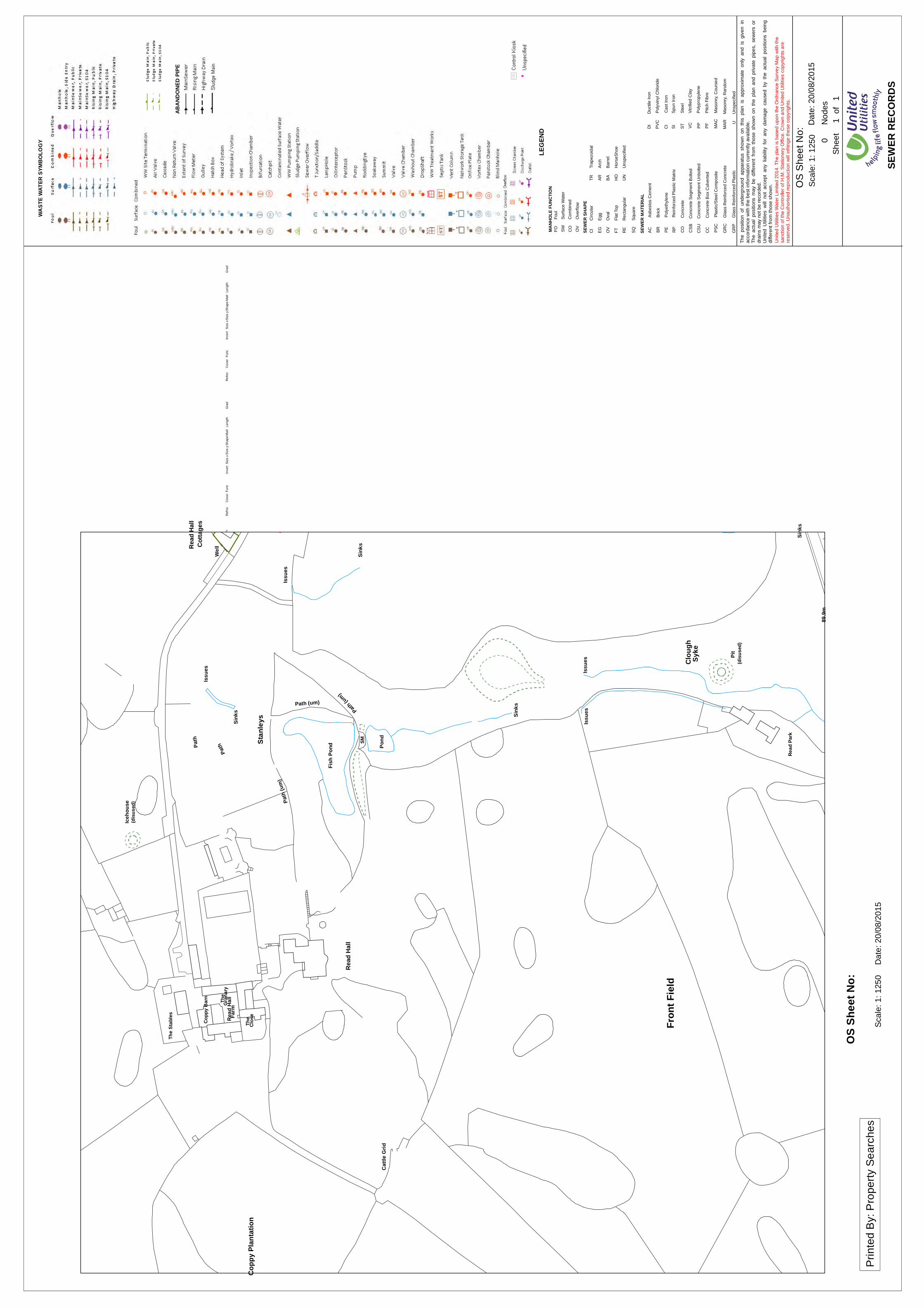
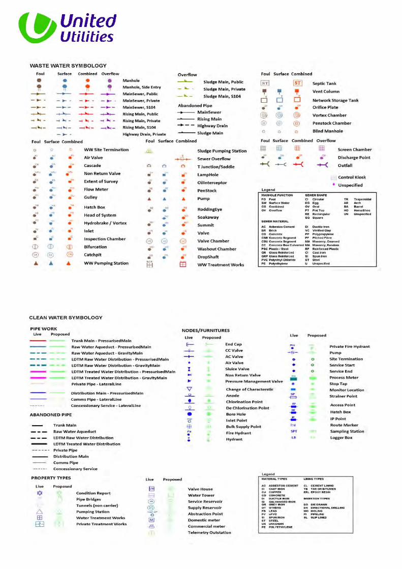
Hammond Ground, Read Flood Risk Assessment and Drainage Management Strategy FRA317-HAMMOND.GROUND_FRA&DMS APPENDIX F: UU SEWER RECORDS & CORRESPONDENCE This page has been left intentionally blank
Transcript
Hammond Ground, Read
Flood Risk Assessment and Drainage Management Strategy
FRA317-HAMMOND.GROUND_FRA&DMS
APPENDIX F: UU SEWER RECORDS & CORRESPONDENCE
This page has been left intentionally blank
1
Chris Pickles
From: Wastewater Developer Services <[email protected]>Sent: 17 July 2015 11:13 AMTo: Chris PicklesSubject: RE: Hammond Ground, Read, Lancashire, BB12 7RH
Hi I can confirm that there are no recorded historical sewer flooding issues within the vicinity of the proposed development site. Please note that United Utilities Water plc (UUW) can only record and check flooding events which are reported to us and we have to comply with our Regulators instructions on the qualification of flooding events to place on the ‘at risk’ register.
Also, this does not include any sewer flooding events caused by blockages or collapses which are the result of third party actions, natural events or other actions over which UUW has no control and not a facet of sewer capacity. Should you require any further information please do not hesitate to contact me. Thanks sue
If you have received a great service today why not tell us? Visit: unitedutilities.com/wow Sue King Developer Services Assistant Developer Services and Planning Operations Control United Utilities T: 01925 679413 (internal 79413) unitedutilities.com
From: Chris Pickles [mailto:[email protected]] Sent: 17 July 2015 09:16 To: Wastewater Developer Services Subject: Hammond Ground, Read, Lancashire, BB12 7RH To whom it may concern,
Hammond Ground, Read, Lancashire, BB12 7RH Please could you confirm whether you have any information that you feel would be valuable to a Flood Risk Assessment for the above site (location plan attached), including details of historical flooding; this would be greatly appreciated.
2
Please do not hesitate to contact me on the details below to discuss further should you require additional information or clarification. Kind regards Chris Christopher Pickles Flood Risk & Engineering Technician Betts Associates Ltd Old Marsh Farm Barns, Welsh Road, Sealand, Flintshire, CH5 2LY T ‐ 01244 288178 F ‐ 01244 288516 chris.pickles@betts‐associates.co.uk www.betts‐associates.co.uk CIVIL | STRUCTURAL | GEO‐ENVIRONMENTAL | TECHNICAL DUE DILIGENCE FLOOD RISK MANAGEMENT | STRUCTURAL SURVEYS | PARTY WALL DUTIES | ECOLOGY ELECTRONICALLY TRANSMITTED INFORMATION This electronic transmission is strictly confidential and intended solely for the addressee. It may contain information which is covered by legal, professional or other privilege. If you are not the intended addressee, you must not disclose, copy or take any action in reliance of this transmission. If you have received this transmission in error, please notify us as soon as possible. All emails transmitted by Betts Associates are virus checked. This does not guarantee that transmissions are virus free. Reference should always be made to the hard copy of any electronically transmitted files. Electronic data does not constitute contract documentation. Use of the content of our files is at your own risk. You remain responsible for anything produced using all or part of the data supplied.
EMGateway3.uuplc.co.uk made the following annotations --------------------------------------------------------------------- The information contained in this e-mail is intended only for the individual to whom it is addressed. It may contain legally privileged or confidential information or otherwise be exempt from disclosure. If you have received this Message in error or there are any problems, please notify the sender immediately and delete the message from your computer. You must not use, disclose, copy or alter this message for any unauthorised purpose. Neither United Utilities Group PLC nor any of its subsidiaries will be liable for any direct, special, indirect or consequential damages as a result of any virus being passed on, or arising from the alteration of the contents of this message by a third party. United Utilities Group PLC, Haweswater House, Lingley Mere Business Park, Lingley Green Avenue, Great Sankey, Warrington, WA5 3LP Registered in England and Wales. Registered No 6559020 www.unitedutilities.com www.unitedutilities.com/subsidiaries ---------------------------------------------------------------------
Th
e p
ositio
n o
f u
nd
erg
rou
nd
a
ppa
ratu
s sh
ow
n
on
this
p
lan
is
a
pp
roxim
ate
o
nly
a
nd
is g
ive
n
inaccord
an
ce
with t
he
be
st
info
rmatio
n c
urr
en
tly a
va
ilab
le.
Th
e a
ctu
al
po
sitio
ns m
ay b
e d
iffe
ren
t fr
om
tho
se sh
ow
n o
n t
he
pla
n a
nd
priva
te p
ipe
s,
se
we
rs o
rdra
ins m
ay n
ot
be r
ecord
ed
.U
nite
d U
tilit
ies w
ill n
ot
acce
pt
an
y lia
bili
ty fo
r an
y d
am
age
ca
use
d b
y th
e actu
al
po
sitio
ns b
ein
gdiffe
rent
fro
m t
ho
se
sho
wn
.
Un
ite
d U
tilit
ies W
ate
r L
imite
d 2
01
4. T
he p
lan is b
ase
d u
po
n t
he
Ord
na
nce
Su
rve
y M
ap
with t
he
sa
nctio
n o
f th
e C
ontr
olle
r o
f H
.M.
Sta
tio
ne
ry O
ffic
e.
Cro
wn
an
d U
nite
d U
tilit
ies c
op
yrig
hts
are
rese
rve
d.
Una
uth
orise
d r
ep
rod
uctio
n w
ill infr
ing
e th
ese c
op
yrig
hts
.
Plo
t 1
DS
!
!
!!
!
!!
!!
!
!
!!
a
u#
z
Pit
The S
tables
Path (um)
Fish P
ond
Issue
s
(disu
sed)
Copp
y Plan
tation
Read
Hall
Path
Path (um)
Clos
e
Sinks
Issue
s
Read
Hall
The
The
Iceho
use
Issue
s
Path
Cattle
Grid
Gran
ary
(disu
sed)
Read
Park
Fron
t Fiel
d
Syke
Stan
leys
Farm
Copp
y Barn
SM
Path
(um)
Pond
Clou
gh
Sinks
Issue
s
Sinks
89.9m
Cotta
ges
Well
Sinks
Read
Hall
1
Sca
le:
1:
125
0D
ate
: 20
/08/2
015
OS
Sh
ee
t N
o:
Re
fno
Co
ve
rF
unc
Inve
rtS
ize
.xS
ize
.yS
ha
pe
Ma
tl
Pri
nte
d B
y:
Pro
pe
rty S
ea
rch
es
Sca
le:
1:
125
0D
ate
: 20
/08/2
015
OS S
heet
No:
0N
od
es
Sh
ee
t1
1of
Gra
dLe
ng
thR
efn
oC
ove
rF
unc
Inve
rtS
ize
.xS
ize
.yS
ha
pe
Ma
tlG
rad
Le
ng
th
SEWE
R RE
CORD
S
LEGE
NDMA
NHOL
E FU
NCTIO
NF
O
SW
CO
Fou
l
Surf
ace
Wa
ter
Co
mbin
ed
OV
Overf
low
SEWE
R SH
APE
CI
Cir
cu
lar
EG
Egg
OV
Oval
FT
Fla
t To
p
RE
Re
cta
ngu
lar
SQ
Squ
are
TR
Tra
pezoid
al
AR
Arc
h
BA
Barr
el
HO
Ho
rseS
hoe
UN
Un
specifie
d
SEWE
R MA
TERI
ALA
CA
sb
esto
s C
em
ent
BR
Brick
CI
Ca
st Ir
on
SI
Spu
n Iro
n
CO
Co
ncre
te
CS
BC
oncre
te S
egm
ent B
olted
CS
UC
oncre
te S
egm
ent U
nbo
lte
d
CC
Co
ncre
te B
ox C
ulv
ert
ed
DI
Du
ctile
Iro
n
GR
CG
lass R
ein
forc
ed C
oncre
te
GR
PG
lass R
ein
forc
ed P
lastic
PS
CP
lastic/S
tee
l C
om
posite
PV
CP
oly
vin
yl C
hlo
rid
e
PE
Poly
eth
yle
ne
RP
Re
info
rce
d P
lastic M
atr
ix
ST
Ste
el
VC
Vitrified
Cla
y
PP
Poly
pro
pyle
ne
PF
Pitch F
ibre
MA
CM
aso
nry
, C
ou
rse
d
MA
RM
aso
nry
, R
an
do
m
UU
nspecifie
d
WAST
E WA
TER
SYMB
OLOG
Y
ABAN
DONE
D PIP
E
Th
e p
ositio
n o
f u
nd
erg
rou
nd
a
ppa
ratu
s sh
ow
n
on
this
p
lan
is
a
pp
roxim
ate
o
nly
a
nd
is g
ive
n
inaccord
an
ce
with t
he
be
st
info
rmatio
n c
urr
en
tly a
va
ilab
le.
Th
e a
ctu
al
po
sitio
ns m
ay b
e d
iffe
ren
t fr
om
tho
se sh
ow
n o
n t
he
pla
n a
nd
priva
te p
ipe
s,
se
we
rs o
rdra
ins m
ay n
ot
be r
ecord
ed
.U
nite
d U
tilit
ies w
ill n
ot
acce
pt
an
y lia
bili
ty fo
r an
y d
am
age
ca
use
d b
y th
e actu
al
po
sitio
ns b
ein
gdiffe
rent
fro
m t
ho
se
sho
wn
.
Un
ite
d U
tilit
ies W
ate
r L
imite
d 2
01
4. T
he p
lan is b
ase
d u
po
n t
he
Ord
na
nce
Su
rve
y M
ap
with t
he
sa
nctio
n o
f th
e C
ontr
olle
r o
f H
.M.
Sta
tio
ne
ry O
ffic
e.
Cro
wn
an
d U
nite
d U
tilit
ies c
op
yrig
hts
are
rese
rve
d.
Una
uth
orise
d r
ep
rod
uctio
n w
ill infr
ing
e th
ese c
op
yrig
hts
.
DS
Plot 3
Plo
t 1
DS
Plo
t R
ob
in H
ill 6
DS
PL
OT
1-2
DS
o
#
!!
!
!
!!
!!
!!
!
!!
!!
!
!!
!
!
!
!
!
!
!
!!
!
!
!
!
!
!
!
!
!
!
!
!!
!
!!
Wx
w
wwwww
z
z
za
a
aa
aa
a
a
a
bu
b ba b
abt
u
X
X X
X
X
X
#
z
z
Issue
s
WHINS
LANE
Lea
Sinks
Hamm
ond F
ield
130.1
m
Hillcot
Mead
owlan
ds
Well
8
Rake BottomCottage
Rake
Hamm
ond G
roun
d
23
18
3
146.6
m
Ash
5
Cotta
ges
Woodside
Cotta
ges
Darn
ley
136.9
m
2
East Cottage
111.6
m
Read
Park
34
Well
El Su
b StaDu
dley H
ill Ho
use
Edmo
ndso
ns
Whitehead Cottage
LB
2
137.8
m
LANE
Cottage
Read
Hall
126.5
m
118.9m
11
Botto
m
Barn
HAMM
OND
DRIVE
Issue
s
The B
arnGP
1
GEORGE
Dudle
y Hill
The
Cotta
ge
Mead
owHi
gh
13
225 VC
10
0 V
C
15
0 V
C
300 VC
15
0 V
C
150 V
C
150 V
C150 V
C
T390
0
T180
6T18
05
T290
4
T450
2
T280
2
T470
2
T470
1
T490
1T39
04
T490
0
T480
1
T480
0
T460
2
T460
1
T460
0
T450
1
T450
0
T390
3T390
2
T390
1
T290
2
T290
1T29
00
T180
4 T180
3T18
02T18
01
T180
0
T080
2 T080
1 T080
0
100 C
I
Sca
le:
1:
125
0D
ate
: 20
/08/2
015
SD
763
4N
WO
S S
hee
t N
o:
Re
fno
Co
ve
rF
unc
Inve
rtS
ize
.xS
ize
.yS
ha
pe
Ma
tl
Pri
nte
d B
y:
Pro
pe
rty S
ea
rch
es
Sca
le:
1:
125
0D
ate
: 20
/08/2
015
SD76
34NW
OS S
heet
No:
38
No
des
Sh
ee
t1
1of
Gra
dLe
ng
thR
efn
oC
ove
rF
unc
Inve
rtS
ize
.xS
ize
.yS
ha
pe
Ma
tlG
rad
Le
ng
th
SEWE
R RE
CORD
S
LEGE
NDMA
NHOL
E FU
NCTIO
NF
O
SW
CO
Fou
l
Surf
ace
Wa
ter
Co
mbin
ed
OV
Overf
low
SEWE
R SH
APE
CI
Cir
cu
lar
EG
Egg
OV
Oval
FT
Fla
t To
p
RE
Re
cta
ngu
lar
SQ
Squ
are
TR
Tra
pezoid
al
AR
Arc
h
BA
Barr
el
HO
Ho
rseS
hoe
UN
Un
specifie
d
SEWE
R MA
TERI
ALA
CA
sb
esto
s C
em
ent
BR
Brick
CI
Ca
st Ir
on
SI
Spu
n Iro
n
CO
Co
ncre
te
CS
BC
oncre
te S
egm
ent B
olted
CS
UC
oncre
te S
egm
ent U
nbo
lte
d
CC
Co
ncre
te B
ox C
ulv
ert
ed
DI
Du
ctile
Iro
n
GR
CG
lass R
ein
forc
ed C
oncre
te
GR
PG
lass R
ein
forc
ed P
lastic
PS
CP
lastic/S
tee
l C
om
posite
PV
CP
oly
vin
yl C
hlo
rid
e
PE
Poly
eth
yle
ne
RP
Re
info
rce
d P
lastic M
atr
ix
ST
Ste
el
VC
Vitrified
Cla
y
PP
Poly
pro
pyle
ne
PF
Pitch F
ibre
MA
CM
aso
nry
, C
ou
rse
d
MA
RM
aso
nry
, R
an
do
m
UU
nspecifie
d
WAST
E WA
TER
SYMB
OLOG
Y
ABAN
DONE
D PIP
E
0800
128.4
4C
O
0801
128.8
1C
O 1
28.0
7150
CI
VC
6.1
3
0802
131.6
6C
O 1
31.0
8150
CI
VC
10.9
74
1800
126.3
4C
O
1801
126.7
CO
0150
CI
VC
20.2
9
1802
126.6
4C
O 1
25.7
6150
CI
VC
12.6
9
1803
126.6
1C
O
0150
CI
VC
15.9
7
1804
126.3
9C
O
126
150
CI
VC
6.7
6
1805
CO
1806
CO
2802
CO
2900
138
CO
2901
143.3
1C
O 1
42.5
4100
CI
VC
45.4
48
2902
145.6
3C
O 1
44.6
6100
CI
VC
17.5
98
2904
CO
3900
137.9
1S
W
3901
137.9
8C
O
3902
137.1
3C
O
3903
135.1
3C
O
0150
CI
VC
58.1
4
3904
CO
4500
110.2
7C
O
4501
112.5
4C
O 1
10.5
1225
CI
VC
40.7
617
4502
110.2
5C
O
4600
114.8
6C
O 1
13.0
4225
CI
VC
43.1
117
4601
126.8
8C
O 1
24.6
8225
CI
VC
79.6
74602
119.7
3C
O 1
18.2
3150
CI
VC
8.5
2
4701
CO
4702
CO
4800
127.9
1C
O 1
25.8
3225
CI
VC
10.9
9
4801
129.1
3C
O 1
27.2
5225
CI
VC
94.9
169
4900
141.1
3C
O
0225
CI
VC
80.8
7
4901
134.3
9C
O
2903
CO
0150
CI
VC
5.8
8
3905
CO
1
36.3
8225
CI
VC
42.1
6
4604
CO
0150
CI
VC
10.0
1
4503
CO
1
07.0
5300
CI
VC
38.2
517
4603
CO
2801
CO
0
CI
CI
149.8
4
Th
e p
ositio
n o
f u
nd
erg
rou
nd
a
ppa
ratu
s sh
ow
n
on
this
p
lan
is
a
pp
roxim
ate
o
nly
a
nd
is g
ive
n
inaccord
an
ce
with t
he
be
st
info
rmatio
n c
urr
en
tly a
va
ilab
le.
Th
e a
ctu
al
po
sitio
ns m
ay b
e d
iffe
ren
t fr
om
tho
se sh
ow
n o
n t
he
pla
n a
nd
priva
te p
ipe
s,
se
we
rs o
rdra
ins m
ay n
ot
be r
ecord
ed
.U
nite
d U
tilit
ies w
ill n
ot
acce
pt
an
y lia
bili
ty fo
r an
y d
am
age
ca
use
d b
y th
e actu
al
po
sitio
ns b
ein
gdiffe
rent
fro
m t
ho
se
sho
wn
.
Un
ite
d U
tilit
ies W
ate
r L
imite
d 2
01
4. T
he p
lan is b
ase
d u
po
n t
he
Ord
na
nce
Su
rve
y M
ap
with t
he
sa
nctio
n o
f th
e C
ontr
olle
r o
f H
.M.
Sta
tio
ne
ry O
ffic
e.
Cro
wn
an
d U
nite
d U
tilit
ies c
op
yrig
hts
are
rese
rve
d.
Una
uth
orise
d r
ep
rod
uctio
n w
ill infr
ing
e th
ese c
op
yrig
hts
.
DS
Plot Unit
!
!
!
!
!!
!
!
!
!!
!!!
!
!!
!!
W
Wx
wwwww
z
za
aa
aa
a
a
bu
u
b ba b
abtX
X X
X
X
X
#
z
z
12
1
A 671
1 Pond
Sinks
Drain
Planta
tion
New
15
4
89.9m
93.9m
2
119
High
sett
Issue
s
105.8
m
WESTGATE
2
Issue
s
Sinks
Pond
Issue
s
1
93
Sinks
107
WHAL
LEY R
OAD
El Su
b Sta
100 V
C
300
VC
225 VC
15
0 C
I
300 VC
T440
1T44
00
T430
0
T230
0
T130
0
T030
0
Sca
le:
1:
125
0D
ate
: 20
/08/2
015
SD
763
4S
WO
S S
hee
t N
o:
Re
fno
Co
ve
rF
unc
Inve
rtS
ize
.xS
ize
.yS
ha
pe
Ma
tl
Pri
nte
d B
y:
Pro
pe
rty S
ea
rch
es
Sca
le:
1:
125
0D
ate
: 20
/08/2
015
SD76
34SW
OS S
heet
No:
10
No
des
Sh
ee
t1
1of
Gra
dLe
ng
thR
efn
oC
ove
rF
unc
Inve
rtS
ize
.xS
ize
.yS
ha
pe
Ma
tlG
rad
Le
ng
th
SEWE
R RE
CORD
S
LEGE
NDMA
NHOL
E FU
NCTIO
NF
O
SW
CO
Fou
l
Surf
ace
Wa
ter
Co
mbin
ed
OV
Overf
low
SEWE
R SH
APE
CI
Cir
cu
lar
EG
Egg
OV
Oval
FT
Fla
t To
p
RE
Re
cta
ngu
lar
SQ
Squ
are
TR
Tra
pezoid
al
AR
Arc
h
BA
Barr
el
HO
Ho
rseS
hoe
UN
Un
specifie
d
SEWE
R MA
TERI
ALA
CA
sb
esto
s C
em
ent
BR
Brick
CI
Ca
st Ir
on
SI
Spu
n Iro
n
CO
Co
ncre
te
CS
BC
oncre
te S
egm
ent B
olted
CS
UC
oncre
te S
egm
ent U
nbo
lte
d
CC
Co
ncre
te B
ox C
ulv
ert
ed
DI
Du
ctile
Iro
n
GR
CG
lass R
ein
forc
ed C
oncre
te
GR
PG
lass R
ein
forc
ed P
lastic
PS
CP
lastic/S
tee
l C
om
posite
PV
CP
oly
vin
yl C
hlo
rid
e
PE
Poly
eth
yle
ne
RP
Re
info
rce
d P
lastic M
atr
ix
ST
Ste
el
VC
Vitrified
Cla
y
PP
Poly
pro
pyle
ne
PF
Pitch F
ibre
MA
CM
aso
nry
, C
ou
rse
d
MA
RM
aso
nry
, R
an
do
m
UU
nspecifie
d
WAST
E WA
TER
SYMB
OLOG
Y
ABAN
DONE
D PIP
E
0300
87.4
CO
0100
CI
VC
60.9
7
1300
88.4
2C
O
87.5
7100
CI
VC
103.7
7
2300
90.0
1C
O
88.9
1100
CI
VC
99.4
74
4300
104.5
1C
O 1
01.4
3300
CI
VC
72.9
2
4400
106.7
1C
O 1
03.0
3300
CI
VC
54.6
167
4401
108.0
6C
O 1
04.6
1300
CI
VC
29.2
919
4402
CO
0150
CI
CI
28.9
2
4403
CO
0300
CI
VC
20.0
7
4404
CO
4405
CO
1
Kirsty Williams
From: Perry, Graham <[email protected]>Sent: 09 September 2015 16:10To: Kirsty WilliamsSubject: FW: DE1446 - Hammond Ground, Read. Burnley Due by 17.09.2015Attachments: UU-Wastewater_predevelopment_enquiry.pdf
Hello Kirsty We have carried out an assessment of your application which is based on the information provided; this predevelopment advice will be valid for 12 months Foul
Foul will be allowed to drain to the public combined/ foul sewer network. Our preferred point of discharge would be to the combined sewer located at the junction of Whalley Rd & Westgate Surface Water Surface water from this site should drain to either soak away or directly to watercourse to the south or to the west. Discharge rates and consents must be discussed and agreed with all interested parties. Under no circumstances should surface water be allowed to drain to the combined sewer as this would potentially cause flooding issues downstream. Connection Application Although we may discuss and agree discharge points & rates in principle, please be aware that you will have to apply for a formal sewer connection. This is so that we can assess the method of construction, Health & Safety requirements and to ultimately inspect the connection when it is made. Details of the application process and the form itself can be obtained from our website by following the link below http://www.unitedutilities.com/connecting-public-sewer.aspx Sewer Adoption Agreement You may wish to offer the proposed new sewers for adoption. United Utilities assess adoption application based on Sewers adoption 6th Edition and for any pumping stations our company addenda document. Please refer to link below to obtain further guidance and application pack: http://www.unitedutilities.com/sewer-adoption.aspx Existing Asset Crossing the Site There are two existing easements that cross the site which do not appear to have any connection to our wastewater assets. Therefore I would recommend that you contact our clean water team to see if the easements protect water mains and they will cause issue on your proposed development. Please be aware that on site drainage must be designed in accordance with Building Regulations, National Planning Policy, Planning Conditions and local flood authority guidelines, we would recommend that you liaise and make suitable agreements with the relevant statutory bodies. Regards
2
Thanks Graham Perry Development Engineer Developer Services and Planning Operational Services United Utilities T: 01925 679405 (internal 79405) unitedutilities.com
If you have received a great service today why not tell us? Visit: unitedutilities.com/wow
From: Wastewater Developer Services Sent: 27 August 2015 11:08 To: Perry, Graham Subject: DE1446 - Hammond Ground, Read. Burnley Due by 17.09.2015 FYI Regards, Will Harrison Technical Administrator Developer Services & Planning Operational Control United Utilities T : 01925 679319 E : [email protected]
If you have received a great service today why not tell us? Visit: unitedutilities.com/wow United Utilities Water Ltd. - Developer Services and Planning Warrington North Wastewater Treatment Works Barnard Street Off Old Liverpool Road Gatewarth Industrial Estate Warrington WA5 1DS
From: Kirsty Williams [mailto:[email protected]] Sent: 26 August 2015 13:12 To: Wastewater Developer Services Subject: Pre-Dev Enquiry - Hammond Ground, Read To Whom It May Concern,
3
We are currently preparing a preliminary drainage strategy to support an outline planning application for a residential development in Read, Lancashire; we are looking for any drainage advice specific to this area in order to determine feasibility of the strategy and are hoping that we can obtain an agreement in principle to the preliminary drainage strategy in order to support the FRA and in turn the planning application. I have briefly summarised the proposals below and attached the pre‐development enquiry pack, we would greatly appreciate your feedback on the proposals and look forward to a response. Due to the early stage, the development area has not yet been defined; we have assumed that the development area will be a small portion of the wider site boundary as illustrated in the plans attached; the development area will be defined following receipt of the various consultee responses and consultation reports supporting the application; development will be steered to the most suitable location within the wider site boundary. We have drafted a drainage strategy which is proposing that the surface water generated by the development area discharge to the watercourse bisecting site (should infiltration be proved not feasible); the strategy is proposing the use of various SuDS features to convey and attenuate flows onsite (including a pond, swales and rills). The foul water generated by the residential development is proposed to outfall to the public combined sewer network adjacent to site (see attached plan). Two potential points for connection have been identified, we do not have accurate invert levels at this time however it is understood from review of the topo survey that a gravity connection to one of the identified points would be feasible. The gravity connection lies within adjacent Third Part Land (UU Ref. 2300) and therefore constraints are present which have been identified within the FRA; requisition for the gravity connection may be possible although further discussion with UU has been recommended. The alternative option is a pumped solution from the development area to the combined network to the east of Whalley Road (UU Ref. 4400). The drainage strategy detailed above is only a strategy at this time, no hydraulic simulation has been undertaken and therefore detailed design will be required to confirm feasibility. I trust the above is sufficient to allow you to review the strategy however if you require any additional information please do not hesitate to contact me on the details below. Kind Regards Kirsty Williams Graduate Flood Risk Analyst Betts Associates Ltd Old Marsh Farm Barns, Welsh Road, Sealand, Flintshire, CH5 2LY T ‐ 01244 288178 kirstywilliams@betts‐associates.co.uk www.betts‐associates.co.uk CIVIL | STRUCTURAL | GEO‐ENVIRONMENTAL | TECHNICAL DUE DILIGENCE FLOOD RISK MANAGEMENT | STRUCTURAL SURVEYS | PARTY WALL DUTIES | ECOLOGY ELECTRONICALLY TRANSMITTED INFORMATION This electronic transmission is strictly confidential and intended solely for the addressee. It may contain information which is covered by legal, professional or other privilege. If you are not the intended addressee, you must not disclose, copy or take any action in reliance of this transmission. If you have received this transmission in error, please notify us as soon as possible. All emails transmitted by Betts Associates are virus checked. This does not guarantee that transmissions are virus free. Reference should always be made to the hard copy of any electronically transmitted files. Electronic data does not constitute contract documentation. Use of the content of our files is at your own risk. You remain responsible for anything produced using all or part of the data supplied.
Hammond Ground, Read
Flood Risk Assessment and Drainage Management Strategy
FRA317-HAMMOND.GROUND_FRA&DMS
APPENDIX G: LPA/LLFA CORRESPONDENCE
This page has been left intentionally blank
1
Chris Pickles
From: Chris PicklesSent: 17 July 2015 9:16 AMTo: '[email protected]'Subject: Hammond Ground, Read, Lancashire, BB12 7RHAttachments: LOCATION PLAN.pdf
To whom it may concern,
Hammond Ground, Read, Lancashire, BB12 7RH Please could you confirm whether you have any information that you feel would be valuable to a Flood Risk Assessment for the above site (location plan attached), including details of historical flooding; this would be greatly appreciated. Please do not hesitate to contact me on the details below to discuss further should you require additional information or clarification. Kind regards Chris Christopher Pickles Flood Risk & Engineering Technician Betts Associates Ltd Old Marsh Farm Barns, Welsh Road, Sealand, Flintshire, CH5 2LY T ‐ 01244 288178 F ‐ 01244 288516 chris.pickles@betts‐associates.co.uk www.betts‐associates.co.uk CIVIL | STRUCTURAL | GEO‐ENVIRONMENTAL | TECHNICAL DUE DILIGENCE FLOOD RISK MANAGEMENT | STRUCTURAL SURVEYS | PARTY WALL DUTIES | ECOLOGY ELECTRONICALLY TRANSMITTED INFORMATION This electronic transmission is strictly confidential and intended solely for the addressee. It may contain information which is covered by legal, professional or other privilege. If you are not the intended addressee, you must not disclose, copy or take any action in reliance of this transmission. If you have received this transmission in error, please notify us as soon as possible. All emails transmitted by Betts Associates are virus checked. This does not guarantee that transmissions are virus free. Reference should always be made to the hard copy of any electronically transmitted files. Electronic data does not constitute contract documentation. Use of the content of our files is at your own risk. You remain responsible for anything produced using all or part of the data supplied.
Dear Chris Pickles, Please find attached your completed HFI Request. Yours Sincerely, Terry McCormick Graduate Civil Engineer Community Services Lancashire County Council T: 01772 530978 W: www.lancashire.gov.uk
Learn something new this autumn with an adult learning course .
********************
This e-mail contains information intended for the addressee only.
It may be confidential and may be the subject of legal and/or professional privilege.
If you are not the addressee you are not authorised to disseminate, distribute, copy or use this e-mail or any attachment to it.
The content may be personal or contain personal opinions and unless specifically stated or followed up in writing, the content cannot be taken to form a contract or to be an expression of the County Council's position.
Lancashire County Council reserves the right to monitor all incoming and outgoing email.
Lancashire County Council has taken reasonable steps to ensure that outgoing communications do not contain malicious software and it is your responsibility to carry out any checks on this email before accepting the email and opening attachments.
Flood Risk Information Request Hammond Ground, Read, Lancashire, BB12 7RH DATE OF REPORT: 11th August 2015
Flood Risk Information Request
• 2 •
Introduction
Lancashire County Council is the Lead Local Flood Authority (LLFA) for the County Council's
administrative area. The Flood and Water Management Act (FWMA) sets out the
requirement for the LLFA to manage local flood risk within their area.
It is advised that flooding from "local" sources (surface water, groundwater and flooding
from ordinary watercourses) is taken into consideration, where possible, and especially
where there is a known flooding issue in an area.
This package includes:
a) Historical flood maps
b) Flood zones 2 and 3
c) Flood warning areas
d) Surface Water Susceptibility
e) Ground Water Susceptibility
f) Main rivers
g) Fluvial flood areas
h) Tidal flood area
i) Flood defences
j) Flood storage areas
k) Reservoirs
l) Highway drainage nodes
m) Highway drainage pipes
n) Highway drainage ponds
o) Highway Gullies
p) Ecology Standing Advice Consultation Zones
q) Public Enquiry Management System
r) Section 19 Flood Investigation records
s) Ordinary Watercourse Consenting and Enforcement register
Flood Risk Information Request
• 3 •
Section 1. Information Request
Lancashire County Council has been instructed to execute a search for historical flooding in
relation to a Flood Risk Assessment which Betts-Associates are conducting on the site.
Betts-Associates have requested the provision of any information which may be valuable to
a Flood Risk Assessment of the site.
Section 2. Site Location
The map below shows the location of the site to which this report relates. The red line
outlines the boundary of the proposed site area.
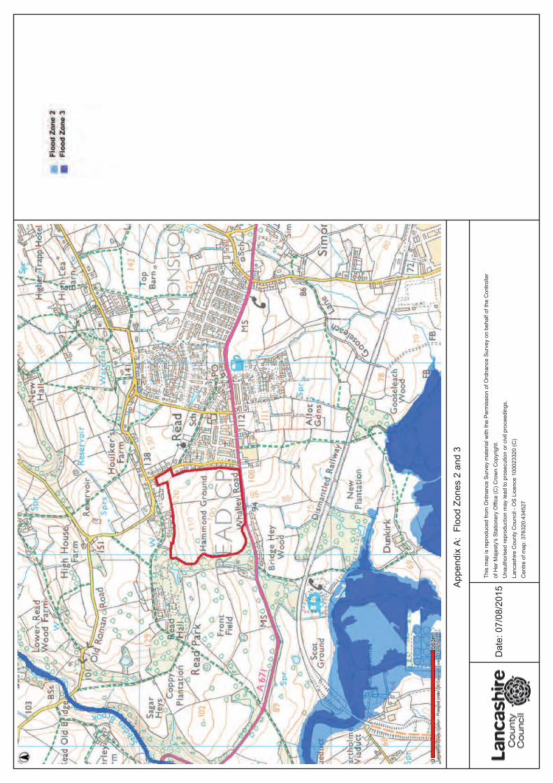
This map is reproduced from Ordnance Survey material with the Permission of Ordnance Survey on behalf of the Controller of Her Majesty's Stationery Office (C) Crown Copyright. Unauthorised reproduction may lead to prosecution or civil proceedings. Lancashire County Council - OS Licence 100023320 (C) Centre of map: 376320:434527
Flood Risk Information Request
• 4 •
Section 3. Lancashire County Council Report
a. Historical Flood Maps:
The Flood Risk Management Team (FRM) has no record of any historical flooding within the
proposed site.
b. Flood Zones 2 and 3:
These Flood Zones refer to the probability of river and sea flooding, ignoring the presence
of defences.
Flood Zone 2 (medium probability) is defined as land having between a 1 in 100 and 1 in
1,000 annual probability of river flooding; or land having between a 1 in 200 and 1 in 1,000
annual probability of sea flooding.
Flood Zone 3 (high probability) is defined as land having a 1 in 100 or greater annual
probability of river flooding; or land having a 1 in 200 or greater annual probability of sea
flooding.
Our records indicate that the proposed site is not located within Flood Zones 2 or 3.
Refer to Appendix A.
c. Flood Warning Areas:
Our records indicate that the proposed site is not located within a flood warning area.
d. Surface Water Susceptibility
Our records indicate that the proposed site is located within an area susceptible to surface
water flooding. This runs South-West to North-East across the site, with additional areas
leading away from this main thread.
Refer to Appendix B.
e. Ground Water Susceptibility
Our records indicate that the proposed site is located within an area susceptible to
groundwater flooding. This area predominantly carries a risk of ground water flooding in
the range of 25% to 50%.
Refer to Appendix C.
The FRM Team has no record of any recent groundwater flooding occurring at this location.
f. Main Rivers
Our records indicate that the nearest Main Rivers located within the surrounding area of
the proposed site are the River Calder (approximately 550m South-West of the site) and
Sabden Brook (approximately 830m North-West of the site.
Refer to Appendix D.
Flood Risk Information Request
• 5 •
g. Fluvial Flood Watch Area:
Our records indicate that the proposed site is located within a fluvial flood watch area
which forms part of the Calder Catchment. This area encompasses the Rivers Calder, Brun,
Don and Pendlewater, from Laneshaw Bridge to the River Ribble including Trawden,
Burnley, Nelson, Colne, Accrington and Whalley.
Refer to Appendix E.
h. Tidal Flood Watch Areas:
Our records indicate that the proposed site is not located within a tidal flood watch area.
i. Flood Defences:
Our records indicate that there are no known flood defences located within the proposed
site.
j. Flood Storage Areas:
Our records indicate that there are no known flood storage areas located within the
proposed site.
k. Reservoirs:
Our records indicate that there are no known reservoirs located within the proposed site.
l. Highway Drainage Nodes:
Our records indicate that there are no known highway drainage nodes located within the
proposed site.
m. Highway Drainage Pipes:
Our records indicate that there are no known highway drainage pipes located within the
proposed site.
n. Highway Drainage Ponds:
Our records indicate that there are no known highway drainage ponds located within the
proposed site.
o. Highway Gullies:
Our records indicate that there are no known highway gullies located within the proposed
site. There are however, a number of highway gullies located within the surrounding area.
These are situated along the Southern boundary of the site, along Whalley Road (A671),
and along the Eastern edge of the site, along George Lane.
Refer to Appendix F.
Flood Risk Information Request
• 6 •
p. Ecology Standing Advice Consultation Zones:
Our records indicate that the proposed site is located within an Ecology Standing Advice
Consultation zone. This zone extends from inside the Eastern edge of the site out to the
North, West and South-West.
These zones are areas of high ecological interest and could be adversely affected by
development. For that reason, consultation is required should development takes place at
this location.
There are also Ecology Standing Advice Consultation Zones in the near vicinity of the
surrounding area.
Refer to Appendix G.
q. Lancashire County Council's Public Enquiry Management System:
Following a review of the Lancashire County Council's Public Enquiry Management System,
no records have been identified within close proximity of the proposed site.
r. Section 19 Flood Investigation Records:
Following a review of the Lancashire County Council's Flood Investigation Record Sheet, no
records have been identified within close proximity of the proposed site.
s. Ordinary Watercourse Consenting and Enforcement register
Following a review of the Lancashire County Council's Ordinary Watercourse Consenting
and Enforcement register, no records have been identified within close proximity of the
proposed site.
Flood Risk Information Request
• 7 •
Section 4. Supplementary Information
4.1 – Ordinary Watercourses
Our records indicate that there is an Ordinary Watercourse, open or culverted, located
within the proposed site.
Any surface water connections and/or modifications to the banks or beds of an ordinary
watercourse will require Land Drainage Consent from Lancashire County Council. Please
note that Lancashire County Council currently follows the Environment Agency's guidelines
of requesting 8m easements around watercourses for future maintenance purposes.
4.2 – Sustainable Drainage Systems (SuDS)
Details of the LLFA's position regarding SuDS can be found using the following link: