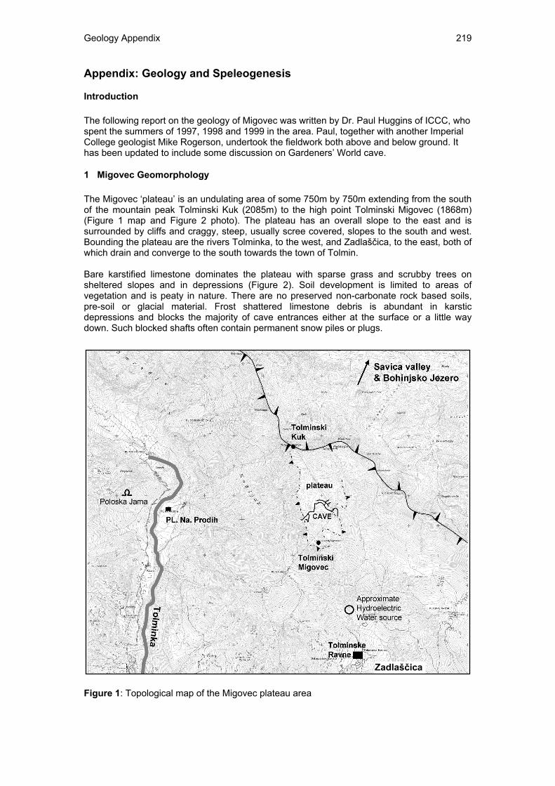
Geology Appendix 219 Appendix: Geology and Speleogenesis Introduction The following report on the geology of Migovec was written by Dr. Paul Huggins of ICCC, who spent the summers of 1997, 1998 and 1999 in the area. Paul, together with another Imperial College geologist Mike Rogerson, undertook the fieldwork both above and below ground. It has been updated to include some discussion on Gardeners’ World cave. 1 Migovec Geomorphology The Migovec ‘plateau’ is an undulating area of some 750m by 750m extending from the south of the mountain peak Tolminski Kuk (2085m) to the high point Tolminski Migovec (1868m) (Figure 1 map and Figure 2 photo). The plateau has an overall slope to the east and is surrounded by cliffs and craggy, steep, usually scree covered, slopes to the south and west. Bounding the plateau are the rivers Tolminka, to the west, and Zadlaščica, to the east, both of which drain and converge to the south towards the town of Tolmin. Bare karstified limestone dominates the plateau with sparse grass and scrubby trees on sheltered slopes and in depressions (Figure 2). Soil development is limited to areas of vegetation and is peaty in nature. There are no preserved non-carbonate rock based soils, pre-soil or glacial material. Frost shattered limestone debris is abundant in karstic depressions and blocks the majority of cave entrances either at the surface or a little way down. Such blocked shafts often contain permanent snow piles or plugs. Figure 1: Topological map of the Migovec plateau area Zadlaščica
Transcript
Geology Appendix 219
Appendix: Geology and Speleogenesis
Introduction The following report on the geology of Migovec was written by Dr. Paul Huggins of ICCC, who spent the summers of 1997, 1998 and 1999 in the area. Paul, together with another Imperial College geologist Mike Rogerson, undertook the fieldwork both above and below ground. It has been updated to include some discussion on Gardeners’ World cave.
1 Migovec Geomorphology The Migovec ‘plateau’ is an undulating area of some 750m by 750m extending from the south of the mountain peak Tolminski Kuk (2085m) to the high point Tolminski Migovec (1868m) (Figure 1 map and Figure 2 photo). The plateau has an overall slope to the east and is surrounded by cliffs and craggy, steep, usually scree covered, slopes to the south and west. Bounding the plateau are the rivers Tolminka, to the west, and Zadlaščica, to the east, both of which drain and converge to the south towards the town of Tolmin. Bare karstified limestone dominates the plateau with sparse grass and scrubby trees on sheltered slopes and in depressions (Figure 2). Soil development is limited to areas of vegetation and is peaty in nature. There are no preserved non-carbonate rock based soils, pre-soil or glacial material. Frost shattered limestone debris is abundant in karstic depressions and blocks the majority of cave entrances either at the surface or a little way down. Such blocked shafts often contain permanent snow piles or plugs. Figure 1: Topological map of the Migovec plateau area
Zadlaščica
Geology Appendix 220
Tolminski Kuk is one peak along a long high NW-SE mountain ridge (Figure 1 map). This ridge is part of the western frontal ranges of the high Julian Alps, running from the Italian-Austrian border, south into the Croatian Dinarides. The line linking the hills Rodica in the east, through Tolminski Migovec to Krn in the west, crossing two mountain ridges, marks the western front of the high Julian Alps and the Slatna overthrust of thick Triassic limestone. To the north-east are the main limestone ranges, while to the south-west are the lower lying mountains of the Tolmin Pre-alps of younger mixed lithology rocks. To the north of the ridge is an east-west valley, with the town of Bohinjsa Bistrica and the lake Bohinjsko Jezero at an altitude of ca. 530m. Around the sides of the Tolminka valley is a line of discontinuous but extensive high cliffs (Figure 3). The tops of these cliffs change height down the valley, from ca. 1200m at the head of the valley, ca. 1000m west of Migovec plateau, to ca. 800m at the village of Polog. There is also some evidence for terracing of the valley sides along the lower valley where it opens out towards the south around the village of Čadrg. Above the cliffs, the slopes are covered with thick preserved deposits of well cemented limestone talus breccias. No analysis of glacial deposits or features has been made. It is possible that the top of the cliffs marks an old valley floor level which has subsequently been eroded by the river. It is not known whether the river downcutting is related to tectonic episodes of uplift and tilting, or periods of glacial action. Figure 2: Photo of the Migovec plateau from the side of the mountain Tolminski Kuk, looking to the south. The mountain peak to the left is Vrh nad Škribino. The Tolminka valley is to the right of the photo and the middle cirque leads down to the Zadlaščica valley. Figure 3: View of the western side of the Migovec plateau and the western side of the Tolminka valley. This photo was taken from the entrance of Pološka Jama cave on the eastern side of the Tolminka valley.
Geology Appendix 221
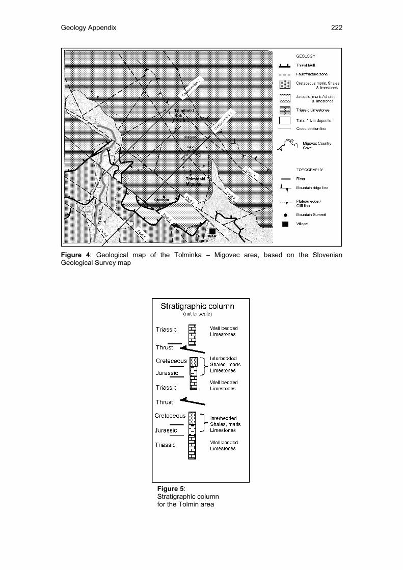
2 Geology of Migovec The regional geological description is based upon field observations placed in the context of the geological map of the area (Buser 1987). A sheet description report/memoir is apparently available, however, only a photocopy of the map with no guide has been obtained. A geological trail through the Julian Alps, including a section passing up from Tolmin to Tolminske Ravne, is marked on the topographic map, and presumably a guide is available for this trail, though probably only in Slovene. Again, a copy of this guide was not obtained. The geological strata of the Julian Alps in the Tolmin area comprise a thick sequence of Triassic carbonates, mostly nearly pure, thin-medium bedded limestones and dolomites, overlain by a Jurassic and Cretaceous section of limestones and shales (Figures 4 & 5). The Jurassic and Cretaceous limestones are usually thinly bedded, marly and interbedded with shales and do not reach large thicknesses. The Cretaceous strata are exposed in the left (east) bank of the Tolminka valley, beneath the peak of Grusnica (1570m) just to the south west of Migovec, and along the road from Tolmin to Tolminske Ravne. The Triassic carbonates are well exposed areally on the Migovec plateau and in section in the upper slopes and cliffs around the Tolminka valley. A major thrust complex, the Slatna overthrust, comprising a couple of discrete thrust faults emplaces the Triassic carbonates on top of the Cretaceous shales (Figure 4 map & 6 & 7 cross-sections). The thrusts dip to the north-north-east and transported the Triassic carbonates to the south. Many NW-SE to NNW-SSE trending, steeply dipping faults cut the thrust sheet and offset the thrusts. Offsets taken from the geological map and field (underground) observations indicate that at least some of the faults appear to have a normal offset. It is this thrust sheet of thick carbonate rocks that forms the high peaks of the Julian Alps, including Migovec and Tolminski Kuk and contains the large vertically developed ‘alpine’ style cave systems, while the Cretaceous shales beneath the thrust form the regional aquiclude controlling the water table. However, the presence of dolomites could locally control the water table, being largely impervious to extensive solution and cave development. Major dolomite layers and their control on speleogenesis within carbonate thrust massifs has been described for the Kanin massif by Casagrande et al (1999). From the geological map (Buser 1987) several facies of carbonate are marked but without a legend or translated guide it has not been possible to determine what these facies are and whether they distinguish limestone from dolomite. The Triassic carbonates, as exposed on the Plateau, are well bedded, with ca. 0.5 – 1m alternating layers of more or less weathering resistant carbonate (Figures 2 & 3), though there is little obvious facies difference to distinguish the layers. With the provisional level of geological mapping undertaken, it was not possible in the field, either surface or subsurface, to differentiate between limestone and dolomite units. In addition to the major mapped faults, the rock is intensely cut by smaller faults and fractures (Figure 9 – photo of faults). A large fold can be mapped on the plateau (Figure 8 – plateau geological map) which itself contains a range of smaller scale, 10 – 100m open folds with axes in a number of orientations (Figure 10 – photo of fold).
Mike Rogerson taking geological field notes (JE)
Geology Appendix 222
Figure 4: Geological map of the Tolminka – Migovec area, based on the Slovenian Geological Survey map
Figure 5: Stratigraphic column for the Tolmin area
Geology Appendix 223
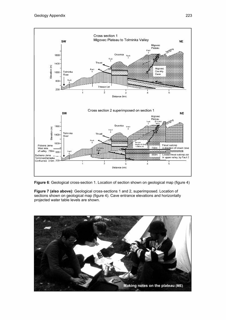
Figure 6: Geological cross-section 1. Location of section shown on geological map (figure 4) Figure 7 (also above): Geological cross-sections 1 and 2, superimposed. Location of sections shown on geological map (figure 4). Cave entrance elevations and horizontally projected water table levels are shown.
Making notes on the plateau (ME)
Geology Appendix 224
Figure 8: Geological map of the Migovec plateau showing fault lines, bedding orientation and major fold axis.
Dawn over Vrh nad Škrbino (HP)
Geology Appendix 225
Figure 9: Two small faults in well bedded Triassic limestone on the flank of Tolminski Kuk above the Migovec plateau. Figure 10: Minor fold in well bedded Triassic limestone on the Migovec plateau. A small cave passage has formed in the axis of the fold exposed in the side of a small shaft. Both the passage and shaft are debris filled.
Geology Appendix 226
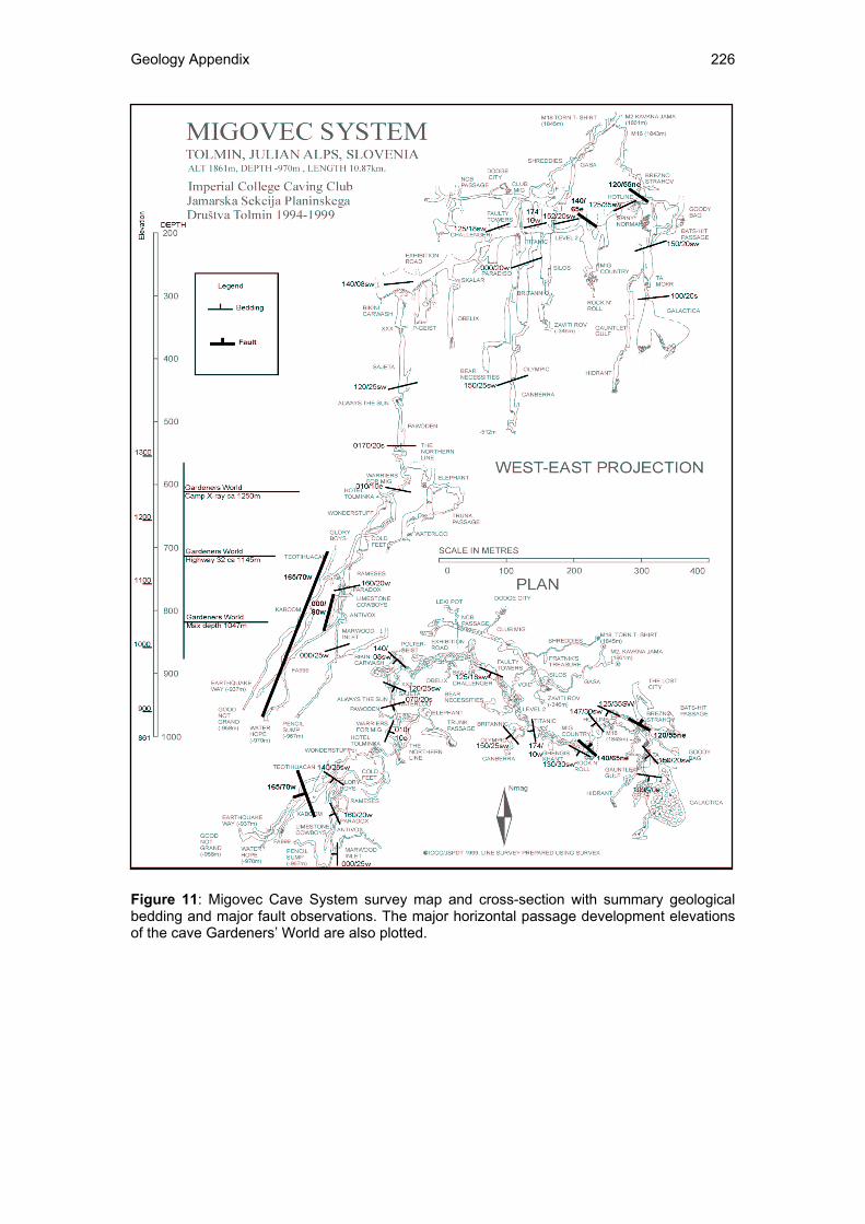
Figure 11: Migovec Cave System survey map and cross-section with summary geological bedding and major fault observations. The major horizontal passage development elevations of the cave Gardeners’ World are also plotted.
Geology Appendix 227
3 System Migovec Cave Passage Description The cave can be divided into a number of zones that have broadly similar passage characteristics and, it is believed, timings and styles of genesis. However, this zonation may largely reflect the exploration of the known connected passages. It is clear that speleogenesis has a long and complex history with a number of different phases being identifiable. Passages from these different phases cross cut one another to form a complex 3D network. Zone 1: M16 Entrance series Pitch series Zone 2: M18 Entrance series – Shreddies series Tight vadose streamway with pitches – sharp rock Zone 3: Level 1 (NCB – Goody Bag) NCB and Goody Bag are two separate passages but appear to align as a single trend, defining a horizontal level. Zone 4: Level 2 (Exhibition Road; Hotline to Bikini Carwash) Wide horizontal passage with boulder floor. Zone 5: Vertical Shafts (Galactica, Mig Country, Titanic, Challenger, XXX-Sajeta) The two main ‘horizontal’ levels are intersected by a number of large, 10-15m diameter, roughly circular shafts that extend both upwards and downwards. These shafts are vertical and have depths of 40-80m. Many of the shafts form descending series of several shafts linked by short vadose streamways. Shafts are commonly near-circular with smooth, sometimes scalloped walls. Where shafts intersect other passages, the shafts have generally been explored downwards but not always to a termination. The difficulty in exploring these shafts upwards, which has not been seriously attempted, leads to a dominance of downward mapped shaft passages. This results in probably the most artificial distribution of the cave zones. Shafts are known throughout the cave system down to zone 6. Many of the surface depressions are shafts that have been largely infilled with scree. In the cave many passage floor pits and pitches are often directly aligned with roof avens. The shafts are often ‘wet’ ranging from a water film on the rock surface through drips to small trickles of running water. In Level 2 some avens have associated blind pits that are 2-3m deep. Some shafts are spaced very closely with only a thin wall of rock between them and may coalesce downwards. Mig Country and Galactica are believed to have formed multiple coalesced shafts that have been modified by major collapse to create large chambers with boulder floors. The walls of the shafts contain many side passage openings including phreatic looking circular tubes to vadose looking trenches and rifts. The phreatic tubes are up to ca 50cm in diameter and are sometimes elongate parallel to bedding or vertically. They are nearly always infilled with red mud/silt. The vertical rifts are often of the order of 10’s cm wide and are commonly filled with limestone boulders and pebbles, sometimes cemented. It is interpreted that the shafts, with linking streamways, are vadose in origin. The water is thought to relate more to low volume percolation of seepage water down fractures from the surface than vertical drops of larger volume flowing streamways. Condensation water may also be significant. The shafts are believed to be younger than the passages they intersect, and possibly the most recent phase of speleogenesis. Zone 6a: Vadose Passages (Warriers for Mig – Northern Line - Cold Feet) Below the shaft Pawoden, the balance between shaft and vadose streamway changes to become dominated by streamway punctuated by shorter vertical shafts, generally 10 - 40m. Unlike the true shafts (passing both upwards and downwards) in Zone 5, the floor pits/pitches often have continuous roof levels from the streamway, having no associated avens. The first major streamway, with 10’s cm3 of water, is encountered near the top of this level at Hotel Tolminka. A couple of streamways have been followed to sumps.
Geology Appendix 228
Zone 6b: Dipping Rift Shafts (Teotihuacan – Earthquake way) One of the streamways intersects a major fault. This feature controls the passage creating a steeply inclined linear passage/pitch series down to a sump, Good Not Grand. Three sumps have been reached, Good Not Grand, -958m, Water Hope, -970m, and Pencil Sump, -967m. The sumps all show recent evidence of significant flooding, with mud covered walls some way above the sump levels. Given the large number of cave passages that exist it is felt that all the main passages are probably inter-connected. The difference in depth of 12m between sumps, is felt to be a combination of changing sump level responding to rain between survey measurements and survey error, rather than separate perched sumps. The intermediate depth, and that of the closest pair of values, of -967m is taken as the ‘averaged’ sump depth. A cave depth of -967m equates to an elevation above sea level of approximately 890m.
4 Other Tolminka Valley Caves Gardeners’ World - Four zones can be defined in the cave Gardeners’ World: Zone 1 Entrance Series Series of pitches and shafts. A small stream flows from Laurel to Swing and then reappears halfway down Space Odyssey and can be followed to the base of Fistful of Tolars. Zone 2: The Pink Series from Pink pitch to Zimmer Small pitches in breakdown fault breccia. Zone 3: Horizontal Level A: (Camp X-ray – Friendship Gallery) Dry horizontal passage undercut by an active vadose stream. Zone 4: Horizontal Level B (Highway 32 – No more Potatoes) This series starts truly horizontal with Highway 32, before changing into a series of down and up inclining passages. It is though that this series may represent a phreatic level of lifts. Gardeners’ World – Migovec Country Comparison Gardeners’ World Horizontal Level A corresponds with the approximate depth of the top of Migovec System Zone 6 (Hotel Tolminka) which defines the base of the main vertical shaft system. This may reflect a geological control and/or a specific phase or change of speleogenesis related to a water table level. More significant is the depth of Gardeners’ World Horizontal Level B which occurs at a depth in the middle of the Migovec Dipping Rift series. This indicates that the cave system is not simply a younger vadose zone beneath Migovec Level 2 to the current water table, but that there may be a number of old ‘horizontal’ phreatic levels throughout the mountain that have not yet been discovered. Across which continual vadose shaft development in the higher levels has occurred. Pološka Jama Pološka Jama is situated on the right (west) bank of the Tolminka valley opposite Migovec. The bottom entrance is at a height of ca 750m, almost 150m deeper than the sumps in Migovec. The cave is still in the Triassic limestone of the thrust sheet which outcrops at a lower elevation due to dip up valley. The cave passage appears to be phreatic in nature (I only investigated it for ca 50m) but is now clearly abandoned. This indicates there may be a relatively recent phreatic cave level being developed at present at ca. 600m, to the west of the Tolminka, corresponding to the present day valley floor. To the east, under Migovec, this phreatic level may still be flooded, a higher water table being kept in place by the dipping aquiclude shales beneath the thrust. Zadlaška Jama (a.k.a. Dantejeva Jama) Zadlaška Jama is an abandoned dry alpine cave (Knez & Slabe 1999), located on the southern slope of Kalec hill above the confluence of the Tolminka and Zadlaščica rivers, some 5km to the south of Migovec. Three entrances are present at an elevation of 310m, about 80m above the river level at the confluence. The cave is 1140m long with a height difference of 41m, climbing into the hill from the entrance, having a horizontal development of anastomosing passages. The cave entrance is situated in Cretaceous limestones, beneath the main Slatna thrusts, but is interpreted from the presence of fossil fragments, to penetrate Triassic Limestones updip.
Geology Appendix 229
5 Cave Sediments
Breakdown The large passages at the higher levels of the cave, such as Exhibition Road and NCB passage, and the larger shafts all contain extensive breakdown / collapse material along their floors. Nearly all of this material appears to derive from the roof, controlled by bedding planes and fractures. White Sand Forms partial passage fills in the upper abandoned levels and occurs in small volumes as layers and patches on wall shelves in younger abandoned and presently active streamways. It is unknown whether this ‘sand’ material is clastic or carbonate, but probably carbonate erosion product. If clastic, it indicates a preserved type of material no longer observed on the surface of the high mountains. White sand occurs in thick layers on the base of some fossil passages and as small volumes or patches on wall shelves in active streamways. Sand/grit Mixed sand and grit of brown colour. Occurs in small volume layers and patches on wall shelves in active streamways. Gravel Well rounded gravel grade pebbles of dark limestone and possibly some chert. No units of this facies have been observed within the Triassic section. The source limestones for the gravels could be Jurassic / Cretaceous Formations that have been eroded from the mountains, or from glacial tills, though there is no evidence of glacial material currently preserved on the hill tops. False Floors False floors have been noted, though no detailed observations are recorded. These could record reactivation of passageways and multiple fill and erosion events. Red mud & silt Occurs infilling enlarged fissures and small, 10’s cm passages and tubes that appear to be phreatic in origin. Occurs extensively below Level 2 (Exhibition Road) in side passages to the big shafts. Impression that the red muds are being washed out at the present day. The muds are typically homogenous looking with a stiff clay like consistency. Laminations have been seen in some passages and occasional limestone fragments can be present. Occasionally the muds are cemented and hard. Thought to be phase of cave infilling early in cave development when passages had not developed beyond embryonic stage of early phreatic network development. Possible sources for the red muds/silts are: Triassic bauxites (and cherts); Jurassic/Cretaceous red Flysh deposits (found on south flank of Krn mountain); Any Tertiary Flysh / Loess (much of central Europe covered by Pleistocene Loess; Post deposition staining – solution of iron by biogenic acids from weathered surface sediments or early pre-glaciation warmer climate vegetation and soil cover. After the earthquake of 1998, local cavers report that the Tolminka flowed red for a couple of days afterwards. This red colouration could be caused by the red muds being washed out from some of the infilled passages in the cave system. This indicates that the earthquake caused sufficient rock displacement to open up new water pathways and at least temporarily reactivate some of the abandoned passages. Brown Muds Soft dark brown mud coating cave passage surfaces for approximately 20m vertical height above surveyed sump depths - clearly recent deposits from cave flooding as the sumps have backed-up Black Powder Occurs as a thin mm layer covering the tops and sometimes sides of passage floors and boulders. Typically covers a layer of mud or soft white calcite (moonmilk?). The layer does not cover passage roofs or underhangs on boulders, but does cover the tops of boulders beneath. Occasionally ‘shadows’ of non deposition are seen to the side of some boulders. This deposit is observed in the upper passages, mainly in Level 1 passages associated with a strong air flow. It is possible that this deposit is soot from forest fires.
Geology Appendix 230
6 Cave formations
Moonmilk A soft white paste like substance is observed in some of the higher passages of Level 1, often covered by a black powder, possibly soot. It is thought that this deposit is calcite moonmilk. Hard Calcite Formations Very little in the way of hard calcite formations have been described from throughout the cave system. No stalactites and stalagmites have been recorded. Thin nodular, cauliflower, calcite sheets have been observed in the upper ‘horizontal’ passages of level 2, both preserved on the walls and on breakdown boulders, suggesting that they formed early after passage abandonment, prior to collapse. The nodules are aligned both vertically and parallel to the inclination of the passage.
7 Geological controls on cave passage & Speleogenesis
Geological surveys were made on a number of trips into System Migovec over several years by a couple of geologists. These trips cover the whole range of the system, however, many parts of the cave have not been visited and measured. A summary of observations are presented in Figure 11, showing bedding measurements and fault and fracture measurements. Throughout most of the cave, rock bedding is very clear, through visible differences in rock, differential erosion or lines of collapse. However, in places the bedding is almost or completely undetectable. Many of the bedding surfaces show tectonic deformation and brecciation from bed parallel slip, which may have aided solution and speleogenesis. The rock is virtually all carbonate, assumed limestone. Occasional 10 – 30cm thick greenish shales have been observed. Usually in the roofs of vadose streamways. The lateral extent of these shales and therefore their likely influence on speleogenesis has not been established. Geological control of cave passages is clear throughout the system and in all the different styles of passage. Phreatic and vadose passages alike are usually aligned along bedding surfaces and fault or fracture zones, and typically along the intersection of fractures with bedding. Shafts and pitches commonly occur at the intersection of differently orientated fractures. In the larger passages, particularly the two sub-horizontal levels, the passages have been extensively modified by breakdown so that the original form of the passage is no longer discernable and thus it is much harder to identify controlling features and the nature of speleogenesis. In Level 1 (zone 3) the passage is horizontal and appears to follow the strike (horizontal line) of bedding (as observed on the surface and provided by indirect reports. No direct underground observations). In map view Level 2 – Exhibition Road mirrors Level 1 apparently following the strike of bedding, but is overall inclined downwards from the SE around to the NW end. In detail Horizontal Level 2 has a central SE-NW section from Mig Country to Challenger which is near horizontal and follows the strike of bedding. The two ends trend NE-SW and are inclined down to the SW, orientated down maximum bedding dip. The difference in overall orientation of Level 1 and Level 2, horizontal to inclined respectively, may reflect a number of controls: 1. geological control alone (both in the phreatic zone) 2. be influenced by the palaeo hydrological conditions at formation of either, at the water table or in the deep phreatic zone, 3. It is also possible that the difference reflects complete reorientation of the whole rock massif due to uplift and tilting associated with mountain building over millions of years. The large shafts occurring from the ground surface down to Zone 6 appear to have a complex evolution, either as a series of periodic phases of development with abandonment of one system and development of a new, or as continuous development with ongoing formation, capture and abandonment of shafts. In a number of places through the cave major fault zones have controlled cave development by focussing and aligning passages into the plane of the fault, i.e Zone 6b (Teotihuacan – Earthquake Way). In other areas, particularly in the areas of large shaft development, i.e. Ta Mokr – Galactica and Mig Country, faults have influenced late cave modification by facilitating large scale roof and wall collapse to create merged chambers and boulder halls.
Geology Appendix 231
Phreatic passages are often aligned along bedding surfaces and sometimes show a vertical teardrop section of upward solution of a roof fracture parallel to the passage, indicating inception along the bedding fracture intersect. Vadose trenches and streamways typically follow bed strike or dip and are often seen to follow the line of a fracture. These passages frequently change direction, often through nearly 90 degrees, from bed strike to bed dip orientation. Pitches in the streamway are often located at these changes in direction, commonly marked by intersection fracture lines. In many vadose passages early phreatic roof passages or anastomosing tubes can be identified. These forms are highly ellipsoid, located at and elongate along a bedding surface. They are often meandering cross cutting fracture orientations and display deep pitting and anastomosing tubes. The underly in vadose trenches and streamways often go through sharp direction changes sometimes deviating away from the overlying phreatic ‘tube’. These observations indicate that, in the phreatic zone, bedding is the dominant control. While in the vadose zone, where gravity is more influential, the fracture network becomes the more prevalent control.
8 Cave Hydrology Present Day Hydrology Present-day rainfall and snow melt water drains directly into the fissure network and cave system of the bare limestone. No streams are present and no evidence for palaeo-streams has been identified. Small valley like features are present but are interpreted as glacial erosion features. Most of the upper passages in the system are abandoned and dry. Occasionally a small active stream, though usually only a trickle, is intersected in a stream passage or tiny rift which can not be followed for any distance, or often even entered. All active waterways and interpreted recent cave passages are of two main types: 1. vadose running water drainage consisting of pitches linked by short stream passageways and deeply trenched phreatic roof tubes. 2. vadose ‘percolation’ water which appears to have generated the system of deep shafts cross cutting all other passages. In these shafts water is rarely seen as running streamways but rather as drips or water films coating the shaft walls. From Zone 6 down, significant streamways are encountered with flow volumes of the order of 10’s cubic centimetres. Many of the deeper pitches also take flowing water. All flowing water is in steeply descending passage way or pitches. No significant horizontal active stream development has been discovered. Three sumps have been reached, Good Not Grand, -958m, Water Hope, -970m, and Pencil Sump -967m. All are located in the deepest section of the cave in the south-west, inclined into the Tolminka Valley. Given the large number of cave passages explored and expected to be present, it is believed that all the main passages are probably inter-connected and link a common water table, at least in this part of the mountain massif. The difference in depth of 12m between sumps, is considered to be a combination of changing sump level, responding to rain or drainage between survey measurements, and survey error, rather than separate perched sumps. The intermediate depth of -967m is taken as the ‘averaged’ sump depth. All three sumps show recent evidence for significant flooding, with fresh mud-covered walls some way above the observed sump levels. This indicates that they respond to seasonal or storm waters. It is unknown how far the sumps may drop during late winter when water inflow is expected to be at its lowest as heavy snow then covers the mountains. The sump level at -967m, equates to an approximate elevation of 890m. Work to identify the cave resurgence has been undertaken with a programme of dye testing. This work is described elsewhere (see page 108). In summary, the testing has not provided any indication of the resurgence. No bed-rock springs or resurgence locations have been identified hampering focussed test placement. Test placements in the main river are believed to have been swamped by extreme rainfall and runoff during the test period. Potential resurgences are discussed from analysing the topographic and geological maps.
Geology Appendix 232
In discussing the water table and possible resurgences it will be initially assumed here, for simplification and within the accuracy of the measurements, that the water table is horizontal and projected from the lowest point of the intersection of the aquiclude (thrust fault top to the Jurassic / Cretaceous shaley interval) and the topography, or the lowest elevation in the appropriate section of the valley. Many of the measurements are estimated from a variety of topographic and geological maps and have an accuracy of maybe 10’s metres at best. No resurgence has yet been confirmed for the cave system. Three possible resurgence areas have been identified, being the head of the Tolminka Valley to the west, the Zadlaščica Valley to the south east, and the head of the Savica Valley, by Lake Bohinjsko Jezero to the north. Potential resurgence levels are estimated to be 550m in the Tolminka, 550m in the Savica and 950m in the Zadlaščica, with distances of 2km, 6km and 1.5km respectively. The lower part of the entered cave is heading towards the Tolminka Valley. In the Tolminka Valley the most likely resurgence area and level is at the head of the valley, a little to the north of Pl. Na. Prodih, where the valley turns abruptly to run NW-SE. The upper NW-SE part of the valley is aligned along a major NW-SE fault line, Fault 3 (Figure 4). This fault downthrows the Triassic Carbonates to the NE. To the SW of Fault 3 the Slatna Thrusts underlain by the Cretaceous shales dipping to the NW runs down the east side of the valley to cross the valley floor at an elevation of ca. 550m (Figure 7). Assuming the shales are the regional aquiclude then this location will control the water table ‘spill-point’ into the valley. In the west side of the valley, on the upthrown (SW) side of Fault 3, is the lower entrance to the cave Pološka Jama in the Triassic limestones at an elevation of ca. 750m. This lower entrance passage is probably phreatic in origin but is now dry and abandoned. Presumably the present day water table in the lower, western Tolminka, below Fault 3, is deeper than the lower Pološka Jama passage level. Immediately adjacent to Pološka Jama, the valley floor is at an elevation of 500m. The lower Pološka Jama passage is 140m deeper than the Migovec System sumps to the east of the valley on the downthrown (NE) side of Fault 3. Suggesting that the combination of dipping shales ‘sealing’ the eastern lower valley wall and Fault 3 offsetting the shale depth, control the resurgence levels around the valley. The base of the Tolminka Valley is filled by scree and river deposits with no bed rock outcrops. Although focussed areas of water rising through the debris have been found no definitive bed rock springs have been identified. This has made the placement of water testing equipment difficult, and largely restricted to the main river, which probably has too high a flow volume to detect the tracer used. The cave sump elevation, 890m, is some 390m above the possible horizontally projected water table level, 550m, in the Tolminka that might be expected from the key geological controls (Figures 4, 6 & 7). Alternatively, this equates to a water table dip of 11 degrees down to the NW. A second possible resurgence area is in the Zadlaščica Valley. To the east of the village Tolminske Ravne are a couple of shallow valleys orientated up towards Migovec. Along one of these valleys runs a major fault, Fault 3 (Figure 4). This is the same fault as controlling the aquiclude level in the Tolminka Valley. Fault 3 down-throws the Triassic limestones to the NE, against the Jurassic and Cretaceous shales of the hill Grusnica. The geological map marks the downthrown Slatna Thrust and Cretaceous shales in the NE to be at about 850m elevation at the bottom of the valley, but covered by talus and therefore unproven. While in the upthrown block to the SW, on the SE side of Grusnica hill, the Slatna Thrust is at an elevation of ca. 1300m. This compares to an elevation of 550m in the Tolminka Valley 2.5km away, giving an apparent dip to the NW of 16 degrees. Some way up the side valley from the path contouring around from Tolminske Ravne is the water source for a hydroelectric scheme. The valley is floored by massive blocks of limestone scree, the water take point being covered by a concrete block house at about 950m. To justify the hydro scheme, it is assumed that the water is a permanent flow, and therefore a deep source spring. This spring could represent a major resurgence for the Migovec Plateau. If it is assumed that the take point is located at or near the spring this places the resurgence at ca. 950m. This is above the Slatna Thrust control in the NE downthrown block of Fault 3 and below the thrust control to the SW upthown block. It is also 60m above the Migovec cave sump level.
Geology Appendix 233
If the resurgence is taken as -950m, this equates to a water table dip to the cave sumps, some 1500m away, of 2 degrees to the NW. If the resurgence is taken as 1300m (the upper thrust level) this equates to a water table dip of 15 degrees to the NW. If the main resurgence level is taken as 850m (the lower thrust level) then the water table dip is 1.5 degrees to the SE. Compared to a dip of 11 degrees to the NW from the cave sumps into the Tolminka valley. Combining the observation from the Tolminka and Zadlaščica valleys it is possible to postulate an inclined water table from the SE down to the NW into the Tolminka Valley. The water table being supported to the south by the thrust and shales, and dipping to the NW following the dip of the thrust and shales and reflecting the deeper incision and valley floor at the outcrop of Fault 3 in the Tolminka Valley (550m) over the Zadlaščica Valley (850m). An alternative interpretation to the single inclined water table in a homogenously permeable limestone massive is that the water table is actually a complex pattern of different catchment areas at and within the phreatic zone, defined by significant faults. These faults being sufficiently permeable on a ‘long’ time scale to allow cross flow but strong enough baffles to support water level changes across them. Another complexity of independent control is the presence of dolomite layers within the carbonate massive. These dolomite layers may be impervious to water and thus control local water base level and dip, and thus cave formation. Such lithological control on water tables and speleogenesis within carbonate thrust massifs on the Kanin massif has been described by Casagrande et al (1999). The third potential resurgence area at the head of the Savica Valley has not been visited by the expedition. The area of potential resurgence has been considered too large and therefore too time consuming to warrant a comprehensive testing programme at this stage of exploration. It is not known whether the large lake in the flat bottomed valley at ca. 550m indicates the regional water table or is a perched level in impervious glacial deposits. The valley floor is about the same elevation as the interpreted resurgence level in the Tolminka Valley, but is several more kilometres further away. So it would fit with a regional deep water table level but its distance suggests it would not be the immediate resurgence of the majority of the water from Migovec. However, from discussions with local cavers a number of resurgences are reported around the head of the valley but at unknown elevations. Some postulate that the Migovec resurgence is in the SW corner of the valley. Palaeo Hydrology Palaeo water table levels and resurgence areas will have been controlled by earlier erosion levels in the Tolminka, Zadlaščica and Savica valleys and by how deeply the Cretaceous shale aquiclude beneath the Slatna Thrust to the SW was incised. Preliminary observations such as; the cliff lines around the valleys, the presence of bands of cemented talus on the steep slopes, and breaks in slope, indicate that several valley down-cutting episodes can be identified. No detailed work has been done on investigating the geomorphology. Some work has been undertaken and reported in Lipušček (1993), but no English translation is known. It could be useful to compare the surface geomorphological features with the cave character and passage levels.
The plateau in Winter (MM)
Geology Appendix 234
References
Casagrande, G., Cucchi, F., Manca P. & Zini, L. 1999. Deep Hypogean karst phenomena of Mt. Canin (western Julian Alps): A synthesis of the state of present research. Acta Carsologica, v.28/1, 4, p57-69. Knez, Martin & Slabe, Tadej. 1999. Origin and development of an old alpine cave (Zadlaška Jama, Julian Alps). Acta Carsologica, v.28/1, 9, p127-137. Slovenian: Lipušček Radovan (editor?). Alpski mladinski raziskovalni tabori, Tolmin 1988-1990. 1993. Dolini Tolminke in Zadlaščica, Zbornik. ZOTK Slovenije – RO gibanje Znanost mladini. Triglavski narodni park. English: Lipušček Radovan (editor?). The alpine youth research camps, Tolmin 1988-1990. 1993. The valleys of Tolminka and Zadlaška, Proceedings. Triglav national park. There is an extensive geological ‘route/tour with observation points’ in the area, the route of which is marked on the topographic map. Locally, the route passes from Tolmin up the Zadlaščica valley road to the village Tolminske Ravne from where it traverses around the lower mountain side to the south of Migovec to Pl. Razor and onwards. No details or literature of the route have been obtained. At the time of this work, it was understood that the guide had not yet been written. A possible contact for the guide is Dr Stanko Buser, Geology Department, University of Ljubljana. Maps
Geological map: Buser, S. 1987. Tolmin in Videm. Carta Geologica, 1:100,000. Ljubljana. Topographic maps: Posocje. Izletniska Karta. Freizeitkarte – Carta Turistica – Leisure Map. 1 : 50,000. Geodetski Zavod Slovenje. 1998. (contains markers and locations for the geological trail) Bila nekoč je složna klapa... Bila nekoč je složna klapa, ki v jame je zahajala. Po Migovcu se je podila in Kavkno jamo tam našla. Bili so dnevi, član, ko v Kavkni jami, tam v meandrih smo zabili vsak svoj dan. Bilo nas ni nič strah, ne brezen, ne pasaž, ne vode, ki škropila je na nas. Spet si pripravil bom nahrbtnik in vso svojo kramo noter dal. In spet odšel bom s svojo klapo med sive škraplje Migovca.
Bilo nam ni nič mraz, ker grelo je srce, ki bilo je za našo sekcijo. In bije še za njo, saj stkane so vezi, ki se ne dah jih več pretrgati. Leta pa minevajo brez konca in nosijo s seboj minule dni, klapa stara več se ne povrne, postala je del preteklosti. A v nas še zdaj živi spomin na minule dni, na dneve, ko še skupaj smo bili. Ko polni upanja in željni novih zmag, iskali smo izziv nevarnosti. Rutar – Fratnik, September 1981