26
Appendix O Wastewater Flow Studies
Appendix O Wastewater Flow Studies
Technical Memorandum
Sacramento • Berkeley • San Jose • Concord
To: Mark Sauer
From: Alex Park, PE
Reviewed By: Curtis Lam, PE
Subject: Placer Ranch Specific Plan and Sunset Planning Area Wastewater Flow Update to Roseville Model – DRAFT
Date: December 22, 2017
Introduction
The existing Sunset Industrial Area (SIA) Plan area, which includes the Placer Ranch Specific Plan (PRSP) area, encompasses 8,172 acres in unincorporated western Placer County. The proposed Sunset Area Plan (SAP) area includes an additional 325 acres west of the SIA for a total of 8,497 acres. The SAP area covers 13.9 square miles between the cities of Rocklin to the east, Roseville to the south, and Lincoln to the north and unincorporated Placer County to the west. The proposed PRSP area encompasses 2,213 acres in the southern portion of the SAP area. The southern boundary of the PRSP area is contiguous with the Roseville city limits, and the northern boundary is defined, in part, by the future Placer Parkway.
Wastewater treatment and conveyance would be provided by both Placer County and the South Placer Wastewater Authority (SPWA). Placer County is responsible for the collection and conveyance of wastewater in the plan area. The SPWA treats wastewater at the Pleasant Grove Wastewater Treatment Plant (PGWWTP), which is operated by the City of Roseville. The PGWWTP is located approximately 2 miles southwest of the PRSP area.
There are three sheds in the SIA area, the western, central, and eastern sheds. How flow from each of these sheds will be sewered to existing SPWA facilities is further described below.
Flows in the western shed would be conveyed by gravity to a proposed lift station along Sunset Boulevard, near the western edge of the PRSP. From this lift station, flows would be pumped through a proposed force main in Sunset Boulevard to a receiving manhole, at which point they would flow by gravity to an 36-inch stub in Angus Road approximately 4,200 feet south of the plan area. From this connection point, flows would be conveyed to the existing 72-inch Regional Sewer Transmission pipeline located within the Pleasant Grove Creek corridor. The existing 72-inch Regional Sewer Transmission pipeline will convey all flows from the PRSP and SAP areas to the PGWWTP.
All flows in the western and central sheds would flow by gravity in an easterly and southerly direction to the intersection of Fiddyment Road and Sunset Boulevard. In the central shed, flows would be conveyed by gravity in a westerly and southwesterly direction to Fiddyment Road. From Fiddyment Road, flows would be conveyed via a 27-inch line in Fiddyment Road southward to the southern edge of the plan area. From this point, flows would continue to be conveyed by gravity to aforementioned 36-inch stub.
In addition to Placer Ranch, SAP flows enter both the Placer Ranch collection system and Roseville collection system.
Mackay and Somps Placer Ranch Specific Plan and Sunset Planning Area Wastewater Flow Update to Roseville Model December 22, 2017 Page 2 of 13
www.hydroscience.com
Wastewater flows from off-site adjacent properties and the SAP area have been accommodated for conveyance through the PRSP area. Future stub-out connection points have been provided with the PRSP for development of adjacent off-site parcels in the future.
Background Documents
Two reports were the sources of information for updating the Placer Ranch and Sunset Area sanitary sewer flows:
1. Placer Ranch Specific Plan Sanitary Sewer Master Plan, MacKay and Somps, July 18, 2017 (Placer Ranch SSMP).
2. Sunset Area Water, Wastewater and Recycled Water Technical Report for Placer County, PSOMAS September 2017 (Sunset Area Report).
The City of Roseville updated their hydraulic model in June 2017, and published their City of Roseville, Sewer Model Update, Final Report (Sewer Model Update Report). Data in the model received from the City was compared to data in the June 2017 Sewer Model Update Report to verify the accuracy of the model used for analysis.
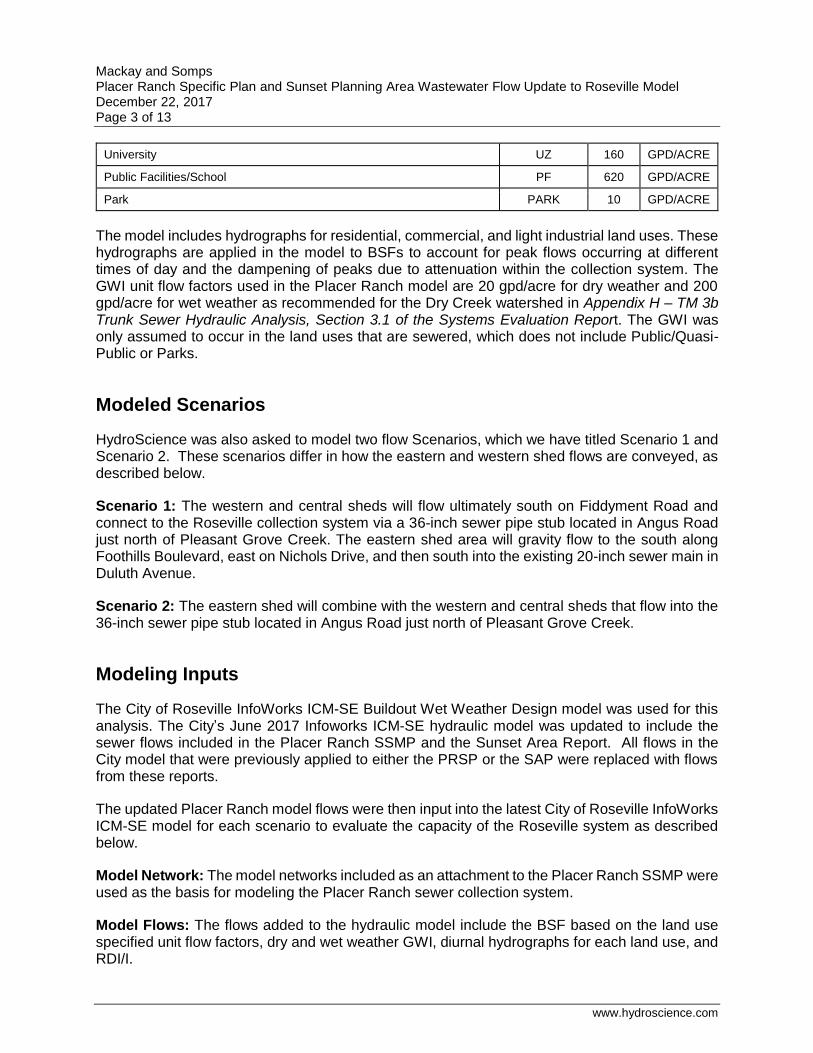
Land Use and Flow Update
This section describes the land use and flow update for the Placer Ranch model, which includes flow from the Sunset Area. The flows from the Placer Ranch model were used to update the Roseville hydraulic model.
The sanitary sewer flows include base sanitary flow (BSF), dry and wet weather groundwater infiltration (GWI), and rainfall dependent inflow/infiltration (RDI/I).
The BSF for Placer Ranch and the Sunset Area was based on the land used described in the Placer Ranch SSMP and Sunset Area Reports. The BSF is based on the unit flow factors listed in Table 1. For modeling purposes, each of these land uses was assigned into one of three categories for use with hydrographs developed in the original model: residential (Load 1), commercial (Load 2), or light industrial (Load 3).
The BSF is based on the unit flow factors listed in Table 1.
Table 1. Unit Flow Factors for Placer Ranch and Sunset Area
Land Use Abbreviation Flow
Factor Unit
Low Density Residential/ Medium Density Residential LDR/MDR 180 GPD/DU
High Density Residential HDR 120 GPD/DU
Mixed Use/Entertainment Mixed Use CMU 2160 GPD/ACRE
Commercial, Office, Business Park, Light Industrial, Innovation Center East and West, Eco-Industrial
COM, OFF, BP/PC, LI
800 GPD/ACRE
Mackay and Somps Placer Ranch Specific Plan and Sunset Planning Area Wastewater Flow Update to Roseville Model December 22, 2017 Page 3 of 13
www.hydroscience.com
University UZ 160 GPD/ACRE
Public Facilities/School PF 620 GPD/ACRE
Park PARK 10 GPD/ACRE
The model includes hydrographs for residential, commercial, and light industrial land uses. These hydrographs are applied in the model to BSFs to account for peak flows occurring at different times of day and the dampening of peaks due to attenuation within the collection system. The GWI unit flow factors used in the Placer Ranch model are 20 gpd/acre for dry weather and 200 gpd/acre for wet weather as recommended for the Dry Creek watershed in Appendix H – TM 3b Trunk Sewer Hydraulic Analysis, Section 3.1 of the Systems Evaluation Report. The GWI was only assumed to occur in the land uses that are sewered, which does not include Public/Quasi-Public or Parks.
Modeled Scenarios
HydroScience was also asked to model two flow Scenarios, which we have titled Scenario 1 and Scenario 2. These scenarios differ in how the eastern and western shed flows are conveyed, as described below.
Scenario 1: The western and central sheds will flow ultimately south on Fiddyment Road and connect to the Roseville collection system via a 36-inch sewer pipe stub located in Angus Road just north of Pleasant Grove Creek. The eastern shed area will gravity flow to the south along Foothills Boulevard, east on Nichols Drive, and then south into the existing 20-inch sewer main in Duluth Avenue.
Scenario 2: The eastern shed will combine with the western and central sheds that flow into the 36-inch sewer pipe stub located in Angus Road just north of Pleasant Grove Creek.
Modeling Inputs
The City of Roseville InfoWorks ICM-SE Buildout Wet Weather Design model was used for this analysis. The City’s June 2017 Infoworks ICM-SE hydraulic model was updated to include the sewer flows included in the Placer Ranch SSMP and the Sunset Area Report. All flows in the City model that were previously applied to either the PRSP or the SAP were replaced with flows from these reports.
The updated Placer Ranch model flows were then input into the latest City of Roseville InfoWorks ICM-SE model for each scenario to evaluate the capacity of the Roseville system as described below.
Model Network: The model networks included as an attachment to the Placer Ranch SSMP were used as the basis for modeling the Placer Ranch sewer collection system.
Model Flows: The flows added to the hydraulic model include the BSF based on the land use specified unit flow factors, dry and wet weather GWI, diurnal hydrographs for each land use, and RDI/I.
Mackay and Somps Placer Ranch Specific Plan and Sunset Planning Area Wastewater Flow Update to Roseville Model December 22, 2017 Page 4 of 13
www.hydroscience.com
Dry Weather Flows: Dry weather includes the BSF and dry weather GWI. The base flows were calculated per manhole based on specific land use tributary areas and dwelling units. The detailed flow information by manhole for each exhibit, the east flows and the west flows (upstream of PR94), and the offsite flows is included in Attachment A. Diurnal curves were then applied to these base flows to estimate the daily varied flow with peaks and minimums. Three curves were used in the hydraulic model: residential (Load 1), commercial (Load 2), and light industrial (Load 3).
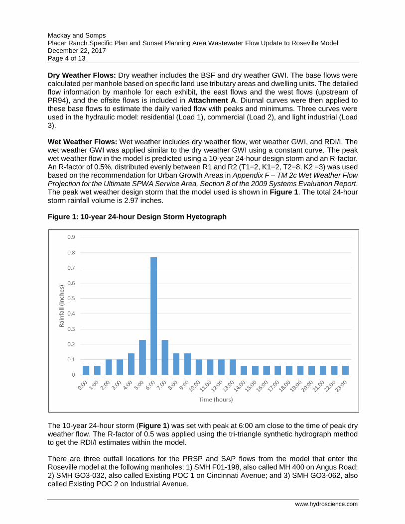
Wet Weather Flows: Wet weather includes dry weather flow, wet weather GWI, and RDI/I. The wet weather GWI was applied similar to the dry weather GWI using a constant curve. The peak wet weather flow in the model is predicted using a 10-year 24-hour design storm and an R-factor. An R-factor of 0.5%, distributed evenly between R1 and R2 (T1=2, K1=2, T2=8, K2 =3) was used based on the recommendation for Urban Growth Areas in Appendix F – TM 2c Wet Weather Flow Projection for the Ultimate SPWA Service Area, Section 8 of the 2009 Systems Evaluation Report. The peak wet weather design storm that the model used is shown in Figure 1. The total 24-hour storm rainfall volume is 2.97 inches.
Figure 1: 10-year 24-hour Design Storm Hyetograph
The 10-year 24-hour storm (Figure 1) was set with peak at 6:00 am close to the time of peak dry weather flow. The R-factor of 0.5 was applied using the tri-triangle synthetic hydrograph method to get the RDI/I estimates within the model.
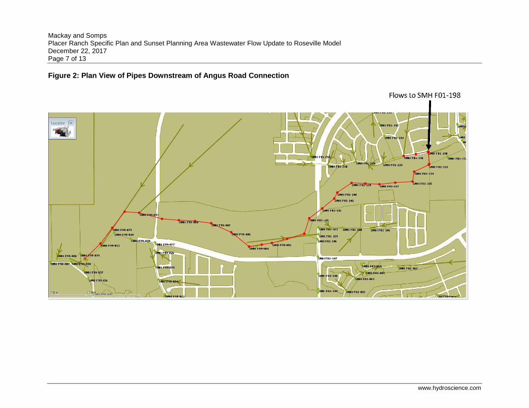
There are three outfall locations for the PRSP and SAP flows from the model that enter the Roseville model at the following manholes: 1) SMH F01-198, also called MH 400 on Angus Road; 2) SMH GO3-032, also called Existing POC 1 on Cincinnati Avenue; and 3) SMH GO3-062, also called Existing POC 2 on Industrial Avenue.
Mackay and Somps Placer Ranch Specific Plan and Sunset Planning Area Wastewater Flow Update to Roseville Model December 22, 2017 Page 5 of 13
www.hydroscience.com
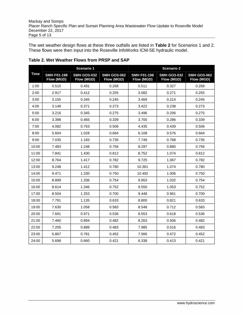
The wet weather design flows at these three outfalls are listed in Table 2 for Scenarios 1 and 2. These flows were then input into the Roseville InfoWorks ICM-SE hydraulic model.
Table 2. Wet Weather Flows from PRSP and SAP
Time
Scenario 1 Scenario 2
SMH F01-198 Flow (MGD)
SMH GO3-032 Flow (MGD)
SMH GO3-062 Flow (MGD)
SMH F01-198 Flow (MGD)
SMH GO3-032 Flow (MGD)
SMH GO3-062 Flow (MGD)
1:00 0.510 0.491 0.268 0.511 0.327 0.268
2:00 2.917 0.412 0.255 3.082 0.271 0.255
3:00 3.155 0.345 0.245 3.469 0.214 0.245
4:00 3.149 0.371 0.273 3.422 0.238 0.273
5:00 3.216 0.345 0.275 3.496 0.206 0.275
6:00 3.398 0.465 0.339 3.700 0.286 0.339
7:00 4.082 0.763 0.506 4.435 0.439 0.506
8:00 5.604 1.028 0.664 6.108 0.576 0.664
9:00 7.035 1.183 0.735 7.749 0.768 0.735
10:00 7.483 1.248 0.756 8.297 0.880 0.756
11:00 7.841 1.430 0.812 8.752 1.074 0.812
12:00 8.764 1.417 0.782 9.725 1.067 0.782
13:00 9.248 1.412 0.780 10.361 1.074 0.780
14:00 9.471 1.330 0.750 10.492 1.006 0.750
15:00 8.899 1.336 0.754 9.953 1.032 0.754
16:00 8.614 1.346 0.752 9.550 1.053 0.752
17:00 8.504 1.253 0.700 9.448 0.961 0.700
18:00 7.791 1.135 0.633 8.800 0.821 0.633
19:00 7.630 1.058 0.583 8.548 0.712 0.583
20:00 7.691 0.971 0.536 8.553 0.618 0.536
21:00 7.460 0.894 0.482 8.263 0.506 0.482
22:00 7.205 0.889 0.483 7.985 0.516 0.483
23:00 6.867 0.781 0.452 7.566 0.472 0.452
24:00 5.698 0.660 0.421 6.338 0.413 0.421

Mackay and Somps Placer Ranch Specific Plan and Sunset Planning Area Wastewater Flow Update to Roseville Model December 22, 2017 Page 6 of 13
www.hydroscience.com
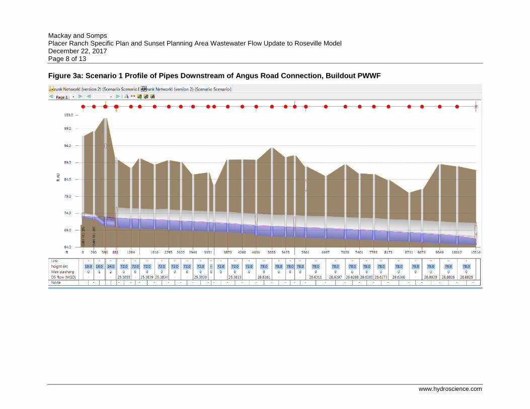
Model Results
The updates to the flows for the PRSP and the SAP did not indicate a change in pipe diameter for the Placer Ranch collection system.
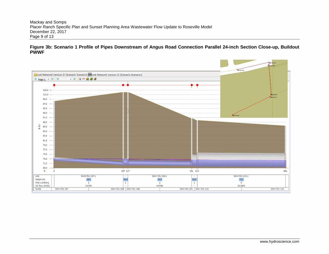
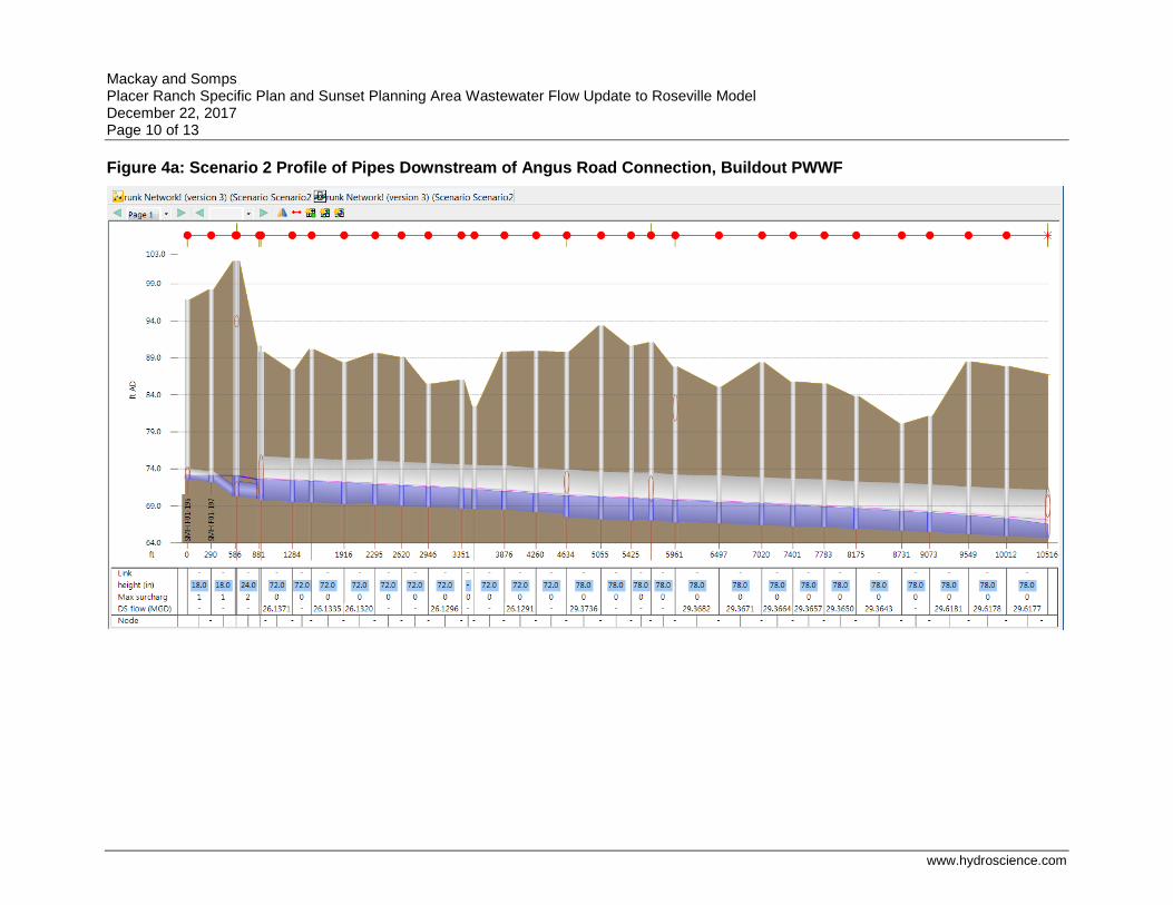
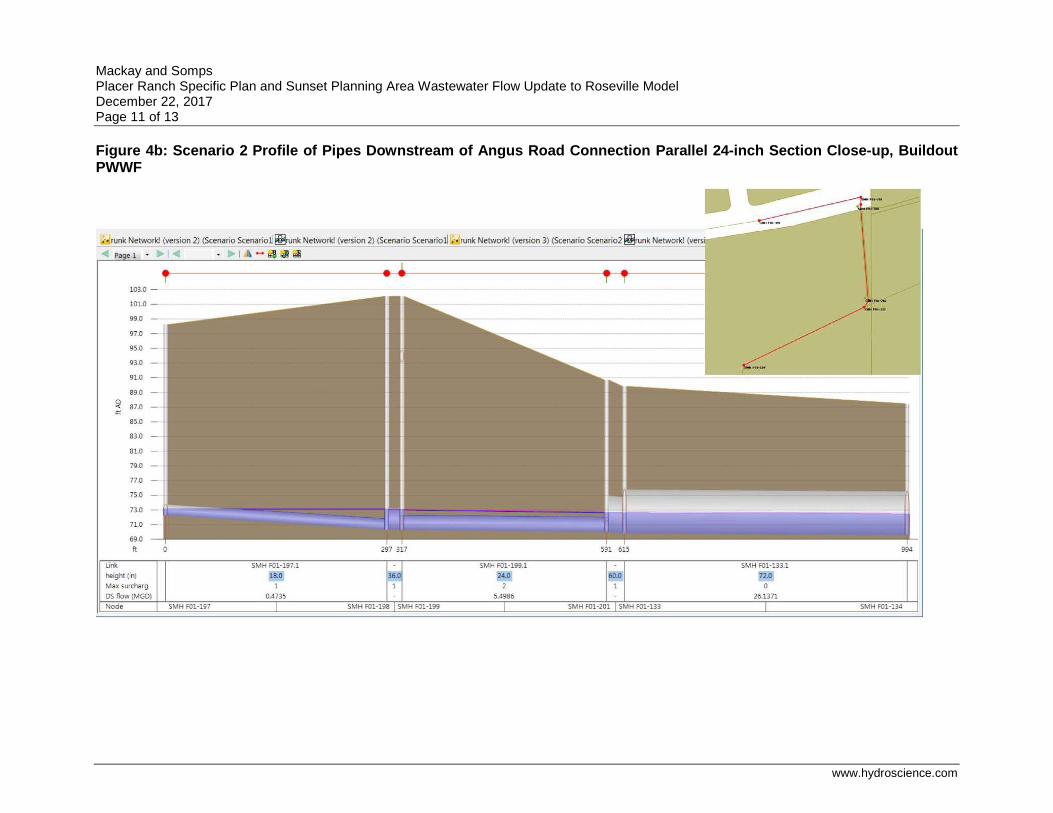
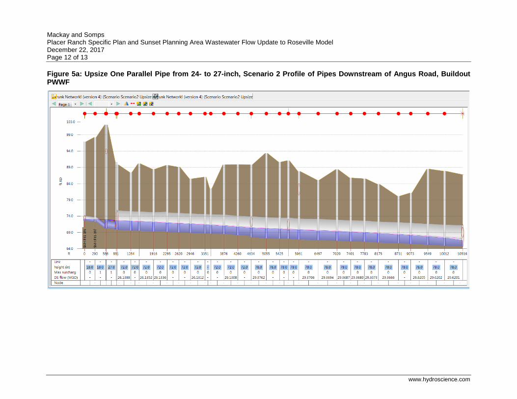
The previously estimated flows for Placer Ranch and the Sunset Area entering the City of Roseville collection system were removed and replaced by the flows listed in Table 2. Capacity is available in the City collection system to handle the PRSP/SAP flows outlined in the current technical studies, save for one segment. The location where flow is limited is where two 24-inch sewers cross underneath Pleasant Grove Creek between a 36-inch stub and a 60-inch sewer. Because of the dual 24-inch sewer, it causes the 36-inch sewer and one 18-inch sewer to the west to surcharge due to a backwater condition.
The 36 and 60-inch sewers have ample capacity to convey flows from PRSP and SAP, but the dual 24-inch sewers do not. The City of Roseville InfoWorks ICM-SE hydraulic model also shows an 18-inch overflow sewer parallel to the dual 24-inch that is not shown in the Placer Ranch SSMP. The 18-inch sewer overflow line parallel to the dual 24-inch SS has no flow in it during PWWF as the hydraulic grade line does not reach the inlet elevation of the overflow line. Increasing the size of one of the dual 24-inch sewers to 27-inches creates adequate capacity to handle the PWWF from PRSP and SAP at buildout.
The results are shown in Figures 2 through X below. In InfoWorks, a “Surcharge State” of 0 indicates adequate capacity, a “Surcharge State” of 1 indicates surcharge due to backwater, and a “Surcharge State” of 2 indicates surcharge caused by insufficient pipe capacity. The maximum surcharge state is shown on the profiles as “Max surcharge.”
Mackay and Somps Placer Ranch Specific Plan and Sunset Planning Area Wastewater Flow Update to Roseville Model December 22, 2017 Page 7 of 13
www.hydroscience.com
Figure 2: Plan View of Pipes Downstream of Angus Road Connection
Mackay and Somps Placer Ranch Specific Plan and Sunset Planning Area Wastewater Flow Update to Roseville Model December 22, 2017 Page 8 of 13
www.hydroscience.com
Figure 3a: Scenario 1 Profile of Pipes Downstream of Angus Road Connection, Buildout PWWF
Mackay and Somps Placer Ranch Specific Plan and Sunset Planning Area Wastewater Flow Update to Roseville Model December 22, 2017 Page 9 of 13
www.hydroscience.com
Figure 3b: Scenario 1 Profile of Pipes Downstream of Angus Road Connection Parallel 24-inch Section Close-up, Buildout PWWF
Mackay and Somps Placer Ranch Specific Plan and Sunset Planning Area Wastewater Flow Update to Roseville Model December 22, 2017 Page 10 of 13
www.hydroscience.com
Figure 4a: Scenario 2 Profile of Pipes Downstream of Angus Road Connection, Buildout PWWF
Mackay and Somps Placer Ranch Specific Plan and Sunset Planning Area Wastewater Flow Update to Roseville Model December 22, 2017 Page 11 of 13
www.hydroscience.com
Figure 4b: Scenario 2 Profile of Pipes Downstream of Angus Road Connection Parallel 24-inch Section Close-up, Buildout PWWF
Mackay and Somps Placer Ranch Specific Plan and Sunset Planning Area Wastewater Flow Update to Roseville Model December 22, 2017 Page 12 of 13
www.hydroscience.com
Figure 5a: Upsize One Parallel Pipe from 24- to 27-inch, Scenario 2 Profile of Pipes Downstream of Angus Road, Buildout PWWF
Mackay and Somps Placer Ranch Specific Plan and Sunset Planning Area Wastewater Flow Update to Roseville Model December 22, 2017 Page 13 of 13
www.hydroscience.com
Technical Memorandum
Sacramento • Berkeley • San Jose • Concord
To: Mark Sauer
From: Alex Park, PE
Reviewed By: Curtis Lam, PE
Subject: Placer Ranch Specific Plan and Sunset Planning Area Sanitary Sewer Hydraulic Modeling Update – DRAFT
Date: January 8, 2018
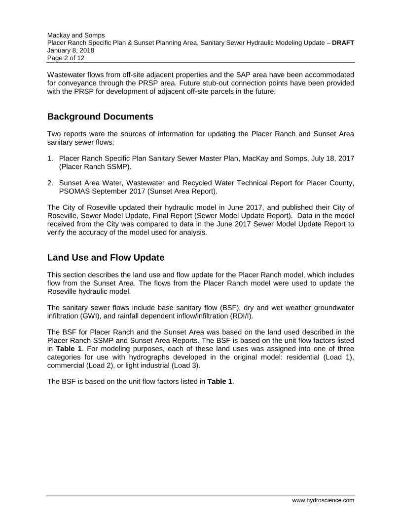
Introduction
The existing Sunset Industrial Area (SIA) Plan area, which includes the Placer Ranch Specific Plan (PRSP) area, encompasses 8,172 acres in unincorporated western Placer County. The proposed Sunset Area Plan (SAP) area includes an additional 325 acres west of the SIA for a total of 8,497 acres. The SAP area covers 13.9 square miles between the cities of Rocklin to the east, Roseville to the south, and Lincoln to the north and unincorporated Placer County to the west. The proposed PRSP area encompasses 2,213 acres in the southern portion of the SAP area. The southern boundary of the PRSP area is contiguous with the Roseville city limits, and the northern boundary is defined, in part, by the future Placer Parkway.
Wastewater treatment and conveyance would be provided by both Placer County and the South Placer Wastewater Authority (SPWA). Placer County is responsible for the collection and conveyance of wastewater in the plan area. The SPWA treats wastewater at the Pleasant Grove Wastewater Treatment Plant (PGWWTP), which is operated by the City of Roseville. The PGWWTP is located approximately 2 miles southwest of the PRSP area.
There are three sheds in the SIA area, the western, central, and eastern sheds. How flow from each of these sheds will be sewered to existing SPWA facilities is further described below.
Flows in the western shed would be conveyed by gravity to a proposed lift station along Sunset Boulevard, near the western edge of the PRSP. From this lift station, flows would be pumped through a proposed force main in Sunset Boulevard to a receiving manhole, at which point they would flow by gravity to an 36-inch stub in Angus Road approximately 4,200 feet south of the plan area. From this connection point, flows would be conveyed to the existing 72-inch Regional Sewer Transmission pipeline located within the Pleasant Grove Creek corridor. The existing 72-inch Regional Sewer Transmission pipeline will convey all flows from the PRSP and SAP areas to the PGWWTP.
All flows in the western and central sheds would flow by gravity in an easterly and southerly direction to the intersection of Fiddyment Road and Sunset Boulevard. In the central shed, flows would be conveyed by gravity in a westerly and southwesterly direction to Fiddyment Road. From Fiddyment Road, flows would be conveyed via a 27-inch line in Fiddyment Road southward to the southern edge of the plan area. From this point, flows would continue to be conveyed by gravity to aforementioned 36-inch stub.
In addition to Placer Ranch, SAP flows enter both the Placer Ranch collection system and Roseville collection system.
Mackay and Somps Placer Ranch Specific Plan & Sunset Planning Area, Sanitary Sewer Hydraulic Modeling Update – DRAFT January 8, 2018 Page 2 of 12
www.hydroscience.com
Wastewater flows from off-site adjacent properties and the SAP area have been accommodated for conveyance through the PRSP area. Future stub-out connection points have been provided with the PRSP for development of adjacent off-site parcels in the future.
Background Documents
Two reports were the sources of information for updating the Placer Ranch and Sunset Area sanitary sewer flows:
1. Placer Ranch Specific Plan Sanitary Sewer Master Plan, MacKay and Somps, July 18, 2017 (Placer Ranch SSMP).
2. Sunset Area Water, Wastewater and Recycled Water Technical Report for Placer County, PSOMAS September 2017 (Sunset Area Report).
The City of Roseville updated their hydraulic model in June 2017, and published their City of Roseville, Sewer Model Update, Final Report (Sewer Model Update Report). Data in the model received from the City was compared to data in the June 2017 Sewer Model Update Report to verify the accuracy of the model used for analysis.
Land Use and Flow Update
This section describes the land use and flow update for the Placer Ranch model, which includes flow from the Sunset Area. The flows from the Placer Ranch model were used to update the Roseville hydraulic model.
The sanitary sewer flows include base sanitary flow (BSF), dry and wet weather groundwater infiltration (GWI), and rainfall dependent inflow/infiltration (RDI/I).
The BSF for Placer Ranch and the Sunset Area was based on the land used described in the Placer Ranch SSMP and Sunset Area Reports. The BSF is based on the unit flow factors listed in Table 1. For modeling purposes, each of these land uses was assigned into one of three categories for use with hydrographs developed in the original model: residential (Load 1), commercial (Load 2), or light industrial (Load 3).
The BSF is based on the unit flow factors listed in Table 1.
Mackay and Somps Placer Ranch Specific Plan & Sunset Planning Area, Sanitary Sewer Hydraulic Modeling Update – DRAFT January 8, 2018 Page 3 of 12
www.hydroscience.com
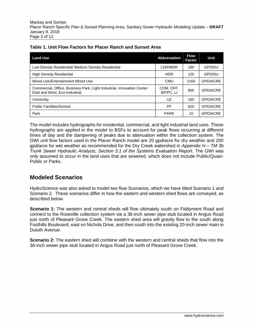
Table 1. Unit Flow Factors for Placer Ranch and Sunset Area
Land Use Abbreviation Flow
Factor Unit
Low Density Residential/ Medium Density Residential LDR/MDR 180 GPD/DU
High Density Residential HDR 120 GPD/DU
Mixed Use/Entertainment Mixed Use CMU 2160 GPD/ACRE
Commercial, Office, Business Park, Light Industrial, Innovation Center East and West, Eco-Industrial
COM, OFF, BP/PC, LI
800 GPD/ACRE
University UZ 160 GPD/ACRE
Public Facilities/School PF 620 GPD/ACRE
Park PARK 10 GPD/ACRE
The model includes hydrographs for residential, commercial, and light industrial land uses. These hydrographs are applied in the model to BSFs to account for peak flows occurring at different times of day and the dampening of peaks due to attenuation within the collection system. The GWI unit flow factors used in the Placer Ranch model are 20 gpd/acre for dry weather and 200 gpd/acre for wet weather as recommended for the Dry Creek watershed in Appendix H – TM 3b Trunk Sewer Hydraulic Analysis, Section 3.1 of the Systems Evaluation Report. The GWI was only assumed to occur in the land uses that are sewered, which does not include Public/Quasi-Public or Parks.
Modeled Scenarios
HydroScience was also asked to model two flow Scenarios, which we have titled Scenario 1 and Scenario 2. These scenarios differ in how the eastern and western shed flows are conveyed, as described below.
Scenario 1: The western and central sheds will flow ultimately south on Fiddyment Road and connect to the Roseville collection system via a 36-inch sewer pipe stub located in Angus Road just north of Pleasant Grove Creek. The eastern shed area will gravity flow to the south along Foothills Boulevard, east on Nichols Drive, and then south into the existing 20-inch sewer main in Duluth Avenue.
Scenario 2: The eastern shed will combine with the western and central sheds that flow into the 36-inch sewer pipe stub located in Angus Road just north of Pleasant Grove Creek.
Mackay and Somps Placer Ranch Specific Plan & Sunset Planning Area, Sanitary Sewer Hydraulic Modeling Update – DRAFT January 8, 2018 Page 4 of 12
www.hydroscience.com
Modeling Inputs
The City of Roseville InfoWorks ICM-SE Buildout Wet Weather Design model was used for this analysis. The City’s June 2017 Infoworks ICM-SE hydraulic model was updated to include the sewer flows included in the Placer Ranch SSMP and the Sunset Area Report. All flows in the City model that were previously applied to either the PRSP or the SAP were replaced with flows from these reports.
The updated Placer Ranch model flows were then input into the latest City of Roseville InfoWorks ICM-SE model for each scenario to evaluate the capacity of the Roseville system as described below.
Model Network: The model networks included as an attachment to the Placer Ranch SSMP were used as the basis for modeling the Placer Ranch sewer collection system.
Model Flows: The flows added to the hydraulic model include the BSF based on the land use specified unit flow factors, dry and wet weather GWI, diurnal hydrographs for each land use, and RDI/I.
Dry Weather Flows: Dry weather includes the BSF and dry weather GWI. The base flows were calculated per manhole based on specific land use tributary areas and dwelling units. The detailed flow information by manhole for each exhibit, the east flows and the west flows (upstream of PR94), and the offsite flows is included in Attachment A. Diurnal curves were then applied to these base flows to estimate the daily varied flow with peaks and minimums. Three curves were used in the hydraulic model: residential (Load 1), commercial (Load 2), and light industrial (Load 3).
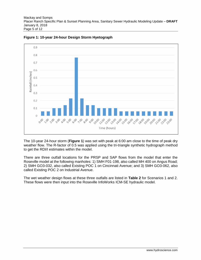
Wet Weather Flows: Wet weather includes dry weather flow, wet weather GWI, and RDI/I. The wet weather GWI was applied similar to the dry weather GWI using a constant curve. The peak wet weather flow in the model is predicted using a 10-year 24-hour design storm and an R-factor. An R-factor of 0.5%, distributed evenly between R1 and R2 (T1=2, K1=2, T2=8, K2 =3) was used based on the recommendation for Urban Growth Areas in Appendix F – TM 2c Wet Weather Flow Projection for the Ultimate SPWA Service Area, Section 8 of the 2009 Systems Evaluation Report. The peak wet weather design storm that the model used is shown in Figure 1. The total 24-hour storm rainfall volume is 2.97 inches.
Mackay and Somps Placer Ranch Specific Plan & Sunset Planning Area, Sanitary Sewer Hydraulic Modeling Update – DRAFT January 8, 2018 Page 5 of 12
www.hydroscience.com
Figure 1: 10-year 24-hour Design Storm Hyetograph
The 10-year 24-hour storm (Figure 1) was set with peak at 6:00 am close to the time of peak dry weather flow. The R-factor of 0.5 was applied using the tri-triangle synthetic hydrograph method to get the RDI/I estimates within the model.
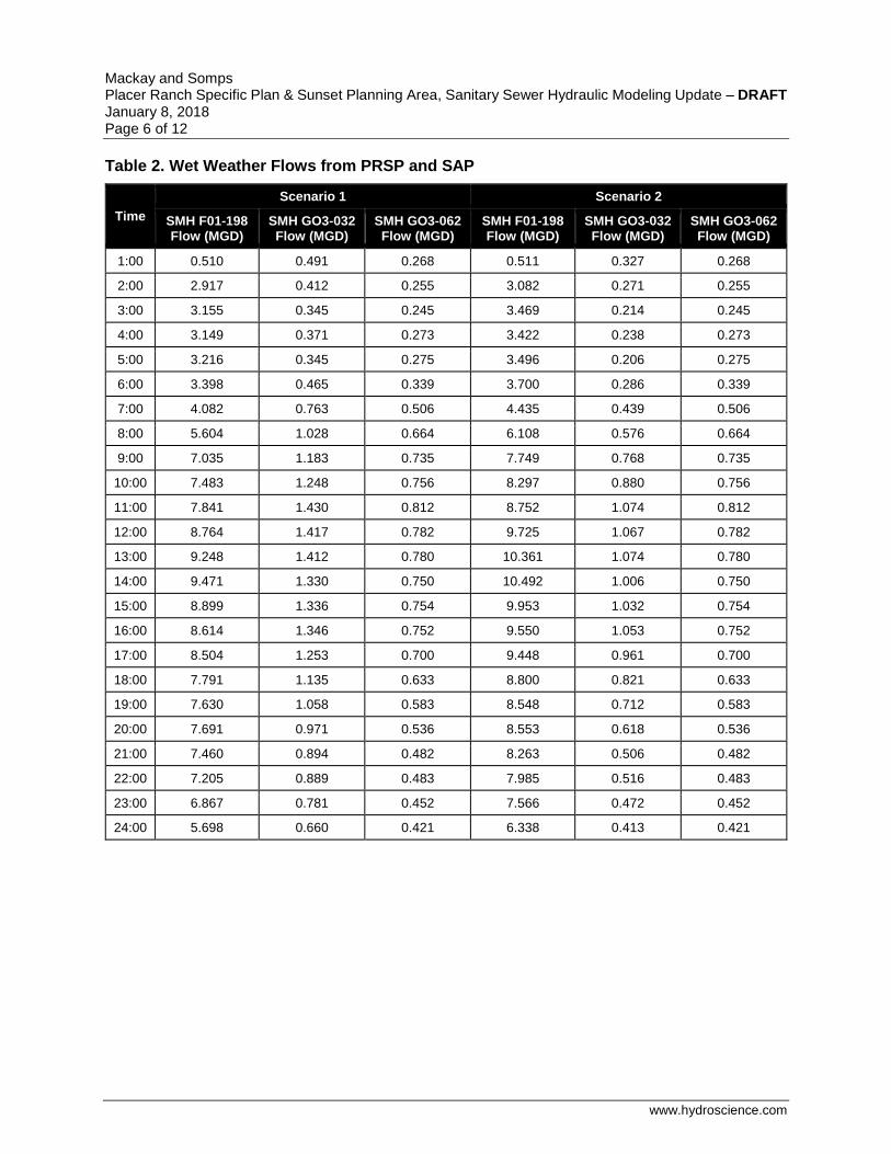
There are three outfall locations for the PRSP and SAP flows from the model that enter the Roseville model at the following manholes: 1) SMH F01-198, also called MH 400 on Angus Road; 2) SMH GO3-032, also called Existing POC 1 on Cincinnati Avenue; and 3) SMH GO3-062, also called Existing POC 2 on Industrial Avenue.
The wet weather design flows at these three outfalls are listed in Table 2 for Scenarios 1 and 2. These flows were then input into the Roseville InfoWorks ICM-SE hydraulic model.
Mackay and Somps Placer Ranch Specific Plan & Sunset Planning Area, Sanitary Sewer Hydraulic Modeling Update – DRAFT January 8, 2018 Page 6 of 12
www.hydroscience.com
Table 2. Wet Weather Flows from PRSP and SAP
Time
Scenario 1 Scenario 2
SMH F01-198 Flow (MGD)
SMH GO3-032 Flow (MGD)
SMH GO3-062 Flow (MGD)
SMH F01-198 Flow (MGD)
SMH GO3-032 Flow (MGD)
SMH GO3-062 Flow (MGD)
1:00 0.510 0.491 0.268 0.511 0.327 0.268
2:00 2.917 0.412 0.255 3.082 0.271 0.255
3:00 3.155 0.345 0.245 3.469 0.214 0.245
4:00 3.149 0.371 0.273 3.422 0.238 0.273
5:00 3.216 0.345 0.275 3.496 0.206 0.275
6:00 3.398 0.465 0.339 3.700 0.286 0.339
7:00 4.082 0.763 0.506 4.435 0.439 0.506
8:00 5.604 1.028 0.664 6.108 0.576 0.664
9:00 7.035 1.183 0.735 7.749 0.768 0.735
10:00 7.483 1.248 0.756 8.297 0.880 0.756
11:00 7.841 1.430 0.812 8.752 1.074 0.812
12:00 8.764 1.417 0.782 9.725 1.067 0.782
13:00 9.248 1.412 0.780 10.361 1.074 0.780
14:00 9.471 1.330 0.750 10.492 1.006 0.750
15:00 8.899 1.336 0.754 9.953 1.032 0.754
16:00 8.614 1.346 0.752 9.550 1.053 0.752
17:00 8.504 1.253 0.700 9.448 0.961 0.700
18:00 7.791 1.135 0.633 8.800 0.821 0.633
19:00 7.630 1.058 0.583 8.548 0.712 0.583
20:00 7.691 0.971 0.536 8.553 0.618 0.536
21:00 7.460 0.894 0.482 8.263 0.506 0.482
22:00 7.205 0.889 0.483 7.985 0.516 0.483
23:00 6.867 0.781 0.452 7.566 0.472 0.452
24:00 5.698 0.660 0.421 6.338 0.413 0.421
Mackay and Somps Placer Ranch Specific Plan & Sunset Planning Area, Sanitary Sewer Hydraulic Modeling Update – DRAFT January 8, 2018 Page 7 of 12
www.hydroscience.com
Model Results
The updates to the flows for the PRSP and the SAP did not indicate a change in pipe diameter for the Placer Ranch collection system.
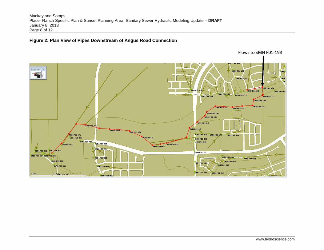
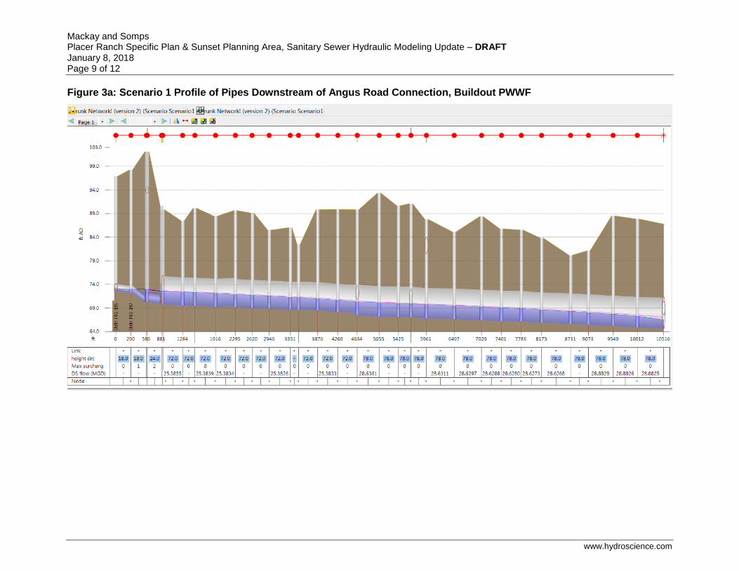
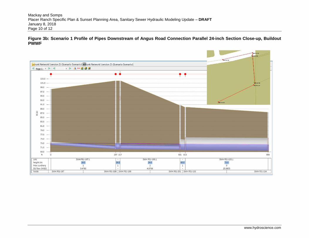
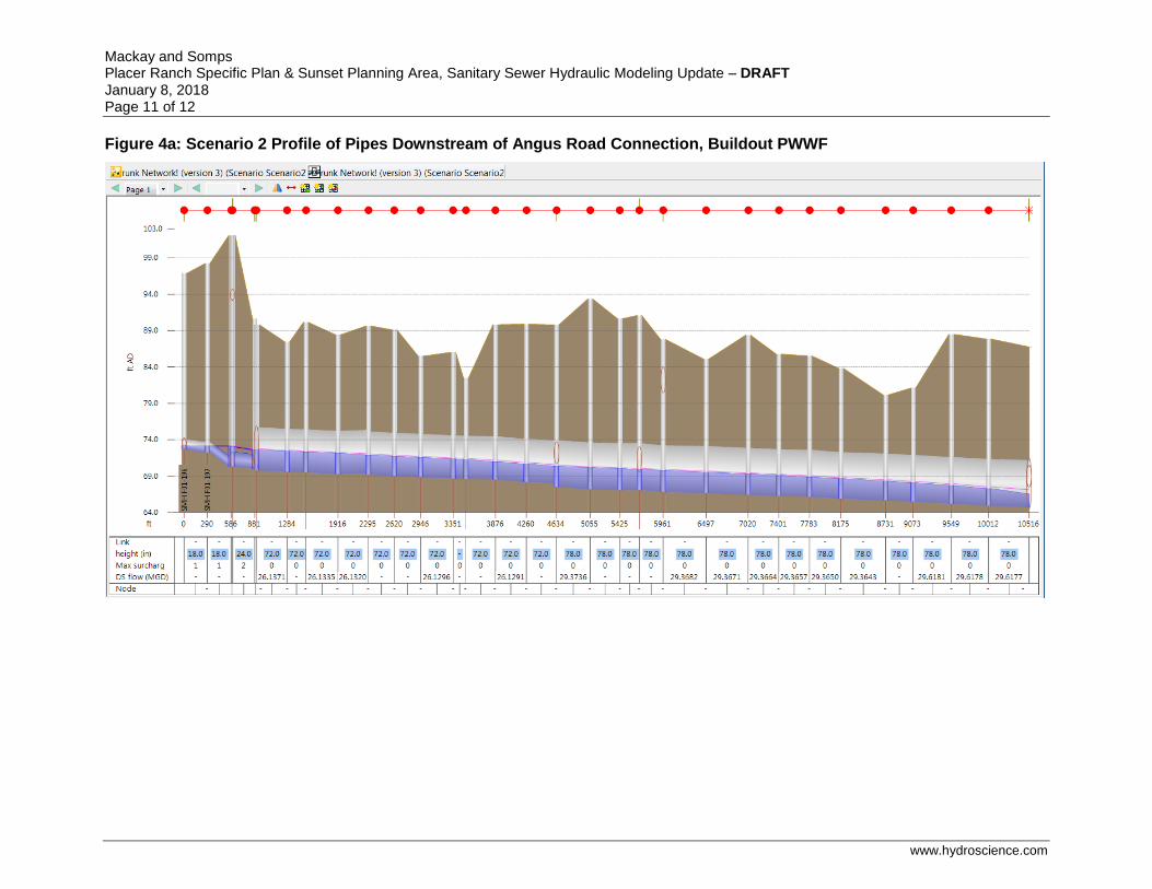
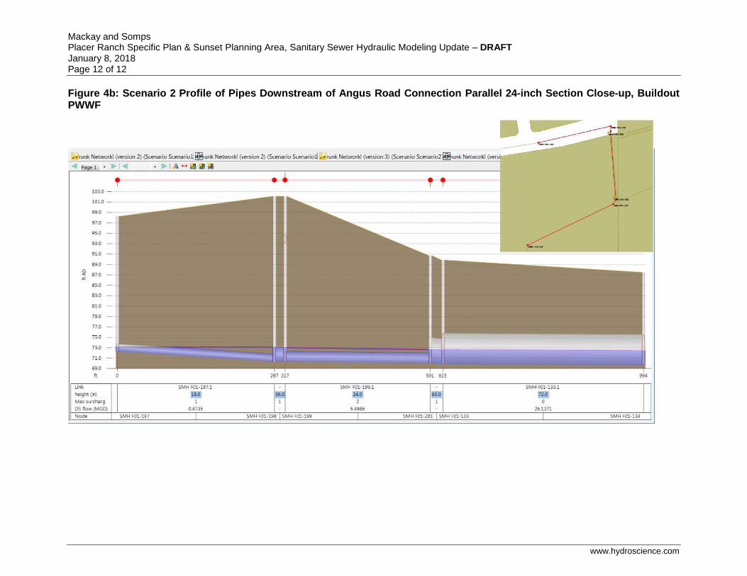
The previously estimated flows for Placer Ranch and the Sunset Area entering the City of Roseville collection system were removed and replaced by the flows listed in Table 2. Capacity is available in the City collection system to handle the PRSP/SAP flows outlined in the current technical studies, save for one segment. The location where flow is limited is where two 24-inch sewers cross underneath Pleasant Grove Creek between a 36-inch stub and a 60-inch sewer.
The 72-inch sewer has adequate capacity to convey buildout flows from both the PRSP and the SAP. The existing stub connecting PRSP and SAP flows to the 72-inch sewer meets the interceptor at a common invert elevation instead of a common crown elevation. Because the existing stub connects at a common invert, this results in a backwater condition due to a smaller pipe connecting into a larger pipe at buildout of the PRSP and the SAP. At no time is there surcharging of flows outside of any manhole.
Section 4.5.2 of the South Placer Regional Wastewater and Recycled Water Systems Evaluation (RMC, December 2009) stated that where surcharging was caused by “backwatering” from larger diameter pipes into smaller diameter pipes, the surcharge criterion was ignored. These situations generally occur at junctions between larger diameter and smaller diameter pipes, particularly where the junctions are invert aligned and not crown aligned. Due to the evaluation criteria stated in the Systems Evaluation report, the sewers at the junction where flow from the PRSP and SAP enter the 72-inch pipeline do not need to be upsized to accommodate flow from the PRSP and SAP. The conveyance of sewage from the PRSP and SAP is consistent with the stated trunk sewer evaluation criteria.
Modeling results are shown in Figures 2 through 4b on the following pages. In InfoWorks, a “Surcharge State” of 0 indicates adequate capacity, a “Surcharge State” of 1 indicates surcharge due to backwater, and a “Surcharge State” of 2 indicates surcharge caused by insufficient pipe capacity. The maximum surcharge state is shown on the profiles as “Max surcharge.” The reader should note that the surcharge state for the 24-inch pipe was ignored due to the aforementioned evaluation criteria.
Mackay and Somps Placer Ranch Specific Plan & Sunset Planning Area, Sanitary Sewer Hydraulic Modeling Update – DRAFT January 8, 2018 Page 8 of 12
www.hydroscience.com
Figure 2: Plan View of Pipes Downstream of Angus Road Connection
Mackay and Somps Placer Ranch Specific Plan & Sunset Planning Area, Sanitary Sewer Hydraulic Modeling Update – DRAFT January 8, 2018 Page 9 of 12
www.hydroscience.com
Figure 3a: Scenario 1 Profile of Pipes Downstream of Angus Road Connection, Buildout PWWF
Mackay and Somps Placer Ranch Specific Plan & Sunset Planning Area, Sanitary Sewer Hydraulic Modeling Update – DRAFT January 8, 2018 Page 10 of 12
www.hydroscience.com
Figure 3b: Scenario 1 Profile of Pipes Downstream of Angus Road Connection Parallel 24-inch Section Close-up, Buildout PWWF
Mackay and Somps Placer Ranch Specific Plan & Sunset Planning Area, Sanitary Sewer Hydraulic Modeling Update – DRAFT January 8, 2018 Page 11 of 12
www.hydroscience.com
Figure 4a: Scenario 2 Profile of Pipes Downstream of Angus Road Connection, Buildout PWWF
Mackay and Somps Placer Ranch Specific Plan & Sunset Planning Area, Sanitary Sewer Hydraulic Modeling Update – DRAFT January 8, 2018 Page 12 of 12
www.hydroscience.com
Figure 4b: Scenario 2 Profile of Pipes Downstream of Angus Road Connection Parallel 24-inch Section Close-up, Buildout PWWF


