Phoenix Environmental Sciences, February 2011. Long-necked Turtle Baseline Survey for Roe Highway Extension Project. Unpublished report prepared for South Metro Connect, Perth, WA.
Long-necked Turtle Baseline Survey for the Roe Highway Extension Project South Metro Connect
Final Report
Phoenix Environmental Sciences Pty Ltd i
4
Long-necked Turtle Baseline Survey for Roe Highway Extension Project
Prepared South Metro Connect
Final Report
February 2011
Long-necked Turtle Baseline Survey for the Roe Highway Extension Project South Metro Connect
Final Report
Phoenix Environmental Sciences Pty Ltd ii
Long-necked Turtle Baseline Survey for the Roe Highway Extension Project
Prepared for South Metro Connect
Final Report
Authors: Mary-Anne Clunies-Ross
Reviewers: Jarrad Clark, Karen Crews
Date: February 2011
Submitted to: Jamie Shaw and Peter Magaro (AECOM Australia Ltd)
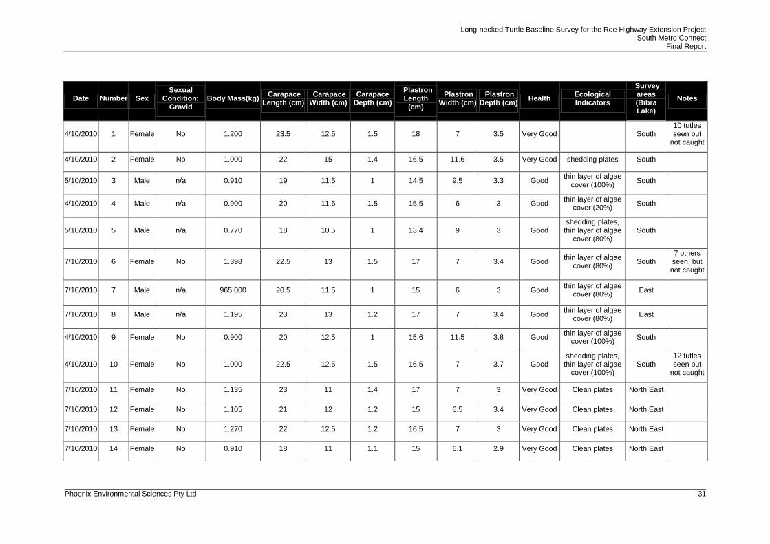
APPENDIX 1 TURTLES RECORDED IN BIBRA LAKE DURING THE OCTOBER 2010 SURVEY .... 30
LIST OF TABLES
Table 4-1 Location of Oblong Turtle survey areas. ........................................................................ 16
Long-necked Turtle Baseline Survey for the Roe Highway Extension Project South Metro Connect
Final Report
Phoenix Environmental Sciences Pty Ltd iv
Table 4-2 Limitations of the Oblong Turtle baseline survey ........................................................... 18
Table 5-1 Basic population statistics (carapace length) for turtles caught in Bibra Lake ............... 21
Table 5-2 Ecological Indictors on Male and Female turtles caught in Bibra Lake ......................... 23
LIST OF FIGURES
Figure 1-1 Location of the Roe Highway Extension Project .............................................................. 7
Figure 2-1 Soil types and vegetation complexes of the Roe Highway Extension Project ............... 11
Figure 2-2 Daily minimum and maximum temperatures at Jandakot Airport during the survey period
(4-8 October 2010) ......................................................................................................... 12
Figure 5-1 Size structure of male turtles caught from Bibra Lake ................................................... 21
Figure 5-2 Size structure of female turtles caught from Bibra Lake ................................................ 21
Figure 5-3 Linear regression comparing carapace length to body mass for male turtles caught in
Bibra Lake ...................................................................................................................... 22
Figure 5-4 Linear regression comparing carapace length to body mass for female turtles caught in
Bibra Lake ...................................................................................................................... 22
Figure 5-5 Barometric pressure and rainfall recorded during the month of October 2010 .............. 24
Figure 5-6 Minimum and maximum temperatures recorded during the month of October 2010 .... 25
LIST OF PLATES
Plate 1 Oblong Turtle caught in Bibra Lake ................................................................................. 6
Plate 2 Lake habitats surveyed (wet and dry) ............................................................................ 17
Plate 3 Algal and fungal growth present on an individual. ......................................................... 23
Long-necked Turtle Baseline Survey for the Roe Highway Extension Project South Metro Connect
Final Report
Phoenix Environmental Sciences Pty Ltd 5
EXECUTIVE SUMMARY
South Metro Connect commissioned Phoenix Environmental Sciences Pty Ltd (Phoenix) to
undertake a baseline survey for the Long-necked Turtle (Chelodina Oblonga) (herein referred
to as the ‘Oblong Turtle’), within the project area (‘the project area’) of the Roe Highway
Extension Project (‘the proposed project’).
The Oblong Turtle is not listed as a species of conservation significance but considered to be
of local significance. The survey aimed to collect baseline information on Oblong Turtle
populations within the project area, in particular population estimates, dynamics, health and
local distribution. It also aimed to identify any potential upland nesting movements.
Twenty three adult Oblong Turtles (16 females and 7 males) and no juveniles were captured
at Bibra Lake, representing the minimum population size at the lake. Thirty-seven turtles were
seen within the lake but not captured. There were no recaptures. No turtles were seen or
captured in North Lake.
The size structure (carapace length) for both male and female captures were within normal
ranges based on results from previous surveys. Carpace length in male turtles ranged from
18-23cm (average of 20.5cm) and in female turtles ranged from 18-25cm (average of
22.3cm). No gravid females were caught within this survey.
More than half of the individuals captured (52.1%) had ecological indicators, with algal growth
the most prevalent indicator. Eighty five percent of males had ecological indicators present
compared with 43% of females. Strong to moderate positive correlations were evident
between carapace length and body mass in both sexes. Generally, the turtles sampled were
in good to very good condition with only one individual considered to be in satisfactory
condition.
The turtle population in Bibra Lake is likely to be substantially larger than the sample size
captured, given limitations with sampling, lack of recaptures and lack of juvenile captures.
Based on the available data, the minimum population density estimate for the Oblong Turtle
within Bibra Lake is approximately 168 turtles in 157ha, approximately 1.058 turtles per ha.
This suggests that an area of 0.93ha needs to be surveyed before one turtle is expected to be
caught.
The presence of adult turtles suggests that the long-term viability of this population is
possible, but also dependant on other habitat requirements. Although no turtles were captured
in North Lake anecdotal evidence and opportunistic findings (turtle remains) suggest that they
have been previously present in this area.
Terrestrial habitat assessments suggest that turtle populations within these lakes may be
restricted in their upland nesting movements due to the presence of retaining walls, steep lake
side banks, thick non-native grasslands and the presence of dense Typha sp. fringing these
wetlands. Increased fragmentation of upland habitats, weed invasion, road mortality and
predation are also existing threats to this species which may limit their dispersal and breeding
success.
Long-necked Turtle Baseline Survey for the Roe Highway Extension Project South Metro Connect
Final Report
Phoenix Environmental Sciences Pty Ltd 6
1 INTRODUCTION
South Metro Connect commissioned Phoenix Environmental Sciences Pty Ltd (Phoenix) to
undertake a baseline survey for the Long-necked Turtle (Chelodina Oblonga) (herein referred
to as the ‘Oblong Turtle’), within the project area (‘the project area’) of the Roe Highway
Extension Project (‘the proposed project’).
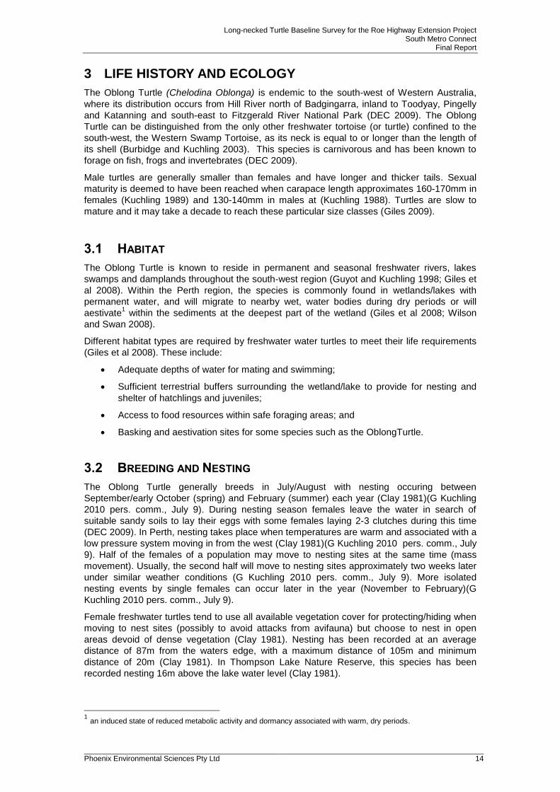
1.1 BACKGROUND
The Government of Western Australia (Main Roads WA) is planning to extend Roe Highway
from its current connection to Kwinana Freeway in Jandakot to Stock Road in Coolbellup.
The proposed alignment for the highway between the Kwinana Freeway and North Lake Road
is within the existing Primary Regional Roads Metropolitan Regional Scheme (MRS) boundary
that divides the Beeliar Regional Park between Bibra Lake and North Lake (Figure 1-1).
The project area is considered to be of high environmental value and as such, extensive
biological surveys are required as part of the environmental impact assessment for the
proposed project.
This baseline survey was developed in response to local community concern about the
potential impact of the proposed project on the Oblong Turtle and to contribute to local
knowledge of the Oblong Turtle in the North Lake/Bibra Lake area (Plate 1). The species is
not of conservation significance but is of local significance to the project area.
Plate 1 Oblong Turtle caught in Bibra Lake
Datum: GDA94 Projection: MGA z50
Figure 1-1Location of theRoe Highway
Extension Project
Swan River
BooragoonLake
North Lake
Bibra Lake
South Lake
Little Rush Lake
Yangebup Lake
Kogolup Lake
ThomsonsLake
Market GardenSwamp
Manning Lake
Canning River
K w
i n
a n
a F
w y
S o u t h S t
C o
c k
b u
r n
R d
C a n n i n g H w y
L e a c h H w y
N o r t h
L a k eR d
S to
ck
Rd
R o e
H w y
Ka
r e l
Av
S o u t hS t
M a n n i n g R d
!!
!!
!!
!!
!! !!
!!
!!
Perth
Morley MidlandStirling
Armadale
Fremantle
Cannington
Rockingham
0 1 2 3
Kilometres
Project Area
Date Modified: 15/02/2011Author: unknown J:\Client_Data\Main_Roads\60100953_Roe_Extension\Workspaces\#2011\Technical_Reports\SRE and Inverts Baseline Survey\Figure 1-1 - Location of the Roe Highway Extension Project.mxd
°°°
Long-necked Turtle Baseline Survey for the Roe Highway Extension Project South Metro Connect
Final Report
Phoenix Environmental Sciences Pty Ltd 8
1.2 SCOPE OF WORK AND SURVEY OBJECTIVES
Survey design for this baseline study is consistent with the Environmental Protection
Bibra Lake (South) Terrestrial Parkland and Eucalyptus/Melaleuca Woodland
Bibra Lake (East) Terrestrial Riparian vegetation and Parkland
Bibra Lake (West) Terrestrial Eucalyptus/Xanthorrhea Woodland
4.3 SURVEY EFFORT
Surveying for the Oblong Turtle took place from 04 to 08 October 2010 (spring nesting
season) within wet lake areas of Bibra Lake, North Lake and upland, terrestrial dry areas
fringing these lakes. Wet areas targeted included those fringing the lake’s edge, specifically
where Typha sp. and/or submergent/emergent vegetation were present. Open water was not
surveyed as this habitat is less likely to harbour individuals and therefore result in the capture
of turtles.
Survey work consisted of a combination of hand collection and active searching. Subsequent
active searching in upland areas was also conducted following the baseline survey on 27
October and 18 November 2010.
4.3.1 HAND COLLECTION AND NET SCOOPING
Due to insufficient water levels in both Bibra Lake and North Lake (approximately 20-30cm
depth), modified funnel traps that were initially proposed to be used for trapping turtles were
Long-necked Turtle Baseline Survey for the Roe Highway Extension Project South Metro Connect
Final Report
Phoenix Environmental Sciences Pty Ltd 17
disregarded. Hand collection and net scooping, using crab scoops was used instead. A total
of 29.4hours was spent surveying via these methods.
Lake Photographs - Bibra Lake
North Lake Lower Swamp (Dry)
Plate 2 Lake habitats surveyed (wet and dry)
4.3.2 ACTIVE SEARCHING
Active searching was used in an attempt to capture upland movement by turtles during the
nesting season survey period. This comprised searches of any observable habitats likely to
support nesting turtles. Such habitats included upland areas of parkland, remnant bushland
and dry lakes/swamps. Where possible, a series of transects 10 meters apart were traversed
on foot to inspect these potential nesting habitats. A total of 23.5hours was spent forgaing.
4.4 BIOLOGICAL PARAMETERS RECORDED
In order to investigate and interpret population dynamics, health and breeding conditions, the
following measurements were taken:
Long-necked Turtle Baseline Survey for the Roe Highway Extension Project South Metro Connect
Final Report
Phoenix Environmental Sciences Pty Ltd 18
Body mass (kg);
Carapace - length, width and depth (cm);
Plastron - length, width and depth (cm);
Ecological Indicators (EI) that provide a relative indication of how well individuals are
managing in their wetland environment e.g the external presence of injuries, scars,
leech infestations, algal cover on carapace, spot softening on carapace, lethargic or
vigourous movement;
Sex; and
Sexual condition: gravid (with eggs).
All captured individuals were marked for recapture identification purposes..
4.5 LIMITATIONS
Limitations of the Oblong Turtle baseline survey are outlined in (Table 4-2).
Table 4-2 Limitations of the Oblong Turtle baseline survey
Limitations Relevant? Comments
Competency / experience of the consultant
carrying out the survey.
No All personnel involved in the field surveys
are competent, experienced zoologists.
Scope (what faunal groups were sampled and
were some sampling methods not able to be
employed because of constraints such as
weather conditions, e.g. pitfall trapping in
waterlogged soils or inability to use pitfall
traps.)
No Scope was adequate. Urban related
constraints determined upfront and worked
around. This was a species-specific
targeted survey.
Proportion of fauna identified, recorded and/or
collected.
No These surveys recorded 23 individuals.
Other Oblong Turtle surveys conducted in
the nearby vicinity recorded more
individuals, however this could be attributed
to longer survey periods. Ongoing surveys
are likely to support this finding.
Sources of information e.g. previously available
information (whether historic or recent) as
distinct from new data.
No Several monitoring programs have been
undertaken in the near vicinity of the project
area (Blue Gum, Booragoon and Piney
Lakes). Findings from these surveys have
supplemented this baseline survey.
Timing/weather/season/cycle. No The timing of the field survey was based on
potentially capturing any seasonal upland
nesting movements.
The proportion of the task achieved and further
work which might be needed.
No The program was implemented as planned
with no further investigations required.
Disturbances (e.g. fire, flood, accidental human
intervention etc.) which affected results of
survey.
No No disturbance occurred during the surveys.
However the project area is located in an
urban bushland, which is subject to
numerous ongoing pressures and historic
degradation.
Long-necked Turtle Baseline Survey for the Roe Highway Extension Project South Metro Connect
Final Report
Phoenix Environmental Sciences Pty Ltd 19
Limitations Relevant? Comments
Intensity (in retrospect, was the intensity
adequate?)
No Survey intensity is adequate for
investigating baseline information on the
resident Oblong Turtle populations within
Bibra Lake and North lake.
Completeness (was relevant area fully
surveyed?)
No All habitat areas specific to the Oblong Turtle
were sampled. Windy and overcast
conditions and murky, shallow lake areas
restricted lake survey sampling. The
relatively small data set has limited the
interpretations presented in this report. This
survey delivered satisfactory results.
Remoteness and/or access problems. No n/a
Availability of contextual (e.g. biogeographic)
information on the region.
No Adequate information exists.
Long-necked Turtle Baseline Survey for the Roe Highway Extension Project South Metro Connect
Final Report
Phoenix Environmental Sciences Pty Ltd 20
5 RESULTS
5.1 LOCAL DISTRIBUTION
There are many previous records of the Oblong Turtle within the project area, surrounding
lakes approximately 3-7km north east and south of the project area (Blue Gum, Booragoon
Piney and Thompsons) and other lakes (Shenton, Perry, and Joondalup, amongst others)
throughout the Perth Metropolitan area.
Anecdotal evidence from conversations with local people and opportunistic findings (turtle
remains) from Phoenix vertebrate surveys and project walkovers within the area suggest that
the Oblong Turtle is a common resident within the project area (Phoenix 2010). Anecdotal
evidence in 2010 suggested that no turtles have been seen crossing roads within the project
area during the current nesting season compared to 2009, where a few turtles were seen. It
was also noted that in the last four years no turtles were seen in horse paddock swamp, as
opposed to previous years.
Further, anecdotal evidence suggests that Oblong Turtles have been known to move into
neighbouring residential properties perhaps in search of nesting sites.
5.2 POPULATION DENSITY ESTIMATES
A total of 23 individuals were captured in Bibra Lake. The southern and northeastern sections
of Bibra Lake captured the most individuals, possibly due to degree of submergent/emergent
vegetation cover fringing these areas. In addition to the 23 turtles captured, 37 turtles were
seen whilst surveying in Bibra Lake that were not able to be captured due to poor water
column visibility and their fast movements. As they were not captured, it was not possible to
determine if they were additional individuals to those recorded.
Based on the aquatic area surveyed (21.6ha or 216,000 m2) and the number of captures, the
minimum population density estimate of Oblong turtles in Bibra Lake is 167.9 or 168 turtles in
157 ha with approximately 1.058 turtles per ha. However, there were no recaptures during
the survey period, suggesting the Bibra Lake population and population density is
considerably larger than that recorded.
No live individuals were seen or captured in North Lake. Four turtle shells were found on the
shoreline of North Lake with no clear evidence of the cause of mortality. Population estimates
of the Oblong turtle in North Lake are unable to be attained based on these results.
5.3 POPULATION DYNAMICS AND STRUCTURE
Of the 23 individuals captured at Bibra Lake, 16 were adult females (69.5%) and seven were
adult males (30.4%). No juveniles were recorded. Within the population sampled female
turtles outnumbered males by more than two to one (2.2:1).
The size structure (carapace length) for both males and females were within normal ranges
based on results from previous surveys. Adult male and female turtles were quite similar in
size with the carpace length in male turtles ranging from 18-23cm (Figure 5-1), with an
average carapace length of 20.5cm, and female turtles 18-25cm (Figure 5-2), with an average
carapace length of 22.3cm (Table 5-1). The standard deviation in carapace length was similar
for both sexes; 1.89 for males and 1.79 for females. There was no evidence of recruitment
(juveniles) within the population sampled. There was also no evidence of reproduction, with
no gravid (with eggs) females captured.
Long-necked Turtle Baseline Survey for the Roe Highway Extension Project South Metro Connect
Final Report
Phoenix Environmental Sciences Pty Ltd 21
Figure 5-1 Size structure of male turtles caught from Bibra Lake
Figure 5-2 Size structure of female turtles caught from Bibra Lake
Table 5-1 Basic population statistics (carapace length) for turtles caught in Bibra
Lake
Minimum Carapace
Length (cm)
Maximum Carapace
Length (cm)
Average Carapace
(mean) Length
(cm)
Standard Deviation
Carapace Length
(cm)
Males 18 23 20.5 1.892969
Females 18 25 22.3 1.793507
5.3.1 CONDITION INDEX
In order to assess the general condition of the turtles captured, a condition index based on
carapace length in relation to body mass was used. A strong positive correlation exists in
male turtles (R² = 0.935) with the minimum body mass (0.770 kg) recorded at 18cm carapace
length and maximum body mass of 1.301 kg recorded at 23cm carapace length (Figure 5-3).
0
1
2
3
18 19 20 20.5 23
Nu
mb
er
of
in
div
idu
als
cau
gh
t
Carapace Length (cm)
Males
0
1
2
3
4
18 20 21 22 22.5 23 23.5 24.5 25Nu
mb
er
of
in
div
idu
als
cau
gh
t
Carapace Length (cm)
Females
Long-necked Turtle Baseline Survey for the Roe Highway Extension Project South Metro Connect
Final Report
Phoenix Environmental Sciences Pty Ltd 22
A moderate positive correlation exists between carapace length and body mass in females (R²
= 0.6082) with the minimum body mass (0.910 kg) recorded at 18cm and maximum 25cm at
1.813 kg (Figure 5-4). The extent of scatter in the graphs may be attributed to the relatively
small sample size. Two females and one male were shedding plates (12.5% and 14.2% of the
population respectively) which is a general indication of growth.
Figure 5-3 Linear regression comparing carapace length to body mass for male
turtles caught in Bibra Lake
Figure 5-4 Linear regression comparing carapace length to body mass for female
turtles caught in Bibra Lake
R² = 0.9351
0.000
0.200
0.400
0.600
0.800
1.000
1.200
1.400
18 18.5 19 19.5 20 20.5 21 21.5 22 22.5 23
Bo
dy m
ass (
kg
)
Carapace length (cm)
R² = 0.6082
0.000
0.200
0.400
0.600
0.800
1.000
1.200
1.400
1.600
1.800
2.000
18 19 20 21 22 23 24 25
Bo
dy m
ass (
kg
)
Carapace length (cm)
Long-necked Turtle Baseline Survey for the Roe Highway Extension Project South Metro Connect
Final Report
Phoenix Environmental Sciences Pty Ltd 23
5.3.2 ECOLOGICAL INDICATORS
Of the 23 turtles captured 12 turtles (52.1%) had ecological indicators (EI’s) present, with algal
growth on the carapace the most common EI. Generally males had the greatest degree of EI’s
present, with 85% displaying EI’s compared with 43% of females (Table 5-2). In total,
approximately 57.1% of males and 25.0% of females had a thin layer of algal coverage
greater than 80.0%.
One male and two females had a medium layer of algal growth present with the male
considered to be in a satisfactory condition, despite recording a combination of two ecological
indictors (algal and fungal growth) (Plate 3). Only one male had 20% algal coverage on his
carapace. Of the females, 56.2% had clean carapaces, whereas only one of seven males had
a clean carapace (14.3%). Consequently, the population is considered to be in good to very
good condition.
Table 5-2 Ecological Indictors of male and female turtles caught in Bibra Lake
Sex
No Algal Coverage %
Thin layer algal coverage (20-79% coverage)
Thin layer algal coverage (greater than 80% coverage)
Medium layer algal coverage (greater than 80% coverage) Fungal Growth
Total number of individuals with Ecological Indicators present (%)
Male 14.2 14.2 57.1 14.2 14.2 85
Female 56.2 n/a 25 12.5 n/a 43
Plate 3 Algal and fungal growth present on an individual.
5.4 MOVEMENTS
5.4.1 WEATHER CONDITIONS
A study by Clay 1981 showed that a decrease in barometric pressure caused by an
approaching low pressure system was known to initiate the movement of females to nest
sites. The lowest barometric pressure recorded during the month of October occured on the
1st, 9-10
th and 27
th of the month of which none oocurred within the survey period (Figure 5-5).
Rainfall followed some of these low pressure systems on the 10-11th and 28-29
th. Clay (1981)
Long-necked Turtle Baseline Survey for the Roe Highway Extension Project South Metro Connect
Final Report
Phoenix Environmental Sciences Pty Ltd 24
also found that females move to nest sites when maximum daily temperatures remain above 17.5°C, however maximum temperatures above 25°C may hinder movements/observations
due to increased desiccation and potential mortality (Figure 5-6). During the survey period, daily maximum temperatures were consistently above 17.5°C and on two of the survey days
were above 25°C. No upland nesting movements were recorded during the survey period.
Data sourced: Bureau of Meterology, January 3rd 2011.
Figure 5-5 Barometric pressure and rainfall recorded during the month of October
2010
0
1
2
3
4
5
6
7
8
9
995
1000
1005
1010
1015
1020
1025
1030
1035
1 3 5 7 9 11 13 15 17 19 21 23 25 27 29 31
Rain
fall (
mm
)
Baro
metr
ic P
ressu
re (
hP
a)
Date in October 2010
Survey Period Rainfall 9am 3pm
Long-necked Turtle Baseline Survey for the Roe Highway Extension Project South Metro Connect
Final Report
Phoenix Environmental Sciences Pty Ltd 25
Data sourced: Bureau of Meterology, January 3rd 2011.
Figure 5-6 Minimum and maximum temperatures recorded during the month of
October 2010
5.4.2 ACCESSS TO SUITABLE NESTING HABITAT
A number of factors have been identified as limiting access to potentially suitable upland
nesting habitat for the Oblong Turtle within the survey area. These include retaining walls,
steep lake side banks, thick non-native grasslands and the presence of dense Typha sp.
fringing wetlands.
Bibra Lake
The retaining wall situated in the central, western shore of Bibra Lake was identified as
restricting turtle movements into bushland areas directly west of the lake. Turtles may enter
the southern extent of this bushland although the distance to reach this particular upland area
is approximately 150m from the lake itself and based on previous literature turtles are unlikely
to travel those distances (Clay 1981).
In the southern end of the lake, banks are steep in sections with pockets of thick Typha sp.
and other fringing lakeside vegetation potentially preventing turtles from accessing upland
areas beyond the lake. Oblong turtles are generally good climbers on angled slopes,
particularly surfaces that are covered with lawn or even over shrubs (G Kuchling 2010 pers.
comm., November 26). It is however uncertain if they will climb the steep banks (>45º)
situated in this area. Some areas in this southern section have gently sloping banks allowing
potential access to the dry, open swamp area south-west of the lake (south of Adventure
World) and also the adjacent parkland.
Generally, any potential northern movements from Bibra Lake to Horse Paddock Swamp are
restricted by the 30-160m wide, dense patch of Typha fringing the northern tip of Bibra Lake.
Oblong turtles are unlikely to cross over these dense areas, especially if there are no
openings, clearings or animal tracks present (G Kuchling 2010 pers. comm., November 26).
Only one small, open, relatively flat section (north-eastern corner) exists which may allow
turtles to potentially cross to upland areas east of Horse Paddock Swamp.